Embed Size (px)
Citation preview

SITA Enhancing Nature and NE Special Project
Improving the Conservation Status of Freshwater Pearl Mussel Targeting the Clun SAC and Upstream Waters
Project Report
April 2013
SITA Enhancing Nature Project Work
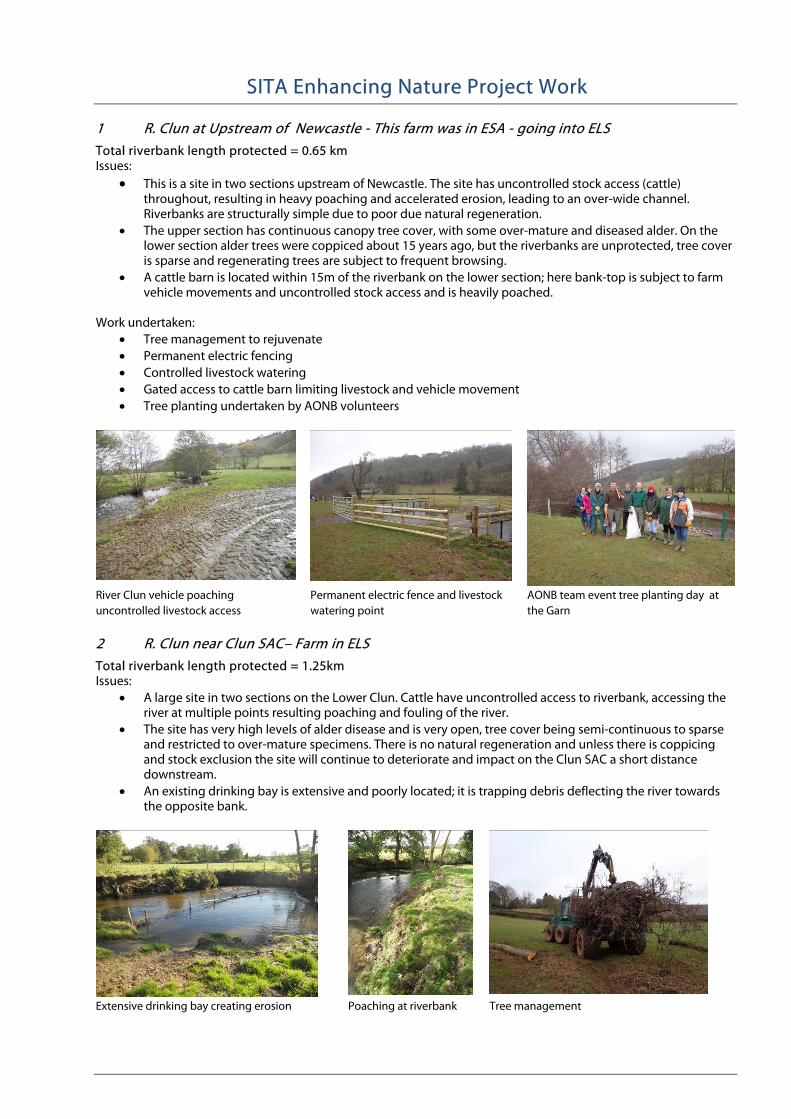
1 R. Clun at Upstream of Newcastle - This farm was in ESA - going into ELS
Total riverbank length protected = 0.65 km Issues:
• This is a site in two sections upstream of Newcastle. The site has uncontrolled stock access (cattle) throughout, resulting in heavy poaching and accelerated erosion, leading to an over-wide channel. Riverbanks are structurally simple due to poor due natural regeneration.
• The upper section has continuous canopy tree cover, with some over-mature and diseased alder. On the lower section alder trees were coppiced about 15 years ago, but the riverbanks are unprotected, tree cover is sparse and regenerating trees are subject to frequent browsing.
• A cattle barn is located within 15m of the riverbank on the lower section; here bank-top is subject to farm vehicle movements and uncontrolled stock access and is heavily poached.
Work undertaken: • Tree management to rejuvenate • Permanent electric fencing • Controlled livestock watering • Gated access to cattle barn limiting livestock and vehicle movement • Tree planting undertaken by AONB volunteers
River Clun vehicle poaching uncontrolled livestock access
Permanent electric fence and livestock watering point
AONB team event tree planting day at the Garn
2 R. Clun near Clun SAC– Farm in ELS
Total riverbank length protected = 1.25km Issues:
• A large site in two sections on the Lower Clun. Cattle have uncontrolled access to riverbank, accessing the river at multiple points resulting poaching and fouling of the river.
• The site has very high levels of alder disease and is very open, tree cover being semi-continuous to sparse and restricted to over-mature specimens. There is no natural regeneration and unless there is coppicing and stock exclusion the site will continue to deteriorate and impact on the Clun SAC a short distance downstream.
• An existing drinking bay is extensive and poorly located; it is trapping debris deflecting the river towards the opposite bank.
Extensive drinking bay creating erosion Poaching at riverbank Tree management
Work undertaken: • Tree management coppicing of diseased and over-mature alders, limited pollarding of crack willow • It is not possible to fence the lower Clun with stock netting due to flooding risk, as cattle graze the site (no
sheep) three strands of barbed wire is considered the best solution. Gates are installed to allow occasional stock access.
• Two new drinking bays for controlled livestock watering • Tree planting throughout the site with volunteers from Severn Trees Trust
New drinking bay and fence Diseased alders coppiced fenced and inter-planted
Meander headlands fenced off and gated to allow occasional stock access
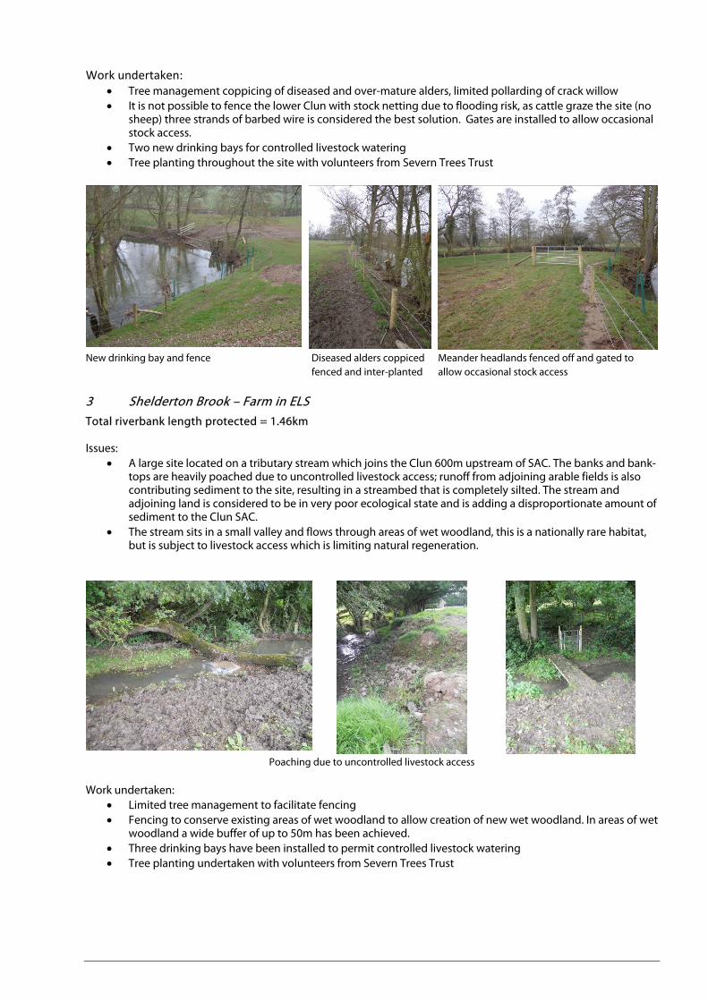
3 Shelderton Brook – Farm in ELS Total riverbank length protected = 1.46km Issues:
• A large site located on a tributary stream which joins the Clun 600m upstream of SAC. The banks and bank-tops are heavily poached due to uncontrolled livestock access; runoff from adjoining arable fields is also contributing sediment to the site, resulting in a streambed that is completely silted. The stream and adjoining land is considered to be in very poor ecological state and is adding a disproportionate amount of sediment to the Clun SAC.
• The stream sits in a small valley and flows through areas of wet woodland, this is a nationally rare habitat, but is subject to livestock access which is limiting natural regeneration.
Poaching due to uncontrolled livestock access
Work undertaken:
• Limited tree management to facilitate fencing • Fencing to conserve existing areas of wet woodland to allow creation of new wet woodland. In areas of wet
woodland a wide buffer of up to 50m has been achieved. • Three drinking bays have been installed to permit controlled livestock watering • Tree planting undertaken with volunteers from Severn Trees Trust
Wet Woodland protected Livestock Drinking Bay Wide Buffer Established
Public right of way Shelderton Brook Gated access for management Volunteers from Severn Trees Trust
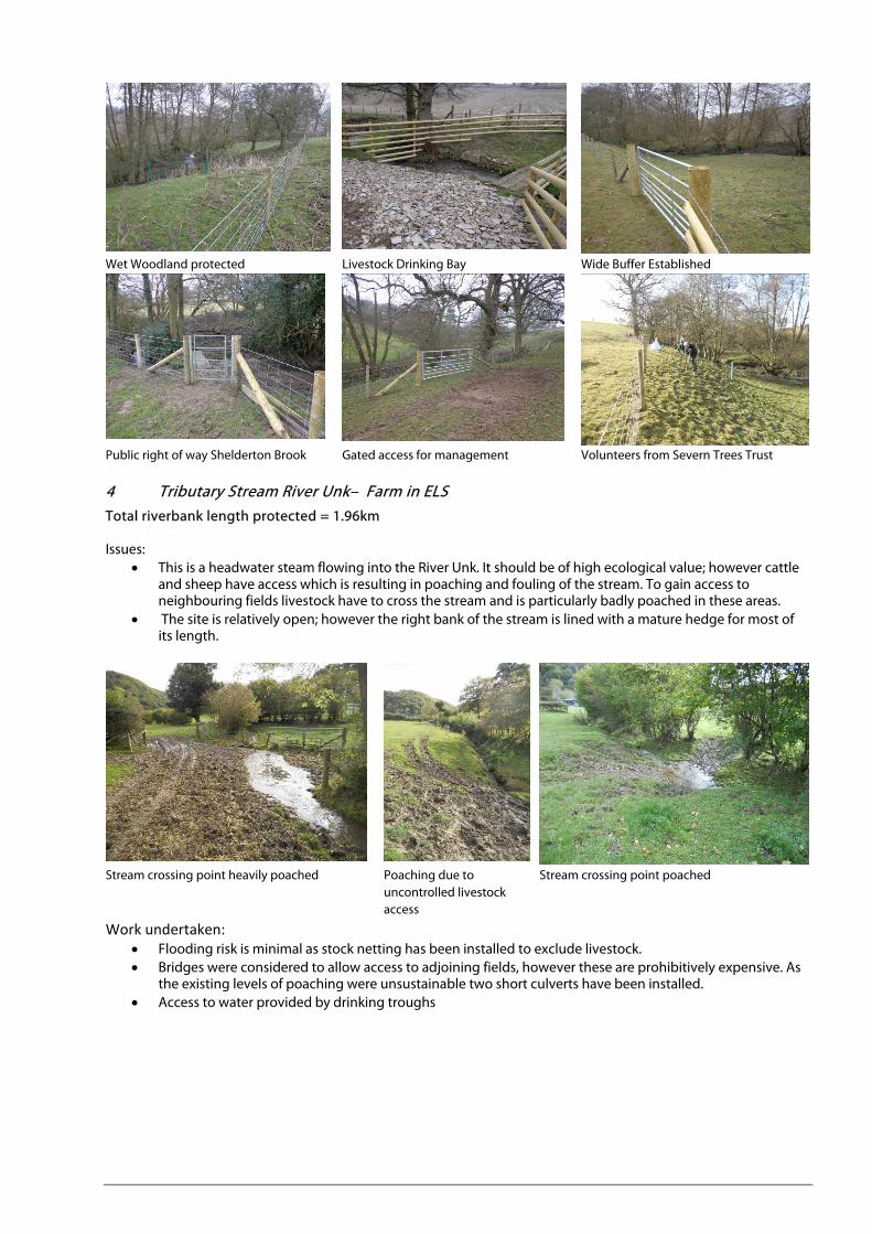
4 Tributary Stream River Unk– Farm in ELS
Total riverbank length protected = 1.96km Issues:
• This is a headwater steam flowing into the River Unk. It should be of high ecological value; however cattle and sheep have access which is resulting in poaching and fouling of the stream. To gain access to neighbouring fields livestock have to cross the stream and is particularly badly poached in these areas.
• The site is relatively open; however the right bank of the stream is lined with a mature hedge for most of its length.
Stream crossing point heavily poached Poaching due to uncontrolled livestock access
Stream crossing point poached
Work undertaken: • Flooding risk is minimal as stock netting has been installed to exclude livestock. • Bridges were considered to allow access to adjoining fields, however these are prohibitively expensive. As
the existing levels of poaching were unsustainable two short culverts have been installed. • Access to water provided by drinking troughs

Watercourse stock fenced New crossing point and culvert
5 Tributary Stream Folly Brook – Farm in ELS Total riverbank length protected = 1.44km Issues:
• This is an upland farm with limited access to water. The valley bottom is diverse in character with riparian/wet woodland and rush pastures and it is very wet in the upper reaches. It is an area that has the potential to be of high ecological value however livestock congregate at the stream which is resulting in extensive poaching and fouling.
Work undertaken: • Flooding risk is minimal and stock netting has been installed to exclude livestock. A very wide riparian
corridor has been created up to 50m wide. Gated access has been provided, to allow seasonal grazing. • Water provision has been provided by series livestock water troughs.
Gated access to wide riparian corridor Rush pasture protected by stock fence Area of wet woodland and rush pasture
Riparian woodland protected by stock fence Water provision provided by piped water to livestock troughs

6 Volunteer Tree Planting Events Volunteers have been used to undertake tree planting at 5 sites Volunteers From:
• Severn Trees Trust • Shropshire Council • Environment Agency • Shropshire Hills AONB • Members of the public
Tree planting undertaken at:
• River Clun at Upper House Farm • River Clun u/s Broadward • Shelderton Brook • River Redlake at Jay Barns • River Clun at The Garn
Environment Agency team day planting trees on the River Redlake
7 Sediment Traps
An in-line sediment trap has been created on a tributary of the River Redlake upstream of Clun SAC at Jay Barns. Here the buffer strip has been widened and vegetation will establish on the shelf at the side of the stream to trap sediment at times of high flow.
Next quarter, a sediment trap is due to be installed on the upper Clun at Duffryn to intercept highway runoff which is running across a stock yard to a roadside gully pot and then to the Clun.
8 Re-wetting/ditch and drain blocking
Situation is as previous report. The project has arranged a meeting with Shropshire Wildlife Trust to move this element forward.
9 Awareness Raising Events This quarter, the AONB facilitated a River Clun Workshop at the Hundred House Inn Purslow. The event was well supported with 45 people attending. The objective was to bring together farmer, contractors land agents and agency staff to discuss Clun related issues and signpost to initiatives that might help. Topics covered:
• Helen Waters, Shropshire Council Watercourse maintenance and consenting for works • Clare Davis, Shropshire Hills AONB Farming Project - Support and Advice • Emma Buckingham, Severn Rivers Trust - Support and Advice • Adam Shipp, Environment Agency - Staying Legal • Ken Downward, Teme Catchment Sensitive Farming Initiative – Capital Grants and Advice

• Mike Kelly, Shropshire Hills AONB - Riparian Management and Large Woody Debris
River Clun Workshop at hundred House Inn
10 Solar livestock pump
Order placed with Dulas ltd. to supply and install – due May 2013
11 Community Groups
The project continues to support the Land, Life and Livelihoods (LLL) community initiative. The project supports LLL e.g. by liaising with agencies and helping with grant applications. LLL have been successful in a securing grant from Environment Agency to undertake Septic Tank Survey of households in the Upper Catchment.
12 Community Water Monitoring
During the winter period this element of the project has been put on hold and is due to re-start May 2013.
13 Partnership Working
The AONB continues to work with and support project partners. The AONB is represented on the: • The Clun Steering Group • Clun Field Officers Group • Clun Catchment Partnership • NE/Atkins Upper Clun Hydrological Steering Group • NE/Jacobs Middle Clun Restoration Strategy Steering Group

NE Funded Sites
Total riverbank protected by Natural England Funding = 8.45km
The Sites:
1 R. Clun at near Newcastle - This farm is not in any Stewardship Scheme Total riverbank length protected = 1.96km Issues:
• Uncontrolled stock access (cattle) throughout – heavy poaching promoting accelerated erosion • Over-wide channel • Diseased and over-mature riverbank trees – creating erosion bays • Simple vegetation structure due to grazing and poor natural regeneration.
Alder dieback Uncontrolled livestock access throughout – frequent poaching Work Undertaken:
• Tree Management • Fencing almost complete (top wire to do) – contractor hopes by end of Month • Mains water pipe installed in main field - Complete • Mains water pipe across river – can only be done outside of fish spawning and fry hatch season – to be
done May 2013 and invoiced separately • Fabrication of livestock bridge – complete (to be installed at landowners cost as soon as ground conditions
allow)
Permanent electric fence installed

Bridge components awaiting installation
2 Clun SAC D/S of Jay Bridge The Farm is in HLS (but included due to complexities of HLS modification - Agreed with NE and to be funded by NE) Total riverbank length protected = 0.37km Issue - Site lacks tree cover (vital to sustain pearl mussel) tree planting undertaken by contract tree planters
3 Minor Stream at–immediately upstream of Clun SAC – In ELS
Total riverbank length protected = 3.82km Issues
• Site highlighted by EA - 600m U/S Confluence of Clun SAC • Having uncontrolled stock access (cattle) throughout – heavy poaching promoting accelerated erosion just
upstream of Clun SAC • Simple vegetation structure due to poor natural regeneration.
Heavy poaching just upstream of Clun SAC Heavy poaching just upstream of Clun SAC
Work undertaken • Fencing along stream • Drinking bays installed • Sediment trap at bottom end of site (Funded by SITA) • Tree planting (landowner to do - trees from by SITA)
Stream Fenced
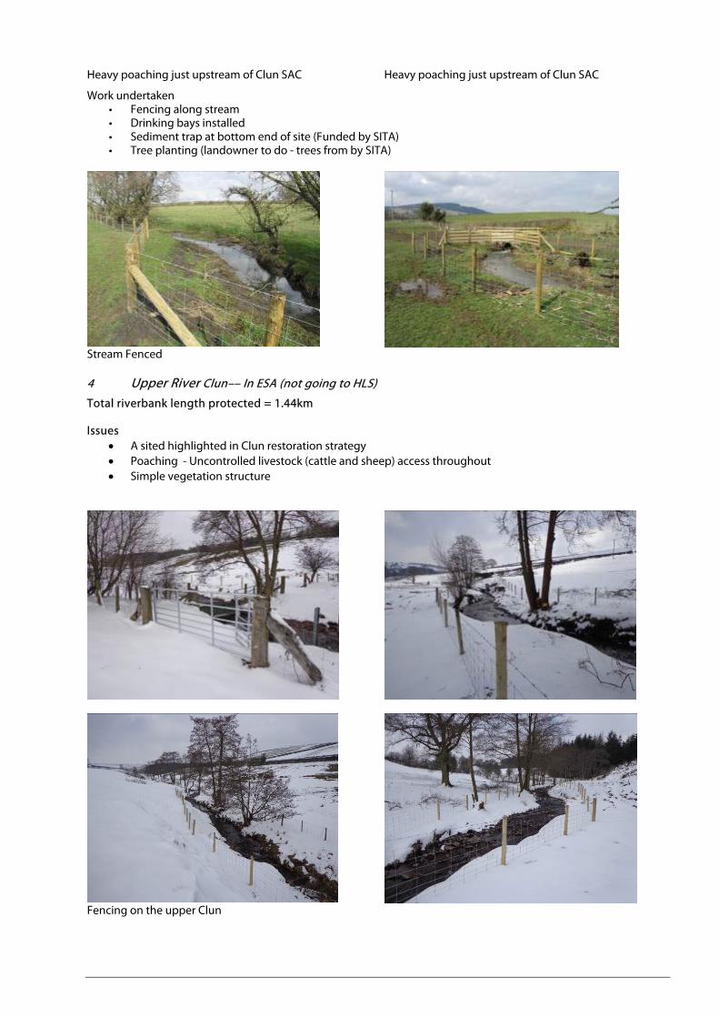
4 Upper River Clun–– In ESA (not going to HLS)
Total riverbank length protected = 1.44km Issues
• A sited highlighted in Clun restoration strategy • Poaching - Uncontrolled livestock (cattle and sheep) access throughout • Simple vegetation structure
Fencing on the upper Clun

5 Riddings Brook -–– In ESA (not going to HLS)
Total riverbank length protected = 0.86km Issues:
• Uncontrolled stock access throughout in an area of rush pasture and wet woodland –resulting in simple vegetation structure.
This work has protected an area of wet woodland and rush pasture typically 50m wide
Wide buffer established on Riddings Brook
6 Unk Farm– Gateway Improvement (NE funded)
Runoff from field to highway is entering the Clun via a system of roadside gully pots. This gateway was acting as a funnel concentrating runoff to the highway. Now new hedgebank established and infiltration drainage installed – Hedgebank and beyond planted with native broadleaves and new field access created up from problem gateway.
Problem gateway Gateway blocked New gateway established
7 Research Elements (NE funded)
Wetland Opportunity Mapping
Natural Environment Team have undertaken GIS element of Wetland Opportunity Mapping – This provides a large dataset which can be interrogated to highlight areas of wetland opportunity in the Upper Clun Catchment and the Kemp Valley. It is wetland opportunity in its widest sense, ranging for arable field habitats (arable reversion to grassland) to extending mire/flush habitats. A dataset of existing good habitat has also been established and identifies opportunities for extension. This information can be superimposed Natural England datasets eg agri-environment schemes etc.
A study of the historic extent of wetland has also been undertaken looking at tithe maps for parts of the catchment. GIS Shapefiles will be available to Natural England
A landowner survey has been conducted to assess landowner’s perceptions of wetlands in the catchment.

Highways Sediment Scoping Study
The AONB has undertaken a study of the highways in the catchment and how they impact on the Clun. The report consists of:
• A representative photographic record detailing the issues
• Shropshire Council/Mouchel Survey of Gully Pots Survey of the Upper Clun and Lower Clun and GIS dataset
• Assessment of ecological and hydrological impact of highways in the Clun Catchment
• Rural SUDS mitigation methods with supporting photographs and illustrations
• Representative costing of SUDS based on similar schemes