Embed Size (px)
Citation preview
OBSERVER RESEARCH FOUNDATION
RCA HES FE OR U
R N
E D
V A
R T
E IOS B NO
MAY 2013ORF OCCASIONAL PAPER #42
Sino-Indian Border Infrastructure: An Update
Rajeswari Pillai Rajagopalan
Rahul Prakash
OBSERVER RESEARCH FOUNDATION
Sino-Indian Border Infrastructure: An Update
Rajeswari Pillai Rajagopalan
Rahul Prakash
2013 Observer Research Foundation. All rights reserved. No part of this publication may bereproduced or transmitted in any form or by any means without permission in writing from ORF.
About the Authors
Dr. Rajeswari Pillai Rajagopalan is Senior Fellow at the Observer
Research Foundation (ORF), New Delhi. Dr. Rajagopalan joined ORF after an
almost five-year stint at the National Security Council Secretariat (2003-2007),
where she was an Assistant Director. Prior to joining the NSCS, she was Research
Officer at the Institute of Defence Studies and Analyses, New Delhi. She was also a
Visiting Professor at the Graduate Institute of International Politics, National
Chung Hsing University, Taichung, Taiwan in early 2012. She is the author of three
books: Clashing Titans: Military Strategy and Insecurity Among Asian Great Powers; The
Dragon's Fire: Chinese Military Strategy and Its Implications for Asia; and Uncertain Eagle:
US Military Strategy in Asia.
Rahul Prakash is a Junior Fellow at Observer Research Foundation. His research
interests include technology and security, Chemical, Biological, Radiological and
Nuclear (CBRN) issues and security developments in Asia. He has co-authored a
report on Chemical, Biological and Radiological Materials: An Analysis of Security Risks and
Terrorist Threats in India, an outcome of a joint study conducted by ORF and the
London-based Royal United Services Institute. He has also published Issue Briefs
on China’s Progress in Space and Rise of Micro Blogs in China. He has done BA
(Hons.) Political Science from Delhi College of Arts and Commerce, Delhi
University and holds a Post Graduate degree in International Relations. He can be
reached at [email protected]
t is widely acknowledged that the 21st century will be an Asian
century. The simultaneous rise of/re-emergence of major powers in IAsia—China, Japan, Russia and India—provides opportunities and
challenges. Asia has major military powers—six out of nine nuclear
powers are in Asia—and some of the fastest growing economies in the
world. While the rise of the “rest” as Fareed Zakaria noted in his book has
been important, the rise of China in the last decade has been most
dramatic. China's rise—with significant output in the economic, military
and strategic spheres—has given shape to an Asia that is characterised by
cooperation, competition and (potential for) conflict. In addition, the
relative decline of the US or at least the perception of it following the long
drawn-out wars in Iraq and Afghanistan has added complexities to an
already uncertain and insecure Asia. Besides, the baggage of historical
conflicts, unresolved border and territorial issues, and rising nationalism
are further fuelling insecurities in the region.
Closer home, India-China relations have gone from one end of the
spectrum to the other. Progress in the last decade has essentially been
dictated by economic drivers. While trade between the two countries
increased from US$ 7 billion to over US$ 70 billion, it has not altered the
overall nature of the ties, which are invariably on a “simmering tension
mode”. India and China being neighbours need to make significant
political investment in changing the course of their bilateral relations. As
www.orfonline.org 1
Sino-Indian Border Infrastructure: 1
An Update
Introduction
key powers in the emerging Asian strategic framework, the two countries
have a responsibility in ensuring peace and stability in the region.
Unresolved border and territorial issues have continued to hold the
bilateral relationship from realising its full potential. India and China have
been on an “engaged mode” on the border issue since 1981. The Joint
Working Groups (JWG), Special Representative talks and the successive
political leaderships—Rajiv Gandhi during his visit in 1988, Atal Bihari
Vajpayee during his visit in 2003, Manmohan Singh in his talks with
Premier Wen Jiabao in 2005 and President Hu Jintao in 2006 and
2008—have taken up the boundary issue but the two sides have not been
able to make any progress. The fact that the Line of Actual Control (LAC)
is not demarcated or delineated on the ground or on military maps reflects
the complexities involved as well as the inflexible positions the two
countries adopt on the issue. Today, the LAC is a matter of perception.
Both the militaries patrol up to the area that they consider is their territory.
Between the two perceived lines is what is called the No Man's Land or the
Red Zone, which is the overlapping area that both sides contest. This area
has witnessed periodic patrol face-offs, although there has been no
incident of firing since the Nathu La incident of 1967. There was,
however, a serious standoff at Sumdorong Chu valley--the Wangdung
incident of 1987.
Unlike on the Chinese side, which has a single unified commander who is
responsible for the Tibetan Autonomous Region (TAR) forces,the Indian
side of the border is managed by several different authorities including
the Army, the Indo-Tibetan Border Police (ITBP), the Border Security
Force (BSF) and the Assam Rifles. Consequently, the Chinese border is
better managed; the Indian side also suffers from multiplicity of
authority—in some places the Ministry of Home Affairs (MHA) is in
charge through the ITBP and in others the Ministry of Defence (MOD)
ORF Occasional Paper
www.orfonline.org2
through the Indian Army. India needs to bring about unity of command
to strengthen its defenses along the border.
This Paper looks at the infrastructure on the India-China border. It is
broadly structured into three sections. The first section details China's
infrastructural developments along the border including highways,
railway networks and oil pipelines that enhance its force deployment and
sustenance capabilities. The second part looks at the significance of the
Chinese military infrastructure and how it impacts upon India. The last
section details India's initiatives on the border, the lacunae in its approach
and gives a few policy recommendations that would help augment the
infrastructure.
China's Initiatives in the Border Region
Infrastructural development in the border region could impact in multiple
ways, both positive and negative. On the positive side, it could strengthen
regional connectivity, boosting economic linkages at a sub-regional level
which may or may not impact the overall political relations between the
countries. Overall, the benefits that can accrue to the border regions from
trade cannot be overlooked. On the negative side, infrastructural
upgradation could raise suspicions, up the ante and accentuate the
possibility of a conflict along the border, as has been the case with India
and China.
This section provides details of some of the major infrastructural
networks created by China in the border areas. The highway network in
the Tibetan Autonomous Region—theWestern Highway, the Central
Highway and the Eastern Highway—remains the most notable and has
been significantly upgraded.
www.orfonline.org 3
Sino-Indian Border Infrastructure: An Update
On the Western Highway, a stretch of 490 km has been tarred from Lhasa
to Lhatse Dz. Tarring also been in progress up to Parkha (510 km) and
according to some reports has been completed. Similarly, on the Eastern
Highway, tarring has been completed from Lhasa to Ngiti (400) km. In
addition, on the Central Highway, a 90-km stretch between Lhasa and
Yangbajain has been developed as a four-lane highway. With these
improvements, the assessed capacity of the highways in the TAR is
estimated to be 7,100 tonnes per day.
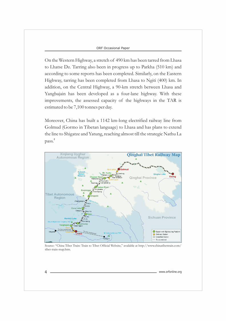
Moreover, China has built a 1142 km-long electrified railway line from
Golmud (Gormo in Tibetan language) to Lhasa and has plans to extend
the line to Shigatze and Yatung, reaching almost till the strategic Nathu La 2pass.
ORF Occasional Paper
www.orfonline.org4
Source: “China Tibet Train: Train to Tibet Official Website,” available at http://www.chinatibettrain.com/tibet-train-map.htm.
www.orfonline.org 5
China is planning to extend the Golmud-Lhasa (Qinghai Tibet) railway 3
line to Nyingchi (expected to be completed by 2013) , close to its border
with India on the Arunachal Pradesh side and further extend it to Dali in
Yunnan Province. This line, running parallel to Arunachal Pradesh, will
enable the PLA to rapidly relocate troops stationed in Kunming, Dali and
Kaiyuanand to TAR. It would also enable the PLA troops, the 13 Group
Army (Unit 56005), to relocate from Sichuan Province to TAR. This
railway line has a capacity to run up to eight trains (one way) per day. It has
been a significant achievement as it has reduced the traveling time from
mainland China to Lhasa to two days with a total tonnage capacity of
3,200 tonnes per train. China has also developed four new airbases in
Tibet in addition to three in southern China. Oil pipelines have been
constructed from Gormo to Lhasa with a total capacity to transport five
million tonnes of oil per year. Currently, to meet the limited demand in the
TAR, the pipeline transports 1.25 million tonnes per year.
Meanwhile, there has been simultaneous refurbishing of the Karakoram
highway (KKH) situated on the western front. This is again significant as
it provides connectivity to both China and Pakistan.
While the Karakoram highway has been operational for many years,
China is now in the process of building a rail network in the region. The
KKH, the world's highest paved road, was completed in 1986 after 20
years of construction, connecting Pakistan's northern areas through the
ancient silk route—a stretch of 1300 km running from Kashgar in
Xinjiang to Havelian in Abbottabad in Pakistan. China, in addition, plans
to establish a railway network beyond the KKH in PoK. From the Chinese
perspective, these networks are significant as they become the shortest
trading route as well as provide alternate energy supply routes from the 4
Persian Gulf to Xinjiang.
Sino-Indian Border Infrastructure: An Update
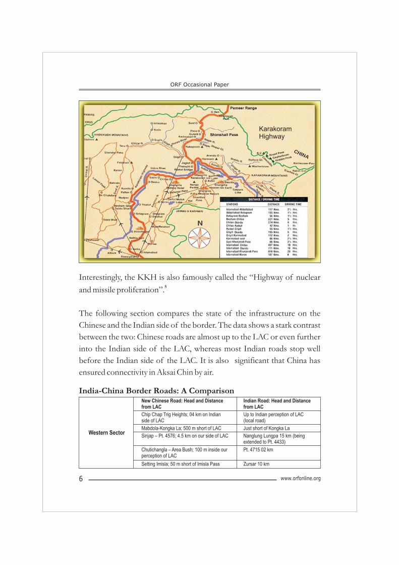
Interestingly, the KKH is also famously called the “Highway of nuclear 5and missile proliferation”.
The following section compares the state of the infrastructure on the
Chinese and the Indian side of the border. The data shows a stark contrast
between the two: Chinese roads are almost up to the LAC or even further
into the Indian side of the LAC, whereas most Indian roads stop well
before the Indian side of the LAC. It is also significant that China has
ensured connectivity in Aksai Chin by air.
www.orfonline.org6
ORF Occasional Paper
KarakoramHighway
India-China Border Roads: A ComparisonNew Chinese Road: Head and Distance from LAC
Indian Road: Head and Distance from LAC
Chip Chap Trig Heights; 04 km on Indian side of LAC
Up to Indian perception of LAC (local road)
Mabdola-Kongka La; 500 m short of LAC Just short of Kongka La
Sirijap – Pt. 4576; 4.5 km on our side of LAC Nanglung Lungpa 15 km (being extended to Pt. 4433)
Chutichangla – Area Bush; 100 m inside our perception of LAC
Pt. 4715 02 km
Setting Imisla; 50 m short of Imisla Pass Zursar 10 km
Western Sector
Western Sector
www.orfonline.org 7
SIRIJAP
DAMBU GURU
DUMCHELE
LACCHIP CHAP
SUMDO
CHIAKANG
DBOX
CHUSHUL
KALSAR
ZURSAR10 K
RECHIN LA
ANELA LA
GALWAN
INDIA
KHURNAK FORT
CHUTICHANGLA
RUDOK
TASHIGONG
TRIG HTS
NOH
KAPSAN G LA
SPANGGUR
CHURKANG
DEMCHOK
JARA LA
SIQUANHE
QIZIL JILGA
YUL LA
Cl 9
Cl 50
Cl 9
Cl 9
Cl 50
Cl 9
Cl 9Cl 9
Cl 5
Cl 50
Cl 9
Cl 9
Cl 9
Cl 50
Cl 9 Cl 9
Cl 50
Cl 50
Cl 9
CHINA
CHIKONKURGMA
RAKSUMCl 9
GAR DZ
TOMARBURTSATANG
HAJILANGAR
KONGKALA
KK PASS
Cl 9
RIVER POST
Manza-Churup; Churup 03 km short of LAC (construction of road ahead of Churup in progress)
Sugar 04 km
Tayak-Shipki; Shipki 06 km short of LAC (construction of road ahead of Shipki in progress)
Chuppan 05 km
Middle Sector: Opposite
Himachal Pradesh
Sino-Indian Border Infrastructure: An Update
Bobra-Mana Pass; 01 km short of Mana Pass Musapani (35 km) (being extended to Ghastoli)
Lungi-Jindu-Niti; 02 km short of Niti Malari (50 km)Middle Sector:
Opposite Uttaranchal Lungi-Tunjun La; Tunjun La up to LAC KM 16 (33 km)
Pulan-Lipulekh; 700 m short of Lipulekh Jibti (80 km) (being extended)
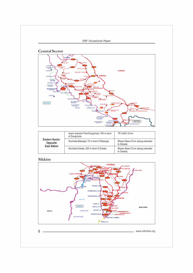
Asam-Jhandori Post-Dongchuila; 700 m short of Dongchuila
TR JUNC 03 km
Sinchella-Batangla; 75 m short of Batangla Bheem Base 03 km (being extended to Dokala)
Eastern Sector: Opposite
East SikkimSinchella-Dokala; 250 m short of Dokala Bheem Base 03 km (being extended
to Dokala)
Central Sector
Sikkim
ORF Occasional Paper
www.orfonline.org8
ZUSAR
Cl 9
SANGONG
KAURIKCHURUP
3 KM
MANZA NUPUK
GIAZUMSOMAR GOMPA
SUGAR PT4 KM
SUMDO CHINA
SHIPKI7 KM GARTOKCl 9
Cl 9
Cl 5 Cl 50
Cl 5
CHIARKANG
THAGLA RIDIDANG
SHANG
GIATELUK
SHIPKILA
RANISO PASS
X
XTICHMAUR
20 KM
TYAK
CHITKUL50 KM
KHANADUNTI
THANGI40 KM
7KM GARTOK
THOLING
M/T
B/T IN PROGRESS
Cl 9
Cl 9
Cl 9 Cl 9Cl 9
CHIARKANG
MANAPASS
POLING
NELANG
NITI PASS
X
LUNGI
GHASTOLI
HARSIL
KHANADUNTI25 KM
BOBRADAPA DZ
TAGO ZAMPU
NAKTSOK
KYUNGLUNG
X
MENZE
DONGPO GOMPA
PULAMSUMDACl 9 Cl 9
Cl 9
Cl 50
U/C
PORKHA
NABUK
TAKCHEN
RINGTACHUGYANIMIAX
X
TUNJUNLA
SILANGTHAR18 KM
MANA
G S O33 KM
MUSAPANI45 KM
INDIA
BARAHOTI
M/T
M/TKUMGRIBINGRI
M/T
Cl 9
Cl 50
NAMARDINGYERNGOG
NUWE DHURA
LIPULEKH
TAWAGHAT80 KM
SOBALA60 KM
MUNSYARI80 KM
BUGDIAR60 KM
DARCHEN3 KM KHOJARNATH
NEPALTAKLAKOT
Cl 9
Cl 9
TO LHASA
Cl 18
KHAMBA DZ
TRAKSIK GOMPACl 9 Cl 9
Cl 18KALASHARCl 18
CHINA
LAWU GOMPA
SESE LAX
Cl 40
Cl 9
TUNA
MATING
KONGRA LA
SEBU LA
GIRU
GOMPA
CHAGO LA
CHAMODZCl 9
Cl 9
Cl 9
Cl5
Cl 9 TO NELUNG
Cl 18
KHUNGYAMILAX
Cl 40
Cl 9
Cl5
NAKU LA
GORA LAX
X
X
GONGGA
PHARI DZ
CHUGYA
P TANG LA
Cl 9
FINGER
PHIMKARU LA
XTANGKARU LA
Cl 9
LARANG
YAKSHA
BHUTAN
JELEP LA
X
GANGTOK
SIKKIM
CHOLA
NATU LAINDIA X
JANDORHI PT
PHARI
DZ
YATUNG
X Cl 9ASAM
GELLING
Cl 18
Cl 18
Cl 9
NEPAL
DONGCHUI LA
X
XKALIMPONGSINCHU LUMBA
JANDORHI PT
DOKA LA
MORING LAJANDORHI PT
Cl 5
Cl 9
Cl 18
Cl 9Cl 40
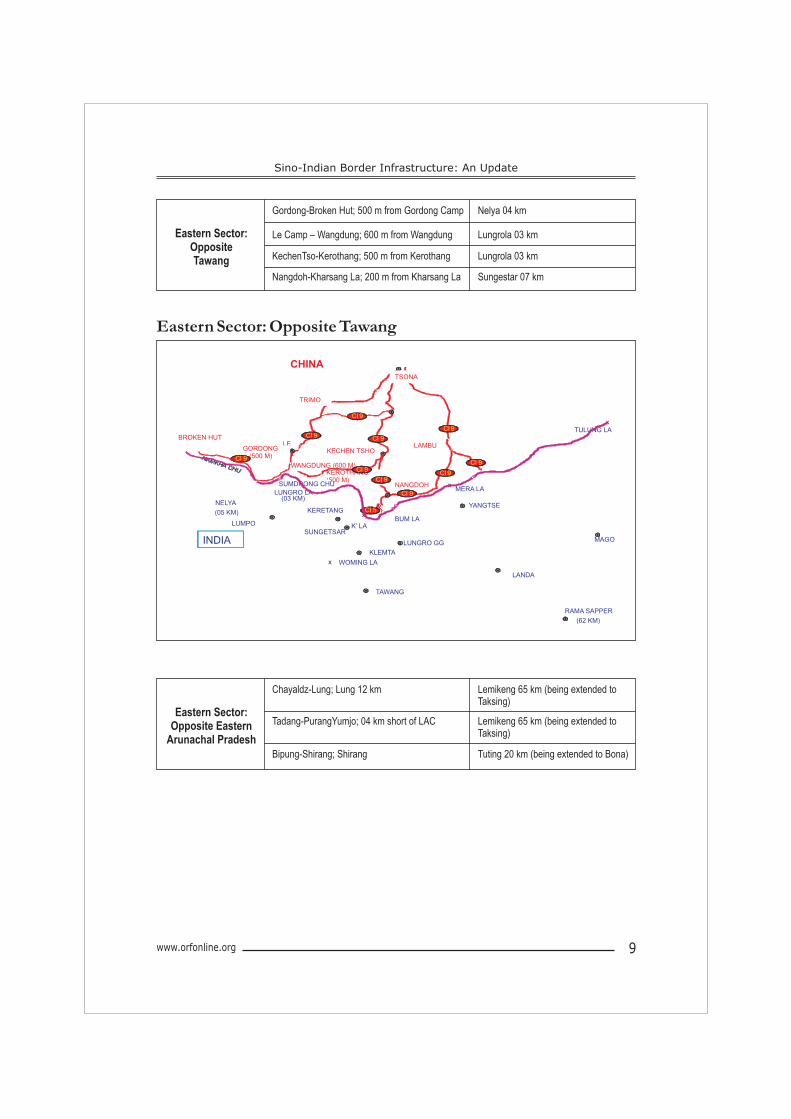
Eastern Sector: Opposite Tawang
www.orfonline.org 9
Gordong-Broken Hut; 500 m from Gordong Camp Nelya 04 km
Le Camp – Wangdung; 600 m from Wangdung Lungrola 03 kmEastern Sector: Opposite Tawang KechenTso-Kerothang; 500 m from Kerothang Lungrola 03 km
Nangdoh-Kharsang La; 200 m from Kharsang La Sungestar 07 km
TULUNG LA
BUM LA
TAWANG
YANGTSE
KLEMTA
LUMPO
KERETANG
LUNGRO GG
LANDA
RAMA SAPPER
(62 KM)
KECHEN TSHO
x
x
WOMING LAx
x
MAGO
LE
WANGDUNG (600 M)KEROTHANG(500 M)
GORDONG(500 M)
TRIMO
TSONA
NANGDOH
LAMBU
BROKEN HUT
NELYA
(05 KM)
LUNGRO LA(03 KM)
K’ LA
x
SUNGETSAR
MERA LAxSUMDRONG CHU
Cl 5
Cl 9Cl 9
Cl 9
Cl 9
Cl 9
Cl 9
Cl 9
Cl 9
INDIA
CHINA
Cl 9
Cl 9
Sino-Indian Border Infrastructure: An Update
Chayaldz-Lung; Lung 12 km Lemikeng 65 km (being extended to Taksing)
Tadang-PurangYumjo; 04 km short of LAC Lemikeng 65 km (being extended to Taksing)
Eastern Sector: Opposite Eastern
Arunachal PradeshBipung-Shirang; Shirang Tuting 20 km (being extended to Bona)
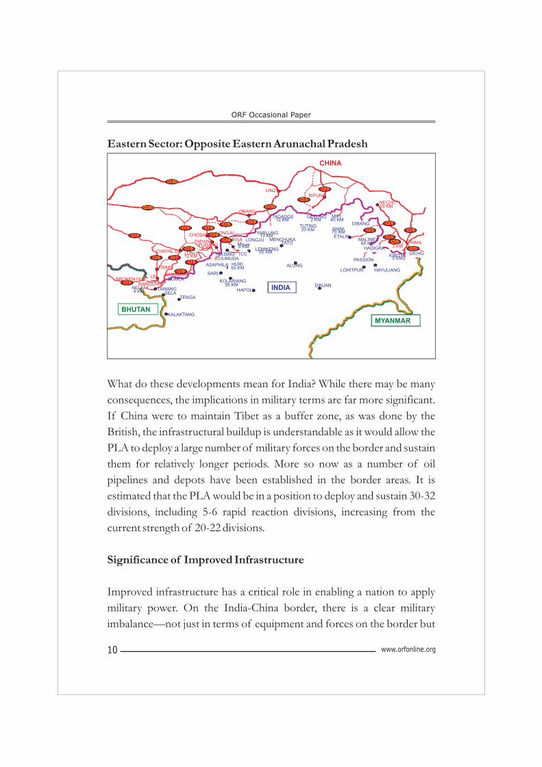
Eastern Sector: Opposite Eastern Arunachal Pradesh
What do these developments mean for India? While there may be many
consequences, the implications in military terms are far more significant.
If China were to maintain Tibet as a buffer zone, as was done by the
British, the infrastructural buildup is understandable as it would allow the
PLA to deploy a large number of military forces on the border and sustain
them for relatively longer periods. More so now as a number of oil
pipelines and depots have been established in the border areas. It is
estimated that the PLA would be in a position to deploy and sustain 30-32
divisions, including 5-6 rapid reaction divisions, increasing from the
current strength of 20-22 divisions.
Significance of Improved Infrastructure
Improved infrastructure has a critical role in enabling a nation to apply
military power. On the India-China border, there is a clear military
imbalance—not just in terms of equipment and forces on the border but
ORF Occasional Paper
www.orfonline.org10
INDIA
BHUTAN
MYANMAR
CHINA
TRIMO
RIMA
NANGDOHLEBROKEN HUT
WANDUNGBUMLA
TAWANG
TENGASELA
KALAKTANG
LUNG12 KM
TADANG
LONGJU
BISA
ORANG
LINZI
PURANG5 KM
CHOSAM
BIPUNG
NECHE10 KM
TATU3 KM
HAPOLI
KOLARIANG95 KM
SARLI
LEMIKENG65 KMTCC
MAJA9 KM
TAKSING12 KM
TATO
ALONG
MENCHUKA
YARLUNG13 KM
HURI55 KM
TADADGE
12 KM
NELYA4 KM
TUTING20 KM
GELLING2 KM
ETALIN
ANINI70 KM
MALINEY65 KM
MIPI40 KM
DINJAN
LOHITPUR
KIBITHU5 KM
HAYULIANG
CHAYAL DZ
ASAPHILA
LONGJU
DIBANG
DICHUOJUMUDA
Cl
50
Cl 50
Cl 9 Cl 9
Cl 9Cl 9
Cl 9
Cl 9 Cl 5
Cl 9
Cl 9
Cl 5
Cl 9
Cl 9Cl 5
Cl 50
Cl 9
PASSION
HADIGRA
Cl 5
Cl 5
Cl 5
Cl 9
Cl 9
Cl 5
Cl 5
also in terms of the physical infrastructure. In the last decade, China has
made tremendous improvements in the infrastructure in the TAR and the
Sino-Indian border. With the massive upgradation, China now has a
40,000 km road network in Tibet and rail links such as the 1,142 km link
between Lhasa and Gormo in Qinghai Province. The improved network
has enabled China to amass large number of forces by train and road in a
relatively short span of time. This exercise earlier took about six months
and was not possible during winters. China has also established multiple 6
air bases and forward airstrips near the border. All these measures have
made movement of troops as well as shifting of logistic supplies much
easier. On the Indian side, many of the roads stop 60 to 80 km before the
LAC, thus affecting troop deployment and forward presence.
The PLA troops remain acclimatized as the military camps are established
close to the border (these are not cantonments).There are only a few
divisions on the Indian side of the border with most of the border forces
being based in the plains of Assam. Given that these forces are virtually at
sea-level, acclimatisation before deployment in the border becomes a
major challenge for the Indian troops.
China has approximately 160,000 troops in Tibet (on border guard and
law and order duties). With the upgraded infrastructure network, it is
capable of mobilising an additional 100,000 troops from the Central 7Reserve within six weeks. Moreover, with the improved infrastructure for
air operations, China is equipped to deploy heavy lift planes in Tibet.
Nevertheless, difficulties to land and take off fully loaded due to altitude
and weight restrictions are an issue. Deployment of intermediate range
ballistic missiles (IRBMs) such as DF-4 and DF-21 is also noteworthy.
There have been reports indicating that China could deploy DF-31
intercontinental ballistic missiles (ICBMs) at the Delingha base close to
Tibet. The fact that China has a modernised logistics system with digitised
www.orfonline.org 11
Sino-Indian Border Infrastructure: An Update
tracking of logistics assets and automated inventory control, which have
been tested in military exercises, enables swiftness and efficiency during
joint operations. In the Indian context, it is particularly relevant that China
has established a logistics park close to the railway and highway networks
in the TAR. A key logistics centre set up in Nagqu Township in the TAR in
2009 caters to Lhasa, Qamdo, Ali and northern Shigatse. The centre
provides assistance in the areas of freight transportation, storage
packaging, processing, distribution and information transaction. The
centre is estimated to handle 2.2 million tonnes of cargo by 2015 and 3.1
million tonnes by 2020. This would include raw minerals (Nagqu is ripe
for mineral exploitation and animal husbandry development), herbs, 8building materials and other goods.
The augmentation of China's air mobile reserve forces that can be flown 9
in rapidly from the East to the Indian borders is significant. These forces
have rapid reaction units which, equipped with small arms and light 10weapons, can be airlifted or sealifted to any terrain (desert, swamp or
11mountain) in just 10 hours after an order is issued. Even though high
altitude and related restrictions are issues, they are being addressed by
lengthening the runways. Development of these forces is significant given 12
that they enhance PLA's ability to engage in short and swift operations.
There have been intense debates on the use of air power and its relevance
in high altitude areas. The fact that China has established air support
infrastructure in high altitude areas suggests that India should not rule out
such operations. India fought a high altitude air war with Pakistan in
Kargil. It has also augmented its strategic airlift capabilities in the border
regions with the induction of heavy transport aircrafts, including the C-
130J.
ORF Occasional Paper
www.orfonline.org12
China's inventory of tanks has not been considered seriously in the Indian
context given the mountainous terrain of the border region. However, it
is a factor, particularly in the Ladakh sector, where once the mountains are
crossed the region presents itself as a high altitude desert.Moreover,
China's artillery with long-distance heavy calibre guns capable of firing up
to 40 km-plus are of significance in this context.
Compared to China's augmented capacities to apply military power in the
border regions, the Indian leadership's approach—political, military and
civilian bureaucracy—comes across as narrow and naïve. This approach,
guided by the argument that improvement in the border infrastructure
would facilitate the Chinese, has however undergone a change in the
recent past.
In 2010, Defence Minister A.K. Antony while addressing a function
organised by the Border Roads Organisation (BRO) said, “Earlier the
thinking was that inaccessibility in far-flung areas would be a deterrent to
the enemies.” He acknowledged that this was an “incorrect approach”
and stated that the government has decided to upgrade roads, tunnels and 13airfields in the border areas. Border Road Organisation Director Lt.
Gen. A.K. Nanda, speaking in a similar vein, stated that border
infrastructure development was not undertaken earlier “by design”,
adding, “our approach has changed and we are building on our capacity, 14modern equipment and workforce”.
Whatever the logic, an underdeveloped border region has serious
consequences for India—the primary one being the inability to deploy
forces on time. This could complicate India's options and lead to an
unfavourable outcome, particularly in the initial stages of a conflict.
www.orfonline.org 13
Sino-Indian Border Infrastructure: An Update
India's Border Infrastructure Initiatives
As mentioned above, India adopted a narrow approach to border
infrastructure projects. With the result that it takes 20 hours to drive a
distance of 500 km (300 miles) from Guwahati to Tawang—a reflection
of the deplorable condition of the road network in the region. It was only
in 2006 that the Cabinet Committee on Security, Government of India,
approved some of the major road and other infrastructural projects in the
border region. The decision entailed building of 72 roads, three airstrips 15and several bridges in the border areas. It was expected that these
measures would have a significant impact on the Indian military's ability to
“swiftly move forces into the region and sustain them logistically in the 16
event of any untoward trouble or emergency”. As of 2010, only nine of
the 72 roads have been completed. The delays have been attributed to
pending and delayed clearance and other administrative processes of the
Ministry of Environment and Forests, as well as shortage of appropriate
and adequate men and machinery. Inadequate funding has also been cited
as a reason, but a study of some of the Comptroller and Auditor General
(CAG) reports reveals that a significant amount of money has remained
unspent. For instance, the report submitted to Parliament in May 2010
records that the unspent amount on border infrastructure and other
security-related spending in 2008-09 was to the tune of 58 per cent. In
addition, it pointed out that apart from the supplementary grants that
remained unused, 97 per cent of the regular funds were not used between
2006 and 2009.
The Central government in 2009 made an investment plan of US$ 3
billion for establishing road networks in the border areas. Reports
indicated that this amount was meant for upgradation of advanced
landing grounds, airfields and construction of roads. For the first time,
these projects were opened up to the private sector to enable timely
ORF Occasional Paper
www.orfonline.org14
implementation. Until then, the engineers of the Indian Air Force or the
BRO remained solely responsible for these projects.
In another announcement in 2005, the Ministry of Road Transport and
Highways made a 100-day agenda allocating Rs. 13,397.2 crore (US$ 2.8
billion) for road construction in Jammu and Kashmir and the Northeast.
The government also mandated deadlines for many of these critical
projects. Projects in Jammu and Kashmir include four-laning of the
Jammu-Srinagar national highway (NH-1A); improving the national
highway 1D (Zozila-Kargil-Leh road); and construction of a 3 km two-
lane road at national highway 1B (Batot-Kishtwar). BRO is implementing
some of these projects at an estimated cost of Rs. 100 crores.
Additionally, the Ministry cleared two other projects worth Rs. 768 crores 17
for the region.
The four-laning of the NH-1A was considered originally as part of the
North-South corridor project but because of the prohibitive cost it was
taken separately. This new road will reduce the distance between Jammu 18and Srinagar by 60 km. The road would be accessible 24/7 with no
interruption during snow in winters, which has been a seasonal problem
that the authorities have been dealing with. Presently, the road is closed
over for six months with essential supplies being transported to the region
by air. Similarly, upgradation of NH-1D is significant as it is one of the
only two roads that connects Ladakh with the rest of the country—the
other being the Leh-Manali highway. It is telling that this road was 19
categorised as a National Highway only in 2006.
www.orfonline.org 15
Sino-Indian Border Infrastructure: An Update
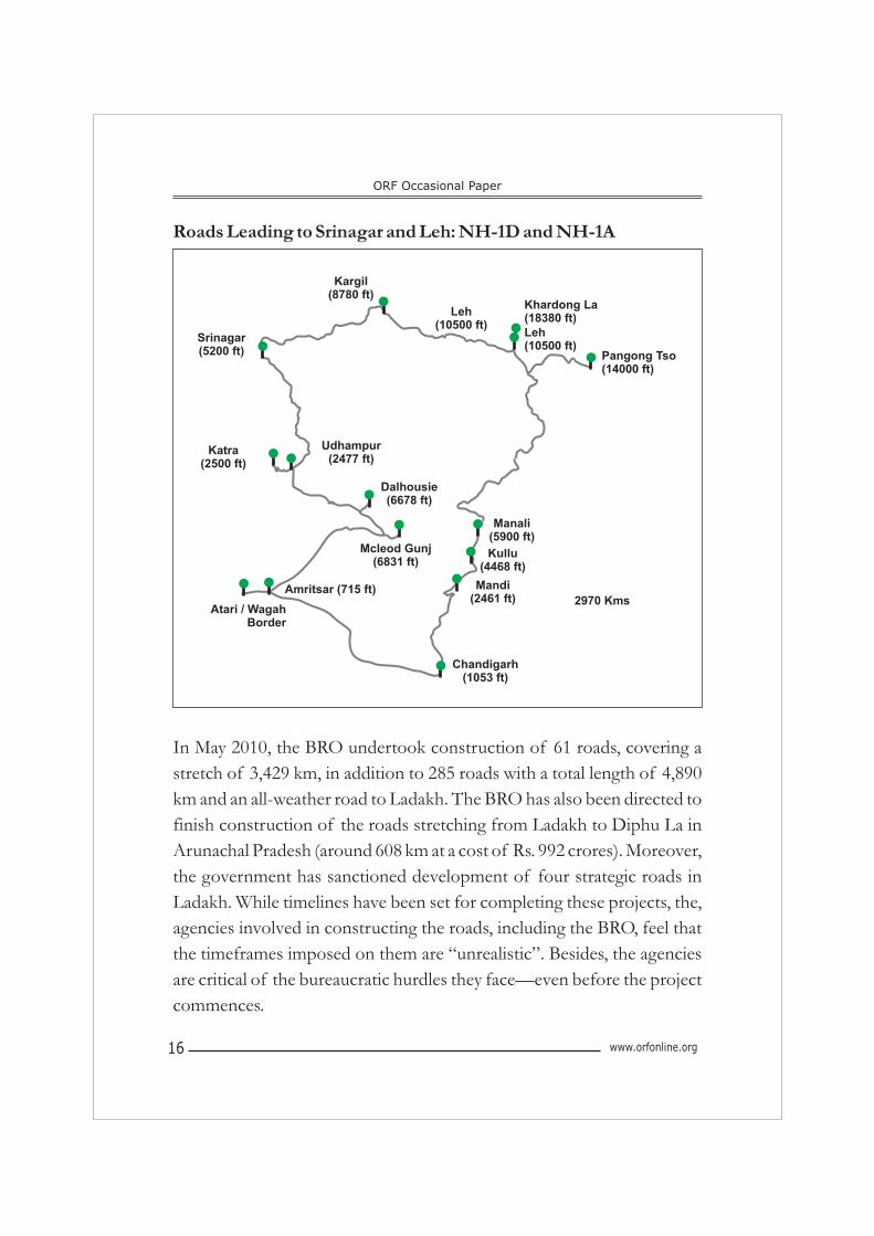
Roads Leading to Srinagar and Leh: NH-1D and NH-1A
In May 2010, the BRO undertook construction of 61 roads, covering a
stretch of 3,429 km, in addition to 285 roads with a total length of 4,890
km and an all-weather road to Ladakh. The BRO has also been directed to
finish construction of the roads stretching from Ladakh to Diphu La in
Arunachal Pradesh (around 608 km at a cost of Rs. 992 crores). Moreover,
the government has sanctioned development of four strategic roads in
Ladakh. While timelines have been set for completing these projects, the,
agencies involved in constructing the roads, including the BRO, feel that
the timeframes imposed on them are “unrealistic”. Besides, the agencies
are critical of the bureaucratic hurdles they face—even before the project
commences.
ORF Occasional Paper
www.orfonline.org16
Kargil(8780 ft)
Srinagar(5200 ft)
Katra(2500 ft)
Udhampur(2477 ft)
Khardong La(18380 ft)
Leh(10500 ft)
Dalhousie(6678 ft)
Manali(5900 ft)
Kullu(4468 ft)
Mandi(2461 ft) 2970 Kms
Chandigarh(1053 ft)
Atari / WagahBorder
Amritsar (715 ft)
Mcleod Gunj(6831 ft)
Leh(10500 ft)
Pangong Tso(14000 ft)
www.orfonline.org 17
India's initiatives in the middle and western sectors of the border are also
equally sensitive and significant. However, the progress has been slow on
both these fronts. In January 2008, a package was announced for the
construction of a rail link between Harmuti (a small town in Assam, 20
located 33 km south of Itanagar) and Itanagar. Other major projects in
the region include two-laning of trans-Arunachal highway from Nechipu
to Hoj; and Potin to Pangin; upgradation of Stillwell road in Arunachal
Pradesh; and four projects of two-laning of roads, including national
highway 154 in Assam. The road density of Arunachal Pradesh is at a
deplorable level of 18.65 km per 100 sq km. as against the national
average of 84 km per 100 sq km.
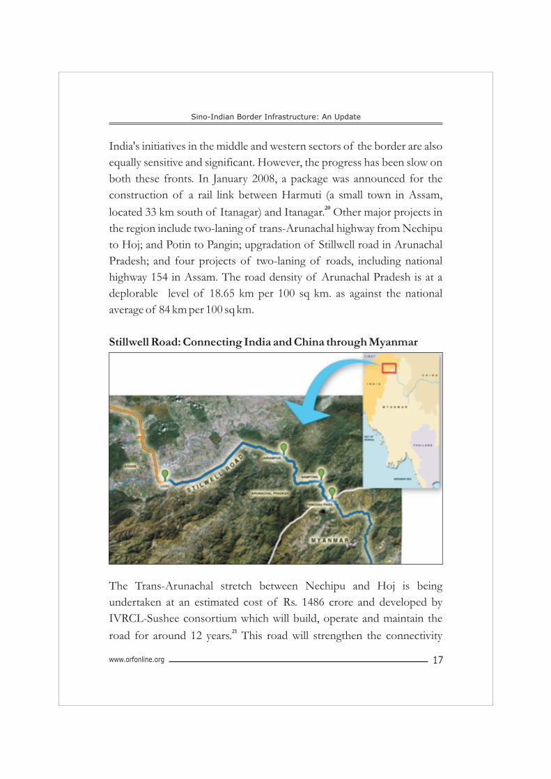
Stillwell Road: Connecting India and China through Myanmar
The Trans-Arunachal stretch between Nechipu and Hoj is being
undertaken at an estimated cost of Rs. 1486 crore and developed by
IVRCL-Sushee consortium which will build, operate and maintain the 21road for around 12 years. This road will strengthen the connectivity
Sino-Indian Border Infrastructure: An Update
ORF Occasional Paper
www.orfonline.org18
within the state in the western districts, such as Seepa and Bomdila with
Itanagar, in addition to adding to the border regional connectivity to
safeguard national security. Upgradation of the Stilwell road in Arunachal
Pradesh would help strengthen regional connectivity among the
northeastern states and help open up direct trade routes to Myanmar and
Thailand.
The road network in Sikkim requires urgent attention as the current road
density is just 28.45 km per 100 sq km. There is just one road linking
Gangtok and Nathu La and one landslide-prone road with a width of 5 m,
connecting the state with the rest of India. The railway network in the
region is next to nil with no trains to India's northeastern states of Sikkim, 22Tripura, Meghalaya, Mizoram and Arunachal Pradesh.
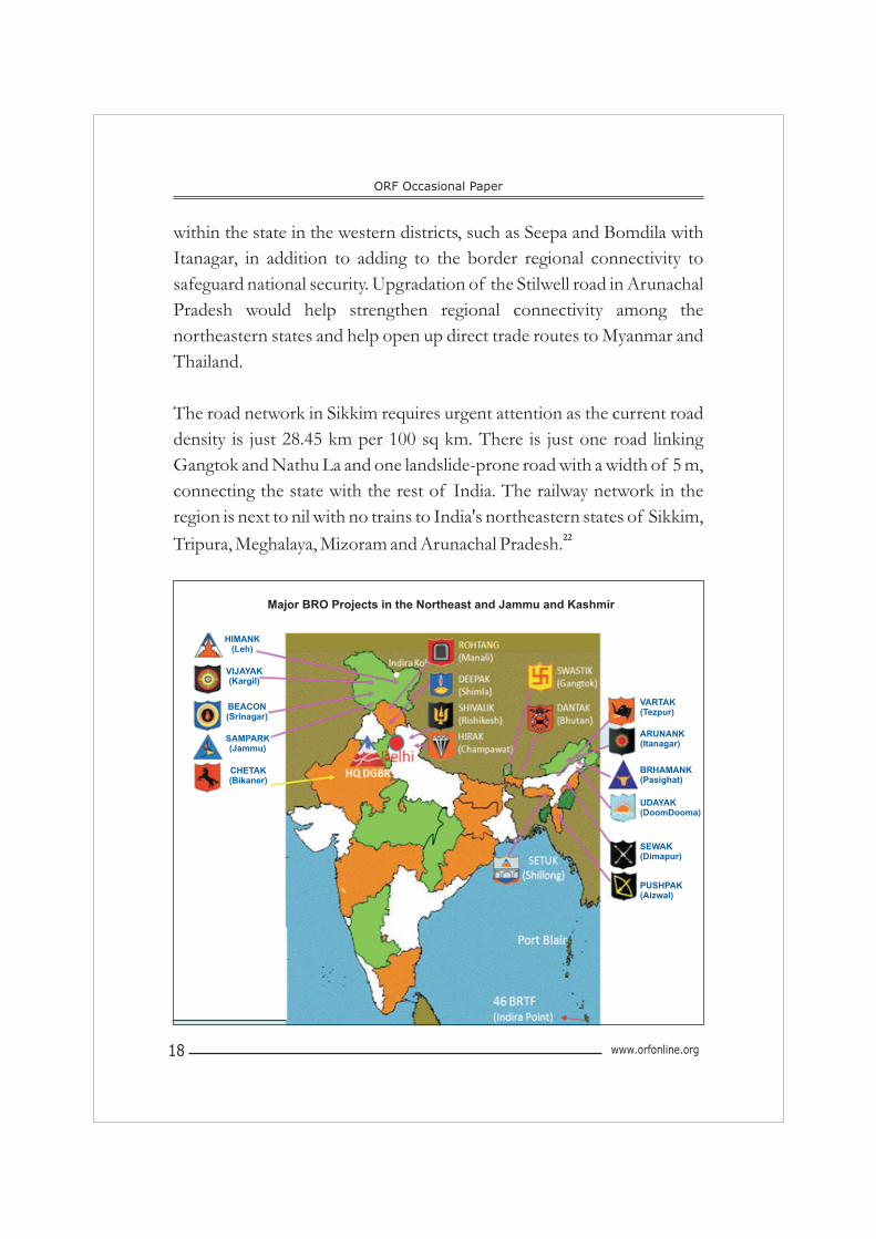
Major BRO Projects in the Northeast and Jammu and Kashmir
HIMANK(Leh)
VIJAYAK(Kargil)
BEACON(Srinagar)
CHETAK(Bikaner)
SAMPARK(Jammu)
VARTAK(Tezpur)
ARUNANK(Itanagar)
BRHAMANK(Pasighat)
UDAYAK(DoomDooma)
SEWAK(Dimapur)
PUSHPAK(Aizwal)
www.orfonline.org 19
While there has been considerable progress in infrastructure projects
along the Indian side of the border, the road projects are lagging behind.
Some of the major projects in the eastern and middle sectors include
Swastik; Vartak; Arunank; Brahmank; on the western sector, they include
Himank; Vijayak; Beacon and Sampark.
Out of the total of 61 roads (3000-plus km) planned in the areas
bordering China, only 15 (500-plus km) have been completed. 27 of the
total planned roads (approx. 1200 km) are currently being constructed
and are expected to be finished within the stipulated timeframe. However,
19 roads (approx. 1550 km) are currently delayed due to many reasons. It
is reported that around 50 per cent of the connecting roads have been
tarred and in around 75 per cent, laying of roads has been completed. A
few other road projects have been held up, including the Flaghill-Dokala 23road in Sikkim. While connectivity has been established in a small
portion of these 19 roads, most of them are yet to be fully connected.
These projects are expected to be completed by the end of 2016. There
are approximately 20 tunnels covering a stretch of 140 km to be
constructed, of which only the Rohtang is in progress as of now. This
momentum may pick up as the tunneling rate per day is expected to
increase from 6 to 20 m in the next few years.
India's Border Projects: Contextualisng the Problem
Rationally analysed, the timeframes set for the BRO seem unreasonable.
Due to the flawed Indian approach of not developing the border regions,
most of these border roads leading to Gangtok, Tawang, among other
places, are single-lane roads. The planners of the last five decades never
visualised the importance of these roads nor the huge volume of traffic
that flows through them today. As a result, the situation today is that there
is a heavy burden to construct new roads while increasing the capacity of
Sino-Indian Border Infrastructure: An Update
ORF Occasional Paper
www.orfonline.org20
existing roads. Also bridge-road construction ratio is skewed in favour of
roads at 5 km of road as against 9 m of bridge construction per day.
The delays are due to many reasons. For instance, while the projects were
initiated in 2007, the funding and clearances from different ministries
including from that of Environment and Forests came much later in
2009/ 2010. This meant that the actual project implementation began
only in 2010-11 and therefore most of the deadlines for 2012 could not be
met. Scarcity of raw materials required for construction, shortage of
officers, poor quality of labour as well as contractors and insecurity in the
region are among the other hurdles that have delayed many of the 24
projects. Moreover, the areas along India's border with China are prone
to natural calamities such as cloudbursts, avalanches, landslides and
earthquakes, which have further derailed projects. BRO has also been
bogged down by red tapism, problems in training of personnel and
lengthy and time-consuming land acquisition processes.
The terrain adds another layer of complication. The Himalayas, being a
young-fold mountain range, are still rising which means that the
construction has to take place on fissured rocks mixed with clay. Given
the north to south flow of rivers on the Indian side, creating lateral
connectivity is hindered. The altitudes at the Indian side of the border
also increase dramatically over short distances rising from near sea level to
17000 feet. This creates problems in building road infrastructure as
valleys and high mountain passes have to be crossed to reach the border.
However, on the Chinese side, the altitudes of the Tibetan plateau remain
almost the same (variation of 2000-3000 feet), making it much easier to
construct roads and railways. On the Indian side, developing inter-valley
connectivity is possible but significantly challenging. Once the initial
projects are completed, the BRO could take up the task of creating lateral
www.orfonline.org 21
connectivity as well. Moreover, construction on the Indian side of the
border is hampered by heavy monsoons; Tibet receives far less rainfall.
In addition to the above requirements of strengthening/developing
connectivity, agencies including BRO are required to maintain strategic
roads in the border region, which run up to about 22,000 km, and around
seven air fields.
Conclusion
A strengthened border infrastructure is of utmost importance for India.
In an era of globalisation, regional and sub-regional economic and trade
linkages are vital drivers of economic growth and prosperity. Improving
border connectivity in order to facilitate stronger linkages with Myanmar,
Thailand and other Southeast Asian countries should be an added
imperative for the country.
Given the baggage of history as well as the increased emphasis on hard
power, infrastructural projects that would augment mobility of forces and
systems, thereby enabling application of military power, should be
considered as a high priority. The comparative exercise in the paper shows
that India is significantly lagging behind. India must attempt at closing
some of the critical gaps in order to meet any challenge on the border
effectively.
India should reconsider its border management approach with an
objective of effective planning and speedy implementation of border
infrastructure projects. A body such as the Cabinet Committee on
Security (CCS) should be made responsible for oversight of critical
projects. The CCS should also include the Ministry of Environment and
Forests while dealing with border infrastructure projects. It could also
Sino-Indian Border Infrastructure: An Update
ORF Occasional Paper
www.orfonline.org22
entrust the responsibility on a national level coordinator for getting all the
clearances and timely implementation of border projects.
The advantages of reviving the original concept behind the creation of
the Sahastra Seema Bal (SSB) should be considered. The concept
originally attempted to include the local population in these areas to
contribute to the region's defence in times of conflict. The renewed
concept could be along the lines of the Territorial Army under the control
of the Ministry of Defence.
The need to establish unity of command in border management is urgent.
India must move away from its current practice of multiple agency
involvement and establish better coordination and efficiency among the
various border forces under a single command.
Above all, responsibility must be fixed for periodic monitoring and
auditing of projects under implementation.
***********************
www.orfonline.org 23
Endnotes:
1. This Paper is an updated version of a previous ORF publication on the
subject published in August 2010. This paper has also benefitted from a
closed-door discussion held on the subject at ORF in 2012.
2. For a detailed study on China's railway development plans, see
Environment and Development Desk, Department of Information and
International Relations, Central Tibetan Administration, Dharamshala,
Himachal Pradesh (India), China's Railway Project: Where will it take Tibet?,
August 2001, available at http://tibet.net/wp-content/uploads/2011/
08/rail_report.pdf.
3. China Tibet Train, Train to Tibet Official Website, available at
http://www.chinatibettrain.com/lhasa-to-nyingchi.htm.
4. Reports indicate that China's new railway links to Pakistan could connect
China to Chabahar in Iran. China is also reportedly considering a railway
network from the Northwestern city of Mashhad on the Eastern border of
Iran up to the port of Chabahar. For details see, “Chinese may build railway
line from Mashhad to Chabahar,” September 10, 2009, available at
http://www.steelguru.com/middle_east_news/Chinese_may_build_
railway_line_from_Mashhad_to_Chabahar/111068.html.
5. Few years back, American satellites detected the movement of 12
consignments of Chinese missiles to Pakistan via Karakoram Highway.
The silkworm missiles that China got in trouble for selling to Pakistan came
only through Karakoram route, whose bridges are reconstructed to handle
heavy freights. Also, North Korea received Uranium enrichment
equipment from the A.Q. Khan network through this route only. See, Pak-
Iran nuclear nexus: UN confirmation, India News Online, September 01,
2003, available at http://74.125.153.132/ search?q=cache:
2gpAqLjg5LMJ:news.indiamart.com/news -analysis/pak-irannuclearnex
874.html+Karakoram+highway,+ Missile,+proliferation&cd=11&hl=en
&ct=clnk&gl=in; Karakoram Highway In China, available at
http://factsanddetails.com/china.php?itemid=441&catid=15&
subcatid=104; and Richard Bond, The Proliferation Security Initiatives:
Sino-Indian Border Infrastructure: An Update
ORF Occasional Paper
www.orfonline.org24
Targeting Iran and North Korea , Occasional Paper on International
Security Policy, Number 53, January 2003, British American Security
Council.
6. Hari Sud, “China's Designs on India's Northeast,” UPI Asia, March 25,
2008, available at http://www.upiasia.com/Security/2008/03/25/
chinas_designs_on_indias_northeast/7412/.
7. Hari Sud, “China's Designs on India's Northeast,” UPI Asia, March 25,
2008, available at http://www.upiasia.com/Security/2008/03/25/
chinas_designs_on_indias_northeast/7412/.
8. “Key Railway Logistics Center Set Up in Tibet,” Xinhua News Agency,
August 18, 2009, available at www.china.org.cn/china/news/2009-
08/18/content_18352718.htm.
9. China's indigenous production and the recent flight test of heavy transport
aircraft Y-20 is of significance. “China's Heavy Transport Aircraft Y-20
Takes First Flight,” Global Times, January 27, 2013, available at
http://www.globaltimes.cn/content/758410.shtml.
10 China's airlift capabilities are not necessarily adequate since they have a
small number of IL-76s. PLAAF is reported to have 18 of them and they
have placed an additional order for 30. As of November 2012, Sergei
Kornev, head of Rosoboronexport's aviation equipment department,
stated that the Russian exporter Rosoboronexport and the Ukrainian
counterpart, Ukrspetsexport were involved in selling new and old IL-76s to
China. The TAPO plant located in Tashkent is also reported to have sold
IL-76s to Beijing. Each IL-76MD is capable of carrying 190 troops or 3
armoured vehicles over a distance of 6,100 km and capable of dropping
them directly to enemy zone. The aircraft's airdrop and cargo handling
equipment allows it to load, unload and airdrop paratroopers, material, and
cargo quickly. In addition, the avionics onboard is capable of executing
airlift and airdrop missions day and night in VFR (visual flight rules) and
IFR (instrument flight rules) weather conditions as well as under hostile air
defence conditions. These are decisive advantages for the PLAAF. For
details on Chinese transport inventory, see IISS Military Balance and “IL-
76MD Transpor t A i rc ra f t” , S inoDefence , ava i l ab l e a t
http://www.sinodefence.com/airforce/airlift/il76.asp.; and Vladimir
www.orfonline.org 25
Karnozov, “China Orders IL-76s as it Awaits IL-476s,” AIN Online,
November 30, 2012, available at http://www.ainonline.com/aviation-
news/ain-defense-perspective/2012-11-30/china-orders-il-76s-it-awaits-
il-476s-1.
11. Klimenko AF, “The Evolution of China's Military Policy and Military
Doctrine,” Military Thought, January 04, 2005; Vol. 14 Nbr. 2.
12. India should take cognizance of these developments and be prepared to
face quick, short military operations by China as they continue to make
political assertions on the border.
13. Vivek Raghuvanshi, “India to Modernize Road Networks in Border
A r e a s , ” D e f e n c e N e w s , M a y 0 7 , 2 0 1 0 , a v a i l a b l e a t
http://www.defencenews.com/ story.php?i=4616391.
14. “India Matching China in Border Infrastructure: PallamRaju,” Economic
T i m e s , S e p t e m b e r 3 0 , 2 0 0 8 , a v a i l a b l e a t
http://economictimes.indiatimes.come/articleshow/3545223.cms.
15. 27 of these roads are in Arunachal Pradesh, 19 in Uttarakhand, 14 in
Jammu and Kashmir, 7 in Himachal Pradesh and 6 in Sikkim. 27 of the
total are developed under the aegis of the Home Ministry and 15 are with
the BRO. The remaining 12 are being constructed by CPWD or state
PWDs. The aim is to construct 72 roads in a time-bound manner with an
initial schedule of completion by 2012.
16. Mohan Malik “India-China Competition Revealed in Ongoing Border
Disputes,” PINR Repor t , October 09, 2007, available at
http://www.pinr.com/report.php?ac=view_printable&report_id=695&l
anguage_id=1.
17. “Government to Revamp Road Infrastructure in Kashmir, Northeast,”
Thaindian News, June 30, 2009.
18. Pranab Dhal Samanta, “A New Road to Srinagar: No Winter Shut-downs,
60 km Less, Four Lanes,” Indian Express, February 18, 2007, available at
http://www.indianexpress.com/news/a-new-road-to-srinagar-no-
w i n t e r - s h u t d ow n s - 6 0 - k m - l e s s - f o u r - l a n e s - - - - - - - - / 2 3 6 2 3 /
#sthash.Xde9b1dn.dpuf.
Sino-Indian Border Infrastructure: An Update
ORF Occasional Paper
www.orfonline.org26
19. “Srinagar-Leh Road Gets National Status, Indian Express, April 23, 2006.
20. “Chapter-1 Economic Planning IN Arunachal Pradesh: An Overview,”
Annual Plan 2008-09, available at http://www.arunachalplan.nic.in/
html/docs/2_AnnualPlan2008_09.pdf.
21. Mamuni Das, “SREI Infra-ECI Consortium May Bag Rs 1,985-crore
Arunachal Highway Project,” Hindu Business Line, March 21, 2011, available
at http://www.thehindubusinessline.com/companies/srei-infraeci-
consortium-may-bag-rs-1985crore-arunachal-highway-project/
article1559119.ece?css=print.
22. SudhaRamachandran, “Indian Might Met with Chinese Threats,” Asia
Times, July 10, 2009.
23. “Govt Moves SC for Road along Indo-China Border in Sikkim,” UNI,
IndLaw News, January 27, 2013, available at http://www.indlawnews.com/
NewsDisplay.aspx?7206faf7-5115-4b37-8d8d-f5488535ef48.
24. According to sources within the government, a shortage of personnel in
the BRO is to the tune of nearly 6000.
Observer Research Foundation is a public policy think-tank that aims to influence formulation of policies for building a strong and prosperous India. ORF pursues these goals by providing informed and productive inputs, in-depth research and stimulating discussions. The Foundation is supported in its mission by a cross-section of India's leading public figures, academics and business leaders.
Observer Research Foundation20, Rouse Avenue, New Delhi-110 002
Email: [email protected]: +91-11-43520020 Fax: +91-11-43520003
www.orfonline.org
RCA HES FE OR U
R N
E D
V A
R T
E IOS B NO