Embed Size (px)
Citation preview

Simon Templer & Thorsten Reitz, wetransform GmbH
24.10.2016 Geonovum, Amersfoort

www.wetransform.to24.10.2016 Geonovum, Amersfoort#2
Thorsten ReitzFounderPreviously:Lead Product Engineer, Esri R&D Center ZurichDepartment Head GEO, Fraunhofer IGD
wetransform GmbHFraunhoferstr. 564283 DarmstadtTel. +49 (6151) 155-408
What we do:
Professional support and consulting for data harmonisation with hale studio
Software as a Service Solutions for agile standardisation (hale connect) and spatial data infrastructures (inspire gis)
Research Data Management
We make Standards Agile.
Simon TemplerFounderPreviously:Research Scentist GEO, Fraunhofer IGD
www.wetransform.to
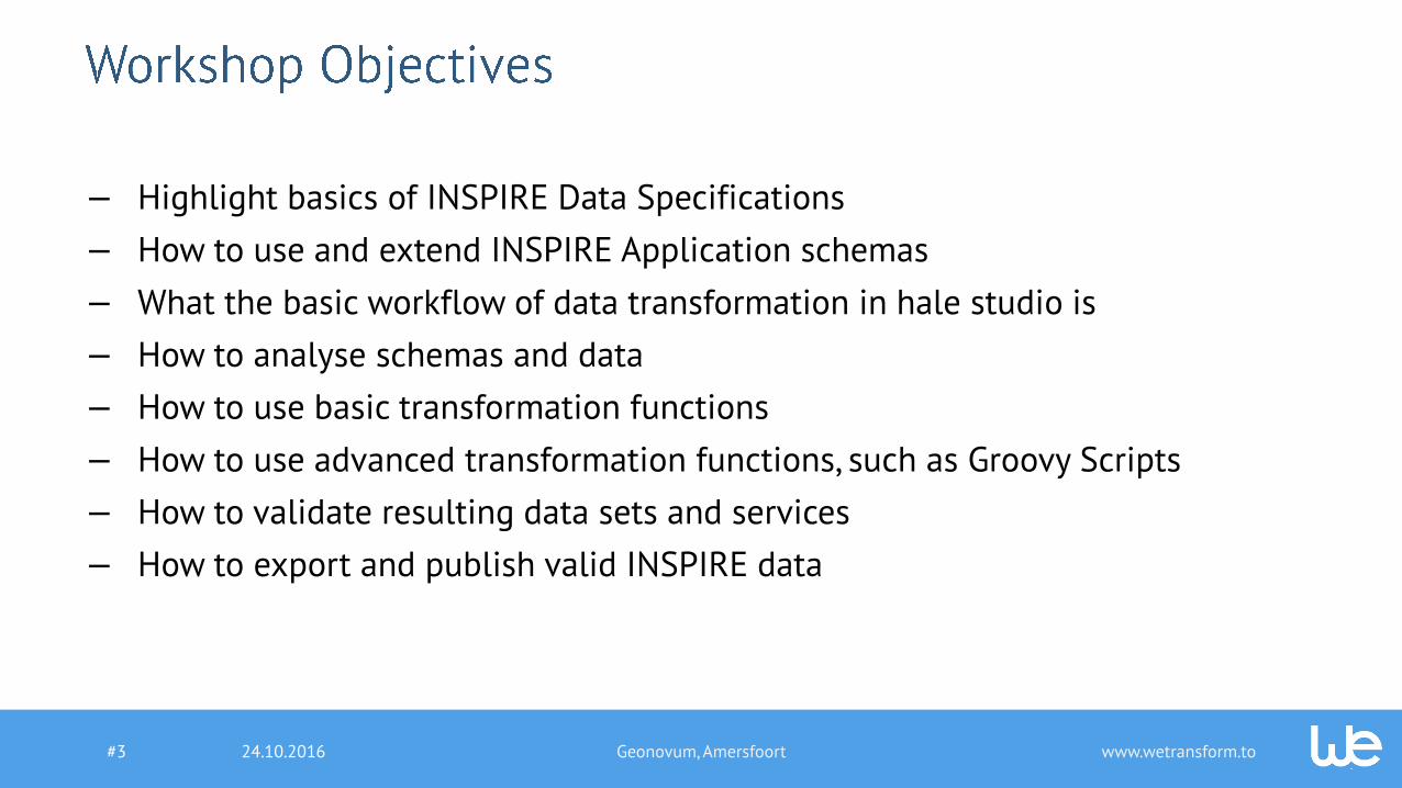
— Highlight basics of INSPIRE Data Specifications
— How to use and extend INSPIRE Application schemas
— What the basic workflow of data transformation in hale studio is
— How to analyse schemas and data
— How to use basic transformation functions
— How to use advanced transformation functions, such as Groovy Scripts
— How to validate resulting data sets and services
— How to export and publish valid INSPIRE data
24.10.2016 Geonovum, Amersfoort#3

www.wetransform.to24.10.2016 Geonovum, Amersfoort#4
09:00 – 09:30 Introduction and agenda
Introduction of participants
Expectations, Goals and Context
09:30 – 10:30 Methods and Concepts for INSPIRE Data Transformation
10:30 – 10:45 Coffee Break
10:45 – 11:30 INSPIRE Data Specifications and Extensions
11:30 – 12:30 Hands-On Basics of hale studio
12:30 – 13:30 Lunch Break
13:30 – 15:15 Hands-On Advanced HALE Features
15:15 – 15:30 Coffee Break
15:30 – 17:30 Hands-On Harmonisation Project for Natura2000 data
www.wetransform.to24.10.2016 Geonovum, Amersfoort#5
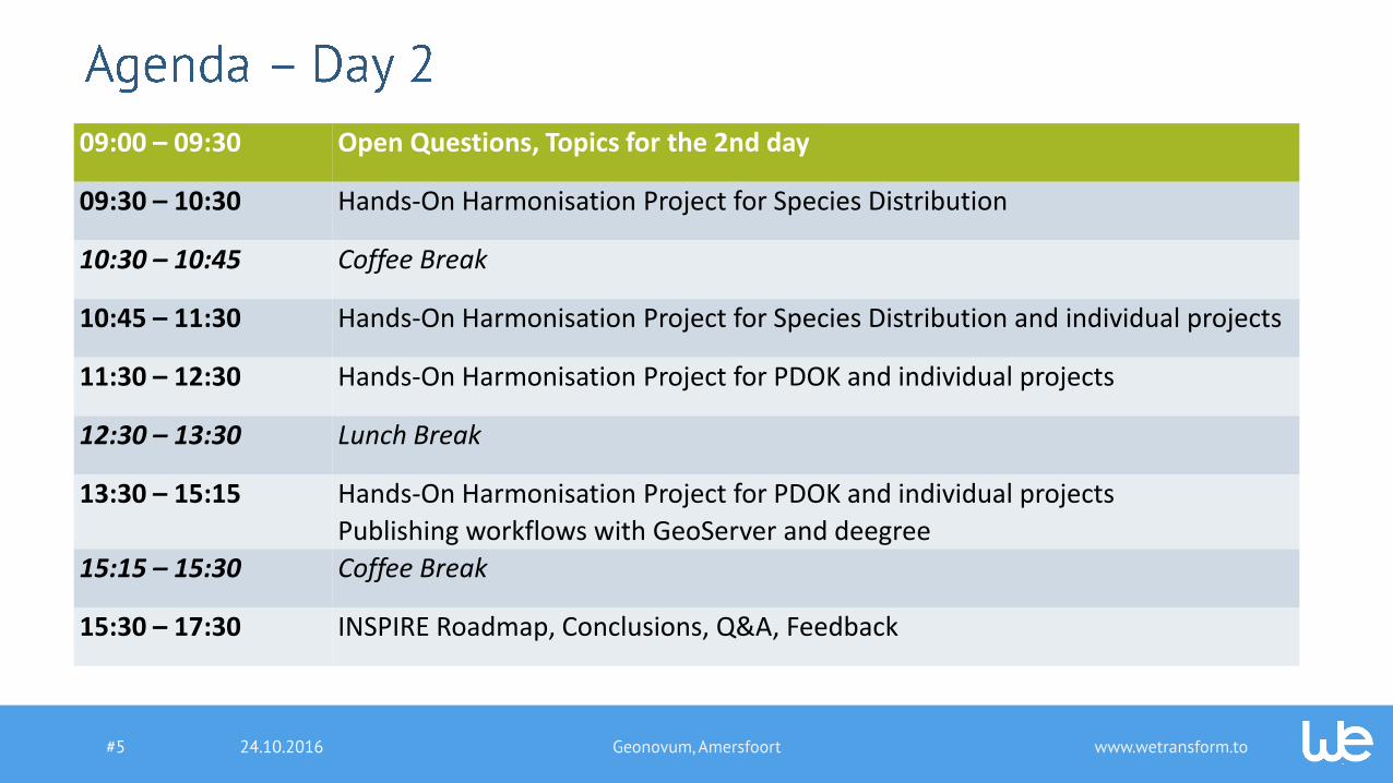
09:00 – 09:30 Open Questions, Topics for the 2nd day
09:30 – 10:30 Hands-On Harmonisation Project for Species Distribution
10:30 – 10:45 Coffee Break
10:45 – 11:30 Hands-On Harmonisation Project for Species Distribution and individual projects
11:30 – 12:30 Hands-On Harmonisation Project for PDOK and individual projects
12:30 – 13:30 Lunch Break
13:30 – 15:15 Hands-On Harmonisation Project for PDOK and individual projects
Publishing workflows with GeoServer and deegree
15:15 – 15:30 Coffee Break
15:30 – 17:30 INSPIRE Roadmap, Conclusions, Q&A, Feedback

www.wetransform.to24.10.2016 Geonovum, Amersfoort#6
Natura 2000 Protected Sites Species Distribution PDOK

www.wetransform.to24.10.2016 Geonovum, Amersfoort#7
Manage Transform Validate PublishModel
*.shp *.gml

www.wetransform.to24.10.2016 Geonovum, Amersfoort#8
Manage Transform Validate PublishModel
WFS PostGreSQL
Oracle WFS-T

www.wetransform.to
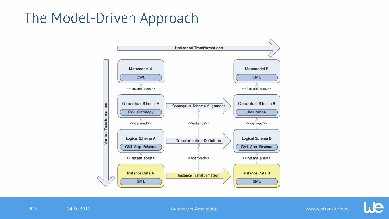
Data Modelling for INSPIRE
24.10.2016 Geonovum, Amersfoort#9

www.wetransform.to24.10.2016 Geonovum, Amersfoort#10

www.wetransform.to
— Consistent and well-structured approach across the teams working on all 34 themes
— Ability to model cross-theme relationships
— Effective re-use and detection of inconsistencies and errors
— Easy generation of encodings and other artifacts such as feature catalogues and mapping tables
24.10.2016 Geonovum, Amersfoort#11

www.wetransform.to24.10.2016 Geonovum, Amersfoort#12
UML

www.wetransform.to24.10.2016 Geonovum, Amersfoort#13
«FeatureType»
ProtectedSite
- geometry: GM_Object- inspireId: Identifier«voidable»- legalFoundationDate: DateTime- legalFoundationDocument: CI_Citation- siteDesignation: DesignationType [1..*]
- siteName: GeographicalName [0..*]
- siteProtectionClassification: ProtectionClassif. [1..*]

www.wetransform.to24.10.2016 Geonovum, Amersfoort#14
www.wetransform.to24.10.2016 Geonovum, Amersfoort#15

www.wetransform.to
— INSPIRE Generic Conceptual Model: This document provides a common technological and methodological framework for the creation of INSPIRE data specifications. It is the baseline document for all model extension work as well.
— TC211 UML Best Practices: This GitHub repository contains best practices on UML modelling in accordance with ISO standards, which is useful for the modelling of the extensions of INSPIRE. The repository also contains Enterprise Architect Model Validation scripts you can use to test you model's compliance to the ISO guidance.
— Guidelines for the encoding of Spatial Data: This document describes how to create interoperable data using a common encoding derived from the conceptual model.
— EN ISO 19101:2005, Geographic information — Reference model: This ISO standard and other in the 191xx series provide the foundation for the INSPIRE Generic Conceptual Model.
24.10.2016 Geonovum, Amersfoort#16

www.wetransform.to
Data Transformation for INSPIRE
24.10.2016 Geonovum, Amersfoort#17

www.wetransform.to
Formats & Encoding
Reference Systems
Classification systems
Definition and Semantics
Multiple Representations
Attribute Types and values
24.10.2016 Geonovum, Amersfoort#18

www.wetransform.to24.10.2016 Geonovum, Amersfoort#19

www.wetransform.to
1. Renaming classes and attributes
2. Simple attribute derivation
3. Aggregating input records
4. Complex derivation and dynamic type selection
5. Deriving values based on multiple features
6. Conflation and model generalisation
24.10.2016 Geonovum, Amersfoort#20

www.wetransform.to
— Verbosity— How many statements are needed to define a mapping?
— Impacts maintenance, effectiveness
— Transparency and Traceability— What happens in the transformation engine? Can I debug it?
— Tools/Implementations— Performance, Reliability, Usability, …
24.10.2016 Geonovum, Amersfoort#21

www.wetransform.to
— Spatial harmonisation— Edge Matching, Reference Systems, Multiple Representations
— Structure— References, Aggregates & Composites, Inheritance
— Quality— Metadata, geometric quality, classification accuracy, ...
— Semantics— Code Lists, Feature Types, nillable properties, geometries,…
24.10.2016 Geonovum, Amersfoort#22

www.wetransform.to
— Declarative Approaches— Describe the logic of a computation without describing its control flow.
— Leave optimization and actual execution order to the runtime engine.
— Examples: XSLT, HALE
— Procedural Approaches— Describe a computation by giving its control flow through a series of functions.
— Examples: Python GeoProcessing Tool, FME
— Other Paradigms (Rule-based, Functional, Object-oriented, Aspect-Oriented, Agent-based…)
24.10.2016 Geonovum, Amersfoort#23

www.wetransform.to
— Data-driven Approaches— Use information available in features (instances) to infer correct transformation
functions to use
— Examples: FCA-Merge, XSLT, FME
— Schema-driven Approaches— Use conceptual schema and define relations based on the elements of the schema
— Examples: PROMT, COMA++ (Protégé), EDOAL/gOML
— Combined Approaches— Use information available on instance level to enhance the quality of an automatically
derived mapping on the extension level
24.10.2016 Geonovum, Amersfoort#24

www.wetransform.to
FME
XQuery
24.10.2016 Geonovum, Amersfoort#25

www.wetransform.to
Name Abstraction SchemaLanguage
Paradigm(s) Primary Driver
Primary Representation
XSLT Logical XSD Declarative+ Data Textual
XQuery Logical XSD Procedural Data Textual
hale (gOML) Conceptual Any Declarative Schema Graphical
RIF Conceptual Any Declarative Data Textual
QVT/ATL Conceptual UML Both Schema Combined
UML-T Conceptual UML Declarative Schema Graphical
GeoKettle Logical Internal Procedural Data Graphical
Talend Logical Internal Procedural Data Graphical
FME Logical Internal Procedural Data Graphical
24.10.2016 Geonovum, Amersfoort#26

www.wetransform.to
Name Tools Domain Expressivity2 Verbosity3 Maturity4
XSLT 10+ Universal + Spatial 80% 11145 4
XQuery 10+ Universal + Spatial 96% 392 4
EDOAL/gOML 2 Universal + Spatial 92% 91 3
RIF 3 Universal 80% 4145 2
QVT/ATL 4+ Universal 76% 117 3
UML-T 1 Universal + Spatial 60% -.- 1
GeoKettle 1 Spatial 96% -.- 3
Talend 1 Universal + Spatial 92% -.- 3
FME 1 Spatial 100% 205 3
1 Research conducted in 2010-2011.2 Coverage of functions listed in [Beare 2010], Appendix 23 Number of statements needed for a set of example projects4 no. of implementations, user base, iterations, functionality5 generated XSLT/RIF
24.10.2016 Geonovum, Amersfoort#27

www.wetransform.to
— How well does an approach cover all activities in my ST project?— If only some steps are covered, which issues are introduced through combination of
multiple approaches?
— How well can I maintain my ST project?— As with any software, a project outcome will loose value quickly if it cannot be
maintained
— How can I document my ST project?— How do I explain to others what tricks I used to get the approach to do what I
wanted?
24.10.2016 Geonovum, Amersfoort#28

www.wetransform.to24.10.2016 Geonovum, Amersfoort#29
www.wetransform.to
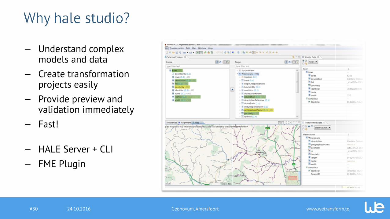
— Understand complexmodels and data
— Create transformationprojects easily
— Provide preview andvalidation immediately
— Fast!
— HALE Server + CLI
— FME Plugin
24.10.2016 Geonovum, Amersfoort#30

www.wetransform.to
2.82.0
2.7
2.6
2.5
2.1 2.91.0 2.1.2 3.0
24.10.2016 Geonovum, Amersfoort#31

www.wetransform.to24.10.2016#32 Geonovum, Amersfoort
Declarative Mapping

www.wetransform.to24.10.2016#33
Declarative Mapping
Easy to author & re-use Fast & Scalable Execution Any data structure & format
Geonovum, Amersfoort

www.wetransform.to24.10.2016#34
Performance (Core i7-4500U, 16GB RAM)
hale studio 3.0
FME 2015
Use Case: 1.3 M Parcels, 3A to INSPIRE – 17 GB Input, 33GB output
0h 44min
47h 12min
hale studio 3.0
FME 2015
Use Case: 230k Buildings, File GDB to CityGML – 1.3 GB Input, 1.6GB output
0h 9min
1h 21min
Geonovum, Amersfoort

www.wetransform.to
Introduction and Maintenance of hale studio
Customer: Landesbetrieb Geoinformation und Vermessung Hamburg
Duration: since July 2015
Objectives:
- Providing hale- and INSPIRE know how
- Create transformation projects
- Extension of hale studio according to customer requirements
Results:
- Hale and INSPIRE workshops on Protected Sites, CadstralParcels and Geology
- Production-ready hale- projects
- Maintenance of deegree Download Services
24.10.2016 Geonovum, Amersfoort#35

www.wetransform.to
GDI InspireUmsetzer
Customer: GDI-Südhessen
Duration: November 2015 bis Juni 2016, Production Operations ongoing
Objectives:
- Really simple provisioning ofINSPIRE services for 6 districtsand 96 municipalities
- Management of data sets,metadata, transformation projectsand services
Results:
- Customisation of hale connectto the requirements ofGDI-Südhessen
24.10.2016 Geonovum, Amersfoort#36

www.wetransform.to
Alignment ALKIS/ATKIS to INSPIRE Annex I
Customer: Arbeitsgemeinschaft der Vermessungsverwaltungen (AdV) DE
Duration: March to September 2016
Objectives:
- Implementation of reference mappings from the AAA XML Schemato the INSPIRE Annex I application schemas
- Formal documentation for schema transformation
Results:
- Hale projects and documentation for the mapping ofALKIS/ATKIS to INSPIRE Annex I Themes
- Extension of hale studio to improve the mapping documentation,such as including DE localisation
24.10.2016 Geonovum, Amersfoort#37

www.wetransform.to24.10.2016 Geonovum, Amersfoort#38

www.wetransform.to
Demo hale studio
24.10.2016 Geonovum, Amersfoort#39

www.wetransform.to
1. 3.1.0: November 20161. Basic Integration with inspire gis/hale connect2. Support for Arcs/Curves3. Improvements to Custom Functions4. MS SQL Server Reader
2. 3.2.0: March 20171. Aspect Mappings2. Spatial Merge3. Spatial Join
3. 3.3.0: July 20171. Hale cloud integration2. Support multiple Geometries in Map and Styling
4. 4.0.0: November 20171. Improved Platform Integration2. 3D Geometry + Raster/Coverage support
24.10.2016 Geonovum, Amersfoort#40

www.wetransform.to24.10.2016 Geonovum, Amersfoort#41

www.wetransform.to24.10.2016#42 Geonovum, Amersfoort
The Platform

www.wetransform.to
— Extend and customize datamodels
— Maintain transformation projects
— Transform and valdiate dataonline
— Publish services
— Fork, Diff, Merge
— Communication & Annotation
24.10.2016#43 Geonovum, Amersfoort

www.wetransform.to24.10.2016#44 Geonovum, Amersfoort
— Software as a Service Solution to fully complywith INSPIRE obligations
— Fulfills INSPIRE SLA, European Privacy Protection Guidelines andISO 27001
— Constantly updated to newINSPIRE versions
— Metadata integration andpublication
— Highly cost effective
www.wetransform.to
Contact us!
+49 6151 155 408
www.wetransform.to
www.linkedin.com/company/wetransform-gmbhhttps://twitter.com/tr_xsdi
24.10.2016 Geonovum, Amersfoort#45