Embed Size (px)
Citation preview
SILVERSTARTELEPHONECOMPANY,INC.
ENVIRONMENTALASSESSMENTOFTHE
WYOMINGLOOPCOMPLETIONPROJECTS
PreparedFor:NationalTelecommunications&InformationAdministration
BroadbandTechnologyOpportunitiesProgram1401ConstitutionAvenueNW
Washington,DC20230
PreparedBy:
POBox8849
Jackson,Wyoming83002
February18,2011

WLCPEA Summary‐PageA NTIA‐BTOPFebruary18,2011
EXECUTIVESUMMARYIntroductionandSetting:ThisEnvironmentalAssessment(EA)hasbeenpreparedtodisclosepotentialenvironmentalimpactsoftheDeliveringOpportunities:InvestinginRuralWyomingBroadband(AwardNumber:NT10BIX5570077)andExpandingGreaterYellowstoneAreaBroadbandOpportunities(AwardNumber:NT10BIX5570078)projects.ThetwoprimarycomponentsoftheprojectsaretheTetonPassSegment(EZGID7080)andtheTogwoteePassSegment(EZGID7357).ForthepurposesofthisEA,theacronymWLCP(WyomingLoopCompletionProjects)hasbeencreatedtodescribethecombinedproposedproject.ThisEAservesseveralfunctions.ItprovidesanalysesandinformationrequiredbytheDepartmentofCommerce’sNationalTelecommunicationsandInformationAdministration(NTIA)underprovisionsoftheNationalEnvironmentalPolicyAct(NEPA)todisclosepotentialimpactsofimplementingSilverStarTelephoneCompany’s(SST)applicationsforgrantsundertheBroadbandTechnologyOpportunityProgram(BTOP).TheEAalsonotesthata“specialusepermit”(SUP)orsimilarpermittingvehiclewillberequiredforSSTtoinstalltheburiedconduitonNationalForestSystem(NFS)orNationalParkSystem(NPS)lands.TheUSFSandNPSwillusetheinformationinthisEAandotherinformationasappropriatetoindependentlymakeadecision,inthiscaseaFindingofNoSignificantImpact(FONSI),astowhetherandunderwhattermsandconditions,SSTcanimplementtheWLCPonNFSandNPSlands.Itwasagreedthatiftheprojectwereapproved,aSUPwouldbeissuedbytheBTNFcoveringboththeBTNFandtheSNFwiththeCTNFissuinganamendmenttoapreviouslyexistingSUPthattheyhaveinplacewithSST.PermitsoragreementswithotheragenciessuchasWYDOT,municipalandcountygovernments,groups,orentitiesarepartoftheanalysisandpermittingprocessesrelatedtothisEA.ProjectNeed:TheStateofWyomingisrectangularwithseveralpopulationcentersdistributednearitsperimetersandinitscenter.AlmosttheentireStateofWyomingisbydefinition,“ruralandremote”withalargeportionofthestateconsistingofruggedmountainousterrain.Allregionsofthecountry,particularlythoseasremoteandruggedasWyoming,haveaneedfordependable,high‐speed,availablebroadbandtelecommunicationsinordertoremaincompetitiveandtoparticipateinmodernformsofcommunicationandservices.NTIAundertheBTOPcriteriarecognizedtheneedtosignificantlyadvancethebroadbandcapabilitiesintheregion,particularlytoimprovethereliabilityandredundancyofcommunicationswithinTetonCountyandtheStateofWyomingbyagreeingtoconsiderfundingtheprojectsbasedoninformationfoundinthisEA.ThisneedhasalsobeenrecognizedforseveralyearsbythevariousfiberopticserviceprovidersinWyoming.Thereisaparticularneedtoallowforadditionaltransport,redundancy,reliability,andbroadbandservicesthroughtheTownofJacksonandTetonCounty.Theneedtoprovidereliabilityandredundancyisunderscoredbytheexistenceof“gaps”intwocriticalloopswithinWyoming’sfiberopticsystem.TheneedtocompletekeyloopsofbroadbandserviceinWyomingisvitalinordertoensurecontinuedserviceswhenlinesarecut,damagedortemporarilytakenoutofserviceforrepair.OutagesofservicetoTetonCounty,lastingfromdaystohours,haveresultedfromaccidentalseveringoffibercableatleastannuallyforthepastseveralyears.Completingtheloopswouldallowservicetocontinuewithoutdisruptionevenifalinewerebroken(plannedredundancy).Theservicesprotectedinthiscaseinvolvenationalsecurity,safety,andlawenforcement,alongwithsupportforschools,libraries,andahostofothercustomercategoriesincludingthe911emergencysystems.ThisneedisalsorecognizedandsupportedbytheOfficeoftheGovernorinalettertotheDepartmentofCommerce(DOC).Internetspeedisalwaysaconsiderationandthusthereisaneedtoupdateandmaintainspeedonacontinuingbasis.
WLCPEA Summary‐PageB NTIA‐BTOPFebruary18,2011
ProjectPurpose:ThepurposeoftheWLCPistocompletetwofiberopticcableringsthatprovideservicetoamajorityoftheStateofWyomingandaportionofeasternIdaho.Thepurposeistoprovidearobustbroadbandnetworkforusebycriticalcommunityfacilities,communityanchorinstitutions,publicsafetyentities,internetserviceproviders,voiceanddataproviders,andforthetransportofthattrafficbothwithinandoutsidethestate.Specifically,thepurposeoftheproposedprojectistwofold:1)tocloseanexistingfiberopticgapoverTetonPasstocompleteaWyoming/Idaholoopand2)tocloseanexistingfiberopticgapbetweenJacksonandTogwoteePasstocompleteamajorintra‐Wyomingloop.ItistheintentoftheWLCPtocreateredundancytoensurereliablebroadbandservicesandneededmiddle‐mileinfrastructuretomeetthefutureneedsofWyoming’sbroadband‐connectedcommunities.Directandindirectbeneficiariesofafast,robustanddiverse(redundant)fiberopticbroadbandnetworktopologyinclude:approximately70percentoftheestimatedstatepopulation;theUniversityofWyomingandfivecommunitycolleges;222Wyomingpublicschools;WYOLINK(WyomingHomelandSecurityCommunicationsInitiative)andotherlocalandstatewideemergencyresponseteamsandrelatedinitiatives;42healthcarefacilities;otherproviders,telecommunicationscarriersandadjoiningstatenetworksseekingorneedingalternateorprotectedbroadbandtransportandcarrierclassserviceroutesinandoutofJackson,andthestateofWyomingingeneral;andstart‐upbusinesseslookingfornetworkreliability,existingbusinessesseekingtoexpandtoothercommunitiesorconnectofficesusinglesscostly,shortertransportandcircuitroutes.TheTetonPassSegmentwasproposedinordertoclosethegapbetweenJackson,Wyoming,andVictor,Idaho,asthefinalpartinanexistingWyoming/Idahofibernetwork.ThisgapoverTetonPassisolatesmuchoftheTetonCountyareafromothercommunicationscarriers,businessentrepreneurs,healthcareproviders,educationalfacilities,andcommunityservices.CompletingthefibernetworkwouldprovideaneededredundantnetworkpathformuchofWyomingandTetonCountycommunicationssubscribersandtheaforementionedemergencyandotherservices.Thissegmentwouldenhancethebroadbandnetworkopportunitiesforhouseholdsandbusinesseswithin11countiesand26ruralcommunitiesinWyomingandIdaho.InitsoriginalsubmittaltoNTIA,SSTproposedtoprovideserviceopportunitiesto12communityanchorinstitutions(CAIs)fortheTetonPassSegment.Eightofthose12areeducationproviders,threearepublicsafetyentities,andoneisamedical/healthcareprovider.OneofthespecialawardconditionsoftheawardbyNTIAundertheBTOPdirectedSSTtoremoveanyduplicationofeffortprovidedbytheTogwoteePassSegment(EZGID7357)thatisprovidedbytheTetonPassSegment(EZGID7080).Inmanywaysthiseffectivelyconsolidatedthetworoutesintoasingleproject.However,atthistimethetwoprojectsremainastwoawardsandretaintheiridentityassuch.SSTthenelectedtoapplythesavingsfromeliminatingtheduplicitybetweentheprojectstowardsprovidingserviceopportunitiestomoreCAIswithintheprojectarea.HencetheTetonPassSegmentwasmodifiedtoprovideserviceopportunitiesto34CAIs;10educationproviders,6publicsafetyentities,3medical/healthcareproviders,and15othergovernment(federal,state,county,andmunicipal)facilities.TheTogwoteePassSegmentfulfillstheneedtocompleteastatewidefiberopticringthatwouldcompletetheconnectionsamongthelargercitiesofJackson,Evanston,GreenRiver,RockSprings,Rawlins,Laramie,Cheyenne,Casper,Riverton,andDubois,affectingnumeroussmallercitiesalongtherouteaswellasmanytownsandcitieslocatedonspursorsmallerfiberrings.ThisexistingfiberopticnetworkformsapartialringconnectingthesecommunitieswitharemaininggapbetweenDuboisandJacksonoverTogwoteePass.ThisgaprestrictstheavailabilityofrobustandprotectedbroadbandopportunitiesforthecitizensandbusinessesofWyoming.Asaresultof
WLCPEA Summary‐PageC NTIA‐BTOPFebruary18,2011
implementingthespecialawardconditionsoftheBTOPaward,theTogwoteePassSegmentincreasedthenumberofserviceopportunitiesforCAIsfrom12to23whichwouldinclude2educationproviders,1publicsafetyentity,1medical/healthcareprovider,1publicairportauthority,and18othergovernmentfacilities.TheproposedWLCPwouldassisttheBTOPandhelpmeetgoalsofnationalbroadbandplansbyprovidingupto1gigabytepersecond(Gb/sec)connectionstoanchorinstitutionsandredundantconnectionreliabilitytoallbroadbandcommunitieswithintheareasinfluencedbytheseincompleteloops.TheproposedprojectaddressesfourofthefivekeypurposesoftheBTOPasestablishedbytheRecoveryandReinvestmentAct(ARRA):
1. TheprojectwillenhancetheavailabilityandprovisionofbroadbandservicestounderservedhouseholdsandbusinessesinwesternWyomingcommunities.
2. Theprojectwillprovidebroadbandaccessandsupporttoschools,libraries,medicalandhealthcareproviders,andwillservetofacilitategreateruseofbroadbandservicesbyvulnerablepopulationswithintheproposedfundedservicearea.
3. Theprojectwillservetoimproveaccesstoanduseofbroadbandservicebypublicsafetyagencieswithintheproposedfundingservicearea,includingcountylawenforcement,fireprotectionandemergencyservice,byenhancingtheeconomicviabilityandavailabilityofhigh‐capacitybroadbandfacilities.
4. Theprojectwillstimulatethedemandforbroadbandbyenhancingitsavailability,andwillstimulateeconomicgrowthandjobcreation.Thesetwoprojectsaloneareestimatedtocreateorsave148directjobsaccordingtotheCouncilofEconomicAdvisor’sguideforestimatingjobcreation.Thiswould,fostereconomicgrowthandadditionaljobcreation.
DescriptionoftheProposedAction:TheWLCPwouldtraversemultiplejurisdictionsincludingthreenationalforests(BTNF,CTNF,andSNF)andGrandTetonNationalPark(GTNP)aswellaslandscontrolledoradministeredbyWYDOT,TownofJacksonandTetonCounty.TetonPassSegment:Theroughly36mileTetonPassSegmentwouldoriginateafewmilessouthofJackson,Wyoming,involveportionsoftheTownofJackson,continuenorthalongUS89/26totheintersectionofWYO22thesegmentwouldheadwestalongWYO22towardsWilsonandTetonPass.ItwouldascendtothepassusingacombinationoftheTrailCreekRoadROWandtheOldTetonPassHighwaywhichisnowabicycle/hikerpathandispaved.AftercrossingTetonPassitwoulduseacombinationofanexistinggravelroadusedtoaccesstheBonnevillePowerAuthoritypowerlineeasementandareasadjacenttotheWYO22ROWtoeventuallyreachtheWyoming/Idahoborder.TheTetonPassSegmentwouldalsoprovideopportunitiesforservicesbyconstructingspurstoTetonScienceSchoolandTetonVillageusingexistingROWsandeasements.ItwouldalsoconnecttoanexistingservicetowerdirectlysouthofTetonPass.FollowingtheexpansionofthenumberofCAIsfrom12to34,twoprefabricatedequipmentcabinetswereaddedtotheprojectinordertoallowformoreefficientuseofthefibernetwork.OnecabinetwouldbenearWilsonElementarySchoolandanotheratthejunctionofWYO390andWestLakeCreekDrive.TogwoteePassSegment:Theroughly66mileTogwoteePassSegmentwouldconnecttotheproposedTetonPassSegmentintheTownofJackson,involveadditionalCAIsandportionsoftheTownofJacksonandtheneventuallyturnnorthalongthewestsideofUS89/26inanexistingROW.TheroutewouldcontinuenorthtoprovideopportunitiesforserviceattheJacksonHole
WLCPEA Summary‐PageD NTIA‐BTOPFebruary18,2011
AirportthennorthagaintoMooseJunctionwhereaspurwouldconnecttoGTNPHeadquartersatMoose,WYwhereatelecommunicationshutwouldbeconstructed.ContinuingnorthfromMooseJunction,thelinewoulduseROWs,easements,andseveraloftheunpavedroadsthemselvesinordertoavoidheavilyforestedandotherenvironmentallysensitiveareas.TheroutewouldagainfollowUS89/26north,fromalocationsouthandeastoftheparkinglotusedfortheCunninghamCabinHistoricSitetoWolffRanchRoad,followingthatroadandeventuallyapowerlineuntilitisboredundertheBuffaloForkRiver.Atthispoint,aspurwouldgowest,alongUS26,toMorantoprovideserviceaccesstotheMoranElementarySchool,FireStation,PostOffice,andfacilitiesatGTNPincludingtheentrancestation.OriginallyatelecommunicationshutwasproposedtobebuiltatMorganbutthatsamehutisnowproposedtobeplacedneartheGTNPHeadquartersinMoose,Wyoming.AftercrossingundertheBuffaloForkRiver,themainroutewouldcontinueeastalongUS26totheBuffaloRangerDistrictoffice(BlackrockRangerStation).AtthedistrictofficetheroutewouldturnnorthandwouldfollowasystemofROWsandroadstoanexistingradiocommunicationscomplexatopthewesternendofRosie’sRidgethenalongvariousFSroadstoTogwoteeMountainLodge.FromthelodgethelinewouldfollowaUS26ROWallthewaytoitsjunctionwiththeDuboisTelephoneExchange(DTE)facilityaboutahalfmileeastoftheBridger‐Teton/ShoshoneNationalForestboundary.AtthisendpointanothertelecommunicationshutwouldbebuilttoconnecttoDuboisTelephoneExchange(DTE).ThishutisdescribedanditspotentialimpactsaredisclosedinthisEAbutitisaconnectedactionthatwouldbepaidforbyDTEandnotfundedundertheEZGID7357BTOPgrant.GeneralConstructionProvisions:Eachsegmentwouldconsistofburyingtwo,1¼‐inchplasticconduitswithonecarryinga96SMFopticalcable(about½‐inchindiameter)insertedbyaircompressionaftertheconduitisburied.Theextraconduitwouldprovideforfutureexpansionasneeded.The1¼‐inchtubingwouldbe‘plowed’about36to48inchesintothegroundusingspecialtrack/wheel‐drivenmachineswithaplowtooth.Formostofthelinetheactualwidthofdisturbancefromthetooth‐plowwouldaverage12‐inchesorless.Crossingofrivers,streams,andcreekswouldinvolveattachinga4‐inchmetalconduittotheundersideofexistingbridgesorusingdirectionalboringequipmentthatinsertstheconduitunderthebedofthewatercourse.Similarly,mostwetlandswithmovingorstandingsurfacewaterwouldbetraversedby‘boring’underthewetlandwithouttheneedtodisturbsoilsorcreateatrench.CrossingofwetlandswouldbedoneunderthetermsandconditionsofNationwideWetlandPermit#12.Lastly,insomesituationsonacase‐by‐casebasis,asmallmicro‐excavatormaybeusedtoworkaroundindividualtreesorverytightcurves.Inaddition,temporalavoidancewouldbeimplementedtoavoiddisturbancestonestingwildlifeorotherseason‐sensitiveresourcesorresourceuses.Multiplecrewswouldinstalltheconduitandcableinatemporary20‐footwideconstructionROW/easementoverroughlytwoseven‐monthsummerseasonsbeginninginMay/June2011onthesouthernandlowerportionsoftheprojectareaandconcludingathigherelevationsasconditionsallow.AllworkisanticipatedtobecompletedbyOctober2012orbefore.Installationwouldbeaccomplishedusingstandardconstructionsupportequipmentsuchastracked/wheeledcableplows,backhoes,excavators,directionalboringequipment,andfueltrucks.Installationofthelineinareasofrockyterrain,orinsomecasesexistingpavement,mayrequirerocksawing(usingadiamondsawtomakeanarrowgaptoadepthof36inches)orusingmicroductingwhereappropriateandapprovedinurbansituations.Electronictransportequipmentwouldbeinstalledinexistingrackspaceandtwosmallprefabricated“huts”constructedspecificallyforthisprojectattheGTNPHeadquartersinMooseandthecommunicationscomplexonTogwoteePass.Constructionequipmentandmaterialswouldbestoredatoneof10staging
WLCPEA Summary‐PageE NTIA‐BTOPFebruary18,2011
areaslocatedatappropriatesitesalongeachsegment.Asidefromtheconduitandcable,ancillaryfacilitieswouldincludehandholesevidencedbysmall,buriedboxesthatproject4to6inchesabovegradewithtreatedpoststomarktheirlocationandthefibercablemarkersasrequired.Alternatives:Incontemplatingarouteorroutestofollowinordertoinstallthefiberopticcable,SSTelectedtoconsideronlythoseoptions/alternativesthatmetthepurposeandneedoftheproposedprojectasdefinedbytheNTIA(particularlytheBTOP),thetechnicalrequirementsforfulfillingthepurposeandneed,andhadaveryhighprobabilityofmeetingthefollowingassumptionsorprovisions:1)followandbecompatiblewithexistinghighwayandutilityright‐of‐ways(ROWs)oreasementswhereverfeasibleandpreferable;2)taketheleastdamagingenvironmentallyoptionwherevertherewasachoicetobemade;3)qualifyforissuanceunderNationwidePermit#12forUtilityCorridorsundertheCleanWaterAct(1972,asamended);4)have“NoEffect”toplantorwildlifespeciesunderprovisionsoftheEndangeredSpeciesAct(1973,asamended);5)havefullconcurrencewiththeWyomingStateHistoricPreservationOfficethatimplementationwouldnotadverselyaffectanyculturalresourcesunderSection106oftheAntiquitiesAct(1906,asamended)6)receivefullconcurrencefromtheNPSandUSFSthatimplementationwouldnotadverselyaffecttheORVsofanywaterwaysprotectedundertheWildandScenicRiversAct(1968,asamended);7)qualifyforconsiderationforaSUPorequivalentbytheUSFSandNPSbybeingincompliancewiththeForestPlansandManagementPlanforGTNP;8)nothaveanyapparentsignificantimpactsasdefinedbytheNationalEnvironmentalPolicyAct(1969,asamended);and9)beabletocompletepermitting,analyses,andimplementationwithinthescheduleandtimeframesoftheoverallprojectrequirementsundertheARRAandBTOPstipulations.Tohelprefineaproposalthatwouldmeettheseassumptions,membersoftheplanningstaffandconsultantsforSSTreviewedagencyplanningdocumentsandmetorspokeinformallywiththeUSFS,NPS,USArmyCorpsofEngineers,WYDOT,TetonCounty,theTownofJackson,andotherstosolicitideasonroutingandpreferredmethodstobeemployed.Thisresultedindevelopingaproposedroute,scheduleandmethodologiesthatmetthegeneralexpectationsofSSTandtheaffectedagenciesandlandowners.NEPArequiresthatataminimumtheNoActionalternativebeevaluatedalongwithaProposedActionAlternative.UndertheNoActionAlternative,theproposedfiberopticcablewouldnotbeinstalled.ImplementationoftheNoActionAlternativewouldmaintainthestatusquowithnochangestothebiotic,abiotic,andhumanenvironment,includingthesocioeconomicelements,attributabletotheWLCP.ForthepurposesoftheEA,thePreferredAlternativeissynonymouswiththeProposedActionAlternative.Otheralternativesthathavethepotentialtofulfillthepurposeandneedfortheprojectalsowereconsidered.TheProposedActionAlternativefortheWLCPmetthebasicrequirements,assumptionsandprovisions.Inaddition,over20otherroutingoptionswereconsideredduringtheinitialanalysisprocessbuteachofthesewasrejectedfornotmeetingoneormoreofthestatedrequirements,assumptions,orprovisions.AdescriptionofthesealternativesandoptionsalongwithdiscussionsofwhytheywereeacheliminatedisfoundinthetextoftheEA.TheEAconcludedthatnoimpactstoanyresourceswouldoccurunderimplementationoftheNoActionAlternativebutthattheadverseconditionsdescribedasexistingconditionsforinfrastructureandinthePurposeandNeedsectionssuchasthelackofredundancyorthecompletionoffiberopticloopswouldpersist.ItalsoconcludedthatthesocioeconomicbenefitsresultingfromtheconstructionandoperationoftheWLCPwouldnotoccur,perhaps
WLCPEA Summary‐PageF NTIA‐BTOPFebruary18,2011
disproportionatelytothoselivinginoutlyingareasofTetonCountywhowantedtoinvolvetheinternetandcommunicationswitheconomicorbusinesspurposes.IftheWLCPwereimplementedasdescribedintheEA,theEAconcludedthatnosignificantimpacts(asdefinedunderNEPA)wouldoccurtoanyoftheresourcesordisciplinesofinterest.ItalsoconcludedthatnopermanentadverseimpactswouldoccurtoanyoftheresourcesordisciplinesiftheWLCPwereimplementedasdescribedandthebestmanagementpracticesandreclamationpracticesasintendedwerealsofollowed.Shorttermimpactsrangedfromnonetoandlongtermimpactsrangedfromnonetominorforalldisciplinesorareasofinterest.MostdisciplineswouldhavenegligibleshorttermimpactsandnolongtermimpactsassociatedwiththeimplementationoftheproposedWLCP.InregardstospecificresourcesandresourceareastheEAconcludedthat:1)short‐termincreasestoambientnoisewouldoccurintheimmediatevicinityoftheinstallationequipmentbutwouldceaseastheequipmentmovedalongtheroute;2)geologicalresourceswouldnotbealteredfromexistingconditionsandthatsoilerosionwouldalsobeunlikely,particularlyifbestmanagementandreclamationmeasureswerefollowed;3)therewouldbenoadverseeffecttowaterresourceswithconcurrencebytheUSACEandWDEQbecauseofavoidance(usingbridges)orboringunderrivers,streamsandwetlandsandbyadheringtothetermsandconditionsofNWP#12andassociatedpermits;4)therewouldbe“NoEffect”tolistedplantorwildlifespecieswithconcurrencebytheUSFWSandthatputtingtherouteinalreadydisturbedsitesandadheringtothebestmanagementprovisions(includingsurveyingfornestingbirdsaheadofconstruction)avoidednewimpactstoplantsandwildlife;5)therewouldbenoimpactstoHistoricandCulturalresourcesbecausethelineavoidedallareasofpotentialandknownoccurrencesandwouldfollowprovisionsrequiredbytheNTIA,USFS,NPS,andSHPO;6)aestheticandvisualresourcesincludingthoseassociatedwithstateandnationalscenicbyways,WildandScenicRivers,nationalforests,nationalparks,WildernessAreas,municipalandcountylands,andwildliferefugeswouldnotbeadverselyaffectedbecausetheactionsareshortterm,mostlyburied,andconformwithrequirements,termsandconditionsofpermits,andoversightbytheaffectedagencies;7)implementingtheWLCPwouldnotresultinanychangestoexistinglanduse;8)therewouldbenoadverseimpactstoinfrastructureasidefromperhapsshorttermtrafficdelayscoupledwithimprovementsinthetelecommunicationinfrastructure;9)therewouldbemanydirect,indirectandcumulativebenefitsinthesocioeconomicconditionsasaresultofmeetingtheneedandfulfillingthepurposeoftheWLCP;10)therewouldbeoverallbenefitstothehealthandsafetyoftheaffectedenvironmentafterinstallationbuttherewouldbeminimal,shorttermimpactsassociatedwiththeconstructionphaseoftheproject(mostlyassociatedwithtrafficdelaysandequipmentoperation);11)theproposedprojectwouldaddcumulativelytothenegativeshorttermimpactsassociatedwithtrafficandhighwayconstruction,repeateddisturbanceofexistingROWsandutilityeasements,generalconstructionandroadmaintenance,humanactivityinremoteareasbutpositivelyformanystatewide,unservedorunderservedsocioeconomicandinfrastructureelements;and12)Theamountsofemissionsfromvehicles,operationofequipmentwillgenerateanestimated100,000poundsofCO2duringthecombinedtwoconstructionperiods.Operationofconstructionvehiclesalongunpavedportionsoftheproposedrouteswilldirectlycreatefugitivedustandwillcontributecumulativelytofugitivedustgeneration.However,theneteffectofdirectandcumulativeimpactstoairqualitywillnotaffectairqualityattainmentstatus.Theentireareawouldremaininattainment.Withimplementationofthemitigationmeasures,installationandoperationoftheproposedfiberopticcableprojectwouldnotconflictwithorobstructimplementationofanyapplicableairqualitygoalsnorviolateanyairqualitystandardsincludingthoseassociatedwithgreenhousegases.
DraftWLCPEA i NTIA‐BTOPFebruary18,2011
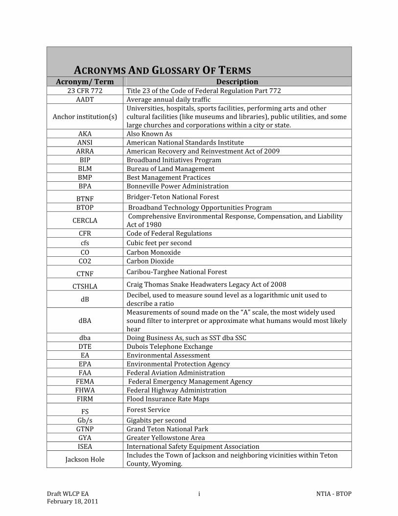
ACRONYMSANDGLOSSARYOFTERMSAcronym/Term Description
23CFR772 Title23ofthe CodeofFederalRegulationPart772AADT Averageannualdailytraffic
Anchorinstitution(s)Universities,hospitals,sportsfacilities,performingartsandotherculturalfacilities(likemuseumsandlibraries),publicutilities,andsomelargechurchesandcorporationswithinacityorstate.
AKA AlsoKnownAsANSI AmericanNationalStandardsInstituteARRA AmericanRecoveryandReinvestmentActof2009BIP BroadbandInitiativesProgramBLM BureauofLandManagementBMP BestManagementPracticesBPA BonnevillePowerAdministration
BTNF Bridger‐TetonNationalForest
BTOP BroadbandTechnologyOpportunitiesProgram
CERCLAComprehensiveEnvironmentalResponse,Compensation,andLiabilityActof1980
CFR CodeofFederalRegulationscfs CubicfeetpersecondCO CarbonMonoxideCO2 CarbonDioxide
CTNF Caribou‐TargheeNationalForest
CTSHLA CraigThomasSnakeHeadwatersLegacyActof2008
dBDecibel,usedtomeasuresoundlevelasalogarithmicunitusedtodescribearatio
dBAMeasurements ofsoundmadeonthe“A”scale,themostwidelyusedsoundfiltertointerpretorapproximatewhathumanswouldmostlikelyhear
dba DoingBusinessAs,suchasSSTdbaSSCDTE DuboisTelephoneExchangeEA EnvironmentalAssessmentEPA EnvironmentalProtectionAgencyFAA FederalAviationAdministrationFEMA FederalEmergencyManagementAgencyFHWA FederalHighwayAdministrationFIRM FloodInsuranceRateMaps
FS ForestService
Gb/s GigabitspersecondGTNP GrandTetonNationalParkGYA GreaterYellowstoneAreaISEA InternationalSafetyEquipmentAssociation
JacksonHoleIncludestheTownofJacksonandneighboringvicinitieswithinTetonCounty,Wyoming.
DraftWLCPEA ii NTIA‐BTOPFebruary18,2011
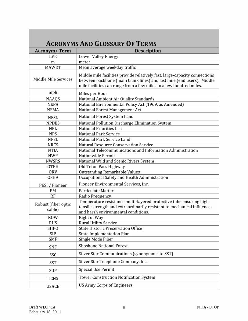
ACRONYMSANDGLOSSARYOFTERMSAcronym/Term Description
LVE LowerValleyEnergym meter
MAWDT Meanaverageweekdaytraffic
MiddleMileServicesMiddlemilefacilitiesproviderelativelyfast,large‐capacityconnectionsbetweenbackbone(maintrunklines)andlastmile(endusers).Middlemilefacilitiescanrangefromafewmilestoafewhundredmiles.
mph MilesperHourNAAQS NationalAmbientAirQualityStandardsNEPA NationalEnvironmentalPolicyAct(1969,asAmended)NFMA NationalForestManagementAct
NFSL NationalForestSystemLand
NPDES NationalPollutionDischargeEliminationSystemNPL NationalPrioritiesListNPS NationalParkServiceNPSL NationalParkServiceLandNRCS NaturalResourceConservationServiceNTIA NationalTelecommunicationsandInformationAdministrationNWP NationwidePermitNWSRS NationalWildandScenicRiversSystemOTPH OldTetonPassHighwayORV OutstandingRemarkableValuesOSHA OccupationalSafetyandHealthAdministration
PESI/Pioneer PioneerEnvironmentalServices,Inc.
PM ParticulateMatterRF RadioFrequency
Robust(fiberopticcable)
Temperatureresistancemulti‐layeredprotectivetubeensuringhightensilestrengthandextraordinarilyresistanttomechanicalinfluencesandharshenvironmentalconditions.
ROW RightofWayRUS RuralUtilityServiceSHPO StateHistoricPreservationOfficeSIP StateImplementationPlanSMF SingleModeFiber
SNF ShoshoneNationalForest
SSC SilverStarCommunications(synonymoustoSST)
SST SilverStarTelephoneCompany,Inc.
SUP SpecialUsePermit
TCNS TowerConstructionNotificationSystem
USACE USArmyCorpsofEngineers
DraftWLCPEA iii NTIA‐BTOPFebruary18,2011
ACRONYMSANDGLOSSARYOFTERMSAcronym/Term Description
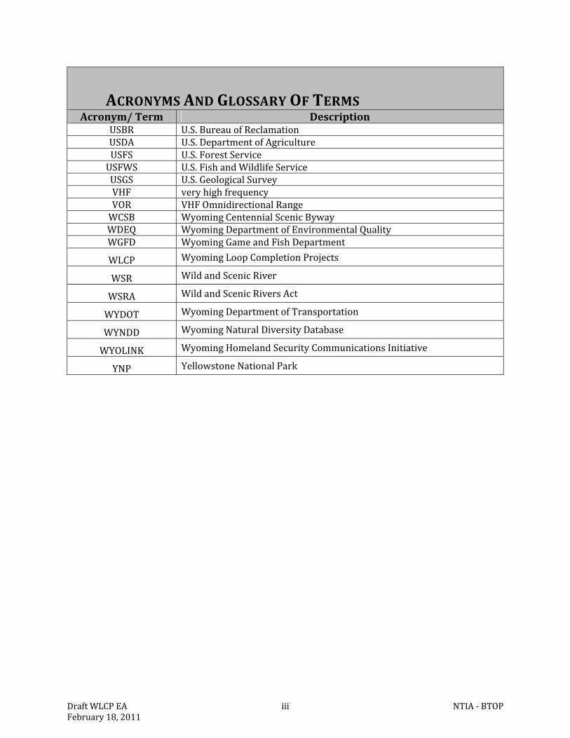
USBR U.S.BureauofReclamationUSDA U.S.DepartmentofAgricultureUSFS U.S.ForestServiceUSFWS U.S.FishandWildlifeServiceUSGS U.S.GeologicalSurveyVHF veryhighfrequencyVOR VHFOmnidirectionalRangeWCSB WyomingCentennialScenicBywayWDEQ WyomingDepartmentofEnvironmentalQualityWGFD WyomingGameandFishDepartment
WLCP WyomingLoopCompletionProjects
WSR WildandScenicRiver
WSRA WildandScenicRiversAct
WYDOT WyomingDepartmentofTransportation
WYNDD WyomingNaturalDiversityDatabase
WYOLINK WyomingHomelandSecurityCommunicationsInitiative
YNP YellowstoneNationalPark
DraftWLCPEA iv NTIA‐BTOPFebruary18,2011
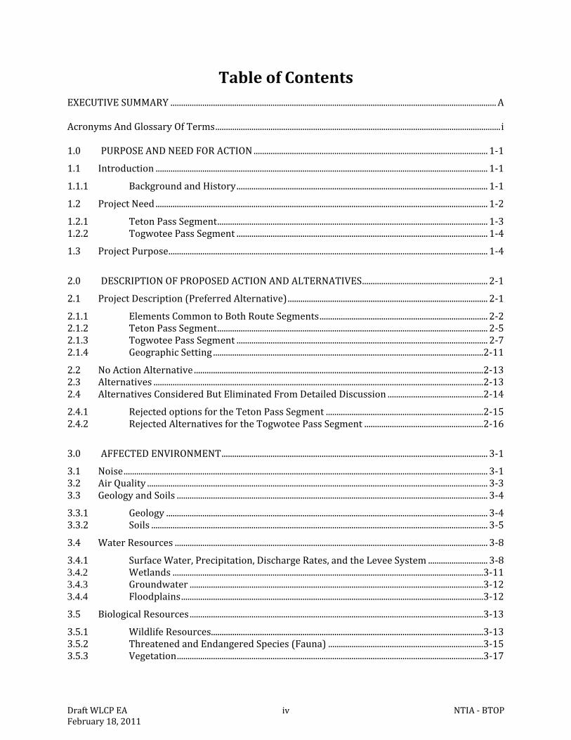
TableofContentsEXECUTIVESUMMARY.........................................................................................................................................................A AcronymsAndGlossaryOfTerms......................................................................................................................................i 1.0 PURPOSEANDNEEDFORACTION..............................................................................................................1‐1
1.1 Introduction............................................................................................................................................................1‐1
1.1.1 BackgroundandHistory......................................................................................................................1‐1
1.2 ProjectNeed............................................................................................................................................................1‐2
1.2.1 TetonPassSegment...............................................................................................................................1‐3 1.2.2 TogwoteePassSegment......................................................................................................................1‐4
1.3 ProjectPurpose......................................................................................................................................................1‐4
2.0 DESCRIPTIONOFPROPOSEDACTIONANDALTERNATIVES...........................................................2‐1
2.1 ProjectDescription(PreferredAlternative)..............................................................................................2‐1
2.1.1 ElementsCommontoBothRouteSegments...............................................................................2‐2 2.1.2 TetonPassSegment...............................................................................................................................2‐5 2.1.3 TogwoteePassSegment......................................................................................................................2‐7 2.1.4 GeographicSetting...............................................................................................................................2‐11
2.2 NoActionAlternative........................................................................................................................................2‐13 2.3 Alternatives...........................................................................................................................................................2‐13 2.4 AlternativesConsideredButEliminatedFromDetailedDiscussion.............................................2‐14
2.4.1 RejectedoptionsfortheTetonPassSegment..........................................................................2‐15 2.4.2 RejectedAlternativesfortheTogwoteePassSegment........................................................2‐16
3.0 AFFECTEDENVIRONMENT.............................................................................................................................3‐1
3.1 Noise...........................................................................................................................................................................3‐1 3.2 AirQuality................................................................................................................................................................3‐3 3.3 GeologyandSoils..................................................................................................................................................3‐4
3.3.1 Geology.......................................................................................................................................................3‐4 3.3.2 Soils..............................................................................................................................................................3‐5
3.4 WaterResources...................................................................................................................................................3‐8
3.4.1 SurfaceWater,Precipitation,DischargeRates,andtheLeveeSystem............................3‐8 3.4.2 Wetlands..................................................................................................................................................3‐11 3.4.3 Groundwater..........................................................................................................................................3‐12 3.4.4 Floodplains..............................................................................................................................................3‐12
3.5 BiologicalResources..........................................................................................................................................3‐13
3.5.1 WildlifeResources................................................................................................................................3‐13 3.5.2 ThreatenedandEndangeredSpecies(Fauna).........................................................................3‐15 3.5.3 Vegetation................................................................................................................................................3‐17
DraftWLCPEA v NTIA‐BTOPFebruary18,2011
3.5.4 ThreatenedandEndangeredSpecies(Flora)...........................................................................3‐19
3.6 HistoricandCulturalResources...................................................................................................................3‐19
3.6.1 ArcheologicalResources....................................................................................................................3‐19 3.6.2 ArchitecturalResources.....................................................................................................................3‐21 3.6.3 NativeResources..................................................................................................................................3‐21
3.7 AestheticandVisualResources.....................................................................................................................3‐22
3.7.1 StateandNationalScenicByways.................................................................................................3‐23 3.7.2 WildandScenicRivers.......................................................................................................................3‐25 3.7.3 NationalParks,NationalForests,WildernessAreas,andWildlifeRefuges.................3‐26 3.7.4 StateLands..............................................................................................................................................3‐26 3.7.5 MunicipalandCountyLands............................................................................................................3‐26
3.8 LandUseandRecreation.................................................................................................................................3‐27 3.9 Infrastructure.......................................................................................................................................................3‐28
3.9.1 Communications&Utilities..............................................................................................................3‐28 3.9.2 ExistingRoadNetwork.......................................................................................................................3‐29
3.10 SocioeconomicResources...............................................................................................................................3‐31
3.10.1 DemographicsandPopulation........................................................................................................3‐31 3.10.2 EmploymentandIncome..................................................................................................................3‐31
3.11 HealthandSafety................................................................................................................................................3‐32
3.11.1 TRAFFIC....................................................................................................................................................3‐32 3.11.2 ContaminatedSitesandOtherAdverseHealthEffects.........................................................3‐33
4.0 ENVIRONMENTALCONSEQUENCES...........................................................................................................4‐1
4.1 Noise...........................................................................................................................................................................4‐1
4.1.1 NoActionAlternative............................................................................................................................4‐1 4.1.2 ProposedActionAlternative..............................................................................................................4‐1
4.2 AirQuality................................................................................................................................................................4‐3
4.2.1 NoActionAlternative............................................................................................................................4‐3 4.2.2 ProposedActionAlternative..............................................................................................................4‐3
4.3 GeologyandSoils..................................................................................................................................................4‐4
4.3.1 NoActionAlternative............................................................................................................................4‐4 4.3.2 ProposedActionAlternative..............................................................................................................4‐4
4.4 WaterResources...................................................................................................................................................4‐6
4.4.1 NoActionAlternative............................................................................................................................4‐6 4.4.2 ProposedActionAlternative..............................................................................................................4‐6
4.5 BiologicalResources..........................................................................................................................................4‐10
4.5.1 NoActionAlternative..........................................................................................................................4‐10 4.5.2 ProposedActionAlternative............................................................................................................4‐10
4.6 HistoricandCulturalResources...................................................................................................................4‐15
DraftWLCPEA vi NTIA‐BTOPFebruary18,2011
4.6.1 NoActionAlternative..........................................................................................................................4‐15 4.6.2 ProposedActionAlternative............................................................................................................4‐16
4.7 AestheticandVisualResources.....................................................................................................................4‐19
4.7.1 NoActionAlternative..........................................................................................................................4‐19 4.7.2 ProposedActionAlternative............................................................................................................4‐19
4.8 LandUseandRecreation.................................................................................................................................4‐23
4.8.1 NoActionAlternative..........................................................................................................................4‐23 4.8.2 ProposedActionAlternative............................................................................................................4‐23
4.9 Infrastructure.......................................................................................................................................................4‐24
4.9.1 NoActionAlternative..........................................................................................................................4‐24 4.9.2 ProposedActionAlternative............................................................................................................4‐24
4.10 SocioeconomicResources...............................................................................................................................4‐26
4.10.1 NoActionAlternative..........................................................................................................................4‐26 4.10.2 ProposedActionAlternative............................................................................................................4‐26
4.11 HealthandSafety................................................................................................................................................4‐27
4.11.1 NoActionAlternative..........................................................................................................................4‐27 4.11.2 ProposedActionAlternative............................................................................................................4‐27
4.12 CumulativeEffects..............................................................................................................................................4‐30
4.12.1 traffic,multi‐usepathway,androadinfrastructure...............................................................4‐30 4.12.2 Soils,VegetationandWildlife..........................................................................................................4‐31 4.12.3 SocioeconomicandInfrastructureDevelopment....................................................................4‐32
5.0 APPLICABLEENVIRONMENTALPERMITSANDREGULATORYREQUIREMENTS..................5‐1
5.1 NationalPollutionDischargeEliminationSystem(NPDES)PermitforStormWaterDischargesAssociatedwithConstructionActivities.............................................................................5‐1
5.2 U.S.ArmyCorpsofEngineers,WyomingRegulatoryOfficeandWyomingDepartmentofEnvironmentalQuality......................................................................................................................................5‐1
5.3 U.S.FishandWildlifeService,EcologicalServicesOffice.....................................................................5‐1 5.4 WyomingDepartmentofTransportation...................................................................................................5‐2 5.5 WyomingStateHistoricPreservationOffice,CheyenneOffice..........................................................5‐2 5.6 U.S.ForestService,Bridger‐TetonNationForestOffice.......................................................................5‐3 5.7 NationalParkService..........................................................................................................................................5‐3 5.8 EnvironmentalJustice.........................................................................................................................................5‐3 5.9 TheWildandScenicRiversActthroughNFSLandNPSL....................................................................5‐4 5.10 TetonCountyPlanningCommission.............................................................................................................5‐4 5.11 TownofJackson.....................................................................................................................................................5‐4
6.0 LISTOFAGENCIESANDPERSONSCONSULTED....................................................................................6‐1 7.0 REFERENCES.........................................................................................................................................................7‐1 8.0 LISTOFPREPARERS..........................................................................................................................................8‐1
DraftWLCPEA vii NTIA‐BTOPFebruary18,2011
ListofTablesTable2‐1.TotalmilesofjurisdictionscrossedbytheproposedTetonPassSegment..........................2‐6 Table2‐2.TotalmilesofjurisdictionscrossedbytheproposedTogwoteePassSegment...............2‐10 Table2‐3.RoutesorportionsofroutesconsideredasoptionsfortheTetonPassSegmentbut
dismissedfromdetailedanalysisorconsiderationofbeingpartoftheProposedAction.........................................................................................................................................2‐15
Table2‐4.RoutesorportionsofroutesconsideredasoptionsfortheTogwoteePassSegmentbutdismissedfromdetailedanalysisorconsiderationofbeingpartoftheProposedAction.........................................................................................................................................2‐17
Table3‐1.Decibellevelsoftypicalsounds.*...........................................................................................................3‐1 Table3‐2.AirPollutionlevelsinTetonCounty,Wyomingduring20051...................................................3‐3 Table3‐3.WSRAOutstandingRemarkableValuesidentifiedfortheSnakeRiverHeadwaters.....3‐25 Table3‐4.NumberofTetonCountyresidentsemployedbyindustry.......................................................3‐31
ListofFiguresFigure2‐1.LocationoftheWyomingLoopCompletionProject(WLCP),TetonCounty,
Wyoming.......................................................................................................................................................2‐12 Figure3‐1GreaterYellowstoneEcosystem...........................................................................................................3‐23 Figure3‐2.WyomingCentennialScenicByway:DuboistoPinedale.........................................................3‐24
ListofAppendicesAppendixA–LargeTablesAppendixB‐MapsAppendixC–Drawings,Figures,andPhotosofAncillaryFacilitiesandEquipmentAppendixD–SynopsesofReportsSpecificallyIncludedbyReferenceAppendixE‐CorrespondenceAppendixF–BestManagementPracticesandRecommendations
WLCPEA 1‐1 NTIA‐BTOPFebruary18,2011
1.0 PURPOSEANDNEEDFORACTION
1.1 INTRODUCTION
ThisEnvironmentalAssessment(EA)hasbeenpreparedtodisclosepotentialenvironmentalimpactsoftheDeliveringOpportunities:InvestinginRuralWyomingBroadband(AwardNumber:NT10BIX5570077[EZGID7080])andExpandingGreaterYellowstoneAreaBroadbandOpportunities(AwardNumber:NT10BIX5570078[EZGID7357])projects.Thetwoprimarycomponentsoftheprojects,theTetonPassSegmentandtheTogwoteePassSegment,areshowninFigure1‐1belowandaredescribedindetailinChapter2.ForthepurposesofthisEA,theacronymWLCP(WyomingLoopCompletionProjects)hasbeencreatedtodescribetheproposedproject.Whereappropriate,eachproposedprojectisdefinedseparatelyasoneoftwosegments;theTetonPassSegmentortheTogwoteePassSegmentorjointlyasWLCP.In2009,CongresspassedtheAmericanRecoveryandReinvestmentActof2009(ARRA,2009)asadirectresponsetotheeconomiccrisis.TheARRAhasthreeimmediategoals:
Createnewjobsandsaveexistingones Spureconomicactivityandinvestinlong‐termgrowth;and Fosterunprecedentedlevelsofaccountabilityandtransparencyingovernmentspending
TheproposedWLCPispartlyfundedbytheARRAandmeetstheintentofthislegislation,ThisEAservesseveralfunctions.ItprovidesanalysesandinformationrequiredbytheDepartmentofCommerce’s(DOC)NationalTelecommunicationsandInformationAdministration(NTIA)underprovisionsoftheNationalEnvironmentalPolicyAct(NEPA)todisclosepotentialimpactsofSilverStarTelephoneCompany’s(SST)applicationsforgrantsundertheBroadbandTechnologyOpportunityProgram(BTOP).TheEAalsonotesthataspecialusepermit(SUP)orsimilarpermittingvehiclewillberequiredforSSTtoinstalltheburiedconduitonNationalForestSystem(NFS)orNationalParkSystem(NPS)lands.EachoftheseagencieswillusetheinformationinthisEAandotherinformationasappropriatetoindependentlymakeadecisionastowhetherandunderwhatconditions,SSTcanimplementtheWLCPonNFSandNPSlands.Itwasagreedthatiftheprojectwereapproved,aSUPwouldbeissuedbytheBridger‐TetonNationalForest(BTNF)whichwillcoverboththeBTNFandtheShoshoneNationalForest(SNF)withtheCaribou‐TargheeNationalForest(CTNF)issuinganamendmenttoapreviouslyexistingSUPwhichtheyhavewithSST.PermitsoragreementswithotheragenciessuchasWyomingDepartmentofTransportation(WYDOT),municipalandcountygovernments,groups,orentitiesarepartoftheanalysisandpermittingprocessesrelatedtothisEAandareidentifiedinthetextaswell.
1.1.1 BACKGROUNDANDHISTORY
Originally,SST(alsodbaSilverStarCommunications[SSC])providedbasictelephoneservicetoStarValley,Wyoming.SSThassinceevolvedintoafull‐scaletechnologycompanyofferingcommunicationsandbroadbandservicestoawidegeographicareacoveringeasternIdahoandnorthwesternWyoming.SSTprovidesservicesinallofStarValley,Wyoming;SodaSprings,Idaho;Irwin,Idaho;SwanValley,Idaho;TetonValley,Idaho;Jackson,Wyoming;andTetonCounty,Wyoming.SSTprovidestheseruralcommunitieswithavarietyofservices,directlyand/orbyprovidingservicestoothercommercialcarriers.MostrecentlySSTsoughttomakealargeinvestmentintothecommunicationsandbroadbandinfrastructuretoensurethattheycouldmeet
WLCPEA 1‐2 NTIA‐BTOPFebruary18,2011
thefuturedemandsoftheindustryandservetheresidentswithstate‐of‐the‐art,highstandardcommunicationservices,aswellascomplete“loops”fortheirwholesaleclientsandothercarriersintheWest,includingSST.SSThasfiberconnectivitythroughouttheirnetworkandhasmadeplanstocontinuemodifyingandimprovingtheirsystemstohandlefuturetechnologies,Hence,whentheopportunityarosetomakethosetechnologicalenhancementsundernewfederalprogramssuchastheBroadbandTechnologyOpportunitiesProgram(BTOP)andRuralUtilityService(RUS)program,SSTrespondedwithapplicationsforconstructingseveralproposedfiberopticroutesinWyoming.TheAARAsupportsthefederalgovernment’slongstandinggoalofmakinghigh‐speedinternetaccesswidelyavailableacrosstheUnitedStates.TheARRAhas,inpart,madefundingavailabletotheDepartmentofCommerce’sNTIAandtheAgriculturalDepartment’sRuralUtilityService(RUS).WiththisfundingtheNTIAdevelopedtheBTOPandtheRUSdevelopedtheBroadbandInitiativesProgram(BIP).TheNTIAsupportsgrantsandloansforprojectsthatdocumentandmapexistingbroadband;increasebroadbanduseinunderservedareas;providebroadbandtrainingandsupporttoschools,libraries,healthcareproviders,andotherorganizations;andimprovebroadbandaccesstolocalpoliceandfiredepartments.TheBIPwasformedtofundgrantsandloansexclusivelyforbroadbandinruralandremoteareas.SST’sproposedprojectisspecificallysupportedbytheOfficeoftheWyomingGovernor,asstatedintheirApril30,2010letterincludedinAppendixE.Theletterstatesthat,“AspecialpriorityforbroadbandstimulusinWyomingistocompleteastatewidefibernetworkwithredundant,self‐healingnetworkarchitecturecapableofsupportingarobustbroadbandenvironment”.Redundantinthiscontextreferstoaclosedfiberopticloop,whichprotectsservicealongthelineifdisruption(plannedorunplanned)occurs.
1.2 PROJECTNEED
TetonCountyhasbeenoneofthefastestgrowingcountiesinWyomingduetothescenicandnaturalvalueofthearea.ItishometoGrandTetonNationalPark(GTNP)andservesasagatewaytoYellowstoneNationalPark(YNP).TetonCountyincludesthepopulationcentersofJackson,Wilson,Moran,Kelly,TetonVillage,andMoose.NTIAundertheBTOPcriteriarecognizedtheneedtosignificantlyadvancethebroadbandcapabilitiesintheregion,particularlyimprovingthereliabilityandredundancyofcommunicationswithintheStateofWyomingbyagreeingtofundtheprojects.ThisneedhasalsobeenrecognizedforseveralyearsbythevariousfiberopticserviceprovidersinWyoming.Thereisaparticularneedtoallowforadditionaltransport,redundancy,reliability,andbroadbandservicesthroughtheTownofJacksonandTetonCounty.Theneedtoprovidereliabilityandredundancyisunderscoredby“gaps”intwocriticalloopswithinWyoming’sfiberopticsystem.TheneedtocompletekeyloopsofbroadbandserviceinWyomingisvitalinordertoensurecontinuedservicesincaselinesarecut,damagedortemporarilytakenoutofserviceforrepair.Completingtheloopswouldallowservicetocontinuewithoutdisruptionevenifalinewerebroken(plannedredundancy).Servicesinthiscaseinvolvenationalsecurity,safety,andlawenforcement,alongwithsupportforschools,libraries,andahostofothercustomercategoriesincludingthe911emergencysystem.TheneedforthistypeofredundancyfortheentireStateofWyomingaswellasTetonCountyhasbeendemonstratedinrecentyearswhenalinenear
WLCPEA 1‐3 NTIA‐BTOPFebruary18,2011
Evanstonwasaccidentallycutduringconstructionleavingmuchofthestate,includingJacksonandTetonCounty,without911service,landlinevoiceservice,internetaccess,andcellularservice.Plannedredundancyisevenmorecrucialwhenoneconsidersthatnearlyallofthedatatransfer,internet,long‐distancetelephoneserviceandothertelecommunicationservicesareusuallyroutedthroughdistantpointssuchasCasperorCheyennefordistributionandcompletion.OutagesinfiberopticserviceasaresultofconstructionaccidentshaveoccurredinGlenrock,Glendo,Evanston,andelsewhereinWyomingduringthelastfewyears.Thelongestoutagewas26hoursandaffectednearlyallofthestate’spopulationcenters.Althoughthisneedcouldpotentiallybemetusingacombinationofaerial,buriedandevenwirelessbroadbandsystems;meetingthisneedusingburiedcablehasmanydistinctadvantagesincludingspeed,dependability,security,reducedenergydemands,routinemaintenancedemandsincludingtheneedtorevisitremoteareaswithinGTNP,beingmoreuniversallycompatiblewithothersystems,reducedvisualimpacts,andreducedneedfortransferequipmentandfacilities.ThisneedisalsosupportedbytheOfficeoftheGovernorinalettertotheDOCincludedinAppendixE.AlthoughseveralportionsofTetonCountyareservedbyburiedfiberopticline,someofthatfiberisconnectedtoburied‐copperlines.Connectingfiberopticservicetocoppercanreadilybedonebutrequiresspecializedequipmentandfacilitiesandcanbequiteexpensive.Whenfiberopticisconnectedtocopperfacilities,allofthedownsidesassociatedwithcopperbecomeinherentinthatportionofaline.Infrastructureservicedbycopperhaslessspeed,lowercapacity,lessutilityandissubjecttoinfluencessuchastemperatureandelectricalconductivitywhereasfiberopticisnot.Partoftheneedforthisprojectistoprovidebroadbandservicethatisnotconnectedtocopperandhenceavoidsthedisadvantagesandprovidestheadvantagesofcontinuousfiberopticcable.
1.2.1 TETONPASSSEGMENT
TheTetonPassSegmentwouldprovideanadditionalcommunicationspathoutofTetonCountyandcompletealoopwhichprovidesservicesthroughTeton,Bonneville,Bingham,andCariboucountiesinIdahoalongwithTetonandLincolncountiesinWyoming(AppendixB,FigureB13).ThisgapoverTetonPassisolatesmuchoftheTetonCountyareafromothercommunicationscarriers,businessentrepreneurs,healthcareproviders,educationalfacilities,andcommunityservices.Thissegmentwouldbeutilizedtopreventisolationofthesecountiesduetoafailureordisruptionoftheexistingorplannedfibercable.Theprojectwouldbenefitalmosteveryinstitutioninthosecountiesincludingschools,firestations,emergencymanagementoffices(includingthe911system),andmedicalfacilities.TheTetonPassSegmentisamiddle‐mileprojectthatwouldconstructapproximately36milesoffiberopticfacilitiesbetweenJackson,WyomingandtheWyoming/Idahoborder.Theproject“closesthegap,”(i.e.,completestheloop)inanexisting159‐milefiberopticnetwork,whichisoneoftheprimaryandmostimportantfunctionsoftheproposedproject(AppendixB,FigureB13).Middle‐milefacilitiesproviderelativelyfast,large‐capacityconnectionsbetweenbackbone(maintrunklines)andlastmile(endusers).Middlemilefacilitiescanrangefromafewmilestoafewhundredmiles.TheTetonPassSegmentwouldprovideaneededredundantnetworkpathformuchofWyomingandTetonCountycommunicationssubscribersandtheaforementionedemergencyandotherservices.Thissegmentwouldenhancebroadbandnetworkopportunitiesforhouseholdsandbusinesseswithin11countiesand26ruralcommunitiesinWyomingandIdaho.Thisprojectwouldalsoconnectto34communityanchorinstitutions(CAIs),tenofwhichareeducationproviders(TableA7,AppendixA).Thissegmentisneededinordertonotonlyprovideconnectionstoanchorinstitutionsbuttoalsoallowredundantconnections,reliability,andeconomicstimulation.
WLCPEA 1‐4 NTIA‐BTOPFebruary18,2011
1.2.2 TOGWOTEEPASSSEGMENT
TheTogwoteePassSegmentfulfillstheneedtocompleteastatewidefiberopticringthatwouldconnectthelargercitiesofJackson,Evanston,GreenRiver,RockSprings,Rawlins,Laramie,Cheyenne,Casper,Riverton,andDubois,affectingnumeroussmallercitiesalongtherouteaswellasmanytownsandcitieslocatedonspursorsmallerfiberrings.TheexistingfiberopticnetworkformsapartialringconnectingmanyofthesecommunitieswitharemaininggapbetweenDuboisandJacksonoverTogwoteePass(AppendixB,FigureB14).ThisgaphasrestrictedtheavailabilityofrobustandprotectedbroadbandopportunitiesforthecitizensandbusinessesofWyomingforoveradecade.Ofthe86milesoriginallyproposedforfiberopticinstallation,severalsectionsdonothaveanyexistingfiberopticcable(unservedareas).Muchoftheremainingproposedrouteisunderservedinthattheexistingfiberopticcableisinsufficient.Itcannothandleexpectedbroadbandtrafficorprovideconnectionspeedupto1gigabitspersecond(Gb/sec)thatwouldadequatelyaccommodateanchorinstitutions.Alsothereareverylimitedopportunitiesforfutureexpansionandtoprovideforredundancyinthecaseofanunplannedoutage.Inessence,theexistingfibercableisnotadequatetomeetexpectedneeds.ThissameconclusionwasreachedbyNTIAintheirreviewundertheBTOPcriteriathattherewasaneedformiddle‐mileserviceswithintheaffectedarea.Eliminatingthegapintheexistingintra‐Wyomingfiberopticloopwouldcompleteconnectionsthattraversenearlytwo‐thirdsoftheStateofWyoming.TheGovernor’sOffice,theWyomingBusinessCouncil,OfficeoftheStateChiefInformationOfficer,numerousstateagencies,othercommunicationscarriers,businessentrepreneurs,healthcareproviders,educationalfacilitiesandcommunityleadershaveidentified“closingthegap”asahighprioritybroadbandstimulus‐fundedprojectforWyoming(SeeAppendixE,Governor’sLetter).InitsoriginalsubmittalundertheBTOP,SSTproposedtotraverseapproximately86milesviatheTogwoteePassSegment(SST2010).AsaSpecialAwardCondition,SSTwasdirectedtoremoveanyredundancyfromtheTogwoteePassSegmentthatwaspartoftheTetonPassSegment.SSTeliminatedtheredundancyandthenelectedtoapplythesavingstowardconstructionofsimilar,allowableactivitieswithintheproposedfundedservicearea.Oncetheredundancywastakenintoaccount,theactuallengthoftheTogwoteePassSegmentbecameapproximately66milesbuttheoverall(bothsegments)numberofCAIsbeingofferedservicesrosefrom34to57(TablesA7andA8,AppendixA).
1.3 PROJECTPURPOSE
ThepurposeoftheWLCPistocompletetwofiberopticcableringsthroughoutamajorityoftheStateofWyominginordertoprovidearobustbroadbandnetworkforusebycriticalcommunityfacilities,communityanchorinstitutions,publicsafetyentities,internetserviceproviders,voiceanddataproviders,andforthetransportofthattrafficbothwithinandoutsidethestate.Specifically,thepurposeoftheproposedprojectistwofold:1)tocloseanexistingfiberopticgapoverTetonPasstocompleteaWyoming/Idaholoopand2)tocloseanexistingfiberopticgapbetweenJacksonandTogwoteePasstocompleteamajorintra‐Wyomingloop.ItistheintentoftheWLCPtocreateredundancytoensurereliablebroadbandservicesandneededmiddle‐mileinfrastructuretomeetthefutureneedsofWyoming’sbroadband‐connectedcommunities.Thesemiddle‐mileprojects"closethegaps,”(i.e.,completetheloops)inanexistingintra‐Wyoming/
WLCPEA 1‐5 NTIA‐BTOPFebruary18,2011
region‐widefiberopticnetwork,enablingrobust,redundantbroadbandnetworkopportunitiesfor11countiesand26communitiesinWyomingandIdaho.TheexistinggapsoverTetonPassandTogwoteePassisolatemuchofTetonCountyandadjacentareasfromothercommunicationcarriers,businessentrepreneurs,healthcareproviders,emergencyservices,educationalfacilities,andcommunityservices.Theresultingfiberopticringtopologywouldconsistofthisproject,existingfibersegmentsownedbytheapplicant,andexistingfiberopticsegmentsownedbyotherestablishedtelecommunicationscompaniesservingWyomingandIdaho.TheproposedWLCPprojectwouldassisttheBroadbandStimulusProgramandhelpmeetgoalsofnationalbroadbandplansbyprovidingupto1Gb/secconnectionstoanchorinstitutionsandredundantconnectionreliabilitytoallbroadbandcommunitieswithintheareasinfluencedbytheseincompleteloops.TheWLCPwouldalsoprovidesubstantialdirectandindirecteconomicstimulationthroughdirectspendingwithintheTetonCountyareaandbyestablishingatelecommunicationinfrastructurethatallowslocalbusinessesororganizationstobemorecompetitive.Theproposedprojectsaddressfourofthefivekeypurposesofthenationalbroadbandservicedevelopmentandexpansionprogram,asestablishedbytheARRA:
1. TheprojectwillenhancetheavailabilityandprovisionofbroadbandservicestounderservedhouseholdsandbusinessesinwesternWyomingcommunities.
2. Theprojectwillprovidebroadbandaccessandsupporttoschools,libraries,medicalandhealthcareproviders,andfacilitategreateruseofbroadbandservicesbyvulnerablepopulationswithintheproposedfundedservicearea.
3. Theprojectwillimproveaccesstoanduseofbroadbandservicebypublicsafetyagencieswithintheproposedfundingservicearea,includingcountylawenforcement,fireprotectionandemergencyservice,byenhancingtheeconomicviabilityandavailabilityofhigh‐capacitybroadbandfacilities.
4. Theprojectwillstimulatethedemandforbroadbandbyenhancingitsavailability,andwillstimulateeconomicgrowthandjobcreation.IntheirapplicationtotheBTOP,SSTestimatedthatthesetwoprojectsalonewouldcreateorsave148directjobsaccordingtotheCouncilofEconomicAdvisor’sguideforestimatingjobcreation(http://www.whitehouse.gov/administration/eop/cea/Estimate‐of‐job‐creation).Inthiswayitwouldalsofosterdirecteconomicgrowthandpromoteadditionaljobcreation.
CompletionoftheWLCPwouldensuresurvivablefiberopticringsuponwhich911emergencyservicessystemsandotheressentialserviceswillbecarriedcontinuously.Inotherwords,servicessuchasinternet,telephonecommunications,anddatatransferviafiberopticcablewouldnotberenderedinoperableregion‐widebyasinglecutinthefibersystem.Directandindirectbeneficiariesofarobustanddiverse(redundant)fiberopticbroadbandnetworktopologyinclude:
Approximately70percentoftheestimatedstatepopulation(about395,000peoplebasedonthe2010USCensus);
TheUniversityofWyomingandfivecommunitycolleges;
222Wyomingpublicschools;
WLCPEA 1‐6 NTIA‐BTOPFebruary18,2011
WYOLINK(WyomingHomelandSecurityCommunicationsInitiative)andotherlocaland
statewideemergencyresponseteamsandrelatedinitiatives;
42healthcarefacilities;
Otherproviders,telecommunicationscarriersandadjoiningstatenetworksseekingalternateorprotectedbroadbandtransportandcarrierclassserviceroutesinandoutofJackson,andthestateofWyomingingeneral;and
Start‐upbusinesseslookingfornetworkreliability,existingbusinessesseekingtoexpandtoothercommunitiesorconnectofficesusinglesscostly,shortertransportandcircuitroutes.
Healthcareandeducationalopportunitieswouldincludeadequatecapacityandaredundant,protected,securefacilitytotransportcriticalinformationtoandfromremotelocationstospecializedmedicalfacilitiesandlearningcenters.Thisprojectwouldcreateahighcapacity,redundantandsecurebroadbandfacilityforusebyalloftheexistinghealthcarefacilities,emergencyservicesandpublicschoolslocatedwithinproposedfundedservicearea.
WLCPEA 2‐1 NTIA‐BTOPFebruary18,2011
2.0 DESCRIPTIONOFPROPOSEDACTIONANDALTERNATIVES
2.1 PROJECTDESCRIPTION(PREFERREDALTERNATIVE)
Incontemplatingarouteorroutestofollowinordertoinstallthefiberopticcable,severalalternativeconfigurationsbecameapparentthatofferedopportunitiestoreduceorminimizepotentialimpacts.Theseconfigurationswereconsideredandeitherrejectedoradoptedonacase‐by‐casebasis.SSTproposestoburyfiberopticcablewithinexistingrights‐of‐way(ROW)oreasementswhereverfeasibleandpreferable.BychoosingexistingutilityandtransportationROWsoreasements,creatingnewimpactstotheexistingenvironmentanddisruptionstoprivatepropertyownerswouldbefurtherminimized.Whileallimpactscouldnotbeavoidedalongtheproposedroute,thesideofaroadwithanexistingutilityROWoreasementthathadtheleastpotentialforcreatingenvironmentalimpactswaschosen.Someoftheconcernsorpotentialissuesthatdrovetheproposedlinefromonesideofaroadtotheotherincluded:wetlandcrossings,culturalresources,technicalinstallationconcerns,wildlifeorplanthabitat,lackofpropertyeasements,andsafetyconsiderations.SSThasconsultedwiththeUSForestService(USFS),NationalParkService(NPS),USArmyCorpsofEngineers(USACE),TetonCounty,theTownofJackson,andotherstosolicitideasonroutingandmethodstobeemployed.InadditiontotheProposedAction,theNEPAprocessrequiresthataNoActionalternativebeevaluatedalongwithotherreasonablealternativesthathavethepotentialtofulfillthepurposeandneedfortheproject(s).TheProposedAction,NoActionAlternative,Alternatives,andalternativesconsideredbutdismissedfromdetailedanalysesarealldescribedinthischapter.SSTsubmittedthreeproposalsundertheBTOP.Thethreeprojectswerecloselyrelatedinlocationandfunctionbutsufficientlydistinctintheirpurposetobeevaluatedindependently.Eventually,SSTwasawardedtwoofthethreeprojects.TheTetonPassSegmentisofficiallynumberedandtitledasNT10BIX5570077‐DeliveringOpportunities:InvestinginRuralWyomingBroadbandProjectswhiletheTogwoteePassSegmentisNT10BIX5570078‐ExpandingGreaterYellowstoneAreaBroadbandOpportunities.TheEasyGrantIdentification(EZGID)numbersforeachoftheseprojectsare7080and7357,respectively.TogethertheseprojectsconstitutetheProposedActionsfortheWyomingLoopCompletionProjects(WLCP)andaredescribedgraphicallyinAppendixB,FiguresB1‐B12astheTetonPassSegmentandtheTogwoteePassSegment.TheTetonPassprojectwasawardedbyNTIAasproposed,whiletheTogwoteePassprojectawardincludedaSpecialAwardConditiontoremovetheduplicationoffacilitiesbetweenthetwoprojects.SSTthenelectedtoreallocatethedollarssavedtoallowableprojectpurposeswithintheproposedfundedservicearea.Originally,thetwosegmentswerenotconnectedactionsasdefinedundertheNEPA.However,inanefforttoaccommodatetheSpecialAwardCondition,thoseportionsoftheTogwoteePassSegmentthatduplicatedthoseoftheTetonPassSegmentwereremovedmakingtheTogwoteePassSegmentdependentontheTetonPassSegment.However,theyremainedastwograntsundertheBTOP.Inaddition,duringdiscussionswithvariousgovernmentagenciesitbecameevidentthatchangestotheproposedrouteswouldbenecessaryinordertoaccommodatepublicsafety,landownership,andotherpotentialpermittingissues.Theconsolidationandaccommodationsresultedinareductionoftheoveralllengthofthecombinedfiberopticlinesbutanincreaseinthecommunityanchorinstitutions(CAIs)servedwithoutcompromisingthefunction
WLCPEA 2‐2 NTIA‐BTOPFebruary18,2011
ofeithersegment.Originallythetwosegmentsweretohaveacombinedlengthofabout127milesandprovideserviceto28CAIs(12forTetonPassSegmentand16fortheTogwoteePassSegment).AfterconsolidationpertheSpecialAwardConditionandaccommodationstorouting,thecombinedlengthisabout102miles.FollowingtheconsolidationandreroutingprocessmorefundingwasavailabletoprovidepotentialservicetoCAIs.Asaresult,thecombinedtotalofCAIsnowstandsat57;34fortheTetonPassSegmentand23fortheTogwoteePassSegment.MoreCAIsmaybeaddedasappropriateasavailablefundingundertheBTOPawardsbecomefirmlyestablished.TablesA7andA8(AppendixA)listtheCAIsfortheTetonPassandTogwoteePasssegments,respectively.ThelocationsoftheCAIsarealsonotedonFiguresB2‐B12ofAppendixB.Averbaldescriptionofeachofthesesegmentsisgivenbelow.
2.1.1 ELEMENTSCOMMONTOBOTHROUTESEGMENTS
Eachsegmentwouldconsistofburyingtwo,1¼‐inchplasticconduitswithonecarryinga98SMFopticcable(about½‐inchindiameter)insertedbyaircompressionaftertheconduitisburied.Theextraconduitwouldprovideforfutureexpansionasneeded.InadditiontoavoidingundisturbedareasbystayinginexistingROWsandeasements;SSTplanstoimplementseveralconstructiontechniquesinordertominimizeenvironmentalimpacts.Firstandforemost,the1¼‐inchtubingwouldbe‘plowed’about36to48inchesintothegroundusingaspecialtrack‐drivenmachinewithaplowtooth(sometimesavibratingplowtoothisused)sothatdiggingorcreatingatrenchwouldnotbenecessaryforalmosttheentireline.Formostofthelinetheactualwidthofdisturbancefromthetooth‐plowwillaverage12‐inchesorless.Insomecases,smallerorwheel‐drivenmachinesmaybeusedsothatsurfaceimpactsarefurtherminimized.Theexactlocationsofareaswhereburyingwouldnotbetheleastenvironmentallybestoptionorwherewheeledratherthantrackedvehicleswouldcausetheleastdamagehastobedeterminedonasitebysiteorcasebycasebasisbecauseoflocalconditionsatthetimeofimplementation.Useofamethodotherthanplowingoruseofwheeledvehicleswouldbeveryminimal(<1%oftheentireline).Crossingofrivers,streams,andcreekswouldinvolveattachinga4‐inchmetalconduitontheundersideofexistingbridgesoruseofdirectionalboringequipmentthatinsertstheconduitthreefeetormoreunderthebedofthewatercourse.Forinstance,inordertoavoidanarrow,unstable,sensitiveareaalongUS89/26andtheBuffaloForkRiversouthofMoran,thecrossingisproposedatastrategic,upstreamlocationthatavoidspotentialimpacttotheriverandadjacentriparianhabitats.Theriverwouldbecrossedbyboringabout4feet(deeperifsitespecificdatadictate)undertheactualriverchannelforalengthofabout500feet(totalboreatthissitewouldbecloseto850feet).Similarly,wetlandswithmovingorstandingsurfacewaterwouldbetraversedby‘boring’underthewetlandwithouttheneedtodisturbsoilsorcreateatrench.ThelocationsoftheproposedsitesforboringarenotedinAppendixA,TablesA1andA3andAppendixB,FiguresB2‐B12.Sitesthatareboredwillrequirethataboreholeapproximately3feetwide,6feetlong,and3to4feetdeepbedugatthebeginningandendingofeachsectionbeingbored.Insomecases,placementofthecableindrierwetlandsitessuchassub‐irrigatedmeadoworsimilartypescanbedonebyplowingtheconduitintothegroundasdescribedforcertainlocationsnotedinTableA1andA3ofAppendixA.Inallcasesregardingwetlands,adherencetothetermsandconditionsnotedintheUSACENationwidePermit#12wouldbefollowed(SeeAppendixE).Lastly,insomesites,asmallmicro‐excavatormaybethepreferredmethodtoworkaroundindividualtreesorverytightcurvesinordertoavoidcuttingtreesorcreatingotherimpactstothesoilorexistingfacilities.Thelocationofthesesiteswouldbeverylimitedanddeterminedinthefieldonasite‐specificbasis.Inadditiontothesefivemethodsofinsertingtheconduit,temporalavoidanceorsurveyingaheadof
WLCPEA 2‐3 NTIA‐BTOPFebruary18,2011
constructionwouldbeimplementedtoavoiddisturbancestonestingwildlifeorotherseason‐sensitiveresourcesorresourceuses.Constructionwouldinvolvemultiplecrewsinordertocompletetheprojectwithinthelimitedconstructionseasonsavailable.Constructionwouldoccuroverroughlytwoseven‐monthsummerseasonsbeginninginMay/June2011onthesouthernandlowerportionsofeachsegment.Theworkathigherelevationswouldbecompletedassnow,ground,andsoilconditionsbecomeappropriate.Somespecificsitesmayrequirethatconstructiontakeplaceattimeswhenconcernsforwildlifeandotherresourcescanbeaccommodated.Constructioninwetlandswouldnotoccurduringtimesofpeakflow.WorkisanticipatedtobecompletedbyOctober2012orbefore.Althoughthedurationofconstructionwouldbespreadovertwoseasons,actualconstructionactivitiesforagivenareawouldlastonlyamatterofadayortwo.Onaverage,overflatterrainapproximately2milesofconduitcanbeplowedperday.Rougherterrainandothersite‐specificconditionswouldreducethatratetoone‐halftothree‐quartermilesperday.Installationwouldbeaccomplishedusingstandardconstruction,equipmentsuchascableplows,smallbackhoes/excavators,boringequipment,truckshaulingconduitandcable,fueltrucks(nofueltankswillbeestablishedalongtherouteoratstagingareas)androcksawingequipmenttomakeanarrowgaptoadepthof36inches.Insomecases,suchasonremoteroads,anoffsetplowtoothmaybeusedtoplacetheconduitneartheshoulderorborrowditchsothatlittleoff‐roadtravelwouldbeneeded.Inordertofurtherreducepotentialimpactsandtoexpediteinstallation,SSTisproposingtouse“microducting”asameanstoinstallcableinurbansettingswithintheTownofJackson..Ingeneral,microductingisthoughttobelessintrusivebecauseitrequiresthatonlyanarrowslotbecut,atadepthofabout24inches,andwouldbeclosedalmostimmediatelyusingacement/pavingslurry.However,itisnotappropriateforallpavedsettingsandwouldbeusedonlywithconcurrenceoftheTownofJacksonorotheragencieshavingjurisdiction.ItiscurrentlyproposedthattheconduitwouldbeinsertedalongthesideoftheOldTetonPassHighway(OTPH)byplowingtheconduitintothegroundimmediatelyadjacenttothepavementwithexcavationorcuttingofthepavementheldtoanabsoluteminimum.BoringundertheroadwouldbedoneinordertochangefromonesideoftheOldHighwaytotheother.Also,intheareasoftheOldHighwayhavingnarrow,sharpturns;boringwouldbeusedtofacilitateinstallationintheseareasinordertominimizetheneedtodisturbthepavement.ThisinsertionmethodwouldonlychangewithconcurrencebetweenSSTandtheUSFSatthissiteifadifferentapproachwasdeterminedtobelessintrusive.NohandholesareplannedforconstructionalongtheOTPHbutifthefibercablerollrunsoutalongthisstretchoftheroute,ahandholewouldbeneededinordertosplicebetweenfiberopticcables.Runningoutofarolloftheconduitwouldnotnecessitatehavingahandhole.The10stagingareaswouldbeestablishedatthefollowinglocations(AppendixB,FiguresB1‐B12):
WYO22westofWilson(MP7.25)atapulloutacrossfromtherunawaytruckramp; WYO22(MP14.6)nearSquawCanyon; US89eastofJacksonHoleAirport; alonganunnamedGTNProad(ForestService(FS)road30333)nearLostCreekRanch; nearthejunctionofUS89/WolffRanchRoad; attheUSFScompoundnorthofBuffaloRangerDistrictOffice; TurpinMeadowRoadneartheUS26junction; anexistingstagingareausedforUS26about4mileseastofTogwoteeLodge; thejunctionofUSFS30010RoadandUS26,and atthecommunicationcomplexattheterminusoftheproposedTogwoteePassSegment
WLCPEA 2‐4 NTIA‐BTOPFebruary18,2011
Becausethiswouldbeaburied‐lineprojectwiththecableprotectedinaplasticconduit,revisitingasiteforrepairormalfunctionwouldbeveryrare.However,ifasitehadtoberevisited,remoteelectronicequipmentlocatedinthehutsorelsewherecanpinpointtheproblemsitewithininchesofitslocation.Theproblemwouldthenbehandledonacase‐by‐casebasis.Electronictransportequipmentwouldbeinstalledinexistingrackspaceinexistingbuildingsandinthetwohutsproposedforthisproject.ConstructionequipmentandmaterialswouldbestoredatstagingareasatthelocationsnotedinAppendixB,FiguresB2‐B12pendingagreementorconsultationfromadministrativeagencies.Theequipmentthatwouldbefoundatthestagingareaswouldinclude:standardconstructionequipmentsuchascableplows,smallbackhoes/excavators,boringequipment,truckshaulingconduitandcable,fueltrucks(nofueltankswillbeestablishedalongtherouteoratstagingareas),pickuptrucks,cars(dailytransportuseforworkers),androcksawingequipment.Inadditionmaterialssuchasrollsofconduit,fiberopticcable,andsuppliesneededforhandholesandmarkingthelinewouldbefoundatthestagingareas.Atanygivenstagingareaany,all,multiplesofallornoneoftheaboveequipmentcouldbefoundatthesitedependingonwhatstageofinstallationisgoingonandhowmanycrewsareworkingalongagivenstretchofeachsegment.Fuelwouldnotbestoredatstagingareaalongtheroutesbutwouldbedeliveredbyapprovedfuelhandlingservices.AppendixCprovidesdrawings,figuresandphotosofancillaryfacilitiesandequipmentproposedforuseonthisproject.Foursmallstructureswouldbebuiltalongthetworoutestofacilitatedatatransfer(AppendixB).Thefourstructureswouldinclude:twohuts(GTNPheadquartersinMooseorMoranasdirectedbytheNPS(12’x20’)andatthecommunicationscompoundnearTogwoteePass(10’x16’),SeeAppendixCfordetails)andtwo41inchesWx27inchesDx60inchesH(onenearWilsonSchoolandanotheralongHighway390atWestLakeCreekDrive).Allfourofthesestructureswouldbelocatedinareaswithsimilarstructures.Therewouldalsobesmall,buriedhandholeboxesthatproject4to6inchesabovegradewithtreatedpoststomarktheirlocationandfibercablemarkersasrequired.Thesehandholeswouldbeinstalledat10,000‐to15,000‐footintervalsorasneededtojoincablesectionsandprovideopportunitiesforservices.Noneoftheburiedboxeswouldbeintraffic(vehicle,pedestrian,orbicycle)areasorenvironmentallysensitivesites.Theexactnumberofhandholeswillbedeterminedinthefieldpendingsite‐specificconditions.Installationwouldresultintemporarydisturbancetoawidthofupto20feet(theconstructioncorridor)butwouldoftenbemuchnarrowerbecauseofthecableinsertiontechniquesbeingimplemented.Thewidthofactualsoildisturbancewouldbe12‐inchesorlessingoodsoilswithnolargeburiedrocks.NearlyallofthisproposedprojectwouldbebuiltwithinexistingROWsoreasements.AdistanceofatleastfivefeetfromexistingburiedutilitylineswithintheseROWsoreasementswouldbenecessaryfornormaloperationsandpotentialmaintenanceactivities.InthoserareinstanceswhereanewROWoreasementmaybeneeded,apermanentwidthof10feetwouldberequested.ChoosingwhichsideofaroadorwhichportionofaROWoreasementtousewasdrivenbySSTelectingtominimizeimpactsasmuchasfeasible.FiguresB2‐B12ofAppendixBnotethesideoftheroadwherethefiberopticlineisproposedtobeburied.EachsideoftheexistingROWsalongthepotentialrouteswasevaluatedforanyissuesthatmayadverselyaffecttheexistingconditionsand/orinstallationproceduresoftheproposedcable.Whileallimpactscouldnotbeavoidedalongtheproposedroute,theROWsidewiththeleastamountofenvironmentalimpactswaschosen.Someoftheconcernsorpotentialissuesthatdrovetheproposedlinefromonesideofaroadtotheotherincluded:wetlandcrossings,technicalinstallationconcerns,wildlifeorplanthabitat,lackofpropertyeasements,andsafetyconsiderations.
WLCPEA 2‐5 NTIA‐BTOPFebruary18,2011
TheWLCPwouldcrossmultiplejurisdictionsincludingeasementswithinNFSandNPSlandaswellaseasementsforWYDOT,TownofJacksonandTetonCounty(Tables2‐1and2‐2).WithintheTownofJacksonmultiplezoningdistrictswouldbecrossedoradjacenttothefiberopticcablerouteincludingpublic/semi‐public,residential‐business,andneighborhoodconservation‐plannedunitdevelopment.WithinTetonCountyjurisdiction,rural,neighborhoodconservation‐singlefamily,plannedunitdevelopment,park,suburbanandpublic/semi‐publiczoningdistrictswouldbecrossedoradjacenttothefiberopticcableroute.
2.1.2 TETONPASSSEGMENT
TheTetonPassSegmentwouldstartwithinTetonCountyattheexistingSSThutat4000S.US89,southofJackson,nearLowerValleyEnergyandRafterJRanch(AppendixB,FigureB1andB2).ThefiberopticcableroutewouldfollownorthalongUS89/26toHighSchoolRoad,whereitenterstheTownofJackson,thenturnswestalongHighSchoolRoadtopickupschoolsandotherkeyfacilities.AtMiddleSchoolRoad,astubwouldcontinuewesttotheintersectionofHighSchoolRoadandSouthParkLoopRoad.ThemainlinewouldcontinuenorthalongMiddleSchoolRoadandtheneastalongSouthParkLoopRoadtothejunctionwithUS89/26.FiberopticcablewouldalsobeinstalledalongUS89/26betweenHighSchoolRoadandthejunctionofSouthParkLoopRoadwithUS89/26(boringunderFlatCreek).AttheintersectionofSouthParkLoopRoadandUS89/26,theproposedsegmentcontinuesnorthalongUS89/26totheintersectionofWYO22.AttheintersectionofUS89/26andMeadowlarkLane,asegmentwouldbeinstalledtoaconnectionpointwiththeproposedTogwoteePassSegmentneartheexistingLowerValleyEnergyfacilityat435E.KellyAvenue,Jackson.TherouteforthissegmentwouldfollowMeadowlarkLaneeasttoPowderhornLanethennorthtoMapleWay,turnnorthonScottLane,eastonSnowKingAvenue,northonVineStreetandeastonKellyAvenue,terminatinginanexistingbuilding.ContinuingfromtheintersectionofUS89/26andWYO22,thesegmentwouldenterTetonCountyorWYDOTjurisdictionandheadwestalongWYO22towardsWilsonandTetonPassprovidingopportunitiesforservicestotheTetonCountySearchandRescuefacilitiesandTetonScienceSchool.ItwouldcrosstheSnakeRiverbybeingattachedtotheexistingbridgeonWYO22whichisabout12milessouthofanywaterswithintheNationalWildandScenicRiversSystem(NWSRS).AttheintersectionofWYO22andWYO390(Moose‐WilsonRoad)asectionofthecablewouldbeinstalledadjacenttotheMoose‐WilsonRoadthatwouldcontinuenorthtowardsTetonVillageprovidingopportunitiesforservicestotheCBarVRanchSchool,BonnevillePower,theWilsonFire/EmergencyMedicalServices(EMS)Station,andotherpublicandprivatefacilities.Aprefabricatedcabinet41inchesWx27inchesDx60inchesHwouldbeinstallednearthejunctionofWYO390andWestLakeCreekDrive.AfterboringunderLakeCreek,thisbranchoftheTetonPassSegmentwouldthenterminatewithinTetonVillageasahandhole/cabinetorwithinanexistingcommoncommunicationsvaultasappropriate,providingopportunitiesforservicestotheTetonVillagePostOffice,firestation,andotherinfrastructureelements.ContinuingfromtheintersectionofWYO22andWYO390,theroutewouldtravelwesttoWilsonprovidingserviceaccesstotheWilsonSchoolandpublicfacilities.Aprefabricatedcabinet41inchesWx27inchesDx60inchesHwouldbeinstalledwithinWilsonattheintersectionofWYO22andHHRRanchRoad.AftercrossingontheFishCreekBridgeinWilson,theroutewouldcontinuewestforaboutonemilewithintheWYO22ROWthencrossontotheROWofTrailCreekRoad.Approximately0.4milesalongTrailCreekRoadtheroutewouldentertheBridger‐TetonNationalForest(BTNF)andproceedtothehiking/bikingpathparkinglotlocatedatthewestendoftheroad.Thelinewouldcontinueadjacenttothehiking/bikingpath(OldTetonPassHighwayroute)andintersectbackwithWYO22nearthetopofTetonPass.AtthesummitofTetonPasstherouteenterstheCaribou‐TargheeNationalForest(CTNF).Aspurwouldservicefacilitiesatthetopofthe
WLCPEA 2‐6 NTIA‐BTOPFebruary18,2011
passtothesouthofWYO22usinganexistingroad.ThefiberopticlinewouldcontinuewestintheWYO22ROW,forapproximatelyaquarter‐milewhereitwouldbelocateduphilltothenorthtoanexistingunimproveddirtroadwhichispartoftheOTPHroutebutisnowusedtoaccesstheBonnevillePowerAuthority(BPA)powerlineeasement.ItwouldfollowthisdirtroadtothewestuntilitagainjoinswithWYO22nearCoalCreekandwouldcontinuewestontheWYO22ROWandterminateatmilemarker17.49ontheWyomingsideoftheWyoming/Idahoborder.TheTetonPassSegmentisamiddle‐milefacilitywhichwouldproviderelativelyfast,large‐capacityconnectionsbetweenbackbone(maintrunklines)andlastmile(endusers).Middlemilefacilitiescanrangefromafewmilestoafewhundredmiles.TheproposedTetonPassSegmentwouldbeapproximately36mileslongandwouldtraverseseveraljurisdictions.TheagenciesinvolvedandtheapproximatelengthofproposedfiberopticlinewithintheaffectedareaarelistedinTable2‐1below.
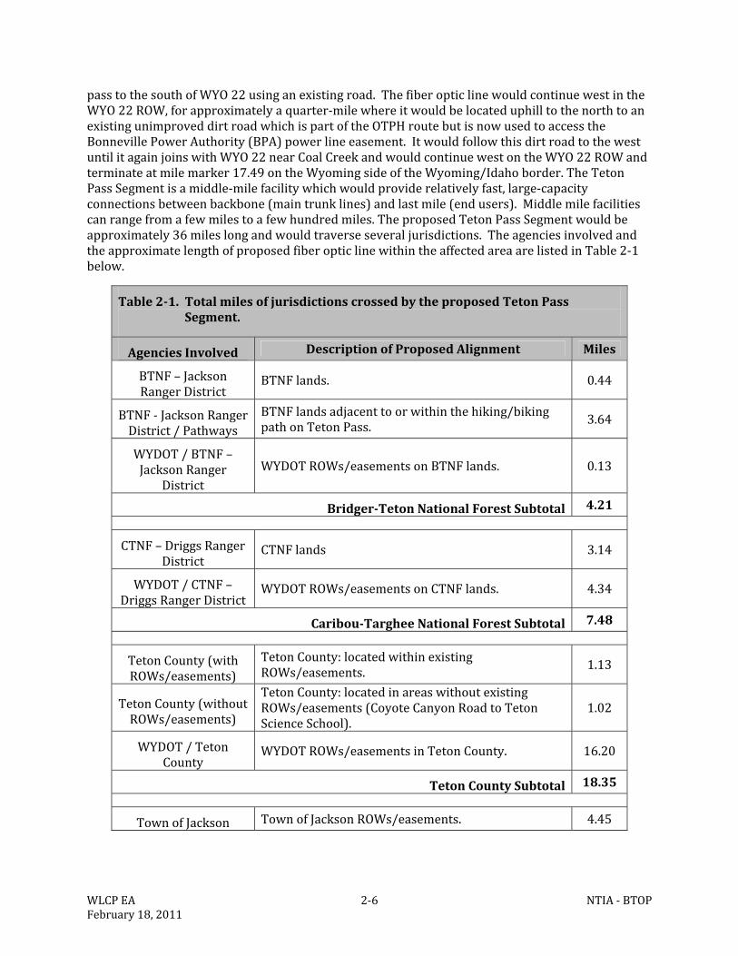
Table2‐1.TotalmilesofjurisdictionscrossedbytheproposedTetonPassSegment.
AgenciesInvolved DescriptionofProposedAlignment Miles
BTNF–JacksonRangerDistrict
BTNFlands. 0.44
BTNF‐JacksonRangerDistrict/Pathways
BTNFlandsadjacenttoorwithinthehiking/bikingpathonTetonPass. 3.64
WYDOT/BTNF–JacksonRanger
DistrictWYDOTROWs/easementsonBTNFlands. 0.13
Bridger‐TetonNationalForestSubtotal 4.21
CTNF–DriggsRangerDistrict
CTNFlands 3.14
WYDOT/CTNF–DriggsRangerDistrict
WYDOTROWs/easementsonCTNFlands. 4.34
Caribou‐TargheeNationalForestSubtotal 7.48
TetonCounty(withROWs/easements)
TetonCounty:locatedwithinexistingROWs/easements.
1.13
TetonCounty(withoutROWs/easements)
TetonCounty:locatedinareaswithoutexistingROWs/easements(CoyoteCanyonRoadtoTetonScienceSchool).
1.02
WYDOT/TetonCounty
WYDOTROWs/easementsinTetonCounty. 16.20
TetonCountySubtotal 18.35
TownofJackson TownofJacksonROWs/easements. 4.45
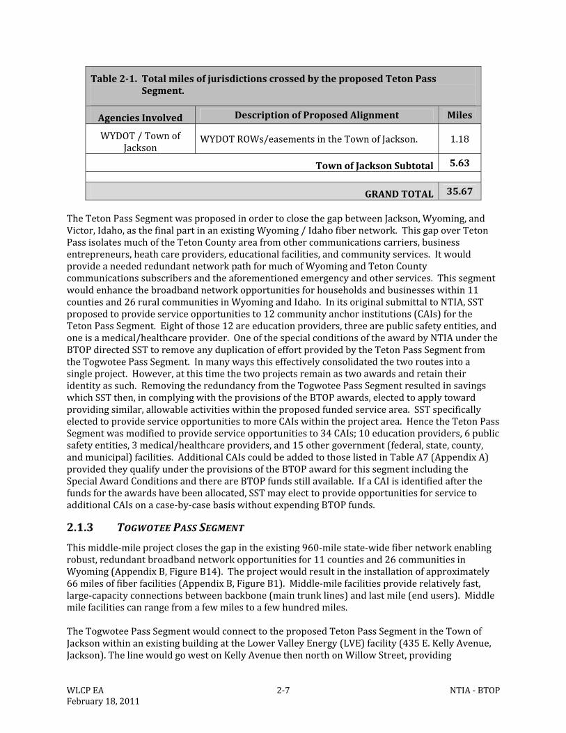
WLCPEA 2‐7 NTIA‐BTOPFebruary18,2011
Table2‐1.TotalmilesofjurisdictionscrossedbytheproposedTetonPassSegment.
AgenciesInvolved DescriptionofProposedAlignment Miles
WYDOT/TownofJackson
WYDOTROWs/easementsintheTownofJackson. 1.18
TownofJacksonSubtotal 5.63
GRANDTOTAL 35.67
TheTetonPassSegmentwasproposedinordertoclosethegapbetweenJackson,Wyoming,andVictor,Idaho,asthefinalpartinanexistingWyoming/Idahofibernetwork.ThisgapoverTetonPassisolatesmuchoftheTetonCountyareafromothercommunicationscarriers,businessentrepreneurs,heathcareproviders,educationalfacilities,andcommunityservices.ItwouldprovideaneededredundantnetworkpathformuchofWyomingandTetonCountycommunicationssubscribersandtheaforementionedemergencyandotherservices.Thissegmentwouldenhancethebroadbandnetworkopportunitiesforhouseholdsandbusinesseswithin11countiesand26ruralcommunitiesinWyomingandIdaho.InitsoriginalsubmittaltoNTIA,SSTproposedtoprovideserviceopportunitiesto12communityanchorinstitutions(CAIs)fortheTetonPassSegment.Eightofthose12areeducationproviders,threearepublicsafetyentities,andoneisamedical/healthcareprovider.OneofthespecialconditionsoftheawardbyNTIAundertheBTOPdirectedSSTtoremoveanyduplicationofeffortprovidedbytheTetonPassSegmentfromtheTogwoteePassSegment.Inmanywaysthiseffectivelyconsolidatedthetworoutesintoasingleproject.However,atthistimethetwoprojectsremainastwoawardsandretaintheiridentityassuch.RemovingtheredundancyfromtheTogwoteePassSegmentresultedinsavingswhichSSTthen,incomplyingwiththeprovisionsoftheBTOPawards,electedtoapplytowardprovidingsimilar,allowableactivitieswithintheproposedfundedservicearea.SSTspecificallyelectedtoprovideserviceopportunitiestomoreCAIswithintheprojectarea.HencetheTetonPassSegmentwasmodifiedtoprovideserviceopportunitiesto34CAIs;10educationproviders,6publicsafetyentities,3medical/healthcareproviders,and15othergovernment(federal,state,county,andmunicipal)facilities.AdditionalCAIscouldbeaddedtothoselistedinTableA7(AppendixA)providedtheyqualifyundertheprovisionsoftheBTOPawardforthissegmentincludingtheSpecialAwardConditionsandthereareBTOPfundsstillavailable.IfaCAIisidentifiedafterthefundsfortheawardshavebeenallocated,SSTmayelecttoprovideopportunitiesforservicetoadditionalCAIsonacase‐by‐casebasiswithoutexpendingBTOPfunds.
2.1.3 TOGWOTEEPASSSEGMENT
Thismiddle‐mileprojectclosesthegapintheexisting960‐milestate‐widefibernetworkenablingrobust,redundantbroadbandnetworkopportunitiesfor11countiesand26communitiesinWyoming(AppendixB,FigureB14).Theprojectwouldresultintheinstallationofapproximately66milesoffiberfacilities(AppendixB,FigureB1).Middle‐milefacilitiesproviderelativelyfast,large‐capacityconnectionsbetweenbackbone(maintrunklines)andlastmile(endusers).Middlemilefacilitiescanrangefromafewmilestoafewhundredmiles.TheTogwoteePassSegmentwouldconnecttotheproposedTetonPassSegmentintheTownofJacksonwithinanexistingbuildingattheLowerValleyEnergy(LVE)facility(435E.KellyAvenue,Jackson).ThelinewouldgowestonKellyAvenuethennorthonWillowStreet,providing
WLCPEA 2‐8 NTIA‐BTOPFebruary18,2011
opportunitiesforservicetotheTetonCountyandTownofJacksonoffices.PriortopassingtheTetonCountyOfficesastubintendedtoservicetheareaneartheJacksonHoleCenterfortheArtsbuilding,whichincludestheUniversityofWyomingandCentralWyomingCollege(Jacksoncampuses),wouldstemofftothewestonSimpsonAvenue,turnnorthonKingStreetforhalfablock,turnwestthroughanalleywayandthenturnsouthontoCacheStreetterminatingnearthesouthsideoftheCenterfortheArtsbuilding.Anotherstub,endingnearSt.John’sHospital,stemsofffromWillowLanetotheeastthroughanalleywaybetweenPearlAvenueandBroadway.Thestemcontinueseastthroughthealleywayuntilitintersectswith(South)GrosVentreStreetthenturnstothenorthandtheneastonBroadwayendingatSt.John’sHospitalandprovidingopportunitiesservingthehospitalfacilitiesaswellastheUSFWSElkRefugeoffice.ThemainlinewouldcontinuenorthonWillowStreet,turningwestonGillAvenuetotheintersectionwithNorthCacheStreet(US89/26).ContinuingfromtheintersectionofGillStreetandNorthCacheStreet,theroutewouldprovideserviceopportunitiesfortheUSForestServiceandWyomingGameandFishDepartment(WGFD).TheroutewouldcontinuenorthonNorthCacheStreet,exitingJacksonandenteringTetonCountyneartheFlatCreekBridge(attachedtothebridge).TheroutewouldremainonthewestsideofUS89/26withintheWYDOTROWtotheGrandTetonNationalPark(GTNP)boundarynearElkViewTerraceRoad.TheretheproposedroutewouldenterGTNPwithintheexistingROWforUS89/26butonNPSland.PriortoGrosVentreJunctionthelinewouldcrosstheGrosVentreRiver(attachedtothewestsideofthebridge)andseveralotherwaterfeatures(allbored).ThecurrentlyplannedborelocationsareidentifiedintheTablesinAppendixAandonthemapsinAppendixB.AtGrosVentreJunctiontherouteturnswestalongthesouthsideofLowerGrosVentreRoadthennorthontheeastsideofSpringGulchRoadtothesouthernperimeterfencelineoftheJacksonHoleAirport.ThelinewouldfollowontheinsideoftheGTNPboundaryfenceboringunderEnterpriseDitchfollowingtheexistingutilityeasementontheeastsideoftheaccessroadtogeneralaviationandontoserviceotherairportfacilities.EventuallythelinewillturneastonthenorthsideofAirportRoad.AtthejunctionofAirportRoadwithUS89/26,thelinewouldbeboredunderUS89/26andthenproceednorthalongaremnantofanold,vegetatedtwo‐trackroad(buriedadjacenttotheexistingburiedQwestroute)eastofUS89/26fromtheAirportRoadtoMooseJunction.HereitwouldbeboredunderUS89/26toprovideastemtotheGTNPHeadquarterscomplex.TheroutewouldfollowtheexistingburiedQwestline,northofTetonParkRoad,beattachedtothenorthsideoftheexistingSnakeRiverbridgeinordertoprovideservicetothecomplex.Aprefabricatedhut(12feetx20feet)wouldbebuiltwithintheheadquartersatasiteacceptabletoGTNPinordertofacilitateuseofthefiberopticservicestothearea.Detailsforasimilarhutthatis12feetx24feetinsizeareincludedinAppendixC.FinalconstructiondrawingsfortheMoosehutwillbesubmittedtoGTNPforapproval.ContinuingnorthfromMooseJunction,thelinewouldcontinueacrossDitchCreek(theSSTlinewouldfollowAntelopeFlatsRoad,parallelbutnocloserthan5feetfromtheexistingburiedQwestservice,easttoEastBoundaryRoadthennorthwhereitwouldparalleltheexistingoverheadpowerline.ThecablewouldfollowtheexistingpowerlineuntilitintersectswithFSroad30333(unnamedNPSroad)nearLostCreekRanch.Followingthisunimprovedroaditwouldcontinuenorth.TheseroadsaremostlyonNPSlandwithsomeborderingormakingshortcrossingswithinNFSland.AtBrushCreekRoadtheroutewouldre‐entertheUS89/26ROWonthesouthsideofUS89/26inordertoavoidtheparkinglotfortheCunninghamCabinHistoricSitewhichislocatedabout2,000feetnorthoftheparkinglot.Itwouldcontinuenorthforashortdistancethencrosstothenorth/westsideoftheUS89/26ROWbeforecontinuingnorth.ThecrossingofSpreadCreekwouldbebyboring,asdirectedbytheNPStominimizelongtermimpacts.JustnorthofSpread
WLCPEA 2‐9 NTIA‐BTOPFebruary18,2011
CreekthelinewouldturneastontoWolffRanchRoad,thenfollowingtheroadthelinewouldturnnorthtoapointthatitisunderanexistingoverheadpowerlineroute.ItwouldfollowthisexistingpowerlineROWdeviatingslightlytothewestasthepowerlineapproachesthebankoftheBuffaloForkRiver.ItwouldcrosstheBuffaloForkRiverbybeingboredwellunderthechannelstartingatadistanceofover200feetfromthesouthbankandendingupabout75feetbeyondthenorthbankoftheriveralongUS26.TheroutewouldprovideastemthatgoeswesttoMorantoprovideserviceaccesstotheMoranElementarySchool,FireStation,andPostOffice,andtheGTNPentrancegateandotherNPSfacilities.ThemainroutewouldcontinuetowardstheeastwithintheUS26ROW.About1.6mileseastoftheBuffaloForkRivercrossing(withinGTNP)therouteentersacombinationofBTNFandprivatelandsuntilitonceagaincrossestheBuffaloForkRiveronanexistingbridge,neartheBuffaloValleyRoad.Atthebridgecrossingtheroutere‐entersGTNPforabout1milethenitwouldenterprivatelandsforabout2.5milesthenitwouldre‐entertheBTNFandcontinuewithintheUS26ROWtotheBuffaloRangerDistrictoffice(BlackrockRangerStation).Atthedistrictofficetheroutewouldturnnorth,boringunderBlackrockCreektotheBTNFForestServicecompound.TheroutewouldfollowanexistingpowerlineROWnorththeneastandfinallysouthtotheFederalAviationAdministration(FAA)veryhighfrequency(VHF)OmnidirectionalRange(VOR)radiotowerandForestServiceradiotowersonRosie’sRidge.TheroutewouldthenfolloweastalongtheedgeofForestServiceroads30060and30040,whereanexistingburiedcommunicationlineiscurrentlylocated.UsingtheForestServiceroadskeepstheSSTlinewithinexistingeasementsandutilityROWsandavoidsconstructiontrafficdelaysonUS26.UsingtheFSroad30040routebringsthefibertotheTogwoteeMountainLodge.ThelinewouldthenbelocatedwithintheUS26ROWallthewaytoitsjunctionwiththeDuboisTelephoneExchange(DTE)facility,whichislocatedonthesouthsideofUS26,aboutahalfmileeastoftheBridger‐Teton/Shoshoneforestboundary(AppendixB,FiguresB5‐B12).Aprefabricatedhut(10feetx16feet)wouldbeconstructedwithintheexistingcommunicationbuildingcomplexwhereitconnectstotheDTEfacility.ThishutwouldbesimilartotheonedescribedinAppendixCbutofsmallerdimensions.FinalconstructiondrawingsfortheDTEhutnearTogwoteePasswillbesubmittedtoUSFSforapproval.ThecolorofthehutwouldbedarkgreenwiththeUSFSapprovingthefinalcolorpriortoconstruction.TheproposedTogwoteePassSegmentwouldcrossseveraldifferentjurisdictions;however,themajorityisproposedtofollowfederalhighwayswithinGTNPandsmallgravelordirtroadswithinNPSandNFSlands.AROWjustnorthofJacksononUS89/26administeredbyWYDOTandROWswithintheTownofJacksonprovideroutingfornearlyalloftheremainderoftheproposedproject.TheagenciesinvolvedandtheapproximatelengthofproposedfiberopticlinewithintheaffectedareaarelistedinTable2‐2below.TheTogwoteePassSegmentfulfillstheneedtocompleteastatewidefiberopticringthatwouldcompletetheconnectionsamongthelargercitiesofJackson,Evanston,GreenRiver,RockSprings,Rawlins,Laramie,Cheyenne,Casper,Riverton,andDubois,affectingnumeroussmallercitiesalongtherouteaswellasmanytownsandcitieslocatedonspursorsmallerfiberrings.ThisexistingfiberopticnetworkformsapartialringconnectingthesecommunitieswitharemaininggapbetweenDuboisandJacksonoverTogwoteePass.ThisgaphasrestrictedtheavailabilityofrobustandprotectedbroadbandopportunitiesforthecitizensandbusinessesofWyomingforoveradecade.AsaresultofimplementingthespecialconditionsoftheBTOPaward,theTogwoteePassSegmentincreasedthenumberofserviceopportunitiesforCAIsfrom12to23whichinclude2educationproviders,1publicsafetyentity,1medical/healthcareprovider,1publicairportauthority,and18othergovernmentfacilities.AdditionalCAIscouldbeaddedtothoselistedinTableA8(AppendixA)providedtheyqualifyundertheprovisionsoftheBTOPawardsincluding
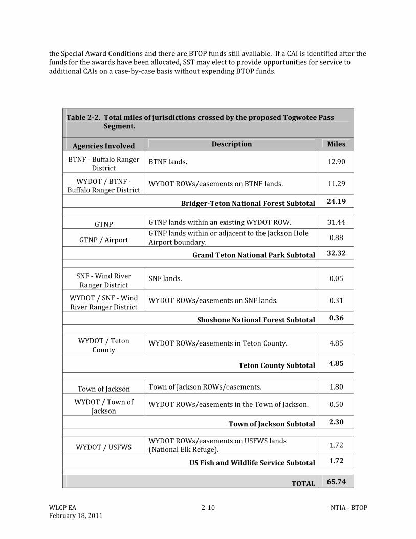
WLCPEA 2‐10 NTIA‐BTOPFebruary18,2011
theSpecialAwardConditionsandthereareBTOPfundsstillavailable.IfaCAIisidentifiedafterthefundsfortheawardshavebeenallocated,SSTmayelecttoprovideopportunitiesforservicetoadditionalCAIsonacase‐by‐casebasiswithoutexpendingBTOPfunds.
Table2‐2.TotalmilesofjurisdictionscrossedbytheproposedTogwoteePassSegment.
AgenciesInvolved Description Miles
BTNF‐BuffaloRangerDistrict
BTNFlands. 12.90
WYDOT/BTNF‐BuffaloRangerDistrict
WYDOTROWs/easementsonBTNFlands. 11.29
Bridger‐TetonNationalForestSubtotal 24.19
GTNP GTNPlandswithinanexistingWYDOTROW. 31.44
GTNP/AirportGTNPlandswithinoradjacenttotheJacksonHoleAirportboundary. 0.88
GrandTetonNationalParkSubtotal 32.32
SNF‐WindRiverRangerDistrict
SNFlands. 0.05
WYDOT/SNF‐WindRiverRangerDistrict
WYDOTROWs/easementsonSNFlands. 0.31
ShoshoneNationalForestSubtotal 0.36
WYDOT/TetonCounty
WYDOTROWs/easementsinTetonCounty. 4.85
TetonCountySubtotal 4.85
TownofJackson TownofJacksonROWs/easements. 1.80
WYDOT/TownofJackson
WYDOTROWs/easementsintheTownofJackson. 0.50
TownofJacksonSubtotal 2.30
WYDOT/USFWSWYDOTROWs/easementsonUSFWSlands(NationalElkRefuge). 1.72
USFishandWildlifeServiceSubtotal 1.72
TOTAL 65.74
WLCPEA 2‐11 NTIA‐BTOPFebruary18,2011
WithintheTownofJacksontheroutewouldbewithinroad/highwayROWsthatareadjacenttotheauto‐urbancommercial,businesspark,andruralzoningdistricts.ThereareaboutfourmilesoftheWYDOTROWalongUS26immediatelywestoftheBuffaloForkRiverBridge(eastofMoran)andeastoftheGTNPboundary.TheseportionsoftheproposedrouteliewithinconservationeasementsheldbyJacksonHoleLandTrustorarewithinprivatelandsthathaveexistinghighway/utilityROW/easementstraversingthem.TheproposedTogwoteePassroutewouldremainwithinthoseexistingROWs/easements.
2.1.4 GEOGRAPHICSETTING
TheStateofWyomingisrectangularwithseveralpopulationcentersdistributednearitsperimetersandinitscenter.AlmosttheentireStateofWyomingisbydefinition,“ruralandremote”withalargeportionofthestateconsistingofruggedmountainterrain.Wyominghasalandareaof97,814squaremilesandestimatedpopulationofonly563,626(2010)whichmakesittheninth‐largeststateinarea,buttheleastpopulatedstateinthenation.Theentirestatehasanaverageof5.8peoplepersquaremile.Cities,townsandsmallcommunitiesarepredominantlydistributedacrossthestatewithtwo‐tothree‐hourdrivesbetweenpopulationcentersof25,000to50,000people.Wyomingbusinessesandcitizenshave,bynecessity,beguntostronglyembracebroadbandtechnologytoovercomethedistance,terrain,anddensityfactors.
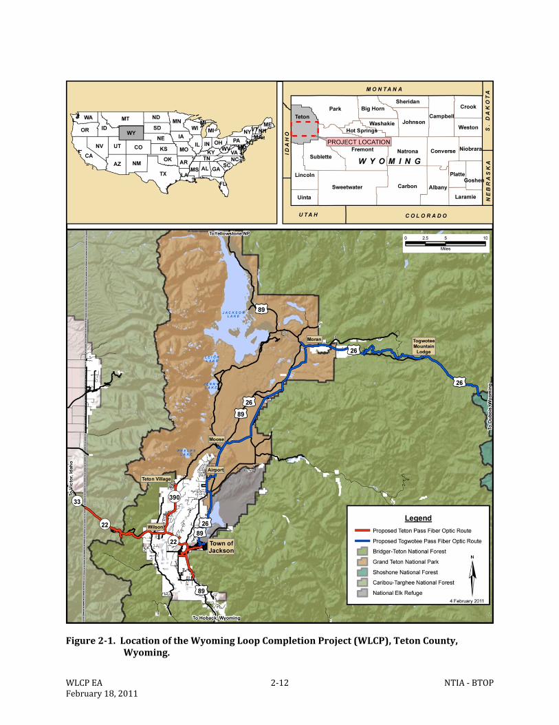
WLCPEA 2‐12 NTIA‐BTOPFebruary18,2011
Figure2‐1.LocationoftheWyomingLoopCompletionProject(WLCP),TetonCounty,Wyoming.
WLCPEA 2‐13 NTIA‐BTOPFebruary18,2011
2.2 NOACTIONALTERNATIVE
UndertheNoActionAlternative,theproposedfiberopticcablewouldnotbeinstalledforeithersegment.ImplementationoftheNoActionAlternativewouldmaintainthestatusquowithnochanges.AlthoughtheNoActionAlternativewouldnotmeetthepurposeandneedfortheproposedprojectitisusefultoevaluateitasacomparisonagainstotheralternativesanditsanalysisisarequirementunderprovisionsoftheNEPA.
2.3 ALTERNATIVES
Incontemplatingarouteorroutestofollowinordertoinstallthefiberopticcable,SSTconsideredfordetailedanalysisonlythoseoptions/alternativesthatmetthepurposeandneedoftheproposedprojectasdefinedbytheNTIA(particularlytheBTOP),thetechnicalrequirementsforfulfillingthepurposeandneed,andanycriteriaestablishedbythepermittinglandmanagementagenciesspecifictothistypeofproject.OnceSST’ssubmittalstoNTIAwereaccepted,SSTbegananintensiveefforttocommunicateanddiscussalternativeroutesandoptionswiththeaffectedagenciesandparties.Asaresultoftheseearlydiscussions,manypotentialproblemsandconcernswereeliminated.Consequently,SST’sproposedalternativeevolvedfollowinginputfromagenciessuchastheUSFS,NPS,WYDOT,TownofJackson,TetonCounty,varioususergroups,andprivatelandowners.SSTusedthefollowingassumptionsorprovisionsasguidelinesintheirplanningprocessinordertominimizeproblemsandconcernsandidentifyoptimalroutes:1)followandbecompatiblewithexistinghighwayandutilityright‐of‐ways(ROWs)oreasementswhereverfeasibleandpreferable;2)taketheleastenvironmentallysensitiveoptionwherevertherewasachoicetobemade;3)qualifyforissuanceunderNationwidePermit#12forUtilityCorridorsundertheCleanWaterAct(1972,asamended);4)have“NoEffect”toplantorwildlifespeciesunderprovisionsoftheEndangeredSpeciesAct(1973,asamended);5)havefullconcurrencewiththeWyomingStateHistoricPreservationOfficethatimplementationwouldnotadverselyaffectanyculturalresourcesunderSection106oftheAntiquitiesAct(1906,asamended)6)receivefullconcurrencefromtheNPSandUSFSthatimplementationwouldnotadverselyaffecttheORVsofanywaterwaysprotectedundertheWildandScenicRiversAct(1968,asamended);7)qualifyforconsiderationforaSUPorequivalentbytheUSFSandNPS;8)nothaveanyapparentsignificantimpactsasdefinedbytheNEPA(1969,asamended);and9)beabletocompletepermitting,analyses,andimplementationwithinthescheduleandtimeframesoftheoverallprojectrequirementsundertheARRAandBTOPstipulations.TheendresultsoftheplanningandinternalscopingprocessesaretheproposedactionsdescribedabovefortheTetonPassandTogwoteePasssegmentsoftheWLCP.Havingthelatitudetomakeminorchangesinroutingforeithersegmentorvarythetimingofactionsatspecificlocationsinordertoavoidsite‐specificimpactsarepartoftheProposedActionwhichisthePreferredAlternative.Also,throughboththeagencyscopingprocessesthatSSTengagedinandotheragencyscopingprocesses,thePreferredAlternativestillprovidesopportunitiestoreduceimpactsasthoseopportunitiesbecomeknownandarereviewed.AlsoboththeNPSandUSFShadopportunitiestoreviewthefinalplansandhaveinputandsuggestionsforchanges.ThesesuggestionsandinputswerethenincorporatedintothefinalEAandprojectplans.Theintenseefforttoproposeaviable,workable,technicallyfeasible,andacceptableprojectresultedintwoalternativesbeingconsideredindetailforthisEA.TheProposedActionasdescribedinSection2.1aboveandtheNoActionAlternativedescribedinSection2.2.Thereason
WLCPEA 2‐14 NTIA‐BTOPFebruary18,2011
thatnootheralternativewasevaluatedwasthattherewerenounacceptableimpactsthatwouldhaverequiredanadditionalalternativethatwouldhavemetthePurposeandNeed.
2.4 ALTERNATIVESCONSIDEREDBUTELIMINATEDFROMDETAILEDDISCUSSION
OneoftherequirementsforanalternativetobeconsideredwasthatitwouldfulfillthePurposeandNeedoftheprojectasproposedbySST.ThisisimportanttounderstandbecausetheSSTprojectasitwaspresentedtoNTIAundertheBTOPprogramhadtocompetewithotherprojectsforfunding.Consequently,onceitwasacceptedforconsiderationandfundingitwasdefinedasaviable,neededproject.Otherprojectsthatdidnotqualifyorthatwerewithdrawnceasedtobeconsidered.UnderprovisionsoftheNEPA,allofthealternativesconsideredincludingthoseconsideredbuteliminatedfromfurtherdiscussionconstitutethe“rangeofalternatives.”Consequently,therewerenearly20SSTalternativesconsideredundertheanalysesofthisEA.Eachofthespecificalternativesconsideredbuteliminatedfromfurtherdiscussionisdescribedbelowwiththereason(s)foritsdismissalforeachsegment.ThereasonthatnoalternativesotherthanthePreferredAlternative(ProposedAction)andtheNoActionAlternativewereevaluated,wasthatfollowingbothinformal(internalagencycontactsandmeetings)andformalscopingprocesses,itbecameapparentthattherewerenounacceptableimpactsthatwouldhaverequiredanadditionalalternativethatwouldhavealsometthePurposeandNeedoftheproject.Inadditiontothealternativesnotedbelow,twogeneralalternativesweredismissedfromfurtherdiscussion.One(AlternativeA)wasinstallingaerialfiberopticcable(attachingittopoles,eitherexistingornewones)andanother(AlternativeB)wastorelyonmicro‐wavetowerstofulfilltheroleoffiberopticcable.AlternativeA.SSTdidnotproposetofulfillthepurposeormeettheneedforthisprojectusingaerialcablebecauseSSTdoesnotinstallormaintainaerialfiberopticfacilities.Thereliabilityandpotentialproblemswithaerialcableinhighwind,heavysnow,andremoteareasiswelldocumented.InsectionsoftheproposedroutewherethereareexistingpowerpolessuchasportionsoftheTogwoteePassSegment,aerialinstallationwasrejectedbecausethepurposeandneedcallsforan“extra”conduitsuitableforpotential,efficientfutureexpansionthatwouldnothaveadditionalimpacts.Installinganotheraeriallinelaterwouldoftenduplicateimpactsofaninitialaerialinstallation.Also,therewereconcernsregardingcumulativeeffectsforvisualresources,dependability,andtheneedformaintenanceaccessinremoteareasduringharshseasonalconditions.Muchoftheroutethatcomprisesthe“gaps”doesnothaveoverheadlinesorpolessoifaportionofasegmentweretohaveamixofaerialandburiedlineitwouldnecessitateconstructingotherancillaryfacilitiesatthepointswherethelinechangedfromburiedtoaerial.VisualimpactstothesensitiveareaswithintheNPSandNFSlandcouldhavebeensignificantwithnewaeriallines.Whetherthefiberopticlinewere“plowedin”orsuspendedfromexistingpoles,theareawouldstillneedtobeaccessedbyvarioustypesofvehiclesbutwithaerialinstallationrevisitingthelinewouldbemorelikely.Buryingthelineusingtheplowingtechniqueappearedtobetheleastintrusiveandmostenvironmentallysensitivemethodoverthelongterm.Ahostofotherconcernswithaerialcablewereidentifiedbutthefactthatnoopticcableproviderthatinstalls,maintains,orservicessuchcablemadeanacceptablebidundertheBTOPisevidenceofthelackofsupportforthisalternative.AlternativeB.Installingmicro‐wavetowerstofulfillthepurposeandneedforthisprojectwouldrequiretheconstructionandmaintenanceofseveral,perhapsdozensoftowers.Thesefacilitiesare
WLCPEA 2‐15 NTIA‐BTOPFebruary18,2011
veryvisibleandrequireannualormorefrequentmaintenance.Theunreliabilityofmicro‐wavetowerscomparedtoburiedstate‐of‐theartfiberopticcableiswelldocumentedbythebroadbandindustry.Micro‐wavetechnologyhasitsplaceamongbroadbanddistributionsystemsbutithasmanydrawbacksanddisadvantagesasnotedinSection2.1.Also,micro‐wavetechnologydoesnotsupportthebandwidthsrequiredtofulfilltheneedsoftheproject,consequentlyitisnotadirectreplacement.Thiswouldalsorequirelengthyrevisionprocessesofexistinglanduseplanswithnocertaintyofthedesiredoutcomes.
2.4.1 REJECTEDOPTIONSFORTHETETONPASSSEGMENT
Table2‐3presentsrouteoptionsconsideredfortheTetonPassSegmentthatweresubsequentlydismissedfromdetailedanalysis,alongwiththereasonfortheirdismissal.Table2‐3.RoutesorportionsofroutesconsideredasoptionsfortheTetonPassSegment
butdismissedfromdetailedanalysisorconsiderationofbeingpartoftheProposedAction.
Route–OptionSegment*
DescriptionandLocation
ReasonforDismissal
OptionA:WYO22ROWfromTrail
CreekRoadtoCoalCreek
A7‐milesectionofWYO22startingwestofWilsonatTrailCreekRoad,goingoverTetonPassandendingneartheCoalCreekparkinglot.
WYO22overTetonPassisaverydifficultlocationforconstructionactivities.TherockyoutcropswouldrequireSSTtoinstallthecableby“rocksawing,”averytimeconsumingandexpensiveoperation,overamajorityoftheroute.WYDOThasinstalledseveralroadstabilizingfeatures,cross‐drains,alargerock‐linedborrowditchandotherstabilizationelementswhichwouldneedtobecarefullyavoided.Theinstallationofthecablewouldmakeavoidingthesefeaturesverydifficultifnotimpossible.Also,installingthecableonthissectionofWYO22wouldrequireblockingonelaneoftrafficthuscausingdelaysfortravelersoverthepasswheneverconstructiontookplace.Thisisevenmoreproblematicbecausetherearefewsafelocationstostoptraffic.WYDOTrecommendedmovingtotheProposedActionAlternativeroute.
OPTIONB:BPA/LVEPowerLineEasement
ThissectionstayswithintheexistingBonnevillePowerAuthority(BPA)andLowerValleyEnergy(LVE)overheadlineeasementsastheycrossoverTetonPass.Startingalongthebikepathaboutthree‐quartersofamilewestoftheTrailCreekparkinglot,thelinewouldturntothesouthandontotheLVEeasementthenfollowthiseasementtothewestwhereitwouldconnecttoaBPAeasement.ContinuingwestalongtheBPAeasementforjustover0.6miles,thelinewouldmoveupsloperejoiningtheWYO22ROW.ThefiberopticlinewouldcontinueintheWYO22ROW,tothewestforapproximatelyaquarter‐mile,whereitwouldbelocateduphilltothenorthtoanexistingunimproveddirtroadwhichisusedtoaccesstheBPApowerlineeasement.ItwouldthenfollowtheBPAeasementtothewestwhere,justpriortotheIdahoborder,itwouldjoinbackwiththeWYO22ROWandterminateattheWyoming/Idahoborder.
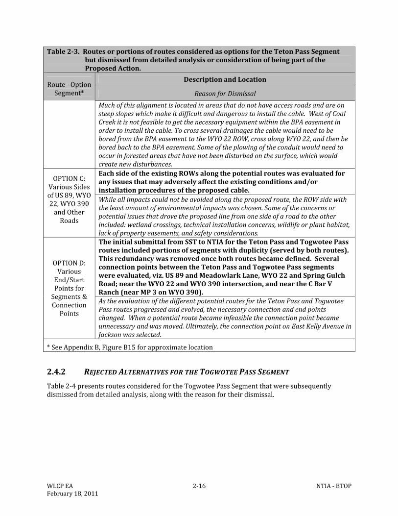
WLCPEA 2‐16 NTIA‐BTOPFebruary18,2011
Table2‐3.RoutesorportionsofroutesconsideredasoptionsfortheTetonPassSegmentbutdismissedfromdetailedanalysisorconsiderationofbeingpartoftheProposedAction.
Route–OptionSegment*
DescriptionandLocation
ReasonforDismissal
Muchofthisalignmentislocatedinareasthatdonothaveaccessroadsandareonsteepslopeswhichmakeitdifficultanddangeroustoinstallthecable.WestofCoalCreekitisnotfeasibletogetthenecessaryequipmentwithintheBPAeasementinordertoinstallthecable.TocrossseveraldrainagesthecablewouldneedtobeboredfromtheBPAeasementtotheWYO22ROW,crossalongWYO22,andthenbeboredbacktotheBPAeasement.Someoftheplowingoftheconduitwouldneedtooccurinforestedareasthathavenotbeendisturbedonthesurface,whichwouldcreatenewdisturbances.
OPTIONC:VariousSidesofUS89,WYO22,WYO390andOtherRoads
EachsideoftheexistingROWsalongthepotentialrouteswasevaluatedforanyissuesthatmayadverselyaffecttheexistingconditionsand/orinstallationproceduresoftheproposedcable.Whileallimpactscouldnotbeavoidedalongtheproposedroute,theROWsidewiththeleastamountofenvironmentalimpactswaschosen.Someoftheconcernsorpotentialissuesthatdrovetheproposedlinefromonesideofaroadtotheotherincluded:wetlandcrossings,technicalinstallationconcerns,wildlifeorplanthabitat,lackofpropertyeasements,andsafetyconsiderations.
OPTIOND:VariousEnd/StartPointsforSegments&ConnectionPoints
TheinitialsubmittalfromSSTtoNTIAfortheTetonPassandTogwoteePassroutesincludedportionsofsegmentswithduplicity(servedbybothroutes).Thisredundancywasremovedoncebothroutesbecamedefined.SeveralconnectionpointsbetweentheTetonPassandTogwoteePasssegmentswereevaluated,viz.US89andMeadowlarkLane,WYO22andSpringGulchRoad;neartheWYO22andWYO390intersection,andneartheCBarVRanch(nearMP3onWYO390).AstheevaluationofthedifferentpotentialroutesfortheTetonPassandTogwoteePassroutesprogressedandevolved,thenecessaryconnectionandendpointschanged.Whenapotentialroutebecameinfeasibletheconnectionpointbecameunnecessaryandwasmoved.Ultimately,theconnectionpointonEastKellyAvenueinJacksonwasselected.
*SeeAppendixB,FigureB15forapproximatelocation
2.4.2 REJECTEDALTERNATIVESFORTHETOGWOTEEPASSSEGMENT
Table2‐4presentsroutesconsideredfortheTogwoteePassSegmentthatweresubsequentlydismissedfromdetailedanalysis,alongwiththereasonfortheirdismissal.
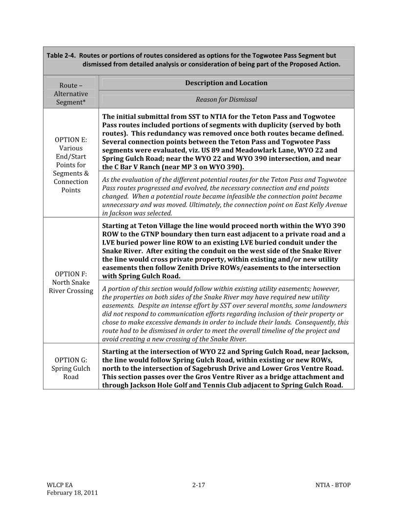
WLCPEA 2‐17 NTIA‐BTOPFebruary18,2011
Table 2‐4. Routes or portions of routes considered as options for the Togwotee Pass Segment but dismissed from detailed analysis or consideration of being part of the Proposed Action.
Route–AlternativeSegment*
DescriptionandLocation
ReasonforDismissal
OPTIONE:VariousEnd/StartPointsforSegments&ConnectionPoints
TheinitialsubmittalfromSSTtoNTIAfortheTetonPassandTogwoteePassroutesincludedportionsofsegmentswithduplicity(servedbybothroutes).Thisredundancywasremovedoncebothroutesbecamedefined.SeveralconnectionpointsbetweentheTetonPassandTogwoteePasssegmentswereevaluated,viz.US89andMeadowlarkLane,WYO22andSpringGulchRoad;neartheWYO22andWYO390intersection,andneartheCBarVRanch(nearMP3onWYO390).
AstheevaluationofthedifferentpotentialroutesfortheTetonPassandTogwoteePassroutesprogressedandevolved,thenecessaryconnectionandendpointschanged.Whenapotentialroutebecameinfeasibletheconnectionpointbecameunnecessaryandwasmoved.Ultimately,theconnectionpointonEastKellyAvenueinJacksonwasselected.
OPTIONF:NorthSnakeRiverCrossing
StartingatTetonVillagethelinewouldproceednorthwithintheWYO390ROWtotheGTNPboundarythenturneastadjacenttoaprivateroadandaLVEburiedpowerlineROWtoanexistingLVEburiedconduitundertheSnakeRiver.AfterexitingtheconduitonthewestsideoftheSnakeRiverthelinewouldcrossprivateproperty,withinexistingand/ornewutilityeasementsthenfollowZenithDriveROWs/easementstotheintersectionwithSpringGulchRoad.
Aportionofthissectionwouldfollowwithinexistingutilityeasements;however,thepropertiesonbothsidesoftheSnakeRivermayhaverequirednewutilityeasements.DespiteanintenseeffortbySSToverseveralmonths,somelandownersdidnotrespondtocommunicationeffortsregardinginclusionoftheirpropertyorchosetomakeexcessivedemandsinordertoincludetheirlands.Consequently,thisroutehadtobedismissedinordertomeettheoveralltimelineoftheprojectandavoidcreatinganewcrossingoftheSnakeRiver.
OPTIONG:SpringGulch
Road
StartingattheintersectionofWYO22andSpringGulchRoad,nearJackson,thelinewouldfollowSpringGulchRoad,withinexistingornewROWs,northtotheintersectionofSagebrushDriveandLowerGrosVentreRoad.ThissectionpassesovertheGrosVentreRiverasabridgeattachmentandthroughJacksonHoleGolfandTennisClubadjacenttoSpringGulchRoad.
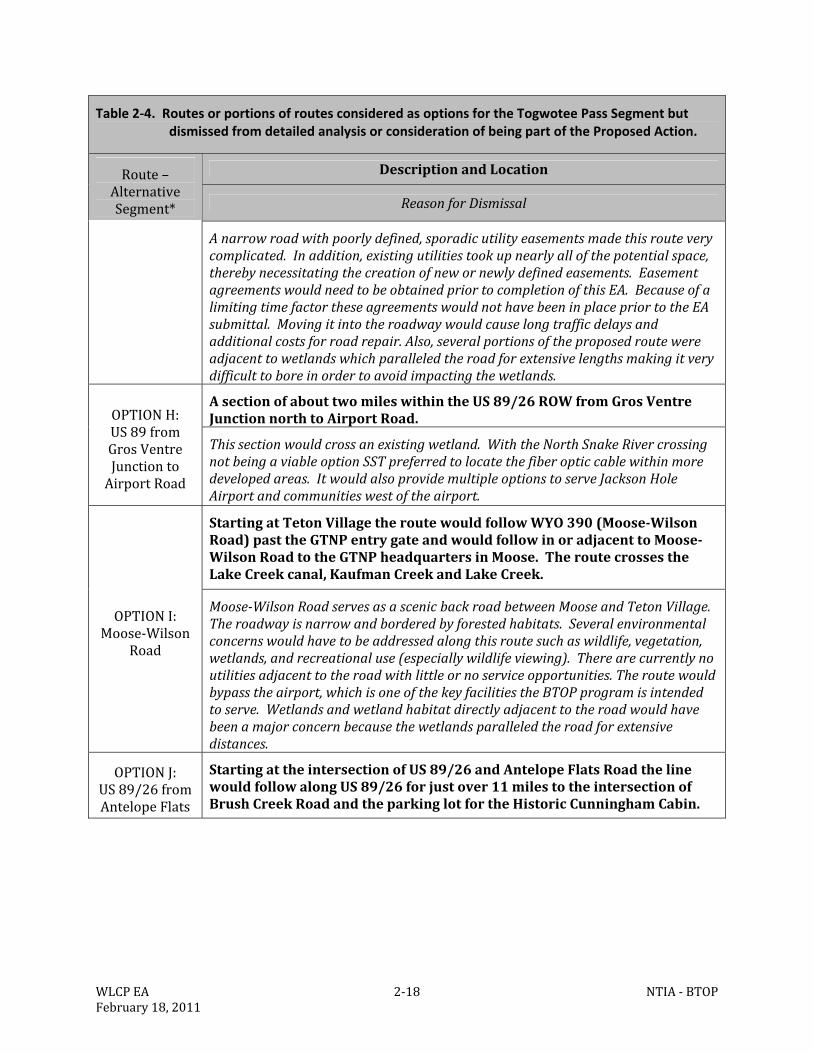
WLCPEA 2‐18 NTIA‐BTOPFebruary18,2011
Table 2‐4. Routes or portions of routes considered as options for the Togwotee Pass Segment but dismissed from detailed analysis or consideration of being part of the Proposed Action.
Route–AlternativeSegment*
DescriptionandLocation
ReasonforDismissal
Anarrowroadwithpoorlydefined,sporadicutilityeasementsmadethisrouteverycomplicated.Inaddition,existingutilitiestookupnearlyallofthepotentialspace,therebynecessitatingthecreationofnewornewlydefinedeasements.EasementagreementswouldneedtobeobtainedpriortocompletionofthisEA.BecauseofalimitingtimefactortheseagreementswouldnothavebeeninplacepriortotheEAsubmittal.Movingitintotheroadwaywouldcauselongtrafficdelaysandadditionalcostsforroadrepair.Also,severalportionsoftheproposedroutewereadjacenttowetlandswhichparalleledtheroadforextensivelengthsmakingitverydifficulttoboreinordertoavoidimpactingthewetlands.
OPTIONH:US89fromGrosVentreJunctiontoAirportRoad
AsectionofabouttwomileswithintheUS89/26ROWfromGrosVentreJunctionnorthtoAirportRoad.
Thissectionwouldcrossanexistingwetland.WiththeNorthSnakeRivercrossingnotbeingaviableoptionSSTpreferredtolocatethefiberopticcablewithinmoredevelopedareas.ItwouldalsoprovidemultipleoptionstoserveJacksonHoleAirportandcommunitieswestoftheairport.
OPTIONI:Moose‐Wilson
Road
StartingatTetonVillagetheroutewouldfollowWYO390(Moose‐WilsonRoad)pasttheGTNPentrygateandwouldfollowinoradjacenttoMoose‐WilsonRoadtotheGTNPheadquartersinMoose.TheroutecrossestheLakeCreekcanal,KaufmanCreekandLakeCreek.
Moose‐WilsonRoadservesasascenicbackroadbetweenMooseandTetonVillage.Theroadwayisnarrowandborderedbyforestedhabitats.Severalenvironmentalconcernswouldhavetobeaddressedalongthisroutesuchaswildlife,vegetation,wetlands,andrecreationaluse(especiallywildlifeviewing).Therearecurrentlynoutilitiesadjacenttotheroadwithlittleornoserviceopportunities.Theroutewouldbypasstheairport,whichisoneofthekeyfacilitiestheBTOPprogramisintendedtoserve.Wetlandsandwetlandhabitatdirectlyadjacenttotheroadwouldhavebeenamajorconcernbecausethewetlandsparalleledtheroadforextensivedistances.
OPTIONJ:US89/26fromAntelopeFlats
StartingattheintersectionofUS89/26andAntelopeFlatsRoadthelinewouldfollowalongUS89/26forjustover11milestotheintersectionofBrushCreekRoadandtheparkinglotfortheHistoricCunninghamCabin.
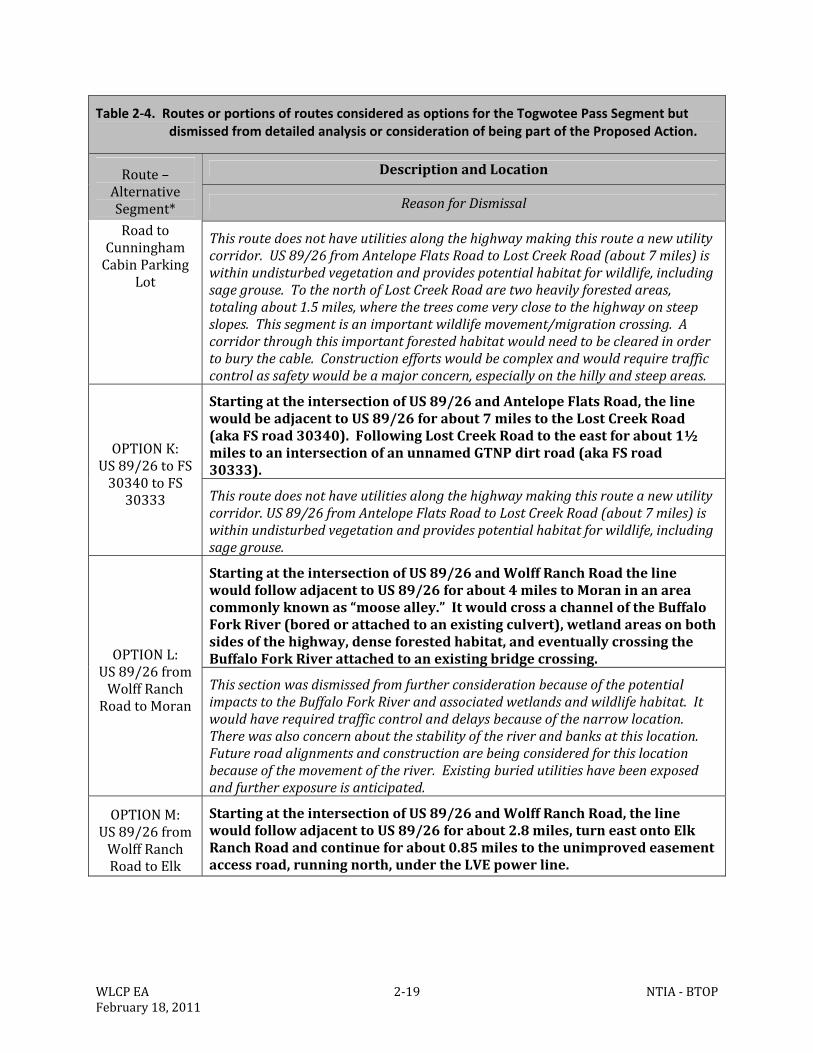
WLCPEA 2‐19 NTIA‐BTOPFebruary18,2011
Table 2‐4. Routes or portions of routes considered as options for the Togwotee Pass Segment but dismissed from detailed analysis or consideration of being part of the Proposed Action.
Route–AlternativeSegment*
DescriptionandLocation
ReasonforDismissal
RoadtoCunninghamCabinParking
Lot
Thisroutedoesnothaveutilitiesalongthehighwaymakingthisrouteanewutilitycorridor.US89/26fromAntelopeFlatsRoadtoLostCreekRoad(about7miles)iswithinundisturbedvegetationandprovidespotentialhabitatforwildlife,includingsagegrouse.TothenorthofLostCreekRoadaretwoheavilyforestedareas,totalingabout1.5miles,wherethetreescomeveryclosetothehighwayonsteepslopes.Thissegmentisanimportantwildlifemovement/migrationcrossing.Acorridorthroughthisimportantforestedhabitatwouldneedtobeclearedinordertoburythecable.Constructioneffortswouldbecomplexandwouldrequiretrafficcontrolassafetywouldbeamajorconcern,especiallyonthehillyandsteepareas.
OPTIONK:US89/26toFS30340toFS30333
StartingattheintersectionofUS89/26andAntelopeFlatsRoad,thelinewouldbeadjacenttoUS89/26forabout7milestotheLostCreekRoad(akaFSroad30340).FollowingLostCreekRoadtotheeastforabout1½milestoanintersectionofanunnamedGTNPdirtroad(akaFSroad30333).
Thisroutedoesnothaveutilitiesalongthehighwaymakingthisrouteanewutilitycorridor.US89/26fromAntelopeFlatsRoadtoLostCreekRoad(about7miles)iswithinundisturbedvegetationandprovidespotentialhabitatforwildlife,includingsagegrouse.
OPTIONL:US89/26fromWolffRanchRoadtoMoran
StartingattheintersectionofUS89/26andWolffRanchRoadthelinewouldfollowadjacenttoUS89/26forabout4milestoMoraninanareacommonlyknownas“moosealley.”ItwouldcrossachanneloftheBuffaloForkRiver(boredorattachedtoanexistingculvert),wetlandareasonbothsidesofthehighway,denseforestedhabitat,andeventuallycrossingtheBuffaloForkRiverattachedtoanexistingbridgecrossing.
ThissectionwasdismissedfromfurtherconsiderationbecauseofthepotentialimpactstotheBuffaloForkRiverandassociatedwetlandsandwildlifehabitat.Itwouldhaverequiredtrafficcontrolanddelaysbecauseofthenarrowlocation.Therewasalsoconcernaboutthestabilityoftheriverandbanksatthislocation.Futureroadalignmentsandconstructionarebeingconsideredforthislocationbecauseofthemovementoftheriver.Existingburiedutilitieshavebeenexposedandfurtherexposureisanticipated.
OPTIONM:US89/26fromWolffRanchRoadtoElk
StartingattheintersectionofUS89/26andWolffRanchRoad,thelinewouldfollowadjacenttoUS89/26forabout2.8miles,turneastontoElkRanchRoadandcontinueforabout0.85milestotheunimprovedeasementaccessroad,runningnorth,undertheLVEpowerline.
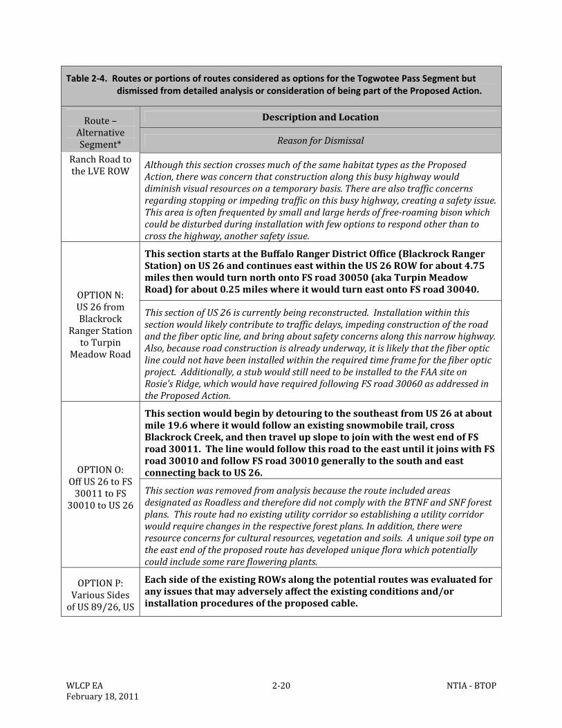
WLCPEA 2‐20 NTIA‐BTOPFebruary18,2011
Table 2‐4. Routes or portions of routes considered as options for the Togwotee Pass Segment but dismissed from detailed analysis or consideration of being part of the Proposed Action.
Route–AlternativeSegment*
DescriptionandLocation
ReasonforDismissal
RanchRoadtotheLVEROW
AlthoughthissectioncrossesmuchofthesamehabitattypesastheProposedAction,therewasconcernthatconstructionalongthisbusyhighwaywoulddiminishvisualresourcesonatemporarybasis.Therearealsotrafficconcernsregardingstoppingorimpedingtrafficonthisbusyhighway,creatingasafetyissue.Thisareaisoftenfrequentedbysmallandlargeherdsoffree‐roamingbisonwhichcouldbedisturbedduringinstallationwithfewoptionstorespondotherthantocrossthehighway,anothersafetyissue.
OPTIONN:US26fromBlackrock
RangerStationtoTurpin
MeadowRoad
ThissectionstartsattheBuffaloRangerDistrictOffice(BlackrockRangerStation)onUS26andcontinueseastwithintheUS26ROWforabout4.75milesthenwouldturnnorthontoFSroad30050(akaTurpinMeadowRoad)forabout0.25mileswhereitwouldturneastontoFSroad30040.
ThissectionofUS26iscurrentlybeingreconstructed.Installationwithinthissectionwouldlikelycontributetotrafficdelays,impedingconstructionoftheroadandthefiberopticline,andbringaboutsafetyconcernsalongthisnarrowhighway.Also,becauseroadconstructionisalreadyunderway,itislikelythatthefiberopticlinecouldnothavebeeninstalledwithintherequiredtimeframeforthefiberopticproject.Additionally,astubwouldstillneedtobeinstalledtotheFAAsiteonRosie’sRidge,whichwouldhaverequiredfollowingFSroad30060asaddressedintheProposedAction.
OPTIONO:OffUS26toFS30011toFS
30010toUS26
ThissectionwouldbeginbydetouringtothesoutheastfromUS26ataboutmile19.6whereitwouldfollowanexistingsnowmobiletrail,crossBlackrockCreek,andthentravelupslopetojoinwiththewestendofFSroad30011.ThelinewouldfollowthisroadtotheeastuntilitjoinswithFSroad30010andfollowFSroad30010generallytothesouthandeastconnectingbacktoUS26.
ThissectionwasremovedfromanalysisbecausetherouteincludedareasdesignatedasRoadlessandthereforedidnotcomplywiththeBTNFandSNFforestplans.Thisroutehadnoexistingutilitycorridorsoestablishingautilitycorridorwouldrequirechangesintherespectiveforestplans.Inaddition,therewereresourceconcernsforculturalresources,vegetationandsoils.Auniquesoiltypeontheeastendoftheproposedroutehasdevelopeduniqueflorawhichpotentiallycouldincludesomerarefloweringplants.
OPTIONP:VariousSidesofUS89/26,US
EachsideoftheexistingROWsalongthepotentialrouteswasevaluatedforanyissuesthatmayadverselyaffecttheexistingconditionsand/orinstallationproceduresoftheproposedcable.
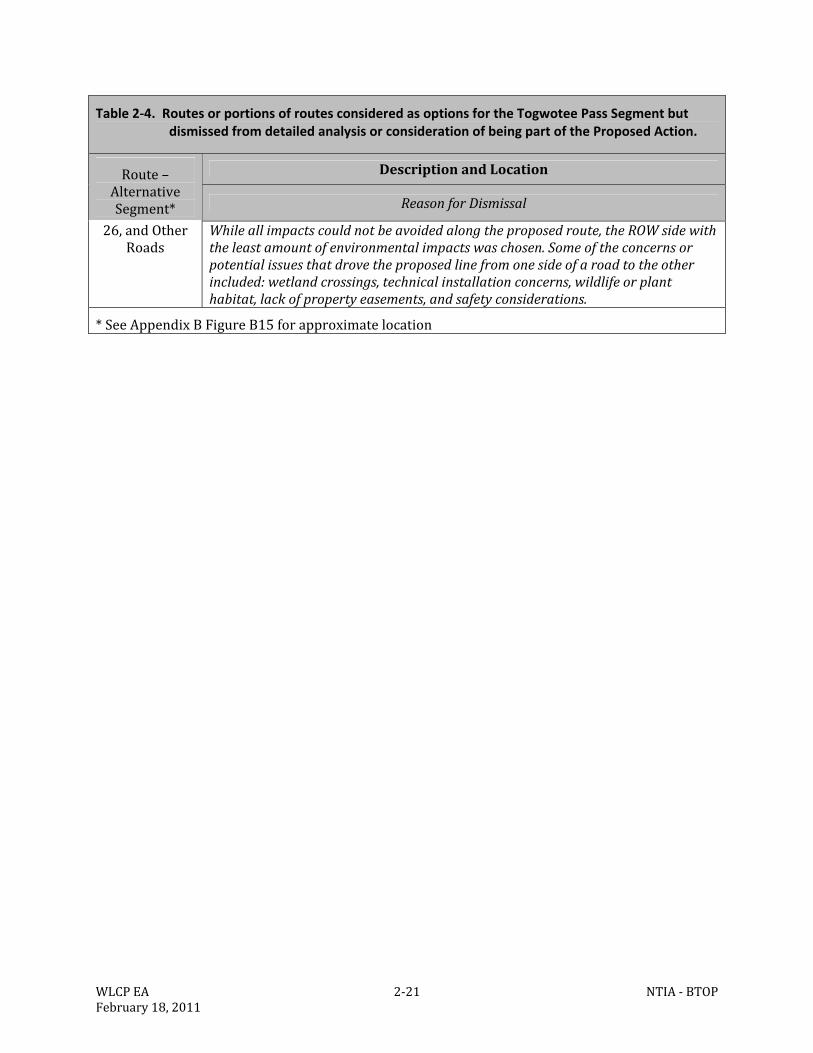
WLCPEA 2‐21 NTIA‐BTOPFebruary18,2011
Table 2‐4. Routes or portions of routes considered as options for the Togwotee Pass Segment but dismissed from detailed analysis or consideration of being part of the Proposed Action.
Route–AlternativeSegment*
DescriptionandLocation
ReasonforDismissal
26,andOtherRoads
Whileallimpactscouldnotbeavoidedalongtheproposedroute,theROWsidewiththeleastamountofenvironmentalimpactswaschosen.Someoftheconcernsorpotentialissuesthatdrovetheproposedlinefromonesideofaroadtotheotherincluded:wetlandcrossings,technicalinstallationconcerns,wildlifeorplanthabitat,lackofpropertyeasements,andsafetyconsiderations.
*SeeAppendixBFigureB15forapproximatelocation
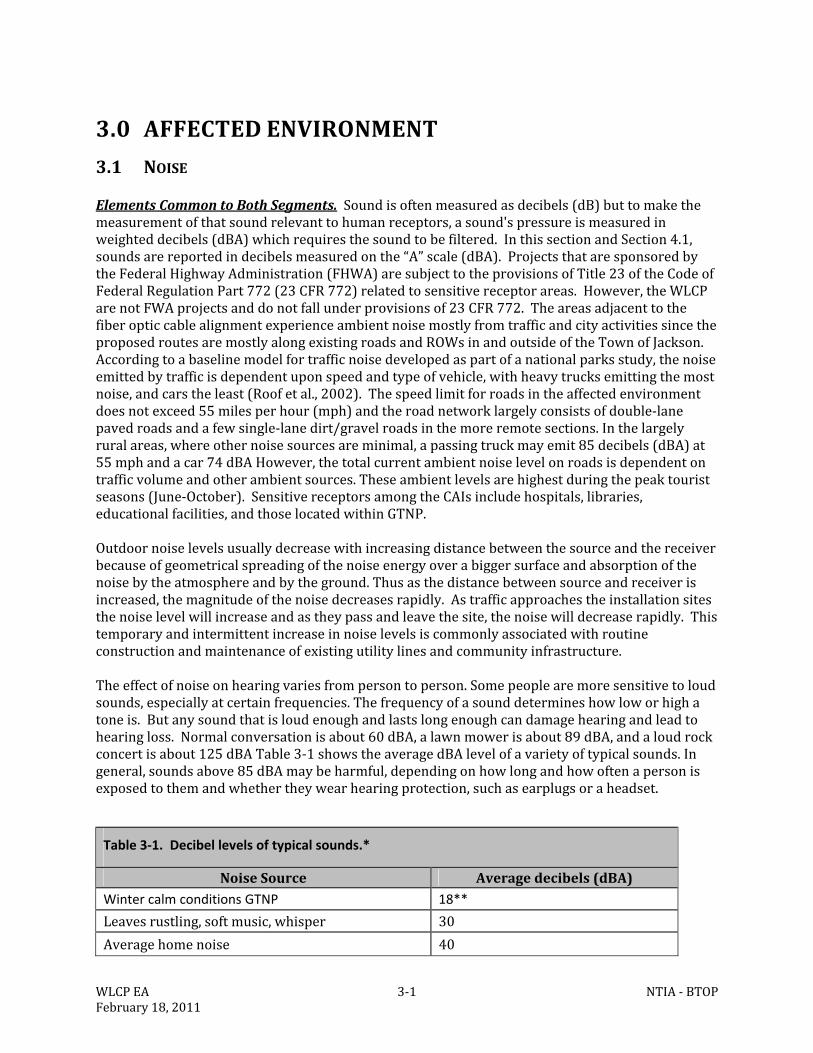
WLCPEA 3‐1 NTIA‐BTOPFebruary18,2011
3.0 AFFECTEDENVIRONMENT
3.1 NOISE
ElementsCommontoBothSegments.Soundisoftenmeasuredasdecibels(dB)buttomakethemeasurementofthatsoundrelevanttohumanreceptors,asound'spressureismeasuredinweighteddecibels(dBA)whichrequiresthesoundtobefiltered.InthissectionandSection4.1,soundsarereportedindecibelsmeasuredonthe“A”scale(dBA).ProjectsthataresponsoredbytheFederalHighwayAdministration(FHWA)aresubjecttotheprovisionsofTitle23oftheCodeofFederalRegulationPart772(23CFR772)relatedtosensitivereceptorareas.However,theWLCParenotFWAprojectsanddonotfallunderprovisionsof23CFR772.TheareasadjacenttothefiberopticcablealignmentexperienceambientnoisemostlyfromtrafficandcityactivitiessincetheproposedroutesaremostlyalongexistingroadsandROWsinandoutsideoftheTownofJackson.Accordingtoabaselinemodelfortrafficnoisedevelopedaspartofanationalparksstudy,thenoiseemittedbytrafficisdependentuponspeedandtypeofvehicle,withheavytrucksemittingthemostnoise,andcarstheleast(Roofetal.,2002).Thespeedlimitforroadsintheaffectedenvironmentdoesnotexceed55milesperhour(mph)andtheroadnetworklargelyconsistsofdouble‐lanepavedroadsandafewsingle‐lanedirt/gravelroadsinthemoreremotesections.Inthelargelyruralareas,whereothernoisesourcesareminimal,apassingtruckmayemit85decibels(dBA)at55mphandacar74dBAHowever,thetotalcurrentambientnoiselevelonroadsisdependentontrafficvolumeandotherambientsources.Theseambientlevelsarehighestduringthepeaktouristseasons(June‐October).SensitivereceptorsamongtheCAIsincludehospitals,libraries,educationalfacilities,andthoselocatedwithinGTNP.Outdoornoiselevelsusuallydecreasewithincreasingdistancebetweenthesourceandthereceiverbecauseofgeometricalspreadingofthenoiseenergyoverabiggersurfaceandabsorptionofthenoisebytheatmosphereandbytheground.Thusasthedistancebetweensourceandreceiverisincreased,themagnitudeofthenoisedecreasesrapidly.Astrafficapproachestheinstallationsitesthenoiselevelwillincreaseandastheypassandleavethesite,thenoisewilldecreaserapidly.Thistemporaryandintermittentincreaseinnoiselevelsiscommonlyassociatedwithroutineconstructionandmaintenanceofexistingutilitylinesandcommunityinfrastructure.Theeffectofnoiseonhearingvariesfrompersontoperson.Somepeoplearemoresensitivetoloudsounds,especiallyatcertainfrequencies.Thefrequencyofasounddetermineshowloworhighatoneis.Butanysoundthatisloudenoughandlastslongenoughcandamagehearingandleadtohearingloss.Normalconversationisabout60dBA,alawnmowerisabout89dBA,andaloudrockconcertisabout125dBATable3‐1showstheaveragedBAlevelofavarietyoftypicalsounds.Ingeneral,soundsabove85dBAmaybeharmful,dependingonhowlongandhowoftenapersonisexposedtothemandwhethertheywearhearingprotection,suchasearplugsoraheadset.
Table 3‐1. Decibel levels of typical sounds.*
NoiseSource Averagedecibels(dBA)Winter calm conditions GTNP 18**
Leavesrustling,softmusic,whisper 30
Averagehomenoise 40
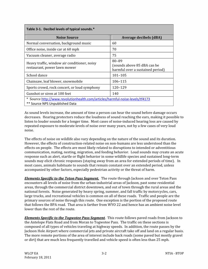
WLCPEA 3‐2 NTIA‐BTOPFebruary18,2011
Table 3‐1. Decibel levels of typical sounds.*
NoiseSource Averagedecibels(dBA)
Normalconversation,backgroundmusic 60
Officenoise,insidecarat60mph 70
Vacuumcleaner,averageradio 75
Heavytraffic,windowairconditioner,noisyrestaurant,powerlawnmower
80–89(soundsabove85dBAcanbeharmfuloverasustainedperiod)
Schooldance 101–105
Chainsaw,leafblower,snowmobile 106–115
Sportscrowd,rockconcert,orloudsymphony 120–129
Gunshotorsirenat100feet 140*Sourcehttp://www.revolutionhealth.com/articles/harmful‐noise‐levels/tf4173** Source NPS Unpublished DataAssoundlevelsincrease,theamountoftimeapersoncanhearthesoundbeforedamageoccursdecreases.Hearingprotectorsreducetheloudnessofsoundreachingtheears,makingitpossibletolistentoloudersoundsforalongertime.Mostcasesofnoise‐inducedhearinglossarecausedbyrepeatedexposuretomoderatelevelsofnoiseovermanyyears,notbyafewcasesofveryloudnoise.Theeffectsofnoiseonwildlifealsovarydependingonthenatureofthesoundanditsduration.However,theeffectsofconstruction‐relatednoiseonnon‐humansarelessunderstoodthantheeffectsonpeople.Theeffectsaremostlikelyrelatedtodisruptionstointendedoradventitiouscommunication,mating,nesting,migration,andfeedingbehavior.Loudsoundsmaycreateanacuteresponsesuchasalert,startleorflightbehaviorinsomewildlifespeciesandsustainedlong‐termsoundsmayelicitchronicresponses(stayingawayfromanareaforextendedperiodsoftime).Inmostcases,animalshabituatetosoundsthatremainconstantoveranextendedperiod,unlessaccompaniedbyotherfactors,especiallypedestrianactivityorthethreatofharm.ElementsSpecifictotheTetonPassSegment.TheroutethroughJacksonandoverTetonPassencountersalllevelsofnoisefromtheurban‐industrialareasofJackson,pastsomeresidentialareas,throughthecommercialdistrictdowntown,andoutoftownthroughtheruralareasandthenationalforests.Noisegeneratedbyheavyspring,summer,andfalltrafficbymotorcycles,cars,largetrucks,andrecreationalvehiclesiscommononalloftheseroads.Trafficandpeoplearetheprimarysourcesofnoisethroughthisroute.OneexceptionistheportionoftheproposedroutethatfollowstheBPAroad.ThatareaisfartherfromWYO22andhencehasanambientnoiselevellowerthantherestoftheroute.ElementsSpecifictotheTogwoteePassSegment.ThisroutefollowspavedroadsfromJacksontotheAntelopeFlatsRoadandfromMorantoTogwoteePass.Thetrafficonthesesectionsiscomposedofalltypesofvehiclestravelingathighwayspeeds.Inaddition,theroutepassesbytheJacksonHoleAirportwherecommercialjetsandprivateaircrafttakeoffandlandonaregularbasis.Themoreremoteportionsoftheareaofinterestincludebackroads(somepavedbutmostlygravelordirt)thataremuchlessfrequentlytravelledandvehiclespeedisoftenlessthan25mph.
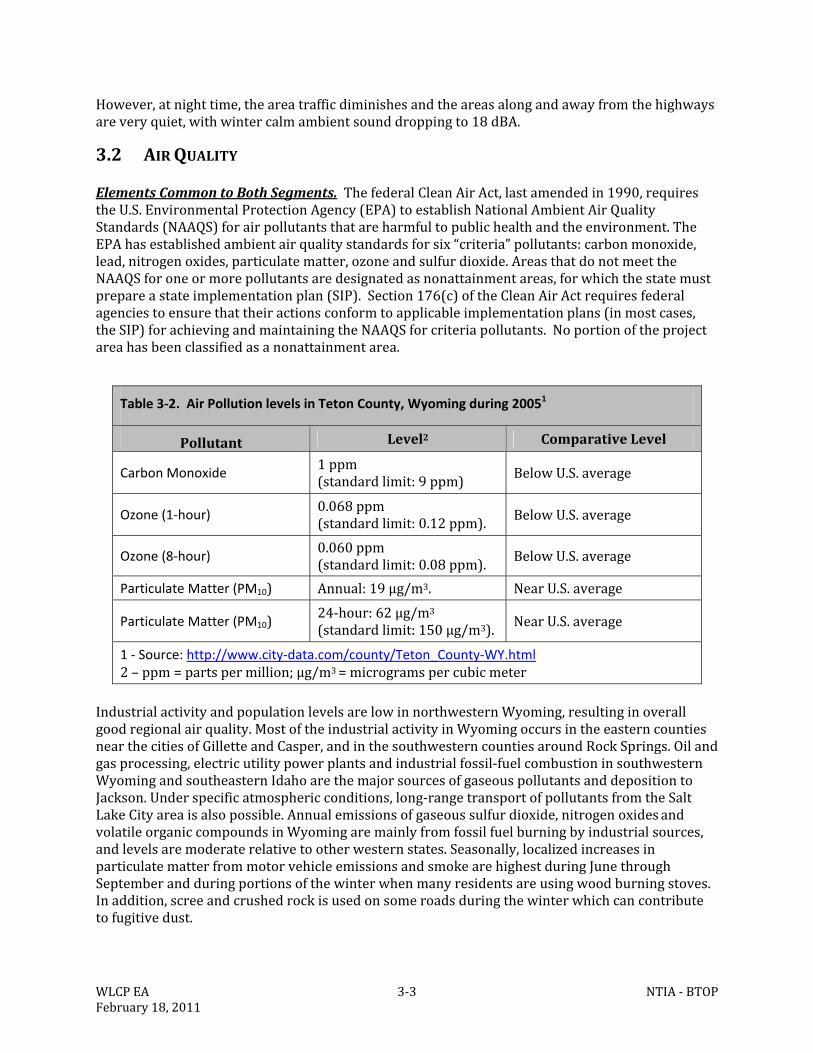
WLCPEA 3‐3 NTIA‐BTOPFebruary18,2011
However,atnighttime,theareatrafficdiminishesandtheareasalongandawayfromthehighwaysareveryquiet,withwintercalmambientsounddroppingto18dBA.
3.2 AIRQUALITY
ElementsCommontoBothSegments.ThefederalCleanAirAct,lastamendedin1990,requirestheU.S.EnvironmentalProtectionAgency(EPA)toestablishNationalAmbientAirQualityStandards(NAAQS)forairpollutantsthatareharmfultopublichealthandtheenvironment.TheEPAhasestablishedambientairqualitystandardsforsix“criteria”pollutants:carbonmonoxide,lead,nitrogenoxides,particulatematter,ozoneandsulfurdioxide.AreasthatdonotmeettheNAAQSforoneormorepollutantsaredesignatedasnonattainmentareas,forwhichthestatemustprepareastateimplementationplan(SIP).Section176(c)oftheCleanAirActrequiresfederalagenciestoensurethattheiractionsconformtoapplicableimplementationplans(inmostcases,theSIP)forachievingandmaintainingtheNAAQSforcriteriapollutants.Noportionoftheprojectareahasbeenclassifiedasanonattainmentarea.
Table 3‐2. Air Pollution levels in Teton County, Wyoming during 20051
Pollutant Level2 ComparativeLevel
Carbon Monoxide 1ppm(standardlimit:9ppm) BelowU.S.average
Ozone (1‐hour) 0.068ppm(standardlimit:0.12ppm). BelowU.S.average
Ozone (8‐hour) 0.060ppm(standardlimit:0.08ppm).
BelowU.S.average
Particulate Matter (PM10) Annual:19µg/m3. NearU.S.average
Particulate Matter (PM10)24‐hour:62µg/m3(standardlimit:150µg/m3). NearU.S.average
1 ‐ Source: http://www.city‐data.com/county/Teton_County‐WY.html2–ppm=partspermillion;µg/m3=microgramspercubicmeter
IndustrialactivityandpopulationlevelsarelowinnorthwesternWyoming,resultinginoverallgoodregionalairquality.MostoftheindustrialactivityinWyomingoccursintheeasterncountiesnearthecitiesofGilletteandCasper,andinthesouthwesterncountiesaroundRockSprings.Oilandgasprocessing,electricutilitypowerplantsandindustrialfossil‐fuelcombustioninsouthwesternWyomingandsoutheasternIdahoarethemajorsourcesofgaseouspollutantsanddepositiontoJackson.Underspecificatmosphericconditions,long‐rangetransportofpollutantsfromtheSaltLakeCityareaisalsopossible.Annualemissionsofgaseoussulfurdioxide,nitrogenoxidesandvolatileorganiccompoundsinWyomingaremainlyfromfossilfuelburningbyindustrialsources,andlevelsaremoderaterelativetootherwesternstates.Seasonally,localizedincreasesinparticulatematterfrommotorvehicleemissionsandsmokearehighestduringJunethroughSeptemberandduringportionsofthewinterwhenmanyresidentsareusingwoodburningstoves.Inaddition,screeandcrushedrockisusedonsomeroadsduringthewinterwhichcancontributetofugitivedust.
WLCPEA 3‐4 NTIA‐BTOPFebruary18,2011
NationalForestSystem(NFS)landsdesignatedasWildernessbyCongressunderthe1964WildernessActandthe1984WyomingWildernessActaredesignatedasClassIairqualityareas.ClassIareasalsoincludenationalparksgreaterthan6,000acresandWildernessareasgreaterthan5,000acresthatwereinexistenceorauthorizedasofAugust7,1977.TheyreceivethehighestdegreeofairqualityprotectionundertheCleanAirAct.Formostvisitors,scenicvistasareanimportantreasonfortheirvisittothearea.DegradationofvisibilityfromparticulatesisthemostimportantairqualityconcernintheGrandTetonNationalPark(GTNP)asarespecificClassIair‐shedsoverWildernessareaswithinthenationalforests.ClassIairshedsaresubjecttoanti‐degradationpracticesinordertomaintaintheirstatus.Smokefromlocalanddistantforestandgrassfiresalsocontributetoshort‐termdecreasesinambientairqualityinTetonCounty,particularlyduringJulythroughOctober.WhethersmokefromfiresremainsinTetonCountyoriscarriedaway(usuallyeast)isdependentonsurfaceandupperairflows.Inaddition,theParkhasanaturalfirepolicythatmayallowwildfirestoburninthebackcountrythroughmostofthesummer.Thesefirescansignificantlyreducevisibilityintheareaforextendedperiods.Forestfiresandfugitivedustgeneratedonunpavedroadsareimportantsourcesofparticulatesduringsummermonths.Duringcoldermonths,increasesincarbonmonoxideandparticulatematterassociatedwithwoodburningstovesinTetonCountyareofconcern.ExhaustfromsnowmobileusewithinNFSandNPSlandisalsoaconcernduringthewinter.FutureimpactstoairqualityinTetonCountymaycontinuetooriginatefromthefollowingsources:1)increasingresidentialandbusinessdevelopmentinJacksonsouthofGTNPandYellowstoneNationalPark(YNP),includinguseofwood‐burningstovesandfireplaces,automobiles,snowmobiles,andairtraffic;2)increasinguseofnaturalwildfiresandprescribedburningasmanagementtoolsinandaroundJackson;3)proposedoilandgasdevelopmentandassociatedactivitiessouth,east,andwestofJackson;4)agriculturalpracticesinIdahowherefieldburningiscommoninthefall;and5)metropolitanandindustrialdevelopmentalongthewesternslopeoftheWasatchMountainsintheSaltLakeCity,Utah,areanearly200milesaway.ElementsSpecifictotheTetonPassSegment.TheTetonPassSegmentcomesclosesttotheJedediahSmithWildernessalongtheexistingBonnevillePowerAdministration(BPA)easement.However,thisWildernesswascreatedin1984andisnotaClass1air‐shedarea.TheonlyClass1areaclosetothisinstallationsegmentisGTNPentranceontheMoose‐WilsonRoad,about1.5milesnorthoftheterminusofthisproposedrouteatTetonVillage.ElementsSpecifictotheTogwoteePassSegment.ThreequalifyingClass1areasliewithintheBridger‐Teton,ShoshoneandCaribou‐TargheeNationalForests:theTeton,Bridger,andWashakieWildernesses.Inaddition,GTNPisalsoaClass1area.TheTogwoteePassSegmentpassesthroughtheparkandjustsouthoftheTetonWildernessalongUS26neartheFAAVORsiteonRosie’sRidge.
3.3 GEOLOGYANDSOILS
3.3.1 GEOLOGY
TheprojectareaislocatedintheMiddleRockyMountainsphysiographicregion(USGS,2003).JacksonHole(socalled)isanorth‐northeasttosouth‐southwesttrendingvalleythatslopestothesouth.Itissurroundedbymountains,theGrosVentreRangetotheeastandsoutheast,theSnakeRiverRangetothesouthandsouthwest,theTetonRangetothewest,theYellowstonePlateauto
WLCPEA 3‐5 NTIA‐BTOPFebruary18,2011
thenorth,theAbsarokaRangetothenortheast,andtheWindRiverRangetotheeast.TheareaisdrainedbytheSnakeRiveranditstributaries,whicharepartoftheColumbiaRiverBasin.Theareahasseenatleastthreemajorglacialadvancesoverthelast250,000years.Glacialmovementcarvedthelandscapeintowhatisseentoday(Loveetal.,2007).Activetectonicsalsoplaysaroleasseenbyfrequentearthquakesthroughoutthearea.Massmovementsandrockfallsarealsofrequentincertainareas.ElementsCommontoBothSegments.ThefiberopticcablewouldbeburiedinportionsoftheTetonRange,theGrosVentreRange,theSnakeRiverRange,theAbsarokaRange,andTetonCounty.TheTetonsandJacksonHolearetheresultofplatetectonicmovementalongtheTetonfault(Loveetal.,2007).TheTetonfaultseparatestheBasinandRangeProvinceinthewestfromtheRockyMountainProvinceintheeast.TheTetonsareamongtheyoungestintheRockyMountains.Mostoftheiruplifthasoccurredinthelastfivemillionyearsandtherangecontinuestorise.Thewest,northandsouthendsoftherangearecomposedofsedimentaryrockandthecoreisgranite(Young,1982).TheGrosVentreRangeismorethan50millionyearsolderthantheTetonRangeandiscomposedoffoldedsedimentaryrocks.TheAbsarokaRangeiscomposedofhorizontallylayeredaccumulationsofvolcanicrockandsedimentaryrockthathavebeencarvedintomountainsbyerosion.Thisvolcanicactivitylikelytookplaceover50millionyearsago.TheSnakeRiverRangeiscomposedofsedimentaryrocks(Loveetal.,2007).ElementsSpecifictotheTetonPassSegment.TheproposedTetonPassSegmentwouldbeburiedinportionsofthesouthendofJacksonandthroughtheSnakeRiverRangeandTetonRange.ElementsSpecifictotheTogwoteePassSegment.TheTogwoteePassSegmentwouldbeburiedthroughJackson(southendoftowntravelingnorthtotheAbsarokaRange).ThelinewouldborderportionsoftheGrosVentreRangeandpassthroughtheAbsarokaRangeatTogwoteePass.
3.3.2 SOILS
ElementsCommontoBothSegments.DuetotheharshclimateofWyoming,soilstendtoshowacloserelationshiptothegeologicparentmaterialsonwhichtheyform.Therefore,soilsintheprojectareaareinfluencedbyglacialoutwashandvolcanicmaterials.Majorsoilsseriesintheareainclude(soilseriesinformationtakenfromtheNaturalResourceConservationService(NRCS)WebSoilSurveyandYoung,1982):
Bearmouthseries:Verydeep,welldrainedsoilsformedingravellyalluviumandglacialdeposits.Thesesoilsareonalluvialfansandterraces.
Edgwayseries:Verydeep,welldrainedsoilsformedinlocalalluviumorcolluviumderivedfrommixedsources.Thesesoilsareonfoothillsandmountains.
Fritzseries:Deeporverydeepandwelldrainedsoilsformedincolluviumderivedfromlimestoneandloess.Thesesoilsarefoundonmountains.
Ganyseries:Verydeep,welldrained,moderatelypermeablesoilsformedinslopealluviumorcolluviumfromlimestone.Thesesoilsarefoundonmountains.
Greybackseries:Verydeep,somewhatexcessivelydrainedsoilsformedinalluvium.Thesesoilsareonalluvialfansandhighterraces.
WLCPEA 3‐6 NTIA‐BTOPFebruary18,2011
Hourglassseries:Verydeep,welldrainedsoilsthatformedinslopealluviumderiveddominantlyfromsandstoneandlimestone,butalsofrommixedsources.Thesesoilsareonmountainslopes.
Huckridgeseries:Verydeep,welldrainedsoilsformedinmixedloessandvolcanicash.Thesesoilsareonfoothillsanddissectedtablelands.
Katpaseries:Verydeep,welldrainedsoilsformedinlocalalluviumorcolluviumderivedfromlimestoneandloess.Thesesoilsarefoundonmountainsideslopes.
Koffgoseries:Verydeep,welldrainedsoilsformedinslopealluvium,colluviumorresiduumderivedfrommixedsources.Thesesoilsareoncanyonsides,tablelands,plateaus,foothillsandmountains.
Owlcreekseries:Verydeep,welldrainedsoilsformedinslopealluviumandcolluviumderivedfromandesite,rhyolite,breccia,ortuff.Thesesoilsareonmountainslopesandridges.
Poveyseries:Verydeeptodeep,welldrainedsoilsthatformedinalluviumandcolluviumfromquartziticsandstone,igneous,orquartziticmetamorphicrocks.Thesesoilsareonhills,canyonsideslopes,andmountainsides.
Presaseries:Deep,welldrainedsoilsthatformedinmaterialweatheredfromsandstoneandshale.Thesesoilsareonsteepslopesofmountainsandcanyons.
Quazarseries:Verydeep,welldrainedsoilsformedinalluvium,slopealluvium,colluvium,andtillderivedfromandesite,rhyolite,breccia,ortuff.Thesesoilsareonalluvialfansandmountainslopes.
Rhylowseries:Verydeep,welldrainedsoilsformedinlocalalluviumandcolluviumderivedfromloess,volcanicashandigneousorsedimentaryrocks.Thesesoilsarefoundontablelands,canyons,foothillsandmountains.
Roxalseries:Shallow,welldrainedsoilsformedofresiduumofinterbeddedsandstoneandclayshale.Thesesoilsareonbedrockcontrolleduplandslopesandbuttes.
Sebudseries:Verydeep,welldrainedsoilsthatformedinstonytill,slopealluviumandcolluviumderivedfromigneousandmetamorphicrock.Thesesoilsareonalluvialfans,terraces,tillplains,moraines,hills,andmountains.
Starleyseries:Welldrainedsoilsthatareveryshalloworshallowtohardbedrockformedinresiduumandcolluvialslopewashweatheredprimarilyfromlimestone.Thesesoilsareonhillslopes,ridges,andmountainslopes.
Tetoniaseries:Verydeep,welldrainedsoilsformedinloess.Thesesoilsareonhillsandbuttes.
Tetonvilleseries:Verydeep,somewhatpoorlydrainedsoilsformedinalluvium.Thesesoilsareonbottomlandsorterraces.
WLCPEA 3‐7 NTIA‐BTOPFebruary18,2011
Tinemanseries:Verydeep,welldrainedandsomewhatpoorlydrainedsoilsformedin
gravellyalluviumandglacialdeposits.Thesesoilsareonalluvialfansandterraces.
Turnervilleseries:Verydeep,welldrainedsoilsformedinloess.Thesesoilsareonhills,buttesandmountainfootslopes.
Uhlseries:Consistsofverydeep,welldrainedsoilsformedinalluviumderivedofglacialtillandsedimentarybedrock.Thesesoilsareonalluvialfansandfootslopes.
Wilsonvilleseries:Verydeep,somewhatpoorlydrainedsoilsformedinalluvium.Thesesoilsareonbottomlandsandterraces.
ForthepurposesofthisEA,soilseriescanbecombinedintogeneralsoilcomplexes.Theseinclude:SoilsoftheFoothills,Buttes,andGlacialMoraines
Turnerville‐Tetonia‐Greyback:Nearlyleveltosteep,verydeep,somewhatexcessivelywelldrainedandwelldrainedsoils;onfoothills,mountainfootslopes,andalluvialfans.
Uhl‐Roxal:Slopingtosteep,verydeepandshallow,welldrainedsoils;onfoothills,buttes,andalluvialfans.
SoilsoftheTerracesandAlluvialFans
Tineman‐Bearmouth‐Greyback:Nearlyleveltosteep,verydeep,welldrainedandsomewhatexcessivelywelldrainedsoils;onstreamterracesandalluvialfans.
SoilsoftheFloodplains
Tetonville‐Wilsonville‐Tineman:Nearlylevel,verydeep,somewhatpoorlydrainedsoils;onfloodplainsandlowterraces.
Tetonville‐Riverwash:Nearlylevel,verydeep,somewhatpoorlydrainedsoils;andriverwash;onfloodplains.
SoilsoftheMountainSlopesandRidges
Gany‐Katpa‐Fritz:Deeptoverydeep,welldrainedsoils;onmountainslopes.
Hourglass‐Quazar:Moderatelywelltowelldrainedsoils;onsteepermountainslopesandslideareas.
Owlcreek‐Presa‐Quazar:Deep,welldrainedsoils;onmountainslopesandslideareas.
SoilsofTablelands,Plateaus,Foothills,andMountains
Huckridge‐Koffgo‐Edgeway:Verydeep,welldrainedsoils;ontablelands,plateaus,foothills,andmountains.
WLCPEA 3‐8 NTIA‐BTOPFebruary18,2011
Koffgo‐Rhylow‐Povey:Verydeep,welldrainedsoils;oncanyonsides,tablelands,plateaus,
foothills,andmountains.
ElementsSpecifictotheTetonPassSegment.TheTurnerville‐Tetonia‐GreybackcomplexoccursinareasaroundJackson,Wilson,andalongWYO22leadingtoTetonPass.Tetonville‐Wilsonville‐TinemancomplexisfoundaroundJackson,Wilson,alongWYO22leadingtoTetonPass,andalongtheMoose‐WilsonRoad.TheTineman‐Bearmouth‐GreybackcomplexisfoundalongtheMoose‐WilsonRoad.TheHuckridge‐Koffgo‐EdgewaycomplexisfoundfromTrailCreektotheIdahoborder.TheGany‐Katpa‐FritzcomplexisfoundalongWYO22onthewestsideofTetonPass,theBPApowerlineeasement,andagainonWYO22totheIdahoborder.TheKoffgo‐Rhylow‐PoveycomplexoccursatthetopofTetonPass,alongWYO22onthewestsideofTetonPass,theBPApowerlineeasement,andagainonWYO22totheIdahoborder.TheStarleyandSebudsoilsarefoundalongWYO22fromTrailCreekRoadtoWilson.TherearenosoildataavailablefortheOTPHroutetoTrailCreekRoad.TherearenoprimeoruniquefarmlandsalongtheTetonPassSegment.ElementsSpecifictotheTogwoteePassSegment.TheTurnerville‐Tetonia‐GreybackcomplexoccursinareasaroundJackson,alongtheeasternboundaryofGrandTetonNationalPark,andatBlacktailButte.TheareawestofUS26neartheSnakeRiverisTetonville‐Riverwash.TheTetonville‐Wilsonville‐TinemancomplexisfoundaroundJackson,alongtheMoose‐WilsonRoad,TetonVillage,andsoutheastofUS26andMoranJunction.TheTineman‐Bearmouth‐GreybackcomplexisfoundalongtheMoose‐WilsonRoad,TetonVillage,US26,andAntelopeFlats.TheOwlcreek‐Presa‐QuazarandHourglass‐QuazarcomplexesarefoundonTogwoteePass.TherearenosoildataavailablefortheareasaroundFSroads30040and30060.TherearenoprimeoruniquefarmlandsalongtheTogwoteePassSegment.
3.4 WATERRESOURCES
3.4.1 SURFACEWATER,PRECIPITATION,DISCHARGERATES,ANDTHELEVEESYSTEM
3.4.1.1 SurfaceWater
ElementsCommontoBothSegments.TheWLCPencompassespartoftheSnakeRiveranditsdrainagebasinincludingtheBuffaloForkRiveranditsassociatedtributaries(AppendixB‐FigureB1).Alsowithintheareaofinterestaremuchsmallerperennialandintermittentdrainagesandirrigationditches.Wetlandscrossedbytheproposedrouteareoftenassociatedwithriparianhabitatassociatedwiththesedrainages.Althoughtherivers,streamsandcreekswithintheareaofinterestaretypicalofhighelevation,mountainousterrain;TrailCreekanditstributaries(locatedontheeastsideofTetonPass,FigureB4ofAppendixB)areparticularlysteep,highenergystreamscapableofcarryingsignificantamountsofsedimentduringspringrunoff.Inthenon‐mountainousterrainwithintheareaofinterest,rivers,streams,andcreeksaremoretypicalofslowermovingwatercourses.Somewithbraidedfloodplainsandwithstretcheswithmoreconfinedbedandbanks. Surfacewaterswithintheareaofinterestareofsufficientqualitytosupportanumberofusesincludingfishandwildlifehabitat,agriculture,andrecreation.AllwaterswithinGTNPareconsideredClass1(“Outstanding”)watersunderthetermsoftheCleanWaterAct.Class1watersarethosesurfacewatersinwhichnofurtherwaterqualitydegradationbypointsourcedischargesotherthanfromdamsisallowed.OtherClass1watersintheprojectareainclude:mainstemofthe
WLCPEA 3‐9 NTIA‐BTOPFebruary18,2011
SnakeRiverthroughitsentirelengthabovetheWYO22bridge(WilsonBridge);allwaterswithintheFishCreekdrainage(nearWilson,WY.);wetlandsadjacenttoallClass1waters.Non‐pointsourcesofpollutionmustbecontrolledthroughimplementationofappropriatebestmanagementpractices.PursuanttoSection7ofWyomingDepartmentofEnvironmentalQuality’s(WDEQ)WaterQualityRulesandRegulations,thewaterqualityandphysicalandbiologicalintegritywhichexistedonthewateratthetimeofdesignationwillbemaintainedandprotected.IndesignatingClass1waters,theEnvironmentalQualityCouncilconsideredwaterquality,aesthetic,scenic,recreational,ecological,agricultural,botanical,zoological,municipal,industrial,historical,geological,cultural,archaeological,fishandwildlife,thepresenceofsignificantquantitiesofdevelopablewaterandothervaluesofpresentandfuturebenefittothepeople.ElementsSpecifictotheTetonPassSegment.ListsanddepictionsofthissegmentanditsproximitytosurfacewaterresourcesareincludedasAppendixA‐TableA1andAppendixB‐FiguresB1‐B4,respectively.OfinterestisthatthenameTrailCreekactuallyappliestocreeksflowingeastintoFishCreeksouthofWilson,WyomingontheeastsideofTetonPassandanotherdistinctcreek(alsonamedTrailCreek)flowingwestonthewestsideofTetonPassintotheTetonRiverinIdaho.ElementsSpecifictotheTogwoteePassSegment.ListsanddepictionsofthissegmentanditsproximitytosurfacewaterresourcesareincludedasAppendixA‐TableA2andAppendixB‐FiguresB5‐B12,respectively.TheTogwoteePassSegmentcrosseswaterswithintheNationalWildandScenicRiverSystemfourtimes(SnakeRiver,BuffaloForkRivertwice,andBlackrockCreek).WildandScenicRiverswithintheprojectareaarediscussedinmoredetailinSection3.6.2.
3.4.1.2 Precipitation
ElementsCommontoBothSegments. Mostprecipitationintheregionfallsassnow,withaslittleas10inchesofprecipitation(aswater)peryearatlowerelevations,andasmuchas45inchesperyearathigherelevationswiththemaximumreaching60inchesnearthesummitoftheTetonMountainRange.Precipitationisabout15‐17inchesannuallyattheTownofJacksonandincreaseswithelevationwithinthevalley. Theaverageannualprecipitationvariesfromabout10inchesnortheastofJacksontoabout60inchesnearthesummitoftheTetonMountainRange.Themodeled6‐hourmaximumrainfallforthe100‐yearstormisintherangeof2.5inchesandthe24‐hourmaximumrainfallisintherangeof3to4inches(http://www.cocorahs.org/ViewData/TotalPrecipSummary.aspx).Precipitationisratherevenlydistributedthroughouttheyearinthevalley,[http://wwwmountaincaster.com/precip.htm]butmoreprecipitationisconcentratedinthewintermonthsathigherelevations.Duetothecooltemperaturesofthishigh‐elevationarea,theprecipitationaccumulatesmainlyassnowfromNovemberthroughMay,althoughsnowcanfallanymonthoftheyear.Averageannualsnowfallvariesfromabout80inchesatJacksontoover300inchesathighmountainsnowcourses.Maximumdepletion(melting)ratesofsnownormallyoccurduringMayandJune,oftenresultinginpeakflowsontheSnakeRiverandtheotherstreamsintheprojectareaduringthesemonthsandintoearlytomid‐July.Thesehighflowsresultinmaximumsedimenttransportduringthesemonths(USGS,1996).Occasionalintensesummerconvectiverainsalsoraiseflowsandtheamountofsedimentinriversandstreams. ElementsSpecifictotheTetonPassSegment.PrecipitationalongtheTetonPassSegmentcorrespondstotherangeofelevationvariationcharacteristicoftheprojectareawithminimumsat
WLCPEA 3‐10 NTIA‐BTOPFebruary18,2011
about16inchesperyeartoTetonPasswithcloserto40inchesperyear,mostlyintheformofsnow.ElementsSpecifictotheTogwoteePassSegment.TheTogwoteePassSegmentpassesthroughsomeofthedriestportionsoftheupperSnakeRiverdrainage,especiallybetweenJacksonandtheBuffaloForkRiver.Precipitationinthisareaaveragescloserto10inchesperyear,increasingtoabout30inchesperyearclosertoTogwoteePass.
3.4.1.3 Water‐SurfaceProfiles‐RunoffandPeakDischarges
ElementsCommontoBothSegments.TheSnakeRiveranditstributariesintheupperSnakeRiverbasinhaveregularpatternsofnaturalseasonalflowwithhighflowsduringthemonthsofMaythroughJuly,recedingflowsinAugustandSeptember,andlowflowsinthemonthsofOctoberthroughApril.Highflowsinthelatespringandearlysummerresultfrommeltingsnowpack,sometimesaugmentedbyrainstorms.Winterfloodingduetothawingconditionsandrain‐on‐snowconditionscanoccur,butrarelyresultsindamagingflows.Fortheperiodofrecord,maximumannualpeakdischargeshavealwayscoincidedwiththespringsnowmeltseasonandsometimespersistfordaysorweeks.Totalannualrunoffforagivenstream/riverreachvarieswiththeamountsofprecipitationreceivedduringthesnowpackaccumulationandthesnowmeltseasons.Summerthunderstormsarecommoninthemountains;however,runofffromthesestormstendstobehighlylocalized.TheannualpatternofdischargeintheSnakeRiverissubstantiallymodifiedbythestorageandreleaseofwaterforirrigationfromJacksonLakeDam,whichcontrolsthelevelofJacksonLake.RegulationofstorageinthelakereducestheSnakeRiverflowfromOctoberthroughearlyJune.Correspondingtothepeakirrigationseason,highflowsarereleasedintotheriverfromJulytoSeptember.Sustainedflowsduringthesummersometimesexceed11,000cubicfeetpersecond(cfs),whichapproximatesnatural(pre‐levee)bank‐fulldischargeconditionsforthatsameperiod.TheprimarysourceforstreamflowrecordsistheUSGeologicalSurvey(USGS).Inaddition,theUSGSpublishesdischargedataatvariousgagingstations.InflowandreleasedataarealsoavailablefromtheUSBureauofReclamation(BOR)forJacksonDam.Between1904and1988,flooddischargesexceeding10,000cfsintheSnakeRiverbelowJacksonDamoccurred83times,anddischargesexceeding20,000cfshaveoccurred15times.Duringa1997flood,apeakflowof32,027cfswasobservedattheUSGSgagingstationontheSnakeRiverbelowFlatCreek.ElementsSpecifictotheTetonPassSegment.Generally,thesteepertheterrainthemorelikelythatproblemswithrunofffrompeakdischargeswillbeofconcern.TheTetonPassSegmentisdominatedbyrelativelyflatterrainfromJacksontoTetonVillageandontoWilson.SteeperterrainiscommonwestofWilsonandagainonthewesternsideofTetonPassastherouteproceedstotheIdahoborder.TetonPassdividesthedrainagesofTrailCreek,atributarytoFishCreekontheeasternsideandanothertributarynamedTrailCreekwhichemptiesintotheTetonRiverinIdahoonthewest.ElementsSpecifictotheTogwoteePassSegment.Generally,thesteepertheterrainthemorelikelythatproblemswithrunofffrompeakdischargeswillbeofconcern.TheTogwoteePassSegmentisfullywithintheupperSnakeRiverdrainageanditstributariesuntilitcrossesTogwoteePass.AllofthestreamchannelsaretypicaloftheSnakeRiverplain,broadflatchannelswithmanymeanders.TheflowpatternintheSnakeRiverdrainage,includingFishCreek,FlatCreek,SpreadCreekandtheBuffaloForkandGrosVentreriversarebraidedwithyear‐to‐yearchangesinchannelbeds.Gravelbarsandaccumulationsofdebriscancauselocalvariationsinchannelsandtheir
WLCPEA 3‐11 NTIA‐BTOPFebruary18,2011
abilitiestoaccommodatesurfacewaterflows.Asmallchangeinthetail‐waterresultingfromneworshiftingdebriscanhavesignificanteffectsonthesurfaceareacoveredbythewater.OnceJacksonLakeisfilledbythespringrunoff,JacksonDamrevertstoapass‐throughmode.Releasesabovethelevelofinflowcommencewhenrequiredbythoseholdingirrigationstoragerights.Ingeneral,elevatedflowslastallsummerandtaperofftominimumreleasesinSeptemberorearlyOctober.TheirrigationseasongenerallylastsfromaboutMay1toOctober1.NumerousirrigationdiversionsexistalongtheSnakeRiveranditstributaries.Duringlowwateryears,thetotalflowoftheGrosVentreRivercanbedivertedforirrigationduringthesummerandfall,leavingthelower3milestoitsconfluencewiththeSnakeRivernearlydry.WithinamileofGrosVentreJunctionalongUS89,theWLCPtraversesseveralchannels,ditches,streams,andtheGrosVentreRiver(TableA3,AppendixAandFigureB6,AppendixB).
3.4.1.4 LeveeSystem
ElementsCommontoBothSegments. AsystemofleveeshasbeenestablishedinthelowerreachesoftheSnakeandGrosVentreriverstominimizeflooding,confinelateralchannelmigration,andpreventbank,channel,andfloodplainerosion.TheleveeshavereducedthehistoricfloodingzonealongtheSnakeandGrosVentrerivers.Theleveesaretypicallyearthenandgravelfillfeatures.Extensiveleveerepairsareoftenrequiredduringandafterfloodevents.Protectionandmaintenanceoftheseleveesisimportanttotheresidentsandpropertyownersthattheyprotect.ElementsSpecifictotheTetonPassSegment.Asspecifiedabove.ElementsSpecifictotheTogwoteePassSegment.Asspecifiedabove.
3.4.2 WETLANDS
ElementsCommontoBothSegments.Becauseoftheabundantsurfacewatersandshallowgroundwatertable,freshwaterwetlandsareabundantthroughouttheupperSnakeRiverdrainage.Wetlandtypesincludeforestedfloodplains,emergentfreshwatermarshes,palustrinemeadows,sub‐irrigatedwetmeadows,andvernalpools.Theyaretypicallyremnantsofglacialrecessionandfedbygroundwater,orareassociatedwithsurfacewaters.Someofthewetlandswithintheareaofinterestwerecreatedbyrunoffcollectedalongroadsidessuchasinborrowditches.Inaddition,therearenumerousirrigationditchesthatsometimessupportwetlandsorareaswithsomewetlandcharacteristics.Wetlandswithintheareaofinterestareoftencharacterizedbywillows(Salixspp.)andhaveanunderstorydominatedbysedgesandgrasses.Wetmeadowscharacterizedbysedges(Carexspp.)arealsofoundwithintheproposedprojectroute.Ashallowwatertablesupplementedwithsurfaceflowsandirrigationrunoffsupportsemergentvegetationtypessuchasgrasses,cattails,rushesandsedges.ElementsSpecifictotheTetonPassSegment.BasedontheNationalWetlandInventoryandsupplementedwithonsiteverifications,theproposedroutewouldcrossover30siteswithwetlandcharacteristics(water,hydrophyticvegetation,orhydricsoils)andotherregulatedwatersoftheUSincludingpalustrine‐emergentandscrub‐shrubwetlands,ponds,riversandstreams.ThewetlandcrossingsassociatedwiththissegmentarelistedinAppendixA,TableA1andaredepictedinAppendixB,FiguresB2‐B4.
WLCPEA 3‐12 NTIA‐BTOPFebruary18,2011
ElementsSpecifictotheTogwoteePassSegment. BasedontheNationalWetlandInventoryandsupplementedwithonsiteverifications,theproposedroutewouldcrossabout60siteswithwetlandcharacteristics(water,hydrophyticvegetation,orhydricsoils)andotherregulatedwatersoftheUSincludingpalustrine‐emergentandscrub‐shrubwetlands,ponds,riversandstreams.ThewetlandcrossingsassociatedwiththissegmentarelistedinAppendixA,TableA3andaredepictedinAppendixB,FiguresB5‐B12.
3.4.3 GROUNDWATER
ElementsCommontoBothSegments.Inadditiontosurfacewater,considerableamountsofgroundwaterdrainintotheSnakeRiverandsurroundingtributariesinTetonCounty.TheporousandunconsolidatedalluvialandglacialdepositsarethemajoraquifersinTetonCounty.Muchofthefloodplainisclosetotheleveloftheriversandischaracterizedbymanyabandonedorreliefchannels.Duetothereadyexchangeofwaterbetweentheriversandtheaquifer,channelsthathavebeenabandonedorcutoffbyleveesoftenstillcontainflowingorstandingwater.AlongtheSnakeRiveranditsmajortributaries,theaquifercansupplyverylargeamountsofwater.Watertablesareoftenlessthan5feetbelowthegroundsurfaceforasignificantportionoftheyear.Groundwaterlevels,reflectingthesurfacerunoffpatterns,arehighestinthespringandearlysummerandlowestlaterinthefallandearlywinter.LocalauthoritiesandWallaWallaDistrictUSACEconstructionpersonnelreportthatspring‐fedwatercourseswillriseintandemwiththesnowmeltrunoffinthemainstreams,buttheincreaseinflow(inthespring‐fedwatercourses)isofamuchlessermagnitudeanddoesnotseemtoapproachdamaginglevels(USACE,2000).ElementsSpecifictotheTetonPassSegment.ThewesternpartofthisinstallationwouldencounterlittlegroundwaterasitproceedsupthesteeperslopesalongtheOldPassRoad(exceptinthevicinityofCraterLake)andoverTetonPass.ThesurfacewaterfeaturesdiscussedaboveareoftenfedbyshallowgroundwatersourcesuphillfromtheinstallationorfromFishCreekandLakeCreekdiversionsfartherupthevalley.ElementsSpecifictotheTogwoteePassSegment.TheTogwoteePassrouteliesmainlyinthevalleyandbasinsofTetonCounty.Theseareashaveveryhighwatertablesinverydeepglacialoutwash(rockandgravel),whichcanplacethegroundwateratdepthsof0to10feetbelowthesurfaceoftheground.AsthisrouteproceedsuptheBuffaloValley,theproximityofgroundwatertothesurfaceincreasesinareasadjacenttotheBuffaloForkRiveranditstributariesfartherupTogwoteePass.ThewatertableadjacenttoUS26reflectsthistrendwiththeexceptionthatfilladdedforconstructionofUS26placesdistancebetweenthegroundsurfaceandthehighwaysurface.
3.4.4 FLOODPLAINS
ElementsCommontoBothSegments.TheFederalEmergencyManagementAgency(FEMA)identifiesareasthathavea1percentchanceofbeingfloodedinagivenyearas100‐yearfloodplainorbasefloodplain.Theexistingroutescrossareasthathavebeenidentifiedas100‐yearfloodplainsonFloodInsuranceRateMaps(FIRM).FloodcharacteristicsoftheSnakeRiveranditsmaintributariesaretypicalofhighlybraidedstreamsthataresnowmelt‐dominatedsystems.Duetothehightransportofbedload,thechannel‐bedcomplexisconstantlychanging.Duringhighflows,avulsionofthemainchannelintosidechannelsiscommon.Whentheflowerodesagravelbarorthemainchannelbecomescloggedwithdebris,theflowcanshiftdirectionsuddenlyandunpredictably.Flowvelocitiesinboththemainchannelsandthebackchannelstendtobehighduetothegeneralsteepnessofthevalley.Ordinaryflooddamagesincludewaterdamagefrominundation,lossoflandduetobankerosion,anddamagetoleveesduetoerosionorundercutting.
WLCPEA 3‐13 NTIA‐BTOPFebruary18,2011
BeforetheleveeswereconstructedaboveandbelowJackson,flooddamagestoman‐madefacilitiesinreacheswithoutleveesbeganatflowsof5,000cfsandbecamesignificantasflowsincreasedtothe8,000cfsto10,000cfsrange.Withthecurrentleveesysteminplace,significantdamagetoman‐madefacilitiesnowbeginsinthenon‐federalreacheswithflowsintherangeof11,000cfs.However,bankmaterialsareoftensolowinresistancethatbankerosioncancontinue,tosomeextent,evenduringlowflows.ElementsSpecifictotheTetonPassSegment.The100‐yearfloodplainscrossedbytheproposedTetonPassSegmentwouldincludeTrailCreek,FishCreek,FlatCreek,SnakeRiver,andLakeCreek.ElementsSpecifictotheTogwoteePassSegment.The100‐yearfloodplainscrossedbytheproposedTogwoteePassSegmentwouldincludeFlatCreek,SnakeRiver,GrosVentre,DitchCreek,SpreadCreek,BuffaloForkRiver,andBlackrockCreek.
3.5 BIOLOGICALRESOURCES
3.5.1 WILDLIFERESOURCES
ElementsCommontoBothSegments.Adiversityofforested,non‐forested,sagebrushplains,andothercovertypeswithintheareasofinterestfortheWLCPprovideshabitatforabroadspectrumofwildlifespeciesgroupsincludinglarge,mediumandsmallmammals;reptilesandamphibians;avianfaunafromseveralfamilies;andfishes.JacksonHole,GTNP,andTetonCountyasawholearefamousworldwidefortheabundantopportunitiestoviewwildlifeintheirnativehabitats.Theareaalsoprovidesmanyopportunitiestohuntlargeandsmallgamespecies.Boththeviewingandhuntingofwildlifeareveryimportantcontributorstolocaleconomies.TheWLCParelocatedinEcoregion17,MiddleRockies(Omemik,1987).Duringvarioustimesoftheyear,theareasofinterestfortheWLCPproviderearing,wintering,movement,migration,andforaginghabitatsformuledeer(Odocoileushemionus),elk(Cervuselaphus),moose(Alcesalces),antelope(Antilocapraamericana),andoneofveryfewfree‐rangingherdsofbison(Bisonbison)inNorthAmerica.Smallandmid‐sizedmammalsobservedorreportedwithintheWLCPareaincludebobcat(Lynxrufus),badger(Taxideataxus),beaver(Castorcanadensis),redfox(Vulpesvulpes),pinemarten(Martesamericana),porcupine(Erethizondorsatum),riverotter(Lontracanadensis),long‐tailweasel(Mustelafrenata),snowshoehare(Lepusamericanus),redsquirrel,(Tamiasciurushudsonicus),deermice(Peromyscusmaniculatus),voles(Microtuspennsylvanicus),chipmunks(Eutamiasumbrinus),Uintagroundsquirrels(Spermophilusarmatus),andpocketgophers(Thomomystalpoides).Besidesthepredatorslistedabove,theWLCPareahasanabundanceofcoyotes(Canislatrans)andawell‐establishedpopulationofmountainlion(Pumaconcolor).Inaddition,grizzlybear(Ursusarctoshorribilis),wolf(Canislupus)arefoundwithinornearportionsoftheprojectareaandblackbears(Ursusamericanus)arealsocommonwithinmuchoftheWLCParea.Habitatthatsupportsreproduction,foraging,migrationandoverwinteringforavianfaunaisfoundwithintheprojectarea.Avianfaunaassociatedwiththehabitatsimpactedbytheprojectincludemigratorybirdsandyear‐roundresidentpopulations.Neotropicalmigratorybirdsthatoccurintheprojectareaincluderaptors,passerines,andshorebirdsthatbreedinNorthAmericabutmigratetoMexicoandCentralandSouthAmericaforthewinter.InWyoming,162birdspeciesareconsideredneotropicalmigrants(Cerovskietal.2000).Inadditiontotheneotropicalmigrantsintheprojectarea,theWGFDandUSFWSmaintainasensitivebirdspecieslists.AppendixA,TableA6includesalistofsensitiveWyomingavianspecies.
WLCPEA 3‐14 NTIA‐BTOPFebruary18,2011
Theriparianhabitatsnearandadjacenttostreams,rivers,andwetlandsprovideparticularlydiversehabitatsforavianfauna,ungulates,andanimalsmovingwithintheirhomeranges,dispersingormigrating.Thereisconsiderable“edgehabitat”(habitatthatisahybridamongseveraladjoininghabitattypes)withinthewatercoursecorridorsandthoseareaswithabruptchangesinelevation,aspect,orthattransitionamonglandusetypes.Habitattypesorwildlifespeciesmorespecifictooneortheotherproposedsegmentsarenotedbelow.AsensitivespecieslistingbytheUSFSincludesthosespeciesidentifiedbytheRegionalForesterwherepopulationviabilityisaconcern.Thisconcernisevidencedbysignificantcurrentorpredicteddownwardtrendsinpopulationnumbersordensity;andsignificantcurrentorpredicteddownwardtrendsinhabitatcapabilitythatwouldreduceaspecies'existingdistribution.UnlessthesespeciesarealsolistedasThreatenedorEndangered,theyareonlyprotectedonUSFSlands.TheStateofWyomingalsomaintainsanextensivelistofwildlifespeciesthatareconsideredsensitiveorotherwiseimportantforbiodiversityforoneormorereasons.Thatlistisextensiveandisincludedbyreference.Thelistcanbeviewedathttp://www.uwodmnweb.uwyo.edu/wyndd/.TheproposedprojectroutedoesnotgenerallyincludehabitatsthatarenormallyconsideredofhighvalueforForestSensitiveSpeciesorManagementIndicatorSpecies.Forinstance,manyofthehabitatsinvolvedinthisprojectincluderoadsides,roadsthemselves,andestablishedROWsandeasementsthataresubjecttorepeateddisturbanceforutilitiesorotherinfrastructurewiththepossibleexceptionofashort(about200yards)sectionsouthoftheproposedBuffaloForkboring.Thatsectionismostlyopenmeadowandwouldnotbealteredfromitspre‐projectcondition.Consequently,giventhehabitatsinvolved,theverytemporarynatureofdisturbancesassociatedwiththeproject,andthatnopermanentchangetothesoilsorvegetatedhabitatswouldoccur;nosurveysforthesespeciesweredone.AlistoftheForestSensitivespeciesandtheirpreferredhabitatsisfoundinAppendixA,TableA6.Also,anestingsurveyaheadoftheconstructionandtemporalavoidancemeasuresarepartoftheprojectdescription.Thesemeasuresfurtherreducedtheneedforsite‐specificsurveys.ElementsSpecifictotheTetonPassSegment.MuchoftheproposedTetonPassSegmentisinurban,openranchlandorsemi‐urbanenvironmentsalonghighwaysorroadswithinexistingROWs,particularlyeastofWilson.Thewildlifespeciesmostlikelytobefoundalongthissegmentincludeanumberofavianspecies(particularlypasserines,corvids,raptorsandbirdsnestingintallgrasses),themediumandsmallpredatorcomplex,muledeer,elkandmoose.FromthebaseofTetonPassonWYO22,theproposedrouteiswithinornearmostlyforestedhabitatsthatarelessdevelopedbutalsoproximatetoexistingroadssuchasWYO22,theOldPassRoad,andtheBPAaccessroad.Thewildlifespeciesmostlikelytobefoundalongthisportionoftherouteincludeawidevarietyofavianspeciesthatnestinforested,grassland,scrub‐shrub,andunderstoryhabitats.ThereisanospreynestatthejunctionofWYO22andWYO390thathasbeenoccupiedandactiveforyearsdespitelargetrafficvolumesandotherpedestrianactivities.Someofthesespeciesmaybetolerantofhumans,motortraffic,andnoiseothersmaynotbe.Typicallargemammalslikelytobefoundinthesemoremountainoushabitattypesincludeelk,muledeer,moose,mountainlion,andbears,bothgrizzlyandblack,especiallyinthespring.Inaddition,pika,whichisastatelistedsensitivespecies,maybeencounteredalongexistingroadcutsthatcontainrock.ThedisturbedhabitatsfoundalongthisportionoftheproposedTetonPassSegmentprovidefood,cover,water,andconcealmentmostlyduringAprilthroughOctoberbutsomespeciesareresidentyearround.However,giventheelevation,prevailingaspects(generallyeastern),and
WLCPEA 3‐15 NTIA‐BTOPFebruary18,2011
heavyaccumulationsofsnow;thewesternportionofthisrouteisill‐suitedtowinteringhabitatformanyspeciesasawhole.ElementsSpecifictotheTogwoteePassSegment.AlthoughportionsoftheproposedTogwoteePassSegmentinandnearJacksonarelocatedinurban,openorsemi‐urbanenvironments,mostofthisproposedroutetraversessagebrushplains,roadsidegrass,orgraveledroadenvironments.Althoughadjacenttoexistingroads,excellentwildlifehabitatisavailableintheprojectarea.Thewildlifespeciescharacteristicsofthissegmentincludelargeungulatessuchasbison,antelope,elk,muledeer,andmoose;particularlyinthesagebrushhabitatsandhabitatsadjacenttoaspenstands,riparianareas,andedgehabitats.Blackbearsandgrizzlybearscanbefoundusingthehabitatstraversedbytheproposedroute.Avianspeciescharacteristicofhabitatsfoundwithinornearthisproposedsegmentincludepasserinesthatnestinshortgrassandsagebrushhabitatsandseveralspeciesofeagles,hawks,owls,andotheravianpredators.Ofparticularinterestwithinthesagebrushplainshabitatisthegreatersagegrousewhichisdiscussedbelow.ThereisanospreynestlocatedonapowerpolenearA(600feetnorthofthesouthernboreholeandabout300feetsoutheastofthejunctionoftheboreacrosstheBuffaloForkRiverandUS26(FigureB9,AppendixB).Thisnestwasactivein2010.Thereisagreatblueheroncolonyofabout10+heronslocatedabout3mileswestofthesouthernterminusofthatsameproposedbore.TheWYGFDclassifiesthegreatblueheronasaSpeciesofSpecialConcernwithaNativeSpeciesStatusof4becauseitshabitatisrestrictedandvulnerable.
3.5.2 THREATENEDANDENDANGEREDSPECIES(FAUNA)
ElementsCommontoBothSegments.SpecieslistedunderprovisionsoftheEndangeredSpeciesAct(1973,asamended)withapotentialtobefoundwithintheWLCPareasandtheirdesignationbytheUSFWSunderprovisionsoftheESA(1973,asamended)asThreatened,Endangered,orNonessentialExperimentalPopulationinclude:
Canadalynx(LynxCanadensis),listedasThreatenedinWyoming;
Graywolf(Canislupus),listedasNonessentialExperimentalPopulationinWyomingbuttreatedasaThreatenedspecieswithinNationalParksandNationalWildlifeRefugesincludingGTNP;and
Grizzlybear(Ursusarctoshorribilis),listedasThreatenedinWyoming.
Canadalynxarecloselyassociatedwithforestedhabitatsandtheirprimarypreyspecies,snowshoehare.Theyarerarelyseen,especiallyatlowerelevationsandtendtoavoidhumancontact.GraywolveshavebeenreportedwithinthegeneralproposedWLCPareabutalsotendtoshyawayfromhumans.Theircrepuscularandnocturnalbehaviorpatternsassociatedwithbeingactivewhentheirpreyisalsoactiveandtheirtendencytoavoidhumancontactundermostsituationstendstoseparatethemfromfrequentencounterswithhumans.However,theproposedroutewillpasswithinonemileofaknowndensitefortheAntelopePackandwithintwomilesoftheBuffaloPackdensite.IntheWolffRidgeandElkRanchareastheprojectdivergesconsiderablyfromthemainroadandincludesareasregularlyfrequentedbybothwolvesandgrizzlybears.OtherspecieslistedbytheUSFWSaseitherProposed(P)orasCandidate(C)includethemountainplover(Charadriusmontanus)(P),greatersagegrouse(Centrocerusurophasiaus)(C),theyellow‐
WLCPEA 3‐16 NTIA‐BTOPFebruary18,2011
billedcuckoo(Coccyzusamericanus)(C)andthewolverine(Guloguloluscus)[(C)“WarrantedbutPrecludedfromListing”].MountainPlover(Charadriusmontanus)PProposedforlistingonJune23,2010,themountainploverisnativetoshort‐grassandmixed‐grassprairiesandpreferstonestinlarge,flatgrasslandexpansesdominatedbybluegramaandbuffalograssinterspersedwithshrub‐steppeincludingcacti,saltbush,andherbaceousforbs.AccordingtothepredicteddistributionmapsoftheWyomingNaturalDiversityDatabase(WYNDD)andknownoccurrencesfromtheWGFDdistributionmaps,themountainploverdoesnotoccurinTetonCounty(Estes2010).GreaterSageGrouse(Centrocerusurophasiaus)CGreatersagegrouseoccurineverycountyofWyoming(Connellyet.al2004).TheyarethelargestgrouseinNorthAmerica.Theirpreferredhabitatisgenerallyamosaicofsemi‐barrensagebrushsteppemixedwithperennialgrassesandbroadleafherbaceousforbsforforage.InAugust2010,theOfficeoftheWyomingGovernorreleasedanExecutiveOrderregardinggreatersagegrousecoreareaprotectionasidentifiedbytheWGFD.Theorderdictatesprotection,managementanddevelopmentoftheidentifiedcoreareasinWyoming.InJacksonHole,mostofthegreatersagegrousesuitablehabitatiswithinGTNPandtheNationalElkRefuge.Theprojectiswithinandadjacenttogrousenesting,broodrearingandwinterhabitat.Besidesanimportantsourceofforage,sagebrushisutilizedashidingplacesfrompredators,butinopenings,themaleshaveannualbreedingdisplaysitesknownasleks.Therearetwoknownlekswithinthegeneralvicinityoftheproposedroute;theMoultonlek,whichisthelargestinJacksonHoleisahalfmilefromAntelopeFlatsroadandasatellitelekoralternatelekahalfmilefromtheroutealongUS89/26locatedatthegunrangeacrossfromtheairport.GreatersagegrousewinterhabitatislikelyalimitingfactorfortheJacksonHolepopulation.Althoughtheprojectwillnotdisturbwinteringbirdsitislocatedwithinandadjacenttotheirwinterhabitat,specificallysagebrushhabitatssouthoftheairportaroundGrosVentreJunctionbothnorthandsouthoftheriver,theareaaroundKellyinGTNPandtheGrosVentreHillsintheNationalElkRefuge.AlsoElkRanch/SpreadCreekinGTNP,southoftheLostCreekRanchaccessroadonAntelopeFlatsandthebenchalongtheSnakeRiverinthePotholesportionofGTNP(HolloranandAnderson2004).AccordingtoanAugust31,2010pressrelease,WGFDannounced“conservativehuntingseasonsdonothaveadetrimentalimpactonmostpopulationsinWyoming,"(TomChristiansen,GameandFishSageGrouseProgramcoordinator).HealsonotedthatinMarch2010initslistingdecision,theUSFWSstatedthatgreatersagegrouseisnotthreatenedby"overutilization"buthuntingshouldcontinuetobecarefullymanaged.Avoidinghabitatdestructionisthemainconcernforthisspecies.Yellow‐billedCuckoo(Coccyzusamericanus)CAnuncommonsummerresidentinWyoming,theyellow‐billedcuckoo,nestsprimarilyinlargestandsofcottonwood‐riparianhabitatbelow7,000feetwithdenseshrubsanddiverseheightsinothervegetation.Theonlyareasthatcurrentlysupportthelargecottonwood‐riparianstandsrequiredbythisspeciesoccurinisolatedstandsalongtheBighorn,Powder,andNorthPlatterivers(Leukeringet.al2003).ForthisProposedAction,nocottonwoodswillbecutdownordamagedinanyway,andtherewillbenosignificantdisturbancetosurroundingvegetation.Directionalboringorbridgeattachmentwillbeutilizedtoavoiddisturbancetomanyriparianareas.However,itshouldbementionedthatayellow‐billedcuckoowasdocumentedinGTNPin2000nearDitchCreek(USFWSandNPS2007)andobservedattheTetonScienceSchool,KellyCampusin2001(NPSwildlifeobservationdatabase).
WLCPEA 3‐17 NTIA‐BTOPFebruary18,2011
Wolverine(Guloguloluscus)CInNorthAmerica,wolverinesoccurwithinawidevarietyofalpine,boreal,andarctichabitats,includingborealforests,tundra,andwesternmountainsthroughoutAlaskaandCanada.Thesouthernportionofthespecies’rangeextendsintothecontiguousUnitedStates,includinghigh‐elevationalpineportionsofWashington,Idaho,Montana,Wyoming,California,andColorado.Giventheproposedlocationofthefiberopticline,thelikelihoodofencounterswithwolverineislimitedtoararetransitoryencounter.ElementsSpecifictotheTetonPassSegment.ThemostlikelyThreatenedorEndangeredspeciestobeencounteredalongtheTetonPassSegmentwouldbegrizzlybearsandCanadalynx,bothassociatedwiththeTetonPassareaandtheforested/montanehabitatsofthisportionofthesouthernTetonMountainRange.Thepresenceofbothofthesespecieshasbecomemorecommoninthisarea,especiallyaboveWilsonduringthespring.ElementsSpecifictotheTogwoteePassSegment.ThemostlikelyspeciestobeencounteredalongtheTogwoteePassSegmentlistedunderprovisionsoftheESAwouldbethegrizzlybear(Threatened)andpossiblymembersofthewolfpack(NonessentialExperimentalPopulation)locatedsoutheastofMoranJunction.GrizzlybearshavebeensightedandreportedthroughouttheprojectareaincludingAntelopeFlatsRoad,MormonRow,andLostCreek.Adherencetotherules,regulations,andbestmanagementpracticesdesignedtoprotectbearsandminimizebear‐humaninteractionswillberequired.TheCanadalynx(Threatened)hasalsousedthisareamorefrequentlyinrecentyearsatremote,highelevationswheresnowshoeharearecommon.
3.5.3 VEGETATION
NativevegetationplantcommunitiesintheprojectareawereidentifiedbyfieldobservationsandaredescribedinFieldMemorandumspreparedforthisproject(CDR,INC.2010a,b,andc).TheseFieldMemorandumsarespecificallyincludedbyreferenceinthisEA.WatercrossingandwetlandareaswerealsoidentifiedandarediscussedaboveinSection3.4.TheproposedroutespredominantlyoccuralongexistingROWsandeasementsthathavebeenpreviouslydisturbedbyvarioustypesofconstruction.Ofthesmallamountofnativevegetationincurredalongtheproposedroutes,vegetativelandcovertypeswereidentifiedasgeneralclassificationsanddistinguishedbytree,shrub,orherbaceousplants(SeeTableD1ofAppendixD).TheentireWLCPislocatedinEPARegion8,Ecoregion17,MiddleRockies(Omemik,1987).ElementsCommontoBothSegments.Inamountainousregion,speciescompositioncanoftenbecontinuousbetweeneachcategory.Theincurredlandcovertypesinclude:semi‐barrensagebrush,recently‐disturbedbarrenroadside,establishedhighwayseedmix,willowthickets,ripariannarrowleaf‐cottonwoodbottomland,mixed‐coniferousforest,aspenwoodlandandassociatedshrubs,seepybogsandwetmeadows,drymountainmeadows,andtallforbcommunityaswellasdirt,graveled,andpavedsurfacesdevoidofvegetation.VariousunderstoryshrubsandherbaceousvascularplantsassociatedwitheachcategoryarelistedinAppendixD,TableD1.Invasiveandnoxiousweedsareassignedanindividualdesignation(SeeAppendixD,TableD1).AsensitivespecieslistingbytheUSFSincludesthosespeciesidentifiedbytheRegionalForesterwherepopulationviabilityisaconcern.AlistoftheForestSensitivewildlifespecies(TableA5),plantspecies(TableA6a)andtheirpreferredhabitatsforUSFSRegion4andacombinedlistofsensitivespeciesforRegion2(TableA6b)areincludedinAppendixA.Thisconcernisevidencedbysignificantcurrentorpredicteddownwardtrendsinpopulationnumbersordensity;andsignificantcurrentorpredicteddownwardtrendsinhabitatcapabilitythatwouldreduceaspecies'existing
WLCPEA 3‐18 NTIA‐BTOPFebruary18,2011
distribution.UnlessthesespeciesarealsolistedasThreatenedorEndangered,theyareonlyprotectedonUSFSlands.TheStateofWyomingalsomaintainsanextensivelistofplantspeciesthatareconsideredsensitiveorotherwiseimportantforbiodiversityforoneormorereasons.Thatlistisextensiveandisincludedbyreference.Thelistcanbeviewedathttp://www.uwodmnweb.uwyo.edu/wyndd/.Ingeneral,theproposedWLCProutesdonotincludehabitatsorsoiltypesthatarenormallyconsideredofhighvalueforforestsensitiveplantspecies.Thehabitatsinvolvedinthisprojectincludegravelroadsides,roadsthemselves,andpreviouslydisturbedordesignatedROWsandeasementsthathavebeenoraresubjecttorepeateddisturbanceforutilitiesorotherinfrastructure.ItshouldbenotedhoweverthatsomeofthesedesignatedROWsoreasementshavenotbeendisturbedforseveralyearsandthatthereare‘pockets’ofhabitatalongthealignmentsthatcouldnotbeavoided.SomeofthesepocketsofhabitatmaybesuitableforspecieslistedinTablesA6aandA6b.ThefewknownsituationswherepotentialhabitatforaspecieslistedundertheESAwasfoundarenotedinSection3.5.4.Giventhatthevastmajorityofthehabitatsinvolvedarepreviouslydisturbedorevendeveloped(pavedorgraveled)andaredesignationasanassignedROWoreasement,nosurveysforsensitiveplantswereconducted.Contributingtothisdecisionwastheverytemporarynatureofdisturbancesassociatedwiththeprojectandthatnopermanentchangetothesoilsorvegetatedhabitatswouldoccur.ElementsSpecifictotheTetonPassSegment.Asidefromthewaterfeatures,wetlandareas,andthegeneralcovertypesnotedaboveorinSection3.4;therearenoelementsofthevegetationcommunitiesthatarespecificoruniquetotheproposedTetonPassSegmentwithoneexception.ThisexceptioninvolvespotentialhabitatforUteladies’‐tresses(Spiranthesdiluvialis)andisdescribedinSection3.5.4below.ElementsSpecifictotheTogwoteePassSegment.VegetationcategoriesalongthissegmentaresimilartotheTetonPassSegmentandarefurtherdescribedinCDRINC(2010a,b,andc).Inaddition,anareaofrolling,exposeddarkergrayclay/sandysemi‐barrenhillsislocatedontheborderofBridger‐TetonandShoshoneNationalForestsattheeastendofFSroad30010nearTogwoteePass,onthesouthsideofUS26(T44NR110WNE¼Sect.29).ThislandscapecoverisnotcommonintheTogwoteePassareaandprovidesanenvironmentforseverallocallyendemicplantspecies.Voucherspecimens(unidentifiableinthefield)werecollected,determined,anddepositedattheRockyMountainHerbarium,UniversityofWyoming,andtheMonteL.BeanHerbarium,BrighamYoungUniversity,byCRDINCpersonnel.Anephemeralmeadow,possiblyaseasonalcalcareousmeadow,islocatedadjacenttothewestsideofBuffaloFork.ItwasseasonallydryatthetimeanddominatedbypossiblyblueElymus.Positiveidentificationcouldnotbemadeatthetimeofthesurveybecauseinflorescencewasnotpresent.Onlyvegetativeleafbladeswerepersistent.AspeciesofblueElymus(Elymusmulticaulis)isanindicatorofsensitivecalcareousbogsinYellowstoneNationalPark.ThissmallmeadowshouldbeavoideduntilanearlyspringsurveycanbeconductedtoverifywhichElymusispresentandwhetherlocallyendemic,rarespringmeadowforbsoccuratthissite(CDRINC2010c).NoThreatenedorEndangeredplantswerelocated,norwerethereanyForestServicesensitivespeciesatthissite.ItisimportanttonotethattheproposedTogwoteePassSegmentusesexposededgesofexistingroadsortheroadsthemselvesalongmuchofitsroute.Consequently,itisveryunlikelythatspeciesrequiringstableconditionsornativesoilswouldbefoundwithintheproposedconstructionzone.
WLCPEA 3‐19 NTIA‐BTOPFebruary18,2011
3.5.4 THREATENEDANDENDANGEREDSPECIES(FLORA)
Inaccordancewithsection7oftheEndangeredSpeciesAct,asamended,alistofThreatenedandEndangeredplantsforTetonCountywasobtainedfromtheU.S.FishandWildlifeServiceofficialwebsite(http://www.fws.gov/endangered/species/us‐species.html).Itisrestrictedtoonespecies:Uteladies’‐tresses,listedasThreatenedinRegion6.HabitatvariesforUteladies’‐tresses,butusuallyisassociatedwithmoistenvironmentsincludingalkalinewetlands,moistmeadows,floodplains,floodedriverterraces,sub‐irrigatedorspring‐fedabandonedstreamchannelsandvalleys,lakeshores,irrigationcanals,berms,levees,irrigatedmeadows,excavatedgravelpits,roadsidebarrowpits,reservoirs,andotherhuman‐modifiedwetlands.Elevationrangesfrom720‐1830feet(220‐558meters)inWashingtonto7000feet(2134meters)innorthernUtah(Fertigetal.,2005).Historically,nopopulationshaveoccurredorbeendocumentedinTetonCounty;however,afieldsurveyoftheprojectareawasconductedonJuly24‐29,August5‐8,andSeptember9‐16,2010(CDR,INC2010a,b,andc)becausetheseareashadnotbeensurveyedbefore.NoplantswerelocatedbutthemostfavorablepotentialhabitatsforUteladies’‐tresseswereidentified.
3.6 HISTORICANDCULTURALRESOURCES
Thissectionfocusesonthearchaeological,architectural,andnativeresourcesintheprojectareathatarerecognizednationallyandlocally.
3.6.1 ARCHEOLOGICALRESOURCES
HumanoccupationinJacksonHolelikelyextendsback11,000years,althoughevidenceforLatePleistoceneoccupationsislimitedtosurfacefindsonJacksonLake(Connor,1997)andprobablestratigraphicdepositsattheCrescentHRanchsite(Cannonetal.,2001).TheGameCreeksite,currentlyundergoinginvestigation,mayshedfurtherevidenceontheseearlyoccupations(EakinandEckerle,2004).PrecontactNativeAmericanslivedahunter‐gathererlifestyleintheregion,livinginsmallgroupsandexploitingseasonallyavailableresources.AmodelofthisseasonalroundwasdevelopedbyWrightandBender(1980),andmorerecentlytestedandrevised(Cannonetal.,2004).Archaeologicalsitestendtobeassociatedwithpermanentwatersources,butspecialusesites,suchaslithicprocurementareas,cairnsandwickiupsites,occurinuplandsettingsremovedfrompermanentwater.NativeAmericanswereforcedfromtheregionin1878toreservationsinIdahoandWyoming(Haines,1977).ThefirstEuro‐AmericanvisitortoJacksonHoleisbelievedtobeJohnColterin1807,althoughthereissomecontroversyonthistopic(Smithetal.,2004).Duringthe1820sto1840strappersandexplorersfrequentedthearea,includingDavidE.JacksonforwhomJacksonHoleisnamed.ContemporariesofJacksonincludehispartnerWilliamSublette,JimBridger,JoeMeek,andTomFitzpatrick.Withthecollapseofthefurtradein1840,Euro‐Americanswerelargelyabsentfromtheregion.Rediscoveryoftheareabeganinthe1860sfollowingtheHomesteadActof1862,thecompletionofthetranscontinentalrailroad,thediscoveryofgoldandotherminerals,andtherestrictionofNativeAmericanstoreservationlands.Governmentsurveypartiesalsoenteredtheareainthe1870s,includingtheHaydenexpeditionandDoaneparty(Haines,1977).ThefirstpermanentsettlersofJacksonHolewereJohnHollandandJohnCarnesin1884.TheysettledintheareanowoccupiedbytheNationalElkRefugenorthofMillerButte.
WLCPEA 3‐20 NTIA‐BTOPFebruary18,2011
Theearlypartofthetwentiethcenturysawincreasedsettlement,withthemostproductiveandeasilyfarmedandirrigatedlandsinitiallysettled.Sincethistimeranchingandtourismhavebecometheeconomicstaplesofthevalley.AccordingtotheWyomingStateHistoricPreservationOffice(SHPO),therearenearly1,000precontactNativeAmericansitesrecordedinTetonCounty.Themajorityofthesesitesarehabitationorworkshopsites,althougharangeofsitetypesexist.Theseincludehabitation,lithicprocurementsites,stonecirclesites,cairns,andwickiups.Wyoming’sSHPOistaskedwithidentifying,evaluating,andprotectingWyoming’ssignificantculturalresources,pertheNationalHistoricPreservationActof1966.TheDepartmentofCommerceinitiatedconsultationwiththeWyomingSHPOforthisprojectviaaletterdated15September2010(AppendixE).AninvestigationofarchaeologicalresourceswasundertakeninOctoberandNovember2010inconsultationwiththeNPSandtheUSFS(CannonandVarnum,2010).Alargeportionoftheproposedalignmenthasalreadybeensurveyedforculturalresources(CannonandVarnum,2010:Table1).Atotalof49.8milesofpreviouslyunsurveyedportionsofthealignmentweresurveyedforthisproject.DuringthissurveyfourhistoricEuro‐Americansitesweredocumented.ElementsCommontoBothSegments.A100‐metercorridorcenteredoverthealignmentofbothsegmentswasconstructedfortheWyomingSHPOfilesearchofpreviouslyrecordedculturalresources.TheresultsofthefilesearcharepresentedinAppendixD,TableD2fortheTetonPassSegmentandTableD3fortheTogwoteePassSegment.ElementsSpecifictotheTetonPassSegment.AccordingtotheSHPOrecordstherearetwoeligibleprehistoricsitesalongtheTetonPassSegment.Theseincludesites48TE1367and48TE1369.Bothofthesesitesareprehistorichabitationsitesanddonotfallwithintheinstallationalignment.Noprehistoricsitesweredocumentedduringthe2010survey.Onehistoricsitewasdocumentedduringthe2010survey.ThisistheOldTetonPassRoad(48TE1453),whichwastheinitialroadconstructedbytheUSFSbetween1913and1917.Thelargelyunchangedroadwasuseduntil1961whenthecurrentroadalignmentwasconstructed.Todaythealignmentisusedasahiker/bikerpathontheeastsideandasautilitylineaccessroadonthewestside.MoredetailregardingarchitecturalresourcesforthissegmentisfoundinthesurveyforthisEA(CannonandVarnum2010).ElementsSpecifictotheTogwoteePassSegment.AccordingtotheSHPOrecordstherearefourprehistoricsiteslocatedalongtheTogwoteePassSegmentoftheproject.Theseincludesites48TE1408,48TE1414,48TE1418,and48TE1664,whichareprehistorichabitationsiteswithassociatedfeaturesbuttheydonotfallwithinthealignmentoftheproposedproject.Noprehistoricsitesweredocumentedduringthe2010survey.Duringthe2010survey,threehistoricEuro‐Americansiteswererecorded.Theseincludesites48TE1846,48TE1847,and48TE1848.Site48TE1846isariver/watergaugestationlocatedontheeastbankoftheBuffaloForkRiverconstructedduringthe1950sor1960s.Site48TE1847istheEnterpriseDitch,ahistoricirrigationditchthatoriginatesintheGrosVentreRiver.Anotherirrigationditch,theUhlDitch(48TE1848),isalateralditchofftheWolffDitchsystemandlikelydatestothe1940s.
WLCPEA 3‐21 NTIA‐BTOPFebruary18,2011
3.6.2 ARCHITECTURALRESOURCES
ElementsCommontoBothSegments.AsummaryoftheSHPOrecordsforbuildingsandsitesassociatedwiththeregion’shistoryintheprojectareathatarecurrentlylistedintheNationalRegisterofHistoricPlacesarelistedinTablesD2andD3(AppendixD).TheseplacesareassociatedwiththeEuro‐Americansettlementoftheareaandaddresssuchdiversethemesaseducation,cattleranching,transportation,andthetouristindustry.TablesD2andD3(AppendixD)alsoincludesitesthatareeligibleforlistingontheNRHP,sitesnoteligibleforlistingontheNRHP,andsiteswithunknowneligibilitystatus.ElementsSpecifictotheTetonPassSegment.TableD2(AppendixD)liststhepreviouslyrecordedsitesalongthissegmentbasedonWyomingSHPOrecords.NoNationalRegister‐listedoreligiblepropertiesarelocatedwithintheTetonPassSegmentoftheprojectarea.ElementsSpecifictotheTogwoteePassSegment.TableD3(AppendixD)liststhepreviouslyrecordedsitesalongthissegmentbasedonWyomingSHPOrecords.Twenty‐ninehistoricstructuresorhistoricdistrictsarepresentalongtheTogwoteePassSegmentoftheproject(AppendixD,TableD3).Theseinclude:St.John’sEpiscopalChurch(48TE912),theRosencransCabinDistrict(48TE971),theCowboyBar(48TE1210),theJacksonDrugStore(48TE1211),theTetonTheater(48TE1212),theAmericanLegionPost43(48TE1213),JacksonTownSquare(48TE1214),theWortHotel(48TE1216),theKudarLogCabinLodge(48TE1220),theBlackrockRangerStation(48TE1221),ArchieTeaterStudio(48TE1222),VanVleckHouseandBarn(48TE1373),HeningerBarn(48TE1444),WolffRanch(48TE1539),D&WMotel(48TE1691),FlameHotel(48TE1694),HuffHouse(48TE1697),Huff’sMotel(48TE1698),MillerHouse(48TE1705),WagonWheelLodge(48TE1717),EliasWilsonBarn(48TE1719),ElkRefugeBunkhouse(48TE1797),Clubhouse/DanceHall(48TE1798),DeloneyBuilding/SpicerGarage/DiamondLilTheatre/PinkGarterTheater(48TE1799),JacksonHoleMuseum(48TE1800),1OOFBuilding(48TE1801),KarnsCabin/TackShop(48TE1802),andtheUSDAAdministrationBuilding(48TE1806).Twohistoricdistrictsarealsopresentinthisportionoftheprojectarea.TheseincludeMormonRow(48TE1444)andtheWolffRanch(48TE1539).Eachofthesedistrictsincludesstandingstructuresassociatedwiththeearlysettlement,development,tourism,andranchingofJacksonHole.ThestructuresandsitesthatarenoteligibleorareunknownfortheTogwoteePassSegmentarealsolistedinTableD3(AppendixD).
3.6.3 NATIVERESOURCES
ElementsCommontoBothSegments.TheWyomingSHPOistaskedwithmaintainingrecordsonNativeResourcesandTraditionalCulturalProperties.BasedupontherecordsearchwiththeSHPOtherearethreepreviouslyrecordedNativeResourcesorTraditionalCulturalPropertiesintheprojectarea(allwithintheTogwoteePassSegment).ElementsSpecifictotheTetonPassSegment.BasedupontherecordsearchwiththeWyomingSHPOtherewerenopreviouslyrecordedNativeResourcesorTraditionalCulturalPropertiesontheTetonPassSegmentoftheproject.ElementsSpecifictotheTogwoteePassSegment.BasedupontherecordsearchwiththeWyomingSHPOtherearethreepreviouslyrecordedNativeResourcesorTraditionalCulturalPropertiesintheTogwoteePassSegmentoftheproject.TheseNativeResourcesincludethreeprehistoricsites(48TE1408,48TE1414,48TE1418)andopenmeadowareasnearTogwoteePass
WLCPEA 3‐22 NTIA‐BTOPFebruary18,2011
Lodge.TheseresourceswererecognizedduringtheconsultationforthereconstructionoftheTogwoteePassRoadandwillbeavoidedbythisproject.
3.7 AESTHETICANDVISUALRESOURCES
Theobjectiveofthevisualresourcesinvestigationistoidentifyanddescribeimportantvisualresourcesthatcouldbeaffectedbytheconstructionoftheproposedproject.Importantvisualresourcesaredefinedforthisstudyasvisuallysensitiveuseareaswherethemaintenanceofthesurroundingvisualenvironmentisimportanttopeople’senjoymentofusinganareaanduniqueorunusuallandscapeshavingnaturalscenicvalue.Theprojectareaisdefinedtoincludelandscapesinwhichviewersmaytravel,recreate,orresidewhereexistingviewsmaypotentiallybeaffectedbytheProposedAction(BLM,2009).TheaestheticandvisualresourcesinTetonCounty,Wyoming—partoftheGreaterYellowstoneArea(GYA)(Figure3‐1)—areimportantcomponentsofthestate’stourismindustryandofthequalityoflifeenjoyedbymanyofthearearesidents.TheseresourcesintheGYAincludeabroadrangeofnaturalanddeveloped(cultural/historic)landscapesandwaterbodiesthatsupportwildlifeintheirnaturalhabitatsaswellasuniquevegetationcommunities.Theseareasrangefromsmalltownsoflessthan500peopletothemostpopulatedtownofJackson,Wyoming,withapproximately14,000people.Inseveralinstances,aestheticandvisualresourcesareidentifiedasscenicbywaysorwildandscenicrivers.Inothercases,resourceswithintheprojectareaareidentifiedaspartofstateorfederallands,includingtheBridger‐Teton,Caribou‐Targhee,andShoshoneNationalForests;GrandTetonNationalPark;theJedediahandTetonWildernessareas;andtheNationalElkRefuge.
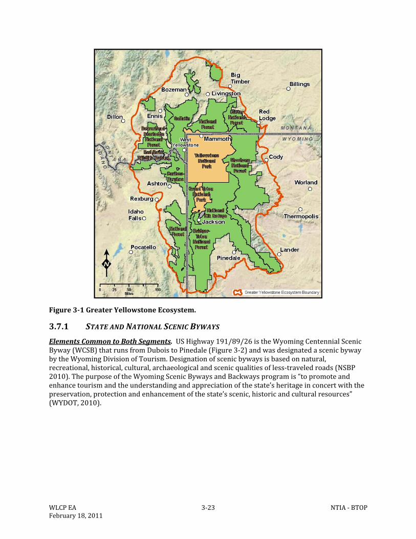
WLCPEA 3‐23 NTIA‐BTOPFebruary18,2011
Figure3‐1GreaterYellowstoneEcosystem.
3.7.1 STATEANDNATIONALSCENICBYWAYS
ElementsCommontoBothSegments.USHighway191/89/26istheWyomingCentennialScenicByway(WCSB)thatrunsfromDuboistoPinedale(Figure3‐2)andwasdesignatedascenicbywaybytheWyomingDivisionofTourism.Designationofscenicbywaysisbasedonnatural,recreational,historical,cultural,archaeologicalandscenicqualitiesofless‐traveledroads(NSBP2010). ThepurposeoftheWyomingScenicBywaysandBackwaysprogramis“topromoteandenhancetourismandtheunderstandingandappreciationofthestate’sheritageinconcertwiththepreservation,protectionandenhancementofthestate’sscenic,historicandculturalresources”(WYDOT,2010).
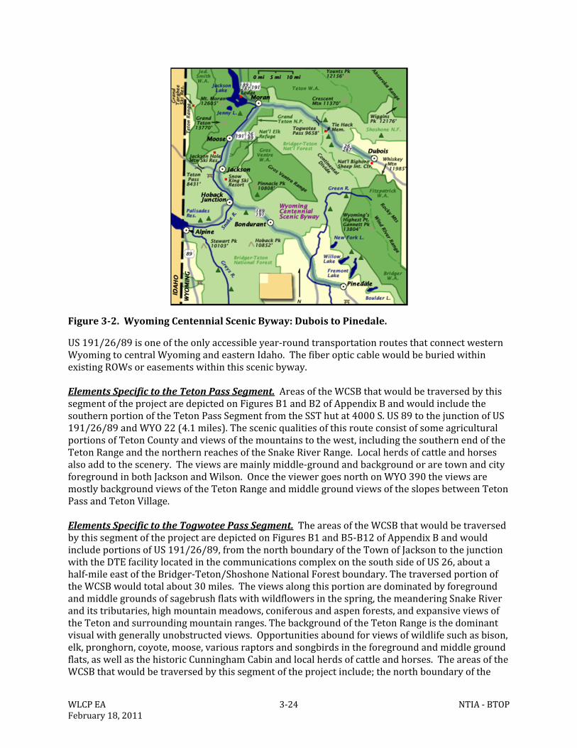
WLCPEA 3‐24 NTIA‐BTOPFebruary18,2011
Figure3‐2.WyomingCentennialScenicByway:DuboistoPinedale.
US191/26/89isoneoftheonlyaccessibleyear‐roundtransportationroutesthatconnectwesternWyomingtocentralWyomingandeasternIdaho.ThefiberopticcablewouldbeburiedwithinexistingROWsoreasementswithinthisscenicbyway.ElementsSpecifictotheTetonPassSegment.AreasoftheWCSBthatwouldbetraversedbythissegmentoftheprojectaredepictedonFiguresB1andB2ofAppendixBandwouldincludethesouthernportionoftheTetonPassSegmentfromtheSSThutat4000S.US89tothejunctionofUS191/26/89andWYO22(4.1miles).ThescenicqualitiesofthisrouteconsistofsomeagriculturalportionsofTetonCountyandviewsofthemountainstothewest,includingthesouthernendoftheTetonRangeandthenorthernreachesoftheSnakeRiverRange.Localherdsofcattleandhorsesalsoaddtothescenery.Theviewsaremainlymiddle‐groundandbackgroundoraretownandcityforegroundinbothJacksonandWilson.OncetheviewergoesnorthonWYO390theviewsaremostlybackgroundviewsoftheTetonRangeandmiddlegroundviewsoftheslopesbetweenTetonPassandTetonVillage.ElementsSpecifictotheTogwoteePassSegment.TheareasoftheWCSBthatwouldbetraversedbythissegmentoftheprojectaredepictedonFiguresB1andB5‐B12ofAppendixBandwouldincludeportionsofUS191/26/89,fromthenorthboundaryoftheTownofJacksontothejunctionwiththeDTEfacilitylocatedinthecommunicationscomplexonthesouthsideofUS26,aboutahalf‐mileeastoftheBridger‐Teton/ShoshoneNationalForestboundary.ThetraversedportionoftheWCSBwouldtotalabout30miles.Theviewsalongthisportionaredominatedbyforegroundandmiddlegroundsofsagebrushflatswithwildflowersinthespring,themeanderingSnakeRiveranditstributaries,highmountainmeadows,coniferousandaspenforests,andexpansiveviewsoftheTetonandsurroundingmountainranges.ThebackgroundoftheTetonRangeisthedominantvisualwithgenerallyunobstructedviews.Opportunitiesaboundforviewsofwildlifesuchasbison,elk,pronghorn,coyote,moose,variousraptorsandsongbirdsintheforegroundandmiddlegroundflats,aswellasthehistoricCunninghamCabinandlocalherdsofcattleandhorses.TheareasoftheWCSBthatwouldbetraversedbythissegmentoftheprojectinclude;thenorthboundaryofthe
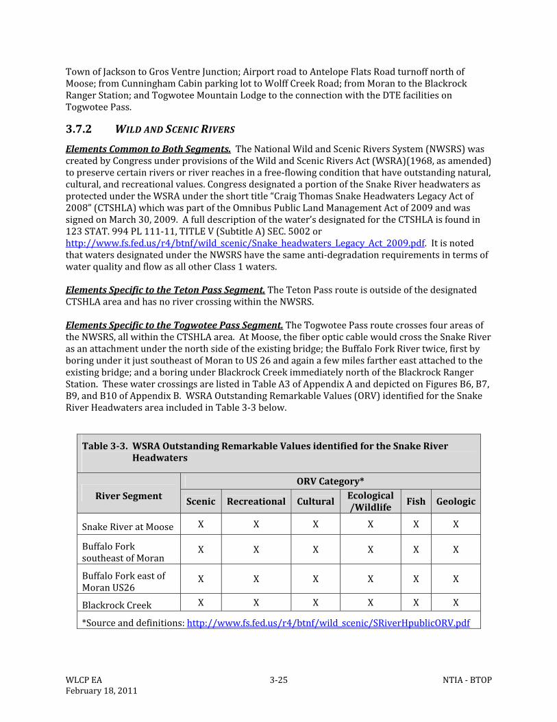
WLCPEA 3‐25 NTIA‐BTOPFebruary18,2011
TownofJacksontoGrosVentreJunction;AirportroadtoAntelopeFlatsRoadturnoffnorthofMoose;fromCunninghamCabinparkinglottoWolffCreekRoad;fromMorantotheBlackrockRangerStation;andTogwoteeMountainLodgetotheconnectionwiththeDTEfacilitiesonTogwoteePass.
3.7.2 WILDANDSCENICRIVERS
ElementsCommontoBothSegments.TheNationalWildandScenicRiversSystem(NWSRS)wascreatedbyCongressunderprovisionsoftheWildandScenicRiversAct(WSRA)(1968,asamended)topreservecertainriversorriverreachesinafree‐flowingconditionthathaveoutstandingnatural,cultural,andrecreationalvalues.CongressdesignatedaportionoftheSnakeRiverheadwatersasprotectedundertheWSRAundertheshorttitle“CraigThomasSnakeHeadwatersLegacyActof2008”(CTSHLA)whichwaspartoftheOmnibusPublicLandManagementActof2009andwassignedonMarch30,2009.Afulldescriptionofthewater’sdesignatedfortheCTSHLAisfoundin123STAT.994PL111‐11,TITLEV(SubtitleA)SEC.5002orhttp://www.fs.fed.us/r4/btnf/wild_scenic/Snake_headwaters_Legacy_Act_2009.pdf.ItisnotedthatwatersdesignatedundertheNWSRShavethesameanti‐degradationrequirementsintermsofwaterqualityandflowasallotherClass1waters. ElementsSpecifictotheTetonPassSegment.TheTetonPassrouteisoutsideofthedesignatedCTSHLAareaandhasnorivercrossingwithintheNWSRS.ElementsSpecifictotheTogwoteePassSegment.TheTogwoteePassroutecrossesfourareasoftheNWSRS,allwithintheCTSHLAarea.AtMoose,thefiberopticcablewouldcrosstheSnakeRiverasanattachmentunderthenorthsideoftheexistingbridge;theBuffaloForkRivertwice,firstbyboringunderitjustsoutheastofMorantoUS26andagainafewmilesfarthereastattachedtotheexistingbridge;andaboringunderBlackrockCreekimmediatelynorthoftheBlackrockRangerStation.ThesewatercrossingsarelistedinTableA3ofAppendixAanddepictedonFiguresB6,B7,B9,andB10ofAppendixB.WSRAOutstandingRemarkableValues(ORV)identifiedfortheSnakeRiverHeadwatersareaincludedinTable3‐3below.
Table3‐3.WSRAOutstandingRemarkableValuesidentifiedfortheSnakeRiverHeadwaters
RiverSegment
ORVCategory*
Scenic Recreational CulturalEcological/Wildlife Fish Geologic
SnakeRiveratMoose X X X X X X
BuffaloForksoutheastofMoran
X X X X X X
BuffaloForkeastofMoranUS26
X X X X X X
BlackrockCreek X X X X X X
*Sourceanddefinitions:http://www.fs.fed.us/r4/btnf/wild_scenic/SRiverHpublicORV.pdf
WLCPEA 3‐26 NTIA‐BTOPFebruary18,2011
3.7.3 NATIONALPARKS,NATIONALFORESTS,WILDERNESSAREAS,ANDWILDLIFE
REFUGES
ElementsCommontoBothSegments.TheGreaterYellowstoneAreaishometotwofederallydesignatedwildliferefugesandfiveWildernessareas,aswellastwonationalparksandsixnationalforests.Theselandsaregenerallyopentothepublic,provideoutdoorrecreationopportunities,andcontributetothevariousscenicvistasforwhichtheareaisknown.Theseareasarealsosubjecttoperiodicwildfiresduringthesummerandearlyfall.Althoughwildfiresuppressionpoliciesvaryfromagencytoagency,thereareanumberofareaswherewildfiresmaybemanagedasnaturaleventsandpermittedtoburnforindefiniteperiods.Thesefireshavethepotentialtocreatelargeamountsofsmokethatcansettleinthebasinandobscureviewsformonthsatatime.ElementsSpecifictotheTetonPassSegment.TheproposedroutefortheTetonPassSegmentisdepictedinFiguresB1andB2‐B4ofAppendixB.Thelengthsofvariouslandjurisdiction/managementagenciesfortheTetonPassSegmentarelistedinTable2‐1.NFSlandonboththeBTNFandCTNFwouldbetraversed.TheproposedroutewouldnottraverseanyWildernessareasbutwouldcomewithinlessthan0.5mileoftheborderoftheJedediahSmithWildernessAreaontheCTNF.ElementsSpecifictotheTogwoteePassSegment.TheproposedroutefortheTogwoteePassSegmentisdepictedinFiguresB1andB5‐B12ofAppendixB.Thelengthsofvariouslandjurisdiction/managementagenciesfortheTogwoteePassSegmentarelistedinTable2‐2.TheproposedroutewouldnottraverseanydesignatedWildernessareas.NFSlandonboththeBTNFandSNFwouldbetraversed.ThesegmentwouldalsotraverseportionsoftheGTNPandtheNationalElkRefugeonanestablishedROWsonUS89/26.
3.7.4 STATELANDS
ElementsCommontoBothSegments.NolandsownedbytheStateofWyomingasstateSchoolTrustLandsorotherspecialdesignationwouldbecrossedbyeithersegment,butROWscontrolledormanagedbytheWYDOTwouldbetraversedonbothproposedsegments.ElementsSpecifictotheTetonPassSegment.Asspecifiedabove.ElementsSpecifictotheTogwoteePassSegment.Asspecifiedabove.
3.7.5 MUNICIPALANDCOUNTYLANDS
ElementsCommontoBothSegments.Municipalitiesandcountygovernmentsarealsopropertyownerswithintheirrespectivepoliticalboundaries.WithinTetonCounty,themajorityoftheproposedrouteswillbewithintheruralzoningdistrictbutwouldalsocrossintotheauto‐urbancommercial,businesspark,affordablehousingplannedunitdevelopment,andsingle‐familyzoningdistricts.Themunicipalandcountylandsareinbothurbanandruralsettings,eachwiththeirownaestheticandscenicattributes,andsimilartothoseofthestatelands.ElementsSpecifictotheTetonPassSegment.TheproposedroutefortheTetonPassSegmentincludesanumberofspursusingexistingROWsoffofUS89,WYO390andWYO22toprovidepotentialservicetokeyfacilitiesinJacksonandalongtheroutetoWilsonandTetonVillage.Lands
WLCPEA 3‐27 NTIA‐BTOPFebruary18,2011
traversedbytheproposedsegmentaredepictedonFiguresB1‐B4ofAppendixB.ThegenerallengthsofthejurisdictionstraversedarenotedinTable2‐1.ElementsSpecifictotheTogwoteePassSegment.LandstraversedbytheproposedsegmentaredepictedonFiguresB1andB5‐B12ofAppendixB.ThegenerallengthsofthejurisdictionstraversedarenotedinTable2‐2.TheproposedroutefortheTogwoteePassSegmenttraversesmunicipalandcountylandswithinexistingROWsinordertoprovideserviceaccesstoeducationfacilities,medicalfacilities,governmentbuildings,andotheranchorinstitutions.
3.8 LANDUSEANDRECREATION
ElementsCommontoBothSegments.TetonCountyiscomprisedofbothpublicandprivateland,howeveronlythreepercentofthelandareainTetonCountyisprivatelyownedwiththeremaining97percentbeingpubliclands.Theprojectareaispredominantlywithinpreviouslydisturbedutility,roadcorridorsandexistingdevelopedareas.Surroundinglanduseinthevicinityofthecorridorisdictatedbythejurisdictioninwhichitfalls.TheWLCPpassesthroughthreenationalforests,GTNP,TetonCounty,Wyoming,andtheTownofJackson,Wyoming,andrunswithintheNationalElkRefuge(withinaWYDOTROW)forabout1.7miles(SeeAppendixB,FiguresB1‐B12,http://www.jacksontetonplan.com/plan/maps/ExistingLandUse)andTables2‐1and2‐2.Federallandintheprojectareaisusedprimarilyforrecreation,wilderness,wildlifemanagement,andforestry.LanduseinTetonCountyisprimarilyruralandagriculturalwithlowtomid‐densityresidential.LanduseintheTownofJacksonispredominantlyamixofresidentialandcommerciallands.PrivatelandsareconcentratedonthevalleyfloorofTetonCounty,Wyoming,southofGTNP.OutsideoftheTownofJackson,mostoftheprivatelandshavenotbeenintensivelydeveloped.BTNF,SNF,CTNF,GTNP,andtheNationalElkRefuge(NER)providediversebasesofrecreationalopportunityformillionsofusersonayearroundbasisandarerecognizedasnationallysignificant,heavilyusedrecreationalresources.Bothresidentsandtourists’relyontheNFSlands,GTNP,andtheNERassourcesofabroadspectrumofrecreationalopportunities.FormanyresidentsandvisitorstheJacksonHoleareaissynonymouswithrecreationintheformsofhiking,skiing,fishing,biking,variousmotorizedactivitiessuchassnowmobiling,boating,camping,sight‐seeing,andnumerousotherformsofrecreationthatincludemechanized,motorized,equestrian,andpedestrianparticipants.InparticulartheUSFSandGTNPhaveadoptedspecificguidelinesforaccommodatingrecreationalopportunities.ElementsSpecifictotheTetonPassSegment.TheTetonPassSegmentisapproximately36mileslong.About75%ofthissegmentcrossesTetonCounty,TownofJackson,BTNF,andCTNFpropertywithinexistingROWsandeasementswiththeremainingcrossingsoutsideofexistingROWsoreasements(Table2‐1).OneofthemoreimportantrecreationalopportunitiesalongthissegmentistheOTPH..TheOTPHinnowapopularhikingandbikingtrailfromatrailheadwestofWilsontoTetonPassandisusedyearround.Approximately45usersperdaytravelonOldPassRoadduringthesnow‐freeseason.However,theForestServicehasrecorded50usersinjusta2‐hourperiod,sotherearetimeswhenuseismuchhigherandtherearetimeswhenthereareveryfewusersontheroad.TheOTPHhasconsiderableuseinthewinterforskiing,sledding,andsnowshoeing.ThevastmajorityofuseonOldPassRoadoccursbetweentheTrailCreektrailheadandCraterLake.Thebiggestusergroupiswalkers/hikers,oftenwithdogs.Bicyclistsarethenextlargestusergroup.SomeuseoftheOldPassRoadbybicyclistscanbeconsideredcommutertrafficparticularlywhenWYO22isbeingrepaired
WLCPEA 3‐28 NTIA‐BTOPFebruary18,2011
ormaintainedwhichisacommonoccurrence.Duringthosetimes,theOTPHoffersanalternativetolongdelays.However,duringnormaltimesthemajorityofbiketrafficisrecreationaltraffic.AnotherimportantandhighlyvaluedrecreationalresourcefoundalongtheproposedTetonPassSegmentarethebikeandhikingpathsleadingfromtheBTNFtoWilsonandbeyond.Thisnetworkofpathwaysprovidesyearroundusetoresidentsandvisitorstobicycle,walk,jog,andattimesski.TheportionsofthepathwaysbetweenWilson(tworoutesonepavedonthesouthandoneunpavedonthenorthofWYO22(so‐calleddirttrail))andtheBTNFandfromtheJunctionofWYO390andWYO22toTetonVillageandbeyondareparticularlyheavilyused.ElementsSpecifictotheTogwoteePassSegment.TheTogwoteePassSegmentisalmost66mileslong.Mostofthissegment(56miles)traversesGTNPandBTNFlandwith11ofthosemilesfallingwithinexistingWYDOTROWsandeasementsontheBTNF(Table2‐2).Abouta0.5mileportionoftheWLCPiswithintheSNFoneitheraWYDOTROWoreasementorwithinanexistingcommunicationcomplexspecialusearea.TheTogwoteePassSegmentalsoprovidesverydiverse,heavilyused,andnationallysignificantrecreationopportunitiessimilartotheTetonPassSegment.ImportantrecreationalelementsuniquetotheTogwoteePassSegmentincludeanew(2010/2011)multi‐usepathfromtheTownofJacksontoMooseHeadquarterswithinGTNP.Thismulti‐usepathwayiscurrentlyunderconstructionbutispartiallycompletedandwillprovideopportunitiesforthousandsofuserstobike,walk,ski(withinalimitedseasonofclosure),andgenerallyenjoytheareabetweenJacksonandGTNP.Besidesthenewmulti‐userpathway,existingtrails,pathways,unpavedbackroads,highways,andwaterwaystraversedbytheTogwoteePassSegmentprovidenumerousopportunitiesforrecreationonayearroundbasis.Constructionofthemulti‐usepathwayfromJacksontoMooseincludingtwooverpassesarescheduledforcontinuedconstructionduring2011.
3.9 INFRASTRUCTURE
ThemajorityofTetonCounty,Wyoming,isrural,withapopulationcenterlocatedwithina12‐mileradiusoftheTownofJackson.Locatedwithinthisradiusareallgeneralinfrastructurefeatures.Infrastructureisthenecessaryfacilitiesthathelpsupportasocietyanditseconomy.Typicalinfrastructureinvolvesarangeofservices,including:
Communications(cellular,landlines,internetservices,andcable);
Undergroundandoverheadutilities(water,sanitarysewer,naturalgas,powergrids,etc.);and
AirportsandroadnetworksOutsideoftheradius,thesefeaturesbecomelessavailableorabsenttherebynecessitatingtravel.Electricalandtelecommunicationlinestraversemuchofthecounty,providingservicestomosthomes.
3.9.1 COMMUNICATIONS&UTILITIES
ElementsCommontoBothSegments.AmajorityofthecommunicationsandutilityinfrastructureiscenteredaroundtheTownofJacksonandthecommunitiesofWilson,TetonVillage,Moose,RafterJ,MelodyRanch,HobackJunctionandthedevelopmentsnorthofJacksonaroundJackson
WLCPEA 3‐29 NTIA‐BTOPFebruary18,2011
GolfandTennisClub,theairport,andMoran.Withinthisdevelopedradius,communication,water,sewer,naturalgas,power,andcableservicesaregenerallyavailable.ServicesdiminishnorthpasttheJacksonHoleAirport,westfromWilson,andsouthfromHobackJunction.Theareasoutsidetheradiusmayonlyoffercommunication,fullyservicedroads,andpowerservice.MostoftheWLCParecoveredbycellularcommunicationsalthoughasinglecellularprovidermaynotcovertheentirearea.Waterisprovidedtoconsumersfromeithermunicipal,waterdistrict,orprivatelyownedgroundwaterwells.SanitarysewerislimitedtothedevelopedareasnearJacksonwithresidencesoutsideitsrangeutilizingsepticsystems.Buriedand/oroverheadtelecommunicationlandlines(copperservice)extendthroughouttheTownofJacksonandsurroundingareas,includingWilsonandTetonVillage.AllcopperservicesconnecttoanexistingfiberopticlineownedandoperatedbyQwest,whichgenerallyfollowsUS89northtoMoran,Wyoming,andexitsTetonCountytothesouth.Connectingfiberopticservicetocoppercanreadilybedonebutrequiresspecializedequipmentandfacilitiesandcanbequiteexpensive.Whenfiberopticisconnectedtocopperfacilities,allofthedownsidesassociatedwithcopperbecomeinherentinthatportionofaline.Infrastructureservicedbycopperhaslessspeed,lowercapacity,lessutilityandissubjecttoinfluencessuchastemperatureandelectricalconductivitywhereasfiberopticisnot.ElementsSpecifictotheTetonPassSegment.CommunicationservicesareofferedtoandwithinthedevelopedbaseareaofTetonPassbutdonotcurrentlycrossoverthepasstoconnectwithservicesinIdaho(AppendixB,FigureB13).ElementsSpecifictotheTogwoteePassSegment.CommunicationserviceisprovidedthroughouttheTownofJacksonandsurroundingareas.Telecommunicationlinesbothburiedandoverhead,provideservicetocustomersthroughoutthisareaofthecounty.Qwest‐ownedand‐operatedburiedlines(copperserviceandonefiberopticservice)extendnorthfromtheTownofJacksonalongUS89/26,servicingthedevelopmentsnearJacksonGolfandTennisClub,JacksonHoleAirport,andMooseareas.Theselinesservicemuch,butnotall,oftheareanorthofGrosVentreJunctionwithinTetonCounty.ContinuingnorthfromMooseJunction,theQwestlinesturnatAntelopeFlatsRoadandfollowittotheeastwheretheyturnnorthattheEastBoundaryRoadandfollowunderexistingpowerlinestothenorthwheretheymeetbackwithUS89/26neartheHistoricCunninghamCabinparkinglot.AtthisjunctionthelinescontinuenorthadjacenttoUS89/26toMoran.ThefiberopticcablecontinuesnorthalongUS89(AppendixB,FigureB14)andthecopperservicecontinuestotheeastadjacenttoUS26.Thecopperservice,continuingeast,followsadjacenttoUS26totheBlackrockRangerStationthenturnsnorthandfollowsunderanexistingpowerline.ThecopperserviceturnstotheeastfromtheFAAVORstationandfollowsFSroad30060andFSroad30040endingnearTogwoteeMountainLodgeleavingaburiedcommunicationservicegapbetweenthelodgeandtheDTEfiberopticline,whichterminatesnearthesummitofTogwoteePass.
3.9.2 EXISTINGROADNETWORK
ElementsCommontoBothSegments.TheexistingroadnetworkintheTetonValleyhasdevelopedoverthelast100yearstoprimarilyserviceagriculturalandrecreationinterests.Inordertokeepthehighwaysingoodcondition,repavingonaregularbasisiscommon.Becauseofthehighelevation,heavysnowfallandgeographicalsetting,theareaingeneralhasarelatively
WLCPEA 3‐30 NTIA‐BTOPFebruary18,2011
shortconstructionseason,oftenrestrictedtolateJunethroughearlyOctober.ThisisparticularlytrueforroadsegmentsoverbothTetonandTogwoteepasses.ElementsSpecifictotheTetonPassSegmentMoose‐WilsonRoad(WYO390).WYO390wasoriginallyaroadconstructedbyranchers.In1954and1955,theentireroadwasgradedandabasewaslaiddowntothesouthernboundaryofGTNPatmile7.71.By1971,itwaspavedtothissamepoint.GuardrailswereinstalledjustsouthoftheLakeCreekBridgein1982.In1994,aturnlanewasaddedtotheNethercottRoadintersection,theintersectionwithWYO22wasmodified,andshoulderworkwasdoneonjustunder0.2milesofroadwaynorthofTetonVillage.In2002,aROWfencewasinstalledfromtheLakeCreekBridgetojustnorthofTetonVillageandworkbegantorebuildthebridgeacrossLakeCreek.Effortstorebuildthisroadcontinue,althoughthetimingofreconstructionremainsunknown.TetonPasstoJackson(WYO22).In1918,theBureauofPublicRoadscompletedanewroadoverTetonPassandtheForestServiceallocated$12,000tosurfacetheroadin1925.TheBureauofPublicRoadsinitiatedamajorupgradein1932,wideningtheroadfrom8to18feet,surfacingit,andreducingthegrades3to4percentinsomeplaces.The1932improvementsweredoneonwhatisknowntodayastheOldTetonPassroad.From1960to1970,theentireroadwasgradedandsurfacedfromtheIdahobordertojustaboveWilson,Wyoming.Inthe1970s,WYO22fromitsjunctionwithUS89wasgradedandsurfacedandTetonPasswasoverhauledtoincludethecurrentmajorrealignmentstoimprovesafetyandreduceavalancheimpacts.Asurfacingandwideningprojectoccurredona0.1‐milestretchofWYO22betweentheWilsonBridgeandtheintersectionofWYO390in1975.FenceswereinstalledalongWYO22fromtheintersectionwithWYO390toWilsonin1989.AtrafficlightwasinstalledattheintersectionofWYO22and390in1991,andthatintersectionwasmodifiedtoaccommodateaturninglanein1994.WYO22waswidenedatthesharpbendintheroadneartheWaltonRanch(miles3.0‐3.2)andthemostrecentprojectonWYO22wastheinstallationofatrafficlightwhereitintersectsSpringGulchRoadin2001.WYO22hasbeenscheduledformajorreconstructiontoaccommodatelargeincreasesintraffic.FrequentrepairandmaintenancetotheroadinfrastructureonWYO22overTetonPassiscommonandbringswithittrafficdelaysandserviceinterruptionswhiletheseactivitiesoccur.ElementsSpecifictotheTogwoteePassSegmentJacksontoMoranJunction(U.S.26/89/191/287).Asteel‐trussbridgewasbuiltacrosstheGrosVentreRiverinthe1920s.In1948,aproposalwaspresentedtoconstructanewhighwayfromthesouthboundaryoftheJacksonHoleNationalMonument(nowpartofGTNP)totheBuffaloForkRiver.TheNationalParkServicehadconcernsabouttheexistingalignmentoftheroadanditsimpactsonwildlifehabitatandfavoredahighwaydivertingwestfromtheexistingroad,whichwaslocatedsoutheastofBlacktailButte,runningnorthacrossAntelopeFlatstoDeadman’sBar,thencrossingSpreadCreekandtheBuffaloForktojointheYellowstone‐Dubois‐LanderHighway.ThePublicRoadsAdministrationconstructedthecurrenthighwaybetween1955and1957toNationalParkServicespecifications.TogwoteePass(U.S.26/287).TogwoteePasswasmovedtoitspresentlocation,reconstructed,andpavedfrom1967‐1971.TheremainderofrecentWYDOTprojectsonthatstretchofroadinvolvedsealing,resurfacing,fencingandguardrailinstallation.TheentiresectionofhighwaybetweenMoranandDuboiswasscheduledforreconstructionin2007andthatworkisnearlycompleted.ThefinalsectionofUS26tobecompletedisbetweenTogwoteeLodgeandthebridgespanningtheBuffaloForkRivereastofMoran.
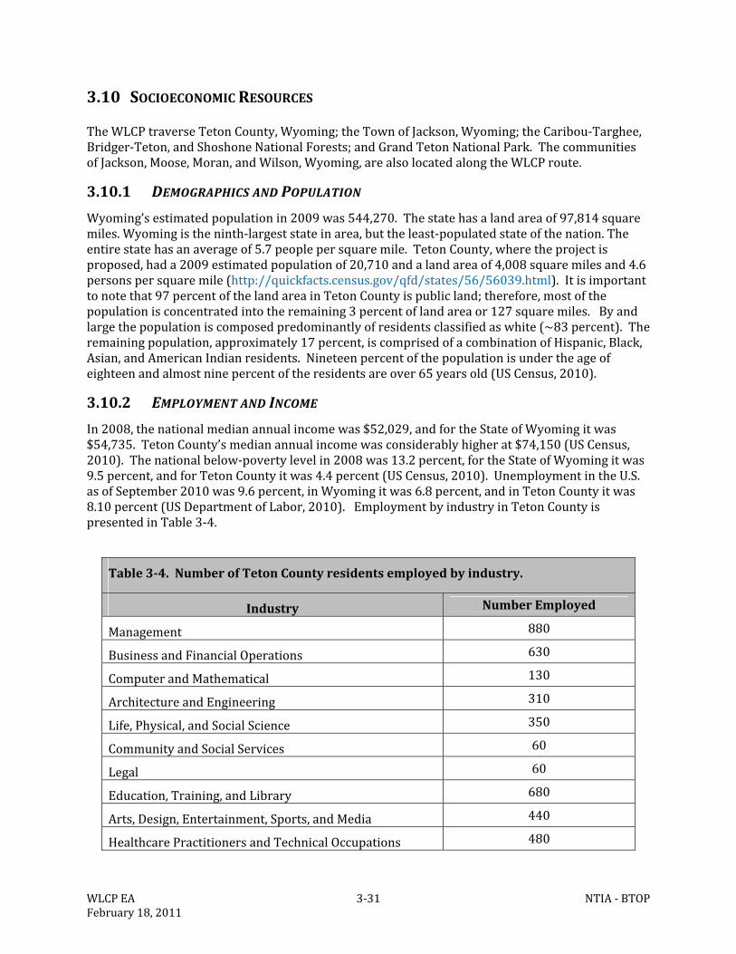
WLCPEA 3‐31 NTIA‐BTOPFebruary18,2011
3.10 SOCIOECONOMICRESOURCES
TheWLCPtraverseTetonCounty,Wyoming;theTownofJackson,Wyoming;theCaribou‐Targhee,Bridger‐Teton,andShoshoneNationalForests;andGrandTetonNationalPark.ThecommunitiesofJackson,Moose,Moran,andWilson,Wyoming,arealsolocatedalongtheWLCProute.
3.10.1 DEMOGRAPHICSANDPOPULATION
Wyoming’sestimatedpopulationin2009was544,270.Thestatehasalandareaof97,814squaremiles.Wyomingistheninth‐largeststateinarea,buttheleast‐populatedstateofthenation.Theentirestatehasanaverageof5.7peoplepersquaremile.TetonCounty,wheretheprojectisproposed,hada2009estimatedpopulationof20,710andalandareaof4,008squaremilesand4.6personspersquaremile(http://quickfacts.census.gov/qfd/states/56/56039.html).Itisimportanttonotethat97percentofthelandareainTetonCountyispublicland;therefore,mostofthepopulationisconcentratedintotheremaining3percentoflandareaor127squaremiles.Byandlargethepopulationiscomposedpredominantlyofresidentsclassifiedaswhite(~83percent).Theremainingpopulation,approximately17percent,iscomprisedofacombinationofHispanic,Black,Asian,andAmericanIndianresidents.Nineteenpercentofthepopulationisundertheageofeighteenandalmostninepercentoftheresidentsareover65yearsold(USCensus,2010).
3.10.2 EMPLOYMENTANDINCOME
In2008,thenationalmedianannualincomewas$52,029,andfortheStateofWyomingitwas$54,735.TetonCounty’smedianannualincomewasconsiderablyhigherat$74,150(USCensus,2010).Thenationalbelow‐povertylevelin2008was13.2percent,fortheStateofWyomingitwas9.5percent,andforTetonCountyitwas4.4percent(USCensus,2010).UnemploymentintheU.S.asofSeptember2010was9.6percent,inWyomingitwas6.8percent,andinTetonCountyitwas8.10percent(USDepartmentofLabor,2010).EmploymentbyindustryinTetonCountyispresentedinTable3‐4.
Table3‐4.NumberofTetonCountyresidentsemployedbyindustry.
Industry NumberEmployed
Management 880
BusinessandFinancialOperations 630
ComputerandMathematical 130
ArchitectureandEngineering 310
Life,Physical,andSocialScience 350
CommunityandSocialServices 60
Legal 60
Education,Training,andLibrary 680
Arts,Design,Entertainment,Sports,andMedia 440
HealthcarePractitionersandTechnicalOccupations 480
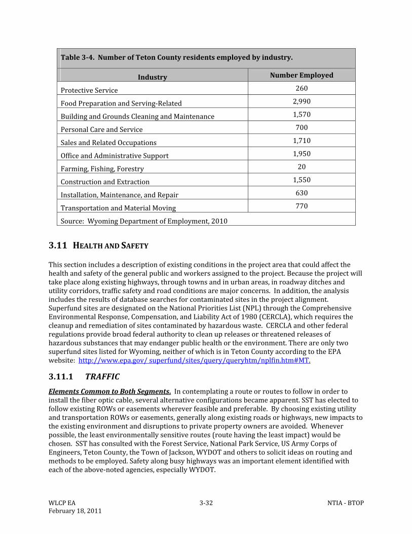
WLCPEA 3‐32 NTIA‐BTOPFebruary18,2011
Table3‐4.NumberofTetonCountyresidentsemployedbyindustry.
Industry NumberEmployed
ProtectiveService 260
FoodPreparationandServing‐Related 2,990
BuildingandGroundsCleaningandMaintenance 1,570
PersonalCareandService 700
SalesandRelatedOccupations 1,710
OfficeandAdministrativeSupport 1,950
Farming,Fishing,Forestry 20
ConstructionandExtraction 1,550
Installation,Maintenance,andRepair 630
TransportationandMaterialMoving 770
Source:WyomingDepartmentofEmployment,2010
3.11 HEALTHANDSAFETY
Thissectionincludesadescriptionofexistingconditionsintheprojectareathatcouldaffectthehealthandsafetyofthegeneralpublicandworkersassignedtotheproject.Becausetheprojectwilltakeplacealongexistinghighways,throughtownsandinurbanareas,inroadwayditchesandutilitycorridors,trafficsafetyandroadconditionsaremajorconcerns.Inaddition,theanalysisincludestheresultsofdatabasesearchesforcontaminatedsitesintheprojectalignment.SuperfundsitesaredesignatedontheNationalPrioritiesList(NPL)throughtheComprehensiveEnvironmentalResponse,Compensation,andLiabilityActof1980(CERCLA),whichrequiresthecleanupandremediationofsitescontaminatedbyhazardouswaste.CERCLAandotherfederalregulationsprovidebroadfederalauthoritytocleanupreleasesorthreatenedreleasesofhazardoussubstancesthatmayendangerpublichealthortheenvironment.ThereareonlytwosuperfundsiteslistedforWyoming,neitherofwhichisinTetonCountyaccordingtotheEPAwebsite:http://www.epa.gov/superfund/sites/query/queryhtm/nplfin.htm#MT.
3.11.1 TRAFFIC
ElementsCommontoBothSegments.Incontemplatingarouteorroutestofollowinordertoinstallthefiberopticcable,severalalternativeconfigurationsbecameapparent.SSThaselectedtofollowexistingROWsoreasementswhereverfeasibleandpreferable.BychoosingexistingutilityandtransportationROWsoreasements,generallyalongexistingroadsorhighways,newimpactstotheexistingenvironmentanddisruptionstoprivatepropertyownersareavoided.Wheneverpossible,theleastenvironmentallysensitiveroutes(routehavingtheleastimpact)wouldbechosen.SSThasconsultedwiththeForestService,NationalParkService,USArmyCorpsofEngineers,TetonCounty,theTownofJackson,WYDOTandotherstosolicitideasonroutingandmethodstobeemployed.Safetyalongbusyhighwayswasanimportantelementidentifiedwitheachoftheabove‐notedagencies,especiallyWYDOT.
WLCPEA 3‐33 NTIA‐BTOPFebruary18,2011
Averageannualdailytraffic(AADT)onTetonCounty’shighwayshasincreasedanaverageof60percentfrom1990to2001and92percentonportionsofWYO22.AccordingtoWYDOTdataforUS89,WYO22andWYO390(year2009),peaktrafficcountsoccurduringthemonthsofJulyandAugustbetween5and6p.m.(http://www.dot.state.wy.us/wydot/planning_projects/Traffic_Data).TrafficishigheronweekdaysthanweekendswithFridaygenerallyhavingthehighestcounts.Themonthswiththelowesttrafficcountsduring2009inTetonCountywereNovemberthroughApril.ElementsSpecifictotheTetonPassSegment.TheTetonPassroutepassesalongtownstreetsinJackson,andWYO22,US89,andWYO390,aswellasthecurrentpavedbicyclepathfromtheTrailCreekparkinglotwestofWilsontoTetonPass(OTPH).Thepeakmeanaverageweekdaytraffic(MAWDT)inAugustonWYO390toTetonVillageisabout15,000,droppingtoabout12,000onweekends.Thisisabout5,000lessthantheMAWDTonWYO22eastoftheproposedSnakeRivercrossing.ThedifferenceintrafficvolumeisattributabletodisbursementstothebusinessorresidentialareasinWilsonortrafficcontinuingoverTetonPasstoVictor.AveragedailytrafficinVictorisabout4,000,butthistrafficcanoriginatefromseverallocations(http://www.itd.idaho.gov/planning/roadwaydata/counters/102/index.html).Trafficonthebicycle/hikingpathvariesbyseasonbutaveragesaround45usersperday.ThereareveryfewflatstretchesofroadonWYO22betweenWilsonandTetonPassorbetweenTetonPasstoCoalCreekCampgroundsuitabletosafelystopandholdtraffic.Consequently,trafficdelaysandmanagementduringmosttypesofroadwayconstructionaremajorconcernswhenoperatingalongandwithinthenarrowWYO22ROWapproachingTetonPassfromeitherside.ElementsSpecifictotheTogwoteePassSegment.TheTogwoteePassSegmentwouldpassalongstreetsinJackson,andUS89/26,aswellastheseveraldirtroadsfromtheAntelopeFlatsRoadtotheBuffaloForkRiverandUS26eastofMoran.Thepeakmeanaverageweekdaytraffic(MAWDT)inAugustonUS89betweenJacksonandMoranisabout6,000,droppingtoabout5,400onweekends.Thisisabout6,500lessthantheMAWDTonUS89southofJacksonduringthesametimeperiod.MAWDTforAugusteastofMorantowardTogwoteePassisabout2,000(http://www.dot.state.wy.us/wydot/planning_projects/Traffic_Data).
3.11.2 CONTAMINATEDSITESANDOTHERADVERSEHEALTHEFFECTS
ElementsCommontoBothSegments.Brownfieldsarerealpropertywhereexpansion,redevelopment,orreuseiscomplicatedbythepresenceofahazardoussubstance,pollutant,orcontaminant(EPA,2010).TherearenoknownactivebrownfieldsiteswithinoradjacenttotheproposedalignmentoftheProposedAction.Also,asnotedabove,therearenoSuperfundsiteswithintheareaofinterest.ElementsSpecifictotheTetonPassSegment.Asspecifiedabove.ElementsSpecifictotheTogwoteePassSegment.Asspecifiedabove.
WLCPEA 4‐1 NTIA‐BTOPFebruary18,2011
4.0 ENVIRONMENTALCONSEQUENCES
4.1 NOISE
4.1.1 NOACTIONALTERNATIVE
UnderimplementationoftheNoActionAlternative,ambientnoiselevelswouldremainasdescribedinSection3.1.
4.1.2 PROPOSEDACTIONALTERNATIVE
PotentialImpactsCommontoBothSegments.SincethisprojectisnotaFederalHighwayAdministration(FHWA)constructionproject,itisnotsubjecttotheprovisionsofTitle23oftheCodeofFederalRegulationPart772(23CFR772)relatedtosensitivereceptorareas.Althoughtheinstallationwilltakeplacenearresidentialareas,businesses,schoolsandmedicalfacilities(sensitivereceptors),thelevelofnoiseproducedwouldbeofrelativelyshortdurationandnotasignificantimpactontheresidents.ThisisalsotrueintheClassAareasbetweenJacksonandTogwoteePass,wherequietpunctuatedbyrecreationtrafficandhighwaytrafficconstitutetheambientsounds.Inaddition,thewholeofGrandTetonNationalPark(GTNP)isanoise‐sensitivearea.Noneoftheinstallationactivitieswouldresultinanypermanentchangetoambientnoiselevels.Exceptfortheconstructionofthetwohutsandtwocabinets,impactsatspecificlocationscouldbemeasuredinminutesoratmosthours.Therewouldbeisolatedincreasesinnoiseduringtheactualinstallationofthebroadbandcableresultingfromoperationofthetrencherandbackhoe,thedeliveryandloadingandunloadingofthecableandconduit,andthepeopleandtrucksdeliveringandinstallingthesematerials.Thesenoiseswouldbelocalizedandwillmoveanddisappearasinstallationprogressesalongtheroute.Asaresult,ambientnoiselevelswouldtemporarilyincrease.ProbablytheslowestrateofprogresswillbewithinurbansettingssuchastheTownofJacksonbecauseoftheneedtoprotectand/orremove,relocate,orrepaircityinfrastructurelikeroads,sidewalks,andundergroundutilities.Keysensitivenoisereceptorsincludingmanyofthecommunityanchorinstitutions(CAIs)arelocatedeitherwithintheTownofJacksonorotherurbansetting.Ambientnoiselevelsinsuchlocationsaregenerallyhigherthaninmoreruralsettingsconsequentlynoisefromtheproposedconstructionactivitieswouldbelessnoticeableandlessapttocauseanimpacttosensitivereceptorssuchasresidences,schools,andmedicalfacilities.AsidefromtheWolffRidgeandElkRanchareas,whichhavesignificantwildlifeuseinthesummer,theeffectoftheaddedconstructionnoiseonwildlifewouldbeminimal.Mostoftherouteisalongexistingroadwaywherewildlifeoftenbecomehabituatedtothistypeofnoisedisturbanceandanyadditionalnoisefromtheproposedconstructioneffortwouldbetemporaryandshortterm.MoreregardingnoiseandwildlifeisfoundinSection4.5.Sincetheburiedfiberopticcablestransmitphotonsandnotelectricalcurrent,thereisnopotentialforhumming,crackling,orothernoiseassociatedwithbreakdownandionizationofair,whichoccursfromarcingacrosspowerlineinstallations.Theabove‐groundfacilities,includingcabinets,wouldnotgeneratenoiseundernormaloperation;however,theproposedhutsatMooseandTogwoteePasswouldincludeanemergencydieselorpropanegenerator,heatingandairconditioningunitsthatwillgenerateintermittentnoiseat65dBAat10feet.Thegeneratorwouldbeactivatedonlyintheeventofapowerfailure(AppendixF)andoperateuntilpowerisrestored.
WLCPEA 4‐2 NTIA‐BTOPFebruary18,2011
Theheating,ventilating,andairconditioningunitwilloperateasneededtomaintaintheclimatewithinthebuilding.ExamplesofregulationsandBMPsthatmayberequiredduringtheconstructionandinstallationoftheWLCParenotedinAppendixF.PotentialImpactsSpecifictotheTetonPassSegment.WithintheTownofJackson,noiselevelswouldbesimilartoordinarystreetmaintenanceinvolvingheavyequipmentusedinhighwayconstructionandrepair.OncetheinstallationleavestownandproceedswestonWYO22,thenoisewouldcontrastwiththeambientnoise.Passingmotoristsmaynotnoticeanychangewhereaspassingpedestriansandbicyclistsmay,especiallywithin500to1000feet.Soundcreatedbyinstallationequipmentafterthosedistanceswouldlikelydissipatetothelevelsofambientconditions.AnyimpactsregardingnoiseassociatedwiththeimplementationofthePreferredAlternativeincludingtheinstallationoftheproposedequipmentcabinetsorCAIconnectionswouldbeminorintheshorttermandnoneinthelongterm.PotentialImpactsSpecifictotheTogwoteePassSegment.NorthofJackson,theTogwoteePassSegmentremainsalongthemainrecreationtravelhighway(US89)topasttheairport,Moose,andAntelopeFlatsRoad.Thisportionoftheroutehasveryfewsensitivesoundreceptors,althoughallofGTNPisconsideredanoisesensitivearea.AtthejunctionofUS89/26andAntelopeFlatsRoad,lesstrafficisencounteredsoambientnoiseisreduced,butasaconsequence,therearefewerpeopletohearanynoisegeneratedbyinstallationequipment.EventuallytheAntelopeFlatsRoadgiveswaytowhattheNationalParkService(NPS)callstheEastBoundaryRoad.WheretherouteisbeingconstructedeitherundertheLowerValleyEnergy(LVE)powerlineorontheEastBoundaryRoad,verylittletrafficorveryfewpeopleareencountered.Althoughthesedirtroadsdoreceivesomerecreationtraffic,itisminimalandtheinstallationnoiseisnotlikelytodisturbanyoneforverylongdistancessincetheterrainisflatandtheinstallationislikelytoproceedatamorerapidpace.BisonherdsarecommonlyfoundalongtheAntelopeFlatsRoad,theEastBoundaryRoad,WolffRanchRoadandnorthtotheMoranportionofthisproject.Thetemporaryincreaseinnoiselevelduringinstallationmaycausebisonandotherungulatestomoveawayfromtheimmediateconstructionarea.However,itappearsthatmanybison,elk,antelopeanddeerfoundalongthisportionoftheroutehaveacceptedtraffic,noiseandevenpedestriantrafficandarefrequentlyseenfeedingalongandonwell‐traveledroads.However,theselargeungulateshavenotbeenexposedtothisspecifictypeofactivityonaregularbasisandmayresponddifferentlytoit.Theabove‐groundfacilitiesatMooseandTogwoteePasswouldnotgeneratenoiseundernormaloperation;however,theproposedhutsatMooseandTogwoteePasswouldincludeanemergencydieselorpropanegenerator,aswellasheatingandairconditioningunitsthatwhencombinedwouldgenerateintermittentnoiseat65dBAat10feet.Thegeneratorwouldbeactivatedonlyintheeventofapowerfailureandthenonlyuntilpowerisrestored.Theheating,ventilating,andairconditioning(HVC)unitwilloperateasneededtomaintaintheclimatewithinthebuilding.TheremainingportionsoftheTogwoteePassSegmentencounterbothbusyhighwaysandmoreremoteForestServiceroads.Avianspecies,suchasNeotropicalmigrants,sagegrouse,heronsandospreyusetheprojectareaforbreeding,nesting,andbroodrearing.Theytoomaynotnecessarilybecomehabituatedtotheproposeddisturbance.However,thedisturbancewouldbeshortterm,temporaryandmeasureswillbetakentoavoidnestandothersensitiveareaseitherspatiallyortemporallyiftheyarewithinthedirectinfluenceoftheconstructionalignment.AnyimpactsregardingnoiseassociatedwiththeimplementationofthePreferredAlternativeincludingtheinstallationoftheproposedequipmentcabinets,telecommunicationhutsorCAIconnectionswouldbeminorintheshorttermandnegligibleinthelongterm.
WLCPEA 4‐3 NTIA‐BTOPFebruary18,2011
4.2 AIRQUALITY
4.2.1 NOACTIONALTERNATIVE
UnderimplementationoftheNoActionAlternative,theambientconditionsandtrendsdescribedinSection3.2wouldpersist.
4.2.2 PROPOSEDACTIONALTERNATIVE
PotentialImpactsCommontoBothSegments.Theproposedcableroutesarealongexistinghighwaysorrightofways(ROWs)orlocatedintownsorurbanareas.Theseareasexperienceairpollutionfromautomobilesandothermodesoftransportationandagriculturalactivitiesonaregularbasis.Neithertheplacementoftheburiedfiberopticcablenortheoperationofthecabletoprovidedatatransmissionwouldcreateanyadditionalpermanentsourcesofemissionsintotheair.Inthelongterm,theprojectmayhelpreduceairpollutionbymakingitpossibleformorepeopletowork,shop,andgotoschoolonline,reducingtheneedfortravel.Potentialemissionsgeneratedbytheproposedprojectwouldbetemporaryandshortterm,resultingfromconstructionactivitiesusedtoinstallthefiberopticcableandanyfuturemaintenanceactivity.Theproposedinstallationprojectcouldaddanestimated50,000 lbs. of carbondioxide(22.7metrictons) totheenvironmentduringeachofthetwoconstructionseasons.Generationofthisgreenhousegas(GHG)wouldoriginatefromtheoperationofvehiclesandconstructionequipment.Generally,onlyonepieceofequipment(theinstallationtractor)willoperateonacontinuousbasisthroughouttheday.Inaddition,thetractorwillbefollowedbyabackhoethatwouldcompactthesoilabovetheburiedline,andatruckpullingatrailerwithextraconduit,cable,andothersupplies.Assumingthatallofthevehiclesworkingontheactualinstallationwillburnacombinedtotalofabout100gallonsofdieselperdayforatotalofabout50days(106milesat2milesperday):thetotalestimatedcarbondioxideproduced(CO2)wouldbeabout100,000pounds(45.4metrictons)forthetotalinstallation,assuming20lbs.ofCO2producedpergallonofdieselburnt.Onceinstallationiscomplete,thisCO2productionfromtheWLCPwouldeffectivelyceasesincethefunctioningfiberopticcabledoesnotgenerateCO2(http://www.epa.gov/otaq/climate/420f05003.htm).Emissionswouldoccuroveratleasttwo,seven‐monthperiods,andwouldbedistributedalongthelengthoftheproject.Theestimatedquantityofemissionsfortheproposedcombinedproject(45.4metrictons)issignificantlylowerthanthepresumptiveeffectsthresholdof25,000metrictonsofCO2establishedbytheCouncilonEnvironmentalQualityasathresholdforsignificantcontribution.EveniftheestimatesforemissionsfortheWLCPwereenlargedbyamagnitude(10times)itwouldstillbesignificantlylessthanthethresholdforsignificance.MinorfugitivedustemissionswouldresultfromtheoperationofconstructionequipmentalongunpavedorpoorlyvegetatedROWsandstagingareas.Dustemissionswouldvaryfromdaytoday,dependingonthelevelofactivityandsoilandmeteorologicalconditions.AllconstructionvehiclemovementswouldbelimitedtotheROW,pre‐designatedstagingareas,orpublicroads.MaintenancevehicleswouldoccasionallyberequiredontheROWtoperformroutinemaintenanceonequipment.Nosignificantairqualityimpactsareexpectedfromongoingoperationandmaintenance.
WLCPEA 4‐4 NTIA‐BTOPFebruary18,2011
Giventhetemporarynatureofinstallationandthelimitedimpactsduringoperation,nosignificanteffectstoairqualitywouldbeassociatedwiththeproject,anditwouldnotbesubjecttonewsourcereview(NSR)permittingundertheCleanAirAct.TheprojectwoulduseBMPs(AppendixF)forconstructionactivities,andwouldtrainworkcrewsinthosemeasuresbeforebeginningwork.Ataminimum,theBMPswillincludereestablishinggroundcover,maintainingtruckandequipmentenginesingoodrunningconditionandlimitingspeedsofprojectrelatedvehiclesto15‐20milesperhouronunpavedroadsinordertoreducefugitivedustgeneration.PotentialImpactsSpecifictotheTetonPassSegment.Thevalleyportionofthissegmentwillbeinstalledalongpavedroadswithwell‐vegetatedROWsresultinginminoramountsofconstructiondust.MoredustcouldbegeneratedontheportionoftheroutethatfollowstheBonnevillePowerAdministration(BPA)ROWbecausethereislessnativevegetationonsomeofthesouth‐facingslopesunderneaththetransmissionlines.ThislocationisadjacenttotheJedediahSmithWildernessbutnotnearanypublicaccessareasandshouldnotresultinlong‐termvisibilityimpacts.LimitedconstructiondustmaybegeneratedalongtheOldPassRoad,whichwouldlikelybeatemporarilyannoyancetoanyuserofthepathatthetimeofconstruction.AnyimpactsregardingairqualityassociatedwiththeimplementationofthePreferredAlternativeincludingtheinstallationoftheproposedequipmentcabinetsorCAIconnectionswouldbeminorintheshorttermandnegligibleinthelongterm.PotentialImpactsSpecifictotheTogwoteePassSegment.ThissegmenttraversesorcomesclosetoseveralClass1airqualityareas,includingGTNPandtheTetonWilderness.However,theselocationsarewellvegetatedandlittledustwouldbegeneratedortransportedbeyondtheinstallationsite.Consequently,noimpactstoairqualityareanticipatedduringorfollowinginstallation.Theamountsofemissionsfromvehicles,operationofequipment,andcreationoffugitivedustresultingfromconstruction,operationandmaintenanceoftheWLCPwillnotaffecttheairqualityattainmentstatusfortheaffectedarea.TheentireareawouldremaininattainmentasdescribedinSection3.2.Withimplementationofthemitigationmeasures,installationandoperationoftheproposedfiberopticcableprojectwouldnotconflictwithorobstructimplementationofanyapplicableairqualitygoalsnorviolateanyairqualitystandards.AnyimpactsregardingairresourcesassociatedwiththeimplementationofthePreferredAlternativeincludingtheinstallationoftheproposedequipmentcabinets,telecommunicationhutsorCAIconnectionswouldbeminorintheshorttermandnegligibleinthelongterm.
4.3 GEOLOGYANDSOILS
4.3.1 NOACTIONALTERNATIVE
TheNoActionAlternativewouldnotimpactgeologicorsoilresourcesintheprojectarea.ExistingconditionswouldcontinueasdescribedinChapter3.3.
4.3.2 PROPOSEDACTIONALTERNATIVE
4.3.2.1 Geology
PotentialImpactsCommontoBothSegments.Giventhatthecablewouldbeburiedtoadepthofonly36to48inchesandthatSSTismainlyfollowingexistingROWssomostconstructionwould
WLCPEA 4‐5 NTIA‐BTOPFebruary18,2011
occurinareasthathavealreadybeendisturbed,theplacementofburiedfiberopticcablewouldnotaltergeologicresourcesalongeitheroftheproposedsegments.Rocksawingwouldbenecessarytoinstallthecableinsomeareas;however,anyrocksawingwouldoccurwithinpreviouslydisturbedareasorpavedsurfaces.PotentialImpactsSpecifictotheTetonPassSegment.Seeabove.AnyimpactsregardinggeologicalresourcesassociatedwiththeimplementationofthePreferredAlternativeincludingtheinstallationoftheproposedequipmentcabinetsorCAIconnectionswouldbeminorintheshorttermandnegligibleinthelongterm.PotentialImpactsSpecifictotheTogwoteePassSegment.Seeabove.AnyimpactsregardinggeologicalresourcesassociatedwiththeimplementationofthePreferredAlternativeincludingtheinstallationoftheproposedequipmentcabinets,telecommunicationhutsorCAIconnectionswouldbeminorintheshorttermandnegligibleinthelongterm.
4.3.2.2 Soils
PotentialImpactsCommontoBothSegments.BecauseSSTismainlyfollowingexistingROWsandmostconstructionwouldoccurinareasthathavealreadybeendisturbed,suchasexistingroads,theplacementofburiedfiberopticcablewouldnotaltersoilcontent.Generallythecablewouldbeburiedinanarrowplowedtrench,thuscreatinglittletonoerosionpotentialalongeitheroftheproposedroutes.Inaddition,adherencetotheBMPs(examplesinAppendixF)anddirectionfromagenciesregardingreclamation/revegetation/noxiousweedcontrolmeasuresfromappropriatefederal,state,andcountyagencieswillbemandatory.TakingintoaccounttheoveralllengthoftheWLCP;thattheaveragesoildisturbancewouldbeabout12‐incheswide;thenumberofboreholesandtheirsize,theareasnotdisturbedbecausetheywouldbebored:thetotalamountofsoildisturbancefortheWLCPwouldbeabout12.2acres.PotentialImpactsSpecifictotheTetonPassSegment.TherearenopotentialimpactstosoilsspecifictotheproposedTetonPassSegment,thegeneralimpactsnotedabovewouldapply.ItisanticipatedthatstrictadherencetotheBMPsandguidelines(examplesinAppendixF)wouldminimizeanypotentialimpactonasite‐specificbasis.Thetotalsoildisturbancewouldbe4.3acresfortheTetonPassSegment.AnyimpactsregardingsoilresourcesassociatedwiththeimplementationofthePreferredAlternativeincludingtheinstallationoftheproposedequipmentcabinetsorCAIconnectionswouldbeminorintheshorttermandnegligibleinthelongterm,assumingimplementationofBMPssimilartothosenotedinAppendixF.Thesoildisturbancerelatedtotheplowbladeislimitedtoawidthofaboutonefootorlessingoodsoilsthatarefreeoflargerocks.AlthoughvegetationmaybedamagedbyequipmentbeingdrivenoverotherportionsoftheconstructionROW,thiswillrecoveroverseveralyearstowheretheinstallationisnotvisibleexceptforthehandholecovers,markers,andhuts.PotentialImpactsSpecifictotheTogwoteePassSegment.Althoughtheareaproposedforinsertionoffiberopticcable/conduitbyplowingundertheexistingLVEpowerlineswestandeastofEastBoundaryRoadandtheareaimmediatelysouthoftheproposedcrossingoftheBuffaloForkRiverhavenotbeenrecentlydisturbed,thereislittlepotentialforsoilerosiongiventheflatterrain.ItisanticipatedthatstrictadherencetotheBMPsandguidelines(examplesinAppendixF)wouldminimizeanypotentialimpactonasite‐specificbasis.Disturbancewouldbeminimalinareasthathavenotseenrecentdisturbance(underthepowerlineonAntelopeFlatandaroundtheBuffaloForkRiver)andwhereboringisnecessary(undertheBuffaloForkRiver).Thereislittletonoerosionpotentialalongtheroute..Thetotalsoildisturbancewouldbe7.9acresfortheTogwotee
WLCPEA 4‐6 NTIA‐BTOPFebruary18,2011
PassSegment.AnyimpactsregardingsoilresourcesassociatedwiththeimplementationofthePreferredAlternativeincludingtheinstallationoftheproposedequipmentcabinets,telecommunicationhuts,orCAIconnectionswouldbeminorintheshorttermandnoneinthelongterm,assumingimplementationofBMPssimilartothosenotedinAppendixF
4.4 WATERRESOURCES
4.4.1 NOACTIONALTERNATIVE
TheNoActionAlternativewouldhavenoeffectonsurfacewater,wetlands,groundwaterorfloodplainsintheprojectarea.
4.4.2 PROPOSEDACTIONALTERNATIVE
4.4.2.1 SurfaceWater
PotentialImpactsCommontoBothSegments.Theproposedroutescrossseveralsurfacewaterfeaturessuchasrivers,streams,creeks,andwetlands.Sincetheinstallationsacrosswaterfeatureswillbeboredbelowthechannelbedsofrivers,streamsandcreekswithsurfacewaterorsuspendedonexistingbridges;installationandoperationwouldhavenoeffectonsurfacewaters.Therewouldbenoimpacttochannelsorotherdynamicelementsofsurfacewaterswithintheareasofinterest.NoimpacttothefluvialgeomorphiccharacteristicsoftheSnakeRiversystemisanticipated.Ifasituationisencounteredwhereanadverseimpactmightoccur,theinstallationprocessisflexibleandcaneasilybeadjustedtothesiteconditionsatthetimeofinstallation.Ifconditionsaretoowetorfloodedatthetimeofinstallation,thelengthofthenecessaryboreunderthewaterfeaturecouldbelengthenedorshortenedasnecessaryorthetimingoftheactivitywouldberescheduled.Itisalsoimportanttonotethatwhensurfacewaterfeaturesaretobecrossedusingdirectionalboring,thedrillingpitswillbeinstalledoutsideofthebankandfloodplainareas.BMPswouldbeimplementedwheninstallingcableinexistinggravelroadsortrailsthathavelimitedvegetationorareotherwisevulnerabletofloodingorerosion.ThespecificBMPsusedwouldbedictatedbysite‐specificconditionsandbythelandmanagementagency.Thesemayinvolvetheuseoferosioncontroltoolssuchassiltfencing,wattles,blanketsorothermethodstodetainflowsandstoperosion.ItisanticipatedthatstrictadherencetotheBMPguidelines(examplesprovidedinAppendixF)wouldminimizeanypotentialimpactonasite‐specificbasisAlthoughNationwidePermit(NWP)#12asdiscussedinSection4.4.2.2andasnotedinAppendixE,specificallyappliestowetlands,adheringtothetermsandconditionsstipulatedbythatprocessplustheadditionaltermsandconditionsrequiredbytheWDEQwillservetoprotectandavoidimpactstosurfacewatersaswell.SSThasagreedtoadheretothosetermsandconditions.PotentialImpactsSpecifictotheTetonPassSegment.ThemajorsurfacewatersthatwouldbetraversedbytheproposedTetonPassSegmentandtheavoidancemeasuresprescribedareasfollows:
FlatCreek(3crossings)‐Noimpact,crossedbysuspendingtheconduitontheexistingbridges(SitesT‐1,T‐2,andT‐33);
SpringCreek‐Noimpact,boredunderthechannel(SiteT‐5);
SnakeRiver‐Noimpact,crossedbysuspendingtheconduitonanexistingbridge(SiteT‐9);
WLCPEA 4‐7 NTIA‐BTOPFebruary18,2011
FishCreek‐Noimpact,crossedbysuspendingtheconduitonanexistingbridge(SiteT‐11);
NorthForkofTrailCreek‐Noimpact,boredunderthechannel(SiteT‐16);
CoalCreek‐Noimpact,boredunderthechannel(SiteT‐21);
TalbotCanyonCreek‐Noimpact,boredunderthechannel(SiteT‐22);and
LakeCreek‐Noimpact,boredunderthechannel(SiteT‐25).
Acompletelistoftheproposedcrossingsofothercreeks,minordrainages(includingditches),andwetlandsalongwiththeimpactavoidancemeasuresproposedtobeusedatthesesurfacewatersfortheTetonPassSegmentarelistedinAppendixA,TableA1anddepictedonFiguresB2‐B4ofAppendixB.TheTetonPassSegmentthroughJacksonwouldhavenoimpactonsurfacewatersbeyondthatcommontoordinaryburiedutilitylineinstallation.Inordertofurtherreducepotentialimpactsandtoexpediteinstallation,SSTisproposingtouse“microducting”asameanstoinstallcableinurbansettingswithintheTownofJackson.ConstructiononTetonPassalongsidetheexistingOTPHandontheexistingBPApowerlineroadwouldtakeplaceineitherwellvegetatedstripsthatprovideprotectionfromerosionandrunofforinanexistinggravelroadorinvegetationimmediatelyadjacenttoWYO22.Inallcases,thenarrowareadisturbedbyplowingwouldbeimmediatelyreclosedandre‐compactedwithnolingeringexposureofdisturbedsoilwheresurfacewaterscouldinitiateerosion.Ifmoresoilisdisturbedsuchasiftheplowweretodislodgealargerockorboulder,thesitewouldalsobeimmediatelyrestoredandactionstakenonasite‐specificbasistopreventsurfacewatersfromcreatingsoilerosionorcontributingtosedimentationofadjacentwaters.ImplementationofaStormWaterManagementPlan,preparedforthisprojectandapprovedbythepermittingagenciespriortoconstruction,wouldprovideprotectiontowaterresourcesthatmightresultfromrunoffofsurfacewaterfollowingstormeventsduringconstruction.PotentialImpactsSpecifictotheTogwoteePassSegment.ThemajorsurfacewaterstraversedbytheTogwoteePassrouteandtheavoidancemeasuresprescribedareasfollows:
FlatCreek‐Noimpact,crossedbysuspendingtheconduitonanexistingbridge(SiteG‐1);
GrosVentreRiver‐Noimpact,crossedbysuspendingtheconduitonanexistingbridge(SiteG‐3);
EnterpriseDitch‐Noimpact,boredunderthechannel(SiteG‐7);
SnakeRiver‐Noimpact,crossedbysuspendingtheconduitonanexistingbridge(SiteG‐8);
DitchCreek‐Noimpact,boredunderthechannel(SiteG‐9);
SpreadCreek‐Noimpact,boredunderthechannel(SiteG‐17);
BuffaloForkRiver(1stcrossing)‐Noimpact,boredunderthechannel(SiteG‐28);
WLCPEA 4‐8 NTIA‐BTOPFebruary18,2011
LavaCreek‐Noimpact,boredunderthechannel(SiteG‐29);
BuffaloForkRiver(2ndcrossing)‐Noimpact,crossedbysuspendingtheconduitonanexistingbridge(SiteG‐30);and
BlackRockCreek‐Noimpact,boredunderthechannel(SiteG‐39).
Acompletelistofallsurfacewatercrossingsincludingcreeks,minordrainages(includingditches),andwetlandsalongwiththeimpactavoidancemeasuresproposedtobeusedatthesesurfacewatersareincludedasAppendixA,TableA3anddepictedonFiguresB5‐B12ofAppendixB.Throughurbansettings,theTogwoteePassSegmentwouldhavenoimpactonsurfacewatersbeyondthatcommontoordinaryinstallationofburiedutilitylines.Inordertofurtherreducepotentialimpactsandtoexpediteinstallation,SSTisproposingtouse“microducting”asameanstoinstallcableinurbansettingswithintheTownofJackson.ImplementationofaStormWaterManagementPlan,preparedforthisprojectandapprovedbythepermittingagenciespriortoconstruction,willprovideprotectiontowaterresourcesthatmightresultfromrunoffofsurfacewaterfollowingstormeventsduringconstruction.InsertionoftheconduitwithinexistingROWsandutilitycorridorswouldtakeplaceinwellvegetatedstripsthatprovideprotectionfromerosionandrunoff,inexistinggravelroads,orinvegetationimmediatelyadjacenttoexistingroads.Inallcases,thenarrowareadisturbedbyplowingmethodswouldbeimmediatelyreclosedandre‐compactedwithnolingeringexposureofdisturbedsoilwheresurfacewaterscouldinitiateerosionorcreatesedimentationofadjacentwaters.Ifmoresoilisdisturbedsuchasiftheplow‐toothweretodislodgealargerockorboulder,thesitewouldalsobeimmediatelyrestoredandactionstakenonasite‐specificbasistopreventsurfacewatersfromcreatingsoilerosionorcontributingtosedimentationofadjacentwaters.NoleveesalongtheSnakeRiverorGrosVentreRiverwouldbecrossedbyplowingorboring.Allcrossingsnearleveeswouldbedonebysuspendingaconduitcontainingthecableonanexistingbridge.Hence,noeffecttothesestructureswouldoccur.
4.4.2.2 Wetlands
PotentialImpactsCommontoBothSegments.Installationofthefiberopticconduit/cablewouldtakeplaceunderprovisionsofthegeneralandspecifictermsofaNWP#12.AletterfromtheCheyenneRegulatoryOfficeoftheUSArmyCorpsofEngineers(USACE)(AppendixE,December30,2010)verifiedthattheWLCPasdescribedinpre‐constructionnotifications(projectdescriptionsasfoundinChapter2.0andAppendicesAandBofthisEA)areauthorizedbyNWP#12asdefineinPartIIoftheFederalRegisterpublishedonMarch12,2007(Vol.72,No.47).AletterfromtheWDEQ(AppendixE,WDEQ,)onDecember21,2010grantedcertificationunderprovisionsofSection401oftheCleanWaterActforactivitiesrequiringa404permit.BothlettersstressedthatthetermsandconditionsforNWP#12andotherspecificconditionsandproceduresmustbefollowed.ThespecifictermsandconditionsforNWP#12canbefoundathttp://www.nwo.usace.army.mil/html/od‐r/nwp‐newtext.html#nwp12.ItisthefullintentionofSSTtototallyavoiddredging,fillingordewateringwetlandsthroughouttheproposedproject.Theonlytimethattheseactivitiesmightoccuriswhenanunforeseenconditionarisessuchasaborebitneedingtoberetrievedorifanunseenobstaclemakesboringorplowingimpossibleormoredetrimentalthananothermethod.AlthoughNWP#12allowsforsomeexcavationofwetlands,SSTproposestotraversemanyofthewetlandsbyboringinordertoavoidpotentialimpacts.LocationswherecrossingofwetlandswouldbedonebyinsertingthecablebyplowingarenotedinTablesA1
WLCPEA 4‐9 NTIA‐BTOPFebruary18,2011
andA3ofAppendixAandthelocationsaredepictedonFiguresB2‐B12ofAppendixB.Thoselocationshavebeenexaminedbyaqualifiedwetlandscientistandtherecommendationtoplowratherthanboreweremadeinthosesituationswherewetlandsareeitherexpectedtobedryduringtheperiodofproposedcrossing,suchasafterlateAugustorwhereboringwouldbemoreinvasivethanplowing.Itisimportanttonotethatboringrequiresholes(3feetwideby6feetlongby3to4feetdeep)onbothsidesoftheboretobedug,refilled,andreclaimedwhereplowingdoesnot.Thewetlandsalongbothproposedrouteswouldbefullyprotectedandnopermanentlossofwetlandswouldoccur.PotentialImpactsSpecifictotheTetonPassSegment.ThewetlandstobecrossedunderthePreferredAlternativealongwiththeprescribedmethodofcrossingareincludedinAppendixA,TableA1anddepictedinAppendixB,FiguresB2‐B4.PotentialImpactsSpecifictotheTogwoteePassSegment.ThewetlandstobecrossedunderthePreferredAlternativealongwiththeprescribedmethodofcrossingareincludedinAppendixA,TableA3anddepictedinAppendixB,FiguresB5‐B12.
4.4.2.3 Groundwater
PotentialImpactsCommontoBothSegments.Thefiberopticcablewouldbeburiedwithinshallowgroundwatertablesatsomelocationsalongtheroute.However,thematerialsthatmakeuptheconduit,cableandhandholesarenotwatersolubleorpermeablebywater.Theconduitwouldnotpresentapollutionhazardtogroundwateroranymunicipalwatersupply.Nothingwatersolubleorharmfulwouldbeburiedinslitsorboringsastheconduitisinsertedintotheground.Theslitsandboringwouldnotuseordraingroundwaterandbecausetheopeningswouldbeimmediatelyrestored,theopeningswouldnotprovideopenaccesstoshallowgroundwater.Groundwaterdeeperthan36to48incheswouldbeunaffected.PotentialImpactsSpecifictotheTetonPassSegment.Sameasnotedabove.PotentialImpactsSpecifictotheTogwoteePassSegment.Sameasnotedabove.
4.4.2.4 Floodplains
PotentialImpactsCommontoBothSegments.Theinstallationofthesesegmentswouldnotalterthebehavioroftheexistingfloodplains.Inallcases,thelineswillbeeitherburiedunderthefloodplainsorsuspendedoverthemonexistingbridges.Onceinstalledandoperational,theadvancedcommunicationsserviceprovidedmaybehelpfulinprovidingservicesduringfloodandotheremergenciesinthefutureorbyprovidingpotentialpointsforinstantcommunicationsforgaugingstations,webcamsorotherdevices.PotentialImpactsSpecifictotheTetonPassSegment.Asspecifiedabove.PotentialImpactsSpecifictotheTogwoteePassSegment.InordertomakecertainthattherewouldbenopotentialimpacttothefloodplainoneithersideofthefirstcrossingoftheBuffaloForkRiverwhereboringisplanned(about0.5mileseastofMoran),thelocationoftheentranceandexitholesfortheboringweremovedanextradistancefromthebankonthesouthandasfarfromthenorthbankasUS26andterrainwouldallow.ThiswasdonebecausetheriveratthisgenerallocationisparticularlyactiveandbeingfartherawaythannormalmadesenseinordertoensurethatnoeffecttothisClass1waterwayortheresourcesprotectedundertheWildandScenicRiverAct(WSRA)wouldoccur.
WLCPEA 4‐10 NTIA‐BTOPFebruary18,2011
InregardstotheWSRA,reviewsoftheproposedcrossingsoftheSnakeRivereastofMoose(suspendedonexistingbridge,NPS),BuffaloForkRiverabout0.5mileseastofUS89/26Junction(boredunderriverchannel,NPS),BuffaloForkRiverabout3.6mileseastoftheUS89/26Junction(suspendedonexistingbridge,NPS)andBlackrockCreeknorthsideofUS26acrossfromtheBuffaloDistrictRangerOffice(boredundercreekchannel,BTNF)weremadebyGTNPandBTNF,respectively.Thosereviews,asrequiredunderSection7oftheWSRA(1968,asamended),werethenprovidedtotherespectiveofficesofthoseagenciesforcommentandconcurrence.BoththeNPSandUSFSconcurredthatimplementationoftheproposedprojectasdescribedwouldcomplywiththeprovisionsoftheWSRAandhavenoeffectontheoutstanding,remarkablevalues(ORVs)ofthoserespectivewaterways(AppendixE).Anyimpactsregardingwaterresourcesincludingsurfacewater,groundwater,wetlands,andfloodplainsassociatedwiththeimplementationofthePreferredAlternativeincludinginstallationoftheproposedequipmentcabinets,telecommunicationhutsorCAIconnectionswouldbeminortonegligibleintheshorttermandnoneinthelongterm.
4.5 BIOLOGICALRESOURCES
4.5.1 NOACTIONALTERNATIVE
TherewouldbenoimpacttobiologicalresourcesunderimplementationoftheNoActionAlternative.ConditionswouldcontinueasdescribedinSection3.5ofthisEA.
4.5.2 PROPOSEDACTIONALTERNATIVE
4.5.2.1 WildlifeResources
PotentialImpactsCommontoBothSegments.Lossofhabitatandthediminishmentofitsvaluearealwaysconcernswheneverconstructionactivitiestakeplacewithincovertypesusedbywildlife.Althoughsomeshort‐termimpactstovegetation,suchascrushingitwhenthetrackedorwheeledvehiclesinstalltheconduit,wouldoccuronthenarrow(<12”)areadisturbedbythetoothedplow;nolong‐termimpactsorchangesinlanduseonareascurrentlyusedbywildlifeareanticipatedasaresultofimplementingtheWLCP.Giventhatnearlyalloftheproposedfiberopticlinewouldbeinstalledbyplowing,asdefinedfortheWLCP,withinexistingROWsandeasementswithnobladingofhabitatorwide‐spreadsoildisturbance;therewouldbeverylittlechangetotheexistinghabitats.Thisapproachcoupledwithinstallingthecabledirectlyadjacenttoorwithinexistingroadswouldfurtherreducethepotentialofdisturbingwildlifeandwildlifehabitat.Theshortduration(0.5‐2miles/day)ofconstructionactivitieswithinagivenareawillprovideforasituationwheremovementofindividuals,migrationorthegeneraluseofhabitatwouldnotbeimpaired.Boringunderwetlandsandseveralofthewatercoursesorinstallingthecablebysuspendingitonexistingbridgeswillavoidcreatingimpactstotheseveryproductive,sensitivehabitatsusedbyalargenumberofspeciesgroups,includingfishes.Theroutesthatwereselectedaftercarefulconsiderationofavarietyofimpacts,includingthosepotentiallyaffectingwildlife,meetthePurposeandNeedfortheprojectsbutoffertheleastdamagingalternativetowildlife.Besidesdirectlossorimperilmentofhabitat,constructionactivitiescanbedisruptivetowildlife,especiallyduringcriticalperiodsoftheirlifecyclessuchasbreeding,calving,brood‐rearingormigration.Constructioncanevenposedirectthreatsbyrunningovernestsortheanimalsthemselves.ConstructionactivitieswouldtakeplaceatvariouslocationsfortheWLCPduringmid‐Aprilthroughmid‐Novemberasdictatedbyweather,siteconditions,andregulations.Thevery
WLCPEA 4‐11 NTIA‐BTOPFebruary18,2011
limitedandshortconstructionseasonsavailabletoimplementtheWLCPincludethenestingseasonformanyoftheavianspeciesfoundwithintheareasofinterest.DisruptionofbreedingandnestingactivitiesisprohibitedunderprovisionsoftheMigratoryBirdTreatyAct(1918,asamended)andiscontrarytotherulesandregulationsoflandmanagementagenciessuchastheUSFS,NPS,WGFD,andTetonCounty.InordertoavoidthistypeofpotentialimpactandtoadheretothestipulationbytheUSFWS(AppendixE)toeither;1)avoidconstruction(vegetationremoval)inareaswithnestinghabitatwhennestingbymigratorybirdscouldoccur(May1throughJuly31)or2)surveytheroutewithinaweek(7days)ofconstructioninordertomakecertainthatno“take”asdefinedbytheMigratoryBirdTreatyAct(1918,asamended)wouldoccur.SuchsurveyswouldservetoidentifynestsandprovidedirectiontoSSTinordertoavoidimpactstomigratorybirds.SSThasagreedtodoacombinationofavoidingconstructionduringthenestingseasonandsurveyingaheadofconstructioninordertoavoidimpactstonestingbirds. Ifanestisfoundduringsurveysorconstruction,itwillbeavoidedtemporallyor,ifpossible,spatially.Nestsurveyswillbeprovidedbytheapplicableagencyortheirassigneesandagencyprotocolregardingnestingbirdswillbeadheredto.Sometimesthemerepresenceofconstructionequipmentandpersonnel,particularlythoseontheground,canadverselyaffecttheuseofhabitatbywildlife.InordertoreducethoseimpactsSSTwoulduseacompact,short‐durationapproachtoinstallingtheconduit.Onaverage,overflatterrainapproximately2milesofconduitcanbeplowedperday.Rougherterrainandothersite‐specificconditionswouldreducethatratetoone‐halftothree‐quartermilesperday.Consequently,thereshouldbenoimpacttoanimalmovement,evenwithinmigrationroutes.Thelengthofconstructionplow‐trainequipmentwillnotexceedabout200yards;willnotleaveanopentrench;andwillberestoredshortlyaftertheconduithasbeeninstalled.Inthoseareaswhereadditionalreclamationeffortsareneededsuchasreseeding(holesforboringornexttoinstalledhandholes),reclamationwilltakeplaceassoonaspractical,realizingthatreseedingmayneedtooccurwhenitisbiologicallyappropriate.GuidelinesinAppendixFandBMPsissuedbytheappropriatelandmanagementagencywillguidecontractorsselectedtodotheinstallationworkandtheywillbesupervisedbySSTortheiragent.Implementationofthisguidancewillavoidconvertingproductivewildlifehabitattonon‐nativevegetation.Inadditiontoprotectinghabitat,theprovisionsandsuggestedBMPsnotedinAppendixFmaybemademandatorybyappropriateagenciesforallcontractorsworkingontheinstallation,maintenance,andoperationoftheproposedWLCP.Thisincludesnotmakinganyfoodavailabletobearsorotherwildlife;adheringtotheregulationssetforthbytheUSFS,NPS,andTetonCountydirectedatreducinghuman‐wildlifeinteractions;andbeingresponsivetosite‐specificsituationsthathavethepotentialtoadverselyaffectwildlife.Inordertoavoidattractingwildlifetotheinstallationsites,NPSandUSFSfoodstorageregulationswillbefollowedbyallinstallationemployeesworkingonsite.Giventheabovedescriptionsandprovisions;noadverse,long‐termimpactstowildliferesourcesareanticipatediftheWLCPwereimplementedasdescribedinChapter2.PotentialImpactsSpecifictotheTetonPassSegment.NoimpactsotherthanthosenotedaboveinSection4.5.2.AnyimpactstowildliferesourcesassociatedwithimplementationofthePreferredAlternativeincludinginstallationoftheproposedequipmentcabinetsorCAIconnectionswouldbeminorintheshorttermandnoneinthelongterm.
WLCPEA 4‐12 NTIA‐BTOPFebruary18,2011
PotentialImpactsSpecifictotheTogwoteePassSegment.Theospreysusingthenestlocatedonapowerpoleabout600feetfromthenorthendoftheboresiteforcrossingtheBuffaloRiver(FigureB9,AppendixB)mayormaynothabituatetothedisturbancesassociatedwithboringundertheriveratthissite.ThesouthernboreholesitefortheBuffaloForkRivercrossingiswellhiddenfromthenestbytreesandisover600feetaway.Thenorthernboreholeisabout200feetfromthenest.Inordertominimizethepotentialtodisturbthisnestingpair,boringatthissitewillbescheduledtobeginnoearlierthanSeptember1,Duringthe2‐4dayswhenthisboringisactivespecialcarewillbetakentominimizedisturbances,particularlynoiseandpedestrianactivityatthislocation.Ifitappearsthatthepairisactivelynestingandaredisturbedbytheboringactivities,SSTortheiragentwillconsultwiththebiologistforGTNPtodeterminewhatcanbedonetofurtherminimizethispotentialimpact.Similarly,heronsareverysensitivetodisturbancebyhumansandbyforagingeagles.Therewillbenodisturbancecloserthanabout3milestotheheroncolonylocatedtothewestoftheproposedconstructionactivitiessonoadverseimpacttothisspeciesisanticipated.SomeavianspeciesintheprojectareasuchasBrewer’ssparrow,sage‐thrashers,andotherpasserinesthatnestandbrood/rearwithinthesagebrushhabitatsalongtheTogwoteePassSegmentroutemayormaynotbehabituatedtothistypeofdisturbance.However,measuressuchaspre‐constructionsurveyswillbetakentoavoidactivenests.Specificeffortswillbemadetonotprovidewildlife,particularlybears,anyopportunitytoassociateavailablefoodwiththehumansandactivitiesofinstallingtheWLCP.AnyimpactstowildliferesourcesassociatedwithimplementationofthePreferredAlternativeincludinginstallationoftheproposedequipmentcabinets,telecommunicationhutsorCAIconnectionswouldbeminorintheshorttermandnoneinthelongterm.
4.5.2.2 ThreatenedandEndangeredSpecies(Fauna)
PotentialImpactsCommontoBothSegments.Thetypesofpotentialimpactstogrizzlybears,Canadalynxandgraywolfaswellasthosespeciesthatarebeingconsideredforlistingarethesameasthosenotedforgeneralwildlife.Implementingmeasurestoavoidandminimizepotentialimpactstothisgroupofspeciesarethepreferredoptions.Avoidanceandminimizingeffortsaredetailedbelow.TheprovisionsanddescriptionstoimplementtheProposedActionincludeseveralstate‐of‐the‐arttechniquestoavoidandminimizepotentialimpactstospecieslistedasThreatened,Endangeredorunderconsiderationforlisting.TheseprovisionsincludedcarefulselectionoftheProposedAction.SSTwiththehelpofseveralstate,federal,andmunicipalagenciesevaluatedover18alternativeroutingoptions,someofwhichwouldhavehadmorepotentialtoadverselyaffectlistedspecies,beforesettlingontheProposedAction.ThemethodsofinstallationproposedfortheWLCPincludedplowing,boringorsuspendingtheconduitonbridgesinordertoavoidtrenching.SSTalsoproposed,againwithimportantinputfromtheUSFS,NPS,WYDOTandTetonCounty,touseexistingROWs,easements,bridges,so‐calledbackroads(unpavedgraveldirtroadswhentheconduitcouldbeinstalledeitherintheroadanddirectlyadjacenttoit),andotherdisturbedareasasmuchaspossibleinordertoavoidcreatingnewdisturbancesorincurimpactsinsensitivehabitatsincludingforests,wetlands,andwaterways.ByeitheravoidingareasthatpotentiallyprovidedhabitatfornestingbirdsuntilafterJuly31orbysurveyingaheadoftheconstructioncrewinordertoalertthemtoavoidnests;theprovisionsoftheMigratoryBirdTreatyAct(1918,asamended)wouldbeobeyed.Ifanestisfoundduringsurveysorconstructionwithinthedistancesprescribedforavoidance,itwillbeavoidedtemporallyor,ifpossible,spatially.Nestsurveyswillbeprovidedbytheapplicableagencyandagencyprotocolregardingnestingbirdswillbefollowed.ItwillbemandatoryforcontractorsworkingontheWLCP
WLCPEA 4‐13 NTIA‐BTOPFebruary18,2011
toadheretotheregulationsandBMPsdesignedtokeephumanfoodfrombearsandtofollowtheotherstipulationsnotedinregulationsissuedbytheNPSandUSFS.Oneofthemostimportantconsiderationsindealingwithgrizzlybearsistonotaffordthemtheopportunitytoobtainorbeattractedtohumanfoods.Aspecialprogramknownas“BearAware”andotherdirectivesfromtheUSFS,NPSandWyomingGameandFishDepartment(WGFD)arespecificallyaimedateliminatingthehuman‐bearinteractionsthatmoreoftenthannotleadtothedestructionofbears.Adheringtothestrictguidelinesfoundinthevariousstateandfederalprogramshasproveneffectiveinsavingbearsfromhavingtobedestroyedortrans‐located.Lastly,theproposedprojectrequiresthatavarietyofguidelinesorBMPsbefollowed(AppendixF).Amongthemisreclamationpracticestorestoreanyunavoidableimpactswhileinsertingtheconduit,followexplicitrulestocleanequipmentandnotspreadnoxiousweedswithinorbetweenthetworoutes,andreseedorreplantasdirectedatthosesiteswherediggingmayhaveoccurred(handholes,boringsitesorhutsites).ImplementingtheproposedWLCPusingtheseapproachesprovidesbothspatialandtemporalavoidanceandminimizationmeasures.LandmanagementagenciessuchastheUSFS,NPSandTetonCountyhavealreadypreparedtheprotocolsandgeneralmanagementplansforminimizingandreclaimingimpactstohabitatsforprojectssimilartotheWLCP.Thoseprotocolswillbefollowedandinmanycasesoverseenbythoseagenciesortheiragentsforthisproject.Adetaileddescriptionoftheproposedproject,includingmethodsofinstallation,timing,locations,anditsapplicant(SST)wasprovidedtotheCheyenneOfficeoftheUSFWSasinformalconsultation(Pioneer,2010).TheresponsetothatletterbytheUSFWSisincludedinAppendixE.Theletterconcursthatimplementationoftheproposedprojectswouldhave“noeffect”ontheCanadalynx,graywolf,grizzlybear,mountainplover,greatersagegrouse,andyellow‐billedcuckoo.Theletternotes,“Shouldaneedtoremovevegetationbelateridentified,vegetationremovalwilloccuroutsideofthenestingseasonofmigratorybirdsorthatnestsearcheswillbeconductedconcurrentwithoperationstoprotectmigratorybirds.”Italsonotesthatbecausetheprojectswouldoccurwithinanareathatmaybeoccupiedbygrizzlybears,thatBMPsforwastedisposalandfoodstoragebeusedtominimizehuman‐bearconflicts.Sincethereisthepossibilityofbearencounters,employeeswillberequiredtocarrybearsprayandbetrainedinitsuse.SSTagreestoimplementtheabovenotedconditions.SincereceiptoftheUSFWSletter,thewolverinehasbeendesignatedaCandidatespecies.ImplementationofthePreferredAlternativewouldhave“NoEffect”onthatspeciesforthesamereasonsthatwerenotedintheearliercorrespondence(Pioneer2010andUSFWS2010).ItshouldalsobenotedthattheUSFWSdoesnotconsultonCandidatespecies.PotentialImpactsSpecifictotheTetonPassSegment.NoneotherthanthosenotedaboveinSection4.5.2,AppendixD,SynopsisD1andAppendixE.AnyimpactsregardingwildlifespecieslistedasThreatened,EndangeredorCandidateunderprovisionsoftheESA(1973,asamended)associatedwiththeimplementationofthePreferredAlternativeincludinginstallationoftheproposedequipmentcabinetsorCAIconnectionswouldbenegligibleintheshorttermandnoneinthelongterm.PotentialImpactsSpecifictotheTogwoteePassSegment.ThosenotedaboveinSection4.5.2,AppendixEandthatshorttermdisplacementofsomespeciescouldoccurinsomeareassuchasWolffRidge,ElkRanch,BuffaloFork,andAntelopeFlatsandincloseproximitytoLostCreekandTriangleXRanch.Suchshorttermimpactswouldbenegligibleandwouldnotpersistinthelongterm.AnyimpactsregardingwildlifespecieslistedasThreatened,EndangeredorCandidateunderprovisionsoftheESA(1973,asamended)associatedwiththeimplementationofthePreferred
WLCPEA 4‐14 NTIA‐BTOPFebruary18,2011
Alternativeincludinginstallationoftheproposedequipmentcabinets,telecommunicationhutsorCAIconnectionswouldbenegligibleintheshorttermandnoneinthelongterm.
4.5.2.3 Vegetation
PotentialImpactsCommontoBothSegments.Nolong‐termdeleteriousimpactstosurfacevegetationwouldoccuralongeitherroute.Althoughthevehicletracksandplowwouldcrushorbreakvegetationonthesurface,therootswouldonlybedisturbedinanarrowslot.Thisdisturbance,combinedwithimmediateclosingoftheslotshouldresultinthevegetationsproutingandregeneratingatarapidrateovertheyearfollowinginstallation.AsdiscussedinSection4.4,wetlandsandwatercrossingswherespecializedvegetationoccurshavebeenidentifiedalongbothsegments.Thesecrossingswillgenerallybebydirectionalboringinordertoavoidimpactstodelineatedwetlandsandotherendemicplantsnativetopermanentorsporadicwater‐dependentenvironments.Also,workonbothsegmentswillbedoneunderprovisionsofthetermsandconditionsofNationwidePermit#12asspecifiedbytheUSACE.Themaintechniqueforinsertingthecableintothegroundwillbebyuseofavibratingtoothorplow,whichavoidsmostofthepotentialpermanentimpactstovegetation.Anothervehicle,mostlikelyawheeledvehicle,willfollowthevehicleinsertingtheconduittoreformorrestoretheareadisturbedbythetoothedplow,usuallybysimplydrivingoverthedisturbedarea.Neitherofthesegmentswillbebladed,therebykeepingsoildisturbancestoaminimum.Othergeneralavoidancemeasurestovegetationinvolveinstallingthecableeitherwithintheroaditselforadjacenttotheroad,bothofwhichareeitherdevoidofvegetationorhavevegetationcommontoroadsideprojectswhichcaneasilybereplaced.Short‐termimpactstovegetationonbothsegmentswouldinvolvecrushingofroadsidevegetationorvegetationwithintheROWoreasementbythetrackedorwheeledvehiclethatinsertsthecableorbringssuppliestothosevehicles.Thiscouldresultinatemporaryimpacttovegetationuntiltheaffectedplantsrecover.Impactstovegetationwouldalsooccuratthosesiteswherehandholesneedtobeinstalledwithinavegetatedareaorwhereashorttrenchorholeneedstobeduginordertoavoidindividualtreesortoboreunderawaterfeatureorwetland.Inthosecases,areaswherevegetationisdestroyedorthesoilsdisturbedwillbereseededwithspeciesmixesappropriatetothedisturbedsitestherebymakingthosetypesofimpactstemporary.Generalguidelinesandapproachestomanagementforreclamation/revegetationandnoxiousweedcontrolareatthedirectionoftheappropriatefederal,state,andcountyagencies.Theactualmonitoringandimplementationofreclamationeffortswillbeoverseenbytheappropriatelandmanagementagencies.AdherencetothisapproachwillbemandatoryforthecontractorsselectedtodotheinstallationworkandwillalsobesupervisedbySSTortheiragent.Anotherpotentialimpacttovegetationistheintroductionorspreadofnoxiousweedsinareaswherethesoilisdisturbedorwherevehicleshavethepotentialtobringinseedsofundesirablespecies.Inordertoeliminateorminimizethesetypesofimpacts,constructionvehicleswillberequiredtobecleanedandwashedafterhavingworkedinareasknowntocontainnoxiousweedsandpriortocontinuingontoareasthatarenotinfestedwithsuchspecies.Thiswillrequireadherencetothenoxiousweedcontrolguidelines(exampleinAppendixF).AdherencetothisguidancewillbemandatoryforthecontractorsselectedtodotheworkandwillbesupervisedbySSTortheiragent.ExamplesofBMPsforthereclamation/revegetation/noxiousweedcontrolandavoidancemeasuresareprovidedinAppendixF.PotentialImpactsSpecifictotheTetonPassSegment.PotentialimpactstogeneralvegetationontheTetonPassSegmentoftheproposedproject,includingtemporaryimpacts(shortterm)orthoseresultingfromthepossiblespreadofnoxiousweeds,arethesameasthosedescribedabove.Any
WLCPEA 4‐15 NTIA‐BTOPFebruary18,2011
impactsregardingplantspeciesincludingthoselistedasThreatened,EndangeredorCandidateunderprovisionsoftheESA(1973,asamended)associatedwiththeimplementationofthePreferredAlternativeincludinginstallationoftheproposedequipmentcabinetsorCAIconnectionswouldbeminortonegligibleintheshorttermandnoneinthelongterm.PotentialImpactsSpecifictotheTogwoteePassSegment.PotentialimpactstogeneralvegetationontheTogwoteePassSegmentoftheproposedproject,includingthoseintheshorttermorthoseresultingfromthepossiblespreadofnoxiousweeds,arethesameasthosedescribedabove.SeveralchangesintheproposedroutetoTogwoteePassweredrivenbypotentialimpactstovegetation.ThemostimportantchangeinvolvedtheroleofspecialvegetationandsoilsfoundontheridgeattheeastendofFSroad30010ontheBTNFandSNF.Inthatcase,analternateproposedroutewaschoseninordertoavoidtheendemicareaofdarkersemi‐barrenrollingclayhillsonTogwoteePass.Asaresult,noimpactwilloccurtothisarea.ThepotentialsiteforblueElymus(Elymusmulticaulis)inasmallmeadowwillbeavoideduntilanearlyspringsurveycanbeconductedtoverifywhichElymusispresentandwhetherlocallyendemic,rarespringmeadowforbsoccuratthissite.AnyimpactsregardingplantspeciesincludingthoselistedasThreatened,EndangeredorCandidateunderprovisionsoftheESA(1973,asamended)associatedwiththeimplementationofthePreferredAlternativeincludinginstallationoftheproposedequipmentcabinets,telecommunicationhutsorCAIconnectionswouldbeminortonegligibleintheshorttermandnoneinthelongterm.
4.5.2.4 ThreatenedandEndangeredSpecies(Flora)
PotentialImpactsCommontoBothSegments.TherewouldbenoeffecttoThreatenedorEndangeredplantspeciesunderprovisionsoftheEndangeredSpeciesAct(1973,asamended)iftheproposedprojectwereimplementedasdescribedandproposed.IntheirletterofNovember5,2010(USFWS,2010)theCheyenneOfficeoftheUSFWSconcurredwiththis“noeffect”statementbasedoninformationprovidedtotheUSFWSbyPioneer(2010).AlthoughnoUteladies‐tresses(Spiranthesdiluvialis),listedasThreatenedunderprovisionsoftheESA(1973,asamended),werefoundduringthreesurveysconductedinsummer2010,themostfavorableprecautionistoavoididentifiedpotentialUteladies’‐tresseshabitats.PotentialImpactsSpecifictotheTetonPassSegment.Theconcurrenceof“noeffect”onThreatenedorEndangeredplantspeciesnotedaboveappliestotheTetonPassSegment.However,potentialhabitatforUteladies’‐tresseswasidentifiedatonelocation,westofTetonPasswithintheROWforWYO22ontheCTNF.Thepotentialhabitatwasdelineatedandmarkedbyflagging.Thesitewillbere‐flaggedandavoidedduringconstructiononthisportionoftheTetonPassSegment.PotentialImpactsSpecifictotheTogwoteePassSegment.Theconcurrenceof“noeffect”onThreatenedorEndangeredplantspeciesnotedaboveappliestotheentiretyoftheTogwoteePassSegment.AlthoughnoUteladies‐tresseswerefoundduringthreesurveysconductedinsummer2010,themostfavorableprecautionistoavoididentifiedpotentialUteladies’‐tresseshabitats.
4.6 HISTORICANDCULTURALRESOURCES
4.6.1 NOACTIONALTERNATIVE
TheNoActionAlternativewouldnotimpactanyofthehistoricorculturalresourcesintheprojectarea.
WLCPEA 4‐16 NTIA‐BTOPFebruary18,2011
4.6.2 PROPOSEDACTIONALTERNATIVE
4.6.2.1 ArcheologicalResources
PotentialImpactsCommontoBothSegments.Neitherofthetwosegmentswillhaveanadverseeffecttoanyknownorsurveyedsites.IntheirletterofJanuary28,2011(AppendixE),SHPOconcurredforthebenefitoftheUSFSandGTNPthatnohistoricpropertieswouldbeaffectedbyimplementingtheproposedproject(SHPOFile#1210lkn003)andthatafterreviewofthereportpreparedforthisproject(USUArcheologicalServices,Inc.2010)foundthatitmettheSecretaryoftheInterior’sStandardsforArchaeologyandHistoricPreservation(48FR44716‐42).ConcurrenceofthatsamefindingwasconfirmedbySHPOonFebruary24,2011totheDepartmentofCommerce(leadfederalagencyfortheWLCP)thatspecificallyreferencesthetwoBTOPawardsfortheWLCP.Copiesofthepertinentlettersofcorrespondenceregardingculturalresourcesthatnoteagencyconcurrence,eligibilityrecommendations,conclusionof“NoAdverseEffectonHistoricProperties”,andinadvertentdiscoverystipulationarefoundinAppendixE.Sincetheproposedroutesdonotimpactanyknownorsurveyedsites,thereisnoneedforsite‐specificmitigation.SincenonewcommunicationtowersareplannedfortheproposedprojecttheTowerConstructionNotificationSystem(TCNS)willnotapply.However,forallgrounddisturbingactivitiesthatoccurduringprojectimplementationinthevicinityofknownarchaeologicalsitesorsuspectedorknownburials,theSSTmustensurethatanarchaeologistwhomeetstheSecretaryoftheInterior'sProfessionalQualificationStandardsmonitorsgrounddisturbance.Ifearthdisturbingactivitiesduringprojectconstructionuncoverculturalmaterials(i.e.,structuralremains,historicartifacts,orprehistoricartifacts),allworkshallceaseinthatareaandinterestedTribes,theStateHistoricPreservationOffice(SHPO),andNTIAshallbenotifiedimmediately.SuchconstructionactivitiesmaythenonlycontinuewiththewrittenapprovalofaffectedagenciesandNTIA.Ifearthdisturbingactivitiesduringanyareaoftheprojectuncoverhumanremains,allwork(inthatarea)shallceaseimmediatelyinaccordancewiththeNativeAmericanGravesProtectionandRepatriationActof1990(NAGPRA)andrelevantstatestatutes.Theareaaroundthediscoveryshallbesecuredandtherelevantlawenforcementpersonnel(e.g.,localpoliceorCountyCoroner)andNTIAshallbenotifiedimmediately.SuchconstructionactivitiesmaythenonlycontinuewiththewrittenapprovalofaffectedagenciesandNTIA.PotentialImpactsSpecifictotheTetonPassSegment.AccordingtoWyomingSHPOrecords,therearetwoeligibleprehistoricsitesalongtheTetonPassSegment.Theseincludesites48TE1367and48TE1369.Neitherofthesitesiswithinthe20‐footwidthoftheproposedsegmentalignment;therefore,constructionwouldcausenoadverseeffecttoeithersite(CannonandVarnum2010).Onehistoricsitewasdocumentedduringthe2010survey.ThisistheOldTetonPassRoad(48TE1453),whichwastheinitialroadconstructedbytheUSFSbetween1913and1917.TheProposedActionwouldplacethefiberopticlinewithinthecorridoroftheOldTetonPassRoad.However,theconstructionofthefiberopticlinewouldhavenoadverseeffectonthehistoricintegrityofthishistoricresource(CannonandVarnum2010).PotentialImpactsSpecifictotheTogwoteePassSegment.AccordingtoSHPOrecords,therearefourprehistoricsiteslocatedalongtheTogwoteePassSegment.Theseincludesites48TE1408,48TE1414,48TE1418,and48TE1664.Allareprehistorichabitationsiteswithassociatedfeatures.ImplementationofthePreferredAlternativewouldcausenoadverseeffectonthesesites.HoweveritshouldbenotedthattheBlackrockCompoundisproposedasaCAIbutisalsolistedasaneligible
WLCPEA 4‐17 NTIA‐BTOPFebruary18,2011
site(#48TE1664)intheNRHP(TableA8,AppendixA).Thissiteisaprehistorichabitationsitewithlithicartifactsandfeatures.TherearealsomodernFSstructureswithinthegeneralsite.Noimpacttoanyofthestructuresorgroundsisanticipated.Thefiberopticlinewouldbeburiedfollowingcurrentutility/roadalignments.Attachmenttostructure(s)wouldbedoneinanunobtrusivemanneratthesamelocationusedforexistingtelephoneandpowerservices.Also,theconnectiontoabuildingcanberemovedatanytimewithoutpermanentdamage.Consequently,nolongtermimpacttothatresourceisanticipatedasaresultofprovidingfiberopticcommunicationservicesunderimplementationoftheWLCP.Withthisexception,noneoftheotherthreesitesarewithinthe20‐footwidthoftheproposedsegmentalignment;therefore,constructionwouldhavenoadverseeffect(CannonandVarnum2010).Duringthe2010survey,threehistoricEuro‐Americansiteswererecorded.However,onlytwosites,theEnterpriseDitch(48TE1847)andtheUhlDitch(48TE1848)areeligibleforinclusionintheNationalRegisterofHistoricPlaces.TheProposedActionwouldcausenoadverseeffectonthesesites.AportionoftheEnterpriseDitchintersectstheproposedalignmentonthesoutheastsideoftheJacksonHoleAirport.Thecablewouldbeboredundertheditchandthereforewouldnothaveanimpactonthehistoricintegrityoftheproperty.TheUhlDitchparallelsWolffCreekRoad.TheProposedActionplacesthefiberopticlinewithintheroadawayfromtheditch.Noadverseeffectwouldbeincurred.
4.6.2.2 ArchitecturalResources
PotentialImpactsCommontoBothSegments.Neitherofthetwosegmentswillhaveanadverseeffecttoanyknownorsurveyedsites.AccordingtoSHPOrecords,thereareover70buildingsandsitesassociatedwiththeregion’shistoryintheprojectareathatarecurrentlylistedintheNationalRegisterofHistoricPlaces(TablesD2andD3,AppendixD).TheseplacesareassociatedwiththeEuro‐Americansettlementoftheareaandaddresssuchdiversethemesaseducation,cattleranching,transportation,andthetouristindustry.NationalHistoricregistersiteswithintheprojectareaarelistedinAppendixD,TablesD2andD3.Sincetheproposedrouteswouldhavenoadverseeffecttoanyknownorsurveyedsites,thereisnoneedforsite‐specificmitigation.However,ifanyculturalmaterialsarediscoveredduringconstruction,workinthatareashallhaltimmediately,thefederalagencymustbecontacted,andthematerialsevaluatedbyanarchaeologistorhistorianmeetingtheSecretaryoftheInterior’sProfessionalQualificationStandards(48FR22716,Sept.1983).PotentialImpactsSpecifictotheTetonPassSegment.NoNationalRegister‐listedoreligiblehistoricpropertiesarelocatedwithintheTetonPassSegmentoftheprojectarea.PotentialImpactsSpecifictotheTogwoteePassSegment.Twenty‐ninehistoricpropertiesexistalongtheTogwoteePassSegmentoftheproject(AppendixD,TableD3).Theseinclude:St.John’sEpiscopalChurch(48TE912),theRosencransCabinDistrict(48TE971),theCowboyBar(48TE1210),theJacksonDrugStore(48TE1211),theTetonTheater(48TE1212),theAmericanLegionPost43(48TE1213),JacksonTownSquare(48TE1214),theWortHotel(48TE1216),theKudarLogCabinLodge(48TE1220),theBlackrockRangerStation(48TE1221),ArchieTeaterStudio(48TE1222),VanVleckHouseandBarn(48TE1373),HeningerBarn(48TE1444),WolffRanch(48TE1539),D&WMotel(48TE1691),FlameHotel(48TE1694),HuffHouse(48TE1697),Huff’sMotel(48TE1698),MillerHouse(48TE1705),WagonWheelLodge(48TE1717),EliasWilsonBarn(48TE1719),ElkRefugeBunkhouse(48TE1797),Clubhouse/Dance
WLCPEA 4‐18 NTIA‐BTOPFebruary18,2011
Hall(48TE1798),DeloneyBuilding/SpicerGarage/DiamondLilTheatre/PinkGarterTheater(48TE1799),JacksonHoleMuseum(48TE1800),1OOFBuilding(48TE1801),KarnsCabin/TackShop(48TE1802),andtheUSDAAdministrationBuilding(48TE1806).Twohistoricdistrictsarealsopresentinthisportionoftheprojectarea.TheseincludeMormonRow(48TE1444)andtheWolffRanch(48TE1539).EachofthesedistrictsincludesstandingstructuresassociatedwiththeearlysettlementandranchingofJacksonHole.Itshouldbenoted,withthefollowingexception,noneofthesesitesiswithinthe20‐footwidthoftheproposedsegmentalignment;therefore,constructionwouldhavenoadverseeffect(CannonandVarnum2010).TheBlackrockRangerStationisproposedasaCAIbutisalsolistedasaneligiblesite(#48TE1221)intheNRHP(TableA8,AppendixA).Itisasmallhistoricdistrictthatincludesanhistoriccabin.Noimpacttoanyofthestructuresorgroundsisanticipated.Thefiberopticlinewouldbeburiedfollowingcurrentutility/roadalignments.Attachmenttostructure(s)wouldbedoneinanunobtrusivemanneratthesamelocationusedforexistingtelephoneandpowerservices.Also,theconnectiontoabuildingcanberemovedatanytimewithoutpermanentdamage.Consequently,nolongtermimpacttothatresourceisanticipatedasaresultofprovidingfiberopticcommunicationservicesunderimplementationoftheWLCP.Itshouldalsobenotedthattheroutewouldre‐entertheUS89/26ROWonthesouthsideofUS89/26nearBrushCreekinordertoavoidtheparkinglotfortheCunninghamCabinHistoricSitewhichislocatedabout2,000feetnorthoftheparkinglot.ThisroutingwasdonespecificallytoreduceimpactstotheCunninghamCabinareaandthosewhovisitit.
4.6.2.3 NativeResourcesandTraditionalCulturalProperties
PotentialImpactsCommontoBothSegments.Neitherproposedroutewouldhaveanadverseeffecttoanyknownorsurveyedsites,thus,thereisnoneedforsite‐specificmitigation.Oncecompleted,acopyoftheEAwillbesenttotheaffiliatedtribesaskingforcommentandanyadverseimpactsmitigated.PotentialImpactsSpecifictotheTetonPassSegment.BasedupontherecordsearchwiththeWyomingSHPOtherearenopreviouslyrecordedNativeResourcesorTraditionalCulturalPropertiesalongtheTetonPassSegmentoftheproject.Basedontheculturalresourcesurveycompletedforthisproject,itislikelythatanyimpactsregardingculturalresourcesincludingthosenotedasarcheological,architecturalornativeresourcesassociatedwiththeimplementationofthePreferredAlternativeincludinginstallationoftheproposedequipmentcabinetsorCAIconnectionswouldbenegligibleintheshorttermandnoneinthelongterm.PotentialImpactsSpecifictotheTogwoteePassSegment.BasedupontherecordsearchwiththeWyomingSHPO,therearepreviouslyrecordedNativeResourcesorTraditionalCulturalPropertiesalongtheTogwoteePassSegmentoftheproject.NativeResourcesinthissectionincludethreeprehistoricsites(48TE1408,48TE1414,48TE1418)andopenmeadowareasnearTogwoteePassLodge.TheseresourceswererecognizedduringtheconsultationforthereconstructionoftheTogwoteePassRoadandarenotwithintheWLCP’s20‐footconstructioncorridor.NativeResourcesandtraditionalCulturalPropertieswillincurnoadverseeffectfromthisproject.Basedontheculturalresourcesurveycompletedforthisproject,itislikelythatanyimpactsregardingculturalresourcesincludingthosenotedasarcheological,architecturalornativeresourcesassociatedwiththeimplementationofthePreferredAlternativeincludinginstallationoftheproposedequipmentcabinets,telecommunicationhutsorCAIconnectionswouldbenegligibleintheshorttermandnoneinthelongterm.
WLCPEA 4‐19 NTIA‐BTOPFebruary18,2011
4.7 AESTHETICANDVISUALRESOURCES
4.7.1 NOACTIONALTERNATIVE
TherewouldbenoimpacttoaestheticorvisualresourcesoftheprojectareaunderimplementationoftheNoActionAlternative.ExistingconditionswouldremainasdescribedinSection3.7forstateandnationalscenicbyways;wildandscenicrivers;nationalparks;nationalforests;Wildernessareas;wildliferefugesandstate,countyandmunicipallands.
4.7.2 PROPOSEDACTIONALTERNATIVE
4.7.2.1 StateandNationalScenicByways
PotentialImpactsCommontoBothSegments.TheProposedActionwouldresultinshort‐termaestheticandvisualimpactstotheimmediateforegroundalongroadwaysduringtheconstructionandvegetationregrowthphases.Speedlimitsonmostoftheseroutesarebetween35and50mphwhichlimitthevisualexposureofthesitedisturbanceforthosetravelingpasttheongoinginstallationactivitiesinmotorvehiclesoronmotorcycles.Bicyclists,however,willhavemoreexposurebecausetheyusuallytravelatslowerspeeds.Althoughthevehicletracksandplowwouldcrushorbreakvegetationonthesurface,therootswouldonlybedisturbedinanarrowslot(averageabout12‐inches).Thisdisturbance,combinedwithimmediaterestorationandre‐compacting,shouldresultinthevegetationsproutingandregeneratingatarapidrateoverthenextyearfollowinginstallation.AllreclamationactivitieswouldbedoneunderimplementationoftheBMPs(orsimilarasdirectedbythelandmanagementagency)notedinAppendixF.SSTwouldfollowexistingutilityandtransportationROWsoreasementswhereverfeasibleandpreferable.UsingpreviouslyimpactedsurfacesallowsSSTtoavoidundisturbedareasandcreatingnewimpactsontheexistingaestheticandvisualresources.Certainsectionsoftheroutesareawayfromhighways,onruralroadsorrecreationalpathways,whichwoulddecreasethetemporaryimpactstoaestheticandvisualresourcesforthosetravelingviathehighways.Duringconstruction,crewswouldbeworkingalongtherouteswithequipmentsuchascableplows,smallbackhoes,boringequipment,andtruckshaulingconduitandcable,androcksawingequipment.Theaestheticandvisualimpactswouldbetemporaryandvirtuallyeliminateduponcompletionandregrowth.Foursmallstructureswouldbebuiltalongthetworoutestofacilitatedatatransfer.ThesearedepictedonthemapsinAppendixBandarefurtherdescribedwithphotosanddrawingsinAppendixC.Thefourstructureswouldincludetwohuts(GTNPheadquartersinMooseandatthecommunicationscompoundnearTogwoteePass)andtwocabinets(onenearWilsonSchoolandanotheronWestLakeCreekDrive).Thelargesthut,proposedatMoosewouldbe12feetx24feet,theDTEhutatTogwoteePasswouldbe10feetx16feet.Allfourofthesestructureswouldbelocatedinareasthatalreadyhavestructures.Thepresenceofthesestructureswouldnotbeanewsourceofvisualoraestheticimpactbuttheywouldaddcumulativelytotheexistingconditions.AlthoughthehutproposedatGTNPheadquartersinMooseissitedamongsimilarstructures(SeeAppendixC),itwouldbeanadditionalstructureintheviewshedofvisitorsontheRiverAccessRoadonthefuturetrailsconnectingtheCraigThomasDiscoveryVisitorCentertoMenor’sFerryandfromtheSnakeRiverwithintheNWSRS.Therewouldalsobesmall,buriedhandholeboxesthatproject4to6inchesabovegradewithtreatedpoststomarktheirlocationandfibercablemarkersasrequired.Thesehandholeswouldbeinstalledat10,000‐to15,000‐footintervalsorasneededtojoincablesectionsandprovideopportunitiesforservices.Noneoftheburiedboxeswouldbeintraffic(vehicle,pedestrian,or
WLCPEA 4‐20 NTIA‐BTOPFebruary18,2011
bicycle)areasorenvironmentallysensitivesites.Asthevegetationrecovers,theseboxcoverswouldnotbevisiblefrommosttravelroutes.PotentialImpactsSpecifictotheTetonPassSegment.Noneotherthanthosenotedabove.PotentialImpactsSpecifictotheTogwoteePassSegment.Noneotherthanthosenotedabove.
4.7.2.2 WildandScenicRivers
PotentialImpactsCommontoBothSegments.ImplementationofthePreferredAlternativeactionwouldresultinnocrossingsofwildandscenicriversfortheTetonPassSegmentandfourcrossingsfortheTogwoteePassSegment.PotentialImpactsSpecifictotheTetonPassSegment.TherearenoportionsoftheCraigThomasSnakeHeadwatersLegacyAct(CTSHLA)orotherwaterssubjecttoprovisionsoftheNationalWildandScenicRiversAct(NWSRA)withinthissegment.PotentialImpactsSpecifictotheTogwoteePassSegment.ImplementationofthissegmentoftheProposedActionwouldresultinshort‐termaestheticandvisualimpactstotheimmediateforegroundoftheinvolvedsectionsoftheCTSHLAareaduringtheconstructionphases.Thesesectionsinclude:
Moose,wherethefiberopticcablewouldcrosstheSnakeRiverasanattachmenttotheexistingbridge;
TheBuffaloForkoftheSnakeRiver,whichwouldbe“crossed”byboringunderitjustsoutheastofMorantoUS26.
TheBuffaloForkoftheSnakeRiverafewmileseastofthefirstcrossing,nearBuffaloValleyRoad,asanattachmenttotheexistingbridge;and
BlackrockCreekimmediatelynorthoftheBlackrockRangerStation,whichwouldbecrossedbyboringunderthecreek.
BoththeForestServiceandNPShavedeterminedthatunderSection7(WSRA)theconstructionandoperationoftheTogwoteePassSegmentoftheWLCPwillnothavea“directandadverseeffect”tothevalues(free‐flow,waterquality,oroutstandinglyremarkablevalues(ORVs))forwhichtheriversystemwasaddedtotheNWSRS(AppendixE).TheUSFSandNPSbasedtheir“NoEffect”determinationforthesefourcrossingsthat:1)therewouldbenoalterationofsurfacecontoursordrainagepatterns;2)installationofhandholeswouldbeasflushtothegroundaspossibleinthevicinityoftheCTSHLA;3)onlyonetelecommunicationshutwouldbeconstructedwithinaquarter‐mileoftheCTSHLA;4)vegetationwouldnotbedisturbedwithin50feetoftheriverbankswithintheCTSHLA;and5)constructionwouldhaveaverylimiteddurationinthevicinityoftheCTSHLA.Also,atthoseareaswherevegetationisdisturbedfartherthan50feetfromtheriverbank(specificallyholesneededforboringandhandholes),wouldberestoredshortlyaftertheconduithasbeeninstalledandtheareasrevegetatedassoonaspractical,realizingthatreseedingmayneedtooccurwhenitisbiologicallyappropriate.Consequently,thisEArepresentsthattheORVsassociatedwiththeCTSHLAunderprovisionsoftheNWSRAwouldonlybeimpactedonashorttermbasisandwouldquicklyreturntonormal.Duringconstruction,crewswouldbeworkingintheseareaswithequipmentsuchascableplows,smallbackhoes,boringequipment,andtrucks
WLCPEA 4‐21 NTIA‐BTOPFebruary18,2011
haulingconduitandcable,androcksawingequipment.Theaestheticandvisualimpactswouldbetemporaryandvirtuallyeliminateduponconstructionbeingcompletedandcompletionofreclamationandregrowth.
4.7.2.3 NationalParks,NationalForestsandWildernessAreas,andWildlifeRefuges
PotentialImpactsCommontoBothSegments.Thelocationoftheproposedfiberopticinstallationwasreviewedintermsofkeyviewpointsandview‐shedsrelativetotheimpactsuchafacilitywouldhavefromtheperspectiveofthe“visitor’sexperience.”Alsoconsideredwasthelengthoftimethevisitorwouldbeexposedtotheviewoftheinstallationequipmentandresultingdisturbancefollowinginstallation.TheProposedActionwouldresultinshort‐termaestheticandvisualimpactstotheimmediateforegroundoftheinvolvedagencylandsduringtheconstructionandregrowthphases.Althoughthevehicletracksandplowwouldcrushorbreakvegetationonthesurface,therootswouldonlybedisturbedinanarrowslot.Thisdisturbance,combinedwithimmediateclosingoftheslotshouldresultinthevegetationsproutingandregeneratingatarapidrateovertheyearfollowinginstallation.SSTwouldfollowexistingutilityandtransportationROWsoreasements,whereverfeasibleandpreferable.UsingpreviouslyimpactedsurfacesallowsSSTtoavoidundisturbedareasorcreatenewimpactsontheexistingaestheticandvisualresources.Certainsectionsoftheroutesareawayfromhighways,onruralroadsorrecreationalpathways,whichwoulddecreasethetemporaryimpactstoaestheticandvisualresourcesforthosetravelingviathehighways.Duringconstruction,crewswouldbeworkingalongtherouteswithequipmentsuchascableplows,smallbackhoes,boringequipment,andtruckshaulingconduitandcable,androcksawingequipment.Theaestheticandvisualimpactswouldbetemporaryandvirtuallyeliminateduponcompletionandregrowthexceptforafewremainingmarkerpostsandsmallmarkersigns.TheUSFSandtheNPSwillrequirethatSUPs(USFS)orsimilaragreement(NPS)beissuedtoSSTpriortotheconstructionandoperationofthefiberopticlineandtelecommunicationshutswithintheboundariesofthelandsundertheiradministration.Thesepermitsareveryspecificastowhen,how,andunderwhatconditionstheconstructionandoperationsaretotakeplace.TheSUPsaretheprimarymeansbywhichimpactstotheNationalForestSystemLandandNPSlandareminimizedandthosepubliclandsprotected.ThesepermitsmandatethatSSTadheretoveryspecificguidanceprovidedbybothoftheseagenciesandotheragenciessuchastheUSACE,WDEQ,SHPO,andtheUSFWS.TheSUPsorsimilaragreementisissuedfollowingthesigningofaFindingofNoSignificantImpact(FONSI)bytheauthorizedofficerofeachagency.ThosefindingsarebasedontheinformationprovidedinthisEAeitherdirectlyorbyreference.PotentialImpactsSpecifictotheTetonPassSegment.TheproposedroutefortheTetonPassSegmenttraversesNFSlandonboththeBTNFandCTNF.TheproposedroutedoesnottraverseanydesignatedWildernessareas,butwouldcomewithinlessthan0.5mileoftheborderoftheJedediahSmithWildernessontheCTNF.Nolong‐termvisualimpacttothatWildernessAreaisanticipated.PotentialImpactsSpecifictotheTogwoteePassSegment.TheproposedroutefortheTogwoteePassSegmenttraversesNFSlandonboththeBTNFandSNF.TheroutealsotraversesportionsoftheGTNPandiswithintheNationalElkRefugeonanestablishedROWonUS89/26.TheproposedroutedoesnottraverseanydesignatedWildernessareasandwillcreateonlytemporaryshort‐termimpactswithintheforegroundviewingareasalongroadways.
WLCPEA 4‐22 NTIA‐BTOPFebruary18,2011
4.7.2.4 StateLands
ElementsCommontoBothSegments.NolandsownedbytheStateofWyomingasstateSchoolTrustLandsorotherspecialdesignationwouldbecrossedbyeithersegment,butROWscontrolledormanagedbytheWYDOTwouldbetraversedonbothproposedsegments.Theseareaswouldexperienceshort‐termaestheticandvisualimpactstotheimmediateforegroundoftheexistingWYDOTROW’sduringtheconstructionandregrowthphases.Althoughthevehicletracksandplowwouldcrushorbreakvegetationonthesurface,therootswouldonlybedisturbedinanarrowslot.Thisdisturbance,combinedwithimmediaterestoration,shouldresultinthevegetationsproutingandregeneratingatarapidrateoverthenextyearfollowinginstallation.UsingpreviouslyimpactedsurfacesallowsSSTtoavoidundisturbedareasandcreatingnewimpactsontheexistingaestheticandvisualresources.Certainsectionsoftheroutesareawayfromhighways,onruralroadsorrecreationalpathways,whichwoulddecreasethetemporaryimpactstoaestheticandvisualresourcesforthosetravelingviathehighways.Duringconstruction,crewswouldbeworkingalongtherouteswithequipmentsuchascableplows,smallbackhoes,boringequipment,andtruckshaulingconduitandcable,androcksawingequipment.Theaestheticandvisualimpactswouldbetemporaryandvirtuallyeliminateduponcompletionandregrowth.PotentialImpactsSpecifictotheTetonPassSegment.Noneotherthanthosenotedabove.PotentialImpactsSpecifictotheTogwoteePassSegment.Noneotherthanthosenotedabove.
4.7.2.5 MunicipalandCountyLands
ElementsCommontoBothSegments.TheproposedroutestraversemunicipalandcountylandswithinexistingROWsinordertoprovideserviceaccesstobusinesses,governmentbuildings,andotheranchorinstitutions.Theseareaswouldexperienceshort‐termaestheticandvisualimpactstotheimmediateforegroundoftheexistingWYDOTROW’sduringtheconstructionphases.Pavementwouldbecutinordertoplacethefiberopticcable.Thisdisturbance,combinedwithimmediaterestorationofsidewalksand/orroadways,shouldresultinminimaldisturbancetousers.Duringconstruction,crewswouldbeworkingalongtherouteswithequipmentsuchascableplows,smallbackhoes,boringequipment,truckshaulingconduitandcable,andpavement/rocksawingequipment.Theaestheticandvisualimpactswouldbetemporaryandvirtuallyeliminateduponreconstructionofsidewalksand/orroadways.CabinetinstallationsinWilsonwouldbewithinexistingdevelopmentsettingsandwouldbeconsistentwithsurroundingfacilities.Consequently,theonlyimpactstoviewingareaswouldbeduringconstructionandtheseimpactswouldbeshorttermonly.PotentialImpactsSpecifictotheTetonPassSegment.TheproposedroutewouldincludeaspurfromWYO22northonCoyoteCanyonRoadleadingtotheTetonScienceSchool.ThisspurisofparticularinterestbecauseitrepresentstheonlyportionofthissegmentthatpotentiallyrequiresthataseparateEnvironmentalAnalysis(TetonCountyEA)bepreparedunderprovisionsofTetonCounty’senvironmentalevaluationandpermittingprocess.TetonCountydoesnotrequirethisprocessiftheproposedutilitylineistobeinstalledinanareawithanexistingROW,isonfederallymanagedlands,orqualifiesforanexemption.SSThasdeterminedthattheWLCPwouldqualityforanexemptiontoconstructaspurtotheTetonScienceSchoolbutSSTwillberequiredtoobtainotherroutinepermitssuchasagradingpermit.Thiswouldnotposeanyspecialconcernforcreatingavisualimpactasthedurationofinstallationwouldbeshorttermandreclamationwouldbeinitiatedimmediatelyaftertheconduitisinsertedintotheground.
WLCPEA 4‐23 NTIA‐BTOPFebruary18,2011
PotentialImpactsSpecifictotheTogwoteePassSegment.Noimpactstovisualresourcesasidefromthosediscussedabovearespecificallyinherenttothisproposedsegment.Anyimpactsregardingaestheticandvisualresourcesincludingthosenotedforscenicbyways,wildandscenicrivers,nationalparks,nationalforestsorWildernessareas;associatedwiththeimplementationofthePreferredAlternativeincludinginstallationoftheproposedequipmentcabinets,telecommunicationhutsorCAIconnectionswouldbeminorintheshorttermandnoneinthelongterm.
4.8 LANDUSEANDRECREATION
4.8.1 NOACTIONALTERNATIVE
TheNoActionAlternativewouldnotresultinanychangestolanduse.4.8.2 PROPOSEDACTIONALTERNATIVE
TheProposedActionAlternativewouldresultinapproximately102milesofprimarilyroadsideandutilitycorridorconstructionduringinstallationofthefiberopticline.Inadditiontothehuts(discussedbelow),buriedhandholeswillprojectabovegradeapproximately4to6inchesandwillbeplacedatamaximumofevery10,000to15,000feet,dependingontheterrain,andwhereserviceiseitherrequiredoranticipated.Noneoftheburiedboxeswouldbeintraffic(vehicle,pedestrian,orbicycle)areasorenvironmentallysensitivesites.Anydisturbanceresultingfrominstallationofthefiberwillbereclaimedtomeetanylocal,stateorfederalrequirements.AlthoughimplementationoftheProposedActionAlternativewouldnotresultinanylong‐termchangestoexistinglandusetherewouldbesomeshorttermimpactsaffectingrecreationaluseofsomeofthetrailsandpathwayswherethefiberopticcableisbeingburied.Recreationaluserswouldencounterequipment,constructionpersonnelandmaterialsatthoselocationswheretheactualworkisbeingdone.However,oncetheconduithasbeenburiedandthepersonnelandequipmenthavemovedalongtheroute,therewillnotbealong‐termeffectforagivenlocation.Mitigationinthiscasewillbetoinstalltheconduitintheleastintrusivelocationandmanner,movethrougharecreationalsiteasrapidlyaspossibleinordertominimizetheimpact,andimplementBMPsthatassurethatthepathwayortrailisrestoredtopre‐constructionstatusorbetterassoonaspracticable.PotentialImpactsSpecifictotheTetonPassSegment.Inadditiontotheburiedcableandthehandholesnotedabove,twocommunicationcabinetsatthelocationsnotedinSection3.8willbeconstructed.Bothwillbeinthevicinityofexistingdevelopmentandatlocationsthatwillnotconflictwithotherinfrastructure.AsnotedinSection3.8,theOTPHisaheavilyusedpathwayforrecreationandattimesasanalternativetravelrouteonayearroundbasis.SSThaselectedtoburytheconduitforthecabletotheimmediatesideofthepavedsurfacewhereverpossiblealongtheroute.SSTalsointendstonothaveanyhandholesorotherabovesurfacefeatureswithinorneartheOTPHorthedirttrailnorthofWYO22betweentheTrailCreekRoadandWilsonforthesafetyofpedestrians,skiers,bikers,andotherusers.SSTrecognizesthatthedirttrail(notedabove)isaparticularlyvaluedfeatureanddoesnotintendtochangethecontourorreconfigurethetrail.Installationofthelinewillorthemajorityalongofthisportionofthesegment(WilsontoTrailCreekRoad)willbedirectlyadjacent
WLCPEA 4‐24 NTIA‐BTOPFebruary18,2011
toWYO22.Mitigationforavoidingimpactstothedirttrailwillbeavoidanceandthosenotedabove.Inaddition,temporaryclosurestosegmentsoftheOTPHwouldbenecessaryhowevertheseclosureswouldbeofshortdurationandusewouldbedivertedtoalternatetrailsduringthesetimes.MitigationeffortswouldbeimplementedtorepairdamagedsectionsoftheOTPHwhichwouldleavethetrailinthesameoranimprovedcondition.PotentialImpactsSpecifictotheTogwoteePassSegment.Inadditiontotheburiedcableandhandholesnotedabove,twoprefabricatedequipmenthutswouldbeerectedoneatMoose,Wyoming,attheGTNPheadquarterssite(specifiedbyGTNP)oratalocationinMoranandanotherattheendoftheTogwoteePassSegmentontheSNFatanexistingcommunicationscomplex.Bothhutswillbelocatedinthevicinityofexistingdevelopment.AnyimpactsregardinglanduseassociatedwiththeimplementationofthePreferredAlternativeincludinginstallationoftheproposedequipmentcabinets,telecommunicationhutsorCAIconnectionswouldbenegligibleintheshorttermandnoneinthelongterm.
4.9 INFRASTRUCTURE
4.9.1 NOACTIONALTERNATIVE
ImplementationoftheNoActionAlternativemayresultinadverseimpactstothecommunitiesencompassedbytheWLCPbecausenewand/orimprovedbroadbandcapacityandaccesswouldnotbeprovided.Lackofarobust,redundanthigh‐speednetworkfiberopticlineinTetonCountyandtheassociatedstate‐widenetworkisadisadvantageforemergencyservices;smallbusinesses;governmentfacilities;healthcareproviders;libraries;federal,stateandlocalgovernments;studentsandeducationprovidersinTetonCountyandtheStateofWyoming.Wyomingwouldnothavethebenefitsofredundantbroadbandservicesandwouldthereforebesubjecttotheoutagesandpotentiallyseriousproblemsenduredunderthestatusquo.Thegapsininfrastructure,limitedbroadbandcapacity,redundancyofservicesandotherlimitationsoftheexistingconditionsregardingcommunicationutilitieswouldcontinueuntilthisorasimilarproposalisimplemented.Theexistinginfrastructureforroads,utilities,water,sewer,andairportswouldnotbediminishediftheNoActionAlternativeisimplemented.However,thebenefitsofimprovinginfrastructureasproposedbytheWLCPwouldnotbeavailable;therefore,thecommunicationsinfrastructurecouldpreventcriticalinfrastructureelementssuchastheairport,publicsafetyservices,airportsecurity,andmedicalservicesfromkeepingpacewithadvancementsintechnology.
4.9.2 PROPOSEDACTIONALTERNATIVE
4.9.2.1 Communications
ElementsCommontoBothSegments.ImplementationoftheproposedWLCPisexpectedtoresultinanumberofbeneficialimpactsbyprovidingtheinfrastructureforarobustreliablestate‐widenetworkthatwillbeself‐healingtoavoidthedisruptionstocommunicationsandemergencyservicesthroughoutmuchoftheStateofWyomingandintroducingandenhancinghigh‐speedbroadbandaccesstoresidences,businesses,government,medical,emergencyservicesandeducationalinstitutionsinTetonCounty.TheproposedWLCP,throughinterconnectionwithotherprovidersandcarriers,wouldresultinbenefitstonearlytheentireStateofWyomingandmuchof
WLCPEA 4‐25 NTIA‐BTOPFebruary18,2011
theeasternhalfoftheStateofIdaho.Implementationoftheproposedprojectwouldprovidearobustandredundantcommunicationpaththatwouldsecurecontinuoustelecommunications;supportanticipatedpopulationgrowth;andwouldprovideanimprovedandmorereliablehigh‐speeddataaccessandinternetservicetocurrentandfutureinfrastructure;particularlythoseelementsinvolvinggovernment,emergencyservices,security,medicalproviders,educationalfacilitiesandresidentialandbusinesscustomers.Theinstallationofthetelecommunicationhutsandcabinetsareessentialfacilitiesforthefiberopticnetwork.ThesefacilitiesareplacedinstrategiclocationwhichallowforCAIconnectionsandlinktheWLCPtotheexistingstate‐widefiberopticnetworks.TheWLCPmeetstheBTOPgoaltoenhancebroadbandcapacitytounservedandunderservedareas(BTOP,2010).TheWLCPwillprovideserviceandhelptointegrateservicesamonginstitutionssuchashospitals,schools,publicsafety,andlibraries.ElementsSpecifictotheTetonPassSegment.TheTetonPassSegmentprovidesanadditionalpathoutofTetonCountyandcompletesaloopwhichprovidesservicesthroughTeton,Bonneville,Bingham,andCariboucountiesinIdahoalongwithTetonandLincolncountiesinWyoming.Thissegmentcouldbeutilizedtopreventcommunicationisolationofthesecountiesduetoafailureorcutoftheexistingfibercableoraplannedoutage.TheprojectcoulddirectlybenefitalmosteveryinstitutioninTetonCounty,northLincolnCountyandeasternIdahoincludingschools,firestations,emergencymanagementoffices(includingthe911system),education,governmentandmedicalfacilitiesbyprovidinghighcapacity,redundantbroadbandservices.Thiscouldbeconsideredamoderatelongtermbeneficialimpact.ElementsSpecifictotheTogwoteePassSegment.TheTogwoteePassSegmentclosesthegapinanexisting960‐milestate‐widefibernetworkenablingrobust,redundantbroadbandnetworkopportunitiesfor11countiesand26communitiesinWyomingincludingCheyenne,Laramie,MedicineBow,Hanna,Rawlins,Wamsutter,RockSprings,GreenRiverLyman,MountainView,Evanston,Cokeville,Afton,Freedom,Jackson,Dubois,theWindRiverReservation,Riverton,Shoshoni,Casper,DouglasandWheatland.ClosingthisgapwouldprovidesubstantialbenefitsfornearlyalloftheinfrastructuralelementsinTetonCountyandthroughoutnearlyallofWyoming.Thiscouldbeconsideredamoderatelongtermbeneficialimpact.
4.9.2.2 ExistingRoadNetwork
Theconstructionactivitiesproposedforthisprojectwouldhavenotominimalimpactontheexistingroadnetwork.Anynegativeimpactsregardinginfrastructure,includingcommunicationandtransportationfacilities,associatedwiththeimplementationofthePreferredAlternativeincludinginstallationoftheproposedequipmentcabinets,telecommunicationhutsorCAIconnectionswouldbeminorintheshorttermandnoneinthelongterm.PositiveimpactstoinfrastructurethatwouldresultfromimplementationofthePreferredAlternativewouldbeconsideredmoderatetomajor(dependingonspecificlocations)onalongtermbasis.
WLCPEA 4‐26 NTIA‐BTOPFebruary18,2011
4.10 SOCIOECONOMICRESOURCES
4.10.1 NOACTIONALTERNATIVE
ImplementationoftheNoActionAlternativewouldresultinadverseimpactstothecommunitiesencompassedbytheWLCPbecausenewand/orimprovedbroadbandaccesswouldnotbeprovided.Lackofarobust,redundanthigh‐speednetworkfiberopticlineinTetonCountyisadisadvantageforemergencyservices,smallbusinesses,governmentfacilities,healthcareproviders,studentsandeducationprovidersinTetonCountyandtheStateofWyoming.TheStateofWyomingandTetonCountywouldnothavethebenefitsofredundantbroadbandservicesandwouldthereforebesubjecttotheoutagesandpotentiallyseriousproblemsenduredunderthestatusquo.Thejobsandeconomicbenefitsassociatedwithconstructing,maintainingandoperatingeitheroftheproposedrouteswouldnotoccurresultinginaneconomiclosstoTetonCountyandadjacentcommunities.IftheNoActionAlternativewereimplementedthereisapotentialthatminoritiesandlowincomesegmentsofthepopulationmaybedisproportionatelyaffected.Despiteadmirableeffortstoprovidelowincomehousingandservices,therelativelyhighrentalandhouseownershipcostsoftenassociatedwiththeurbancentersofTetonCounty,pressurelowincomeandminorityelementstoeitherliveoutsideofthecountyorinthemoreremoteandisolatedcommunitieswithinthecounty.Currentlytheun‐servedandunderservedneighborhoodsinregardstohavingtheopportunitytousehighspeed,fiberoptictelecommunicationservicesareoftenlocatedoutsideoftheTownofJacksonandotherurbancenterswithinTetonCounty,Wyoming.SincetheProposedActionAlternativeisspecificallydesignedtoprovidetheopportunitiesandadvantagesofhavinghighspeed,dependablefiberoptictelecommunicationservicestoun‐servedorunderservedcommunities;itsabsencewouldcontributetotheoppositeagenda.Iftheproposedfacilitiesarenotbuilt,aswouldbethecaseundertheNoActionAlternative,thentheoutlyingneighborhoodsandisolatedcommunitieswherelowincomeandminoritypopulationsareoftenlocatedwouldbedisproportionatelyaffectedandputatadistinctdisadvantage.Itshouldbenotedthatindividualsintheseoutlyingcommunitieswouldstillhaveaccesstotheinternetviadialupservice.Dialupservicewouldlikelysufficeforpersonalusebutwouldbeadisadvantageifoneweretryingtorunabusinessfromanunservedorunderservedlocation.
4.10.2 PROPOSEDACTIONALTERNATIVE
PotentialImpactsCommontoBothSegments.ImplementationoftheproposedWLCPisexpectedtoresultinanumberofbeneficialimpactsbyintroducingandenhancinghigh‐speedbroadbandaccesstoresidences,businesses,government,medical,emergencyservicesandeducationalorganizationsinTetonCounty.Implementationoftheproposedprojectwouldprovidearobustandredundantcommunicationpaththatwouldsecurecontinuoustelecommunications;supportanticipatedpopulationgrowth;andwouldprovideanimprovedandmorereliablehigh‐speeddataaccessandinternetservicetocurrentandfuturegovernment,emergencyservices,medicalproviders,lawenforcement,educationalfacilitiesandresidentialandbusinesscustomersthroughouttheStateofWyomingandbetweenotherstates.TheWLCPmeetstheBTOPgoaltoenhancebroadbandcapacitytounservedandunderservedareas(BTOP,2010).TheWLCPwillprovideserviceandhelptointegrateinstitutionssuchashospitals,schools,andlibraries.Otheractivities,suchassmallbusinessesthatrequirealargebandwidth,wouldspurjobcreationandstimulatelong‐termeconomicgrowthandopportunityinTetonCounty.
WLCPEA 4‐27 NTIA‐BTOPFebruary18,2011
Jobsintheconstruction,services,andothereconomieswouldbecreated.MoniespaidandspentwouldaccruebenefitstoJackson,TetonCounty,andneighboringcommunitiesdirectlyandwithassociatedmultipliereffects.Theoverallbenefitswouldfarexceedtheamountspentontheproject.Inaddition,oncetheprojectsarefullyimplementedtherewouldbeevengreatereconomicbenefitstothecommunitybecausethedisadvantagesandlimitationsoftheexistingcommunicationserviceswouldbeminimized.PotentialImpactsSpecifictotheTetonPassSegment.TheTetonPassSegmentprovidesanadditionalpathoutofTetonCountyandcompletesaloopwhichprovidesservicesthroughTeton,Bonneville,Bingham,andCaribouCountiesinIdahoalongwithTetonandLincolncountiesinWyoming.Thissegmentcouldbeutilizedtopreventcommunicationisolationofthesecountiesduetoafailureorcutoftheexistingfibercableoraplannedoutage.TheprojectcoulddirectlybenefitalmosteveryinstitutioninTetonCountyincludingschools,firestations,emergencymanagementoffices(includingthe911system),andmedicalfacilities.PotentialImpactsSpecifictotheTogwoteePassSegment.TheTogwoteePassSegmentclosesthegapinanexisting960‐milestate‐widefibernetworkenablingrobust,redundantbroadbandnetworkopportunitiesfor11countiesand26communitiesinWyomingincludingCheyenne,Laramie,MedicineBow,Hanna,Rawlins,Wamsutter,RockSprings,GreenRiverLyman,MountainView,Evanston,Cokeville,Afton,Freedom,Jackson,Dubois,theWindRiverReservation,Riverton,Shoshoni,Casper,DouglasandWheatland.AnynegativeimpactsregardingsocioeconomicresourcesassociatedwiththeimplementationofthePreferredAlternativeincludinginstallationoftheproposedequipmentcabinets,telecommunicationhutsorCAIconnectionswouldbenoneinboththeshortandlongterm.PositiveimpactstosocioeconomicresourcesthatwouldresultfromimplementationofthePreferredAlternativewouldbeconsideredmoderateintheshorttermandpotentiallymajoronalongtermbasis.
4.11 HEALTHANDSAFETY
4.11.1 NOACTIONALTERNATIVE
IftheNoActionAlternativewereimplemented,thestatusquoforHealthandSafetyfortheaffectedenvironmentwouldremainunchangedunlessanotherbroadbandproviderprovidedasimilarprojectorprojectsthatcompletedtheexistinggapsoverTetonandTogwoteepasses.TherewouldstillbeagapsinbroadbandservicesamongJacksonandothercommunitiesinWyoming,thepotentialandrealproblemsdescribedinChapter1regardingthelackofredundancyanddependableserviceswouldremain,thepotentialforoutagesforhealthandsafetyfacilitiesservicingJacksonandmanyotherpartsofWyomingandIdahowouldpersist,andinadditionthoseadversesituationswouldbeexacerbatedastelecommunicationvolumescontinuetoincrease.
4.11.2 PROPOSEDACTIONALTERNATIVE
4.11.2.1 HealthandSafetyIssues
PotentialImpactsCommontoBothSegments.Thereisnoknownhealthissuesassociatedwithadistributionsystemforfiberopticcable.Itdoesnotemitanyelectromagneticfieldandcollocatedfiberopticlinesdonotinterferewitheachother.Fiberopticcabledoesnotinterferewithotherutilitytransmissionlines,suchastelephone,cable,andelectricdistribution.Itisexpectedthatall
WLCPEA 4‐28 NTIA‐BTOPFebruary18,2011
workersinstallingthecablewouldadheretoconstructionsafetyproceduresandtheappropriatetrafficandroadsidesafetypracticeswouldbeimplemented.SafetystandardsandproceduresmandatedbytheOccupationalSafetyandHealthAdministration(OSHA)andtheWYDOTwouldbeappliedtothiswork.TheproposednetworkwouldofferhigherbandwidthconnectivitytoruralhealthcarefacilitiesintheStateofWyomingandeasternIdahoprovidingforimprovedhealthandsafety.Throughthisenhancedconnectivity,ruralhealthcarefacilitiesandtheirpatientswouldhaveaccesstomoreadvancedandspecializedservicesfromlargermedicalinstitutionswithouthavingtotraveloutsidelocalcommunities.Additionally,itwouldgreatlyimprovethespeedatwhichmedicalimagescanbetransferredandreviewed.Theseimprovedcapabilitieswouldhaveapositiveimpactonhealthandsafetyintheruralareastheprojectservesandattractadditionalhealthandsafetyfacilities.Overtime,lawenforcementandsearchandrescueactivitieswouldalsobebenefited.Inordertoavoidcreatinganyimpactsassociatedwithtrafficimpairmentorimpededaccessnearsensitiveareassuchashealthfacilities(particularlySt.JohnsMedicalCenter),firestations,schoolsorkeyintersections;SSTwillcoordinatetheiractivitieswithlawenforcementandmunicipalofficialssothatsafepassageismaintainedtothesefacilities.Ifrequiredbytheaffectedmunicipalityorfacility,SSTwilldevelopaHealthandSafetyPlanwithinputfromthosepotentiallyaffected.IfaformalplanisnotrequiredthenSSTwillcontacttheappropriatemanager/officerforthepotentiallyaffectedfacilitytomakecertainthatSST’sinstallationactivitiesdonotposeathreattosafepassage.PotentialImpactsSpecifictotheTetonPassSegment.HealthandsafetyfacilitiesinthecommunitiesofJackson(westernside)Wilson,TetonVillage,andtheTetonScienceSchoolwouldspecificallybenefitfromimplementationoftheTetonPassSegment.PotentialImpactsSpecifictotheTogwoteePassSegment.HealthandsafetyfacilitiesinthecommunitiesofJackson,Moose,Moran,andtheJacksonHoleAirportwouldspecificallybenefitfromimplementationoftheTogwoteePassSegment.AnynegativeimpactsregardinghealthandsafetyelementswithintheaffectedareaoftheprojectthatwouldbeassociatedwiththeimplementationofthePreferredAlternativeincludinginstallationoftheproposedequipmentcabinets,telecommunicationhutsorCAIconnectionswouldbenoneinboththeshortandlongterm.PositiveimpactstohealthandsafetyintereststhatwouldresultfromimplementationofthePreferredAlternativewouldbeconsideredmoderateintheshorttermandpotentiallymajoronalongtermbasis.
4.11.2.2 Traffic
PotentialImpactsCommontoBothSegments.Theconstructionactivitiesproposedforthisprojectwouldhavenotominimalimpactonthesetransportationfacilities.Duetotheconstructionactivitiestakingplaceonroadshoulders,adjacentditchesandutilitycorridorsalonghighwaysandsometimeswithingravel/dirtroads,SSTanditscontractorswouldnotgenerallybelocateddirectlyinthepathoftrafficexceptwhendelivering,unloading,orpickingupequipmentandsupplies.Atthesetimesappropriatetrafficmanagementwouldbeusedtowarnandmanagetrafficinasafemannertoavoidaccidentsorinjuries.SSTanditscontractorswillcomplywithFHWArequirementsandtheManualonUniformTrafficControlDevicestopromotehighwaysafetyandefficiencybyprovidingwarningandguidancetoallelementsoftraffic.However,therewill

WLCPEA 4‐29 NTIA‐BTOPFebruary18,2011
periodicallybesomeslowdownsortrafficbackupasequipmentandsuppliesaremovedordelivered.SSTanditscontractorswhoareexposedeithertotraffic(vehiclesusingthehighwayforpurposesoftravel)ortoconstructionequipmentwithintheworkareashallwearhigh‐visibilitysafetyapparelmeetingthePerformanceClass2or3requirementsoftheANSI/ISEA107‐2004publicationentitled“AmericanNationalStandardforHigh‐VisibilitySafetyApparelandHeadwear.”ThisappliestoallprojectssubjecttotheprovisionsoftheWYDOTStandardSpecificationsandallotherworkperformedalongfederal‐aidhighways.SSTanditcontractorswillcomplywithOSHARegulation29CFR1926,whichrequiresthecontractortohaveinplaceanaccidentpreventionprogramthatprovidesregularinspectionsofjobsites,materialsandequipmentbycompetentpersons.PotentialImpactsSpecifictotheTetonPassSegment.Noneotherthanthosenotedabove.PotentialImpactsSpecifictotheTogwoteePassSegment.Noneotherthanthosenotedabove.NegativeimpactsregardingtrafficassociatedwiththeimplementationofthePreferredAlternativeincludinginstallationoftheproposedequipmentcabinets,telecommunicationhutsorCAIconnectionswouldbeminorintheshorttermandnoneinthelongterm.PositiveimpactstotrafficthatwouldresultfromimplementationofthePreferredAlternativewouldbeconsideredminorintheshorttermandpotentiallymoderateonalongtermbasisasbettertelecommunicationcouldtranslatetolessneedforphysicaltravel.
4.11.2.3 ContaminatedSitesandOtherAdverseHealthEffects
PotentialImpactsCommontoBothSegments.BasedonasearchofWyomingEPAdatabasesandEPAsites,therearenoknowncontaminatedsites,dumps,abandonedundergroundstoragetanks,orCERCLAsites(http://www.epa.gov/region8/)withinthealignmentoftheproposedfiberopticinstallations.Therearenoknownactivebrownfieldsiteslocatedwithintheproposedrouteofthisproject(http://deq.state.wy.us/volremedi/county‐detail.asp?county=Teton).Consequently,theProposedActionwouldnotaffectorcreatesuchsitesasadirectorindirecteffectoftheinstallation.Thereisnoknownhealthissuesassociatedwithadistributionsystemforfiberopticcable.Itdoesnotemitanyelectromagneticfieldandcollocatedfiberopticlinesdonotinterferewitheachother.Fiberopticcabledoesnotinterferewithotherutilitytransmissionlines,suchastelephone,cable,andelectricdistribution.Noneoftheconduit,cableorassociatedmaterialiswatersolubleorconstitutesahazardafterbeingburied.Itisexpectedthatallworkersinstallingthecablewouldadheretoconstructionsafetyproceduresandtheappropriatetrafficandroadsidesafetypracticeswouldbeimplemented.SafetystandardsandproceduresmandatedbytheOccupationalSafetyandHealthAdministration(OSHA)andWYDOTwouldbeappliedtothiswork.PotentialImpactsSpecifictotheTetonPassSegment.Noneotherthanthosenotedabove.PotentialImpactsSpecifictotheTogwoteePassSegment.Noneotherthanthosenotedabove.ImplementationofthePreferredAlternativeincludinginstallationoftheproposedequipmentcabinets,telecommunicationhutsorCAIconnectionswouldhaveanegligiblecontributionintheshorttermandnoneinthelongtermtowardscreatingcontaminatedsitesoradversehealtheffects.
WLCPEA 4‐30 NTIA‐BTOPFebruary18,2011
4.12 CUMULATIVEEFFECTS
TheeffectsofimplementingtheproposedWLCPwouldaddcumulativelytootherongoingprojectswithintheaffectedareas.Thesecumulativeeffectsarenotedbelowbyresourceorinterestcategory.Thescenarioforcumulativeeffectsanalysiswasfairlysimple.Ifagivenresourcewasbeingadverselyaffectedsimultaneouslyandinthesamegeneralareabytwoindependenttypesofactions,thenasubjectivediscussionofhowtheresourcemaybeaffectedandtheroleoftheWLCPwerediscussed.NearlyallofthepotentialimpactsthatwouldoccuriftheWLCPwereimplementedwouldbeshorttermwithverylittleornolongtermeffects(mostlybecauseit’saburiedlinewithaminimallyintrusivemethodofbeingburied).Consequently,mostofthefollowingdiscussionsregardingcumulativeeffectsinvolvepotentialimpactsbysimultaneoususersofinfrastructuresuchasroads,pathways,highwaysandotherfacilitiesortheadditiveeffectofrepeateddisturbances.ThespecificprojectsthatwereconsideredpartofthecumulativeeffectsanalysisincludedcompletionoftheroadworkonUS26eastfromtheBuffaloForkRiverbridgetoTogwoteeLodge,completionofsegmentsofthemulti‐usepathwayandrelatedancillaryfacilitiesthatoverlapwiththeinstallationoftheWLCP,plannedroutineroad/streetmaintenancealongbothsegmentsoftheWLCP,andnormalrecreational/travelactivitiesalongthemoreremoteportionsofbothsegments.Thedisciplineandresourcecategoriesnotincludedinthecumulativeeffectsdiscussionsandthemainreasonfortheirexclusionisasfollows:waterresourcesbecausenoimpactstotheseresourceswouldoccur(spatiallyortemporallyavoided);geologyandsoilsbecauseofminimalimpactsduetoburyingtheline;historicalandculturalresourcesbecauseallofthesiteswereavoided;aestheticandvisualresourcesbecausethelinewouldbeburiedandimpactswouldbeshorttermorwithinexistingdevelopedareas;andlandusebecausenochangeswouldoccurduetousingexistingROWsandeasements.
4.12.1 TRAFFIC,MULTI‐USEPATHWAY,ANDROADINFRASTRUCTURE
4.12.1.1 Traffic
TheJackson,Wyoming,areahasundergoneasubstantialamountofroadconstructionbothwithinJacksonandinoutlyingareastothesouthandnorth.MostrelevanttotheproposedWLCParethevariousconstructionactivitiesonUS26fromBlackrockCreekRangerStationeastandoverTogwoteePass.MuchoftheconstructionfortheTogwoteePassSegmentoftheWLCPisproposedtobelocatedawayfromUS26ongravelordirtroadswithinNFSandNPSlands.However,installationofaportionofthefiberopticlinebetweenMoranandBlackrockRangerStationwouldbeadjacenttoUS26.Simultaneousworkonthefiberopticlineandthehighwaymayjointlyaffecttrafficforshortperiods.However,itisnotcertainthatthiswouldoccur,asconstructionschedulesforthetwoprojectsarenotyetconfirmed.Thiswouldbeashort‐termimpactandwouldbereducedbyimplementingBMPsandtimeandspaceavoidancemeasures.
4.12.1.2 Multi‐usePathwayConstruction
ConstructionactivitiesassociatedwithGTNP’smulti‐usepathwayfromthesouthboundaryofGTNPtoAntelopeFlatsRoadalongUS89/26,particularlytheoverpassestoMooseandtheNationalWildlifeArtMuseumcouldcoincidewiththeconstructionactivitiesassociatedwiththeWLCP.Althoughbothactivitiesarenotlocatedwithinthevehiculartravellanesandareinproximityofeachotheratverylimitedlocations,thereisapossibilitythatthetwoactivitiescouldaffecttrafficresourcessimultaneouslyforshortdurationsuntilthetwotypesofactivitybecameseparatedbyeitherspaceortime.Thiswouldbeashort‐termimpactbecausethefiberopticline
WLCPEA 4‐31 NTIA‐BTOPFebruary18,2011
canbeinstalledinaveryshorttimeframeandwouldbereducedbyimplementingBMPsorevenboringthesiteinordertoavoidimpactseitherintimeorspace.
4.12.1.3 GeneralConstructionandRoadMaintenanceActivities
ThevariousconstructionactivitieswithinTetonCounty,especiallythoseinvolvingroadmaintenanceandrepaircouldpotentiallycoincidewithconstructionactivitiesassociatedwiththeWLCP.Iftheseactivitiesweretobedoneatthesameplaceandtime,trafficcouldbeimpactedforshortdurationsuntilthetwotypesofactivitybecameseparatedbyeitherspaceortime.However,theWLCPhaveelectedtobeoffmostofthemajorhighwaysandnomajortypeofotherconstructionwithintheareasofinterestareknownatthistime.Thiswouldbeashort‐termimpactandwouldbereducedbyimplementingBMPsandtimeandspaceavoidancemeasures.
4.12.2 SOILS,VEGETATIONANDWILDLIFE
4.12.2.1 RepeatedDisturbanceofROWsandUtilityEasements
Soilsandanarrowbandofvegetationwillbedisturbedasthemachinesplacetheconduitintheground.MostofthisworkwouldtakeplaceinexistingROWsandutilityeasementcorridors.Thiswillmeanthattheseareaswouldagainbeaffectedandneedtimetorecover.Thiswouldaddcumulativelytotheeffectsonthenaturalresourcesthattheseareasrepeatedlyendure.However,theareasweredesignatedasutilityROWsoreasementssothatsuchdisturbanceswouldnotbewidespreadortakeplaceinundisturbedareas.UsingthemasutilitycorridorslimitsoveralldisturbanceeventhoughexistingROWsandeasementsmayexperiencerepeateddisturbances.Theseimpactswouldbeshorttermandwouldbereducedbyimplementingtimeandspaceavoidanceforwildlifeconcernsandreclamationofthesitesforsoilandvegetationconcerns.ItisofprimaryinterestandvitalthatSSTcoordinatewithWYDOTinthereclamationeffortsforbothprojects(WLCPandtheWYDOTworkonUS26)toinsurethatthereclamationworkdonebyonepartyisnotadverselyaffectedorneedingtobedonetwice.Inordertoavoidthispotentialcumulativeimpacttosoilsandvegetation,SSTandWYDOTwillinformtheUSFSastohowthetwoprojectswillcoordinatetoavoidconflictingreclamationandrestorationefforts.
4.12.2.2 HumanActivityinRemoteAreas
Thecrewsinstallingtheconduitwouldtemporarilyincreaseactivityinremoteorlightlytravelledareas.ThisactivitywouldbeadditivetotherecreationistsusingthegravelanddirtroadsmostlyassociatedwiththeTogwoteePassSegmentbutalsoontheBPAaccessroadandtheOldTetonPasshighway(bikepath)ontheTetonPassSegment.Thiscumulativeeffectwouldbeshorttermandwouldnotberepeated.
4.12.2.3 AestheticandVisualResourcesandLandUse
Asmall,prefabricatedbuildingor“hut”isproposedatMooseHeadquartersinGTNP.Thehutwassitedwithsimilarstructuresastoavoidanynewsourceofvisualimpacts,anditsfootprintwouldbesmall(12feetx20feetorsmaller).However,thenewbuildingwouldbeanadditionalstructureinstalledatatimewhenNPSistryingtoreduceoreliminatefootprint/impermeablesurfacesintheMooseadministrativearea.Cumulatively,combinedwithotherpresentandfutureactionsintheMoosearea,itreducestheamountofpermeablesurfaceinMooseandaddsanotherbuildingintheviewshedofvisitorsontheRiverAccessRoad,afuturetrailtoMenor’sFerry,andfromtheSnakeRiverwhichispartoftheNWSRSatthislocation.Anotherprefabricatedhut(10feetx16feet)wouldbebuiltattheexistingcommunicationscomplexnearTogwoteePass.Thishutwouldaddto
WLCPEA 4‐32 NTIA‐BTOPFebruary18,2011
thenumberofbuildingsfoundwithinthisexistingcomplexbutwouldnotoccuratasitethatisnormallyfrequentedbyrecreationistsorotherusersanddoesnotposeanimpacttotheaestheticorvisualresourcesorachangeinlanduseforthislocation.
4.12.3 SOCIOECONOMICANDINFRASTRUCTUREDEVELOPMENT
4.12.3.1 SocioeconomicBenefits
Jobswouldbecreatedand/ormademoreefficientbothstatewideandinTetonCounty.Workerswouldreceivewagesandbenefitsthatwouldbespentinlocalandregionaleconomies.Thiswouldbeapositivecumulativeeffectthatwouldresultinmultiplyingofeconomicbenefitswithintheaffectedeconomies.Bothshort‐termandlong‐termbenefitswouldaccrueasaresultofimplementation,whichwouldaddcumulativelytotheexistingsocioeconomicconditionsbutforvariousperiodsoftime.
4.12.3.2 InfrastructureDevelopment
AdditionofthefiberopticcapabilitiesoftheWLCPwouldenhancemanyaspectsoftheexistingcommunicationsystem.TheWLCPwouldaddcumulativelytotheredundancy,dependability,speed,capacityandextentofthecableandgeneralcommunicationsystemsforWyoming,IdahoandparticularlyTetonCounty.Thisbeneficialimpactwouldberealizedimmediatelyafterinstallationandwouldbepermanent.Anycontributionregardingcumulativeimpactsincludingthoseassociatedwithtraffic,infrastructure,soils,vegetationandwildliferesources,andsocioeconomicresourcesassociatedwiththeimplementationofthePreferredAlternativeincludinginstallationoftheproposedequipmentcabinets,telecommunicationhutsorCAIconnectionswouldbeminorinboththeshortandlongterm.
WLCPEA 5‐1 NTIA‐BTOPFebruary18,2011
5.0 APPLICABLEENVIRONMENTALPERMITSANDREGULATORYREQUIREMENTS
5.1 NATIONALPOLLUTIONDISCHARGEELIMINATIONSYSTEM(NPDES)PERMITFORSTORMWATERDISCHARGESASSOCIATEDWITHCONSTRUCTIONACTIVITIES
OncethedecisionshavebeenissuedandtheprojecthasbeengiventhegoaheadbyNationalTelecommunicationsandInformationAdministration(NTIA),SilverStarTelephoneCompany,Inc.(SST)willprepareandsubmitanapplicationtotheWyomingDepartmentofEnvironmentalQuality(WDEQ)foraStormWaterPermittoconstructtheWyomingLoopCompletionProjects(WLCP)aspermittedunderthedescriptionsfoundinthefinaldocuments.
5.2 U.S.ARMYCORPSOFENGINEERS,WYOMINGREGULATORYOFFICEANDWYOMINGDEPARTMENTOFENVIRONMENTALQUALITY
ItisanticipatedthattheWLCPprojectwillhavenoimpacttowetlandsorwatersoftheU.S.asdefinedanddeterminedundertheCleanWaterAct.However,SSThaselectedtoabidebythetermsandconditionsunderNationwidePermit#12(AppendixE).SSTcoulddothisintwoways:1)ItcouldimplementtheprojectasdefinedinChapter2,whichavoidsanyfilling,dredging,orotherimpacttowetlandsorwatersoftheU.S.withoutverificationbytheUSACEandsimplynotifytheCorpsthattheprojectwillhavenoeffectonwetlandsor2)SSTcouldobtainverificationthatthisprojectasdescribedabidesbythetermsandconditionsofNationwidePermit#12whichallowsforlimitedunexpected,unanticipatedsituationswhereminorfilling,dredgingorotherimpactstowetlandscouldbeallowedwithoutstoppingtheproject.SSTelectedtofollowthesecondoptionandsubmitapre‐constructiondescriptionoftheprojecttotheUSACE(CheyenneRegulatoryOffice,Cheyenne,WYOffice).SSTreceivedverificationthatimplementationoftheprojectwouldqualifyunderthetermsandconditionsofNationwidePermit#12(AppendixE).TheresponsesfromtheUSACEtoSST’scommunicationdatedDecember30,2010andcertificationfromtheWDEQ(December21,2010)regardingprovisionsofSection401oftheCleanWaterActarebothincludedinAppendixE.Bothlettersrefertoorcontainrequiredtermsandconditionsapplicabletotheseverificationsandcertification.
5.3 U.S.FISHANDWILDLIFESERVICE,ECOLOGICALSERVICESOFFICE
Allfederalagenciesthatimplementaprojectrequiringafederaldecision,includingthereleaseoffunding,arerequiredtoenterintoformalorinformalconsultationwiththeUSFWStodeterminewhetherorhowimplementationoftheproposedprojectwillaffectspecieslistedunderprovisionsoftheEndangeredSpeciesAct(1973,asamended).AsleadfederalagencyfortheBTOP,NTIAauthorizedPioneerEnvironmentalServices,Inc.(Pioneer)tocontacttheappropriateUSFWSagencyoffice(Cheyenne,WY)todeterminehowtoproceed.ItwasagreedthatPioneerwouldpreparealetterthatdescribedtheproject,thespeciespotentiallyaffected,andmakerecommendationsonaspeciesbyspeciesbasisastowhetherornottherewouldbeanadverseeffect.AletterdatedOctober26,2010thatdescribedtheprojectanditspotentialeffectonlistedspecieswassenttotheUSFWSEcologicalServicesOffice(Cheyenne).TheUSFWSrespondedwiththeirletterofconcurrenceonNovember5,2010(AppendixE).TheyconcludedthatimplementationoftheWLCPasdescribedwouldhave“noeffect”toanyofthewildlifeorplant
WLCPEA 5‐2 NTIA‐BTOPFebruary18,2011
speciespotentiallyfoundwithintheWLCPareasofinterest.TheUSFWSmadetworecommendations,thefirstregardingprotectionofavianspeciesunderprovisionsoftheMigratoryBirdTreatyAct(1918,asamended),andthesecondregardingspecialconsiderationsforavoidinghumaninteractionswithgrizzlybears,bothofwhichwereacceptedbySSTandhavebeenincorporatedintotheprojectproposal.ItshouldbenotedthatthewolverinebecameofficiallylistedasaCandidatespeciesduringtheprocessofwritingthisEA.BecauseoftheinherentavoidanceandminimizationmeasuresfortheWLCP,thisEAmaintainsthattherewouldbe“noeffect”tothisspeciesaswell.TheUSFWSdoesnotconsultonCandidatespeciessonomentionofitisincludedintheNovember5,2010letterfromtheUSFWS.
5.4 WYOMINGDEPARTMENTOFTRANSPORTATION
MuchoftheproposedWLCPfiberopticlinewouldbeburiedwithinexistingROWsandeasementssharedwithWYDOT.WYDOThasROWsandeasementsonNPSandUSFSlands,aswellasonseveralconservationeasementsandotherlandsproposedforusebyimplementingtheWLCP.SSThashadseveralmeetingswithWYDOTinthreeoffices:RockSprings,Basin,andJackson,Wyoming:andinthefieldfortheTogwoteePassSegment.TheUSFSand/orNPSwereeitherkeptinformedofthosemeetingsorinsomecasesparticipated.Detailsandideasfortheproposedroutingwerediscussed,problemswereidentified,solutionsdiscussedandeventuallychangestobothproposedroutesweremadeasaresultofthoseusefulandconstructiveconversations.WYDOTandSSThavenowenteredintofurtherdiscussionsandlicenseapplicationprocessesthatwouldallowSSTtouseportionsoftheWYDOTROWsonUS89/26,US26,WYO22,andWYO390.ThediscussionsandnegotiationsforuseofthoseROWswillbecompletedpriortoconstructionwithinthoseROWsandeasements.
5.5 WYOMINGSTATEHISTORICPRESERVATIONOFFICE,CHEYENNEOFFICE
UnderprovisionsoftheNationalHistoricPreservationAct(1966,asamended)thefederalgovernmentmustconsidertheeffectsofitsactionsonhistoricandculturalresourcesunderSection106.ConsultationwithSHPOwasinitiatedbytheNTIAfortheWLCPonSeptember17,2010.TheresourceconsultantfortheprojectfollowedupwithcontactswiththeSHPOofficeandcounterpartswithintheNPSandUSFStodesignandimplementaninventoryandsurveyoftheproposedsegmentsfortheWLCP.Thereport,CulturalResourceInvestigationsForTheInvestmentInExpandingBroadbandCommunicationOpportunitiesInTheGreaterYellowstoneArea,TetonCounty,Wyoming(CannonandVarnum2010),wassubmittedtotheNPSandUSFSofficesfortheirreviewaslandmanagementagenciesinMooseandJackson,Wyoming,respectivelyonNovember24,2010.CommentsonthereportinletterformwerereceivedfrombothagenciesasofDecember9,2010.IntheirletterofJanuary28,2011(AppendixE),SHPOconcurredforthebenefitoftheUSFSandGTNPthatnohistoricpropertieswouldbeaffectedbyimplementingtheproposedproject(SHPOFile#1210lkn003)andthatafterreviewofthereportpreparedforthisproject(USUArcheologicalServices,Inc.2010)foundthatitmettheSecretaryoftheInterior’sStandardsforArchaeologyandHistoricPreservation(48FR44716‐42).ConcurrenceofthatsamefindingwasconfirmedbySHPOonFebruary24,2011totheDepartmentofCommerce(leadfederalagencyfortheWLCP)thatspecificallyreferencesthetwoBTOPawardsfortheWLCP.Copiesofthepertinentlettersofcorrespondenceregardingculturalresourcesthatnoteagencyconcurrence,eligibilityrecommendations,conclusionof“NoAdverseEffectonHistoricProperties”,andinadvertentdiscoverystipulationarefoundinAppendixE.
WLCPEA 5‐3 NTIA‐BTOPFebruary18,2011
5.6 U.S.FORESTSERVICE,BRIDGER‐TETONNATIONFORESTOFFICE
SSTmetwithrepresentativesfromthethreenationalforestsaffectedbytheproposedprojects,BTNF,Caribou‐TargheeNationalForest(CTNF),andShoshoneNationalForest(SNF)veryearlyintheawardapplicationprocessandagaininAugustandSeptember2010afterSSThadbeenawardedthetwogrants.ItwasagreedthatBTNFwouldbetheleadcontactfortheUSFSduringtheprocessofpreparing,reviewing,andissuingthespecialusepermit(SUP)basedonaFindingofNoSignificantImpact(FONSI)andcoordinatingreleaseofthescopingnoticestothenewspapersofrecordforthepurposesoftheirNEPAprocess.TheBTNFalsoagreedtocoordinatethereviewofNEPAdocumentsamongthethreeNationalForestsinvolvedwiththeWLCP.Theproposedactionhasbeenreviewedbyeachofthethreeaffectednationalforests,GTNP,andWYDOT.SSThassubmittedanapplication(SF299:ApplicationforTransportationandUtilitySystemandFacilitiesonFederalLands)foraSUPthatwouldauthorizetheproposedactiontotakeplaceonNationalForestSystemlandsatthelocationsdescribedinthisEA.OneSUPwouldbeissuedbytheBTNFwhichwillcoverboththeBTNFandtheSNFbuttheCTNFwouldissueanamendmenttoapreviouslyexistingSUPthattheyhavewithSST.However,eachnationalforestmustindependentlyconsidertheProposedActioninlightofmanagementdirectionandstandardsestablishedintheirplans.TheunitswillreviewtheirforestplansanddetermineiftheProposedActionisconsistentwiththeirplans,andifnotwhatmitigationmeasuresarenecessarytobeconsistent.AccordingtotheBTNF,itisanticipatedthattheSUPwouldbereadyforasignatureinthespringof2011priortobeginningconstruction.TheUSFSwillusetheinformationinthisEAtosupportadecisionastowhetherandunderwhatcircumstancesitwillissueSUPstoSSTtoimplementtheproposedprojectonNFSlands.Therefore,aspartoftheprocessforthisEA,allfederal,stateandprivatelandorROWholdersalongtheproposedalignmentswerecontactedforsuggestionsonrouting,permission,andideasonotherrelevantissuesforthelandthattheyowned,managed,orcontrolled.Inaddition,theUSFSdistributedascopingdocumentonNovember27,2010tothePostRegister(IdahoFalls,ID)fortheCTNFandtheCasperStarTribune(Casper,WY)fortheBTNFandSNF.Membersofthepublicwereoffered30daystocommentontheproposal.TheUSFSwillnotissueadecisionanysoonerthan30daysfromthedatewhenscopingwasinitiated.Inaddition,theUSFScannotissueadecisionuntiltheEAisfinalizedandacceptedbytheUSFS.InthiscasetheearliestthataUSFSFONSI]couldbesigned(whichincludestheSUPs)wouldbeduringFebruary2011.NopubliccommentsfromscopingwerereceivedbytheUSFSattheconclusionofthe30‐dayperiodofnotice(December27,2010).
5.7 NATIONALPARKSERVICE
GTNPmustgrantaUtilitiesROWtoSSTinorderforthemtoinstalltheproposedfiberopticcablewithinthenationalpark.TheROWwillbeissuediftheNPSissatisfiedtherearenosignificantimpactsfromtheproject.ThiswillbebasedontheinformationfoundinthisEAandwillbeformalizedinthedecisiondocument(FONSI)preparedbyGTNP.ThepermitfortheROWwillcontaintheterms,stipulationsandconditionsassociatedwiththeinstallationandmaintenanceoftheTogwoteePassSegment.GTNPanticipatesthatitwilltakeapproximately30daystogranttheROW.ThistimelineisanestimateandisbasedonhavingafinalEAbymidFebruary2011.
5.8 ENVIRONMENTALJUSTICE
Environmentaljusticemustbeaddressedbyallfederalagenciesduetothetypeofproject;therewillbenoenvironmentaljusticeissuesofadisproportionatelyhighleveloradversehumanhealth
WLCPEA 5‐4 NTIA‐BTOPFebruary18,2011
orenvironmentaleffectsonminorityand/orlowincomepopulations.Environmentaljusticehasbeenbroadlydefinedas,"thepursuitofequaljusticeandequalprotectionunderthelawforallenvironmentalstatutesandregulationswithoutdiscriminationbasedonrace,ethnicity,and/orsocioeconomicstatus,”includingenvironmentalequity,environmentalracism,andenvironmentalclassism.TitleVIoftheCivilRightsActof1964prohibitsintentionaldiscriminationandtheSupremeCourtruledthatTitleVIauthorizesfederalagenciestoadoptimplementingregulationsthatprohibitdiscriminatoryeffectsaswellasintentionaldiscrimination.InFebruaryof1994,PresidentWilliamClintonsignedanexecutiveorderthatrequiresallfederalagenciestodevelopstrategiesforincorporatingenvironmentaljusticeconcernsintotheirregulatory,policy‐makingandenforcementstrategies.Frequently,discriminationresultsfrompoliciesandpracticesthatontheirfaceareneutralbuthavediscriminatingeffects.Installationofthefiberopticcableisraceandgenderneutralandwouldnotresultinanydiscriminatoryactionsorviolatetheconceptofenvironmentaljustice.However,thesystemwouldbenefitallresidentsbyimprovingbusinessopportunities,educationalservices,publicsecurity,andemergencyservicesforamajorportionofWyomingandeasternIdaho.
5.9 THEWILDANDSCENICRIVERSACTTHROUGHNFSLANDNPSL
TheWLCPcrosseswatersthatareprotectedundertheWSRA(1968,asamended)atfourlocations:SnakeRiveratMoose(NPSL),BuffaloForkRiver(twiceeastofMoran,NPSL),andBlackrockCreek(northofBlackrockRangerStation,NFSL).ThecrossingoftheseriversandcreekrequiresthatdescriptionsoftheproposedcrossingsandaworksheetunderprovisionsofSection7oftheWSRAbesubmittedforreview.ThesedescriptionsandworksheetsweresubmittedtotheNPS(GTNPHeadquarters,Moose,WYandUSFS(BTNFOffice,Jackson,WY)onDecember6,andDecember7,2010,respectively.TheNPSrespondedwithasignedletterofconcurrenceof“NoEffect”onDecember8,2010.TheUSFShasdecidedthataSection7determinationisnotnecessaryforthecrossingofBlackrockCreekviaboringunderthebedandbanks.CopiesofbothlettersarefoundinAppendixE.
5.10 TETONCOUNTYPLANNINGCOMMISSION
SSTandPioneermetwiththeTetonCountyPlanningCommissioninSeptember2010todiscusswhatpermittingmightberequiredbyTetonCountytoimplementtheWLCPwithinTetonCounty.Severalmeetingsandcontactstookplaceoverathree‐monthperiod.TheendresultisthatgiventheminimalamountofactivityplannedonprivatelandswithinTetonCounty,thePlanningCommissionforTetonCounty,onDecember7,2010,verballyagreedthatSSTqualifiedforanexemptionfrompreparinganEnvironmentalAnalysis(TetonCountyplanningprocess)fortheWLCPproject.SSTisawaitingofficialconfirmationofthisexemptionfromTetonCounty.SSTwillstillberesponsibleforobtainingroutinepermitssuchasgradingandstormwatermanagementpermitsonlandsregulatedbytheCounty.
5.11 TOWNOFJACKSON
TheTownofJacksonandSSTareintothenegotiationstageofenteringintoaFranchiseAgreementthatwillallowSSTtoconstruct,operate,andmaintainthefiberopticfacilitiesforSSTwithin

WLCPEA 5‐5 NTIA‐BTOPFebruary18,2011
Jackson’scorporatelimits.Theprovisionsandstipulationsofthatagreementarebeingdeterminedandthesigningoftheagreementisexpectedwellpriortoactualconstruction.
WLCPEA 6‐1 NTIA‐BTOPFebruary18,2011
6.0 LISTOFAGENCIESANDPERSONSCONSULTEDFederalAgencies
BonnevillePowerAdministrationDepartmentofCommerceFederalAviationAdministrationFederalCommunicationCommissionFederalHighwayAdministrationWesternFederalLandsHighwayDivisionNationalParkServiceGrandTetonNationalParkUSArmyCorpsofEngineersUSDepartmentofAgricultureUSFishandWildlifeServiceUSForestServiceShoshoneNationalForestBridger‐TetonNationalForestCaribou‐TargheeNationalForest
StateAgencies,Wyoming
WyomingEnvironmentalProtectionAgency‐WaterQualityWyoming Game and Fish Department WyomingStateHistoricPreservationOfficeWyoming Department of Transportation
District 3(Jackson&RockSprings) District 5 (Basin & Dubois)
PublicOfficials,Wyoming
GovernorofWyoming:DaveFreudenthal
LocalGovernments
TownofJacksonTetonCounty
Utilities
LowerValleyPower&Light,Inc.DuboisTelephoneExchangeQwest
InterestGroups
FriendsofPathwaysJacksonHoleLandTrust
WLCPEA 7‐1 NTIA‐BTOPFebruary18,2011
7.0 REFERENCESBiotaResearchandConsulting,Inc.FinalReport‐JacksonHoleRoadwayandWildlifeCrossing
Study,TetonCounty,Wyoming.Jackson,Wyoming83002‐8578.BridgeNetInternational(BNI),2009,JacksonHoleAirport2009AnnualNoiseReport.JacksonHole
AirportBoard.Jackson,WY,[online]URL:http://www.AirportNetwork.comBureauofLandManagement(BLM).2009.WindstreamCommunication’sEnvironmental
Assessment,ProposedFiber‐OpticCableInstallationProjectinSandovalCounty,NewMexico,BureauofLandManagement–RioPuercoFieldOfficeOCT2009.[Online]URL:http://www.blm.gov/pgdata/etc/medialib/blm/nm/field_offices/rio_puerco/rio_puerco_planning/rpfo_ea_docs.Par.69013.File.dat/FinalRpt10292009_jes.pdf
City‐Data.2010.[Online]URL:http://www.city‐data.com/county/Teton_County‐WY.html.
CommunityCollaborativeRain,Hail&SnowNetwork(COCORAHS).2010.DatabaseSearchLocationWyoming,Teton:DateRange:10/6/2009to10/6/2010[Online]URL:http://www.cocorahs.org/ViewData/TotalPrecipSummary.aspx
Cannon,K.P.,DawnR.Bringelson,andM.B.Cannon.2004.Hunter‐GatherersinJacksonHole,Wyoming:TestingAssumptionsaboutSiteFunction.In:HuntersandGatherersinTheoryandArchaeology,editedbyGeorgeM.Crothers,pp.103‐124.OccasionalPaperNo.31,CenterforArchaeologicalInvestigations,SouthernIllinoisUniversity.
Cannon,K.P.,D.Bringelson,W.Eckerle,M.Sittler,M.S.Boeka,J.Androy,andH.Roeker.2001.The
ResultsofArcheologicalInvestigationsatThreeSitesAlongtheWilson‐FallCreekRoadCorridor,TetonCounty,Wyoming,MidwestArcheologicalCenter,Lincoln,Nebraska.
Cannon,K.P.,andV.Varnum.2010.CulturalResourceInvestigationsfortheInvestmentin
ExpandingBroadbandCommunicationOpportunitiesintheGreaterYellowstoneArea,TetonCounty,Wyoming,ReportsubmittedtoPioneerEnvironmental,Logan,Utah.USUASTechnicalReportNo.2010‐010.
Connor,M.A.1997.FinalReportontheJacksonLakeArcheologicalProject,GrandTetonNational
Park,Wyoming.TechnicalreportNo.46.MidwestArcheologicalCenter,NationalParkService,Lincoln,Nebraska.
Eakin,D.H.,andW.Eckerle.2004.ArchaeologicalTestingat48TE1572and48TE1573Hoback
Junction‐JacksonSnakeRiverSectionWYDOTProjectNHS‐010‐4(66),TetonCounty,Wyoming.OfficeoftheWyomingStateArchaeologist,ProjectNumberWY‐39‐01.
EnvironmentalProtectionAgency(EPA).2010.[Online]URL:http://epa.gov/brownfields/LastupdatedNovember16,2010.
EnvironmentalProtectionAgency(EPA).2010.FinalNationalPrioritiesList(NPL)Sites‐byState.[Online]URL:http://www.epa.gov/superfund/sites/query/queryhtm/nplfin.htm#WY
WLCPEA 7‐2 NTIA‐BTOPFebruary18,2011
Fertig,W.1994.WyomingRarePlantFieldGuide.TheNatureConservancyWyomingNatural
DiversityDatabase.Laramie,Wyoming.Haines,A.L.1977.TheYellowstoneStory,TwoVolumes.ColoradoAssociatedPress,Boulder.IdahoTransportationDepartment.2010.[Online]URL:http://www.itd.idaho.gov/planning/
roadwaydata/counters/102/index.html.AccessedDecember9,2010.
Love,J.D.,J.C.Reed,andK.L.Pierce.2007.GrandTetonAssociation.Moose,Wyoming.AGeologicalChronicleofJacksonHoleandtheTetonRange.CreationoftheTetonLandscape.
NationalParkService(NPS),AirResourcesDivision.2009.Airqualityinnationalparks:2008
annualperformanceandprogressreport.NaturalResourceReportNPS/NRPC/ARD/NRR—2009/151.NationalParkService,Denver,Colorado.
NationalParkService(NPS).2006.ManagementPolicies2006.[Washington,D.C.].[Online]URL:
http://www.nps.gov.policy/MP2006.pdf.NationalScenicBywaysProgram(NSBP).2010.[Online]URL:http://www.byways.org/learn/NationalWildandScenicRivers(NWSR).2010.[Online]URL:http://www.rivers.gov/wsr‐snake‐
headwaters.htmlNaturalResourcesConservationService(NRCS),UnitedStatesDepartmentofAgriculture.WebSoil
Survey.[Online]URL:http://websoilsurvey.nrcs.usda.gov/AccessedDecember2,2010.Omemik.1987.[Online]URL:www.epa.gov/wed/pages/ecoregions.htmRoof,C.,B.Kim,G.Fleming,J.Burstein,andC.Lee.2002.Noiseandairqualityimplicationsof
alternativetransportationsystems:ZionandAcadiaNationalParkcasestudies.DTS‐34‐HW‐21M‐LR1‐B.U.S.DepartmentofTransportation,ResearchandSpecialProgramsAdministration,JohnA.VolpeNationalTransportationSystemsCenter,EnvironmentalMeasurementandModelingDivision.Cambridge,Massachusetts,USA.
Smith,B.,E.Cole,andD.Dobkin.2004.ImperfectPasture:ACenturyofChangeattheNationalElk
RefugeinJacksonHole,Wyoming.GrandTetonNaturalHistoryAssociation,Moose,Wyoming.
TownofJacksonComprehensivePlan.2010.[Online]URL:
http://www.ci.jackson.wy.us/content/index.cfm?fuseaction=showContent&contentID=30&navID=30.AccessedDecember9,2010.
U.S.ArmyCorpsofEngineers(USACE),WallaWallaDistrict.July2000.JacksonHole,Wyoming
EnvironmentalRestorationFeasibilityReport.U.S.ArmyCorpsofEngineers(USACE),2011.NationwidePermitDocuments.[Online]
URL;http://www.nwo.usace.army.mil/html/od‐rwy/nwpprint.htmUSCensusBureau,2010.StateandCountyGeographyQuickfacts.[Online]URL:
WLCPEA 7‐3 NTIA‐BTOPFebruary18,2011
http://quickfacts.census.gov.USDepartmentofLabor,BureauofLaborStatistics,2010.[Online]URL:
http://www.bls.gov
USGeologicalSurvey(USGS).2003.[Online]URL:http://tapestry.usgs.gov/physiogr/physio.html/Wright,G.,S.J.Bender,andS.A.Reeve.1980.HighCountryAdaptations.PlainsAnthropologist
25(89):181‐197.WyomingDepartmentofEmployment.2010.WyomingQuarterlyCensusofEmploymentand
Wages[Online]URL:http://wydoe.state.wy.usWyomingDepartmentofEnvironmentalQuality.2010.[Online]URL:
http://deq.state.wy.us/volremedi/county‐detail.asp?county=TetonWyomingDepartmentofTransportation(WYDOT).2010.[Online]URL:
http://www.dot.state.wy.us/wydot/travel/scenic_bywaysWyomingDepartmentofTransportation.2010.[Online]URL:
http://www.dot.state.wy.us/wydot/planning_projects/Traffic_DataWyomingDepartmentofTransportation(WYDOT).2002.Young,JackF.SCS(SoilConservationService,USDA).1975.SoilSurveyofTetonCounty,Wyoming
–GTNPArea.Young, J.F. 1982. SoilSurveyofTetonCounty,Wyoming:GrandTetonNationalPark
Area.USDA-Soil Conservation Service. US Government Printing Office. Washington, D.C. 173p. (maps)
WLCPEA 8‐1 NTIA‐BTOPFebruary18,2011
8.0 LISTOFPREPARERSThislistpresentstheindividualswhocontributedtothetechnicalcontentoftheEA.Company:PioneerEnvironmentalServices,Inc.RoyD.Hugie:Position:President/PrincipalNEPAComplianceProjectManagerEducation:Ph.D.(1982),UniversityofMontana,Forestry(WildlifeManagement).M.S.(1973),UniversityofMaine,WildlifeScience.B.S.(1970),UtahStateUniversity,GameManagementwithadditionalmajorsinGerman,Fisheries,andMilitaryScience.Background:37years’experienceasPrincipalandprojectmanager,27years’experienceasWildlifeBiologist,extensiveexperiencewithprojectmanagement,NEPAprocessinvolvingabroadspectrumofenvironmentaldisciplinesbothbioticandabiotic,wildlife/habitatresearchandmanagement,wetlandpermitting,agencyliaison,publicinvolvement,environmentalcomplianceinspection,andenvironmentalinstructionregardingtheNEPAprocess(lecturedatseveraluniversitiesonNEPA).Company:PioneerEnvironmentalServices,Inc.JeffJensen:Position:AssistantProjectManager,Geographer,PioneerEnvironmentalServices,Inc.Education:BSGeography,UtahStateUniversityBackground:20yearscomputeraideddraftingandGeographicInformationSystems(GIS)experienceincluding12yearsofexperiencewithenvironmentalimpactstatements,environmentalassessments,naturalresources,andwetland/waterresourceprojects.Company:PioneerEnvironmentalServices,Inc.WallaceShiverdecker:Position:EnvironmentalAnalyst/WetlandsSpecialistEducation:B.S.inForestry,RecreationManagement,June1969,UtahStateUniversity,CompletedsixweekspecialtraininginPublicAdministrationandGlobalEconomicsatLewisandClarkCollege,Portland,Oregon.WetlandsCertified‐Dr.RichardChinnTrainingBackground:12years’experienceasEnvironmentalAnalystandChiefInspector,30years’experiencewiththeUSDAForestService,extensiveexperiencewithprojectmanagement,ecosystemecology,forestry,recreationmanagement,wetlandmitigation,NEPA,publicrelations,environmentalcomplianceinspection,andwesternfireecology.Company:PioneerEnvironmentalServices,Inc.DianeWardnerMcGee:Position/Responsibilities:EnvironmentalEducationandInterpretiveSpecialist/ResourceSpecialistEducation:M.S.,EnvironmentalEducationandInterpretationUniversityofIdaho;B.A.,EconomicsWillametteUniversityBackground:Directorofsummerenvironmentaleducationprogram;AuthorofapocketguideonAquaticNuisanceSpeciesfortheGreaterYellowstoneArea;EducationSpecialistforGrandTetonNationalParkwhoconductedaneedsassessmentforanoutreacheducationprogram,andfurtherdevelopedandmanagedallaspectsofthepark’sprogram,includingtrainingofparkstaffandgraduatestudentsonInterpretation;14years’experienceinhospitalitymanagementatpremiereresorts.
WLCPEA 8‐2 NTIA‐BTOPFebruary18,2011
Company:PioneerEnvironmentalServices,Inc.SusieHarris:Position:OfficeManagerEducation:AssociatesDegree,WeberStateUniversityBackground:5years’experienceasanofficemanager,25years’experiencecustomerrelations,21years’experiencewithMicrosoftOffice.Company:CRDINC.CharmaineDelmatierPosition:OwnerandSeniorProjectManager:Education:MasterofScienceinBotany,UniversityofWyoming.Background:35yearsasaBotanistinthewesternUnitedStates,ownerofCRDINCsince1997,formerStateBotanistofTexasfortheUSDept.ofInteriorAmyKuszak:Position:EnvironmentalAnalyst/PermitCoordinatorEducation:B.A.,Geography;B.A.,Anthropology;Graduatecoursework,NaturalResourceConservationBackground:Eightyearsofexperiencewithlocalenvironmentalcomplianceandplanning,Fiveyears’experienceperformingenvironmentalassessmentsandoverseeingprojectsrelatingtoenvironmentalpermitting,naturalresourcemanagementandmonitoring.Company:USUArcheologicalServices,Inc.Name:KennethP.Cannon,PhD,RPAPosition/Responsibilities:USUArcheologicalServices,Inc.Director,Education:PhDGeography,2008,UniversityofNebraska‐LincolnMAAnthropology,1989,UniversityofTennessee,KnoxvilleBAAnthropology,1983,UniversityofSouthFlorida,TampaBackground:21yearsarchaeologistwithNationalParkService,1yearprojectmanagerwithprivatearchaeologicalconsultingfirm,1yearDirectorUSUASCompany:USUArcheologicalServices,Inc.AmyCroft:USUstudentPosition/Responsibilities:preparingsoilsandgeologysectionsofJacksonEAEducation:PhDcandidate,Ecology/Biology,UtahStateUniversity,CurrentM.S.,PlantScience,2003,UtahStateUniversityB.S.,Biology,1999,UtahStateUniversityBackground:5years’experienceasresearchassistant,7years’experienceasresearchassociate,2years’experienceasecologist.MiriamHugentobler:Writer/EditorPosition/Responsibilities:TechnicalEditorEducation:BSCommunications,UtahStateUniversityBackground:25years’experienceastechnicalwriter/editorforenvironmentalconsultingfirmsinthewesternUnitedStates.Fiveyears’experienceasajournalist,includingtwoyearswithamajormetropolitandaily.