Embed Size (px)
Citation preview
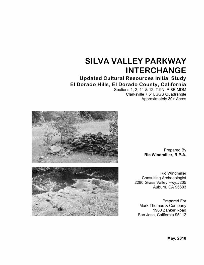
SILVA VALLEY PARKWAYINTERCHANGE
Updated Cultural Resources Initial StudyEl Dorado Hills, El Dorado County, California
Sections 1, 2, 11 & 12, T.9N, R.8E MDMClarksville 7.5' USGS Quadrangle
Approximately 30+ Acres
Prepared ByRic Windmiller, R.P.A.
Ric WindmillerConsulting Archaeologist
2280 Grass Valley Hwy.#205Auburn, CA 95603
Prepared ForMark Thomas & Company
1960 Zanker RoadSan Jose, California 95112
May, 2010
MANAGEMENT SUMMARY
The proposed Silva Valley Parkway Interchange is located in the U.S. 50corridor near the Sacramento County line in western El Dorado County,California. The interchange will provide access to U.S. 50 for existing andapproved development in El Dorado Hills on both sides of the freeway. TheSilva Valley Parkway Interchange alternative will relieve congestion on theexisting El Dorado Hills Boulevard/Latrobe Road interchange and reduceimpacts to traffic circulation during construction of future improvements tothe existing interchange.
In addition to the interchange itself, the proposed project includesconstruction of auxiliary lanes between the El Dorado Hills Boulevard/Latrobe Road interchange and the Silva Valley Parkway Interchange.
The purpose of the present updated initial study is to identify historicalresources located within the boundaries of the proposed interchange project.The study includes an updated records search by the North CentralInformation Center, California Historical Resources Information System,results of a sacred lands file search by the Native American HeritageCommission, Native American and local historical organizations contacts,archival research, field inspections and the technical report now in hand.
The Silva Valley Parkway Interchange project was approved back in the early1990s. With the passage of time and changes in planned lane use andanticipated traffic, as well as changes in the California Environmental QualityAct (CEQA) particularly with respect to the evaluation and treatment ofhistorical resources, the following updated technical report compares thecultural resource findings, impacts and mitigation measures in the originalEIR with those of the present updated study.
The original EIR identified a historic ranch site, prehistoric bedrock millingfeatures, stone and post and wire fence remnants, a multi-component siteincluding the historic Tong cemetery, small stamp mill and cabin features,mines and mine prospects, Byram House, the Mormon Tavern monument andthe Richmond-Hall cemetery. The updated study, including previousobservations by LSA archaeologists identified an additional 27 sites and onedistrict. Byram House is excluded from the current inventory, as it was notidentified within the current project area. Remnants of the Mormon Tavernarchaeological site do appear within the current project area. However,current project design excludes the remnant site from any ground disturbance.
Silva Valley Parkway InterchangeUpdated Cultural Resources Initial Study ' Page ii
The original EIR concluded that the project alternatives as designed back thencould impact the following cultural resources deemed significant underCEQA’s old Appendix K:
C Tong cemetery, stamp mill and cabin site components of multi-component site, P-9-673.
C Richmond-Hall cemeteryC Mormon Tavern State Historic Landmark no. 699 monumentC A portion of the large multi-component site, CA-ELD-600/HC Possible impacts to unknown sites
The present updated study, including additional cultural resources andassessments made under revised CEQA statutes and guidelines, concludesthat the project as currently designed could impact the following sites,features and historic district eligible or potentially eligible for the CaliforniaRegister of Historical Resources:
C Tong cemetery component of multi-component site, P-9-673.C Stamp mill site-component of multi-component site, P-9-673.C Cabin and privy site-component of multi-component site, P-9-673.C Richmond-Hall cemeteryC Mormon Tavern Monument (California Historical Landmark no. 699)C A portion of the large multi-component site, CA-ELD-600/HC Mormon Hill Historic DistrictC Potential impacts to unknown sites
Under the original EIR, mitigation measures included the following:
C Protect the Richmond-Hall cemetery during construction:Archaeologist to identify cemetery limits, install six foot high fencearound perimeter.
C Relocate Mormon Tavern SHL monument by approval of SHPO.
C Relocate Hall/Richmond Cemetery: Determine number and locationof graves by geophysical survey. At least three individualsthere–possibly several more. Move burials preferable to ClarksvilleCemetery.
C Construct retaining wall to protect Tong cemetery component of themulti-component site, P-9-673.
C Preserve other components of site P-9-673 or require additional work.
C Stop work if additional cultural resources are discovered duringconstruction.
Silva Valley Parkway InterchangeUpdated Cultural Resources Initial Study ' Page iii
As a result of the present updated study and application of current CEQAstatutes, guidelines and advisories, the following mitigation measures areproposed:
C Tong Cemetery component of multi-component site, P-9-673: Priorto construction activity within the vicinity of the site, encircle thecemetery with temporary construction fencing under supervision ofa qualified archaeologist. Construct retaining wall to protect thecemetery, also under the supervision of a qualified archaeologist.
C Stamp mill site component of site, P-9-673: Prior to constructionactivity within the vicinity of this site, encircle the mill sitecomponent with temporary construction fencing under supervision ofa qualified archaeologist.
C Cabin and privy site component of the site, P9-673: Prior toconstruction activity within the vicinity of this site, encircle the cabinand privy site component with temporary construction fencing undersupervision of a qualified archaeologist.
C Richmond-Hall Cemetery: As the precise boundary of this cemeteryis unknown and remote sensing is not practical in the rocky soils,mechanized test excavations shall be undertaken prior to any grounddisturbing activity between the freeway and the existing Tong Road.A qualified archaeologist shall supervise the test excavations. Ifgraves are discovered during or subsequent to the test excavations,then the archaeologist will coordinate with El Dorado County todisinter, remove, transport and reinter the remains.
C Mormon Tavern Monument (California Historical Landmark no.699). If it is necessary to relocate the monument because ofconstruction, then approval must be sought from the State Office ofHistoric Preservation and the monument moved prior to constructionin the vicinity of its present location.
C If buried archaeological resources (historic foundations, refusedeposits, prehistoric cultural deposits or other recognizable buriedcultural resources) are encountered during construction, all work musthalt at the location of the find(s) and a qualified archaeologist shall beretained to identify and evaluate their significance and recommendappropriate mitigation, if necessary.
C In the event that human remains are discovered, California Health andSafety Code §7050.5 states that no further disturbance shall occuruntil the county coroner has made the necessary findings as to origin
Silva Valley Parkway InterchangeUpdated Cultural Resources Initial Study ' Page iv
and disposition pursuant to Public Resources Code §5097.98. If thecoroner determines that no investigation of the cause of death isrequired and if the remains are of Native American origin, the coronerwill notify the Native American Heritage Commission, which in turnwill inform a most likely descendant. The descendant will thenrecommend to the landowner appropriate disposition of the remainsand any grave goods.
Implementation of the above measures would reduce impacts of the projecton individual cultural resources eligible or potentially eligible for theCalifornia Register to a less than significant level. Implementation of theabove measures would also reduce impacts of the project on the Mormon HillHistoric District to a less than significant level.
Silva Valley Parkway InterchangeUpdated Cultural Resources Initial Study ' Page v
CONTENTS
Management Summary. . . . . . . . . . . . . . . . . . . . . . . . . . . . . . . . . . . . . . . i
Introduction. . . . . . . . . . . . . . . . . . . . . . . . . . . . . . . . . . . . . . . . . . . . . . . . 1
Setting. . . . . . . . . . . . . . . . . . . . . . . . . . . . . . . . . . . . . . . . . . . . . . . . . . . . . 5
Records Search Results. . . . . . . . . . . . . . . . . . . . . . . . . . . . . . . . . . . . . . 15
Consultations. . . . . . . . . . . . . . . . . . . . . . . . . . . . . . . . . . . . . . . . . . . . . . . 16
Field Methods. . . . . . . . . . . . . . . . . . . . . . . . . . . . . . . . . . . . . . . . . . . . . . 17
Description of Cultural Resources. . . . . . . . . . . . . . . . . . . . . . . . . . . . . . 18
Evaluation. . . . . . . . . . . . . . . . . . . . . . . . . . . . . . . . . . . . . . . . . . . . . . . . 33
Potential Effects. . . . . . . . . . . . . . . . . . . . . . . . . . . . . . . . . . . . . . . . . . . . 54
Mitigation Proposals. . . . . . . . . . . . . . . . . . . . . . . . . . . . . . . . . . . . . . . . 56
References Cited. . . . . . . . . . . . . . . . . . . . . . . . . . . . . . . . . . . . . . . . . . . . 58
Appendix A: Statement of Qualifications. . . . . . . . . . . . . . . . . . . . . . . . 64
Appendix B: Records Search Results. . . . . . . . . . . . . . . . . . . . . . . . . . . . .
Appendix C: Consultations. . . . . . . . . . . . . . . . . . . . . . . . . . . . . . . . . . . . .
Appendix D: Confidential Location of Cultural Resources.. . . . . . . . . . . .
Appendix E: Confidential Record Forms. . . . . . . . . . . . . . . . . . . . . . . . . . .
LIST OF FIGURES
Cover: Rock fence remnant and bedrock milling station . . . . . . . . . . Cover
Figure 1. Silva Valley Parkway Interchange project area. . . . . . . . . . . . . . 2
Figure 2. Silva Valley Parkway Interchange construction design. . . . . . . . 3
Silva Valley Parkway InterchangeUpdated Cultural Resources Initial Study ' Page vi
Figure 3. El Dorado Hills and Mormon Hill historic districts. . . . . . . . . . 32
Figure 4. Confidential location of cultural resources.. . . . . . . . . . . . . . . . . .
INTRODUCTION
The proposed Silva Valley Parkway Interchange is located in the U.S. 50corridor near the Sacramento County line in western El Dorado County,California (see Figures 1 and 2) . The interchange will provide access to U.S.50 for existing and approved development in El Dorado Hills on both sidesof the freeway. The Silva Valley Parkway Interchange alternative will relievecongestion on the existing El Dorado Hills Boulevard/Latrobe Roadinterchange and reduce impacts to traffic circulation during construction offuture improvements to the existing interchange.
In addition to the interchange itself, the proposed project includesconstruction of auxiliary lanes between the El Dorado Hills Boulevard/Latrobe Road interchange and the Silva Valley Parkway Interchange.
The Silva Valley Parkway Interchange project was approved back in the early1990s. With the passage of time and changes in planned lane use andanticipated traffic, as well as changes in the California Environmental QualityAct (CEQA) particularly with respect to the evaluation and treatment ofhistorical resources, it is appropriate that the cultural resources initial studyis updated.
CEQA Regulatory Background
When the EIR for the project was certified back in 1991, evaluation ofcultural resources conformed to CEQA Guidelines in Appendix K. In 1992,the Public Resources Code was amended as it affects historical resources.The amendments included creation of the California Register of HistoricalResources (Public Resources Code §5020.4, §5024.1 and §5024.6). While theamendments became effective in 1993, it was not until January 1, 1998, thatthe implementing regulations for the California Register were officiallyadopted (Public Resources Code §4850 et seq.).
The purpose of the present updated initial study is to identify any historicalresources eligible for the California Register of Historical Resources andarchaeological resources that potentially meet criteria as “uniquearchaeological resources” under current CEQA statutes and guidelines (seeAppendix A: Statement of Qualifications).
Silva Valley Parkway InterchangeUpdated Cultural Resources Initial Study ' Page 2
Figure 1. Silva Valley Parkway Interchange project area.
Silva Valley Parkway InterchangeUpdated Cultural Resources Initial Study ' Page 3
Figure 2. Silva Valley Parkway Interchange design plan.
Silva Valley Parkway InterchangeUpdated Cultural Resources Initial Study ' Page 4
CEQA statutes [Public Resources Code §21001(b) et seq.] require planningagencies to carefully consider the potential effects of a project on historicalresources. Under the revised and adopted CEQA guidelines in §15064.5, a"historical resource" includes: a resource listed in or eligible for theCalifornia Register of Historical Resources; or listed in a local register ofhistorical resources; or identified in a historical resource survey and meetingrequirements in §5024.1(g) of the Public Resources Code; or any object,building, structure, site, area, place, record, or manuscript that a lead agencydetermines historically significant, provided the determination is supportedby substantial evidence in light of the whole record; or a resource sodetermined by a lead agency as defined in Public Resources Code §5020.1(j)or §5024.1.
Under CEQA guidelines, "A project with an effect that may cause asubstantial adverse change in the significance of an historical resource is aproject that may have a significant effect on the environment [PublicResources Code §15064.5(b)]. "Substantial adverse change" is ". . . physicaldemolition, destruction, relocation, or alteration of the resource or itsimmediate surroundings such that the significance of an historical resourcewould be materially impaired [Public Resources Code §15064.5(b)(2)].
While alteration of the setting of an archaeological site that is eligible onlyfor its information potential may not affect the site's significant character-istics, alteration of a property's location (viz., removing or damaging all orpart of the site) may have a significant adverse effect. CEQA's Guidelines§15126.4(b)(3) state, "Public agencies should, whenever feasible, seek toavoid damaging effects on any historical resource of an archaeologicalnature." The guidelines further state that preservation in place is the preferredmanner of mitigating impacts, and that preservation ". . may be accomplishedby, but is not limited to, the following":
1. Planning construction to avoid archaeological sites;
2. Incorporation of sites within parks, greenspace, or other open space;
3. Covering the archaeological sites with a layer of chemically stable soilbefore building tennis courts, parking lots, or similar facilities on thesite.
4. Deeding the site into a permanent conservation easement.
CEQA guidelines state, "when data recovery through excavation is the onlyfeasible mitigation, a data recovery plan, which makes provision foradequately recovering the scientifically consequential information from andabout the historical resource, shall be prepared and adopted prior to anyexcavation being undertaken" [CEQA Guidelines §15126.4(b)(3)(C)].
Silva Valley Parkway InterchangeUpdated Cultural Resources Initial Study ' Page 5
However, "data recovery shall not be required for a historical resource if thelead agency determines that testing or studies already completed haveadequately recovered the scientifically consequential information from andabout the archaeological or historical resource . . ." [CEQA Guidelines§15126.4(b)(3)(D)].
CEQA also requires planning agencies to consider the effects of a project on“unique archaeological resources.” If an archaeological site meets thedefinition of a unique archaeological resource (Public Resources Code§21083.2), then the site must be treated in accordance with the specialprovisions for such resources, which include time and cost limitations forimplementing mitigation.
California law also protects Native American burials, skeletal remains andassociated grave goods regardless of their antiquity, and provides for thesensitive treatment and disposition of those remains (Health and Safety Code§7050.5, Public Resources Code §5097.94 et seq.).
SETTING
Silva Valley Parkway Interchange is situated at the ecotone or "edge area"between the Sacramento Valley and the Sierra foothills. The property is hillygrassland with scattered oaks and gallery forests of mixed trees alongseasonal waterways. The principal drainage is Carson Creek, a seasonalstream that meanders through the eastern portion of the interchange projectarea. Screech Owl Creek emerges from the hills to join Carson Creek southof the project. Bucket Ravine drains south crossing the western portion of theproject area. The elevation of the project varies between approximately 600and 900 feet above sea level. Summers are hot and rainless; winters are coolwith 6-20 inches of rainfall and fog. The climate of the region isMediterranean (Storer and Usinger 1963:27).
The proposed interchange lies at the north edge of the historic townsite ofClarksville, originally a mining camp during the gold rush that quicklydeveloped into a regional trading center for ranchers of the surroundingWhite Rock and Carson Creek areas.
Prehistory
While scholars have conducted a number of excavations in the deep villagemounds along the Sacramento, Cosumnes and American rivers, relativelylittle scientific work other than surface surveys and limited test excavationshas been accomplished along the valley's eastern edge away from the riversand major tributaries.
Silva Valley Parkway InterchangeUpdated Cultural Resources Initial Study ' Page 6
Since the early 1950's, stone tools of the so-called "Farmington Complex"have been unearthed periodically along the Sacramento Valley-Sierrafoothills ecotone (Moratto 1984:62). Archaeologist Eric Ritter has shown thatthe artifacts are either contemporaneous with, or older than the ModestoFormation, which would date the tools between 10,000 and 5000 B.C. (Ritteret al. 1976).
Commenting on the 1979 excavations by Peak & Associates of a stone toolquarry and campsites near Rancho Murieta, 10 miles south of Clarksville, thelate Southwestern archeologist Julian Hayden once remarked about thesimilarity of Farmington artifact types with those of San Dieguito II fromsouthern California and the Lower Colorado River area (Peak 1981; JulianHayden, personal communication 1994).
San Dieguito II is coeval with the Western Pluvial Lakes Tradition, anadaptation of ancient cultures to lake, marsh and grassland habitats along theeastern side of the Sierra Nevada as early as 9000 B.C. (Moratto 1984:90-91).The development of the Western Pluvial Lakes Tradition and its regionalvariants such as the Farmington Complex may, as Moratto suggested,correspond to the emergence and initial differentiation of Hokan languages(1984:544).
The Archaic Period, which in California lasted from about 6000 B.C. to A.D.1000, is divided by archaeologists into three sub-periods: lower, middle andupper (Fredrickson 1994:100, Figure 9.1). During the Lower Archaic,between 6000 and 3000 B.C., many pluvial lakes across the state became dryplayas as a result of climatic changes. Early milling stone complexes of thissub-period have been identified by scholars at a number of sites in southernand northern California. Previous finds of milling stones and Pinto-likeprojectile points at sites in Marble Valley, two miles east of Clarksville, couldreflect Native American use of the area dating back 4000-7000 years(Windmiller 1996:1; 1997:10; see also Moratto 1984:Figure 4).
Seed gathering, inferred from the use of milling stones, was an arid landadaptation. Speakers of Hokan languages probably brought the concept ofmilling stones to California, since scholars recognize that Hokan peopleswere in regions of the western United States where deserts first appeared afterthe end of the last Ice Age (Moratto 1984:546-547).
The Middle Archaic, dating between 3000 and 500 B.C., marked thebeginning of the fluorescence of aboriginal cultures in California's GreatCentral Valley. Though concerted exploration of the Sacramento Delta'sancient village mounds was well underway by the 1930s, it was not untilmuch later that archaeologists began taking a systematic look at the regionwhere the Sacramento Valley meets the Sierra foothills.
Silva Valley Parkway InterchangeUpdated Cultural Resources Initial Study ' Page 7
In 1950, Archaeologist Franklin Fenenga reported on salvage archaeology atFolsom Reservoir, four miles northwest of Clarksville (Fenenga 1950). Also,Louis A. Payen reported on the petroglyphs or "Indian rock art" ofSacramento and adjoining counties in 1959 (Payen 1959). Payen's workincluded an analysis of rock art styles found at sites along the valley edge inthe general vicinity of Clarksville.
In 1962, Charles Gebhardt conducted salvage archaeology at CA-SAC-166,a proto-historic and prehistoric midden (village site)along Alder Creek, fivemiles west of Clarksville (Gebhardt 1962).
It was not until implementation of the National Environmental Policy Act(NEPA) and the California Environmental Quality Act (CEQA) in the early1970s that the region around Folsom was more extensively inspected forarchaeological sites (cf. Foster and Bingham 1978; Furnis 1975). As a resultof these and many other studies, our understanding of the broad patterns oflocal prehistory is improving.
Native Americans of the Middle Archaic may have used the lower foothillsas a summer resource area (Moratto 1984:206). A study of Hawyer Cavelocated in the foothills near the American River revealed artifact typescommon in the Middle Archaic levels of village mounds in the SacramentoDelta region (Wallace and Lathrap 1952).
Bedrock mortars are common along the Sacramento Valley-Sierra foothillsedge. Reliance on acorns as a staple is inferred from what is generallyrecognized as the first appearance of mortars and pestles in archeologicalsites dating early in the period (Fredrickson 1994:100, Figure 9.1).
Between 4000 and 2000 B.C., it is probable that Hokan languages werespoken in much of California. However, with increased aridity east of theSierra, speakers of Penutian languages apparently began moving from thedeserts of the northwestern Great Basin and southern Columbia Plateau intonorthern California.
Sedentary villages were established in the western Sierra by the time ofChrist, possibly earlier (Moratto 1984:303). In the mid-Sacramento Valley,these developments followed the formation of the Sacramento Delta andmarsh lands, which were fully formed by 2000 B.C. Birth of the delta was aconsequence of the rising sea level caused by global warming and melting ofglaciers at the end of the Pleistocene.
The Windmiller Pattern dates back as early as 2400 B.C. in the CentralValley. Its origins are also tentatively traced to the Altithermal cultures of thenorthwest Great Basin and southern Columbia Plateau, as archaeologists havespeculated that people of the same language group occupied the juncture
Silva Valley Parkway InterchangeUpdated Cultural Resources Initial Study ' Page 8
between the Great Basin and Plateau provinces before 2500 B.C. (Moratto1984:552)..
It is also possible that other Great Basin peoples occupied the area in placeof the proto-Yokutsan speaking people of the Windmiller Pattern. The so-called “Martis Complex” with its characteristic dart points made of basaltoriginally identified by archaeologists at sites in the high Sierra is alsorepresented in the Sierra foothills and may reflect local settlement by anentirely different language group. Such sites may date to the period, 2000B.C. to A.D. 500 (cf. Elston et al. 1977). Large, Martis-like projectile pointshave been discovered at archaeological sites in the lower foothills (cf.Wallace and Lathrap 1952 and Archeo-Tec 1991). Finds in Marble Valleyincluded projectile point styles similar to Martis (Windmiller 1996:1).Moratto speculated on a Hokan language association with the Sierra foothillsexpression of Martis (Moratto 184:562).
Between 2000 and 500 B.C., Utian populations appear to have occupied theSacramento Delta, the areas along rivers and streams, marsh land, as well asthe hills on both the east and west sides of the Sacramento Valley (Moratto1984:553). Expansion westward into the San Francisco Bay area seems tohave brought about some type of fusion between the bearers of Utianlanguages and the resident speakers of Hokan and Yukian languages. Thisapparent fusion of cultures, whatever its precise nature, resulted in whatarchaeologists now recognize as the Berkeley Pattern, sometimes still referredto as the "Middle Horizon."
Ancestors of the Nisenan, a Maiduan people who historically inhabited theAmerican River drainage and who lived for part of their history in theClarksville vicinity, migrated to the region rather late in time. Increasedaridity in the Great Basin seems to have been an important factor initially thatprompted entry of ancestral Maiduans into the northern Sierra Nevada.
During the first 200 years of the Christian era, Maiduan groups penetratedfarther west to the Yana territory of northeastern California (Moratto1984:562). Ritter's Bidwell Complex may represent the radiation of Maiduanspeakers into the Oroville locality around A.D. 600-700 (Ritter 1970a, 1970b;Moratto 1984:562).
After comparing various linguistic models of Maiduan radiation, archaeolo-gist Makoto Kowta suggested that Maiduan-speakers entered California fromthe north around A.D. 500 and settled first in the foothills or valley edge inwhat historically became Nisenan territory (1988:190).
During the Bidwell phase, population growth in the foothills is evident fromthe archaeological discoveries. In the Sacramento Valley, such growth is
Silva Valley Parkway InterchangeUpdated Cultural Resources Initial Study ' Page 9
reflected by the occurrence of large village mounds along the Sacramento,Cosumnes and American rivers.
The Emergent Period, A.D. 1000-1800, was characterized by theconsolidation of territories formed as a result of the migration of nativegroups, including the Nisenan. The territories formed during the Emergentprobably remained in much the same locations as noted by early Spanishobservers (cf. Fredrickson 1994:100, Figure 9.1). Interregional trade seemsto have expanded greatly during the Emergent, up to the succeeding MissionPeriod when Spanish intrusions began tearing the fabric of native life inCalifornia.
Ethnography/Ethnohistory
The Silva Valley Parkway Interchange project area is located within aboundary zone between traditional Nisenan and Miwok territories. JamesBennyhoff's doctoral dissertation, which has become the definitive work onPlains Miwok ethnogeography, indicated a boundary area located betweenLatrobe on the south and Folsom on the north (Bennyhoff 1977:165).
In both Valley Nisenan and Plains Miwok groups, the tribelet, a loosepolitical organization, controlled specific districts usually bounded by theland between drainages (cf. Wilson 1995:2-36). Prior to the gold rush, theestablishment of Sutter's Fort, and prior to the 1833 epidemic, villages weredistributed along the banks and tributaries of major rivers such as theSacramento, American and Cosumnes (Bennyhoff 1977:34).
Valley Nisenan communities ranged in size from small, extended families of15 to 25 people to large villages with a population over 500 (Kroeber1925:831). In the early 1800s, a large group could be found at a single villageor a cluster of small camps around a large village. The Valley Nisenan builttheir villages on low, natural levees along rivers and streams, or on gentleslopes with southern exposure (Wilson and Towne 1978:388). The post-Sutter Nisenan village of Kadema (CA-SAC-192) excavated by John S.Clemmer in 1960 was situated on a low knoll along the American River 20miles west of Clarksville.
The villages varied in size from three to 40 or 50 houses. Living quarterswere dome-shaped, 10-15 feet diameter, covered with earth, tule mats orgrasses. Brush shelters supported by upright posts were constructed insummer and during seasonal rounds of food-gathering. Specialized structuresincluded the semi-subterranean assembly house located at major villages, thesweat house used for curing and purification and the acorn granary. Thewomen of most villages made mortar holes in exposures of bedrock topulverize acorns.
Silva Valley Parkway InterchangeUpdated Cultural Resources Initial Study ' Page 10
According to the published literature, foothill Nisenan villages were locatedon ridges and large flats along major streams. These village sites were smallerthan their valley counterparts. Littlejohn reported on the Nisenan village sitesof Bamon at Shingle Springs, Yo hi mu and Tu lul near Shingle Springs, Polun kit near Clarksville and Wapumi at Latrobe (Littlejohn 1928:44-46). In thefoothills, it was common for families to live away from the main village.Other sites included seasonal camps, quarries, ceremonial grounds, tradingsites, fishing locales, cemeteries, river crossings and battlefields (Wilson andTowne 1978:389).
The 1833 epidemic, probably malaria brought south from Oregon by a partyof trappers, decimated an estimated 75 percent of California’s nativepopulation. By the 1840s, a number of the remaining Nisenan people settledaround Sutter’s Fort and worked for Sutter until the gold rush. Others pressedinto traditional Miwok territory (Wilson 1995:2.46).
Independent records show the 1840-1843 location of Yusumne, a ValleyNisenan village, on the valley portion of the American River six miles eastof Sutter’s Fort. However, in 1846, when Gatten took a census of Indiansalong the Cosumnes, he intimated that Yusumne was located betweenSloughhouse and Plymouth. Bennyoff saw the apparent move as the firstconcrete evidence of Nisenan intrusion into Miwok territory (Bennyhoff1977:85).
Payen described a Nisenan group from Carson Creek (CA-ELD-80/H?) thatmoved five miles southwest of Clarksville to Walltown under pressure fromminers on Carson Creek during the early part of the gold rush (Payen 1961:6).Payen indicated that the Walltown Nisenan group attended a “Big Time”(dances and ceremonies) at Po lun kit (CA-ELD-918/H and field no. V-45?),thereby retaining their connections with the Clarksville area. In the 1870s,however, Walltown residents apparently forced the native people to moveagain. This time, the move was to Palmul at Michigan Bar on the CosumnesRiver (Payen 1961:18).
Prior to 1848, members of another Nisenan tribelet, the Wapumne, wereapparently located along the foothills portion of the American River drainage.The tribelet center may have been near Shingle Springs. However, the tribeletmoved to Latrobe, several miles south of Clarksville, sometime between 1847and 1864 (Bennyhoff 1977:92).
In 1861, miners burned an Indian village located near present-day CameronPark. The miners killed its leaders and ran off the village’s 450 inhabitants(Payen 1961:6). Yet, not all relations between miners and native people werehostile. In the early part of the gold rush, Nisenan headmen supplied labor forthe placer mines. Intermarriage also occurred. John Wilson, descendant of alocal ranching family, recounted the story of an Irishman named Craig who
Silva Valley Parkway InterchangeUpdated Cultural Resources Initial Study ' Page 11
prospected around Clarksville in the 1850s. Craig was said to have taken anative woman “ . . . from Screech Owl, up the canyon south of Clarksville”(CA-ELD-918/H and field no. V-45?) and had five children (Wilson 1986;Windmiller and Osanna 1999:27-30).
Archaeological excavations at CA-ELD-451 and CA-ELD-452, three milesnorthwest of Clarksville, revealed the presence of cremations, glass beads andother historic artifacts. The two neighboring archaeological sites, possibly theruins of a pre-Sutter period Nisenan camp and post-Sutter cry site, aresituated in a sheltered canyon at the west edge of the first tier of Sierrafoothills east of Folsom (Windmiller and Starns 1998).
By 1880, Nisenan were probably intermarrying with Northern Sierra Miwokfrom Yuleyumne, located near Plymouth. Sometime after 1890, Nisenanpeople moved from Palmul at Michigan Bar to Homit, a new site that wasprobably at “Indian Hill” four miles northwest of Ione (Bennyhoff 1977:93)..
Based on Bennyhoff’s exhaustive study and other sources mentioned above,the historical record illustrates a progressive movement of Nisenansouthward, a movement that began during the Sutter period and was probablyaccelerated by the gold rush.
Prior to 1843, it is likely that Valley Nisenan held the territory along theAmerican River and Plains Miwok “ . . . held the entire valley drainage of theCosumnes River from its juncture with the Mokelumne River to about the500 foot contour in the foothills.” The area between the two drainages mayhave been used by both groups and possibly also by Hill Nisenan people(Bennyhoff 1977:94).
History
Following the initial discovery of gold at Sutter’s Mill, Coloma, in January,1848, two members of the disbanded Mormon Battalion found gold on theSouth Fork of the American River about a mile above its confluence with theNorth Fork. The March, 1848 discovery at “Mormon Island” actually startedthe gold rush (Castenada et al. 1984:31).
The discoveries spurred thousands of immigrants to California. By May,1848, there were only a few hundred working at shallow placer mines. By theend of 1848, there were 8,000-10,000. During the following year, 1849,almost 40,000 followed routes by land and sea to the gold fields. Themigration of 1850 was just as great (Caughey 1953:245,247,252).
The early mining focused on the river placers. Deposits of gravel along theriver meanders were an initial attraction. Mining camps arose at these river
Silva Valley Parkway InterchangeUpdated Cultural Resources Initial Study ' Page 12
“bars.” Early placer mining expanded from Coloma to Weber Creek and thento the rich creek gravels in the vicinity of present-day Placerville. Fueled bydiscoveries at Coloma, Placerville and Folsom, nearly every ravine in theregion was mined (Lindstrom 1998:13).
The route of immigrants bound for Sacramento and who entered Californiaby way of Carson Pass in 1849 was a simple wagon road that followed thepresent-day Highway 50 corridor in the vicinity of the proposed Silva ValleyParkway Interchange. In turn, immigrants who came by ship to SanFrancisco, then by boat from Sacramento and disembarked for Weber Creekand Placerville traveled along the same route. Roadside inns and taverns wereput up at numerous locations along the Sacramento to Placerville road.
The earliest settlement in the Silva Valley Parkway Interchange vicinity wasthe Mormon Tavern. A roadhouse established in 1848 by a Mormonimmigrant named “Morgan,” Mormon Tavern was situated at the foot of thefirst steep grade into the Sierra foothills from Sacramento. According to localavocational historian John Wilson, the original Mormon Tavern was a largebuilding noted for its immense dining room. Due to its strategic location atthe intersection of the Sacramento-Placerville road and the stage road fromFolsom and Mormon Island, the inn remained in business through the 1860sand 1870s (Wilson 1986:122).
As the earliest settlement in the locality, Mormon Tavern lent its name to thesteep grade beyond it and to the toll road that climbed the grade (also knownas the old Bass Lake Road). Mormon Tavern was a stage stop during the1850s. During the short-lived Pony Express, Mormon Tavern also served asa changing station for the horses (Jones & Stokes Associates 2000:9; Wilson1986:123).
Near Mormon Tavern was a large house known as “The Nunnery,” used asa home by a group of nuns. At the top of the hill behind the house, the nunschiseled a bench from solid rock where they would meditate. In 1876, JosephJoerger, his daughter and second wife moved into The Nunnery, which bythat time had been abandoned by the sisters. When The Nunnery burnedduring the winter of 1878-1879, Joerger purchased Mormon Tavern fromthen owner, Charlie Winchell. The Joerger family used the tavern as theirhome while operating a dairy. In April, 1964, the old building was burned asa training exercise (Wilson 1986:122-123).
In 1986, John Wilson wrote: “. . . nothing is left . . . except a historicalmarker, nearly out of sight across Highway 50 from the site of the originalMormon Tavern” (Wilson 1986:124).
Clarksville, established one-half mile east of Mormon Tavern began as amining camp and way station. John Wilson wrote that by this time, ravines
Silva Valley Parkway InterchangeUpdated Cultural Resources Initial Study ' Page 13
throughout the region were dotted with camps and cabins. In recent years,cultural resource studies both north and south of Clarksville identified stonefootings of small cabins, as well as crescent-shaped hearths where the earliestminers apparently built pole and canvas structures heated by the fireplaces(cf. Jones & Stokes Associates 2000 and Windmiller and Osanna 1999).
In the early years of the gold rush, Clarksville was known as “Clarkson’s” or“Clarkson Town.” The mining camp was situated near the junction of thefreighting road to the mines and the stage coach road that connected Rhoad’sDiggings, Prairie City and Sacramento. The freight wagon road was aseparate route owing to the fact that freight wagons were much slower thanstage coaches. The freighting route connected Clarksville with Placerville tothe east and White Rock Springs and Mill’s Station to the west.
During the 1850's, Clarksville boasted of four inns: the Railroad Houselocated in the upper part of town; Mormon Tavern on the stagecoach roadwest of town; Umbrella House, west of town on the freighting road and; AlexRichmond’s hotel, also on the freighting road west of town (Wilson 1986:13).
In his Historical Souvenir of El Dorado County, Paolo Sioli indicated thatquartz veins were prospected from the Mother Lode westward to thefoothills-valley edge. Sioli described rich pocket mines at “ . . . Gray’s Flat,around Shingle Springs, and as far down as Clarksville; but in the main, thework has been desultory and unsatisfactory” (Sioli 1883 [1998]:94).
The early period of mining was confined to the wet seasons of winter andspring when sufficient water was available in the local creeks. Minersconstructed small, temporary camps near the diggings along the creeks andgullies. Archaeologist Susan Lindstrom indicated that Carson, Screech Owland Plunket creeks were all seasonal; the seasonal availability of waterneeded for mining along these creeks and their tributaries was supplementedby ditches tapping the system connected with the American Reservoir (BassLake), which was constructed in 1856 (Lindstrom 1998:54).
Local ranchers supplemented their income with proceeds from gold mining.Lindstrom indicated that James Van Wicklin and Tim Coglin filed a miningclaim on Plunkett Creek south of Clarksville in the early 1880s. During theearly part of the 20 century, Van Wicklin’s descendant contracted withth
Williken, Boething and Edwards to mine 20 acres in the vicinity of ScreechOwl Creek. The mining resulted in at least 32 prospects, shafts or pocketmines, as well as access roads and isolated artifacts (Lindstrom 1998:20-21).
Tong, Bence and Taylor of Clarksville owned and worked quartz mines in theClarksville locality. In the 1890s, news articles announced discoveriesincluding a quartz ledge near Marble Valley to the east (Lindstrom 1998:21).
Silva Valley Parkway InterchangeUpdated Cultural Resources Initial Study ' Page 14
During the so-called “second gold rush” of the 1930s, dragline and dry-landdredging was conducted at the Jumbo Placer Mine along Carson Creeksouthwest of Clarksville. Formerly the White Rock Land and MineralCompany mine, the property was first worked in the 1920s by digging shaftsto bedrock and drifting. Lindstrom reported that the gold content of gravelworked in the drift mines was spotty (Lindstrom 1998:23). Most gold miningacross the country ceased in 1942 by order of the War Production Board.
The land around Clarksville had little agricultural value, except for stockraising and dairying. During the gold rush and before the railroads,agriculture in western El Dorado County depended mainly on the homedemand, which was regulated by the mining industry. Strategically locatednear the junction of the freighting and stage coach roads, Clarksville quicklydeveloped from a mining camp and way station to a regional trading center,which drew ranchers of the surrounding White Rock and Carson Creek areas(Wilson 1986:13).
Prominent among Clarksville’s early citizens was John H. Tong, who becamethe proprietor of the Railroad House, a well-known resort. Other Clarksvillenotables were Dr. John W.S. Giles, physician; E. Daniel and H. M. Johnson,merchants; Russell Bean, blacksmith; Mr. A. Morgan, restauranteur andSylvester Kelly Cram, saloon-keeper. The area’s early ranchers includedGeorge Carston, Dennis Phillip Bence, W. S. Cothrin, William Dormody,George Fitch, Abe Jewell, Andrew Morrison and William Showers (Wilson1986:13).
Land ownership in the region surrounding Clarksville was dominated byJoerger, Cothrin, Euer and Van Wicklin families. The Joerger holdings aloneamounted to several thousand acres near Clarksville and in Martis Valleynear Truckee. By the 1870s, many of the region’s ranchers owned and leasedland in the Sierra high country to “summer” their herds. Around Clarksvilleduring the summer months, John Wilson, descendant of local ranchers wrote“ . . .the land is seared to a lifeless yellow, the creeks lay naked in their bedsand the dull, brown dust settles in huge feathery heaps along the sides ofrutted roads” (Wilson 1986:131).
Sheep were introduced to the semi-arid foothills around Clarksville in the1850s. The peak of sheep raising was probably reached by the 1860s and1870s. The California Trespass Act of 1850 required farmers to fence theircrops to keep out grazing animals. By the late 1860s, however, the burden offencing was placed on the ranchers who kept livestock. Many of the rockfences found in the region may date to this period and later.
Armin Winje, an elderly Gold Hill resident, once stated that rocks wereabundant in the Clarksville area and fences were made out of whatever washandy and cheap. Mr. Winje recalled that fences were built as high as they
Silva Valley Parkway InterchangeUpdated Cultural Resources Initial Study ' Page 15
could be built, then a strand or more of barbed wire was placed along the topof the rock fence to make it higher (Armin Winje, personal communication1997).
The late Jess Tong, descendant of the pioneer Clarksville family, once toldthe author that in winter when there was little to do, you could always buildmore rock fence (Jess Tong, personal communication 1996).
The land around Clarksville was rocky and clearing fields was necessary toallow the grass to grow and relieve difficulty in mowing. Ranchers wouldextend barbed wire fences from the rock walls to create acreage. The fencesfunctioned as field divisions, section lines and corrals.
Shifting transportation corridors spelled the end of Clarksville and numerousinns of the locality. The Comstock boom of the 1860s temporarily boostedthe area’s economy. By 1864, however, 12 miles of the Sacramento andPlacerville Railroad had been built from Folsom toward Latrobe, bypassingClarksville. The new railroad was originally designed as a link fromSacramento via the Sacramento Valley Railroad to Latrobe and Placerville,then as far as the Carson Valley and Virginia City across the Sierra throughJohnston Pass (Briggs 1954:77-78).
With the railroad, there was less need for the inns, less demand for quantitiesof supplies and the consequent decline of a local market for the neighboringfarmers and ranchers. The period, 1870-1960 was characterized by aconsolidation of land holdings and the transhumance or seasonal movementof livestock to greener pastures in the Sierra. By the early 1870s, it wasvirtually impossible to earn a living from the smaller parcels of land that oncedotted the countryside around Clarksville. The early mixed economy ofmining, ranching and other activities was replaced by the focused strategy oflarge-scale cattle and sheep ranching.
RECORDS SEARCH RESULTS
On October 16, 2003, the North Central Information Center, CaliforniaHistorical Resources Information System responded to a records searchrequest from LSA Associates, Inc. The records search encompassed theproposed Empire Ranch Road Interchange on U.S. 50. The results of therecords search illustrated the location of cultural resource surveys previouslyconducted, as well as objects, sites, structures and districts previouslydocumented within what is presently the proposed Silva Valley ParkwayInterchange project area. The records search results listed the culturalresources and surveys within the project area as it was defined at the time anda half-mile radius beyond the project location. According to informationcenter records of the time, 25 different studies had been conducted in the
Silva Valley Parkway InterchangeUpdated Cultural Resources Initial Study ' Page 16
area. The cultural resources identified during those studies ranged fromisolated piles of field stones to the Mormon Hill Historic District (seeAppendix B: Records Search Results).
Additional information was provided by the information center to LSAAssociates on the interchange project in May and June, 2006.
In an updated March 24, 2010 records search specifically for the Silva ValleyParkway Interchange, North Central Information Center staff reported no“new” cultural resources recorded since the 2003 records search despite fournew studies within the same area: #8119 (Kaplain and Huster’s 2006 surveyalong U.S. 50); #10119 (Blind’s 2009 survey for the El Dorado HillsBoulevard Interchange modifications); #8924 (Peak’s 2007 survey for theClarksville Professional Business Park) and; #10131 (DeBaker and Siskin’s2008 survey for the Goldhill to Clarksville Reconductoring Project) (for theupdated records search report, see also Appendix B: Records Search Results).
CONSULTATIONS
On March 16, 2010, the Native American Heritage Commission respondedto the consultant’s request for a search of its sacred lands file and list ofNative American contacts. The file search failed to indicate the presence ofNative American cultural resources in the immediate project area.Commission staff enclosed a list of six Native American contacts andrecommended soliciting information from those individuals and groups. Thecontacts included: El Dorado County Indian Council, El Dorado (Miwok/Maidu); Ms. Jessica Tavares, Chairperson, United Auburn Indian Communityof the Auburn Rancheria, Auburn (Maidu/Miwok); Mr. Christopher Suehead,Todd Valley Miwok-Maidu Cultural Foundation, Foresthill (Miwok/Maidu);Mr. Nicholas Fonseca, Chairperson, Shingle Springs Band of Miwok Indians,Shingle Springs (Miwok/Maidu); Tribal Preservation Committee, UnitedAuburn Indian Community of the Auburn Rancheria, Auburn (Maidu/Miwok); Ms. April Moore, Colfax (Nisenan-Southern Maidu/Konkow/Washoe). The consultant contacted each by letter. No response has beenreceived to date.
On March 13, 2010, the consultant contacted Ms. Sue Silver, former memberof the El Dorado County Pioneer Cemeteries Commission, a non-profitorganization. One, potentially two, historic cemeteries are located within orimmediately adjacent to the project area: the Tong Cemetery (also known asthe Railroad House cemetery) and the Metropolitan Exchange Cemetery (alsoknown as the Richmond-Hall cemetery or the “Fitch” graves, or “IndianGraves.” In a December 31, 2003 letter report to LSA Associates, Silverpresented a detailed history of both cemeteries. Silver also outlined previousresearch and recommended mitigation considering potential impacts of the
Silva Valley Parkway InterchangeUpdated Cultural Resources Initial Study ' Page 17
proposed Silva Valley Parkway Interchange. The mitigation recommenda-tions included an effort to locate the one-acre Metropolitan Exchange(Richmond-Hall) Cemetery on the ground and re-establish the legalboundaries of the one-acre parcel. Once the boundaries are re-established andsurveyed, Silver recommended that the survey map should be filed with theCounty Recorder accompanied by a statement of dedication to cemeterypurposes. Silver also recommended that the cemetery should be fenced andprovided with a gate for pedestrian access. A sign identifying the cemeteryshould be installed at the site (Sue Silver, personal communication 2010).
In the same 2003 letter, Silver recommended that a ground penetrating radar(GPR) survey should be conducted within 100 feet of all sides of the TongCemetery outside the existing cemetery fence to locate unmarked graves.Silver cited verbal reports including Mrs. Jess (Mimi) Tong’s conversationwith a clerk in the El Dorado County Recorder’s Office where Mrs. Tongindicated her father-in-law, George Tong, had broken up several gravestonesand buried the broken pieces near where they had been erected. Silver alsorecommended that a site record form should be filed on the cemetery (SueSilver, personal communication 2010).
On April 27, 2010, the consultant met with Geraldine Joerger, ClarksvilleHistorical Society. During the consultation, the author questioned Ms. Joergerabout the various historic sites located within the Silva Valley ParkwayInterchange project area. Of particular interest was LSA’s location of the firstTong residence at Clarksville, which was given the field number, “SV-4" byLSA’s archaeologist. LSA had indicated that the site was located on the eastside of Carson Creek, north of U.S. 50. Ms. Joerger suggested that the firstTong house site was on the south side of the freeway. Descendant of thepioneer Joerger family, Ms. Joerger also commented on the Mormon Tavernsite. Ms. Joerger indicated that modernization (widening) of U.S. 50 hadtaken out the Mormon Tavern site. When questioned about remainingfeatures on the north side of U.S. 50 near what had been the Mormon Tavernhistoric site, Ms. Joerger indicated that foundations of the later Joerger dairybarn remain. Also, Ms. Joerger commented that up the hill from the MormonTavern site, the bench chiseled from rock by the nuns was still intact(Geraldine Joerger, personal communication 2010).
FIELD METHODS
Because the project area has been thoroughly inspected by a number ofarchaeologists on different projects over the past 23 years, the consultantfocused on revisiting the identified cultural resources and assessing theircurrent condition. In the process of re-locating the previously identifiedcultural resources, the consultant also traversed the project area in broadtransects to check the reliability of previous field survey coverage and walked
Silva Valley Parkway InterchangeUpdated Cultural Resources Initial Study ' Page 18
areas on the fringes of those marked by the information center as previouslysurveyed to insure adequate coverage of the entire project area.
The majority of previously documented cultural resources located within theSilva Valley Parkway Interchange project area were recorded by Peak &Associates, Inc., Foothill Archaeological Services and Jones & StokesAssociates. LSA Associates, Inc. was the most recent firm to tackle theidentification of cultural resources within the project area. LSA identified thesites designated with the field number prefix, “SV-.” However, none of theLSA sites were documented on record forms. In addition, LSA provided thepresent consultant with several tentative lists with differing field numbers forthe same cultural resources, which seemed to indicate that the list was not afinal draft.
The present consultant revisited not only the previously recorded resources,but also the cultural resources noted by LSA. The consultant applied manyof the “SV-“ field numbers to the same resources as LSA. However, wherethe LSA field numbers varied between LSA lists, the present consultantfinalized the site list and arbitrarily applied an “SV-“ field number to eachresource whose identifier was in question.
Where an archaeological site with an “SV-“ field number could not be re-located during the present study or where no physical evidence of such a siteexisted, the present consultant still included the field designation in the listof sites along with the appropriate explanation (could not be found or nophysical evidence of the suspected site could be found at the previouslydesignated location). The consultant presents this explanatory scheme in the“Description of Cultural Resources” and “Evaluation” sections, below, aswell as in Appendices D and E.
Upon visiting each archaeological site, the present consultant updatedexisting records by filling out an entirely new set of record forms using DPR523 series forms distributed by the California Office of Historic Preservation.In the case of sites with the “SV-“ field number prefix, the record forms filledout by the consultant are the original first set of forms for those particularcultural resources, although LSA originally identified the sites. In some casesthe “SV-“ field numbers were added by the present consultant to sites withpre-existing site and/or feature numbers to signal that the record formsrepresented an update to previously recorded information.
DESCRIPTION OF ARCHAEOLOGICAL RESOURCES
The original EIR for the Silva Valley Parkway Interchange cited two previousPeak & Associates cultural resource studies as having encompassed most ofthe project area as defined at that time (Peak & Associates, Inc. 1987a,
Silva Valley Parkway InterchangeUpdated Cultural Resources Initial Study ' Page 19
1987b). Ten sites, isolated features and a building were identified within theoriginal project area. The sites included CA-ELD-558-H, the 1930s enclosuresurrounding the Fitch home and gardens and associated ranch features;additional features including bedrock mortars associated with an extensivesite recorded as CA-ELD-600/H; A variety of historic features including thehistoric Tong Cemetery and a bedrock milling station documented as CA-ELD-585/H; five isolated features including rock fence remnants, a mineprospect and a bedrock milling station; the Richmond-Hall Cemetery,Mormon Tavern Monument and Byram House, a residence dating to the1950s (Jones & Stokes Associates 1989:220-221).
In the present study, 41 individual cultural resources and one historic districtare located within the current project area of the proposed Silva ValleyParkway Interchange. Among the sites and features are those mentioned inthe preceding paragraph as part of the previous EIR (see Appendix D:Confidential Location of Archaeological Resources, below, and Appendix E:Confidential Record Forms).
Prehistoric (Native American) Archaeological Resources
Bedrock Milling Station (P-9-017). This minor archaeological resource isa single shallow bedrock mortar hole located on a rock outcrop measuring 0.7x 2.5 meters. The bedrock mortar is situated on an east-facing slope on thewest side of Carson Creek. The site currently shows a shallow mortar holenear the south end of a nearly flat grano-diorite outcrop at ground level.Surrounding soil is reddish orange clay. No artifacts or cultural deposits werefound in association with the bedrock mortar. The bedrock milling featureappears to be in the same condition as earlier described by Peak &Associates.
Bedrock Milling Station (CA-ELD-600/H, Feature 11). This minorarchaeological resource is an elongated outcrop of grano-diorite on the westside of the Carson Creek streambed. Reported but not recorded in 1992 byFoothill Archaeological Services as Feature 11 of CA-ELD-600/H (a largesite containing some related and some disparate features on the north side ofU.S. 50 in the Carson Creek drainage), this elongated bedrock milling stationhas five oval mortar holes. Currently, four of the five mortar holes are gravelfilled. One is partly inundated by the creek flow. The outcrop lies on the northside of a narrow, three foot-deep erosion gully. No midden or other culturaldeposit was noted in the vicinity. The milling station appears in much thesame condition as described earlier by Foothill Archaeological Services.
Bedrock Milling Station (CA-ELD-600/H, Feature 12). This minorarchaeological resource was described by Foothill Archaeological Servicesduring its 1992 field inspection as “a bedrock mortar feature with
Silva Valley Parkway InterchangeUpdated Cultural Resources Initial Study ' Page 20
approximately six shallow pits in a smooth granodiorite outcrop in the maincourse of Carson Creek.” The site was noted by Foothill’s archaeologists, butnot recorded. Although the site lies between Foothill’s Feature 11 and Feature13, current attempts to relocated the site have failed. It is possible that growthof cattails in the creek channel or the abundant present water flow obscure thefeature from view.
Bedrock Milling Station (CA-ELD-600/H, Feature 13). This minorarchaeological resource was described but not recorded by FoothillArchaeological Services during its 1992 field inspection as a bedrock mortarfeature with 6-10 deep pits in a granodiorite outcrop on the north bank ofCarson Creek. Currently, the bedrock milling station consists of a water-worn, relatively flat outcrop of grano-diorite on the west side of Carson Creekbed with 11 mortar holes scattered across its surface. The outcrop is inclinedtoward the center of the creek. The mortar holes vary from circular andshallow to oval and deep. Some mortar holes are filled with water wornpebbles from times of high water. At least one mortar hole is submerged inthe stream flow of mid-April. No midden or other cultural deposit wasidentified at or near the bedrock milling station. Condition of the site is good.
Historic Archaeological Sites
Mormon Tavern (CHL-699; CA-ELD-1266-H). In a recent draft HistoricResource Evaluation Report (HRER) for Caltrans, Foothill Resourcesarchaeologists described the original Mormon Tavern site as encompassinga large, two-story frame structure with a two-story veranda on the front, alarge barn, sheds, two frame houses and a 1950 residence. The archaeologistscontinued with their description by observing that all were demolished duringthe widening of U.S. 50 in the 1960s. In the year 2000, when FoothillResources, Ltd. conducted its field survey, the archeologists identified threestructure depressions, a hand stacked, mortared rock wall and a concentrationof historic artifacts. This description conforms roughly to the contemporarydescription by Jones & Stokes archaeologists who identified a concentrationof artifacts and daffodils at the highway’s cutbank edge, a rock wall, housedepression and paved walkway farther north (away from) the highway’scutbank edge, a nearby water reservoir and some 300 feet to the northwest,two depressions with a concentration of 19 century artifacts (Jones & Stokesth
Associates 2000:Appendix A). The site remains in much the same conditionas described 10 years ago by Jones & Stokes archaeologists. However, theJones & Stokes archaeologists overlooked the rock bench where the nunsonce meditated.
Prospect (P-9-013-H/Field no. IF-4). This minor historic archaeologicalresource is a depression measuring 15 x 20 feet and five deep. The depressionwas originally documented on record forms by Peak & Associates back in
Silva Valley Parkway InterchangeUpdated Cultural Resources Initial Study ' Page 21
1987. The Peak & Associates archaeologist recorded a square nail, end pieceof shoring, belt buckle and a five inch diameter can lid associated with thefeature. Despite a search of the area, the present consultant was unable to re-locate the feature.
Rock Fence (P-9-014). This minor historic resource is a rock fence remnantthat borders the south side of the old White Rock Road (Lincoln Highway)immediately west of the 1918 Carson Creek bridge. The rock fence makes a90 degree turn to the south to parallel the west bank of Carson Creek. Theeast-west fence bordering White Rock Road is at present approximately 600feet long and is backed by a more modern wood post and barbed wire fencewith some metal T-posts. The east-west fence is in poor condition with rocksstacked as high as three feet, but more often much less including shortreaches where only the initial rock footings survive. The north-south rockfence segment along Carson Creek reaches heights of four feet and is in muchbetter condition. This reach of the fence is about 300 feet long. Both fencessuffer from loss of rock. Peak and Associates originally recorded only theeast-west fence line (as 1,150 feet long) back in 1987, although both fencesare connected and may have been constructed during the same period, 1895-1917.
Rock Fence (P-9-016). This minor historic archaeological resource is theremnants of a “rock reinforced” fence line. Recorded by Peak & Associatesback in 1987, the old fence line appears unaltered since that time. At present,the fence remnant consists of an alignment of rocks no more than a singlerock high and wide with scattered rocks in places along this roughly east-westformer fence. Actual orientation of the old fence line is S70EW (truebearing). The old fence line was probably post and wire with rock placedalong the base, as other fences in the locality. Current condition of this linearresource is poor. Posts and wire are gone.
Rock Fence (P-9-018). This minor historic resource is, according to Peak &Associates’ 1987 record form, a “dry-laid rock-reinforced fence line.” Thislinear resource remains in much the same condition as described in 1987.However, the fence line is best described as a wood post and barbed wirefence constructed on an alignment of rocks where rock outcrops naturallyoccur on the same ridge. The segment of fence line documented here isapproximately 400 feet long and located within the Silva Valley ParkwayInterchange project area. The fence line is oriented true north-south and abutsthe old fence line documented above as P-9-016. Current condition of thefence line segment is poor. There are missing posts and down wire.
Fitch House Site (P-9-646). The 1987 Peak & Associates record documentsthis 1920s site of a home and gardens located on a small hill. The site waslargely enclosed with fencing supported by concrete and stucco pillars. Otherfeatures included a stone-lined well with concrete rim, 1932-dated watering
Silva Valley Parkway InterchangeUpdated Cultural Resources Initial Study ' Page 22
trough, remnants of a barn, cement-lined well, concrete dam with rock trim,concrete storage tank. An updated record from 2002 by Pacific Legacy, Inc.noted deterioration of the site: stone-lined well, water trough, rock andconcrete wall and rock garden, concrete tank were still visible. Currently,only a few pillars remain. Much of the enclosure has been shattered intoruins. The well is largely filled in. However, the stone-topped concrete damis intact. The concrete, four-compartment, tank (cistern?) remains intact,though painted with graffiti. The porch footings of quarried sandstone blocksremain largely intact. The site occupies the south end of a south-trendingridge. Exotic trees on site include two varieties of palm, cyprus, pines and redEucalyptus. The site is littered with modern trash. Current overall conditionof the site is poor.
Multi-Component Site Including Tong Cemetery (P-9-673). Theboundaries of this archaeological site surrounded a number of related as wellas unrelated features: the historic Tong family cemetery, the site of a stampmill, mine and miner’s cabin (all historically related), a ditch remnant,depression, bedrock mortar station, rock bridge abutments, covered mineshaft and tailings. The site also included excavated pits, which, during thepresent study were recorded as a separate site–historic bank diggings (SV-23,described below). All of the features appear in much the same condition asoriginally described in the Peak & Associates 1998 site record forms.However, the bedrock milling station could not be re-located.
Like the Richmond-Hall Cemetery, the Tong Cemetery is situated on the crestof a hill overlooking Clarksville, but from a slightly lower elevation. Anestimated 25 graves occupy the Tong Cemetery. Four graves marked witheither headstone or rocks lie outside the cemetery’s fence. Within theapproximately 50 x 100 foot cemetery fence, the cemetery includes graves,each marked with an outline of rocks. Some headstones are white marble;some are simply large flat rocks turned on end. Several graves are markedwith an outline of rocks and a flat board as a head or foot “stone.” Thecemetery also includes more modern black granite monuments and cementcaps over some of the graves. Most of the graves are those of the Tongfamily. However, the earliest marked grave is that of Calvin E. Rose whodied in 1856. The most recent grave is that of Jess Tong, 1996. The graveyardwithin the existing fence is tended at least seasonally. Overall condition isgood. The one grave outside the cemetery fence marked with a white marbleheadstone dated 1868 is missing part of that headstone.
The largely in-filled ditch segment located on the west and south sides of thecemetery is in poor condition. It was barely recognizable when revisitedduring the present study. The ditch terminates at a circular depressionovergrown with woody shrubs. The condition of both features is poor, as isthe condition of the adit and tailings on the east side of the cemetery.
Silva Valley Parkway InterchangeUpdated Cultural Resources Initial Study ' Page 23
The stamp mill site situated by Carson Creek west of the cemetery consistsof three relatively small and roughly leveled terraces, one below the other.The uppermost terrace is marked by a dry-laid rock retaining wall. Somequartz rock lies on and next to the terraces. A dump of large rock lies on thenorth side of the terraces. An adit was reported nearby, but was apparentlytaken out with widening of U.S. 50. The stamp mill was removed from theterraced mill feature. Therefore, no structures remain. Condition of the millfeature is poor.
Downstream from the mill feature are the dry-laid rock foundations of a smallcabin and associated depression of what is probably a privy feature. The rockfoundation is approximately 8 x 12 feet. Approximately 12 feet south of thefoundation is the shallow depression approximately 4x5 feet in plan view.Present condition of the cabin site is good. There does not appear to havebeen any vandalism.
Rock “bridge” abutments reported by Peak & Associates were not re-located.
Sacramento to Placerville Road Segment (P-9-809). This historic linearresource is a short segment of the Sacramento to Placerville road thatparallels an old fence line on its west side. The southern end of the roadsegment lies on the north side of Tong Road and extend northeasterly for adistance of approximately 800 feet. The old road is approximately 15 feetwide. The current condition of this old road trace is poor. A currently used,deeply rutted dirt road mounts the old road and occupies the northern thirdof the old road trace.
Corral Remnant (P-9-861-H). This minor historic resource was originallyreported by Peak & Associates in 1987. It was described as a corralassociated with the Richmond/Hall Dairy. The site was described as a flatterrace with two non-contiguous low rock walls. The remaining corralfencing locations were marked by narrow, low berms encompassing an areaapproximately 70 feet on a side. A north-south rock wall measuredapproximately 45 feet long, while an east-west rock wall remnant along theexisting fence line bordering White Rock Road on the north measured halfthat length. In revisiting the site, the rock fence remnant paralleling WhiteRock Road remained intact. The north-south rock wall was not seen from theroad. Closer inspection was not possible due to bees swarming. Severalpatches of young Alianthus trees mark the corral’s location. Otherwise, thesite is overgrown with high, dense grasses and annuals including a swathgraded at some time in the past that may have disturbed the northern half ofthe site. Condition of the site remains poor.
Silva Valley Road Segment (P-9-1141). This road segment north of U.S.50 was recorded by Foothill Archaeological Services back in 1992. Foothillarchaeologists also reported the road on the same forms as the old Coloma
Silva Valley Parkway InterchangeUpdated Cultural Resources Initial Study ' Page 24
Road to Clarksville. Revisited during the current study, the only remnant roadsegment identified is approximately 400 feet long and visible on a southeast-facing hill slope from the new straightened, widened and paved Silva ValleyParkway. The old road trace is visible from the side of the present-day pavedroad and ends at the south boundary of a new residential development. Theold road trace is estimated at approximately 16 feet wide and is in poorcondition.
Rock Fence (P-9-1646). Peak & Associates described this minor historicresource as a “dry-laid rock-reinforced fence line” on a 1987 record form.This approximates a current description of the old wood post and wire fenceremnant with a single rock width alignment at its base along the east slope ofa ridge. The fence line is oriented east-west on true bearings. On the west, thefence abuts a true north-south fence of similar construction (see P-9-018).The east end of the rock fence line P-9-016 also abuts P-9-018-H, but isoffset approximately 15 feet north of the west end of P-9-1646. Condition ofP-9-1646 is poor. There are missing posts and down wire.
Road Segment (Field No. SV-1). This old road segment is approximately 12feet wide and 500 feet long. Located on the east side of Carson Creek, theabandoned track’s east end is overrun by the current dirt road that connectsthe Old Bass Lake Road (Lincoln Highway) with Silva Valley Road. The oldroad segment is cut into the uphill side of the west-facing slope byapproximately 12 inches. The road is overgrown with grasses and annuals.Judging by the lack of erosion and width corresponding to the width of abulldozer blade, it is tempting to speculate that the road cut was made noearlier than the 1950s. Condition of the road segment is fair.
Road Segment (Field No. SV-2). This historic archaeological resource is anold road cut on the west-facing slope of Mormon Hill. The old road segmentroughly parallels the Old Bass Lake Road (Lincoln highway) about 200 feetup slope from the concrete road. The old dirt road segment is approximately12 feet wide and 500 feet long. The road segment is overgrown with densegrasses and annuals. Piles of field rocks (probably from clearing the field)have been placed on the old roadway. Condition of the road is poor. Thesouthern extension to Clarksville appears to have been obliterated in thesurrounding field.
Mine Tailings (Field no. SV-3). This minor historic archaeological resourceconsists of rock tailings on the southeast side of Carson Creek immediatelydownstream from a creek crossing of the dirt track (narrow unimproved road)from Silva Valley Road on the west to the old Bass Lake Road (LincolnHighway) on the east. The rock tailings may have been disturbed byconstruction of the church immediately southeast. The tailings pile isapproximately 15-20 feet high and 50 feet north-south paralleling the creek.An estimate of the uphill side is not possible due to the effects of
Silva Valley Parkway InterchangeUpdated Cultural Resources Initial Study ' Page 25
earthmoving when the modern church as constructed. There remains novisible evidence of the mine; condition of the remaining resource, the tailingsdump, is poor.
Site of First Tong Residence (Field no. SV-4). The site of the first Tongresidence on the east side of Carson Creek, north of U.S. 50, was noted byLSA, but not formally recorded. Upon revisiting the purported location of thesite between the creek and a modern church, it was apparent that earth-moving related to construction of the Korean church may have destroyed thesite. Earth and rock had been pushed westward to a point near the edge of theravine through which Carson Creek flows. The remaining narrowed terraceabove the creek was searched. However, no evidence of a habitation site (dry-laid rock foundation, depression(s) or artifacts) was found. Consultation withthe Joerger family descendant indicated that the first Tong residence waslocated south of the freeway and not at the location by the church indicatedby LSA (Geraldine Joerger, personal communication 2010). The CaliforniaOffice of Historic Preservation’s Instructions for Recording HistoricalResources states that the threshold for recording such resources is “anyphysical evidence of human activities over 45 years old” (California Officeof Historic Preservation 1995:2). Lacking physical evidence, the purportedlocation of the Tong residence was not recorded on DPR 523 series formsduring the present study.
Road and Borrow Area (Field no. SV-5). This minor historic resource is asingle lane dirt road that originates at a gate on the metal T-post and wirefence that parallels the north side of Tong Road on the ridge immediatelywest of Carson Creek. The road descends the east slope of the ridge in anortheasterly direction to the west side of Carson Creek. At the terminus ofthe road, there is an area excavated from the side of the ridge. The roadway,overgrown with grasses and annuals is approximately 12 feet wide and wasprobably constructed in the late 1950s, early 1960s and may even coincidewith construction of additional highway lanes and Tong Road in 1965.Condition of the road and borrow area is fair.
Rock Pile (Field no. SV-6). This minor historic archaeological resource isa large pile of rock. Most of the rock is angular. The pile is about three feethigh, 15 feet long (north-south) and 12 feet wide (east-west). The site islocated in the middle of a west-sloping field bounded by old fence lines onthe east (SV-8) and south and (before construction of modern U.S. 50) on thenorth. Condition of the rock pile is fair. Area old timers would comment thatthe size of the rocks (head-size and smaller) would be good to outline graves.Similar stones were used to outline graves found in the Tong Cemetery innearby Clarksville.
Prospect (Field no. SV-7). This minor historic archaeological resource is alarge mine prospect. The remaining pit is approximately 20 feet east-west and
Silva Valley Parkway InterchangeUpdated Cultural Resources Initial Study ' Page 26
15 feet north-south with a spoil pile on the downhill (west) slope adjacent tothe pit. The pit itself is about four feet deep in the middle. Above thenortheast corner of the sub-rectangular-shaped pit stands a rusted iron wagonaxle driven into the ground. The axle stands approximately four feet highabove the ground surface outside the pit. Condition of this minor resource isfair.
Road Segment (Field no. SV-8). This historic archaeological site includesa segment of an old N25EW (true bearing) fence line and road segment (downhill side of the fence). It is presumed that the road paralleled the fence line,though down hill (west of the fence). Although previously visible toarchaeologists who noted the road, with high spring season grasses, the roaddoes not appear obvious at this time. The fence line is post and wire with fewwooden posts remaining. Some rock is gathered along the base of the fenceline, which is marked by a low, narrow berm. The north end of the fenceterminates approximately 30 feet south of the U.S. 50 right of way fence. Thesouth end of the fence is disturbed by recent earth-moving and constructionof a staging area. The road segment is disturbed by construction of a modernpower pole near the middle of the segment and destroyed by earth-movingand construction of a staging area at its south end. Total remaining length ofboth fence and road is approximately 500 feet.
Road Segment (Field no. SV-9). This dirt road segment was identified butnot recorded by LSA on the southeast corner of White Rock Road and SilvaValley Parkway. However, the old roadbed could not be re-located during thepresent study. Recently, an equipment and materials staging area wasconstructed and additional earth-moving undertaken at the approximatelocation of the old roadbed. These ground-disturbing activities may haveobscured remaining evidence of the old road segment.
Prospect (Field no. SV-10). This minor historic archaeological resource wasreported but not recorded by LSA archaeologists. The feature was describedas a circular depression approximately 25 feet in diameter. The location of theprospect on a hill south of White Rock Road leading into Clarksville and eastof Silva Valley Parkway places the feature within the bounds of a currentlygraveled equipment and materials staging area. As a consequence, the featurecould not be re-located during the present study.
Corral Fence (Field no. SV-11). This minor historic resource is arectangular corral or small fenced enclosure approximately 75 feet on a side.The remnant fencing consists of split cedar or redwood posts and barbedwire. The corral fencing abuts the rock fence (P-9-014) that parallels thesouth side of White Rock Road on the west side of Clarksville. A gateopening appears in the rock fencing and in the mixed wood post and wirefencing on the opposite (south) side of the enclosure. Condition of theenclosure is poor; few posts remain standing. The Richmond-Hall Dairy
Silva Valley Parkway InterchangeUpdated Cultural Resources Initial Study ' Page 27
corral on the north side of White Rock Road opposes this enclosure on thesouth side of the road. Their contemporaneity is unknown.
Rock Fence (Field no. SV-12). This minor historic resource is a rock fenceremnant that parallels the west bank of Carson Creek from the old LincolnHighway bridge at Carson Creek south (downstream) for a distance ofapproximately 300 feet. The rock fence meets the east end of the remnantrock, post and wire fence P-9-014 at the southwest bridge abutment. The rockfence attains a height of nearly four feet in some places. In other spots, thefence rocks have collapsed to a height of two feet more or less. The south endof the rock fence curves westward away from the creek for a distance ofapproximately 15 feet. Condition of the fence is fair.
Fence Remnant (Field no. SV-13). This minor historic archaeologicalresource is an old fence line on the west side of White Rock Road betweenLatrobe Road and Silva Valley Road. The old fence line consists of scatteredrocks on an alignment paralleling the existing White Rock Road at a distancevarying between 15 and 30 feet. Portions of the old fence line survive astumbled rock from what may have been a stacked rock fence. Other portionssurvive only as a narrow berm and may have been post and wire. The oldfence line remnant extends for a distance of 1,500 feet from about 400 feetsouth of the Joerger Cutoff to a unnamed gated access road east of LatrobeRoad intersection. Condition of this linear resource is poor.
Rock Pile (Field no. SV-14). This minor historic archaeological resource isa deflated pile of rock quarried from an outcrop at the same location. Therock pile is no higher than one foot above ground surface, 15 feet long (north-south) and six feet wide (east-west). The rock pile lies about 25 feet up slope(east ) of the remnants of an old fence line, itself marked by a berm thatparallels the route of the old Sacramento-Placerville road on historic maps.The fence line was reinforced in places along its base with similar quarriedrocks. Condition of the rock pile is fair.
Old Bass Lake Road Segment of Lincoln Highway (P-9-809; Field no.SV-15). This historic linear resource is an approximately 400 foot longsegment of the old concrete Lincoln Highway (Old Bass Lake Road) locatedwithin the Silva Valley Parkway Interchange APE. The segment beginsapproximately 50 feet south of a gate entry on a T-post and wire fence andends before an abrupt right turn east. The concrete road is 17 feet wide witha two-foot wide asphalt shoulder on each side. Condition is poor in relationto the road’s segment on the south side of U.S. 50 in Clarksville. The crackedconcrete surface displays a ghost impression of the six inch wide solid whiteline down the center of the road. Grasses grow along large fissures in theroad. The road still serves local traffic. Condition of the segment is poor.
Silva Valley Parkway InterchangeUpdated Cultural Resources Initial Study ' Page 28
Rock Fence (CA-ELD-600/H, Feature 14; Field no. SV-17). This minorhistoric resource is a dry-laid rock fence remnant. The fence remnant parallelsthe east bank of Carson Creek for a distance of approximately 90 feet. Theremnant functioned as a creek bank erosion control as the uphill side of thefence is largely in-filled. On the down hill (creek) side, the highest point ofthe remnant fence is four feet. Located directly under modern power lines, thefence remnant extends only a few inches above ground surface on the uphillside. Condition of the fence is fair. A large section of the middle has tumbledinto the creek drainage.
Rock Fence (P-9-69; Field no. SV-20). This minor historic resource is arock fence that parallels the west side of Carson Creek north of the 1918bridge on White Rock Road (Lincoln Highway). The fence consists of threesegments. The first segment is approximately 10 feet long, 2.5 feet wide atthe base and three feet high. This first segment is located adjacent to the northside of the old Lincoln Highway bridge on Carson Creek in Clarksville. Thesecond segment is approximately 75 feet long, 100 feet north (upstream) fromthe first segment. The third segment is approximately 10 feet long and locatedabout 100 feet north of the second. The width and height of the third andsecond segments of rock fence are similar to the first. Overall condition of thefence is fair.
Ditch Segment (Field no. SV-21). This minor historic archaeologicalresource is a short (50 feet long) segment of a largely in-filled ditch. Theditch is approximately two feet wide across the top with no residual depth.The segment was recognized at the southeast edge of a ridge where rocks hadbeen removed from the ditch location and stacked within five feet uphill. Theditch probably brought water from Carson Creek downstream to the bankdiggings along the northwest bank of the same creek. The ditch would haveserved bank diggings between U.S. 50 on the north and the old LincolnHighway bridge on the south. Condition of the ditch is poor. Only a shortsegment of the ditch is recognizable on the landscape.
Bank and Hillside Diggings (Field no. SV-22). This minor historicarchaeological resource consists of heavily eroded, amorphous bank diggingson the west side of Carson Creek immediately south (downstream) from theold Lincoln Highway bridge on Carson Creek. The site also includes heavilyeroded diggings on the adjacent east-facing hillside that survives as ahummocky landscape. The old placer mined site encompasses an areaapproximately 400 feet north-south and 200 feet east-west. The bank diggingsare confined to two low-lying areas at the foot of the moderate to steep, east-facing hill slope. The hill side diggings are confined to the moderate slopeabove, immediately west of the bank diggings. Condition of the site is poor.
Bank Diggings (Field no. SV-23). This minor historic archaeologicalresource is a series of bank diggings along the west side of Carson Creek
Silva Valley Parkway InterchangeUpdated Cultural Resources Initial Study ' Page 29
located between U.S. 50 on the north and the old Lincoln Highway bridge atCarson Creek on the south. The northernmost diggings are located adjacentto the rock foundations of a cabin previously recorded as the rock foundationand possible privy feature of P-9-673, a large multi-component site thatincludes the Tong Cemetery. The bank diggings reported here consist of aseries of six separate diggings extending along approximately 200 feet of thecreek’s west bank. The diggings range from a small circular pit about 15 feetdiameter and 3-4 feet deep to a large ground-sluice like feature approximately40 feet long, 15 feet wide and six feet deep. Rocks are stacked along side ofthe diggings. A short ditch segment recorded as field no. SV-21 may haveprovided water for the sluice. The diggings are less eroded than thosereported for Field no. SV-22 and may be more recent.
Richmond-Hall Cemetery (Field no. SV-25). This historic cemetery istentatively identified near the crest of a hill overlooking Clarksville to thesouth. The only physical evidence remaining on the surface are loose rockspurported to have marked graves at the one acre cemetery site. However, thelocation is overgrown with dense grasses and annuals, which frustratedattempts to identify the precise boundaries of the one acre parcel. In anundated draft Historic Resource Evaluation Report, Foothill Resources Ltd.indicated that in 1965 during construction of additional highway lanes andTong Road, the cemetery had brush piled and burned on it. Constructionequipment was also parked on the cemetery site. At least one of the gravesand possibly others were identified by “rings” of rock and flat slabs of rockon the surface. The location was also identified by the nearby access gateconstructed by Caltrans in 1965 on the south side of Tong Road. Thecemetery was originally laid out with north-south and east-west boundaries.There may be at least five graves at the cemetery dating between the 1870sand 1930. Condition of the site surface is poor. Condition of the humanburials is unknown.
Rock Fence (CA-ELD-600/H, Feature 10; Field no. SV-26). This minorhistoric resource is a dry-laid rock fence remnant that forms the southboundary of a meadow on the west side of Carson Creek. The 1992 updatedrecord by Foothill Archaeological Services described the fence remnant as aT-shaped rock fence feature about two feet wide and one to three feet highthat outlined a large meadow and intersected the historic Mormon Hill TollRoad on the north. The rock fence appears in much the same condition todayas documented by in 1992. Condition of the fence is fair. Portions of thefence have tumbled to one side or the other.
North Clarksville Segment of Lincoln Highway (P-9-809; Field no. SV-27). This historic linear resource is an approximately 100 foot long segmentof the old concrete Lincoln Highway located within the Silva Valley ParkwayInterchange project area on the south side of U.S. 50. The segment lies on thesouth side of the existing U.S. 50 right-of-way. The concrete road is 17 feet
Silva Valley Parkway InterchangeUpdated Cultural Resources Initial Study ' Page 30
wide with a two-foot wide asphalt shoulder on each side. Condition is poordue to overcoating of the concrete with asphalt and construction of a muchlarger turn-around area adjacent to the highway’s south right-of-way fence.
West Clarksville Segment of Lincoln Highway (P-9-809; Field no. SV-28). This historic linear resource is an approximately 800 foot long segmentof the old concrete Lincoln Highway located within the Silva Valley ParkwayInterchange project between the existing White Rock Road/Silva ValleyParkway intersection on the west and the 1918 Carson Creek bridge on theeast. The old concrete road is approximately 17 feet wide with two-foot wideasphalt shoulders on each side of the roadway. Condition of the road segmentis poor due to asphalt over paving and destruction of the curved west portionof the road and replacement of the curve by a modern asphalt intersectionwith the modern, widened asphalt White Rock Road, Silva Valley Parkwayand Joerger Cutoff. Condition of the eastern two-thirds of the road segmentis only fair with some asphalt patching.
Historic Structures and Objects
White Rock Road at Carson Creek (Bridge no. 25C0112). This concretebridge was constructed in 1918 for the Lincoln Highway crossing of CarsonCreek at Clarksville. The roadway is 21 feet wide and 68 feet long. Theconcrete bridge railings are three feet high. The massive concrete bridgeabutments support both ends of the bridge, while two sets of arched concretepillars support the bridge span. Inlaid into the end railing pillar on thenorthwestern corner of the bridge is a brass U.S. Coast and Geodetic SurveyBench Mark dated 1932. Condition of the bridge is good.
Joerger Cutoff at Bucket Ravine (Field no. SV-24). This historic “bridge”is a concrete box culvert with raised concrete sides in the form of moldedpanels. The bridge is approximately 14 feet wide with a 12 foot span. BucketRavine is a small, seasonal tributary to Carson Creek. The culvert crossingis about 300 feet west of the intersection of Joerger Cutoff and White RockRoad. Construction date is unknown. Condition of the culvert is good.
Mormon Tavern Monument (California Historical Landmark no. 699).This stone masonry monument with brass plaque commemorating MormonTavern was erected in April, 1960. At 50 years old, the monument itself mustnow be considered as a potential historical resource.
Spring House and Well (Field no. SV-19). This historic structure is a springhouse consisting of a rectangular concrete reservoir enclosed by sheet metalsiding and a gable roof clad in corrugated iron sheets. The little house isapproximately 8x12 feet, four feet high. The south elevation has an off-setvent, a centered, square door hung by two hinges and secured by a metal
Silva Valley Parkway InterchangeUpdated Cultural Resources Initial Study ' Page 31
hasp. A hole in the center of the roof peak suggests another vent once existed.The north elevation has an off-set vent and a 3/4 inch pipe with gate valve.A capped concrete well (concrete portal 4x4 feet) lies approximately 75 feetnorth northeast of the spring house. Remnants of a water line continue southtowards Clarksville. Condition of the spring house is fair.
Historic Districts
Archaeologists recognize several different types of resources that can occuron a given property. The above descriptions include sites, structures andobjects. Objects are generally small in scale and simply constructed, such asa monument. Structures are part of the built environment such as bridges orcovered concrete water reservoirs. Sites are locations of prehistoric or historichuman occupation or activity, a ruined building or structure, or a naturallandmark with a strong association with significant historic or prehistoricevents.
A district is a significant concentration of sites and/or objects (and also mayinclude buildings and structures) that are related historically by function,theme, plan or physical development. From the archaeologist’s perspective,a district is a grouping of archaeological sites related principally by theircommon components (Townsend et al. 1993:9-11).
Two historic districts were previously defined in the local region, portions ofwhich lie within the Silva Valley Parkway Interchange project area: the ElDorado Hills Historic District and the Mormon Hill Historic District (seeFigure 3).
El Dorado Hills Historic District. Peak & Associates defined this historicdistrict as a result of their 1987 cultural resources inventory for the El DoradoHills Specific Plan. The district reportedly included 26 archaeological sitesand 22 isolated archaeological features and spanned an area from the CarsonCreek drainage north to the Allegheny Creek drainage. Out of this totalnumber of resources, Peak & Associates defined the El Dorado Hills HistoricDistrict, which included 12 contributing and five non-contributing culturalresources (Peak & Associates 1994).
Mormon Hill Historic District (P-9-1670). In conducting archaeologicalstudies in conjunction with the Serrano El Dorado Hills development, Jones& Stokes Associates had a goal of mitigating the adverse effects of theproject on the El Dorado Hills Historic District. It was during these studiesthat Jones & Stokes archaeologists recognized that by reorganizing the ElDorado Hills Historic District boundaries, the resulting new district wouldinclude only those cultural resources with common ties to a specific history.The El Dorado Hills Historic District, as defined earlier by Peak & Associates

Silva Valley Parkway InterchangeUpdated Cultural Resources Initial Study ' Page 32
Figure 3. The two historic districts and the Silva Valley Parkway Interchangeproject area juxtaposed.
Silva Valley Parkway InterchangeUpdated Cultural Resources Initial Study ' Page 33
included historic sites along two separate drainages, each with separatehistorical associations. Jones & Stokes’ newly defined Mormon Hill HistoricDistrict focused specifically on the Carson Creek drainage and the historictownsite of Clarksville. Jones & Stokes archaeologists then categorized theoriginal contributing resources of the El Dorado Hills Historic District asbelonging to one or the other of the new Mormon Hill Historic District or there-defined El Dorado Hills Historic District (Jones & Stokes Associates2000:3-4).
Based on the redefinition of districts, the Mormon Hill Historic District isnow the only previously identified district located within the present footprintof the proposed Silva Valley Parkway Interchange. In fact, the Mormon HillHistoric District, as defined by the Jones & Stokes study, encompasses all, orin a few cases, portions of all the cultural resources identified in the presentSilva Valley Parkway Interchange study.
EVALUATION
In the original EIR for the Silva Valley Parkway Interchange, the evaluationof significance was based on guidance found in CEQA’s Appendix K.Cultural resource specialists of the time compared the identified culturalresources against a short list of criteria of significance. An “important”cultural resource was one that:
A. Is associated with an event or person of:1. Recognized significance in California or American history, or2. Recognized scientific importance in prehistory.
B. Can provide information which is both of demonstrable public interestand useful in addressing scientifically consequential and reasonable orarchaeological research questions;
C. Has a special or particular quality such as oldest, best example, largestor last surviving example of its kind;
D. Is at least 100 years old and possesses substantial stratigraphicintegrity; or
E. Involves important research questions that historical research hasshown can be answered only with archaeological methods.
In 1992, the Public Resources Code was amended as it affects historicalresources. The amendments included creation of the California Register ofHistorical Resources (Public Resources Code §5020.4, §5024.1 and §5024.6).The objective of the amendments was to bring the evaluation of historical
Silva Valley Parkway InterchangeUpdated Cultural Resources Initial Study ' Page 34
resources into closer congruence with federal regulations, as oftencompliance with both federal and state regulations was necessary. The criteriaof significance for cultural resources outlined in CEQA’s Appendix K, whilehaving some similarities with federal regulations, posed some irreconcilabledifferences. For example, CEQA’s criterion D indicated that a historicalresource must be at least 100 years old where National Register criteria ofeligibility was often determined by an age of 50 years or more. And, incertain cases, significance could be applied to a cultural resource less than 50years old. While the amendments to bring CEQA in line with federalregulation became effective in 1993, it was not until January 1, 1998, that theimplementing regulations for the California Register were officially adopted(Public Resources Code §4850 et seq.).
Under the California Environmental Quality Act (CEQA), historicalresources are recognized as a part of the environment [Public Resource Code§21001(b), §21083.2, §21084(e), §21084.1]. A "historical resource" includes,but is not limited to, any object, building, structure, site, area, place, record,or manuscript that is historically or archaeologically significant, or importantin the architectural, engineering, scientific, economic, agricultural,educational, social, political, military or cultural annals of California (PublicResources Code §5021.1).
The California Register is an authoritative listing and guide for state and localagencies and private groups and citizens in identifying historical resources.This listing and guide indicates which resources should be protected fromsubstantial adverse change. The California Register includes historicalresources that are listed automatically by virtue of their appearance on oreligibility for certain other lists of important resources. The Register includeshistorical resources that have been nominated by application and listed afterpublic hearing. Also included are historical resources listed as a result of anevaluation by specific criteria and procedures adopted by the State HistoricalResource Commission.
The criteria used for determining the eligibility of a cultural resource for theCalifornia Register are similar to those developed by the National ParkService for the National Register of Historic Places. However, criteria ofeligibility for the California Register were reworded to better reflectCalifornia history.
Any building, site, structure, object or historic district meeting one or moreof the following criteria may be eligible for listing in the California Register:
1. It is associated with events that have made a significantcontribution to the broad patterns of local or regional history, orthe cultural heritage of California or the United States;
Silva Valley Parkway InterchangeUpdated Cultural Resources Initial Study ' Page 35
2. It is associated with the lives of persons important to local,California, or national history;
3. It embodies the distinctive characteristics of a type, period,region, or method of construction, or represents the work of amaster or possesses high artistic values; or
4. It has yielded, or has the potential to yield, information importantto the prehistory or history of the local area, California, or thenation.
Eligibility for the California Register also depends on the integrity, or thesurvival of characteristics of the resource that existed during its period ofsignificance. Eligible historic resources must not only meet one of the abovecriteria, but also they must retain enough of their historic character orappearance to convey the reasons for their importance, or retain the potentialto yield significant scientific or historical information or specific data.
Like the process of evaluating historical resources for National Registereligibility, California Register evaluations include the consideration of sevenaspects of integrity: location, design, setting, materials, workmanship, feelingand association. The evaluation of integrity must be judged with reference tothe particular criterion or criteria under which a resource may be eligible forthe California Register. However, the implementing regulations specificallycaution that alterations of a historic resource over time may themselves havehistorical, cultural or architectural significance.
Most often, historical resources eligible for the California Register will be 50years old or older. However, the new implementing regulations stipulate that"a resource less than fifty (50) years old may be considered for listing in theCalifornia Register if it can be demonstrated that sufficient time has passedto understand its historical importance." If an archaeological resource doesnot meet the definition of a “historical resource,” it may meet the definitionof a “unique archaeological resource” under Public Resource Code §21083.2.An archaeological resource is “unique” if it:
1. Is associated with an event or person of recognized significance inCalifornia or American history or recognized scientific importance inprehistory;
2. Can provide information that is of demonstrable public interest and isuseful in addressing scientifically consequential and reasonableresearch questions;
3. Has a special or particular quality such as oldest, best example, largest,or last surviving example of its kind;
Silva Valley Parkway InterchangeUpdated Cultural Resources Initial Study ' Page 36
4. Is at least 100 years old and possesses substantial stratigraphicintegrity;
5. Involves important research questions that can be answered only witharchaeological methods.
Note that the above criteria are similar to those outlined in CEQA’s oldAppendix K.
Prehistoric (Native American) Archaeological Resources
Bedrock Milling Stations (P-9-017, CA-ELD-600/H Features 11, 12 and13). These minor archaeological resources are isolated bedrock millingfeatures. No midden or other cultural deposit was found associated with theseisolated features. In the original EIR, isolated features, which included abedrock milling station, were recorded on forms distributed by the CaliforniaOffice of Historic Preservation. The process of recording such isolated findswas considered to have exhausted their research potential and therefore theisolated finds had no further research value.
Under current CEQA guidelines and advisories, all four criteria of potentialeligibility for the California Register must be considered. To be eligible forthe California Register under Criterion 1, the bedrock milling stations wouldhave to be associated with a specific period or trend marking an importantaspect of local, regional or state prehistory or history. Under Criterion 2, thesites would have to have a direct association with an important person inhistory and to the reason why that person is important. Under Criterion 3, thesites would need to be distinguished as a significant representative of cultureor technology. Under Criterion 4, the sites must have as a minimum thepotential to yield information of an archaeological nature important to ourunderstanding of local prehistory.
While the bedrock milling stations grouped here retain the most importantaspects of integrity for resources of their type under Criterion 4 (informationpotential), by themselves, they do not contribute to important researchdomains such as the refinement of local or regional culture sequences. Thenature and location of the milling stations may contribute to ourunderstanding of Native American subsistence patterns.
However, these data were gathered when the sites were recorded. It isunlikely that the isolated bedrock milling sites would contribute furtherinformation important in any local study or regional analysis given currentmethods and theory in North American archaeology. Therefore, it is theconsultant’s opinion that the sites do not meet any of the four criteria of
Silva Valley Parkway InterchangeUpdated Cultural Resources Initial Study ' Page 37
eligibility, nor do they qualify as a “unique archaeological resource” underCEQA.
Historic Archaeological Sites
Mormon Tavern (CHL-699; CA-ELD-1266-H). In a recent draft HistoricResource Evaluation Report (HRER) for Caltrans, Foothill Resourcesarchaeologists described the original Mormon Tavern site as encompassinga large, two-story frame structure with a two-story veranda on the front, alarge barn, sheds, two frame houses and a 1950 residence. The archaeologistscontinued with their description by observing that all were demolished duringthe widening of U.S. 50 in the 1960s.
In the year 2000, when Foothill Resources, Ltd. conducted its field survey,archeologists identified three structure depressions, a hand stacked, mortaredrock wall and a concentration of historic artifacts. This description conformsroughly to the contemporary description by Jones & Stokes archaeologistswho identified a concentration of artifacts and daffodils at the highway’scutbank edge, a rock wall, house depression and paved walkway farther north(away from) the highway’s cutbank edge, a nearby water reservoir and some300 feet to the northwest, two depressions with a concentration of 19th
century artifacts (Jones & Stokes Associates 2000:Appendix A).
It is the present consultant’s opinion that the latter two depressions mayrepresent “The Nunnery” where the Joerger family first lived. No mentionwas made in previously archaeological studies of finding the bench chiseledout of rock and used by the nuns. However, it does still exist. The otherremaining depression, rock wall, house depression and paved walkwayapparently represents a later Joerger residence site (Geraldine Joerger,personal communication 2010). The historic artifact scatter and area ofdaffodils near the present freeway cutbank may represent all that remains ofthe Mormon Tavern site itself, while the other remaining features probablyrelate to either The Nunnery or the more recent Joerger residence. Inevaluating solely the Mormon Tavern landmark, most of that site has beendestroyed by previous highway construction. Lacking archaeological testexcavations as means of identifying the presence of any significantsubsurface remnants specifically associated with the Mormon Tavern and notthe Nunnery or later Joerger construction, it is not possible to evaluate site’scurrent eligibility for the California Register or to determine if the sitequalifies in any way as a “unique archaeological resource.” Because adetermination cannot be made at present, it must be assumed that the siteretains its eligibility for the California Register of Historical Resources.
Prospects (P-9-013-H/Field no. IF-4; SV-7; SV-10). These minor historicarchaeological resources are depressions interpreted as mine prospects. SV-
Silva Valley Parkway InterchangeUpdated Cultural Resources Initial Study ' Page 38
10 was identified by LSA but not recorded and this particular isolate couldnot be located during the present study to assess its present condition. Thisisolate may have been destroyed by construction of a staging area. P-9-013was previously recorded by Peak & Associates and it, too, could not belocated during the present study to assess its current condition. None of thethree isolated prospects could be associated with any specific mining activityor period of significance, which is often the case for prospect pits. Lackinghistorical associations, any evidence of innovation in mining technology orother aspects of significance, it is the consultant’s opinion that none of thethree isolates is eligible for the California Register under any criterion ofeligibility. Also, none of the three qualify as a “unique archaeologicalresource’ under CEQA.
Rock and/or Post and Wire Fences (P-9-014; P-9-016; P-9-018; P-9-069;P-9-861-H; CA-ELD-600/H, Features 10 and 14; P-9-1646; SV-11; SV-12; SV-13; SV-17). In previous studies of the Clarksville vicinity,archaeologists have noted that rock fences are associated with thefluorescence of sheep and cattle ranching dating back to the 1870s and 1880s.Within the Silva Valley Parkway Interchange project area, the condition ofrock fences is generally poor, except for a few specific places along a rockfence line remnant. For example, the rock fence along Carson Creek south ofthe old Lincoln Highway bridge has a few places where the fence achieves aheight of approximately four feet, while in most places, the fence height isconsiderably less and even mostly tumbled down.
Sections of fence built of rock are located primarily where rock was locallyavailable. Among ranchers of the foothills-valley edge, it was cheaper toconstruct a rock fence than to import split cedar or redwood posts andpurchase wire, although barbed wire was often used to raise the effectiveheight of a rock fence. Some of the fence remnants encountered within theSilva Valley Parkway Interchange project area are what have been describedin the cultural resource technical reports as “rock reinforced” fence lines.Here, rock alignments at ground level formed the base of a former post andwire fence line, as exemplified by P-9-016. All that remains of this fence isthe rock alignment. The old fence line P-9-018 abuts P-9-016 and is markedin places by a rock alignment where such rock outcrops nearby. P-9-018 isalso marked by remnant split wood posts and barbed wire. The condition ofthe post and wire fences is poor.
Corral fencing consisting of remnant rock walls as in P-9-861-H and post andwire remnants as in Field no. SV-11 is likewise in poor condition.
While rock fence ruins may be the most visible reminder of historic ranchingon a landscape, it is difficult to demonstrate under Criterion 1 for theCalifornia Register, the importance of the rock fence remnants located withinthe Silva Valley Parkway Interchange project area. Under Criterion 2, the
Silva Valley Parkway InterchangeUpdated Cultural Resources Initial Study ' Page 39
historic fence remnants would have to be directly linked to an importantperson and the reason why that person was considered important. UnderCriterion 3, the fence remnants would need to represent a significantinnovation for agriculture generally, or mark a notable change in engineeringor construction methods. Under Criterion 4, the fences would need to havethe potential to yield information important in history. As fences wereoriginally built by local ranchers, their families and hired hands, it is difficultto demonstrate how further study could contribute significantly to ourunderstanding of local history beyond existing oral and written histories. Itis the consultant’s opinion that the fences located within the Silva ValleyParkway Interchange project area are not eligible for the California Registerunder any criterion, nor do they qualify as “unique archaeological resources”under current CEQA statutes and guidelines.
Fitch House Site (P-9-646). The 1987 Peak & Associates site recorddocuments this 1920s-1930s site of a home and gardens located on a smallhill. It is clear from reading the succession of records made of this site overthe years, including recent field visits by this consultant, that the site’scondition has degraded considerably since the early Peak & Associatesrecord.
The site represents the remnants of the residence either constructed oracquired by Albert Fitch, an avid gardener whose reported interest includedplanting a tree from every country in the world. The son of George ClintonFitch who settled in the Clarksville vicinity in 1865, Albert Fitch continuedthe family’s ranching occupation. The house identified here as P-9-646burned in the early 1950s. Fitch then moved to Clarksville where he liveduntil 1954 when he died.
In 2003, Pacific Municipal Consultants evaluated the Fitch residence site forNational Register of Historic Places eligibility and for its potentialsignificance under CEQA statutes and guidelines. As a result of thatevaluation, Pacific Municipal Consultants’ staff deemed the site not eligiblefor the National Register, the California Register, nor did it qualify as a“unique archaeological resource” under CEQA (Pacific MunicipalConsultants 2003:18-19). The present consultant concurs with PMC’s earlierconclusions.
Multi-Component Site Including Tong Cemetery (P-9-673). The originalPeak & Associates record drew an arbitrary boundary around a number ofrelated, as well as non-related cultural resources: the historic Tong familycemetery, the site of a stamp mill, mine and miner’s cabin, a ditch segment,depression, bedrock mortar station, rock bridge abutments, covered mineshaft and tailings. The site also included two examples of bank diggings onthe west side of Carson Creek, which the present consultant has recorded asa separate site (Field no. SV-23). The mine that was apparently the source of
Silva Valley Parkway InterchangeUpdated Cultural Resources Initial Study ' Page 40
quartz reduced by the stamp mill was apparently destroyed with the earlierexpansion of U.S. 50. The bedrock milling station was also not located duringthe present updated study. No bridge abutments were located. Thoughmentioned in the original site record forms, there is no illustration of bridgeabutments or road trace on the site sketch map.
The Tong cemetery is an example of the “rural” cemetery movement datingfrom the 1850s to the last burial in 1996. Most of the marked graves are thoseof the Tong family that settled at Clarksville in 1857. The family patriarchwas proprietor of the Rail Road House, an early inn located in the upper partof Clarksville. Another member of the family was postmaster at Clarksvilleand also served as justice of the peace. Over the 150 year period in which theTongs lived in Clarksville, their predominant occupation was ranching andmining. The cemetery may be eligible under Criterion 1 because of itsassociation with the historic development of Clarksville and as a potentialcontributing resource to the Mormon Hill Historic District (see below under“Historic Districts”). As an individual historical resource, the cemetery is ofsufficient age to represent the pattern of early development of Clarksville.Although the cemetery may not be eligible for the California Register undercriteria 2 and 3, it may be eligible under Criterion 4 (information Potential),as it has the potential to provide clues to mid-19th and early 20 centuryth
burial practices.
The ditch remnant is a narrow, largely filled-in feature. While it appears tobe related to placer mining, no actual historical association has beenestablished for the ditch. Due to its largely in-filled nature and lack of aspecific historical association, it is the present consultant’s opinion that theditch remnant fails to convey any historical importance it may have had underany of the four criteria of eligibility. It is also the consultant’s opinion that theditch remnant does not qualify as a “unique archaeological resource” underCEQA.
The mill feature of this multi-component site occupies three successive smallterraces on the lower slope of a hill above Carson Creek. One of the terracesassociated with the stamp mill is longer than the upper two terraces and mayhave been mistaken for a road. It is also likely that rock footings on theterrace may have been mistaken for a bridge abutment.
Peak & Associates interviewed the late Jess Tong, who confirmed that thestamp mill was apparently abandoned for a short time before the machinerywas sold to Bob Craig circa 1917 and moved to another site. Jess Tongindicated that the land on which the mine and mill were located alwaysbelonged to the Tong family. However, he did not remember a direct familyassociation with the discovery or working of the mine. Peak & Associatesindicated that the Tong family may have leased portions of their land (Peak& Associates 1987a:29-30).
Silva Valley Parkway InterchangeUpdated Cultural Resources Initial Study ' Page 41
Gold recovery operations incorporating a stamp mill typically occupiedmultiple terraces on a relatively steep hill slope, which is reflected by thethree successive small terraces at the present site. The dry-laid rock footingsat the uphill side of each terrace and the terraces themselves reflect this typeof gravity milling operation. Typically, ore was dumped into the mill over ascreen at the upper end of the mill. The materials were then fed by gravity ormechanically to the stamps and lead battery and the resulting pulp was thenpassed over mercury amalgamation plates and concentrated (cf. Wagner1970:250 and Young 1970:195-198).
The mill site documented by Peak & Associates and the physical remnantsobserved during the present study did not yield any evidence of technologicalinnovation or differences in operation beyond that described above.Apparently, the mill was in operation at least 50 years after stamp mills firstcame into common use in California’s gold country. It is the consultant’sopinion that the mill site, which is now devoid of machinery, has only a weakassociation with the history of local and regional gold mining. The millstructures were dismantled and only the terraces remain. It is the consultant’sopinion that the site fails to convey any historical importance that it may havehad.
Under Criterion 1 for California Register eligibility, this cultural resourcewould need to be associated with events that made a significant contributionto at least local history. The most applicable area of significance under thiscriterion would be agriculture, where mining was conducted as an adjunct tostock-raising, as exemplified in the Tong family history. However, it isapparent that the Tong family did not own or operate the stamp mill.
Under Criterion 2, the mill would have to be associated with the lives ofsignificant persons. However, the owner-operator of the mill does not appearin local (written) history. Under Criterion 3, the mill site would need to besignificant in architecture or in mine engineering, neither of which is the case.
Under Criterion 4, the mill site would need to have at least the potential toyield information important in history. Areas of significance under thiscriterion would be the potential for important contributions in the arena ofvariability and change in mining technology, spatial organization of miningsettlements, production and consumption of commodities in the miningfrontier. It is the consultant’s opinion that data recovery would notsignificantly add to the body of scientific knowledge about any one of theseareas of study. It is the consultant’s conclusion that the mill site is not eligiblefor the California Register under any criterion due in part to integrityconsiderations and in part to the inability of the site to yield such informationin its present state. It is also the consultant’s opinion that the site does notqualify as a “unique archaeological resource” under CEQA.
Silva Valley Parkway InterchangeUpdated Cultural Resources Initial Study ' Page 42
The historic cabin feature of this multi-component site was associated withthe mine and presumably the mill feature, according to a Peak & Associatesstaff interview with Jess Tong (Peak & Associates 1987a:13-14). As the mineand stamp mill were apparently in operation around the turn of the 19th
century, which coincides with the official closing of the American frontier,archaeological excavations at the site could potentially provide informationon lifestyle and morbidity of the miner(s) some 50 years after the gold rush,yet at a time when America was in transition from a predominantly agrariancountry to a modern industrial nation. It is unlikely that the site would beeligible for the California Register under criteria 1,2 or 3, but under Criterion4, it does have the potential to yield information important to local andpossibly regional history by means supplementing written history on thelifestyle of miners at small operations during this period of significant culturechange.
Sacramento to Placerville Road Segment (P-9-809). The Primary Number“P-9-809" has been assigned by the North Central Information Center to morethan one historic route between Sacramento and Placerville. The specific roadsegment evaluated here is an approximately 800 foot long dirt road remnantand associated old fence line remnant that follows the road on its east sidefrom the north side of Tong Road northeast to the west edge of a hill wherethe road and the fence line remnant turn east. A currently used, deeply rutteddirt road mounts the old road and occupies the northern third of the old roadtrace. The old fence line is marked only by ground-level rock “footings” inplaces. Modern traffic over the old road trace has literally made it impossibleto distinguish the old from the new. The southern portion of the trace, whilenot impacted by modern traffic, is so eroded that it is difficult to distinguishfrom the surrounding landscape. It is the consultant’s opinion that the roadtrace described here fails to convey any historical importance it may havehad. Therefore, the consultant concludes that the trace and accompanyingfence line remnant are not eligible for the California Register under anycriterion on the basis of integrity considerations.
Silva Valley Road Segment (P-9-1141). This road segment north of U.S.50 was recorded by Foothill Archaeological Services back in 1992. Foothillarchaeologists also reported the road on the same forms as the old ColomaRoad to Clarksville. Due to recent road construction and residentialdevelopment, the consultant could only identify an approximately 400 footlong remnant of the road and adjacent remnant post and wire fence linepreviously described by Foothill Archaeological Services. The linear site’smaterials, workmanship, setting and feeling, four very important aspects ofintegrity for a cultural resource of this type are severely compromised. It isthe consultant’s opinion that the road remnant fails to convey any historicalimportance it may once have had and, therefore, is not eligible for theCalifornia Register nor qualify as an “unique archaeological resource.”
Silva Valley Parkway InterchangeUpdated Cultural Resources Initial Study ' Page 43
Road Segment (Field No. SV-1) and Road and Borrow Area (Field No.SV-5). These two road segments may be contemporary with one another.Based on the relative lack of erosion, both appear to have been made withinthe last 50 years by modern mechanized equipment. Field no. SV-1 lies in anopen field. Its approximately 12-14 foot width suggests that it was made witha bulldozer or grader. The second road, which connects Tong Road with aborrow area next to Carson Creek begins at a gate in a fence built in the mid-1960s during highway construction. Neither road nor road and borrow areahave demonstrated any significant historical associations. It is theconsultant’s opinion that neither resource is old enough to have achieved anyhistorical importance. Therefore, neither resource appears eligible for theCalifornia Register. Neither qualifies as a “unique archaeological resource”under CEQA.
Road Segment (Field No. SV-2). This historic archaeological resource is anold road cut on the west-facing slope of Mormon Hill that roughly parallelsthe old Lincoln Highway and could be another feature of P-9-809, ifprecedents set by the North Central Information Center in designatingsegments of the Sacramento to Placerville Road is extended to this example.Piles of field stones are stacked on the road segment, which of coursesuggests that the road remnant predates the collecting and stacking of fieldstones. The southern extension of the road to Clarksville is not longer inevidence in the sloping field. The linear site’s integrity of materials andworkmanship have been severely compromised. It is the consultant’s opinionthat because of this loss of integrity, the road remnant is not eligible for theCalifornia Register as it fails to convey any historical importance it may havehad. It follows that the site does not qualify as a “unique archaeologicalresource” under CEQA.
Mine Tailings (Field no. SV-3). This minor historic archaeological resourceconsists of rock tailings on the southeast side of Carson Creek. It is apparentthat the rock tailings may have been disturbed by construction of the churchimmediately southeast of the site. Coupled with the absence of any evidenceof a mine, which may have been destroyed by construction of the church, itis the consultant’s opinion that the site fails to convey any historicalimportance it may have had. Lacking the most important aspects of integrityfor a cultural resource of its type (location, design, setting, materials,workmanship and association–all due in part to the absence of the mine andspecific historical associations), it is the consultant’s opinion that the tailingsfeature is not eligible for the California Register under any criterion on thebasis of integrity considerations. It is also the consultant’s opinion that thesite does not qualify as a “unique archaeological resource” under CEQA.
Site of First Tong Residence (Field no. SV-4). The site of the first Tongresidence on the east side of Carson Creek, north of U.S. 50, was noted byLSA, but not formally recorded. Upon revisiting the purported location of the
Silva Valley Parkway InterchangeUpdated Cultural Resources Initial Study ' Page 44
site between the creek and a modern church, it was apparent that earth-moving related to construction of the church may have destroyed the site, ifit existed at that location. Earth and rock had been pushed westward to apoint near the edge of the ravine through which Carson Creek flows. Theremaining narrow terrace above the creek was searched. However, noevidence of a habitation site (dry-laid rock foundation, depression(s) orartifacts) was found. In a subsequent conversation with the descendant ofearly settlers at Clarksville, Geraldine Joerger indicated that the first Tongresidence was on the opposite (south) side of U.S. 50 and not at the locationindicated by LSA. Joerger was not specific as to the exact site of the firstTong residence on the south side of the freeway. However, it does not appearon the roster of sites documented within the proposed Silva Valley ParkwayInterchange. It is the present consultant’s opinion that eligibility for theCalifornia Register cannot be determined, as no physical evidence of an earlyresidence has been identified.
Rock Piles (Field no. SV-6 and SV-14). These two rock piles sharesimilarities. Both occur in open fields. Both consist of angular rock.However, SV-6 may have been the result of clearing an agricultural field ofrocks, while SV-14 was a small quarry where rock was broken from anoutcrop and may have been used to construct part of a nearby fence thatfollowed the route of an early Sacramento to Placerville road recorded as P-9-809. Both are minor archaeological resources with only weak association tolocal historical events and areas of significance such as agriculture. As such,they are not eligible for the California Register under any criterion. It is alsothe consultant’s opinion that neither resource qualifies as a “uniquearchaeological resource” under CEQA.
Road Segment (Field no. SV-8). This historic archaeological site includesa segment of an old N25EW (true bearing) fence line and dirt road segment(down hill side of the fence) located on the south side of U.S. 50. This mayhave been a part of the old Sacramento-Placerville Road (another segment ofP-9-809). The condition of this segment is very poor–the trace is hardlyrecognizable if it was not for the remaining berm that marks the old fenceline. For the non-rancher, narrow berms that marked old fencelines are anartifact left from livestock walking up and down at least one side if not bothsides of a fence. The result is deflation of the soil on one or both sides of thefence leaving the visual impression of a berm. In the case of this linearresource, the physical evidence remaining is so little that the site fails toconvey any historical importance it may have had. It is the consultant’sopinion that the site is not eligible for the California Register under anycriterion due to integrity considerations and fails to qualify as a “uniquearchaeological resource” under CEQA.
Road Segment (Field no. SV-9). This dirt road segment was identified butnot recorded by LSA on the southeast corner of White Rock Road and Silva
Silva Valley Parkway InterchangeUpdated Cultural Resources Initial Study ' Page 45
Valley Parkway. However, the old roadbed could not be re-located during thepresent study. Recently, an equipment and materials staging area wasconstructed and additional earth-moving undertaken at the approximatelocation of the old roadbed. These ground-disturbing activities may haveobscured remaining evidence of the old road segment. The consultantconcludes that lacking physical evidence, the site fails to convey anyhistorical importance it may have had and, therefore, is not eligible for theCalifornia Register under any criterion due to integrity considerations. Thesite also does not qualify as a “unique archaeological resource” under CEQA.
Lincoln Highway Segments (P-9-809; CA-ELD-721-H; Field nos. SV-15,SV-27 and SV-28). Three segments of the old Lincoln Highway are locatedwithin the Silva Valley Parkway Interchange project area. The northernmostsegment lies on the north side of U.S. 50 (Field no. SV-15). Thisapproximately 400 foot-long segment of concrete road is in poor condition.The concrete, laid in 1918, is heavily fractured and partially overgrown withgrass, despite the fact that the road is still in use by local residents. Althoughthe road is potentially eligible for the California Register under criteria 1 and3, this particular segment fails to convey its historical importance due to itspresent condition.
The second segment of the old Lincoln Highway (Field no. SV-27) locatedwithin the Silva Valley Parkway Interchange project area lies immediatelyadjacent to the south side of U.S. 50. Here, the Lincoln Highway has beenpaved over with asphalt and does not yield any surface evidence of theoriginal road. Again, based on integrity considerations, this segment of theold highway fails to convey its historical importance.
The third segment of the old Lincoln Highway (Field no. SV-28) locatedwithin the project area begins at the intersection with Silva Valley Parkwayand extends east to the 1918 bridge over Carson Creek. The first third of thisroad segment is partially paved over with asphalt. Originally, the road curvedto the south just east of the current Silva Valley Parkway intersection. Thecurve outside the existing right of way has been demolished. The remainingtwo-thirds of the roadway east to the Carson Creek bridge (Caltrans Bridgeno. 25C0112) are in fair condition. The bridge appears in better conditionthan the road.
Pacific Municipal Consultants evaluated that portion of the old highwaysouth of present-day U.S. 50 and found it eligible for the National Registerof Historic Places under Criterion A–associated with events that made asignificant contribution to broad patterns of history. However, PMC staff alsodisqualified the road from National Register eligibility citing lack of integrityof design, setting, materials, workmanship, feeling and association. Thisappears to be the case for those specific segments of the old highwaydescribed above. However, the present consultant would disagree with
Silva Valley Parkway InterchangeUpdated Cultural Resources Initial Study ' Page 46
PMC’s findings for that portion of the old highway that lies outside the SilvaValley Parkway Interchange project area where it meanders throughClarksville itself. There, the old highway does retain all of the aspects ofintegrity that PMC staff declared it did not (Pacific Municipal Consultants2003:20-21)..
PMC staff suggested that the old highway may be eligible for the CaliforniaRegister because of its regional and local significance. However, it is thepresent consultant’s opinion that due to integrity considerations, the threeshort segments of the old Lincoln Highway located within the Silva ValleyParkway Interchange project area and that lie outside Clarksville are noteligible for the California Register due to integrity considerations. It is alsothe consultant’s opinion that the three short highway segments do not qualifyas “unique archaeological resources” under CEQA.
Ditch segment (SV-21).This short ditch remnant is a narrow, largely filled-infeature. While it appears to be related to placer mining, no actual historicalassociation has been established for the ditch. Due to its largely in-fillednature and lack of a specific historical associations, it is the presentconsultant’s opinion that the ditch remnant fails to convey any historicalimportance it may have had under any of the four criteria of eligibility. It isalso the consultant’s opinion that the ditch remnant does not qualify as a“unique archaeological resource” under CEQA.
Placer Diggings (Field no. SV-22 and SV-23). These two minor historicarchaeological resources consist of placer diggings along the west bank ofCarson Creek both north and south of the old Lincoln Highway at CarsonCreek bridge. The diggings south of the bridge to the first turn west of thecreek are heavily eroded bank diggings and the hummocky east-facing hillslope overlooking the creek. These amorphous diggings may well date backto the gold rush. North of the bridge, there is one area of bank diggingsclosest to the south side of U.S. 50 that are equally eroded and may becontemporaneous with those south of the bridge. However between thenorthernmost eroded diggings and the bridge are a series of much less erodeddiggings that may date to a much later period such as the 1890s-1900 or the1930s. However, no direct historical associations have been found.
These particular diggings lack specific historical associations and do notrepresent significant examples of mining technology. For example, one of themore recent-appearing bank diggings was elongated and suggestive of aground sluicing operation. However, no rock-reinforced gate feature wasidentified, nor were other features in evidence, such as a ditch to feed thesluice. It is the consultant’s opinion that the mining features have only weakassociation with the gold rush and later periods of mining activity in thelocality and region. It is unlikely that the mines would be eligible for the
Silva Valley Parkway InterchangeUpdated Cultural Resources Initial Study ' Page 47
California Register under any criterion. It is also the consultant’s opinion thatthe mines do not qualify as ‘unique archaeological resources” under CEQA.
Richmond-Hall Cemetery. This historic cemetery is tentatively identifiednear the crest of a hill overlooking Clarksville to the south. The only physicalevidence remaining on the surface are loose rocks purported to have markedgraves at the one acre cemetery site. There may be at least five graves at thecemetery dating between the 1870s and 1930. Due to its location on a hilloverlooking the historic townsite of Clarksville, the cemetery marks acontinuation of the “rural” cemetery movement when cemeteries wereestablished on elevated sites with vistas at the outskirts of communities. TheRichmond-Hall cemetery’s first documented use was during the post-CivilWar period when land conservation and public health concerns broughtagitation for the practice of cremation. Although the cemetery may not beeligible for the California Register under criteria 1, 2 or 3 based on surfaceintegrity considerations, it may be eligible under Criterion 4 (informationpotential). Here, the cemetery is associated with at least one local ranchingfamily representing a small part of the Clarksville community. The burialsmay provide clues to Late 19 and early 20 century burial practices, as wellth th
as social and economic status not found in public records.
Historic Structures and Objects
White Rock Road at Carson Creek (Bridge no. 25C0112). This concretebridge was constructed in 1918 for the Lincoln Highway crossing of CarsonCreek at Clarksville. Despite the good condition of the bridge and itsassociation with the historic Lincoln Highway, Caltrans has evaluated thebridge as not eligible for the National Register of Historic Places including,it is presumed, with respect to local significance. As it is not eligible for theNational Register, the bridge is not automatically eligible for the CaliforniaRegister.
Joerger Cutoff at Bucket Ravine (Field no. SV-24). This historic “bridge”is a concrete box culvert with raised concrete sides in the form of moldedpanels. This “bridge” has not been evaluated in the Caltrans bridge inventory,according to the results of previous records searches. In California, the mostcommon historic bridge type is that constructed of concrete. The use ofreinforced concrete was introduced to the United States from Europe in themid-1870s. Its first use in bridge work in the country was in 1889. Theconsultant estimates that the Joerger Cutoff culvert was constructed no earlierthan the White Rock Road at Carson Creek bridge at the end of the firstWorld War.
Such reinforced concrete structures are more numerous in California than inother states, which may be a reason why the Carson Creek bridge was
Silva Valley Parkway InterchangeUpdated Cultural Resources Initial Study ' Page 48
deemed not eligible for the National Register (cf. California Department ofTransportation 1990:71). From a strictly California Register perspective, theJoerger Cuttoff at Bucket Ravine culvert does not appear to representinnovation in design or materials, as bridges of concrete were already incommon use in the state by the time of its estimated period of construction.It is not associated with a specific designer, engineer or contractor significantin California or local history, nor is it a particularly significant type ofstructure. Therefore, it does not appear eligible under criteria 1, 2, or 3. Also,the bridge does not appear to have the potential to yield informationimportant in local, regional, state or national history. It is the consultant’sopinion that the bridge is not eligible for the California Register under anycriterion.
Mormon Tavern Monument (California Historical Landmark no. 699).This stone masonry monument with brass plaque commemorating MormonTavern was erected in April, 1960. At 50 years old, the monument itself mustnow be considered as a potential historical resource. As a commemorativeproperty, the monument was obviously constructed well after the site itcommemorates–Mormon Tavern. There is no apparent direct associationbetween the monument and the Tavern site. Therefore, the monument mustbe evaluated for significance based on its own value.
The monument was constructed by the California State Park Commission incooperation with E. Clampus Vitus, Native Daughters of the Golden Westand the Central Overland Pony Express Trail Association. Angular rockmortared together forms the tabular shape of the monument. Its height isgreater than its width. The monument’s thickness is less at the top than at thebottom. A founded brass plaque is affixed to the monument’s flat side thatnow faces the freeway from just outside the current highway right-of-wayfence. The monument is unimposing and occupies a narrow space betweenthe right-of-way fence and the narrow, paved Joerger Cutoff. A Pacific Gas& Electric Company substation occupies the opposite site of the JoergerCutoff at the monument’s location. As the brass plaque faces the freeway, itis at least reasonable to assume that at one time, when U.S. 50 was not adivided highway, there may have been a turnout where tourists could havestopped to read the monument’s message. That setting is now gone.
Nonetheless, the monument still retains its integrity of location, design,materials and association, if not its integrity of setting and feeling. The useof a certain type of rock may be associated with a particular mason ordesigner presently unknown to this consultant. Also, the monument mayrepresent a particular type significant in the history of commemorativemonuments constructed in California. Therefore, it is possible that themonument may have significance under Criterion 2 or 3 and possiblyCriterion 1, though not under Criterion 4 (information potential).
Silva Valley Parkway InterchangeUpdated Cultural Resources Initial Study ' Page 49
Spring House and well (Field no. SV-19). This historic structure is a springhouse consisting of a rectangular concrete reservoir enclosed by sheet metalsiding and a gable roof clad in corrugated iron sheets. While potentially atleast 50 years old, this structure does not represent a structure significant inany particular period, nor associated with a significant architect, designer orbuilder. Construction was probably carried out by a local individual orindividuals, quite possibly the landowner of the time, or his hired help. Thelittle structure does not appear to be a particularly good representative ofspring houses, nor does it have the potential to yield information importantin history. It is the consultant’s opinion that the structure is not eligible forthe California Register under any criterion.
Historic Districts
Archaeologists recognize several different types of resources that can occuron a given property. The above descriptions include sites, structures andobjects. Objects are generally small in scale and simply constructed, such asa monument. Structures are part of the built environment such as bridges orcovered concrete water reservoirs. Sites are locations of prehistoric or historichuman occupation or activity, a ruined building or structure, or a naturallandmark with a strong association with significant historic or prehistoricevents.
A district is a significant concentration of sites and/or objects (and also mayinclude buildings and structures) that are related historically by function,theme, plan or physical development. From the archaeologist’s perspective,a district is a grouping of archaeological sites related principally by theircommon components (Townsend et al. 1993:9-11).
Two historic districts were previously defined in the local region, portions ofwhich lie within the Silva Valley Parkway Interchange project area: the ElDorado Hills Historic District and the Mormon Hill Historic District (seeFigure 3).
El Dorado Hills Historic District. During a 1987 cultural resourcesinventory for the El Dorado Hills Specific Plan, Peak & Associates identified26 archaeological sites and 22 isolated archaeological features. Out of thistotal number of resources, Peak & Associates defined the El Dorado HillsHistoric District, which included 12 contributing and five non-contributingcultural resources located across an area spanning the Carson Creek drainagenorth to the Allegheny Creek drainage. (Peak & Associates 1994).
LSA expended considerable effort to determine the National Registereligibility of the El Dorado Hills Historic District, as it did not appear on listsduring LSA’s records search. In a June, 2006 communication from
Silva Valley Parkway InterchangeUpdated Cultural Resources Initial Study ' Page 50
archaeologist Leslie Fryman to LSA’s Neal Kaptain, Fryman indicated thatthe State Historic Preservation Officer (SHPO) concurred on the eligibilityof sites located within the district, as only the sites were listed forconcurrence and no district name was included in Peak & Associates’ requestfor concurrence. Jones & Stokes Associates were awarded the contract fordata recovery. Leslie Fryman was one of the supervising archaeologists forJones & Stokes. It was Fryman’s opinion that the reason why the district isnot officially listed is that the district as an entity separate from the individualsites located within it was not a part of any concurrence between the Corpsof Engineers and the SHPO at that time (1995-1996) (cf. Email from LeslieFryman to Neal Kaptain, June 30, 2006).
Following the Caltrans precedent where the American River Placer MiningDistrict was redefined (and replaced) by the Alder Creek Corridor MiningDistrict along U.S. 50 several miles to the west, it is this consultant’s opinionthat we can propose the same action here. As the subsequently defined“Mormon Hill Historic District” includes those previously identified culturalresources within the El Dorado Hills Historic District and located within theSilva Valley Parkway Interchange project area-- and association of those siteswith the Mormon Hill Historic District is more germane to understanding anyhistorical significance that the sites may have had--then it makes sense toevaluate only the Mormon Hill Historic District for California Registereligibility (cf. Windmiller 2007:24-26; 62-68; 93-98).
Mormon Hill Historic District (P-9-1670). In conducting archaeologicalstudies in conjunction with the Serrano El Dorado Hills development, Jones& Stokes Associates had a goal of mitigating the adverse effects of theproject on the El Dorado Hills Historic District. It was during these studiesthat Jones & Stokes archaeologists recognized that by reorganizing the ElDorado Hills Historic District boundaries, the resulting new district wouldinclude only those cultural resources with common ties to a specific history.The El Dorado Hills Historic District, as defined earlier by Peak & Associatesincluded historic sites along two separate drainages, each with separatehistorical associations. Jones & Stokes’ newly defined Mormon Hill HistoricDistrict focused specifically on the Carson Creek drainage and the historictownsite of Clarksville. Jones & Stokes archaeologists then categorized theoriginal contributing resources of the El Dorado Hills Historic District asbelonging to one or the other of the new Mormon Hill Historic District or there-defined El Dorado Hills Historic District (Jones & Stokes Associates2000:3-4).
Based on the redefinition of districts, the Mormon Hill Historic District isnow the only previously identified district located within the present footprintof the proposed Silva Valley Parkway Interchange. In fact, the Mormon HillHistoric District, as defined by the Jones & Stokes study, encompasses all, or
Silva Valley Parkway InterchangeUpdated Cultural Resources Initial Study ' Page 51
in a few cases, portions of all the cultural resources identified in the presentSilva Valley Parkway Interchange study.
Though not explicit in the Jones & Stokes study, it is apparent that Peak &Associates defined the El Dorado Hills Historic District primarily on thebasis of function and theme, whereas the Jones & Stokes archaeologists re-defined the El Dorado Hills and Mormon Hill districts more on the basis ofplan and development.
Jones & Stokes archaeologists described the Mormon Hill Historic Districtas “characterized by its ‘gold country’ setting and its development as a ruralagricultural community following the Gold Rush era.” Its period ofsignificance dated from 1848 to 1900. Its key characteristics includedeconomic dependence on the Sacramento to Placerville transportationcorridor, the landmark inn, Mormon Tavern, the town of Clarksville, eightlarge ranch complexes, mining camps, transitional mining claims andhomesteads, and remnants of the Eureka ditch (Jones & Stokes 2000:26).
The archaeological sites located within the Serrano El Dorado Hillsdevelopment proposed at the time of the Jones & Stokes study and consideredcontributing resources to the Mormon Hill Historic District included: theMormon Tavern site; portions of the Mormon Hill Toll Road; Eureka ditch;three mining camps along Carson Creek, a possible quarry site and fourhistoric ranch complexes (Jones & Stokes Associates 2000:27).
Jones & Stokes archaeologists indicated that all cultural resources within thedistrict would be eligible for the National Register under Criterion A(California Register Criterion 1), although it was noted that significanceunder Criterion A could not be conveyed by most of the district’s resourcesprovided that their historical association could be demonstrated by means ofarchaeological investigations. The Jones & Stokes archaeologists thereforeargued that it was likely that all of the district’s contributors were eligibleunder National Register Criterion D (California Register Criterion 4).
Below is a list of the proposed contributing and non-contributing resourcesof the district based on plan and development within the district’s period ofsignificance and located within the current Silva Valley Parkway Interchangeproject area:
Contributing ResourcesC Mormon Tavern (CHL-699; CA-ELD-1266-H)C Richmond-Hall Cemetery C Tong Cemetery (P-9-673, unnumbered cemetery feature)C Stamp Mill Site (P-9-673, unnumbered mill feature)
Silva Valley Parkway InterchangeUpdated Cultural Resources Initial Study ' Page 52
C Cabin and Privy Site (P-9-673, unnumbered foundation and privyfeatures)
Non-Contributing ResourcesC Bedrock milling stations (P-9-017, CA-ELD-600/H, features 11,
12 and 13).C Prospect (P-9-013)C Rock Fence (P-9-014)C Rock Fence (P-9-016)C Rock Fence (P-9-018)C Fitch House Site (P-9-646)C Bedrock milling station, depression (prospect?), in-filled ditch,
filled adit and tailiings features of P-9-673.C Sacramento to Placerville Road Segment (P-9-809; Mormon Toll
Road Segment CA-ELD-721-H cited in Jones & Stokes2000:Appendix A)
C Corral Remnant (P-9-861-H)C Silva Valley Road Segment (P-9-1141)C Rock Fence (P-9-1646)C Road Segment (Field no. SV-1)C Road Segment (Field no. SV-2)C Mine Tailings (Field no. SV-3)C Site of First Tong Residence (Field no. SV-4)C Road and Borrow Area (Field no. SV-5)C Rock Pile (Field no. SV-6)C Prospect (Field no. SV-7)C Road Segment (Field no. SV-8)C Road Segment (Field no. SV-9)C Prospect (Field no. SV-10)C Corral Fence (Field no. SV-11; CA-ELD-773-H cited in Jones &
Stokes 2000:Appendix A)C Rock Fence (Field no. SV-12)C Fence Remnant (Field no. SV-13)C Rock Pile (Field no. SV-14)C Lincoln Highway Segments (P-9-809; Field nos. SV-15, SV-27
and SV-28)C Rock Fences (CA-ELD-600/H, Features 10 and 14/SV-17)C Rock Fence (P-9-69; Field no. SV-20)C Ditch Segment (Field no. SV-21)C Bank and Hillside Diggings (Field no. SV-22)C Bank Diggings (Field no. SV-23)C White Rock Road at Carson Creek Bridge (Bridge no. 25C0112)C Joerger Cutoff at Bucket Ravine Culvert (Field no. SV-24)C Mormon Tavern Monument (California Historical Landmark no.
699)C Spring House and Well (Field no. SV-19)
Silva Valley Parkway InterchangeUpdated Cultural Resources Initial Study ' Page 53
Discussion
Only one identified cultural resource located within the Silva Valley ParkwayInterchange project area was considered not eligible for the CaliforniaRegister as an individual resource, but potentially eligible for the register asa contributing resource to the Mormon Hill Historic District: the stamp millfeature of the multi-component site, P-9-673. Oral history places the age ofthe stamp mill site roughly within the district’s period of significance. Whilethe feature may not be eligible under Criterion 4, information potential andnot eligible as an individual resource under the remaining three criteriabecause of its weak association to the overall history of mining in the region,it may be eligible under Criterion 1 as a contributing resource to the MormonHill Historic District. As a contributing resource to the district, the millfeature represents “transitional” mining described by Jones & Stokesarchaeologists as a component of the district (Jones & Stokes 2000:27).
In an opposite sense, the Mormon Tavern Monument (State HistoricLandmark no. 699) is potentially eligible for the California Register as anindividual resource, but because the monument was constructed only 50 yearsago, it does not date to the Mormon Hill Historic District’s period ofsignificance and, therefore, is not eligible as a contributing resource to thedistrict.
It is important to note that the majority of cultural resources identified in thepresent study are not considered contributing resources to the Mormon HillHistoric District. All of the non-contributing resources are also not eligiblefor the California Register as individual resources–many because of their lackof the most important aspects of integrity for a resource of their type. Ditchremnants are a perfect example. The two ditch remnants located within theSilva Valley Parkway Interchange project area are largely in-filled; theirorigins and destinations could not be determined.
Some of the cultural resources are non-contributors because their historicalassociation falls outside of the district’s period of significance. The bedrockmilling stations provide such an example.
Since the Mormon Hill Historic District was defined 10 years ago by Jones& Stokes archaeologists, road and residential construction has impactedprimarily the north and west portions of the district. Although it is beyond thescope of the present study to re-evaluate the California Register eligibility ofthe district as a whole, as the district is far larger than the Silva ValleyParkway Interchange project, nonetheless, it is important to point out that thepresent integrity of the district has been severely impacted with the exceptionof the original Jones & Stokes contributors such as the townsite ofClarksville, Clarksville and Tong cemeteries and remnants of the MormonTavern site.
Silva Valley Parkway InterchangeUpdated Cultural Resources Initial Study ' Page 54
POTENTIAL EFFECTS
The potential impacts of the Silva Valley Parkway Interchange on significantor potentially significant cultural resources outlined in the original EIR weredisturbance or destruction of the following cultural resources depending onwhich design alternative was used:
C Tong cemetery component of multi-component site, P-9-673.C Richmond-Hall cemeteryC Mormon Tavern State Historic Landmark no. 699C A portion of the large multi-component site, CA-ELD-600/HC Possible impacts to unknown sites
Under current CEQA regulations, “A project with an effect that may causea substantial adverse change in the significance of a historical resource is aproject that may have a significant effect on the environment [PublicResources Code §15064.5(b)]. The significance of a historical resource ismaterially impaired when a project demolishes or materially alters in anadverse manner those physical characteristics of a resource that convey itshistorical significance, unless the evidence demonstrates that the resource isnot historically or culturally significant [Public Resources Code§15064.5(b)(2)(A-C)].
Potential Effects on Individual Resources
Implementation of the proposed development could destroy or alter potentialhistorical resources as defined under current CEQA statutes and guidelines.A direct impact would be the result if an archaeological site is located at leastpartly within an area of planned construction and cannot be avoided. Anindirect impact would be a potential if the archaeological site is locatedoutside of areas of physical disturbance (grading, trenching and construction)and would not be directly impacted by construction. One indirect impactwould be the increased potential for vandalism with the likelihood ofincreased public access and awareness of the archaeological resources duringor after construction. However, recent development in the project vicinity hasalready contributed to increased potential for vandalism. Therefore, it isdifficult to project any degree of increase in exposure to such indirectimpacts.
Since the time when the original EIR was certified, additional culturalresources have been identified within the Silva Valley Parkway Interchangeproject area. The following cultural resources evaluated in the present studyas meeting one or more criteria of eligibility for the California Register ofHistorical Resources or that qualify as “unique archaeological resources”
Silva Valley Parkway InterchangeUpdated Cultural Resources Initial Study ' Page 55
under CEQA may be directly impacted by the Silva Valley ParkwayInterchange as currently conceived:
C Tong cemetery component of multi-component site, P-9-673.C Stamp mill site-component of multi-component site, P-9-673.C Cabin and privy site-component of multi-component site, P-9-673.C Richmond-Hall cemeteryC Mormon Tavern Monument (California Historical Landmark no.
699)C A portion of the large multi-component site, CA-ELD-600/HC Potential impacts to unknown sites
Potential Effects on Historic Districts
Based on the re-definition of the El Dorado Hills Historic District by Jones& Stokes archaeologists back in the year 2000, it is this consultant’s opinionthat the historic district lies outside the current Silva Valley ParkwayInterchange project area and will not be impacted directly or indirectly by theproposed project.
However, the Mormon Hill Historic District boundaries defined by Jones &Stokes archaeologists in that same year encompasses most of the Silva ValleyParkway Interchange. Therefore, construction of the interchange will have aneffect on the district. The question is whether or not construction of theinterchange will alter the California Register or National Register eligibilityof the historic district, which was originally defined largely on the basis of itseligibility for the National Register under Criterion D (information potential).The California Register counterpart for eligibility would be Criterion 4. Jones& Stokes archaeologists previously made the case that the district’s eligibilityunder Criterion A was arguable and depended in great measure on itseligibility under Criterion D (Jones & Stokes 2000:Appendix A).
The most important aspects of integrity for a property eligible under CriterionD. Criterion D has two requirements that must be met to maintain itseligibility:
C The district must have or have had information to contribute to ourunderstanding of human history or prehistory and;
C The information must be considered important on a local, regionalor national level.
Construction of the Silva Valley Parkway Interchange may affect adverselythe Mormon Hill Historic District’s eligibility for the National Register underCriterion D and the California Register under Criterion 4.
Silva Valley Parkway InterchangeUpdated Cultural Resources Initial Study ' Page 56
MITIGATION PROPOSALS
The original EIR for the Silva Valley Parkway Interchange stipulated thefollowing mitigation alternatives with respect to cultural resources:
C Protect the Richmond-Hall cemetery during construction:Archaeologist to identify cemetery limits, install six foot highfence around perimeter. No sign to draw attention to site.
C Relocate Mormon Tavern SHL monument by approval of SHPO.
C Relocate Hall/Richmond Cemetery: Determine number andlocation of graves by geophysical survey. At least three individualsthere–possibly several more. Move burials preferable to Clarks-ville Cemetery.
C Construct retaining wall to protect Tong cemetery component ofthe multi-component site, P-9-673.
C Preserve other components of site P-9-673 or require additionalwork.
C Stop work if additional cultural resources are discovered duringconstruction.
Under current CEQA statutes, guidelines and advisories, the ideal mitigationis reducing any adverse effects to a less than significant level. The preferredapproach is to preserve significant archaeological resources in place. This canbe accomplished by planning construction to avoid the significantarchaeological sites or features; incorporating them within parks, greenspaceor other open space, covering them with a layer of chemically stable soilbefore constructing light use facilities or; deeding significant sites andfeatures into permanent conservation easements. CEQA advises that theremay be other options, as well.
The California Office of Historic Preservation’s advisory on CEQA andhistorical resources states that “a project that has been determined to conformwith the Secretary of the Interior’s Standards for the Treatment of HistoricProperties can generally be considered to be a project that will not cause asignificant impact (CEQA Guidelines §15126.4(b)(1).” However, the samepublication emphasizes that the use of drawings, photographs, and/or displaysdo not mitigate the physical impact on the environment caused by demolitionor destruction of a historical resource. CEQA requires that all feasiblemitigation should be undertaken even if it does not mitigate the adverseeffects to a less than significant level (Office of Historic Preservation2000:3).

Silva Valley Parkway InterchangeUpdated Cultural Resources Initial Study ' Page 57
As implementation of the proposed Silva Valley Parkway Interchange coulddestroy or alter potential historical resources, the following mitigationmeasures are proposed to lessen the impacts to a less than significant level.
C Tong Cemetery component of multi-component site, P-9-673:Prior to construction activity within the vicinity of the site, encirclethe cemetery with temporary construction fencing undersupervision of a qualified archaeologist. Construct retaining wallto protect the cemetery, also under the supervision of a qualifiedarchaeologist.
C Stamp mill site component of site, P-9-673: Prior to constructionactivity within the vicinity of this site, encircle the mill sitecomponent with temporary construction fencing under supervisionof a qualified archaeologist.
C Cabin and privy site component of the site, P9-673: Prior toconstruction activity within the vicinity of this site, encircle thecabin and privy site component with temporary constructionfencing under supervision of a qualified archaeologist.
C Richmond-Hall Cemetery: As the precise boundary of thiscemetery is unknown and remote sensing is not practical in therocky soils, mechanized test excavations shall be undertaken priorto any ground disturbing activity between the freeway and theexisting Tong Road. A qualified archaeologist shall supervise thetest excavations. If graves are discovered during or subsequent tothe test excavations, then the archaeologist will coordinate with ElDorado County to disinter, remove, transport and reinter theremains.
C Mormon Tavern Monument (California Historical Landmark no.699). If it is necessary to relocate the monument because ofconstruction, then approval must be sought from the State Officeof Historic Preservation and the monument moved prior toconstruction in the vicinity of its present location.
C If buried archaeological resources (historic foundations, refusedeposits, prehistoric cultural deposits or other recognizable buriedcultural resources) are encountered during construction, all workmust halt at the location of the find(s) and a qualified archaeologistshall be retained to identify and evaluate their significance andrecommend appropriate mitigation, if necessary.
C In the event that human remains are discovered, California Healthand Safety Code §7050.5 states that no further disturbance shall
Silva Valley Parkway InterchangeUpdated Cultural Resources Initial Study ' Page 58
occur until the county coroner has made the necessary findings asto origin and disposition pursuant to Public Resources Code§5097.98. If the coroner determines that no investigation of thecause of death is required and if the remains are of NativeAmerican origin, the coroner will notify the Native AmericanHeritage Commission, which in turn will inform a most likelydescendant. The descendant will then recommend to the landownerappropriate disposition of the remains and any grave goods.
It is the consultant’s opinion that if the above mitigation measures areimplemented, the proposed project will not have any adverse effect on theCalifornia Register- or National Register-eligibility of the Mormon HillHistoric District. In addition, the above recommended mitigation proposalsfor individual cultural resources eligible for the California Register ofHistorical Resources or that qualify as “unique archaeological resources”under CEQA will reduce impacts to less than significant.
The local government general plan, specific plan(s), ordinances or otherregulations may affect the validity of any of the above mitigation proposals.The above mitigation alternatives are presented as information only and donot constitute legal advice.
REFERENCES CITED
Archeo-Tec1991 Archaeological Testing Program of the Marble Valley
Property, El Dorado County, California. Archeo-Tec, Inc.Submitted to Coker-Ewing Company. Copies available fromthe North Central Information Center, California StateUniversity, Sacramento.
Bennyhoff, J. A. 1977 Ethnogeography of the Plains Miwok. University of California,
Davis, Center for Archaeological Research at DavisPublications 5.
Briggs, R.O.1954 The Sacramento Valley Railroad, 1853-1865. Unpublished
Master’s thesis, Department of History, Sacramento StateCollege, Sacramento.
California Department of Transportation1990 Historic Highway Bridges of California. California Depart-
ment of Transportation, Sacramento.
Silva Valley Parkway InterchangeUpdated Cultural Resources Initial Study ' Page 59
California Office of Historic Preservation1995 Instructions for Recording Historical Resources. Office of
Historic Preservation, Sacramento.
Castaneda, A., R. Docken, E. Pitti, C. Ide, J. Wells1984 Natomas Company, 1851-1984. Manuscript on file, Sacra-
mento Archives and Museum Collection Center, Sacramento.
Caughey, J. W.1953 California. Prentice-Hall, Inc., Englewood Cliffs.
Elston, R., J.O. Davis, A. Leventhal, C.Covington1977 The Archaeology of the Tahoe Reach of the Truckee River.
Manuscript on file, Archaeological Study Center, Departmentof Anthropology, California State University, Sacramento.
Fenenga, F.1950 An Account of the Archaeological Fieldwork Conducted at Site
Eld-1 in the Folsom Reservoir, El Dorado County. Manuscripton file, Smithsonian Institution, Washington, D.C.
Foster, J. W. and J. Bingham1978 Archeology in Solution: Testing Inundation's Effects at Folsom
Reservoir, California. Manuscript. on file, Southwest CulturalResources Center, National Park Service, Santa Fe.
Fredrickson, D. A.1994 Archaeological Taxonomy in Central California Reconsidered.
In Toward a New Taxonomic Framework for CentralCalifornia Archaeology, edited by R. E. Hughes, pp. 90-103.Contributions of the University of California ArchaeologicalResearch Facility 52. Berkeley.
Furnis, L.1975 Beal's Point, Folsom Lake State Recreation Area. Manuscript
on file, Cultural Heritage Section, California Department ofParks and Recreation, Sacramento.
Gebhardt, C. L.1962 Archaeological Salvage Excavations of Sac-166, near Natoma,
California. Manuscript on file, North Central InformationCenter, California State University, Sacramento.
Jones & Stokes Associates1989 Draft Environmental Impact Report for the Silva Valley
Parkway/U.S. 50 Interchange, County of El Dorado,
Silva Valley Parkway InterchangeUpdated Cultural Resources Initial Study ' Page 60
California. Prepared for County of El Dorado, Department ofTransportation. Copies available from County of El Dorado,Placerville.
2000 Archaeological Data Recovery at Serrano El Dorado Hills, ElDorado County, California. Prepared for the U.S. Army Corpsof Engineers, Sacramento District and Serrano Associates,LLC. Copies available from the North Central InformationCenter, California State University, Sacramento.
Kowta, M.1988 The Archaeology and Prehistory of Plumas and Butte
Counties, California: An Introduction and Interpretive Model.Manuscript on file, Northeast Information Center, CaliforniaState University, Chico.
Kroeber, A. L.1925 Handbook of the Indians of California. Bureau of American
Ethnology Bulletin 78. Smithsonian Institution, WashingtonDC.
Lindstrom, S.1998 Heritage Resource Inventory, Valley View Specific Plan EIR,
2038-Acre Parcel Near El Dorado Hills, California, ElDorado County, vol. 1: Report. Susan Lindstrom, ConsultingArchaeologist. Submitted to Wagstaff and Associates. Copiesavailable from the North Central Information Center,California State University, Sacramento.
Littlejohn, H.1928 Maidu Geography. Ms. on file. Document #18, Bancroft
Library, University of California, Berkeley..
Moratto, M. J.1984 California Archaeology. Academic Press, New York.
Pacific Municipal Consultants2003 Archaeological Investigations for the White Rock Road East
Project. Submitted to El Dorado County. Copies availablefrom the North Central Information Center, California StateUniversity, Sacramento.
Payen, L. A.1959 Petroglyphs of Sacramento and Adjoining Counties,
California. University of California Archaeological SurveyReports 48:66-92. Berkeley.
Silva Valley Parkway InterchangeUpdated Cultural Resources Initial Study ' Page 61
1961 The Walltown Nisenan. Ms. on file, California State Library,Sacramento.
Peak, A.S.1981 Archaeological Investigations of CA-SAC-370 and CA-SAC-
379: The Rancho Murieta Early Man Sites in EasternSacramento County. Ms. on file, Peak & Associates, Inc.,Sacramento.
Peak & Associates1987a Cultural Resource Assessment of the El Dorado Hills Project.
Prepared for Jones & Stokes Associates. Copies available fromthe North Central Information Center, California StateUniversity, Sacramento.
1987b Cultural Resource Assessment of the Matz Property,Clarksville. Prepared for Reiners and Hayes. Copies availablefrom the North Central Information Center, California StateUniversity, Sacramento.
1994 A Determination of Eligibility and Effect on CulturalResources within the El Dorado Hills Project Area. Preparedfor El Dorado Hills Development Company. Copies availablefrom the North Central Information Center, California StateUniversity, Sacramento.
Ritter, E. W.1970a Northern Sierra Foothill Archaeology: Culture History and
Culture Process. University of California, Davis, Center forArchaeological Research at Davis Publications 2:171-184,Davis.
1970b The Archaeology of 4-Pla-101, the Spring Garden Ravine Site.In Archaeological Investigations in the Auburn ReservoirArea, Phase II-III, edited by E.W. Ritter, pp. 278-538. Copiesavailable from the National Park Service, San Francisco.
Ritter, E. W., B. W. Hatoff and L. A. Payen1976 Chronology of the Farmington Complex. American Antiquity
41(3):334-341.
Sioli, P.1883 Historical Souvenir of El Dorado County, California. Paolo
Sioli, Oakland.
Silva Valley Parkway InterchangeUpdated Cultural Resources Initial Study ' Page 62
Storer, T. I. and R. L. Usinger1963 Sierra Nevada Natural History. University of California Press,
Berkeley.
Townsend, J., J. H. Sprinkle, Jr. And J. Knoerl1993 Guidelines for Evaluating and Registering Historical
Archaeological Sites and Districts. National Register Bulletin36. National Park Service, Washington, D.C.
Wagner, J. R.1970 Gold Mines of California. Howell-North Books, Berkeley.
Wallace, W.J. and D.W. Lathrap1952 An Early Implement Assemblage from a Limestone Cavern in
California. American Antiquity 18(2):133-138.
Wilson, J. N.1986 These Lonely Hills. Folsom Historical Society, Folsom.
Wilson, N. L.1995 Ethnohistorical Background. In Report on the Evaluation of
Cultural Resources within the Proposed Twelve Bridges GolfClub, City of Lincoln, California: Volume 1, edited by Peak &Associates, Inc., pp.2.36-2.46. Submitted to Placer HoldingsIncorporated. Copies available from the North Centralinformation Center, California State University, Sacramento.
Wilson, N. L. and A. H. Towne1978 Nisenan. In California, edited by R. F. Heizer, pp. 387-397.
Handbook of North American Indians, vol. 8, W.C. Sturtevant,general editor, Smithsonian Institution, Washing-ton D.C.
Windmiller, R.1996 Cultural Resources Inventory for the Marble Valley
Development Off-Site Utilities and Road Extension, El DoradoCounty, California. Ric Windmiller, Consulting Archaeologist.Submitted to the S.H. Cowell Foundation and Coker-Ewing.Copies available from the North Central Information Center,California State University, Sacramento.
1997 Supplemental Inventory and Evaluation of Cultural Resources,Marble Valley Development, El Dorado County, California.Ric Windmiller, Consulting Archaeologist. Submitted to S.H.Cowell Foundation and Coker-Ewing. Copies available fromthe North Central Information Center, California StateUniversity, Sacramento.
Silva Valley Parkway InterchangeUpdated Cultural Resources Initial Study ' Page 63
2007 Carpenter Ranch: Cultural Resources Inventory, Folsom,Sacramento County, California, vol. 1. Ric Windmiller,Consulting Archaeologist. Submitted to Carpenter Ranch, L.P.Copies available from the North Central Information Center,California State University, Sacramento.
Windmiller, R. and D. Osanna1999 Evaluation of Cultural Resources, Valley View Specific Plan
Area, El Dorado Hills, El Dorado County, California. RicWindmiller, Consulting Archaeologist. Submitted to ElDorado Hills Investors, Inc. Copies available from the NorthCentral Information Center, California State University,Sacramento.
Windmiller, R. and J. Starns1998 Supplemental Inventory and Evaluation of Cultural Resources,
The Promontory, El Dorado County, California. RicWindmiller, Consulting Archaeologist. Submitted to PalisadesProperties, Inc. Copies available from the North CentralInformation Center, California State University, Sacramento.
Young, O. E.1970 Western Mining. University of Oklahoma Press, Norman.
APPENDIX A: STATEMENT OF QUALIFICATIONS
APPENDIX B: RECORDS SEARCH RESULTS
This appendix may contain information on the specific locationsof archaeological resources. This information is not forpublication or release to the general public. It is for planning,management and research purposes only. Information on thelocations of prehistoric and historic sites are exempted from theCalifornia Freedom of Information Act, as specified inGovernment Code §6254.10.
APPENDIX C: CONSULTATIONS
APPENDIX D: CONFIDENTIAL LOCATION OF ARCHAEOLOGICAL RESOURCES
This appendix may contain information on the specific locationsof archaeological resources. This information is not forpublication or release to the general public. It is for planning,management and research purposes only. Information on thelocations of prehistoric and historic sites are exempted from theCalifornia Freedom of Information Act, as specified inGovernment Code §6254.10.

Silva Valley Parkway InterchangeUpdated Cultural Resources Initial Study ' Page 68
Silva Valley Parkway InterchangeUpdated Cultural Resources Initial Study ' Page 69
Figure 4. Confidential location of archaeological resources.
APPENDIX E: CONFIDENTIAL RECORD FORMS
This appendix may contain information on the specific locationsof archaeological resources. This information is not forpublication or release to the general public. It is for planning,management and research purposes only. Information on thelocations of prehistoric and historic sites are exempted from theCalifornia Freedom of Information Act, as specified inGovernment Code §6254.10.


![Welcome [portal.ct.gov]...Project 102-269 - City of Norwalk March 18, 2008 Improvements to the Merritt Parkway / Route 7 Interchange & Merritt Parkway / Main Ave. Interchange Project](https://img.pdfslide.us/doc/110x75/5fb83be498b0e509cb7f0458/welcome-project-102-269-city-of-norwalk-march-18-2008-improvements-to.jpg)