Embed Size (px)
Citation preview
Significant Wildlife Habitat Criteria Schedules For Ecoregion 6E
January, 2015
Ontario Ministry of Natural Resources and Forestry Regional Operations Division:
Southern Region Resources Section: 300 Water Street, 4th Floor South
Peterborough, Ontario, Canada, K9J 8M5
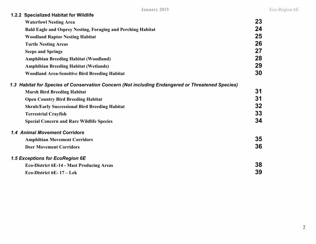
Table of Contents – SWH Ecoregion 6E Criterion Schedule
IDENTIFICATION OF Significant Wildlife Habitat 31. 1 Seasonal Concentration Areas of Animals 3
Waterfowl Stopover and Staging Areas (Terrestrial) 3Waterfowl Stopover and Staging Areas (Aquatic) 4Shorebird Migratory Stopover Area 5Raptor Wintering Area 6Bat Hibernacula 7Bat Maternity Colonies 8Bat Migratory Stopover Area 8Turtle Wintering Areas 9Reptile Hibernaculum 10Colonially -Nesting Bird Breeding Habitat (Bank and Cliff) 11Colonially -Nesting Bird Breeding Habitat Breeding Habitat (Tree/Shrubs) 12Colonially -Nesting Bird Breeding Habitat (Ground) 13Migratory Butterfly Stopover Areas 13Landbird Migratory Stopover Areas 14Deer Yarding Areas 15Deer Winter Congregation Areas 16
1.2 Rare Vegetation Communities or Specialized Habitat for Wildlife 181.2.1 Rare Vegetation Communities
Cliffs and Talus Slopes 18Sand Barren 19Alvar 19Old Growth Forest 20Savannah 21Tallgrass Prairie 21Other Rare Vegetation Communities 22
Eco-Region 6E
2
January 2015 1.2.2 Specialized Habitat for Wildlife
Waterfowl Nesting Area 23Bald Eagle and Osprey Nesting, Foraging and Perching Habitat 24Woodland Raptor Nesting Habitat 25Turtle Nesting Areas 26Seeps and Springs 27Amphibian Breeding Habitat (Woodland) 28Amphibian Breeding Habitat (Wetlands) 29Woodland Area-Sensitive Bird Breeding Habitat 30
1.3 Habitat for Species of Conservation Concern (Not including Endangered or Threatened Species) Marsh Bird Breeding Habitat 31Open Country Bird Breeding Habitat 31Shrub/Early Successional Bird Breeding Habitat 32Terrestrial Crayfish 33Special Concern and Rare Wildlife Species 34
1.4 Animal Movement Corridors Amphibian Movement Corridors 35Deer Movement Corridors 36
1.5 Exceptions for EcoRegion 6E Eco-District 6E-14 - Mast Producing Areas 38Eco-District 6E- 17 – Lek 39
-
January 2015 Eco-Region 6E
3
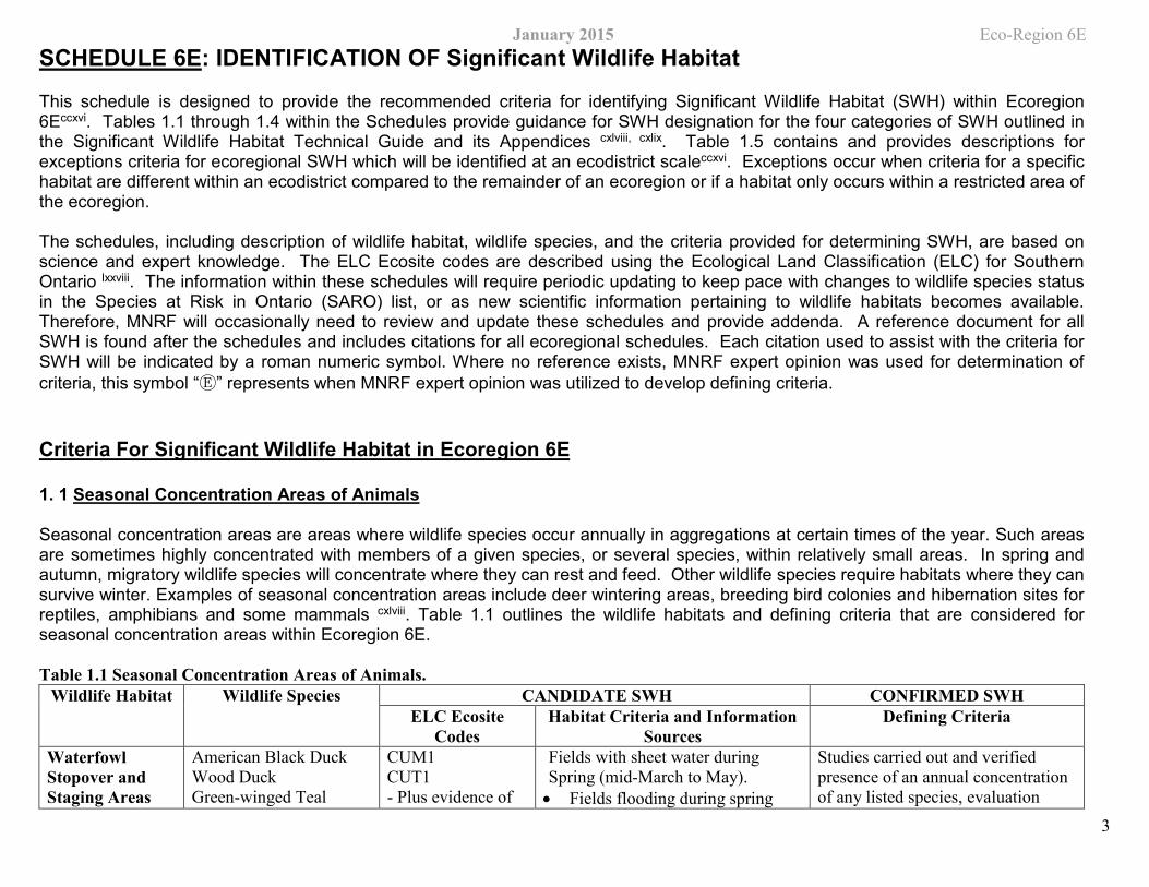
SCHEDULE 6E: IDENTIFICATION OF Significant Wildlife Habitat This schedule is designed to provide the recommended criteria for identifying Significant Wildlife Habitat (SWH) within Ecoregion 6Eccxvi. Tables 1.1 through 1.4 within the Schedules provide guidance for SWH designation for the four categories of SWH outlined in the Significant Wildlife Habitat Technical Guide and its Appendices cxlviii, cxlix. Table 1.5 contains and provides descriptions for exceptions criteria for ecoregional SWH which will be identified at an ecodistrict scaleccxvi. Exceptions occur when criteria for a specific habitat are different within an ecodistrict compared to the remainder of an ecoregion or if a habitat only occurs within a restricted area of the ecoregion.
The schedules, including description of wildlife habitat, wildlife species, and the criteria provided for determining SWH, are based on science and expert knowledge. The ELC Ecosite codes are described using the Ecological Land Classification (ELC) for Southern Ontario lxxviii. The information within these schedules will require periodic updating to keep pace with changes to wildlife species status in the Species at Risk in Ontario (SARO) list, or as new scientific information pertaining to wildlife habitats becomes available. Therefore, MNRF will occasionally need to review and update these schedules and provide addenda. A reference document for all SWH is found after the schedules and includes citations for all ecoregional schedules. Each citation used to assist with the criteria for SWH will be indicated by a roman numeric symbol. Where no reference exists, MNRF expert opinion was used for determination of criteria, this symbol “Ⓔ” represents when MNRF expert opinion was utilized to develop defining criteria.
Criteria For Significant Wildlife Habitat in Ecoregion 6E
1. 1 Seasonal Concentration Areas of Animals
Seasonal concentration areas are areas where wildlife species occur annually in aggregations at certain times of the year. Such areas are sometimes highly concentrated with members of a given species, or several species, within relatively small areas. In spring and autumn, migratory wildlife species will concentrate where they can rest and feed. Other wildlife species require habitats where they can survive winter. Examples of seasonal concentration areas include deer wintering areas, breeding bird colonies and hibernation sites for reptiles, amphibians and some mammals cxlviii. Table 1.1 outlines the wildlife habitats and defining criteria that are considered for seasonal concentration areas within Ecoregion 6E.
Table 1.1 Seasonal Concentration Areas of Animals. Wildlife Habitat Wildlife Species CANDIDATE SWH CONFIRMED SWH
ELC Ecosite Codes
Habitat Criteria and Information Sources
Defining Criteria
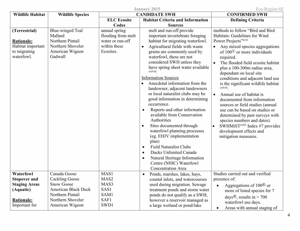
Waterfowl Stopover and Staging Areas
American Black Duck Wood Duck Green-winged Teal
CUM1 CUT1
Plus evidence of
Fields with sheet water during Spring (mid-March to May). • Fields flooding during spring
Studies carried out and verified presence of an annual concentration of any listed species, evaluation
January 2015 Eco-Region 6EWildlife Habitat Wildlife Species CANDIDATE SWH CONFIRMED SWH
ELC Ecosite Codes
Habitat Criteria and Information Sources
Defining Criteria
4
(Terrestrial)
Rationale: Habitat important to migrating waterfowl.
Blue-winged Teal Mallard Northern Pintail Northern Shoveler American Wigeon Gadwall
annual spring flooding from melt water or run-off within these Ecosites.
melt and run-off provide important invertebrate foraging habitat for migrating waterfowl.
• Agricultural fields with waste grains are commonly used by waterfowl, these are not considered SWH unless they have spring sheet water available
cxlviii. Information Sources • Anecdotal information from the
landowner, adjacent landowners or local naturalist clubs may be good information in determining occurrence.
• Reports and other information available from Conservation Authorities
• Sites documented through waterfowl planning processes (eg. EHJV implementation plan)
• Field Naturalist Clubs • Ducks Unlimited Canada • Natural Heritage Information
Centre (NHIC) Waterfowl Concentration Area
methods to follow “Bird and Bird Habitats: Guidelines for Wind Power Projects”ccxi • Any mixed species aggregations
of 100Ⓔ or more individuals required.
• The flooded field ecosite habitat plus a 100-300m radius area, dependant on local site conditions and adjacent land use is the significant wildlife habitat cxlviii.
• Annual use of habitat is documented from information sources or field studies (annual use can be based on studies or determined by past surveys with species numbers and dates).
• SWHMiSTcxlix Index #7 provides development effects and mitigation measures.
Waterfowl Stopover and Staging Areas (Aquatic)
Rationale: Important for
Canada Goose Cackling Goose Snow Goose American Black Duck Northern Pintail Northern Shoveler American Wigeon
MAS1 MAS2 MAS3 SAS1 SAM1 SAF1 SWD1
• Ponds, marshes, lakes, bays, coastal inlets, and watercourses used during migration. Sewage treatment ponds and storm water ponds do not qualify as a SWH, however a reservoir managed as a large wetland or pond/lake
Studies carried out and verified presence of: • Aggregations of 100Ⓔ or
more of listed species for 7 daysⒺ, results in > 700 waterfowl use days.
• Areas with annual staging of
January 2015 Eco-Region 6E Wildlife Habitat Wildlife Species CANDIDATE SWH CONFIRMED SWH
ELC Ecosite Codes
Habitat Criteria and Information Sources
Defining Criteria
5
local and migrant waterfowl populations during the spring or fall migration or both periods combined. Sites identified are usually only one of a few in the eco-district.
Gadwall Green-winged Teal Blue-winged Teal Hooded Merganser Common Merganser Lesser Scaup Greater Scaup Long-tailed Duck Surf Scoter White-winged Scoter Black Scoter Ring-necked duck Common Goldeneye Bufflehead Redhead Ruddy Duck Red-breasted Merganser Brant Canvasback Ruddy Duck
SWD2 SWD3 SWD4 SWD5 SWD6 SWD7
does qualify. • These habitats have an abundant
food supply (mostly aquatic invertebrates and vegetation in shallow water)
Information Sources • Environment Canada. • Naturalist clubs often are aware
of staging/stopover areas. • OMNRF Wetland Evaluations
indicate presence of locally and regionally significant waterfowl staging.
• Sites documented through waterfowl planning processes (eg. EHJV implementation plan)
• Ducks Unlimited projects • Element occurrence
specification by Nature Serve: http://www.natureserve.org
• Natural Heritage Information Centre (NHIC) Waterfowl Concentration Area
ruddy ducks, canvasbacks, and redheads are SWH cxlix
• The combined area of the ELC ecosites and a 100m radius area is the SWH cxlviii
• Wetland area and shorelines associated with sites identified within the SWHTG cxlviii Appendix K cxlix are significant wildlife habitat.
• Evaluation methods to follow “Bird and Bird Habitats: Guidelines for Wind Power Projects”ccxi
• Annual Use of Habitat is Documented from Information Sources or Field Studies (Annual can be based on completed studies or determined from past surveys with species numbers and dates recorded).
• SWHMiSTcxlix Index #7 provides development effects and mitigation measures.
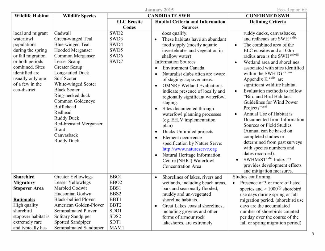
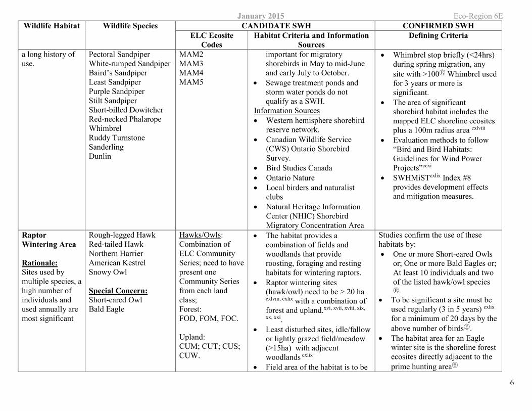
Shorebird Migratory Stopover Area
Rationale: High quality shorebird stopover habitat is extremely rare and typically has
Greater Yellowlegs Lesser Yellowlegs Marbled Godwit Hudsonian Godwit Black-bellied Plover American Golden-Plover Semipalmated Plover Solitary Sandpiper Spotted Sandpiper Semipalmated Sandpiper
BBO1 BBO2 BBS1 BBS2 BBT1 BBT2 SDO1 SDS2 SDT1 MAM1
• Shorelines of lakes, rivers and wetlands, including beach areas, bars and seasonally flooded, muddy and un-vegetated shoreline habitats.
• Great Lakes coastal shorelines, including groynes and other forms of armour rock lakeshores, are extremely
Studies confirming: • Presence of 3 or more of listed
species and > 1000Ⓔ shorebird use days during spring or fall migration period. (shorebird use days are the accumulated number of shorebirds counted per day over the course of the fall or spring migration period)
January 2015 Eco-Region 6E Wildlife Habitat Wildlife Species CANDIDATE SWH CONFIRMED SWH
ELC Ecosite Codes
Habitat Criteria and Information Sources
Defining Criteria
6
a long history of use.
Pectoral Sandpiper White-rumped Sandpiper Baird’s Sandpiper Least Sandpiper Purple Sandpiper Stilt Sandpiper Short-billed Dowitcher Red-necked Phalarope Whimbrel Ruddy Turnstone Sanderling Dunlin
MAM2 MAM3 MAM4 MAM5
important for migratory shorebirds in May to mid-June and early July to October.
• Sewage treatment ponds and storm water ponds do not qualify as a SWH.
Information Sources • Western hemisphere shorebird
reserve network. • Canadian Wildlife Service
(CWS) Ontario Shorebird Survey.
• Bird Studies Canada • Ontario Nature • Local birders and naturalist
clubs • Natural Heritage Information
Center (NHIC) Shorebird Migratory Concentration Area
• Whimbrel stop briefly (<24hrs) during spring migration, any site with >100Ⓔ Whimbrel used for 3 years or more is significant.
• The area of significant shorebird habitat includes the mapped ELC shoreline ecosites plus a 100m radius area cxlviii
• Evaluation methods to follow “Bird and Bird Habitats: Guidelines for Wind Power Projects”ccxi
• SWHMiSTcxlix Index #8 provides development effects and mitigation measures.
Raptor Wintering Area
Rationale: Sites used by multiple species, ahigh number of individuals and used annually are most significant
Rough-legged Hawk Red-tailed Hawk Northern Harrier American Kestrel Snowy Owl
Special Concern: Short-eared Owl Bald Eagle
Hawks/Owls: Combination of ELC Community Series; need to have present one Community Series from each land class; Forest: FOD, FOM, FOC.
Upland: CUM; CUT; CUS; CUW.
• The habitat provides a combination of fields and woodlands that provide roosting, foraging and resting habitats for wintering raptors.
• Raptor wintering sites (hawk/owl) need to be > 20 ha cxlviii, cxlix with a combination of forest and upland.xvi, xvii, xviii, xix,
xx, xxi. • Least disturbed sites, idle/fallow
or lightly grazed field/meadow (>15ha) with adjacent woodlands cxlix
• Field area of the habitat is to be
Studies confirm the use of these habitats by: • One or more Short-eared Owls
or; One or more Bald Eagles or; At least 10 individuals and two of the listed hawk/owl species Ⓔ.
• To be significant a site must be used regularly (3 in 5 years) cxlix for a minimum of 20 days by the above number of birdsⒺ.
• The habitat area for an Eagle winter site is the shoreline forest ecosites directly adjacent to the prime hunting areaⒺ
January 2015 Eco-Region 6E Wildlife Habitat Wildlife Species CANDIDATE SWH CONFIRMED SWH
ELC Ecosite Codes
Habitat Criteria and Information Sources
Defining Criteria
7
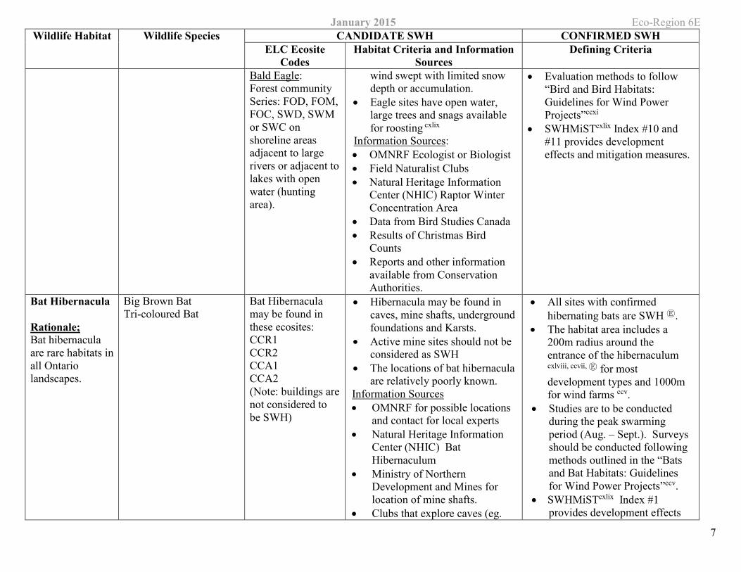
Bald Eagle: Forest community Series: FOD, FOM, FOC, SWD, SWM or SWC on shoreline areas adjacent to large rivers or adjacent to lakes with open water (hunting area).
wind swept with limited snow depth or accumulation.
• Eagle sites have open water, large trees and snags available for roosting cxlix
Information Sources: • OMNRF Ecologist or Biologist • Field Naturalist Clubs • Natural Heritage Information
Center (NHIC) Raptor Winter Concentration Area
• Data from Bird Studies Canada • Results of Christmas Bird
Counts • Reports and other information
available from Conservation Authorities.
• Evaluation methods to follow “Bird and Bird Habitats: Guidelines for Wind Power Projects”ccxi
• SWHMiSTcxlix Index #10 and #11 provides development effects and mitigation measures.
Bat Hibernacula
Rationale; Bat hibernacula are rare habitats in all Ontario landscapes.
Big Brown Bat Tri-coloured Bat
Bat Hibernacula may be found in these ecosites: CCR1 CCR2 CCA1 CCA2 (Note: buildings are not considered to be SWH)
• Hibernacula may be found in caves, mine shafts, underground foundations and Karsts.
• Active mine sites should not be considered as SWH
• The locations of bat hibernacula are relatively poorly known.
Information Sources • OMNRF for possible locations
and contact for local experts • Natural Heritage Information
Center (NHIC) Bat Hibernaculum
• Ministry of Northern Development and Mines for location of mine shafts.
• Clubs that explore caves (eg.
• All sites with confirmed hibernating bats are SWH Ⓔ.
• The habitat area includes a 200m radius around the entrance of the hibernaculum cxlviii, ccvii, Ⓔ for most development types and 1000m for wind farms ccv.
• Studies are to be conducted during the peak swarming period (Aug. – Sept.). Surveys should be conducted following methods outlined in the “Bats and Bat Habitats: Guidelines for Wind Power Projects”ccv.
• SWHMiSTcxlix Index #1 provides development effects
January 2015 Eco-Region 6E Wildlife Habitat Wildlife Species CANDIDATE SWH CONFIRMED SWH
ELC Ecosite Codes
Habitat Criteria and Information Sources
Defining Criteria
8
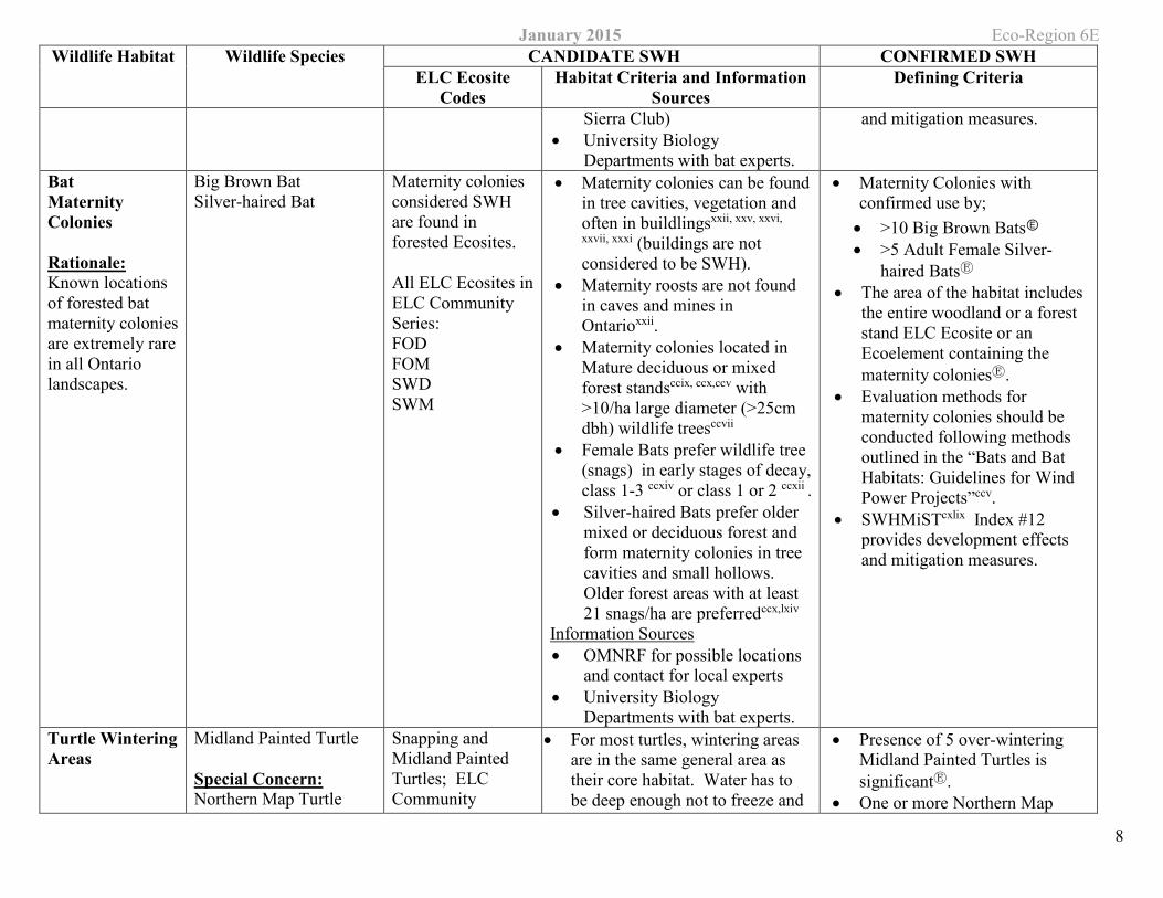
Sierra Club) • University Biology
Departments with bat experts.
and mitigation measures.
Bat Maternity Colonies
Rationale: Known locations of forested bat maternity colonies are extremely rare in all Ontario landscapes.
Big Brown Bat Silver-haired Bat
Maternity colonies considered SWH are found in forested Ecosites.
All ELC Ecosites in ELC Community Series: FOD FOM SWD SWM
• Maternity colonies can be found in tree cavities, vegetation and often in buildlingsxxii, xxv, xxvi,
xxvii, xxxi (buildings are not considered to be SWH).
• Maternity roosts are not found in caves and mines in Ontarioxxii.
• Maternity colonies located in Mature deciduous or mixed forest standsccix, ccx,ccv with >10/ha large diameter (>25cm dbh) wildlife treesccvii
• Female Bats prefer wildlife tree (snags) in early stages of decay, class 1-3 ccxiv or class 1 or 2 ccxii .
• Silver-haired Bats prefer older mixed or deciduous forest and form maternity colonies in tree cavities and small hollows. Older forest areas with at least 21 snags/ha are preferredccx,lxiv
Information Sources • OMNRF for possible locations
and contact for local experts • University Biology
Departments with bat experts.
• Maternity Colonies with confirmed use by; • >10 Big Brown BatsⒺ • >5 Adult Female Silver-
haired BatsⒺ • The area of the habitat includes
the entire woodland or a forest stand ELC Ecosite or an Ecoelement containing the maternity coloniesⒺ.
• Evaluation methods for maternity colonies should be conducted following methods outlined in the “Bats and Bat Habitats: Guidelines for Wind Power Projects”ccv.
• SWHMiSTcxlix Index #12 provides development effects and mitigation measures.
Turtle Wintering Areas
Midland Painted Turtle
Special Concern: Northern Map Turtle
Snapping and Midland Painted Turtles; ELC Community
• For most turtles, wintering areas are in the same general area as their core habitat. Water has to be deep enough not to freeze and
• Presence of 5 over-wintering Midland Painted Turtles is significantⒺ.
• One or more Northern Map
January 2015 Eco-Region 6E Wildlife Habitat Wildlife Species CANDIDATE SWH CONFIRMED SWH
ELC Ecosite Codes
Habitat Criteria and Information Sources
Defining Criteria
9
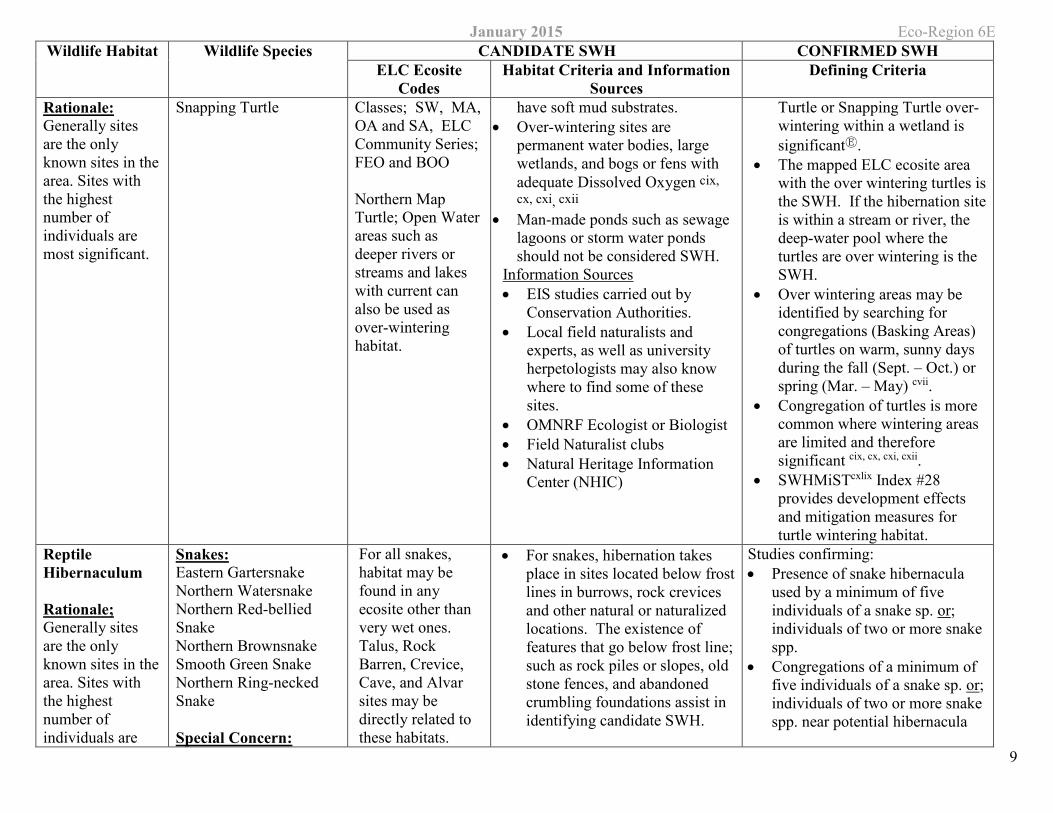
Rationale: Generally sites are the only known sites in the area. Sites with the highest number of individuals are most significant.
Snapping Turtle Classes; SW, MA, OA and SA, ELC Community Series; FEO and BOO
Northern Map Turtle; Open Water areas such as deeper rivers or streams and lakes with current can also be used as over-wintering habitat.
have soft mud substrates. • Over-wintering sites are
permanent water bodies, large wetlands, and bogs or fens with adequate Dissolved Oxygen cix, cx, cxi, cxii
• Man-made ponds such as sewage lagoons or storm water ponds should not be considered SWH.
Information Sources • EIS studies carried out by
Conservation Authorities. • Local field naturalists and
experts, as well as university herpetologists may also know where to find some of these sites.
• OMNRF Ecologist or Biologist • Field Naturalist clubs • Natural Heritage Information
Center (NHIC)
Turtle or Snapping Turtle over-wintering within a wetland is significantⒺ.
• The mapped ELC ecosite area with the over wintering turtles is the SWH. If the hibernation site is within a stream or river, the deep-water pool where the turtles are over wintering is the SWH.
• Over wintering areas may be identified by searching for congregations (Basking Areas) of turtles on warm, sunny days during the fall (Sept. – Oct.) or spring (Mar. – May) cvii.
• Congregation of turtles is more common where wintering areas are limited and therefore significant cix, cx, cxi, cxii.
• SWHMiSTcxlix Index #28 provides development effects and mitigation measures for turtle wintering habitat.
Reptile Hibernaculum
Rationale; Generally sites are the only known sites in the area. Sites with the highest number of individuals are
Snakes: Eastern Gartersnake Northern Watersnake Northern Red-bellied Snake Northern Brownsnake Smooth Green Snake Northern Ring-necked Snake
Special Concern:
For all snakes, habitat may be found in any ecosite other than very wet ones. Talus, Rock Barren, Crevice, Cave, and Alvar sites may be directly related to these habitats.
• For snakes, hibernation takes place in sites located below frost lines in burrows, rock crevices and other natural or naturalized locations. The existence of features that go below frost line; such as rock piles or slopes, old stone fences, and abandoned crumbling foundations assist in identifying candidate SWH.
Studies confirming: • Presence of snake hibernacula
used by a minimum of five individuals of a snake sp. or; individuals of two or more snake spp.
• Congregations of a minimum of five individuals of a snake sp. or; individuals of two or more snake spp. near potential hibernacula
January 2015 Eco-Region 6E Wildlife Habitat Wildlife Species CANDIDATE SWH CONFIRMED SWH
ELC Ecosite Codes
Habitat Criteria and Information Sources
Defining Criteria
10
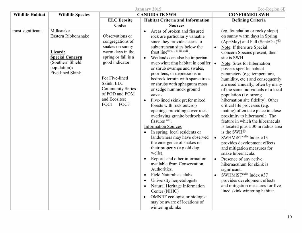
most significant. Milksnake Eastern Ribbonsnake
Lizard: Special Concern (Southern Shield population): Five-lined Skink
Observations or congregations of snakes on sunny warm days in the spring or fall is a good indicator.
For Five-lined Skink, ELC Community Series of FOD and FOM and Ecosites: FOC1 FOC3
• Areas of broken and fissured rock are particularly valuable since they provide access to subterranean sites below the frost linexliv, l, li, lii, cxii .
• Wetlands can also be important over-wintering habitat in conifer or shrub swamps and swales, poor fens, or depressions in bedrock terrain with sparse trees or shrubs with sphagnum moss or sedge hummock ground cover.
• Five-lined skink prefer mixed forests with rock outcrop openings providing cover rock overlaying granite bedrock with fissures cciii.
Information Sources • In spring, local residents or
landowners may have observed the emergence of snakes on their property (e.g.old dug wells).
• Reports and other information available from Conservation Authorities.
• Field Naturalists clubs • University herpetologists • Natural Heritage Information
Center (NHIC) • OMNRF ecologist or biologist
may be aware of locations of wintering skinks
(eg. foundation or rocky slope) on sunny warm days in Spring (Apr/May) and Fall (Sept/Oct)Ⓔ
• Note: If there are Special Concern Species present, then site is SWH
• Note: Sites for hibernation possess specific habitat parameters (e.g. temperature, humidity, etc.) and consequently are used annually, often by many of the same individuals of a local population (i.e. strong hibernation site fidelity). Other critical life processes (e.g. mating) often take place in close proximity to hibernacula. The feature in which the hibernacula is located plus a 30 m radius area is the SWHⒺ
• SWHMiSTcxlix Index #13 provides development effects and mitigation measures for snake hibernacula.
• Presence of any active hibernaculum for skink is significant.
• SWHMiSTcxlix Index #37 provides development effects and mitigation measures for five-lined skink wintering habitat.
January 2015 Eco-Region 6E Wildlife Habitat Wildlife Species CANDIDATE SWH CONFIRMED SWH
ELC Ecosite Codes
Habitat Criteria and Information Sources
Defining Criteria
11
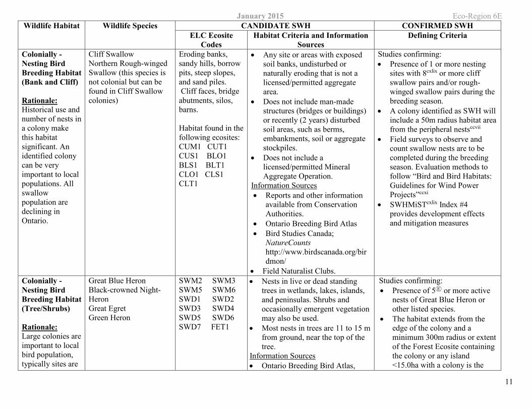
Colonially -Nesting Bird Breeding Habitat (Bank and Cliff)
Rationale: Historical use and number of nests in a colony make this habitat significant. An identified colony can be very important to local populations. All swallow population are declining in Ontario.
Cliff Swallow Northern Rough-winged Swallow (this species is not colonial but can be found in Cliff Swallow colonies)
Eroding banks, sandy hills, borrow pits, steep slopes, and sand piles. Cliff faces, bridge abutments, silos, barns.
Habitat found in the following ecosites: CUM1 CUT1CUS1 BLO1 BLS1 BLT1 CLO1 CLS1 CLT1
• Any site or areas with exposed soil banks, undisturbed or naturally eroding that is not a licensed/permitted aggregate area.
• Does not include man-made structures (bridges or buildings) or recently (2 years) disturbed soil areas, such as berms, embankments, soil or aggregate stockpiles.
• Does not include a licensed/permitted Mineral Aggregate Operation.
Information Sources • Reports and other information
available from Conservation Authorities.
• Ontario Breeding Bird Atlas • Bird Studies Canada;
NatureCounts http://www.birdscanada.org/birdmon/
• Field Naturalist Clubs.
Studies confirming: • Presence of 1 or more nesting
sites with 8cxlix or more cliff swallow pairs and/or rough-winged swallow pairs during the breeding season.
• A colony identified as SWH will include a 50m radius habitat area from the peripheral nestsccvii
• Field surveys to observe and count swallow nests are to be completed during the breeding season. Evaluation methods to follow “Bird and Bird Habitats: Guidelines for Wind Power Projects”ccxi
• SWHMiSTcxlix Index #4 provides development effects and mitigation measures
Colonially -Nesting Bird Breeding Habitat (Tree/Shrubs)
Rationale: Large colonies are important to local bird population, typically sites are
Great Blue Heron Black-crowned Night-Heron Great Egret Green Heron
SWM2 SWM3 SWM5 SWM6 SWD1 SWD2 SWD3 SWD4 SWD5 SWD6 SWD7 FET1
• Nests in live or dead standing trees in wetlands, lakes, islands, and peninsulas. Shrubs and occasionally emergent vegetation may also be used.
• Most nests in trees are 11 to 15 m from ground, near the top of the tree.
Information Sources • Ontario Breeding Bird Atlas,
Studies confirming: • Presence of 5Ⓔ or more active
nests of Great Blue Heron or other listed species.
• The habitat extends from the edge of the colony and a minimum 300m radius or extent of the Forest Ecosite containing the colony or any island <15.0ha with a colony is the
January 2015 Eco-Region 6E Wildlife Habitat Wildlife Species CANDIDATE SWH CONFIRMED SWH
ELC Ecosite Codes
Habitat Criteria and Information Sources
Defining Criteria
12
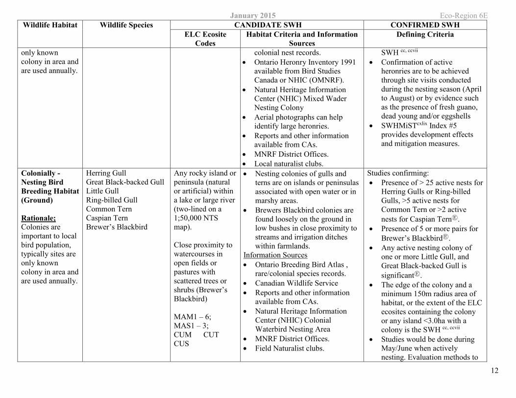
only known colony in area and are used annually.
colonial nest records. • Ontario Heronry Inventory 1991
available from Bird Studies Canada or NHIC (OMNRF).
• Natural Heritage Information Center (NHIC) Mixed Wader Nesting Colony
• Aerial photographs can help identify large heronries.
• Reports and other information available from CAs.
• MNRF District Offices. • Local naturalist clubs.
SWH cc, ccvii
• Confirmation of active heronries are to be achieved through site visits conducted during the nesting season (April to August) or by evidence such as the presence of fresh guano, dead young and/or eggshells
• SWHMiSTcxlix Index #5 provides development effects and mitigation measures.
Colonially -Nesting Bird Breeding Habitat (Ground)
Rationale; Colonies are important to local bird population, typically sites are only known colony in area and are used annually.
Herring Gull Great Black-backed Gull Little Gull Ring-billed Gull Common Tern Caspian Tern Brewer’s Blackbird
Any rocky island or peninsula (natural or artificial) within a lake or large river (two-lined on a 1;50,000 NTS map).
Close proximity to watercourses in open fields or pastures with scattered trees or shrubs (Brewer’s Blackbird)
MAM1 – 6; MAS1 – 3; CUM CUT CUS
• Nesting colonies of gulls and terns are on islands or peninsulas associated with open water or in marshy areas.
• Brewers Blackbird colonies are found loosely on the ground in low bushes in close proximity to streams and irrigation ditches within farmlands.
Information Sources • Ontario Breeding Bird Atlas ,
rare/colonial species records. • Canadian Wildlife Service • Reports and other information
available from CAs. • Natural Heritage Information
Center (NHIC) Colonial Waterbird Nesting Area
• MNRF District Offices. • Field Naturalist clubs.
Studies confirming: • Presence of > 25 active nests for
Herring Gulls or Ring-billed Gulls, >5 active nests for Common Tern or >2 active nests for Caspian TernⒺ.
• Presence of 5 or more pairs for Brewer’s BlackbirdⒺ.
• Any active nesting colony of one or more Little Gull, and Great Black-backed Gull is significantⒺ.
• The edge of the colony and a minimum 150m radius area of habitat, or the extent of the ELC ecosites containing the colony or any island <3.0ha with a colony is the SWH cc, ccvii
• Studies would be done during May/June when actively nesting. Evaluation methods to
January 2015 Eco-Region 6E Wildlife Habitat Wildlife Species CANDIDATE SWH CONFIRMED SWH
ELC Ecosite Codes
Habitat Criteria and Information Sources
Defining Criteria
13
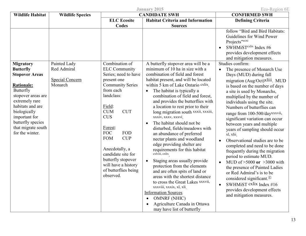
follow “Bird and Bird Habitats: Guidelines for Wind Power Projects”ccxi
• SWHMiSTcxlix Index #6 provides development effects and mitigation measures.
Migratory Butterfly Stopover Areas
Rationale: Butterfly stopover areas are extremely rare habitats and are biologically important for butterfly species that migrate south for the winter.
Painted Lady Red Admiral
Special Concern Monarch
Combination of ELC Community Series; need to havepresent one Community Series from each landclass:
Field: CUM CUT CUS
Forest: FOC FOD FOM CUP
Anecdotally, a candidate site for butterfly stopover will have a history of butterflies being observed.
A butterfly stopover area will be a minimum of 10 ha in size with a combination of field and forest habitat present, and will be located within 5 km of Lake Ontario cxlix. • The habitat is typically a
combination of field and forest, and provides the butterflies with a location to rest prior to their long migration south xxxii, xxxiii, xxxiv, xxxv, xxxvi.
• The habitat should not be disturbed, fields/meadows with an abundance of preferred nectar plants and woodland edge providing shelter are requirements for this habitat
cxlviii, cxlix. • Staging areas usually provide
protection from the elements and are often spits of land or areas with the shortest distance to cross the Great Lakes xxxvii, xxxviii, xxxix, xl, xli.
Information Sources • OMNRF (NHIC) • Agriculture Canada in Ottawa
may have list of butterfly
Studies confirm: • The presence of Monarch Use
Days (MUD) during fall migration (Aug/Oct)xliii. MUD is based on the number of days a site is used by Monarchs, multiplied by the number of individuals using the site. Numbers of butterflies can range from 100-500/dayxxxvii, significant variation can occur between years and multiple years of sampling should occur xl, xlii.
• Observational studies are to be completed and need to be done frequently during the migration period to estimate MUD.
• MUD of >5000 or >3000 with the presence of Painted Ladies or Red Admiral’s is to be considered significant.Ⓔ
• SWHMiST cxlix Index #16 provides development effects and mitigation measures.
January 2015 Eco-Region 6E Wildlife Habitat Wildlife Species CANDIDATE SWH CONFIRMED SWH
ELC Ecosite Codes
Habitat Criteria and Information Sources
Defining Criteria
14
experts. • Field Naturalist Clubs • Toronto Entomologists
Association • Conservation Authorities
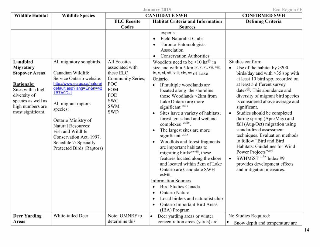
Landbird Migratory Stopover Areas
Rationale: Sites with a high diversity of species as well as high numbers are most significant.
All migratory songbirds.
Canadian Wildlife Service Ontario website: http://www.ec.gc.ca/nature/default.asp?lang=En&n=421B7A9D-1
All migrant raptors species:
Ontario Ministry of Natural Resources: Fish and Wildlife Conservation Act, 1997. Schedule 7: Specially Protected Birds (Raptors)
All Ecosites associated with these ELC Community Series; FOC FOM FOD SWC SWM SWD
Woodlots need to be >10 haⒺ in size and within 5 km iv, v, vi, vii, viii, ix, x, xi, xii, xiii, xiv, xv of Lake Ontario. • If multiple woodlands are
located along the shoreline those Woodlands <2km from Lake Ontario are more significant cxlix
• Sites have a variety of habitats; forest, grassland and wetland complexes cxlix.
• The largest sites are more significant cxlix
• Woodlots and forest fragments are important habitats to migrating birdsccxviii, these features located along the shore and located within 5km of Lake Ontario are Candidate SWH cxlviii.
Information Sources • Bird Studies Canada • Ontario Nature • Local birders and naturalist club • Ontario Important Bird Areas
(IBA) Program
Studies confirm: • Use of the habitat by >200
birds/day and with >35 spp with at least 10 bird spp. recorded on at least 5 different survey datesⒺ. This abundance and diversity of migrant bird species is considered above average and significant.
• Studies should be completed during spring (Apr./May) and fall (Aug/Oct) migration using standardized assessment techniques. Evaluation methods to follow “Bird and Bird Habitats: Guidelines for Wind Power Projects”ccxi
• SWHMiST cxlix Index #9 provides development effects and mitigation measures.
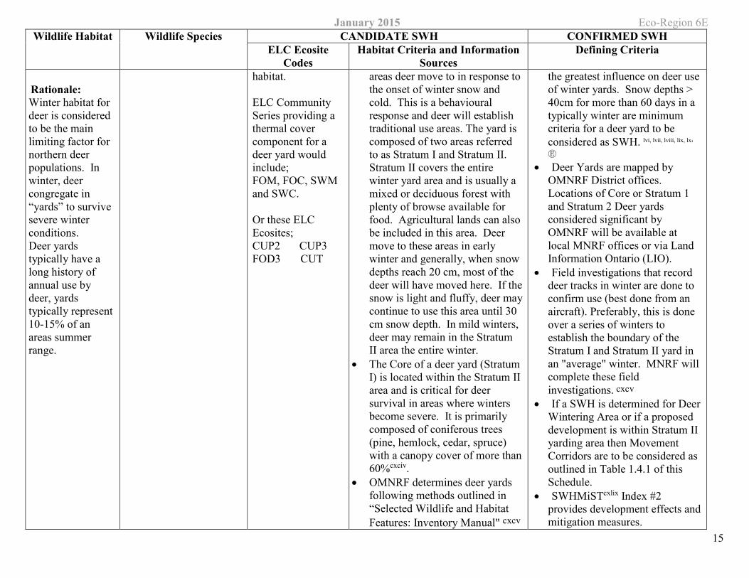
Deer Yarding Areas
White-tailed Deer Note: OMNRF to determine this
• Deer yarding areas or winter concentration areas (yards) are
No Studies Required: • Snow depth and temperature are
January 2015 Eco-Region 6E Wildlife Habitat Wildlife Species CANDIDATE SWH CONFIRMED SWH
ELC Ecosite Codes
Habitat Criteria and Information Sources
Defining Criteria
15
Rationale: Winter habitat for deer is considered to be the main limiting factor for northern deer populations. In winter, deer congregate in “yards” to survive severe winter conditions. Deer yards typically have a long history of annual use by deer, yards typically represent 10-15% of an areas summer range.
habitat.
ELC Community Series providing a thermal cover component for a deer yard would include; FOM, FOC, SWM and SWC.
Or these ELC Ecosites; CUP2 CUP3FOD3 CUT
areas deer move to in response to the onset of winter snow and cold. This is a behavioural response and deer will establish traditional use areas. The yard is composed of two areas referred to as Stratum I and Stratum II. Stratum II covers the entire winter yard area and is usually a mixed or deciduous forest with plenty of browse available for food. Agricultural lands can also be included in this area. Deer move to these areas in early winter and generally, when snow depths reach 20 cm, most of the deer will have moved here. If the snow is light and fluffy, deer may continue to use this area until 30 cm snow depth. In mild winters, deer may remain in the Stratum II area the entire winter.
• The Core of a deer yard (Stratum I) is located within the Stratum II area and is critical for deer survival in areas where winters become severe. It is primarily composed of coniferous trees (pine, hemlock, cedar, spruce) with a canopy cover of more than 60%cxciv.
• OMNRF determines deer yards following methods outlined in “Selected Wildlife and Habitat Features: Inventory Manual" cxcv
the greatest influence on deer use of winter yards. Snow depths > 40cm for more than 60 days in a typically winter are minimum criteria for a deer yard to be considered as SWH. lvi, lvii, lviii, lix, lx, Ⓔ
• Deer Yards are mapped by OMNRF District offices. Locations of Core or Stratum 1 and Stratum 2 Deer yards considered significant by OMNRF will be available at local MNRF offices or via Land Information Ontario (LIO).
• Field investigations that record deer tracks in winter are done to confirm use (best done from an aircraft). Preferably, this is done over a series of winters to establish the boundary of the Stratum I and Stratum II yard in an "average" winter. MNRF will complete these field investigations. cxcv
• If a SWH is determined for Deer Wintering Area or if a proposed development is within Stratum II yarding area then Movement Corridors are to be considered as outlined in Table 1.4.1 of this Schedule.
• SWHMiSTcxlix Index #2 provides development effects and mitigation measures.
January 2015 Eco-Region 6E Wildlife Habitat Wildlife Species CANDIDATE SWH CONFIRMED SWH
ELC Ecosite Codes
Habitat Criteria and Information Sources
Defining Criteria
16
• Woodlots with high densities of deer due to artificial feeding are not significantⒺ.
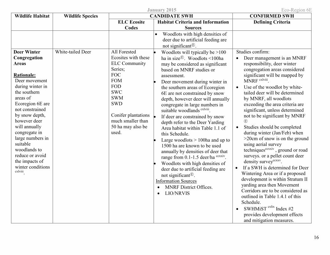
Deer Winter Congregation Areas
Rationale: Deer movement during winter in the southern areas of Ecoregion 6E are not constrained by snow depth, however deer will annually congregate in large numbers in suitable woodlands to reduce or avoid the impacts of winter conditions
cxlviii.
White-tailed Deer All Forested Ecosites with these ELC Community Series; FOC FOM FOD SWC SWM SWD
Conifer plantations much smaller than 50 ha may also be used.
• Woodlots will typically be >100 ha in sizeⒺ. Woodlots <100ha may be considered as significant based on MNRF studies or assessment.
• Deer movement during winter in the southern areas of Ecoregion 6E are not constrained by snow depth, however deer will annually congregate in large numbers in suitable woodlands cxlviii.
• If deer are constrained by snow depth refer to the Deer Yarding Area habitat within Table 1.1 of this Schedule.
• Large woodlots > 100ha and up to 1500 ha are known to be used annually by densities of deer that range from 0.1-1.5 deer/ha ccxxiv.
• Woodlots with high densities of deer due to artificial feeding are not significantⒺ.
Information Sources • MNRF District Offices. • LIO/NRVIS
Studies confirm: • Deer management is an MNRF
responsibility, deer winter congregation areas considered significant will be mapped by MNRF cxlviii.
• Use of the woodlot by white-tailed deer will be determined by MNRF, all woodlots exceeding the area criteria are significant, unless determined not to be significant by MNRF Ⓔ
• Studies should be completed during winter (Jan/Feb) when >20cm of snow is on the ground using aerial survey techniquesccxxiv , ground or road surveys. or a pellet count deer density surveyccxxv.
• If a SWH is determined for Deer Wintering Area or if a proposed development is within Stratum II yarding area then Movement Corridors are to be considered as outlined in Table 1.4.1 of this Schedule.
• SWHMiST cxlix Index #2 provides development effects and mitigation measures.
January 2015 Eco-Region 6E
17
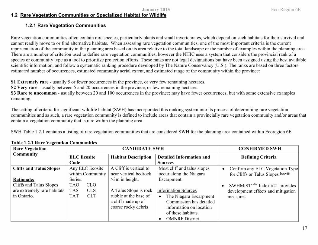
1.2 Rare Vegetation Communities or Specialized Habitat for Wildlife
1.2.1 Rare Vegetation Communities
Rare vegetation communities often contain rare species, particularly plants and small invertebrates, which depend on such habitats for their survival and cannot readily move to or find alternative habitats. When assessing rare vegetation communities, one of the most important criteria is the current representation of the community in the planning area based on its area relative to the total landscape or the number of examples within the planning area. There are a number of criterion used to define rare vegetation communities, however the NHIC uses a system that considers the provincial rank of a species or community type as a tool to prioritize protection efforts. These ranks are not legal designations but have been assigned using the best available scientific information, and follow a systematic ranking procedure developed by The Nature Conservancy (U.S.). The ranks are based on three factors: estimated number of occurrences, estimated community aerial extent, and estimated range of the community within the province:
S1 Extremely rare - usually 5 or fewer occurrences in the province, or very few remaining hectares. S2 Very rare - usually between 5 and 20 occurrences in the province, or few remaining hectares. S3 Rare to uncommon - usually between 20 and 100 occurrences in the province; may have fewer occurrences, but with some extensive examples remaining.
The setting of criteria for significant wildlife habitat (SWH) has incorporated this ranking system into its process of determining rare vegetation communities and as such, a rare vegetation community is defined to include areas that contain a provincially rare vegetation community and/or areas that contain a vegetation community that is rare within the planning area.
SWH Table 1.2.1 contains a listing of rare vegetation communities that are considered SWH for the planning area contained within Ecoregion 6E.
Table 1.2.1 Rare Vegetation Communities. Rare Vegetation Community
CANDIDATE SWH CONFIRMED SWH
ELC Ecosite Code
Habitat Description Detailed Information and Sources
Defining Criteria
Cliffs and Talus Slopes
Rationale: Cliffs and Talus Slopes are extremely rare habitats in Ontario.
Any ELC Ecosite within Community Series: TAOTASTAT
CLO CLSCLT
A Cliff is vertical to near vertical bedrock >3m in height.
A Talus Slope is rockrubble at the base of a cliff made up of coarse rocky debris
Most cliff and talus slopes occur along the Niagara Escarpment.
Information Sources • The Niagara Escarpment
Commission has detailed information on location of these habitats.
• OMNRF District
• Confirm any ELC Vegetation Type for Cliffs or Talus Slopes lxxviii
• SWHMiSTcxlix Index #21 provides development effects and mitigation measures.
January 2015 Eco-Region 6E Rare Vegetation Community
CANDIDATE SWH CONFIRMED SWH
ELC Ecosite Code
Habitat Description Detailed Information and Sources
Defining Criteria
18
• Natural Heritage Information Center (NHIC) has location information available on their website
• Field Naturalist clubs • Conservation Authorities
Sand Barren
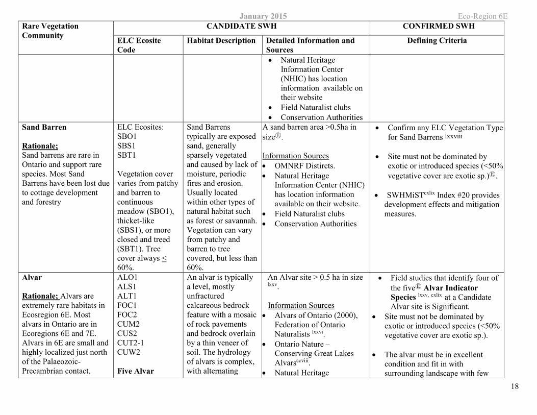
Rationale; Sand barrens are rare in Ontario and support rare species. Most Sand Barrens have been lost due to cottage development and forestry
ELC Ecosites: SBO1 SBS1 SBT1
Vegetation cover varies from patchy and barren to continuous meadow (SBO1), thicket-like (SBS1), or more closed and treed (SBT1). Tree cover always < 60%.
Sand Barrens typically are exposed sand, generally sparsely vegetated and caused by lack of moisture, periodic fires and erosion. Usually located within other types of natural habitat such as forest or savannah. Vegetation can vary from patchy and barren to tree covered, but less than 60%.
A sand barren area >0.5ha in sizeⒺ.
Information Sources • OMNRF Distircts. • Natural Heritage
Information Center (NHIC) has location information available on their website.
• Field Naturalist clubs • Conservation Authorities
• Confirm any ELC Vegetation Type for Sand Barrens lxxviii
• Site must not be dominated by exotic or introduced species (<50% vegetative cover are exotic sp.)Ⓔ.
• SWHMiSTcxlix Index #20 provides development effects and mitigation measures.
Alvar
Rationale; Alvars are extremely rare habitats in Ecosregion 6E. Most alvars in Ontario are in Ecoregions 6E and 7E. Alvars in 6E are small and highly localized just north of the Palaeozoic-Precambrian contact.
ALO1 ALS1 ALT1 FOC1 FOC2 CUM2 CUS2 CUT2-1 CUW2
Five Alvar
An alvar is typically a level, mostly unfractured calcareous bedrock feature with a mosaic of rock pavements and bedrock overlain by a thin veneer of soil. The hydrology of alvars is complex, with alternating
An Alvar site > 0.5 ha in size
lxxv.
Information Sources • Alvars of Ontario (2000),
Federation of Ontario Naturalists lxxvi.
• Ontario Nature – Conserving Great Lakes Alvarsccviii.
• Natural Heritage
• Field studies that identify four of the fiveⒺ Alvar Indicator Species lxxv, cxlix at a Candidate Alvar site is Significant.
• Site must not be dominated by exotic or introduced species (<50% vegetative cover are exotic sp.).
• The alvar must be in excellent condition and fit in with surrounding landscape with few
January 2015 Eco-Region 6E Rare Vegetation Community
CANDIDATE SWH CONFIRMED SWH
ELC Ecosite Code
Habitat Description Detailed Information and Sources
Defining Criteria
19
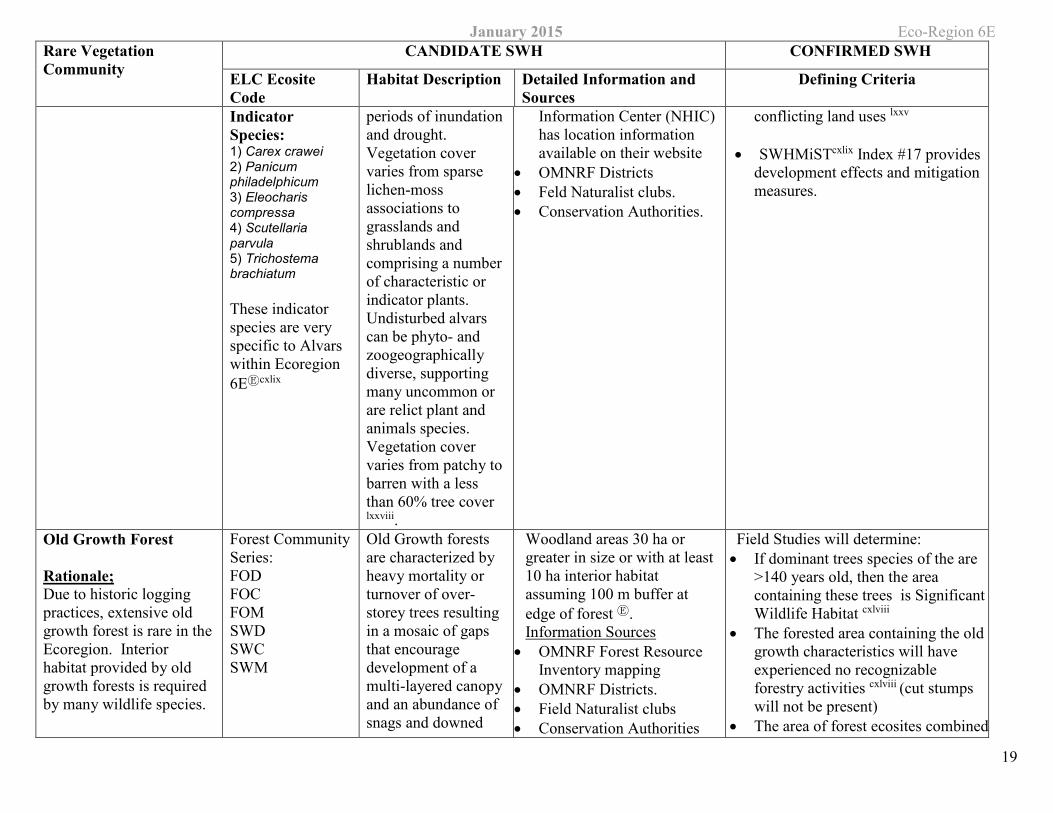
Indicator Species: 1) Carex crawei 2) Panicum philadelphicum 3) Eleocharis compressa 4) Scutellaria parvula 5) Trichostema brachiatum
These indicator species are very specific to Alvars within Ecoregion 6EⒺcxlix
periods of inundation and drought. Vegetation cover varies from sparse lichen-moss associations to grasslands and shrublands and comprising a number of characteristic or indicator plants. Undisturbed alvars can be phyto- and zoogeographically diverse, supporting many uncommon or are relict plant and animals species. Vegetation cover varies from patchy to barren with a less than 60% tree cover lxxviii.
Information Center (NHIC) has location information available on their website
• OMNRF Districts • Feld Naturalist clubs. • Conservation Authorities.
conflicting land uses lxxv
• SWHMiSTcxlix Index #17 provides development effects and mitigation measures.
Old Growth Forest
Rationale; Due to historic logging practices, extensive old growth forest is rare in the Ecoregion. Interior habitat provided by old growth forests is required by many wildlife species.
Forest CommunitySeries: FOD FOC FOM SWD SWC SWM
Old Growth forests are characterized by heavy mortality or turnover of over-storey trees resulting in a mosaic of gaps that encourage development of a multi-layered canopy and an abundance of snags and downed
Woodland areas 30 ha or greater in size or with at least 10 ha interior habitat assuming 100 m buffer at edge of forest Ⓔ. Information Sources
• OMNRF Forest Resource Inventory mapping
• OMNRF Districts. • Field Naturalist clubs • Conservation Authorities
Field Studies will determine: • If dominant trees species of the are
>140 years old, then the area containing these trees is Significant Wildlife Habitat cxlviii
• The forested area containing the old growth characteristics will have experienced no recognizable forestry activities cxlviii (cut stumps will not be present)
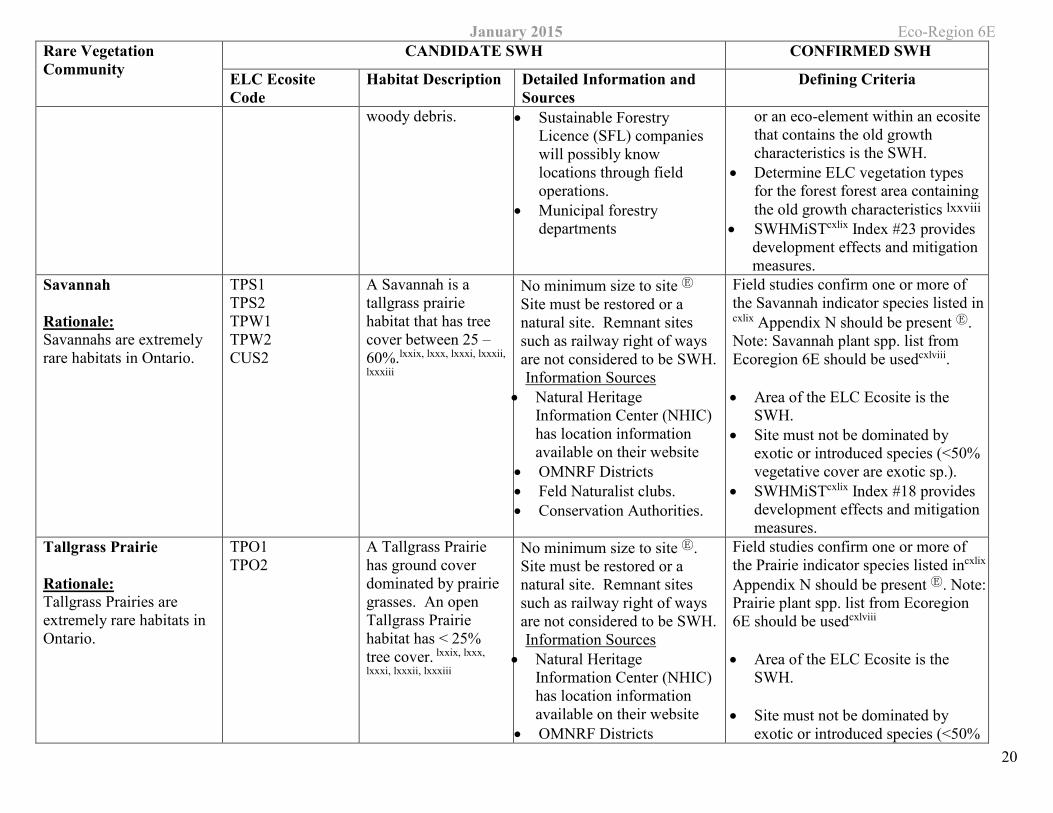
• The area of forest ecosites combined
January 2015 Eco-Region 6E Rare Vegetation Community
CANDIDATE SWH CONFIRMED SWH
ELC Ecosite Code
Habitat Description Detailed Information and Sources
Defining Criteria
20
woody debris. • Sustainable Forestry Licence (SFL) companies will possibly know locations through field operations.
• Municipal forestry departments
or an eco-element within an ecosite that contains the old growth characteristics is the SWH.
• Determine ELC vegetation types for the forest forest area containing the old growth characteristics lxxviii
• SWHMiSTcxlix Index #23 provides development effects and mitigation measures.
Savannah
Rationale: Savannahs are extremely rare habitats in Ontario.
TPS1 TPS2 TPW1 TPW2 CUS2
A Savannah is a tallgrass prairie habitat that has tree cover between 25 – 60%.lxxix, lxxx, lxxxi, lxxxii,
lxxxiii
No minimum size to site Ⓔ Site must be restored or a natural site. Remnant sites such as railway right of ways are not considered to be SWH. Information Sources
• Natural Heritage Information Center (NHIC) has location information available on their website
• OMNRF Districts • Feld Naturalist clubs. • Conservation Authorities.
Field studies confirm one or more of the Savannah indicator species listed in cxlix Appendix N should be present Ⓔ. Note: Savannah plant spp. list from Ecoregion 6E should be usedcxlviii.
• Area of the ELC Ecosite is the SWH.
• Site must not be dominated by exotic or introduced species (<50% vegetative cover are exotic sp.).
• SWHMiSTcxlix Index #18 provides development effects and mitigation measures.
Tallgrass Prairie
Rationale: Tallgrass Prairies are extremely rare habitats in Ontario.
TPO1 TPO2
A Tallgrass Prairie has ground cover dominated by prairie grasses. An open Tallgrass Prairie habitat has < 25% tree cover. lxxix, lxxx,
lxxxi, lxxxii, lxxxiii
No minimum size to site Ⓔ. Site must be restored or a natural site. Remnant sites such as railway right of ways are not considered to be SWH. Information Sources
• Natural Heritage Information Center (NHIC) has location information available on their website
• OMNRF Districts
Field studies confirm one or more of the Prairie indicator species listed incxlix Appendix N should be present Ⓔ. Note: Prairie plant spp. list from Ecoregion 6E should be usedcxlviii
• Area of the ELC Ecosite is the SWH.
• Site must not be dominated by exotic or introduced species (<50%
January 2015 Eco-Region 6E Rare Vegetation Community
CANDIDATE SWH CONFIRMED SWH
ELC Ecosite Code
Habitat Description Detailed Information and Sources
Defining Criteria
21
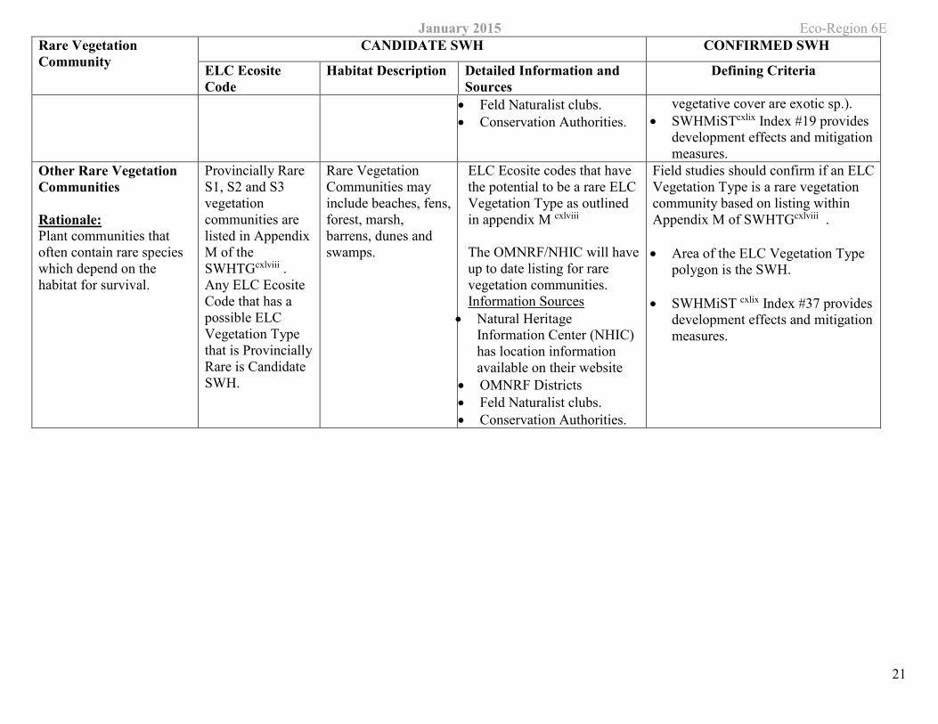
• Feld Naturalist clubs. • Conservation Authorities.
vegetative cover are exotic sp.). • SWHMiSTcxlix Index #19 provides
development effects and mitigation measures.
Other Rare Vegetation Communities
Rationale: Plant communities that often contain rare species which depend on the habitat for survival.
Provincially Rare S1, S2 and S3 vegetation communities are listed in Appendix M of the SWHTGcxlviii . Any ELC Ecosite Code that has a possible ELC Vegetation Type that is Provincially Rare is Candidate SWH.
Rare Vegetation Communities may include beaches, fens, forest, marsh, barrens, dunes and swamps.
ELC Ecosite codes that have the potential to be a rare ELC Vegetation Type as outlined in appendix M cxlviii
The OMNRF/NHIC will have up to date listing for rare vegetation communities. Information Sources
• Natural Heritage Information Center (NHIC) has location information available on their website
• OMNRF Districts • Feld Naturalist clubs. • Conservation Authorities.
Field studies should confirm if an ELC Vegetation Type is a rare vegetation community based on listing within Appendix M of SWHTGcxlviii .
• Area of the ELC Vegetation Type polygon is the SWH.
• SWHMiST cxlix Index #37 provides development effects and mitigation measures.
January 2015 Eco-Region 6E
22
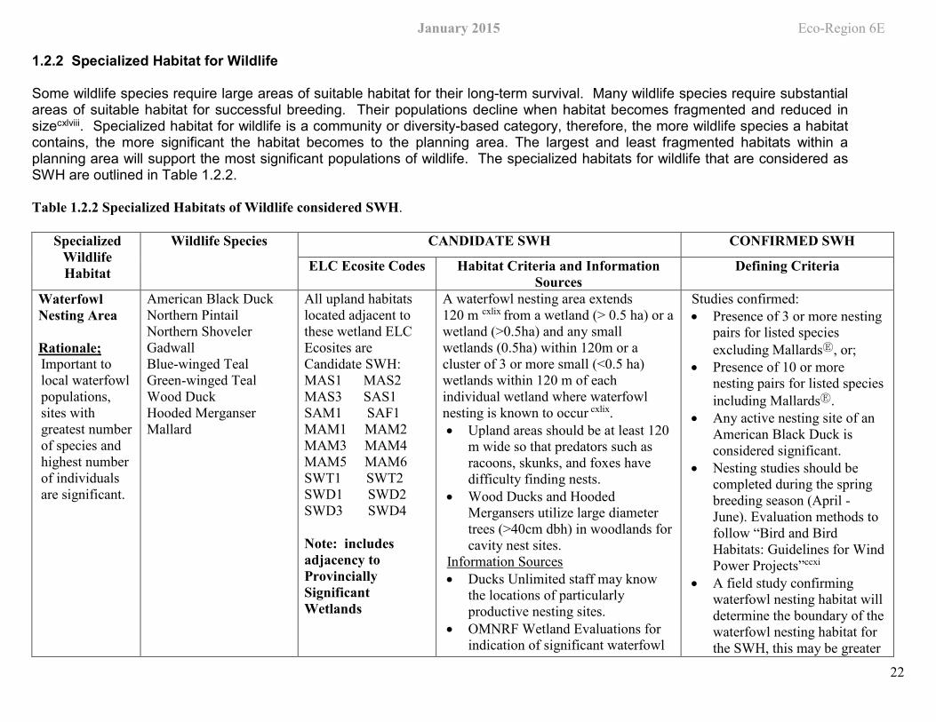
1.2.2 Specialized Habitat for Wildlife
Some wildlife species require large areas of suitable habitat for their long-term survival. Many wildlife species require substantial areas of suitable habitat for successful breeding. Their populations decline when habitat becomes fragmented and reduced in sizecxlviii. Specialized habitat for wildlife is a community or diversity-based category, therefore, the more wildlife species a habitat contains, the more significant the habitat becomes to the planning area. The largest and least fragmented habitats within a planning area will support the most significant populations of wildlife. The specialized habitats for wildlife that are considered as SWH are outlined in Table 1.2.2.
Table 1.2.2 Specialized Habitats of Wildlife considered SWH.
Specialized Wildlife Habitat
Wildlife Species CANDIDATE SWH CONFIRMED SWH
ELC Ecosite Codes Habitat Criteria and Information Sources
Defining Criteria
Waterfowl Nesting Area
Rationale; Important to local waterfowl populations, sites with greatest number of species and highest number of individuals are significant.
American Black Duck Northern Pintail Northern Shoveler Gadwall Blue-winged Teal Green-winged Teal Wood Duck Hooded Merganser Mallard
All upland habitats located adjacent to these wetland ELC Ecosites are Candidate SWH: MAS1 MAS2 MAS3 SAS1 SAM1 SAF1 MAM1 MAM2 MAM3 MAM4 MAM5 MAM6 SWT1 SWT2 SWD1 SWD2 SWD3 SWD4
Note: includes adjacency to Provincially Significant Wetlands
A waterfowl nesting area extends 120 m cxlix from a wetland (> 0.5 ha) or a wetland (>0.5ha) and any small wetlands (0.5ha) within 120m or a cluster of 3 or more small (<0.5 ha) wetlands within 120 m of each individual wetland where waterfowl nesting is known to occur cxlix. • Upland areas should be at least 120
m wide so that predators such as racoons, skunks, and foxes have difficulty finding nests.
• Wood Ducks and Hooded Mergansers utilize large diameter trees (>40cm dbh) in woodlands for cavity nest sites.
Information Sources • Ducks Unlimited staff may know
the locations of particularly productive nesting sites.
• OMNRF Wetland Evaluations for indication of significant waterfowl
Studies confirmed: • Presence of 3 or more nesting
pairs for listed species excluding MallardsⒺ, or;
• Presence of 10 or more nesting pairs for listed species including MallardsⒺ.
• Any active nesting site of an American Black Duck is considered significant.
• Nesting studies should be completed during the spring breeding season (April - June). Evaluation methods to follow “Bird and Bird Habitats: Guidelines for Wind Power Projects”ccxi
• A field study confirming waterfowl nesting habitat will determine the boundary of the waterfowl nesting habitat for the SWH, this may be greater
January 2015 Eco-Region 6E Specialized
Wildlife Habitat
Wildlife Species CANDIDATE SWH CONFIRMED SWH
ELC Ecosite Codes Habitat Criteria and Information Sources
Defining Criteria
23
nesting habitat. • Reports and other information
available from Conservation Authorities.
or less than 120 m cxlviii from the wetland and will provide enough habitat for waterfowl to successfully nest.
• SWHMiSTcxlix Index #25 provides development effects and mitigation measures.
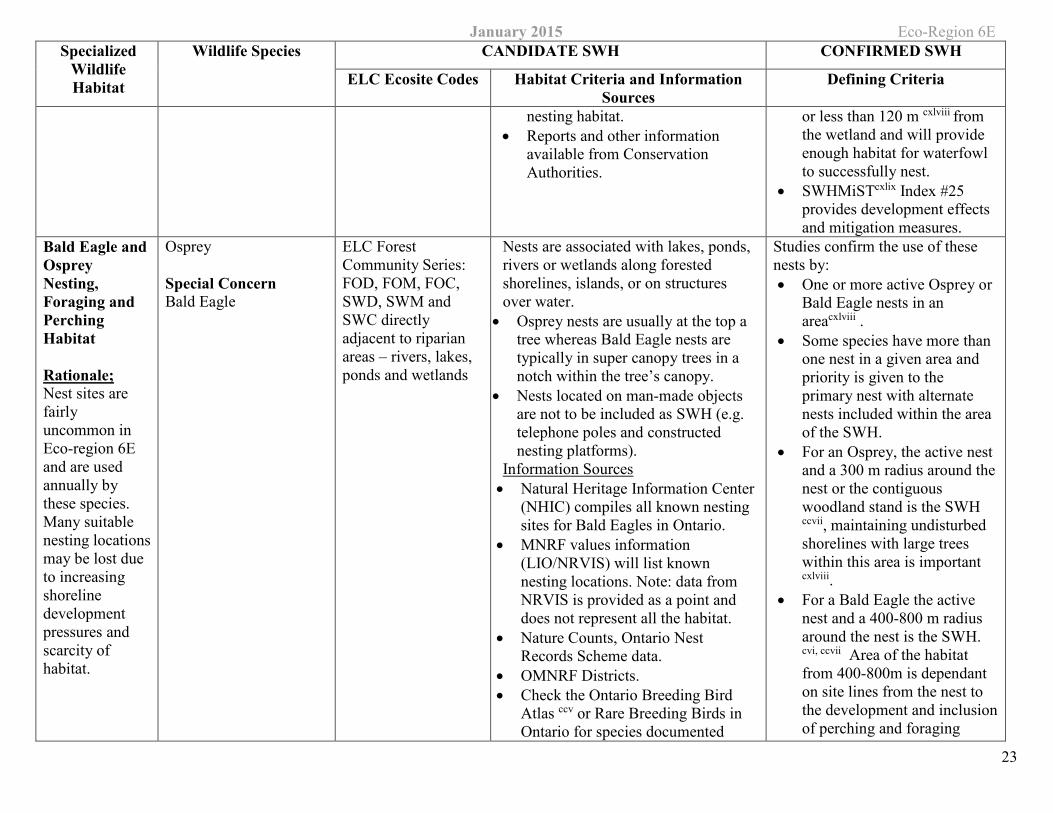
Bald Eagle and Osprey Nesting, Foraging and Perching Habitat
Rationale; Nest sites are fairly uncommon in Eco-region 6E and are used annually by these species. Many suitable nesting locations may be lost due to increasing shoreline development pressures and scarcity of habitat.
Osprey
Special Concern Bald Eagle
ELC Forest Community Series: FOD, FOM, FOC, SWD, SWM and SWC directly adjacent to riparian areas – rivers, lakes, ponds and wetlands
Nests are associated with lakes, ponds, rivers or wetlands along forested shorelines, islands, or on structures over water.
• Osprey nests are usually at the top a tree whereas Bald Eagle nests are typically in super canopy trees in a notch within the tree’s canopy.
• Nests located on man-made objects are not to be included as SWH (e.g. telephone poles and constructed nesting platforms).
Information Sources • Natural Heritage Information Center
(NHIC) compiles all known nesting sites for Bald Eagles in Ontario.
• MNRF values information (LIO/NRVIS) will list known nesting locations. Note: data from NRVIS is provided as a point and does not represent all the habitat.
• Nature Counts, Ontario Nest Records Scheme data.
• OMNRF Districts. • Check the Ontario Breeding Bird
Atlas ccv or Rare Breeding Birds in Ontario for species documented
Studies confirm the use of these nests by: • One or more active Osprey or
Bald Eagle nests in an areacxlviii .
• Some species have more than one nest in a given area and priority is given to the primary nest with alternate nests included within the area of the SWH.
• For an Osprey, the active nest and a 300 m radius around the nest or the contiguous woodland stand is the SWH ccvii, maintaining undisturbed shorelines with large trees within this area is important cxlviii.
• For a Bald Eagle the active nest and a 400-800 m radius around the nest is the SWH. cvi, ccvii Area of the habitat from 400-800m is dependant on site lines from the nest to the development and inclusion of perching and foraging
January 2015 Eco-Region 6E Specialized
Wildlife Habitat
Wildlife Species CANDIDATE SWH CONFIRMED SWH
ELC Ecosite Codes Habitat Criteria and Information Sources
Defining Criteria
24
• Reports and other information available from Conservation Authorities.
• Field Naturalists clubs
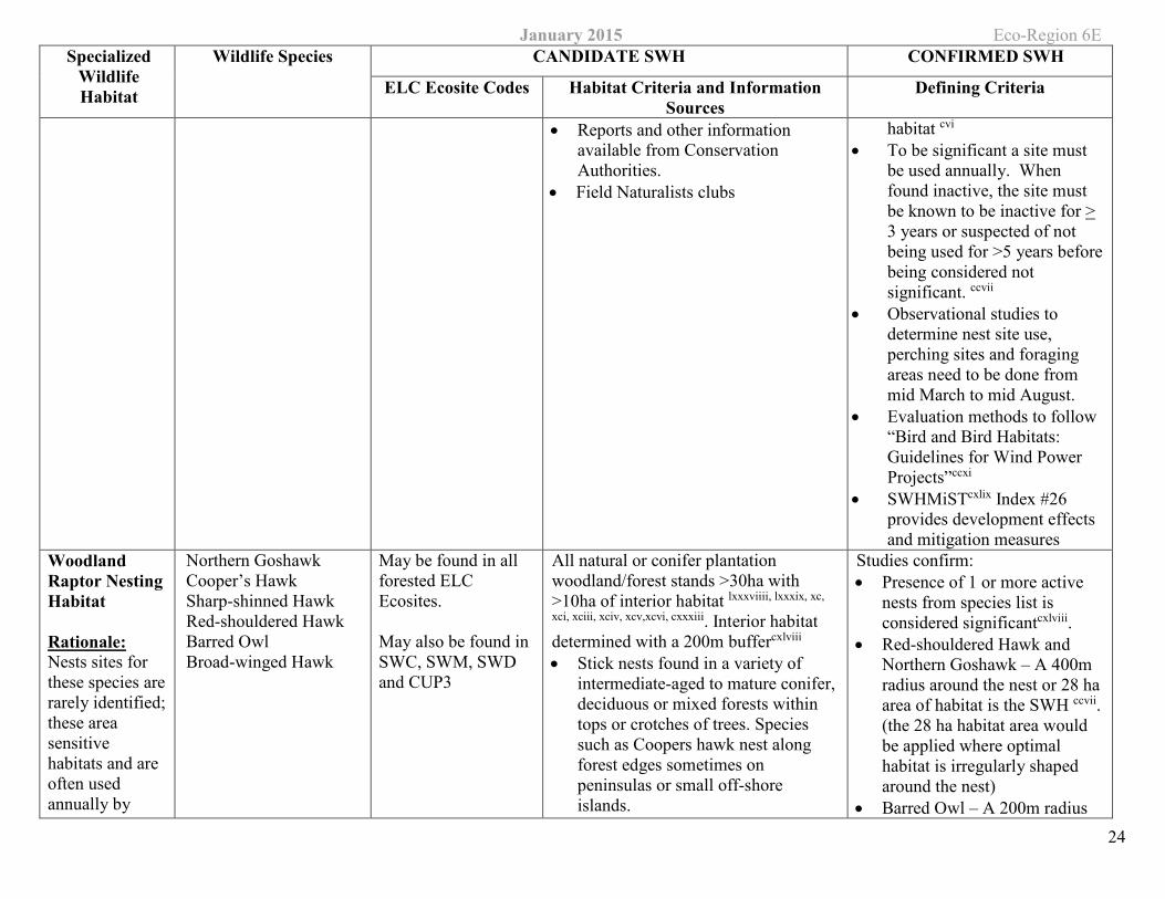
habitat cvi • To be significant a site must
be used annually. When found inactive, the site must be known to be inactive for > 3 years or suspected of not being used for >5 years before being considered not significant. ccvii
• Observational studies to determine nest site use, perching sites and foraging areas need to be done from mid March to mid August.
• Evaluation methods to follow “Bird and Bird Habitats: Guidelines for Wind Power Projects”ccxi
• SWHMiSTcxlix Index #26 provides development effects and mitigation measures
Woodland Raptor Nesting Habitat
Rationale: Nests sites for these species are rarely identified; these area sensitive habitats and are often used annually by
Northern Goshawk Cooper’s Hawk Sharp-shinned Hawk Red-shouldered Hawk Barred Owl Broad-winged Hawk
May be found in all forested ELC Ecosites.
May also be found in SWC, SWM, SWD and CUP3
All natural or conifer plantation woodland/forest stands >30ha with >10ha of interior habitat lxxxviiii, lxxxix, xc,
xci, xciii, xciv, xcv,xcvi, cxxxiii. Interior habitat determined with a 200m buffercxlviii • Stick nests found in a variety of
intermediate-aged to mature conifer,deciduous or mixed forests within tops or crotches of trees. Species such as Coopers hawk nest along forest edges sometimes on peninsulas or small off-shore islands.
Studies confirm: • Presence of 1 or more active
nests from species list is considered significantcxlviii.
• Red-shouldered Hawk and Northern Goshawk – A 400m radius around the nest or 28 ha area of habitat is the SWH ccvii. (the 28 ha habitat area would be applied where optimal habitat is irregularly shaped around the nest)
• Barred Owl – A 200m radius
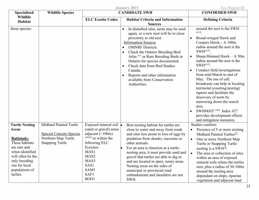
January 2015 Eco-Region 6E Specialized
Wildlife Habitat
Wildlife Species CANDIDATE SWH CONFIRMED SWH
ELC Ecosite Codes Habitat Criteria and Information Sources
Defining Criteria
25
these species. • In disturbed sites, nests may be used again, or a new nest will be in close proximity to old nest.
Information Sources • OMNRF Districts. • Check the Ontario Breeding Bird
Atlas ccv or Rare Breeding Birds in Ontario for species documented.
• Check data from Bird Studies Canada.
• Reports and other information available from Conservation Authorities.
around the nest is the SWH ccvii.
• Broad-winged Hawk and Coopers Hawk,– A 100m radius around the nest is the SWHccvii.
• Sharp-Shinned Hawk – A 50m radius around the nest is the SWHccvii.
• Conduct field investigations from mid-March to end of May. The use of call broadcasts can help in locating territorial (courting/nesting) raptors and facilitate the discovery of nests by narrowing down the search area.
• SWHMiST cxlix Index #27 provides development effects and mitigation measures.
Turtle Nesting Areas
Rationale; These habitats are rare and when identified will often be the only breeding site for local populations of turtles.
Midland Painted Turtle
Special Concern Species Northern Map Turtle Snapping Turtle
Exposed mineral soil (sand or gravel) areas adjacent (<100m) cxlviii or within the following ELC Ecosites: MAS1 MAS2 MAS3 SAS1 SAM1 SAF1 BOO1
• Best nesting habitat for turtles are close to water and away from roads and sites less prone to loss of eggs by predation from skunks, raccoons or other animals.
• For an area to function as a turtle-nesting area, it must provide sand and gravel that turtles are able to dig in and are located in open, sunny areas. Nesting areas on the sides of municipal or provincial road embankments and shoulders are not SWH.
Studies confirm: • Presence of 5 or more nesting
Midland Painted TurtlesⒺ • One or more Northern Map
Turtle or Snapping Turtle nesting is a SWHⒺ.
• The area or collection of sites within an area of exposed mineral soils where the turtles nest, plus a radius of 30-100m around the nesting area dependant on slope, riparian vegetation and adjacent land
January 2015 Eco-Region 6E Specialized
Wildlife Habitat
Wildlife Species CANDIDATE SWH CONFIRMED SWH
ELC Ecosite Codes Habitat Criteria and Information Sources
Defining Criteria
26
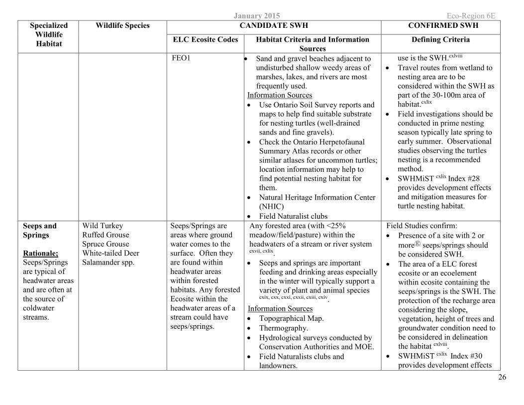
FEO1 • Sand and gravel beaches adjacent to undisturbed shallow weedy areas of marshes, lakes, and rivers are most frequently used.
Information Sources • Use Ontario Soil Survey reports and
maps to help find suitable substrate for nesting turtles (well-drained sands and fine gravels).
• Check the Ontario Herpetofaunal Summary Atlas records or other similar atlases for uncommon turtles; location information may help to find potential nesting habitat for them.
• Natural Heritage Information Center (NHIC)
• Field Naturalist clubs
use is the SWH.cxlviii • Travel routes from wetland to
nesting area are to be considered within the SWH as part of the 30-100m area of habitat.cxlix
• Field investigations should be conducted in prime nesting season typically late spring to early summer. Observational studies observing the turtles nesting is a recommended method.
• SWHMiST cxlix Index #28 provides development effects and mitigation measures for turtle nesting habitat.
Seeps and Springs
Rationale; Seeps/Springs are typical of headwater areas and are often at the source of coldwater streams.
Wild Turkey Ruffed Grouse Spruce Grouse White-tailed Deer Salamander spp.
Seeps/Springs are areas where ground water comes to the surface. Often they are found within headwater areas within forested habitats. Any forested Ecosite within the headwater areas of a stream could have seeps/springs.
Any forested area (with <25% meadow/field/pasture) within the headwaters of a stream or river system cxvii, cxlix. • Seeps and springs are important
feeding and drinking areas especially in the winter will typically support a variety of plant and animal species cxix, cxx, cxxi, cxxii, cxiii, cxiv.
Information Sources • Topographical Map. • Thermography. • Hydrological surveys conducted by
Conservation Authorities and MOE. • Field Naturalists clubs and
landowners.
Field Studies confirm: • Presence of a site with 2 or
moreⒺ seeps/springs should be considered SWH.
• The area of a ELC forest ecosite or an ecoelement within ecosite containing the seeps/springs is the SWH. The protection of the recharge area considering the slope, vegetation, height of trees and groundwater condition need to be considered in delineation the habitat cxlviii.
• SWHMiST cxlix Index #30 provides development effects
January 2015 Eco-Region 6E Specialized
Wildlife Habitat
Wildlife Species CANDIDATE SWH CONFIRMED SWH
ELC Ecosite Codes Habitat Criteria and Information Sources
Defining Criteria
27
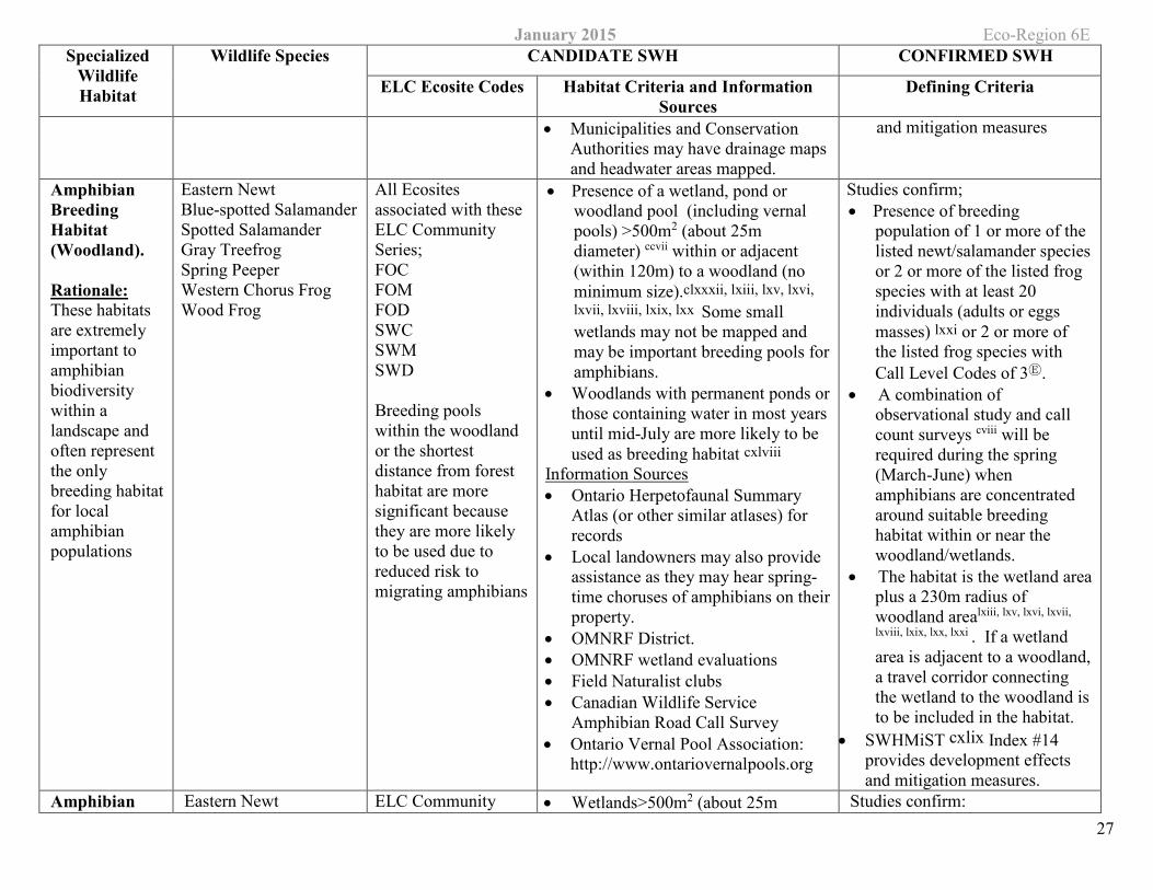
• Municipalities and Conservation Authorities may have drainage maps and headwater areas mapped.
and mitigation measures
Amphibian Breeding Habitat (Woodland).
Rationale: These habitats are extremely important to amphibian biodiversity within a landscape and often represent the only breeding habitat for local amphibian populations
Eastern Newt Blue-spotted Salamander Spotted Salamander Gray Treefrog Spring Peeper Western Chorus Frog Wood Frog
All Ecosites associated with these ELC Community Series; FOC FOM FOD SWC SWM SWD
Breeding pools within the woodland or the shortest distance from forest habitat are more significant because they are more likely to be used due to reduced risk to migrating amphibians
• Presence of a wetland, pond or woodland pool (including vernal pools) >500m2 (about 25m diameter) ccvii within or adjacent (within 120m) to a woodland (no minimum size).clxxxii, lxiii, lxv, lxvi, lxvii, lxviii, lxix, lxx Some small wetlands may not be mapped and may be important breeding pools for amphibians.
• Woodlands with permanent ponds or those containing water in most years until mid-July are more likely to be used as breeding habitat cxlviii
Information Sources • Ontario Herpetofaunal Summary
Atlas (or other similar atlases) for records
• Local landowners may also provide assistance as they may hear spring-time choruses of amphibians on their property.
• OMNRF District. • OMNRF wetland evaluations • Field Naturalist clubs • Canadian Wildlife Service
Amphibian Road Call Survey • Ontario Vernal Pool Association:
http://www.ontariovernalpools.org
Studies confirm; • Presence of breeding
population of 1 or more of the listed newt/salamander species or 2 or more of the listed frog species with at least 20 individuals (adults or eggs masses) lxxi or 2 or more of the listed frog species with Call Level Codes of 3Ⓔ.
• A combination of observational study and call count surveys cviii will be required during the spring (March-June) when amphibians are concentrated around suitable breeding habitat within or near the woodland/wetlands.
• The habitat is the wetland area plus a 230m radius of woodland arealxiii, lxv, lxvi, lxvii,
lxviii, lxix, lxx, lxxi . If a wetland area is adjacent to a woodland, a travel corridor connecting the wetland to the woodland is to be included in the habitat.
• SWHMiST cxlix Index #14 provides development effects and mitigation measures.
Amphibian Eastern Newt ELC Community • Wetlands>500m2 (about 25m Studies confirm:
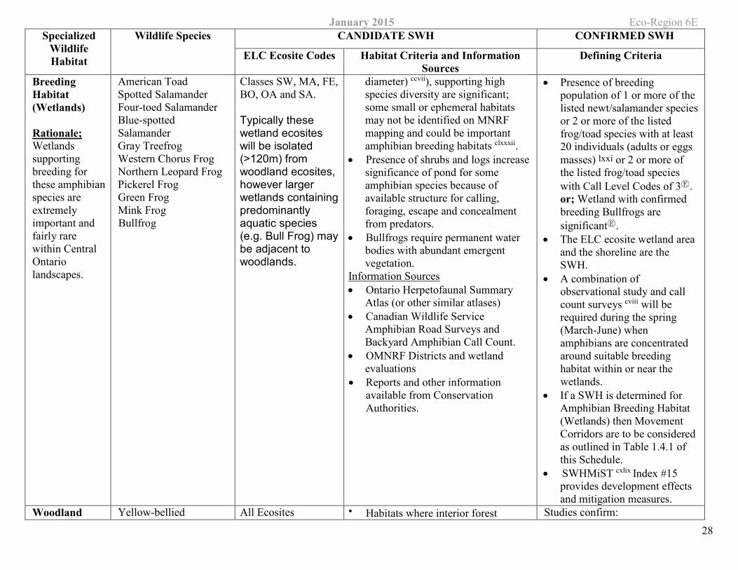
January 2015 Eco-Region 6E Specialized
Wildlife Habitat
Wildlife Species CANDIDATE SWH CONFIRMED SWH
ELC Ecosite Codes Habitat Criteria and Information Sources
Defining Criteria
28
Breeding Habitat (Wetlands)
Rationale; Wetlands supporting breeding for these amphibian species are extremely important and fairly rare within Central Ontario landscapes.
American Toad Spotted Salamander Four-toed Salamander Blue-spotted Salamander Gray Treefrog Western Chorus Frog Northern Leopard Frog Pickerel Frog Green Frog Mink Frog Bullfrog
Classes SW, MA, FE, BO, OA and SA.
Typically these wetland ecosites will be isolated (>120m) from woodland ecosites, however larger wetlands containing predominantly aquatic species (e.g. Bull Frog) may be adjacent to woodlands.
diameter) ccvii), supporting high species diversity are significant; some small or ephemeral habitats may not be identified on MNRF mapping and could be important amphibian breeding habitats clxxxii.
• Presence of shrubs and logs increase significance of pond for some amphibian species because of available structure for calling, foraging, escape and concealment from predators.
• Bullfrogs require permanent water bodies with abundant emergent vegetation.
Information Sources • Ontario Herpetofaunal Summary
Atlas (or other similar atlases) • Canadian Wildlife Service
Amphibian Road Surveys and Backyard Amphibian Call Count.
• OMNRF Districts and wetland evaluations
• Reports and other information available from Conservation Authorities.
• Presence of breeding population of 1 or more of the listed newt/salamander species or 2 or more of the listed frog/toad species with at least 20 individuals (adults or eggs masses) lxxi or 2 or more of the listed frog/toad species with Call Level Codes of 3Ⓔ. or; Wetland with confirmed breeding Bullfrogs are significantⒺ.
• The ELC ecosite wetland area and the shoreline are the SWH.
• A combination of observational study and call count surveys cviii will be required during the spring (March-June) when amphibians are concentrated around suitable breeding habitat within or near the wetlands.
• If a SWH is determined for Amphibian Breeding Habitat (Wetlands) then Movement Corridors are to be considered as outlined in Table 1.4.1 of this Schedule.
• SWHMiST cxlix Index #15 provides development effects and mitigation measures.
Woodland Yellow-bellied All Ecosites • Habitats where interior forest Studies confirm:
January 2015 Eco-Region 6E Specialized
Wildlife Habitat
Wildlife Species CANDIDATE SWH CONFIRMED SWH
ELC Ecosite Codes Habitat Criteria and Information Sources
Defining Criteria
29
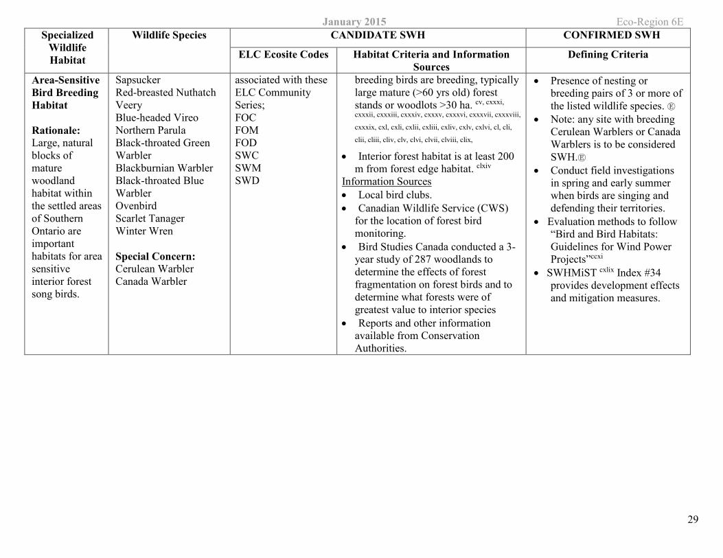
Area-Sensitive Bird Breeding Habitat
Rationale: Large, natural blocks of mature woodland habitat within the settled areas of Southern Ontario are important habitats for area sensitive interior forest song birds.
Sapsucker Red-breasted Nuthatch Veery Blue-headed Vireo Northern Parula Black-throated Green Warbler Blackburnian Warbler Black-throated Blue Warbler Ovenbird Scarlet Tanager Winter Wren
Special Concern: Cerulean Warbler Canada Warbler
associated with these ELC Community Series; FOC FOM FOD SWC SWMSWD
breeding birds are breeding, typically large mature (>60 yrs old) forest stands or woodlots >30 ha. cv, cxxxi,
cxxxii, cxxxiii, cxxxiv, cxxxv, cxxxvi, cxxxvii, cxxxviii,
cxxxix, cxl, cxli, cxlii, cxliii, cxliv, cxlv, cxlvi, cl, cli,
clii, cliii, cliv, clv, clvi, clvii, clviii, clix,
• Interior forest habitat is at least 200 m from forest edge habitat. clxiv
Information Sources • Local bird clubs. • Canadian Wildlife Service (CWS)
for the location of forest bird monitoring.
• Bird Studies Canada conducted a 3-year study of 287 woodlands to determine the effects of forest fragmentation on forest birds and to determine what forests were of greatest value to interior species
• Reports and other information available from Conservation Authorities.
• Presence of nesting or breeding pairs of 3 or more of the listed wildlife species. Ⓔ
• Note: any site with breeding Cerulean Warblers or Canada Warblers is to be considered SWH.Ⓔ
• Conduct field investigations in spring and early summer when birds are singing and defending their territories.
• Evaluation methods to follow “Bird and Bird Habitats: Guidelines for Wind Power Projects”ccxi
• SWHMiST cxlix Index #34 provides development effects and mitigation measures.
January 2015 Eco-Region 6E
30
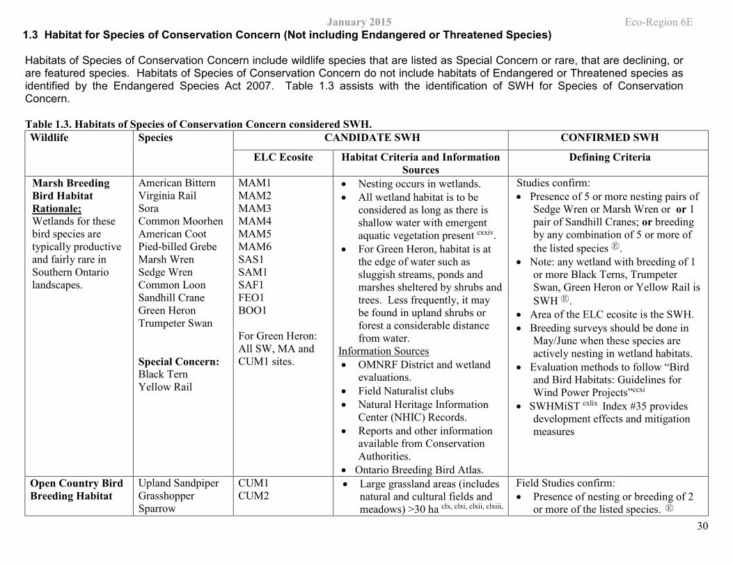
1.3 Habitat for Species of Conservation Concern (Not including Endangered or Threatened Species)
Habitats of Species of Conservation Concern include wildlife species that are listed as Special Concern or rare, that are declining, or are featured species. Habitats of Species of Conservation Concern do not include habitats of Endangered or Threatened species as identified by the Endangered Species Act 2007. Table 1.3 assists with the identification of SWH for Species of Conservation Concern.
Table 1.3. Habitats of Species of Conservation Concern considered SWH. Wildlife Species CANDIDATE SWH CONFIRMED SWH
ELC Ecosite Habitat Criteria and Information Sources
Defining Criteria
Marsh Breeding Bird Habitat Rationale; Wetlands for these bird species are typically productive and fairly rare in Southern Ontario landscapes.
American Bittern Virginia Rail Sora Common Moorhen American Coot Pied-billed Grebe Marsh Wren Sedge Wren Common Loon Sandhill Crane Green Heron Trumpeter Swan
Special Concern: Black Tern Yellow Rail
MAM1 MAM2 MAM3 MAM4 MAM5 MAM6 SAS1 SAM1 SAF1 FEO1 BOO1
For Green Heron: All SW, MA and CUM1 sites.
• Nesting occurs in wetlands. • All wetland habitat is to be
considered as long as there is shallow water with emergent aquatic vegetation present cxxiv.
• For Green Heron, habitat is at the edge of water such as sluggish streams, ponds and marshes sheltered by shrubs and trees. Less frequently, it may be found in upland shrubs or forest a considerable distance from water.
Information Sources • OMNRF District and wetland
evaluations. • Field Naturalist clubs • Natural Heritage Information
Center (NHIC) Records. • Reports and other information
available from Conservation Authorities.
• Ontario Breeding Bird Atlas.
Studies confirm: • Presence of 5 or more nesting pairs of
Sedge Wren or Marsh Wren or or 1 pair of Sandhill Cranes; or breeding by any combination of 5 or more of the listed species Ⓔ.
• Note: any wetland with breeding of 1 or more Black Terns, Trumpeter Swan, Green Heron or Yellow Rail is SWH Ⓔ.
• Area of the ELC ecosite is the SWH. • Breeding surveys should be done in
May/June when these species are actively nesting in wetland habitats.
• Evaluation methods to follow “Bird and Bird Habitats: Guidelines for Wind Power Projects”ccxi
• SWHMiST cxlix Index #35 provides development effects and mitigation measures
Open Country Bird Breeding Habitat
Upland Sandpiper Grasshopper Sparrow
CUM1 CUM2
• Large grassland areas (includes natural and cultural fields and meadows) >30 ha clx, clxi, clxii, clxiii,
Field Studies confirm: • Presence of nesting or breeding of 2
or more of the listed species. Ⓔ

January 2015 Eco-Region 6E Wildlife Species CANDIDATE SWH CONFIRMED SWH
ELC Ecosite Habitat Criteria and Information Sources
Defining Criteria
31
Rationale; This wildlife habitat is declining throughout Ontario and North America. Species such as the Upland Sandpiper have declined significantly the past 40 years based on CWS (2004) trend records.
Vesper Sparrow Northern Harrier Savannah Sparrow
Special Concern Short-eared Owl
clxiv, clxv, clxvi, clxvii, clxviii, clxix. • Grasslands not Class 1 or 2
agricultural lands, and not being actively used for farming (i.e. no row cropping or intensive hay or livestock pasturing in the last 5 years) Ⓔ.
• Grassland sites considered significant should have a history of longevity, either abandoned fields, mature hayfields and pasturelands that are at least 5 years or older.
• The Indicator bird species are area sensitive requiring larger grassland areas than the common grassland species.
Information Sources • Agricultural land classification
maps, Ministry of Agriculture. • Local bird clubs. • Ontario Breeding Bird Atlas • Reports and other information
available from C0nservation Authorities.
• A field with 1 or more breeding Short-eared Owls is to be considered SWH.
• The area of SWH is the contiguous ELC ecosite field areas.
• Conduct field investigations of the most likely areas in spring and early summer when birds are singing and defending their territories.
• Evaluation methods to follow “Bird and Bird Habitats: Guidelines for Wind Power Projects”ccxi
• SWHMiST cxlix Index #32 provides development effects and mitigation measures
Shrub/Early Successional Bird Breeding Habitat
Rationale; This wildlife habitat is declining throughout Ontario and North America.
Indicator Spp: Brown Thrasher Clay-coloured Sparrow
Common Spp. Field Sparrow Black-billed Cuckoo
CUT1 CUT2 CUS1 CUS2 CUW1 CUW2
Patches of shrub ecosites can be
Large field areas succeeding to shrub and thicket habitats>10haclxiv in size. • Shrub land or early
successional fields, not class 1 or 2 agricultural lands, not being actively used for farming (i.e. no row-cropping, haying or live-stock pasturing in the last 5
Field Studies confirm: • Presence of nesting or breeding of 1
of the indicator species and at least 2 of the common species. Ⓔ
• A habitat with breeding Yellow-breasted Chat or Golden-winged Warbler is to be considered as Significant Wildlife Habitat. Ⓔ
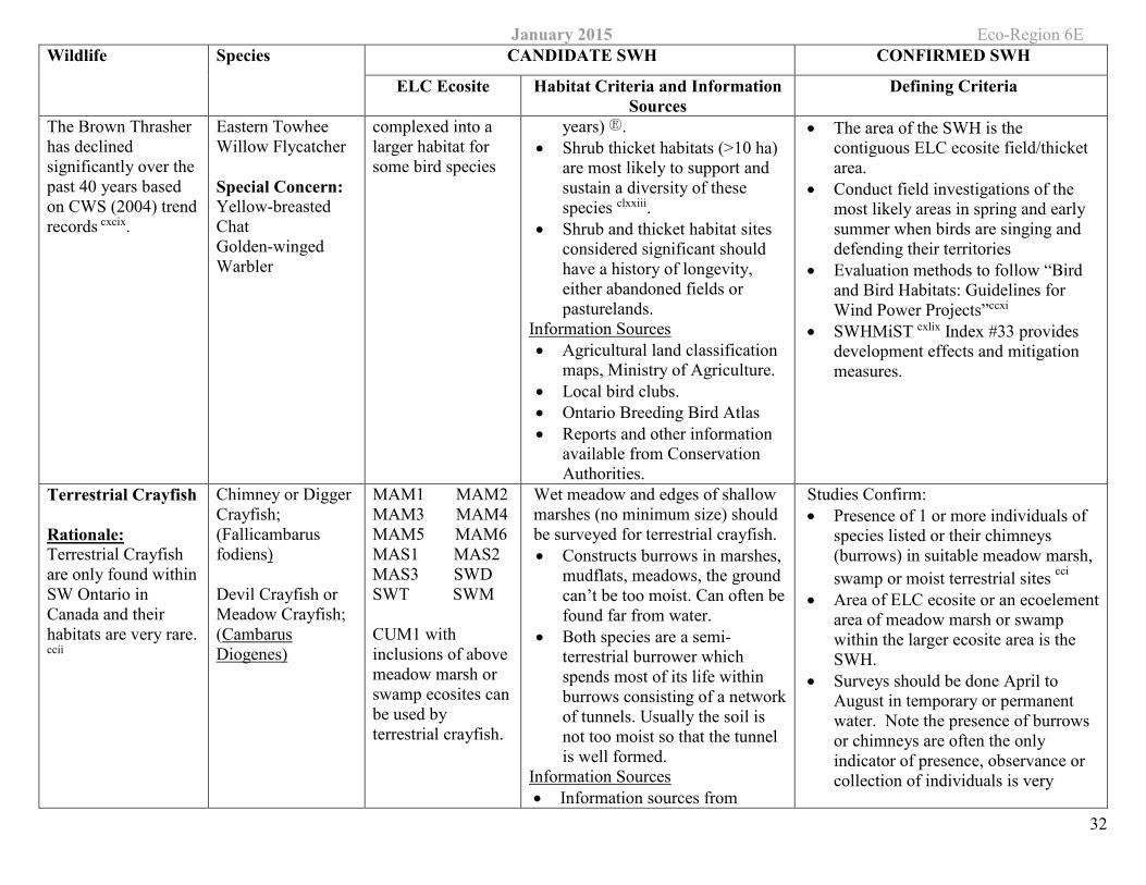
January 2015 Eco-Region 6E Wildlife Species CANDIDATE SWH CONFIRMED SWH
ELC Ecosite Habitat Criteria and Information Sources
Defining Criteria
32
The Brown Thrasher has declined significantly over the past 40 years based on CWS (2004) trend records cxcix.
Eastern Towhee Willow Flycatcher
Special Concern: Yellow-breasted Chat Golden-winged Warbler
complexed into a larger habitat for some bird species
years) Ⓔ. • Shrub thicket habitats (>10 ha)
are most likely to support and sustain a diversity of these species clxxiii.
• Shrub and thicket habitat sites considered significant should have a history of longevity, either abandoned fields or pasturelands.
Information Sources • Agricultural land classification
maps, Ministry of Agriculture. • Local bird clubs. • Ontario Breeding Bird Atlas • Reports and other information
available from Conservation Authorities.
• The area of the SWH is the contiguous ELC ecosite field/thicket area.
• Conduct field investigations of the most likely areas in spring and early summer when birds are singing and defending their territories
• Evaluation methods to follow “Bird and Bird Habitats: Guidelines for Wind Power Projects”ccxi
• SWHMiST cxlix Index #33 provides development effects and mitigation measures.
Terrestrial Crayfish
Rationale: Terrestrial Crayfish are only found within SW Ontario in Canada and their habitats are very rare. ccii
Chimney or Digger Crayfish; (Fallicambarus fodiens)
Devil Crayfish or Meadow Crayfish; (Cambarus Diogenes)
MAM1 MAM2 MAM3 MAM4 MAM5 MAM6 MAS1 MAS2 MAS3 SWD SWT SWM
CUM1 with inclusions of above meadow marsh or swamp ecosites can be used by terrestrial crayfish.
Wet meadow and edges of shallow marshes (no minimum size) should be surveyed for terrestrial crayfish. • Constructs burrows in marshes,
mudflats, meadows, the ground can’t be too moist. Can often be found far from water.
• Both species are a semi-terrestrial burrower which spends most of its life within burrows consisting of a network of tunnels. Usually the soil is not too moist so that the tunnel is well formed.
Information Sources • Information sources from
Studies Confirm: • Presence of 1 or more individuals of
species listed or their chimneys (burrows) in suitable meadow marsh, swamp or moist terrestrial sites cci
• Area of ELC ecosite or an ecoelement area of meadow marsh or swamp within the larger ecosite area is the SWH.
• Surveys should be done April to August in temporary or permanent water. Note the presence of burrows or chimneys are often the only indicator of presence, observance or collection of individuals is very
January 2015 Eco-Region 6E Wildlife Species CANDIDATE SWH CONFIRMED SWH
ELC Ecosite Habitat Criteria and Information Sources
Defining Criteria
33
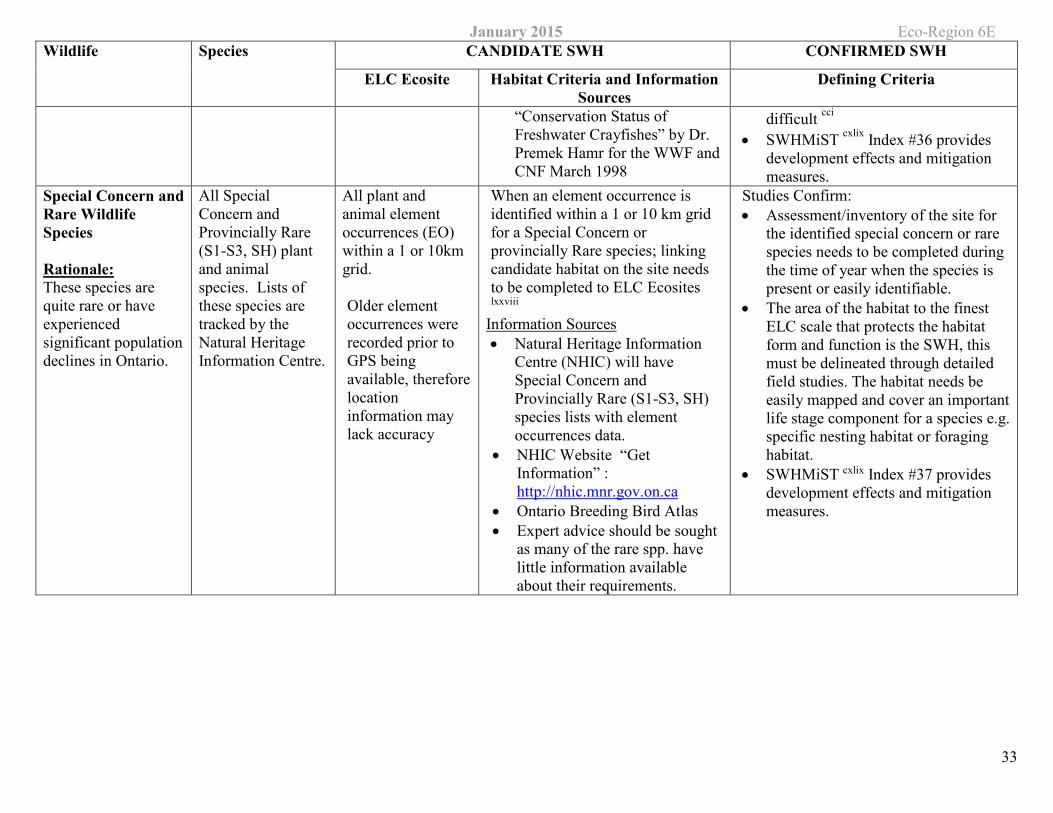
“Conservation Status of Freshwater Crayfishes” by Dr. Premek Hamr for the WWF and CNF March 1998
difficult cci • SWHMiST cxlix Index #36 provides
development effects and mitigation measures.
Special Concern andRare Wildlife Species
Rationale: These species are quite rare or have experienced significant population declines in Ontario.
All Special Concern and Provincially Rare (S1-S3, SH) plant and animal species. Lists of these species are tracked by the Natural Heritage Information Centre.
All plant and animal element occurrences (EO) within a 1 or 10km grid.
Older element occurrences were recorded prior to GPS being available, thereforelocation information may lack accuracy
When an element occurrence is identified within a 1 or 10 km grid for a Special Concern or provincially Rare species; linking candidate habitat on the site needs to be completed to ELC Ecosites lxxviii
Information Sources • Natural Heritage Information
Centre (NHIC) will have Special Concern and Provincially Rare (S1-S3, SH) species lists with element occurrences data.
• NHIC Website “Get Information” : http://nhic.mnr.gov.on.ca
• Ontario Breeding Bird Atlas • Expert advice should be sought
as many of the rare spp. have little information available about their requirements.
Studies Confirm: • Assessment/inventory of the site for
the identified special concern or rare species needs to be completed during the time of year when the species is present or easily identifiable.
• The area of the habitat to the finest ELC scale that protects the habitat form and function is the SWH, this must be delineated through detailed field studies. The habitat needs be easily mapped and cover an important life stage component for a species e.g. specific nesting habitat or foraging habitat.
• SWHMiST cxlix Index #37 provides development effects and mitigation measures.
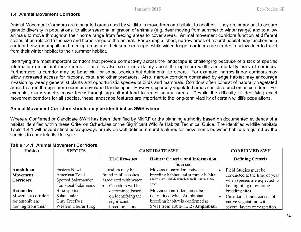
January 2015 Eco-Region 6E
34
1.4 Animal Movement Corridors
Animal Movement Corridors are elongated areas used by wildlife to move from one habitat to another. They are important to ensure genetic diversity in populations, to allow seasonal migration of animals (e.g. deer moving from summer to winter range) and to allow animals to move throughout their home range from feeding areas to cover areas. Animal movement corridors function at different scales often related to the size and home range of the animal. For example, short, narrow areas of natural habitat may function as a corridor between amphibian breeding areas and their summer range, while wider, longer corridors are needed to allow deer to travel from their winter habitat to their summer habitat.
Identifying the most important corridors that provide connectivity across the landscape is challenging because of a lack of specific information on animal movements. There is also some uncertainty about the optimum width and mortality risks of corridors. Furthermore, a corridor may be beneficial for some species but detrimental to others. For example, narrow linear corridors may allow increased access for racoons, cats, and other predators. Also, narrow corridors dominated by edge habitat may encourage invasion by weedy generalist plants and opportunistic species of birds and mammals. Corridors often consist of naturally vegetated areas that run through more open or developed landscapes. However, sparsely vegetated areas can also function as corridors. For example, many species move freely through agricultural land to reach natural areas. Despite the difficulty of identifying exact movement corridors for all species, these landscape features are important to the long-term viability of certain wildlife populations.
Animal Movement Corridors should only be identified as SWH where:
Where a Confirmed or Candidate SWH has been identified by MNRF or the planning authority based on documented evidence of a habitat identified within these Criterion Schedules or the Significant Wildlife Habitat Technical Guide. The identified wildlife habitats Table 1.4.1 will have distinct passageways or rely on well defined natural features for movements between habitats required by the species to complete its life cycle.
Table 1.4.1 Animal Movement Corridors Habitat SPECIES CANDIDATE SWH CONFIRMED SWH
ELC Eco-sites Habitat Criteria and Information Sources
Defining Criteria
Amphibian Movement Corridors
Rationale; Movement corridors for amphibians moving from their
Eastern Newt American Toad Spotted Salamander Four-toed Salamander Blue-spotted Salamander Gray Treefrog Western Chorus Frog
Corridors may be found in all ecosites associated with water. • Corridors will be
determined based on identifying the significant breeding habitat
Movement corridors between breeding habitat and summer habitat clxxiv, clxxv, clxxvi, clxxvii, clxxviii, clxxix, clxxx,
clxxxi. Movement corridors must be determined when Amphibian breeding habitat is confirmed as SWH from Table 1.2.2 (Amphibian
• Field Studies must be conducted at the time of year when species are expected to be migrating or entering breeding sites.
• Corridors should consist of native vegetation, with several layers of vegetation.
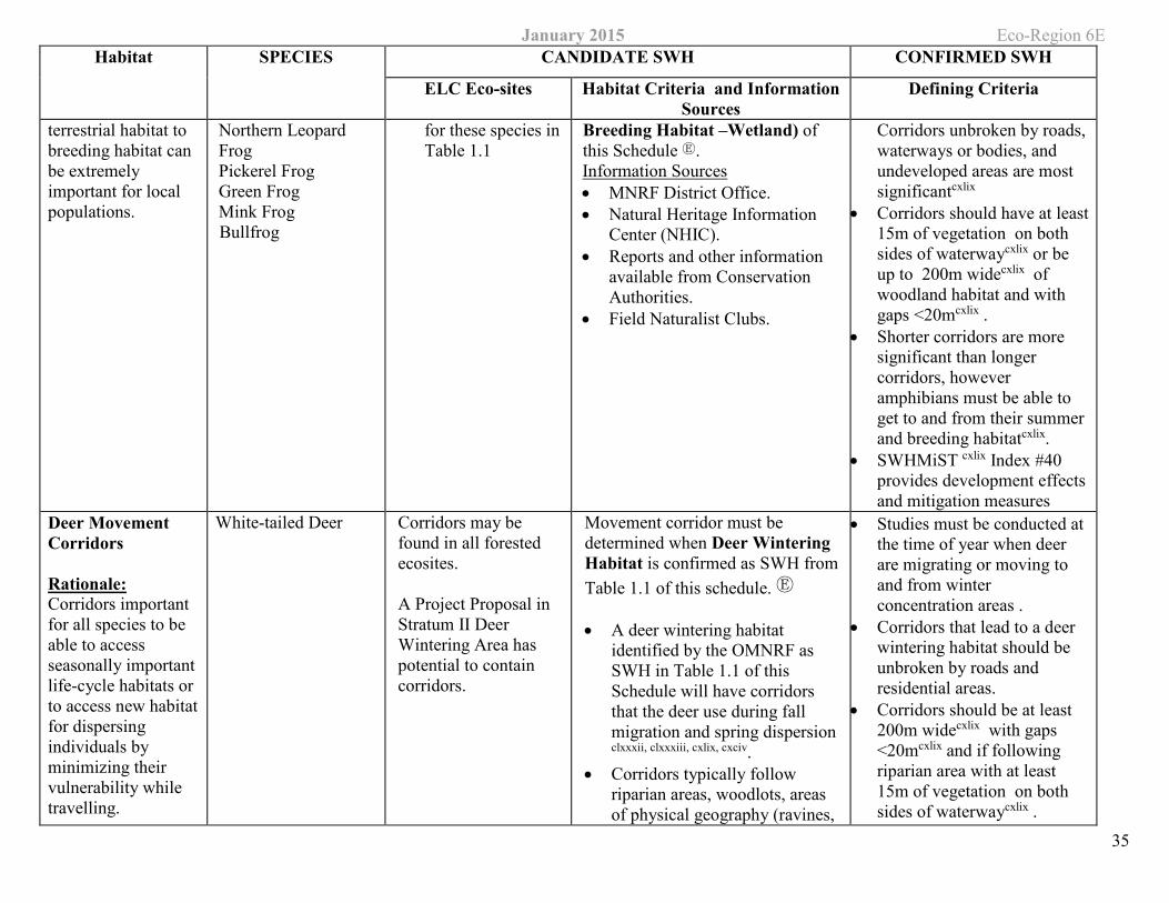
January 2015 Eco-Region 6E Habitat SPECIES CANDIDATE SWH CONFIRMED SWH
ELC Eco-sites Habitat Criteria and Information Sources
Defining Criteria
35
terrestrial habitat to breeding habitat can be extremely important for local populations.
Northern Leopard Frog Pickerel Frog Green Frog Mink Frog Bullfrog
for these species in Table 1.1
Breeding Habitat –Wetland) of this Schedule Ⓔ. Information Sources • MNRF District Office. • Natural Heritage Information
Center (NHIC). • Reports and other information
available from Conservation Authorities.
• Field Naturalist Clubs.
Corridors unbroken by roads, waterways or bodies, and undeveloped areas are most significantcxlix
• Corridors should have at least 15m of vegetation on both sides of waterwaycxlix or be up to 200m widecxlix of woodland habitat and with gaps <20mcxlix .
• Shorter corridors are more significant than longer corridors, however amphibians must be able to get to and from their summer and breeding habitatcxlix.
• SWHMiST cxlix Index #40 provides development effects and mitigation measures
Deer Movement Corridors
Rationale: Corridors important for all species to be able to access seasonally important life-cycle habitats or to access new habitat for dispersing individuals by minimizing their vulnerability while travelling.
White-tailed Deer Corridors may be found in all forested ecosites.
A Project Proposal in Stratum II Deer Wintering Area has potential to contain corridors.
Movement corridor must be determined when Deer Wintering Habitat is confirmed as SWH from Table 1.1 of this schedule. Ⓔ
• A deer wintering habitat identified by the OMNRF as SWH in Table 1.1 of this Schedule will have corridors that the deer use during fall migration and spring dispersion clxxxii, clxxxiii, cxlix, cxciv.
• Corridors typically follow riparian areas, woodlots, areas of physical geography (ravines,
• Studies must be conducted at the time of year when deer are migrating or moving to and from winter concentration areas .
• Corridors that lead to a deer wintering habitat should be unbroken by roads and residential areas.
• Corridors should be at least 200m widecxlix with gaps <20mcxlix and if following riparian area with at least 15m of vegetation on both sides of waterwaycxlix .
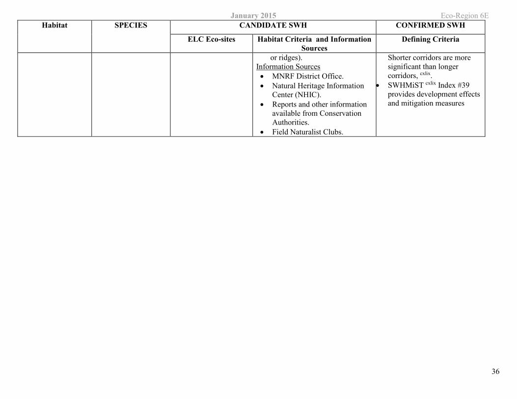
January 2015 Eco-Region 6E Habitat SPECIES CANDIDATE SWH CONFIRMED SWH
ELC Eco-sites Habitat Criteria and Information Sources
Defining Criteria
36
or ridges). Information Sources • MNRF District Office. • Natural Heritage Information
Center (NHIC). • Reports and other information
available from Conservation Authorities.
• Field Naturalist Clubs.
Shorter corridors are more significant than longer corridors, cxlix.
• SWHMiST cxlix Index #39 provides development effects and mitigation measures
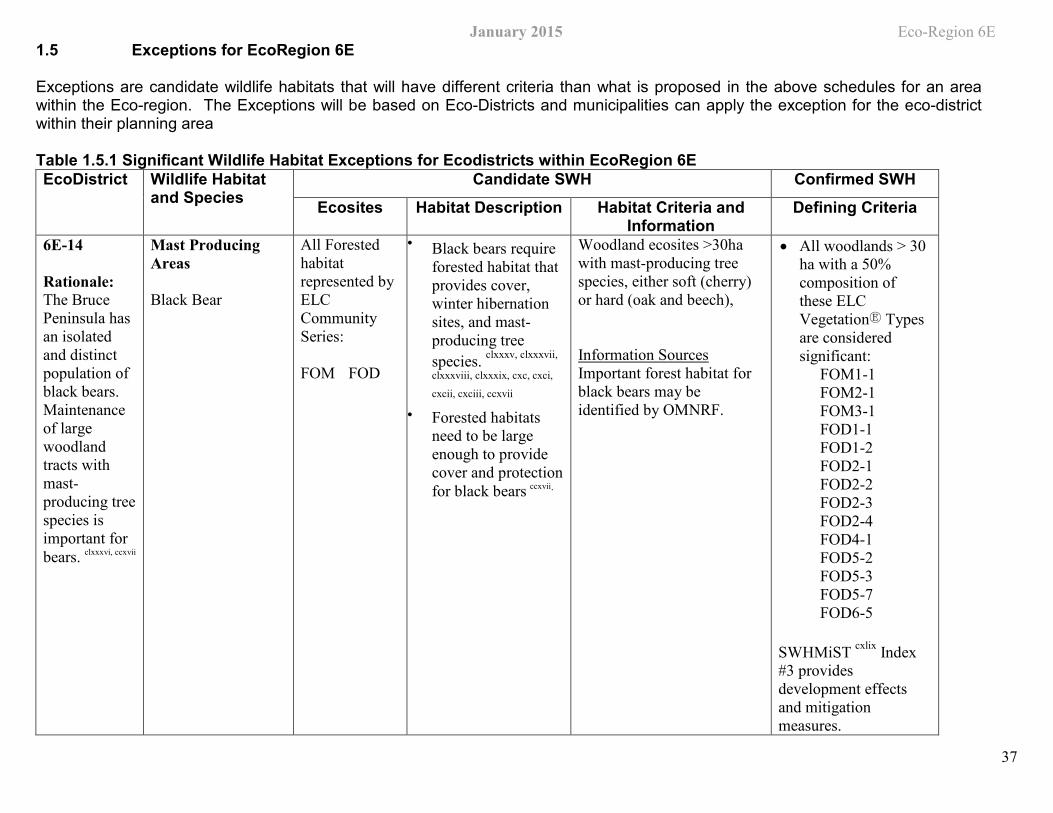
January 2015 Eco-Region 6E
37
1.5 Exceptions for EcoRegion 6E
Exceptions are candidate wildlife habitats that will have different criteria than what is proposed in the above schedules for an area within the Eco-region. The Exceptions will be based on Eco-Districts and municipalities can apply the exception for the eco-district within their planning area
Table 1.5.1 Significant Wildlife Habitat Exceptions for Ecodistricts within EcoRegion 6E EcoDistrict Wildlife Habitat
and Species Candidate SWH Confirmed SWH
Ecosites Habitat Description Habitat Criteria and Information
Defining Criteria
6E-14
Rationale: The Bruce Peninsula has an isolated and distinct population of black bears. Maintenance of large woodland tracts with mast-producing tree species is important for bears. clxxxvi, ccxvii
Mast Producing Areas
Black Bear
All Forested habitat represented by ELC Community Series:
FOM FOD
• Black bears require forested habitat that provides cover, winter hibernation sites, and mast-producing tree species. clxxxv, clxxxvii,
clxxxviii, clxxxix, cxc, cxci,
cxcii, cxciii, ccxvii
• Forested habitatsneed to be largeenough to providecover and protectionfor black bears ccxvii.
Woodland ecosites >30ha with mast-producing tree species, either soft (cherry) or hard (oak and beech),
Information Sources Important forest habitat for black bears may be identified by OMNRF.
• All woodlands > 30ha with a 50%composition ofthese ELCVegetationⒺ Typesare consideredsignificant:
FOM1-1FOM2-1 FOM3-1FOD1-1 FOD1-2FOD2-1 FOD2-2FOD2-3 FOD2-4FOD4-1 FOD5-2FOD5-3 FOD5-7FOD6-5
SWHMiST cxlix Index #3 provides development effects and mitigation measures.
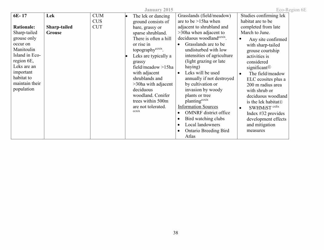
January 2015 Eco-Region 6E
38
6E- 17
Rationale: Sharp-tailed grouse only occur on Manitoulin Island in Eco-region 6E, Leks are an important habitat to maintain their population
Lek
Sharp-tailed Grouse
CUMCUS CUT
• The lek or dancing ground consists of bare, grassy or sparse shrubland. There is often a hill or rise in topographyccxix.
• Leks are typically a grassy field/meadow >15ha with adjacent shrublands and >30ha with adjacent deciduous woodland. Conifer trees within 500m are not tolerated. ccxix
Grasslands (field/meadow) are to be >15ha when adjacent to shrubland and >30ha when adjacent to deciduous woodlandccxix. • Grasslands are to be
undisturbed with low intensities of agriculture (light grazing or late haying)
• Leks will be used annually if not destroyed by cultivation or invasion by woody plants or tree plantingccxix
Information Sources • OMNRF district office • Bird watching clubs • Local landowners • Ontario Breeding Bird
Atlas
Studies confirming lek habitat are to be completed from late March to June. • Any site confirmed
with sharp-tailed grouse courtship activities is considered significantⒺ
• The field/meadow ELC ecosites plus a 200 m radius area with shrub or deciduous woodland is the lek habitatⒺ
• SWHMiST cxlix Index #32 provides development effects and mitigation measures


![Developing a Wildlife Habitat Management Planweb.mnstate.edu/stockram/WildlifeEcol/4-H-991-W[1].pdfDeveloping a Wildlife Habitat Management Plan WILDLIFE HABITAT EVALUATION CAREER](https://img.pdfslide.us/doc/110x75/5fe7fa3d9f69891190384d11/developing-a-wildlife-habitat-management-1pdf-developing-a-wildlife-habitat-management.jpg)