Embed Size (px)
Citation preview
Sample Ordinancesfor
Protecting
Significant Coastal Habitats
ANJECAssociation of New Jersey Environmental Commissions
The original printing of this booklet was funded by a grant from the New Jersey Department of Environmental Protection through the New Jersey Coastal Zone Management Program and the National Oceanic and Atmospheric
Administration. Thanks to William Penn Foundation for making the second printing of this booklet possible.
Second edition: October 2007
Association of New Jersey Environmental Commissions (ANJEC)PO Box 157
Mendham, NJ 07945
Tel: 973-539-7547 • fax: 973-539-7713 • email: [email protected] • web site www.anjec.org
Sandy Batty, executive director • Julie Lange Groth, editor
Cover illustration: Barbara Pretz

ContentsCoastal Ordinance Excerpts in this Booklet ___________________________________________ 2
Acknowledgments _________________________________________________________________ 3
Preface __________________________________________________________________________ 3
How to Use This Booklet ___________________________________________________________ 3
Introduction______________________________________________________________________ 4New Jersey State Regulations in Brief ................................................................................................................4Map of CAFRA Areas ..........................................................................................................................................4Need for Local Planning .......................................................................................................................................5The Role of the Environmental Commission ...................................................................................................5
Development and Zoning __________________________________________________________ 5Recognizing Impacts of New Development .....................................................................................................6Flexible Zoning Techniques .................................................................................................................................9
Lot size averaging ............................................................................................................................................9Clustered housing ..........................................................................................................................................10Conservation design ordinances .................................................................................................................11Setbacks ...........................................................................................................................................................11Overlay zones .................................................................................................................................................12Transfer of Development Rights (TDR) ...................................................................................................13
Open Space _____________________________________________________________________14Local Open Space Trust Funds .........................................................................................................................14
The campaign for a local open space trust ..............................................................................................15Establishing an open space trust and open space committee ................................................................15
Mandatory Open Space with New Development ...........................................................................................17The open space plan .....................................................................................................................................17Insuring the preservation of sensitive areas ..............................................................................................18Ownership and maintenance of open space .............................................................................................19
Landscaping and Vegetation _______________________________________________________20Vegetation Standards ...........................................................................................................................................20Trees .......................................................................................................................................................................21
Development standards and reforesting ...................................................................................................21Establishing a shade tree commission ........................................................................................................23
Water __________________________________________________________________________24Stream Corridor Protection and Water Quality ...............................................................................................24Stormwater Management and Quality ..............................................................................................................25
Dune Protection _________________________________________________________________27
Flood Damage Prevention _________________________________________________________28
Other Types of Ordinances ________________________________________________________28

� SampleOrdinancesfor
Coastal Ordinance Excerpts in this Booklet Type of ordinance Municipality County Page
Cluster zoning Franklin Gloucester 10
Community impact statement Lawrence Mercer 6
Conservation design Plumsted Ocean 11
Conservation easement Montgomery Somerset 19
Conservation easement Mendham Twp. Morris 19
Dune protection Sea Bright Monmouth 27
Environmental impact statement Woodstown-Pilesgrove Salem 7
Flood damage prevention Harvey Cedars Ocean 28
Landscaping and vegetation plan Cape May Point Cape May 21
Lot size averaging Holmdel Monmouth 10
Open space referendum Blairstown Warren 15
Open space required with development Mansfield Burlington 17
Open space trust Harding Morris 16
Overlay districts Woodstown Salem 12
Ownership and maintenance of open space Readington Township Hunterdon 19
Shade tree commission Mountain Lakes Morris 23
Stormwater management Neptune Monmouth 26
Stream corridor Marlboro Monmouth 24
Transfer of development rights (TDR) Chesterfield Burlington 13
Tree preservation Upper Deerfield Cumberland 22
Variable setbacks Wantage Sussex 12
Woodland protection Plumsted Ocean 22
ProtectingSignificantCoastalHabitats �
Acknowledgments
As with any project, there are countless organizations and individuals to thank. The Association of New Jersey Environmental Commissions (ANJEC) wishes to thank the New Jersey Coastal Zone Management Program, the National Oceanic and Atmospheric Admin-istration, and the New Jersey Department of Environmental Protection for providing fund-ing for the initial project.
Also, sincere appreciation is offered to the citizens, mayors, councilmen, planning boards and departments, environmental commissions, shade tree commissions, and municipal clerks who created the ordinances and provided copies of them for this publication.
The original printing of this booklet was an outcome of the Cape May Stopover Protec-tion Project, with the goal of decreasing the gross amounts of land converted from habitat. The project was a partnership of the New Jersey Division of Fish, Game and Wildlife’s Endangered and Nongame Species Program; The Nature Conservancy; New Jersey Audu-bon Society; and ANJEC.
Preface
Don’t be fooled by the title of this publication, Sample Ordinances for Protecting Significant Coastal Habitats. “Coastal habitats” can include expanses of woodlands, acres of marshland, and perhaps even your own backyard.
While habitat loss may not be a meaningful term to every New Jerseyan, every resident wants a high quality of life, the enjoyment of open spaces for recreation, and the economic benefits of natural places in their communities. Birds and wildlife require many of the same resources as people, and good local ordinances can help secure them for all the community’s residents.
How to Use This Booklet
The sections in this booklet cover general topics, such as open space and water. Many of the topics are interrelated and should be cross-referenced. For example, to protect water quality you also must have a commitment to the preservation of open space and the use of appropriate landscaping. And open space and clean water are equally important for our quality of life and for their contribution to a healthy wildlife habitat.
The beginning of each section briefly introduces the topic and its importance in rela-tion to the protection of habitat, followed by one or more sample ordinances to address the general topic. These excerpted ordinances deal with subjects such as clustered housing and the ownership of open space.
The sample ordinances are exactly that—samples. Each municipality will determine local ordinance provisions based upon a variety of factors. For the full texts of cited ordinances or additional sample ordinances on the same topics, please contact the ANJEC Resource Center at 973-539-7547 or by email at [email protected]. We also encourage you to send us any ordinances your own municipality adopts on any of these topics so we can share them with other towns working to protect coastal habitats.
� SampleOrdinancesfor
Introduction
ANJEC originally developed this booklet in 1998 in an effort to establish sound public policy guidelines for land use decisions and to educate local officials and citizens on the benefits of protecting coastal migratory bird habitat. Today, with growing concerns about the impacts of sea level change due to global warming, the importance of sustainable land use decisions has become even more critical, particularly in coastal areas. We hope this booklet will offer local environmental commissions and planning boards an arsenal of practical tools and techniques they can use, not only to protect bird habitat but to mitigate and adapt to the changes ahead.
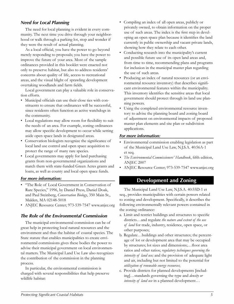
New Jersey State Regulations in BriefCoastal areas have three main state laws regulating
development: the Coastal Areas Facilities Review Act (CAFRA, N.J.S.A. 13:19-1 et seq.), the Wetlands Act of 1970 (N.J.S.A. 13:9A-1 et seq.), and the Waterfront Development Law (N.J.S.A.12:5-3). Under these laws, the New Jersey Department of Environmental Protec-tion (NJDEP) developed a permitting process for various forms of development through its New Jersey Coastal Management Program.
CAFRA, enacted in 1973 to regulate increasing devel-opment, governs about 20 percent of New Jersey’s land in the southern part of the state. CAFRA II, passed in 1993, partially closed an infamous loophole in the origi-nal legislation, which had exempted housing development of fewer than 25 units. The law divides the CAFRA area into five zones, and regulates different types of devel-opment in each zone. The CAFRA permitting process is most restrictive on beaches and dunes and becomes increasingly relaxed with landward development.
Regulated activities within the CAFRA area include a wide variety of residential, commercial, or industrial development such as construction, relocation, and enlargement of buildings and structures; and associated work such as excavation, grading, site preparation, and the installation of shore protection structures. The pen-alty for violations could be as much as $25,000 per day per violation.
Map of CAFRA Areas
The Wetlands Act of 1970 regulates activities on coastal wetlands that have been delineated and mapped by NJDEP. Examples of regulated activities include excavation, dredging, fill, or placement of a structure on a mapped coastal wetland.
Under the Waterfront Development Law, NJDEP regulates the construction, reconstruction, alteration, expansion, or enlargement of any structure, or the exca-vation or filling of any area adjacent to tidal waterways throughout the state.
ProtectingSignificantCoastalHabitats �
Need for Local PlanningThe need for local planning is evident in every com-
munity. The next time you drive through your neighbor-hood or walk through a parking lot, stop and wonder if they were the result of actual planning.
As a local official, you have the power to go beyond merely responding to proposals; you have the power to improve the future of your area. Most of the sample ordinances provided in this booklet were enacted not only to preserve habitat, but also to address residents’ concerns about quality of life, access to recreational areas, and the visual blight of sprawling development overtaking woodlands and farm fields.
Local government can play a valuable role in conserva-tion efforts.• Municipal officials can use their close ties with con-
stituents to ensure that ordinances will be successful, since residents often function as active watchdogs in the community.
• Local regulations may allow room for flexibility to suit the needs of an area. For example, zoning ordinances may allow specific development to occur while setting aside open space lands in designated areas.
• Conservation biologists recognize the significance of local land use control and open space acquisition to protect the range of many rare species.
• Local governments may apply for land purchasing grants from non-governmental organizations and match them with state-funded Green Acres grants and loans, as well as county and local open space funds.
For more information:• “The Role of Local Government in Conservation of
Rare Species,” 1996, by Daniel Press, Daniel Doak, and Paul Steinberg, Conservation Biology, 350 Main St., Malden, MA 02148-5018
• ANJEC Resource Center; 973-539-7547 www.anjec.org
The Role of the Environmental CommissionThe municipal environmental commission can be of
great help in protecting local natural resources and the environment and thus the habitat of coastal species. The State statute that enables municipalities to create envi-ronmental commissions gives these bodies the power to advise their municipal government on local environmen-tal matters. The Municipal Land Use Law also recognizes the contribution of the commission in the planning process.
In particular, the environmental commission is charged with several responsibilities that help preserve wildlife habitat:
• Compiling an index of all open areas, publicly or privately owned, to obtain information on the proper use of such areas. The index is the first step in devel-oping an open space plan because it identifies the land currently in public ownership and vacant private lands, showing how they relate to each other.
• Conducting research into the municipality’s current and possible future use of its open land areas and, from time to time, recommending plans and programs for inclusion in the municipal master plan regarding the use of such areas.
• Producing an index of natural resources (or an envi-ronmental resource inventory) that describes signifi-cant environmental features within the municipality. This inventory identifies the sensitive areas that local government should protect through its land use plan-ning powers.
• Using the completed environmental resource inven-tory to advise the planning board and zoning board of adjustment on environmental impacts of proposed master plan elements and site plan or subdivision applications.
For more information:• Environmental commission enabling legislation as part
of the Municipal Land Use Law, N.J.S.A. 40:56A-1 et seq.
• The Environmental Commissioners’ Handbook, fifth edition, ANJEC 2007
• ANJEC Resource Center; 973-539-7547 www.anjec.org
Development and Zoning
The Municipal Land Use Law, N.J.S.A. 40:55D-1 et seq., provides municipalities with certain powers related to zoning and development. Specifically, it describes the following environmentally relevant powers contained in the zoning ordinance:a. Limit and restrict buildings and structures to specific
districts…and regulate the nature and extent of the use of land for trade, industry, residence, open space, or other purposes;
b. Regulate…buildings and other structures; the percent-age of lot or development area that may be occupied by structures; lot sizes and dimensions;…floor area ratios and other ratios; regulatory techniques governing the intensity of land use; and the provision of adequate light and air, including but not limited to the potential for utilization of renewable energy resources;
c. Provide districts for planned developments [includ-ing]…standards governing the type and density or intensity of land use in a planned development…
� SampleOrdinancesfor
For more information:• Municipal Land Use Law, N.J.S.A. 40:55D-65• The Environmental Manual for Municipal Officials,
ANJEC 1998• ANJEC Resource Center; 973-539-7547 www.anjec.org
Recognizing Impacts of New DevelopmentHow will new development affect the environment
and quality of life within a community? While the short- and long-term impacts may be hard to recognize, several methods can help predict the impact on natural systems and habitats: • Local planners often use a strategy called a build-out
analysis to determine the extent and type of develop-ment the current zoning ordinances would allow. The county planning office often has the mapping exper-tise and facilities to perform this analysis.
• A build-out analysis should incorporate all regulatory factors, such as lands considered undevelopable due to wetlands buffers.
• Some engineering firms use models or computer simu-lations to graphically depict what new developments might look like. They incorporate such factors as street and sidewalk width, setbacks, landscaping, allowed densities, and architectural types.
• A cost-benefit analysis will show the fiscal impact of new developments upon school facilities, services for water, sewerage and road maintenance, and facets of the local economy, such as recreational tourism. Washington and Mendham Townships, both in Morris County, have used this technique.
• An ordinance can mandate that each proposed devel-opment consider various impacts. For example, Lawrence Township’s (Mercer) “Community Impact Statement” contains the applicant’s opinion, along with other opinions and data.
• Environmental impact statements typically address other impacts, specifically those on wildlife. Munici-palities can enhance these statements by recognizing the importance on threatened or endangered flora and fauna. The worksheet the Woodstown - Pilesgrove (Salem) Joint Environmental Commission developed to help applicants complete environmental impact statements directs applicants to use the Natural Heri-tage database and also requires mitigation to avoid or minimize adverse environmental impacts.
• Municipalities can use an interactive mapping program available through the New Jersey Department of Environmental Protection’s Landscape Project to help predict the impact a proposed development might have on wildlife and plant species within an area. This
Geographic Information System (GIS) mapping tool requires no special expertise to use, and shows five basic habitat types: forest, wetlands, forested wetlands, grasslands, and beach. It also identifies critical habitat areas essential to the persistence and recovery of rare species populations.
For more information:• Natural Heritage Program, NJDEP, 609-984-1339
www.state.nj.us/dep/parksandforests/natural/heritage• Endangered and Nongame Species Program,
NJDEP, 609-292-9400 www.state.nj.us/dep/fgw/ensphome.htm
• Landscape Project, NJDEP Division of Fish and Wildlife, www.state.nj.us/dep/gis/depsplash.htm
• ANJEC Resource Center; 973-539-7547 www.anjec.org
Lawrence Township, Mercer CountyLand Use Ordinance VIII-75, Section 813 Community Impact Statement (Excerpted)
A. When Required. All applications for preliminary major subdivision approval where more than 10 lots are proposed and all applications for preliminary major site plan approval in excess of 50,000 gross square feet of floor area shall be accompanied by a community impact statement analyzing the proposed development and its expected impacts upon existing municipal facilities and services. General development plan applications shall be submitted with an abbreviated community impact statement consisting of items B.1 and B.5 below.
The community impact statement shall indicate why, in the appli-cant’s opinion, the proposed development is in the public interest as well as providing data and opinions concerning the impacts in subsection B.
B. Submission Format: 1. Population impact. An analysis of the number of people expected
to be added to the municipal population as a result of the proposed development, including those attracted to the Township for the num-ber of projected jobs in non-residential development, according to the following age cohorts: a) 0-4 years, b) 5-17 years, c) 17-24 years, d) 25-44 years, e) 45-64 years, f) 65 years and older.
2. Schools impact. An analysis of the anticipated number of public school students projected to be added and the ability of the existing public school facilities to absorb the additional population projected ten years into the future. The overall anticipated cost of facilities necessitated and the development’s share of the cost on a pro rata basis by the increase in student population shall be provided.
3. Community facilities impact. An analysis of the existing com-munity facilities and infrastructure available to serve the proposed development and its impact on the adequacy of existing public water facilities, public sewerage facilities, recreational facilities, library facilities, and senior services. Should such facilities be determined inadequate to serve the proposed development, the remedies, either expected or proposed by the applicant, shall be indicated along with the estimated costs for such additional facilities.
ProtectingSignificantCoastalHabitats �
4. Services impact. An analysis of the existing services provided by the municipality to serve the proposed development and the impact of the development upon police protection, fire protection, solid waste disposal, and street maintenance services.
5. Fiscal Impact. An analysis of the revenues expected to be generated from the development compared to the anticipated costs which the proposed development is expected to generate. Revenues and costs shall be shown for the municipality, the municipal school system, and the county library system.
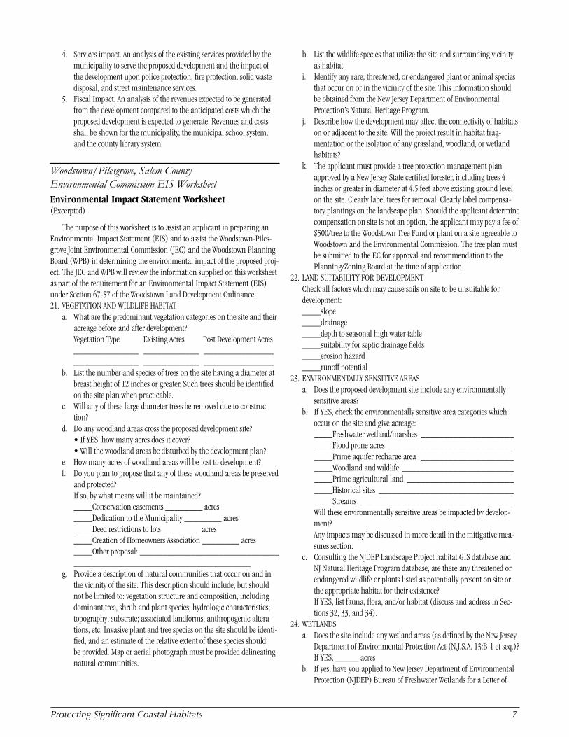
Woodstown/Pilesgrove, Salem County Environmental Commission EIS WorksheetEnvironmental Impact Statement Worksheet (Excerpted)
The purpose of this worksheet is to assist an applicant in preparing an Environmental Impact Statement (EIS) and to assist the Woodstown-Piles-grove Joint Environmental Commission (JEC) and the Woodstown Planning Board (WPB) in determining the environmental impact of the proposed proj-ect. The JEC and WPB will review the information supplied on this worksheet as part of the requirement for an Environmental Impact Statement (EIS) under Section 67-57 of the Woodstown Land Development Ordinance.21. VEGETATION AND WILDLIFE HABITAT
a. What are the predominant vegetation categories on the site and their acreage before and after development?
Vegetation Type Existing Acres Post Development Acres ______________ ____________ _______________
______________ ____________ _______________b. List the number and species of trees on the site having a diameter at
breast height of 12 inches or greater. Such trees should be identified on the site plan when practicable.
c. Will any of these large diameter trees be removed due to construc-tion?
d. Do any woodland areas cross the proposed development site? • If YES, how many acres does it cover? • Will the woodland areas be disturbed by the development plan? e. How many acres of woodland areas will be lost to development? f. Do you plan to propose that any of these woodland areas be preserved
and protected? If so, by what means will it be maintained? ____Conservation easements ________ acres ____Dedication to the Municipality ________ acres ____Deed restrictions to lots ________ acres ____Creation of Homeowners Association ________ acres ____Other proposal: ______________________________
______________________________________g. Provide a description of natural communities that occur on and in
the vicinity of the site. This description should include, but should not be limited to: vegetation structure and composition, including dominant tree, shrub and plant species; hydrologic characteristics; topography; substrate; associated landforms; anthropogenic altera-tions; etc. Invasive plant and tree species on the site should be identi-fied, and an estimate of the relative extent of these species should be provided. Map or aerial photograph must be provided delineating natural communities.
h. List the wildlife species that utilize the site and surrounding vicinity as habitat.
i. Identify any rare, threatened, or endangered plant or animal species that occur on or in the vicinity of the site. This information should be obtained from the New Jersey Department of Environmental Protection’s Natural Heritage Program.
j. Describe how the development may affect the connectivity of habitats on or adjacent to the site. Will the project result in habitat frag-mentation or the isolation of any grassland, woodland, or wetland habitats?
k. The applicant must provide a tree protection management plan approved by a New Jersey State certified forester, including trees 4 inches or greater in diameter at 4.5 feet above existing ground level on the site. Clearly label trees for removal. Clearly label compensa-tory plantings on the landscape plan. Should the applicant determine compensation on site is not an option, the applicant may pay a fee of $500/tree to the Woodstown Tree Fund or plant on a site agreeable to Woodstown and the Environmental Commission. The tree plan must be submitted to the EC for approval and recommendation to the Planning/Zoning Board at the time of application.
22. LAND SUITABILITY FOR DEVELOPMENT Check all factors which may cause soils on site to be unsuitable for development:____slope____drainage____depth to seasonal high water table____suitability for septic drainage fields____erosion hazard____runoff potential
23. ENVIRONMENTALLY SENSITIVE AREASa. Does the proposed development site include any environmentally
sensitive areas?b. If YES, check the environmentally sensitive area categories which
occur on the site and give acreage: ____Freshwater wetland/marshes ____________________
____Flood prone acres ___________________________ ____Prime aquifer recharge area ____________________
____Woodland and wildlife ________________________ ____Prime agricultural land _______________________
____Historical sites _____________________________ ____Streams _________________________________ Will these environmentally sensitive areas be impacted by develop-
ment? Any impacts may be discussed in more detail in the mitigative mea-
sures section.c. Consulting the NJDEP Landscape Project habitat GIS database and
NJ Natural Heritage Program database, are there any threatened or endangered wildlife or plants listed as potentially present on site or the appropriate habitat for their existence?
If YES, list fauna, flora, and/or habitat (discuss and address in Sec-tions 32, 33, and 34).
24. WETLANDSa. Does the site include any wetland areas (as defined by the New Jersey
Department of Environmental Protection Act (N.J.S.A. 13:B-1 et seq.)? If YES, _____ acresb. If yes, have you applied to New Jersey Department of Environmental
Protection (NJDEP) Bureau of Freshwater Wetlands for a Letter of
� SampleOrdinancesfor
Interpretation to determine whether or not any freshwater wetlands are present on the site?
c. Have you applied to the NJDEP Bureau of Freshwater Wetlands for delineation or verification of wetland lines?
d. If you answered yes to 24b or 24c, will these environmentally sensi-tive areas be impacted by the proposed development?
If yes, what mitigative measures will be taken?e. Will the proposed project remove, excavate, or disturb soils; dump
or fill soil; erect any structure; place pavement; or alter the existing pattern of vegetation within 50 feet of any freshwater wetland of exceptional resource value (as classified in N.J.A.C. 7:7A-2.5) or within 150 feet of any wetland of intermediate resource value?
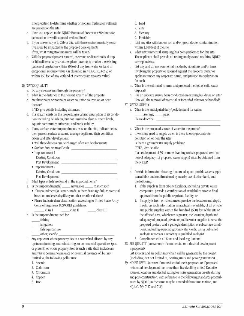
... 26. WATER QUALITY
a. Do any streams run through the property? b. What is the distance to the nearest stream off the property? c. Are there point or nonpoint water pollution sources on or near
the site? If YES give details including distances: d. If a stream exists on the property, give a brief description of its condi-
tion including details on, but not limited to, flow, nutrient levels, aquatic community, substrate, and bank stability.
e. If any surface water impoundments exist on the site, indicate below their present surface area and average depth and their condition before and after development:
• Will these dimensions be changed after site development? • Surface Area Average Depth _______________________ • Impoundment 1 Existing Condition ____________________________
Post Development ____________________________ • Impoundment 2 Existing Condition ____________________________ Post Development ____________________________f. What types of fish are found in the impoundments? g. Is the impoundment(s) ____ natural or ____ man-made? • If impoundment(s) is man-made, is there drainage failure potential
based on undersized spillway or other overflow devices? • Please indicate dam classification according to United States Army
Corps of Engineers (USACOE) guidelines. _____ class I ____ class II ____ class III.
h. Is the impoundment used for: ____ fishing ____ irrigation ____ fish aquiculture ____ other; specify: ____________________________i. Any applicant whose property lies in a watershed affected by any
upstream farming, manufacturing, or commercial operations (past or present) or whose property itself is such a site shall include an analysis to determine presence or potential presence of, but not limited to, the following pollutants:
1. Arsenic 2. Cadmium 3. Chromium 4. Copper 5. Iron
6. Lead 7. Zinc 8. Mercury 9. Pesticidesj. List any sites with known soil and/or groundwater contamination
within 1,000 feet of the site.k. What environmental sampling has been performed for this site?
The applicant shall provide all testing analysis and resulting NJDEP correspondence.
l. List any and all environmental incidents, violations and/or fines involving the property or assessed against the property owner or applicant under any corporate name, and provide an explanation for each.
m. What is the estimated volume and proposed method of solid waste disposal?
n. Has an asbestos survey been conducted on existing buildings on site? How will the removal of potential or identified asbestos be handled?
27. WATER SUPPLYa. What is the anticipated daily/peak demand for water:
____ average; ____ peak Please describe: ________________________________ __________________________________________b. What is the proposed source of water for the project? c. If wells are used to supply water, is there known groundwater
pollution on or near the site? Is there a groundwater supply problem? If YES, give details: If a development of 50 or more dwelling units is proposed, certifica-
tion of adequacy (of proposed water supply) must be obtained from the NJDEP.
...e. Provide information showing that an adequate potable water supply
is available and not threatened by nearby use of other land, and the following:1. If the supply is from off-site facilities, including private water
companies, provide a certification of availability prior to final approval from the public or private facility; or
2. If supply is from on-site sources, provide the location and depth, insofar as such information is practically available, of all private and public supplies within five hundred (500) feet of the site or the affected area, whichever is greater; the location, depth and adequacy of proposed private or public water supplies to serve the proposed project; and a geologic description of subsurface condi-tions, including expected groundwater yields, using published geologic reports or a report by a qualified geologist.
3. Compliance with all State and local regulations.28. AIR QUALITY (answer only if commercial or industrial development
is proposed) List sources and air pollutants which will be generated by the project
(including, but not limited to, heating units and power generators).29. NOISE LEVEL (answer if nonresidential use is proposed or if proposed
residential development has more than five dwelling units.) Describe sources, location and decibel rating for noise generation on-site during and post-construction, with reference to the following standards promul-gated by NJDEP, as the same may be amended from time to time, and N.J.A.C. 7:9, 7:27 and 7:29.
ProtectingSignificantCoastalHabitats �
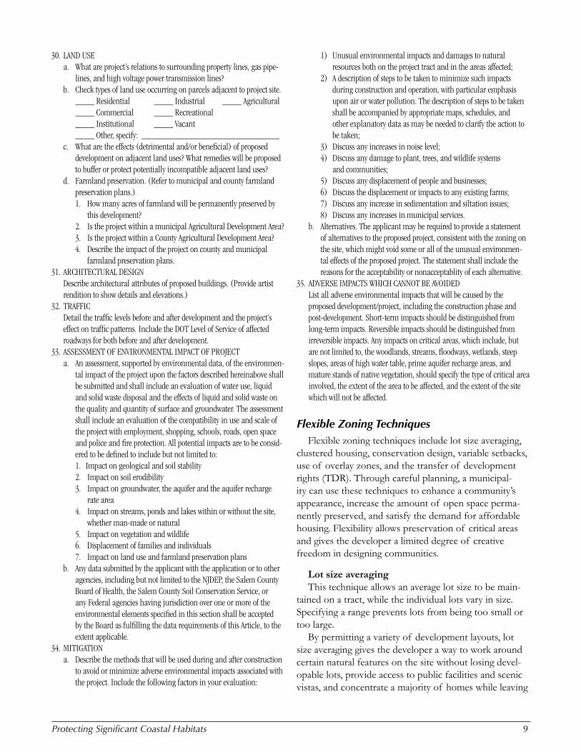
30. LAND USEa. What are project’s relations to surrounding property lines, gas pipe-
lines, and high voltage power transmission lines?b. Check types of land use occurring on parcels adjacent to project site. ____ Residential ____ Industrial ____ Agricultural ____ Commercial ____ Recreational ____ Institutional ____ Vacant ____ Other, specify: _____________________________c. What are the effects (detrimental and/or beneficial) of proposed
development on adjacent land uses? What remedies will be proposed to buffer or protect potentially incompatible adjacent land uses?
d. Farmland preservation. (Refer to municipal and county farmland preservation plans.)1. How many acres of farmland will be permanently preserved by
this development? 2. Is the project within a municipal Agricultural Development Area? 3. Is the project within a County Agricultural Development Area? 4. Describe the impact of the project on county and municipal
farmland preservation plans.31. ARCHITECTURAL DESIGN Describe architectural attributes of proposed buildings. (Provide artist
rendition to show details and elevations.)32. TRAFFIC Detail the traffic levels before and after development and the project’s
effect on traffic patterns. Include the DOT Level of Service of affected roadways for both before and after development.
33. ASSESSMENT OF ENVIRONMENTAL IMPACT OF PROJECTa. An assessment, supported by environmental data, of the environmen-
tal impact of the project upon the factors described hereinabove shall be submitted and shall include an evaluation of water use, liquid and solid waste disposal and the effects of liquid and solid waste on the quality and quantity of surface and groundwater. The assessment shall include an evaluation of the compatibility in use and scale of the project with employment, shopping, schools, roads, open space and police and fire protection. All potential impacts are to be consid-ered to be defined to include but not limited to:
1. Impact on geological and soil stability2. Impact on soil erodibility3. Impact on groundwater, the aquifer and the aquifer recharge
rate area4. Impact on streams, ponds and lakes within or without the site,
whether man-made or natural5. Impact on vegetation and wildlife6. Displacement of families and individuals7. Impact on land use and farmland preservation plans
b. Any data submitted by the applicant with the application or to other agencies, including but not limited to the NJDEP, the Salem County Board of Health, the Salem County Soil Conservation Service, or any Federal agencies having jurisdiction over one or more of the environmental elements specified in this section shall be accepted by the Board as fulfilling the data requirements of this Article, to the extent applicable.
34. MITIGATIONa. Describe the methods that will be used during and after construction
to avoid or minimize adverse environmental impacts associated with the project. Include the following factors in your evaluation:
1) Unusual environmental impacts and damages to natural resources both on the project tract and in the areas affected;
2) A description of steps to be taken to minimize such impacts during construction and operation, with particular emphasis upon air or water pollution. The description of steps to be taken shall be accompanied by appropriate maps, schedules, and other explanatory data as may be needed to clarify the action to be taken;
3) Discuss any increases in noise level;4) Discuss any damage to plant, trees, and wildlife systems
and communities;5) Discuss any displacement of people and businesses;6) Discuss the displacement or impacts to any existing farms;7) Discuss any increase in sedimentation and siltation issues;8) Discuss any increases in municipal services.
b. Alternatives. The applicant may be required to provide a statement of alternatives to the proposed project, consistent with the zoning on the site, which might void some or all of the unusual environmen-tal effects of the proposed project. The statement shall include the reasons for the acceptability or nonacceptablity of each alternative.
35. ADVERSE IMPACTS WHICH CANNOT BE AVOIDED List all adverse environmental impacts that will be caused by the
proposed development/project, including the construction phase and post-development. Short-term impacts should be distinguished from long-term impacts. Reversible impacts should be distinguished from irreversible impacts. Any impacts on critical areas, which include, but are not limited to, the woodlands, streams, floodways, wetlands, steep slopes, areas of high water table, prime aquifer recharge areas, and mature stands of native vegetation, should specify the type of critical area involved, the extent of the area to be affected, and the extent of the site which will not be affected.
Flexible Zoning TechniquesFlexible zoning techniques include lot size averaging,
clustered housing, conservation design, variable setbacks, use of overlay zones, and the transfer of development rights (TDR). Through careful planning, a municipal-ity can use these techniques to enhance a community’s appearance, increase the amount of open space perma-nently preserved, and satisfy the demand for affordable housing. Flexibility allows preservation of critical areas and gives the developer a limited degree of creative freedom in designing communities.
Lot size averagingThis technique allows an average lot size to be main-
tained on a tract, while the individual lots vary in size. Specifying a range prevents lots from being too small or too large.
By permitting a variety of development layouts, lot size averaging gives the developer a way to work around certain natural features on the site without losing devel-opable lots, provide access to public facilities and scenic vistas, and concentrate a majority of homes while leaving
10 SampleOrdinancesfor
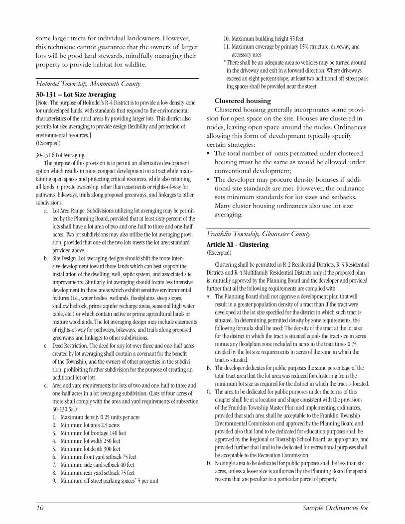
some larger tracts for individual landowners. However, this technique cannot guarantee that the owners of larger lots will be good land stewards, mindfully managing their property to provide habitat for wildlife.
Holmdel Township, Monmouth County30-131 – Lot Size Averaging [Note: The purpose of Holmdel’s R-4 District is to provide a low density zone for undeveloped lands, with standards that respond to the environmental characteristics of the rural areas by providing larger lots. This district also permits lot size averaging to provide design flexibility and protection of environmental resources.] (Excerpted)
30-131.6 Lot Averaging. The purpose of this provision is to permit an alternative development
option which results in more compact development on a tract while main-taining open spaces and protecting critical resources, while also retaining all lands in private ownership, other than easements or rights-of-way for pathways, bikeways, trails along proposed greenways, and linkages to other subdivisions.
a. Lot Area Range. Subdivisions utilizing lot averaging may be permit-ted by the Planning Board, provided that at least sixty percent of the lots shall have a lot area of two and one-half to three and one-half acres. Two lot subdivisions may also utilize the lot averaging provi-sion, provided that one of the two lots meets the lot area standard provided above.
b. Site Design. Lot averaging designs should shift the more inten-sive development toward those lands which can best support the installation of the dwelling, well, septic system, and associated site improvements. Similarly, lot averaging should locate less intensive development in those areas which exhibit sensitive environmental features (i.e., water bodies, wetlands, floodplains, steep slopes, shallow bedrock, prime aquifer recharge areas, seasonal high water table, etc.) or which contain active or prime agricultural lands or mature woodlands. The lot averaging design may include easements of rights-of-way for pathways, bikeways, and trails along proposed greenways and linkages to other subdivisions.
c. Deed Restriction. The deed for any lot over three and one-half acres created by lot averaging shall contain a covenant for the benefit of the Township, and the owners of other properties in the subdivi-sion, prohibiting further subdivision for the purpose of creating an additional lot or lots.
d. Area and yard requirements for lots of two and one-half to three and one-half acres in a lot averaging subdivision. (Lots of four acres of more shall comply with the area and yard requirements of subsection 30-130.5a.):1. Maximum density 0.25 units per acre2. Minimum lot area 2.5 acres3. Minimum lot frontage 140 feet4. Minimum lot width 250 feet5. Minimum lot depth 300 feet6. Minimum front yard setback 75 feet7. Minimum side yard setback 40 feet8. Minimum rear yard setback 75 feet9. Minimum off-street parking spaces* 5 per unit
10. Maximum building height 35 feet11. Maximum coverage by primary 15% structure, driveway, and
accessory uses *There shall be an adequate area so vehicles may be turned around
in the driveway and exit in a forward direction. Where driveways exceed an eight percent slope, at least two additional off-street park-ing spaces shall be provided near the street.
Clustered housingClustered housing generally incorporates some provi-
sion for open space on the site. Houses are clustered in nodes, leaving open space around the nodes. Ordinances allowing this form of development typically specify certain strategies:• The total number of units permitted under clustered
housing must be the same as would be allowed under conventional development;
• The developer may procure density bonuses if addi-tional site standards are met. However, the ordinance sets minimum standards for lot sizes and setbacks. Many cluster housing ordinances also use lot size averaging.
Franklin Township, Gloucester CountyArticle XI - Clustering (Excerpted)
Clustering shall be permitted in R-2 Residential Districts, R-3 Residential Districts and R-4 Multifamily Residential Districts only if the proposed plan is mutually approved by the Planning Board and the developer and provided further that all the following requirements are complied with:A. The Planning Board shall not approve a development plan that will
result in a greater population density of a tract than if the tract were developed at the lot size specified for the district in which such tract is situated. In determining permitted density by zone requirements, the following formula shall be used: The density of the tract at the lot size for the district in which the tract is situated equals the tract size in acres minus any floodplain zone included in acres in the tract times 0.75 divided by the lot size requirements in acres of the zone in which the tract is situated.
B. The developer dedicates for public purposes the same percentage of the total tract area that the lot area was reduced for clustering from the minimum lot size as required for the district in which the tract is located.
C. The area to be dedicated for public purposes under the terms of this chapter shall be at a location and shape consistent with the provisions of the Franklin Township Master Plan and implementing ordinances, provided that such area shall be acceptable to the Franklin Township Environmental Commission and approved by the Planning Board and provided also that land to be dedicated for education purposes shall be approved by the Regional or Township School Board, as appropriate, and provided further that land to be dedicated for recreational purposes shall be acceptable to the Recreation Commission.
D. No single area to be dedicated for public purposes shall be less than six acres, unless a lesser size is authorized by the Planning Board for special reasons that are peculiar to a particular parcel of property.
ProtectingSignificantCoastalHabitats 11
E. All land to be dedicated shall be appropriate and in suitable condition for their intended use, provided that not more than 50% of any land required to be dedicated shall be located in the flood-prone districts and provided further that all parcels shall have road frontages commensurate with the requirements of the intended public use, except that land to be dedicated for public use shall not be required to have road frontage if such land is situated adjacent to public land with road frontage or access.
F. The title to all land conveyed by the developer to the township for public use shall be free and clear of all liens and encumbrances. The deed or deeds to such land shall be conveyed to the township at the time of final approval of the subdivision plan by the Planning Board.
G. The proposed clustered development meets all site plan standards as set forth in this chapter.
253-99. R-A, R-1 and PR-R Districts. Clustering shall be permitted in R-A, R-1 and PR-R Zoning Districts,
subject to the previously listed requirements with the following additional requirements:A. The tract to be developed is all or partially located in an area shown on
the Development Constraints Map and listed in the Conservation Plan of Franklin Township Master Plan as having a minimum of two of the three major limitations for development which are as follows:(1) Flood hazard area (stream overflow).(2) Severe septic limitations.(3) Prime woodlands.
B. The applicant for development shall show that the proposed develop-ment of the tract under a cluster plan will not adversely affect adjacent streams, lakes, and ponds; freshwater wetlands and marshes; forests; or adjacent tracts of land, whether developed or virgin; and that there exist adequate streets to accommodate the additional traffic to be generated by the proposed development.
253-100. Minimum cluster standards. The minimum cluster standards shall be as follows, with no relief
permitted:Yards Frontage
ZoneLot Size (sq feet) Front Side Rear
Maximum Lot Coverage1 (percent)
At Street (feet)
At Build-ing Line(feet)
R-A 30,000 50 20 50 15 75 125R-1 27,000 50 20 50 15 75 125R-2 20,500 40 15 40 15 70 120R-3 20,500 40 15 50 15 70 120R-4 11,250 See2 See2 See2 15 See2 See2
87,120 50 20 50 15 125 1251 In computing lot coverage the following shall be considered as lot cover:
(A) Resident structure; (B) Garage; (C) Driveways, parking areas, and sidewalks; (D) Accessory outbuildings; (E) Swimming pools.
2 Shall be as required in the R-4 Zoning District.
Conservation design ordinancesBecause it usually applies to larger tracts of 25 acres or
more, cluster zoning has some shortcomings that can be overcome by a conservation design approach, which can apply to tracts as small as five acres. Also, unlike cluster arrangements, which often provide a density bonus, con-servation design provides for full density with a minimum of 50 percent open space.
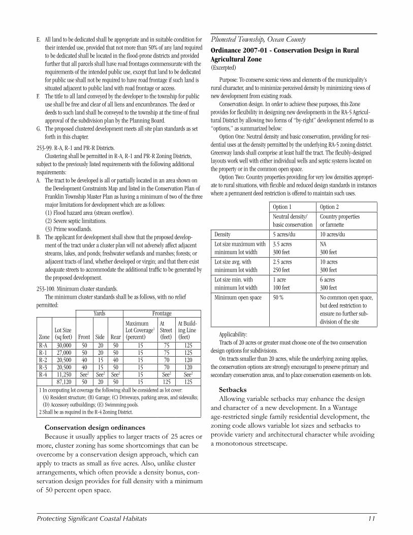
Plumsted Township, Ocean CountyOrdinance 2007-01 - Conservation Design in Rural Agricultural Zone (Excerpted)
Purpose: To conserve scenic views and elements of the municipality’s rural character, and to minimize perceived density by minimizing views of new development from existing roads.
Conservation design. In order to achieve these purposes, this Zone provides for flexibility in designing new developments in the RA-5 Agricul-tural District by allowing two forms of “by-right” development referred to as “options,” as summarized below:
Option One: Neutral density and basic conservation, providing for resi-dential uses at the density permitted by the underlying RA-5 zoning district. Greenway lands shall comprise at least half the tract. The flexibly-designed layouts work well with either individual wells and septic systems located on the property or in the common open space.
Option Two: Country properties providing for very low densities appropri-ate to rural situations, with flexible and reduced design standards in instances where a permanent deed restriction is offered to maintain such uses.
Option 1 Option 2
Neutral density/ basic conservation
Country properties or farmette
Density 5 acres/du 10 acres/du
Lot size maximum with minimum lot width
3.5 acres300 feet
NA300 feet
Lot size avg. with minimum lot width
2.5 acres250 feet
10 acres300 feet
Lot size min. with minimum lot width
1 acre100 feet
6 acres300 feet
Minimum open space 50 % No common open space, but deed restriction to ensure no further sub-division of the site
Applicability:Tracts of 20 acres or greater must choose one of the two conservation
design options for subdivisions. On tracts smaller than 20 acres, while the underlying zoning applies,
the conservation options are strongly encouraged to preserve primary and secondary conservation areas, and to place conservation easements on lots.
SetbacksAllowing variable setbacks may enhance the design
and character of a new development. In a Wantage age-restricted single family residential development, the zoning code allows variable lot sizes and setbacks to provide variety and architectural character while avoiding a monotonous streetscape.
12 SampleOrdinancesfor
Wantage Township, Sussex CountyOrdinance 2006-09 Design Standards for Small Community Villages and Hamlets (Excerpted)
13-4D McCoy’s Corner Village: The purpose of the McCoy’s Corner Village is to establish the new Sussex
County Library as the cornerstone of the “center” by integrating growth consistent with smart growth principles. Pedestrian and vehicular connec-tions should be incorporated into the “center” with concentrated retail and service uses to support the library and airport. Light industrial uses should be encouraged in the airport hazard zone to promote the local economy and create jobs.
...4. Bulk Requirements for Age Restricted Single Family Residential Uses.
The intent of the ordinance standards is to establish variable lot sizes and setbacks to provide a variety of site conditions and architectural character and avoid obvious repetition and a monotonous streetscape.
a. Minimum lot area shall be 7,200 square feet but not to exceed 25,000 square feet.
b. Minimum lot depth shall be 120 feet.Minimum lot width shall be 75 with a maximum of 120 feet, expect
if the lot is part of the common open space or recreational area.Minimum front yard setback shall be 22 feet with a maximum of
35 feet. Homes adjacent to each other must vary the front building setback a
minimum of 5 feet. Minimum rear yard setback shall be 30 feet. Minimum side yard set back shall be 8 feet. Maximum building height shall be 40 feet. Maximum number of stories shall be 2 ½. Accessory Structures refer to Ordinance 13-24.11d.2(g). Maximum lot coverage shall not exceed 50 %.
5. Bulk Requirements for Age Restricted Town Home Residential Uses. The intent of the ordinance standards is to establish building setback
variation to avoid obvious repetition and a monotonous streetscape. a. Minimum front yard setback shall be 22 feet with a maximum of
35 feet. Homes adjacent to each other must vary the front building setback a
minimum of 5 feet.Maximum length of building not to exceed 200 feet.Minimum offset of units in the same building shall 5 feet.Minimum distance side to side shall be 30 feet.Minimum distance rear to rear shall be 60 feet.Minimum distance rear to side shall be 40 feet.Minimum distance front to back shall be 75 feet.Minimum distance front to front shall be 70 feet.Minimum distance front to side shall be 40 feet.Minimum distance from any building to property line shall be
30 feet.Maximum building height shall be 40 feet.A maximum of 2 ½ stories.
Overlay zonesThese zones serve to define the areas a municipality
seeks to conserve or preserve, such as aquifers, stream corridors, buffer zones, and historically significant areas.
An overlay zone is a mapped zone that imposes a set of requirements in addition to those of the underlying zon-ing district or districts. Within an overlay zone, property is simultaneously in two zones, and the land may be developed only under the conditions and requirements of both zones.
The use of overlay zones is a helpful tool for cohesive planning. Rather than allowing a hodgepodge of open space with no connectivity, this method may help to cre-ate greenways for wildlife, linear recreation, and unbro-ken scenic vistas. The zones are reflected in the official map, helping to limit uses on lands designated for public purposes (N.J.S.A. 40:55D-32 and 34).
Woodstown Borough, Salem CountyChapter 67-39.2 Conservation Overlay [This section establishes the purpose and objectives of a conservation area overlay district.] (Excerpted)
A. The purpose of the conservation area overlay district is to provide special controls over land use and development located in ecologically signifi-cant landscapes identified by the Borough of Woodstown. The overlay district is designed to preserve and protect ecosystems in their entirety to the greatest extent possible. This shall be accomplished by minimizing fragmentation of the landscape, maintaining biodiversity and specifically protecting unique environmental features identified as integral parts of the designated landscape. The overlay district shall establish standards and procedures which are designed to protect, conserve, enhance, restore, and maintain significant natural features and the ecological connections between them.
B. The regulations contained in this overlay district seek to protect areas known to be ecologically sensitive to disturbance by development, or that are ecologically important because they support threatened, endangered or regionally declining species, maintain connections within a land-scape, support a high diversity of species, or constitute rare or unusual habitats.
C. These regulations are intended to:(1) Maintain the diversity of wildlife species and habitat found in the
conservation area.(2) Protect habitat areas from activities that would cause immediate or
foreseeable danger to significant wildlife habitat.(3) Ensure that land uses and development are planned and designed to
be harmonious with wildlife habitat and the species that depend on that habitat, and to protect the full range of habitats and species in the area.
(4) Preserve and protect open space to the maximum extent possible by requiring the clustering of permitted development and limiting intrusion into natural habitat.
(5) Connect open spaces with each other to the greatest extent possible to allow for the preservation of wildlife habitat and other environmental features.
(6) Reduce the amount of nutrients, sediment, organic matter, pesticides, and other harmful substances reaching watercourses, wetlands, or subsurface water bodies by using scientifically proven processes including filtration, deposition, absorption, plant uptake, and deni-
ProtectingSignificantCoastalHabitats 1�
trification, and by improving infiltration, encouraging sheet flow, and stabilizing concentrated flows.
(7) Improve and maintain the safety, reliability, and adequacy of the water supply for domestic, agricultural, commercial, industrial, and recreational uses along with sustaining diverse populations of aquatic flora and fauna.
(8) Retain areas of annual flooding, floodplains, water areas, and wetlands in their natural state to the maximum extent possible to preserve water quality and protect water retention capabilities, and facilitate recharging of the water table and natural functions.
(9) Protect steep slopes and other areas of erosion or potential erosion to the greatest extent possible by minimizing the impacts in these areas by properly managing disturbances.
(10) Protect the quality of air, water, and soil and maintain minimum noise and artificial lighting levels in sensitive environmental areas.
(11) Protect areas generally recognized for their special or unique vegetative features or ecological communities including natural vegetation along lakes, rivers, wetlands and streams, grasslands, woodlands, stands of trees, and mature forests.
(12) Limit human and domestic animal intrusion and impact.D. The regulations contained in this law are not intended to be substituted
for other general zoning district provisions, but should be considered as additional requirements to be met by applicants, prior to project approval. The purpose of the overlay district is to provide the Borough of Woodstown with an additional level of review and regulation to control how land use and development, permitted by the Borough of Woodstown’s primary zoning districts, occurs in sensitive or unique environmental areas.
3. If the Environmental Impact Statement identifies any environmentally sensitive habitat or natural resource, additional setbacks and develop-ment techniques shall be applied.
Transfer of Development Rights (TDR)TDR allows property owners within conservation
areas to sell their development rights to owners of developable property. This concept rests on the underly-ing principle that all property owners have a fundamental right to reap a fiscal benefit through development. One of the main benefits of TDR is that it allows entire tracts of property to be preserved.
A 1996 amendment to the Municipal Land Use Law permits any municipality to cluster development using noncontiguous sites. Doing so allows a community to transfer development density from areas the municipal-ity wants to preserve to those within its borders that are better suited for growth. In 2004, passage of the State Transfer of Development Rights Act authorized New Jersey municipalities to use TDR programs in local land use planning.
A widely recognized TDR program is New Jersey’s Pinelands Development Credit program. Administered by a state created TDR bank, the program transfers development credits to regional growth areas within the Pinelands. The landowners within the region’s Preserva-tion Area and agricultural production areas can continue
to use the land for certain uses. Municipalities with lands within the protection zone have adopted ordinances in compliance with the TDR program.
One reason TDR is under utilized is the perceived complications of administering such a program. Some of the concerns of municipalities include:• How to create the zones of conservation and the
zones of allowable higher development densities, or growth areas;
• How to determine the number of development credits for conserved properties;
• How to set up a land bank to administer the sale and purchase of development credits;
• How to convince landholders that they are being paid fairly for not developing their properties.Another obstacle to setting up TDR programs in
environmentally sensitive regions may be finding suitable receiving areas.
Chesterfield Township, Burlington CountyArticle 4, Agricultural District [This section enables properties within the Agricultural Zoning District to be
enrolled in a TDR program.] (Excerpted)
All lands located within the AG Zoning District may be incorporated within a voluntary transfer development rights program. Upon enrollment, the tract enrolled may only be developed and used in accordance with the regulations applicable to this option and deed restrictions imposed upon the lands enrolled.(1) Under this option, permitted uses shall be:
(a) Farms and farm buildings;(b) Detached dwellings;(c) Golf courses are not permitted on a parcel which transfers
development rights.(2) Permitted accessory uses shall be:
(a) Customary farm buildings;(b) Accessory dwellings for domestic or household employees or farm
workers, provided that each such dwelling unit meets local codes and complies in every respect to the statutes of the State of New Jersey and the rules and regulations of the New Jersey State Board of Health concerning farm labor housing;
(c) Roadside farm stands primarily for the sale of farm products grown or raised locally by the owner or operator of the farm, with a limit of one stand per farm, and provided that such stand shall be set back a
minimum of 20 feet from the street line;(d) Private garages and carports;(e) Off-street parking facilities;(f) Private residential swimming pools; (g) Signs.
(3) Conditional uses shall meet the standards set forth in Article XI.(a) Home occupations as a use subordinate and incidental to the primary
residential use, after site plan approval, located on lots conforming to the residential requirements of this chapter and conforming to the requirements of 130-48A, except that no commercial vehicles with a
14 SampleOrdinancesfor
gross vehicle weight in excess of 10,000 pounds shall be parked on the lot unless the lot is 3.3 acres or larger in size, in which case, no more than two commercial vehicles with a gross vehicle weight in excess of 10,000 pounds shall be parked on the lot and these vehicles shall be parked in an area screened from public streets and adjoining properties by buildings, plantings, or both. No construction vehicles shall be permitted to be parked on a property as part of a home occupation.
(4) Area, yard, and bulk requirements. The attached area, yard, and bulk requirements set forth for the AG District apply to parcels which transfer development rights and one development right shall be retained for each existing and proposed dwelling.(a) The number of detached dwellings which may be developed on par-
cels which transfer development rights shall not exceed one dwelling for each 50 acres (.02 dwelling unit per parcel).
(b) For existing parcels which are smaller than 50 acres in size and transfer development rights, one detached dwelling shall be permitted.
For more information:• Transfer of Development Rights Resource Paper,
ANJEC 2007
Open Space
Consider New York without Central Park, the creation of Frederick Law Olmsted. Even the greatest of cities treasures the concept and reality of open space. The preservation of open space is critical—for our quality of life, for investments in property, and for wildlife sharing our landscape. While the previous section on Develop-ment and Zoning mentioned the preservation of open space during the development process, this chapter focuses on open space first and development second.
Open space property may have various uses, depend-ing on the ownership, sensitivity of flora and fauna to disturbance, and the community’s desires. In cases where only the development rights have been sold, a perpetual conservation easement may still allow the continuation of activities such as farming. Open space areas may provide scenic vistas for homes or roadways, be managed for wildlife, be passively used for hiking, or even be actively used for playing fields.
Studies show that preserved open space also has finan-cial benefits. For every $1.00 collected in taxes, residential development in New Jersey costs between $1.14 and $1.51 in services—and these services continue forever, generally increasing over time. Farmland, on the other hand, costs less than 33 cents for each dollar it generates in taxes. Preserved open space also increases the value of adjacent private properties, and contributes a substantial portion of New Jersey’s tourism industry, amounting to $37.6 billion in 2006.
For more information:• Open Space Is a Good Investment, ANJEC 2004• ANJEC Resource Center; 973-539-7547 www.anjec.org
Local Open Space Trust FundsBy 2007, all 21 counties and 231 municipalities in New
Jersey had established a dedicated portion of the prop-erty tax as an open space tax. Some municipalities set a target funding amount and calculate the tax rate each year to reach that value. Others set a specific tax rate (gener-ally one to three cents per $100 assessed valuation), with a general knowledge of how much money that will raise.
Local open space trusts are an important tool in pro-tecting critical habitats. Although the dedicated taxes may raise only $100,000 a year for the open space trust, they enable municipalities to purchase land without having to issue a local bond and assume additional financing and debt service costs.
Local open space trusts also give municipalities access to larger sources of funds. When awarding grants, Green Acres and most county open space programs rate applicants with local open space trusts higher than those without. The proceeds of a local tax can also provide the necessary funds to pay debt service on a Green Acres loan. And the Green Acres planning incentive program provides up to $3 million in block grants for communi-ties with open space plans and trusts. In this program, municipalities can draw against their allotment to pur-chase any tract included in their open space plan, elimi-nating time consuming, separate applications for funding.
State funding sources for habitat protection include the New Jersey Waterfowl Stamp program, which buys coastal and inland wetlands, and mitigation funds through the Office of Natural Resource Damage Assessment of NJDEP. In addition, the Stewart Trust provides funds to municipalities in Gloucester, Salem, Atlantic, Cumber-land, Ocean, and Cape May Counties for land acquisition along streams or water bodies for parks, game refuges, fishing areas, bird sanctuaries, or wildlife preserves.
In many towns, environmental commissions have played a leading role in passing referendums and the necessary ordinances to set up local open space trusts. Commissions usually are the only local agency with comprehensive information about the location and importance of specific habitat areas. Most have devel-oped Environmental Resource Inventories and/or open space indexes. These reports are objective listings with text and maps that provide baseline documentation on an area’s natural and cultural resources, including open space, historic sites, soils, water courses, vegetation,
ProtectingSignificantCoastalHabitats 1�
specific habitats, and wildlife. They also describe limiting factors such as wetlands, slopes, existing development, and contaminated sites.
The campaign for a local open space trust Getting a local open space trust established requires
a well-planned campaign, crafted to appeal to as many voters as possible. Approval by at least two-thirds of the voters creates momentum for open space preservation and gives the local governing body a clear signal that it should move ahead in open space acquisition.
The committee organizing an open space referendum needs to research several issues to gauge voter support and determine what kind of educational campaign will be needed for a successful effort. These include:• Assessing the community’s specific open space needs;• Determining how much of a tax increase voters
will support;• Finding out what types of projects appeal to voters;• Reviewing local voting history on Green Acres and
county open space referendums.The committee also should build a broad-based coali-
tion, involving senior citizens, youth and social services, business leaders, bankers, developers, the media, and local officials as well as conservation and park groups. Obtain-ing the governing body’s support is critical.
To get a referendum on the ballot, the governing body must pass a resolution authorizing the measure and file a request with the county clerk for the proposition to appear on the ballot: 60 days before the election for a referendum supported by petition signatures of not less than 10 percent of voters; or 74 days before the election for a local government referendum. Given state and local timetables, work with the local governing body should begin in early May to insure that the question can appear on the November ballot.
The wording of the ballot question is important, since it will control the use of the proceeds of the open space tax. To insure that funds will go toward habitat preserva-tion, the ballot question and its explanatory statement should include language like “preservation of habitat, stream corridors, and environmentally sensitive areas.”
An open space referendum is not binding. Once the referendum passes, the governing body must pass a spe-cific ordinance increasing the property tax and dedicating the proceeds to an open space trust fund, as specified in the enabling legislation N.J.S.A. 40:12-15.1 et seq.
Blairstown Township, Warren CountyMunicipal Resolution Authorizing Open Space Ballot Measure (Excerpted)
Whereas New Jersey Statutes Annotated, N.J.S.A. 40:12-15.7 authorizes the governing body of any New Jersey municipality to submit to the voters of the municipality in a general election a referendum question authorizing imposition of an annual levy for an amount or at a rate deemed appropriate for the following purposes:
a) Acquisition of lands for recreation and conservation purposes;b) Acquisition of farmland for farmland preservation purposes;Whereas the Township Committee has determined that it would be in the
public interest to place a non-binding referendum question on the November 2000 general election ballot for the purpose of assessing voter preference with regard to the question as to whether Blairstown Township shall create a municipal open space recreation and farmland preservation trust fund for the purposes aforesaid funded by an annual levy, i.e., tax, at an annual rate not to exceed $.02 per $100.00 of total municipal equalized real property valuation to be imposed in Blairstown Township.
Now, therefore, be it resolved by the Township Committee of the Town-ship of Blairstown, Warren County, New Jersey, that the Township cause the following referendum question to be placed on the November 2000 general election ballot:
“Shall the Township of Blairstown consider establishing a Municipal Open Space, Recreation and Farmland Preservation Trust Fund, pursuant to N.J.S.A.. 40:12-15.7, to be funded at a rate not to exceed $.02 per $100.00 of total municipal equalized real property valuation and used exclusively for:
c) Acquisition of lands for recreation and conservation purposes;d) Acquisition of farmland for farmland preservation purpose.”
Establishing an open space trust and open space committee
Following the successful passage of an open space ref-erendum, it is necessary to establish an open space trust and an open space trust committee.
The trust is a reserve within the general capital account, funded by the approved tax levy and donations. The establishing ordinance must follow the wording of the ballot question. It should clearly state the purpose and uses of the fund.
An open space trust committee provides prioritized recommendations to the governing body for the acquisi-tion of property or development rights, ideally with input from planning officials. The trust committee works with the governing body to arrange for the purchase of the approved properties or rights.
See “Ownership and Maintenance of Open Space,” page 19, for a description of another type of organiza-tion the municipality can assign to oversee and maintain open space.
16 SampleOrdinancesfor
For more information:• A Handbook for Public Financing of Open Space in New
Jersey, ANJEC 2001• Keeping the Garden State Green: A Local Government Guide
for Greenway and Open Space Planning, ANJEC 1989• Open Space Trust enabling legislation, P.L. 1997,
Chapter 24; N.J.S.A. 19:37-1 et seq.• Environmental Commission Enabling Legislation,
N.J.S.A. 40:56A-1 et seq.• ANJEC Resource Center; 973-539-7547 www.anjec.org
Harding Township, Morris CountyEstablishment of Open Space Trust Committee
A. Establishment of Open Space Trust Committee. There is hereby estab-lished an Open Space Trust Committee.
B. Membership. The Open Space Trust Committee shall consist of a mini-mum of nine members as follows:1. Mayor 2. Township Administrative Officer3. One member of the Township Committee of the Township of Hard-
ing, in addition to the Mayor, appointed by the Township Committee.4. One representative from each of the Planning Board, the Envi-
ronmental Commission and the Shade Tree Commission, to be appointed by the Mayor.
5. A minimum of three citizens of the Township to be appointed by the Mayor. The citizens appointed by the Mayor shall hold no other municipal office, position, or employment in the municipal government.
C. Terms of office. 1. The Mayor shall serve for so long as he or she holds such position. 2. The Administrative Officer shall serve as a member of the Open Space
Trust Committee as long as he or she is employed by the Township in the capacity of Township Administrative Officer.
3. The member of the Township Committee appointed to the Open Space Trust Committee shall have a term of one year.
4. The representatives of the Planning Board, Environmental Commission, and Shade Tree Commission shall serve for a term of one year.
5. One of the citizens of the Township appointed by the Mayor and so designated by the Mayor at the time of appointment shall have a term of three years.
6. One of the citizens of the Township appointed by the Mayor and so designated by the Mayor at the time of appointment shall have a term of two years.
7. One of the citizens of the Township appointed by the Mayor and so designated by the Mayor at the time of appointment shall have a term of one year.
D. Powers and operating procedures. Officers.
The Open Space Trust Committee shall select from among its members a Chair and a Vice Chair to serve as the presiding officer in the absence of the Chairman. The Committee shall also select a Secretary whose function shall be to maintain minutes of the Committee’s meetings and records of its proceedings.
Initial organization meeting. The Open Space Trust Committee shall hold its initial organization
meeting within 60 days after the final adoption of this section. Meetings.
The Open Space Trust Committee shall hold public meetings, which pub-lic meetings shall be held in accordance with the Open Public Meetings Act. (See N.J.S.A. 10:4-6 et seq.) Procedures.
The Open Space Trust Committee shall determine the criteria which are to be used in analyzing properties for possible acquisition by the Town-ship whether in fee, by easement or by means of development rights. From time to time, the Committee is to advise the Township Committee of properties which it has determined meet the criteria and might be suitable for acquisition. The Township Committee shall determine which properties, easements, or development rights should be acquired. After selection of the lands, easements, or development rights as hereinabove provided, the Township may proceed to acquire by gift, purchase or by eminent domain proceedings pursuant to N.J.S.A. 20:3-1 et seq. the identified lands, easements or development rights within the financial constraints established by the Township Committee. Funding.
There is hereby established a reserve in the Township’s general capital fund which shall be known and designated as the “Open Space Trust Fund.” A separate bank account shall be opened and maintained for this purpose. The Open Space Trust Fund shall be funded through the dedica-tion to the fund of an amount not to exceed $0.05 per $100 of assessed valuation of each annual tax levy. The fund shall also be permitted to accept donations and testamentary bequests. The monies accumulated within the fund may be used for the following purposes, or any combina-tion thereof: • Acquisition of lands for conservation and recreation purposes; • Maintenance of lands acquired for conservation and recreation
purposes; • Acquisition of farmland for farmland preservation purposes; • Payment of debt service on indebtedness issued or incurred by the
Township of Harding for the acquisition of lands for conservation and recreation purposes;
• Historic preservation and the acquisition of historic properties, struc-tures, facilities, sites, or areas, to the extent of up to 10% of annual open space tax levies. Such amounts may be accumulated for this purpose or redirected to the other purposes authorized by Subsection E(1)(a) through (d) above.
The Township Committee shall determine the appropriate amount to be allocated to each purpose after conducting at least one public hearing thereon. Any and all interest or other income earned on monies in the fund shall be credited to the fund to be used for the above-described purposes. Disposition of property or other interest in land.
No property or interest in land acquired with funds from the Open Space Trust Fund shall be sold or otherwise disposed of by the Township until the disposition has been authorized by the Township Committee after and in accordance with a public referendum. Review.
In the event that no property is acquired for a period of three consecu-tive years, then the Township Committee shall review the activities of the Open Space Trust Committee and issue a report with recommendations and conclusions relating to the Open Space Trust Fund.
ProtectingSignificantCoastalHabitats 1�
Mandatory Open Space with New Development
There is a significant difference between passively encouraging responsible development through density incentives and mandating that open space be incor-porated into every new subdivision or development proposal.
While many developers willingly comply with requests and favorably respond to incentives, some feel that these changes will greatly lengthen the time involved and prove a nuisance. While open space sells homes, it is still lacking in many new developments around the state. By being up front about desires and expectations, a municipality can be receptive to development and still retain some control.
Mansfield Township, Burlington CountyOrdinance to promote open space by requiring certain development requirements (Excerpted)
65-76. Required open space in nonresidential developments.In all nonresidential developments, not less than 10% of each tract shall
be devoted to open space. These areas are defined to include any areas not covered by buildings, structures or by paved streets or parking areas. Such green areas shall be landscaped and may be used for active as well as passive recreational uses.65-77. Required open space in residential developments.
In all residential developments which will result in four or more dwelling units, not less than 10% of the total area shall be set aside for open space and active recreation uses.
This 10% shall not include easement or right-of-way areas. The location, form, and design of such areas shall be approved by the Planning Board. The area specifically designated for recreational purposes shall be fully usable for that purpose and shall have all improvements as required by this chapter. In the case of large subdivisions, consideration should be given to decentral-izing several smaller recreational areas throughout the development. The method of preserving such areas for recreation open space shall be approved by the Planning Board.
In special circumstances where, because of the size, location, and design requirements of the project, it is not feasible, in the opinion of the Planning Board, to set aside such area or areas for open space, the applicant shall make a payment to the Township in lieu of the provision of such open space land. Such payments shall be placed in a special recreational open space land fund to be utilized either for the purchase of public recreational open space or of recreational equipment. The amount of the payment shall be equal to the size and character of the land and improvement which would otherwise be provided within the project in compliance with the regulations of this chapter.
65-78. Standards.A. The designated open space areas which may be used for recreational
purposes shall not contain grades that prevent the construction of recre-ational facilities.
B. In the selection of the location of such open spaces, consideration shall be given to the preservation of natural features.
C. The open space should be approximately located so that it is easily acces-sible to the maximum number of residents of the development.
D. There should be a close visual and physical relationship between the open space and as many dwelling units as is reasonably possible.
E. The configuration of the open space area should be so arranged that the connections can be made to existing or future adjacent open spaces.
F. Open space areas should be located to preserve unique characteristics of the site, such as woodlands, streams, topography, etc.
G. Portions of the open space should be developed to afford both passive and active recreational opportunities. Passive recreational activities may include but are not limited to pedestrian paths, sitting areas, and naturally preserved areas. Active recreational activities may include but are not limited to swimming pools, tennis courts, bicycle paths, tot lots, softball fields, and hard-surface court games.
H. The usage of the open space should be appropriate for the residents of the development it serves.
The open space planWhere will your municipality’s open space be? A key
element of planning is deciding appropriate locations for preserved open space. The first step is to obtain an inventory of existing public and private open space and lands protected by conservation easements. The environ-mental commission’s ERI/NRI and/or open space index typically provide maps and written descriptions of some or all of these areas. The conservation element of the municipal master plan might also have information on critical environmental areas.
Next, a municipality should develop an open space plan to complete the inventory and identify the kinds of areas that it wants to preserve, such as stream corridors and floodplains, forests, or animal migration routes. The open space plan should also identify the opportunities for linking existing protected open spaces through greenways or linear corridors of undeveloped land.
Greenways or greenbelts can be very effective in habitat protection. Well-designed greenways can protect habitat along a stream, its floodplains and wetlands. This insures sufficient area for wildlife and plants to flour-ish, with some insulation from the hustle and bustle of civilization. Consider the following in crafting your open space plan and its implementing ordinances:1. Is your open space contiguous? Will the individual
pieces connect to other established open space areas?2. Should it be accessible to many residents? Where will
access points be?3. What types of lands are you targeting? Are you seeking
to protect farmlands, woodlands, groundwater recharge zones, vistas, and/or historically significant areas?
4. Do your mandatory open space requirements stipulate the percentage of passive open space to be perma-nently set aside to protect wetlands and wildlife cor-ridors? Does that percentage also include stormwater facilities, existing easements and roads?
18 SampleOrdinancesfor
5. May developers meet open space requirements offsite?6. How will conflicts be minimized between various user
groups and adjacent land users?What are the minimum dimensions for the open space
parcels? Consider the width necessary to block unwanted views, dissipate noise, and provide usable habitat for numerous species.
Funding, assistance, and/or support for open space planning is available from a number of sources:• The Green Acres Program – was created in 1961 to
meet New Jersey’s growing recreation and conserva-tion needs. It provides funding in four program areas:state park and open space acquisition; local govern-ments and nonprofit funding; stewardship and legalservices; and planning and information management. www.state.nj.us/dep/greenacres
• The Environmental Endowment for New Jersey– funded by proceeds from the settlement of a lawsuitbrought under the Federal Water Pollution Con-trol Act, awards grants up to $15,000 for nonprofit organizations and government agencies for projects with direct benefit in or near the tidally-related New York/New Jersey Harbor Complex, including the Hackensack, Raritan, and Passaic watersheds, or in the Delaware River Basin;
• Conservation Resources Inc. (CRI) – a nonprofitorganization providing financial and technical servicesto the conservation community in New Jersey as wellas a small grants program to provide assistance tononprofit conservation organizations working on landacquisition, stewardship, and restoration projects.www.conservationresourcesinc.org/index.htm
• NJ Conservation Foundation – a nonprofit organiza-tion that buys and protects lands through strategicpartnerships to achieve conservation goals.www.njconservation.org
• New Jersey Natural Lands Trust – preserves land in itsnatural state for enjoyment by the public and to pro-tect natural diversity through the acquisition of openspace. The Trust owns or manages over 22,000 acresof open space from Sussex to Cape May Counties,including over 2,500 acres of conservation easements.http://nj.gov/dep/njnlt
• The Trust for Public Land – a national, nonprofit,land conservation organization that conserves land forpeople to enjoy as parks, community gardens, historicsites, rural lands, and other natural places. TPL helpsagencies and communities identify and raise fundsfor conservation from federal, state, local, and philan-thropic sources. www.tpl.org
• NJDEP Coastal Blue Acres Program – provides grants and loans to municipalities and counties in the coastal area to acquire storm-damaged property for storm protection and recreation and conservation purposes.
• The New Jersey Department of EnvironmentalProtection, Natural & Historic Resources, HistoricPreservation Office (HPO) – offers Certified LocalGovernment (CLG) Historic Preservation Fund grantsfor eligible historic preservation activities.www.state.nj.us/dep/hpo/3preserve/local.htm
For more information:• Keeping the Garden State Green: A Local Government Guide
for Greenway and Open Space Planning, ANJEC 1989• Open Space Plan, ANJEC 2000• Charting a Course for the Delaware Bay Watershed, New
Jersey Conservation Foundation 1998• Garden State Greenways – Dynamic online planning
tool providing maps and Geographic InformationSystem (GIS) data and planning tools to help iden-tify larger areas of undeveloped land with importantnatural resource values and linear connectors betweenthese hubs. Email [email protected],www.gardenstategreenways.org
• ANJEC Resource Center; 973-539-7547 www.anjec.org
Insuring the preservation of sensitive areasState laws and local ordinances protect many environ-
mentally sensitive areas, such as wetlands, slopes, streams, dunes, and trails, during the development process, but there is always a possibility that these laws might be amended and weakened in the future.
To insure long-term preservation of these invalu-able habitat areas, a municipality should include specific measures in its open space plan and in the conservation element of the master plan for sensitive areas preserva-tion. This establishes the official goal of preservation of the sensitive lands. It also alerts property owners to the opportunities for potential tax benefits if they donate the areas to the municipality or a nonprofit land trust.
The owner can either donate the land outright or convey an easement, which restricts the use of the property. Under Internal Revenue Service criteria, to qualify for a tax deduction, an easement donation must be made in perpetuity, be given to a qualified organization like a land trust or public agency, and provide signifi-cant natural habitat, public recreation/education, scenic enjoyment, contribution to local government policy, or historic preservation.
ProtectingSignificantCoastalHabitats 1�
Montgomery Township, Somerset CountySection 8 – Conservation Easements (Excerpted)
For the protection and enjoyment of natural features, conservation ease-ments or conservation deed restrictions on such areas shall be provided, if required by the Board.
Treed areas outside the “limits of disturbance” shall be protected by a conservation easement or conservation deed restriction, if required by the Board, when such areas have been credited towards the granting of a design waiver from the total shade tree requirements in Subsection 16-5.6d. of this Ordinance.
All “critical areas” shall be protected by conservation easements or con-servation deed restrictions. Where the “critical areas” or areas to be conserved are wooded, the conservation easements or conservation deed restrictions area shall extend twenty feet (20’) beyond the closest tree in order to ensure that there will be no disturbance to the root structure of the tree(s).1. Prior to any clearing, grading, or construction taking place on a site
proposed for development, the conservation easement or deed restricted area(s) shall be clearly marked in the field and subject to inspection by the Township Engineer. Eight (8) inch concrete monuments shall be permanently installed at the property line(s) where the easement or deed restricted area begins, at minimum, subject to the inspection and approval by the Township Engineer.
2. In stream corridor areas which are to be preserved by conservation easements or deed restrictions in accordance with this section and where existing vegetation is sparse, additional plantings of indigenous species shall be required to promote stability to the flood plains and slopes and to promote the wildlife habitat.
3. The conservation easement or conservation deed restriction shall follow the form established by the Township and is subject to the Township Attorney’s review and approval.
Mendham Township, Morris CountyChapter XXIV.A – 16-10.10A Conservation Easement for Watercourse, Stream, etc. (Excerpted)
a. When property depicted on a subdivision or site plan is traversed or bordered by a watercourse, drainage way, channel, or stream, a storm water easement or drainage right-of-way and a conservation easement dedicated to the Township conforming substantially with the lines of such watercourse, and such further width or construction, or both, as will be adequate for the purpose, shall be provided by the developer. For perennial streams, and where applicable, the conservation easement shall be one hundred fifty (150) feet in width on either side of the stream center line. The minimum width for a conservation easement for a watercourse of intermittent nature shall be fifty (50) feet on either side of the center line, where applicable.
b. Easements or rights of way as required by the Planning Board under subparagraph a. above shall be described by metes and bounds, and any deeds prepared in favor of the Township shall be approved as to form and substance by the Township Attorney.
Ownership and maintenance of open spacePeople may hesitate to encourage the preservation
and use of open space due to concerns over its owner-ship and maintenance. Municipalities have the power to establish open space organizations to manage common open space in developments through the Municipal Land Use Law.
An appropriate owner could be an established hom-eowners’ association, developer, government entity, independent nonprofit land conservancy, and/or an individual. Typically, the assigned owner is responsible for any necessary maintenance on the property.
For more information:• Municipal Land Use Law, N.J.S.A. 40:55D-43• ANJEC Resource Center; 973-539-7547 www.anjec.org
Readington Township, Hunterdon County402.7 - Open Space Regulation in the SSR Steep Slope Residential Zone in two-acre cluster developments (Excerpted)
609.3 Common open space may be deeded to the Township, another governmental agency or dedicated to an open space organization or trust, with incorporation and bylaws to be approved by the Plan-ning Board. If common open space is not dedicated and accepted by the Township or another governmental agency, the landowner shall provide for and establish an open space organization or trust for the ownership and maintenance of the common open space. Such organization or trust shall not be dissolved, nor shall it dispose of any common open space by sale or otherwise.
609.3.1 If the applicant proposes that the common open space shall be dedicated to the Township, then the Planning Board shall forward such request with its recommendation to the Township Committee prior to the granting of preliminary plan approval of any develop-ment application containing common open space.
609.3.2 All lands not offered to and/or not accepted by the Township or other governmental agency shall be owned and maintained by an open space organization or trust as provided in N.J.S.A. 40:55D-43 and stipulated herein.
609.3.3 The applicant/developer shall notify the Township Committee at the time 50% of the units have sold at such time the homeowner’s association/open space organization takes over the responsibility of maintaining the open space and commonly owned facilities.
609.4 In the event that the organization created for common open space management shall fail to maintain any open space or recreation area in a reasonable order and condition in accordance with the approved site plan, the Township may serve notice upon such organization or upon the owners of the development, setting forth the manner in which the organization has failed to maintain such area in reasonable conditions, and said notice shall include a demand that such deficiencies of maintenance be cured within thirty-five (35) days thereof and shall set the date and place of a hearing thereon which shall be held within fifteen (15) days of the notice. At such hearing the Township may modify the terms of the
20 SampleOrdinancesfor
original notice as to the deficiencies and may give an extension of time not to exceed 65 days in which the deficiencies shall be cured.
609.4.1 If the deficiencies set forth in the original notice or in modifica-tions thereof shall not be cured within said thirty-five (35) days or any extension thereof, the Township, in order to preserve the common open space and maintain the same for a period of one year, may enter upon and maintain such land. Said entry and said maintenance shall not vest in the public any rights to use the open space and recreation areas except when the same is voluntarily dedicated to the public by the owners.
609.4.2Before the expiration of said one (1) year, the Township shall, upon its initiative or upon the request of the organization theretofore responsible for the maintenance of said areas, call a public hearing upon fifteen (15) days’ written notice to such organization and to the owners of the development, to be held by the Township, at which hearing such organization and owners of the development shall show cause why such maintenance by the municipality shall not, at the election of the Township, continue for a succeeding year, if the Township shall determine that such organization is ready and able to maintain such open space and recreation areas in reasonable condition, the Township shall cease to maintain such open space and recreation areas at the end of said year. If the Township shall determine such organization is not ready and able to maintain said open space and recreational areas in a reasonable condition, the Township may, in its discretion, continue to maintain said open space and recreation areas during the next succeeding year. Each year thereafter the Township may hold similar public hearing to determine whether the organization is ready and able to maintain the open space and recreation areas. The decision of the Township in any case shall constitute a final administrative decision subject to judicial review.
609.4.3 The cost of such maintenance by the Township shall be assessed pro rata against the properties within the development that have a right of enjoyment of the open space in accordance with the assessed value at the time of imposition of the lien, and shall become a lien and tax on said properties and be added to and be a part of the taxes to be levied and assessed thereon, and enforced and collected with interest by the Township in the same manner as other taxes.
609.4.4 Any open space organization or trust initially created by the devel-oper shall clearly describe in its bylaws the rights and obligations of the homeowners and tenants in the residential development and the articles of incorporation of the organization shall be submitted for review by the Planning Board prior to the granting of final approval by the Township.
Landscaping and Vegetation
A landscaping ordinance may easily incorporate provisions for wildlife. The major requirements for habitat-friendly landscaping are food, water, and shelter. Many species of trees and other vegetation provide these essentials while also meeting landowners’ needs.
The benefits of landscaping for wildlife include:• increased wildlife populations,• diversity of wildlife,• energy conservation for homeowners, • soil conservation,• aesthetic appeal,• opportunity for hobbies, such as wildlife photography,
bird watching, and gardening,• natural insect control,• increased property values, and• educational opportunities for children.
Commissions are likely candidates to develop lists of plant species appropriate for landscaping and to educate property owners about the expectations of a landscaping ordinance, possibly by providing a pamphlet listing the allowed plant species.
Vegetation StandardsMany communities have ordinances regulating the
spacing and types of trees and other landscaping in new developments, and it is becoming increasingly com-mon to find towns committed to maintaining vegetation as well.
Trees and other vegetation increase property values, provide shade, serve as a windbreak, slow stormwater runoff, and help control flood damage. Private landscap-ing also provides habitat for migrating bird species, which have historically relied on New Jersey’s coastal areas for food and shelter.
The following ordinance from the Borough of Cape May Point exemplifies vegetation standards. An edito-rial by The Press of Atlantic City cheered the commission for its farsightedness, sensitivity, and enforcement of the ordinance: “What a pity, as well, that such laws are needed. It would be nice if developers were as far-sighted…and realized that a community that retains its natural roots is a far more attractive and desirable place to live.”
The ordinance was motivated by a wave of develop-ment that hit the borough in the early 1980s. The Envi-ronmental Commission prepared a report that outlined residents’ concerns over the development of vacant lots, in combination with the dying of trees, and made specific recommendations concerning aesthetics and the
ProtectingSignificantCoastalHabitats �1
preservation of bird habitat. As The Press stated, “The entire community is now a bird sanctuary.”
For more information:• Backyard Habitat for Birds, A Guide for Landowners and
Communities in New Jersey, Patricia Taylor Sutton 1989• Landscaping to Attract Birds, Terry Ross, available on line
at http://baltimorebirdclub.org/by/attract.html• ANJEC Resource Center; 973-539-7547 www.anjec.org
Borough of Cape May Point, Cape May County27-36 Landscaping and vegetation plan (Excerpted)
a. Prior to the issuance of any zoning permit for additions to any existing structure which increases the lot coverage in excess of ten percent, or construction of a new dwelling unit, or conversion of larger dwelling units to apartments or condominiums or the removal of more than forty percent of the vegetation covering of a lot, a landscaping and vegetation plan for the parcel in question must be submitted to and approved by the City of West Cape May Zoning Officer to ensure substantial compliance with the criteria and requirements set forth in this section, which land-scaping and vegetation plan must constitute the minimum percentage of overall vegetation coverage of the lot as set forth below and incorporate the parameters of paragraph e,1. hereafter:1. R1 – 35% overall vegetation coverage2. R2 – 45% overall vegetation coverage3. R3 – 45% overall vegetation coverage4. C1 – 35% overall vegetation coverage5. C2 – 35% overall vegetation coverage6. C3 – 35% overall vegetation coverage
b. The landscaping and vegetation plan must constitute the above minimum percentage of the overall lot either left in its natural state or covered in vegetation, incorporating the parameters of paragraph e,1. hereafter. The utilization of natural indigenous vegetation is encouraged.
c. The Zoning Officer may require such information as is reasonably necessary to enable him to make the determination required under the provision of this Chapter.
d. All driveways and parking areas shall be deemed to be covered and excluded from the overall vegetation coverage for the purposes of this section.…
h. Existing Lots.1. Any existing improved lots with structures shall be allowed to exist
in their current state together with routine maintenance, expansion, trimming, planting, and replanting of vegetation.
2. Existing improved lots with structures having less than the required percentage of overall vegetation coverage will be allowed to remain as such, but will be considered an existing nonconforming landscaped property in which the nonconformity must be corrected should the primary structure be altered, outbuildings added, or the property be significantly altered or relandscaped. Any new landscap-ing and vegetation plan must meet the minimum required percent-ages of overall vegetation coverage for the lot, as set forth herein, and incorporate the parameters of paragraph e,1.
i. In lieu of replacing bushes, vines, and grasses, the applicant shall plant or leave in place one tree at approximately twenty-foot intervals along
the side yard and rear yard, which trees shall be at least two inches in diameter, or the applicant shall plant two bushes of a minimum of two feet in diameter in lieu of every second replacement tree. The require-ments of this paragraph are in addition to other tree requirements.
j. In the case of the issuance of a zoning permit for alteration or construc-tion, the property owner shall be required to plant any new vegetation provided for by the landscaping and vegetation plan within six months of the issuance of a Certificate of Occupancy for such structure. In the case of the issuance of a permit only for the removal of natural vegetation, the property owners will be required to plant any new vegetation provided for by the landscaping and vegetation plan within six months of the issu-ance of said permit.
TreesLarge areas of forest, connected by greenway corri-
dors to other sizeable forested areas, are important elements of wildlife habitat. Scientific study has shown that large blocks of habitat have a better chance of main-taining species diversity than small areas.
Development standards and reforesting One of the most critical times for tree protection
is prior to development. Ordinances typically stipulate that trees not be cut during the period of development proposal review. However, little protection is given prior to such review.
Making the situation more difficult is the duration of a foresting or tree-harvesting permit. Many last up to ten years.
It is not surprising that, by the time subdivision and development proposals are submitted for properties, few trees remain. A developer may have removed quantities of vegetation to ease and expedite the permitting pro-cess, supposedly saving time and money by removing considerable specimen trees, endangered or threatened flora or habitat for fauna, and changing the characteristics of the site.
Instituting standards for clearing sites and manda-tory reforestation help alleviate this situation; combined with development standards, they create more desirable communities.
Plumsted requires developers to submit a woodlands preservation plan to the Land Use Board before remov-ing any trees. No clearing activities can take place prior to approval of the plan and no grading is allowed in preserved indigenous vegetated buffer areas. The town-ship also requires that any new vegetation be of an indigenous variety.
Upper Deerfield Township sets standards for reforestation on lots that have been cleared for devel-opment ad provides special protections for heritage or specimen trees.
22 SampleOrdinancesfor
Plumsted Township, Ocean County14-3.5 E – Woodland protection (Excerpted)
IV. Major SubdivisionsAnyone applying for a major subdivision to the Plumsted Township Land
Use Board shall submit, as part of the application package, a “Woodland Preservation Plan” to the Land Use Board, the Environmental Commission, and to the Township’s Designated Arborist. The plan shall list and demar-cate, at a minimum, the Lot and Block of the project area and all adjacent properties, all vegetated areas of the site, any specimen trees, any vegetative buffers between properties, and identify and list all significant trees and shrub masses as defined in the definitions. The Plan shall show proposed construction and/or subdivision on the plan and all impacted vegetated areas. The final approval of any disturbance to vegetated areas or waiver of the criteria as set below shall be by the Land Use Board with advisement from the Environmental Commission and the Township’s Designated Arborist. The plan shall conform to the criteria as set below:1. All indigenous vegetated buffers between properties shall remain in their
“natural state” without being removed or damaged. Any disturbance to these vegetated buffers must be requested as a waiver and the reasons documented.
2. The Plan shall depict the limits of clearing for all common site areas and for each individual lot. In project areas there shall be a maximum of 25 foot clearing around all structures unless approved due to specific circumstances such as septic system, well installation, driveways, parking lots, or substantiated site-specific situations. This requirement shall not supersede any state or federal safety regulation. Any additional clearing shall be requested as a waiver and the reasons documented.
3. The Plan must list all significant trees and shrub masses (as sized in the definitions), specimen and landmark trees to be impacted by the project and shall incorporate best management practices so to minimize the impact to existing vegetation during project design. It shall also explain why the removal of vegetation is necessary and what attempts, if any, were made during the site layout to preserve the vegetation to be removed. Tree and shrub masses do not have to be individually located on the project plan in areas that are not impacted by the project. These areas can be delineated on the plans and designated as “woodlands” and are not to be disturbed. Where woodlands are delineated, the forest type shall be indicated.
4. The Plan must list all pre-construction and post-construction measures utilized to ensure the protection of all on-site vegetation which is to remain. This includes the installation of high-visibility safety fencing to prevent heavy equipment from being parked under the drip-line of trees, material to be stockpiled, or any other adverse impacts to occur near protected vegetation including runoff from construction. Vegetated areas shall be protected by establishing a clearly marked perimeter equal to 1½ times the diameter of the dripline. Within this area any activities which will compact or regrade the soil or damage the plants are prohibited.
5. The Plan must delineate all on-site wetlands and vernal ponds and maintain appropriate buffers around the wetlands and transition areas.
6. The Plan must list all new vegetation types and sizes to be planted and, unless otherwise approved, the new vegetation shall be of an indigenous variety occurring naturally in Plumsted Township. This includes vegeta-tion for street trees, screenings, and detention/retention basins. It does not include foundation planting for homes or businesses.At the time of approval, the applicant/developer shall post a restoration
bond, as established by the Township Engineer, to restore the cleared areas should the project not reach completion. The restoration bond shall include all items required to return the area to a vegetated stabilized state. If a perfor-mance bond is posted and the required restoration items are included in the performance bond then the restoration bond may be waived.
The fee to perform the inspection and review of the Woodland Pres-ervation Plan by the Township’s Designated Arborist or Engineer shall be included in the application and escrow fee for the project as determined by Ordinance. Any deviations from the approved Woodland Preservation Plan may require revegetation prior to issuance of C.O. or release of bonds.
An applicant may request a waiver from the Woodland Preservation Plan if it can be shown that no impact to natural buffers and indigenous plant material will take place.
V. General ProhibitionsUnder no circumstances shall the following be permitted.• No trees shall be planted until final grade has been completed and
approved by the Township Engineer.• The Woodland Preservation Plan must be followed until all construc-
tion is complete. Any changes to the plan shall require a new submis-sion to the appropriate parties.
• No clear cutting is permitted.• Clearing activities performed prior to application for or approval of a
Woodland Preservation Plan will be cause for rejection of the permit and assessment of penalties as stipulated in this section.
• No regrading shall be allowed in preserved indigenous vegetated buf-fer areas. This includes removal of the natural forest vegetation and the adding of any type of fill in indigenous buffers.
Upper Deerfield Township, Cumberland CountyOrdinance 577 – Preservation of Trees (Excerpt)
G. REFORESTATION AND RESTORATION1. On an application which is subject to the provisions of this ordi-
nance, and on which 5,000 square feet or more of trees are to be cleared, the following standards shall apply:a. There shall be planted a minimum of 1 deciduous tree for every
500 square feet of land area or any part thereof;b. All planted trees shall be a minimum size of three inches caliper
(i.e. diameter) four and a half feet above the ground;c. The trees planted shall be planted no less than 15 feet from trunk
to trunk.d. Trees indigenous to the particular area involved shall be planted.
H. SPECIMEN OR HERITAGE TREES1. Specimen or heritage trees are an irreplaceable, scientific, historical,
and scenic resource. Often these trees have been associated with historical events. As such, it is declared to be the policy of the Township of Upper Deerfield to preserve and protect specimen and heritage trees.
2. All development is restricted that would prevent or unduly interfere with the amount of light reaching the crown of a specimen or heri-tage tree, alter the drainage patterns within the site where the speci-men or heritage tree is located, adversely affect the quality of water reaching the site where the specimen tree is located, causing erosion or the depositing of material in or directly adjacent to the specimen or heritage tree, or otherwise injure a specimen or heritage tree. The
ProtectingSignificantCoastalHabitats ��
site of a heritage or specimen tree shall be considered to extend to the outer limit of the area necessary to avoid adverse impact to the heri-tage or specimen tree or 50 feet from the tree, whichever is greater.
Establishing a shade tree commissionA shade tree commission or committee serves a differ-
ent purpose than an environmental commission, although the latter sometimes takes on the role of a shade tree commission. Among a shade tree commission’s roles may be:• Developing a list of appropriate tree species for vari-
ous locations and purposes;• Providing tree maintenance and care;• Providing on-site consulting for prospective develop-
ers, helping to determine which trees will be protected;• Assisting with public education;• Selecting locations for new plantings. (N.J.S.A. 40:64-1
to 12)Shade tree commissions are able to create guidelines
and demonstration plantings for their locale, incorporat-ing the following considerations:• Inclusion of native species, shrubs, and trees; • Encouraging species diversity by providing lists of
conifers, grasses, legumes, nectar producers, nut and acorn producers, and plants that bear fruit throughout the year;
• Providing for wildlife needs throughout all four seasons;
• Arranging landscapes for greater protection from pre-vailing winds;
• Observing plant hardiness zones provided by the U.S. Department of Agriculture;
• Being mindful of soils, topography, and the availability of water. One study has shown that, when migrating, songbirds
switch their diets from insects to mostly fruit. These fruits are on native shrub species, such as arrowwood, bayberry, and pokeweed. When these fruit-bearing spe-cies are a part of the landscape, birds benefit by spending less time and energy seeking and consuming food. Shrubs also help to hide the feeding songbirds from predators.
The same study showed that shrubs containing berries are three times as protective as those lacking berries. Judi-cious use of landscaping helps provide both shelter and a rich source of food for numerous birds.
For more information:• Shade tree commission enabling legislation, N.J.S.A.
40:64-1 to 12.• ANJEC Resource Center; 973-539-7547 www.anjec.org
Borough of Mountain Lakes, Morris County9-6 Establishment of Shade Tree Commission
A. Establishment. There shall be a Shade Tree Commission for the regula-tion, preservation, planting, control, and care of trees and shrubs upon the Borough streets, rights-of-way, highways, public places, and parks within the Borough of Mountain Lakes. For the purposes hereof, a tree or shrub shall be deemed to be located upon a Borough street, right-of-way, highway, public place, or park if the center of the trunk of a tree or of a shrub is located upon a Borough street, right-of-way, highway, public place, or park. The Shade Tree Commission shall be responsible for the following public places and parks: areas along a Borough street, right-of-way, or highway; Lyman Wilson Memorial Park; Linear Park; Birchwood Beach area; Island Beach area; Midvale boat launching area; parking areas for Haswell and Taft Fields; Memorial Park; Briarcliff Park; Frank B. Kaufman Memorial Park; Wildwood Park; and The Esplanade.
B. Membership, terms, and vacancies. The Commission shall consist of seven members, each appointed by the Council for a term of five years as required by N.J.S.A. 40:64-1. Vacancies shall be filled by the Council for the unexpired term only. All appointments, except to fill vacancies, shall be made to take effect on January 1 of each year.
C. Alternate members. In addition to regular members, there may be two alternate members appointed to the Shade Tree Commission by the Bor-ough Council and designated at the time of appointment as Alternate No. 1 and Alternate No. 2 and who shall serve in order during the absence or disqualification of any regular member. The terms of the alternate mem-bers shall be for five years. Vacancies shall be filled for the unexpired term only. All appointments, except to fill vacancies, shall be made to take effect on January 1 of each year. Alternate members may participate in discussions of the proceedings but shall not vote except in the absence or disqualification of a regular member. A vote shall not be delayed in order that a regular member may vote instead of an alternate member.
D. Organization. The Shade Tree Commission shall organize within 30 days after January 1 of each year by the election of one of its members as the Shade Tree Commission Chairperson and the appointment of a secretary, who need not be a member.
E. Powers and duties. The Shade Tree Commission shall, subject to and contingent upon the approval of the Borough Council by resolution, have the power to: (1) Regulate the planting and care of trees and shrubs now located or
which may hereafter be planted upon any Borough street, right-of-way, highway public place, or park. This power includes the planting, trimming, spraying, care, protection, and removal of trees and shrubs under the control of the Shade Tree Commission.
(2) Regulate and control the use of the ground surrounding the Borough’s trees and shrubs, so far as may be necessary for their proper growth, care, and protection.
(3) Move or require the removal of any tree or part thereof dangerous to public safety.
(4) Care for and control trees and shrubs within Borough streets, rights-of-way, highways, public places, and parks.
(5) Encourage arboriculture. (6) Administer treatment to, or remove, any tree situated upon private
property which is believed to harbor a disease or insects readily com-municable to neighboring healthy trees in the care of the Borough and enter upon private property for that purpose, with the consent of
24 SampleOrdinancesfor
the owner thereof, provided the suspected condition is first confirmed by certificate issued by or on behalf of the Department of Agriculture.
(7) Report, with the assistance of the Borough Manager, from time to time as may be necessary and at least once a year to the Borough Council regarding the activities and expenses of the Shade Tree Commission.
(8) Maintain and annually review a reliable street tree inventory and data base.
(9) Administer Article VII of Chapter 102, as applicable. F. Expenses and staff. The Shade Tree Commissioners shall serve without
compensation. The Borough Council may annually appropriate funds as may be necessary to fund the expenses incurred in the performance of the duties of the Shade Tree Commission as provided herein. Subject to the appropriation of funds and approval of the Council by resolution, the Shade Tree Commission may recommend the engagement by the Council of an advisor or advisors to the Shade Tree Commission.
G. No liability for death or injury. Nothing in this section shall be construed to make the Shade Tree Commission, the Council, or any member thereof or any volunteer participating in the performance of the powers of the Shade Tree Commission responsible for the death or injury of any person, or for an injury to any property tree or shrub. Liability for any such death or injury shall be governed by the provisions of the New Jersey Tort Claims Act, N.J.S.A. 59:1-1 et seq.
Water
Water pollution comes from both point sources and nonpoint sources. Point source pollution occurs where the source is easily determined, such as from a discharge pipe. Nonpoint source pollution, such as stormwater runoff from roadways, occurs where sources of pollution are often ill defined. Municipalities need to be concerned with both types, for the sake of people and wildlife within and outside the municipal boundaries.
Municipalities can help manage nonpoint source pol-lution, which comes primarily from runoff from roads, construction sites, farmland, urban and suburban house-hold hazardous waste, lawns, driveways, and parking lots. The municipality can alleviate water pollution through better design standards, vegetation buffers, public educa-tion, and other means.
Stream Corridor Protection and Water QualityOne strong approach to protecting water quality for
wildlife habitat is to insure that stream corridors are preserved. Stream corridors are the wetlands, floodplains, woodlands, forests, and steep slopes associated with streams, through which most of the water drained from upland surfaces flows.
Streams receive water from rainfall, surface runoff, springs, and seeps. Stream corridors are major plant and animal habitats. At the headwaters, leaf litter forms the base of the food chain for the entire system. Down-
stream, larger animals and plants make up an intricate self-supporting community.
Plant and animal habitats suffer from point and nonpoint pollution and their attendant decreases in dis-solved oxygen. As stream banks are cleared of shading vegetation, water temperatures rise, and algae grow in the increased sunlight and remove additional oxygen from the water. Clearing streamside vegetation also removes sources of food and shelter. As a result, fewer species survive. Stream or riparian buffers are essential for pro-tecting plant and animal habitat along waterways.
For more information:• Protecting Our Streams, ANJEC 2005• ANJEC Resource Center; 973-539-7547 www.anjec.org
Marlboro Township, Monmouth CountyStream Corridor Preservation Restrictions (Excerpt)
A. Rules.(1) Stream corridors shall have a buffer of one hundred feet (100’) on
each side.(2) No septic system shall be located within any stream corridor or
stream corridor buffer, or portion thereof.(3) On any major subdivision where a stream corridor buffer has been
disturbed by prior land use such as agriculture, revegetation of the disturbed area using native tree and plant species is required. The submitted plan must be approved by the Township Conservation Officer or other entity designated by the administrator.
(4) An approved application for development on a property that contains a stream corridor or stream corridor buffer or portion thereof shall provide a conservation easement for the continued protection of the stream corridor or stream corridor buffer or portion thereof. Any conservation easements made under the provisions of this section shall be dedicated to the Township in perpetuity and shall specifi-cally prohibit the erection of any and all structures, including but not limited to fences and walls, and shall be in conformance with all provisions of the Land Use Development and Regulations Ordinance of the Township of Marlboro. Any conservation easements created under the provisions of this section shall be made by Deed which shall be recorded in the Monmouth County Clerk’s office.
(5) Stream corridor buffer averaging may be permitted, provided that the width at all points of the averaged buffer is at least seventy percent (70%) of the width of the stream corridor buffer before such averaging.
B. Standards and Practices.(1) Permitted Activities. Stream corridors and stream corridor buffers
shall remain in their natural state with no altering of waterways, re-grading or construction, or any clearing or cutting of trees and/or brush (except for the removal or pruning of dead vegetation for reasons of public safety and welfare as deemed necessary by the Township Engineer) except in the case of the following activities:(a) Wildlife sanctuaries, woodland preserves, and arboretums,
excluding enclosed structures;
ProtectingSignificantCoastalHabitats ��
(b) Game farms, fish hatcheries, and fishing reserves operated for the protection and propagation of wildlife, excluding any enclosed structures;
(c) Hiking, bicycle, and bridle trails, including bridges or other structures appurtenant thereto;
(d) Trails or pathways, including bridges or other structures appur-tenant thereto, constructed and/or maintained by or under the authority of the Township for the purpose of providing access to public recreation areas;
(e) Fishing areas; and(f) Cultivation of the soil for agricultural or horticultural produc-
tion, pasture, and similar agricultural uses undertaken in accor-dance with agricultural best management practices to reduce or prevent non-point source pollution.
(2) Location of activities on tracts partially within stream corridors and/or stream corridor buffer areas.(a) All new lots in major and minor subdivisions and site plans shall
be designed to provide sufficient areas outside of stream corridors and stream corridor buffers to accommodate principal buildings and uses as well as any permitted accessory use; and
(b) The applicable land use approval board may allow an average stream corridor buffer width of one hundred feet from the stream corridor, allowing for reasonable flexibility to accommodate site planning when necessitated by the size and shape of the tract and physical conditions thereupon. The stream corridor buffer width may be reduced to no less than a minimum of seventy feet from the stream corridor, provided that there is an equivalent increase in the width elsewhere on site and that all relevant permits, e.g., stream encroachment, freshwater wetlands, and so forth, are obtained from the New Jersey Department of Environ-mental Protection and any other applicable federal, state, and local agencies.
(3) Permitted activities in stream corridors and stream buffers when there is no reasonable or prudent alternative.
In cases where there are no reasonable or prudent alternatives, the following exception to the regulations and requirements of this section may be permitted by the applicable land use approval board in a stream corridor or stream corridor buffer when subdivisions or site plans cannot be designed in the manner set forth herein and if the land use approval board determines that there is no other reason-able or prudent alternative to placement in the stream corridor or stream corridor buffer.(a) Recreational use, whether open to the public or restricted to
private membership, such as parks, camps, picnic areas, golf courses, sports or boating clubs, not to include enclosed struc-tures, but permitting piers, docks, floats, or shelters customarily associated with developed outdoor recreational areas;
(b) Outlet installation for sewage treatment plants and sewage pumping stations and the expansion of existing sewage treat-ment facilities;
(c) Private or public water supply wells that have a sanitary seal, flood-proofed water treatment facilities, or pumping facilities;
(d) Dredging or grading when incidental to permitted structures or uses, including stream cleaning and stream rehabilitation work undertaken to improve hydraulics or to protect the public health, safety, and welfare;
(e) Dams, culverts, bridges, and roads, provided that such structures cross the stream corridor directly;
(f) Sanitary or storm sewers;(g) Utility transmission lines installed during periods of low stream
flow in accordance with soil erosion and sediment control practices and approved by the State Soil Conservation District in a manner that will not impede flows or cause ponding of water;
(h) Stormwater management facilities such as detention basins and outfall facilities.
(4) Prohibited Activities. All activities not permitted pursuant to this section shall be prohibited. In no circumstances shall the follow-ing be permitted as exceptions to any of the provisions contained in this section.(a) Any solid or hazardous waste facilities, including, but not limited
to, sanitary landfills, transfer stations, and wastewater lagoons; and
(b) Junkyards, commercial and industrial storage facilities, and open storage of vehicles and materials.
(5) Provisions governing activities in stream corridor and stream corridor buffers.(a) The applicant or any activity permitted in a stream corridor
or stream corridor buffer shall rehabilitate any degraded area within the stream corridor or stream corridor buffer in a manner acceptable to the applicable land use approval board and/or municipal agency.
(b) The applicant shall also:(1) Rehabilitate or cure the effects of the disturbance caused dur-
ing construction in a timely manner, using best business and construction practices;
(2) Maintain the integrity and pristine nature of the surrounding habitat; and
(3) Maintain the existing ability of the stream corridor to buffer the affected waterway.
(c) The applicant shall provide whatever additional measures are deemed necessary by the applicable land use approval board and any federal, state, or local agencies or laws, to ensure that areas designated as stream corridors and stream corridor buffers will be preserved and to prevent additional encroachments in the stream corridors or stream corridor buffers likely to occur as the result of any approvals granted.
(d) The applicable land use approval board may also require that conservation easements or deed restrictions ensuring that there will be no further intrusion and/or encroachment on any stream corridor and stream corridor buffer than that permitted by the activity so approved be dedicated to the Township and memorialized by deed and recorded in the Monmouth County Clerk’s Office.
Stormwater Management and QualityNew Jersey has some of the most stringent stormwa-
ter regulations in the country. These rules provide the foundation to develop municipal and regional stormwater management plans, and they establish the stormwater management design and performance standards for new proposed development, including groundwater recharge, runoff quality controls, and Category One buffers.
26 SampleOrdinancesfor
Neptune’s stormwater management ordinance estab-lishes a policy that nonstructural strategies should be employed to achieve flood control, groundwater recharge, and pollutant reduction before relying on structural solutions for major development. The ordinance also requires that stormwater measures prevent concentrated flows that could adversely impact habitat for threatened and endangered species, especially swamp pink and the bog turtle.
Neptune Township, Monmouth CountySection 528 – Stormwater Management (Excerpted)
A. Design and Performance Standards for Stormwater Management Measures1. Stormwater management measures for major development shall be
developed to meet the erosion control, groundwater recharge, storm-water runoff quantity, and stormwater runoff quality standards in this section. To the maximum extent feasible, these standards shall be met by incorporating nonstructural stormwater management strategies into the design. If these strategies alone are not sufficient to meet these standards, structural stormwater management mea-sures necessary to meet these standards shall be incorporated into the design.
2. The standards in this ordinance apply only to new major develop-ment and are intended to minimize the impact of stormwater runoff on water quality and water quantity in receiving water bodies and maintain groundwater recharge. The standards do not apply to new major development to the extent that alternative design and performance standards are applicable under a regional stormwater management plan or Water Quality Management Plan adopted in accordance with Department [of Environmental Protection] rules. Such alternative standards shall provide at least as much protection from stormwater-related loss of groundwater recharge, stormwater quantity, and water quality impacts of major development projects as would be provided under the standards in this subchapter.
3. For site improvements regulated under the Residential Site Improve-ment Standards (RSIS) at N.J.A.C.5: 21, the RSIS shall apply in addition to this section except to the extent the RSIS are superseded by this section or alternative standards applicable under a regional stormwater management plan or Water Quality Management Plan adopted in accordance with Department rules.
528-2 Stormwater Management Requirements for Major DevelopmentA. The development shall incorporate a maintenance plan for the storm-
water management measures incorporated into the design of a major development.
B. Stormwater management measures shall avoid adverse impacts of concentrated flow on habitat for threatened and endangered species as documented in the Department’s Landscape Project or Natural Heritage Database established under N.J.S.A. 13:1B-15.147 through 15.150, particularly Helonias bullata (swamp pink) and/ or Clemmys muhlne-bergi (bog turtle).
C. Nonstructural Stormwater Management Strategies1. To the maximum extent practicable, the standards in 528.3.F and
528.3.G shall be met by incorporating nonstructural stormwater management strategies at 528.3.E into the design. The applicant shall identify the nonstructural measures incorporated into the design of the project. If the applicant contends that it is not feasible for engineering, environmental, or safety reasons to incorporate any nonstructural stormwater management measures identified in 528.3.E.2 below into the design of a particular project, the applicant shall identify the strategy considered and provide a basis for the contention.
2. Nonstructural stormwater management measures incorporated into site design shall:a. Protect areas that provide water quality benefits or areas
particularly susceptible to erosion and sediment loss;b. Minimize impervious surfaces and break up or disconnect the
flow of runoff over impervious surfaces and lawns in excess of one acre;
c. Maximize the protection of natural drainage features and vegetation;
d. Minimize the decrease in the “time of concentration” from preconstruction to post construction. “Time of concentration” is defined as the time it takes for runoff to travel from the hydrauli-cally most distant point of the watershed to the point of interest within a watershed;
e. Minimize land disturbance, including clearing and grading;f. Minimize soil compaction;g. Provide low-maintenance landscaping that encourages retention
and planting of native vegetation and minimizes the use of lawns, fertilizers, and pesticides;
h. Provide vegetated open-channel conveyance systems discharging into and through stable vegetated areas;
i. Provide other source controls to prevent or minimize the use or exposure of pollutants at the site in order to prevent or minimize the release of those pollutants into stormwater runoff. These source controls include, but are not limited to:(1) Site design features that help to prevent accumulation of
trash and debris in drainage systems;(2) Site design features that help to prevent discharge of trash
and debris from drainage systems;(3) Site design features that help to prevent and/or contain spills
or other harmful accumulations of pollutants at industrial or commercial developments; and
(4) When establishing vegetation after land disturbance, apply-ing fertilizer in accordance with the requirements established under the Soil Erosion and Sediment Control Act, N.J.S.A. 4: 24-39 et seq., and implementing rules.
3. Any land area used as a nonstructural stormwater management measure to meet the performance standards in Sections 528.3.F and 528.3.G shall be dedicated to a government agency, subjected to a conservation restriction filed with the Monmouth County Clerk’s office, or subject to an approved equivalent restriction that ensures that measure or an equivalent stormwater management measure approved by the reviewing agency is maintained in perpetuity.
4. Guidance for nonstructural stormwater management measures is available in the New Jersey Stormwater Best Management Practices
ProtectingSignificantCoastalHabitats ��
Manual. The manual is available on the Department of Environ-mental Protection’s stormwater web page at www.njstormwater.org.
Dune Protection
Some municipalities have been protecting dunes for decades, realizing that little else offers protection for property owners from the occasional northeaster. These same dunes offer protection for numerous other inhabitants, including nesting black skimmers and pip-ing plovers, which appear on the Federal Endangered and Threatened Species List. They also provide reserves of sand to replenish beaches and aesthetically improve an area.
If people could design the ideal dune, perhaps it would be tall enough to guard against the greatest waves, short enough to maintain a view and easy access, and it would definitely be stationary. However, intuition and observation tell us that nature has an alternate design in mind; our ordinances need to reflect the reality that dunes are constantly shifting.
Elements of good dune protection are reflected in various municipalities’ ordinances:• Recognition that dunes are dynamic and naturally
migrate. Legally defined dune boundaries, or building lines, need to be reviewed yearly and after every large damaging storm (Atlantic City, Atlantic County).
• Restriction of public access, specifically foot traffic and motorized vehicles. Limited walkways may be zigzagged or placed perpendicularly to approaching waves to address the problem of overwash onto street ends. Use signs to notify and educate visitors about restrictions (Ocean City, Cape May County).
• Design criteria for walkways and platforms to prevent the vertical erosion of dunes. Walkways and platforms should be raised, allowing sand and water to pass beneath (Mantoloking and Bay Head, Ocean County). Alternatively, walkways may consist of a flexible sur-face, such as roll-up sidewalks, mats, or cordgrass.
• Determination of the ideal dune height above mean sea level. The U.S. Natural Resources Conservation Service (NRCS) recommends a height of between 12 and 16 feet.
• Clear guidelines for maintaining dunes and related vegetation. Dune maintenance includes using sand fencing, planting vegetation, and prohibiting the removal of beneficial vegetation. Specifically state who is responsible for such activities, for instance, whether the landholder immediately adjacent must install fencing and vegetation.
• Adherence to current recommendations of the NRCS for plantings and sand fencing (Brick Township, Monmouth County).
• Ineligibility for waiver or variance by deeming all por-tions of the dune ordinance necessary (Mantoloking, Ocean County).
• Enforcement through inspections and written notices, with penalties for violations.
For more information• Coastal Hazard Management: Lessons and Future Directions
from New Jersey, Norbert P. Psuty, Douglas D. Ofiara 2002
• Vulnerability of New Jersey’s Coastal Habitats to Sea Level Rise, Richard G. Lathrop Jr. and Aaron Love, Rutgers University 2007
• ANJEC Resource Center; 973-539-7547 www.anjec.org
Borough of Sea Bright, Monmouth CountyArticle IV – Beach Preservation Ordinance (Excerpted)
66-14. Development. Development is prohibited on dunes, except for development that has no
prudent or feasible alternative in any area other than a dune, and that will not cause significant adverse long-term impacts on the natural functioning of the beach and dune system, either individually or in combination with other existing or proposed structures, land disturbances, or activities.
66-15. Accessways for pedestrian-authorized vehicles. Limited designated accessways for pedestrian-authorized motor vehicles
between public streets and the beach that provide for the minimal feasible threat to breaching or overtopping as a result of storm surge or wave run-up shall be utilized.
66-16. Limited access across dune to beach. Limited stairs, walkways, pathways, and boardwalks to permit access
across dune to beach shall be provided, because minimal feasible interfer-ence with beach and dune system must be utilized.
66-17. Vegetation; sand fencing; barricades. The planting of native vegetation to stabilize dunes is highly encouraged.
Sand fencing and either a brush-type barricade or a picket-type to accumu-late sand and aid in dune formation is highly encouraged.
66-17.1. Prohibitions and exceptions. A. Prohibitions.
(1) No person, firm, or corporation shall place any structure or object of any kind within the dune areas of the Borough.
(2) No person shall trespass by foot on or across the dune areas of the Borough.
(3) No person shall operate any bicycle or motor vehicle of any kind on or across the dune areas of the Borough.
(4) No person shall remove or destroy the natural vegetation, dunes, fences, or other types of dune-protective devices in the dune areas of the Borough.
28 SampleOrdinancesfor
Flood Damage Prevention
Scientists predict that rising sea levels due to climate change will increase the frequency and severity of damag-ing storm surges in New Jersey, flooding not only coastal areas but also river valleys and other low lying lands. Ordinances to prevent flood damage are among the sim-plest measures coastal communities can take to mitigate the impact of these changes on human life and health, property, and commerce.
Borough of Harvey Cedars, Ocean CountySection 12-8 – Flood damage prevention (Excerpted)
12-8.1 Findings of Fact. A. The flood hazard areas of the Borough of Harvey Cedars are subject
to periodic inundation which results in loss of life, property, health and safety hazards, disruption of commerce and governmental services, extraordinary public expenditures for flood protection and relief, and impairment of the tax base, all of which adversely affect the public health, safety, and general welfare.
B. These flood losses are caused by the cumulative effect of obstructions in areas of special flood hazard which increase flood heights and velocities, and when inadequately anchored, damage uses in other areas. Uses that are inadequately floodproofed, elevated, or otherwise protected from flood damage also contribute to the flood loss.
12-8.2 Statement of Purpose. It is the purpose of this section to promote the public health, safety, and general welfare and to minimize public and private losses due to flood conditions in specific areas by provi-sions designed to:
A. To protect human life and health.B. To minimize expenditure of public money for costly flood con-
trol projects.C. To minimize the need for rescue and relief efforts associated
with flooding and generally undertaken at the expense of the general public.
D. To minimize prolonged business interruptions. E. To minimize damage to public facilities and utilities such as water
and gas mains, electric, telephone and sewer lines, streets and bridges located in areas of special flood hazard.
F. To help maintain a stable tax base by providing for the sound use and development of areas of special flood hazard so as to minimize future flood blight areas.
G. To insure that potential buyers are notified that property is in an area of special flood hazard.
H. To ensure that those who occupy the areas of special flood hazard assume responsibility for their actions.
12-8.3 Methods of Reducing Flood Losses. In order to accomplish its purposes, this section includes methods and provisions for:
A. Restricting or prohibiting uses which are dangerous to health, safety, and property due to water or erosion hazards, or which result in damaging increases in erosion or in flood heights or velocities.
B. Requiring that uses vulnerable to floods, including facilities that serve such uses, be protected against flood damage at the time of initial construction.
C. Controlling the alteration of natural flood plains, stream channels, and natural protective barriers, which help accommodate or channel flood waters.
D. Controlling filling, grading, dredging, and other development that may increase flood damage.
E. Preventing or regulating the construction of flood barriers which will unnaturally divert flood waters or which may increase flood hazards to other lands.
Other Types of Ordinances
Other types of ordinances can help New Jersey’s natural resources and wildlife, particularly birds. They include the following subjects:1. Reduce lighting. Many communities have ordinances
regarding lighting, especially in commercial districts. Newer research may give credence to the notion that light pollution negatively impacts birds. We can reduce the amount of excessive lighting and glare through simple (and cost-saving) measures.
2. Reduce pesticides and fertilizers. We know that some commercial and private landscapers and gardeners use excessive amounts of unnecessary pesticides and fertilizers. These practices pollute our waters and harm prey species of birds. We can insist on proper use of these chemicals and encourage alternatives, such as integrated pest management (IPM). IPM stresses early detection and prevention of insect infestation and disease, often making pesticide spraying unnecessary.
3. Control domestic animals. Though seemingly trivial, our pets and local strays may have a serious impact on local wildlife. The following types of ordinances should be included because they will improve our habitats for migratory birds, which is the founding principle behind this booklet. • Regulate dogs on beaches – Virtually every Atlantic
Coast municipality has clearly posted “NO DOGS” signs by every public access. This ordinance may not be new for the coastal communities attract-ing large numbers of tourists. However, it may be useful to bayshore communities, which attract a large number of shorebirds and birding tourists. The seasonality of bird migration, with peaks from May through July, easily lends itself to a “seasonally restrictive” ordinance. While many shore commu-nity residents enjoy walking their dogs along the beaches, such disturbance interrupts feeding flocks of birds.
ProtectingSignificantCoastalHabitats ��
• Prohibit feeding of wild cats – Sustaining feral cat populations does not benefit them or other wild-life. The forbidding of feeding feral cats will have a beneficial long-term impact on them and bird species. Many animal control officers live trap such wild cats and place them in shelters.
These are only a few suggestions. Numerous other ideas may be found in neighboring municipalities, on the Internet and at the ANJEC Resource Center by calling 973-539-7547 or visiting our web site at www.anjec.org.

1.5M1007 Printed on recycled paper.