Embed Size (px)
Citation preview

| Downloaded form www.singhranendra.com.np |
Lecture note on Geology prepared by SHARMA RAM PRASAD 1
Unit: 1
DEFINITION & INTRODUCTION
The word Geology has been derived from the Greek words 'Ge' meaning the earth and 'Logos'
meaning science. Thus, Geology is the science which deals with the study of earth in terms of
its development as a planet since its origin. Geology is essentially the observation &
interpretation of events that have occurred and are occurring in our earth. The study of
geology is mainly concerns itself with the study of the earth's constitution, structure and
history of development as well as the outer solid shell of the earth i.e. lithosphere,
hydrosphere and atmosphere. The earth consists of air (atmosphere), water (hydrosphere) and
land (lithosphere).
The earth‘s surface have been created, maintained and destroyed by numerous physical,
chemical and biochemical processes. They produce the new earth materials necessary for our
survival. Collectively such processes are referred to as the geologic cycle. The geologic cycle
is a collective form of a group of sub cycles i.e. Tectonic, rock, hydrologic and geochemical
sub cycles.
(Figure GEOLOGIC CYCLE)
Hydrologic cycle
The hydrologic cycle is the movement of water from the oceans to the atmosphere and back
to the oceans, by way of evaporation, runoff in streams and rivers, and groundwater flow.
Geochemical cycle
Geochemistry is the study of the distribution and migration of elements in earth‘s processes.
The geochemical cycle is the migratory path of elements during geologic change. This cycle
involves the chemistry of the lithosphere, asthenosphere, hydrosphere and biosphere.
Tectonic cycle:
Plate tectonics is the relative movement of lithospheric plate with geological activities in
geologic past. The earth crust created and destroyed due to forces developed on the earth
surface or below the earth surface and they produce earth‘s external forms such as ocean
basins, continents and mountains as in cycling manner i.e. from orogeny and epiorogeny.
Collectively such processes are called the tectonic cycle.
Rock Cycle:
The rocks are the aggregate of minerals. The rock cycle is a sequence of processes that
produce the three rock families; igneous, sedimentary and metamorphic rocks.
Deposition & Lithification
W&E
Sediments Sedimentary Rock
W&E
W&E Metamorphism
Melting
Igneous Rocks (Magma) Metamorphic Rocks
Metamorphism
Note: W&E = Weathering & Erosion.

| Downloaded form www.singhranendra.com.np |
Lecture note on Geology prepared by SHARMA RAM PRASAD 2
Studying Geology:
The soils and their vegetation may indicate the type of underlying rock; buildings and
walls made of local stone may well be worth observing.
Study of geology gives first hand knowledge about natural environment. E.g. the
evaluation of fossils and particle distribution in sedimentary rock reflects the paleo-
environment.
The attitudes (Strike, Dip and Dip direction) existing elsewhere may well be able to walk
out what happened in surface and below the surface.
Geology is useful for the determination of the location of mines, oils, and natural gas. The
satellites scanning are recently developed methods for the location of economically
important minerals.
Folded and crumpled rocks give information of hidden forces.
BRANCHES OF GEOLOGY
A. Basic Geology
1. Physical Geology: The study of earth composition, structure, movements & processes by
which the earth surface is or has been changed.
2. Mineralogy: The study of minerals. Minerals are inorganic substances & are integral parts
of the rocks which form the crust of the earth.
3. Petrology: The study of rocks which provides us with much needed information about the
composition of the earth.
4. Structural Geology: the study of the earth structural features like folds, faults, joints etc &
their mode & mechanism of formation.
5. Economic Geology: The study of economic products of earth crusts & their application for
commercial and industrial purposes.
6. Geomorphology: The study of land forms & surface processes.
7. Geo tectonics: The study of movements of earth crusts & deformation caused by them.
B). Historical Geology: It is the study of the origin & evolution of earth & its inhabitant.
8. Stratigraphy: The study of the origin, composition, proper sequence & correlation of the
rock strata.
9. Paleontology: Greek: Palaios means ancient Ontos means being.
The study of fossils i.e. plant and animals in rock beds of past geological periods.
10. Paleogeography: The study of past geographic condition. It is possible to reconstruct t he
relations of ancient lands and sea and the organism that inhibited them.
C) Applied geology: 11. Engineering Geology: The application of geological information to engineering
problems.
12. Hydrology: The study of surface and subsurface water.
13. Geophysics: The study of the application of physics in geology which is applicable in
subsurface exploration.
14. Geochemistry: The study of the application of chemistry in geology. It deals with the
chemical constituent of earth, the distribution & migration of various elements in various
parts of the earth.
15. Forest Geology: The application of geologic information to forestry problems.
16. Agricultural Geology: The application of geologic information to agricultural problems.
17. Mining Geology: The application of geology in mining & extraction of problems.

| Downloaded form www.singhranendra.com.np |
Lecture note on Geology prepared by SHARMA RAM PRASAD 3
18. Photo Geology: The geological interpretation of aerial photographs or the study of
satellite photographs.
PLATE TECTONICS
Introduction:
The crust of the earth consists of about 35km thick layer of solid rock matter which
varies in thickness from about 5km in the oceanic areas and 70-80kms in the
mountainous regions.
Evidences derived from paleomagnetic studies and seismic waves show that within
the upper mantle there is a soft layer which behaves plastically because of increased
temperature & pressure. This layer (approx. 300km thick) of the upper mantle is
known as 'asthenosphere'.
The part of the crust together with the uppermost portion of the mantle which overlies
the asthenosphere is known as lithosphere. Crust Lithosphere
Upper part of the Upper Mantle
Upper Mantle
Earth Mantle Lower part of the Upper Mantle
Lower mantle (Asthenosphere)
Core
The rigid lithosphere is capable of moving bodily over the asthenosphere and is
disjointed into large segments or blocks by fault or thrust. These blocks are known as
'lithospheric plate'.
The relative movement of the lithospheric plate with geologic activities in geologic
past is known as 'Plate-tectonics'.
The lithospheric plates are move relatively due to the following causes:
- Formation of ocean crust.
- Formation of mid oceanic ridge.
- Rate of motion.
- Temperature difference.
- Gravity difference.
- Mantle convection.
Features of plate tectonics:
The concept of 'Plate-tectonics' is a world wide network of moving lithospheric plates
and formulated by the American scientists Hess & Dietz.
Le Pichon (1968) divided lithosphere into 6 major plates and the smaller plates (about
20) were incorporated into them. These 6 plates are commonly accepted world
widely. These major plates are:
1. The Pacific Plate Sea Floor Plate
2. The American Plate
3. The African Plate
4. The Eurasian Plate Continental Plate
5. The Indian Plate
6. The Antartic Plate
All lithospheric plates are large and rigid slab of rocks which moves slowly over the
asthenosphere.

| Downloaded form www.singhranendra.com.np |
Lecture note on Geology prepared by SHARMA RAM PRASAD 4
The lithospheric plates have been moving with respect to each other and to the earth's
axis of rotation with velocities ranging from 1 to 6cm per year.
The surface trace of the zone of motion between two plates is known as Plate
boundary. On the basis of plate movement, the plate boundaries are classified into:
a. Constructive Plate Boundary: Plates move away from each other.
b. Destructive Plate Boundary: Plates move towards each other.
c. Conservative Plate Boundary: Plates move past each other.
All seismic, volcanic and tectonic activities are localized around the plate boundaries.
Generally devoid of all geological activities (seismic, volcanic and tectonic) below the
lithospheric plate.
Plate margin is the marginal part of the particular plate. Two plate margins meet at a
common plate boundary. Where three plate boundaries meet at a point is known as
Triple-junction.
Plate boundaries: Plate boundaries are the site of intense seismic, volcanic, earthquakes & geologic activities
due to the movement of plates. On the basis of plate movement plate boundaries are,
1. Constructive Plate boundary (Divergent plate boundary)
Oceanic Divergence
Continental Divergence or Continental rupturing
2. Destructive Plate boundary (Convergent plate boundary)
Ocean-Ocean Convergence
Ocean-Continent Convergence
Continent-Continent Convergence
3. Conservative or Passive Plate Boundary
Constructive Plate boundary:
Two plates move away from each other.
Upwelling of hot molten rock materials.
Fissure represent zone of spreading.
Formation of new crust.
a. Oceanic Divergence:
Two oceanic plates diverge
Formation of mid oceanic ridge (new materials).
Intrusion of basaltic volcanism.
Net effect is sea floor spreading.
b. Continental Divergence/ Continental rupturing:
Elevation of continent due to mantle plume.
Formation of rift valley at an elevation.
Divergence continues in rift valley. Results Ocean between two continents
their by sediment deposition.
Intrusion of basaltic volcanism.
Formation of new mid oceanic ridge in newly developed oceanic continent.
Destructive Plate boundary:
Two plates move towards each other.
The more dense plate is deflected beneath the less dense one.
The net effect is to destroy the surface of the existing plate i.e. called sinks.

| Downloaded form www.singhranendra.com.np |
Lecture note on Geology prepared by SHARMA RAM PRASAD 5
a. Ocean-Ocean Convergence:
Two Oceanic plates converge.
One plate more dense) bends downward beneath the other called subductive plate
& then formed the trench.
Formation of tholeitic (first) & Andesitic magma due to frictional & higher
geothermal heat along subducting plate.
Partial melting of over lying plate results magma body rise slowly forms island
arc.
Formation of marginal ocean basin in between island arc & the continent.
b. Ocean-continent Convergence
Oceanic plate is subducted under the continental plate.
Formation of volcanic arc in continental plate due to rise of magma from the
subduction zone.
Volcanic arc composed Andesitic lava.
Young mountain range may form due to the upliftment of the thickened crust.
c. Continent-continent convergence
Ocean floor exist between two continents.
Subduction of one continent under ocean floor.
Continued subduction of continent & narrowing the ocean basin eventually bring
the continents into a collision.
The accumulated sediments of ocean basin squeezed into complicated folds with
thrust and faults and then results the mountain range. Example Karakorum
Himalayan range or NEFA Himalaya.
Significance of plate tectonics: 1. Origin of Mountain ranges & their distribution.
2. Formation of mid Oceanic ridge & rift valleys
3. Site of valuable mineralization.
4. Formation of island arcs, volcanic arc & Oceanic trenches.
5. Possibility of sea-floor spreading.
6. Possibility of formation of andisol soils.
7. Origin & distribution of earthquakes & volcanoes.
8. Continental drifts (Large-scale horizontal displacement lithospheric plate within
Geologic past.)

| Downloaded form www.singhranendra.com.np |
Lecture note on Geology prepared by SHARMA RAM PRASAD 6
MINERALS
Minerals are naturally occurring element or compound having an ordered atomic structure
and characteristic chemical composition, physical properties and crystal form.
Classification of minerals
1. General classification
Essential minerals
a. Rock forming minerals
Accessory minerals
b. Minerals of economic values.
1. Classification on the basis of chemical composition
Edward Salibary Dana (1947) classified minerals on the basis of chemical composition.
Metals E.g., gold, silver
a. Native elements Semi-metals E.g., antimony, arsenic
Non-metals E.g., carbon, sulphur.
b. Sulphides – Pyrite (FeS2), Galena (PbS)
c. Sulphosalt – Gypsum (CaSO4.2H2O), Barite (BaSO4)
d. Oxides – Hematite (Fe2O3), Magnetite (Fe2O4)
e. Halides- Rock salt (NaCl),Fluorite (CaF2)
f. Silicates- Quartz (SiO2),Feldspar (RAlSi3O8), where R = K, Na &Ca.
g. Oxygen salt – Calcite (CaCO3), Siderite (Fe2CO3)
h. Salts and Organic acids – Oxalates (CaC2O4.H2O)
i. Hydro carbon compounds –Petroleum (CnH2n+2)
PHYSICAL PROPERTIES OF MINERALS
A. Characters depending upon light: 1. Color:
The color of a mineral depends upon either to the selective absorption of light or reflection
of light within the body of minerals. Color variation due to chemical impurities. E.g.
Azurite –Blue, Malachite –Green, Pyrite –Yellow, Hematite –Gray. 2. Streak:
It is the color of a mineral when it is finely powdered. It can be determined by rubbing the
minerals on the piece of unglazed white Porcelain plate i.e. Streak plate. E.g. Haematite –
Cherry Red. 3. Lusture :
It is the appearance of mineral surface in reflected light. On the basis of variation in
nature of the reflecting surface lusture can be divided into following categories. Metallic lusture: The shining surface to that of broken piece of metal. E.g. gold
Non-metallic lusture: The shining surface to that of non-metal. Non-metallic
lusture are as given below.
I. Adamantine: The lusture of brilliant glossy i.e. Diamond. E.g. Corundum
II. Vitreous: The lusture of broken glass. E.g. Quartz, Topaz
III. Resinous: lusture of yellow resin. E.g. Sphalerite
IV. Greasy: The lusture of an oily glass. E.g. Nepheline
V. Pearly: The lusture of the pearl. E.g. Talc, Brucite
VI. Silky: The fibrous feature found in mineral like as silk. E.g. Asbestos

| Downloaded form www.singhranendra.com.np |
Lecture note on Geology prepared by SHARMA RAM PRASAD 7
Degree of Intensity of Lusture:
o Splendent: The reflecting surface with brilliancy and giving well-defined image e.g.
Hematite.
o Shining: The surface is producing an image due to reflection but giving undefined
image. E.g. Celestite
o Glistening: The mineral is affording a general reflection from the surface without
image. E.g. Talc
o Glimmering: The mineral affording imperfect reflection only from the points over the
surface. E.g. Flint, Chalcedony
o Dull: The total absence of lusture in minerals. E.g. Chalk, Kaolin
4. Transparency: It is the ability of mineral to transmit light. The varying degree of
transparency is given below.
Transparent: Light passes through the mineral and the outline of an object can be seen
clearly. E.g. Halite, Calcite
Translucent: Light passes through the mineral but an object cannot be seen through it.
E.g. Chalcedony
Opaque: No light passes through the minerals. E.g. Galena, Pyrite
B. Characters Depending Upon Cohesion & Elasticity:
5. Hardness: The hardness of a mineral is its resistance to scratching or abrasion. In 1824
German Mineralogists Friedrich Mohs selected set of minerals in order of increasing
hardness i.e. 1 to 10 in number on the basis of test. Such scale of hardness is known as
Mohs Hardness Scale.
I. Talc- Mg3Si4O10(OH)2
II. Gypsum- CaSO4.2H2O
III. Calcite- CaCO3
IV. Fluorite- CaF2
V. Apatite- Ca5F(PO4)3 or Ca5Cl(PO4)3
VI. Orthoclase- KAlSi3O8
VII. Quartz- SiO2
VIII. Topaz- Al2F2SiO4 or Al2SiO4(OH)2
IX. Corundum- Al2O3
X. Diamond- C
Some other possible hardness test can be done by using the following common objects.
Fingernail about- 2.5
Copper coin 2.5 - 3
Glass 5 – 5.5
Knife Blade 5.5 – 6
Steel File 6.5 – 7
6. Cleavage: It is the ability of a mineral to break along certain plane within specific
direction. The following parameters are used to evaluate the quality of cleavage.
Perfect Cleavage: Mineral breaks into very thin sheets with mirror like surfaces. E.g.
Mica, Gypsum.
Good Cleavage: The mineral break in definite direction to form smooth surface. E.g.
Calcite, Galena, Halite.
Distinct Cleavage: Mineral broken with rough irregular surface. E.g. Feldspar,
Hornblende.
Indistinct Cleavage: Mineral broken with undulated surface. E.g. Beryl, Apatite.

| Downloaded form www.singhranendra.com.np |
Lecture note on Geology prepared by SHARMA RAM PRASAD 8
Non-Cleavage: No any broken plane in definite direction.
The cleavage can be observed in set i.e. I, II, III etc.
7. Fracture: It is the breaking down of the mineral mass in a direction other than cleavage
direction. They are not parallel to each other. Fracture is defined by using the following
terminology.
Conchoidal: The fracture having smooth and curved surface. E.g. the surface
developed on a piece of broken glass.
Even: The fracture having more or less smooth and plane surface.
Uneven: The fracture having rough surface.
Hackly: The irregular fracture with sharp elevations.
Splintery: The mineral separate out in fibers. E.g. Asbestos
Earthy: Like the appearance of hard clay.
8. Parting: The mineral split fairly from weakness plane. The weakness plane produced by
deformation, inclusion etc.
9. Tenacity: The measurement of mineral deformation or disintegration under outer
force i.e. hammering. The tenacity can be defined as the given below.
Brittle: When parts of mineral separates in powder form. E.g. Calcite
Sectile: Mineral cuts without powder. E.g. Gypsum, Graphite
Malleable: Mineral flattens out under a hammer. E.g. Gold
Flexible: Mineral bends without breaking, when the force is removed. E.g. Talc
Elastic: When the mineral attains its previous position after the withdrawal of the
force. E.g. Micas
C. Characters Depending Upon Density Compared With That Of Water:
10. Specific Gravity: It is the ratio of the weight of a given volume of mineral to the weight
of an equal volume of water. Specific Gravity can be determined by the chemical balance,
Jolly's spring balance or Specific Gravity Bottles.
The weight of mineral in air = W1
The weight of mineral in water = W2
The weight of an equal volume of water = W1-W2
Specific Gravity = W1/ (W1-W2)
D. Others:
11. Habit (Form): 98% of the minerals are crystalline & few are amorphous. The major
habits are as given below.
o Crystalline: Minerals have recognizable crystal forms.
o Massive: Minerals have no recognizable crystal forms.
12. Taste: Example: Halite (Rock salt)
13. Odour (Smell): Example: Pyrite gives strong smell in heating.
14. Feel: Smooth or greasy. Example: Talc
15. Magnetic: Example: Haematite

| Downloaded form www.singhranendra.com.np |
Lecture note on Geology prepared by SHARMA RAM PRASAD 9
IMPORTANCE OF STUDY OF MINERALS IN FORESTRY SCIENCE
1. Minerals play important role in weathering process or soil derived from minerals.
2. Most of the plant nutrients namely essential elements derived from minerals.
3. Production of Chemical Fertilizers. Example: Lime from Calcite mineral.
4. Used in building stone & raw materials in watershed management & Soil
Conservation.
5. Enhances the national economy due to export of valuable minerals and mineral
products. Due to that nation can invest the sufficient money in Forestry and
Watershed management.
6. Give guideline to analyses erosion prone areas.
CHEMICAL COMPOSITION OF MINERALS
The average composition of crystal in rocks is given below which has been calculated from
many chemical analysis.
SiO2 59.26%
Al2O3 15.35%
Fe2O3 3.14%
FeO 3.74%
MgO 3.46%
CaO 5.08%
Na2O 3.81%
K2O 3.12%
H2O 1.26%
P2O5 0.28%
TiO2 0.73%
Rest 0.77%
Total 100%
Out of 105 elements, eight elements are abundance in crystal rocks.
Si + O = 75%
Al + Fe + Ca + Na + K + Mg = 23%
Others = 2%
Occurrence of most abundant elements
Oxygen 46.60%
Silicon 27.72%
Aluminum 8.13%
Iron 5.00%
Calcium 3.63%
Sodium 2.83%
Potassium 2.59%
Magnesium 2.09%
Total 98.59%
| Downloaded form www.singhranendra.com.np |
Lecture note on Geology prepared by SHARMA RAM PRASAD 10
ROCKS
The rocks are naturally occurring aggregate of minerals. They can be broadly categorized as:
1. Monominralic Rock: The rock containing only one minerals.
2. Polyminralic Rock: The rock containing more than one mineral.
On the basis of their mode of formation & occurrence, the rocks can be categorized as:
Igneous rock volcanic rock
Rock Sedimentary rock Hypabyssal rock
Metamorphic rock Plutonic rock
IGNEOUS ROCK:
Derived from Latin word 'ignis' meaning fire.
A rock that solidified from molten or partially molten materials i.e. magma.
Characteristics of Igneous rocks:
Interlocking of mineral grains.
Devoid of any layering except pyroclastic materials.
Cross-cutting relationship.
Lack of fossils.
Massive, hard & compact.
MAGMA:
Magma is a molten & mobile rock material which is naturally occurring high temperature
solution of silicates, water and gasses. They may be derived from homogenous basaltic
magma within the greater depth of earth‘s crust or in upper mantle as a result of partial
melting and frictional crystallization.
Characteristics of Magma:
Chemically abundance of 8 elements i.e. O2, Si, Al, Fe, Ca, Na, K & Mg.
Temperature ranges from 500 to 1200 o c. (where average geothermal gradient 30
oc/km.)
Mobility depends upon water, CO2, magma composition and other gasses.
ORIGIN OF MAGMA (Highly debated topic) The primary magmas are originated from solid rock by melting and partial melting of rocks
in the lower crust and upper mantle. The secondary magma results from frictional
crystallization i.e. melt segregation or other means. According to modern concepts of magma
genesis in subduction zone due to partial melting as given below. a. In the upper mantle, Peridotite overlying a subducting lithospheric slab.
b. In the subducting zone from Basaltic slab.
c. In the lower continental crust above the subducting plate.
d. The mechanism ‗a‘ and ‗b‘are the well account for origin of magma in island arcs and
continental margins. They produce mafic magma in mantle.
e. An older continental salic crust involved in granitic magma production due to ‗c‘
mechanism.
A. Role of heat
Rocks in the lower crust and upper mantle are near their melting points.
Any additional heat (from rocks descending into the mantle or rising heat from the
mantle or accumulation of radioactive element) may induce melting.

| Downloaded form www.singhranendra.com.np |
Lecture note on Geology prepared by SHARMA RAM PRASAD 11
Temperature increases within Earth‘s crust (called the geothermal gradient)
average between 20°C to 30°C per kilometer.
B. Role of pressure
– An increase in confining pressure causes an increase in a rock‘s melting
temperature or conversely, reducing the pressure and lowers the melting
temperature.
– When confining pressures drop, decompression melting occurs.
C. Role of volatiles
– Volatiles (water, carbon dioxide etc.) cause rocks to melt at lower temperatures.
– This is particularly important where wet oceanic lithosphere descends into the
mantle.
Processes of formation of igneous rocks
Old view:
Acidic magma: composition as silica, alumina and alkali E.g. Granite
Basic magma: composition as iron, magnesia and lime E.g. Basalt
Intermediate magma: admixture of acidic and basic magma E.g. Diorite
Recent worldwide-accepted view:
Single parental magma (homogeneous magma) of basaltic composition was put
forwarded by N.L. Bowen (1928). The basaltic magma contains diverse type of minerals.
The resulting rock formed due to this magma depends upon reaction series.
Reaction series is sequences in which early-formed minerals react with melt to form new
minerals that are further down in the series. Reaction series represented as continuous
and discontinuous series. Continuous series is one in which there are no abrupt phase
changes during the reaction of early-formed crystals with later melts. The series is of
feldspar minerals i.e. Plagioclase. Discontinuous series is one in which reaction of early-
formed crystals with later melts represents the sharp phase changes. E.g. early-formed
Olivine minerals react with melt to form Pyroxene.
The reaction series put forwarded by N. L. Bowen is given below:
Discontinuous series Continuous series
Olivine Calcic Plagioclase (Anorthite)
Mg Pyroxene Calc-Alkalic Plagioclase
Ca Pyroxene Alkali- calc Plagioclase
Amphibole Alkali plagioclase (Albite)
Biotite
Potash Feldspar
Muscovite
Quartz
Bowen‘s reaction series

| Downloaded form www.singhranendra.com.np |
Lecture note on Geology prepared by SHARMA RAM PRASAD 12
Magmatic differentiation: The internal diversification processes that separate an initially
homogenous closed magma body into two or more daughter magmas of different
chemical composition, thus forming more than a single type of igneous rock from a
common magma. A variety of mechanisms have been suggested, of which principal ones
are:
1. Liquid immiscibility: involves the separation of two compositionally different liquid
phases from an initially homogenous melt. E.g. immiscibility between Sulphide and
Silicate liquids for the formation of magmatic Nickel- Sulphide ore deposits.
2. Fractional crystallization: It is an effective differentiation process. Crystals that form at
high temperatures are prevented from equilibrating with parent magma, either by
mantling with an overgrowth of another mineral or by separation from magma. Or the
separation of first formed minerals of different melting points from parent magma due to
precipitation or gravitational means. The mineral crystallized out in a magma mass due
to the formation of solid and liquid phases. This produces a series of residual magmas
with composition that are more and more depleted in the components of the early-
formed minerals and very different from that of the original magma.
3. Gravity settling: The crystallized mineral is of a specific gravity higher than that of the
fluid magma, the former would naturally have a tendency to sink down towards the floor
of the magma chamber i.e. from settling of crystals due to gravity.
4. Filter pressing: The driven out of the fluid magma from the solid crystals due to severe
lateral pressure set up within mountain building movement or operation.
5. Gaseous transfer: During crystallization of magma, the volatile matters tend to move
towards the regions of comparatively less pressure and their transfer from one place to
another may be accompanied by the removal of some of the magmatic constituents from
the original magma. This process of separation of some of the magmatic constituents due
to movement of volatile matters may be called gaseous transfer.
6. Assimilation: The process of incorporation of the country- rock within the erupted
magma- mass is known as assimilation.
The above mention mechanisms of origin of magma, they reflect the following rock types.
When Olivine mineral is completely separated out from the magma, the resulting rock is
Dunite i.e. ultramafic rock.
If Pyroxene and Calcium rich Plagioclase separated out together, forming basic rocks i.e.
Gabbro, Basalt etc.
If minerals like Quartz, Orthoclase, Biotite and Sodic plagioclase as a principal
constituent, forming acidic rock E.g. Granite.
VOLCANISM:
Volcanism is the phenomena related to the eruption of magma to the surface of the earth.
Volcanism is dynamic and endogenous in nature. Volcanism is considered to be the outcome
of the release of high pressures which build up within the magma chambers below the ground
surface.
Causes of Volcanism: The volcanism may be produce due to following factors.
a. Geothermal gradient i.e. the increase of temperature with depth.
b. Accumulation of radioactively generated heat.
c. Relaxation of pressure locally.
d. Water vapor within the magma chambers (Water percolation through the crust).

| Downloaded form www.singhranendra.com.np |
Lecture note on Geology prepared by SHARMA RAM PRASAD 13
Volcanic Products: Volcanoes contain three types of materials i.e. solid, liquid and gases.
a. Solid Products: Fragments of rocks or pieces of already cooled lava. The rock fragments
ejected during volcanic eruption are called Pyroclast or tephra. The Pyroclastic
material are classified as: Volcanic blocks (angular >32mm diameter), Volcanic
bombs (rounded >32mm in diameter), Cinders or Lapilli (rounded but 4mm to 32mm
diameter), Ash (.25mm to 4mm) & Fine Ash or Volcanic dust (<0.25mm in diameter)
b. Liquid Products: Lavas are the major and most important liquid products. Lava may be
of 3 types i.e. Acidic, Intermediate and Basic.
c. Gaseous Products: Water vapor (60-90%), Carbon dioxide, besides them HCl, SO2, H2,
N2 etc.
Types of Volcanoes:
The volcanoes are classified from the following bases.
1) Continuity of eruption:
i. Active: Still erupt.
ii. Dormant: Long gap in eruption but may active in anytime
iii. Extinct: Stopped eruption over a long time.
2) Nature of Eruption: Due to the factors like chemical compound, the amount of gas content, the pressure
and temperature etc. The volcanic eruption may be quite, intermediate, or violent.
o Quite type: Eruption without any explosion. E.g. Lava of basaltic compound.
o Intermediate type: Explosive in beginning and gradually quiet in later.
o Violent: Explosive eruption. E.g. Lava of acidic composition.
3) Mode of Eruption:
o Central type: where creator, Vent & Magma chamber present. E.g. Hawian.
o Fissure type: where eruption through fissure. E.g. Dykes
Distribution of Volcanoes:
The most important places of volcanisms are given below.
o The circum-pacific belt: This belt also known as Ring of Fire. More than 60% of the
active volcanoes are located.
o Atlantic belt:
o Mediterranean Himalayan belt:
TEXTURE OF IGNEOUS ROCKS Texture of igneous rocks is the actual relations between crystals or in between crystal and
glassy matter under physiochemical environment. It gives the cooling history of magma.
I. Crystallinity: The degree of crystallization.
a. Holocrystalline: Consisting wholly of crystal (e.g., Granites).
b. Holohyaline: Consisting wholly of glass (e.g., Pitchstone, Obsidian)
c. Hypo crystalline: Consisting partly of glass and partly crystals, (e.g. Rhyolites,
Andesites).
(Crystallization depends on rate of cooling, viscosity, depth of cooling and volume of
magma)
II. Granularity: The size of the grains or crystals.
a. Phanerocrystalline / Phaneritic/ Eucrystalline: Crystal visible to the naked eye /pocket
lenses.
i. Coarse –Grained : When the average crystal diameter >5mm
ii. Medium –Grained : When the average crystal diameter1 to5mm

| Downloaded form www.singhranendra.com.np |
Lecture note on Geology prepared by SHARMA RAM PRASAD 14
iii. Fine –Grained: When the average crystal diameter <1mm
b. Aphanitic: Crystal cannot be seen with unaided eye.
i. Microcrystalline: Crystals distinguishable only under microscope.
ii. Merocrystalline: Intermediate in range.
iii. Cryptocrystalline: Crystals too small to be distinguishable even under powered
microscope.
iv. Glassy: No crystallization at all.
III. Fabric A. Shapes of crystals: The degree of development of crystal faces.
1. With reference to development of crystal faces:
i. Euhedral: Crystals completely bounded by faces.
ii. Subhedral: Crystal faces partly developed.
iii. Anhedral: Crystal faces altogether absent.
2. With reference to relative dimensions in 3 spaces –direction:
i. Equidimensional /Equant: Equally developed in every direction. (E.g. Polyhedral
crystals of Garnet, Augite, Leucite).
ii. Tabular: Better developed in 2 spatial directions than 3rd
. They form plates, tablets,
flakes (e.g. Micas).
iii. Prismatic: Better developed in one direction than other two. They form columns, prisms
(thick & thin) Rods, Needles, (e.g., Hornblende, Apatite).
iv. Irregular: Wisps, shreds, ragged patches, veins, skeletons. (e.g., Lattice-like skeletal
crystals of Limestone).
B. Mutual Relations of crystals:
It is relative (not absolute) size, shape and dimensions of crystals & their mutual
arrangement to one another.
1. Equigranular / Granular textures:
All constituent minerals of approximately same size, thus rock are evenly granular (e.g.
many Plutonic rocks & Pegmatites are coarsely granular; dykes and lavas are finely
granular)
i. Panidiomorphic/Idiomorphic / Automorphic granular:
Rock has euhedral grains (e.g. lamprophyres) and also called Lamprophyric texture.
ii. Hypidiomorphic Granular /Hypautomorphic/ Granitic: All grains are subhedral (e.g.
most Granites )
iii. Allotriomorphic / Xenomorphic granular: All grains are anhedral; includes
Aplitic/Sugary/Sacchraoidal (i.e., of Aplites).
2. Inequigranular Textures: Constituent minerals show pronounced differences in size.
ii. Seriate: Grain size varies gradually smallest to largest.
iii. Texture with two dominating grain sizes (with few crystals of intermediate size).
a. Porphyritic texture: Large crystals (Phenocrysts) embedded in fine grained
i.e.glassy matrix (Groundmass).
Phenocrysts are recognizable to unaided eye (Megaphenocryst) and the
texture is Megaporphyritic.
Phenocrysts are detectable only with microscope the texture called
Microporphyritic.
Groundmasses have dense intergrowth of quartz and feldspar (felsite)
in Felsophyric texture.
Groundmass of feldspar has no slender laths but they are stumpy
rectangular in forms called the Orthophyric texture. (e.g., in some
Trachytes).

| Downloaded form www.singhranendra.com.np |
Lecture note on Geology prepared by SHARMA RAM PRASAD 15
Phenocrysts gathered into distinct clusters (spot) in Glomero-
porphyritic texture.
b. Poiklitic Texture: Smaller crystals are enclosed in the larger ones without
common orientation. The enclosing crystal is Oikocrysts and the enclosed
crystal is Chadacrysts.
E.g. In acid Plutonic rocks (syenite, Monzonite) plates of potash
feldspar (Orthoclase) enclose abundant laths of Plagioclase.
In some ultrabasics (Peridotite,Picrite ) plates of hornblende/ Biotite
may enclose granules of Olivine /Pyroxene.
STRUCTURE OF IGNEOUS ROCKS
The large scale features of igneous rocks called the structure of igneous rocks. They are
dependent on composition and viscosity of magma, temperature and pressure at cooling and
presence of gases and other volatiles. The igneous structures are mainly formed in the flow
stage of magma i.e. in extrusive rocks.
i. Vesicular and amygdaloidal structures: Near the top of the flows, empty
cavities of variable dimensions are formed due to lavas with gases and other
volatiles. The individual cavity called the vesicles and as a whole resulted
structure called the vesicular structure. The empty cavities filled by secondary
minerals are called the amygdales. The lavas with amygdales are said to have
amygdaloidal structure.
ii. Lava drain tunnels: The hollow structure developed due to drain out of interior
fluid lava.
iii. Block lava: A very rough surface developed during acidic lava flows due to their
high viscosity. They are also called ‗aa‘ structure.
iv. Ropy lava: A very smooth surface developed during basic lava flows due to
their low viscosity. They are also known as ‗Pahoehoe‘ structure.
v. Pillow structure: It consists of isolated pillow shaped masses piled one upon
another.
vi. Sheet structure: The horizontal slices developed on the massive igneous rock
due to one set of well defined jointing.
vii. Platy structure: The plate like structure developed in rocks due to the
development of different set of joints.
viii. Columnar structure: The formation of columns due to development of vertical
sets of joints through contraction of lava.
ix. Flow structure: The lavas and crystallized particles are arranged parallel to the
direction of flow of the lava.
x. Rift and grain: The equally spaced joints are producing cubical blocks. These
joints are known as rift and grain.
Geological relation of igneous rocks (Igneous rock formation)
Extrusive (On surface through lava flows)
Igneous Rock
Intrusive (Below the surface through solidification of magma)
The contact of igneous rock with surrounding rocks may either be concordant or discordant.
Concordant: Igneous rocks parallel to the bedding or foliation plane.
Discordant: Contact makes an angle with bedding or foliation plane.
Vesicles: Gas bubbles within igneous rocks. It results vesicular structure.
Foreign materials within igneous rocks are called inclusions. Inclusion may be,
- Xenolith: Inclusion of rock fragments. It results xenolithic structure.
- Xenocryst: Inclusion of crystals.

| Downloaded form www.singhranendra.com.np |
Lecture note on Geology prepared by SHARMA RAM PRASAD 16
Types of intrusion:
The intrusive magma results the following relations to the surrounding rocks for the
formation of igneous rocks.
1. Sills: Concordant tabular bodies that are emplaced essentially parallel to the foliation
or bedding of the surrounding rocks.
They are commonly sheet like masses.
Mostly they are basaltic in composition with high fluidity.
They may be simple (only one injection) and multiple (more than one
injection) or differentiated (composition variation from upper to lower
surface).
2. Laccoliths: These are mushroom-shaped (dome) concordant igneous bodies.
Silicic or intermediate in composition with higher viscosity.
They are occurring relatively in undisturbed sediments at shallow depth.
3. Lopoliths: These are funnel shaped concordant igneous bodies.
Large, mostly Mafic to Ultramafic in composition.
4. Phacoliths: It is concordant intrusive body associated with folded rocks.
Igneous materials accumulated in zone of minimum stress (i.e. crest and trough of
folds) at relatively deep zones.
5. Dykes: These are tabular discordant igneous bodies that cut across the foliation or
bedding plane of country rocks.
They are commonly found in cracks within surrounding rocks.
They may be more or less vertical.
Veins are small tabular or sheet like mineral filling within crack of country rocks..
6. Batholiths: These are large discordant plutonic mass more than 100 Sq.km in area and
with no visible or clearly inferred floor.
Mostly Silicic in composition.
They are irregular in outline with greater depth.
The smaller (up to 100 Sq. km) outcrop is known as stocks.
Many batholiths are concordant to the regional structure and are highly discordant
when mapped in detail.
Types of extrusion:
Igneous extrusions have varieties of forms on the basis of nature & amount of erupted
materials, & their relationship with country rocks.
Lava flows:
Magma solidified as in flow with a low gas content and low viscosity on the surface
of the earth.
- The most lava flows are basaltic and lesser amount have intermediate in
composition.
Sub aerial lavas:
Pahoehoe: They are glassy and smooth with ropy surface in large areas.
Aa lava: They are rough and fragmented with vesicular surface.
Blocky lava: They are fragmented & smooth with irregular surface.
Pillow lava: Lava flows with ellipsoidal or pillow-shaped bodies radial jointing.
(figure)
Pyroclastic rocks:
The accumulation of tephra (solid fragmented materials).
Many volcanic structures consist of mixture of both lava & tephra.

| Downloaded form www.singhranendra.com.np |
Lecture note on Geology prepared by SHARMA RAM PRASAD 17
CLASSIFICATION OF IGNEOUS ROCKS
Igneous rocks are classified on the basis of
1. Chemical classification: On the basis of SiO2 percentage.
2. Mineralogical classification: On the basis of mineral content in volume percentage
(IUGS classification).
3. Geological mode of occurrence and texture: i.e. Volcanic, Hypabyssal, Plutonic rocks.
SIMPLE CLASSIFICATION OF IGNEOUS ROCKS (according to chemical and geological
mode of occurrence)
Acid or Over
Saturated (SiO2 >
66%)
Intermediate
(SiO2 66% -
55%)
Basic (SiO2
55% - 44%)
Ultrabasic (SiO2
< 44%)
Volcanic Rhyolite, Dacite Trachyte,
Andesite,
Phonolite
Basalt, Alkali
basalt
Limburgite,
Olivine-basalt
Hypabyssal Microgranite,
Pegmatite
Micro-syenite,
Micro-diorite
Dolerite
Plutonic Granite, Grano-
diorite
Syenite, Diorite,
Nepheline-
syenite
Gabbro,
Anorthosite
Peridotite,
Dunite, Picrite,
Perknite
Mineralogical classification:
Simple mineralogical classification is given below on the basis of the relative amount of the
various minerals in rocks. According to them the classes are,
1. Essential minerals: They have great role in naming of the rocks. E.g. Feldspar and
Quartz in granite rock.
2. Accessory minerals: These are minor constituents of rocks and have no role in naming
of rocks. E.g. Biotite, Pyroxene etc. in Granite rock.
3. Secondary minerals: Minerals alters through the processes of weathering,
metamorphism etc.
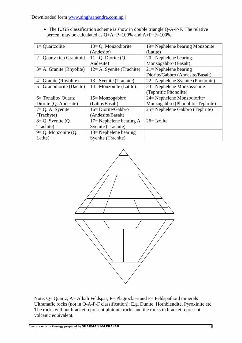
Mineralogical classification by International union of geological sciences (IUGS
1967):
This classification also known as Albert Streakaisens classification.
Igneous rocks are classified on the basis of mineral content in volume percent.
Most of the igneous are found in nature contains Feldspar (Alkali feldspar and
plagioclase), silica rich mineral (Quartz) and silica deficiency minerals
(Feldsfathoids).
The felsic, intermediate and mafic rocks are described in Q-A-P-F classification
but ultramafic rocks do not described in this classification. Such classification
based on dark colored mineral contents.
Felsic rock: Less than 40% dark colored minerals.
Intermediate rock: Dark colored minerals in between 40 to 70%.
Mafic rock: Dark colored minerals in between 70 to 90%.
Ultramafic rock: More than 90% dark colored minerals.
| Downloaded form www.singhranendra.com.np |
Lecture note on Geology prepared by SHARMA RAM PRASAD 18
The IUGS classification scheme is show in double triangle Q-A-P-F. The relative
percent may be calculated as Q+A+P=100% and A+P+F=100%.
1= Quartzolite 10= Q. Monzodiorite
(Andesite)
19= Nephelene bearing Monzonite
(Latite)
2= Quartz rich Granitoid 11= Q. Diorite (Q.
Andesite)
20= Nephelene bearing
Monzogabbro (Basalt)
3= A. Granite (Rhyolite) 12= A. Syenite (Trachite) 21= Nephelene bearing
Diorite/Gabbro (Andesite/Basalt)
4= Granite (Rhyolite) 13= Syenite (Trachite) 22= Nephelene Syenite (Phonolite)
5= Granodiorite (Dacite) 14= Monzonite (Latite) 23= Nephelene Monzosyenite
(Tephritic Phonolite)
6= Tonalite/ Quartz
Diorite (Q. Andesite)
15= Monzogabbro
(Latite/Basalt)
24= Nephelene Monzodiorite/
Monzogabbro (Phonolitic Tephrite)
7= Q. A. Syenite
(Trachyte)
16= Diorite/Gabbro
(Andesite/Basalt)
25= Nephelene Gabbro (Tephrite)
8= Q. Syenite (Q.
Trachite)
17= Nephelene bearing A.
Syenite (Trachite)
26= Izolite
9= Q. Monzonite (Q.
Latite)
18= Nephelene bearing
Syenite (Trachite)
Note: Q= Quartz, A= Alkali Feldspar, P= Plagioclase and F= Feldspathoid minerals
Ultramafic rocks (not in Q-A-P-F classification): E.g. Dunite, Hornblendite, Pyroxinite etc.
The rocks without bracket represent plutonic rocks and the rocks in bracket represent
volcanic equivalent.

| Downloaded form www.singhranendra.com.np |
Lecture note on Geology prepared by SHARMA RAM PRASAD 19
SEDIMENTARY ROCKS: Introduction: A rock resulting from the consolidation of loose sediments which are derived from the pre-
existing rocks & minerals, chemical precipitation from solution and an organic remains of
plants and animals at or near the earth's surface.
The sedimentary rocks that originate with the accumulation of discrete mineral or
rock particles derived from weathering and the erosion of pre-existing rocks (i.e.
deposited by mechanical means). Such rocks are called clastic or detrital
sedimentary rock. The particles in those rocks called clastic/detrital and sometimes
fluvial (deposited by river).
The sedimentary rocks that originate from the chemical precipitation as well as from
the biologic means are called non-clastic sedimentary rock. The particles in those
rocks called chemically deposited and biological sediment.
Stages of formation of sedimentary rocks: 1. The breaking down of the pre-existing rocks. (By weathering i.e. due to
decomposition & disintegration.)
2. Erosion of weathering products due to the action of natural agencies like water, wind,
glaciers etc.
3. Transportation of eroded materials due to those natural agencies.
4. Deposition of transported materials under suitable condition.
5. Transformation of deposited materials (sediments) into sedimentary rocks due to the
process of diagenesis.
Diagenesis is the sum of physical, chemical or biochemical changes in a sedimentary
deposit after its initial deposition and before metamorphism. Diagenesis occurs at
temperature below 300oc and pressures less than 1kbar and under static load. Diagenesis
involves following processes:
I. Consolidation: It is the process of removing pore water under static load. It is a
time dependent phenomenon. For coarse sediment, drainage is sufficient and
consolidation is instantaneous.
II. Compaction: It is the reduction of pore space in response to pressure. It occurs by the
readjustment & preferred orientation of equi-dimensional grains.
III. Dissolution: The water moving through the pores dissolve the grains and reduce the
grain size. It depends upon composition of water and grains. Evaporites, limestone
are more soluble and form solution channels.
IV. Pressure Solution: It is a process in which a solid dissolves at its contact with
another solid and with pore water; because increased pressure has increased its
solubility. Due to this, grains are welded together and the pore space is reduced.
V. Replacement: The pore water contain various ions, they may replace the grains and
change partially or wholly the composition of grains. Calcites are replaced by silica,
phosphorite, magnesium etc.
VI. Decomposition (Matrix Formation): Decomposition of feldspar or unstable rock
fragment occurs during the deep buried of sediments.
VII. Cementation: It is the process of binding of grains to form an aggregate mass. It is
due to the precipitation of minerals in the pore spaces. Common cementing minerals
are calcite, silica, clay minerals, ferromagnesians, gypsum etc.
VIII. Neomorphism: New shape formation due to either grain size increase or decrease.
The above mention processes are not dominance in all type of sediment but one
kind of process may be dominant in one kind of sediment. Simply as,
Limestone: Recrystallization
| Downloaded form www.singhranendra.com.np |
Lecture note on Geology prepared by SHARMA RAM PRASAD 20
Shale: Compaction
Sandstone: Cementation & Composition
Texture of Sedimentary Rocks: Texture is the relationship among the mineral grains and includes size, shape and
arrangement of the constituent particles in rock.
a. Grain Size: The principal factors which determine the size of grain are: Mode of
weathering, Composition of pre-existing rocks, the kind & amount of transport
suffered by the materials. The size grades of clastic particles are as follows:
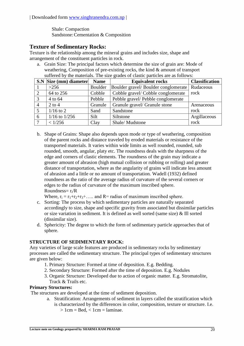
S.N Size (mm) diameter Name Equivalent rocks Classification
1 >256 Boulder Boulder gravel/ Boulder conglomerate Rudaceous
rock 2 64 to 256 Cobble Cobble gravel/ Cobble conglomerate
3 4 to 64 Pebble Pebble gravel/ Pebble conglomerate
4 2 to 4 Granule Granule gravel/ Granule stone Arenaceous
rock 5 1/16 to 2 Sand Sandstone
6 1/16 to 1/256 Silt Siltstone Argillaceous
rock 7 < 1/256 Clay Shale/ Mudstone
b. Shape of Grains: Shape also depends upon mode or type of weathering, composition
of the parent rocks and distance traveled by eroded materials or resistance of the
transported materials. It varies within wide limits as well rounded, rounded, sub
rounded, smooth, angular, platy etc. The roundness deals with the sharpness of the
edge and corners of clastic elements. The roundness of the grain may indicate a
greater amount of abrasion (high mutual collision or rubbing or rolling) and greater
distance of transportation, where as the angularity of grains will indicate less amount
of abrasion and a little or no amount of transportation. Wadell (1932) defined
roundness as the ratio of the average radius of curvature of the several corners or
edges to the radius of curvature of the maximum inscribed sphere.
Roundness= ri/R
Where, ri = r1+r2+r3+….. and R= radius of maximum inscribed sphere.
c. Sorting: The process by which sedimentary particles are naturally separated
accordingly to size, shape and specific gravity from associated but dissimilar particles
or size variation in sediment. It is defined as well sorted (same size) & Ill sorted
(dissimilar size).
d. Sphericity: The degree to which the form of sedimentary particle approaches that of
sphere.
STRUCTURE OF SEDIMENTARY ROCK:
Any varieties of large scale features are produced in sedimentary rocks by sedimentary
processes are called the sedimentary structure. The principal types of sedimentary structures
are given below:
1. Primary Structure: Formed at time of deposition. E.g. Bedding.
2. Secondary Structure: Formed after the time of deposition. E.g. Nodules
3. Organic Structure: Developed due to action of organic matter. E.g. Stromatolite,
Track & Trails etc.
Primary Structures:
The structures are developed at the time of sediment deposition.
a. Stratification: Arrangements of sediment in layers called the stratification which
is characterized by the differences in color, composition, texture or structure. I.e.
> 1cm = Bed, < 1cm = laminae.

| Downloaded form www.singhranendra.com.np |
Lecture note on Geology prepared by SHARMA RAM PRASAD 21
b. Cross Bedding: Layering inclined at an angle to the main bedding planes of
general stratification. Mainly in steeply dipping forest bed.
c. Graded Bedding: Layers are formed with sharply distinct grains. Typical in
marine deposit.
d. Ripple Marks: The wavy structures were developed in sedimentary strata. Such
structures were formed due to the drag of waves and current of water or wind
over sediments i.e. mainly in sand and silt size sediment. They may be
symmetric and asymmetric in nature.
Wave Ripple Mark: Symmetric, through waves
Ripple marks in sediment of stagnant water.
Current Ripple Mark: Asymmetric, through
flowing water and wind in sediment.
e. Mud Cracks: Formed due to shrinkage of mud at dry. River flood plain or floors
of lakes are suitable sites of mud cracks.
Organic Structure:
Track & Trails: The movement of organisms on the loose & soft sediment. Organisms may
develop the markings, impressions or foot prints in the sediment. Such structures are called
are known as track & trails.
Importance of primary sedimentary structures: The primary sedimentary structures provide valuable information as,
Show palaeocurrent condition through the analysis of sedimentary particles.
Rate of supply of sediments from source area.
Mode of transportation of sediment due to the analysis of particles.
Environment of deposition through sediment analysis.
Gives information about top and bottom of bed i.e. younger and older.
Classification of sedimentary rocks: The classification of sedimentary rocks has been a problem till now. The classification is an
organization of knowledge and schistematic representation of ideas. Single classification
schemes for all sediments encounter difficulties due to polygenetic nature of sedimentary
rocks. Few most important scheme of classification of sedimentary rocks are given below:
1. The classification based on genesis of sediments:
a) Residual sedimentary rocks: The rocks were formed from weathering residue at in situ
place. E.g. Laterite, Bauxite
b) Mechanical sedimentary rocks: The rocks were formed due to deposition under
suitable condition. E.g. Shale, sandstone, conglomerate
c) Chemical sedimentary rocks: The rocks were formed due to precipitation and
consequent accumulation of the soluble constituents. E.g. Limestone, dolomite
d) Organic sedimentary rocks: The rocks were formed due to the organic matter
accumulation and their preservation under suitable condition. E.g. Coal, Fossiliferous
limestone.
2. The classification based on grain size: See texture.
3. Classification by Greensmith (1957):
A. Clastic:
I. Rudite- Boulderbeds, Conglomerates
II. Arenite- Sandstone
III. Lutite- Siltstone, Claystone

| Downloaded form www.singhranendra.com.np |
Lecture note on Geology prepared by SHARMA RAM PRASAD 22
B. Non-clastic:
I. Calcareous- Carbonate of Ca, Mg. E.g. Magnesite
II. Carbonaceous- Organic, E.g. Lignite
III. Ferriginous- Fe2o3, Mno2 e.g. Ironstone
IV. Siliceous- Silica, E.g. Chert
V. Aluminous- Al2o3, hydrous oxides e.g. Laterite
VI. Phosphetic- E.g. Phosphorite
METAMORPHIC ROCKS
Introduction:
In Greek word 'meta' meaning change 'morphe' meaning shape or form.
Any rock derived from pre-existing rocks by mineralogical, chemical, structural or
textural changes in solid state, in response to marked changes in temperature, pressure
and chemical environment at depth in earth's crust i.e. below the zone of weathering and
cementation. The rocks are derived from igneous rocks are called orthometamorphic
rocks e.g. Gneiss. The rocks are derived from sedimentary rocks are called Para
metamorphic rocks e.g. Slate.
Metamorphism: The processes which changes pre-existing rocks into new ones.
Agents of Metamorphism:
1. Heat:
Thermal energy results recrystallization and dehydration.
Thermal energy breaks chemical bonds.
They increase rate of reaction. Heat leads to changes in mineralogical
composition and crystals and, that leads to make coarse texture.
2. Pressure: Uniform Pressure (Equidimensional pressure)
Directed pressure (differential force)
Uniform pressure leads to changes of volume by pore space reduction due to
closer atomic packing.
Directed pressure leads to changes of shape, texture & structure.
3. Chemically active fluids:
The changes take place through partial or complete solution of the minerals.
The most important chemically reactive fluids derived from magma and other
source i.e. water, CO2 etc.
They lead to chemical changes in rocks.
Texture of metamorphic rocks:
Textures are the small scale features developed in metamorphic rocks. Texture refers to the
shape, size, orientation and arrangement of mineral grains in a metamorphic rock.
In describing metamorphic texture the term ―blastic‖ or ―blast‖ are used as a suffix to
represent the metamorphic equivalent of igneous texture e.g. Porphyroblastic or
porphyroblast for porphyritic texture of igneous and prefix ―blasto‖ is used to describe relict
texture of pre-existing rocks e.g. Blasto- porphyritic of relict porphyritic texture of igneous
rocks.
| Downloaded form www.singhranendra.com.np |
Lecture note on Geology prepared by SHARMA RAM PRASAD 23
METAMORPHIC STRUCTURE
Five major types of metamorphic structure are given below on the basis of texture and agent
included in formation of metamorphic rocks. The metamorphic structures are the large scale
features developed in metamorphic rocks. They are measured in hand specimen.
1. Cataclastic structure: under directed pressure i.e. stress. E.g. Granite, Mylonite.
2. Maculose structure: From thermal metamorphism in argillaceous rocks. Dark colored
minerals giving a spotted appearance. E.g. Slate.
3. Schistose structure: under stress platy or flaky minerals in parallel orientation. In
micas & inequidimensional minerals. E.g. Biotite, Schist
4. Granulose Structure: From heat & uniform pressure in equi-dimensional minerals by
the process of recrystallisation. E.g. Quartzite, Marbles
Also known as Sacchroidal structure. E.g. Marble
5. Gneissose structure: banded structure due to alternation of dark colored & light
colored minerals by highest grade of metamorphism through regional metamorphism.
E.g. Granite, Gneiss
RECOGNIZATION OF METAMORPHIC ROCK
1. Foliation:
Refers to the parallel orientation of platy or ellipsoidal minerals or mineral banding in
rocks,which is formed by the segregation of minerals. It includes compositional layering
and slaty cleavage, as in slates; schistosity, as in schist and compositional layering as in
Gneiss.
a. Schistosity: A parallel arrangement of Micas or other platy minerals giving a more or
less planar fissility with decrease in grain size. This structure is easily measured in
Schist and Phyllite.
b. Slaty cleavage: The parallel arrangement of very fine grained minerals or micas
which gives it very good planar fisility. This structure is easily measure in slate.
c. Gneissocity: The alternation o lighter and darker layers in a rock. This structure is
easily measured in Gneiss.
d. Lineation: The parallelism or alignment of linear elements in the rock, which are
formed by aligned prismatic grains, aggregates of minerals, axes of micro folds and
lines of intersection of two or more planar element.
TYPES OF METAMORPHISM
Metamorphism is broadly classified into three major categories on the basis of the dominant
agent involved in the formation of the rocks.
1. Contact metamorphism: (Thermal metamorphism)
Resulted from emplacement of a hot igneous intrusion into cooler country
rocks at relatively low pressure.
Heat is dominating factor.
The metamorphism operation area around the magma intrusion called Contact
Aureole.
Changes in mineral composition & Texture.
Commonly formed in carbonate –rich country rocks.
Contact metamorphic rocks are usually massive.
Example, Limestone to Marble.
2. Regional metamorphism: It occur over wide areas (hundreds of kilometer) & within
large Orogenic (mountain building process) belts.
Temperature and directed pressure are dominating factors.
Regional metamorphism also classified into following two types.

| Downloaded form www.singhranendra.com.np |
Lecture note on Geology prepared by SHARMA RAM PRASAD 24
a. Regional Dynamothermal metamorphism:
Results from the thermal gradient in broad region.
The rocks are characterized by a parallelism of platy and elongated minerals.
Changes both mineral composition &texture.
b. Regional burial metamorphism: (high grade diagenesis )
Results from the thick piles of hydrous sediments or fragmental volcanic
materials due to several hundred degrees temperature with high water
pressure.
Lack of significant parallelism of metamorphic mineral grain.
Difficult to identify but only possible in polarizing microscope.
Example, Geolite, Glaucophane etc are burial metamorphic mineral.
3. Dynamic metamorphism: (Cataclastic metamorphism)
Occurs in zone of intense deformation as fractures, faults etc at shallow
depths.
Change in texture i.e. decrease in grain size.
Mechanical deformation produces rocks ranging from Breccias to Mylonites.
Directed pressure is dominating factor.
CLASSIFICATION OF METAMORPHIC ROCKS
The metamorphic rocks have been classified on the following basis.
1) The parent rocks from which they have been metamorphosed.
a. Orthometamorphic rocks: From igneous rocks.
b. Parametamorphic rocks: From sedimentary rocks.
2) Structure, texture and predominance of agents.
a. Foliated rocks: The rocks were formed by parallel arrangement of minerals
during regional metamorphism e.g. Slate, Phyllite, Schist etc.
b. Non-foliated rocks: The rocks were formed by equidimentional mineral grains
during contact metamorphism e.g. Quartzite and Marble.

| Downloaded form www.singhranendra.com.np |
Lecture note on Geology prepared by SHARMA RAM PRASAD 25
Unit 6: Geological time
Historical geology: The origin and evolution of the earth and its inhabitants.
Stratigraphy: The branch of geology dealing with the definition and interpretation of
stratified rocks; especially their lithology, sequence, distribution and correlation.
PRINCIPLES OF STRATIGRAPHY
The most fundamental principles of stratigraphy (in 19th
century) had been recognized. They
are given below.
1. Principle of superposition (Stenoes principles):
- In undisturbed sequence, the bottom layers are older than overlying layer.
- In disturbed sequence, determine top and bottom of beds.
A. Stratigraphic criteria: Original features were developed at the time of deposition.
E.g. Graded bedding, cross bedding etc.
B. Tectonic criteria: Features were developed due to tectonic movements. E.g. drag
fold, overthrust etc
2. The principle of funnal succession:
An older rock contain primitive organism and younger rock contain more advanced life.
3. Principle of uniformatism (actualism):
The geologic processes of the past were pronounced by the same processes acting today.
or Present is key to the past.
4. Walther’s law of facies correlation:
The succession of facies and lateral variation of deposition may be taken place at the
same time of different environment.
5. Principle of cross cutting relationship:
Any body of rock that cut across the boundaries of other unit of rock must be younger.
6. Principle of inclusion:
The enclosed rocks are older than enclosing rocks.
7. Law of palaeogeography: This is the distribution and relationship of ancient seas and land masses. Ancient
geography is reconstructed through an interpretation of the sedimentary rocks and fossils
of a certain age. E.g. the fossiliferous sediment of Mt. Everest shows once it was the
bottom of an ocean floor in historic time.
8. Law of unconformities: At any places of geologic record, there is an evidence of crustal upliftment followed by
long period of erosion. Such break or gap in the record called unconformities.
9. Principle of correlation: Correlation is the matching of rock strata of the relative same age. Similar stratigraphic
units can be correlated to each other. Few most important evidences of correlation are
given below.
A. Palaeontological evidences:
a. Similarities of fossils.
b. Index fossils
c. Palaeontological sequences.
d. Palaeontologic similarity
e. Evolutionary development.
B. Physical evidences:
a. Continuity of strata.
b. Lithologic similarity
c. Position of stratigraphic sequence
d. Metamorphism
e. Radioactivity.etc.

| Downloaded form www.singhranendra.com.np |
Lecture note on Geology prepared by SHARMA RAM PRASAD 26
Stratigraphic nomenclature:
All stratigraphic units require distinctive names or comparable designations in order that they
may be identified and differentiated from each other. The stratigraphic names derived from,
o Due to more recognized place.
o Due to geographic features.
o Due to distinguishing physical features.
o Due to characteristic fossils, formations etc.
General introduction to Lithostratigraphy and Chronostratigraphy:
Lithostratigraphy:
It is the branch of stratigraphy concerned with the organization of strata into units based on
lithological characters and the correlation of that unit. Or
It is the branch of stratigraphy in which the division, classification, correlation of rock strata
on the basis of their lithologic characters.
Lithostratigraphic units: It is body rock having certain unifying lithological features. They are
naming by locality, lithology and unit terms. They are identified by following characters.
Defined and classified on the basis of rock strata.
Characterized by lithozones, lithohorizons.
Key beds, marker beds and unconformities are boundaries of lithostratigraphic units.
Different rocks unit are divided and identified on the basis of color, textures, density
etc.
The basic lithostratigraphic units are given below just like as to animal classification.
Super group (Complex)
Group
Formation
Members
Beds
(Additional fundamental units are designated as adding prefix super and sub for larger and
smaller respectively.)
Geologically mapable units:
a. Small scale: 1: 5000000 to 1: 1000000
b. Intermediate scale: 1: 1000000 to 1:25000
c. Large scale: 1: 25000 to 1: 1000
Complex:
o It is regional stratigraphic unit generally used in metamorphic rocks.
o The mapable scale as 1: 5000000
o E.g. Nuwakot and Kathmandu complex.
Group:
o Group is naming by geographic region.
o It covers large area and large thickness.
o It includes several different formations.
o The mapable scale as 1: 1000000
o Group is equivalent to the ‗system‘ of chronostratigraphic units.
o E.g. Kathmandu complex: a. Phulchouki group
b. Bhimphedi group
Formation:
o Basic unit of lithostratigraphic units.
o It covers several hundred of meters.
o Mapable in intermediate scale i.e. generally 1: 50000

| Downloaded form www.singhranendra.com.np |
Lecture note on Geology prepared by SHARMA RAM PRASAD 27
o Named after the combination of type locality and rock types. E.g. Dhading dolomite
and Malekhu limestone of lower Nuwakot group of central Nepal.
o It includes different members and beds.
o It is comparable with ‗series‘ of chronostratigraphic unit.
Members:
o It includes several beds of distinct lithologic composition.
o It covers several tens of meter thickness.
o It is mapped in larger geological scale i.e. 1:10000 to 1: 25000
o E.g. Riri member in Kaligandaki super group of Palpa.
Beds:
o It is smallest lithostratigraphic unit.
o Thickness ranges from few cm. to few meters.
o It is lithologically and economically important unit i.e. for mine location.
o E.g. Jhiku calcareous bed of the formation Benighat slate of central Nepal.
Chronostratigraphy:
Chronostratigraphy is that area of stratigraphy dealing with the age and time relation of strata.
or
It is the branch of stratigraphy in which division, classification, correlation of rocks and
geologic history is based on time interval.
o The chronostratigraphic classification is the organization of rock strata into units on
the basis of their age of time of origin.
o The applied units in chronostratigraphy are rock time units which are also called
chronostratigraphic unit and derived from the geochronologic units where the rocks
formed during the specific interval of time.
o The chronostratigraphic units were naming on the basis of geographic and any
geological features. E.g. Jurassic period – From Jura Mountain of Europe,
Carbonaceous period- from coal area etc. Other naming by priority rule.
The recognized chronostratigraphic units and their equivalent time units from most inclusive
to least exclusive are as given below.
Chronostratigraphic unit Equivalent time unit (Span of time)
Eonothem Eon
Erathem Era
System Period
Series Epoch
Stage Age
Chronozone Chron
Methods of chronostratigraphy (In rock classification, correlation and age determination):
I. Direct (Absolute): From radiometric dating i.e. Uranium lead method, Potassium-
Argon method, Carbon method etc.
II. Indirect (Relative):
a. Palaeontological method: From the analysis of index fossils or assemblage of
fossils.
b. Palaeomagnetic method: Due to magnetic reversal.
Biostratigraphy:
It is the branch of stratigraphy in which division, classification, correlation of rocks and
geologic history is based on palaeontological features (Fossils) developed in rock strata.
Biostratigraphic units are the body of strata that is identified by the particular fossil content.
The basic unit of Biostratigraphy is ‗biozone‘.

| Downloaded form www.singhranendra.com.np |
Lecture note on Geology prepared by SHARMA RAM PRASAD 28
Fossils and condition of fossilization: Fossils: The remnant or trace of organisms buried by natural cases and preserved in the
earth‘s crust. Or the remnants of ancient life were preserved in geologic past.
Fossilization: The processes of formation of fossils and their preservation in rock strata are
known as fossilization. The most important conditions of fossilization are given below.
I. Quick burial in protective medium: The deposited organisms did not decompose by
Bacteria and did not disturb by oxidation or by other means.
II. Presence of hard part: The hard part of organisms had good preservation in rock strata
i.e. bones, teeth, shell, woody tissue of plants etc. The soft parts were easily
decomposable but rarely preserved.
Types of fossilization:
Fossilization
Petrifaction: Preservation of hard parts of many organisms by mineral bearing solution after
burial in sediments.
Mould: The impression of fossil shell on encasing materials.
Cast: The mould was filled by mineral matter.
Coprolites: The fossilized faecal (excreted) matter.
Gastroliths: The highly polished and rounded stones from certain extinct reptiles.
Index fossils Certain forms of extinct animals and plants were restricted to the beds of definite geological
age beyond which they were not known to occur called the index fossils. The formations of
index fossils are dependent on following parameters.
a. The short geological range i.e. limited interval of time.
b. The organisms are most abundant in quantity.
c. The organisms should in wide geographical distribution.
d. The organisms should have easy in identification.
Direct evidence
Indirect evidence or
trace of organisms
Actual remains
Altered hard part
Unultered soft part e.g. woof, mammoth
Unultered hard parts
Carbonized e.g. Jellyfish
Petrification
Recrystallized- e.g. Brachiopod shell
Dehydrated and crystallized e.g.
Radiolarian test
Replaced
Moulds and cast
Tracks and trails
Burrows and boring
Coprolites
Gastroliths
Pseudofossils
| Downloaded form www.singhranendra.com.np |
Lecture note on Geology prepared by SHARMA RAM PRASAD 29
Uses of index fossils:
For the classification of stratigraphy.
For the correlation of different rock strata in stratigraphic paleontology.
It is the tools for the determination of the relative age of fossilliferous strata.
Limitation of index fossils:
The organisms have own definite physio-chemical condition. The all species have the
same geographical distribution.
Some species have wide range of adapting ability and they widely distributed in the
earth surface.
Any organisms may reappear higher up in younger beds.
The organic evolution A study of evolution indicates that our modern day plants and animals have attained their
present degree of development as a result of gradual or orderly changes which taken place in
the geologic past. The theories of organic evolution were given by Lamark, Darwin and Hogo
de veries.
I. Lamark (1809):
a. Theory of inheritance of acquired characters.
b. Theory of use and disuse.
II. Darwin (1859):
a. The struggle for existence.
b. Variation.
c. Natural selection.
d. Sexual selection.
III. The mutation theory (Mutation-sudden change or variation in germ plasm of
organisms). Inherited to the offspring and passed from one generation to another.
Evidences of evolution:
i. Evidences from comparative anatomy.
ii. Evidences from embryology.
iii. Evidences from classification.
iv. Evidences from genetics.
v. Evidences from geographic distribution.
vi. Evidences from paleontology.

| Downloaded form www.singhranendra.com.np |
Lecture note on Geology prepared by SHARMA RAM PRASAD 30
Geological time scale The earth has undergone multitudinous changes during its long history. These changes both
physical and biological had a marked effect on the climate, geography, topography and life
forms of prehistoric times. An arbitrary chronological arrangement of these geological events
in a chart like form called the geological time scale. The Precambrian i.e. cryptozoic time
may well represent as much as 85% of all earth history.
The geological time scale and the Himalayas (K. Kizaki)
Eon Era Period Mi.
yrs
Geological events
P
H
E
N
E
R
O
Z
O
I
C
C
A
I
N
O
Z
O
I
C
Quaternary Holocene 0.01 Uplift continues
Pleistocene 1.7 Upheaval of siwaliks
followed by Mahabharat
range
Tertiary Neogene Pliocene 5 Upheaval of whole
Himalayas
Miocene 24 Upheaval of Higher
Himalaya, Metamorphism
and nappe formation
Paleogene Oligocene 36 Uplift of Tibetan marginal
Mountains
Eocene 58 Collision of India with
Eurasia, Tethys sea dry up
Paleocene 66
ME
SO
ZO
IC
Cretaceous K1, K2, K3 144 India‘s northward drift
initiated (Dinosaur
disappear)
Jurassic J1, J2, J3 208 Break of Gondwana
Triassic T1, T2, T3 245 Dinosaur appear
PA
LA
EO
ZO
IC
Permian P1, P2 286
Carboniferous C1, C2 360
Devonian D1, D2, D3 406
Silurian S1, S2 438 Formation of gondwana
continent
Ordovician O1, O2, O3 505
Cambrian Ca1, Ca2,
Ca3
570 Tethys sea appear
(Trilobites)
CR
YP
TO
ZO
IC
PROT
ERO
ZOIC
Late proterozoic 1600
Early Proterozoic 2600
ARCH
EOZOIC
4500

| Downloaded form www.singhranendra.com.np |
Lecture note on Geology prepared by SHARMA RAM PRASAD 31
Unit: 7
WEATHERING: Weathering is the processes of disintegration and decomposition of rocks and minerals at or
near the earth surface. It is the initial stage of denudation & the static part of the process of
erosion. Weathering products are equilibrium in position with the new physio-chemical
condition and tend to accumulate in insitu forming soft layer called regolith.
Controlling Factors on Weathering: 1. Structure, Texture & Mineral Composition of Rocks
Structures: Joints, Cracks, Fissures, Beddings, Foliations.
Textures: Fine grained rocks – More Susceptible to weathering than coarse grained
Mineral Composition: High Silica content – Less weathering, Low Silica content –
More weathering
It depends upon Bowen's reaction series. (Consult Book)
2. Climate: Sum total of Temperature, Moisture (Humidity, Precipitation), Atmospheric
pressure, Wind etc
Tropical & arid climate – Physical weathering
Temperate & humid climate – Chemical weathering
Temperature: Diurnal & Seasonal temperature changes results contraction &
expansion of rocks High temperature within humid condition effects rate of chemical
weathering.
Rainfall: High precipitation saturate rocks increase pore pressure. H+, OH
-, HCO3
- ion
with water react unstable minerals causes Chemical decomposition.
3. Topography: It is the gradient of area
Most effective weathering in average topography is due to percolation of water.
In high relief less effective weathering but high rate of erosion & transportation.
4. Vegetation:
Plants roots on joints & fissures cause the disintegration of rocks.
Organic acid from plant decay cause decomposition.
5. Time:
Longer the time period the degree of weathering is maximum and affects the greater
rock volume.
Types of Weathering: Insolation: Due to thermal expansion results
1. Physical Weathering: exfoliation & granular disintegration.
Dilation: Due to pressure variation or unloading
Crystal Growth: Due to soluble constituents
(HaCl, CaCO3, MgSO4 etc) on fractures & joint
Frost action: Frost wedging (laterally)
Frost Heaving (Upwardly)
Colloidal Plucking: Soil colloids have power to
Loosen rocks.
2. Chemical Weathering: Process of mineral alteration due to chemical reaction.
Depending upon size, composition of rocks, temperature and humidity the most important
Chemical weathering are:
a. Hydration: Chemical union of water causing more stress.
E.g. CaSO4 + 2H2O CaSO4.2H2O
(Anhydrite) (Gypsum)

| Downloaded form www.singhranendra.com.np |
Lecture note on Geology prepared by SHARMA RAM PRASAD 32
Fe2O3 +nH2O Fe2O3.nH2O
(Hematite) (Limonite)
When the mineral is hydrated, OH- ion builds new crystal lattice.
b. Hydrolysis: Chemical reaction between ions of minerals and H+ or OH- ions of
water. H+ ion & OH- ions are measured by PH values.
When PH = 7 – H+ = OH
- (Neutral)
PH > 7 – H+
< OH- (Basic)
PH < 7 – H+ > OH
- (Acidic)
Example:
KAlSi3O8 + HOH HAlSi3O8 + KOH
(Orthoclase) (Unstable Colloidal Silica & Colloidal complex Clay)
& 2KOH + H2CO3 K2CO3 + 2H2O
MgFeSiO2 + 2HOH Mg (OH) 2 + H2SiO3 + FeO
(Olivine) (Silicic acid)
c. Oxidation: Chemical union of oxygen with metallic elements. It is active in Ferro-
magnesium minerals (Pyroxene, Hornblende & Olivine).
Example:
FeS2 + nO2 + mH2O Fe (SO4)3 Fe2O3.nH2O
(Pyrite) (Limonite)
PbS + 2O2 PbSO4 (Soluble)
d. Reduction: Opposite process of Oxidation.
Example:
2FeO 2Fe + O2
Fe3+
+ e- Fe
2+
S + H2 H2S
e. Carbonation: Addition of CO2 in minerals.
H2O+ CO2↔H2CO3
2KAlSi3O8+H2CO3 →K2CO3+AlSi2O5 (OH) 4(Kalonite) +4SiO2
f. Solution: mineral dissolved by water & removed in solution. Al2O3 have high ionic
Potential tend to remain in insitu & these controlled by PH value.
The CaCO3 is soluble in low PH & SiO2 is soluble in high PH.
E.g. CO2+ H2O↔H2CO3
CaCO3 +H2CO3 →Ca (HCO3)2
3. Biological Weathering: Disintegration and decomposition of rocks by the action of plants
and animals. Biological weathering due to,
Plants root on cracks results wedge.
Activities of burrowing animals.
Produce reducing gasses (H2S) results chemical weathering.
Organic acids i.e. humic acids in rain water increase its solvent power.
Some bacteria are active in reducing condition and making Sulphide.
Other bacteria can convert N2 to NH4 which affect the PH value.

| Downloaded form www.singhranendra.com.np |
Lecture note on Geology prepared by SHARMA RAM PRASAD 33
Processes of Weathering The most important following five processes are involved in weathering.
a. Dual effect of water molecules – freezing and expansion, electrical charge.
b. Disintegration
c. Decomposition
d. Weathering from organisms
e. Complex weathering
Significance of Weathering i. As an aid to mass wasting and erosion.
ii. As a factor in the general lowering of land surface.
iii. It contributes to the creation and modification of land forms.
iv. As a major process involved in the formation of regolith or soil.
v. Facilitates soil nutrients within earth crust. Most of the plant nutrients are
derived from weathering processes.
vi. Suitable site for plant growth and forest development.

| Downloaded form www.singhranendra.com.np |
Lecture note on Geology prepared by SHARMA RAM PRASAD 34
Unit: 8
GEOMORPHIC PROCESSES & THEIR AGENTS: Geomorphic Process: They are all those physical and chemical changes which effect a
modification of earth's surfacial form.
Geomorphic agents: Any natural medium which is capable of securing and transporting earth
materials. These are running water, wind, glacier, tides etc.
AN OUTLINE OF THE GEOMORPHIC PROCESSES
A. Exogenetic Processes:
1. Gradation (denudation):- It tends to bring surface of the lithosphere to a common level.
i. Degradation: Those level down.
Weathering
Mass wasting
Erosion
ii. Agradation: those levels up (deposition)
B. Endogenetic Processes:
i. Diastrophism: Movement of earth's crust.
ii. Volcanism
iii. Earthquakes
iv. Metamorphism
C. Extra-terrestrial Processes:
i. Infall of Meteorites
GEOLOGICAL PROCESSES:
Geological processes have been playing dominant role in shaping the surface of the earth due
to both constructive as well as destructive in nature. The following two major processes have
been operating in earth's lithosphere.
1. Endogenous Processes:
2. Exogenous Processes
Endogenous Processes:
The processes were originated within/under the earth's crust. These processes are caused by
thermal energy due to the decay and disintegration of radioactive elements and gravitational
differentiation in the mantle. The most important end genetic processes are as given below.
a) Earthquakes: It is a form of energy as in wave motion transmitted through the
surface layer of the earth and they produced due to underground dislocation of rocks.
An Earthquake is a sudden and temporary vibration set up on the earth's surface due
to the sudden release of energy stored in the rocks beneath the earth's surface.
Focus: The point within the earth where earthquake waves originate is called Focus
& from the focus the vibrations spread in all directions.
Epicenter: The point found on surface above the focus where the earthquake waves
reach first.
Seismic waves: The waves of energy sent out through the earth are called Seismic
waves. On the basis of amplitude, wavelength & nature of vibration, the seismic
waves are classified into following 3 main types:

| Downloaded form www.singhranendra.com.np |
Lecture note on Geology prepared by SHARMA RAM PRASAD 35
1. Primary or P-wave (Longitudinal wave): The rocks vibrate parallel to the
direction of wave propagation i.e. in the same direction as the waves are
moving. They travel in all media. This wave is fastest in all.
2. Secondary or S-waves (Transverse waves): The rocks vibrate perpendicular
to the direction of wave propagation. These waves travel only in solid media.
The transverse vibration causes a sacking of the earth surface.
The P & S-waves are traveling through the earth interior and
spread outward from the focus in all directions.
3. Surface or L-waves: These waves are transverse in nature and travel in the
earth surface away from the epi-centre. They travel at low speed in
comparison to P and S-waves. They produce more ground movement and are
responsible for most of the destructive force of the earthquake.
Causes of Earthquake:
Earthquake originates due to following two major causes:
1. Non-Tectonic Causes:
a. Surface Causes: Rock falls and avalanches, large landslides, underground
explosion of bombs, working of heavy machinery etc.
b. Volcanic Causes: Due to volcanic eruption and the hydraulic shock of magma.
c. Collapse of Subterranean cavities: In the caverns of Horst areas.
2. Tectonic Causes: The structural changes of the earth crust due to deformation or
displacement i.e. faulting or folding. An elastic rebound theory (Movement along a
fault) is proposed to explain the origin of tectonic earthquake.
Classification of Earthquake:
The earthquakes are classified mostly by the following criteria.
a. Cause of Origin:
Tectonic Earthquake
Volcanic Earthquake
b. Depth of Focus:
Surface Earthquakes (depth <10000m)
Shallow focus Earthquakes (depth in between 10-50kms)
Intermediate focus Earthquakes (depth in between 50-300kms)
Deep focus Earthquakes (depth >300kms)
Intensity & Magnitude of Earthquakes:
The strength of an earthquake can be measured either by its intensity or by its magnitude.
Intensity of an earthquake is a measure of a degree of damage and destruction. It can be
measured without any sensitive instrument. The line of equal intensity is known as
isoseismic line. The magnitude of an earthquake can be measured from Richter scale. The
Richter scale is Logarithmic. The most of the destructive earthquakes originate within
following two zones.
i. The Circum-Pacific belt: About 80% of all the terrestrial earthquake.
ii. The Mediterranean: Himalayan Seismic belt
b) Tectonic Movements: It results faulting, folding and creation of new landforms.
i. Orogeny: Mountain building activities with deformation of earth's crust.
ii. Epi-orogeny: Regional upliftment with marked deformation.
E.g. Mountains – Subsidence
Subsidence – Up
iii. Lateral Movements/Displacement: Displacement of the crustal blocks by
continental drift, ocean floor spreading etc.

| Downloaded form www.singhranendra.com.np |
Lecture note on Geology prepared by SHARMA RAM PRASAD 36
c) Volcanism: The processes of effusion/intrusion of magmatic materials on the surface
of the earth, thus forming carious volcanic structures and/or flowing over the surface
called Volcanism.
d) Metamorphism: It is the transformation of pre-existing rocks into new rock types by
the action of temperature, hydrostatic as well as directive pressure and chemically
active fluids.
Exogenous Processes: The processes of external origin (i.e. from outside the surface) are due to the effect of sun
energy, wind blow, moisture, the force of gravity, the activities of organisms etc. The
exogenous processes are closely linked with the role of geomorphic agents such as running
water, underground water, glaciers, wind etc on the surface of the earth. The exogenous
processes are divisible into two major categories viz. (i) Degradation (ii) Aggradations.
Degradation: The processes of level down (materials from high land are removed by the
geomorphic agents). The degradation of the earth's surface is mainly carried out through,
a) Weathering
b) Mass-Wasting
c) Erosion
Mass-Wasting: It is the processes of downward movement of soil/regolith and rock due to
the influence of gravity. C.F.S Sharpe (1938) classified mass movement on the basis of
movement involved are given below.
Soil Creep: in unconsolidated mass, on < 35o slope
Talus Creep: Coarse & fragments of rocks in downhill
movement i.Slow-Flowage: Rock Creep: Movement of jointed block
Rock Glacier Creep: Creep of boulder with stream of ice.
Solifluction: Water saturated regolith in down hill.
Earth flow: Water saturated soil move down from steep slope.
ii.Rapid Flowage: Mud flow: Fluid mass of fine soil in stream channel.
Debris avalanche: Saturated material with natural disturbance
Slump: Movement of bed rock mass down from curved surface
Debris Slide: Rapid down slope movement of coarser materials
iii. Landslides: through rolling & sliding process.
Debris fall: Materials fall from a vertical cliff.
Rock Slide: Rocks move down usually from weak surface.
Rock fall: Free falling or rolling from steep cliff.
iv. Subsidence:

| Downloaded form www.singhranendra.com.np |
Lecture note on Geology prepared by SHARMA RAM PRASAD 37
EROSION
The wearing away of any part of the earth's surfaces are due to the natural agencies. The
major processes of erosion are given below.
a. Abrasion or Corrasion: wearing down the surface and crave out due to the processes
of rubbing, rolling, scratching and grinding.
b. Attrition: Mechanical wears and tears of the transported materials by collision
themselves.
c. Corrosion: Chemical processes of rock erosion mainly from solution in Calcareous
rocks.
d. Cavitations: River with high pressure create hollow. E.g. Pot holes
e. Hydraulic action: materials move out due to Turbulence flow of water in river
channel.
Aggradations:
The levels up of the land are due to the processes of sediment deposition. When transporting
agents loose their carrying power, the transported materials get deposited in low lying tracts.
The deposition of sediments creates new land of various types.
Thus the processes of gradation are considered as three-fold processes because of the
following processes.
The earth surface is first decayed and eroded.
The product of the decay and erosion are transported, and
The transported materials are deposited in low lying areas
So the geological processes have been playing significant role in changing the surface of the
earth.

| Downloaded form www.singhranendra.com.np |
Lecture note on Geology prepared by SHARMA RAM PRASAD 38
Unit: 9
GLACIERS:
Snow: The frozen vapor falling from the sky in soft and white flakes in the ground.
Ice: The frozen water which makes water solid by cold.
Glacier: It is a moving mass of ice with rock debris and air under the influence of gravity.
Snow Line: The lower limit of snow is known as snow line. The snow line is divided broadly
into two categories.
a. Permanent: The snow line appears through out the year.
b. Temporary: The snow line appears only in the winter season.
The snow line is determined largely by latitude.
Snow line falls in the lower altitude (sea level) as latitude increases (at latitude 90o
North or North Pole.)
In the equatorial zone or latitude 0, the snow line appear above 6000m from sea
level.
Snow field: The massive accumulation of snow above snow line.
Nave or Firn: When the snow freezes and compacts, they are changes into granular ice
particles called Nave or firn. The neve undergoes changes which transform the entire mass
into glacier ice.
TYPES OF GLACIERS:
The glaciers are divided into three major groups on the basis of their stages of development,
size, shape and the relationships between the supply & flow areas.
a. Mountain or Valley Glacier:
o Simple Glacier
o Complex Glacier
o Cirque Glacier
o Transaction Glacier: They spill over dividing ridges & join with other glacier
in adjoining areas.
b. Continental Glacier:
c. Piedmont Glacier:
Valley Glacier: It is originated at the head of mountain valley. It occurs particularly in Alps
&Himalayas.
Continental Glacier or Ice Sheet: The broad ice masses in large land areas. The smaller ice
sheet called ice caps. Glaciers spread outward from the centre of the land mass as a radial
drainage pattern. They are mostly found in polar region. E.g. ice sheet in Antartica.
Piedmont Glacier: Two or more valley glacier emerges from adjacent mountain valleys on
to the plain below. The lower end of glaciers unites to form a broad rounded mass of ice
called Piedmont Glacier. E.g. Malaspina glacier of Alaska.
CAUSES OF GLACIATION:
Glaciations: The covering and alternation of the earth's surface by glacier and ice sheet. The
major causes of glaciations are given below:
a. Variation in the intensity of solar radiation.
b. Changes in the atmospheric composition – increase in CO2 causes green house effect
and increase temperature & vice versa.

| Downloaded form www.singhranendra.com.np |
Lecture note on Geology prepared by SHARMA RAM PRASAD 39
c. Increase of dust in the atmosphere absorbs solar heat causing decrease of temperature
at the surface.
d. Shifting of continent with respect to poles.
e. Elevation of continental masses by tectonic movement.
Movement of Glaciers:
Factors which affect the rate of movements are given below.
a. Size of the glacier (i.e. thicker-faster).
b. Slope & topography of the land.
c. Temperature of the area (Higher temperature-Faster move.)
d. The amount of unfrozen water in the glacier.
Depositional Features of Glaciers:
Three distinct types of depositional features are developed by glacier.
1. Unstratified Deposit
2. Stratified Deposit
3. Glacio-Lacustrine Deposit
Unstratified Deposit: Deposited by valley glacier. A heterogeneous mass of boulder to clay
sized particles in the form of unstratified deposit is called till. The land forms are developed
by till called Moraines. Moraines are found either on the body of existing glacier or in the
ancient glaciated valleys.
Surface Moraine: i. Lateral
Moving Moraines ii. Medial
Moraines Ground Moraine
(In Stream valley floor)
Englacial Moraine (in crevasses)
End Moraine
Stationary Moraines (At the end of Glacier)
Recessional Moraine
(Several end moraine in the form
of concentric fashion)
Erratic blocks: Deposition of different large block. A group of erratic block spread out fan
wise called Boulder Train.
2. Stratified or Glacio-Fluvial Deposits:
The landforms are developed due to the deposition earth materials by the stream which is
formed by the melting of glaciers.
Deposits are sorted and stratified.
The important depositional features are given below.
Outwash Plain: Materials carried out by melt water, deposited in gentler slope as a broad fan shaped deposits.
These are composed of sand and gravel. Outwash deposits in valley floor forming terrace like
feature called Valley trains.
Esker: A long, narrow, sinuous or straight ridges are formed due to melt water deposits. Ridge
appears in the direction of the movement of glacier. These are resulted due to Recession and
evaporation of melt water.
| Downloaded form www.singhranendra.com.np |
Lecture note on Geology prepared by SHARMA RAM PRASAD 40
Kame and Kame terrace:
Small, rather steep sided, flat topped hills of stratified deposits due to collection of sediments
in circular depressions. Layered deposits of sand and gravel formed in between the side of
wasting glacier and the adjoining valley wall called Kame terrace.
Kettles: Kettles are depressions developed on the surface of glacial deposits. These hollows are
formed by the melting of ice blocks that might have been enclosed or buried within the
glacial drift during time of deposition.
3. Glacio-Lacustrine Deposits: The deposition in glacial lakes.
Varves: Layering of fine clays and silts accumulated in Lake Bottom forming stratified layer
when the lake drain away. The fine sediments carried in lakes in suspension with the melt
water.
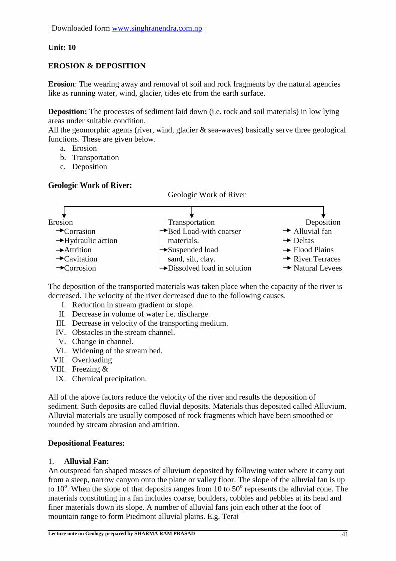
| Downloaded form www.singhranendra.com.np |
Lecture note on Geology prepared by SHARMA RAM PRASAD 41
Unit: 10
EROSION & DEPOSITION
Erosion: The wearing away and removal of soil and rock fragments by the natural agencies
like as running water, wind, glacier, tides etc from the earth surface.
Deposition: The processes of sediment laid down (i.e. rock and soil materials) in low lying
areas under suitable condition.
All the geomorphic agents (river, wind, glacier & sea-waves) basically serve three geological
functions. These are given below.
a. Erosion
b. Transportation
c. Deposition
Geologic Work of River:
Geologic Work of River
Erosion Transportation Deposition
Corrasion Bed Load-with coarser Alluvial fan
Hydraulic action materials. Deltas
Attrition Suspended load Flood Plains
Cavitation sand, silt, clay. River Terraces
Corrosion Dissolved load in solution Natural Levees
The deposition of the transported materials was taken place when the capacity of the river is
decreased. The velocity of the river decreased due to the following causes.
I. Reduction in stream gradient or slope.
II. Decrease in volume of water i.e. discharge.
III. Decrease in velocity of the transporting medium.
IV. Obstacles in the stream channel.
V. Change in channel.
VI. Widening of the stream bed.
VII. Overloading
VIII. Freezing &
IX. Chemical precipitation.
All of the above factors reduce the velocity of the river and results the deposition of
sediment. Such deposits are called fluvial deposits. Materials thus deposited called Alluvium.
Alluvial materials are usually composed of rock fragments which have been smoothed or
rounded by stream abrasion and attrition.
Depositional Features:
1. Alluvial Fan:
An outspread fan shaped masses of alluvium deposited by following water where it carry out
from a steep, narrow canyon onto the plane or valley floor. The slope of the alluvial fan is up
to 10o. When the slope of that deposits ranges from 10 to 50
o represents the alluvial cone. The
materials constituting in a fan includes coarse, boulders, cobbles and pebbles at its head and
finer materials down its slope. A number of alluvial fans join each other at the foot of
mountain range to form Piedmont alluvial plains. E.g. Terai

| Downloaded form www.singhranendra.com.np |
Lecture note on Geology prepared by SHARMA RAM PRASAD 42
2. Deltas: When a river flows into a large body of water such as sea or lakes, its velocity is
suddenly decreased and much of its load is dropped. Approximately triangular shape
deposits formed under this condition are called Deltas. E.g. Ganges Delta of India
(Figure)
Bottom-shaped Bed – Gentle seaward slope of finer materials
Foreset Bed – A steep slope deposit of silt and clay towards the sea.
Topset Bed – Thin layer sediment lying on the top of foreset bed.
3. Flood Plain: Flood plains are formed when a river in flood (overflow of river from its
banks). The velocity is reduced when the stream or river leaves its channel and much of
the load deposited on the valley floor.
4. Natural Levees: When stream flows over its banks onto the flood plain, the greatest
loss of coarse materials taken place along the bank of the channel and this process trend to
build up a ridge or embankment called a Natural levee. They may afford protection to the
adjacent low lands during time of flood.
5. River Terraces: The remnants of ancient flood plain that has undergone erosion are
known as river terraces. Such terraces are topographically higher than the surrounding flood
plain.
Agents & Processes of Erosion
Types of
Erosion
Active
Agents
Agent Alone Agent armed
with detritus
Detritus
alone
Solvent &
Chemical
Action
Mechanical loosening
& removal of
Materials passed over
Wearing of
surfaces by
transported
materials
Mutual wear
of materials
transported
Rain
Erosion
Rain
Water
Corrosion Splashing rainwater
sheetwash
Localized
Corrosion
Attrition
Slight; if any
River
Erosion
Rivers Corrosion Hydraulic lifting and
scoring Cavitation
Corrasion Attrition
Glacial
Erosion
Glaciers,
ice-
sheets
Corrosion
limited to sub-
glacial streams
Exaration (Plucking &
Quarrying)
Abrasion (e.g.
Striated
surfaces)
Attrition
Wind (or
Aeolian)
Erosion
Wind - Deflation (Blowing
away)
Wind Corrasion
(Sand Blasting)
Attrition
Marine
Erosion
Sea &
Ocean
waves,
tides &
current
Corrosion Various hydraulic
processes
Marine
Abrasion
Attrition.
Definition:
Abrasion: Wearing away of surfaces by mechanical processes such as rubbing,
cutting, scratching, grinding, and polishing.
Attrition: Reduction in size of detrital fragments by friction and impact during
transport.

| Downloaded form www.singhranendra.com.np |
Lecture note on Geology prepared by SHARMA RAM PRASAD 43
Cavitations: Collapse of bubbles of water vapor in highly turbulent eddies of water;
such collapse is like a negative explosion and sets of powerful shock-waves which
tend to disintegrate any adjacent rocks.
Corrasion: Cumulative effects of mechanical erosion by running water or wind when
charged with detritus and so provided with 'tools' or abrasives.
Corrosion: Wearing away of surfaces and of detrital particles and fragment by the
solvent and chemical action of natural water.
Deflation: Lifting and removal of dust and sand by wind.
Exaration: A term now little used, for modes of erosion by glacial ice, a kin to
'plucking' and ‗quarrying‘.
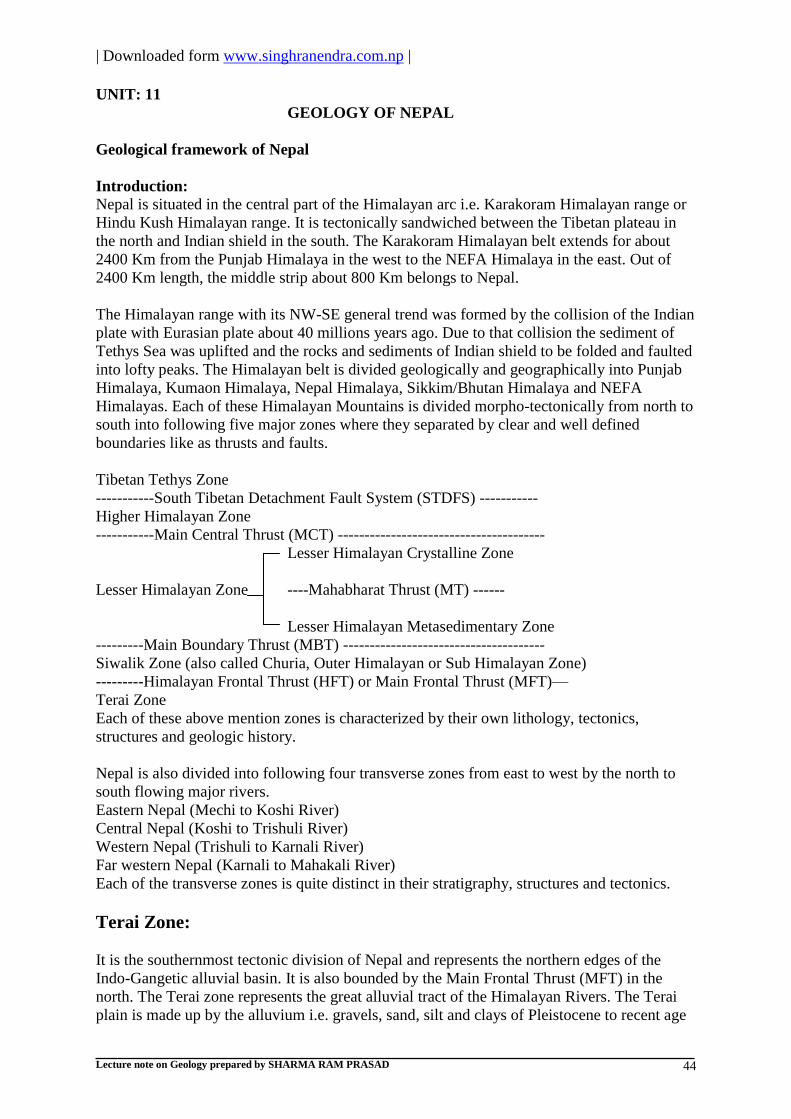
| Downloaded form www.singhranendra.com.np |
Lecture note on Geology prepared by SHARMA RAM PRASAD 44
UNIT: 11
GEOLOGY OF NEPAL
Geological framework of Nepal
Introduction:
Nepal is situated in the central part of the Himalayan arc i.e. Karakoram Himalayan range or
Hindu Kush Himalayan range. It is tectonically sandwiched between the Tibetan plateau in
the north and Indian shield in the south. The Karakoram Himalayan belt extends for about
2400 Km from the Punjab Himalaya in the west to the NEFA Himalaya in the east. Out of
2400 Km length, the middle strip about 800 Km belongs to Nepal.
The Himalayan range with its NW-SE general trend was formed by the collision of the Indian
plate with Eurasian plate about 40 millions years ago. Due to that collision the sediment of
Tethys Sea was uplifted and the rocks and sediments of Indian shield to be folded and faulted
into lofty peaks. The Himalayan belt is divided geologically and geographically into Punjab
Himalaya, Kumaon Himalaya, Nepal Himalaya, Sikkim/Bhutan Himalaya and NEFA
Himalayas. Each of these Himalayan Mountains is divided morpho-tectonically from north to
south into following five major zones where they separated by clear and well defined
boundaries like as thrusts and faults.
Tibetan Tethys Zone
-----------South Tibetan Detachment Fault System (STDFS) -----------
Higher Himalayan Zone
-----------Main Central Thrust (MCT) ---------------------------------------
Lesser Himalayan Crystalline Zone
Lesser Himalayan Zone ----Mahabharat Thrust (MT) ------
Lesser Himalayan Metasedimentary Zone
---------Main Boundary Thrust (MBT) --------------------------------------
Siwalik Zone (also called Churia, Outer Himalayan or Sub Himalayan Zone)
---------Himalayan Frontal Thrust (HFT) or Main Frontal Thrust (MFT)—
Terai Zone
Each of these above mention zones is characterized by their own lithology, tectonics,
structures and geologic history.
Nepal is also divided into following four transverse zones from east to west by the north to
south flowing major rivers.
Eastern Nepal (Mechi to Koshi River)
Central Nepal (Koshi to Trishuli River)
Western Nepal (Trishuli to Karnali River)
Far western Nepal (Karnali to Mahakali River)
Each of the transverse zones is quite distinct in their stratigraphy, structures and tectonics.
Terai Zone:
It is the southernmost tectonic division of Nepal and represents the northern edges of the
Indo-Gangetic alluvial basin. It is also bounded by the Main Frontal Thrust (MFT) in the
north. The Terai zone represents the great alluvial tract of the Himalayan Rivers. The Terai
plain is made up by the alluvium i.e. gravels, sand, silt and clays of Pleistocene to recent age

| Downloaded form www.singhranendra.com.np |
Lecture note on Geology prepared by SHARMA RAM PRASAD 45
(1.8 million years to present) with an average thickness of about 1500m. The varying width
of the Terai plain is 10 to 50 Km and forms the continuous belt from east to west exceptions
along the Chitwan (70 Km) and Rapti (80 Km) valleys. The topography below the alluvium is
not uniform; the depth to the basement beneath alluvial sediments also varies greatly
(Valdiya, 1988).
Stratigraphy:
On the basis of lithological variation the Terai plain is divided into three parallel strips from
north to south as given below.
a. Bhabar zone (Upper Terai): The coarser Terai sediments lie close to the Mountain
front which is known as Bhabar zone. It consists near about 100m thick sediment of
boulder, cobble, and pebble and with or without clays. It is made up of alluvial fan
deposits sloping to the south, with its southern margin marked by the spring line that
give rise to many streams.
b. Middle Terai: The middle Terai is an undulating terrain with isolated pocket of
waterlogged and marshy conditions towards the southern part of the Bhabar zone. It
consists of about 454mthick sediments of gravel, sand, silt and clay.
c. Southern Terai (Lower Terai): The southern Terai stretches along the Nepal-India
boarder, with an altitude of less than 90m. It consists of about 450m thick sediments
of sand, silt and clay.
Structure and tectonics:
Structurally the Terai plain is synclinal basin i.e. Himalayas to the north and Indian Peninsula
in the south. The rocks under the alluvium far south of the Mountain front are experiencing
tectonic activity and a number of thrusts and thrust propagated folds have been recognized
(Bashyal,1998, Mugnier et.al..1999) due to the shearing of a significant proportion of
Himalayan stress accumulation.
Degradation and aggradations:
The land system in The Terai is divided into recent flood plains of the rivers and older river
terraces. Generally gravel and boulder soil prevail in the foothills and sand silt and clay soils
are found in most of the remaining areas. The region often suffers from devastating flood and
droughts.
The Terai has experienced massive deforestation since the control of malaria except for the
‗protected forests‘, almost the entire Terai is cultivated.
Main Frontal Thrust (MFT):
A thrust plane passing through the northern part of the Terai plain and at the foothills of the
Siwalik range is called MFT. The lower Siwalik rocks override the recent alluvium of Terai
plain. It is active and enechelon (relatively short faults that are parallel and overlap each
other) in pattern.
Siwalik Zone:
The Siwalik Zone consists of fluvial sedimentary rocks of Neogene to Quaternary age (14 to
1 million years ago). This Zone is bounded to the north By MBT and to the south by MFT. It
is the southernmost hill range of Nepal. The Lesser Himalayan metasedimentary rocks have
been thrust southward over the Siwalik Zone rocks along the MBT due to that the large part
of the northern Siwalik Zone buried beneath them.

| Downloaded form www.singhranendra.com.np |
Lecture note on Geology prepared by SHARMA RAM PRASAD 46
Stratigraphy:
The Siwalik Zone of Nepal has been divided from top to bottom into three informal
stratigraphic formations as Upper Siwalik, Middle Siwalik and Lower Siwalik.
Upper Siwalik: The upper Siwalik is characterized by the presence of very coarse sediments
such as boulder conglomerate with minor proportion of mudstone intercalation.
Middle Siwalik: The middle Siwalik beds are marked by the first appearance of thick bedded
salt and peppery sandstone due to the abundance of dark colored biotite and light colored
quartz and feldspar minerals with alternating subordinate beds of mudstone. An occurrence of
paleosols (i.e. clay layer) with fossils of plants and freshwater mollusks is in the upper part
that shows fining upward sequence.
Lower Siwalik: The lower Siwalik is characterized by the presence of alternation of fine
grained sedimentary rocks as variegated mudstone, siltstone and shale with subordinate
amount of fine grained sandstone.
The lithostratigraphy of the Siwalik zone has been studied by many authors. The
lithostratigraphy of Siwalik zone of central west Nepal (by Tokuoka et.al. 1986) from bottom
to top is given in the following table.
Unit Main lithology Approx.
thickness
(m)
Fossil records
Arung Khola
Formation (Lower
Siwalik)
Variegated mudstone and fine
grained sandstone
2100 Shivapithecus
Binai Khola Formation
(Middle Siwalik)
Medium to coarse grained
sandstone, shale and mudstone
2800 Hiparian,
Rhinoceras,
Stegoden,
several bivalve
fossils.
Chitwan Formation
(upper Siwalik)
Pebbly conglomerate with few
coarse grained sandstone and
shale
700
Deorali Formation
(Upper Siwalik)
Poorly sorted angular to sub
angular conglomerate and rare
shale.
450
The dun valley within the Siwalik consists of quaternary fluvial sediments. The Siwalik
succession is 4 to 6 Km in thickness and fluviatile in origin. The Siwalik succession is also
contains invertebrate, vertebrate and plant fossils.
Structures and tectonics:
The Siwalik represents coarsening upward sequence with individual fining up cycles. The
coarsening upward sequence is indicating the intense upheaval of the Himalayas in the
geologic past. The Siwalik zone is tectonically less complicated than overlying Lesser
Himalayan zone. Siwalik rocks are faulted, thrusted and folded to the south over the recent
alluvium of the Terai zone. Intra-churia thrust called the central churia thrust (CCT) was
developed due to thrusting. These are confirmed by the repetition of the Formations. The
thrust propagated broad asymmetric folds have given rise to many wide valleys in the churia
zone of Nepal i.e. dun valleys which were generally filled with recent sediments.
Magmatism:
Hypabyssal basic magmatic sills and dykes of late Tertiary age have been reported from the
middle and lower Siwalik sequence of the central Nepal i.e. Dolerite in Marine khola section
(Herail et.al., 1986), small basic bodies along Dawar khola section (Kaphle and Pant, 1988).

| Downloaded form www.singhranendra.com.np |
Lecture note on Geology prepared by SHARMA RAM PRASAD 47
Degradation:
The Siwalik zone is generally covered with thick forests and comprises the youngest
sedimentary rocks. The soft, loose and easily erodible rocks represented by sandstone,
siltstone, mudstone, shale and conglomerate. Due to the combination of geologic,
anthropogenic and climatic (Rainfall 1500-2000mm per year) conditions has made the
Siwalik range highly susceptible to the common types of mass movement and erosion like as
gulley erosion, mudflow, and slumping, toppling and rock fall. The frequency of sliding
increases considerably in the rainy season due to saturation of soft rocks. The water
penetrates into the colluviums and than into the rocks along the fractures and joints. They
exert enormous water pressure causing huge slumps and mudflows. The mass movement can
also been activated due to the fast toe cutting by river which are flowing through upstream
land i.e. lesser Himalayan zone and road construction. Due to the land‘s inherent week
geologic characteristics, slope stabilization and erosion control is very difficult.
Main Boundary Thrust (MBT):
A thrust plane passing from the northern part of the Siwalik range and from the lower part of
the Mahabharat range called the MBT. The MBT is an active fault. The outcrop of the MBT
is very well exposed in the field.
a. The MBT is a low angle fault that has brought very older lesser Himalayan
metamorphic units over the Siwalik Zone.
b. MBT has sharply separates the outer metasedimentary belt of Lesser Himalayan zone
from the Siwalik zone.
c. The MBT follows mostly E-W trends of minor as well as major rivers.
d. The evidence of thrusting, the sedimentary structures in Siwalik rock adjacent to
MBT invariably show that the top of the beds are facing north and bottom of the beds
are facing south.
e. It has imbricate structures (Nearly parallel thrust faults that are overlap each other and
oriented in the same direction) with metamorphic areas.
f. It appears vertical in many places and in other places it becomes 30o to 45
o dipping
north.
g. The age of the MBT is Pliocene or Pleistocene that shows the evolution of the
Himalayas was late event.
h. The MBT area is highly susceptible to mass wasting due to tectonic activities.
Lesser Himalayan Zone:
The lesser Himalayan zone is bordered to the south by MBT and to the north by MCT. These
are reaching the altitudes of 4000m. Morphologically it can be divided into the southernmost
part called the Mahabharat range and more depressed part called the midland zone further
north. Both zones are 60 to 100Km wide and consist of more than 30 Km thick sequence.
These sequence are unfossiliferous sedimentary, metasedimentary and low- grade
metamorphic rocks such as shale, slate, phyllite, quartzite, limestone, dolomite etc. called the
lesser Himalayan metasedimentary zone. The age of these rocks are ranging from
Precambrian i.e. 1800 million years to Eocene i.e. 40 million years. The rocks in this zone are
highly folded and faulted, and have developed complicated structures. The high grade
metamorphic rocks such as marble, quartzite, schist, gneiss etc. with granite intrusion in the
lesser Himalayan zone are called the lesser Himalayan crystalline zone. These are rooted in
the higher Himalayan zone.
Stratigraphy and age:

| Downloaded form www.singhranendra.com.np |
Lecture note on Geology prepared by SHARMA RAM PRASAD 48
Stratigraphically, The lesser Himalayan zone is complicated in comparison to other zones due
to nappe formation. The simplified stratigraphy is given below.
1. The lesser Himalayan Metasedimentary zone:
The rock sequences are exposed in two distinct belts i.e. inner and outer belt.
The age of inner belt is mostly Precambrian to early Paleozoic and the age of the outer
belt in restricted area is Permo- Carboniferous to early Tertiary. The middle Paleozoic
gap is in the lesser Himalayan zone.
The simplified stratigraphic scheme of lesser Himalayan metasedimentary zone is as
given below.
Kuncha group (Precambrian)
Inner belt ----Unconformity--------------
Nawakot group (Precambrian to early Paleozoic)
-----------------Unconformity----------------------------------------------------
Permo-Carboniferous series (Sisne Formation, W.
Nepal)
------Unconformity---------------------------------------------
Outer belt i.e. Tansen group Mesozoic series (Gondwanaland of Taltung and Amile
Formation, W. Nepal)
Tertiary series (Gondwanaland of Bhainskati and Dumri
Formation, W. Nepal)
2. Lesser Himalayan Crystalline Zone:
The lesser Himalayan crystalline zone of Nepal is broadly divided into two
stratigraphic groups on the basis of lithological, metamorphic and structural
characters.
a. Bhimphedi group (Proterzoic to Precambrian)
b. Phulchoki group (Precambrian to lower Paleozoic
The lesser Himalayan crystalline zone are comprise the metamorphosed rock
sequence with an occasional fossiliferous sedimentary cover overlie the lesser
Himalayan metasedimentary rocks as klippen (remnants of overlying rocks due to
long period of erosion).
The lesser Himalayan zone consist of phyllite, marble, quartzite, schist and gneiss.

| Downloaded form www.singhranendra.com.np |
Lecture note on Geology prepared by SHARMA RAM PRASAD 49
The lesser Himalayan zone of Nepal is complete in central Nepal. The stratigraphy of lesser
Himalayan zone of central Nepal (Stoklin and Bhattrai, 1977) is given in the following table.
Unit Main lithology Approx.
thickness (m)
Age
--------------------------- ----------------------MCT--
--
------------- ----------------------------
Phulchoki group
Godavari limestone Limestone, Dolomite 300 Devonian
Chitlang Formation Slate 1000 Silurian
Chandragiri limestone Limestone 2000 Cambro-Ordovician
Sopang Formation Slate, calcareous Phyllite 200 ? Cambrian
-------------------------- --------Transitional
contact-
------------- ----------------------------
Bhimphedi group
Tistung Formation Metasandstone, Phyllite 3000 Precambrian/E.Cambrian
Markhu Formation Marble, Schist 1000 Precambrian
Kulekhani Formation Quartzite, Schist 2000 Precambrian
Chisapani quartzite White Quartzite 400 Precambrian
Kalitar Formation Schist, Quartzite,
Dolomite, Conglomerate
2000 Precambrian
Bhainsedovan marble Marble 800 Precambrian
Radhuwa Formation Garnetiferous Schist 1000 Precambrian
-------------------------- --Mahabharat thrust
(MT)--
------------- ----------------------------
Upper Nawakot
group
Robang Phyllite with
dunga quartzite
Phyllite, Quartzite 200-1000? Paleozoic
Malekhu limestone Limestone, Dolomite 800 Paleozoic
Benighat slate with
Jhikhu carbonate bed
Slate, argillaceous
Dolomite
500?- 3000? Paleozoic
------------------------- ---------Unconformity----
---
------------- ----------------------------
Lower Nawakot
group
Dhading dolomite Stromatolitic Dolomite 500-1000 Late Precambrian
Norpul Formation Phyllite, Quartzite,
Dolomite
800 Late Precambrian
Dandagaon pyllite Phyllite 1000 Late Precambrian
Fagfog quartzite White Quartzite 400 Late Precambrian
Kuncha Formation Phyllite, Quartzite 3000 Late Precambrian
------------------------- -----------MBT-------------
--
------------- ----------------------------
Magmatism:
Acidic rocks: Granitoid rocks such as Palung Granite, Dadeldhura Granite, Ulleri augen
Gneiss (source rock is granite) etc.
Basic rocks: Small sill like lenses and dykes of basic rocks are occurring in Manohari Khola
of Kuncha group, Tansen area, Barahchhetra etc.

| Downloaded form www.singhranendra.com.np |
Lecture note on Geology prepared by SHARMA RAM PRASAD 50
Intermediate alkaline rocks: A massif of Nepheline Syenite and alkaline Gneisses in the
Gorkha district at Ampipal and Dhorandi Khola.
Tectonics and Structures:
The tectonics and structures of lesser Himalayan zone of Nepal are more complicated in
comparison to other morpho-tectonic division. The tectonics of lesser Himalayan zone of
Nepal has been seen great variety from east to west. In eastern Nepal, the tectonics are
characterized by the development of an extensive crystalline thrust sheet i.e. nappe that has
traveled southward for at least 100Km to reach close to the outcrop of the MBT. The lesser
Himalayan rocks are exposed only in few large tectonic windows i.e. Taplejung, Arun and
Chautara-Okhaldhunga windows. The lesser Himalayan zone in central Nepal is similarly
occupied by the Kathmandu nappe. The outcrop of that nappe covered wide area around
Kathmandu and extends in narrow arm (south-eastward) along the Mahabharat range ti join
the great thrust sheet of eastern Nepal. The west of Kathmandu, the crystalline rocks are
restricted to the higher Himalayan zone north of MCT except for outcrops in a narrow klippe
in Jajarkot area and most of the areas have covered by the metasedimentary rocks. The lesser
Himalayan zone consist many major thrust as well as other types of faults and, several types
of anticline and syncline folds.
Degradation:
The lesser Himalayan zone is highly susceptible to mass movement due to the combination of
climatic factors, week geologic conditions, very steep slope, improper land use, intense
deforestation etc. The most common types of degradation and aggradations processes are
wedge failure, rock slide, rock fall, rock toppling, debris avalanche, deep gulley erosion,
debris flow, slump and several alluvial fans.
Main Central Thrust (MCT):
The thrust plane boundary between northern part of the lesser Himalayan zone and southern
part of the higher Himalayan zone is called the MCT. The thrust plane is a continuous plane
which separates two types of rocks such as low grade metamorphic rocks as Phyllite,
Quartzite, Slate etc. and high grade metamorphic rocks as Schist, Marble, Gneiss, Migmatite
etc. from east to west of Himalayas including Nepal. The MCT have divided into MCT1 and
MCT2 (Arita et.al., 1973).
MCT1 lie in between the high grade gneisses and low grade metasediments.
MCT2 is a contact between the low grade metamorphic rocks and very low grade
metasediments.
The rocks between MCT1 and MCT2 have been recognized as the MCT zone
sequence.
The tectonic zone of regional significance involve in breaking the stratigraphic
continuity between the rocks of different zones, the MCT1 is regarded as the real
MCT in the map and in the several literatures.
The age of MCT is Miocene and later period.
The rocks in MCT zone are highly metamorphosed like as migmatization due to
selective metamorphism by magma injection and their higher tectonic levels.
Several geothermal springs are found in the MCT zone e.g. hot spring of Dana area of
Myagdi district in Kaligandaki River, West Nepal.
Largely across the MCT, the metamorphic reversal is seen due to the hot iron model.
The MCT zone is highly susceptible to magma intrusion and mass movement.
Higher Himalayan Zone:

| Downloaded form www.singhranendra.com.np |
Lecture note on Geology prepared by SHARMA RAM PRASAD 51
The higher Himalayan zone is bordered to the south by MCT and to the north by STDFS.
Geologically, the higher Himalayan zone includes the rocks lying north of the MCT and
south of the fossiliferous rocks of Tibetan Tethys zone within the altitudinal range up to
8000m and more. The crystalline rock units of the higher Himalaya extend continuously
along the entire length of the country, its width (5 to 15Km) varies from place to place with
more than 10Km thickness. This zone is distinctive zone comprising of high grade
metamorphic rocks such as gneiss, schist, quartzite, marble and migmatites.
Stratigraphy:
The higher Himalayan zone is less complicated in comparison to lesser Himalaya. The
stratigraphy of higher Himalaya (informally) is given below from top to bottom.
Topmost sequence: It is represented by augen gneiss, granitic gneiss, granite and migmatites
e.g. Makalu granite i.e. Leucogranite.
Middle sequence: It is represented by calcareous gneiss with smaller interbanding of argillites
at various stages of gneissification.
Lower sequence: It is represented by the appearance of kyanite-sllimanite gneiss with
dominant argillo-arenaceous fraction i.e. quartzite.
The age of higher Himalayan zone is Precambrian (i.e. in basement rocks) and Tertiary (The
rock resulting from magmatic intrusion and thrusting).
Magmatism:
The igneous rocks i.e. leucogranite, granitic gneiss, pegmatites are resulted from acid
magmatism in topmost sequence (Le Fort, 1982).
The sills and dykes of amphibolites occur invariably in the lower and middle
sequence.
Structures and Tectonics:
The presence of diversely oriented micro-structures related to the multiple
deformational stages suggest their involvements in the orogenic movements prior to
the last Himalayan orogenesis.
The higher Himalayan zone constitutes a moderately NNE dipping homoclinal
structures.
Hagen (1969), Le Fort (1975) and Pecher (1977) divided the gneissic complex into a
series of thrust sheets which is thrusted over the rocks of lesser Himalaya.
Mass movement:
The rocks found in higher Himalaya have undergone metamorphism at very high
temperatures and pressures. They are comparatively strong and can support very steep slopes
with very little soil cover. Due to that the resulting erosion and mass movements are sheet
erosion, rock fall, debris fall and sudden glacier lake outbursts.
South Tibetan Detachment Fault System (STDFS):
Between higher Himalayan zone and Tibetan Tethys zone there is a north dipping normal
fault plane called the STDFS. The fault is a continuous plane separating high- grade
metamorphic rock with granitic intrusion and fossiliferous sedimentary rocks in the north.

| Downloaded form www.singhranendra.com.np |
Lecture note on Geology prepared by SHARMA RAM PRASAD 52
Tibetan Tethys Zone:
The Tibetan Tethys zone lies in between the STDFS in the south and extends to the north in
Tibet. In Nepal, the fossiliferous rocks of the Tibetan Tethys zone are well exposed in Thak
Khola (Mustang) and uncomplicated succession in Manang and Dolpa districts which is the
most complete succession of the Karakoram Himalayan range. Most of the great Himalayan
peaks of Nepal including Mount Everest, Manaslu, Annapurna and Dhaulagiri are belong to
the Tibetan Tethys zone. This zone is composed of marine sedimentary rocks like as shale,
limestone and sandstone with young granite intrusion. The age is ranging from Cambro-
Ordovician (570 million years) to late cretaceous- lower Tertiary (70 million years). This
zone is largely made up of sedimentary rocks exceeding more than 10 Km in thickness.
Stratigraphy:
The biostratigraphic division is adopted in Tibetan Tethys zone from younger to older are
given below.
Plio- Pleistocene Series
---------------Unconformity------------------------------------------------------------
Cretaceous Succession
Mesozoic series Jurassic Succession
Triassic Succession
Tibetan Tethys Zone
Upper Paleozoic Succession
(Permian-Carboniferous)
Paleozoic Series Middle Paleozoic Succession
(Silurian- Devonian)
Lower Paleozoic Succession
(Cambrian- Ordovician)
-----------------------------------STDFS-----------------------------------------------------
The Tibetan Tethys zone of Nepal has complete succession in Thak Khola area of Mustang.
The simplified lithostratigraphic successions from older to younger are as given below in the
table. Units Main lithology Thicknes
(m)
Age Fossils
Larjung Formation Limestone 900 Early
Cambrian
Brachiopods, Aporthophylla
sp. Nilgiri Limestone Limestone, Dolomite, Marble
North Face Quartzite Calc. Schist, Sandstone,
Siltstone
560 Ordovician Orthoceras, Orthambonites
Dark Band Formation Limestone, Dolomite 300-600 Devonian Landovarian graptolites,
Orthoceras
Tilichopass Formation Quartzite, Limestone 900 Devonian Corals, Gastropods
Tilicho Lake
Formation
Coral bearing Limestone 300-500 Carbonifero
us
Brachiopods, Pelecypods
Thinchu Formation Slate, Sandstone, Dolomite,
Limestone
700-1000 Permian Trilobites fenesleuids,
Brachiopods
Thinigaon Formation Limestone, Shale 1000 Triassic Rhynchonellida, Terebratulla
Quartzite Formation Quartzite, sandstone, Shale

| Downloaded form www.singhranendra.com.np |
Lecture note on Geology prepared by SHARMA RAM PRASAD 53
Jomsom Limestone Dolomitic Limestone, Shale 300 Early
Jurassic
Corals, Pelecypods,
Brachiopods
Lumachelle Formation Limestone, Shale, few
Sandstone
110 Jurassic Pelecypods
Saligram Formation Shale with sandstone lenses 150-550 Jurassic Ammonites, Haplophyloceras
Kagbeni Series Sandstone, Shale, Siltstone 900? Cretaceous Ptilophyllum pectin,
Ammonites
Structures and Tectonics:
The Tibetan Tethys zone is resulted from the collision of Indian plate with Eurassian plate in
the upper Cretaceous age. The Thakkhola is a graben which is resulted from transverse
normal faults (Fort et. al., 1982). The northward recumbent folds (horizontal fold)
characterize the southern margin sediments.
Magmatism:
The acid volcanic tuffs have been reported from Cambro-Ordovician sequences of
central Nepal (Colchen et. al., 1986).
The leucogranites with two micaceous minerals and tourmaline minerals (Le Fort,
1975 and Hamet et. al., 1976).
The banded Amphibolites probably of basic volcanic origin in the lower Paleozoic
succession.
The mafic volcanic elements in the sandstone beds of the lower Cretaceous (Colchen
et. al., 1986).
Degradation:
The Tibetan Tethys zone is the rain shadow of the Nepalese Himalaya with an average annual
rainfall of less than 250mm; these valleys experience less frequent landslides than other
areas. The dominant mass movement of this zone is slump, rock fall and debris slides due to
the causes of toe cutting by rivers and steep slopes.
Igneous Rocks of Nepal Himalaya:
The magmatic rocks of Nepal are broadly divided into following three categories.
1. Basic types: They are reported from various part of Nepal.
a. Epidiorite and Amphibolite: Localized in Kuncha, Norpul and Robang formation of
lesser Himalayan Precambrian rocks of Central Nepal.
b. Basic rocks: Aulis Basalt in Amile and Taltung formation of Tansen group, Western
Nepal of the age late Cretaceous to Pleistocene.
c. Gabbro diabase: Manohari Khola, Central Nepal (C.K. Sharma)
d. Nepheline syenite: Ampipal, Gorkha, Western Nepal.
e. Alkali basalt: In the Siwalik of Sindhuli district (K.P. Kafle).
2. Granitic rocks: Granitic rocks are scattered in several parts of Nepal but authors like
Ganser (1969) and Le Fort (1965) have divided into two distinct regions.
a. Higher Himalayan Granite: Reported in central crystalline rocks of higher Himalayan
zone and Tibetan Tethys zone.
Central crystalline Granite rocks: In the form of large concordant sheet and slab e.g.
Makalu Granite (Leucogranite) of Tertiary age.
Three massive plutons were reported in Tibetan Tethys sediments. They were resulted
from movement in MCT due to magma rising. E.g. Manaslu Granite, Mustang
Granite, Mugu Granite etc.
b. Granite in crystalline klippe: It is found in several lesser Himalayan nappe e.g. Agra
and Palung Granite of Kathmandu nappe.

| Downloaded form www.singhranendra.com.np |
Lecture note on Geology prepared by SHARMA RAM PRASAD 54
3. Granitic Gneiss: These are mostly found in lesser Himalayan crystalline zone and higher
Himalayan zone of Nepal. They were resulted due to the metamorphism of Granitic
rocks under pressure, temperature and thrusting e.g. Augen gneiss.
Metallogenic development in Nepal
1. Siwalik zone: Uranium- Vanadium deposits.
2. Lesser Himalayan zone: Copper- Lead- Zinc province.
3. Higher Himalayan zone: Mica-Beryl, Precious- semi precious stones and Sn-W-Sb
mineralization associated with Granite and Pegmatite.
4. Tibetan Tethys zone: Gypsum salt, Phosphorites and gas province.
History of Geological work of Nepal
Systematic geological investigation in Nepal started very late in comparison to the Himalayas
of the adjoining countries. The earliest report of geology of Nepal was given by Hooker who
visited Tamur valley of eastern Nepal in 1848. Subsequently Medlicott (1875) took a traverse
from Amlekhgunj- Kathmandu- Nuwakot. This was followed by a number of geologists who
visited in Nepal.
The systematic geological investigation in Nepal was started by Auden (1935) who visited
some part of eastern and central Nepal and gave a fairly a good account of the geology of
these part of the Himalaya. Heim and Ganser (1939) visited north- western part of Nepal and
described the geology of remote areas.
The first important and extensive work on the geology of Nepal was conducted by Tony
Hagen (1950) and these works were summarized in their book (published in 1969). He
worked a decade in Nepal almost covering every part of the Nepal and identifies many
nappes in Nepal. Bordet, P with his colleagues also undertook pioneering work in Nepal. His
works (in 1955, 1961, 1964 and 1972) related to eastern, central and central western Nepal
and described about Kathmandu complex and other results. Ganser (1964) published the first
book on the geology of Nepal Himalaya which was covering the entire range accompanied by
regional geological map. Fuch (1967) has contributed significant geological studies in central
western and far western Nepal with higher and Tethys Himalaya.
Hasimoto started geological investigations in Nepal the late fifties of 19th
century and
continued the work for well over a decade and summarized the work of his team in their book
(Hasimoto. 1973). Talalov (1972) did extensive work in Nepal and interpreted geology of
Nepal Himalaya quite differently than the previous workers. Sharma (1975, 1980)
extensively worked in Nepal for over three decades and contributed in various fields of the
geological investigations.
In addition to the above large numbers of published and unpublished literatures by both
Nepalese and foreigner‘s has been contributed. The Nepalese Himalayas have been a great
place of research from the last few decades.