Embed Size (px)
Citation preview
AN ABSTRACT OF THE DISSERTATION OF
Joel E. Johnson for the degree of Doctor of Philosophy in Oceanography presented on
July 19, 2004.
Title: Deformation, Fluid Venting, and Slope Failure at an Active Margin Gas Hydrate
Province, Hydrate Ridge Cascadia Accretionary Wedge
Abstract Approved:
Signature redacted for privacy.
Chris Goldfinger
During the last 15 years, numerous geophysical surveys and geological sampling
and coring expeditions have helped to characterize the tectonic setting, subsurface
stratigraphy, and gas hydrate occurrence and abundance within the region of the
accretionary wedge surrounding Hydrate Ridge. Because of these investigations, Hydrate
Ridge has developed as an international site of active margin gas hydrate research. The
manuscripts presented in this dissertation are focused on the geologic setting hosting the
gas hydrate system on Hydrate Ridge. These papers examine how active margin tectonic
processes influence both the spatial and temporal behavior of the gas hydrate system at
Hydrate Ridge and likely across the margin. From a high resolution sidescan sonar
survey (Chapter II) collected across the region, the distribution of high backscatter, as
well as the locations of mud volcanoes and pockmarks indicates variations in the
intensity and activity of fluid flow across the Hydrate Ridge region. Coupled with
subsurface structural mapping, the origins for many of these features as well the locations
of abundant gas hydrates can be linked to folds within the subsurface. Continued
structural mapping, coupled with age constraints of the subsurface stratigraphy from ODP
drilling, resulted in a model for the construction of the accretionary wedge within the
Hydrate Ridge region (Chapter III). This model suggests the wedge advanced in three
phases of growth since the late Pliocene and was significantly influenced by the
deposition of the Astoria fan on the abyssal plain and left lateral strike slip faulting.
Changes in structural vergence, documented here, also help explain the variability in
bathymetric relief across the region. Determination of the occurrence and timing of
Holocene slope failures derived from Hydrate Ridge (Chapter IV) and comparison with a
Holocene marine record of Cascadia subduction zone earthquakes suggests earthquake
induced slope failure within the gas hydrate stability zone does occur at Hydrate Ridge
and thus, may represent a high frequency mechanism for the mobilization of seafloor and
subseafloor gas hydrates across the margin.
©Copyright by Joel E. Johnson
July 19, 2004
All Rights Reserved
Deformation, Fluid Venting, and Slope Failure at an Active Margin Gas Hydrate
Province, Hydrate Ridge Cascadia Accretionary Wedge
by
Joel E. Johnson
A DISSERTATION
submitted to
Oregon State University
in partial fulfillment of
the requirements for the
degree of
Doctor of Philosophy
Presented July 19, 2004
Commencement June 2005
ACKNOWLEDGEMENTS
I would like to thank my five committee members Chris Goldfinger, Anne Tréhu,
Bob Yeats, Alan Niem, and Tom Dietterich for taking the time to serve on my committee
and for reading and providing helpful comments during the review of this dissertation. In
particular I wish to thank my dissertation advisor, Chris Goldfinger, for introducing me to
marine geology, providing excellent opportunities for cruise participation on a variety of
expeditions, encouraging me to pursue my own research interests, teaching me the ever-
valuable skill of proposal writing, and for excellent guidance and discussion of the
research presented here. I also wish to thank Anne Tréhu for helpful and insightful
discussions during the course of this research and for inviting me to sail as a shipboard
sedimentologist on ODP Leg 204, a forever valuable experience and the starting point for
much of my post-dissertation research. I thank Bob Yeats for great discussions of the
geology of the Cascadia margin and his supportive guidance over the years. I thank Alan
Niem for offering great courses and field trips in sedimentology and stratigraphy and for
engaging discussions throughout my time at OSU. I also thank Marta Tones for helpful
discussion of the research presented here and supportive guidance and enthusiastic
encouragement throughout my time at OSU.
I also wish to acknowledge the following individuals who contributed helpful
professional advice and scientific insight during the course of this research: Nathan
Bangs, C. Hans Nelson, Andrew Meigs, Bob Collier, Bobbie Conard, and Gerhard
Bohrmann. I also thank numerous friends for making my experience at OSU enjoyable
and unforgettable, both at sea and onshore. In particular, Dan Myers, Vincent
Rinterknecht, Sam VanLaningham, Chris Krugh, Mike Winkler, Heather Petcovic, Drew
Eriksson, Jason Chaytor, Chris Romsos, Matt Arsenault, and Ann Morey-Ross. Finally, I
offer sincere acknowledgement and thanks to my wonderful wife, Megan. Her endless
encouragement, support, and understanding throughout the completion of this research
will always be cherished and appreciated.
I acknowledge the following funding sources which made this research possible:
National Science Foundation, American Chemical Society-Petroleum Research Fund,
Joint Oceanographic Institutions U.S. Science Support Program, and the Oregon State
University College of Oceanic and Atmospheric Sciences Chipman-Downs Fellowship.
CONTRIBUTION OF AUTHORS
Chris Goldfinger, C. Hans Nelson, and Anne Tréhu were the principal and/or co-
principal investigators of the research projects that resulted in the manuscripts presented
here. Their collective contributions included assistance with initial development of the
research problems, guidance with methodology, and interpretation of the results. Erwin
Suess contributed seafloor sample observations and geochemical data from cores
collected across the Hydrate Ridge region, which were used to groundtruth portions of
the sidescan sonar survey discussed in Chapter II. Nathan Bangs helped process and
interpret additional 2-D seismic reflection profiles across northern Hydrate Ridge, which
although not presented in Chapter III, provided important insight into the structures of
that region. Johanna Chevallier mapped the structures within the 3-d seismic survey at
southern Hydrate Ridge, tying them to the ODP Leg 204 down hole data, and determined
the timing of landward vergence at southern Hydrate Ridge discussed in Chapter III.
TABLE OF CONTENTS
Page
Introduction 1
Geophysical Constraints on the Surface Distribution of Authigenic
Carbonates Across the Hydrate Ridge Region, Cascadia Margin 4
Abstract 5
Introduction 6
Tectonic Setting 9
Cascadia Accretionary Prism 9
Structure of the Hydrate Ridge Region 10
Methods 14
Imaging the Carbonates 14
SeaMARC 30 Survey 14
High Backscatter and Carbonates 15
Results 16
Sidescan Sonar Survey 16
Backscatter Patterns and Bathymetric Slope 16
Groundtruthing the Sonar 19
Other Fluid Venting Manifestations 25
Discussion 31
Backscatter Distribution 31
Relationship to Geologic Structures 32
Landward Limit of Gas Hydrate Stability 35
Backscatter Patterns and Fluid Flow 36
Conclusions 39
Acknowledgements 40
References 41
Structural Vergence Variation and Clockwise Block Rotation in the
Hydrate Ridge Region, Cascadia Accretionary Wedge 46
Abstract 47
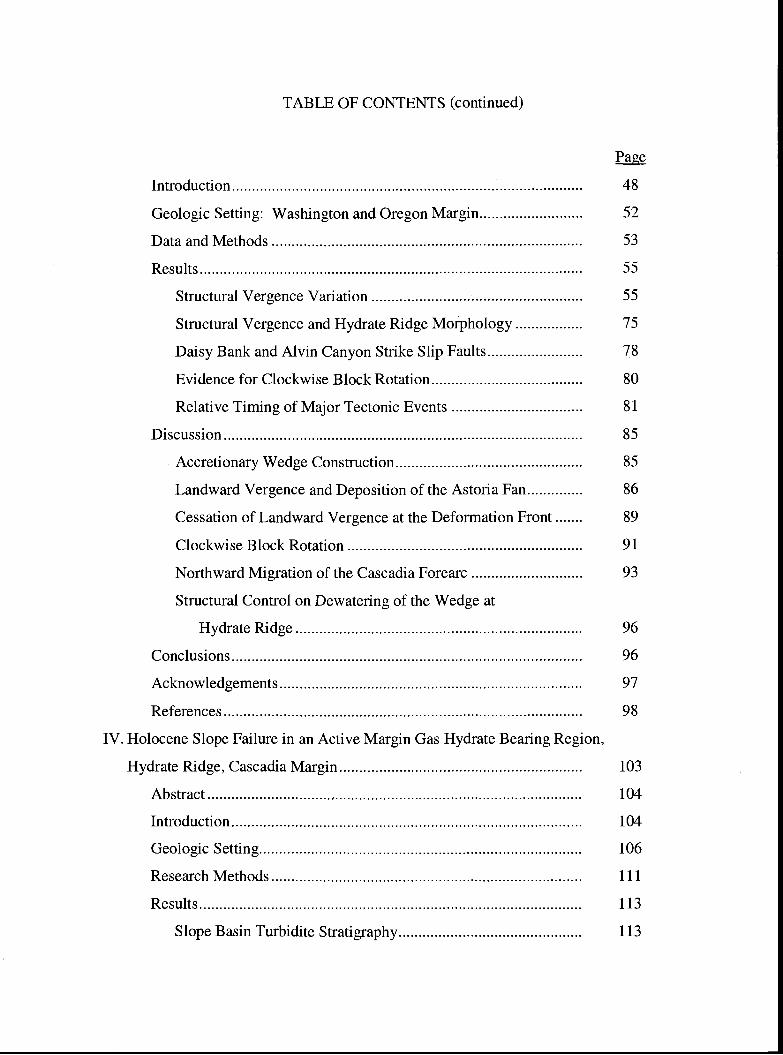
TABLE OF CONTENTS (continued)
Page
Introduction 48
Geologic Setting: Washington and Oregon Margin 52
Data and Methods 53
Results 55
Structural Vergence Variation 55
Structural Vergence and Hydrate Ridge Morphology 75
Daisy Bank and Alvin Canyon Strike Slip Faults 78
Evidence for Clockwise Block Rotation 80
Relative Timing of Major Tectonic Events 81
Discussion 85
Accretionary Wedge Construction 85
Landward Vergence and Deposition of the Astoria Fan 86
Cessation of Landward Vergence at the Deformation Front 89
Clockwise Block Rotation 91
Northward Migration of the Cascadia Forearc 93
Structural Control on Dewatering of the Wedge at
Hydrate Ridge 96
Conclusions 96
Acknowledgements 97
References 98
IV. Holocene Slope Failure in an Active Margin Gas Hydrate Bearing Region,
Hydrate Ridge, Cascadia Margin 103
Abstract 104
Introduction 104
Geologic Setting 106
Research Methods 111
Results 113
Slope Basin Turbidite Stratigraphy 113
TABLE OF CONTENTS (continued)
Page
Correlation of Turbidites Across the Basin 116
Dating the Turbidites 117
Discussion 119
Triggers for Slope Failure 119
Slope Failure Triggers at Hydrate Ridge 120
Correlation to the Earthquake Triggered Turbidite Record 122
A Mix of Earthquakes and Other Triggers 127
Implications for the Mobilization of Seafloor Gas Hydrates 128
Conclusions 130
Acknowledgements 130
References 131
V. Conclusions 134
Bibliography 136
LIST OF FIGURES
Figure Page
CHAPTER II
2-1 Shaded relief bathymetry of the Hydrate Ridge regions 8
2-2 Structure map of the Hydrate Ridge region (interpreted from
multichannel seismic reflection profiles collected as the site survey
for ODP Leg 146, inset), overlain on 100 m shaded relief
bathymetry 12
2-3 Example section of a seismic reflection profile (line 9) from the ODP
Leg 146 site survey. Notice the small scale folds (a = anticline;
s = syncline) and strike slip faults (sense of slip not detectible) 13
2-4 The SeaMARC 30 sidescan sonar mosaic overlain on lOOm shaded
relief bathymetry *AF
2-5 Slope map of the Hydrate Ridge region created from swath
bathymetric data gridded at 50 m 18
2-6 SeaMARC 30 coverage and ground truth across Hydrate Ridge 20
2-7 (A) SeaMARC 30 coverage at the western edge of HRB-E.
Methane distribution in surface sediment multicorer samples
taken at some of the backscatter patches shown in (A).
Methane distribution in two surface sediment gravity
core samples (locations shown in A) 23
2-8 SeaMARC 30 coverage across Daisy Bank 26
2-9 SeaMARC 30 coverage and structures across Hydrate Ridge 28
2-10 SeaMARC 30 complete survey coverage, the pockmark fields
and the extent of the BSR are shown 30
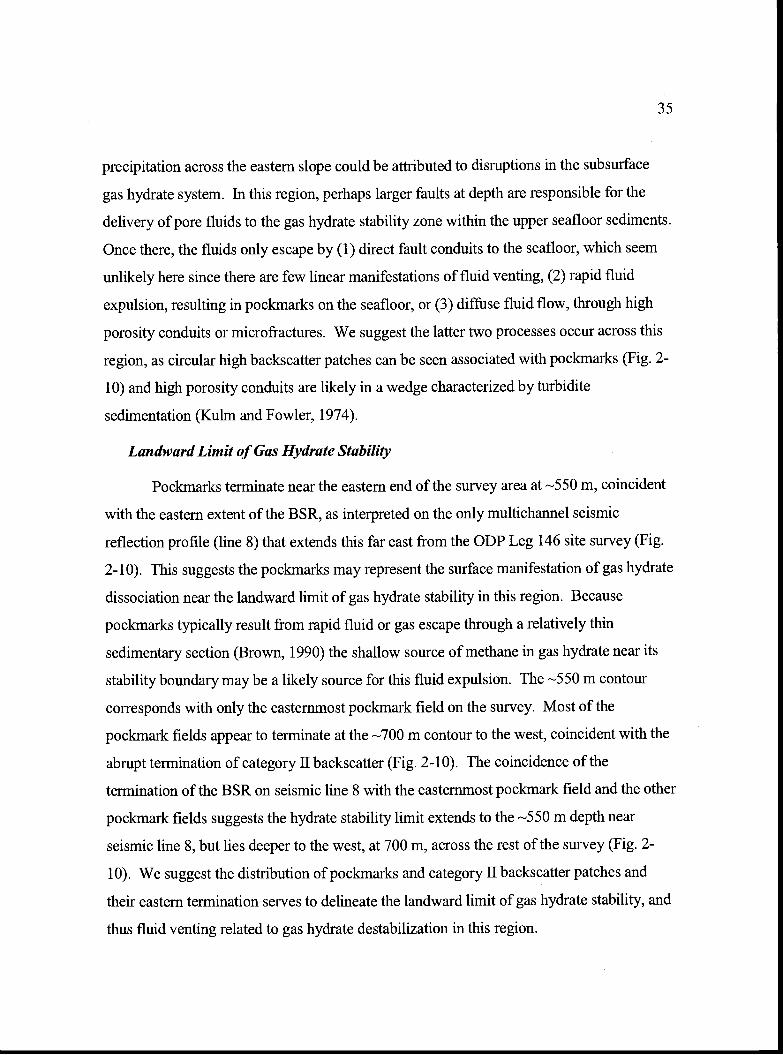
2-11 Schematic diagrams depicting the environments likely responsible
for each of the backscatter categories 37
*AF (Attached Foldout)
LIST OF FIGURES (continued)
Figure Page
CHAPTER III
3-1 Bathymetric map of the offshore portion of the Cascadia
subduction zone 49
3-2 Shaded relief bathymetry (100 m pixel) of the Hydrate
Ridge region 54
3-3 Geologic structures of the Hydrate Ridge region 57
3-4 (A) 0R89 Line 15 (interpreted and uninterpreted).
(B) 0R89 Line 14 (interpreted and uninterpreted) 60
3-5 (A) 0R89 Line 13 (interpreted and uninterpreted).
(B) 0R89 Line 12 (interpreted and uninterpreted) 62
3-6 (A) 0R89 Line 11 (interpreted and uninterpreted).
(B) 0R89 Line 10 (interpreted and uninterpreted) 65
3-7 (A) 0R89 Line 9 (interpreted and uninterpreted).
(B) 0R89 Line 8 (interpreted and uninterpreted). 68
3-8 0R89 Line 5 (interpreted and uninterpreted) 70
3-9 (A) 0R89 Line 2 (interpreted and uninterpreted).
(B) 0R89 Line 1 (interpreted and uninterpreted). 73
3-10 Summary of structural vergence variation within the three
regions (Region north of Hydrate Ridge, Northern Hydrate
Ridge, and Southern Hydrate Ridge) and the three structural
zones (I-Il-Ill) discussed in the text 76
3-11 Schematic diagram showing the interaction of left lateral
strike-slip faults with the accretionary wedge 79
CHAPTER IV
4-1 (A) Bathymetric map of the offshore portion of the Cascadia
subduction zone. (B) Shaded relief bathymetry of the Hydrate
Ridge region (location shown in A) 107
4-2 Stratigraphic records from the three core sites located across
the western slope basin 114
LIST OF FIGURES (continued)
Figure Page
4-3 (A) Comparison of the Holocene Hydrate Ridge record
(RR0207-56PC; in red) to the Holocene subduction zone
earthquake triggered turbidite record at the Juan de Fuca
Canyon site (M9907-12PC; in blue) of Goldfinger et al.
(2003). (B) Calibrated radiocarbon ages for the Juan de Fuca
Canyon and Hydrate Ridge turbidite events (closed symbols,
with 2 sigma error ranges also shown) 123
LIST OF TABLES
Table Page
CHAPTER IV
4-1 Individual foraminifera counts by species taken from
hemipelagic sediments beneath turbidites (e.g. T2) 112
4-2 Down core faunal change documented from smear slide
analyses taken in the RR0207-01 kasten core 115
4-3 Radiocarbon results and correlative foraminifera data
obtained from hemipelagic samples taken beneath each turbidite 118
Deformation, Fluid Venting, and Slope Failure at an Active Margin Gas HydrateProvince, Hydrate Ridge Cascadia Accretionary Wedge
Chapter I
Introduction
On the Cascadia continental margin offshore central Oregon, Hydrate Ridge has
been the focus of numerous geologic and geophysical investigations for nearly two
decades. During the mid- 1980's, its location within the lower slope of the accretionary
wedge initially prompted investigations of seafloor fluid flow and the dewatering
processes associated with accretion of abyssal plain sediments and resulted in one of the
first discoveries of chemosynthetic cold seep faunas. By the early 1990's this early work
was supplemented by detailed structural investigations and ODP (Ocean Drilling
Program) drilling, during which gas hydrates were first recovered. Subsequent work,
including numerous seafloor observation and sampling expeditions since the late 1990's
and more recently a gas hydrate dedicated ODP leg in 2002, has focused on the surface
and shallow subsurface gas hydrate system, seeking to characterize the distribution,
concentration, and behavior of gas hydrates in an active margin setting.
Toward these recent efforts, the three manuscripts that comprise this dissertation
are focused on the geologic setting hosting the gas hydrate system on Hydrate Ridge.
Specifically, examining how active margin tectonic processes influence both the spatial
and temporal behavior of the gas hydrate system at Hydrate Ridge and likely across the
margin. Chapter II addresses the spatial distribution of pore fluid venting manifestations
across a transect of the continental margin spanning the gas hydrate stability zone. The
goals of this work were to determine the relationship of pore fluid venting sites across the
hydrate stability zone to the underlying large scale geologic structures and the gas
hydrate system centered at Hydrate Ridge. The major results indicate that authigenic
carbonates and mud volcanoes are concentrated in areas of intense deformation in
anticlinal structures like Hydrate Ridge. These structures serve to focus methane-rich
fluids, resulting in abundant gas hydrates at the surface and in the shallow subsurface. In
older, more dewatered portions of the wedge, the distribution of patches of authigenic
carbonate, some with gas hydrates, and a field of pockmarks overlying a shallowing base
2
of gas hydrate stability in the subsurface, suggests diffuse fluid flow is likely occurring in
this region and the pockmarks likely result from rapid gas escape during the
destabilization of shallow gas hydrate deposits. These results are important because they
characterize the nature of the gas hydrate/fluid venting system across a transect that spans
the entire gas hydrate stability zone, encompassing several different structural
environments. They also serve to focus several seafloor gas hydrate studies, including
some of the ODP Leg 204 drill sites.
Chapter III examines the structural and tectonic evolution of the Hydrate Ridge
region since the late Pliocene-early Pleistocene. This work serves to emphasize the
complex history of accretion and deformation that occurs in an active margin setting
hosting gas hydrate and also documents the structural evolution, including the
interactions between thrust and strike slip faults, as the wedge was constructed through
time. The results indicate Hydrate Ridge is a composite thrust ridge, formed from both
seaward and landward vergent structures. The across-strike changes in structural
vergence are linked to high pore fluid pressure caused by the rapid deposition of the
Astoria fan sediments on the abyssal plain and the upward propagation of left lateral
strike slip faults into the wedge. These strike slip faults have also been active through
the accretionary process, resulting in the clockwise block rotation of Hydrate Ridge
through time. The changes in structural vergence also help explain the variability in
bathymetric relief across the region.
Chapter IV addresses the influence of the subduction zone earthquake cycle on
the slope failure, and likely gas hydrate destabilization, frequency over the Holocene
timescale at Hydrate Ridge. The results suggest earthquake-induced slope failure within
the gas hydrate stability zone does occur at Hydrate Ridge and thus could represent a
mechanisms for the mobilization of seafloor and subseafloor gas hydrates on a margin
wide scale. This research has implications not only for the short term stability of seafloor
and shallow subseafloor gas hydrate along the Cascadia margin, but also for the stability
of gas hydrate in other active margin settings.
3
The first paper (Chapter II) entitled "Geophysical constraints on the surface
distribution of authigenic carbonates across the Hydrate Ridge region" was published in
November 2003 in the journal Marine Geology. The second paper (Chapter III) entitled
"Structural vergence variation and clockwise block rotation in the Hydrate Ridge region,
Cascadia accretionary wedge" will be submitted to the journal Tectonics for publication.
The third paper (Chapter IV) entitled "Holocene slope failure in an active margin gas
hydrate bearing region, Hydrate Ridge, Cascadia margin" will be submitted to the journal
Earth and Planetary Science Letters.
Chapter II
Geophysical Constraints on the Surface Distribution of Authigenic Carbonatesacross the Hydrate Ridge Region, Cascadia Margin
Joel E. Johnson', Chris Goldfinger', and Erwin Suess2
Oregon State University, College of Oceanic and Atmospheric Sciences, 104
Ocean Admin. Bldg. Corvallis, Oregon 97331
GEOMAR Research Center for Marine Geosciences, 24148 Kiel, Germany
Johnson, J.E., Goldfinger, C., Suess, E., 2003, Geophysical Constraints on the Surface
Distribution of Authigenic Carbonates across the Hydrate Ridge Region, Cascadia
Margin. Marine Geology, 202, 79-120.
4
Abstract
On active tectonic margins methane rich pore fluids are expelled during the
sediment compaction and dewatering that accompany accretionary wedge development.
Once these fluids reach the shallow subsurface they become oxidized and precipitate cold
seep authigenic carbonates. Faults or high porosity stratigraphic horizons can serve as
conduits for fluid flow, which can be derived from deep within the wedge andlor, if at
seafloor depths greater than 300 m, from the shallow source of methane and water
contained in subsurface and surface gas hydrates. The distribution of fluid expulsion
sites can be mapped regionally using sidescan sonar systems, which record the locations
of surface and slightly buried authigenic carbonates due to their impedence contrast with
the surrounding hemipelagic sediment. Hydrate Ridge lies within the gas hydrate
stability field offshore central Oregon and during the last 15 years several studies have
documented gas hydrate and cold seep carbonate occurrence in the region. In 1999, we
collected deep-towed SeaMARC 30 (SM3O) sidescan sonar imagery across the Hydrate
Ridge region to determine the spatial distribution of cold seep carbonates and their
relationship to subsurface structure and the underlying gas hydrate system. High
backscatter on the imagery is divided into three categories, (I) circular to blotchy with
apparent surface roughness, (II) circular to blotchy with no apparent surface roughness,
and (III) streaky to continuous with variable surface roughness. We interpret the
distribution of high backscatter, as well as the locations of mud volcanoes and pockmarks
to indicate variations in the intensity and activity of fluid flow across the Hydrate Ridge
region. Seafloor observations and sampling verify the acoustic signals across the survey
area and aid in this interpretation. Subsurface structural mapping and swath bathymetry
suggest the fluid venting is focused at the crests of anticlinal structures like Hydrate
Ridge and the uplifts along the Daisy Bank fault zone. Geochemical parameters link
authigenic carbonates on Hydrate Ridge to the underlying gas hydrate system and suggest
that some of the carbonates have formed in equilibrium with fluids derived directly from
the destabilization of gas hydrate. This suggests carbonates are formed not only from the
methane in ascending fluids from depth, but also from the shallow source of methane
5
6
released during the dissociation of gas hydrate. The decreased occurrence of high
backscatter patches and the dramatic reduction in pockmark fields, imaged on the eastern
part of the survey, suggests gas hydrate near its upper stability limit may be easily
destabilized and thus, responsible for these seafloor features. High backscatter along the
left-lateral Daisy Bank fault suggests a long history of deep-seated fluid venting,
probably unrelated to destabilized gas hydrate in the subsurface.
Introduction
Pore fluid expulsion is a common process in accretionary wedges on active
continental margins and is coincident with the dehydration and compaction of the
sediment colunm during accretionary wedge development. Fluid expulsion can (1) be
episodic along high-porosity stratigraphic horizons andlor faults exposed at the seafloor
(e.g. Kuim et al., 1986; Lewis and Cochrane, 1990; Moore and Vrolijk, 1992; Sample,
1996; Sample and Reid, 1998), (2) occur during mud volcanism (e.g. Brown, 1990; Kopf,
2002), andlor (3) occur during diffuse, intergranular fluid flow (e.g. Moore and Vrolijk,
1992 and refs. there in). An abundant component in the fluids escaping from organic rich
accretionary wedges is dissolved thermogenic and biogenic methane. When subjected to
the lower temperature, lower pressure, and oxidizing bacteriarich environment near the
seafloor surface, these methane rich fluids can precipitate cold seep carbonates of
aragonite, calcite, and/or dolomite compositions (Ritger et al., 1987; Greinert et al.,
2001). In addition, some of this methane is temporarily incorporated as free gas into the
gas hydrate fabric near the seafloor prior to expulsion (Suess et al., 2001), if at high
enough gas concentrations and appropriate pressure (water depths at least 300m) and
temperature (bottom water temperatures approaching 00 C) conditions (Kvenvolden,
1993).
Both surface and deep towed sidescan sonar surveys offer a unique method for
regional mapping of seafloor fluid venting sites because the acoustic impedence contrast
(density x sound velocity) between the authigenic carbonates precipitated at these sites
and the surrounding hemipelagic sediments is detectible. Sidescan sonar surveys are
valuable because they provide a regional scale survey of seafloor fluid venting
occurrences and distributions, and they also help guide later seafloor observation and
sampling efforts conducted with manned submersibles, ROV's, tv-camera tows, and
coring and dredging devices.
The first documentation of authigenic carbonates and chemosynthetic biological
communities associated with pore-fluid expulsion on an active continental margin
occurred at the first accretionary ridge west of Hydrate Ridge, offshore central Oregon
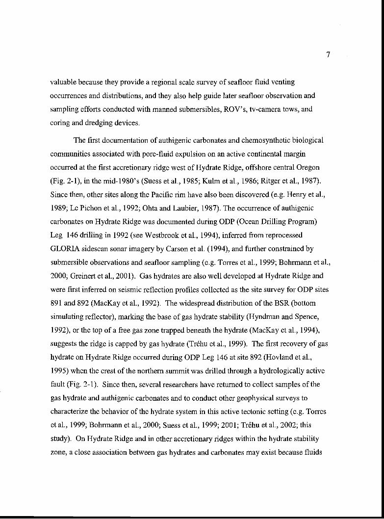
(Fig. 2-1), in the mid-1980's (Suess et al., 1985; Kuim et al., 1986; Ritger et aL, 1987).
Since then, other sites along the Pacific rim have also been discovered (e.g. Henry et al.,
1989; Le Pichon et al., 1992; Ohta and Laubier, 1987). The occurrence of authigenic
carbonates on Hydrate Ridge was documented during ODP (Ocean Drilling Program)
Leg 146 drilling in 1992 (see Westbrook et al., 1994), inferred from reprocessed
GLORIA sidescan sonar imagery by Carson et al. (1994), and further constrained by
submersible observations and seafloor sampling (e.g. Tones et al., 1999; Bohrmann Ct al.,
2000; Greinert et al., 2001). Gas hydrates are also well developed at Hydrate Ridge and
were first inferred on seismic reflection profiles collected as the site survey for ODP sites
891 and 892 (MacKay et al., 1992). The widespread distribution of the BSR (bottom
simulating reflector), marking the base of gas hydrate stability (Hyndman and Spence,
1992), or the top of a free gas zone trapped beneath the hydrate (MacKay et al., 1994),
suggests the ridge is capped by gas hydrate (Tréhu et al., 1999). The first recovery of gas
hydrate on Hydrate Ridge occurred during ODP Leg 146 at site 892 (Hoviand et al.,
1995) when the crest of the northern summit was drilled through a hydrologically active
fault (Fig. 2-1). Since then, several researchers have returned to collect samples of the
gas hydrate and authigenic carbonates and to conduct other geophysical surveys to
characterize the behavior of the hydrate system in this active tectonic setting (e.g. Tones
et al., 1999; Bohrmann et al., 2000; Suess et al., 1999; 2001; Tréhu et al., 2002; this
study). On Hydrate Ridge and in other accretionary ridges within the hydrate stability
zone, a close association between gas hydrates and carbonates may exist because fluids
7
-124
48-1
2440
00
-124
56-1
2448
1251
2'-1
2504
-125
20
Figu
re 2
-1. S
hade
d re
lief
bath
ymet
ry o
f th
e H
ydra
te R
idge
reg
ion.
Con
tour
inte
rval
is 1
00 m
and
bath
ymet
ric
grid
is 1
00 m
pix
el r
esol
utio
n.In
set s
how
s Pa
cifi
c N
orth
wes
t bat
hym
etry
and
topo
grap
hy (
Hau
geru
d, 1
999)
and
the
loca
tion
of H
ydra
te R
idge
reg
ion
on th
e lo
wer
con
tinen
tal
slop
e of
the
Cas
cadi
a ac
cret
iona
ry p
rism
. Hyd
rate
Rid
ge is
a N
E-S
W tr
endi
ng th
rust
rid
ge w
ithno
rthe
rn a
nd s
outh
ern
sum
mits
; (N
HR
) N
orth
ern
Hyd
rate
Rid
ge; (
SHR
) So
uthe
rn H
ydra
te R
idge
.T
he r
idge
is lo
cate
dl0
km
fro
m th
e de
form
atio
n fr
ont (
DF)
and
bor
dere
d on
the
wes
t and
eas
t by
slop
e ba
sins
(H
RB
-W)
Hyd
rate
Rid
ge B
asin
-Wes
t and
(H
RB
-E)
Hyd
rate
Rid
ge B
asin
-Eas
t. O
DP
(Oce
an D
rilli
ng P
rogr
am)
site
891
on
the
cres
t of
the
firs
t acc
retio
nary
rid
ge (
FAR
) an
d si
te 8
92 o
nN
HR
are
sho
wn.
Dai
sy B
ank
(DB
) is
als
o sh
own.
9
dewatered from the prism not only supply methane to the gas hydrate stability zone, but
also transfer heat to shallower depths, which can induce the destabilization of the gas
hydrate (Suess et aL, 2001). On both the northern and southern summits of Hydrate
Ridge, the authigenic carbonate and pore water carbon and oxygen isotopes support this
association by suggesting the carbonates are precipitated in part from methane derived
from destabilized gas hydrate (Bohrmann et al., 1998; Greinert et al., 2001). This
observation suggests destabilized gas hydrate can contribute to the total accumulation of
authigenic carbonate precipitated during accretionary wedge dewatering and compaction.
With this in mind, an understanding of the regional distribution of subsurface structures
(faults and folds) and the extent of the gas hydrate stability zone is necessary to make
interpretations about the possible origins of fluid venting patterns interpreted on sidescan
sonar records and observed on the seafloor.
Our recent research efforts have been focused on identifying the structural
controls on the distribution of authigenic carbonates in the Hydrate Ridge region and
their relationship to the underlying gas hydrate system. In this paper, we present the
results of our 1999 SeaMARC 30 deep-towed sidescan sonar survey coupled with
seafloor observations and samples and subsurface geologic mapping, based on seismic
reflection data, to determine the distribution of authigenic carbonates and their
relationship to large scale subsurface structures and the underlying gas hydrate system
across the Hydrate Ridge region.
Tectonic Setting
Cascadia Accretionary Prism
The Juan de Fuca Plate is currently being subducted obliquely beneath the North
American Plate along the Washington, Oregon, and Northern California continental
margins (Fig. 2-1). The Cascadia accretionary prism evolved in response to this oblique
subduction and is composed of folded and faulted abyssal plain turbidites and
hemipelagic sediments (Kulm and Fowler, 1974). This oblique convergence also creates
a right-lateral shear couple within the upper to lower continental slope and off the
10
Washington and Oregon margins nine WNW trending left-lateral strike-slip faults,
antithetic to the shear couple, have been identified on the continental slope and abyssal
plain (Goldfinger et al., 1992; Goldfinger et al., 1997). The accretionary wedge widens
from 60 km off southern Oregon to 150 km off the northern Olympic Peninsula of
Washington, where the thick Pleistocene Astoria and Nitinat Fans are presently being
accreted to the margin. The active accretionary thrust faults of the lower slope are
characterized by mostly landward vergent thrusts on the Washington and northern
Oregon Margins and seaward vergent thrusts on the central and southern Oregon margin
(Goldfinger et al., 1992; MacKay et al., 1992; MacKay, 1995). The landward vergent
province may be related to the subduction of rapidly deposited and overpressured
sediment from the Astoria and Nitinat submarine fans (Seely, 1977; MacKay, 1995). Off
Washington and northern Oregon the broad accretionary prism is characterized by low
wedge taper and widely spaced accretionary thrusts and folds, which offscrape virtually
all of the incoming sedimentary section. Sparse age data suggest the prism is Quaternary
in age and is building westward at a rate close to the orthogonal component of plate
convergence (Goldfinger et al., 1996). This young accretionary wedge abuts a steep
slope break that separates it from the oceanic and volcano-clastic Siletz terrane that
underlies the continental shelf (Snavely, 1987). Above this basement is a modestly
deformed Eocene through Holocene forearc basin sequence (Snavely, 1987; McNeill et
al., 2000). Hydrate Ridge lies within the northern end of the seaward vergent province,
offshore central Oregon, and is the second seaward vergent accretionary thrust ridge from
the deformation front (Fig 2-1). It is bordered on east and west by slope basins, Hydrate
Ridge Basin-East (HRB-E) and Hydrate Ridge Basin-West (HRB-W).
Structure of the Hydrate Ridge Region
The Hydrate Ridge region is a highly deformed portion of the accretionary wedge
that results from oblique subduction-driven compression. The faults and folds in the
region were initially mapped by Goldfinger et al. (1992; 1997) and MacKay, et al. (1992;
1995) and document the landward to seaward structural vergence change across the
region as well as the presence of two deep-seated left-lateral strike slip faults (the Daisy
11
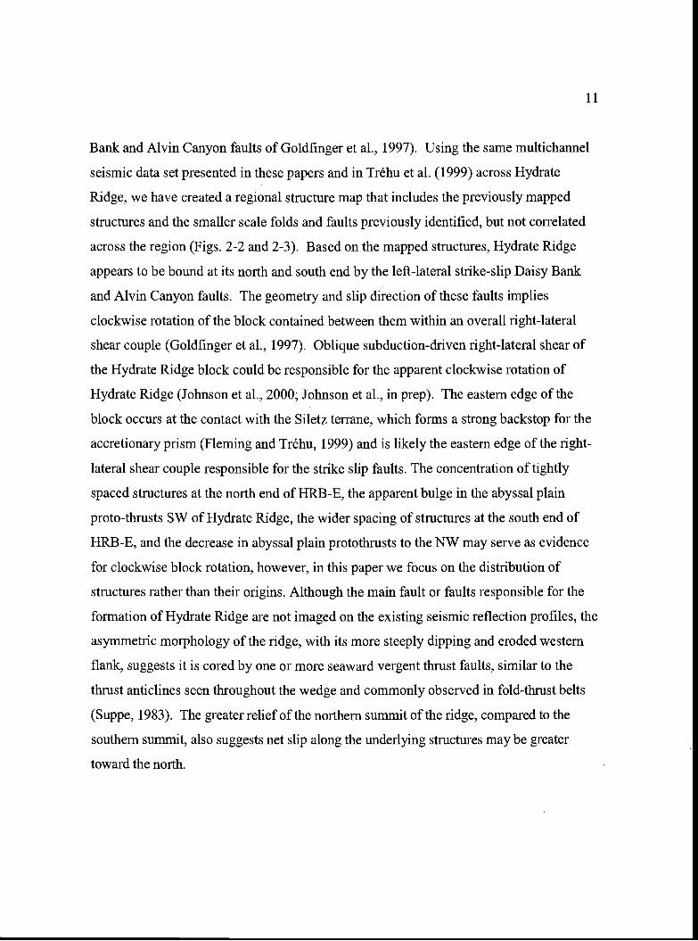
Bank and Alvin Canyon faults of Goldfinger et al., 1997). Using the same multichannel
seismic data set presented in these papers and in Tréhu et al. (1999) across Hydrate
Ridge, we have created a regional structure map that includes the previously mapped
structures and the smaller scale folds and faults previously identified, but not correlated
across the region (Figs. 2-2 and 2-3). Based on the mapped structures, Hydrate Ridge
appears to be bound at its north and south end by the left-lateral strike-slip Daisy Bank
and Alvin Canyon faults. The geometry and slip direction of these faults implies
clockwise rotation of the block contained between them within an overall right-lateral
shear couple (Goldfinger et al., 1997). Oblique subduction-driven right-lateral shear of
the Hydrate Ridge block could be responsible for the apparent clockwise rotation of
Hydrate Ridge (Johnson et aL, 2000; Johnson et al., in prep). The eastern edge of the
block occurs at the contact with the Siletz terrane, which forms a strong backstop for the
accretionary prism (Fleming and Tréhu, 1999) and is likely the eastern edge of the right-
lateral shear couple responsible for the strike slip faults. The concentration of tightly
spaced structures at the north end of HRB-E, the apparent bulge in the abyssal plain
proto-thrusts SW of Hydrate Ridge, the wider spacing of structures at the south end of
HRB-E, and the decrease in abyssal plain protothrusts to the NW may serve as evidence
for clockwise block rotation, however, in this paper we focus on the distribution of
structures rather than their origins. Although the main fault or faults responsible for the
formation of Hydrate Ridge are not imaged on the existing seismic reflection profiles, the
asymmetric morphology of the ridge, with its more steeply dipping and eroded western
flank, suggests it is cored by one or more seaward vergent thrust faults, similar to the
thrust anticlines seen throughout the wedge and commonly observed in fold-thrust belts
(Suppe, 1983). The greater relief of the northern summit of the ridge, compared to the
southern summit, also suggests net slip along the underlying structures may be greater
toward the north.
4448
4444
4420
4434
44
-1 258 125 0'4 -12016 -1256 a -1402 -12444
Jthrustfault anticline
norcnal fault + syncline
strike-slip fault
10km
t9S9MCSsurvey linescsrtion of line
9 5hOWfl in
FIgure 3
4438
3T
44,44'
44 36'
4432'
12524 -12516 -1258 -1250 -12452 -12444
Figure 2-2. Structure map of the Hydrate Ridge region (interpreted frommultichannel seismic reflection profiles collected as the site survey for ODP Leg146, inset), overlain on 100 m shaded relief bathymetry. Deep-seated left-lateralstrike-slip faults (Daisy Bank and Alvin Canyon faults) dominate the deformationnorth and south of Hydrate Ridge and thrusts and folds are common in the regionbetween the strike-slip faults. The distribution and style of structures betweenthese strike-slip faults and the apparent clockwise rotation of Hydrate Ridge,suggests deformation may be influenced by oblique subduction-driven right-lateral shear. The eastern end of the Daisy Bank fault is mapped based on theprevious work of Goldfinger etal. (1996) and the SM 30 sidescan sonar datapresented in this paper. The major geologic and geographical features are labeledas follows; (DF) deformation front; (FAR) first accretionary ridge; (HRB-W)Hydrate Ridge Basin-West; (NHR) Northern Hydrate Ridge; (SHR) SouthernHydrate Ridge; (HRB-E) Hydrate Ridge Basin-East; (DB) Daisy Bank.
12
II,t.
.'i'\\0 "" 2 1
SF 700 600 500 400 300 200
2-i a as a
a a. S
SP: 700 600 500 400 300 2001.1
.- 1.2E 1.3
1.4a)
1.5
1.6
1.7
1.8
1.9
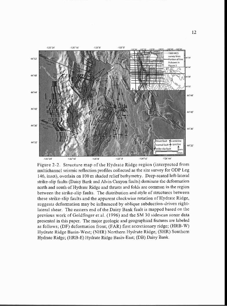
Figure 2-3. (A) Example section of a seismic reflection profile (line 9)from the ODP Leg 146 site survey (location shown in Fig. 2 inset). Thedata is time migrated and depicts relative true amplitudes. The amplitudescale grades from white to black. (B) Notice the small scale folds (a =anticline; s syncline) and strike slip faults (sense of slip not detectible).A small thrust fault is also present. Variations in the degree ofdeformation across the Hydrate Ridge region can be seen by mappingthese small scale features along with the previously mapped largerstructures (Goldfinger et al. (1992;1997) and MacKay et al. (1992;1995).This line in particular shows the concentration of deformation near the NWcorner of Hydrate Ridge.
13
2.0
2.1
1.1
.2C',
.3
.4
.5>
1.6 1.6
1.7 1.7
1.8 1.80
1. .9I-
2 0
2.1 1
Methods
Imaging the Carbonates
The observed authigenic carbonates present in the Hydrate Ridge region are
exposed at the seafloor or slightly buried by a few centimeters ofhemipelagic mud
(Bohrmann et al., 1998; Kulm and Suess, 1990; Suess et al., 2001). Because of the
acoustic impedence (density x sound velocity) contrast between the carbonates and the
surrounding sediments, sidescan sonar can be used to image the distribution ofauthigenic
carbonates across the region at the surface and in the shallow subsurface (Johnson and
Helferty, 1990). Tn regions bearing seafloor gas hydrate, like Hydrate Ridge, there is also
an acoustic impedence contrast between the gas hydrate and the surrounding hemipelagic
sediments. Although, smaller than that due to carbonate, the impedence contrast between
gas hydrate at the seafloor and hemipelagic sediments may be sufficient to produce an
intermediate backscatter signal. Because of the limited bandwidth of current analog sonars
and variations in the towfish depth during the survey, however, the sonar gain must be
adjusted frequently, which makes post-cruise quantitative analysis of variations in
backscatter strength problematic. Because of this, we do not attempt to differentiate
between authigenic carbonates and seafloor gas hydrate of intermediate backscatter
strength across the survey, except where confirmed by seafloor observations.
SeaMARC 30 Survey
To maximize our seafloor resolution and in order to image carbonates buried by a
thin veneer of hemipelagic mud we chose the low frequency (30 kHz), deep-towed,
SeaMARC 30 (SM 30) sidescan sonar system, operated by Williamson and Associates in
Seattle, Washington. The sonar was towed at a depth of-200 m above the seafloor and
collected data in 3 .0 km swaths across the entire region and -1.5 km swaths across the
crest of Hydrate Ridge. The frequency on the port side is 27 kHz and on the starboard side
30 kHz. The gain of the sonar was adjusted manually in 10, 3dB steps to gain
approximately equal record intensity across the survey. Navigation was by Sonardyne
USBL (Ultra-Short BaseLine acoustic positioning). The RIV New Horizon was used to
14
15
tow the SM 30 at 2-3 knots. The sidescan images were acquired and processed using
Triton Elics International (TEl) Isis sonar processing software, and ultimately
georeferenced and gridded at 1 m pixel resolution for the entire survey using Erdas Imagine
software. The survey was designed to image the surface and shallow subsurface authigenic
carbonate and gas hydrate in the Hydrate Ridge region, spanning a corridor from the
deformation front on the west to beyond the predicted upper hydrate stability limit (450-
500 m; Tréhu et al., 2002) on the east. Included on the eastern edge of the survey was the
SE extent of the Daisy Bank fault zone, a deep-seated left-lateral strike-slip fault, and likely
fluid flow conduit, spanning here, just above the upper depth limit of hydrate stability
(Goldfinger et al., 1996). Carson et al. (1994) attempted to remove the bathymetric signal
from shallow-towed GLORIA regional sidescan data in an effort to constrain the extent of
authigenic carbonate on Hydrate Ridge. These low frequency (6.5 kHz) GLORIA data can
record deeply buried features, however, making surficial interpretations problematic.
Nevertheless, our deep-towed SeaMarc 30 data support the general interpretations of
Carson et al. (1994), but a much higher resolution and across not only Hydrate Ridge, but
the slope and shelf to the east.
High Backscatter and Carbonates
The intensity of backscatter on sidescan sonar records is a function of (1) the
angle of incidence of each beam (the bathymetric variations on the seafloor-the slope),
(2) the physical characteristics of the surface (micro scale roughness), (3) the intrinsic
nature of the surface (composition-density) and (4) the frequency and pulse
characteristics of the sonar (Blondel and Murton, 1997). One of the important effects on
the backscatter signal received by the sidescan sonar is the effect due to bathymetric
slope (1, above). Steep seafloor bathymetry sloping toward the passing sonar has
enhanced backscatter strength compared to those slopes dipping away from the sonar.
Because of this signal enhancement, differentiation between sediment types based on
backscatter strength is best determined in regions of low slope. On Hydrate Ridge
submersible dives, tv-camera tows, and seafloor samples (see Groundtruthing the Sonar
16
below) have documented that authigenic carbonates are present where bathymetric
variation is minimal and high backscatter is dominant on the imagery. Similarly, across
much of the survey, the seafloor slopes are less then 5° (see Backscatter Patterns and
Bathymetric Slope below), suggesting high backscatter in these regions is more likely
related to changes in rock and sediment composition on the seafloor rather than a
bathymetric effect.
Results
Sidescan Sonar Survey
The complete mosaiced survey gridded at 1 m pixel resolution for both the 3 km
and l .5 km swaths is presented in Figure 2-4 (attached foldout). The E-W tracklines were
collected in order from south (track 1) to north (track 11), beginning at the SE corner of the
survey. All odd number tracklines were collected towing the sonar from east to west and
even numbered tracks from west to east. Thus, at the overlap between tracklines the same
geologic feature is imaged twice, but with insonification from opposing directions. At the
overlap, the more detailed swath is generally shown. The 1.5 km swaths over the crest of
Hydrate Ridge were towed NE-SW along the axis of the ridge. Dark gray to black lines
along the centers of each trackline are the nadirs (no data recovery beneath the towfish).
White thin continuous lines across the slope basin east of Hydrate Ridge are surface returns
recorded by the sonar. Continuous high backscatter along the nadirs on E-W lines 6-8 is an
artifact of the sonar.
Backscatter Patterns and Bathymetric Slope
Examination of the survey mosaic reveals the high backscatter patterns (light tones)
generally can be divided into three categories; (I) circular to blotchy with apparent surface
roughness, (II) circular to blotchy with no apparent surface roughness, and (III) streaky to
continuous with variable surface roughness (Figure 2-4 attached foldout). Category I high
backscatter is concentrated mainly on the northern summit and NE end of Hydrate Ridge
and to a lesser extent on the southern summit of Hydrate Ridge. Category II high
17
backscatter is concentrated on the eastern edge of HRB-E, and eastward up to the 700 m
bathymetric contour. It also extends spatially from north to south across the entire survey
in this region. Category ifi high backscatter is present on the western edge of the survey in
regions of steep bathymetry associated with the large submarine canyon and steep slopes
on the western flank of Hydrate Ridge, and in the SE corner of the survey, associated with
subtle breaks in slope. Category III high backscatter is also present along the Daisy Bank
Fault Zone to the northeast.
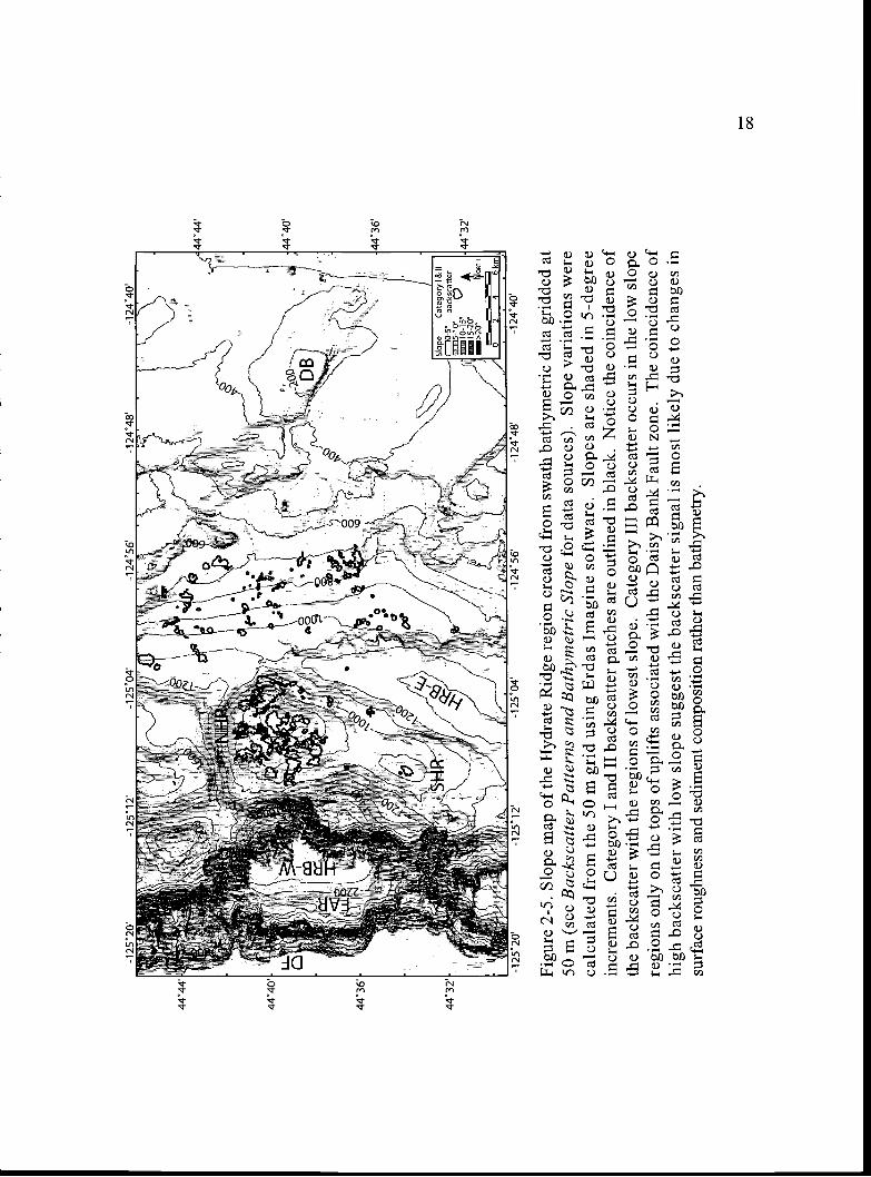
To determine the effect of slope on the backscatter intensity, a slope map was
created from 50 m gridded bathymetry, which is the highest resolution grid available across
the entire survey area (Fig. 2-5). Newly acquired high resolution EM300 data across
Hydrate Ridge and HRB-E (from Clague et al., 2001), EM 120 data across HRB-W, and
EM300 from HRB-E to Daisy Bank (collected by the authors in 2002) are the three
primary data sets used in this bathymetric grid. Additional bathymetric data sets (EM300
and EM 120 swaths from Jack Barth at Oregon State University and lower resolution data
sets, NOAA EEZ SeaBeam 16 and National Ocean Service hydrographic soundings) were
used to fill in gaps in coverage. The inclusion of lower-resolution data in the grid limits the
resolution to 50 m, however, yields coverage coincident with the SM 30 survey.
Examination of bathymetric slope reveals much of the high backscatter (Category I and II)
on Hydrate Ridge, HIRB-E, and the seafloor west of Daisy Bank occurs in regions with the
lowest slope, <100, mostly <5°. The high backscatter observed in regions with the highest
slope, on the western edge of the survey where slopes exceed 15° surrounding HRB-W and
along some of the Daisy Bank fault uplifts, is likely enhanced by the steep bathymetry.
The only major exception to this is observed on some of the low slope, high-to-moderate
backscatter seen on the flat-topped ridges of the Daisy Bank Fault zone (Figs. 2-4 attached
foldout and 2-5; see Groundtruthing the Sonar below). With the slope effect to the
backscatter intensity minimized in regions of low slope, the backscatter can be interpreted
to result from contrasts in surface roughness and/or harder or denser sediment composition
across the survey.
44.4
4
444O
'u-
4436
4432
-125
2O-1
2512
/
-1 2
5O4
S
a
-1 2
456
-1 2
448
Slo
peC
ateg
ory
I & II
O-5
back
scat
ter
5-1
O
415
-2O
llOR
Te
1c'-i
'---
knlj
-124
4O
Figu
re 2
-5. S
lope
map
of
the
Hyd
rate
Rid
ge r
egio
n cr
eate
d fr
om s
wat
h ba
thym
etri
c da
ta g
ridd
ed a
t50
m (
see
Bac
ksca
tter
Patte
rns
and
Bat
hym
etri
c Sl
ope
for
data
sou
rces
). S
lope
var
iatio
ns w
ere
calc
ulat
ed f
rom
the
50 m
gri
d us
ing
Erd
as I
mag
ine
soft
war
e. S
lope
s ar
e sh
aded
in 5
-deg
ree
incr
emen
ts. C
ateg
ory
I an
d II
bac
ksca
tter
patc
hes
are
outli
ned
in b
lack
. Not
ice
the
coin
cide
nce
ofth
e ba
cksc
atte
r w
ith th
e re
gion
s of
low
est s
lope
. Cat
egor
y II
I ba
cksc
atte
r oc
curs
in th
e lo
w s
lope
regi
ons
only
on
the
tops
of
uplif
ts a
ssoc
iate
d w
ith th
e D
aisy
Ban
k Fa
ult z
one.
The
coi
ncid
ence
of
high
bac
ksca
tter
with
low
slo
pe s
ugge
st th
e ba
cksc
atte
r si
gnal
is m
ost l
ikel
y du
e to
cha
nges
insu
rfac
e ro
ughn
ess
and
sedi
men
t com
posi
tion
rath
er th
an b
athy
met
ry.
44,4
4
444o
,
4436
4432
00
1244
8-1
244O
-125
2O
'-1
25O
4-1
2456
-125
12
Groundtruthing the Sonar
Category I Backscatter-Hydrate Ridge
Samples from the seafloor and deep-towed video camera data (Bohrmann et al.,
1998; Greinert et aL, 2001; Suess et al., 2001) as well as Alvin observations (Tones et al.,
1999) on both the northern and southern summits of Hydrate Ridge have confirmed the
presence of extensive authigenic carbonates and gas hydrates. During R/V Sonne Legs
143-1, 2, and 3, deep towed tv-cameras, termed OFOS (Ocean Floor Observation System)
and TVG's (tv-guided grab samplers) were deployed across the Hydrate Ridge region (Fig.
2-6a). A graphic log representing the video observations along OFOS track 216 is shown
in Figure 2-6b. We observe a close conelation between high backscatter on the sidescan
sonar and the slabs, cobbles, and boulders of authigenic carbonates observed in the OFOS
videos along all three tracks, 216, 213 and 223 (Fig. 2-6a). OFOS track 223 documents
carbonate only near the crest of Hydrate Ridge, where the backscatter is of intermediate
intensity but the pattern resembles a pavement of carbonate that extends well into the
saddle between the south and north summits (Fig. 2-6a). In all of the TVG samples shown
(Fig. 2-6a), authigenic carbonates were also recovered from the seafloor, again coincident
with locations of high backscatter.
Observations made during five Alvin dives on the northern summit of Hydrate
Ridge resulted in a map of the bottom types, characterizing the seafloor as consisting of
massive carbonates, mostly carbonates, mixed sediments and carbonates, sediments, or
clams and/or microbial mats (Tones et al., 1999; Fig. 2-6c). On the southern summit of
Hydrate Ridge, six Alvin dives resulted in the discovery of a very large carbonate
chemoherm pinnacle, which stands nearly 50 m above the seafloor (Tones et al., 1999).
The dive sites were concentrated at the largest high backscatter patch on the southern
summit of Hydrate Ridge. In the middle of this patch, the acoustic shadow cast by the
large pinnacle carbonate can be seen (Figs. 2-4 attached foldout; 2-6a and d). Investigation
by Alvin of the intermediate intensity backscatter present northeast of the pinnacle resulted
in the identification of gas hydrate at the seafloor, which was previously sampled with
19
20
Figure 2-6. (A) SeaMARC 30 coverage and ground truth across Hydrate Ridge. TVG (tv-grab) and OFOS (tv-camera tow) tracks from Sonne Leg 143 are shown. Mud volcanoesMV1, MV2, and MV3 are shown (see Other Fluid Venting Manifestations) as well as theSouthern Hydrate Ridge (SHR) pinnacle (note the acoustic shadow on the imagery). Theintermediate backscatter on SHR represents seafloor gas hydrate as observed in ALVINdives (Tones et al., 1999). (B) OFOS track 216 across NHR (from Bohrmann et al., 2000).The diagram was constructed from deep towed video observations of the seafloor. Notethe coincidence of the chemoherm carbonates and carbonate crusts with the regions ofhighest backscatter along the track. (C) A bottom type map constructed from ALVINobservation on NHR (from Tones et al., 1999). Again note the coincidence of highbackscatter on the survey and the carbonates observed on the seafloor. (D) ALVINphotograph of the carbonate on the SHR pinnacle (photo courtesy of Marta Tones, OregonState University). Notice the large fracture in the middle of the image.
4412
4436
'
4432
''250
-I 2
' 6'
'25
2'
o 5a
nne
Leg
043-
i NO
sIte
s-ca
rbon
ate
smpI
esr
ecov
eied
Itoh
rman
n at
al -
200
00
Sco
ne L
eg 1
43-3
0105
HA
Ck,
Isoh
fman
n et
al,.
2000
)
-232
'
B
dge
met
erscn
narn
ohnm
i c.tb
otM
enan
d cl
atiti
L--
caee
sa,e
ttC]
nnee
tj e,
o,o.
'saa
th. S
qe,In
Otu
nern
, sla
bs n
lnn.
r.co
ette
Jlm
IllnM
,Se"
lafil
e (S
HR
) C
arbo
nate
Pin
nacl
e
:te
enie
st e
si c
,eti,
tstln
,,,,, i
nisa
w,
-
-5.
-44
es;;i
etL
(to
ri'55
10
A-1
2512
OF
OS
Tra
ck 2
16
-1 2
510
Figu
re 2
-6.
Alo
ng tr
ack
dist
ance
cN
orth
ern
Hyd
rate
RI
(NH
R)
Bot
tom
Typ
e M
ap
500
000
700
600
'I
000
22
a large TVG (Suess et al., 1999). This suggests the sidescan sonar may have imaged
seafloor gas hydrate here and recorded it with intermediate backscatter intensity (Fig. 2-6a),
alternatively, the intermediate backscatter could be caused by slightly buried authigenic
carbonate not recovered by the TVG. During the same Alvin dives, the small high
backscatter circle northwest of the pinnacle was also investigated, however no carbonate or
gas hydrate was observed at the seafloor surface (Tones et al., 1999). We suggest
sediments cover the authigenic carbonate or hydrate likely responsible for this acoustic
signal, as the SM3O has previously imaged objects of high impedence contrast buried by
several meters of soft sediment (M. Williamson, personal communication, 1999).
Category II Backscatter-Eastern Slope Basin
Tv-camera tows conducted in 1999 across some of the high reflectivity category
II backscatter patches indicated only sediments and bacterial mats at the surface,
suggesting carbonates and/or hydrates if present here are buried beneath a thin veneer of
sediment (Fig. 2-7a). A tv-camera tow conducted during the RJV Sonne (SO 148) cruise
in 2000 however, documented bacterial mats, clam fields, and some authigenic
carbonates present at the seafloor in this same region (Fig. 2-7a). In addition to the tv-
camera tows, three category II circular backscatter patches were cored (by gravity or
multicorer) during R/V Sonne cruises SO 143 and SO 148 (Fig. 2-7a). All of the cored
sites showed unusually high methane contents in the sediment compared to a reference
site (S0143-63-lA-MUC) in the center of the basin (Fig. 2-7a,b, and c). There appears to
be a qualitative relationship between the brightness of the circular patches in the sidescan
sonar image and the methane distribution with depth in cores. The highest methane
content was recorded at the bright patch at site S0143/35-1-SL with almost 1000 nmol/g
within the first 100 cmbsf, whereas the reference site in the center of HRB-E barely
exceeds 1 nmollg (Fig. 2-7b). At the dark patch (sites S0143/32-2-SL and S0143/3 1-lA-
MUC) the methane content gradually increased towards 10 nmollg in the shallow part,
but exceeded 200 nmol/g at >500 cmbsf (Fig. 2-7b and c). The brightest patch (site
SO 148/75-1 B-MUC) showed by far the highest near-surface methane concentration
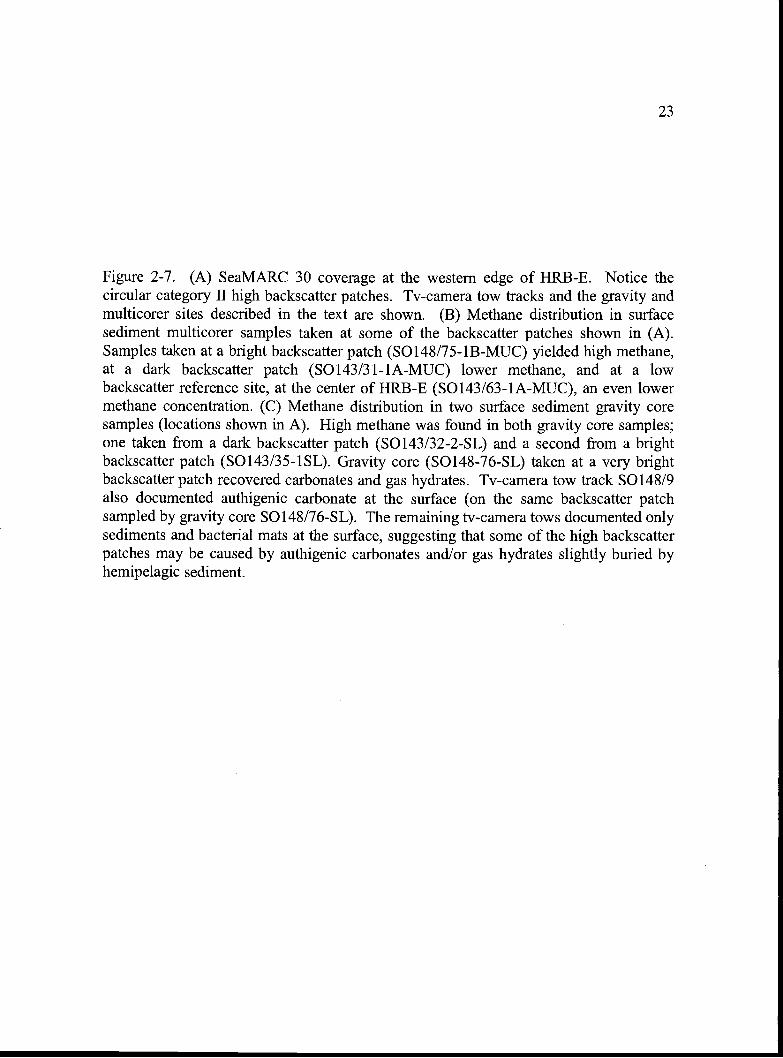
23
Figure 2-7. (A) SeaMARC 30 coverage at the western edge of HRB-E. Notice thecircular category II high backscatter patches. Tv-camera tow tracks and the gravity andmulticorer sites described in the text are shown. (B) Methane distribution in surfacesediment multicorer samples taken at some of the backscatter patches shown in (A).Samples taken at a bright backscatter patch (50148175-1B-MUC) yielded high methane,at a dark backscatter patch (S0143/31-1A-MUC) lower methane, and at a lowbackscatter reference site, at the center of HRB-E (S0143!63-1A-MUC), an even lowermethane concentration. (C) Methane distribution in two surface sediment gravity coresamples (locations shown in A). High methane was found in both gravity core samples;one taken from a dark backscatter patch (S0143/32-2-SL) and a second from a brightbackscatter patch (S0143/35-1SL). Gravity core (S0148-76-SL) taken at a very brightbackscatter patch recovered carbonates and gas hydrates. Tv-camera tow track S0148/9also documented authigenic carbonate at the surface (on the same backscatter patchsampled by gravity core S0148/76-SL). The remaining tv-camera tows documented onlysediments and bacterial mats at the surface, suggesting that some of the high backscatterpatches may be caused by authigenic carbonates andlor gas hydrates slightly buried byhemipelagic sediment.
44 36'
44-34,
Methane nrnol/g sediment2 4 6 8 10
SO 14 3/3 1-lAtSO143J631A°S0148175-lB
-1250
44-34-
24
A -1 252 -1 25 '0 -1 24S8
1000
S-D--S0143/32-2-0- 50143/35-1
Figure 2-7.
- - 1999 (S0143) tv-camera tows- 2000 (S0148) tv-camera tow
0 Gravity core (-SL) or multicorer (-MUC) site
km
B CMethane nmol/g sediment10 100
0 0
10 100
E 20 5 200I-,
:55) CI)
030 0300
40 400
50 500
25
(-8 nmollg at 10 cmbsf) and at greater depth, reached by gravity coring (S0148/76-SL),
contained disseminated gas hydrates and authigenic carbonates. Although limited
sampling and seafloor observations have occurred across the entire category II
backscatter region (Fig. 2-4 attached foldout), the similar shape and backscatter intensity
of the circular patches suggests they may represent authigenic carbonate, as they appear
to have the same backscatter strength as the known carbonates on the crest of Hydrate
Ridge. The lack of visible surface roughness and blurry nature of the circular patches,
however, may indicate many of them are buried by thin drape of hemipelagic sediment.
The close association of the authigenic carbonates and gas hydrates recovered in gravity
core S0148-76-SL also suggests gas hydrates may be present at many of the category II
circular patches.
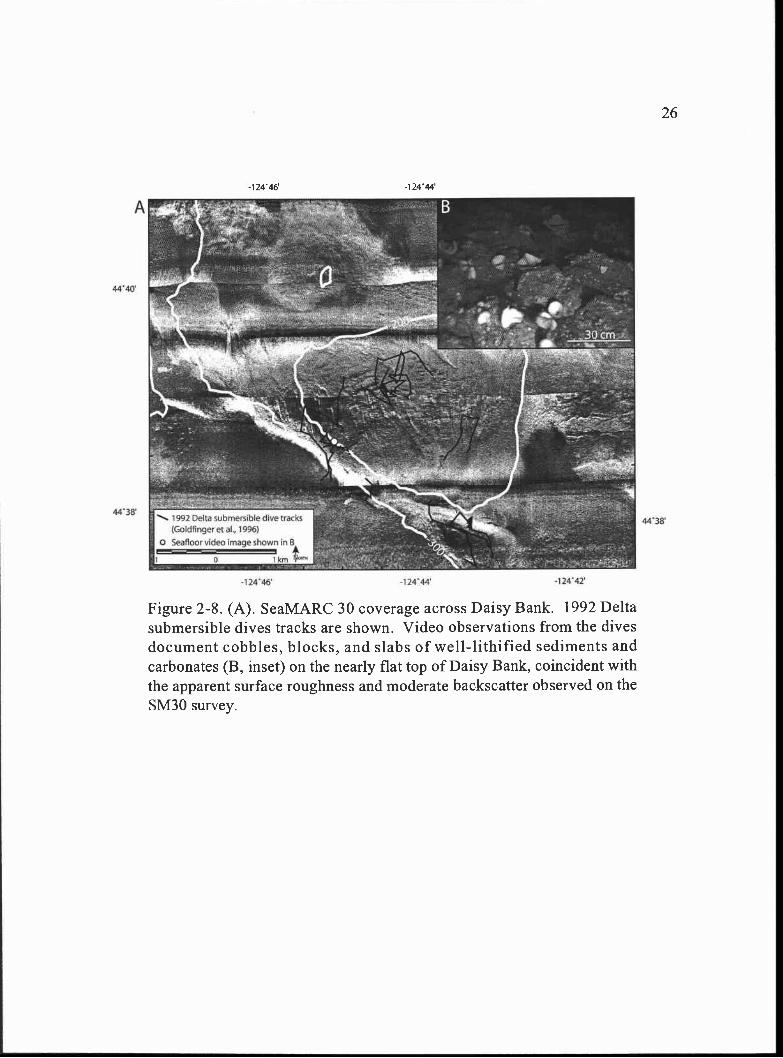
Category III Backscatter-Daisy Bank
Category III high backscatter sites are coincident with regions of high slope (Figs.
2-4 attached foldout and 2-5), however, a major exception to this occurs on the flat topped
ridges associated with the Daisy Bank Fault zone (Fig. 2-4 attached foldout). Seafloor
observations by the Delta submersible document abundant carbonate chimneys, doughnuts,
and slabs, within 100-150 m of the fault traces and tabular carbonate blocks up to 6 m in
length on the top of Daisy Bank (Goldfinger et al., 1996). Recent examination of the 1992
Delta submersible dive videos with the new 5M30 sidescan data indicates the extensive
high-to-moderate backscatter with apparent surface roughness observed on the top of Daisy
Bank is due to cobbles, blocks, and slabs of well-lithified sediments and carbonates (Fig. 2-
8). Although the uplifts associated with the Daisy bank fault NW of Daisy Bank have
higher backscatter than the top of Daisy Bank, the slope effect due to their steep sided,
linear nature, likely enhances some of their backscatter signal, even though lithologically
they may be similar to Daisy Bank.
Other Fluid Venting Manifestations
Also present on the crest of Hydrate Ridge and along its northeastern flank are
three mud volcanoes, MV!, MV2, and MV3 (Fig. 2-9). The circular craters at the centers
4440
4438
A
1992 Delta submersible dive tracks)Goldfingeret at, 1996)
o Seafloor video image shown in 8A
1)
-124 -1 24 44' -12442'
-12446 -12444
Figure 2-8. (A). SeaMARC 30 coverage across Daisy Bank. 1992 Deltasubmersible dives tracks are shown. Video observations from the divesdocument cobbles, blocks, and slabs of well-lithified sediments andcarbonates (B, inset) on the nearly flat top of Daisy Bank, coincident withthe apparent surface roughness and moderate backscatter observed on theSM3O survey.
26
27
of mud volcanoes MV1 and MV3 are clearly visible on the sidescan imagery, however,
MV2 is less obvious because of the high backscatter caused by the surrounding
carbonates, but a circular crater associated with this high backscatter is visible on high
resolution bathymetry (Clague et al., 2001). Mud volcanoes are one of several types of
surface expressions of mud intrusions, which occur as overpressured, mutiphased pore
fluids (methane and water) and sediments are expelled at the seafloor surface (Brown,
1990). The two mud volcanoes present near the crest of Hydrate Ridge (MV1 and MV2)
are coincident with the abundant carbonate chemoherms documented on the northern
summit of the ridge, while the mud volcano on the eastern flank of the ridge (MV3) has
breached the crest of a smaller secondary anticline (Fig. 2-9). The two northern mud
volcanoes (MV2 and MV3) show high backscatter on the sidescan imagery, perhaps
suggesting methane rich fluids were expelled during their eruption and consequently
oxidized to precipitate carbonate (Fig. 2-9). The more southerly mud volcano imaged
with more subdued backscatter is coincident with the general decrease in backscatter
toward the saddle region of Hydrate Ridge.
Active fluid venting in the form of hydrate-coated bubbles has also been observed
on both the northern and southern summits of Hydrate Ridge during Alvin dives (Torres
et al., 1999) and tv-camera tows (Suess et al., 1999) and acoustically imaged in 12 and 18
kHz subbottom profiles (Tones et al., 1999; Bohrmann et al., 2000; Heeschen et al.,
2003). Methane has also been measured in high concentrations plumes in the water
colunm above Hydrate Ridge (Suess et al., 2001).
Additional evidence for fluid or gas escape, imaged on the SM3O survey, is
present in the central to eastern region of the survey as a band of pockmark fields (Fig. 2-
10). The pockmark fields are limited on their eastern side by the -550 m contour and on
the western end by the -1050 m contour. Some of the pockmarks are coincident with the
locations of category II high backscatter and others appear to be isolated in lower
backscatter sediments.
28
Figure 2-9. SeaMARC 30 coverage and structures across Hydrate Ridge. The three mudvolcanoes (MV1, MV2, and MV3) are present on Northern Hydrate Ridge (NHR). MV2and MV3 are associated with high backscatter suggesting carbonate precipitation duringexpulsion. MV2 does not appear to be associated with high backscatter, which isconsistent with an overall decrease in patchy backscatter toward the saddle region. NoticeMV3 breaches the crest of an anticline on the eastern flank of Hydrate Ridge and MV1 andMV2 exist near the crest of NHR. The acoustic shadow of the Southern Hydrate Ridge(SHR) pinnacle is visible as a black speck in the middle of the largest backscatter patch onSHR. The saddle region between NHR and SHR appears highly fractured, perhaps a resultof extension at the crest of Hydrate Ridge.
44'42
44'40
4438'
44-34!
44'37
9 thrust fault anticline
4
normal fault syncline
strike-slip fault
2 km
4442'
44' 40'
44'38'
44'36'
44.34-
4432'
-12512' -1 25'lO' -1 258' -125' 6 -1 25'4 -125' 2'
29
-1 25 6 -1 25'4' -1252
A
4440
4436
4432
-
.4..
..'. n'A J,:jY4 I1,- -.- .a.'..
'fl IJD_________ - .
------- '!A,Il.* 2 -_ . !:
'---U--. --
-".4"e-pill . q - - - - -
- .- j_,.- s_s__ .i
-1 25 12
4-140
-12456
- 2456
4 48
-12448
124 40
- 2440'
4440'
4436
...-.' - . / ) p .z .t--. 1____ ,,
- ''S-
.12459 -12458 14'57
Figure 2-10. (A) SeaMARC 30 complete survey coverage. The pockmarkfields and the extent of the BSR are shown. The easternmost pockmark fieldextends to the 550 m contour and is coincident with the termination of theBSR at nearly the same depth. This suggests the pockmark fields mayrepresent the gas hydrate stability limit near the eastern part of the survey.Also notice the abrupt termination of most of the pockmark fields and CategoryII backscatter patches at the 700 m contour (see Landward Limit of GasHydrate Stability for discussion). (B) Close up image of one of the pockmarkfields (location shown in A).
30
Discussion
Backscatter Distribution
Confirmation of the backscatter patterns on Hydrate Ridge by abundant seafloor
observations makes them the most well-constrained features in the survey. In addition, the
highest level of detail can be seen by looking at the 1.5 km swaths, which only cover the
top of Hydrate Ridge (Fig. 2-4 attached foldout). Examination of this imagery in particular
reveals the variations in backscatter strength and seafloor features from the northern to the
southern summit of the ridge. The northern summit is characterized by extensive
authigenic carbonate chemoherms and gas hydrates of high to intermediate backscatter
intensity and the surface of the ridge appears to break apart toward the saddle region,
between the two summits, coincident with a dramatic decrease in large carbonate
chemoherms. The carbonates appear to become reestablished, to a much lesser degree,
toward the southern summit and result in the large pinnacle structure (Fig. 2-4 attached
foldout).
Category I and II high backscatter patterns are both blotchy to circular and only
differ in their apparent surface roughness. They are both also only present in the regions of
the survey where gas hydrate is either inferred by the presence of the BSR (Tréhu et al.,
1999; Tréhu and Flueh, 2001) or confirmed by recovered samples (Hovland et al., 1995;
Suess et al., 2001). On Hydrate Ridge the apparent surface roughness of the category I
high backscatter has been groundtruthed by Alvin, deep towed video observations, and
seafloor samples and is likely due to the fresh exposure of the authigenic carbonates and
gas hydrates on the seafloor. In contrast to the erosional environment of Hydrate Ridge,
the eastern slope basin and region to the east likely have a higher sedimentation rate, which
may tend to bury authigenic carbonates and hydrates precipitated near the seafloor surface.
This could explain the smooth texture and the variable backscatter intensity of the category
II high backscatter sites in these regions. Seafloor observations and core also suggests at
least some of the category II high backscatter sites contain authigenic carbonate and gas
hydrate buried by hemipelagic sediments. The similar nature of the category II backscatter
31
32
patches across the survey suggests they may all have this same composition, however, with
only a few of the category II backscatter sites investigated at the seafloor, further
groundtruthmg in the central and eastern part of the survey is needed to truly verify their
compositions.
Relationship to Geologic Structures
Hydrate Ridge Region
The pattern of extensive authigenic carbonates, the presence of three mud
volcanoes, and observed seafloor gas discharge suggests fluid venting is highly
concentrated on northern Hydrate Ridge. Structurally, the northern summit is shallower,
at a 6OO m depth, than the southern summit, at 800 m. This difference in bathymetry
suggests the ridge is effectively plunging to the southwest creating a structural trap at the
northern summit for any fluids and gases to migrate toward and accumulate. A large
accumulation of free gas is inferred beneath the northern summit of Hydrate Ridge based
on seismic velocity and attenuation (Tréhu and Flueh, 2001) and it is this pool of gas,
which likely supplies the gas hydrate-authigenic carbonate system in the near surface
sediments. The extensive occurrence of authigenic carbonates on the northern summit
suggests it has either recorded a longer history or a higher rate of methane expulsion than
that recorded by the southern summit U/Th ages from northern summit authigenic
carbonates may indicate a long history of methane expulsion is more likely, as samples of
the carbonate carapace there yield ages between 68,700 and 71,700 years, while samples
from the southern summit pinnacle range in age from 7,300 to 11,400 years (Teichert et
al., in press). The conduits for methane expulsion at the northern end of the ridge could
be faults and fractures, similar to those imaged on the 1.5 km swath sidescan data in the
saddle between the northern and southern summits of Hydrate Ridge (Fig. 2-9). Perhaps,
some of these conduits are bending moment normal faults created during flexure at the
crest of Hydrate Ridge. Bedding parallel faults created during flexural slip folding, out of
sequence thrust faults, or high porosity stratigraphic horizons could also serve as
conduits. Unfortunately, details of the shallow subsurface structure at the crest of
33
Hydrate Ridge cannot be resolved on the existing seismic reflection data, so the true
nature of the conduits can only be speculated at this time. The important observation,
however, is that the carbonates appear to be well developed at the northern summit of
Hydrate Ridge, where concentrated structural deformation is likely. The first
accretionary anticline just west of Hydrate Ridge shows abundant evidence for fluid
expulsion at its crest (Kulm and Suess, 1990) and the location of the mud volcano (MV3)
on the eastern flank of the northern summit of Hydrate Ridge also coincides with the
crest of a smaller anticline (Fig. 2-9). These associations suggest anticlinal folding may
help to focus fluids until faults or fractures, potentially caused by the folding, or exposed
high porosity stratigraphic horizons create the conduits needed for subsequent fluid
expulsion. Future correlation of the high backscatter sites on Hydrate Ridge with higher
resolution seismic reflection data, however, will ultimately yield better insight to these
processes.
Daisy Bank Fault Zone
Most of the category III high backscatter sites are coincident with high slope,
however a major exception to this occurs on the flat topped ridges associated with the
Daisy Bank Fault zone (Fig. 2-4 attached foldout). High backscatter along the fault scarp
and uplifts along the fault zone suggest either authigenic carbonate presence or an older
more lithified and uplifted section of the stratigraphy capable of high backscatter, or a
combination of the two. Seafloor observations in the Delta submersible document
abundant carbonate chimneys, doughnuts, and slabs, within 100-150 m of the fault traces
and tabular carbonate blocks up to 6 m in length on the top of Daisy Bank (Goldfinger et
al., 1996). Authigenic carbonates have also been observed at the Wecoma left-lateral
strike-slip fault to the north and isotopic measurements on them suggest the fluid source is
deep within the sedimentary section (Sample et al., 1993). The high backscatter at Daisy
Bank is shallower (200 m) than the predicted hydrate stability zone (-450-500 m; Tréhu et
al., 2002), and like the Wecoma fault, it likely taps a deeper methane source to precipitate
the carbonates present near the seafloor surface. A long-term history of structurally
34
controlled deep fluid venting along the Daisy Bank Fault is also suspected due to the
pervasive high backscatter present along its length. Such a large active fault conduit is
likely to deliver a significant volume of fluid to the seafloor surface, perhaps
accommodating much of the regional dewatering of the accretionary wedge. These
focused fluids, once expelled, result in the significant carbonate precipitation observed on
the seafloor and inferred by the high backscatter along the fault zone.
HRB-E and Eastern Slope
Highly focused fluid flow is evident on Hydrate Ridge and along the Daisy Bank
Fault, however, in the region between these structures the backscatter pattern is much more
diffuse (Fig. 2-4 attached foldout). Category II high backscatter, circular to blotchy with
no apparent surface roughness, dominates the region along the eastern edge of HRB-E and
eastward toward the Daisy Bank fault zone. The association between the pattern of fluid
venting and bathymetry suggests some of the high backscatter patches may be coincident
with abrupt changes in slope, perhaps caused by small amplitude folds in the subsurface
(similar to those shown in Fig. 2-3). Much of the category II backscatter, however, appears
as small, scattered patches in areas of low slope across the region, suggestive of low
volume diffuse fluid venting. The coincidence of the category II backscatter with the
hydrate stability zone may indicate fluid venting is associated with shallow disruptions in
the underlying gas hydrate system. The lack of significant surface roughness on the
category II high backscatter, however, and subtle variations in backscatter strength suggests
these features maybe buried by variable amounts of hemipelagic sediment. This may
indicate that either (1) fluid venting is currently not active at some of the sites across the
region (where the backscatter is circular but of intermediate reflectivity), (2) fluid venting
and carbonate precipitation are continuous, but occur at a slower rate than hemipelagic
sedimentation, or (3), there is an episodic nature to the fluid venting, permitting active fluid
escape at some sites (e.g. the highest backscatter sites) while abandoning others (e.g.
intermediate backscatter patches, possibly covered by hemipelagic sediment since their last
activity). We suggest the apparent variability in fluid venting and authigenic carbonate
35
precipitation across the eastern slope could be attributed to disruptions in the subsurface
gas hydrate system. In this region, perhaps larger faults at depth are responsible for the
delivery of pore fluids to the gas hydrate stability zone within the upper seafloor sediments.
Once there, the fluids only escape by (1) direct fault conduits to the seafloor, which seem
unlikely here since there are few linear manifestations of fluid venting, (2) rapid fluid
expulsion, resulting in pockmarks on the seafloor, or (3) diffuse fluid flow, through high
porosity conduits or microfractures. We suggest the latter two processes occur across this
region, as circular high backscatter patches can be seen associated with pockmarks (Fig. 2-
10) and high porosity conduits are likely in a wedge characterized by turbidite
sedimentation (Kuim and Fowler, 1974).
Landward Limit of Gas Hydrate Stability
Pockmarks terminate near the eastern end of the survey area at 55O m, coincident
with the eastern extent of the BSR, as interpreted on the only multichannel seismic
reflection profile (line 8) that extends this far east from the ODP Leg 146 site survey (Fig.
2-10). This suggests the pockmarks may represent the surface manifestation of gas hydrate
dissociation near the landward limit of gas hydrate stability in this region. Because
pockmarks typically result from rapid fluid or gas escape through a relatively thin
sedimentary section (Brown, 1990) the shallow source of methane in gas hydrate near its
stability boundary may be a likely source for this fluid expulsion. The -550 m contour
corresponds with only the easternrnost pockmark field on the survey. Most of the
pockmark fields appear to terminate at the 700 m contour to the west, coincident with the
abrupt termination of category II backscatter (Fig. 2-10). The coincidence of the
termination of the BSR on seismic line 8 with the easternrnost pockmark field and the other
pockmark fields suggests the hydrate stability limit extends to the 550 m depth near
seismic line 8, but lies deeper to the west, at 700 m, across the rest of the survey (Fig. 2-
10). We suggest the distribution of pockmarks and category II backscatter patches and
their eastern termination serves to delineate the landward limit of gas hydrate stability, and
thus fluid venting related to gas hydrate destabilization in this region.
Backscatter Patterns and Fluid Flow
Schematic diagrams describing the possible environments responsible for the three
categories of backscatter and the potential pathways for the fluids are shown in Figure 2-
11. Fluid flow, driven by compaction and dewatering of the wedge, in the Hydrate Ridge
region supplies fluids to the hydrate stability zone via faults and fractures, dipping
stratigraphic horizons, or during diffuse intergranular fluid flow. Authigenic carbonates
can precipitate from the methane in these fluids as they interact directly with seawater in
the shallow subsurface and/or as methane is released during the destabilization of gas
hydrate. The distribution of high backscatter across the Hydrate Ridge region suggests
fluids pond in anticlinal structures like Hydrate Ridge and the first accretionary ridge
(FAR), while migrating away from or completely abandoning more undeformed portions
of the wedge (e.g. HRB-E, where there is only one high backscatter patch, Fig. 2-4 attached
foldout). The crests of anticlinal structures like Hydrate Ridge are under local tension and
it is likely that fractures and faults serve as the major vertical fluid flow conduits to the
seafloor. However, because Hydrate Ridge lies within the hydrate stability zone and
carbonates derived from destabilized gas hydrate have been identified there (Bohrmann et
al., 1998; Greinert et al., 2001) it is likely that both structurally influenced fluid migration
and the destabilization of gas hydrate contribute to the authigenic carbonates imaged on the
sidescan imagery. Therefore we c1assif' the category I backscatter environment as
structurally influenced and gas hydrate related (Fig. 2-11). Category II backscatter occurs
in a mildly deformed portion of the wedge within the region of gas hydrate stability. The
hydrate system here is likely fed by up dip fluid flow along porous stratigraphic horizons or
deeper faults out of HRB-E (evidenced by the abundant backscatter on the eastern edge of
HRB-E and on Hydrate Ridge, both up dip of HRB-E). In the middle portion of the survey
(ITRB-E to the Daisy Bank fault) the bathymetric expression of major subsurface structures
is minimal, suggesting the subsurface is only mildly deformed (Fig. 2-1). The high
backscatter patterns in the category II region suggest fluid pathways to the surface are
diffuse or fluids advect at slower rates. Variable backscatter intensity, due to buried
authigenic carbonates may also suggests a sporadic history of fluid venting, although
36
37
Figure 2-11. Schematic diagrams depicting the environments likely responsible for eachof the backscatter categories. Suggested pathways responsible for the delivery of fluidsto the shallow subsurface and gas hydrate stability zone (BSR labeled) are shown in thelower block diagram. Fluids migrate and accumulate at structural highs like HydrateRidge and the first accretionary ridge (FAR) and to a lesser extent on the eastern slopeeast of HRB-E. The structural highs are local sites of tension and it is likely faults andfractures permeate their crests. Category I backscatter occurs in this environment and, inthe presence of abundant gas hydrate, fluid flow responsible for the carbonateprecipitation at the surface is characterized as structurally influenced and gas hydraterelated. Category II backscatter occurs on the eastern slope, east of HRB-E. It ischaracterized by variable intensity and a patchy distribution of backscatter patterns,suggestive of sporadic seafloor venting. It also lies in a region of the wedge that is mildlydeformed, thus structural control on fluid expulsion sites is unlikely. Fluid flowresponsible for this backscatter is likely diffuse and related to disruptions in theunderlying gas hydrate. Category III backscatter across the Daisy Bank fault zonesuggests long-term deep-seated fluid flow. Its location above the hydrate stability zoneand the linear backscatter patterns suggest this region is dominated by structurallycontrolled non-gas hydrate related fluid flow.
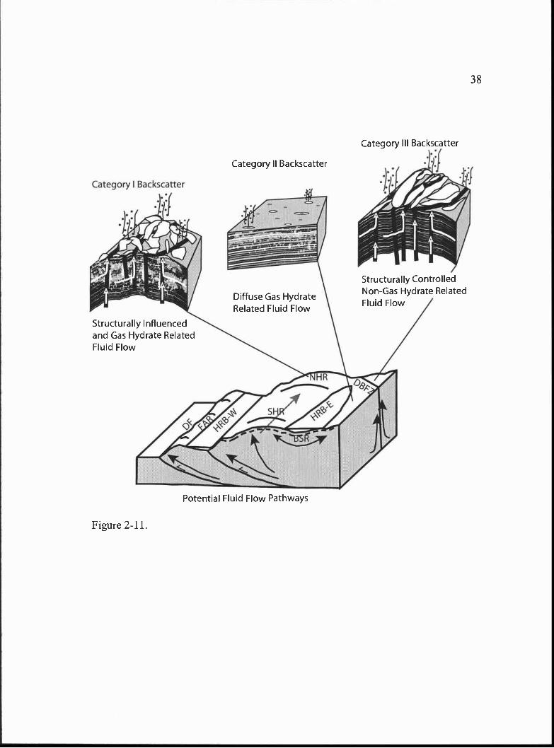
Category I Backscatter
Structurally Influencedand Gas Hydrate RelatedFluid Flow
Figure 2-11.
Potential Fluid Flow Pathways
Category HI Backscatter
Category II Backscatter
Diffuse Gas HydrateRelated Fluid Flow
Structurally ControlledNon-Gas Hydrate RelatedFluid Flow
38
39
high methane content in the near-surface sediments suggests active upward fluid flow. The
lack of significant subsurface structure in the category II backscatter region and its location
within the hydrate stability zone, suggests authigenic carbonate precipitation is most likely
related to the destabilization of gas hydrate in this region. The category II backscatter
environment is thus characterized as diffuse and gas hydrate related (Fig. 2-11). Category
III backscatter, not related to major slope changes, occurs along the Daisy Bank Fault
Zone. Here, high backscatter patterns suggest fluid flow has been continuous and likely
deep-seated. In addition most of the Daisy Bank Fault Zone lies above the eastern hydrate
stability limit (-55O at the shallowest). The environment responsible for the Daisy Bank
category III backscatter is thus classified as structurally controlled and non-gas hydrate
related (Fig. 2-11).
Conclusions
Based on seafloor mapping using high resolution SeaMARC 30 sidescan sonar
data coupled with seafloor observations, samples, and subsurface geologic mapping the
following conclusion can be made: (1) the blotchy to circular category I high backscatter
present on Hydrate Ridge is indeed authigenic carbonate, (2) the category II high
backscatter present along the eastern side of the survey is likely authigenic carbonate,
with some gas hydrate, slightly buried by hemipelagic sediment, (3) both category I and
II high backscatter sites represent carbonates that may have precipitated from destabilized
gas hydrate and show an intimately linked gas hydrate carbonate system, however on
Hydrate Ridge, direct fluid migration from depth also likely contributes to the carbonate
precipitation, (4) breached anticlines serve not only to trap and aid in the migration of
fluids and gases through the sediment column, but also serve as escape pathways,
providing a local extensional environment at their crests for fluid expulsion, (5) diffuse
gas hydrate related fluid flow is likely responsible for the category II high backscatter on
the eastern slope, east of HRB-E, (6) category III backscatter associated with the Daisy
Bank fault zone is likely derived from deep seated fluids that have a long history of
escape along the fault and are likely unrelated to the destabilization of gas hydrate, and
40
(7) the abrupt decrease of pockmark fields and category II backscatter patches on the
eastern edge of the survey area may serve to delineate the landward limit of gas hydrate
stability across this region.
Acknowledgements
We thank the 1999 R!V New Horizon crew, the shipboard scientific party, and
Williamson and Associates of Seattle, WA for their hard work during the SeaMARC 30
data acquisition and processing phase. We also thank Gerhard Bohrmann (GEOMAR), for
helpful comments and suggestions during the sidescan sonar cruise and use of the WV
Sonne Leg 143 data, Peter Linke (GEOMAR) for use of the RIV Sonne SO 148 OFOS data,
and Marta Tones (OSU) for use of her ALVIN observations on Hydrate Ridge. Additional
thanks to Jason Chaytor (OSU) for compiling the 50 mbathymetric grid used to make the
slope map and Anne Tréhu and Matt Arsenault (OSU) for assistance with the 1989 Digicon
seismic data. This manuscript also benefited from very thorough and thoughtful reviews
by Nathan Bangs, David Piper, and an anonymous reviewer. GEOMAR collaborators on
cruises SO 143 and SO 148 were funded through the TECFLUX projects by the Federal
Ministry of Science and Technology (BMBF; grants O3GO/143/148). Funding for the
TECFLUX project at OSU for the data collection and processing of the SM3O data was
provided by NSF Award #9731023. Acknowledgement is also made to the Donors of The
Petroleum Research Fund, administered by the American Chemical Society, for partial
support of this research.
References
Blondel, P. and Murton, B.J., 1997. Handbook of Seafloor Sonar Imageiy. Wiley-PraxisSeries in Remote Sensing. John Wiley & Sons Ltd. in association with PraxisPublishing Ltd., West Sussex, England, 314 p.
Bohrmann, G., Greinert, J., Suess, E. and Tones, M., 1998. Authigenic carbonates from theCascadia subduction zone and their relation to gas hydrate stability. Geology, 26(7), 647-650.
Bohrmaim, G., Linke, P., Suess, E. and Pfannkuche, 0., 2000. RV SONNE Cruise ReportS0143 TECFLUX-I-1999. GEOMAR Report 93.
Brown, K.M., 1990. The nature and hydrogeologic significance of mud diapirs anddiatremes for accretionary systems. J. Geophys. Res., 95 (B6), 8969-8982.
Carson, B., Seke, E., Paskevich, V. and Holmes, M.L., 1994. Fluid expulsion sites on theCascadia accretionary prism: Mapping diagenetic deposits with processed GLORIAimagery. J. Geophys. Res., 99 (B6), 11,959-11,969.
Clague, D.A., Maher, N., and Paull, C.K., 2001. High-resolution multibeam survey ofHydrate Ridge, offshore Oregon. In: Paull, C.K. and Dillon, W.P. (Eds.), NaturalGas Hydrates: Occunence, Distribution, and Detection. Geophysical Monograph124. American Geophysical Union, Washington, D.C., 297-303.
Fleming, S.W. and Tréhu, A., 1999. Crustal structure beneath the central Oregonconvergent margin from potential-field modeling: Evidence for a buried basementridge in local contact with a seaward dipping backstop. J. Geophys. Res., 104(B9), 20,431-20,447.
Goldfinger, C., Kulm, L D ,Yeats, R.S., Appelgate, B., MacKay, M.E., Moore,G.F., 1992. Transverse structural trends along the Oregon convergent margin:Implications for Cascadia earthquake potential and crustal rotations. Geology, 20,141-144.
Goldfinger, C., Kulm, L.D., Yeats, R.S., Hummon, C., Huftile, G.J., Niem, A.R.,McNeill, L.C., 1996. Oblique strike-slip faulting of the Cascadia submarineforearc: The Daisy Bank fault zone off central Oregon. In: Bebout, G.E., Scholl,D.W., Kirby, S.H., Platt, J.P (Eds.), Subduction: Top to Bottom. GeophysicalMonograph 96. American Geophysical Union, Washington, D.C., 65-74.
Goldfinger, C., Kuim, L.D., Yeats, R.S., McNeill, L. and Hummon, C., 1997. Obliquestrike-slip faulting of the central Cascadia submarine forearc. J. Geophys. Res., 102(B4), 8217-8243.
Greinert, J., Bohrmann, G. and Suess, E., 2001. Gas hydrate-associated carbonates andmethane-venting at Hydrate Ridge: Classification, distribution, and origin ofauthigenic lithologies. In: Paull, C.K., Dillon, W.P. (Eds.), Natural Gas Hydrates:Occunence, Distribution, and Detection. Geophysical Monograph 124. AmericanGeophysical Union, Washington D.C., 99-113.
41
Haugerud, R.A., 1999. Digital elevation model (DEM) of Cascadia, latitude 39N-53N,longitude 1 16W-133W. U.S. Geological Survey Open-file Report 99-369.
Heeschen, K.U., Tréhu, A.M., Collier, R.W., Suess, E., and Rehder, G., 2003.Distribution and height of methane bubble plumes on the Cascadia margincharacterized by acoustic imaging Geophys. Res. Letts. v. 30, 1643-1646.
Henry, P., Lallemant, S.J., Le Pichon, X. and Lallemand, S.E., 1989. Fluid venting alongJapanese trenches: Tectonic context and thermal modeling. Tectonophysics, 160,277-291.
Hoviand, M., Lysne, D. and Whiticar, M., 1995. Gas hydrate and sediment gascomposition, Hole 892A. In: Carson, B., Westbrook, G.K., Musgrave, R.J., Suess,E. (Eds.), Proceedings of the Ocean Drilling Program, Scientific Results. OceanDrilling Program, College Station, Texas, 151-161.
Hyndman, R.D. and Spence, G.D., 1992. A seismic study of methane hydrate marinebottom simulating reflectors. J. Geophys. Res., 97 (B5), 6683-6698.
Johnson, J.E., Goldfinger, C., and Tréhu, A.M., 2000, Structural development anddeformation styles of the Hydrate Ridge region, Cascadia accretionaryprism. Geol. Soc. Am. Abstracts with Programs, 32 (7), A36.
Johnson, H.P. and Helferty, M., 1990. The geological interpretation of side-scan sonar.Rev. Geophys., 28 (4), 357-380.
Kopf, A.J., 2002, Significance of Mud Volcanism. Rev. Geophys., 40, B1-B49.
Kuim, L.D. and Fowler, G.A., 1974. Cenozoic sedimentary framework of the Gorda-Juande Fuca Plate and adjacent continental margin- A Review. In: Dott, R.H. Jr.,Shaver, R.H. (Eds.), Modem and Ancient Geosynclinal Sedimentation. Society ofEconomic Paleontologists and Mineralogists, Special Publication 19, 212-229.
Kuim, L.D. and Suess, E., 1990. Relationship between carbonate deposits and fluidventing: Oregon accretionary prism. J. Geophys. Res., 95 (B6), 8899-89 15.
Kulm, L.D., Suess, E., Moore, J.C., Carson, B., Lewis, B.T., Ritger, S.D., Kadko, D.C.,Thomburg, T.M., Embley, R.W., Rugh, W.D., Massoth, G.J., Langseth, M.G.,Cochrane, G.R., Scamman, R.L.,1986. Oregon subduction zone: Venting, fauna,and carbonates. Science, 231, 561-566.
Kvenvolden, K.A., 1993. Gas hydrates - Geological perspective and global change. Rev.Geophys., 31(2), 173-187.
Linke, P. and Suess, E., 2001. RV SONNE Cruise Report SO 148 TECFLUX-II-2000.GEOMAR Report 98.
Le Pichon, X., Kobayashi, K. and Crew, K.-N.S., 1992. Fluid venting activity within theeastern Nankai Trough accretionary wedge: A summary of the 1989 Kaiko-Nankairesults. Earth Planet Sc. Lett., 109, 303-3 18.
42
43
Lewis, B.T.R. and Cochrane, G.C., 1990. Relationship between the location ofchemosynthetic benthic communities and geologic structure on the Cascadiasubduction zone. J. Geophys. Res., 95 (B6), 8783-8793.
MacKay, M.E., 1995. Structural variation and landward vergence at the toe of the Oregonaccretionary prism. Tectonics, 14 (5), 1309-1320.
MacKay, M.E., Jarrard, R.D., Westbrook, G.K., Hyndman, R.D., Shipboard ScientificParty of Ocean Drilling Program Leg 146, 1994. Origin of bottom-simulatingreflectors: Geophysical evidence from the Cascadia accretionary prism. Geology,22, 459-462.
MacKay, M.E., Moore, G.F., Cochrane, G.R., Moore, G.F. and Kulm, L.D., 1992.Landward vergence and oblique structural trends in the Oregon margin accretionaryprism: Implications and effect on fluid flow. Earth Planet Sc. Left., 109, 477-491.
McNeill, L.C., Goldfinger, C., KuIm, L.D., and Yeats, R.S., 2000. Tectonics of theNeogene Cascadia forearc basin: Investigations of a deformed late Mioceneunconformity. Geol. Soc. Am. Bull., 112 (8), 1209-1224.
Moore, J.C. and Vrolijk, P., 1992. Fluids in accretionary prisms. Rev. Geophys., 30, 113-135.
Ohta, S. and Laubier, L., 1987. Deep biological communities in the subduction zone ofJapan from bottom photographs taken during "Nautile" dives in the Kaiko project.Earth Planet Sc. Left., 83, 329-342.
Ritger, S.D., Carson, B. and Suess, B., 1987. Methane-derived authigenic carbonatesformed by subduction-induced-pore-water expulsion along the Oregon/Washingtonmargin. Geol. Soc. Am. Bull., 98, 147-156.
Sample, J.C., 1996. Isotopic evidence from authigenic carbonates for rapid upward fluidflow in accretionary wedges. Geology, 24 (10), 897-900.
Sample, J.C. and Reid, M.R., 1998. Contrasting hydrogeologic regimes along strike-slipand thrust faults in the Oregon convergent margin: Evidence from the chemistry ofsyntectonic carbonate cements and veins. Geol. Soc. Am. Bull., 110 (1), 48-59.
Sample, J.C., Reid, M.R., Tobin, H.J. and Moore, J.C., 1993. Carbonate cements indicatechanneled fluid flow along a zone of vertical faults at the deformation front of theCascadia accretionary wedge (northwest U.S. coast). Geology, 21, 507-510.
Seely, D.R., 1977. The significance of landward vergence and oblique structural trends ontrench inner slopes. In: Talwani, M., Pitman, W.C. (Eds.), Islands Arcs, Deep SeaTrenches, and Back-Arc Basins, Maurice Ewing Series. American GeophysicalUnion, Washington, D.C., 187-198.
Snavely, P.D. Jr., 1987. Tertiary Geologic Framework, Neotectonics, and PetroleumPotential of the Oregon-Washington Continental Margin. In Scholl, D.W.,Grantz, A., and Vedder, J.G. (Eds.), Geology and resource potential of the
44
continental margin of western North America and adjacent Ocean - Beaufort Seato Baja California. Circum-Pacific Council for Energy and Mineral Resources,Earth Science Series 6, 305-335.
Suess, E., Carson, B., Ritger, S., Moore, J.C., Jones, M.L., Kuim, L.D., Cochrane,G.R.,1985. Biological communities at vent sites along the subduction zone offOregon. The hydrothermal vents of the eastern Pacific: An overview. BiologicalSociety of Washington Bulletin, 6, 474-484.
Suess, E., Tones, M.E., Bohrmarm, G., Collier, R.W., Greinert, J., Linke, P., Rehder, G.,Tréhu, A., Wallmann, K., Winckler, G., Zuleger, 1999. Gas hydrate destabilization:Enhanced dewatering, benthic material turnover and large methane plumes at theCascadia convergent margin. Earth Planet Sc. Left., 170, 1-15.
Suess, B., Tones, M.E., Bohrmann, G., Collier, R.W., Rickert, D., Goldfinger, C., Linke,P., Heuser, A., Sahling, H., Heeschen, K., Jung, C., Nakamura, K., Greinert, J.,Pfannkuche, P., Tréhu, A., Klinkhammer, G., Whiticar, M.J., Eisenhauer, A.,Teichert, B., Elvert, M., 2001. Sea floor methane hydrates at Hydrate Ridge,Cascadia Margin. In. Paull, C.K. and Dillon, W.P. (Eds.), Natural Gas HydratesOccunence, Distribution, and Detection. American Geophysical Union.Geophysical Monograph 124, 87-98.
Suppe, J., 1983. Geometry and kinematics of fault-bend folding. American Journal ofScience 283, 684-721.
Teichert, B.M.A., Eisenhauer, A., Haase-Schramm, A., Bock, B. and Linke, P., 2003. U/Thsystematics and ages of authigenic carbonates from Hydrate Ridge, Cascadiaconvergent margin: Recorders of fluid composition and sealevel changes. Geochim.Cosmochim. Ac. in press.
Tones, M.E., Bohrmann, G., Brown, K., deAngelis, M., Hammond, D., Klinkhammer, G.,McManus, J., Suess, E., Tréhu, A., 1999. Geochemical observations on HydrateRidge, Cascadia margin, July 99. Reference 99-3, Oregon State University DataReport 174.
Tréhu, A.M., Bangs, N.L., Arsenault, M.A., Bohrmann, G., Goldfinger, C., Johnson, J.E.,Nakamura, Y., Tones, 2002. Complex Subsurface Plumbing Beneath SouthernHydrate Ridge, Oregon Continental Margin, from High-resolution 3D SeismicReflection and OBS Data. Proceedings of the Fourth International Conference onGas Hydrates, Yokohama, Japan, 90-96.
Tréhu, A.M. and Flueh, E.R., 2001. Estimating the thickness of the free gas zone beneathHydrate Ridge, Oregon continental margin, from seismic velocities and attenuation.J. Geophys. Res., 106 (B2), 2035-2045.
Tréhu, A.M., Tones, M.E., Moore, G.F., Suess, E. and Bohrmann, G., 1999. Temporal andspatial evolution of a gas hydrate-bearing accretionary ridge on the Oregoncontinental margin. Geology, 27 (10), 939-942.
Westbrook, G., Carson, B., Musgrave, R., and Shipboard Scientific Party, 1994. Initialreports of the Ocean Drilling Program, 146. Ocean Drilling Program, CollegeStation, Texas, 630 p.
45
Chapter III
Structural Vergence Variation and Clockwise Block Rotation in the Hydrate RidgeRegion, Cascadia Accretionary Wedge
Joel E. Johnson', Chris Goldfinger1, Nathan L. B. Bangs2, Anne M. Tréhu1,
and Johanna Chevallier1
Oregon State University, College of Oceanic and Atmospheric Sciences, 104
Ocean Admin. Bldg. Corvallis, Oregon 97331
University of Texas, Institute for Geophysics, 4412 Spicewood Springs Rd. Austin,
Texas 78759
To be submitted to Tectonics
46
47
Abstract
Along the Cascadia accretionary margin offshore Oregon, the structural vergence
at the toe of the accretionary wedge varies from landward vergent offshore northern
Oregon to seaward vergent across the southern Oregon margin. A transition zone
between these vergence domains occurs along the central Oregon portion of the wedge,
centered on the Hydrate Ridge region. In this paper we identify past variability in
structural vergence across the Hydrate Ridge region through detailed structural mapping
using multichannel seismic reflection data and gridded bathymetry. These data are
coupled to biostratigraphic age constraints obtained from drilling to constrain the timing
of accretionary wedge growth since the early Pleistocene (<1.7 Ma). Our results indicate
that the wedge in the Hydrate Ridge region advanced in three structural phases during the
Quaternary: an early Pleistocene seaward vergent phase (.-1.7-1.2 Ma), an early to middle
Pleistocene (1 .2-0.3 Ma) landward vergent phase, and a late Pleistocene-Holocene
(O.3-0.25 Ma to present) seaward vergent phase. Age constraints on the timing of
landward vergent deformation suggest coincidence with the deposition of the Astoria fan.
High pore fluid pressures due to rapid fan deposition are the likely cause of landward
vergence for the northern Oregon and Washington margins. The large bathymetric
expression of northern Hydrate Ridge is likely due to its history of continued seaward
vergence, which permitted some sediment subduction, likely underplating and observed
thrust duplexing, all resulting in an increase in the thickness of the accretionary wedge
(more uplift) beneath this region. Superimposed on the accretionary wedge growth in the
Hydrate Ridge region, two transverse strike-slip faults have affected wedge development.
Evidence of clockwise block rotation of the Hydrate Ridge tectonic block between the
two transverse strike-slip faults appears most pronounced in the older portion of the
wedge, and decreases toward the west. Kinematic constraints onshore from GPS and
other evidence for northward migration of the forearc suggests a more southerly location
of the strike slip faults after the accretion of the early Pleistocene seaward vergent phase
(l .7-1.2 Ma) and their subsequent migration north to their present location and
orientation, suggesting their continued presence during the accretion of this portion of the
48
wedge. Constraints on the timing of propagation of the basement strike-slip faults into
the abyssal plain section near the deformation front indicate that the early-middle
Pleistocene landward vergent phase (jl .2-0.3 Ma) may have been terminated by this
faulting, which released pore pressure on the décollement. This local reduction in pore
pressure near the deformation front likely served to increase structural coupling at the
décollement in this region, resulting in the formation of the modern seaward vergent
frontal thrust.
Introduction
Accretionary wedge deformation along active margins has been well documented
at many of the world's subduction zones (e.g. Moore et al., 1988; MacKay et al., 1992;
von Huene et aL, 1996; Gulick et al., 2004). Clues to the geometry and structural
configuration of modern accretionary wedges come primarily from swath bathymetry and
seismic reflection profiles. DSDP (Deep Sea Drilling Project) and ODP (Ocean Drilling
Program) coring have added details of the stratigraphy and physical properties within the
wedges, helping to reconstruct their geologic evolution along several margins (e.g. Moore
et al., 1988; von Huene et al., 1988; Underwood et al., 2003). Because accretionary
wedges develop over long timescales, geophysical methods provide only a snapshot in
time of the longer term behavior and development of the wedge. Sandbox and other
physical models of subduction zone accretion have been used to recreate wedge growth
from inception to full development and have contributed to our understanding of how
wedges deform (e.g. Seely, 1977; Gutscher et al., 1996; 2001; Burbridge and Braun,
1998; Byrne et al, 1993; Smit et al., 2003). Tn addition, structural mapping of fold-and-
thrust belts preserved in geologic records onshore (e.g. Price, 1981; Marshak, 1986;
Echavarria et al., 2003) and critical taper theory (Davis et al., 1983) have enhanced our
understanding of the geologic and geometric controls on accretionary wedge
development.
Along the Cascadia subduction zone of western North America, where the Juan
de Fuca-Gorda plate system subducts obliquely beneath North America (Fig. 3-1), much
of the accretionary wedge is imaged by seismic reflection and swath bathymetric surveys.
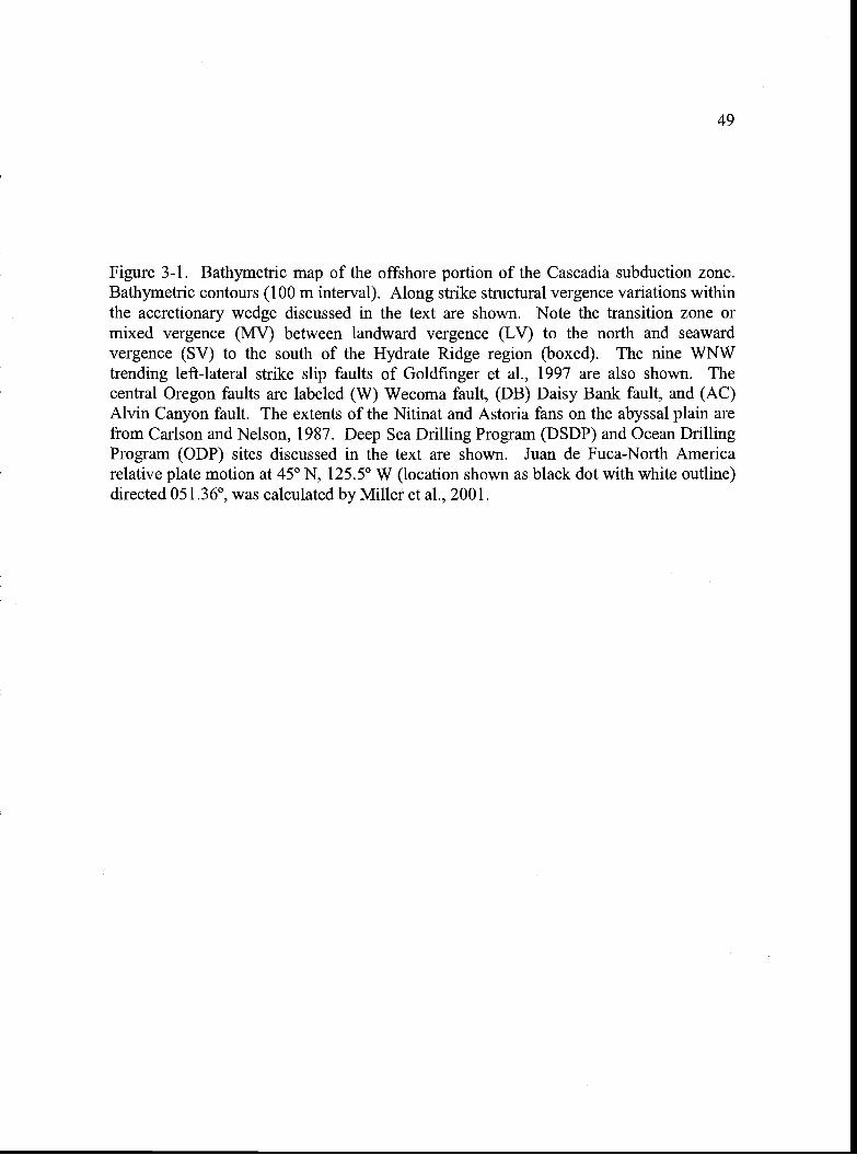
49
Figure 3-1. Bathymetric map of the offshore portion of the Cascadia subduction zone.Bathymetric contours (100 m interval). Along strike structural vergence variations withinthe accretionary wedge discussed in the text are shown. Note the transition zone ormixed vergence (MV) between landward vergence (LV) to the north and seawardvergence (SV) to the south of the Hydrate Ridge region (boxed). The nine WNWtrending left-lateral strike slip faults of Goldfinger et al., 1997 are also shown. Thecentral Oregon faults are labeled (W) Wecoma fault, (DB) Daisy Bank fault, and (AC)Alvin Canyon fault. The extents of the Nitinat and Astoria fans on the abyssal plain arefrom Carlson and Nelson, 1987. Deep Sea Drilling Program (DSDP) and Ocean DrillingProgram (ODP) sites discussed in the text are shown. Juan de Fuca-North Americarelative plate motion at 45° N, 125.5° W (location shown as black dot with white outline)directed 05 1.36°, was calculated by Miller et al., 2001.
48°
470
460
45°
440
430
420
410
400
490
4$0
47°
460
450
44°
'13°
42°
41
40°
-129° -128 0 -127 °
-132° -131° _1300 -129° _1280 -127° -126° 1250 -124° -123°
Figure 3-1.
50
-131° -130 ° -126° -125° -124° -123°
Kilometers100 0 100
51
These data sets document the subsurface structure and resultant surface bathymetric
expression of many of the structures within the wedge and document along-strike (N-S)
variations in structural vergence (Fig. 3-1). Offshore Vancouver Island, the structural
vergence is dominantly seaward (Davis and Hyndman, 1989; Hyndman et al., 1994).
Offshore Washington and northern Oregon, the structural vergence is dominantly
landward (Seely, 1977; MacKay et al., 1992; MacKay, 1995; Flueh et al., 1998).
Offshore central and southern Oregon, the vergence of structures is dominantly seaward
(MacKay et al., 1992; MacKay, 1995; Goldfinger et al., 2000), with a small local region
of landward vergence offshore the Rogue River region (Goldfinger et al., 2000).
Offshore northern California, the structural vergence changes more frequently along
strike (north to south) from dominantly seaward vergent to landward vergent back to
seaward vergent (Gulick et al., 1998). In addition to the seaward and landward thrust
faults and folds that comprise the Cascadia accretionary wedge, nine WNW-striking left-
lateral strike slip faults (Goldfinger et al., 1997) also cut across the lower slope of the
wedge (Fig. 3-1). These faults form in the lower plate as a result of dextral shear of the
forearc, due to the oblique subduction, and propagate upward into the wedge.
In the central Oregon portion of the margin discussed here (the Hydrate Ridge
region), a transition zone exists between the northern landward vergent province and the
southern seaward vergent province, yielding a narrow zone of mixed vergence, both
along and across strike, which is coincident with the location of two of the nine left-
lateral strike slip faults. DSDP Leg 18 and ODP Legs 146 and 204 drilling results
provide insight to the abyssal plain and lower slope accretionary wedge sedimentology
and stratigraphy in this region and biostratigraphy from all three legs helps to constrain
the ages of the sediments and timing of deformation throughout the region (Kulm and
von Huene et aL, 1973; Westbrook, Carson, Musgrave et al. 1994; Tréhu, Bohrmann,
Rack, Tones et al., 2003).
In this paper, we use multichannel seismic reflection data coupled with 100 m
gridded swath bathymetry and core biostratigraphy across the Hydrate Ridge region (Fig.
3-2) to (1) document the faults and folds in the subsurface, (2) determine the interaction
52
and relative timing of seaward and landward vergent thrusting and (3) investigate the
influence of left-lateral strike slip faulting on the deformation history of the lower slope
of the wedge. Our results reveal that the wedge advanced westward in a series of three
structural phases since the late Pliocene-early Pleistocene: a seaward vergent phase, a
landward vergent phase, and a seaward vergent phase. Superimposed on this structural
vergence variation with time is the influence of left-lateral strike-slip faulting, which
appears to have resulted in the clockwise rotation of structures during and likely since
their accretion.
Geologic Setting: Washington and Oregon Margin
The Juan de Fuca and Gorda plates are currently subducting obliquely beneath the
North American Plate along the Washington, Oregon, and Northern California
continental margins (Fig. 3-1). The Cascadia accretionary wedge evolved in response to
the oblique subduction and is composed of folded and faulted abyssal plain turbidites and
hemipelagic clays as well as the recycled products of these uplifted sediments as slope
basin fills (Kulm and Fowler, 1974; Westbrook, Carson, Musgrave et al. 1994; Tréhu,
Bohrmann, Rack, Tones et al., 2003). The oblique convergence also creates a right-
lateral shear couple within the forearc region and, off the Washington and Oregon
margins, nine WNW striking left-lateral strike-slip faults, antithetic to the shear couple,
have been identified on the continental slope and abyssal plain (Goldfinger et al., 1992;
1997). The Quaternary portion of the accretionary wedge is widest off the Washington
and northern Oregon margins, coincident with the accretion of the thick Pleistocene
Astoria and Nitinat Fans (Carlson and Nelson, 1987; Fig. 3-1), and narrows to the south.
Off the central Oregon margin, the incoming abyssal plain stratigraphic section at ODP
Site 174 consists of 284 m of late Pleistocene Astoria Fan sandy turbidites, with a
Columbia River provenance, underlain by 595 m of Pliocene to early Pleistocene silt
turbidites, with a Vancouver Island or Klamath Mountain (southern Oregon) provenance
(Kuim and von Huene et al., 1973; Scheidegger et al., 1973). This change in provenance
is estimated to have occurred at 1.3 -1.4 Ma as shelf and slope basins, previously
53
catchments for these sediments, were filled and breached, marking the initial phase of
Astoria Fan deposition and progradation onto the abyssal plain (McNeill et al., 2000).
The active accretionary thrust faults and folds of the lower slope are characterized
by mostly landward vergent thrusts on the Washington and northern Oregon margins and
seaward vergent thrusts on the central and southern Oregon margin (Seely, 1977;
Goldfinger et al., 1992; MacKay et al, 1992; MacKay, 1995). The origin of the landward
vergent province offshore Washington and northern Oregon may be related to the
accretion of rapidly deposited and overpressured sediment from the Astoria and Nitinat
submarine fans, which resulted in high pore fluid pressure on the incipient décollement
(Seely, 1977; MacKay, 1995). Virtually all of the incoming section in the landward
vergent province is accreted to the margin above a deep décollement, whereas a
shallower décollement in the seaward vergent portion of the margin at Hydrate Ridge
results in accretion of the upper two-thirds of the incoming stratigraphic section and
subduction and/or underplating of the lower one-third (MacKay et al., 1992). The
outermost accretionary wedge abuts a steep slope break that separates it from the Eocene
oceanic basalt Siletz terrane that underlies the continental shelf off the central Oregon to
southern Washington margins (Snavely, 1987; Tréhu et al., 1994). Above this oceanic
basement terrane is a modestly deformed Eocene through Holocene forearc basin
sequence (Snavely, 1987; McNeill et al., 2000). Goldfinger et al. (1992) document a
change in the strike of structures of the accretionary wedge seaward of the Eocene
oceanic Siletzia terrane, from NE-SW driven compression within the wedge east of
Siletzia to E-W driven compression (resulting in margin parallel structures) to the west.
McNeil! et al., 2000 suggest that this boundary may mark the backstop for the younger
Quaternary accretionary wedge to the west.
Data and Methods
To map the subsurface structures in the region, we used multichannel seismic
reflection profiles from an ODP site survey conducted in 1989 (Fig. 3-2). These data
were collected using a 4560 in3 air gun array and 144 channel streamer and processed
through time migration as described in MacKay et al. (1992). The seismic data shown in
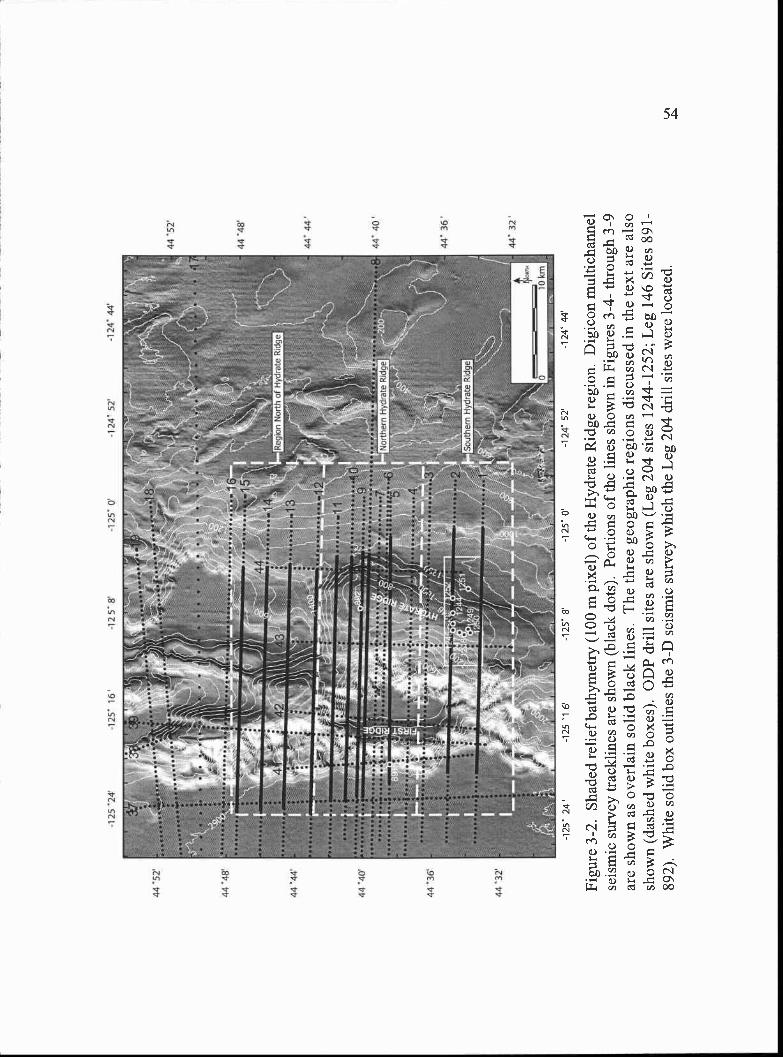
44 5
2
4448
4444
,
44 4
O
44 3
6
44 3
2'
Reg
ion
Nor
th o
f Hyd
rate
Rid
ge
Nor
ther
n H
ydra
te R
idge
Sou
ther
n H
ydra
te R
idge
44 5
2
44 4
8
444
44 4
0
44 3
6
44 3
2
-125
24'
-125
16-1
2 5
8-1
25 0
-124
52
-1 2
4 44
-125
24-1
251
6-1
25 8
-1 2
5 0
-1 2
4 52
-124
44
Figu
re 3
-2. S
hade
d re
lief
bath
ymet
ry (
100
m p
ixel
) of
the
Hyd
rate
Rid
ge r
egio
n. D
igic
on m
ultic
hann
else
ism
ic s
urve
y tr
ackl
ines
are
sho
wn
(bla
ck d
ots)
. Por
tions
of
the
lines
sho
wn
in F
igur
es 3
-4-
thro
ugh
3-9
are
show
n as
ove
rlai
n so
lid b
lack
line
s. T
he th
ree
geog
raph
ic r
egio
ns d
iscu
ssed
in th
e te
xt a
re a
lso
show
n (d
ashe
d w
hite
box
es).
OD
P dr
ill s
ites
are
show
n (L
eg 2
04 s
ites
1244
-125
2; L
eg 1
46 S
ites
891-
892)
. Whi
te s
olid
box
out
lines
the
3-D
sei
smic
sur
vey
whi
ch th
e L
eg 2
04 d
rill
site
s w
ere
loca
ted.
55
this paper are time migrated and no additional changes to the initial processing have been
performed. Although portions of profiles from the survey have been presented in several
previous publications (e.g. MacKay et al., 1992; MacKay, 1995; Goldfinger et al., 1997;
Westbrook, Carson, Musgrave et al. 1994; Tréhu et al., 1999; Johnson et al., 2003),
discussion has been limited to the major structures nearest the deformation front and to
shallower structures related to gas hydrate. In this paper, we include the structures that
lie between the core of Hydrate Ridge and the deformation front. The bathymetric data
used here were compiled from various swath bathymetric surveys conducted in the early
1990's by Oregon State University investigators, National Oceanic and Atmospheric
Association (NOAA) EEZ SeaBeam 16 data, and National Ocean Service hydrographic
soundings. These data were gridded at 100 m pixel resolution (Goldfinger et al., 1997).
Insight was also gained from examination of data from a 3-d seismic survey conducted
across southern Hydrate Ridge (Tréhu et al., 2003 and Chevallier, 2004) and unpublished
2-d seismic reflection profiles collected in 2000 by Anne Tréhu (Oregon State University).
The major faults and folds in the Hydrate Ridge region were initially mapped by
Goldfinger et al. (1992; 1997), MacKay, et al. (1992) and MacKay (1995) and document
the landward to seaward structural vergence change across the region as well as the
presence of two deep-seated left-lateral strike slip faults (the Daisy Bank and Alvin
Canyon faults of Goldfinger et al., 1997). Here we have reexamined the 1989 ODP site
survey seismic data to create a regional structure map that includes previously identified
large scale structures and the smaller scale folds and faults. Construction of the regional
structure map was completed to identify and correlate structures across the region in
order to reconstruct the history of deformation. To obtain the surface expression of the
structures that do not intersect the seafloor, the tip lines of the faults and axes of the folds
were projected vertically onto the bathymetric surface.
Results
Structural Vergence Variation
Hydrate Ridge is the second accretionary thrust ridge from the deformation front
and lies within the younger margin-parallel structural province. Both seaward and
56
landward vergent structures are present (Fig. 3-3), as well as two left-lateral strike-slip
faults (the Daisy Bank and Alvin Canyon faults of Goldfinger et al., 1997; Fig. 3-3). The
faults and folds of the region were initially mapped by Goldfinger et al. (1992; 1997) and
MacKay et al. (1992) and MacKay (1995) and document the landward to seaward
structural vergence change that occurs at the deformation front near the Daisy Bank fault;
south of the Daisy Bank fault, the frontal thrust is seaward vergent and north of the DBF
the frontal thrust is landward vergent. Although the vergence of the frontal thrust changes
abruptly from landward to seaward vergent across the Daisy Bank fault (MacKay et al.,
1992), three additional landward vergent structures (discussed below) exist east of the
deformation front in the previously defined seaward vergent region south of the Daisy
Bank fault. This zone of mixed vergence exists between the Daisy Bank and Alvin
Canyon left-lateral strike-slip faults and across the accretionary wedge from the
deformation front to Hydrate Ridge, and is the focus of this study.
The along and across-strike structural vergence changes in the Hydrate Ridge
region are shown on a series of E-W seismic reflection profiles (Figs. 3-4 through 3-9)
located in Fig. 3-2. In addition to the major structures interpreted on each profile we also
show the approximate position of the seaward vergent décollement horizon as mapped by
MacKay (1995). Using the same seismic reflection data set presented here, MacKay
(1995) documented a more shallowly located décollement near the deformation front in
the seaward vergent portion of the wedge (which is the décollement surface shown on the
seismic lines here) than in the landward vergent portion of the wedge to the north (not
discussed in detail here). Because of poor deep seismic imaging within the wedge away
from the deformation front, identification of the intersection between the bases of the
thrust faults and the décollement horizons are best identified near the deformation front.
For this reason, we can only infer that the décollement surface lies deeper in the landward
vergent portions of the Hydrate Ridge region (discussed below) based on its deeper
position where identified by MacKay (1995) near the deformation front to the north.
We have divided the regions of similar structural style and stratigraphy in the Hydrate
Ridge region into three zones across the wedge from Hydrate Ridge to the deformation
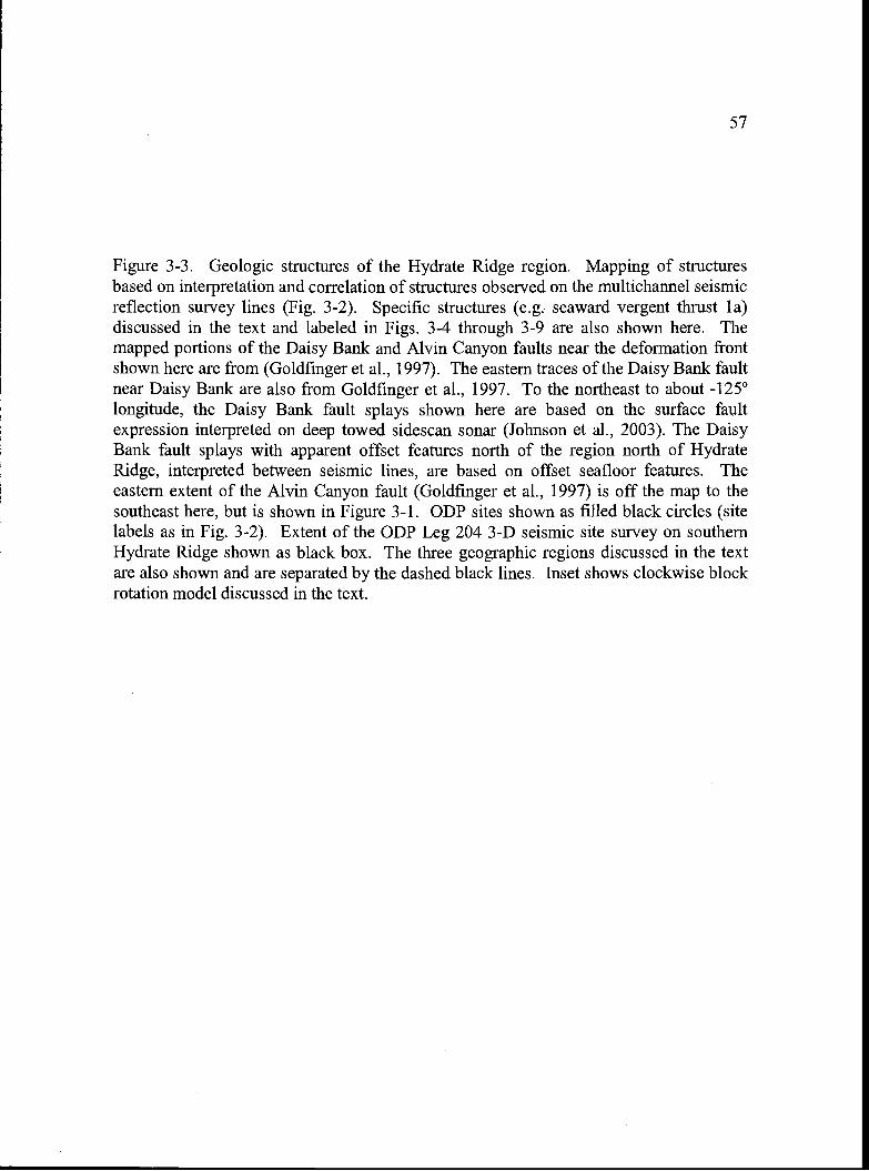
57
Figure 3-3. Geologic structures of the Hydrate Ridge region. Mapping of structuresbased on interpretation and correlation of structures observed on the multichannel seismicreflection survey lines (Fig. 3-2). Specific structures (e.g. seaward vergent thrust la)discussed in the text and labeled in Figs. 3-4 through 3-9 are also shown here. Themapped portions of the Daisy Bank and Alvin Canyon faults near the deformation frontshown here are from (Goldfinger et al., 1997). The eastern traces of the Daisy Bank faultnear Daisy Bank are also from Goldfinger et al., 1997. To the northeast to about -125°longitude, the Daisy Bank fault splays shown here are based on the surface faultexpression interpreted on deep towed sidescan sonar (Johnson et al., 2003). The DaisyBank fault splays with apparent offset features north of the region north of HydrateRidge, interpreted between seismic lines, are based on offset seafloor features. Theeastern extent of the Alvin Canyon fault (Goldfinger et al., 1997) is off the map to thesoutheast here, but is shown in Figure 3-1. ODP sites shown as filled black circles (sitelabels as in Fig. 3-2). Extent of the ODP Leg 204 3-D seismic site survey on southernHydrate Ridge shown as black box. The three geographic regions discussed in the textare also shown and are separated by the dashed black lines. Inset shows clockwise blockrotation model discussed in the text.
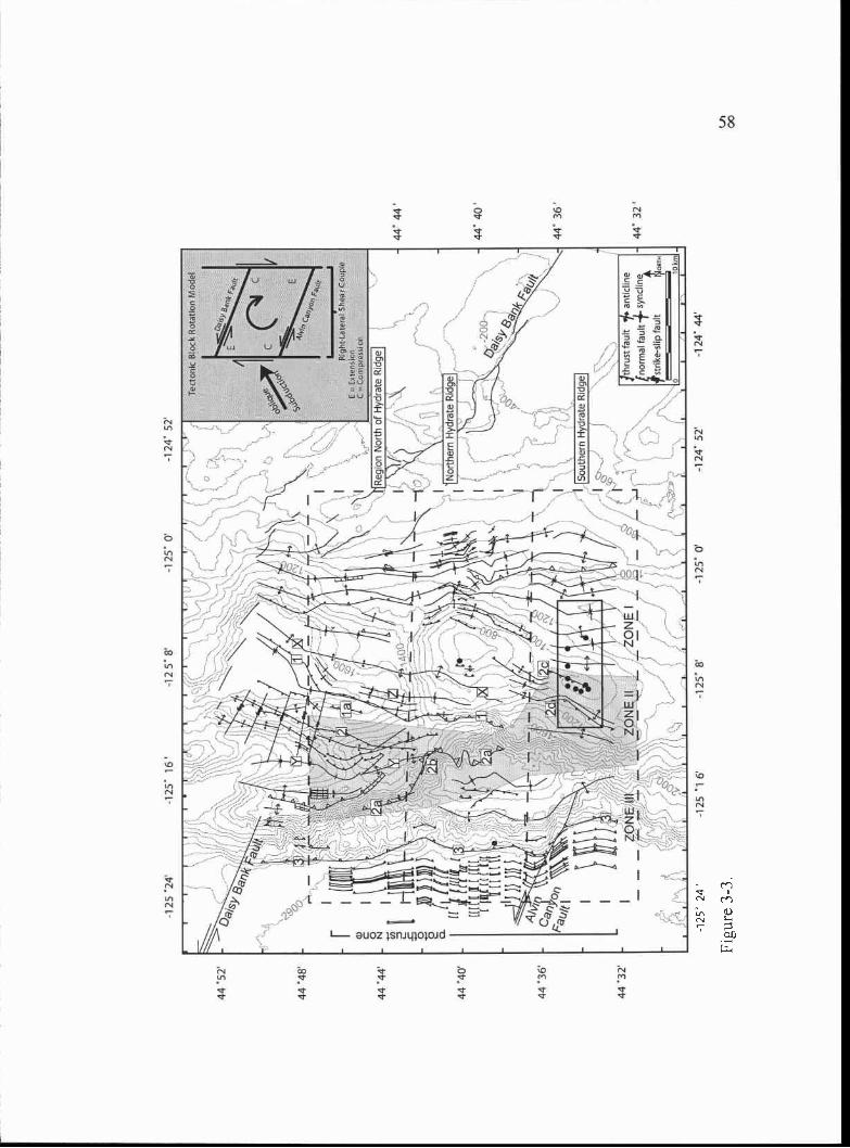
44 '5
2
44 4
8
44 4
4
44 4
0
44 3
6'
44 3
2'
-125
24
-125
' 16
it
Jc4P
j1c
-125
'1 6
-125
'8'
-1 2
5' 8
'
-125
' 0
-1 2
5 0'
-124
' 52
fr t
ISou
ther
n H
ydra
te R
idge
//!/
zoN
EI
/- L;
-124
52
Tec
toni
c B
lock
Rot
atio
n M
odel
Reg
ion
Nor
th o
f Hyd
rate
Rid
geRig
hc-L
acci
al s
hear
Cou
pC
XI?
TI .
1011
C =
Cor
n,p:
eni o
n
Rid
geY -2
00.
cr-1
3>
-124
44
Jthr
ust f
ault
antic
line
(nor
mal
faul
l -f s
ynci
tne
fstr
ike-
slip
faul
tO
1H
Clo
ur
44'4
4(
- 44
'40
-44
' 32'
44 3
6
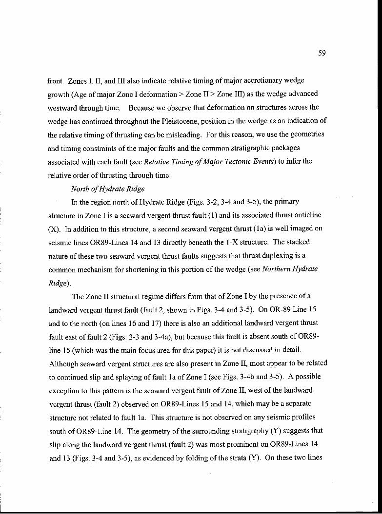
59
front. Zones I, II, and III also indicate relative timing of major accretionary wedge
growth (Age of major Zone I deformation> Zone II> Zone III) as the wedge advanced
westward through time. Because we observe that deformation on structures across the
wedge has continued throughout the Pleistocene, position in the wedge as an indication of
the relative timing of thrusting can be misleading. For this reason, we use the geometries
and timing constraints of the major faults and the common stratigraphic packages
associated with each fault (see Relative Timing of Major Tectonic Events) to infer the
relative order of thrusting through time.
North of Hydrate Ridge
In the region north of Hydrate Ridge (Figs. 3-2, 3-4 and 3-5), the primary
structure in Zone I is a seaward vergent thrust fault (1) and its associated thrust anticline
(X). In addition to this structure, a second seaward vergent thrust (1 a) is well imaged on
seismic lines 0R89-Lines 14 and 13 directly beneath the 1 -x structure. The stacked
nature of these two seaward vergent thrust faults suggests that thrust duplexing is a
common mechanism for shortening in this portion of the wedge (see Northern Hydrate
Ridge).
The Zone II structural regime differs from that of Zone I by the presence of a
landward vergent thrust fault (fault 2, shown in Figs. 3-4 and 3-5). On OR-89 Line 15
and to the north (on lines 16 and 17) there is also an additional landward vergent thrust
fault east of fault 2 (Figs. 3-3 and 3-4a), but because this fault is absent south of 0R89-
line 15 (which was the main focus area for this paper) it is not discussed in detail.
Although seaward vergent structures are also present in Zone II, most appear to be related
to continued slip and splaying of fault la of Zone I (see Figs. 3-4b and 3-5). A possible
exception to this pattern is the seaward vergent fault of Zone II, west of the landward
vergent thrust (fault 2) observed on 0R89-Lines 15 and 14, which may be a separate
structure not related to fault 1 a. This structure is not observed on any seismic profiles
south of 0R89-Line 14. The geometry of the sunounding stratigraphy (Y) suggests that
slip along the landward vergent thrust (fault 2) was most prominent on 0R89-Lines 14
and 13 (Figs. 3-4 and 3-5), as evidenced by folding of the strata (Y). On these two lines
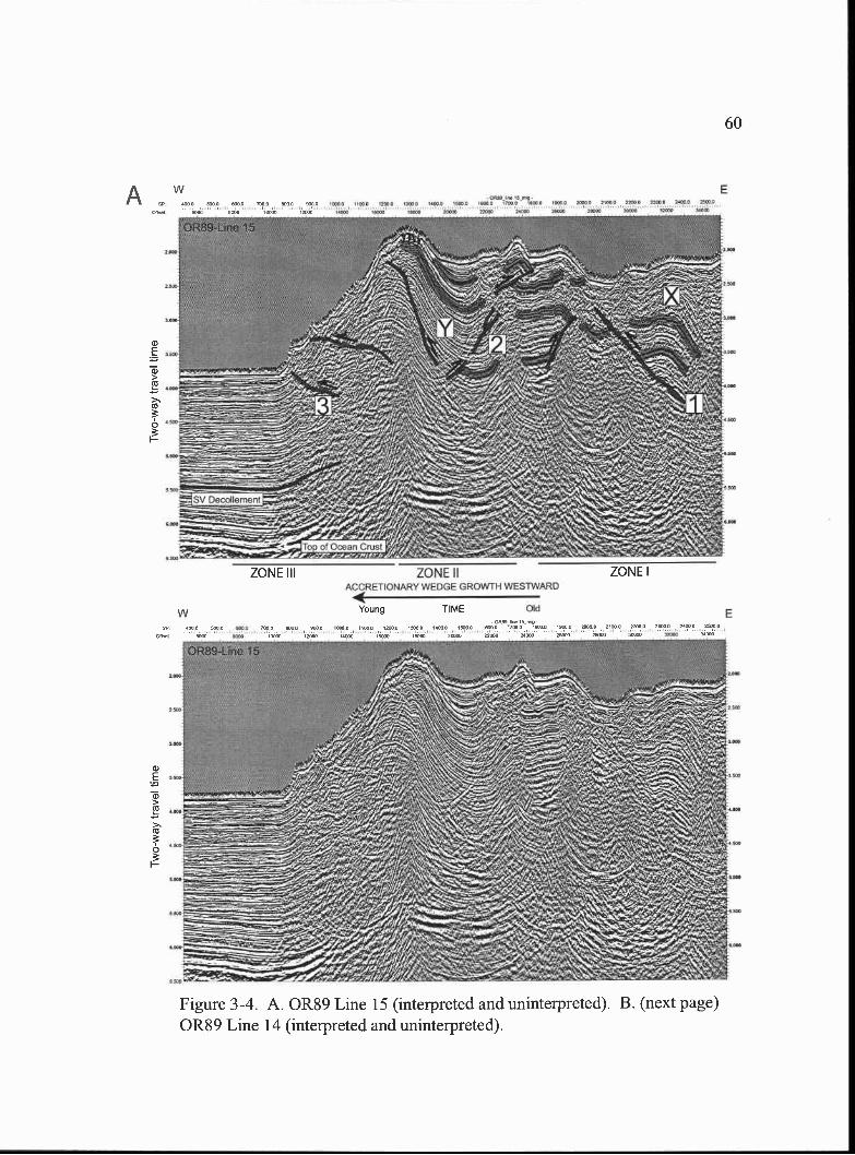
O O I7OO OOO O SG.O Z2O 'O
ZONE IIACCRETIOrIARY WEDGE GROWTH WESTWARD
E
OldE
a)E
a)>a)
>.a)
ZONE III ZONE I
Young TME
Figure 3-4. A. 0R89 Line 15 (interpreted and uninterpreted). B. (next page)0R89 Line 14 (interpreted and uninterpreted).
60
w
w
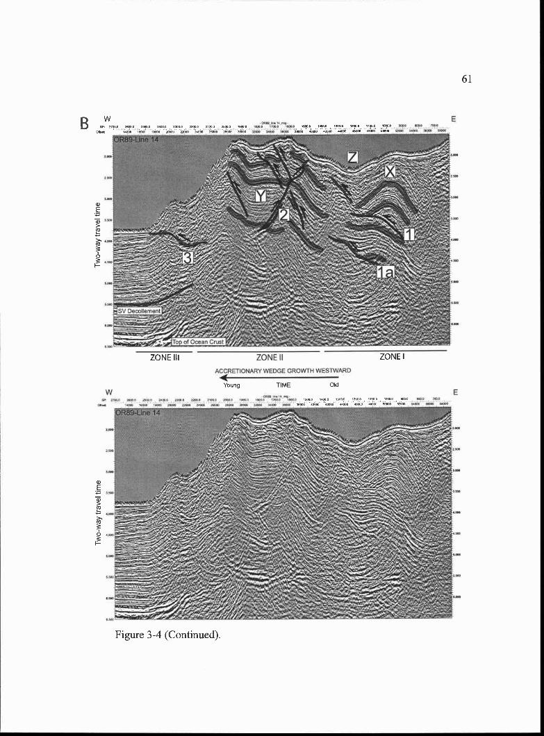
ZONE II
ACCRETONARY WEDGE GROWTH WESTWARD
.-&'.-
-
E
ZONE III ZONE I
Young TIME
Figure 3-4 (Continued).
61
B
Old
0 0-
N 0 z rn
w
ZONE IIACCRETIONARY WEDGE GROWtH WESTWARD
62
Figure 3-5. A. 0R89 Line 13 (interpreted and uninterpreted). B. (next page)0R89 Line 12 (interpreted and uninterpreted).
a)E
a)>Co
>Co
0I
a)
E
a)>Co
>'Co
0I
Figure 3-5 (Continued).
63
ZONE III ZONE II ZONE I
ACCRETIONARY WEDGE GROWTH WESTWARD
Young TIME
O ITOtO 1100.0 1000.0 2000.0 21000 00 20000
64
(Figs. 3-4 and 3-5) the strata (Y) are deformed first subtly, just beyond horizontal (Line
14) then become folded convex upward (Line 13). The effects of slip along the landward
vergent thrust (fault 2) are less pronounced to the south on 0R89-Line 12, where the
structure dies out and is last observed (Figs. 3-4a and 3-5b) and the folded strata (Y)
begins to respond mainly to slip along the seaward vergent splay of fault 1 a (labeled fault
2a; Fig. 3-5).
Zone III deformation is marked by a seaward vergent thrust (3) (Figs. 3-4 and 3-
5). The dominant structure in this region is the seaward vergent frontal thrust fault (3),
which persists across the entire Hydrate Ridge region (Figs. 3-4 through 3-9). Although
relative offsets of seaward and landward vergent thrust faults are difficult to ascertain
from the data, examination of the progression of structures from north to south across the
region north of Hydrate Ridge suggests the accretionary wedge advanced westward first
by seaward vergent thrusting (Zone I), then by landward vergent thrusting (Zone II) with
continued activity of Zone I structure splays (fault 2a) in the southern part of this region
(0R89-Lines 13 and 12), and finally though modern seaward vergent thrusting at the
deformation front (Zone III).
Northern Hydrate Ridge
Identification of the deeper structures of northern Hydrate Ridge is somewhat inhibited
by the presence of a large free gas pool beneath northern Hydrate Ridge (Tréhu and
Flueh, 2001) which results in high attenuation and a seismically incoherent zone (Figs. 3-
6 through 3-8). Correlation of stratigraphy and structures from the region north of
Hydrate Ridge to northern Hydrate Ridge, however, is possible by close examination of
the Zone I structures and stratigraphy in both regions. The upper seaward vergent thrust
(1) and anticline (X) and syncline (Z) pair observed in Zone I on all the seismic profiles
shown from the northern region (Figs. 3-4 and 3-5) are observed on northern Hydrate
Ridge as well (Fig. 3-6). Although the crest of the seaward vergent thrust anticline (X) is
much more deformed andlor eroded in the northern Hydrate Ridge region, the limbs of
the fold are apparent (Fig. 3-6). In addition to fault (1), folded strata in the syncline (Z)
mw
w
ZONEIII ZONEII ZONEI
ACCRETIONARY WEDGE GROWTH WESTWARD
TIME Od
Figure 3-6. A. 0R89 Line 1 1(interpreted and uninterpreted). B. (next page)0R89 Line 10 (interpreted and uninterpreted).
65
24000 25000 20400
A
ZONEIII ZONEII ZONEIACCRETIONARY WEDGE GROWTH WES1WARD
Young TIME
Figure 3-6 (Continued).
66
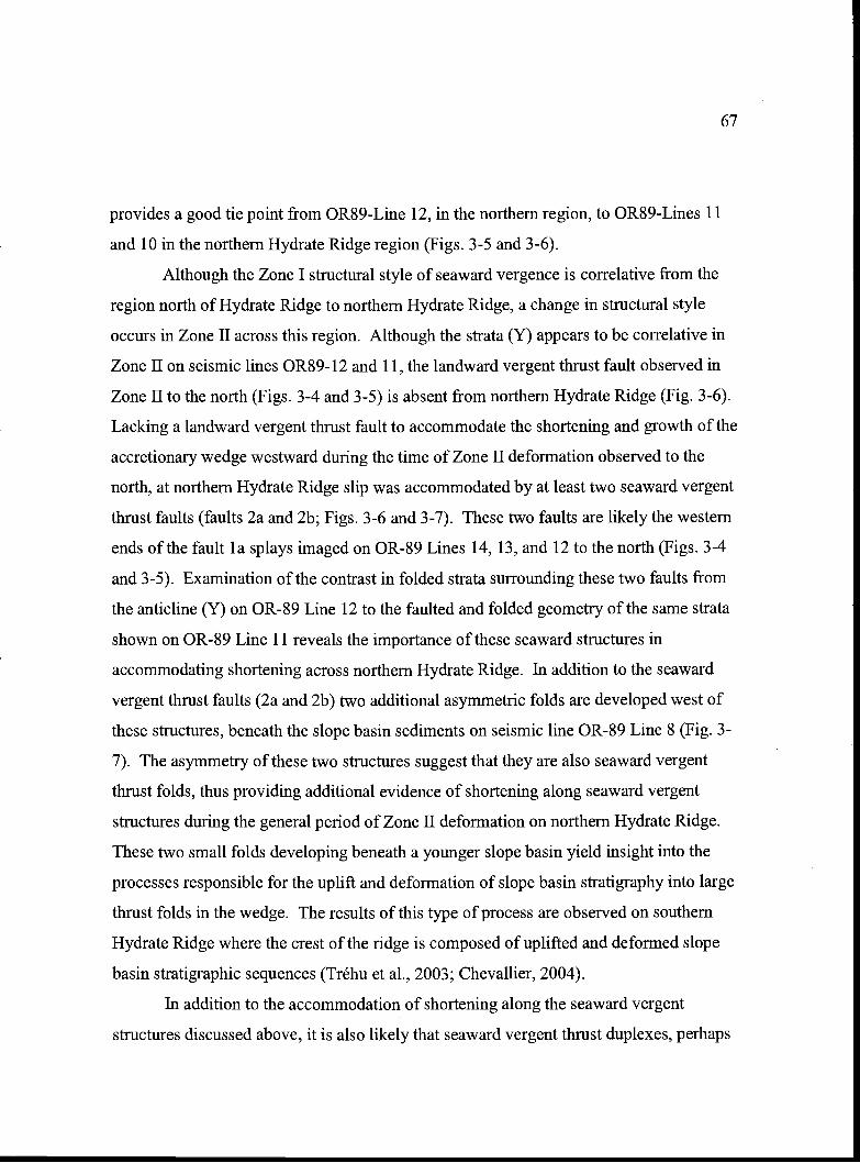
67
provides a good tie point from 0R89-Line 12, in the northern region, to 0R89-Lines 11
and 10 in the northern Hydrate Ridge region (Figs. 3-5 and 3-6).
Although the Zone I structural style of seaward vergence is correlative from the
region north of Hydrate Ridge to northern Hydrate Ridge, a change in structural style
occurs in Zone II across this region. Although the strata (Y) appears to be correlative in
Zone II on seismic lines 0R89- 12 and 11, the landward vergent thrust fault observed in
Zone II to the north (Figs. 3-4 and 3-5) is absent from northern Hydrate Ridge (Fig. 3-6).
Lacking a landward vergent thrust fault to accommodate the shortening and growth of the
accretionary wedge westward during the time of Zone II deformation observed to the
north, at northern Hydrate Ridge slip was accommodated by at least two seaward vergent
thrust faults (faults 2a and 2b; Figs. 3-6 and 3-7). These two faults are likely the western
ends of the fault la splays imaged on OR-89 Lines 14, 13, and 12 to the north (Figs. 3-4
and 3-5). Examination of the contrast in folded strata surrounding these two faults from
the anticline (Y) on OR-89 Line 12 to the faulted and folded geometry of the same strata
shown on OR-89 Line 11 reveals the importance of these seaward structures in
accommodating shortening across northern Hydrate Ridge. In addition to the seaward
vergent thrust faults (2a and 2b) two additional asymmetric folds are developed west of
these structures, beneath the slope basin sediments on seismic line OR-89 Line 8 (Fig. 3-
7). The asymmetry of these two structures suggest that they are also seaward vergent
thrust folds, thus providing additional evidence of shortening along seaward vergent
structures during the general period of Zone II deformation on northern Hydrate Ridge.
These two small folds developing beneath a younger slope basin yield insight into the
processes responsible for the uplift and deformation of slope basin stratigraphy into large
thrust folds in the wedge. The results of this type of process are observed on southern
Hydrate Ridge where the crest of the ridge is composed of uplifted and deformed slope
basin stratigraphic sequences (Tréhu et al., 2003; Chevallier, 2004).
In addition to the accommodation of shortening along the seaward vergent
structures discussed above, it is also likely that seaward vergent thrust duplexes, perhaps
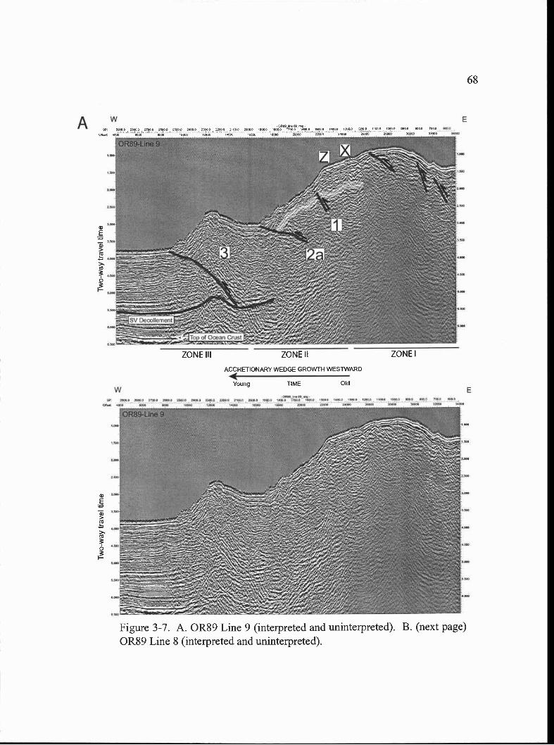
w
E
a)>
>s
0
ZONE III ZONE II
ACCRETIONARY WEDGE GROWTH WESTWARD
Young TIME Old
ZONE I
Figure 3-7. A. 0R89 Line 9 (interpreted and uninterpreted). B. (next page)0R89 Line 8 (interpreted and uninterpreted).
68
w
Figure 3-7 (Continued).
69
w E
ZONE III ZONEII ZONEI
ACCRETIONARY WEDGE GROWTH WESTWARD
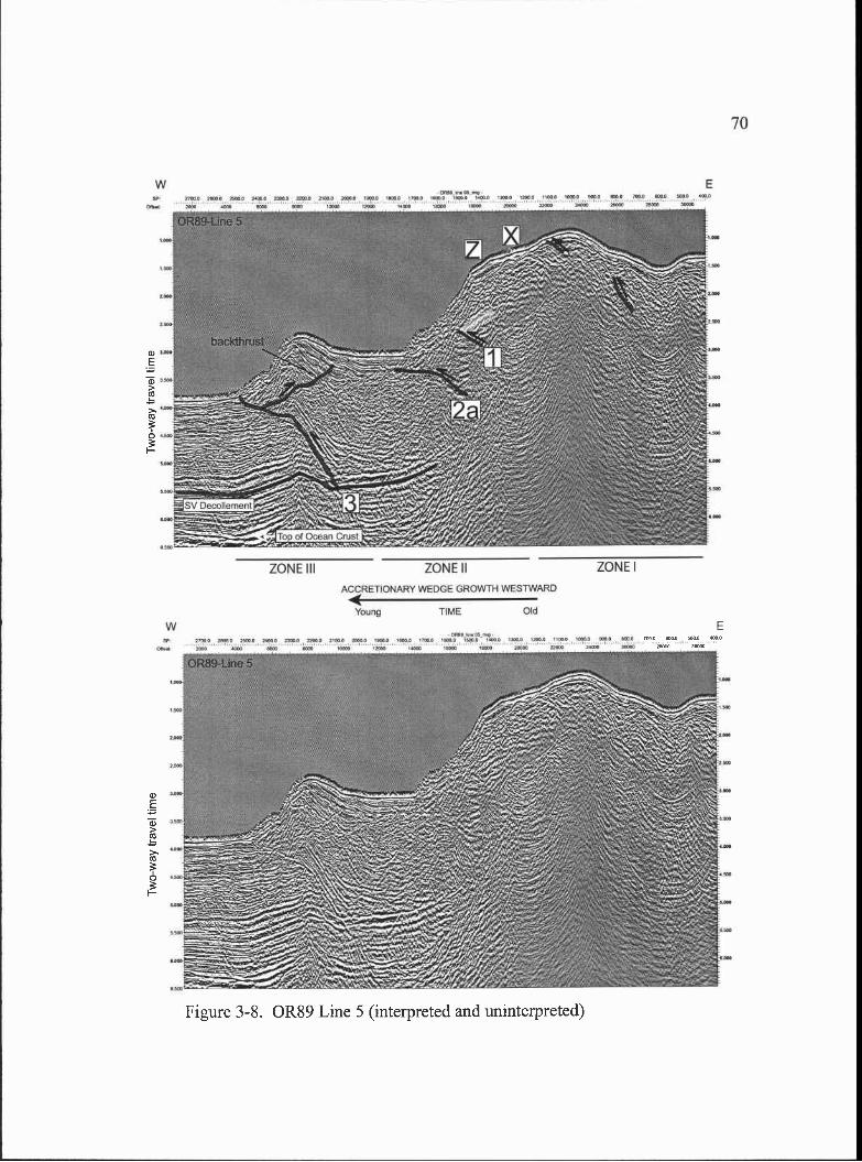
--
DecoUemerit
ACCRE11ONARY WEDGE GROWTH WESTWARD
Young TIME Old
w10000 ml O J'000 110 Ifl-I Cpa Silo 0000 1000 ' 0 50
2000 450 II 000050 400 500 500 20010 2050 2
70
w10 20 PCI 2O fl0O IPOO
E
app
ZONE III ZONE II ZONE I
a)E
a)>a)
>'a)
0
Figure 3-8. 0R89 Line 5 (interpreted and uninterpreted)
71
formed from slip along the stacked couplet of faults (faults 1 and 1 a) imaged to the north
(Fig. 3-4 and 3-5) and additional unimaged structures, are responsible for the abrupt
change in bathymetric relief of fold X seen on OR-89 Lines 15-12 to Lines 11-8 (Figs. 3-
4 through 3-7). Additional evidence for the growth of northern Hydrate Ridge through
thrust duplexing beneath the crest and even toward the eastern flank of the ridge is seen
through the apparent rotation (about a horizontal axis) of faults 1 and 2 in a
counterclockwise direction with progression to the south (Figs. 3-6, 3-7, 3- 8) and the
uplift of an asymmetric thrust anticline on the eastern flank of Hydrate Ridge. The cause
of the decrease in the relief and decrease in growth of northern Hydrate Ridge with
progression to the south is discussed below. The above observations suggest, that
although the structural styles of Zone II deformation differ from north of Hydrate Ridge
(landward vergent thrust) to northern Hydrate Ridge (no landward vergent thrust and
several seaward vergent thrusts), the timing of Zone II deformation in both regions was
approximately the same. Zone III deformation of northern Hydrate Ridge is similar to
that observed to the north (Figs. 3-4 through 3-9), where the frontal thrust is seaward
vergent.
We interpret three main phases of seaward vergent thrusting at Northern Hydrate
Ridge, first in Zone I, then in Zone II, with continued activity of Zone I structures likely,
and finally though modern seaward vergent thrusting at the deformation front (Zone III).
Southern Hydrate Ridge
A recent 3-D seismic survey and ODP Leg 204 drilling (Tréhu et al., 2003;
Chevallier, 2004) have shown that early Pleistocene to recent (<1.6 Ma) slope basin
sediments overlie a core of late Pliocene-early Pleistocene (2.78-1.6 Ma) accretionary
wedge material in the southern Hydrate Ridge region (Fig. 3-2). This differs from
northern Hydrate Ridge, where the drilling results from ODP Leg 146 show this older
core of late Pliocene-early Pleistocene (1.7-1.6 Ma, as determined at ODP Site 892)
accretionary wedge material is exposed near the surface (i.e., there are no overlying,
younger Pleistocene to recent slope basin sediments in the north). Although the deeper
structures responsible for uplift of the core of late Pliocene-early Pleistocene material at
72
southern Hydrate Ridge are not well imaged on the 3-D survey or in the 1989 2-D
seismic data across southern Hydrate Ridge they are imaged in the region north of
Hydrate Ridge (Figs. 3-4 and 3-5; Zone I) and beneath northern Hydrate Ridge (Figs. 3-6
and 3-7; Zone I). In these regions they are dominated by seaward vergent structures that
result in the uplift and deformation of the late Pliocene-early Pleistocene (perhaps even
younger in the region north of Hydrate Ridge) strata there. For this reason, and because
the geometry of the Pliocene core at southern Hydrate Ridge resembles in shape the
asymmetric thrust fold complex to the north (Tréhu et al., 2003), it seems likely that the
Zone I region of southern Hydrate Ridge is dominated by seaward vergent structures as
well (Fig. 3-9). We infer less overall slip, thus less uplift, has accumulated across the
structures at southern Hydrate Ridge, however, because of its subdued bathymetric
expression compared to northern Hydrate Ridge, and because of the preservation of the
overlying Pleistocene slope basin deposits, which are eroded away to the north. Southern
Hydrate Ridge is composed of a small Zone I seaward vergent core (with overlying slope
basin sediments) opposed by two Zone II landward vergent structures (Fig. 3-9), similar
to the region north of Hydrate Ridge. In both of these regions observed uplift, and thus
inferred fault slip, are less in the Zone I seaward vergent portion of the wedge than in the
adjoining landward vergent Zone II regions. If the net shortening across the wedge is
roughly constant along strike, the variability in observed uplift and inferred fault slip
coupled with the documented structural vergence, suggests slip could be more easily
accommodated on landward vergent structures compared to seaward vergent structures
(see Structural Vergence and Hydrate Ridge Morphology). Zone III deformation of
southern Hydrate Ridge is similar to that observed to the north (Fig. 3-4 through 3-9), the
frontal thrust is seaward vergent.
Based on the observations above, it appears that the accretionary wedge advanced
westward at southern Hydrate Ridge first by seaward vergent thrusting (Zone I), then by
landward vergent thrusting (Zone II), and finally though modern seaward vergent
thrusting at the deformation front (Zone III).
Zone I corebeneath slopebasin sediments
w5?, OO2 5O
En5r5o NI 55 '° 51 I?
?51 5 515555 En En En i55550? 55 55510
E
E
ZONE Ill ZONE II ZONE I
OldTIME
ACCRETIONARY WEDGE GROWTH WESTWARD
Young
Figure 3-9. A. 0R89 Line 2 (interpreted and uninterpreted). B. (next page)0R89 Line 1 (interpreted and uninterpreted).
73
w
Zone I corebeneath slopebasin sediments
MOO
EO 1000 0tO 00000 lOOP 12000 nI .000 OflOiOUlrnO!,ttOl.000!flO 20000 T?000 211000 4O 00013 30000 00 VWOa._ I 0000 hal 1000.0 31000 31000
-000000.01 .to000 Ito otn011oIlOOJlalO tao 1050 10 21000 0 00000 M000 31002 2000
11000 4200 ta ta 00000 1300 2.a 211120 I 22021 12(00
ZONE Ill
Ealso ma
w E
Figure 3-9 (Continued).
ZONE II ZONE I
ACCRETIONARY WEDGE GROWTH WESTWARD
Young TIME Old
74
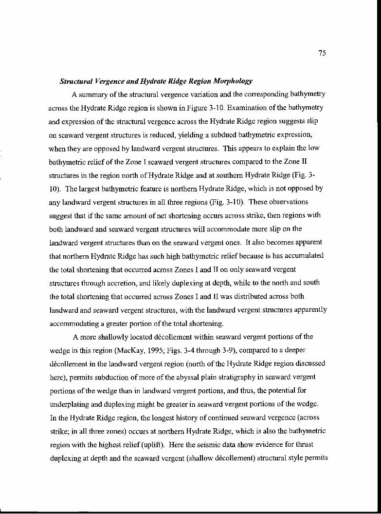
75
Structural Vergence and Hydrate Ridge Region Morphology
A summary of the structural vergence variation and the corresponding bathymetry
across the Hydrate Ridge region is shown in Figure 3-10. Examination of the bathymetry
and expression of the structural vergence across the Hydrate Ridge region suggests slip
on seaward vergent structures is reduced, yielding a subdued bathymetric expression,
when they are opposed by landward vergent structures. This appears to explain the low
bathymetric relief of the Zone I seaward vergent structures compared to the Zone II
structures in the region north of Hydrate Ridge and at southern Hydrate Ridge (Fig. 3-
10). The largest bathymetric feature is northern Hydrate Ridge, which is not opposed by
any landward vergent structures in all three regions (Fig. 3-10). These observations
suggest that if the same amount of net shortening occurs across strike, then regions with
both landward and seaward vergent structures will accommodate more slip on the
landward vergent structures than on the seaward vergent ones. It also becomes apparent
that northern Hydrate Ridge has such high bathymetric relief because is has accumulated
the total shortening that occurred across Zones I and II on only seaward vergent
structures through accretion, and likely duplexing at depth, while to the north and south
the total shortening that occurred across Zones I and II was distributed across both
landward and seaward vergent structures, with the landward vergent structures apparently
accommodating a greater portion of the total shortening.
A more shallowly located décollement within seaward vergent portions of the
wedge in this region (MacKay, 1995; Figs. 3-4 through 3-9), compared to a deeper
décollement in the landward vergent region (north of the Hydrate Ridge region discussed
here), permits subduction of more of the abyssal plain stratigraphy in seaward vergent
portions of the wedge than in landward vergent portions, and thus, the potential for
underplating and duplexing might be greater in seaward vergent portions of the wedge.
In the Hydrate Ridge region, the longest history of continued seaward vergence (across
strike; in all three zones) occurs at northern Hydrate Ridge, which is also the bathymetric
region with the highest relief (uplift). Here the seismic data show evidence for thrust
duplexing at depth and the seaward vergent (shallow décollement) structural style permits
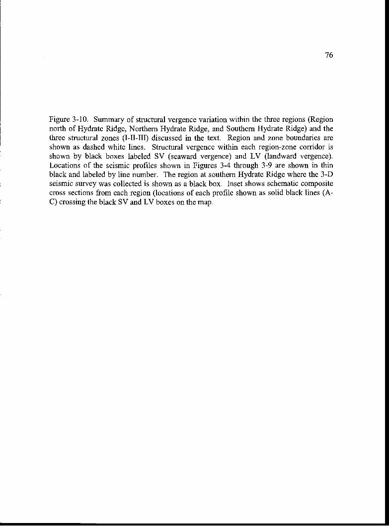
76
Figure 3-10. Summary of structural vergence variation within the three regions (Regionnorth of Hydrate Ridge, Northern Hydrate Ridge, and Southern Hydrate Ridge) and thethree structural zones (1-11-111) discussed in the text. Region and zone boundaries areshown as dashed white lines. Structural vergence within each region-zone corridor isshown by black boxes labeled SV (seaward vergence) and LV (landward vergence).Locations of the seismic profiles shown in Figures 3-4 through 3-9 are shown in thinblack and labeled by line number. The region at southern Hydrate Ridge where the 3-Dseismic survey was collected is shown as a black box. Inset shows schematic compositecross sections from each region (locations of each profile shown as solid black lines (A-C) crossing the black SV and LV boxes on the map.
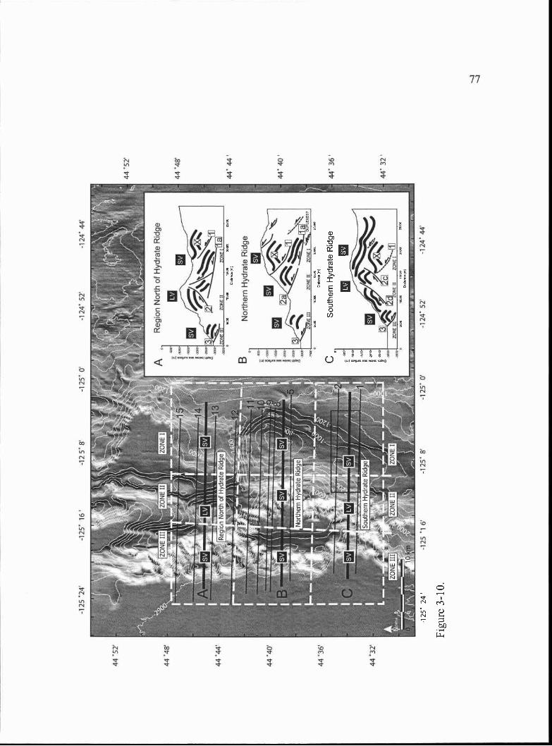
44 5
2'
44 '4
8'
44 '4
4
44 '4
0'
44 '3
6'
44 '3
2'
44 '5
2'
44 '4
8'
44' 4
4'
44' 4
0
44 3
6'
44' 3
2'
-125
'24'
-125
' 16'
-12
5' 8
'-1
250'
1 24
' 52'
-1 2
4' 4
4'
125
'1 6
'-1
25' 8
'-1
25' 0
-124
' 52
-124
44
I::: i
-125
24
Figu
re 3
-10.
Sou
ther
n H
ydra
te R
idge
78
some sediment subduction. The continued subduction of some abyssal plain stratigraphy
(beneath the seaward vergent décollement horizon) in the northern Hydrate Ridge region
during the accretion of zones 1-111 increases the potential for underplating of abyssal plain
strata and likely promotes the observed deep duplex formation. Both underplating and
duplex formation result in thickening of the wedge and are likely the explanation for the
observed high relief of northern Hydrate Ridge. The high relief of northern Hydrate
Ridge is in contrast to the correlative lower bathymetric relief observed at southern
Hydrate Ridge and in the region north of Hydrate Ridge, which as discussed above, are
both opposed by Zone II landward vergent structures. In these landward vergent regions,
the décollement although not well imaged across the region, likely lies deeper and thus,
does not permit abundant abyssal plain sediment subduction.
Daisy Bank and Alvin Canyon Strike-Slip Faults
In addition to the deformation and growth of the accretionary wedge through
thrust faults and folds, the Hydrate Ridge region is also affected by two left-lateral strike-
slip faults (Fig. 3-3). These faults, initially identified by Goldfinger et al. (1992 and
1997), MacKay et al. (1992) and MacKay (1995) are basement involved structures
crossing the Juan de Fuca plate and the wedge at a high angle. They are inferred to be R'
Riedel shears in the basement initiated by a right lateral shear couple that is driven by
oblique subduction. Because the propagation of the strike slip faults from the basement
upward into the accretionary wedge is a function of the coupling across the décollement
and the strength of the wedge, they are best identified in seismic reflection profiles and
reflected by the bathymetry on the abyssal plain near the deformation front and farther
back in the wedge, where older and more dewatered sediments exist. The décollement
beneath the lower slope is inferred to be too poorly coupled (evidenced by landward
vergence) for the strike slip faults to propagate up through to the seafloor, thus their
surface traces are unidentified or broadly distributed (along several splays; e.g. Daisy
Bank fault trace, Fig. 3-3) in these regions. The upward propagation of the strike-slip
faults from the basement into the accretionary wedge from the abyssal plain to the shelf is
shown schematically in Fig. 3-11. Goldfinger et al. (1997) estimated an age of initiation
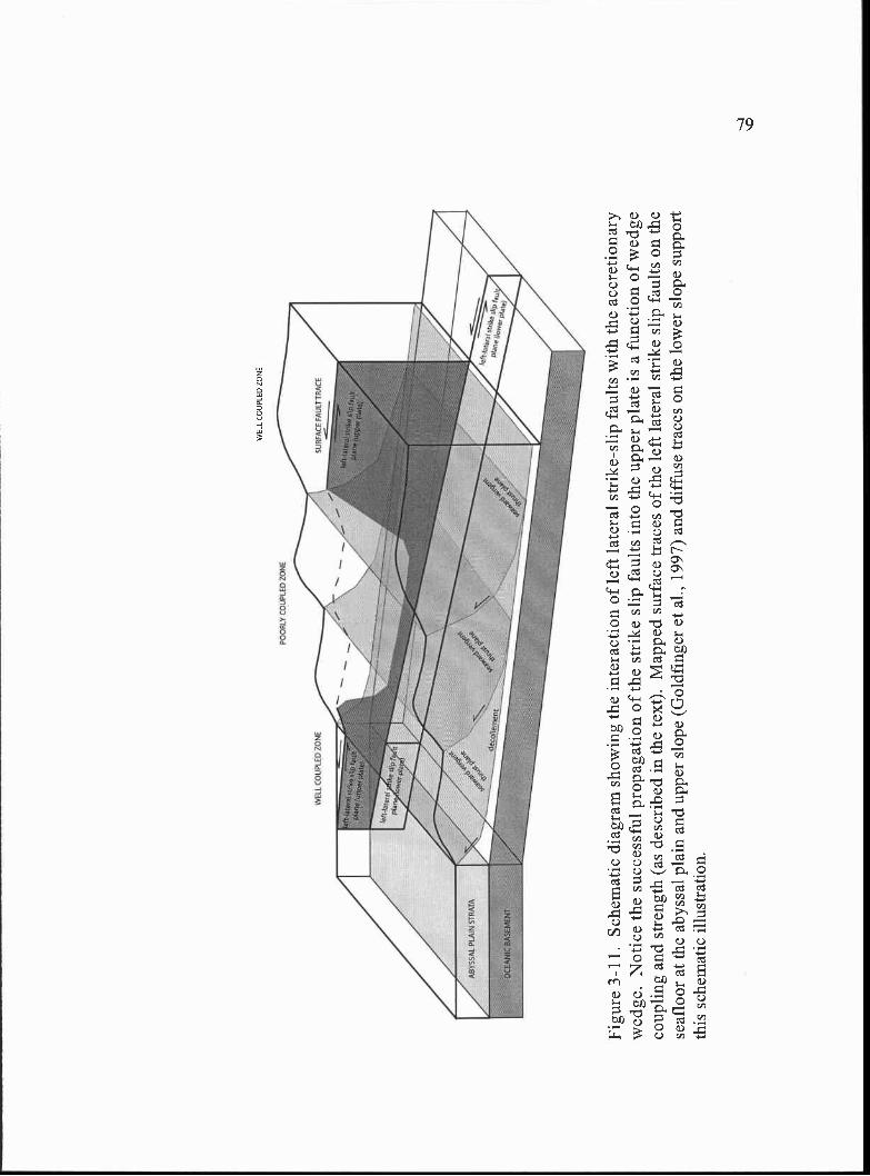
WE
LL 0
00P
IIO Z
ON
E
PO
OR
LY C
OU
PLE
D Z
ON
E
WE
LL C
OU
PLE
D Z
ON
E
Figu
re 3
-11.
Sch
emat
ic d
iagr
am s
how
ing
the
inte
ract
ion
of le
ft la
tera
l str
ike-
slip
fau
lts w
ith th
e ac
cret
iona
ryw
edge
. Not
ice
the
succ
essf
ul p
ropa
gatio
n of
the
stri
ke s
lip f
aults
into
the
uppe
r pl
ate
is a
fun
ctio
n of
wed
geco
uplin
g an
d st
reng
th (
as d
escr
ibed
in th
e te
xt).
Map
ped
surf
ace
trac
es o
f th
e le
ft la
tera
l str
ike
slip
fau
lts o
n th
ese
aflo
or a
t the
aby
ssal
pla
in a
nd u
pper
slo
pe (
Gol
dfin
ger
et a
l., 1
997)
and
dif
fuse
trac
es o
n th
e lo
wer
slo
pe s
uppo
rtth
is s
chem
atic
illu
stra
tion.
80
of upper plate motion near the abyssal plainldeformation front boundary for both the
Daisy Bank and Alvin Canyon faults of 0.38 ± 0.05 Ma. The strike slip fault surface
traces across the wedge and submersible observations of Holocene slip of the Daisy Bank
fault at Daisy Bank, east of Hydrate Ridge (Goldfinger et al., 1 996b) suggests that these
faults are active and likely long lived.
Evidence for Clockwise Block Rotation
Based on the mapped structures, the Hydrate Ridge region appears to be bound at
its north and south end by the left lateral strike slip Daisy Bank and Alvin Canyon faults,
respectively (Fig. 3-3). The geometry and slip direction of these faults imply clockwise
rotation of the block contained between them within an overall right lateral shear couple
(Goldfinger et al., 1997). Right-lateral shear, driven by oblique subduction, of the
Hydrate Ridge block could be responsible for the apparent clockwise rotation of Hydrate
Ridge. The eastern edge of the block likely occurs near the backstop for the Quaternary
wedge, which may occur at the contact with the Eocene oceanic Siletzia terrane (Fleming
and Tréhu, 1999) or the outer arc high (McNeil! et al., 2000). The boundary with the
Siletz terrane may be a more likely position of the backstop, however, as its western edge
is cut by a right lateral strike-slip fault (Fulmar Fault; Snavely et al., 1980), which could
serve as the eastern edge of the right-lateral shear couple responsible for the left lateral
Daisy Bank and Alvin Canyon strike slip faults. West of this backstop boundary, the
trends of folds within the wedge are N-S (Goldfinger et al., 1992; 1997) suggested a
maximum principal stress orientation of east-west. Given this stress orientation, the
strike of Hydrate Ridge ought to be approximately N-S. Instead, the strike of Hydrate
Ridge (or Zone I deformation) is rotated 020°. This apparent deviation in the strike
orientation of Zone I structures is consistent with that predicted during clockwise block
rotation between the two left-lateral strike slip faults within an overall right lateral shear
couple. The concentration of tightly spaced structures at the north end of the eastern
slope basin adjoining Hydrate Ridge and the wider spacing of structures at the south end
of this basin serve as additional evidence for clockwise block rotation. Continued
mapping of the Zone II landward vergent fault in the region north of Hydrate Ridge (fault
81
2; Figs. 3-4 and 3-5) to the north also shows its strike is rotated slightly to the NE (Fig. 3-
3). Near the deformation front, the bulge in the abyssal plain proto-thrusts SW of
Hydrate Ridge and their decrease to the north (Fig. 3-3) provide additional evidence for
clockwise block rotation of the Hydrate Ridge region during the accretion of the Zone III
structures as well.
Relative Timing of Major Tectonic Events
Northern Hydrate Ridge and the First Accretionary Ridge
The ages of the sediments at northern Hydrate Ridge and the first accretionary
ridge (to the west) are constrained by ODP Leg 146 biostratigraphy. At ODP Site 892A
on the crest of northern Hydrate Ridge (Fig. 3-2) the ages of the upper 176.5 m of
stratigraphy determined from diatom, radiolarian, and foraminifer biostratigraphy range
from late Miocene to late Pliocene, (Fourtanier, 1995; Caulet, 1995; Zellers, 1995) with a
thin cap (upper 3 meters) of early Pleistocene age sediments (deposited sometime
between 1.6-0.9 Ma; Fourtanier and Caulet, 1995). The sediments at Site 892A are
deformed by one or more thrust faults, and several hiatuses in sedimentation were
identified from the biostratigraphic work. The lithofacies, in terms of grain size, bulk
composition, and sedimentary structures, of the recovered sediments at ODP Site 892A
are interpreted to be equivalent to the late Pliocene-early Pleistocene abyssal plain section
recovered at DSDP Site 174 (Shipboard Scientific Party, 1994. Site 892). This suggests
abyssal plain stratigraphy was uplifted and deformed at Site 892A as it was accreted to
the margin. Based on the range of ages possible for the upper 3 m of stratigraphy at Site
892A (1.6-0.9 Ma), the sediments recovered near the seafloor at Site 892A could be as
young as 0.9 Ma or as old as 1.6 Ma. If they are indeed 0.9 Ma, they are likely a thin
slope basin sequence that was deposited above a growing northern Hydrate Ridge, which
has since been mostly eroded away, filling the slope basins to the west and east.
Evidence for a thick sequence of slope basin strata deposited over a growing Hydrate
Ridge structure is found at southern Hydrate Ridge (Tréhu et al., 2003; Chevallier, 2004),
which has preserved this slope basin sequence due to less uplift and erosion than northern
Hydrate Ridge. If the upper 3 m of sediments are as old a 1.6 Ma they are consistent with
82
the age of the youngest underlying abyssal plain stratigraphy (1.7-1.6 Ma; Fourtanier and
Caulet, 1995) and no younger slope basin stratigraphy is preserved at northern Hydrate
Ridge.
The older sediments at ODP Site 892 are in contrast to the middle-late Pleistocene
sediments recovered at ODP Site 891, to the west, on the first accretionary ridge (Fig. 3-
2). The age of the sediments at Site 891 is based on foraminifers, radiolarians, and
measured normal polarity paleomagnetism and suggests the recovered sediments above
the frontal thrust were deposited during the last 0.37 m.y. (Shipboard Scientific Party,
1994 explanatory notes; Zellers, 1995). Comparison of the lithology at ODP site 891
with DSDP Site 174 and the seismic reflection data suggests that the stratigraphic section
at Site 891 represents uplifted abyssal plain deposits related to the Astoria fan (Shipboard
Scientific Party, 1994; site 891). Because the core recovery and microfossil abundance
was low, higher resolution age constraint within the section at ODP Site 891 is not
possible. Nevertheless, this implies faulting and folding of the stratigraphy at ODP Site
891 must have occurred sometime after deposition of these sediments or within the
middle to late Pleistocene (<0.37 Ma). Using a separate approach, Westbrook (1994)
used the plate convergence rate and critical taper theory to estimate uplift of ridge one at
ODP Site 891 and concluded uplift is unlikely to be older than 0.3 Ma and probably
initiated about 0.25 Ma, consistent with the estimate based on the biostratigraphy.
Because the sediments at both sites 891 and 892 likely represent uplifted and
accreted abyssal plain section, the folding and thrusting at each site must have occurred
after the deposition of the youngest preserved abyssal plain sediments that are present at
each site. Because there could have been erosion or depositional hiatuses at each site and
deposition during the accretion process, the youngest age of the uplifted abyssal plain
sediments preserved at each site represents the oldest time the deformation at each site
could have began. Because the age of the youngest sediments deformed by the frontal
thrust, however, cannot be determined at ODP Site 891, we will use the range of 0.3 0-
0.25 Ma given by Westbrook (1994) for the timing of uplift of ridge one. We interpret
83
the youngest uplifted abyssal plain deposits at ODP site 892A to be in the range of 1.7-
1.6 Ma.
The above age relationships imply that because Hydrate Ridge lies farther east in
the accretionary wedge and contains older deformed sediments than the first accretionary
ridge, the difference in age of deformed sediments at ODP Site 892 and the timing of
uplift of ridge one at ODP Site 891 can be used as a proxy for the maximum difference in
timing of accretion into the wedge. This implies northern Hydrate Ridge (Zone I
deformation) was incorporated into the wedge sometime after the early Pleistocene (1.7-
1.6 Ma) and the major period of uplift was likely completed by the late Pleistocene (0.30-
0.25 Ma), when the earliest age of ridge one uplift (Zone III deformation), could have
occurred. Because the wedge builds westward with continued accretion, the uplift of
ridge one at the deformation front initiates a time when shortening, previously taken up
on structures to the east, was beginning to be accommodated on the first ridge frontal
thrust. For this reason, we suggest that most of the uplift of Hydrate Ridge (Zone I
deformation) was completed by the time ridge one or Zone III deformation was initiated.
Linking Northern and Southern Hydrate Ridge
The similarity in structural origin inferred in this paper between the Zone I
seaward vergent part of the wedge at northern Hydrate Ridge and the Zone I core of
accretionary material at southern Hydrate Ridge is supported by comparison of the ages
of deformed sediments at each location. Diatom and nannofossil biostratigraphy
completed during ODP Leg 204 drilling on southern Hydrate Ridge (in particular site
1244; Fig. 3-2) yielded an age range of early Pleistocene (1.7-1.6 Ma) for the upper
portion of the older core of accretionary wedge material underlying the younger
Pleistocene to recent slope basin stratigraphy at southern Hydrate Ridge (Shipboard
Scientific Party, 2003-site 1244). The age of the youngest deformed sediments
recovered at Northern Hydrate Ridge (1.7-1.6 Ma) is consistent with the age at the top of
the old core of accretionary wedge material at southern Hydrate Ridge (1.7-1.6 Ma).
This implies that a similar age stratigraphic sequence is deformed at each location and is
consistent with a model of accretion in which the core of southern Hydrate Ridge and
84
northern Hydrate Ridge were incorporated into the wedge from the abyssal plain at
approximately the same time. Currently, the uplift of northern Hydrate Ridge has
exposed this older stratigraphic package at the seafloor surface, whereas at southern
Hydrate Ridge less uplift results in the burial of the core of 1.7-1.6 Ma and older
stratigraphy beneath the younger overlying slope basin sediments (Tréhu et al., 2003).
Southern Hydrate Ridge Landward Vergence
The above age constraints imply that the major period of uplift and seaward
vergent slip along Zone I structures in the northern and southern Hydrate Ridge regions
occurred sometime after the early Pleistocene (1.7-1.6 Ma) and was mostly completed by
the late Pleistocene (0.3-0.25 Ma), which is the estimated age for the initiation of ridge
one uplift as described above. Because of the position of Zone II deformation within the
wedge (between Zones I and III), the timing of Zone II accretion into the wedge
(landward vergence in the region north of Hydrate Ridge and on southern Hydrate Ridge
and seaward vergence on northern Hydrate Ridge), must have occurred sometime within
this same time window (1.7-1.6 Ma to 0.3-0.25 Ma).
Recent structural mapping within the 3-D seismic survey on southern Hydrate
Ridge (Chevallier, 2004), coupled with the ODP Leg 204 biostratigraphic data
(Shipboard Scientific Party, 2003- Site 1245), has constrained the timing of the most
eastward landward vergent folding, and thus thrusting within Zone II at southern Hydrate
Ridge (Fig. 3-9, OR-89 Line 2). Through sequential unfolding of biostratigraphically
constrained horizons, Chevallier (2004) suggests that initiation of the most eastward
landward vergent fold began 1.2 Ma and was completed by 0.3 Ma. We suggest that the
period of landward vergence at southern Hydrate Ridge was coincident with the period of
landward vergence in the region north of Hydrate Ridge and seaward vergence at
northern Hydrate Ridge, as all three regions appear to lie within the same location along
strike within the wedge (the Zone II region). This implies that Zone II deformation
throughout the region most likely occurred between 1.2 Ma and 0.3 Ma.
85
Discussion
Accretionary Wedge Construction
Accretionary wedge growth through time by adding material through continued
accretion at the deformation front (via frontal accretion or underplating) is a well
documented model for the development of the wedge. However, contemporaneous
shortening can occur along major or even minor faults across a range of structures
throughout the wedge at any time (via "out of sequence thrusts", internal folding, small
scale internal faulting, and ductile deformation at depth (Moore and Silver, 1987). In
general, the tectonic activity on thrust faults and folds, however, typically decreases with
distance from the deformation front. This is due in part to (1) the rotation of faults from
shallow to steeply dipping as the wedge deforms; once fault dips become too steep it is
mechanically more efficient to build the wedge outward via a new more shallowly
dipping thrust plane than to sustain activity on the older faults and (2) because the
strength of the wedge increases with distance from the deformation front due to
compaction and pore fluid dewatering processes. The results presented here suggest that
the wedge built outward in a series of three main phases (Zones I-Ill) since the early
Pleistocene (<1.7 Ma). As mentioned above, some continued slip on structures within
these three zones is expected and observed as the wedge develops through time, for
example, on northern Hydrate Ridge some Zone I structures are likely active during Zone
II wedge building. However, here we observed three periods of time when three different
portions of the wedge were most active, suggesting the three wedge building events.
If we assume wedge construction generally progressed from east to west and
occurred through three main phases of deformation, it appears the Zone I structures
developed during a time window spanning 1 7-1.2 Ma. (or during a 0.5 m.y. period), the
Zone II structures developed over 1.2-0.3 Ma. (during a 0.9 m.y. period), and the Zone III
structures developed from 0.3 Ma to the present (during the last 0.3 m.y). The duration
of tectonic activity with time within these three regions appears to correlate well with the
number of structures and amount of uplift present across the Hydrate Ridge region. The
major activity of the Zone II structures occurred over the longest period of time (0.9
86
m.y.). In the region north of Hydrate Ridge, this corresponds with the greatest
bathymetric relief of the wedge in that region, which is cored by one landward vergent
thrust fault. In this same zone to the south, at northern Hydrate Ridge, there is also an
abrupt increase in the bathymetric relief of the Zone II and the Zone I seaward vergent
structures, resulting in large bathymetric relief of northern Hydrate Ridge. To the south,
the Zone II structures consist of two landward vergent thrust faults. The bathymetric
relief of Zone II at southern Hydrate Ridge is less than that of Zone II in the region north
of Hydrate Ridge, even though they are both shortening via landward thrusts. The
difference in bathymetric relief is likely due to the presence of the second landward
vergent thrust fault at southern Hydrate Ridge, which accommodates some of the slip that
to the north is accommodated mostly on a single landward vergent thrust.
Landward Vergence and the Deposition of the Astoria Fan
Possible explanations for the origin of landward vergence in accretionary wedges
are (1) a seaward dipping backstop; (e.g. Byrne et al., 1993) and (2) high pore fluid
pressure and thus low basal shear stress (Seely, 1977; Byrne et al., 1993). MacKay
(1995) also adds to this list (3) an arcward dipping décollement surface and (4) the
strength of the backstop. Along the Washington and northern Oregon portion of the
Cascadia margin, Seely (1977) proposed the rapid deposition of the Nitinat and Astoria
submarine fans onto the abyssal plain during the Pleistocene as the major mechanism
responsible for high pore fluid pressure and thus landward vergence (Fig. 3-3). MacKay
(1995) added that in addition to the change in pore pressure due to the submarine fans, an
arcward dipping décollement and to a lesser degree a strong backstop might also be
needed to promote landward vergence. Across the Hydrate Ridge region, where vergence
has changed across strike from seaward vergent (Zone I) to landward vergent (Zone II) in
the region north of Hydrate Ridge and at southern Hydrate Ridge, but not at northern
Hydrate Ridge, an arcward dipping décollement, within the overlying abyssal plain
stratigraphy that lies parallel to the dip (4-5°; Tréhu et al., 1994) of the underlying Juan
de Fuca plate, and a potentially strong backstop (the Siletz terrane (Fleming and Tréhu,
1999) or the outer forearc high (McNeill et al., 2000) have likely existed and remained
87
relatively constant boundary conditions for the portion of the accretionary wedge formed
during the last 1 .7 Ma (when the Zone I and Zone II structures initiated in the Hydrate
Ridge region). The only remaining mechanism for preferred landward vergence that has
varied over this time interval is high pore fluid pressure, which likely increased after the
rapid deposition of the Pleistocene submarine fans on the abyssal plain. Because
southern margin of the Astoria fan extends across the abyssal plain south of the Hydrate
Ridge region (Fig. 3-1), perhaps the landward vergent portion of the wedge in the
Hydrate Ridge region (Zone II north and south of northern Hydrate Ridge) accreted since
the deposition of the fan may have been susceptible to landward vergence through high
pore pressure induced by rapid fan deposition.
McNeill et al. (2000) suggest the initiation of major Astoria fan deposition on the
abyssal plain was linked to near complete filling of shelf forearc basins and subsequent
breaching of the outer arc high that trapped sediments in them about 1.4-1.3 Ma. Slope
basins and eventually the trench on the abyssal plain would be the first portions of the
margin to fill with sediment during breaching of the outer arc high. Subsequent fan
development would propagate the fan westward with time to the location of DSDP site
174 (Fig. 3-1), where the base of the fan sediments is estimated to be 0.76 Ma in age
(Goldfinger et al., 1996a; Ingle, 1973). Although accretion of part or most of the earliest
version of the Astoria fan with time due to continued subduction of the Juan de Fuca
plate occurred, the rate of fan development was greater than the consumption of the fan
during this time, resulting in the presence of the modern surviving fan on the abyssal
plain. The timing of initiation of the Astoria fan is important as it constrains the timing
of any landward vergence that is attributed to rapid deposition of fan sediments to <1.4-
1.3 Ma. In this paper, we suggest the landward vergence documented in Zone II of the
Hydrate Ridge region initiated 1 .2 Ma and was mostly completed by -0.3 Ma. This
timing is coincident with the presence of Astoria fan on the abyssal plain, and therefore
as in Washington and northern Oregon, we suspect rapid deposition of the fan sediments
and subsequent high pore fluid pressures and low basal shear stress on the décollement is
88
likely the cause of the Zone II landward vergence in the region north of Hydrate Ridge
and on southern Hydrate Ridge.
Different from the Washington and northern Oregon margins, however, the Zone
II landward vergence at Hydrate Ridge is (1) not continuous along strike (e.g. Zone II at
northern Hydrate Ridge is seaward vergent) and as discussed below, (2) did not continue
with time until the present (the deformation frontal thrust of Zone III is seaward vergent;
(see Cessation of Landward Vergence at the Deformation Front). North of the Hydrate
Ridge region discussed here, the correlative portion of the Zone II wedge remains
landward vergent along strike (MacKay et al., 1992). In the correlative Zone II region to
the south, the vergence is seaward (Goldfinger et al., 2000) and remains seaward
southward to the northern California margin (Goldfinger et al., 2000). This suggests that
the along strike mixed vergence zone (Zone II throughout the Hydrate Ridge region) that
lies between landward vergent structures in the north and seaward vergent structures to
the south is quite narrow. The abrupt along strike change to a seaward vergent wedge
south of the Hydrate Ridge region and landward vergent wedge to the north, with a
narrow transition zone of mixed, along strike, vergence in between (Zone II at Hydrate
Ridge), suggests the effect of the rapid deposition of the Astoria fan as a mechanism for
landward vergence was slightly variable in Zone II in the Hydrate Ridge region and not
effective south of Hydrate Ridge, where seaward vergence prevails. If rapid fan
deposition is the mechanism responsible for at least the landward vergent structures of
Zone II, perhaps variability in fan thickness, or more precisely, thinning of the fan
stratigraphy on the abyssal plain to the south, is responsible for the variability in along
strike structural vergence in the Hydrate Ridge region and the lack of landward vergence
south of Hydrate Ridge. In the region farther south of Hydrate Ridge a thinning Astoria
fan near its southern terminus may be a possible explanation for the lack of landward
vergence, however, in the Hydrate Ridge region and to the north, MacKay (1995)
observes, on N-S seismic line OR89-Line 37 across the abyssal plain, that the total
sediment thickness on the abyssal plain is locally relatively uniform, suggesting a
89
thinning Astoria fan is not the likely explanation for the variability in Zone II vergence in
the Hydrate Ridge region.
An alternative explanation for the Zone II structural variability may be that the
thickness of the abyssal plain stratigraphy above the incipient décollement on the abyssal
plain varies in an E-W direction and is modified by slip along the strike slip faults.
MacKay (1995) show that the abyssal plain sediments thicken toward the east as they
approach the deformation front and where they are offset by the left-lateral strike slip
faults, thicker sediments on the north sides of the faults are juxtaposed against thinner
ones to the south. This variation in thickness across the strike slip faults results in subtle
along strike thickness changes in the abyssal plain stratigraphy above the incipient
décollement across the Hydrate Ridge region. The variations in total sediment thickness
above the incipient décollement have the effect of changing the lithostatic sediment load
at any one location, potentially modifying the pore fluid pressure at the depth of the
incipient décollement. A decrease in the thickness of the sediments above the incipient
décollement could result in a decrease in the pore fluid pressure, favoring a seaward
vergent structure to develop, whereas an increase in the thickness might favor high pore
fluid pressures on the décollement, yielding a landward vergent structure. During the
accretion of the Zone II portion of the wedge, the same sediment thickness variability
observed on the modern abyssal plain outboard of the deformation front by MacKay
(1995) was also likely present. We hypothesize that this along-strike sediment thickness
variability may have been sufficient to create the Zone II along strike vergence variability
documented here, however, a definitive explanation for the Zone II structural variability
awaits future work.
Cessation of Landward Vergence at the Deformation Front
Perhaps the most intriguing across-strike vergence change in the Hydrate Ridge
region occurs at the deformation front (Zone III), which contains seaward vergent
structures throughout the region. This is in contrast to the mixed vergence (landward-
seaward-Iandward) documented along strike in Zone II throughout the region and similar
to the seaward vergence documented in Zone I. At the deformation front north of the
90
Daisy Bank fault, the structural vergence is landward, similar to the rest of the
Pleistocene portion of the wedge, and south of the Daisy Bank fault (all the way to the
Rogue Canyon region; Fig, 3-1) the frontal thrust is dominated by seaward vergence. If
the deposition of the Astoria fan was responsible for the Zone II landward vergence in the
region north of Hydrate Ridge and on southern Hydrate Ridge, it would seem likely that
landward vergence would continue to prevail in these region during Zone III deformation
as well, as it does off of northern Oregon and Washington. Zone III is seaward vergent,
however, everywhere in the Hydrate Ridge region.
Similar across strike disruption of landward vergent structures, associated with
the rapid deposition of the Astoria fan, does occur locally in the landward vergent region
just north of Hydrate Ridge as well, where the left lateral Wecoma strike-slip fault insects
the deformation front (Fig. 3-1). In this region, Tobin et al. (1993) document local
seaward vergence of the frontal thrust where the strike slip fault intersects the wedge.
Through a series of Alvin dives, abundant chemo synthetic biological communities,
pervasive veining and fracturing, and extensive carbonate cementation along splays of the
Wecoma fault were observed, documenting its role as an active fluid flow conduit. Based
on these observations, Tobin et al. (1993) suggested that the Wecoma fault acts as a drain
for overpressured fluids located on the incipient décollement. The escape of highly
overpressured fluids from the incipient décollement results in an increase in the effective
basal stress, which results in local seaward vergence. The pervasive occurrence of
landward vergent structures in the region to the north due to an inferred high pore fluid
pressurized décollement caused by the rapid deposition of the Astoria Fan favors this
explanation for localized seaward vergence. In the Hydrate Ridge region, the Daisy Bank
and Alvin Canyon faults intersect the accretionary wedge in the same manner as the
Wecoma fault. In this case, however, the distance between the two strike-slip faults is
quite close, and we suggest the deformation frontal thrust (in Zone III) is seaward vergent
across the region in the same maimer as suggested for the Wecoma fault to the north.
Although, active fluid venting near the deformation front associated with the strike-slip
faults in the Hydrate Ridge region has not been documented, the Daisy Bank and Alvin
91
Canyon faults, both similar to the Wecoma fault to the north, offset both the basaltic
basement and the abyssal plain sections (Goldfinger et al., 1997), suggesting their
probable role as effective fluid conduits.
In addition to the structural similarity between these three strike-slip faults and
their apparent effect on the vergence of the frontal thrust, we also have some indication of
the timing of frontal thrust uplift and strike-slip fault initiation on the abyssal plain.
Here, we suggest that the landward vergence documented on southern Hydrate Ridge
(Chevallier, 2004) and inferred across the Hydrate Ridge Zone II region, was most active
sometime between -4 .2 Ma and was mostly completed by --0.3 Ma. The cessation of
landward vergence appears to coincide with the estimate for the uplift of the seaward
vergent frontal thrust (0.3-0.25 Ma; Westbrook, 1994). Goldfinger et al. (1997) estimated
an age for initiation of motion along both the Daisy Bank and Alvin Canyon faults on the
abyssal plain of 0.38 ± 0.05 Ma. The timing of the above events supports the assertion
that initiation of motion on the strike slip faults may have served to stop the Zone II
landward vergence in the Hydrate Ridge region and be responsible for the seaward
vergent frontal thrust fault.
Clockwise Block Rotation
The surface traces of both the Daisy Bank and Alvin Canyon faults are not only
observed near the deformation front but also within the older portion of the wedge, east
of Hydrate Ridge (Fig. 3-3). The presence of these strike slip fault traces suggests the
strike slip faults are long lived. Because the age of the accretionary wedge is younger
toward the west, and the strike slip faults remain active away from the deformation front
(e.g. Daisy Bank east of Hydrate Ridge has post-12 ka activity; Goldfinger et al., 1997)
and likely continually deform the wedge as it builds out westward, the block contained
between them, farthest back in the wedge, will have experienced the cumulative effect of
rotation through time. This means that between the left lateral strike slip faults, the older
structures farther back in the wedge should be more rotated than those closer to the
deformation front. The best evidence for block rotation between the strike slip faults
comes from the distribution and spacing of structures surrounding Hydrate Ridge and the
92
apparent 200 clockwise rotation of the ridge from a N-S strike. We suggest that the -20°
clockwise rotation of Hydrate Ridge, relative to a N-S strike, was a result of coincident
slip along the strike slip faults during and since the accretion of this portion of the wedge
(during the last 1.7 Ma). This is in contrast to a model in which original accretion to the
margin resulted in structures with a N 200 E strike, which we do not favor because
equivalent structures to the north, away from the strike slip faults, strike N-S. In
addition, the bulge in abyssal plain protothrusts suggests that a more recent phase of this
rotation is in effect, with propagation of frontal thrusts farther toward the west in the
southwest corner of the block and dissipation of these structures to the north. These
observations suggest that clockwise block rotation between the left-lateral strike-slip
faults accompanied east-west thrusting and folding during the tectonic evolution of the
entire Hydrate Ridge region. Clockwise block rotation and northward migration of the
lower portion of the Cascadia forearc through slip along the nine identified left-lateral
strike slip faults is predicted as the basement involved faults propagate up into the wedge
with continued convergence (Goldfinger et al., 1997). Although previous direct evidence
for block rotation along the lower slope of the margin is lacking, a notable change in the
strike of many of the strike-slip fault traces within the older portion of the accretionary
wedge exists (Goldfinger et al., 1997), lending support to the block rotation model and
northward translation of the forearc with time.
There are two potential explanations for why identification of other clockwise
rotated structural blocks within the Cascadia accretionary wedge is difficult off the
Washington and northern Oregon margin and off the southern Oregon margin. The first
involves the mechanics of the propagation of the strike slip faults into the upper plate.
When the wedge is more coupled (high basal shear stress) and strong (dewatered), the
strike slip faults are more likely to propagate up into the accretionary wedge (Fig. 3-11;
Fig. 3-3, as evidenced by their good expression on the abyssal plain and further back in
the wedge; e.g. at Daisy Bank). They then deform the block contained between them,
resulting in clockwise block rotation. In the Hydrate Ridge region, there are more
seaward vergent than landward vergent thrust faults (Fig. 3-10), suggesting in general
93
that the region is more coupled (high basal shear stress) at the décollement interface
compared to that inferred in a landward vergent dominated (low basal shear stress)
portion of the wedge. When the wedge is more coupled, the strike slip faults propagate
more easily up into the wedge, thus deforming the structures of the upper plate. This
suggests that the deformation associated with the strike-slip faults in regions dominated
by landward vergence may be minimized, as the high pore fluid pressure (low basal shear
stress) associated with landward vergence may decrease coupling of the wedge. Perhaps
future work to identify additional evidence for clockwise block rotation between the other
strike slip faults along the margin should focus on the regions of seaward vergence rather
than within the landward vergent region of northern Oregon and Washington. To the
south, offshore southern Oregon and Northern California, although seaward vergence
exists and there are three left-lateral strike slip faults (Goldfinger et al., 1997), giant
submarine landslides have sufficiently disrupted the seafloor bathymetry and stratigraphy
(Goldfinger et al., 2000), making identification of rotated structural blocks virtually
impossible. In addition to the above explanations, limited seismic data equivalent to the
survey used here exists in the regions to the north and south of Hydrate Ridge. Perhaps
future seismic and high resolution bathymetry surveys will potentially identify additional
rotated blocks within the wedge.
Northward Migration of the Cascadia Forearc
If the left lateral strike slip faults are responsible for the clockwise block rotation
of the Hydrate Ridge region, their presence within the wedge during the accretion of
Hydrate Ridge structures during the last 1.7 Ma is necessary. Oblique subduction of the
Juan de Fuca plate beneath North America initiates a right lateral shear couple within the
Cascadia forearc region. This oblique subduction and right lateral shear coupled with
tectonic block rotation of the forearc likely driven by Basin and Range extension
(Humphreys and Hemphill-Haley, 1996; McCaffrey et al., 2000) results in the overall
northward translation of the forearc with time. Evidence for the northward translation of
the Cascadia forearc is documented onshore through paleomagnetic measurements that
show clockwise block rotation in Oregon coast basalts (e.g. Wells and Simpson, 2001)
94
and GPS measurements (e.g. McCaffrey et al., 2000), on both long and short timescales,
respectively. The GPS rates of forearc rotation (about a pole near the Washington-
Oregon border at 310 longitude) are consistent with the geologic rates once the elastic
component of the GPS signal is removed (McCaffrey et al., 2000). Evidence for the
northward translation of the offshore part of the forearc exists by the presence of nine
left-lateral strike slip faults (Goldfinger et al., 1997) which formed in response to a right
lateral shear couple initiated by oblique subduction. Northward translation of the outer
forearc region requires that the western ends of the strike slip faults also translate
northward with time. This process is most easily visualized by sliding a stack of books
on end between your hands (top and bottom of the books perpendicular to your hands)
via right lateral shear, where the boundaries between books are the strike slip faults. This
motion with time results in migration of the left side of the books (or left ends of the
strike slip faults) with continued right lateral shear. In the Hydrate Ridge region, the
northward translation of the forearc could mean that the position of the strike slip faults
in the past was south of their current position, perhaps even out of the Hydrate Ridge
region entirely. To address this possibility we calculate (below) the position of the strike
slip faults at 1.2 Ma. We choose this time, which is just after the accretion of the Zone I
deformation, because the best evidence for clockwise block rotation associated with the
presence of the strike slip faults occurs within this portion of the wedge, and the wedge
must have been mostly accreted for the strike-slip faults to have rotated it.
GPS (Global Positioning System) results at the Newport, central Oregon site
suggest the onshore portion of the central Cascadia forearc is moving northward at a rate
of about 10 mmlyr (McCaffrey et aL, 2000). The GPS measurements record both an
elastic (recoverable) subduction zone signal and permanent (non recoverable)
deformation component. At the Newport site on the coast, the elastic component of the
10 mmlyr is about 3-6 mm/yr, while the remaining 4-7 mm/yr reflects permanent (non
recoverable) deformation. Base on the modeling of McCaffrey et al. (2000), the
projected permanent rate of northward migration of the submarine forearc near the
deformation front west of Newport is 15 mm/yr. The submarine forearc likely
95
accommodates this northward component of translation through slip along the left-lateral
strike slip faults, slip along right lateral margin parallel strike slip faults (e.g. the Fulmar
fault of Snavely, 1980), or through oblique slip along the accretionary wedge thrust
faults. Goldfinger et al. (1997) calculated slip rates for five of the nine strike slip faults
present along the Washington and Oregon margins To calculate the total amount of the
north component of slip that could be accommodated by the strike slip faults near
Hydrate Ridge, we use the fault strike and the calculated slip rates (Goldfinger et al.,
1997) Alvin Canyon (6 2 mm/yr) fault and the minimum margin wide slip rate of 5.5
mmlyr applied to the three strike slip faults south (for which slip rates have not been
determined) to calculate the cumulative north component of slip that could be
accommodated along the strike slip faults at the latitude of Hydrate Ridge. The result
suggests about 10 mm!yr, northward component of the forearc slip, at the latitude of the
Hydrate Ridge region, could be accommodated along the strike slip faults. This is quite
similar (given the assumed estimates of slip rate for the 3 strike slip faults to the south of
the Alvin Canyon fault) to permanent northward rate of 15 mmlyr projected from the
GPS data for this region, suggesting the strike slip faults likely accommodate most of the
northward migration of the submarine forearc.
These constraints suggest that if the strike slip faults were present just after the
accretion of Zone I structures in the Hydrate Ridge region (-1 .2 Ma), they should have
migrated northward since that time approximately 12 km, to their present locations.
Positioning of the western ends of the Daisy Bank and Alvin Canyon faults 12 km
southward from their present location implies that the strike slip faults would have still
encompassed Hydrate Ridge. Although evidence in the seismic data examined here for
the presence of this potentially older strand of the Daisy Bank fault l2 km south of its
current position is lacking, a northwest oriented flank of a submarine bank about 12 km
south of Daisy Bank could be evidence of past left lateral slip on this now abandoned
fault strand. Abandoned traces of the strike-slip faults in the upper plate as they are
translated northward with time were suggested by Goldfinger et al., 1997, and other
examples exist throughout the accretionary wedge.
96
Structural Control on Dewatering of Wedge at Hydrate Ridge
The fluid venting manifestations on the crest of northern Hydrate Ridge are very
extensive, as imaged on deep-towed sidescan sonar data, compared to those on southern
Hydrate Ridge (Johnson et al., 2003). The existence of duplexed seaward vergent thrust
faults beneath northern Hydrate Ridge have likely aided not only in its uplift but also in
providing multiple deep fluid migration pathways to facilitate the massive fluid expulsion
observed at the crest. Duplexing is more prevalent in seaward vergent portions of the
wedge in the Hydrate Ridge region because the detachment for such thrusts typically lies
above the basement cover contact (MacKay, 1995), leaving a portion of the incoming
abyssal plain section to be incorporated into the wedge through duplexing from below.
In contrast, landward vergent detachments in this region usually lie closer to the
basement/cover contact (MacKay, 1995), virtually offscraping all of the incoming section
and incorporating it into the wedge through accretion. On the southern summit of
Hydrate Ridge, this type of duplexing is less pervasive, as shortening here during zone I
and II deformation was accommodated on both the seaward and the landward vergent
thrust faults and folds west of the crest. This results in fewer structural pathways for
fluid escape. Southern Hydrate Ridge is also capped by younger slope basin sediments,
which could act as an impermeable seal that inhibits fluid escape to the surface. Perhaps
these two reasons explain the lack of massive authigenic carbonates on the southern
summit Without an abundance of structural conduits, and with an overlying cap of
relatively impermeable sediments sealing their outlet toward the seafloor, stratigraphic
conduits for fluid flow become important on southern Hydrate Ridge. The significance
of stratigraphic conduits for fluid flow was observed during ODP Leg 204 drilling on
southern Hydrate Ridge, which revealed the only authigenic carbonate occurrence there
was a result of fluid flow through a high porosity and permeable ash rich stratigraphic
horizon (Horizon A; Tréhu et al., submitted).
Conclusions
Based on the results presented in this paper, the following conclusions can be
made regarding the construction of the accretionary wedge in the Hydrate Ridge region
97
during the last 1.7 Ma. (1) The wedge consisted of seaward vergent thrust faults and folds
in early Pleistocene time (Zone I deformation everywhere) that were most active between
1.7 and 1.2 Ma. (2) An earlier version of the left lateral strike-slip faults was likely
present and perhaps initiated clockwise block rotation of Zone Tin the Hydrate Ridge
region at or just after this time. (3) The rapid deposition of Astoria fan (1.4-1.3 Ma-
recent) likely initiated high pore fluid pressure on the incipient décollement in the
Hydrate Ridge region and resulted in the accretion of landward vergent structures in Zone
II, which were most active between 1.2 and 0.3 Ma. (4) The most recent phase of wedge
construction occurred during Zone III seaward vergent faulting at the deformation front
and developed from 0.3 Ma to the present in the Hydrate Ridge region. (5) The
cessation of landward vergent Zone II structures and the initiation of Zone III seaward
vergence was likely controlled by the propagation of the strike slip faults from the
basement to the seafloor -M.38 m.y. ago. These faults may have acted as release valves
for the high pore fluid pressures on the incipient décollement and resulted in the cessation
of landward vergence (Zone II) and initiation of seaward vergence (Zone III). (6)
Progressive clockwise block rotation between vertical propagating and lateral translating
left lateral strike slip faults, as the wedge was constructed through time, results in the N
20° E clockwise orientation of Zone I and II structures in the Hydrate Ridge region.
More recently (0.38 Ma), propagation of the strike slip faults vertically toward the
seafloor in the Zone III region initiated renewed upper plate activity of the strike slip
faults and clockwise block rotation during Zone III deformation, resulting in the map
view bulge of abyssal plain protothrusts.
Acknowledgements
Funding for was provided by NSF Grant #09731023. Acknowledgement is also
made to the Donors of The Petroleum Research Fund, administered by the American
Chemical Society, for partial support of this research and the COAS Chipman-Downs
Fellowship at Oregon State University. Additional thanks to MarIa Tones (OSU) for
valuable discussions and Malt Arsenault (OSU) for assistance with the seismic data.
References
Burbidge, D.R., and Braun, J., 1998, Analogue models of obliquely convergentcontinental plate boundaries: Journal of Geophysical Research, 103, 15,221-15,237.
Byrne, D.E., Wang, W., and Davis, D.M., 1993, Mechanical role of backstops in thegrowth of forearcs: Tectonics, 12, 123-144.
Carlson, P.R., and Nelson, C.H., 1987, Marine geology and resource potential ofCascadia Basin, in Scholl, G., and Vedder, ed., Geology and Resource Potentialof the Continental Margin of Western North America and Adjacent Ocean Basins,6: Houston TX, Circum-Pacific Council for Energy and Mineral Resources, EarthSciences Series, 523-535.
Caulet, J.-P., 1995, Radiolarians from the Cascadia Margin, leg 146, in Carson, B.,Westbrook, G.K., Musgrave, R.J., and Suess, B., eds., Proc. ODP, Sci. Results,Volume 146 (Pt. 1): College Station, TX, Ocean Drilling Program, 47-61.
Chevallier, J., 2004, Seismic sequence stratigraphy and tectonic evolution of SouthernHydrate Ridge [M.S. thesisj: Corvallis, OR, Oregon State University, 117 p.
Davis, D., Suppe, J., and Dahlen, F.A., 1983, Mechanics of Fold-and-Thrust Belts andAccretionary Wedges: J. of Geophys. Res., B2, 1153-1172.
Davis, E.E., and Hyndman, R.D., 1989, Accretion and recent deformation of sedimentsalong the northern Cascadia subduction zone: Geol. Soc. Am. Bull., 101, 1465-1480.
Echavarria, L., Hernández, R., Allmendinger, R., and Reynolds, J., 2003, Subandeanthrust and fold belt of northwestern Argentina: Geometry and timing of theAndean evolution: AAGP Bull., 87, 965-985.
Fleming, S.W., and Tréhu, A., 1999, Crustal structure beneath the central Oregonconvergent margin from potential-field modeling: Evidence for a buried basementridge in local contact with a seaward dipping backstop: J. of Geophys. Res., 104,20,431-20,447.
Flueh, E.R., Fisher, M.A., Bialas, J., Childs, J.R., Klaeschen, D., Kukowski, N., Parsons,T., Scholl, D.W., ten Brink, U., Tréhu, A.M., and Vidal, N., 1998, New seismicimages of the Cascadia subduction zone from cruise SO 108-ORWELL:Tectonophysics, 293, 69-84.
Fourtanier, E., 1995, Neogene diatom biostratigraphy of site 892, Cascadia Margin, inCarson, B., Westbrook, G.K., Musgrave, R.J., and Suess, E., eds., Proc. ODP, Sci.Results, Volume 146 (Pt. 1): College Station, TX, Ocean Drilling Program, 63-77.
Fourtanier, E., and Caulet, J.-P., 1995, Siliceous microfossil stratigraphic synthesis of site892, Cascadia Margin, in Carson, B., Westbrook, G.K., Musgrave, R.J., andSuess, E., eds., Proc. ODP, Sci. Results, Volume 146 (Pt. 1): College Station, TX,Ocean Drilling Program, 369-374.
Goldfinger, C., Kulm, L.D., McNeill, L.C., and Watts, P., 2000, Super-scale failure of thesouthern Oregon Cascadia margin: Pure and Applied Geophysics, 157, 1189-1226.
98
99
Goldfinger, C., Kuim, L.D., Yeats, R.S., McNeill, L., and Hummon, C., 1997, Obliquestrike-slip faulting of the central Cascadia submarine forearc: J. of Geophys. Res.,102, 8217-8243.
Goldfinger, C., Kuim, L.D., Yeats, R.S., Appelgate, B., MacKay, M.E., and Cochrane,G.R., 1996a, Active strike-slip faulting and folding of the Cascadia subduction-zone plate boundary and forearc in central and northern Oregon, in Rogers, A.M.,Walsh, T.J., Kockleman, W.J., and Priest, G.R., eds., Assessing earthquakehazards and reducing risk in the Pacific Northwest, Volume 1: Washington,United States Government Printing Office.
Goldfinger, C., Kulm, L.D., Yeats, R.S., Hummon, C., Huftile, GJ., Niem, A.R., andMcNeill, L.C., 1996b, Oblique strike-slip faulting of the Cascadia submarineforearc: The Daisy Bank fault zone off central Oregon, Subduction: Top toBottom, Geophysical Monograph 96, American Geophysical Union, 65-74.
Goldfinger, C., Kuim, L.D., Yeats, R.S., Appelgate, B., MacKay, M.E., and Moore, G.F.,1992, Transverse structural trends along the Oregon convergent margin:Implications for Cascadia earthquake potential and crustal rotations: Geology, 20,41-144.
Gulick, S.P.S., Bangs, N.L.B., Shipley, T.H., Nakamura, Y., Moore, G., and Kuramoto,5., 2004, Three dimensional architecture of the Nankai accretionary prism'simbricate thrust zone off Cape Muroto, Japan: Prism reconstruction via enechelon thrust propagation: J. of Geophys. Res., 109, doi:10. 1029/2003JB002654.
Gulick, S.P.S., Meltzer, A.M., and Clarke Jr., S.H., 1998, Seismic structure of thesouthern Cascadia subduction zone and accretionary prism north of theMendocino triple junction: J. of Geophys. Res., 103, 27207-27222.
Gutscher, M.-A., Klaeschen, D., Flueh, E., and Malavielle, J., 2001, Non-Coulombwedges, wrong-way thrusting, and natural hazards in Cascadia: Geology, 29, 379-382.
Gutscher, M.-A., Kukowski, N., Malavielle, J., and Lallemand, S., 1996, Cyclicalbehavior of thrust wedges: Insights from high basal friction sandbox experiments:Geology, 24, 135-138.
Humphreys, E. and Hemphill-Haley, M.A., 1996, Causes and characteristics of westernU.S. deformation: Geol. Soc. Am. Abstracts, 28.
Hyndman, R.D., Spence, G.D., Yuan, T., and Davis, E.E., 1994, Regional geophysics andstructural framework of the Vancouver Island Margin Accretionary Prism, inWestbrook, G.K., Carson, B., Musgrave, R.J., and al., e., eds., Proc. ODP, mit.Repts., Volume 146 (Pt. 1): College Station, TX, Ocean Drilling Program, 399-419.
Ingle, J.C., 1973, Neogene foraminifera from the Northeastern Pacific Ocean, Leg 18,Deep Sea Drilling Project, in Kuim, L D., von Huene, R., et al., Initial reports ofthe Deep Sea Drilling Project, Volume 18: Washington, U.S. GovernmentPrinting Office, 5 17-567.
100
Johnson, J.E., Goldfinger, C., and Suess, E., 2003, Geophysical constraints on the surfacedistribution of authigenic carbonates across the Hydrate Ridge region, Cascadiamargin: Marine Geology, 202, 79-110.
Kulm, L.D., and Fowler, G.A., 1974, Cenozoic Sedimentary Framework of the Gorda-Juan de Fuca Plate and Adjacent Continental Margin- A Review, in Dott, R.H.,and Shaver, R.H., eds., Modern and Ancient Geosynclinal Sedimentation, SpecialPublication, Society of Economic Paleontologists and Mineralogists, 212-229.
Kuim, L.D. and von Huene, R., et aL, 1973, Initial reports of the Deep Sea DrillingProject, Volume 18: Washington, U.S. Government Printing Office.
MacKay, M.E., Moore, G.F., Cochrane, G.R., Moore, G.F., and Kulm, L.D., 1992,Landward vergence and oblique structural trends in the Oregon marginaccretionary prism: Implications and effect on fluid flow: Earth and PlanetaryScience Letters, 109, 477-491.
MacKay, M.E., Moore, G.F., Klaeschen, D., and von Huene, R., 1995, The case againstporosity change: Seismic velocity decrease at the toe of the Oregon accretionaryprism: Geology, 23, 827-830.
Marshak, S., 1986, Structure and tectonics of the Hudson Valley fold-thrust belt, easternNew York State: Geol. Soc. Am. Bull., 97, 354-368.
McCaffrey, R., Long, M.D., Goldfinger, C., Zwick, P.C., Nabelek, J.L., Johnson, C.K.,and Smith, C., 2000, Rotation and plate locking at the southern Cascadiasubduction zone: Geophys. Res. Lett., 27, 3117-3120.
McNeill, L.C., Goldfinger, C., Kulm, L.D., and Yeats, R.S., 2000, Tectonics of theNeogene Cascadia forearc basin: Investigations of a deformed late Mioceneunconformity: Geol. Soc. Am. Bull., 112, 1209-1224.
Miller, M.M., Johnson, D.J., Rubin, C.M., Dragert, H., Wang, K., Qamar, A., andGoldfinger, C., 2001, GPS-determination of along-strike variation in Cascadiamargin kinematics: Implications for relative plate motion, subduction zonecoupling, and permanent deformation: Tectonics, 20, 161-176.
Moore, C., J., Mascle, A., Taylor, E., Andreieff, P., Alvarez, F., Barnes, R., Beck, C.,Bhermann, J., Blanc, G., Brown, K., Clark, M., Dolan, J., Fisher, A., Gieskes, J.,Hounslow, M., McLellan, P., Moran, K., Ogawa, Y., Sakai, T., Schoonmaker, J.,Vrolijk, P., Wilkens, R., and Williams, C., 1988, Tectonics and hydrogeology ofthe northern Barbados Ridge: Results from Ocean Drilling Program Leg 110:Geol. Soc. Am. Bull., 100, 1578-1593.
Moore, J.C., and Silver, E.A., 1987, Continental Margin Tectonics: SubmarineAccretionary Prisms: Review of Geophys., 25, 1305-13 12.
Price, R.A., 1981, The Cordilleran foreland thrust and fold belt in the southern CanadianRocky Mountains, in McClay, K.R., and Price, N.J., eds., Thrust and NappeTectonics, Volume 9, Geological Society of London Special Paper, 427-448.
Scheidegger, K.F., Kuim, L.D., and Piper, D.J.W., 1973, Heavy mineralogy ofunconsolidated sands in Northeastern Pacific sediments: Leg 18, Deep SeaDrilling Project, in Kulm, L.D., von Huene, R., and al., e., eds., Initial Reports of
101
the Deep Sea Drilling Project, Volume 18: Washington, U.S. GovernmentPrinting Office, 877-887.
Seely, D.R., 1977, The significance of landward vergence and oblique structural trendson trench inner slopes, in Talwani, M., and Pitman, W.C.L, eds., Island Arcs,Deep Sea Trenches, and Back-Arc Basins, Maurice Ewing Series, Volume vol. 1:Washington, D.C., American Geophysical Union, 187-198.
Shipboard Scientific Party, 1994, Explanatory Notes, in Westbrook, G.K., Carson, B.,Musgrave, R.J., and al., e., eds., Proc. ODP, mit. Repts., Volume 146 (Pt. 1):College Station, TX, Ocean Drilling Program, 15-48.
-, 1994, Site 891, in Westbrook, G.K., Carson, B., Musgrave, R.J., etal., Proc. ODP,mit. Repts., Volume 146 (Pt. 1): College Station, TX, Ocean Drilling Program,241-300.
-, 1994, Site 892, in Westbrook, G.K., Carson, B., Musgrave, R.J., et al., Proc. ODP,mit. Repts., Volume 146 (Pt. 1): College Station, TX, Ocean Drilling Program,301-378.
-, 2003, Site 1244, in Tréhu, A.M., Bohrmann, G., Rack, F., Tones, M.E., et al., mit.Repts. [CD-ROM], Volume 204: College Station, TX, Ocean Drilling Program, 1-132.
-, 2003, Site 1245, in Tréhu, A.M., Bohrmann, G., Rack, F., Tones, M.E., et aL, kit.Repts. [CD-ROM], Volume 204: College Station, TX, Ocean Drilling Program, 1-131.
Smit, J.H.W., Brun, J.P., and Sokoutis, D., 2003, Deformation of brittle-ductile thrustwedges in experiments and nature: J. of Geophys. Res., 108,doi: 10.1 029/2002JB002 190.
Snavely, P.D., Jr., Wagner, H.C., and Lander, D.L., 1980, Geologic cross section of thecentral Oregon cOntinental margin: Boulder, CO, Plate Tecton. Group, U.S.Geodyn. Comm., Geol. Soc. of Am.
Snavely, P.D., Jr., 1987, Tertiary Geologic Framework, Neotectonics, and PetroleumPotential of the Oregon-Washington Continental Margin, in Scholl, D.W., Grantz,A., and Vedder, J.G., eds., Geology and resource potential of the continentalmargin of western North America and adjacent Ocean -Beaufort Sea to BajaCalifornia, Volume 6: Circum-Pacific Council for Energy and Mineral ResourcesEarth Science Series, 305-335.
Tobin, H.J., Moore, J.C., MacKay, M.E., Orange, D.L., and Kuim, L.D., 1993, Fluid flowalong a strike-slip fault at the toe of the Oregon accretionary prism: Implicationsfor the geometry of frontal accretion: Geol. Soc. Am. Bull., 105, 569-582.
Tréhu, A., Asudah, I., Brocher, T.M., Luetgert, J.H., Mooney, W.D., Nabelek, J.L., andNakamura, Y., 1994, Crustal architecture of the Cascadia forearc: Science, 266,237-243.
Tréhu, A.M., Bohrmann, G., Rack, F.R., Tones, M.E., et al., 2003, Proc. ODP, kit.Repts. [CD-ROM], Volume 204: College Station, TX, Ocean Drilling Program.
102
Tréhu, A.M., Flemings, P.B., Bangs, N., Chevallier, J., Gracia, E., Johnson, J.E., Liu, C.-S., Liu, X., Riedel, M., and Tones, M.E., 2004, Feeding methane vents and gashydrate deposits at south Hydrate Ridge: Science, submitted.
Tréhu, A.M., and Flueh, E.R., 2001, Estimating the thickness of the free gas zone beneathHydrate Ridge, Oregon continental margin, from seismic velocities andattenuation: J. of Geophys. Res., 106, 2035-2045.
Tréhu, A.M., Tones, M.E., Moore, G.F., Suess, E., and Bohrmann, G., 1999, Temporaland spatial evolution of a gas hydrate-bearing accretionary ridge on the Oregoncontinental margin: Geology, 27, 939-942.
Underwood, M.B., Moore, G.F., Taira, A., Klaus, A., Wilson, M.E.J., Fergusson, C.L.,Hirano, S., Steurer, J., and Party, L.S.S., 2003, Sedimentary and TectonicEvolution of a Trench-Slope Basin in the Nankai Subduction Zone of SouthwestJapan: Sedimentary Geology, 73, 589-602.
von Huene, R., Pecher, l.A., and Gutscher, M.-A., 1996, Development of the accretionaryprism along Peru and material flux after subduction of Nazca Ridge: Tectonics,15, 19-33.
von Huene, R., and Suess, E., 1988, Ocean Drilling Program Leg 112, Peru continentalmargin: Part 1, Tectonic history: Geology, 16, 934-938.
Wells, R.E., and Simpson, R.W., 2001, Northward migration of the Cascadia forearc inthe northwestern U.S. and implications for subduction deformation: Earth, Planetsand Space, 53, 275-283.
Westbrook, G.K., 1994, Growth of Accretionary Wedges off Vancouver Island andOregon, in Westbrook, G.K., Carson, B., and Musgrave, R.J., eds., Proceedings ofthe Ocean Drilling Program, Initial Reports, Volume 146 (part 1): CollegeStation, TX, Ocean Drilling Program, 38 1-388.
Westbrook, G.K., Carson, B., Musgrave, R.J., et al., 1994, Proc. ODP, Init. Repts.:College Station, TX, Ocean Drilling Program.
Zellers, S.D., 1995, Foraminiferal Biofacies, paleoenvironments, and biostratigraphy ofNeogene-Quaternary sediments, Cascadia Margin, in Carson, B., Westbrook,G.K., Musgrave, R.J., and Suess, E., eds., Proc. ODP, Sci. Results, Volume 146(Pt. 1): College Station, TX, Ocean Drilling Program, 79-113.
Chapter IV
Holocene Slope Failure in an Active Margin Gas Hydrate Bearing Region, HydrateRidge, Cascadia Margin
Joel E. Johnson', Chris Goldfinger1, and C. Hans Nelson2
Oregon State University, College of Oceanic and Atmospheric Sciences, 104
Ocean Admin. Bldg. Corvallis, Oregon 97331
CSIC Instituto Andaluz de Ciencias de la Tierra Facultad de Ciencias, University
of Granada Campus de Fuentenueva s/n 18002 Granada, Spain
103
To be submitted to Earth and Planetary Science Letters
104
Abstract
Slope failure in the marine environment within the gas hydrate stability zone
along continental margins has been suggested as a probable mechanism for the
mobilization of seafloor gas hydrate, allowing its transfer from the seafloor and the
release of its enclosed methane to the ocean and even the atmosphere. In this paper, we
determine the frequency of slope failure events at a well studied active margin gas
hydrate province (Hydrate Ridge) located on the lower slope of the Cascadia accretionary
wedge. Our results suggest an average Holocene recurrence interval of 400-500 years for
slope failure events in this region. Comparison with a Holocene marine paleoseismic
record on the abyssal plain of subduction zone earthquakes suggests between 50-70% of
the slope failure events were likely triggered by subduction zone earthquakes; 13 of the
total 18 Holocene subduction zone earthquakes are recorded at this site. Because these
earthquakes are margin wide events, it is likely that they serve as a dominant trigger for
slope failures not only at Hydrate Ridge, but also within the gas hydrate stability zone
across the margin. These results suggest the frequency of Cascadia subduction zone
earthquakes may influence the frequency of methane flux from the seafloor to the ocean
and even the atmosphere by controlling the margin wide frequency of Holocene slope
failure events.
Introduction
Current gas hydrate research is focused on the physical, chemical, and biological
aspects of gas hydrate systems, the dynamics of gas hydrate stabilization, and perhaps
more importantly, factors that influence their destabilization. Although several long time
scale and potentially global mechanisms are believed to influence the stability of gas
hydrate systems on continental margins worldwide (e.g. changes in bottom water
temperature; Kennett et al., 2003; Jung and Vogt, 2004 or eustatic sea level; Paull et al.,
1996), the potential role of short time scale cycles, such as the subduction zone
earthquake cycle, on the stability of marine gas hydrates has thus far received little
attention.
105
One of the major mechanisms for the nearly instantaneous destabilization of gas
hydrate in the marine environment involves the disruption of the seafloor by submarine
slope failures (i.e. slides, slumps, debris flows, and turbidites). In regions bearing gas
hydrate, the physical disturbance of the seafloor during slope failure could disrupt the
hydrated sediment fabric and allow much, if not all, of the buoyant gas hydrate involved
in the sediment failure to escape to the water column and even the atmosphere. Recently
Brewer et al. (2002) and Paull et al. (2003) documented the ease with which seafloor gas
hydrate is dislodged from seafloor sediments at Hydrate Ridge, on the Cascadia
continental margin. In their experiment, they disrupted the seafloor sediments using the
arm of a ROy, which resulted in dislodged pieces of gas hydrate leaving the seafloor and
buoyantly rising toward the sea surface. They captured the small hydrate pieces in a
mesh bag and followed their ascent upward, witnessing their partial destabilization along
the way and their eventual melting at the sea surface. The methane from the destabilized
gas hydrate was released to both the ocean and the atmosphere as a result of this process.
If slope failures are a mechanism for destabilizing seafloor and shallow seafloor gas
hydrates, determining their frequency of occurrence and understanding their potential
triggering mechanism(s) could yield insight into the processes that affect the frequency of
gas hydrate destabilization events on the seafloor.
As a mechanism for the mobilization of seafloor gas hydrate, slope failures in the
marine environment within the gas hydrate stability zone (water depths >300 m, and
bottom water temperatures approaching 00 C) can vary in frequency depending on the
frequency of the trigger(s) responsible for the failure. On a long (100 ka) timescale
tectonic uplift can result in an increased rate of slope failures in marine settings (e.g.
Klein, 1984). On glacial-interglacial timescales, the in situ destabilization of gas hydrate
during sealevel lowstands has been speculated as a possible trigger for slope failure (e.g.
Paull et al., 1996; Rothwell et al., 1998). At this same timescale, climatically induced
variations in sediment flux from terrestrial to marine environments can also result in
changes in the slope failure frequency on continental margins (e.g. Nelson, 1976). On a
shorter timescale, gas hydrate induced slope failure can also occur during bottom water
106
warming events at millennial time scales during interstadials on continental margins
(Kennett et al., 2003). Also on short timescales, earthquake triggered submarine slope
failures can occur on both passive (e.g. Heezen and Ewing, 1952) and active continental
margins (e.g. Inouchi et al., 1996; Field et aL, 1982). On active margins, a potentially
important recurrent trigger for regionally synchronous and large-scale slope failures is
subduction zone earthquakes. Subduction zone earthquakes are the largest magnitude
seismic events on Earth, and typically have spatially extensive rupture lengths and
recurrence intervals of hundreds to thousands of years. These large seismic events could
potentially trigger multiple slope failures over broad regions of the seafloor, providing a
cyclic, short term mechanism for the mobilization and destabilization of seafloor gas
hydrates.
Along the Cascadia subduction zone margin, a Holocene record of submarine
slope failures attributed to past subduction zone earthquakes is preserved as
synchronously triggered submarine canyon and channel turbidites (Adams, 1990;
Goldfinger et al., 2003). In this paper we examine the Holocene (10,000 yr -recent)
record of slope failure, preserved as turbidites, shed from a region bearing gas hydrate
(Hydrate Ridge) within the accretionary wedge on the Cascadia continental margin (Fig.
4-1) and compare it with the record from one of submarine canyon and channel turbidite
sites of Goldfinger et al. (2003). We use physical property data and AMS radiocarbon
dates from planktonic foraminifera taken from hemipelagic clay intervals between
turbidites to decipher which deposits at Hydrate Ridge can most likely be attributed to
past subduction zone earthquakes and which may have resulted from other triggers.
Geologic Setting
Hydrate Ridge is a composite thrust ridge formed from seaward and landward
vergent thrust faults (Johnson et aL, in prep) and is located within the lower slope of the
Cascadia accretionary wedge (Fig. 4-1). It is flanked on both the east and west by slope
basins. The isolation of the western slope basin from any canyon or channel system
sourced to the east indicates that sedimentation in the slope basin consists of hemipelagic
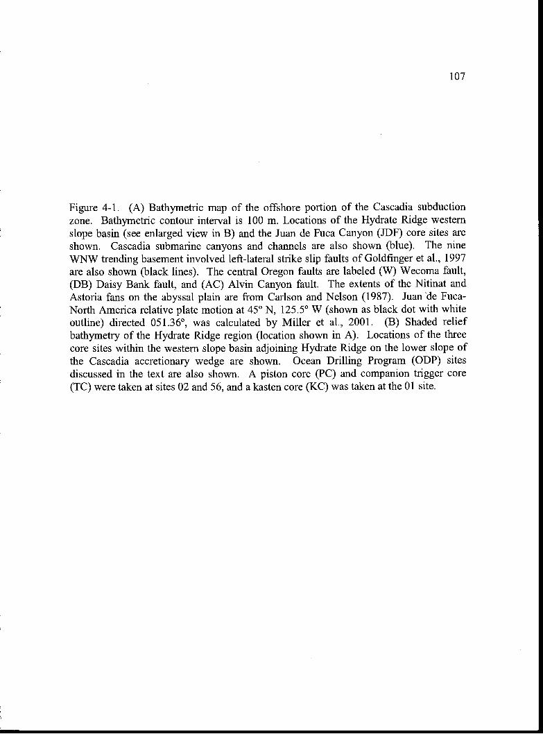
107
Figure 4-1. (A) Bathymetric map of the offshore portion of the Cascadia subductionzone. Bathymetric contour interval is 100 m. Locations of the Hydrate Ridge westernslope basin (see enlarged view in B) and the Juan de Fuca Canyon (JDF) core sites areshown. Cascadia submarine canyons and channels are also shown (blue). The nineWNW trending basement involved left-lateral strike slip faults of Goldfinger et al., 1997are also shown (black lines). The central Oregon faults are labeled (W) Wecoma fault,(DB) Daisy Bank fault, and (AC) Alvin Canyon fault. The extents of the Nitinat andAstoria fans on the abyssal plain are from Carison and Nelson (1987). Juan de Fuca-North America relative plate motion at 450 N, 125.5° W (shown as black dot with whiteoutline) directed 051.36°, was calculated by Miller et al., 2001. (B) Shaded reliefbathymetry of the Hydrate Ridge region (location shown in A). Locations of the threecore sites within the western slope basin adjoining Hydrate Ridge on the lower slope ofthe Cascadia accretionary wedge are shown. Ocean Drilling Program (ODP) sitesdiscussed in the text are also shown. A piston core (PC) and companion trigger core(TC) were taken at sites 02 and 56, and a kasten core (KC) was taken at the 01 site.
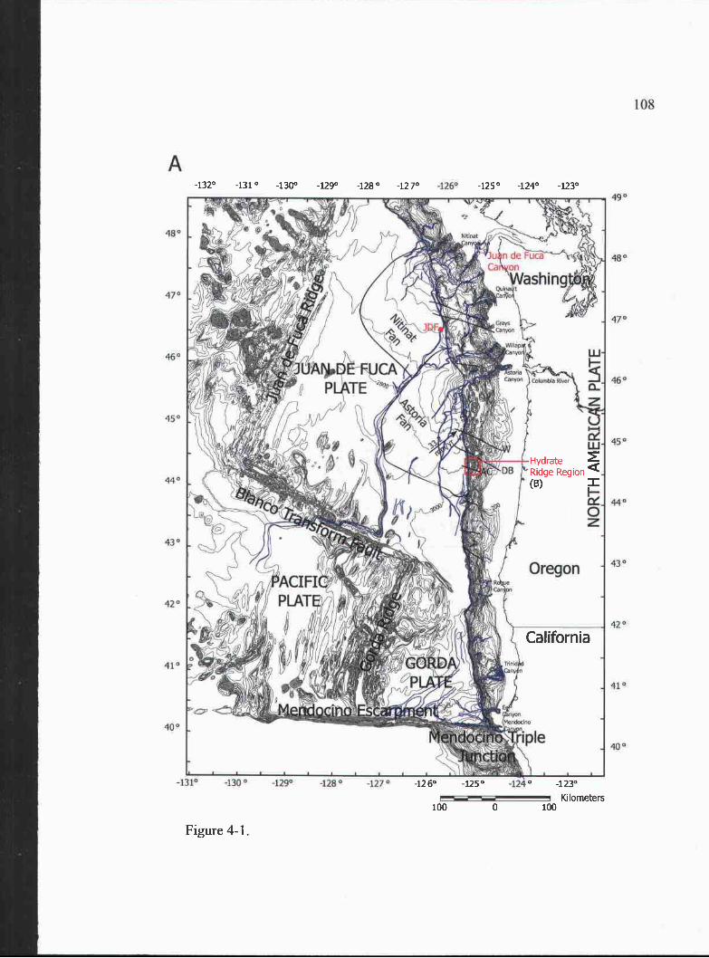
A
480
470
450
450
44°
43°
420
4j0
40°
490
48°
4"
460
450
440
430
42°
4Q0
108
-1 1° -130° -129° -128° -127° -124
1320 -131° -130° -129° -128° -127° -125° -124° -123°
Figure 4-1.
California
1260 -125° -123°
KIlometers100 0 100
(B)
HydrateRidge Region
-1 25 20
KilonThtersNautical miles
a124$12521'4 1244 1251
1? ODPLeg2O4/
109
445O'
44.45,
44 40
44 35'
44 30'
Figure 4-1 (continued).
-125 15' -125 10' -1255' -1250'
110
clay settling out of the water column and local submarine slope failures derived from the
surrounding bathymetric highs (i.e. Hydrate Ridge). The most likely sediment transport
pathway into the basin is a small submarine canyon that cuts into the western flank of
northern Hydrate Ridge (Fig. 4-ib), however, several other smaller potential pathways can
also be seen surrounding the basin toward the east and to the north.
Gas hydrates are prevalent in the subsurface and at the surface of Hydrate Ridge, as
evidence by the presence of a ubiquitous bottom simulating reflector (BSR) recorded in
seismic reflection surveys (Tréhu et al., 1999), and recovered gas hydrate samples from
seafloor sampling devices (e.g. Suess et al., 2001; Greinert et al., 2001) and Ocean Drilling
Program coring efforts (Westbrook et al., 1994; Tréhu et al., 2003) from both the northern
and southern summit regions of the ridge, respectively (Fig. 4-1). In situ and proxy
measurements for the amount of gas hydrate present in the subsurface at southern Hydrate
Ridge suggest heterogeneous concentrations ranging from 30-40 % of pore space at the
summit and up to 20% of pore space at some local patchy zones at the crests of folds along
the flanks to only 1-4% of pore space in other regions (Tréhu et al., 2004). Although the
concentrations of gas hydrate at the northern summit of Hydrate Ridge are not constrained
by extensive drilling, it is likely that similar or even higher concentrations may exist, as the
amplitude of the BSR is stronger than at southern Hydrate Ridge and a larger free gas zone
is inferred beneath the summit of northern Hydrate Ridge (Tréhu and Flueh, 2001). This
suggests that there is the potential for sustaining high gas hydrate concentrations at
northern Hydrate Ridge. The more extensive occurrence of authigenic carbonates on the
northern summit compared to a small region on the southern summit (Johnson et al., 2003)
and older 111Th ages from the carbonates in the north (Teichert et aL, 2003), also suggests
the fluid venting/gas hydrate system is older and thus more developed at northern Hydrate
Ridge.
Paleoseismic records of Cascadia subduction zone earthquakes exists both
onshore (e.g. Atwater and Hemphill-Haley, 1997; Kelsey et al., 2002; Witter et aL, 2003)
and offshore (Adams, 1990; Goldfinger et al., 2003). Onshore, records of subsided
111
marshes and tsunami deposits associated with past subduction zone earthquakes extend as
far back as 6700 years B.P. (Witter et al., 2003). Offshore, the turbidite paleoseismic
record spans the entire Holocene (10,000 years B.P.-recent; Goldfinger et al., 2003). The
average recurrence interval for these past subduction zone earthquakes is about 600
years. At the Holocene timescale under consideration here, the stratigraphic record of
slope failures at Hydrate Ridge can be compared to the offshore turbidite record because
they span the same time interval. An event comparison using radiocarbon dates is
possible because both records are likely similarly affected by the same radiocarbon
reservoirs.
Research Methods
We identify the turbidites preserved in the cores by visual inspection of the
sediments, high resolution line scan camera color images, x-rays and gamma density and
high resolution point magnetic susceptibility measurements. We determine the
approximate age of deposition for turbidites through accelerator mass spectrometry
(AMS) radiocarbon dating of a mixed species assemblage of planktonic foraminifera
(Table 4-1) collected from the hemipelagic clay intervals between turbidites. In order to
obtain enough carbon for dating from the foraminifera tests we typically need 800-. 1000
individuals (or >2.0 mg), which along the Cascadia margin equates to approximately 3
cm of hemipelagic sediment beneath each turbidite. To obtain the foraminifera, we sieve
the hemipelagic clay using a 63 micron mesh, retain the coarse fraction, and pick the
individual foraminifera tests. AMS radiocarbon ages were determined at the Lawrence
Livermore National Laboratory (LLNL) Center for AMS. Raw AMS ages are reservoir
corrected and converted to calendar years using the Calib 4.3 software package (Stuiver
and Reimer, 1993) and marine reservoir correction data base (Stuiver et al., 1998). We
determined which core tops were preserved from our cores through measurements of
210Pb activity (conducted at Oregon State University).
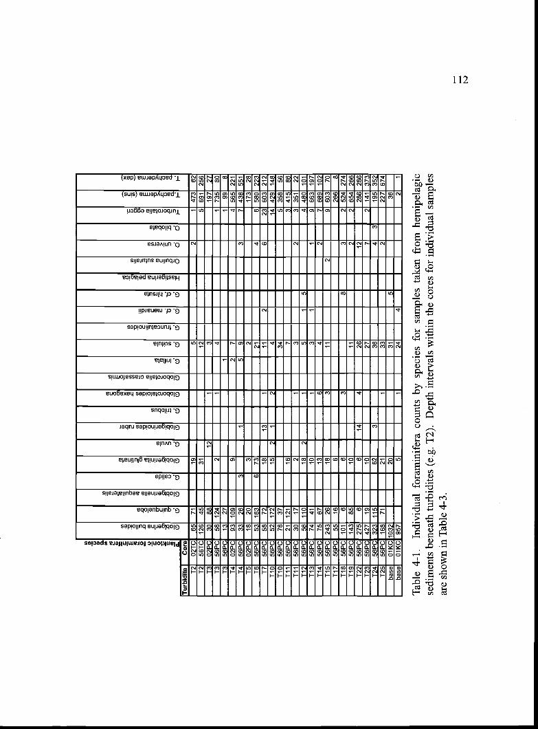
Tab
le 4
-1.
Indi
vidu
al f
oram
inif
era
coun
ts b
y sp
ecie
s fo
r sa
mpl
es ta
ken
from
hem
ipel
agic
sedi
men
ts b
enea
th tu
rbid
ites
(e.g
. T2)
. Dep
th in
terv
als
with
in th
e co
res
for
indi
vidu
al s
ampl
esar
e sh
own
in T
able
4-3
.
C C C) E o (CC
2 (U .0 0
(U
-
d
C.0
= 5 CU
Cl)
CC
)
.2) 0
CU - 3
CU
. C)
CU 2 0
2 CC
C
Cl) 0 5 2' .o 0
Cl) 2
0 C)
CU C CC
) 0 0 2 2
-a E C.)
. .o 2C
U. 0 (U .
5 CU 2 - .
0000
0001
000
CU E
(U E .
CU
CC
C
(0
(U
CO
CC
) E2
CU o a-
.
CO
. (U 0. -
x CU
.
CU D >.
CU -
Tur
bidi
teC
ore
T2
02T
C65
7119
52
147
362
T2
56T
C 1
2645
3112
5 69
125
6T
302
PC
3088
121
319
727
T3
56P
C58
124
21
41
735
80T
356
PC
1327
11
998
14O
2PC
93 1
099
27
4 56
5 22
114
56P
C33
263
15
93
743
8 55
1T
5O
2PC
1820
32
173
2816
56P
C53
163
673
214
658
0 22
317
56P
C58
7218
131
112
623
603
212
110
56P
C52
172
152
12
414
429
148
110
56P
C78
3734
5 35
856
Til
56P
C21
121
167
341
586
T11
56P
C30
172
13
23
351
22T
1256
PC
56 1
1018
21
51
54
480
101
T13
56P
C74
4110
13
11
9 66
319
711
456
PC
7567
136
42
7 68
910
2T
1556
PC
243
2618
311
29
603
7011
756
PC
5516
626
68
118
56P
C 1
016
63
83
252
4 27
411
956
PC
143
8510
112
265
4 26
612
256
PC
275
66
144
2612
286
286
T23
56P
C 4
2719
1027
72
141
373
T24
56P
C 3
23 1
1562
336
43
195
352
T25
56P
C 1
6871
211
332
227
674
base
OIK
C 1
032
2031
536
base
OIK
C 9
575
124
42
1
113
Results
Slope Basin Turbidite Stratigraphy
The Holocene stratigraphic record of slope failures, preserved as turbidites in the
slope basin west of Hydrate Ridge, was studied at three core sites located west of the
submarine canyon cut into the western flank of Hydrate Ridge (Figs. 4-1 and 4-2). The
most proximal (furthest east) site to the canyon contains an upper Holocene (3000 years
[B.P. 1950] to modern) record in piston and trigger core RRO2-O7O2PCITC. The mid-
basin site to the west (RR0207-56PCITC) contains a complete Holocene record (-1 1,000
years [B.P. 1950] to modem]).
The distal kasten core site (RRO2-070 1KC) may contain a partial Holocene
record, however, radiocarbon dating to confirm Holocene stratigraphy was not possible
due to the poor preservation of hemipelagic clay intervals. The only ages obtained from
this core are at the base of the section and are late Pleistocene (see below). Evidence for a
partial Holocene record above a characteristic color change and change in microfossil
fauna (observed in RR0207-01KC at 175 cm; Table 4-2) is consistent with the color
change from gray below to green above and the upward shift from foraminifera to
radiolarian dominance observed throughout Cascadia basin (Duncan et al., 1970), which
typically marks the late Pleistocene to Holocene transition (average age -1 2,500 years
B.P; Duncan et al., 1970). Although this color change and faunal change is present in the
kasten core, radiocarbon ages at the base of the core suggest the turbidites there are late
Pleistocene, -20 ka in radiocarbon years (too old for calendar year calibration) (Fig. 4-2).
Because of the proximity of the old radiocarbon ages to the color and faunal shift at --1 75
cm in this core, it is unlikely that this boundary represents the 12,500 year B.P. datum.
Instead, significant erosion may have occurred near this boundary, disconformably
juxtaposing an older (foraminifera-rich) late Pleistocene section against younger
(radiolarian-rich) Holocene sediments. Measured excess 21 OPb activity at the top of the
kasten core confirms the most recent (< -4 00 years) sediments are preserved. Therefore
it is likely that some portion of the Holocene (evidence by radiolarian rich stratigraphy) is
recorded at this site between the top of the core to a depth of 175 cm. However, whether
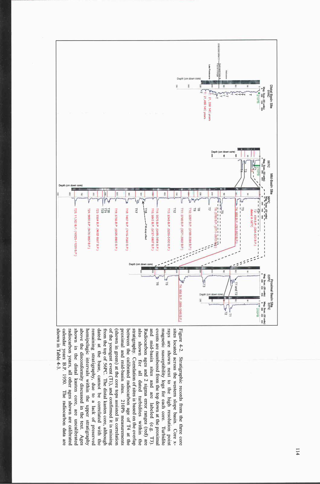
210PB
,T
id
12/
SM
IIa
T5
16
21DP
BTi
12
4: 9568.P. 889-iO
48B.P
P952 B
P.
15
T6: 2765 B
.P (2711-2872
.)
T7
St5'
TB
'ST
iD: 3287 B
.P. (3166-3364 B
.P.)
'.
3740 BR
(3i -3902 B.P
- 42-
13
400
100
00
MO
O
Distal B
asin Site
Mid-B
asin Site
Proxim
al Basin S
iteO
1KC
56TC
56PC
O2P
CO
2TC
Mag. S
usc. (SI units)
Mag. S
usc. (SI units)
Mag. S
usc. (SI units)
.-M
ag. Susc. (S
I units)M
ag. Susc. (S
I units)0
200400
6000
200400
600/
0200
400600
0200
400600
0200
400600
TITao
V
80.a200
a80VECaa,a
a8
Ti 7
0.a,a
Figure 4-2.Stratigraphic records from
the three coresites located across the w
estern slope basin.C
ore x-rays are show
n next to the high resolution pointm
agnetic susceptibility logs for each core.T
urbiditeevents are num
bered from the top dow
n at the proximal
and mid-basin
sites and arelabeled
(e.g.T
3).R
adiocarbon ages and 2 sigma error ranges (red) are
also shown for
alldated turbidites
within the
stratigraphy. Correlation of sites is based on the overlap
between the calibrated radiocarbon age of T
4 at theproxim
al and mid-basin sites.
21 OPb m
easurements
(shown in green) at the core tops assisted in correlation
of the youngest event (Tl), and confirm
ed it is missing
from the top of 56PC
. The distal kasten core, although
dated at the base, cannot be correlated with the
remaining stratigraphy, due to a lack of preserved
hemipelagic intervals w
ithin the upper stratigraphyabove the disconform
ity discussed in the text.A
gesshow
n in the distal kasten core, are uncalibratedradiocarbon years, all other ages show
n are calibratedcalendar years B
.P. 1950.T
he radiocarbon data areshow
n in Table 4-3.
21,230 14C years
21,460 14C years
T2: 458 B
P. (354-523 B
.P)
dated in 56TC
T13: 5345 B
.P. (5250-5450 B
P.)
5575 B.P
(5466.5654 B.P
.)
5843 B.P
. (5727 .5927 B.P
.)
-4 H-II'.) I') r'- 0
7487 B.P
. (7416-7560 B.P
.)
8755 B.P
(8596-8905 B.P
.)
9304 B P
(9032-9507 B.P
.)
9690 BR
(9436-9857 B P
.)
T25: 11,002 B
P (10925-11220 B
.P.)
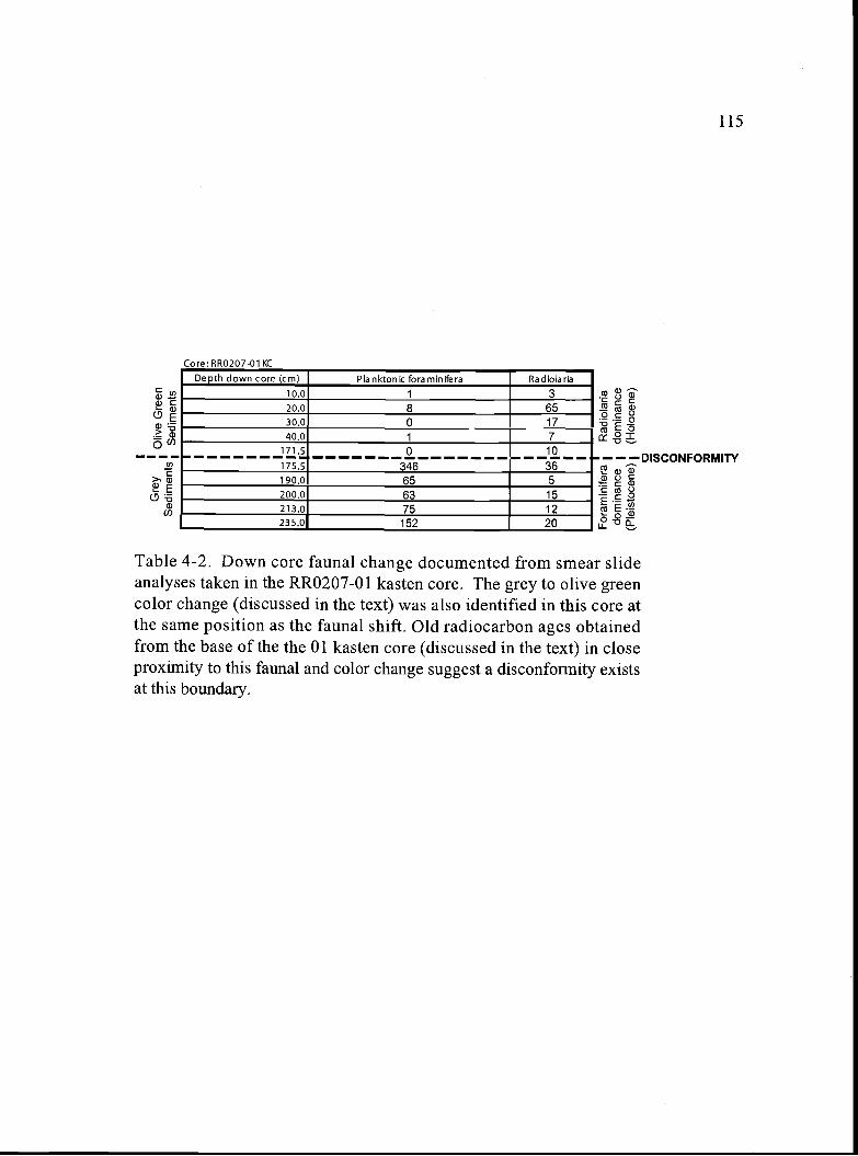
Core: RR0207-01 KC
Table 4-2. Down core faunal change documented from smear slideanalyses taken in the RR0207-01 kasten core. The grey to olive greencolor change (discussed in the text) was also identified in this core atthe same position as the faunal shift. Old radiocarbon ages obtainedfrom the base of the the 01 kasten core (discussed in the text) in closeproximity to this faunal and color change suggest a disconformity existsat this boundary.
115
- - - DISCONFORMITY
Depth down core (cm) Planktonic foraminifera Radiolaria
10.0 1 3
20.0 8 6530.0 0 1740.0 1 7
171.5 0 10
175.5 346 36190.0 65 5200.0 63 15213.0 75 12235.0 152 20
116
or not it is a complete Holocene section cannot be determined because it is possible that
not only some of the late Pleistocene section is missing near the disconformity, but also
part of the early Holocene.
Correlation of Turbidites Across the Basin
Examination of the cores at the proximal and mid-basin sites reveals a general
decrease in thickness of turbidites from the proximal to mid-basin sites and to the distal
core site, which is suggestive of an eastern source region, likely linked to the canyon on
the west side of Hydrate Ridge (Fig. 4-1). We are able to correlate the turbidites across
the basin between the proximal and mid-basin sites using a correlative radiocarbon age
for turbidite T4 (Fig. 4-2) and the correlation of events above and below that datum.
Based on this correlation and measured excess 210Pb activity in cores 56TC and O2TC,
confirming near complete recovery of the seafloor sediment surface (this work also
suggests the top of the core is missing in 56PC, i.e. turbidite 1 is absent there). Although
a correlatable time datum was not found in the distal kasten core (O1KC), comparison of
the total number of Holocene turbidites (approximately 9 above the disconformity)
preserved at the distal kasten core site (O1KC) to the mid-basin site (56PCITC),where
there are more in the Holocene (25 total), suggests either not all of the turbidites sourced
to the east were deposited at the kasten core site or the record at the kasten core site only
represents part of the Holocene, as suggested above. However, because the turbidites
across the basin, as observed at the three sites, are thinner to the west, and a complete
Holocene record could be preserved at the distal kasten site, the discrepancy in total
number of turbidites between the mid-basin and kasten sites could simply indicate that
not all of the events recorded at the mid-basin site had sufficient run out distance to be
deposited at the distal kasten site. Although it is tempting to speculate on the correlation
of events at the distal kasten site and the mid-basin site, without Holocene radiocarbon
results from the kasten core, an event for event correlation between the distal and mid-
basin sites cannot be established with certainty and thus, is not attempted here.
117
Dating the Turbidites
High abundances (800-1000 or more individuals, >2.0 mg) of foraminifera from
well preserved hemipelagic intervals between turbidites are required for obtaining
reliable radiocarbon ages within the stratigraphic sequence. When sampling for
foraminifera in the cores, discrimination between turbidite clay tails (deposited during the
waning stages of a turbidity current and likely containing reworked foraminifera) and
hemipelagic clay (the sediment that slowly rains out through the water column) was made
based on the relative grain size contrast between the sediments. Turbidite tail clay is
slightly coarser grained, containing a larger proportion of silt- or even very fine sand-
sized material, compared to hemipelagic sediment, which is dominated by the clay-size
fraction. The abundance of foraminifera, and other biogenic material (e.g. radiolarians),
within sediments in the tail of a turbidity current is also diluted compared to the biogenic
fraction in hemipelagic samples.
Obtaining sufficient foraminifera from hemipelagic intervals beneath turbidites
can be difficult if the amount of foraminifera falling to the seafloor varies with time, or if
hemipelagic intervals containing the foraminifera have been eroded during the
emplacement of the overlying turbidite. Consistent abundances of foraminifera (900-
1100 individuals/3 cm hemipelagic sample; Table 4-3) throughout the Holocene at the
mid-basin site suggests that the flux to the seafloor has not varied significantly over this
time period. Thus, the low foraminifera counts observed at the proximal site for 4 of the
6 events preserved here (T2, T3, T5, and T6) may be a result of erosive emplacement of
these events (thus the sample included turbidite tail material), which is consistent with the
proximal location of the site to the source region for the slope failures, and the thicker
deposits observed there, which thin to the west, presumably due to deposition during
waning turbidity currents. Because foraminifera counts were low beneath some
turbidites, perhaps due to erosion, and hemipelagic intervals were lacking between others
(either from erosion or short recurrence time between events) and thus not sampled, we
were only able to obtain sufficient foraminifera abundances to radiocarbon date 1 out of
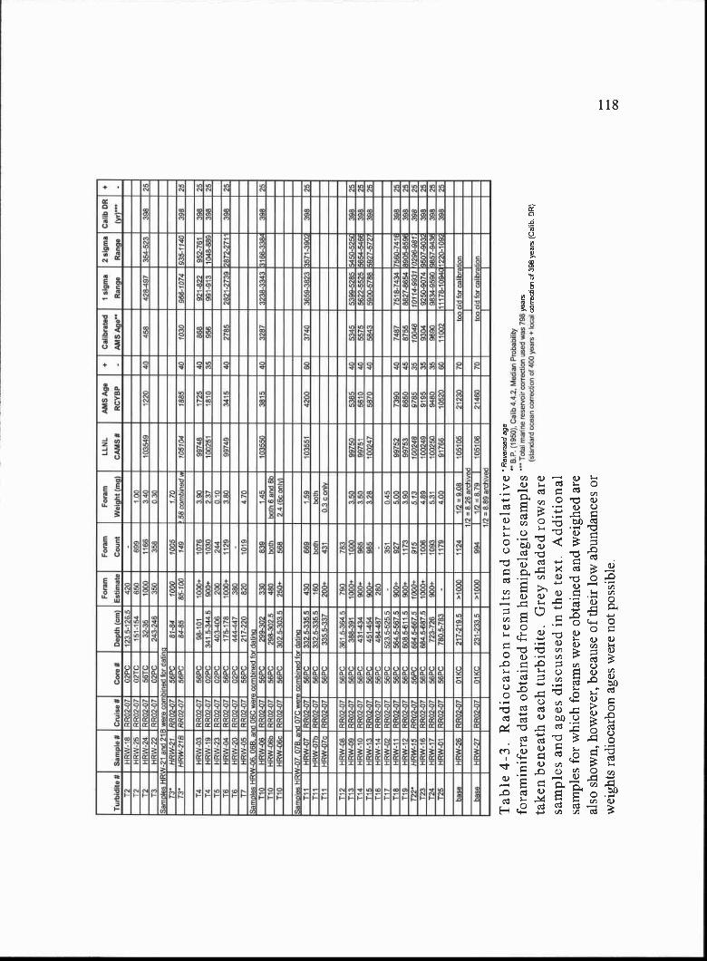
B.P
. (19
50).
Cal
ib 4
.42,
Med
ian
Pro
babd
ityT
oed
mar
ine
rese
rvoi
r co
rrec
tion
used
was
798
(sta
ndar
d oc
ean
corr
ectip
O o
f 400
yea
tslo
cal
Tur
bidi
te 8
Sam
ple
8C
ruis
e 8
Cor
e 8
Dep
th (
cm)
For
ms
Est
imat
e
For
am
Cpu
nt
For
am
Wei
ght (
mg)
LLP
4L
CA
MS
8
AM
S A
ge
RC
YB
P
+ -
Cal
ibra
ted
AM
S A
ge
1 si
gma
Ran
ge
2 si
gma
Ran
ge
Cal
ib D
R
(yr)
'"+ -
12H
RW
-18
RR
O2-
0702
PC
1235
-126
.542
0-
12H
RW
-25
RR
O2-
07O
2TC
151-
154
650
809
100
T2
-IO
W-2
4R
RO
2-07
56T
C32
-35
1000
1166
340
1035
4912
2040
458
428-
497
354-
523
398
2513
l-IR
W-2
2R
002-
07O
2PC
243-
246
350
358
030
Sam
ples
HR
W-2
1 an
d 21
6 w
ere
com
bine
d fo
r da
tinq
T3
HR
W-2
191
702-
07S
f/PC
81-8
410
0010
051
7023
'H
RW
-218
990
2-07
56P
C84
-85
85-1
0014
9i 5
8 co
mbi
ned
a10
5104
1885
4010
3006
6-10
7493
5-11
4039
825
T4
HR
W-0
3R
RO
2-07
S6P
C98
-101
100Q
1076
3.90
9974
817
2540
868
921-
822
952-
761
308
2514
HR
W-1
9R
RO
2-07
O2P
C34
1 5-
3445
900*
-10
3023
710
0251
1$10
3595
699
1-91
310
48-8
8939
825
T5
HR
W-2
3R
RO
2-07
02P
C40
3-40
620
024
-401
015
HR
W-0
4R
RO
2-07
56P
C17
5-17
810
00-i-
1129
380
9974
934
1541
327
8528
21-2
739
2872
-271
139
825
16H
RW
-20
1790
2-07
O2P
C44
4-44
738
017
HR
W-0
5R
RO
2-07
56P
C21
7-22
082
010
1947
0S
ampl
es H
RW
-06,
068
. and
06C
wer
e co
mbi
ned
for
delir
iaT
10H
RW
-Q6
RR
O2-
0756
PC
299-
302
330
839
1,45
1035
5038
1540
3287
3238
-33.
43 3
166-
3384
398
25T
bH
RW
-06b
RR
O2-
07S
SP
C29
8-30
2.5
480
both
both
6 a
nd S
b11
0H
RW
-06c
RR
O2-
0756
PC
302
5-30
3 5
250-
i-56
82.
4 (S
c on
ly)
Sam
ples
HR
W-0
7. 0
75. a
nd 0
7C w
e e
com
bine
d fo
r 08
1i11
011
1H
RW
-07
1790
2-07
56P
C33
2.5-
335,
543
066
91.
5910
3551
4200
6037
4036
59-3
823
3571
-390
239
825
111
HR
W-0
7b99
02-0
756
PC
3325
-33.
5.5
160
both
both
111
HR
W-0
7cR
R13
2-07
56P
C33
5.5-
337
200*
431
03 c
onl
y
112
NR
W-0
891
702-
0756
PC
361
5-36
4570
078
311
3H
RW
-09
RR
O2-
0756
PC
388-
391
1000
.10
0035
099
750
5385
4053
4553
99-5
285
5450
-525
ç39
825
114
HR
W-1
0R
RO
2-07
S6P
C43
1-43
490
0*96
53.
5099
751
5610
4055
7556
22-5
525
5654
-546
639
825
115
HR
W-1
3R
502-
0756
PC
451-
454
900*
-98
532
810
0247
5870
4058
4359
00-5
788
5927
-572
739
825
116
HR
W-1
4R
RO
2-07
5SP
C48
4-4-
8728
0-
117
HR
W-0
217
902-
0756
PC
523
5-52
5.5
-35
10,
4511
8H
RW
-11
1717
02-0
756
PC
564.
5-56
7.5
900*
-92
750
099
752
7390
4074
8775
18-7
434
7560
-741
839
825
119
l-IR
W-1
2R
RO
2--0
7S
6PC
508
5-61
1 5
9130
+11
733.
9099
753
8650
4587
5588
27-8
654
8905
-859
839
825
T22
HR
W-1
599
02-0
756
PC
6645
-667
.510
00+
§15
5 13
1002
4897
8535
1004
810
114-
9931
o29
6-oB
r39
825
123
HR
W-1
617
1702
-07
5690
684.
5-88
7.5
1000
*10
064.
8910
0249
9195
3593
0492
50-9
074
9507
-903
239
825
124
HR
W-1
7R
RO
2-07
5690
723-
726
900*
-10
935.
3110
0250
94-8
035
9690
9834
-959
0 98
57-9
438
308
7512
5l-I
RW
-01
RR
O2-
0756
9C78
05-7
83-
1179
4Q13
9176
610
520
6011
002
1117
8-10
94C
1220
-109
239
825
base
(-IR
W-2
6R
RO
2-07
O1K
C21
7-21
9,5
*100
011
241/
2>90
810
5105
2123
070
too
old
for
calib
ratio
n1/
2 >
B26
arch
ived
base
l-IR
W-2
717
902-
07O
IKC
231-
233.
5>
1131
313
994
1/2
* 8.
7910
5105
2146
070
lOp
old
for
calib
ratio
n1/
2 =
8.8
9 ar
chiv
ed
Tab
le 4
-3. R
adio
carb
on r
esul
ts a
ndfo
ram
inif
era
data
obt
aine
d fr
om h
emip
elag
ic s
ampl
esta
ken
bene
ath
each
turb
idite
. Gre
y sh
aded
row
s ar
esa
mpl
es a
nd a
ges
disc
usse
d in
the
text
. Add
ition
alsa
mpl
es f
or w
hich
for
ams
wer
e ob
tain
ed a
nd w
eigh
ed a
real
so s
how
n, h
owev
er, b
ecau
se o
f th
eir
low
abu
ndan
ces
orw
eigh
ts r
adio
carb
on a
ges
wer
e no
t pos
sibl
e.
year
sco
rrec
tion
of 3
98 y
ears
(C
alib
. DR
)
119
at total of 6 turbidites at the proximal site, 13 out of total of 25 turbidites at the mid-basin
site, and only 2 out of at least 15 turbidites that were deposited at the distal kasten core
site (Table 4-3) We obtained reversed ages for T3 and T22 at the mid-basin site, both
older than the enclosing hemipelagic sediments. The source of this contamination, could
be the inclusion of some older foraminifera, possibly derived from the underlying
turbidite tail of the previous event, although sample handling, or lab errors cannot be
excluded. We intentionally did not sample intervals bearing silty clay, between closely
spaced turbidites lacking significant hemipelagic material. The closely spaced turbidites
not sampled for radiocarbon dating at the mid-basin site included Ti, T5, T8, T9, T20,
and T2 1. Turbidite Ti in core O2TC at the proximal site was also not sampled due to its
proximity to turbidite T2. In addition to these events without radiocarbon dates, a lab
error at LLNL resulted in the loss of the forams for the dating of turbidite T6 and a
micropaleo sample error contaminated the forams that were to be used to date turbidite
Ti 1. Both of these samples were from the mid-basin site. Nevertheless, we do have
good time constraints for enough of the turbidites at the mid-basin site to capture the
entire Holocene slope basin record (Fig. 4-2).
Discussion
The radiocarbon results from the mid-basin site suggest that the entire Holocene
('-j 11,000 year) turbidite record was recovered at this site. 25 total turbidites are
preserved if we interpret all turbidites, including closely spaced ones, as separate slope
failure events. The average recurrence of slope failure during the last 11,000 years is 440
years. To understand what processes may control the frequency of slope failure events at
Hydrate Ridge, and in the likelihood that those same processes control the frequency of
slope failures across the entire continental margin, we discuss the possible triggers for
slope failures in the marine environment and their potential applicability as triggers for
the slope failure events recorded at Hydrate Ridge.
Triggers for Slope Failure
Slope failures in the marine environment can be triggered by (1) oversteepening of
slopes due to rapid sedimentation, (2) or tectonic growth of structures, (3) storm waves, (4)
120
distal tsunamis, (5) excess pore water pressure caused by bubble phase gas, (6) destabilized
gas hydrate, (7) crustal or slab earthquakes, and (8) subduction zone earthquakes. At
Hydrate Ridge, several of these triggers can be eliminated as likely causes for the Holocene
slope failure record in the western slope basin because of its location within the
accretionary wedge. A lack of submarine canyon and channel systems on the central
Oregon margin suggests that oversteepening of slopes due to rapid sediment flux is not
occurring in the Hydrate Ridge region. In fact, the uplifted and isolated nature of the
source region (Hydrate Ridge) for the slope failures in the western slope basin suggests
sedimentation on the ridge has been dominated by slow hemipelagic clay accumulation
since the uplift and isolation of the ridge during accretion from the abyssal plain (4.7-0.3
Ma; Johnson et al., in prep). Because the tectonic growth of structures within the
accretionary wedge at Hydrate Ridge occurs at timescales (1 years) longer than the
Holocene timescale discussed here, it is also not a likely mechanism for triggering the
Holocene slope failures at Hydrate Ridge. Hydrate Ridge is also located in water depths
(>700 m) too deep to be affected by storm wave disturbances and distant tsunamis. The
1964 Alaskan earthquake tsunami wave did not even trigger a slope failure in the shallow
water upper canyon systems on the Washington and southern Oregon continental shelf
(Adams, 1990; Goldfinger, 2003). Because Hydrate Ridge lies within the gas hydrate
stability zone, that leaves excess pore water pressure caused by bubble phase gas or
destabilized gas hydrate, crustal or slab earthquakes, and subduction zone earthquakes as
possible triggers for the slope failure record preserved in the western slope basin.
Slope Failure Triggers at Hydrate Ridge
Of the remaining triggers potentially responsible for the Holocene slope failure
record at Hydrate Ridge, long term records recording the frequency of degas sing events or
the destabilization of gas hydrates unfortunately do not exist. In the last few years,
however, hydrate coated gas bubble plumes have been observed emanating from the
seafloor at southern Hydrate Ridge (Heeschen et al., 2003), and geochemical studies of the
authigenic carbonates preserved at the crest of Hydrate Ridge suggests carbon from
destabilized gas hydrate has contributed to their precipitation in the past (Bohrmann et al.,
121
1998), suggesting that both of these processes occur in the Hydrate Ridge region. Thus,
some slope failures preserved in the western slope basin at Hydrate Ridge may have been
triggered by bubble phase gas escape and/or destabilized gas hydrate events at some time
during the Holocene.
Although instrumental records of crustal and slab earthquakes along the Cascadia
margin region have only become available in the last '40 years, these records indicate very
little offshore seismicity within the central Cascadia margin (e.g. Miller et al., 2001). In the
Hydrate Ridge region the outer portion of the accretionary wedge likely deforms
aseismically, limiting earthquakes in this region to slab events in the Juan de Fuca plate
(Goldfinger et al., 1992; Clarke and Carver 1992). In the Hydrate Ridge region, although
active (Holocene slip) strike slip faults rooted in Juan de Fuca basement exist (Goldfinger
et al., 1997), they have not produced an offshore earthquake over the short time period of
instrumentally recorded seismicity. The only instrumentally recorded earthquake in the
Hydrate Ridge region occurred in 1973 and was a mb 5.8 event in the slab (Spence, 1989).
Because we did not record a recent (<100 year old) turbidite at the top of our cores
(confirmed by a lack of excess 210Pb activity above and beneath the youngest turbidite, Ti),
this event apparently did not trigger a slope failure recorded at any of our three core sites.
Although evidence for slope failure triggered by slab or crustal earthquakes is lacking in
the modern record, that does not preclude that one or more of these types of events could
have triggered a slope failure at some time during the past 11,000 years. Thus, slab and
crustal earthquakes remain possible triggers for Holocene slope failures at Hydrate Ridge.
Along the northern and central portion of the Cascadia margin, the longest
paleoseismic records are those from past subduction zone earthquakes. In the marine
environment, this record consists of synchronously triggered submarine canyon and
channel turbidites (Adams, 1990 and Goldfinger et al., 2003). If subduction zone
earthquakes can trigger slope failures recorded in the submarine canyon and channel cores
along the margin, it seems likely that they might also trigger slope failures in the slope
basin environment at Hydrate Ridge as well. Because the earthquake triggered turbidite
record spans the entire Holocene, we can determine if any of the events at Hydrate Ridge
122
occurred at the same time as slope failures accompanying subduction zone earthquakes
by direct comparison of the Hydrate Ridge record with the record of past subduction zone
earthquakes from Goldfinger et al. (2003). To make this comparison, we use the
radiocarbon results and physical property data described below.
Correlation to the Earthquake Triggered Turbidite Record
The average recurrence interval for earthquake triggered turbidites deposited over
the last 9800 years is 540 years, during which 18 turbidites were deposited (Goldfinger
et al., 2003). Over the same time interval at Hydrate Ridge, there are 24 turbidites
deposited in 9700 years, yielding a more frequent average recurrence interval of about
400 years. To determine if any of the events at Hydrate Ridge are the same age as
subduction zone earthquake triggered turbidites, we compare the radiocarbon results from
the Juan de Fuca Canyon site offshore Washington (Goldfinger et al., 2003) to the
Hydrate Ridge record (Fig. 4-3).
Because the Holocene Hydrate Ridge record is thicker relative to the Holocene
Juan de Fuca Canyon record, likely due to the proximal location of the Hydrate Ridge
cores to the source region, we have expanded the Juan de Fuca Canyon record and broken
it into segments (Fig. 4-3a) that correspond in time and in some cases physical property
character, to the stratigraphy at Hydrate Ridge (Fig. 4-3b). We define correlative events
by overlapping radiocarbon ages (2 sigma error ranges; Fig. 4-3b; Table 4-3), which
imply a subduction zone earthquake trigger at Hydrate Ridge, and hang our correlation
based on those events. Based on the available radiocarbon ages, this results in the
correlation of 7 of the events at Hydrate Ridge (T2, T4, T6, T10, T18, T23, and T24) to
subduction zone earthquake triggered events at the Juan de Fuca Canyon site (solid green
lines in Fig. 4-3). The remaining radiocarbon ages at Hydrate Ridge show that events
(Ti 1, Ti3, T14, and T15) do not correlate with any of the events at the Juan de Fuca site,
and are thus probably not subduction zone earthquake triggered. Because at least 4
events were not triggered by subduction zone earthquakes, the potential other triggers
exists. Because we have ages for events attributed to subduction zone earthquakes events
throughout the Holocene and several of the events at Hydrate Ridge, although undated,
A B
to
45000
250
EQ 16
EQ 17
artifact-
300 EQ1B
range)
400
750
800
ti
T2
-T5T6
17
T18
9800
EQ 1
EQ 2 - - ?- r.
EQ 3
EQ 18
/
T18
T23
T24
.0JOF
Gamma Density CPS6500 8500 50O
Core Site
Maqnetic Susc. SI units200 400 600
Hydrate Ridge Slope BasinT1
R
Juan de Fuca Canyon
JDF H0
Core S
Dat
ed E
vent
sU
ndat
ed E
vent
s
iteID
ated
Eve
nts
Und
ated
Eve
nts
(offs
et r
ot e
ase
or v
iew
ing)
150
200
end ofcorrelative
merecords
0
200
400
600
800
1000
1200
1400
1600
1800
2000
2200
2400
2600
2800
3000
3200
3400
36000th 3800
4000
4200
4400
4600
4800
9, 5000
5200
soo5600
5800
6000
6200
6400
6600
6800
7000
7200
7400
7600
7800
8000
8200
8400
8600
8800
9000
9200
9400
9600
10000
10200
10400
Figure 4-3. (A) Comparison of the Holocene Hydrate Ridge record (RR0207-56PC; in red) to the Holocenesubduction zone earthquake triggered turbidite record at the Juan de Fuca Canyon site (M9907-12PC; in blue)of Goldfinger et al. (2003). The Juan de Fuca Canyon density log is expanded and broken into segments thatcorrespond in time and in some cases physical property character to the record at Hydrate Ridge. Highresolution point magnetic susceptibility logs best capture the signatures of the turbidites, however,comparison of the JDF density log to the high resolution magnetic susceptibility log of core 56PC (HydrateRidge) is necessary because high resolution magnetic data is not available for the Juan de Fuca Canyon site.Examination of gamma density and high resolution magnetic susceptibility records from the samestratigraphy, however, reveals that they record virtually the same turbidite patterns in the stratigraphy andthus, the stratigraphic comparison made here, based on these two seemingly different physical propertymeasurements, is warranted. (B) Calibrated radiocarbon ages for the Juan de Fuca Canyon and HydrateRidge turbidite events (closed symbols, with 2 sigma error ranges also shown). Other events withoutradiocarbon ages (open symbols) are shown and placed on the graph based on their proximity to other datedevents (dashed line indicated maximum range in age based on surrounding dated events). The numericalradiocarbon data is shown in Table 4-3.
EQ 4
EQ14
13
T4
*11, is preserved in 56TC andnot in the 56PC log shown here
TiT2
1314
i 160 17
O TBO T9
110
112
T13
114
115
T16
T17
T19
120
121122
T23
T19
T24 122
T8
19
T1O Ti 1
Ti 1
T12
T13
114
Ti5
116
117
EQ 10
EQ 1
EQ 12
EQ 13
EQ 14
EQ 15
EQ 6
EQ 7
EQ 8
EQ 9
EQ 10
EQ 11
EQ 12
EQ 13
EQ 15
EQ 16
EQ 17
Juan de Fuca Turbidite Undated (date inferred frompostion in the core relative to dated events; dashed line ispossible age range)
Hydrate Ridge 14C Ages (2 sigma error range)
Hydrate Ridge Turbidite Undated (date inferred frompostion in the core relative to dated events; dashed line ispossible age range)
124
are bracketed by ages, we can evaluate if some of the additional undated events are
subduction zone earthquake triggered by using the relative positions of other turbidites
between dated events coupled with the physical property signatures of the turbidites
(character of individual events, relative size of events, and relative spacing of events).
The results of this comparison, suggests a likely earthquake trigger for 6 other turbidites
at Hydrate Ridge (dashed green lines in Fig. 4-3). This comparison also reveals that 5 of
the margin wide earthquakes did not result in a slope failure deposit at Hydrate Ridge (at
least one that was recovered at the 56PC core site) and up to 7 additional events were not
triggered by subduction zone earthquakes (Fig. 4-3). Below we discuss the evidence for
our interpretation of other likely earthquake triggered events, other non sub duction zone
earthquake triggered events, and the missing earthquake triggered events at the Hydrate
Ridge site.
Comparison of the physical property character of individual correlative
earthquake triggered turbidites from canyon and channel records along the entire margin,
suggests the earthquake shaking characteristics during individual events, may be recorded
in the turbidites (Goldfinger et al., 2004). Some of those signals may also be recorded in
some of the events at Hydrate Ridge as well. We notice a remarkable similarity,
particularly in the older portion of the record, between the physical property signature
and relative sizes of some turbidites compared to others at both sites (e.g. JDF Ti 1 and
HR T17 have a similar box shape; JDF Ti i, T13, and T16 are also large deposits at the
Juan de Fuca site and margin wide and have large correlative deposits at Hydrate Ridge,
T17, Ti8, and T22-T20, respectively; discussed below). Coupled with the radiocarbon
dates, these physical characteristics serve as an additional tool for event correlation. For
example, we infer an earthquake origin for T17, Ti9, and T22 at Hydrate Ridge based on
the following lines of evidence. We can lock in the lower portion of the stratigraphy at
Hydrate Ridge, events (Ti 7 to T24), using the 3 radiocarbon ages for events Ti 8, T23,
and T24, which have overlapping ages with earthquake events EQ 13, EQ 17, and EQ 18,
respectively (Fig. 4-3) as a starting point. Next we dated events Ti 5 and Ti 8 at Hydrate
Ridge. We can infer that undated events Ti6, and T17 were deposited in the time
125
between them (dashed red age range for T17; Fig. 4-3b) and that T16 is younger than T17
and older than T15 (Fig. 4-3b). Because of the similarity in the physical properties
between T17 and EQ 11 and the age for EQ 11 is consistent with the age range possible
for Ti 7 at Hydrate Ridge (Fig. 4-3b), we suspect that these events are correlatable,
suggesting turbidite T17 was earthquake triggered. If this relationship is correct, it means
that turbidite T16 at Hydrate Ridge was not triggered by a subduction zone earthquake
(its relative dating places it younger than the Ti 7-EQ 11 age and older than the EQ 10
age). It also implies that EQ12 was not recorded as a turbidite deposit at Hydrate Ridge
(because there is no turbidite between Ti7 and T18, both of which correlate with EQ1 1
and EQ13 earthquakes. With T17 likely correlated to EQ 11, and the other T18/ EQ13,
T23/EQ 17 and T24/EQ 18 overlapping radiocarbon constrained correlations, we can
determine additional relationships between the two records between Ti 8 and T23 at
Hydrate Ridge. Because we lack an age for EQi 5, we can only infer that it occurred
between EQi4, and EQ16 (dashed blue age range line; Fig. 4-3b). We have an age for
Ti 9 at Hydrate Ridge that overlaps with this time range and therefore we suggest TI 9 is
correlatable with EQ 15. The relative spacing of events above and below in both cores
also supports this correlation. With this correlation, that implies that EQ 14 did not
trigger a slope failure at Hydrate Ridge. If Ti 9 is correlative with EQ 15, and we know
T23 is correlative with EQ17 (from radiocarbon age overlap), then EQ16 could be
coincident with T22, T21, or T20, which although not dated, all lie between the dated
Ti 9 and T23 events. The overlapping bracketed ages suggests EQ 16 is recorded as either
T22, T21, or T20 at Hydrate Ridge. In terms of physical properties, we notice a
remarkable similarity between the EQ 16 event at Juan de Fuca canyon (a triple coarse
pulse turbidite) and the closely spaced T22, T2i, and T20 events. Although it is possible
that the characteristics of the EQ 16 shaking resulted in a triplet event across the margin,
and this same shaking signal is recorded at Hydrate Ridge as the triplet T22, T2 1, and
T20, we cannot rule out erosive emplacement of separately-triggered T20 into T2 1, and
T21 into T22 during subsequent deposition, as the cause of this apparent sequence of
events. Another possible interpretation for the close spacing of events in this proximal
126
slope basin environment is that the slope failures were triggered by one mechanism that
initiated slope failure at slightly different distances from the core site, thus arriving at the
core site slightly separated in time and resulting in an amalgamated deposit. This same
scenario may have resulted in the close spacing of events Tb, T9, and T8 and even T2
and Ti as well, discussed below. Nevertheless, we suspect that EQ 16 is correlative with
at least 1 of the three (if separate) events T22, T2 i, or T20, and because of the relative
spacing of events surrounding them, we have correlated EQ 16 with the base of this
sequence, at T22. This leaves open the possibility that T21 and T22 are separate events
triggered by other non subduction zone earthquakes after the EQ 1 6/T22 event or part of a
triplet event, with a base at T22, and two subsequent coarse grained pulses, all three of
which may have been triggered by EQ 16.
In the middle portion of the Holocene section at Hydrate Ridge, turbidite Ti2,
although not dated, is bracketed by two dated events Ti 1 and Ti3, neither of which
correlate in time with EQ8, EQ9, or EQ1O that occurred between them (Fig. 4-3). This
means the deposition of Ti 2 overlaps with the occurrence in time of three earthquakes
(EQ8, EQ9, and EQ 10). Because of this coincidence, we suspect that T12 at Hydrate
Ridge correlates with one of these events. Also implied is that two subduction zone
earthquakes in this time interval did not deposit a turbidite at the Hydrate Ridge core site.
Exactly which 2 of the 3 events, however, cannot be determined The close spacing of
turbidites T5 and T6 (T6 is correlated in time to EQ6) and the potential for a time overlap
between the occurrence of T5 with EQ5 suggests that T5 was triggered by an earthquake
(Fig. 4-3). We correlate T5 with EQ5 rather than EQ4, because of the closer proximity
of T5 to T6 rather than T4 and the closer proximity in time between EQ5 and EQ6 rather
than EQ5 to EQ4. This correlation implies that EQ4 did not deposit a turbidite at the
Hydrate Ridge site. Because turbidite T3 is bracketed by correlative earthquake triggered
turbidites above and below it and EQ2 is coincident in time with the time range for the
deposition of T3 (after T2 and before T4) we correlate T3 with EQ2. Thus, T3 is likely
earthquake triggered. At the top of the section at Hydrate Ridge, we consider Ti to be an
event not related to a subduction zone earthquake.
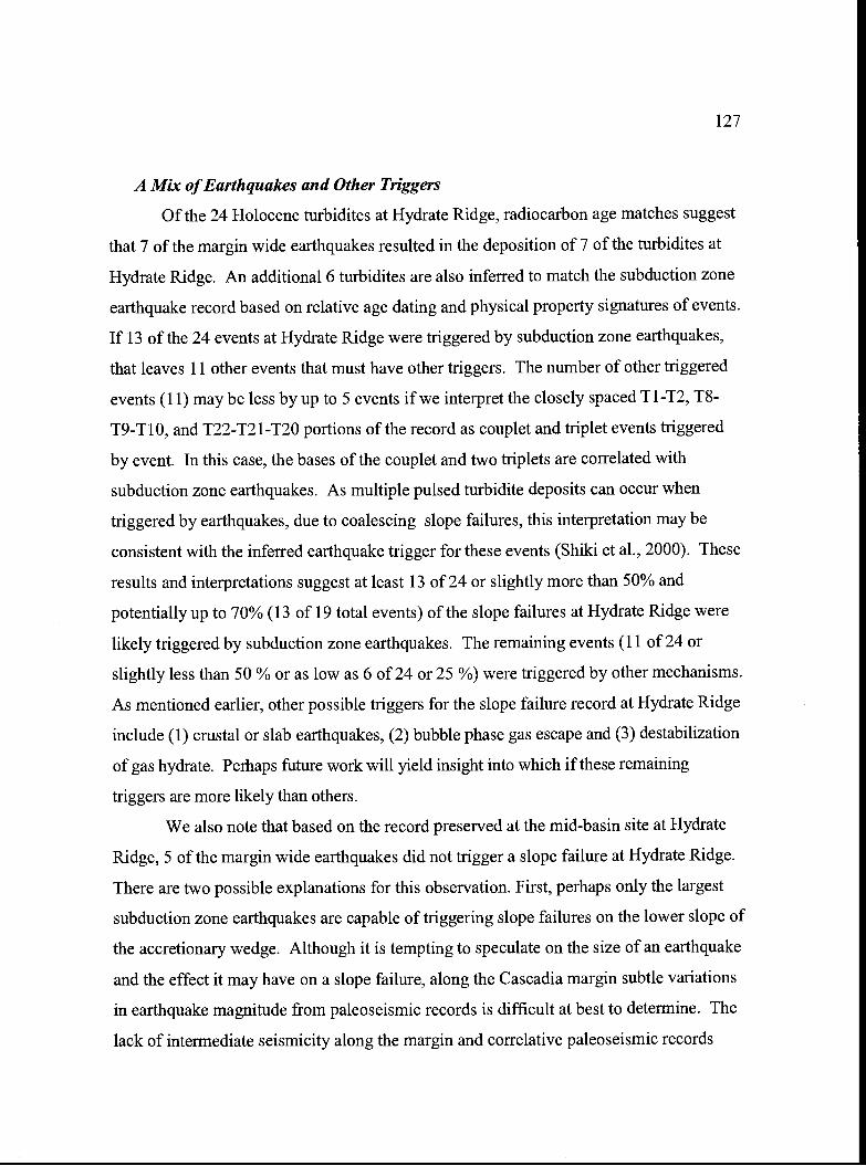
127
A Mix of Earthquakes and Other Triggers
Of the 24 Holocene turbidites at Hydrate Ridge, radiocarbon age matches suggest
that 7 of the margin wide earthquakes resulted in the deposition of 7 of the turbidites at
Hydrate Ridge. An additional 6 turbidites are also inferred to match the subduction zone
earthquake record based on relative age dating and physical property signatures of events.
If 13 of the 24 events at Hydrate Ridge were triggered by subduction zone earthquakes,
that leaves 11 other events that must have other triggers. The number of other triggered
events (11) may be less by up to 5 events if we interpret the closely spaced T1-T2, T8-
T9-T1O, and T22-T21-T20 portions of the record as couplet and triplet events triggered
by event. In this case, the bases of the couplet and two triplets are correlated with
subduction zone earthquakes. As multiple pulsed turbidite deposits can occur when
triggered by earthquakes, due to coalescing slope failures, this interpretation may be
consistent with the inferred earthquake trigger for these events (Shiki et al., 2000). These
results and interpretations suggest at least 13 of 24 or slightly more than 50% and
potentially up to 70% (13 of 19 total events) of the slope failures at Hydrate Ridge were
likely triggered by subduction zone earthquakes. The remaining events (11 of 24 or
slightly less than 50 % or as low as 6 of 24 or 25 %) were triggered by other mechanisms.
As mentioned earlier, other possible triggers for the slope failure record at Hydrate Ridge
include (1) crustal or slab earthquakes, (2) bubble phase gas escape and (3) destabilization
of gas hydrate. Perhaps future work will yield insight into which if these remaining
triggers are more likely than others.
We also note that based on the record preserved at the mid-basin site at Hydrate
Ridge, 5 of the margin wide earthquakes did not trigger a slope failure at Hydrate Ridge.
There are two possible explanations for this observation. First, perhaps only the largest
subduction zone earthquakes are capable of triggering slope failures on the lower slope of
the accretionary wedge. Although it is tempting to speculate on the size of an earthquake
and the effect it may have on a slope failure, along the Cascadia margin subtle variations
in earthquake magnitude from paleoseismic records is difficult at best to determine. The
lack of intermediate seismicity along the margin and correlative paleoseismic records
128
across the margin suggests consistently large magnitude events (M 8-9) are likely
common. Secondly, and perhaps a more likely explanation, is perhaps all of the
subduction zone earthquakes did trigger slope failure at Hydrate Ridge, but only 13 of the
total 18 earthquake triggered slope failures were deposited at the mid-basin core site.
Other events, may have had shorter run out distances, or been sourced in regions away
from the large canyon upslope from the mid-basin site, resulting in a bypassing of the
core site. Additional coring in this slope basin or other lower slope basins could test this
hypothesis. Nevertheless, a majority (13) of the total (18) Holocene margin wide
earthquakes triggered many of the Holocene slope failures at Hydrate Ridge and this has
important implications for the stability of margin wide gas hydrates
Implications for the Mobilization of Seafloor Gas Hydrates
If slope failures are an important mechanism for destabilizing seafloor and
shallow seafloor gas hydrates, determining their frequency of occurrence and
understanding their potential triggering mechanism(s) can yield insight into the processes
that affect the frequency and spatial extent of gas hydrate destabilization events on the
seafloor. In order to have the greatest potential for mobilizing the largest volume of
seafloor gas hydrates during slope failure, either the slope failures have to be massive in
scale, instantaneously mobilizing a large region of the seafloor, or the trigger for the
slope failure has to be massive in scale, effectively causing numerous smaller
synchronous slope failures across a broad region. Along the Cascadia margin, evidence
for young large scale individual slope failures triggered during the Holocene is lacking,
instead, examination of the margin wide bathymetry shows it is riddled with fresh,
smaller slope failure scars suggestive of small and frequent slope failures with a margin
wide distribution of occurrence.
In this paper we present a complete and well dated Holocene record of slope
failures derived from gas hydrate bearing sediments in an active margin setting down slope
from one of these small slope failure scars. The slope basin turbidite record west of
Hydrate Ridge indicates slope failures occur with an average recurrence ranging from 400
years (9700 B.P./24 events) to 500 years (9700 B.P./19 events, if couplet and triplets are
129
single events). Comparison of the Hydrate Ridge record to the marine record of subduction
zone earthquakes suggests slightly more than 50% and perhaps as much as 70% of the
slope failures at Hydrate Ridge are related to subduction zone earthquakes. Because
subduction zone earthquakes along the Cascadia margin are interpreted to have long
rupture lengths (as much as 700 km), based on correlative paleoseismic records, and
subduction zone earthquake triggered slope failures occur at Hydrate Ridge, they are likely
to occur along much of the lower slope of the accretionary wedge within the gas hydrate
stability zone (water depths >500 m). This suggests that margin wide subduction zone
earthquakes could be a trigger for 50-70% of the slope failures in many if not all of the gas
hydrate portions of the margin, perhaps serving to a large extent to regulate the short term
frequency of gas hydrate destabilization events (via slope failure mobilization) along the
Cascadia margin at least during the Holocene.
In addition to subduction zone earthquake triggered slope failures however, there
are other slope failure triggers that could operate in the gas hydrate bearing regions of the
Cascadia margin. From the Hydrate Ridge slope basin record discussed here, the most
likely other triggers include (1) slab or crustal earthquakes, (2) bubble phase gas escape and
(3) destabilization of gas hydrate. Of these remaining triggers only bubble phase gas
escape and the destabilization of gas hydrate are likely to be triggers for margin wide slope
failures and only if they are controlled by a margin wide or large scale process. Recent
work on the Norwegian continental margin has suggested bottom water temperature
changes during the Holocene were responsible for destabilizing the seafloor gas hydrate
there, resulting in massive slope failure (Jung and Vogt, 2004). Perhaps some of the events
not triggered by subduction zone earthquakes, could be a result of this same type of process
operating at Hydrate Ridge and even throughout the gas hydrate stability zone across the
margin. With no supporting evidence, however, for thermally destabilized gas hydrate
events, much less their timing during the Holocene, testing this hypothesis will remain the
subject of future research.
130
Conclusions
In this paper, we document the Holocene frequency of occurrence of slope failure
at an active margin gas hydrate province. The average recurrence of events during the
last 9700 years is 400-500 years. The possible triggers for these slope failures include
slab earthquakes, bubble phase gas escape, the destabilization of gas hydrate, andlor
subduction zone earthquakes. Comparison of the timing of slope failures between the
Hydrate Ridge slope basin site, and the subduction zone earthquake turbidite Juan de Fuca
site of Goldfinger et al. (2003) suggests subduction zone earthquakes are responsible for
triggering 50-70% of the slope failures at Hydrate Ridge during the Holocene. Because
subduction zone earthquakes are a margin wide process and they triggered many of the
slope failures at Hydrate Ridge, it is likely that they triggered other slope failures within
the gas hydrate stability zone, across the margin, thus potentially regulating to a large
extent the frequency of margin wide mobilization of seafloor gas hydrates during the
Holocene. Identification of subduction zone earthquake triggered slope failures as an
important mechanism for margin wide mobilization of seafloor gas hydrates suggests this
type of process may be common on other active continental margins as well.
Acknowledgements
Acknowledgement is also made to the Donors of The Petroleum Research Fund,
administered by the American Chemical Society, for support of this research and the
COAS Chipman-Downs Fellowship at Oregon State University. We also thank Richard
Boettcher for picking the foraminifera for radiocarbon dating, Michelle Arsenault (OSU)
for sieving radiocarbon samples, and Rob Wheatcroft (OSU) and Roger Lewis (OSU) for
radioisotope measurements (OSU). Additional thanks to Bob Yeats (OSU), Anne Tréhu
(OSU), and Marta Tones (OSU) for valuable discussions.
References
Adams, J., 1990, Paleoseismicity of the Cascadia subduction zone: Evidence fromturbidites off the Oregon-Washington margin: Tectonics, 9, 569-5 83.
Atwater, B.F., and Hemphill-Haley, E., 1997, Recurrence Intervals for Great Earthquakesof the Past 3,500 Years at Northeastern Willapa Bay, Washington: U. S. GeologicalSurvey Professional Paper 1576, 108 p.
Bohrmann, G., Greinert, J., Suess, E., and Tones, M., 1998, Authigenic carbonates fromthe Cascadia subduction zone and their relation to gas hydrate stability: Geology,26, 647-650.
Brewer, P.G., Paull, C., Peltzer, E.T., Ussler, W., Rehder, G., and Friederich, G., 2002,Measurements of the fate of gas hydrates during transit through the ocean watercolumn: Geophys. Res. Left., 29, doi:10.1029/2002GL014727.
Carison, P.R., and Nelson, C.H., 1987, Marine geology and resource potential of CascadiaBasin, in Scholl, G., and Vedder, ed., Geology and Resource Potential of theContinental Margin of Western North America and Adjacent Ocean Basins,Volume 6: Houston TX, Circum-Pacific Council for Energy and MineralResources, Earth Sciences Series, 523-535.
Clarke Jr., S.H., and Carver, G.A., 1992, Late Holocene tectonics and paleoseismicity,southern Cascadia subduction zone: Science, 255, 188-191.
Duncan, J.R., Fowler, G.A., and Kuim, L.D., 1970, Planktonic Foraminiferan-RadiolarianRatios and Holocene-Late Pleistocene Deep Sea Stratigraphy off Oregon: Geol.Soc. Am. Bull., 81, 56 1-566.
Field, M.E., Gardner, J.V., Jennings, A.E., and Edwards, B.D., 1982, Earthquake-inducedsediment failures on a 0.25° slope, Kiamath River delta, California: Geology, 10,542-546.
Goldfinger, C., Kuim, L.D., Yeats, R.S., Appelgate, B., MacKay, M.E., and Moore, G.F.,1992, Transverse structural trends along the Oregon convergent margin:Implications for Cascadia earthquake potential and crustal rotations: Geology, 20,141-144.
Goldfinger, C., Kuim, L.D., Yeats, R.S., McNeill, L., and Hummon, C., 1997, Obliquestrike-slip faulting of the central Cascadia submarine forearc: J. of Geophys. Res.,102, 8217-8243.
Goldfinger, C., Nelson, C.H., and Johnson, J.E., 2003, Holocene Earthquake Records Fromthe Cascadja Subduction Zone and Northern San Andreas Fault Based on PreciseDating of Offshore Turbidites: Annual Rev.-Earth and Planetary Sci., 31, 55 5-577.
Goldfinger, C., Nelson, C.H., Johnson, J.E., Chaytor, J.D., Eriksson, D., Karabanov, E.,Morey-Ross, A., and R!V Revelle and R/V Melville Shipboard Scientific Parties,2004, Long-term paleoseismic records along the Cascadia subduction zone andnorthern San Andreas Fault based on turbidite stratigraphy, Japan Earth andPlanetary Science Joint Meeting: Tokyo, Japan, JEPS.
Greinert, J., Bohrmann, G., and Suess, E., 2001, Gas Hydrate-Associated Carbonates andMethane-Venting at Hydrate Ridge: Classification, Distribution, and Origin of
131
132
Authigenic Lithologies, in Paull, C.K., and Dillon, W.P., eds., Natural GasHydrates: Occurrence, Distribution, and Detection, Volume GeophysicalMonograph 124: Washington D.C., American Geophysical Union, 99-113.
Heeschen, K.U., Tréhu, A.M., Collier, R.W., Suess, E., and Rehder, G., 2003, Distributionand height of methane bubble plumes on the Cascadia margin characterized byacoustic imaging Geophysical Research Letters, v. 30, p. 1643-1646.
Heezen, B.C., and Ewing, M., 1952, Turbidity currents and submarine slumps, and the1929 Grand Banks earthquake: American Journal of Science, 250, 849-878.
Inouchi, Y., Kinugasa, Y., Kumon, F., Nakano, S., Yasumatsu, S., and Shiki, T., 1996,Turbidites as records of intense palaeoearthquakes in Lake Biwa, Japan:Sedimentary Geology, 104, 117-125.
Johnson, J.E., Goldfinger, C., Bangs, N., Tréhu, A.M., and Chevallier, J., in prep 2004,Structural vergence variation and clockwise block rotation in the Hydrate Ridgeregion, Cascadia accretionary wedge: Tectonics.
Johnson, J.E., Goldfinger, C., and Suess, E., 2003, Geophysical constraints on the surfacedistribution of authigenic carbonates across the Hydrate Ridge region, Cascadiamargin: Marine Geology, 202, 79-110.
Jung, W., and Vogt, P.R., 2004, Effects of bottom water warming and sea level rise onHolocene hydrate dissociation and mass wasting along the Norwegian-BarentsContinental Margin: J. of Geophys. Res., 109, doi:10.1029/2003JB002738.
Kelsey, H.M., Witter, R.C., and Hemphill-Haley, E., 2002, Plate-boundary earthquakes andtsunamis of the past 5500 yr, Sixes River estuary, southern Oregon: Geol. Soc.Am. Bull., 114, 298-3 14.
Kennett, J.P., Cannariato, K.G., Hendy, I.L., and Bell, R.J., 2003, Methane Hydrates inQuatemary Climate Change The Clathrate Gun Hypothesis: Washington D.C.,American Geophysical Union, 216 p.
Klein, G.d., 1984, Relative rates of tectonic uplift as determined from episodic turbiditedeposition in marine basins: Geology, 12, 48-50.
Miller, M.M., Johnson, D.J., Rubin, C.M., Dragert, H., Wang, K., Qamar, A., andGoldfinger, C., 2001, GPS-determination of along-strike variation in Cascadiamargin kinematics: Implications for relative plate motion, subduction zonecoupling, and permanent deformation: Tectonics, 20, 161-176.
Nelson, H., 1976, Late Pleistocene and Holocene depositional trends, processes, andhistory of Astoria deep-sea fan, northeast Pacific: Marine Geology, 20, 129-173.
Paull, C.K., Brewer, P.G., Ussler III, W., Peltzer, E.T., Rehder, G., and Clague, D., 2003,An experiment demonstrating that marine slumping is a mechanism to transfermethane from seafloor gas-hydrate deposits into the upper ocean and atmosphere:Geo-Marine Lett., 22, 198-203.
Paull, C.K., Buelow, W.J., Ussler III, W., and Borowski, W.S., 1996, Increasedcontinental-margin slumping frequency during sea-level lowstands above gashydrate-bearing sediments: Geology, 24, 143-146.
133
Rothwell, R.G., Thomson, J., and Kähler, G., 1998, Low-sea-level emplacement of a verylarge Late Pleistocene 'megaturbidite' in the western Mediterranean Sea: Nature,392, 377-380.
Shiki, T., Cita, M.B., and Gorsline, D.S., 2000, Sedimentary features of seismites, seismo-turbidites and tsunamiitesan introduction: Sedimentary Geology, 135, vii-ix.
Spence, W., 1989, Stress Origins and Earthquake Potentials in Cascadia: J. of Geophys.Res., 94, 3076-3088.
Stuiver, M., and Reimer, P.J., 1993, Extended 14C database and revised CALIBradiocarbon calibration program: Radiocarbon, 35, 215-230.
Stuiver, M., Reimer, PJ., and Braziunas, T.F., 1998, High-precision radiocarbon agecalibration for terrestrial and marine samples.: Radiocarbon, 40, 1127-1151.
Suess, E., Torres, M.E., Bohrmann, G., Collier, R.W., Rickert, D., Goldfinger, C., Linke,P., Heuser, A., Sahling, H., Heeschen, K., Jung, C., Nakamura, K., Greinert, J.,Pfanrikuche, P., Tréhu, A., Klinkhammer, G., Whiticar, M.J., Eisenhauer, A.,Teichert, B., and Elvert, M., 2001, Sea floor methane hydrates at Hydrate Ridge,Cascadia Margin, in Paull, C.K., and Dillon, W.P., eds., Natural Gas HydratesOccurrence, Distribution, and Detection, Volume 124: American GeophysicalUnion Monograph: Washington D.C., American Geophysical Union, 87-98.
Teichert, B.M.A., Eisenhauer, A., Bohrmann, G., Haase-Schramm, A., Bock, B., andLinke, P., 2003, U/Th systematics and ages of authigenic carbonates from HydrateRidge, Cascadia convergent margin: recorders of fluid composition and sealevelchanges: Geochimica et Cosmochimica Acta, 67, 3845-3857.
Tréhu, A.M., Bohrmann, G., Rack, F., Collett, T., Goldberg, D., Long, P.E., Milkov, A.V.,Riedel, M., Schuitheiss, P., Tones, M.E., Bangs, N.L., Ban, S.R., Borowski, W.S.,Claypool, G.E., Deiwiche, M.E., Dickens, G.R., Gracia, E., Guerin, G., Holland,M., Johnson, J.E., Lee, Y.-J., Liu, C.-S., Su, X., Teichert, B., Tomaru, H., Vanneste,M., Watanabe, M., and Weinberger, J.L., 2004, Three-dimensional distribution ofgas hydrate beneath southern Hydrate Ridge: constraints from ODP Leg 204: Earthand Planetary Sci. Left., 222, 845-862.
Tréhu, A.M., Bohrmann, G., Rack, ER., Tones, M.E., and al., e., 2003, Proc. ODP, mit.Repts. [CD-ROM], Volume 204: College Station, TX, Ocean Drilling Program.
Tréhu, A.M., and Flueh, E.R., 2001, Estimating the thickness of the free gas zone beneathHydrate Ridge, Oregon continental margin, from seismic velocities and attenuation:J. of Geophys. Res., 106, 2035-2045.
Tréhu, A.M., Tones, M.E., Moore, G.F., Suess, E., and BohrmamTi, G., 1999, Temporal andspatial evolution of a gas hydrate-bearing accretionary ridge on the Oregoncontinental margin: Geology, 27, 939-942.
Westbrook, G.K., Carson, B., Musgrave, R.J., et al.,1994, Proc. ODP, mit. Repts.: CollegeStation, TX, Ocean Drilling Program.
Witter, R.C., Kelsey, H.M., and Hemphill-Haley, E., 2003, Great Cascadia earthquakes andtsunamis of the past 6700 years, Coquille River estuary, southern coastal Oregon:Geol. Soc. Am. Bull., 115, 1289-1306.
Chapter V
Conclusions
The research presented in this dissertation describes some of the geologic
processes that can influence the gas hydrate system at Hydrate Ridge. It is likelythat
these same processes occur within other portions of the Cascadia margin within the gas
hydrate stability zone as well, and they may also be applicable at other active margin gas
hydrate systems.
The results presented here, suggest the regional distribution of pore fluid venting
sites and likely gas hydrate occurrences within the Hydrate Ridge region is largely
controlled by the deformation intensity and dewatering history across the margin
(Chapter II). Within large accretionary ridges like Hydrate Ridge, the surface expression
of fluid venting appears to be highly focused. Migrating up dip through stratigraphic
andlor structural conduits, pore fluids serve to feed a well developed shallow gas hydrate
system observed at the summit. These fluids can escape directly to the ocean water,
where they precipitate authigenic carbonates or they can simply supply the gas hydrate
stability zone with methane, which occasionally escapes during the destabilization of gas
hydrate, also resulting in the precipitation of authigenic carbonates. Identification of
regional fluid venting patterns on high resolution sidescan sonar data coupled with
seismic reflection data and gridded bathymetry offers good insight into the processes that
may be operating within a given margin transect, and can greatly aid in guiding more
specific seafloor investigations. Understanding the structural evolution of the region
hosting a gas hydrate system is also valuable in evaluating the distribution and
concentration of marine gas hydrates across a continental margin transect. The results
presented here documented the structural vergence variability across the Hydrate Ridge
region, its relative timing to external geologic processes (deposition of the Astoria fan on
the abyssal plain and strike slip fault propagation into the wedge) and the interaction
between these processes, which results in the present configuration of this portion of the
accretionary wedge (Chapter III). Understanding this evolution is important as it may
134
135
help explain the absence or presence of gas hydrate and provide insight to the evolution
of other gas hydrate systems across the margin. On short timescales the slope failure
frequency induced by subduction zone earthquakes, with minimal contributions from
other triggers, may influence the margin wide slope failure history within the gas hydrate
stability zone. This could mean that a significant portion of seafloor and shallow
subseafloor gas hydrates could be synchronously mobilized during a subduction zone
earthquake, resulting in a potentially large methane release from the seafloor into the
ocean and even the atmosphere.
Although the above research has significantly contributed to our understanding of
the gas hydrate system at Hydrate Ridge and has the potential for extrapolation to other
portions of the Cascadia margin, there is always more insight that can be gained through
continued research efforts, not only here at Hydrate Ridge, but in other active margin gas
hydrate bearing environments.
136
Bibliography
Adams, J., 1990, Paleoseismicity of the Cascadia subduction zone: Evidence fromturbidites off the Oregon-Washington margin: Tectonics, 9, 569-583.
Atwater, B.F., and Hemphill-Haley, E., 1997, Recurrence Intervals for Great Earthquakesof the Past 3,500 Years at Northeastern Willapa Bay, Washington: U. S. GeologicalSurvey Professional Paper 1576, 108 p.
Blondel, P. and Murton, B.J., 1997. Handbook of Seafloor Sonar Imagery. Wiley-PraxisSeries in Remote Sensing. John Wiley & Sons Ltd. in association with PraxisPublishing Ltd., West Sussex, England, 314 p.
Bohrmann, G., Greinert, J., Suess, E., and Tones, M., 1998, Authigenic carbonates fromthe Cascadia subduction zone and their relation to gas hydrate stability: Geology,26, 647-650.
Bohrmaim, G., Linke, P., Suess, B. and Pfannkuche, 0., 2000. RV SONNE Cruise ReportSO143 TECFLUX-I-1999. GEOMAR Report 93.
Brewer, P.G., Paull, C., Peltzer, E.T., Ussler, W., Rehder, G., and Friederich, G., 2002,Measurements of the fate of gas hydrates during transit through the ocean watercolunm Geophys. Res. Left., 29, doi:l0.1029/2002GL014727.
Brown, K.M., 1990. The nature and hydrogeologic significance of mud diapirs anddiatremes for accretionary systems: J. Geophys. Res., 95 (B6), 8969-8982.
Burbidge, D.R., and Braun, J., 1998, Analogue models of obliquely convergentcontinental plate boundaries: J. of Geophys. Res., 103, 15,221-15,237.
Byrne, D.E., Wang, W., and Davis, D.M., 1993, Mechanical role of backstops in thegrowth of forearcs: Tectonics, 12, 123-144.
Carlson, P.R., and Nelson, C.H., 1987, Marine geology and resource potential ofCascadia Basin, in Scholl, G., and Vedder, ed., Geology and Resource Potentialof the Continental Margin of Western North America and Adjacent Ocean Basins,6: Houston TX, Circum-Pacific Council for Energy and Mineral Resources, EarthSciences Series, 523-535.
Carson, B., Seke, E., Paskevich, V. and Holmes, M.L., 1994. Fluid expulsion sites on theCascadia accretionary prism: Mapping diagenetic deposits with processed GLORIAimagery: J. Geophys. Res., 99 (B6), 11,959-11,969.
Caulet, J.-P., 1995, Radiolarians from the Cascadia Margin, leg 146, in Carson, B.,Westbrook, G.K., Musgrave, R.J., and Suess, E., eds., Proc. ODP, Sci. Results,Volume 146 (Pt. 1): College Station, TX, Ocean Drilling Program, 47-61.
Chevallier, J., 2004, Seismic sequence stratigraphy and tectonic evolution of SouthernHydrate Ridge [M.S. thesis]: Corvallis, OR, Oregon State University, 117 p.
Clague, D.A., Maher, N., and Paull, C.K., 2001. High-resolution multibeam survey ofHydrate Ridge, offshore Oregon. In: Paull, C.K. and Dillon, W.P. (Eds.), NaturalGas Hydrates: Occurrence, Distribution, and Detection. Geophysical Monograph124. American Geophysical Union, Washington, D.C., 297-303.
137
Clarke Jr., S .H., and Carver, G.A., 1992, Late Holocene tectonics and paleoseismicity,southern Cascadia subduction zone: Science, 255, 188-19 1.
Davis, D., Suppe, J., and Dahien, F.A., 1983, Mechanics of Fold-and-Thrust Belts andAccretionary Wedges: J. of Geophys. Res., B2, 1153-1172.
Davis, E.E., and Hyndman, R.D., 1989, Accretion and recent deformation of sedimentsalong the northern Cascadia subduction zone: Geol. Soc. Am. Bull., 101, 1465-1480.
Duncan, J.R., Fowler, G.A., and Kulm, L.D., 1970, Planktonic Foraminiferan-RadiolarianRatios and Holocene-Late Pleistocene Deep Sea Stratigraphy off Oregon: Geol.Soc. Am. Bull., 81, 561-566.
Echavarria, L., Hernández, R, Alimendinger, R., and Reynolds, J., 2003, Subandeanthrust and fold belt of northwestern Argentina: Geometry and timing of theAndean evolution: AAGP Bull., 87, 965-985.
Field, M.E., Gardner, J.V., Jennings, A.E., and Edwards, B.D., 1982, Earthquake-inducedsediment failures on a 0.2 5° slope, Klamath River delta, California: Geology, 10,542-546.
Fleming, S.W. and Tréhu, A., 1999. Crustal structure beneath the central Oregonconvergent margin from potential-field modeling: Evidence for a buried basementridge in local contact with a seaward dipping backstop: J. Geophys. Res., 104(B9), 20,431-20,447.
Flueh, E.R., Fisher, M.A., Bialas, J., Childs, J.R., Klaeschen, D., Kukowski, N., Parsons,T., Scholl, D.W., ten Brink, U., Tréhu, A.M., and Vidal, N., 1998, New seismicimages of the Cascadia subduction zone from cruise S0108-ORWELL:Tectonophysics: 293, 69-84.
Fourtanier, E., 1995, Neogene diatom biostratigraphy of site 892, Cascadia Margin, inCarson, B., Westbrook, G.K., Musgrave, R.J., and Suess, E., eds., Proc. ODP, Sci.Results, Volume 146 (Pt. 1): College Station, TX, Ocean Drilling Program, 63-77.
Fourtanier, E., and Caulet, J.-P., 1995, Siliceous microfossil stratigraphic synthesis of site892, Cascadia Margin, in Carson, B., Westbrook, G.K., Musgrave, R.J., andSuess, E., eds., Proc. ODP, Sci. Results, Volume 146 (Pt. 1): College Station, TX,Ocean Drilling Program, 369-374.
Goldfinger, C., Kulm, L.D.,Yeats, R.S., Appelgate, B., MacKay, M.E., Moore,G.F., 1992. Transverse structural trends along the Oregon convergent margin:Implications for Cascadia earthquake potential and crustal rotations: Geology, 20,14 1-144.
Goldfinger, C., Kulm, L.D., Yeats, R.S., Hummon, C., Huftile, G.J., Niem, A.R.,McNeill, L.C., 1996. Oblique strike-slip faulting of the Cascadia submarineforearc: The Daisy Bank fault zone off central Oregon. In: Bebout, G.E., Scholl,D.W., Kirby, S.H., Platt, J.P (Eds.), Subduction: Top to Bottom. GeophysicalMonograph 96. American Geophysical Union, Washington, D.C., 65-74.
Goldfinger, C., Kulm, L.D., Yeats, R.S., McNeill, L., and Hummon, C., 1997, Obliquestrike-slip faulting of the central Cascadia submarine forearc: J. of Geophys. Res.,102, 8217-8243.
138
Goldfinger, C., Kuim, L.D., Yeats, R.S., Appelgate, B., MacKay, M.E., and Cochrane,G.R., 1996, Active strike-slip faulting and folding of the Cascadia subduction-zone plate boundary and forearc in central and northern Oregon, in Rogers, A.M.,Walsh, T.J., Kockleman, W.J., and Priest, G.R., eds., Assessing earthquakehazards and reducing risk in the Pacific Northwest, Volume 1: Washington,United States Government Printing Office.
Goldfinger, C., Kuim, L.D., Yeats, R.S., McNeill, L., and Hummon, C., 1997, Obliquestrike-slip faulting of the central Cascadia submarine forearc: J. of Geophys. Res.,102, 8217-8243.
Goldfinger, C., KuIm, L.D., McNeill, L.C., and Watts, P., 2000, Super-scale failure of thesouthern Oregon Cascadia margin: Pure and Applied Geophysics, 157, 1189-1226.
Goldfinger, C., Nelson, C.H., and Johnson, J.E., 2003, Holocene Earthquake Records Fromthe Cascadia Subduction Zone and Northern San Andreas Fault Based on PreciseDating of Offshore Turbidites: Annual Rev.-Earth and Planetary Sci., 31, 555-577.
Goldfinger, C., Nelson, C.H., Johnson, J.E., Chaytor, J.D., Eriksson, D., Karabanov, E.,Morey-Ross, A., and R/V Revelle and R/V Melville Shipboard Scientific Parties,2004, Long-term paleoseismic records along the Cascadia subduction zone andnorthern San Andreas Fault based on turbidite stratigraphy, Japan Earth andPlanetary Science Joint Meeting: Tokyo, Japan, JEPS.
Greinert, J., Bohrmann, G. and Suess, E., 2001. Gas hydrate-associated carbonates andmethane-venting at Hydrate Ridge: Classification, distribution, and origin ofauthigenic lithologies. In: Paull, C.K., Dillon, W.P. (Eds.), Natural Gas Hydrates:Occurrence, Distribution, and Detection. Geophysical Monograph 124. AmericanGeophysical Union, Washington D.C., 99-113.
Gulick, S.P.S., Bangs, N.L.B., Shipley, T.H., Nakamura, Y., Moore, G., and Kuramoto,5., 2004, Three dimensional architecture of the Nankai accretionary prism'simbricate thrust zone off Cape Muroto, Japan: Prism reconstruction via enechelon thrust propagation: J. of Geophys. Res., 109, doi:10.1 029/2003JB002654.
Gulick, S.P.S., Meltzer, A.M., and Clarke Jr., S.H., 1998, Seismic structure of thesouthern Cascadia subduction zone and accretionary prism north of theMendocino triple junction: J. of Geophys. Res., 103, 27207-27222.
Gutscher, M.-A., Kukowski, N., Malavielle, J., and Lallemand, 5., 1996, Cyclicalbehavior of thrust wedges: Insights from high basal friction sandbox experiments:Geology, 24, 135-138.
Gutscher, M.-A., Klaeschen, D., Flueh, E., and Malavielle, J., 2001, Non-Coulombwedges, wrong-way thrusting, and natural hazards in Cascadia: Geology, 29, 379-382.
Haugerud, R.A., 1999. Digital elevation model (DEM) of Cascadia, latitude 39N-53N,longitude 1 16W-133W. U.S. Geological Survey Open-file Report 99-369.
139
Heeschen, K.U., Tréhu, A.M., Collier, R.W., Suess, E., and Rehder, G., 2003.Distribution and height of methane bubble plumes on the Cascadia margincharacterized by acoustic imaging: Geophys. Res. Letts. v. 30, 1643-1646.
Heezen, B.C., and Ewing, M., 1952, Turbidity currents and submarine slumps, and the1929 Grand Banks earthquake: American Journal of Science, 250, 849-878.
Henry, P., Lallemant, S.J., Le Pichon, X. and Lallemand, S.E., 1989. Fluid venting alongJapanese trenches: Tectonic context and thermal modeling: Tectonophysics, 160,277-291.
Hovland, M., Lysne, D. and Whiticar, M., 1995. Gas hydrate and sediment gascomposition, Hole 892A. In: Carson, B., Westbrook, G.K., Musgrave, R.J., Suess,E. (Eds.), Proceedings of the Ocean Drilling Program, Scientific Results. OceanDrilling Program, College Station, Texas, 151-161.
Humphreys, E. and Hemphill-Haley, M.A., 1996, Causes and characteristics of westernU.S. deformation: Geol. Soc. Am. Abstracts, 28.
Hyndman, R.D. and Spence, G.D., 1992. A seismic study of methane hydrate marinebottom simulating reflectors: J. Geophys. Res., 97 (B5), 6683-6698.
Hyndman, R.D., Spence, G.D., Yuan, T., and Davis, E.E., 1994, Regional geophysics andstructural framework of the Vancouver Island Margin Accretionary Prism, InWestbrook, G.K., Carson, B., Musgrave, R.J., et al., eds., Proc. ODP, mit. Repts.,Volume 146 (Pt. 1): College Station, TX, Ocean Drilling Program, 399-4 19.
Ingle, J.C., 1973, Neogene foraminifera from the Northeastern Pacific Ocean, Leg 18,Deep Sea Drilling Project, in Kuim, L D., von Huene, R., et al., Initial reports ofthe Deep Sea Drilling Project, Volume 18: Washington, U.S. GovernmentPrinting Office, 517-567.
Inouchi, Y., Kinugasa, Y., Kumon, F., Nakano, S., Yasumatsu, S., and Shiki, T., 1996,Turbidites as records of intense palaeoearthquakes in Lake Biwa, Japan:Sedimentary Geology, 104,117-125.
Johnson, J.E., Goldfinger, C., Bangs, N., Tréhu, A.M., and Chevallier, J., in prep 2004,Structural vergence variation and clockwise block rotation in the Hydrate Ridgeregion, Cascadia accretionary wedge: Tectonics.
Johnson, J.E., Goldfinger, C., and Suess, E., 2003, Geophysical constraints on the surfacedistribution of authigenic carbonates across the Hydrate Ridge region, Cascadiamargin: Marine Geology, 202, 79-110.
Johnson, J.E., Goldfinger, C., and Tréhu, A.M., 2000, Structural development anddeformation styles of the Hydrate Ridge region, Cascadia accretionaryprism. Geol. Soc. Am. Abstracts with Programs, 32 (7), A36.
Johnson, H.P. and Helferty, M., 1990. The geological interpretation of side-scan sonar:Rev. Geophys., 28 (4), 357-380.
Jung, W., and Vogt, P.R., 2004, Effects of bottom water warming and sea level rise onHolocene hydrate dissociation and mass wasting along the Norwegian-BarentsContinental Margiir J of Geophys. Res., 109, doi:10.1029/2003JB002738.
140
Kelsey, H.M., Witter, R.C., and Hemphill-Haley, E., 2002, Plate-boundary earthquakes andtsunamis of the past 5500 yr, Sixes River estuary, southern Oregon: Geol. Soc.Am. Bull., 114,298-314.
Kennett, J.P., Cannariato, K.G., Hendy, I.L., and Behi, R.J., 2003, Methane Hydrates inQuaternary Climate Change The Clathrate Gun Hypothesis: Washington D.C.,American Geophysical Union, 216 p.
Klein, G.d., 1984, Relative rates of tectonic uplift as determined from episodic turbiditedeposition in marine basins: Geology, 12, 48-50.
Kopf, A.J., 2002, Significance of Mud Volcanism. Rev. Geophys., 40, B1-B49.
Kuim, L.D. and Fowler, G.A., 1974. Cenozoic sedimentary framework of the Gorda-Juande Fuca Plate and adjacent continental margin- A Review. In: Dott, R.H. Jr.,Shaver, R.H. (Eds.), Modem and Ancient Geosynclinal Sedimentation: Society ofEconomic Paleontologists and Mineralogists, Special Publication 19, 2 12-229.
Kulm, L.D. and Suess, E., 1990. Relationship between carbonate deposits and fluidventing: Oregon accretionary prism: J. of Geophys. Res., 95 (B6), 8899-8915.
Kulm, L.D., Suess, E., Moore, J.C., Carson, B., Lewis, B.T., Ritger, S.D., Kadko, D.C.,Thornburg, T.M., Embley, R.W., Rugh, W.D., Massoth, G.J., Langseth, M.G.,Cochrane, G.R., Scamman, R.L.,1986. Oregon subduction zone: Venting, fauna,and carbonates: Science, 231, 561-566.
Kulm, L.D. and von Huene, R., et al., 1973, Initial reports of the Deep Sea DrillingProject, Volume 18: Washington, U.S. Government Printing Office.
Kvenvolden, K.A., 1993. Gas hydrates - Geological perspective and global change: Rev.Geophys., 31(2), 173-187.
Linke, P. and Suess, E., 2001. RV SONNE Cruise Report S0148 TECFLUX-II-2000.GEOMAR Report 98.
Le Pichon, X., Kobayashi, K. and Crew, K.-N.S., 1992. Fluid venting activity within theeastern Nankai Trough accretionary wedge: A summary of the 1989 Kaiko-Nankairesults: Earth Planet. Sc. Left., 109, 303-3 18.
Lewis, B.T.R. and Cochrane, G.C., 1990. Relationship between the location ofchemosynthetic benthic communities and geologic structure on the Cascadiasubduction zone: J. Geophys. Res., 95 (B6), 8783-8793.
Marshak, 5., 1986, Structure and tectonics of the Hudson Valley fold-thrust belt, easternNew York State: Geol. Soc. Am. Bull., 97, 354-368.
MacKay, M.E., Moore, G.F., Klaeschen, D., and von Huene, R., 1995, The case againstporosity change: Seismic velocity decrease at the toe of the Oregon accretionaryprism: Geology, 23, 827-830.
MacKay, M.E., 1995. Structural variation and landward vergence at the toe of the Oregonaccretionary prism: Tectonics, 14 (5), 1309-1320.
MacKay, M.E., Jarrard, R.D., Westbrook, G.K., Hyndman, R.D., Shipboard Scientific
141
Party of Ocean Drilling Program Leg 146, 1994. Origin of bottom-simulatingreflectors: Geophysical evidence from the Cascadia accretionary prism: Geology,22,459-462.
MacKay, M.E., Moore, G.F., Cochrane, G.R., Moore, G.F., and KuIm, L.D., 1992,Landward vergence and oblique structural trends in the Oregon marginaccretionary prism: Implications and effect on fluid flow: Earth and PlanetaryScience Letters: 109, 477-49 1.
McCaffrey, R., Long, M.D., Goldfinger, C., Zwick, P.C., Nabelek, J.L., Johnson, C.K.,and Smith, C., 2000, Rotation and plate locking at the southern Cascadiasubduction zone: Geophys. Res. Lett., 27, 3117-3120.
McNeill, L.C., Goldfinger, C., Kulm, L.D., and Yeats, R.S., 2000, Tectonics of theNeogene Cascadia forearc basin: Investigations of a deformed late Mioceneunconformity: Geol. Soc. Am. Bull., 112 (8), 1209-1224.
Miller, M.M., Johnson, D.J., Rubin, C.M., Dragert, H., Wang, K., Qamar, A., andGoldfinger, C., 2001, GPS-determination of along-strike variation in Cascadiamargrn kinematics: Implications for relative plate motion, subduction zonecoupling, and permanent deformation: Tectonics, 20, 16 1-176.
Moore, J.C., and Silver, E.A., 1987, Continental Margin Tectonics: SubmarineAccretionary Prisms: Rev, of Geophys., 25, 1305-1312.
Moore, C., J., Mascle, A., Taylor, E., Andreieff, P., Alvarez, F., Barnes, R., Beck, C.,Bhermann, J , Blanc, G., Brown, K., Clark, M., Dolan, J., Fisher, A., Gieskes, J.,Hounslow, M., McLellan, P., Moran, K., Ogawa, Y., Sakai, T., Schoonmaker, J.,Vrolijk, P., Wilkens, R., and Williams, C., 1988, Tectonics and hydrogeology ofthe northern Barbados Ridge: Results from Ocean Drilling Program Leg 110:Geol. Soc. Am. Bull., 100, 1578-1593.
Moore, J.C. and Vrolijk, P., 1992. Fluids in accretionary prisms: Rev, of Geophys., 30,113-135.
Nelson, H., 1976, Late Pleistocene and Holocene depositional trends, processes, andhistory of Astoria deep-sea fan, northeast Pacific: Marine Geology, 20, 129-173.
Ohta, S. and Laubier, L., 1987. Deep biological communities in the subduction zone ofJapan from bottom photographs taken during "Nautile" dives in the Kaiko project:Earth Planet Sc. Left., 83, 329-342.
Paull, C.K., Brewer, P.G., Ussler III, W., Peltzer, E.T., Rehder, G., and Clague, D., 2003,An experiment demonstrating that marine slumping is a mechanism to transfermethane from seafloor gas-hydrate deposits into the upper ocean and atmosphere:Geo-Marine Left., 22, 198-203.
Paull, C.K., Buelow, W.J., Ussler III, W., and Borowski, W.S., 1996, Increasedcontinental-margin slumping frequency during sea-level lowstands above gashydrate-bearing sediments: Geology, 24, 143-146.
Price, R.A., 1981, The Cordilleran foreland thrust and fold belt in the southern CanadianRocky Mountains: In McClay, K.R., and Price, N.J., eds., Thrust and NappeTectonics, Volume 9, Geological Society of London Special Paper, 427-448.
142
Ritger, S.D., Carson, B. and Suess, E., 1987. Methane-derived authigenic carbonatesformed by subduction-induced-pore-water expulsion along the Oregon/Washingtonmargin: Geol. Soc. Am. Bull., 98, 147-156.
Rothwell, R.G., Thomson, J., and Kähler, G., 1998, Low-sea-level emplacement of a verylarge Late Pleistocene 'megaturbidite' in the western Mediterranean Sea: Nature,392, 377-380.
Sample, J.C., 1996. Isotopic evidence from authigenic carbonates for rapid upward fluidflow in accretionary wedges: Geology, 24 (10), 897-900.
Sample, J.C. and Reid, M.R., 1998. Contrasting hydrogeologic regimes along strike-slipand thrust faults in the Oregon convergent margin: Evidence from the chemistry ofsyntectonic carbonate cements and veins: Geol. Soc. Am. Bull., 110 (1), 48-59.
Sample, J.C., Reid, M.R., Tobin, H.J. and Moore, J.C., 1993. Carbonate cements indicatechanneled fluid flow along a zone of vertical faults at the deformation front of theCascadia accretionary wedge (northwest U.S. coast): Geology, 21, 507-510.
Scheidegger, K.F., Kulm, L.D., and Piper, D.J.W., 1973, Heavy mineralogy ofunconsolidated sands in Northeastern Pacific sediments: Leg 18, Deep SeaDrilling Project, in Kulm, L.D., von Huene, R., and al., e., eds., Initial Reports ofthe Deep Sea Drilling Project, Volume 18: Washington, U.S. GovernmentPrinting Office, 877-887.
Seely, D.R., 1977. The significance of landward vergence and oblique structural trends ontrench inner slopes. In: Taiwani, M., Pitman, W.C. (Eds.), Islands Arcs, Deep SeaTrenches, and Back-Arc Basins, Maurice Ewing Series. American GeophysicalUnion, Washington, D.C., 187-198.
Shiki, T., Cita, M.B., and Gorsline, D.S., 2000, Sedimentary features of seismites, seismo-turbidites and tsunamiitesan introduction: Sedimentary Geology, 135, vii-ix.
Shipboard Scientific Party, 1994, Explanatory Notes, in Westbrook, G.K., Carson, B.,Musgrave, R.J., and al., e., eds., Proc. ODP, Init. Repts., Volume 146 (Pt. 1):College Station, TX, Ocean Drilling Program, 15-48.
-, 1994, Site 891, in Westbrook, G.K., Carson, B., Musgrave, R.J., et al., Proc. ODP,mit. Repts., Volume 146 (Pt. 1): College Station, TX, Ocean Drilling Program,241-300.
-, 1994, Site 892, in Westbrook, G.K., Carson, B., Musgrave, R.J., et al., Proc. ODP,bit. Repts., Volume 146 (Pt. 1): College Station, TX, Ocean Drilling Program,301-378.
-, 2003, Site 1244, in Tréhu, A.M., Bohrmann, G., Rack, F., Tones, M.E., et al., bit.Repts. [CD-ROM], Volume 204: College Station, TX, Ocean Drilling Program, 1-132.
-, 2003, Site 1245, in Tréhu, A.M., Bohrmann, G., Rack, F., Tones, M.E., et al., bit.Repts. [CD-ROM], Volume 204: College Station, TX, Ocean Drilling Program, 1-131.
143
Smit, J.H.W., Brun, J.P., and Sokoutis, D., 2003, Deformation of brittle-ductile thrustwedges in experiments and nature: J. of Geophys. Res., 108,doi: 10.1 029/2002JB0021 90.
Snavely, P.D. Jr., 1987. Tertiary Geologic Framework, Neotectonics, and PetroleumPotential of the Oregon-Washington Continental Margin. In Scholl, D.W.,Grantz, A., and Vedder, J.G. (Eds.), Geology and resource potential of thecontinental margin of western North America and adjacent Ocean - Beaufort Seato Baja California. Circum-Pacific Council for Energy and Mineral Resources,Earth Science Series 6, 305-335.
Snavely, P.D., Jr., Wagner, H.C., and Lander, D.L., 1980, Geologic cross section of thecentral Oregon continental margin: Boulder, CO, Plate Tecton. Group, U.S.Geodyn. Comm., Geol. Soc. of Am.
Spence, W., 1989, Stress Origins and Earthquake Potentials in Cascadia: J. of Geophys.Res., 94, 3076-3088.
Stuiver, M., Reimer, P.J., and Braziunas, T.F., 1998, High-precision radiocarbon agecalibration for terrestrial and marine samples: Radiocarbon, 40, 1127-1151.
Stuiver, M., and Reimer, P.J., 1993, Extended 14C database and revised CALIBradiocarbon calibration program: Radiocarbon, 35, 215-230.
Suess, E., Carson, B., Ritger, S., Moore, J.C., Jones, M.L., Kuim, L D., Cochrane,G.R.,1985. Biological communities at vent sites along the subduction zone offOregon. The hydrothermal vents of the eastern Pacific: An overview. BiologicalSociety of Washington Bulletin, 6, 474-484.
Suess, E., Tones, M.E., Bohrmann, G., Collier, R.W., Greinert, J., Linke, P., Rehder, G.,Tréhu, A., Wallmann, K., Winckler, G., Zuleger, 1999. Gas hydrate destabilization:Enhanced dewatering, benthic material turnover and large methane plumes at theCascadia convergent margin Earth Planet Sc. Left., 170, 1-15.
Suess, E., Tones, M.E., Bohrmann, G., Collier, R.W., Rickert, D., Goldfinger, C., Linke,P., Heuser, A., Sahling, H., Heeschen, K., Jung, C., Nakamura, K., Greinert, J.,Pfannkuche, P., Tréhu, A., Klinkhammer, G., Whiticar, M.J., Eisenhauer, A.,Teichert, B., Elvert, M., 2001. Sea floor methane hydrates at Hydrate Ridge,Cascadia Margin. In. Paull, C.K. and Dillon, W.P. (Eds.), Natural Gas HydratesOccurrence, Distribution, and Detection. American Geophysical Union.Geophysical Monograph 124, 87-98.
Suppe, J., 1983. Geometry and kinematics of fault-bend folding: American Journal ofScience 283, 684-721.
Teichert, B.M.A., Eisenhauer, A., Bohnnann, G., Haase-Schramm, A., Bock, B., andLinke, P., 2003, U/Th systematics and ages of authigenic carbonates from HydrateRidge, Cascadia convergent margin: recorders of fluid composition and sealevelchanges: Geochimica et Cosmochimica Acta, 67, 3845-3857.
Tobin, H.J., Moore, J.C., MacKay, M.E., Orange, D.L., and Kuim, L.D., 1993, Fluid flowalong a strike-slip fault at the toe of the Oregon accretionary prism: Implicationsfor the geometry of frontal accretion: Geol. Soc. Am. Bull., 105, 569-582.
144
Tones, M.E., Bohmiann, G., Brown, K., deAngelis, M., Hammond, D., Klinkhammer, G.,McManus, J., Suess, E., Tréhu, A., 1999. Geochemical observations on HydrateRidge, Cascadia margin, July 99. Reference 99-3, Oregon State University DataReport 174.
Tréhu, A., Asudah, I., Brocher, T.M., Luetgert, J.H., Mooney, W.D., Nabelek, J.L., andNakamura, Y., 1994, Crustal architecture of the Cascadia forearc: Science, 266,237-243.
Tréhu, A.M., Bangs, N.L., Arsenault, M.A., Bohrmann, G., Goldfinger, C., Johnson, J.E.,Nakamura, Y., Tones, 2002. Complex Subsurface Plumbing Beneath SouthernHydrate Ridge, Oregon Continental Margin, from High-resolution 3D SeismicReflection and OBS Data. Proceedings of the Fourth International Conference onGas Hydrates, Yokohama, Japan, 90-96.
Tréhu, A.M., Bohrmann, G., Rack, F., Collett, T., Goldberg, D., Long, P.E., Milkov, A.V.,Riedel, M., Schuitheiss, P., Tones, M.E., Bangs, N.L., Ban, S.R., Borowski, W.S.,Claypool, G.E., Deiwiche, M.E., Dickens, G.R., Gracia, E., Guerin, G., Holland,M., Johnson, J.E., Lee, Y.-J., Liu, C.-S., Su, X., Teichert, B., Tomaru, H., Vanneste,M., Watanabe, M., and Weinberger, J.L., 2004, Three-dimensional distribution ofgas hydrate beneath southern Hydrate Ridge: constraints from ODP Leg 204: Earthand Planetary Sci. Left., 222, 845-862.
Tréhu, A.M., Bohrmann, G., Rack, F.R., Tones, M.E., et al., 2003, Proc. ODP, mit.Repts. [CD-ROMJ, Volume 204: College Station, TX, Ocean Drilling Program.
Tréhu, A.M., Flemings, P.B., Bangs, N., Chevallier, J., Gracia, E., Johnson, J.E., Liu, C.-S., Liu, X., Riedel, M., and Tones, M.E., 2004, Feeding methane vents and gashydrate deposits at south Hydrate Ridge: Science, submitted.
Tréhu, A.M. and Flueh, E.R., 2001. Estimating the thickness of the free gas zone beneathHydrate Ridge, Oregon continental margin, from seismic velocities and attenuation.J. Geophys. Res., 106 (B2), 2035-2045.
Tréhu, A.M., Tones, M.E., Moore, G.F., Suess, E. and Bohrmann, G., 1999. Temporal andspatial evolution of a gas hydrate-bearing accretionary ridge on the Oregoncontinental margin. Geology, 27 (10), 939-942.
Underwood, M.B., Moore, G.F., Taira, A., Klaus, A., Wilson, M.E.J., Fergusson, C.L.,Hirano, S., Steurer, J., and Party, L.S.S., 2003, Sedimentary and TectonicEvolution of a Trench-Slope Basin in the Nankai Subduction Zone of SouthwestJapan: Sedimentary Geology, 73, 589-602.
von Huene, R., Pecher, l.A., and Gutscher, M.-A., 1996, Development of the accretionaryprism along Peru and material flux after subduction of Nazca Ridge: Tectonics,15, 19-33.
von Huene, R., and Suess, E., 1988, Ocean Drilling Program Leg 112, Peru continentalmargin: Part 1, Tectonic history: Geology, 16, 934-938.
Wells, R.E., and Simpson, R.W., 2001, Northward migration of the Cascadia forearc inthe northwestern U.S. and implications for subduction deformation: Earth, Planetsand Space, 53, 275-283.
145
Westbrook, G.K., 1994, Growth of Accretionary Wedges off Vancouver Island andOregon, in Westbrook, G.K., Carson, B., and Musgrave, R.J., eds., Proceedings ofthe Ocean Drilling Program, Initial Reports, Volume 146 (part 1): CollegeStation, TX, Ocean Drilling Program, 38 1-388.
Westbrook, G., Carson, B., Musgrave, R., and Shipboard Scientific Party, 1994. Initialreports of the Ocean Drilling Program, 146. Ocean Drilling Program, CollegeStation, Texas, 630 p.
Witter, R.C., Kelsey, H.M., and Hemphill-Haley, E., 2003, Great Cascadia earthquakes andtsunamis of the past 6700 years, Coquille River estuary, southern coastal Oregon:Geol. Soc. Am. Bull., 115, 1289-1306.
Zellers, S.D., 1995, Foraminiferal Biofacies, paleoenvironrnents, and biostratigraphy ofNeogene-Quaternary sediments, Cascadia Margin, in Carson, B., Westbrook,G.K., Musgrave, R.J., and Suess, E., eds., Proc. ODP, Sci. Results, Volume 146(Pt. 1): College Station, TX, Ocean Drilling Program, 79-113.


![From: [REDACTED] Sent: 05 July 2013 11:04 To: [REDACTED ...€¦ · From: [REDACTED] Sent: 05 July 2013 11:04 . To: [REDACTED] Cc: [REDACTED] Subject: FW: Ekwendeni Hospital Aids](https://img.pdfslide.us/doc/110x75/601c89910d63e778dd12db97/from-redacted-sent-05-july-2013-1104-to-redacted-from-redacted-sent.jpg)
![Round schedule Notices issued by Ofcom under … · Airspan [REDACTED] EE [REDACTED] H3G [REDACTED] Telefonica [REDACTED] Vodafone [REDACTED] Bidder Eligibility events available (start](https://img.pdfslide.us/doc/110x75/5ba4d8c509d3f257608be093/round-schedule-notices-issued-by-ofcom-under-airspan-redacted-ee-redacted.jpg)


![Round results Notices issued by Ofcom under Wireless ... · Airspan [REDACTED] 34 34 EE [REDACTED] 16 16 H3G [REDACTED] 46 46 Telefonica [REDACTED] 37 37 Vodafone [REDACTED] 40 40](https://img.pdfslide.us/doc/110x75/5ba4d8c509d3f257608be079/round-results-notices-issued-by-ofcom-under-wireless-airspan-redacted.jpg)