Embed Size (px)
Citation preview
www.fastionline.org/docs/FOLDER-it-2016-352.pdf
The Journal of Fasti Online (ISSN 1828-3179) ● Published by the Associazione Internazionale di Archeologia Classica ● Palazzo Altemps, Via Sant'Appolinare 8 – 00186 Roma ● Tel. / Fax: ++39.06.67.98.798 ● http://www.aiac.org; http://www.fastionline.org
Sicily in Transition Research Project. Investigations at Castronovo di Sicilia.
Results and Prospects, 2015
Martin Carver – Alessandra Molinari
Il progetto Sicily in Transition è nato dalla collaborazione delle Università di York e di Roma Tor Vergata, con il pieno ap-
poggio della Soprintendenza ai BB. CC. AA di Palermo. La finalità della nostra ricerca è quella di analizzare, attraverso il
registro archeologico, in quale modo i mutamenti di regime politico hanno influenzato organizzazione, composizione e stili di
vita delle popolazioni soggette. L’arco di tempo considerato va dal VI al XIII secolo, periodo nel quale la Sicilia ha visto di-
verse dominazioni: quella bizantina, islamica, normanna e sveva. Sicily in Transition prevede di analizzare con metodi in
parte nuovi, in parte più tradizionali, sia insiemi di reperti (ecofatti e manufatti) prodotti da precedenti scavi, sia di acquisire
dati attraverso nuove indagini. In particolare gli scriventi hanno scelto di indagare un’area molto promettente della Sicilia
centrale: il territorio di Castronovo di Sicilia. Qui, in due campagne di ricerca durate ciascuna quattro settimane, sono state
realizzate indagini magnetometriche, ricognizioni di superficie, di archeologia dell’architettura e sondaggi stratigrafici. La fi-
nalità era quella di valutare il potenziale archeologico dei principali siti storici del territorio. I primi risultati sono promettenti in
relazione alla varietà tipologica e cronologica dei diversi insediamenti identificati: una fortezza dei secoli VII-IX sul Monte
Kassar; un fortilizio con fasi del pieno medioevo e dell’età moderna sul Colle San Vitale; un ampio villaggio non difeso con
fasi dall’età tardoantica al medioevo, incluse importanti testimonianze di età islamica, nell’area del Casale San Pietro. Le in-
dagini preliminari hanno quindi confermato le ampie potenzialità informative dell’intero territorio di Castronovo rispetto ai te-
mi della nostra ricerca e stanno quindi consentendo di programmare gli interventi futuri.
I. The Sicily in Transition Research Project
The period of history being studied by the present researchers is the sixth to thirteenth century AD, and
the subject of interest is the social and economic change brought about by successive changes in regime on
the island of Sicily. Recent historical and archaeological research1 underlines the central role of Sicily in the
transformation of the Mediterranean world between Late Antiquity and the Middle Ages. Its experience of be-
longing to successive, and very different, political and cultural formations – the Byzantine, Islamic, Norman,
Swabian – make it a vantage point for the first-hand observation of many themes that run through the current
discourse between archaeologists and historians: migration, identity, conflict and co-existence, acculturation,
social mobility, and more. The imposition of new aristocracies embracing different cultures, the establishment of
a new capital city, the hypothetical arrival of new groups of shepherds and farmers, the changes in the econ-
omy and trade networks, these are matters of primary interest. They are being addressed by the new research
project presented here, one that aims to enlarge the current debate on early medieval Europe and the Mediter-
1 See NEF, PRIGENT 2010; NEF, ARDIZZONE 2014; MOLINARI 2014; EAD. 2015, with references
Martin Carver, Alessandra Molinari ● Sicily in transition research project. Investigations at Castronovo di Sicilia. Results and prospects, 2015
www.fastionline.org/docs/FOLDER-it-2016-352.pdf 2
ranean by combining first-hand experience of Sicilian archaeology with the new frontiers of bioarchaeology
(Sicily in Transition)2.
Our research is underpinned by recent investigations, both archaeological and historical. For the seventh
century, the work of Vivien Prigent3, using written sources together with the evidence of seals and the circula-
tion of coins has drawn a clearer picture of Byzantine Sicily as central to the joint interests of Constantinople
and Rome, with an impressive amount of territory consisting of latifundia of the Empire or the Church, tapped
by an efficient tax-based system. Archaeological research has demonstrated clearly that all the territory on the
island was still linked by monetary circulation and a system of exchange, thanks to which international com-
modities (amphorae from North Africa and the eastern Mediterranean, African red slip) were arriving in places
far inland. It would seem that already from the fifth century, and especially from the gradual end of the villae,
rural settlement was organised in villages, some particularly extensive. No archaeological traces of the earliest
Islamic raids have been recorded, at least not yet.
In the eighth century, a key element bearing on economic and social change was the separation, through
the agency of the Byzantine emperor, of the Church of Rome from its Sicilian properties and thus from the per-
vasive networks of power that had operated there. One result could have been an impressive increase in state
property, another a simplification of the social structure. In any event, the Byzantine state remained the primary
power operating in the island, and for most of the century the only one capable of building grand strongholds
like Monte Kassar, of which more presently. If such sites are seen everywhere to have been subsequently lost,
there are nevertheless other places situated on the plains where extensive agricultural townships endured.
In the ninth century, the story is dominated by the long Islamic conquest of the island (AD 827–902). It is
the least-known period archaeologically, though it would seem that a situation of intense conflict did not result
in a re-investment in fortified sites. The incomers appear to have substituted the existing state system of taxa-
tion for another of a similar kind. The thin distribution of sites and the paucity of finds suggests a fairly low
demographic level. The written sources available are not numerous, but some are exceptionally rich in informa-
tion about land ownership – for example the tenth-century judicial rulings of al-Dawudi. What is currently
emerging from historical research on this material is that the system of landowning and taxation seems to be
strongly linked to the arrival not only of immigrant military and administrative elites but also of groups of farm-
ers. The enormous extent of state property, at the time of the conquest, the different effects of the takeover, the
cultivation of abandoned land – which under Islamic law earned the right of freehold – all these will have re-
sulted in a great variety of tenure. Extensive estates, awarded for example to members of the army [jund],
would have existed side-by-side with peasant smallholdings.
By contrast to the ninth century, the tenth is blessed with a material record of extraordinary richness and
complexity. It is very similar to that of Tunisia and resonates closely with that of all the western regions of Islam.
Palermo grew apace and it is there that key industries were concentrated, for example the production of ce-
ramic fine wares and the processing of sugar cane. Agricultural and technical innovations seem to appear first
in urban and suburban areas rather than elsewhere. Pottery made in Palermo was distributed over all the island
of Sicily and beyond its shores. In the countryside, existing sites were enlarged and new ones created. The
status of ‘District capitals’ (hisn/husun) was affirmed, situated on the heights. The Sicilian gold tarí began to ac-
quire its international prestige. The overthrow of the (Sunni) Aghlabids by the (Shi’ite) Fatimids in the early
tenth century, and the establishment of a stable dynasty and strong Islamic state were fundamental elements of
the political history.
Brutal events would follow during the twelfth century; here we want only to signal the fact that the Nor-
man Conquest from 1061 and the immigration of the Latin Christians would bring about a violent transformation
of human settlement in a conflict driven by social formations that were profoundly different. The dramatic out-
comes of this confrontation, visible in the material evidence towards the middle of the thirteenth century, allow
us to speak almost of an “archaeology of genocide.”
Some of the specific questions may be itemised by the century. The eighth century is a time of substan-
tial change, but one in which the archaeology becomes suddenly more elusive. Is it possible to detect the
weakening of the grip of the Church of Rome, that prominent proprietor of the Sicilian heartland? What was the
2 Sicily in Transition is a joint project of the Universities of Rome Tor Vergata and York, directed by the authors and executed
through the good ofices of the Soprintendenza BB. CC. AA di Palermo (dott. Stefano Vassallo). See https://www.york.ac.uk/archaeology/research/current-projects/sicily-in-transition/ for updates. 3 E.g. PRIGENT 2010.
Martin Carver, Alessandra Molinari ● Sicily in transition research project. Investigations at Castronovo di Sicilia. Results and prospects, 2015
www.fastionline.org/docs/FOLDER-it-2016-352.pdf 3
social structure of the farming community and what form did it take on the ground? Will we be able to distin-
guish the hand of the state and especially that of the ‘landed military’?
In the ninth century, we will seek to detect and define the effects of the invasion, the takeover of the elite
and the arrival of new groups of farmers, noting especially the impact on the pre-existing communities.
In the tenth century, when the material assemblage changes so comprehensively, we will be investigat-
ing, as a potent factor, the role played by the emirs and the Islamicised elite of Palermo, not least through the
commercialisation of agriculture. Did the continuous arrival of immigrants bear on the population increase? How
did the rural communities organise themselves? Was the “new agriculture” universally applied? In what way
can we sense the presence of the Islamic state?
To address these questions we have assembled a team of archaeologists and scientists, based for the
most part at the Universities of Rome Tor Vergata and York, and formulated a programme comprising a valu-
able corpus of previously excavated material, extensive field surveys and new excavations, all of which will be
subject to the latest methods of bioarchaeological analysis.
The aim of the inquiry is to write a history of the peoples of Sicily between the sixth and thirteenth century
seen through the eyes of their demography, economy and landscape. These matters will be assessed using a
variety of methods, both traditional and experimental, in order to determine the character of settlement and bur-
ial over the period of study, to assess the mobility and diet of both the human community and its animals, to
identify the exploited and imported plants, and to classify the ceramics and determine their contents. We have
begun to address the changes in diet, agricultural practice and animal husbandry using both the well-tried
methods of ceramic and artefact research (at the University of Rome Tor Vergata), palaezoology (at the Uni-
versity of Sheffield) and a battery of techniques being deployed by the University of York’s Departement of
Bioarchaeology and by the University of Salento. These include stable isotope analysis of human and animal
bone, designed to reveal both diet and mobility, and the detection of animals and plants at molecular level, in-
cluding residues in pots, designed to show which foodstuffs are being commodified and transported. To provide
a context and a chronological monitor for these changing trends, we have chosen for intensive investigation a
site at which all the periods are represented. This is Castronovo di Sicilia.
II. The Castronovo di Sicilia Investigation
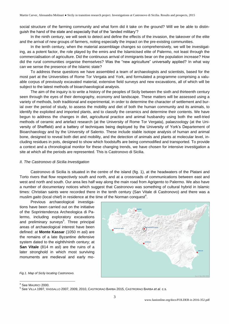
Castronovo di Sicilia is situated in the centre of the island (fig. 1), at the headwaters of the Platani and
Torto rivers that flow respectively south and north, and at a crossroads of communications between east and
west and north and south. Our area lies half way along the main road from Agrigento to Palermo. We also have
a number of documentary notices which suggest that Castronovo was something of cultural hybrid in Islamic
times: Christian saints were recorded there in the tenth century (San Vitale di Castronovo) and there was a
muslim gaito (local chief) in residence at the time of the Norman conquest4.
Previous archaeological investiga-
tions have been carried out on the initiative
of the Soprintendenza Archeologica di Pa-
lermo, including exploratory excavations
and preliminary surveys5. Three principal
areas of archaeological interest have been
defined: at Monte Kassar (1050 m asl) are
the remains of a late Byzantine defensive
system dated to the eighth/ninth century; at
San Vitale (814 m asl) are the ruins of a
later stronghold in which most surviving
monuments are medieval and early mo-
4 See MAURICI 2000.
5 See VILLA 1997, VASSALLO 2007, 2009, 2010, CASTRORAO BARBA 2015, CASTRORAO BARBA et al. c.s.
Fig.1. Map of Sicily locating Castronovo.
Martin Carver, Alessandra Molinari ● Sicily in transition research project. Investigations at Castronovo di Sicilia. Results and prospects, 2015
www.fastionline.org/docs/FOLDER-it-2016-352.pdf 4
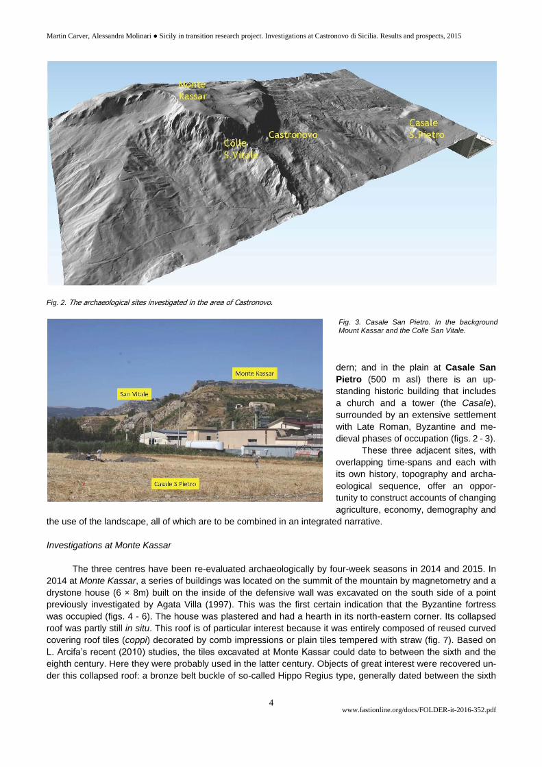
Fig. 2. The archaeological sites investigated in the area of Castronovo.
dern; and in the plain at Casale San
Pietro (500 m asl) there is an up-
standing historic building that includes
a church and a tower (the Casale),
surrounded by an extensive settlement
with Late Roman, Byzantine and me-
dieval phases of occupation (figs. 2 - 3).
These three adjacent sites, with
overlapping time-spans and each with
its own history, topography and archa-
eological sequence, offer an oppor-
tunity to construct accounts of changing
agriculture, economy, demography and
the use of the landscape, all of which are to be combined in an integrated narrative.
Investigations at Monte Kassar
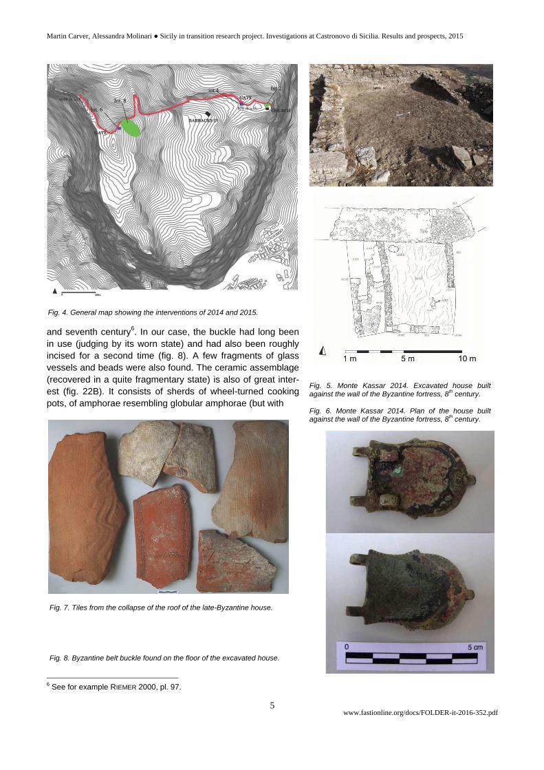
The three centres have been re-evaluated archaeologically by four-week seasons in 2014 and 2015. In
2014 at Monte Kassar, a series of buildings was located on the summit of the mountain by magnetometry and a
drystone house (6 × 8m) built on the inside of the defensive wall was excavated on the south side of a point
previously investigated by Agata Villa (1997). This was the first certain indication that the Byzantine fortress
was occupied (figs. 4 - 6). The house was plastered and had a hearth in its north-eastern corner. Its collapsed
roof was partly still in situ. This roof is of particular interest because it was entirely composed of reused curved
covering roof tiles (coppi) decorated by comb impressions or plain tiles tempered with straw (fig. 7). Based on
L. Arcifa’s recent (2010) studies, the tiles excavated at Monte Kassar could date to between the sixth and the
eighth century. Here they were probably used in the latter century. Objects of great interest were recovered un-
der this collapsed roof: a bronze belt buckle of so-called Hippo Regius type, generally dated between the sixth
Fig. 3. Casale San Pietro. In the background Mount Kassar and the Colle San Vitale.
Martin Carver, Alessandra Molinari ● Sicily in transition research project. Investigations at Castronovo di Sicilia. Results and prospects, 2015
www.fastionline.org/docs/FOLDER-it-2016-352.pdf 5
and seventh century6. In our case, the buckle had long been
in use (judging by its worn state) and had also been roughly
incised for a second time (fig. 8). A few fragments of glass
vessels and beads were also found. The ceramic assemblage
(recovered in a quite fragmentary state) is also of great inter-
est (fig. 22B). It consists of sherds of wheel-turned cooking
pots, of amphorae resembling globular amphorae (but with
6 See for example RIEMER 2000, pl. 97.
Fig. 4. General map showing the interventions of 2014 and 2015.
Fig. 5. Monte Kassar 2014. Excavated house built against the wall of the Byzantine fortress, 8
th century.
Fig. 6. Monte Kassar 2014. Plan of the house built against the wall of the Byzantine fortress, 8
th century.
Fig. 7. Tiles from the collapse of the roof of the late-Byzantine house. Fig. 8. Byzantine belt buckle found on the floor of the excavated house.
Martin Carver, Alessandra Molinari ● Sicily in transition research project. Investigations at Castronovo di Sicilia. Results and prospects, 2015
www.fastionline.org/docs/FOLDER-it-2016-352.pdf 6
thinner walls), apparently not produced locally,
and of other fragments of fine wares. The
complete absence of African red slip ware and
of Late Roman amphorae is significant; these
are however known from elsewhere in the
area (especially at Casale San Pietro in the
plain below). Current thinking suggests that
the date of the assemblage recovered inside
the Monte Kassar house, under its collapsed
roof, is confined to the late seventh and eighth
century. Geophysical survey adjacent to the
excavation raised expectations that rectan-
gular buildings had survived – per-
haps barracks or granaries (fig. 9).
In 2015 we examined the
area to the north of the previous
intervention. It proved to be an
open yard created by levelling
prior to the construction of the
defensive wall. Standing on this
yard were drystone walls of two
buildings (fig. 10), one of which
was an annexe to the house exca-
vated in 2014. These walls had
few diagnostic features, but are
thought to be closely associated
with the defensive wall, both in
time and purpose. The defensive
wall, built of irregular blocks of
limestone and with good-quality
mortar, incorporated at this point a
double set of steps that allowed
access to a chemin de ronde. A
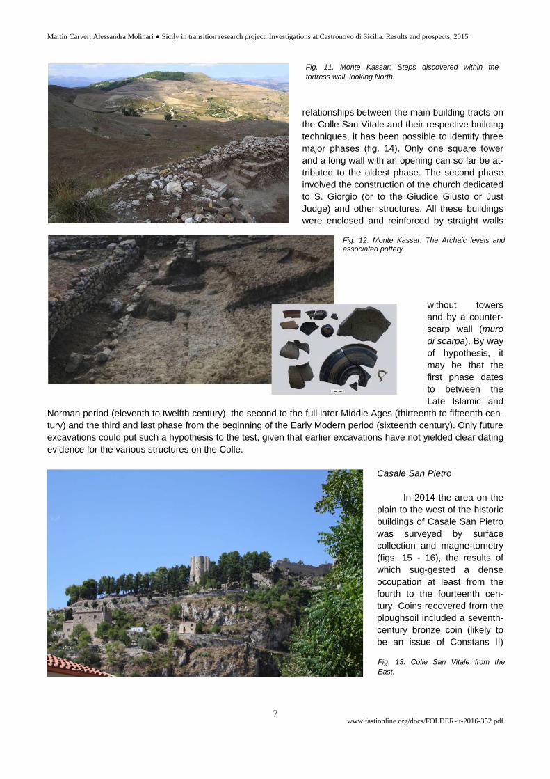
layer of tread leading to them suggested intensive use over a considerable period.
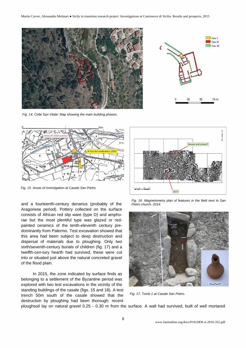
The previous excavations by Agata Villa for the Soprintendenza had contacted a spread of plaster
thought to have underlain the Byzantine features. The plaster was encountered on the west side of a
rudimentary wall assigned a date in the Archaic period (6th – 5th B.C.). Exploration of this plaster floor over a
more extensive area showed that it had been laid in a semi-circular hollow cut through the blocky sandstone
natural. There was no wall associated with this semi-circular cut, but a shallow scoop was located in the centre
of the plaster spread containing a rich assemblage of Archaic pottery and lumps of pure lime. This may have
been intended as a hearth but there were few signs of burning (figs. 11-12).
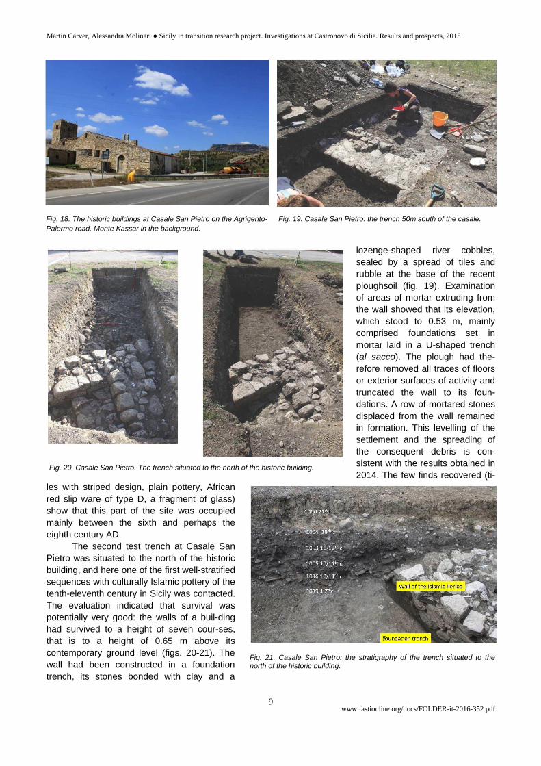
Colle San Vitale: study of extant structures7
On this site investigations focused on establishing a general map of the structures still visible in elevation
and on identifying the main structural phases and building techniques (fig. 13). On the basis of the stratigraphic
7 Research on this site was conducted by Dr. Nicoletta Giannini.
Fig. 9. Monte Kassar: Magnetometry survey carried out in
2014.
Fig. 10. Monte Kassar – 2014-2015 excavations.
Martin Carver, Alessandra Molinari ● Sicily in transition research project. Investigations at Castronovo di Sicilia. Results and prospects, 2015
www.fastionline.org/docs/FOLDER-it-2016-352.pdf 7
relationships between the main building tracts on
the Colle San Vitale and their respective building
techniques, it has been possible to identify three
major phases (fig. 14). Only one square tower
and a long wall with an opening can so far be at-
tributed to the oldest phase. The second phase
involved the construction of the church dedicated
to S. Giorgio (or to the Giudice Giusto or Just
Judge) and other structures. All these buildings
were enclosed and reinforced by straight walls
without towers
and by a counter-
scarp wall (muro
di scarpa). By way
of hypothesis, it
may be that the
first phase dates
to between the
Late Islamic and
Norman period (eleventh to twelfth century), the second to the full later Middle Ages (thirteenth to fifteenth cen-
tury) and the third and last phase from the beginning of the Early Modern period (sixteenth century). Only future
excavations could put such a hypothesis to the test, given that earlier excavations have not yielded clear dating
evidence for the various structures on the Colle.
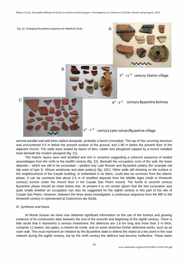
Casale San Pietro
In 2014 the area on the
plain to the west of the historic
buildings of Casale San Pietro
was surveyed by surface
collection and magne-tometry
(figs. 15 - 16), the results of
which sug-gested a dense
occupation at least from the
fourth to the fourteenth cen-
tury. Coins recovered from the
ploughsoil included a seventh-
century bronze coin (likely to
be an issue of Constans II)
and
Fig. 11. Monte Kassar: Steps discovered within the
fortress wall, looking North.
Fig. 12. Monte Kassar. The Archaic levels and associated pottery.
Fig. 13. Colle San Vitale from the
East.
Martin Carver, Alessandra Molinari ● Sicily in transition research project. Investigations at Castronovo di Sicilia. Results and prospects, 2015
www.fastionline.org/docs/FOLDER-it-2016-352.pdf 8
and a fourteenth-century denarius (probably of the
Aragonese period). Pottery collected on the surface
consists of African red slip ware (type D) and ampho-
rae but the most plentiful type was glazed or red-
painted ceramics of the tenth-eleventh century pre-
dominantly from Palermo. Test excavation showed that
this area had been subject to deep destruction and
dispersal of materials due to ploughing. Only two
sixth/seventh-century burials of children (fig. 17) and a
twelfth-cen-tury hearth had survived; these were cut
into or situated just above the natural concreted gravel
of the flood plain.
In 2015, the zone indicated by surface finds as
belonging to a settlement of the Byzantine period was
explored with two test excavations in the vicinity of the
standing buildings of the casale (figs. 15 and 18). A test
trench 50m south of the casale showed that the
destruction by ploughing had been thorough: recent
ploughsoil lay on natural gravel 0.25 - 0.30 m from the surface. A wall had survived, built of well mortared
Fig. 14. Colle San Vitale: Map showing the main building phases.
Fig. 15. Areas of investigation at Casale San Pietro.
Fig. 16. Magnetometry plan of features in the field next to San Pietro church, 2014.
Fig. 17. Tomb 1 at Casale San Pietro.
Martin Carver, Alessandra Molinari ● Sicily in transition research project. Investigations at Castronovo di Sicilia. Results and prospects, 2015
www.fastionline.org/docs/FOLDER-it-2016-352.pdf 9
lozenge-shaped river cobbles,
sealed by a spread of tiles and
rubble at the base of the recent
ploughsoil (fig. 19). Examination
of areas of mortar extruding from
the wall showed that its elevation,
which stood to 0.53 m, mainly
comprised foundations set in
mortar laid in a U-shaped trench
(al sacco). The plough had the-
refore removed all traces of floors
or exterior surfaces of activity and
truncated the wall to its foun-
dations. A row of mortared stones
displaced from the wall remained
in formation. This levelling of the
settlement and the spreading of
the consequent debris is con-
sistent with the results obtained in
2014. The few finds recovered (ti-
les with striped design, plain pottery, African
red slip ware of type D, a fragment of glass)
show that this part of the site was occupied
mainly between the sixth and perhaps the
eighth century AD.
The second test trench at Casale San
Pietro was situated to the north of the historic
building, and here one of the first well-stratified
sequences with culturally Islamic pottery of the
tenth-eleventh century in Sicily was contacted.
The evaluation indicated that survival was
potentially very good: the walls of a buil-ding
had survived to a height of seven cour-ses,
that is to a height of 0.65 m above its
contemporary ground level (figs. 20-21). The
wall had been constructed in a foundation
trench, its stones bonded with clay and a
Fig. 18. The historic buildings at Casale San Pietro on the Agrigento-
Palermo road. Monte Kassar in the background. Fig. 19. Casale San Pietro: the trench 50m south of the casale.
Fig. 20. Casale San Pietro. The trench situated to the north of the historic building.
Fig. 21. Casale San Pietro: the stratigraphy of the trench situated to the north of the historic building.
F
Martin Carver, Alessandra Molinari ● Sicily in transition research project. Investigations at Castronovo di Sicilia. Results and prospects, 2015
www.fastionline.org/docs/FOLDER-it-2016-352.pdf 10
second parallel wall add been added alongside, probably a bench (mastaba). The top of this surviving structure
was encountered 0.5 m below the present surface of the ground, and 1.80 m below the present floor of the
adjacent church. The walls were sealed by layers of tiles, rubble and ploughsoil capped by a recent metalled
track beneath the modern plougsoil (fig. 21).
The historic layers were well stratified and rich in ceramics suggesting a coherent sequence of sealed
assemblages from the ninth to the twelfth century (fig. 22). Beneath the occupation zone of the wall, the lower
deposits – which are still to be excavated – yielded only Late Roman and Byzantine pottery (for example red
slip ware of type D, African amphorae and plain pottery) (fig. 22C). Other walls still showing on the surface in
the neighbourhood of the Casale building, or embedded in its fabric, could also be survivors from the Islamic
phase. It can be surmised that about 2.5 m of stratified deposits from the Middle Ages (ninth to thirteenth
century) survive under the church floor in the Casale San Pietro mound. The fourth to seventh century
Byzantine phase should be intact below that. At present it is not certain (given that the test excavation was
quite small) whether an occupation can also be suggested for the eighth century in this part of the site of
Casale San Pietro. However, between the three areas investigated, a continuous sequence from the fifth to the
thirteenth century is represented at Castronovo dio Sicilia.
III. Synthesis and future
At Monte Kassar we have now obtained significant information on the use of the fortress and growing
evidence of its construction date between the end of the seventh and beginning of the eighth century. There is
little doubt that it represents a serious investment: the defences are 1.8 km long and more than 3 m thick,
comprise 11 towers, two gates, a chemin de ronde, and on some stretches further defensive works, such as an
outer wall. This must represent an initiative by the Byzantine state to defend the island at a key point in the road
network during the eighth century, but by the ninth century the defence had become ineffective. These dates
Fig. 22. Enlarging the pottery sequence for Medieval Sicily.
9th - 11 th
8th - 9 th
5th - 7 th
Martin Carver, Alessandra Molinari ● Sicily in transition research project. Investigations at Castronovo di Sicilia. Results and prospects, 2015
www.fastionline.org/docs/FOLDER-it-2016-352.pdf 11
are consistent with military occupation by a resident garrison in the eighth century, indicated by ceramics, and
the eventual surrender of the site in the mid ninth century as implied by the written documents. The interior of
Monte Kassar has produced little surface material, implying that the garrison was largely quartered near the
wall and occupied in a watching role, especially to the north, east and west. Topographic survey suggests that
a number of other towers remain to be discovered outside the main defensive circuit, especially in the area of
the northern approaches. Further exploration can be conducted by magnetometry, which has already produced
useful results on this terrain. Monte Kassar also invites development as one of the most important and most
neglected monuments in Sicily. A priority would be the commissioning of a conservation and display plan.
The investigations in the area of Casale San Pietro show that in the fields and orchards of the plain the
destruction of the Byzantine and later occupation has been very thorough and virtually nothing remains above
its contemporary ground level. However, negative features, such as furnaces, kilns and stone foundations give
strong signals to magnetometry and much of the area of occupation could be mapped by this means.
By contrast, in the area within and round the Casale San Pietro historic building, the stratigraphy is rich
and deep and far from destroyed. This area not only has the potential to reveal the architecture and economy of
Islamic Sicily, but is probably the only place where the Byzantine ‘agro-town’ has not been destroyed by
ploughing. For these reasons, a programme of research, conservation and public reception is highly desirable.
The area that is still free of buildings is extensive enough to address the bulk of the research questions asked
today. It should also be noted that the dumping of large amounts of Byzantine or earlier building stone,
observed by the directors at first hand (including fragments of a large column), shows that the land is under
continual pressure from farming, road-widening and redevelopment.
Martin Carver
Departmenty of Archaeology, University of York
E-mail: [email protected]
Alessandra Molinari
Università degli Studi di Torvergata
E-mail: [email protected]
REFERENCES
ARCIFA L., 2010, “Indicatori archeologici per l’Alto medioevo nella Sicilia orientale”, in P. PENSABENE (ed.) 2010,
Piazza Armerina. Villa del Casale e la Sicilia tra tardoantico e medioevo, Roma: 105-129.
CASTRORAO BARBA A., 2015, “Entroterra tra due mari: il territorio di Castronovo di Sicilia (Palermo) tra età
romana e periodo bizantino”, in F. CAMBI, G. DE VENUTO, R. GOFFREDO (eds), Storia e archeologia
globale 2. I pascoli, i campi, il mare. Paesaggi d’altura e di pianura in Italia dall’Età del Bronzo al
Medioevo, Bari: 253-267.
CASTRORAO BARBA A., VASSALLO S., MUKAI T., C.S., “Inland between two seas: the territory of Castronovo di
Sicilia (Palermo) from Roman to Byzantine period”, in 3rd International Landscape Archaeology
Conference 2014 (Rome, Italy, 17th– 20th of September 2014).
MAURICI F., 2000, “Problemi di storia, archeologia e topografia medievale nel territorio di Castronuovo di Sicilia
in provincia di Palermo-I”, in Atti II Giornate Internazionali di Studio sull’area Elima 1997, Pisa- Gibellina:
755-776.
MOLINARI A., 2014, “Le ricerche nel territorio di Segesta-Calathamet-Calatafimi: ripensando ad un ventennio di
ricerche nella Sicilia occidentale” in NEF, ARDIZZONE, 2014: 327-340.
MOLINARI A., 2015, “‘Islamisation’ and the Rural World: Sicily and al-Andalus. What Kind of Archaeology?”, in
GELICHI S., HODGEs R. (eds), New Directions in Early Medieval European Archaeology: Spain and Italy
Compared Essays for Riccardo Francovich, Turmhout: 187-221.
NEF A., ARDIZZONE F. (eds), 2014, Les dynamiques de l’islamisation en Méditerranée centrale et en Sicile:
nouvelles propositions et découvertes récentes, Bari-Roma.
Martin Carver, Alessandra Molinari ● Sicily in transition research project. Investigations at Castronovo di Sicilia. Results and prospects, 2015
www.fastionline.org/docs/FOLDER-it-2016-352.pdf 12
NEF A., PRIGENT V. (eds.), 2010, La Sicile de Byzance à l'Islam, Paris.
PRIGENT V., 2010, «La Sicile byzantine, entre papes et empereurs (6eme - 8eme siècle)», in D. ENGELS (ed),
Zwischen Ideal und Wirklichkeit: Herrschaft auf Sizilien von der Antike bis zum Spätmittelalter, Stuttgart:
201-230.
RIEMER E., 2000, Romanische Grabfunde des 5.-8. Jahrhunderts in Italien, Rahden.
VASSALLO S. (ed.), 2007, Archeologia nelle vallate del Fiume Torto e del San Leonardo, Palermo.
VASSALLO S., 2009, “Le fortificazioni bizantine del Kassar di Castronovo di Sicilia: indagini preliminari”, in C.
AMPOLO (ed.), Immagine e immagini della Sicilia e di altre isole del Mediterraneo antico, Pisa: 679-696.
VASSALLO S., 2010, “Il territorio di Castronovo di Sicilia in età bizantina e le fortificazioni del Kassar”, in M.
CONGIU, S. MODEO, M. ARNONE (eds.), La Sicilia bizantina: storia, città e territorio, Atti del VI Convegno di
Studi del "Progetto Mesogheia" (Caltanissetta, 9-10 Maggio 2009), Caltanissetta: 259-276.
VILLA A., 1997, “Indagini archeologiche e ricognizioni nel territorio di Castronovo di Sicilia”, in Atti II Giornate
Internazionali di Studio sull’area Elima 1994, Pisa- Gibellina: 1385-1398.