Embed Size (px)
Citation preview

PENSACOLA PROJECT FERC No. 1494
SHORELINE MANAGEMENT PLAN
As Approved by the Board of Directors on
June 11, 2008
GRAND RIVER DAM AUTHORITY VINITA, OKLAHOMA
PENSACOLA PROJECT FERC No. 1494
SHORELINE MANAGEMENT PLAN
June 11, 2008

GRAND RIVER DAM AUTHORITY VINITA, OKLAHOMA
PENSACOLA PROJECT
FERC NO. 1494
SHORELINE MANAGEMENT PLAN
Executive Summary
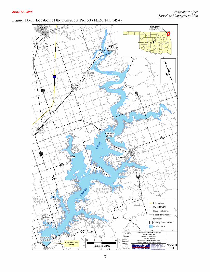
The Pensacola Project (FERC No. 1494) (Project) is an existing, federally licensed
hydroelectric project located in northeastern Oklahoma that is owned and operated by the Grand
River Dam Authority (GRDA), an agency of the State of Oklahoma. Completed in 1940, the
Project’s Pensacola Dam is the longest multi-arched dam in the world. The Pensacola Dam
impounds the waters of the Grand River to form the Grand Lake O’ The Cherokees (Grand
Lake). Grand Lake encompasses approximately 46,500 surface acres of water and 1,300 miles
of shoreline. The Project boundary is located in close proximity to the shoreline and privately
owned land is generally found mere feet from the water’s edge.
Since its creation, Grand Lake has been a popular recreational and residential destination.
During its history, Grand Lake has hosted the National Governor’s Conference and several
nationally recognized fishing tournaments. It is the home of the nation’s oldest long distance
regatta on an inland lake and the oldest yacht club in Oklahoma. Current uses of the shoreline
include residential and commercial development, agriculture, and wildlife management areas.
Grand Lake also has considerable value as an environmental resource. It contains
significant aquatic and terrestrial habitat for a host of species. Additionally, the shoreline serves
an important function in the local ecology.
Increasing development and competing uses for resources around the lake point to the
need for a clearly defined, comprehensive and consistent management strategy for the Project’s
shoreline. This Shoreline Management Plan (SMP or Plan) provides a comprehensive plan for
Grand Lake that considers GRDA’s enabling legislation, the FERC license, historical and current
- ES-1 -

June 11, 2008 Pensacola Project Shoreline Management Plan
- ES-2 -
public use, and the need to accommodate future growth and changing use patterns; all while
maintaining stewardship for the environmental and socioeconomic resources entrusted to GRDA.
This document draws the resulting management strategies, policies, and practices from GRDA’s
existing practices, FERC directives and guidance, and information gained from interested
stakeholders, resource agencies, and other public comments.
The management vision for Grand Lake is defined by the Plan’s distinct Shoreline
Management Classifications (SMC) and Allowable Use Categories (AUC). The multi-tiered
SMC system, which includes Responsible Growth Areas, Stewardship Areas, and Wildlife
Management Areas, identifies clear management objectives for Project land. The Allowable Use
Categories define the use types that will be permitted in those areas. To implement these goals,
objective standards and procedures are detailed in other parts of the Plan. Taken as a whole, the
SMP protects Grand Lake’s valued resources by providing clear guidance for determining
whether a proposed use is appropriate in an area.
This SMP is the product of extensive consultation with stakeholders, including the public
and resource agencies. No less than twenty-seven meetings, open to the public, have been held
during the plan’s development and thousands of written comments have been received.
Additionally, resource agencies have had the opportunity to be actively involved during all
stages of the plan’s development.
In 2005, GRDA began the process of developing an SMP by having discussions with the
Federal Energy Regulatory Commission (FERC or Commission), state and federal resource
agencies, and interested stakeholders. To aid in the development of the SMP, GRDA hired
Kleinschmidt Associates, an energy and water resource consulting firm.
Three public meetings held in October of 2005, led to the development of the Stakeholder
Working Group (SWG), an advisory committee comprised of interested individuals,
representatives of non-governmental organizations, informal citizen groups, commercial
interests, as well as state and federal agencies. The Stakeholder Working Group provided advice
and opinions regarding key components of the SMP including the designation of land use
June 11, 2008 Pensacola Project Shoreline Management Plan
- ES-3 -
classifications for shoreline property, definitions of allowable uses within these areas, and
suggestions for permitting policies.
In December 2006, Kleinschmidt Associates prepared a working draft of the SMP
(December 2006 Working Draft), taking into account input from the Stakeholder Working
Group, the public, and state and federal resource agencies. In February and March 2007, GRDA
held five public hearings to provide stakeholders throughout Oklahoma with the opportunity to
comment on the December 2006 Working Draft. Approximately 724 people attended these
sessions, which were held in several communities around Grand Lake, and in Tulsa and
Oklahoma City, the state’s major population centers. The hearings were moderated by Mr. John
D. Rothman, an experienced mediator and attorney, who was hired by GRDA to conduct the
hearings and to prepare an independent report summarizing the public’s opinions. In addition to
the comments made at hearings, GRDA received 345 written comments, and petitions with a
total of 2,713 signatures.
In his summary, Mr. Rothman stated that the public was overwhelmingly opposed to the
December 2006 Working Draft, with the Vegetation Management Plan (VMP) and the Shoreline
Management Classifications (SMC) being the two greatest areas of concern. The VMP was
criticized for its extensive permitting requirements, especially for routine maintenance and debris
removal, while the SMC were seen as leaving too little shoreline available for future commercial
development.
On September 12, 2007, GRDA staff presented a revised draft of the SMP (Revised
Draft) to the GRDA Board of Directors for review. Stakeholders were given an opportunity to
submit written comments on the SMP and to voice their opinions at public hearings held in
October, 2007. Public support for the Revised Draft was widespread.
As part of this consultation process, GRDA solicited comments from twenty-seven
resource agencies. Further, it delayed final approval of the SMP to engage in a meaningful
dialog with the U.S. Fish and Wildlife Service and the Oklahoma Department of Wildlife
Conservation.
June 11, 2008 Pensacola Project Shoreline Management Plan
- ES-4 -
GRDA made several changes to the SMP as a result of discussions with the resource
agencies. These changes include:
• Creation of a distinct SMC for wildlife management;
• Consolidation and relocation of areas designated as Stewardship Areas to
maximize the benefits of resource management efforts;
• Clear identification of factors to be considered prior to permitting new uses; and,
• Requirements for pubic hearings prior to permitting new uses.
June 11, 2008 Pensacola Project Shoreline Management Plan
GRAND RIVER DAM AUTHORITY VINITA, OKLAHOMA
PENSACOLA PROJECT
FERC NO. 1494
SHORELINE MANAGEMENT PLAN
TABLE OF CONTENTS
1.0 Introduction......................................................................................................................... 1 2.0 Purpose and Scope of the Shoreline Management Plan...................................................... 4
2.1 Introduction............................................................................................................. 4 2.2 Territorial Jurisdiction ............................................................................................ 5 2.3 Structure of the SMP............................................................................................... 5
3.0 Goals and Objectives .......................................................................................................... 8 4.0 Public Participation and Consultation................................................................................. 9
4.1 Kleinschmidt Associates......................................................................................... 9 4.2 Public Information Sessions ................................................................................... 9 4.3 Stakeholder Working Group Meetings ................................................................... 9 4.4 Agency Consultation............................................................................................. 10 4.5 Public Comment on the SMP Drafts..................................................................... 13
5.0 Inventory of existing resources and uses .......................................................................... 15 5.1 Grand River Basin................................................................................................. 15 5.2 Pensacola Project .................................................................................................. 16 5.3 Geology and Soils ................................................................................................. 17 5.4 Water Quality........................................................................................................ 18
5.4.1 Temperature and Dissolved Oxygen......................................................... 19 5.4.2 pH.............................................................................................................. 20 5.4.3 Phosphorus................................................................................................ 21 5.4.4 Sediments and Heavy Metals Contamination ........................................... 21 5.4.5 Bacteria ..................................................................................................... 22
5.5 Aquatic Species..................................................................................................... 22 5.6 Avian Species........................................................................................................ 24 5.7 Mammals............................................................................................................... 24 5.8 Reptiles and Amphibians ...................................................................................... 25 5.9 Current Management ............................................................................................ 25 5.10 Threatened and Endangered Species .................................................................... 25
5.10.1 Ozark Cavefish.......................................................................................... 26 5.10.2 Neosho Madtom........................................................................................ 26 5.10.3 Gray Bat .................................................................................................... 26 5.10.4 Bald Eagle................................................................................................. 27 5.10.5 American Burying Beetle ......................................................................... 27
5.11 Botanical ............................................................................................................... 28 5.12 Wetlands ............................................................................................................... 29 5.13 Land Uses.............................................................................................................. 31
- i -
June 11, 2008 Pensacola Project Shoreline Management Plan
5.14 Aesthetics.............................................................................................................. 35 5.15 Cultural Resources ................................................................................................ 37
5.15.1 Known Cultural Properties ....................................................................... 37 5.15.2 Lands of Tribal Significance..................................................................... 37
5.16 Socioeconomics .................................................................................................... 38 5.16.1 Demographics ........................................................................................... 38 5.16.2 Economy ................................................................................................... 40
6.0 Summary of Recreation Management Plan ...................................................................... 43 6.1 Recreation Management at Grand Lake ............................................................... 43 6.2 Oklahoma Department of Wildlife Conservation ................................................. 45 6.3 Oklahoma Tourism and Recreation Department .................................................. 45 6.4 Recreation Sites .................................................................................................... 46
6.4.1 Public Recreation Sites ............................................................................. 46 6.4.2 GRDA Boat Ramps................................................................................... 46 6.4.3 State Parks................................................................................................. 47 6.4.4 Other Public Access.................................................................................. 47 6.4.5 Private Recreation Access......................................................................... 48 6.4.6 Commercial Development ........................................................................ 48
6.5 Estimates of Recreational Use .............................................................................. 49 6.5.1 Current Recreational Use.......................................................................... 49 6.5.2 Boating Density ........................................................................................ 50 6.5.3 Future Recreational Use............................................................................ 50
6.6 Planning for the Future ......................................................................................... 51 7.0 Shoreline Management Guidelines for Project Lands ...................................................... 53
7.1 Shoreline Management Classifications for Grand Lake ....................................... 54 7.1.1 Project Operations Areas .......................................................................... 54 7.1.2 Municipal / Public Use Areas ................................................................... 54 7.1.3 Stewardship Areas .................................................................................... 54 7.1.4 Wildlife Management Areas ..................................................................... 56 7.1.5 Responsible Growth Areas ....................................................................... 57
7.2 Allowable Use Categories..................................................................................... 58 7.2.1 Commercial Uses ...................................................................................... 58 7.2.2 Residential Uses........................................................................................ 59 7.2.3 Municipal/Public Uses .............................................................................. 60
7.3 Shoreline Management Classification Mapping................................................... 61 8.0 Adaptive Management for Areas of Concern ................................................................... 62 9.0 New Shoreline Uses Evaluation Process ......................................................................... 64
9.1 Evaluation Process ................................................................................................ 65 9.1.1 Project Proponent...................................................................................... 65 9.1.2 GRDA ....................................................................................................... 66
10.0 Permitting and Inspection ................................................................................................. 68 10.1 Article 410 “Standard Land Use Article” ............................................................. 68 10.2 GRDA Permitting and Approval .......................................................................... 70 10.3 Commercial Permit Application Standards .......................................................... 72 10.4 Residential Dock Application Standards .............................................................. 75 10.5 Vegetation Management ....................................................................................... 76
10.5.1 Vegetation Management in Responsible Growth SMC............................ 77 10.5.2 Vegetation Management in Stewardship SMC and Wetlands.................. 79
- ii -
June 11, 2008 Pensacola Project Shoreline Management Plan
10.5.3 Vegetation Management in WMA............................................................ 79 10.5.4 General Provisions .................................................................................... 80
10.6 Other Uses Requiring Review and Permitting by GRDA .................................... 82 10.6.1 Habitable Structures.................................................................................. 82 10.6.2 Dredging and Excavation Policy .............................................................. 83 10.6.3 Placement of Buoys .................................................................................. 85 10.6.4 Shoreline Stabilization .............................................................................. 85 10.6.5 Railways, Tram Systems, Fences, Ramps and Retaining Walls............... 86 10.6.6 Grazing...................................................................................................... 87 10.6.7 Licenses to Encroach ................................................................................ 87 10.6.8 Lease of Project Lands for Public Purposes ............................................. 87
10.7 General Property Inspections................................................................................ 88 10.8 Permit Waivers...................................................................................................... 88
10.8.1 General Procedures ................................................................................... 88 10.9 Grandfathered Improvements ............................................................................... 89 10.10 Best Management Practices and Educational Outreach........................................ 89 10.11 Agency Regulatory Review and Permitting ......................................................... 90
10.11.1 Army Corps of Engineers ............................................................. 90 10.11.2 State of Oklahoma, Regional, and Local Agencies ...................... 90
11.0 Enforcement of the Shoreline Management Plan ............................................................. 94 11.1 Existing Tools for Enforcement............................................................................ 94
11.1.1 Enforcement Staff ..................................................................................... 94 11.1.2 Actions Available for Enforcement .......................................................... 94
12.0 SMP Amendment Process................................................................................................. 96 12.1 Tracking Non-Project Use .................................................................................... 96 12.2 Shoreline Management Classification Monitoring ............................................... 96 12.3 SMP Amendment Process..................................................................................... 97
13.0 Bibliography ..................................................................................................................... 99
LIST OF TABLES
Table 5.12-1: Wetland Cover Types (in acres) by Elevation Zone at Grand Lake ...................... 29 Table 5.13-1: Land Uses within the Project Boundary................................................................. 33 Table 5.16-1: Selected Demographic and Economic Characteristics for Craig, Delaware, Mayes and Ottawa Counties, Oklahoma ..................................................................... 38 Table 5.16-2: Annual Population Estimates for Craig, Delaware, Mayes and
Ottawa Counties, Oklahoma, 2000 through 2006................................................................. 39 Table 5.16-3: Employment by Industry in Craig, Delaware, Mayes and Ottawa
Counties, 2000 ...................................................................................................................... 42
LIST OF FIGURES
Figure 1.0-1. Location of the Pensacola Project (FERC No. 1494) .............................................. 3 Figure 5.12-1.Wetlands Mapping for Grand Lake O’ the Cherokees........................................... 30 Figure 5.7-1. Land Use within the Project Boundary .................................................................. 34
- iii -
June 11, 2008 Pensacola Project Shoreline Management Plan
- iv -
LIST OF APPENDICES
Appendix A – Documentation of Public Participation and Consultation
Appendix B – Shoreline Management Classification Maps
Appendix C – Suggested Best Management Practices for Non-Project Lands
Appendix D – License Articles pertaining to GRDA/Grand Lake Shoreline Management

June 11, 2008 Pensacola Project Shoreline Management Plan
ACRONYMS AND ABBREVIATIONS LIST
AUC Allowable Use Categories BMP Best Management Practice Commission or FERC Federal Energy Regulatory Commission DBH Diameter at Breast Height (4.5 feet) EA Environmental Assessment EIS Environmental Impact Statement GIS Geographic information system GRDA or Licensee Grand River Dam Authority HP Horsepower MW Megawatt NPS Nonpoint source OAC Oklahoma Administrative Code OAS Oklahoma Archeological Survey OCC Oklahoma Conservation Commission ODEQ Oklahoma Department of Environmental Quality ODWC Oklahoma Department of Wildlife Conservation OTRD Oklahoma Tourism and Recreation Department OWRB Oklahoma Water Resources Board PD Pensacola Datum RM River mile, numbered from mouth to source RMP Recreation Management Plan SCORP Statewide Comprehensive Outdoor Recreation Plan SHPO State Historic Preservation Office SMC Shoreline Management Classifications SMP Shoreline Management Plan SWG Stakeholder Working Group USACE U.S. Army Corps of Engineers USFWS U.S. Fish and Wildlife Service VMP Vegetation Management Plan WMA Wildlife Management Area
- v -

June 11, 2008 Pensacola Project Shoreline Management Plan
STANDARD TERMS LIST Confluence The flowing together of two or more streams; the place where a
tributary joins the main stream. Drawdown The act of discharging of water to lower reservoir storage levels. Flood plain The relatively level area of land bordering a stream channel and
inundated during moderate to severe floods. FERC Form 80 FERC mechanism and form for filing periodic reviews of
recreation use. Grand Lake Grand Lake O’ the Cherokees. Nonpoint source A pollution source that cannot be defined as originating from
discrete points such as pipe discharge. Areas of fertilizer and pesticide applications, atmospheric deposition, manure, and natural inputs from plants and trees are types of nonpoint source pollution.
Department of Ecosystems Management Specific department within GRDA, established to aid in the
development of goals and objectives designed to maintain the integrity of the entire lake ecosystem.
Pensacola Datum Pensacola Datum (PD) is 1.07 feet lower than National Geodetic
Vertical Datum, which is a national standard for measuring elevations above sea level.
Project Pensacola Hydroelectric Project (FERC No. 1494). Project area All land within the FERC Project boundary and under the
jurisdiction of the FERC Project license. Project boundary The boundary defined in the license issued by FERC for the
Project as needed for Project operations. For the Pensacola Project, the boundary is identified by a metes and bounds description.
Project lands Lands contained within the Project boundary. Project vicinity The area extending to about five miles from the Project boundary. Project works All of the infrastructure associated with the Project. Relicensing The process of acquiring a new FERC license for an existing
hydroelectric project upon expiration of the existing FERC license.
- vi -

June 11, 2008 Pensacola Project Shoreline Management Plan
- vii -
Stakeholders The public (both resident and non-resident), federal and state
resource agencies, non-governmental organizations, and other interested parties.
Tailrace Channel through which water is discharged from the powerhouse
turbines.

June 11, 2008 Pensacola Project Shoreline Management Plan
1
GRAND RIVER DAM AUTHORITY
SHORELINE MANAGEMENT PLAN
1.0 INTRODUCTION
The Federal Energy Regulatory Commission (FERC or Commission) issued a new
license for the 125-megawatt (MW) Pensacola Hydroelectric Project (FERC No. 1494) (Project)
to the Grand River Dam Authority (GRDA) on April 24, 1992. The Project is located on the
Grand River in northeastern Oklahoma. The Grand River begins in Kansas as the Neosho River
and flows southeasterly, then southerly, into Oklahoma where it joins the Spring River to form
the Grand River. The Pensacola Project is located between river miles (RM) 77 and 143 on the
Grand River in northeastern Oklahoma and lies within Craig, Delaware, Mayes, and Ottawa
counties. Pensacola Dam, which forms the Grand Lake O’ The Cherokees (Grand Lake), is
located between the towns of Langley and Disney. From the Project, the Grand River flows
south through Oklahoma, to its confluence with the Arkansas River near Muskogee, Oklahoma.
The Pensacola Project was the first hydroelectric project constructed in Oklahoma.
Construction of the Project began in 1938. Closing of the spillway gates in March 1940 created
Grand Lake. GRDA has operated and maintained the Pensacola Project since August 1946. In
addition to Grand Lake, the Project works consist of a dam, two auxiliary spillways, an intake
structure, a powerhouse containing six turbine generator units, and appurtenant equipment and
facilities.
GRDA is an agency of the State of Oklahoma, created by the Oklahoma Legislature in
1935 to be a "conservation and reclamation district for the waters of the Grand River." GRDA
manages Grand Lake pursuant to the terms of the license granted by FERC and the relevant
provisions of the Oklahoma Statutes. GRDA owns lands within the Project boundary, as well as
some areas outside of the Project boundary and has authority to prescribe and enforce rules and
regulations for commercial and recreational use of the lake. GRDA currently manages the
shoreline through a permitting system and uses GRDA law enforcement personnel to enforce
regulations. GRDA shares water storage and release operations with the U.S. Army Corps of
Engineers (USACE) as part of a basin wide system of flood control and navigation projects. The
June 11, 2008 Pensacola Project Shoreline Management Plan
2
Project provides flood storage between elevations 745 and 755 feet PD.
The towns of Langley, Disney, Grand Lake Towne, Ketchum, Cleora, Bernice, Afton,
Zena, Grove, Dotyville, Wyandotte, Peoria, and Miami lie within the Project vicinity. In the
early years of Project operation, shoreline development primarily consisted of agricultural and
small, seasonal, private developments. Over the past 20 years, the lake has become a focal point
of residential and commercial development in northeast Oklahoma. The majority of
development to date has occurred on the central and southern portions of the reservoir, with both
residential and commercial uses interspersed adjacent to and within the Project boundary.
This Shoreline Management Plan (SMP) for the Pensacola Project includes:
1) purpose and scope of the SMP;
2) shoreline management goals and objectives;
3) a description of the agency and stakeholder consultation process;
4) an inventory of existing Project resources;
5) a summary of the Project Recreation Plan;
6) shoreline management guidelines for Project lands;
7) adaptive management strategies for assessment of future shoreline development;
8) a process for the evaluation of new shoreline uses under the classification and
permitting system;
9) a description of GRDA’s permitting standards and system;
10) a description of GRDA’s SMP enforcement strategies; and,
11) a monitoring and amendment process for the SMP.
June 11, 2008 Pensacola Project Shoreline Management Plan
3
Figure 1.0-1. Location of the Pensacola Project (FERC No. 1494)
June 11, 2008 Pensacola Project Shoreline Management Plan
4
2.0 PURPOSE AND SCOPE OF THE SHORELINE MANAGEMENT PLAN
2.1 Introduction
FERC guidelines recommend that an SMP use existing resource information to
designate Shoreline Management Classifications (SMC) and to develop guidelines that
provide a framework for determining appropriate proposed shoreline use in relation to
existing uses and environmental resources. An SMP may identify areas afforded
additional protection or that may require additional scrutiny before permitting new uses.
Similarly, an SMP may also identify shoreline segments that are suitable for future use
and that may not require as much scrutiny before development. Most importantly, an
SMP provides a management linkage between the Project’s license and FERC’s
obligations under the Federal Power Act.
This SMP is designed to guide GRDA’s management actions in conformance
with the Project’s license. This document includes strategies to manage and enhance the
environmental and socioeconomic values of the Project. These strategies include
protecting environmental resources while providing public access, and maintaining
consistency with other jurisdictional policies and plans relevant to the area.
This SMP was developed considering all of the existing and reasonably
foreseeable future uses of the Project, resources currently protected by law (e.g., rare,
threatened and endangered species, and wetland sites), public interests, and FERC
regulations and guidelines. Interested stakeholders, including adjacent property owners,
commercial representatives, local realtors, and resource agency staff, provided valuable
assistance in developing the SMP through their involvement in the Stakeholder Working
Group (SWG) and the public hearings, by submitting written comments, and through
direct consultation. Stakeholders provided valuable insight to daily life on the lake, local
knowledge of specific environmental resources, expectations of recreational users,
adjacent property owners and business owners, as well as individual perspectives on
potential management strategies and actions.
June 11, 2008 Pensacola Project Shoreline Management Plan
2.2 Territorial Jurisdiction
The provisions of the SMP apply only to real property owned by GRDA within
the Project boundary and do not control the use of privately owned land. The Project
boundary is defined by the metes and bounds descriptions of property obtained by GRDA
through the exercise of the power of eminent domain, and is not determined by reference
to any particular contour elevation. Thus, questions about whether a particular piece of
land is subject to the SMP can only be answered after review of a survey conducted by a
licensed surveyor.
2.3 Structure of the SMP
The SMP has discrete sections to provide convenience and “usability”.
Section 1.0 provides introductory materials and a brief overview of the Project. (Please
contact GRDA’s headquarters in Vinita, Oklahoma for more detailed information about
the Project, or visit http://www.grda.com ). Section 2.0 provides the purpose and scope
of the SMP and provides context for the remainder of the document. Section 3.0
summarizes GRDA’s management goals and objectives, while Section 4.0 outlines
participation by the public, agencies and other interested stakeholders in the development
of the SMP.
Section 5.0 provides an inventory of existing environmental, cultural and
socioeconomic resources and uses in and around Grand Lake. Information regarding the
area’s recreational resources and GRDA’s recreation management plan is found in
Section 6.0. In 1997, GRDA developed a stand alone Recreation Management Plan
(RMP) specifically related to recreation goals, objectives, and policies at the Project.
This section incorporates general RMP components into the SMP to help guide recreation
facility management within the Project boundary and ensure consistency between the
documents.
The assessment of existing shoreline resources and development, as well as
identification of areas that may be suitable for future development served as the basis for
5

June 11, 2008 Pensacola Project Shoreline Management Plan
establishing the classifications and guidelines for future shoreline management within the
Project as discussed in Section 7.0. Section 7.1 defines the Shoreline Management
Classifications and identifies resource management goals. Section 7.2 also defines
allowable uses and their compatibility with those classifications and identifies allowable
(or prohibited) uses within each SMC. Overall, these classifications, definitions, and
guidelines seek to protect sensitive shoreline resources while permitting appropriate use
and reasonable access to shoreline areas within the Project.
Section 8.0 describes Adaptive Management strategies to monitor ongoing
shoreline development. Section 9.0 identifies the process used to determine what
activities require a specific permit. Section 10.0 discusses permitting standards and
requirements for said activities. Section 11.0 outlines shoreline enforcement policies as
they relate to the overall SMP. Section 12.0 addresses the triggers and milestones that
will be used to assess and, when necessary, update the SMP. The SMP bibliography
identifies sources for more detailed Project related information in Section 13.0.
Appendix A of this SMP contains documentation of agency consultation and
public participation in the development of the SMP, as well as comments received by
GRDA on the SMP drafts, and responses to these comments.
Appendix B provides Shoreline Management Classification mapping. These
maps are part of a Project resource database (Geographic Information System or GIS)
that provides a visual summary of this information and serves as a tool for analysis and
management of environmental resources. The maps and cross references to other Project
related studies allow users to reference more detailed Project-related information. They
also help to integrate other Project related management plans and studies, thus limiting
the potential of conflicting management objectives for the Project’s shoreline resources.
Appendix C provides suggested best management practices for non-Project lands.
As GRDA has no jurisdiction over private lands, these best management practices are for
informational purposes only.
6
June 11, 2008 Pensacola Project Shoreline Management Plan
7
Appendix D contains FERC license articles that pertain directly to the SMP and
management of Grand Lake, including FERC’s standard land use article.

June 11, 2008 Pensacola Project Shoreline Management Plan
8
3.0 GOALS AND OBJECTIVES
The SMP for Grand Lake is a comprehensive plan designed to guide management of the
multiple resources and uses of the Project’s shoreline in a manner consistent with the FERC
license and Project purposes. It is important to note that the SMP applies only to GRDA owned
land and does not control the use of privately owned land. The SMP formalizes many of the
processes and criteria that GRDA currently uses to manage and balance the private and public
uses of the Project’s shoreline with environmental resources and hydroelectric generation. The
SMP provides support and rationale for consistent land management policies and permitting
decisions, both in the short term and over the life of the Project license. This document serves as
a planning tool to guide GRDA in the protection and enhancement of the Project’s
environmental, recreational and other values over the term of the license. It also provides the
background to support permitting decisions and other activities undertaken by GRDA within the
Project.
Objectives:
• Establish Shoreline Management Classifications and Allowable Use Categories to
guide the management of non-Project uses of GRDA’s Project lands;
• Establish an equitable and reasonable balance between private/public uses, overall
maintenance of existing natural and cultural resources, and hydroelectric
generation;
• Provide a reference and/or linkage to other Project-related studies, management
plans, and permitting regulations;
• Provide a summary of the types and locations of existing recreational
opportunities and future recreational enhancements;
• Provide support and rationale for permitting processes and regulations within the
Project boundary; and
• Describe the SMP amendment and monitoring process.
June 11, 2008 Pensacola Project Shoreline Management Plan
9
4.0 PUBLIC PARTICIPATION AND CONSULTATION
4.1 Kleinschmidt Associates
In June 2005, GRDA hired Kleinschmidt Associates, an energy and water
resource consulting firm, to assist in the development of the SMP. Kleinschmidt was
responsible for organizing the initial public meetings, forming and directing the
Stakeholder Working Group, conducting surveys and studies, and authoring the initial
draft of the SMP.
4.2 Public Information Sessions
Consultation for development of the SMP was initiated by holding a series of
three public listening sessions in Grove, Vinita, and “The Coves”, all in the Grand Lake
vicinity. These sessions were an opportunity for stakeholders to voice their comments,
concerns, and questions regarding management of Project lands and for Kleinschmidt to
solicit volunteers to serve on the Stakeholder Working Group.
4.3 Stakeholder Working Group Meetings
The initial meeting of the Stakeholder Working Group was held at the GRDA
offices in Vinita on December 7, 2005. The Stakeholder Working Group was designed as
a volunteer advisory committee to provide opinion, advice and their personal or group
experiences at Grand Lake, so that local insight and information could be considered and
used in the development of the SMP as appropriate. An effort was made to assure
representation of a wide range of private and commercial interests as well as a regionally
diverse group. Because of the number of individuals interested in participating, and to
assure spaces for local, state and federal agency staff, working group participation was
informally capped at approximately 30 individuals. Individuals who indicated interest
after the initial meeting were advised of this cap, but encouraged to forward their
concerns to group members or to attend the meetings as public participants. They were
also directed to GRDA’s website where meeting minutes and draft documents are posted,
and encouraged to contact GRDA directly with questions or comments.
June 11, 2008 Pensacola Project Shoreline Management Plan
10
The Stakeholder Working Group was comprised of three committees with distinct
tasks and objectives. These committees were Land Use Classification, Allowable Use
Determination, and Permitting Policy Development. Working in an advisory role, the
Permitting committee met four times and the Land Use Classification and Allowable Use
committees met five times through October, 2006. Final Shoreline Working Group
meetings were held on May 1 and 2, 2007.
4.4 Agency Consultation
An initial meeting with state and federal regulatory, wildlife, and environmental
agencies was held on December 6, 2005. Attendees at this meeting, held at the U.S. Fish
& Wildlife Services (USFWS) headquarters in Tulsa, Oklahoma, included the USACE,
USFWS, Oklahoma Department of Wildlife Conservation (ODWC), the Oklahoma
Conservation Commission (OCC), GRDA, and Kleinschmidt Associates. GRDA
expressed their intent to develop an SMP and requested ongoing participation in the
process from these entities.
Of the approximately ten federal, state, county, tribal, and local municipal
agencies invited to participate in the Stakeholder Working Group, a representative from
the ODWC and the Ottawa County Commission attended the initial meeting. As the
meetings progressed, Ottawa County staff did not continue to participate; however,
representatives of the Oklahoma Department of Environmental Quality (ODEQ), ODWC,
and USFWS participated when their schedule allowed.
A second meeting with the agencies was held on August 9, 2006. A draft of the
SMP was provided to the agencies at that time and their continued participation in the
process was requested. On December 20, 2006, the agencies were given a copy of the
Working Draft.
On September 12, 2007, twenty-seven resource agencies were provided a draft
copy of the SMP for review and comment prior to GRDA’s filing a license amendment
June 11, 2008 Pensacola Project Shoreline Management Plan
11
for the SMP. Initially, the agencies were given 30 days to prepare and submit their
comments on the draft SMP. While many of the agencies either had no comment or no
opposition to the plan, U.S. Fish and Wildlife Service and the Oklahoma Department of
Wildlife Conservation expressed the need for an extended comment period. (Appendix A
includes a matrix of comments received and GRDA’s responses to those comments.)
GRDA honored this request and delayed a final vote by the Board of Directors to allow
for additional consultation and comment.
In November 2007, representatives of USFWS, ODWC, and GRDA met to
discuss the agencies concerns and recommendations regarding the Revised SMP and to
explore possible alternatives and solutions. GRDA staff considered this meeting to be a
positive and productive experience. Following the meeting, USFWS submitted initial
written comments to GRDA outlining the agencies’ concerns and recommendations.
The following is a brief summary of the major concerns and recommendations of
USFWS and ODWC and GRDA’s response to the same. A complete discussion of the
comments can be found in Appendix A.
In their comments, the agencies expressed concern with the structure and
implementation of the shoreline management classification system found in the Revised
Draft. The agencies opined that the revised classifications do not provide adequate
resource protection and fail to account for areas they believe cannot support additional
uses. The agencies were concerned with the areas designated for protection. They
thought the areas designated under the Stewardship classification were too fragmented to
provide meaningful protection of natural resources.
The agencies favored a shoreline management classification system that included
a limited/residential classification and a distinct classification for wildlife management.
In the proposed limited/residential area, new commercial uses would be prohibited
generally while residential uses would be allowed. The wildlife management
classification proposed by the agencies would afford greater protection than the current
Stewardship classification and no development would be allowed without adequate
June 11, 2008 Pensacola Project Shoreline Management Plan
12
mitigation and the consent of ODWC. The agencies favored allowing development in
wetlands located in areas that are already used and focusing preservation efforts on the
north end of the lake. Additionally, the agencies suggested that protection should be
focused on fish and wildlife habitat.
Both resource agencies recommended that submission of the SMP be delayed one
year to allow time for additional studies. Specifically, the agencies recommended that
GRDA conduct more extensive surveys to determine fish and wildlife habitat values for
project lands and shoreline. They also recommended that the existing recreation plan and
carrying capacity study be revised and expanded.
GRDA believes the revised Shoreline Management Classifications provide
significant resource protection, especially when viewed in light of the clear standards and
procedures detailed in other parts of the Plan. Furthermore, the SMP’s adaptive
management policy, monitoring plans, and amendment provisions allow GRDA to
recognize and respond to emerging management demands.
GRDA opposes the creation of a limited/residential classification because
restricting areas to only residential uses and excluding commercial uses per se does not
rationally advance the protection or enhancement of the Lake’s recreational, scenic, or
environmental resources. Residential uses tend to be less efficient and, in the aggregate,
occupy more space while providing minimized access. Furthermore, residential uses are
by their very nature private and thus, do not promote public access. Commercial uses
tend to be more efficient by concentrating uses and maximizing available space.
Additionally, commercial uses generally provide greater public access and can enhance
the recreational value of the lake.
GRDA supports the creation of a new classification for wildlife management
areas. The Wildlife Management classification will provide greater protection than that
found in the Stewardship classification. These areas will be maintained exclusively for
habitat protection and enhancement and uses inconsistent with these purposes will be
prohibited. GRDA will consult with the resource agencies on management efforts on an
June 11, 2008 Pensacola Project Shoreline Management Plan
13
advisory basis.
GRDA agrees that the benefits of resource management can often be better
realized through focusing efforts on larger contiguous tracts located in areas where the
external pressures of competing uses are minimized. Similarly, GRDA agrees that efforts
to manage habitat in areas that are impacted by competing uses or that are of limited size
can have a diminished potential for benefit. Therefore, GRDA intends to consolidate
protected areas (Stewardship and WMA) in the northern portion of the lake.
GRDA decided not to seek a delay for the purpose of conducting additional
surveys. GRDA based this decision on a letter from FERC dated February 12, 2008,
advising that GRDA efforts in this regard are sufficient and additional studies are not
needed at this time.
4.5 Public Comment on the SMP Drafts
Between February 8 and March 6, 2007, GRDA sponsored five public hearings to
provide stakeholders with an opportunity to comment on the Working Draft. These
hearings were held in the Grand Lake communities of Cleora, Grove, and Vinita, and in
Oklahoma City and Tulsa. The hearings were moderated by Mr. John D. Rothman, an
experienced mediator and attorney, who was hired by GRDA to conduct the hearings and
to prepare an independent report summarizing the public’s opinions. GRDA publicized
the events through press releases, newspaper advertisements, its website, and emails to
stakeholders. Approximately 724 people attended the hearings.
In addition to receiving comments at the hearings, GRDA also received
considerable input from the public through written correspondence and petitions. The
public submitted approximately 345 letters and emails, and petitions containing
approximately 2,713 signatures.
In his summary, Rothman indicated that there was very little public support for
the December 2006 Working Draft. He identified the draft SMP’s Vegetation

June 11, 2008 Pensacola Project Shoreline Management Plan
14
Management Plan (VMP) and the Shoreline Management Classifications (SMC) as
greatest areas of concern for the public. He stated, “the overwhelming tenor of the
comments was critical and negative.”
According to Rothman, the public’s “most persistent and passionate objections
were to the allegedly permit-heavy, micro-managing Vegetation Management Plan.”
Many of the commenters opined that a permit should not be required for “routine
property cleaning and restoration functions” or for the use of heavy equipment to remove
the large amount of debris that accumulates on the shoreline following flooding. Critics
of the VMP, including approximately 1,300 petitioners, argued a “more common sense”
approach needed to be taken.
The public comments on the shoreline management classifications centered
mainly on whether the limited/residential classification should be eliminated. The
majority of commenters argued that the limited/residential classification unnecessarily
restricted the potential for future commercial development around the lake. They
contended that by incorporating the limited/residential category into the multipurpose
designation, the GRDA Board would have more flexibility and control in dealing with
future development issues. Supporters of the limited/residential classification argued that
restricting commercial growth would protect existing residential areas and would benefit
the environment.
On September 12, 2007, GRDA staff made available to the public its revised draft
of the SMP (Revised Draft). Two additional public hearings were held on October 2 and
4, 2007, in Cleora and Grove, OK, to allow the public to comment on the Revised Draft.
The public was also given thirty days to submit written comments.
The public’s comments were largely supportive of the changes made to the SMP.
Many commenters favored the newly created Responsible Growth and Stewardship
classifications over the classifications found in the Working Draft. Changes made to the
VMP also received considerable support from the commenters.
June 11, 2008 Pensacola Project Shoreline Management Plan
15
5.0 INVENTORY OF EXISTING RESOURCES AND USES
5.1 Grand River Basin
The Pensacola Project is located on the Grand River, a tributary of the Arkansas
River, and begins as the Neosho River in the Flint Hills of east central Kansas, just north
of the city of Council Grove in Morris County. The Neosho River flows generally
southeast through Kansas for a distance of approximately 300 miles into Oklahoma. At
the Neosho’s confluence with the Spring River at River Mile (RM) 131.0 southeast of
Miami, Oklahoma, it becomes the Grand River. RM “0” is the confluence of the Grand
and Arkansas Rivers. Pensacola Dam, located at RM 77, backs Grand Lake to the
confluence of the Neosho River and Spring Creek. At flood pool (under USACE
control), the pooled water extends further up the tributaries. Principal tributaries of the
Grand River are the Neosho, Spring, Cottonwood, and Elk rivers and Labette, Big Cabin,
Spavinaw, and Lightning creeks. The Project occupies portions of Craig, Delaware,
Mayes and Ottawa Counties in northeastern Oklahoma (FERC 1991). Downstream of
the Project is the FERC licensed Markham Ferry Project (FERC No. 2183), also owned
and operated by GRDA.
After passing Pensacola Dam, the river flows south to its confluence with the
Arkansas River near Muskogee, Oklahoma. The river basin has a total area of 12,520
square miles of which approximately 6,220 square miles are in Kansas, 2,960 are in
Missouri, 2,930 are in Oklahoma, and 410 are in Arkansas. The River basin ranges from
approximately 1,500 feet mean sea level (msl) in the upper basin in Kansas to about 500
feet msl in the lower basin in Oklahoma (FERC 1991).
Normal daily temperatures in the Project Vicinity average approximately 57°F
and range from 21°F in January to 91°F in July and August. Total annual rainfall in the
Project Vicinity is approximately 44 inches with an average snowfall of approximately
six inches at the Project (NWS, 2007).
June 11, 2008 Pensacola Project Shoreline Management Plan
16
Land use in the Grand River basin is devoted primarily to agriculture and mining.
Corn, small grains, sorghum, alfalfa, fruits, and vegetables are the principal crops
produced while coal, clay, lead, zinc, lime, petroleum, and natural gas are mined in the
basin (FERC, 1991).
5.2 Pensacola Project
The existing Pensacola Project consists of:
1) A main dam, which has a maximum height of 147 feet, and is comprised of (a) a
53.5 foot long non-overflow abutment section on the west end, (b) a 4,284 foot
long multiple-arch section with a crest elevation of 757 feet PD, (c) an 861 foot
long main spillway section, which has a crest elevation of 730 feet PD and is
controlled by 21 Taintor gates each 36 feet long by 25 feet high, (d) a 451 foot
long non-overflow gravity section on the east end, and (e) a 300 foot long non-
overflow abutment section consisting of a concrete core wall;
2) Two auxiliary spillways with approximate lengths of 464 feet and 422 feet about
1.0 mile east of the main dam, which consist of concrete gravity overflow type
spillways with crest elevations of 740 feet PD controlled by a total of 21 Taintor
gates each 37 feet long by 15 feet high;
3) Grand Lake, which has a surface area of 46,500 acres and a storage volume of
1,680,000 acre-feet at the maximum power pool of 745 feet PD;
4) A 27-foot by 246 foot intake structure;
5) A powerhouse with dimensions of 87.75 feet by 279.0 feet, located immediately
downstream of the western end of the dam, which contains
seven turbine generator units with a total nameplate capacity of 86,900 kilowatts
(kW); and,
6) Appurtenant equipment and facilities.
GRDA operates the Project according to its existing operating rule curve,
approved by a December 3, 1996, FERC Order Amending the Project License, Article
401. The existing rule curve for hydro generation and flood control is as follows:
June 11, 2008 Pensacola Project Shoreline Management Plan
17
Period Reservoir Elevation
May 1 – Spring fill - Raise elevation from 742 to 744 feet PD
Jun 1 – Elevation 744 feet PD
Aug 1 – First summer drawdown - Lower elevation from 744 to 743 feet
Aug 16 – Second summer drawdown - Lower elevation from 743 to 741
Sep 1 – Elevation at 741 feet PD
Oct 16 – Fall fill - Raise elevation from 741 to 742 feet PD
Nov 1 – Elevation at 742 feet PD
GRDA shares operations with the USACE as part of a basin wide system of flood
control and navigation projects. Flood storage at the Project is provided between
elevations 745 and 755 feet PD.
5.3 Geology and Soils
The Project is bordered on the east by the Ozark Plateau and on the west by the
Prairie Plains. Bedrock in the Project Vicinity includes limestone, chert, sandstone, and
shale. The Project dam is constructed on chert (FERC, 1991).
The southern and eastern portions of the Project Vicinity (the lower portion of the
reservoir) contain deep ravines and narrow valleys separated by broad, gently rolling
uplands. The shorelines of the lower portions of the reservoir are mostly limestone bluffs
and steep rocky beaches (FERC, 1991; GRDA, 2004).
The northern and western portions of the Project Vicinity lie in the Prairie Plains,
which are typified by gently rolling plains with occasional hills and ridges. The
shorelines in these portions of the reservoir generally have gentler slopes. Wetlands are
confined to inlets and coves along the numerous small tributaries that enter the reservoir,
and are more abundant along the upper, shallower reaches of the reservoir. Extensive
June 11, 2008 Pensacola Project Shoreline Management Plan
18
cave systems occur in some of the limestone formations along the reservoir (FERC, 1991;
GRDA, 2004).
The shores of Grand Lake are primarily stony, silty-loam soils on 5- to 20-percent
slopes. This soil composition also occupies timbered upland ridges in cherty limestone
areas. The soil surface layer is dark grayish brown in the upper 2 inches and pale brown
in the lower horizon. The subsoil, which is a brown, stony, silty, and clay loam, is about
60 percent chert by volume (GRDA 2002).
Substantial shoreline erosion has occurred in certain areas of the Lake as a result
of fluctuating water levels and natural weather conditions. Wake-generated waves of
powerboats and personal watercraft (PWC) have also contributed to this erosion (FERC
2002).
5.4 Water Quality
Grand Lake is the third largest reservoir in Oklahoma and provides power
generation, flood control, recreation, and public and private water supply. In a federally-
funded Clean Lakes Phase I Study in 1995, the primary environmental concerns were
related to heavy metal contamination in the upstream portion of the reservoir, and
eutrophication which is accelerated by high phosphorus inputs (OWRB and OSU, 1995).
Grand Lake is an alkaline lake that stratifies in the summer with respect to
temperature, dissolved oxygen, and pH. Grand Lake shows indications that
eutrophication is occurring faster than a natural rate, partially due to high nutrient levels,
especially phosphorus. Additional concerns stem from heavy metals released from
abandoned mines that enter the water column or are bound to sediments in the upper
portion of the reservoir. The designated beneficial uses for Grand Lake include public
and private water supply, fish and wildlife propagation as a warm water aquatic
community, Class I irrigation, and primary body contact recreation (OWRB, 2001).
The Grand Lake watershed is comprised of approximately 10,000 square miles of
June 11, 2008 Pensacola Project Shoreline Management Plan
19
land spread across Oklahoma, Kansas, Missouri, and Arkansas. The majority of Grand
Lake’s water is supplied by tributaries originating outside Oklahoma’s border in Kansas,
while the majority of people residing in Grand Lake’s watershed live in Missouri.
Oklahoma’s border only encompasses approximately nine percent of the Grand Lake
watershed. Point sources of pollution into the Grand Lake watershed include nutrient
input from residential development around the Lake, from 22 wastewater treatment plants
located in the Oklahoma’s portion of the watershed, plus portions of the watershed
located in Arkansas, Kansas, and Missouri, and acidic mine drainage with associated
heavy metal contaminants from several sources in the Neosho and Spring River
watersheds. Much of the nonpoint source pollution in the watershed comes from
agricultural activities, lakeside recreation, and possible trace metal contamination in the
surface runoff from mining operations (OWRB and OSU, 1995; OK Office of the
Secretary of the Environment, 2004).
Various portions of the Grand Lake watershed are listed on the state 303(d) lists
as impaired waters. Grand Lake has been listed on the 303(d) State Impaired Waters list
for organic enrichment/low dissolved oxygen and color (ODEQ, 2006). Eighty segments
of the watershed are listed on the Kansas 1998 303(d) list as impaired by low dissolved
oxygen, eutrophication, pH, siltation, fecal coliform, cadmium, hydro, zinc, ammonia,
selenium, chlordane, sulfate, lead, metals, copper, and organic enrichment. Twenty
segments are listed on the Missouri 1998 303(d) list as being impaired by zinc, nutrients,
BOD, fecal coliform, algae, sediment, ammonia, and suspended solids. One segment is
on the Arkansas 1998 303(d) list for heavy metals. Multiple segments are listed as
impaired in Oklahoma's 2006 Integrated Report for low dissolved oxygen, chloride, lead,
pathogens, pH, sulfates, TDS, and turbidity (ODEQ, 2006).
5.4.1 Temperature and Dissolved Oxygen
Surface temperatures at Grand Lake typically range between 4 and 28
degrees C on an annual basis. Grand Lake begins exhibiting thermal stratification
in May and anoxic conditions begin to develop in the hypolimnion several weeks
later (OWRB, 2001). As algae from the warmer surface waters die and fall to

June 11, 2008 Pensacola Project Shoreline Management Plan
20
deeper water, they are degraded by bacteria in a process that consumes much of
the oxygen in the hypolimnion. The anoxic condition in the hypolimnion is
exacerbated by high levels of phosphorus, which "fertilize" the Lake and
encourage greater algal productivity (OWRB and OSU, 1995).
Locations in the downstream portions of the Lake display stronger
stratification than locations in the upstream portions of the Lake in terms of the
stratification period and extent of anoxia in the hypolimnion. The stronger
stratification in the lower section of Grand Lake is likely due to increased water
depth.
From November 2003 through August 2004, the Beneficial Use
Monitoring Program (OWRB, 2004) sampled Grand Lake once per quarter.
Vertical profiles showed the strongest stratification in the Lake during the
summer sample, taken on August 23, 2004, with approximately 38 percent of the
water column having DO concentrations below 2.0 mg/L in the lower portion of
the reservoir. During the fall and winter samples, the Lake was mixed and DO
concentrations were above 4.0 mg/L throughout the water column. The Lake
showed weak stratification during the spring sample, taken May 17, 2004, with 6-
10 percent of the water column having DO concentrations of less than 2.0 mg/L
(OWRB, 2004).
5.4.2 pH
Grand Lake is an alkaline lake with pH ranging from 6.8 to 8.8. This is
within state water quality criteria for the fish and wildlife propagation beneficial
use which require pH to fall between 6.5 and 9.0. During the summer
stratification period, the deeper, hypolimnetic water generally has pH values near
the lower end of the range while the surface waters remain more alkaline. While
lower pH values have been shown to be associated with anoxic hypolimnetic
conditions, the lower pH in these waters encourages phosphate resolubilization,
thus accelerating eutrophication (OWRB and OSU, 1995).
June 11, 2008 Pensacola Project Shoreline Management Plan
21
5.4.3 Phosphorus
Grand Lake has been shown to have excessive quantities of phosphorus.
Phosphorus enters the system from several locations, with 72 percent of it coming
from non-point sources and 28 percent of it coming from point sources. Early
residential development paid little attention to sewage and septic systems (OWRB
and OSU, 1995). The over 8,000 homes found within 500 feet of the Lake
perimeter and the additional over 1,000 homes built between 500 feet and ¼ mile
from the shoreline contribute an estimated range of phosphorus between 1,396 to
4,656 kg/year to the Lake (OWRB and OSU, 1995). Concentrated development
around the Lake, including resorts, has exacerbated phosphorus inputs. Upstream
in the watershed, a series of wastewater treatment plants and agricultural practices
release phosphorus and other nutrients in the system. Historically, agricultural
activities have been relatively low-impact, concentrating on cattle grazing and
corn and hay production; however, within the last several decades large-scale
poultry production have also been established. These facilities produce large
amounts of poultry manure in a small period of time, and despite efforts to use the
manure for beneficial purposes, a large amount of phosphorus and nitrogen is lost
to surface runoff (OWRB and OSU, 1995).
5.4.4 Sediments and Heavy Metals Contamination
Another result from agricultural practices in the watershed is increased
sedimentation with storm water runoff. Runoff containing high concentrations of
sediments also results from construction sites and paved or unpaved roads.
Sediments present in the upstream portion of the reservoir additionally contain
heavy metals including lead, zinc and cadmium.
A primary source of heavy metals in the upstream part of the reservoir is
abandoned mines. Mining operations in the watershed ceased in the 1970s and
mines were abandoned. Over time, the mines filled with water resulting in low

June 11, 2008 Pensacola Project Shoreline Management Plan
22
pH water with associated heavy metals flowing into tributaries of Grand Lake.
Acid mine drainage was a serious problem in Tar Creek, a tributary to the Neosho
River. Tar Creek was considered to be one of the nation's most polluted streams
in 1981 and became a Superfund site (OWRB and OSU, 1995). The cleanup
efforts relating to the Superfund program lasted six years and included efforts to
plug and cap abandoned water wells, and diversion of flows around sinkholes and
mine cave-ins (OWRB and OSU, 1995).
5.4.5 Bacteria
In a study conducted during the recreational season of May through
September of 2004, five locations in Grand Lake were sampled for E.coli, fecal
coliform, and enterococci. Sample results were within state standards for Primary
Contact Beneficial Use in reference to E.coli and fecal coliform. However, three
out of ten samples analyzed for enterococci resulted in values greater than the
limit of 61/100 mL for discrete samples for Primary Contact Beneficial Use. The
limit for the monthly geometric mean of the samples, 33/100mL, was not
exceeded (OWRB, 2004).
5.5 Aquatic Species
The fish community in Grand Lake is similar to other reservoirs within the region.
The primary sportfish in the Lake is largemouth bass, and Grand Lake is considered one
of the top bass tournament reservoirs during the past several years (GRDA, 2004). The
Lake also has a sport fishery for smallmouth bass, hybrid striped bass, white bass, black
and white crappie, and panfish. The panfish in Grand Lake include species such as the
warmouth, longear sunfish, bluegill, and green sunfish. A healthy forage fish population
of threadfin and gizzard shad maintains the sport fishery. Other species of recreational
interest include flathead, blue, and channel catfish. Other species within the Lake include
longnose gar, carp, river carpsucker, smallmouth buffalo, logperch, emerald shiner, river
shiner, red shiner, ghost shiner, silverband shiner, bullhead minnow, blue sucker, river
redhorse, and river darter (FERC, 1991). The federally threatened Ozark cavefish and

June 11, 2008 Pensacola Project Shoreline Management Plan
23
Neosho madtom, found near Grand Lake, are discussed in Section 5.10.
Another species of particular interest is the paddlefish, a pelagic, filter-feeding,
planktivore that makes spawning migrations up river to find gravel bars to deposit eggs
(ODWC, 2005b). The numbers of paddlefish migrating up the Grand/Neosho River in
the springtime make this river system one of the top five paddlefish fisheries in the nation
(ODWC, 2005a). Special regulations in Oklahoma now limit a person to one paddlefish
per day, but ongoing research indicates fishing pressure is still depressing this population.
The paddlefish population of Grand Lake was estimated to be 80,808 and 55,404 in 2003
and 2004, respectively. The estimates were dominated by juvenile paddlefish, showing
strong recruitment potential in this Lake (ODWC, 2005b).
Current management of this fishery is limited to creating juvenile habitat by
flooding mudflats seeded with Japanese millet, stocking/regulation of fishery, and lake
level manipulation (GRDA 2003c). The millet-seeding program has low annual success
and only seasonal benefits (OWRB, 2005). On going research into the feasibility of
establishing aquatic plants in the littoral zone of Grand Lake will determine the methods
for future habitat mitigation initiatives. The goal of the new management plan is to
replace the millet-seeding program with an initiative to provide a more diverse native
plant community, while still creating fish habitat and waterfowl forage (OWRB, 2005).
Other attempts to create fish refuge include the construction of 13 brush shelters from
cedar trees sunk in various parts of the Lake (ODWC, 2005a). Additionally in 2007,
GRDA initiated its “Rush for Brush” program, which resulted in the placement of over
500 artificial fish habitats throughout the Lake.
Current fishing regulations are designed to increase the total abundance and quality
size of crappie and bass. ODWC has never stocked crappie in the Lake, but stocked
largemouth bass most recently in 1995 with 30,280 juveniles. Striped bass and hybrids
are the primary species stocked into Grand Lake. In April 2005, a total of 690,000 hybrid
striped bass fry were released into the Lake.
Currently, GRDA is engaged in an aggressive public education campaign to

June 11, 2008 Pensacola Project Shoreline Management Plan
24
contain and manage the risk of zebra mussel. Zebra mussels can reproduce and colonize
new areas very quickly. A population of zebra mussels would likely compete with filter
feeding fish (i.e. paddlefish and shad) and disrupt the natural food chain.
5.6 Avian Species
Raptors, such as barred owl, red-tailed hawk, and red-shouldered hawk occur in
both upland and bottomland forests. Song birds of the wooded lots include tanagers,
nuthatches, warblers, and woodpeckers typical of the eastern deciduous forests.
Grassland birds present in the prairie habitat include horned lark, grasshopper sparrow,
meadowlark, dickcissel, and bobolink. Predatory birds in the grasslands consisted of
short-eared owl, northern harrier, and rough-legged hawk. Bald eagles over-winter at
Grand Lake, and benefit from the fish passed through the hydro plant (Lish, 1987).
Game birds found at Grand Lake include bobwhite quail, wild turkey, mourning dove,
and waterfowl.
Grand Lake is also important as an over-wintering and migratory stop for
shorebirds and waterfowl; however, the over-wintering habitat is limited by the lack of
submerged aquatic vegetation. Cormorants, pelicans, egrets, and herons are among the
non-game birds that show up on Grand Lake annually. A diverse array of game
waterfowl such as geese and dabbling, diving, perching, sea, and stiff-tailed ducks also
occur on Grand Lake during migration (Stancill et al., 1988). Mallards are the only
dabbling duck that over-winter on Grand Lake. Mallards are the most abundant duck
seen on the Lake with a peak number in December. Canada geese and wood ducks live
on the Lake throughout the year.
5.7 Mammals
White-tailed deer, striped skunk, raccoon, fox squirrel, Virginia opossum, eastern
cottontail, armadillo, and red fox inhabit the upland deciduous forest in the Project
Vicinity. The bottomland forests contain all of these species, plus muskrat and beaver.
Common species associated with the grassland/savannah are the least shrew, deer mouse,
June 11, 2008 Pensacola Project Shoreline Management Plan
25
black-tailed jack rabbit, and badger. Bats are of ecological concern in the area and the
endangered gray bat is particularly notable (see Section 5.10.3.)
5.8 Reptiles and Amphibians
A variety of frogs, toads, salamanders, lizards, turtles, and snakes comprise the
local herpetofauna. The amphibians include species such as the American toad,
spadefoot toad, tree frogs, narrow-mouthed. The turtle community includes snapping
turtles, mud turtles, softshell turtles, and a diversity of slider, map, and box turtles. With
the exception of the box turtles, most of the turtle community is highly aquatic.
Representative lizard species include the western slender glass lizard, collard lizard,
Texas horned lizard, and diversity of skinks. Common snakes include species such as rat
snakes, water snakes, bullsnakes, and venomous snakes such as copperheads, western
cottonmouths, timber rattlesnakes, and western pygmy rattlesnakes. (Erickson and
Leslie, 1988)
5.9 Current Management
Article 411 of the Project license currently provides a plan to annually seed 1,000
acres of mudflats along Grand Lake’s shoreline with Japanese millet. A new aquatic
plant program is currently being studied to replace the millet seeding program. This new
habitat enhancement strategy would use native plants planted in the littoral zone to
provide forage and shelter to migrating waterfowl and aquatic species such as fish and
turtles (OWRB, 2005). In addition, GRDA has designated approximately 1,630 acres of
Project lands adjacent to Grand Lake as wildlife management areas and management of
these lands is covered by Article 406 of the license.
5.10 Threatened and Endangered Species
The Ozark cavefish (Amblyosis rosae) and Neosho madtom (Noturus placidus)
are documented as occurring in the Project Vicinity and are listed as threatened under the
Endangered Species Act and by the State of Oklahoma. The gray bat (Myotis

June 11, 2008 Pensacola Project Shoreline Management Plan
26
grisescens), which is state- and federally-listed as endangered, also occurs in the Project
Vicinity. According to the Oklahoma Biological Inventory (2006), no other state-listed
species are documented as occurring in the Project Vicinity or within the Project area.
5.10.1 Ozark Cavefish
The Ozark cavefish is a sightless cave obligate that requires clean-flowing,
permanently dark cave streams, often with rubble bottom (Masters, 1993). A
commensal association exists between this species and the federally-endangered
gray bat, as there is some evidence that Ozark cavefish feed directly on gray bat
guano (USFWS, 1989). The Ozark cavefish is found in pools in two caves
located near the Project (GRDA, 2004). One of these caves is located outside of
the Project drainage basin and, thus, is not influenced by the Project (GRDA,
1986). The land above and adjacent to the other is owned and managed by The
Nature Conservancy (TNC) for the protection of the cave and its cave-dwelling
species (i.e., Ozark cavefish and gray bat). (FERC, 1991).
5.10.2 Neosho Madtom
The Neosho madtom is endemic to the Neosho (Grand) River system in
Oklahoma, Missouri, and Kansas. It occurs in riffle areas of moderate sized,
clear-flowing streams with a substratum of loosely packed gravel pebbles less
than one inch in diameter (Masters, 1993). Neosho madtoms are known to occur
at an upstream site on the Grand River that is periodically inundated by the
USACE’s flood pool (FERC, 1991). Because of their intolerance of impounded
conditions (Masters, 1993), the Neosho madtom is not expected to occur in Grand
Lake with any frequency.
5.10.3 Gray Bat
Gray bats inhabit limestone karst areas of the southeastern United States.
This species migrates seasonally between winter (hibernating) and summer
June 11, 2008 Pensacola Project Shoreline Management Plan
27
(maternity) caves (USFWS, 1982). Gray bats forage almost exclusively over
water along river or reservoir edges bordered by forest (LaVal et al., 1977), and
as such, maternity colonies are typically located is close proximity to such
features (Tuttle, 1976). Gray bats utilizing the Grand Lake area are summer
residents that hibernate in caves in northern Arkansas and Missouri (GRDA,
1986). Two gray bat caves have been documented in the Project Vicinity and are
utilized to varying degrees as maternity caves (GRDA, 2004; FERC, 1991). As
previously noted, land adjacent to and above one of caves is owned and managed
by TNC for the protection of the cave and its cave-dwelling species (i.e., Ozark
cavefish and gray bat). The other cave is located on private property (FERC,
1991).
5.10.4 Bald Eagle
Though no longer considered an endangered species, bald eagles are still
protected by federal law. Bald eagles are found throughout North America,
typically near open waterbodies such as lakes and large rivers. Most eagles
consume a diet consisting primarily of fish, with lesser quantities of waterfowl,
carrion, and small mammals (muskrats, squirrels, rabbits) (Gough, et al., 1998).
Availability of large trees and snags for perching and open flight paths to feeding
areas are important in habitat selection (Polite and Pratt, 2002; BOR, 1994).
Grand Lake is an important wintering area for bald eagles (GRDA, 1986). Most
of the wintering eagles use a large communal roost located on a small island near
Twin Bridges State Park at the north end of the reservoir. Blackbirds represent a
large part of the diet for eagles wintering on Grand Lake due to presence of a
large blackbird roost near Twin Bridges State Park. The bald eagle can be
expected to forage throughout the Project area.
5.10.5 American Burying Beetle
American burying beetles, the largest of North America’s 32 bury beetles,
historically occurred in 35 states, but are currently found in only seven states,
June 11, 2008 Pensacola Project Shoreline Management Plan
28
including Oklahoma. They rely on carrion for both sustenance and reproduction.
No confirmed sightings of American burying beetles have occurred in the Project
Vicinity.
5.11 Botanical
Grand Lake is located in a transitional zone between the Ozark Highlands and
Central Irregular Plain ecoregions of northeast Oklahoma (Woods et al., 2005). In the
Ozark Highlands ecoregion, which characterizes most of the Project Vicinity, oak-
hickory and oak-hickory-pine are the primary forested cover type associations (Woods et
al., 2005). Typical canopy species on dry uplands and ridgetops include black oak, white
oak, blackjack oak, post oak, winged elm, and numerous hickories. Shortleaf pine also
occurs in oak-hickory-pine stands. Mesic forests containing sugar maple, white oak and
northern red oak are typical of north-facing slopes and ravines of more rugged, deeply
dissected sites. Willows, bottomland oaks, maples, hickories, birch, American elm, and
sycamore are typical on floodplains and low terraces. Most level sites in the region have
been converted to haylands or pasturelands (Woods et al., 2005).
In the extreme northern portion of Project, primarily the Neosho River arm of
Grand Lake, the oak hickory forests of the Ozark Highlands give way to the tall grass
prairies of the Central Irregular Plains (Woods et al., 2005). Typical dominants of tall
grass prairie sites include big bluestem, little bluestem, switchgrass, and indiangrass. Dry
upland forests, similar to the oak-hickory forests of the Ozark Highlands to the south and
east, are common on the low rocky hills of the region. Riparian corridors typically are
forested, with canopy dominants that include American elm, oaks, hackberry, black
walnut, sycamore, and pecan. Much of this region has been converted for agriculture,
with rangeland occupying steeper slopes and croplands on nearly level plains. Common
crops include sorghum, alfalfa hay, wheat, and soybeans (Woods et al., 2005).

June 11, 2008 Pens
acola Project Shoreline Management Plan
29
5.12 Wetlands
Grand Lake and the surrounding areas contain numerous wetlands. Wetlands are
most abundant along the upper, shallow reaches of the reservoir. In the reservoir’s lower
reaches, shoreline areas consist primarily of limestone bluffs, with wetlands restricted to
coves and backwaters of inundated tributaries. Acreages of the various wetland types
occurring in the vicinity of the Project are summarized in Table 5.12-1.
Table 5.12-1: Wetland Cover Types (in acres) by Elevation Zone at Grand Lake
Elevation Zones
Wetland Cover Types 735-742a 742-755 755+b Totals
Palustrine Forested Wetlandsc 1,720 5,555 4,374 11,649
Emergent Wetlands 34 145 55 234
Scrub/Shrub Wetlands 194 268 64 526
Mudflats 4,994 645 23 5,662
Ponded Water 89 70 88 247
Totals 7,031 6,683 4,604 18,318
(Source: Adapted from Erickson and Leslie, 1988) a Elevations 735 to 742 are included because the study was conducted under the pre-1992 rule curve when these elevations were occasionally exposed. Since then, many of these areas have become permanently inundated. b To 1/4 mile from 755 foot PD elevation. c Referred to as Bottomland or Floodplain Forests in Erickson and Leslie, 1988.
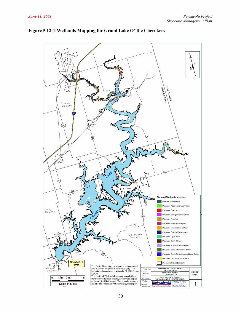
June 11, 2008 Pensacola Project Shoreline Management Plan
30
Figure 5.12-1: Wetlands Mapping for Grand Lake O’ the Cherokees
June 11, 2008 Pensacola Project Shoreline Management Plan
31
5.13 Land Uses
Development along the shoreline of Grand Lake primarily consists of residential,
light commercial and business, and limited agricultural lands. Grand Lake is a popular
location for recreation and residential development, particularly summer homes. The
scenic quality of the reservoir and surrounding landscape, good recreational fishing, and
its proximity to major population centers in Oklahoma, Kansas, Missouri, and Arkansas
contribute to the popularity of the Lake. The historic availability of land adjacent to the
Project boundary for private ownership has also contributed to this popularity. The
majority of the shoreline above the 750 foot contour elevation is privately owned. As a
result, numerous residences and businesses have been constructed around the reservoir,
adjacent to the Project boundary (Figure 5.13-1).
Within 500 feet of the shoreline of Grand Lake, an estimated 4,400 private
residences have been constructed as of 2004. Approximately 50 to 70 percent of these
homes are seasonal (summer) residences (GRDA, 2004a). Likewise, general leisure and
retirement community development has expanded on Grand Lake. Housing density in
Ottawa and Delaware counties is approximately 30 housing units per mi2, compared to
25/mi2 for Mayes County and 8/mi2 for Craig County. Housing construction in the area
has increased significantly in the last decade with Delaware County growing by
approximately 33 percent from 1990 to 2000. Housing growth from 1990 to 2000 for the
remaining counties, by comparison, ranges from 6 to 13 percent (US Census, 2005a-d
and 1990a-d).
The popularity of water-based recreation has resulted in significant economic
development around Grand Lake, particularly in real estate, goods, and services. There
are marinas, resorts, and other commercial operations such as campgrounds and
restaurants located around the shoreline of Grand Lake. Although manufacturing and
health care are the dominant industries for Mayes, Delaware, Ottawa, and Craig counties;
retail trade, lodging and food establishments contribute significantly to the employment
base, particularly for Delaware and Ottawa counties (see Section 5.9, Socioeconomic
Resources, for more information). There are approximately 1,200 lodging and food
June 11, 2008 Pensacola Project Shoreline Management Plan
32
establishments in Craig and Mayes counties in comparison with almost 1,700 in
Delaware and Ottawa Counties (ODOC, 2005a).
Construction of private and commercial boat docks by adjacent landowners is
allowed within the GRDA Project boundary by application through GRDA’s existing
permit program. Approximately 4,611 private and 355 commercial boat docks have been
permitted by GRDA, primarily on the lower section of the Lake below Sailboat Bridge.
More information regarding Grand Lake boat docks are provided in Section 7.0.
Approximately 50 percent of land within the Project boundary is deciduous forest
lands. Residential, commercial, and other development accounts for approximately 11
percent of total land area within the Project boundary. Land uses within the Project
boundary are shown on Figure 5.13-1 and Table 5.13-1.
Approximately 53 percent of lands adjacent to the Project boundary are
undeveloped forestlands. In addition, approximately 31 percent of lands adjacent to the
Pensacola Project shoreline is designated as agricultural/crop lands. The majority of the
agricultural areas are found in Ottawa County, where over 35 percent of the total land
area was used to plant field crops in 2001 (NASS, 2001b). In Delaware County, less than
three percent of the total land area was used for field crops in 2001 (NASS, 2001a).
June 11, 2008 Pens
acola Project Shoreline Management Plan
33
Table 5.13-1: Land Uses within the Project Boundarya
Land Use Percent of Total Land
Use Commercial and Services 0.3%
Cropland and Pasture 35.0% Deciduous Forest Land 49.1%
Mixed Urban or Developed 0.7% Non-forested Wetland 0.4%
Other Agricultural Land 0.0% Other Urban or Developed 0.1%
Residential 9.3% Streams and Canals 4.4%
Transportation, Commercial, and Utilities
0.2%
Transitional Areas 0.5% (Source: Kleinschmidt Associates)
June 11, 2008 Pe
nsacola Project Shoreline Management Plan
34
Figure 5.13-1: Land Use within the Project Boundary

June 11, 2008 Pensacola Project Shoreline Management Plan
35
5.14 Aesthetics
The lands adjacent to the northern and western shores of the Project are
characterized by rolling plains with occasional hills and ridges. The shoreline of Grand
Lake in these areas has generally gentle slopes. The lands adjacent to the southern and
eastern shores are characterized by deep ravines and narrow valleys separated by broad,
gently rolling uplands. Shorelines in these areas are primarily steep rocky beaches and
bluffs. The shoreline of Grand Lake ranges from forested areas (with a mixture of
vegetative cover types) to contiguous manicured lawns, residential housing and
commercial development. The river basin in the Project Vicinity is dominated by
deciduous forests (Figure 5.14-1).
The Lake varies considerably in the extent of development along the shoreline
between the upper and lower sections of the Lake. The majority of the shoreline of the
lower section of the Lake is highly developed. The upper section of Grand Lake presents
some continuous sections of undeveloped shoreline, exhibiting a relatively natural
aesthetic.

FINAL DRAFT – September 12, 2007 Pe
nsacola Project Shoreline Management Plan
36
Figure 5.14-1: Vegetation Patterns around Grand Lake O’ the Cherokees
June 11, 2008 Pensacola Project Shoreline Management Plan
37
5.15 Cultural Resources
Prehistoric peoples, Native Americans in the historic period, and Euro-American
settlers in the modern period leading up to Oklahoma’s statehood have made extensive
use of the Grand River Valley area as a place of both settlement and transportation. This
pattern of use creates a high probability within the Project area for intact cultural
resources dating from prehistoric eras, as well as the periods of early European contact,
the nineteenth century, and the Civil War.
In addition to the historical evidence for the likelihood of intact archaeological
deposits, the topography of the region lends itself to the preservation of archaeological
resources. While much of the land in the downstream portion of the Project near the dam
rises in steep bluffs from the shoreline, the upriver portions of Grand Lake features a
shallower, more riverine topography that has the potential to contain intact archaeological
resources. In addition, there are a number of tributaries that feed into Grand Lake that
have a high potential for intact resources (Gibson, 1984).
5.15.1 Known Cultural Properties
GRDA maintains data supplied by the State Historic Preservation Office
(SHPO) and the Oklahoma Archeological Survey (OAS) that identifies potential
and significant cultural resource sites. Approximately 50 cultural sites are known
to exist within the Project area. Because of the sensitive nature of cultural or
historic resources, their locations and significance is not public information.
5.15.2 Lands of Tribal Significance
No tribal lands are located within the Project boundary. No cultural
resources have been specifically identified as sites of traditional cultural or
religious significance to any tribe. However, the Grand River valley has been
occupied more or less continuously since the Paleo-Indian era, as many as 15,000
years ago. Native Americans have had a presence in the Grand River valley and
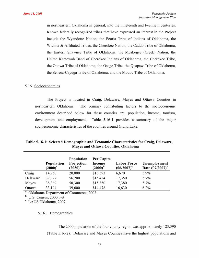
June 11, 2008 Pensacola Project Shoreline Management Plan
in northeastern Oklahoma in general, into the nineteenth and twentieth centuries.
Known federally recognized tribes that have expressed an interest in the Project
include the Wyandotte Nation, the Peoria Tribe of Indians of Oklahoma, the
Wichita & Affiliated Tribes, the Cherokee Nation, the Caddo Tribe of Oklahoma,
the Eastern Shawnee Tribe of Oklahoma, the Muskogee (Creek) Nation, the
United Keetowah Band of Cherokee Indians of Oklahoma, the Cherokee Tribe,
the Ottawa Tribe of Oklahoma, the Osage Tribe, the Quapaw Tribe of Oklahoma,
the Seneca-Cayuga Tribe of Oklahoma, and the Modoc Tribe of Oklahoma.
5.16 Socioeconomics
The Project is located in Craig, Delaware, Mayes and Ottawa Counties in
northeastern Oklahoma. The primary contributing factors to the socioeconomic
environment described below for these counties are: population, income, tourism,
development and employment. Table 5.16-1 provides a summary of the major
socioeconomic characteristics of the counties around Grand Lake.
Table 5.16-1: Selected Demographic and Economic Characteristics for Craig, Delaware, Mayes and Ottawa Counties, Oklahoma
Population (2000)a
Population Projection (2030)a
Per Capita Income (2000)b
Labor Force (06/2007)c
Unemployment Rate (07/2007)c
Craig 14,950 20,000 $16,593 6,670 5.9% Delaware 37,077 56,200 $15,424 17,350 5.7% Mayes 38,369 50,300 $15,350 17,380 5.7% Ottawa 33,194 39,600 $14,478 16,630 6.2% a Oklahoma Department of Commerce, 2002 b U.S. Census, 2000 a-d c LAUS Oklahoma, 2007
5.16.1 Demographics
The 2000 population of the four county region was approximately 123,590
(Table 5.16-2). Delaware and Mayes Counties have the highest populations and
38

June 11, 2008 Pensacola Project Shoreline Management Plan
are roughly equal in estimated population. The largest communities in these
counties are Grove and Pryor, respectively. The Grove Chamber of Commerce
(2006) reports that the community was recently rated one of the top retirement
areas in the nation by Rand McNally, the Wall Street Journal, and Retirement
Places. From 2000 to 2006, Grove’s population grew an estimated 17 percent.
Ottawa ranks third in population among the four counties, and Craig
County ranks last with the lowest 2000 population. The largest communities in
Ottawa and Craig Counties are Miami and Vinita, respectively. Population
projections through the year 2030 show an anticipated increase in the population
of all four counties (Table 5.16-1).
More recent annual population estimates suggest that the populations of
Craig and Ottawa are stagnant or decreasing (Table 5.16-2). Regardless of the
conflicting data, it seems clear that the regional population will continue to grow,
on balance, in the near future. All four counties around Grand Lake likely
experience some seasonal changes in population due to the influx of summer
residents and tourists during the popular summer months from Memorial Day
through Labor Day. Per capita incomes in the four counties ranged from $14,478
to $16,593 in 2000 (Table 5.16-1).
Table 5.16-2: Annual Population Estimates for Craig, Delaware, Mayes and Ottawa Counties, Oklahoma, 2000 through 2006
Census Projections Percent Change
County 2000 2001 2002 2003 2004 2005 2006 2000-2006 Craig 14,950 14,800 14,800 14,900 14,900
15,000
15,000
0.64
Delaware 37,077 37,700 38,000 38,600 39,100 39,200 40,100 8.05 Mayes 38,369 38,500 38,800 39,000 39,300 39,400 39,800 3.66 Ottawa 33,194 33,200 32,900 32,800 32,700 32,800 33,000 - 0.51 123,590 127,900 2.59
39

June 11, 2008 Pensacola Project Shoreline Management Plan
5.16.2 Economy
Construction of Grand Lake resulted in the development of a significant
recreational resource in the region. The Lake supports numerous marinas and
state recreation sites, all providing water-based access and attracting tourism
dollars to the local economy. Local communities capitalize on this by promoting
their individual attractions. In fact, the Oklahoma Department of Tourism and
Recreation estimated that Grand Lake generated in excess of $28 million in
tourism-related revenue to the area in 1987 (Oklahoma Office of the Secretary of
the Environment, 2005). It is likely that tourism related revenue has increased
since 1987.
Vinita is hailed as the second oldest town in Oklahoma and plays a
significant role in the state’s history. It is also located along historic Route 66.
Miami, Oklahoma – sometimes claimed to be the birthplace of Route 66 – also
uses the historic road to attract visitors. Miami also draws in tourism dollars
through several popular gaming facilities. The community of Grove claims to
offer the largest concentration of tourism services and recreation attractions in the
area (Grove Area Chamber of Commerce, 2006).
Many seasonal businesses are established to capitalize on the tourism
industry and support the interests and needs of the visitors and permanent and
seasonal residents alike. These businesses include fast food establishments, gas
stations, waterfront shops, marinas, retail, etc., all providing employment
opportunities and contribute to economic stability of the area.
It is generally acknowledged that property values are, in part, a function of
location, and that includes proximity to water bodies. In Oklahoma, the
availability of waterfront property is relatively limited when compared to land
locked parcels. Thus, one would expect land values near Grand Lake would be
different from land values that are distant from water bodies. Although detailed
40

June 11, 2008 Pensacola Project Shoreline Management Plan
information specific to Grand Lake is not available, there is information available
that suggests that land values in the vicinity of Grand Lake are greater than those
values elsewhere. Land values in Mayes, Delaware, Ottawa and Craig Counties
have increased 75 to 150 percent between the periods 1973-1975 and 1998-2000
(Kletke, 2003). In terms of dollars per acre, land values in Mayes, Delaware and
Ottawa Counties have consistently exceeded land values in the rest of the state
during the period 1972 to 1999. During the same period, land values in Craig
County have generally remained equal to or slightly greater than the statewide
values.
The primary industries contributing to employment in the region are
educational, health and social services, and manufacturing (Table 5.16-3).
Recreation and tourism industry plays an important role, ranking among the top
three industries in terms of employment in Ottawa County. These establishments
employ approximately 4,100 people in the four counties (US Census, 2000e).
The community of Miami, in Ottawa County, supports Northeastern A&M
College, which is reflected in the fact that the education, health and social
services industry is one of the largest employers in the County.
41

June 11, 2008 Pensacola Project Shoreline Management Plan
42
Table 5.16-3:Employment by Industry in Craig, Delaware, Mayes and Ottawa Counties, 2000a
Craig County
Delaware County
Mayes County
Ottawa County
Employed Population 6,366 14,745 16,520 14,172
Percent of Employed Workers by County Educational, health and social services 23.5 17.2 17.4 23.9 Manufacturing 14.9 21.3 25.1 17.7 Retail trade 11.3 12 11 10.3 Transportation and warehousing, and utilities 9.2 5.2 7.2 5 Arts, entertainment, recreation, accommodation and food services 6.3 8.1 6 10.5 Agriculture, forestry, fishing and hunting, mining 6.2 5 3.9 4.9 Construction 5.9 9.8 8.5 6.3 Public administration 5.1 3.4 3.4 4.3 Professional, scientific, management, administrative, and waste management services 4.4 4.1 4.5 3.4 Other services 3.9 4.9 4.5 6.2 Wholesale trade 3.9 2.4 3.4 2.7 Finance, insurance, real estate, and rental and leasing 3.5 4.9 3.5 3.9 Information 1.8 1.5 1.7 0.9 a U.S. Census, 2000e.
June 11, 2008 Pensacola Project Shoreline Management Plan
6.0 SUMMARY OF RECREATION MANAGEMENT PLAN
GRDA has an approved Recreation Management Plan on file with FERC. 1 The RMP is
a stand-alone document available for review from GRDA on GRDA’s website (www.grda.com),
or by calling 918-782-9594 or 918-256-5545 during normal business hours. The following
sections summarize the RMP.
6.1 Recreation Management at Grand Lake
GRDA shares responsibility and authority for recreation management on Grand
Lake with the ODWC, the Oklahoma Tourism and Recreation Department (OTRD), and
several local communities. Each entity has differing responsibilities and management
authorities.
GRDA manages recreation at the lake in accordance with state and federal
regulatory requirements and the goals and objectives established by its Board of
Directors. Pursuant to the Oklahoma Statutes, GRDA is charged with the management of
public recreation on the lake, and oversight and permitting of boating activity and dock
structures. Article 407 of the FERC license for the Project provides authority to GRDA
for ensuring adequate and appropriate public access to Project resources and requires that
GRDA manage and monitor that access and use as appropriate, providing periodic reports
to FERC documenting the level of recreation use at the Project every six years.
GRDA’s management goals include:
1. Provision of adequate, barrier-free public recreational access to Project
lands and waters;
2. Support of recreation patterns that reflect the established recreation
environment; and
43
1 On August 14, 1997, FERC approved and modified a Recreation Plan submitted in compliance with Article 407 of the project license (84 ¶ 62,144).
June 11, 2008 Pensacola Project Shoreline Management Plan
3. Management of public, private and commercial access to and use of
Project lands and waters in a safe and responsible manner.
GRDA has established policies and implementing regulations to facilitate
achieving these goals. The following is a summary of GRDA’s activities that support
recreational management at Grand Lake:
• Lake Patrol – The Lake Patrol is responsible for enforcement of rules and
regulations on the water and on GRDA owned lands, promoting safety,
permitting docks, and boat inspections;
• Recreation Sites – GRDA provided lands and access for the establishment of
state parks at Grand Lake. GRDA continues to cooperate with the state and
with local communities to develop and maintain public recreation sites;
• Public Outreach and Education – GRDA maintains a public education
program to inform citizens and tourists of the locations of public access sites,
boating regulations, etc. As part of this, GRDA provides guided tours of the
Pensacola Dam Powerhouse during the summer;
• Navigation Aides – GRDA maintains navigation aids on Grand Lake;
• Boating Management – GRDA establishes and enforces boating regulations
for Grand Lake;
• Recreation Monitoring – GRDA selected social and environmental indicators
to monitor as a tool for managing recreational boating and monitoring the
recreational carrying capacity of Project waters (see Section 5.6 for
additional detail);
• Improvement of fish nursery habitat – GRDA supports the improvement of
fish nursery habitat through its Aquatic Vegetation Program, and placement
of submerged brush piles and artificial habitat to provide fish habitat; and
• Support of Waterfowl Hunting – A millet-planting program instituted by
GRDA supplements natural habitat in the northern parts of the lake.
44
June 11, 2008 Pensacola Project Shoreline Management Plan
In carrying out the above activities, GRDA addressed, and continues to address,
all of the implementation actions identified in the 1997 Recreation Plan that are specific
to recreational use of Grand Lake.
6.2 Oklahoma Department of Wildlife Conservation
The ODWC manages fisheries, establishes hunting and fishing regulations for
state waters, including Grand Lake, and may assist other state agencies or other entities in
the establishment, maintenance and operation of educational facilities, recreational
facilities and hunting and fishing facilities.
Specific fish and wildlife management goals and activities related to recreation at
the Pensacola Project include management of the recreational fishery (hybrid striped
bass, crappie, bass, and paddlefish) through stocking, and fishing regulations.
6.3 Oklahoma Tourism and Recreation Department
The State of Oklahoma has prepared a Statewide Comprehensive Outdoor
Recreation Plan (SCORP) that provides updated information on the state of Oklahoma’s
parks, the quantity and quality of recreation opportunities, and an assessment of
management topics to address in the future. Oklahoma’s SCORP, written in 2001 and
revised in 2002, identifies its goals for state parks, including those on Grand Lake.
Specific to Grand Lake, the SCORP identifies the following:
• At Grand Lake, visitors have developed expectations and have adjusted
their behavior to cope with recreational conflict. The number of incidents
handled by the lake patrol is minimal;
• Education of park visitors would increase the recreation and social
carrying capacity of the lake; and
• Education is an alternative to enforcement.
45

June 11, 2008 Pensacola Project Shoreline Management Plan
6.4 Recreation Sites
There are public, commercial and private entities that provide access to Grand
Lake. GRDA, the Oklahoma Tourism and Recreation Department (OTRD) and local
municipalities provide public access. Commercial businesses, such as marinas provide
both fee and non-fee services to the public. Private access is available from individual
shorefront properties, neighborhood associations and private clubs.
6.4.1 Public Recreation Sites
The maps in Appendix B include public recreation sites. There are four
access areas provided by GRDA, five state parks, and approximately 14
municipal parks providing access to Grand Lake. There are approximately 22
public boat ramps providing access to Grand Lake in the area south of Sailboat
Bridge.
GRDA maintains the boat launches it provides. OTRD operates the state
parks; municipalities manage the local parks. Numerous other “volunteer” public
access points correspond with rights-of-way and old roadbeds scattered
throughout the area. Such locations are undocumented, usually not maintained at
any specified level of care, and used primarily by local residents and those
knowledgeable of the region.
6.4.2 GRDA Boat Ramps
There are four boat ramps provided by GRDA that provide access to
Grand Lake. Use of these launches is free to the public. These include:
• Duck Creek Bridge Public Access
• Seaplane Base Public Access
• Monkey Island Public Boat Ramp
• Big Hollow
46
June 11, 2008 Pensacola Project Shoreline Management Plan
6.4.3 State Parks
GRDA transferred ownership of land for several state parks to the OTRD.
These include:
• Bernice State Park
• Cherokee State Park (Areas 1, 2 and 3)
• Disney/Little Blue State Park
• Honey Creek State Park
• Twin Bridges State Park
6.4.4 Other Public Access
Various municipalities and organizations maintain or manage the
following community parks, access areas, and launches:
• Willow Park, Town of Ketchum
• Port Ketchum Public Access
• Low Water Dam, City of Miami
• City Boat Ramp, City of Miami
• Wyandotte Public Access, Town of Wyandotte
• Council Cove Public Access
• Cowskin Public Access
• City Boat Ramp, City of Grove
• Carey Bay Public Access
• Sweetwater Hollow Public Access
• Public Boat Dock, Town of Langley
• Drowning Creek Moonlight Cove
• Gray’s Hollow (back of cove)
• Cayuga
47

June 11, 2008 Pensacola Project Shoreline Management Plan
• Lakemont Shores (Drowning Creek)
• Raper Hollow (back of cove)
• Hanger Point
• West Bay
• Shangri-La
6.4.5 Private Recreation Access
GRDA completed a shoreline development inventory in 2006. This
inventory included documentation of private facilities such as boat docks and
ramps. Currently, there are approximately 4,476 private docks and 437 private
boat ramps on Grand Lake. These docks and ramps are the primary access to the
Lake for most of the residents.
Residential boat ramps generally provide lake access for individual
households or small groups of households. They typically consist of an access
roadway and boat ramp, with no parking area or other supporting facilities.
Private residential docks vary greatly in architecture and appearance. A
majority of the private docks are in the southern two-thirds of the lake due to the
nature of the lake and early development patterns. The availability of deeper and
wider reaches of Grand Lake at the southern end and the proximity to population
centers has resulted in a high concentration of private docks.
6.4.6 Commercial Development
Currently, there are numerous commercial facilities on Grand Lake that
provide roughly 3,863 slips for boats of various sizes. In addition, records show
approximately 53 commercial boat ramps.
48
June 11, 2008 Pensacola Project Shoreline Management Plan
6.5 Estimates of Recreational Use
6.5.1 Current Recreational Use
Grand Lake is an extremely popular recreation spot for locals and tourists
alike. In 2002, GRDA estimated that the Project supported 4 million recreation
days annually, and another 1.5 million recreation nights (GRDA, 2003). Grand
Lake is known for its boating and the many other recreational opportunities that
are available. Boating at Grand Lake occurs year round, though the primary
recreation season extends from mid to late May through early September.
Grand Lake is home to several sailing clubs. Sailboats range in size from
16 to 45 feet. Rafting involves the tying together of two or more anchored boats
so that the boaters may visit with one another. On Grand Lake, rafting is popular
in selected areas which are out of the way of boat traffic and in locations where
swimming or cliff diving are popular. Pleasure boating includes many different
individual activities, such as tubing, power boating, water skiing, house-boating,
etc. Oklahoma was among the top 20 states in boating registrations in 2003, when
boat registrations reached nearly 230,000 (NMMA, 2004).
Fishing is a year round activity on Grand Lake. Secluded coves, boat
docks, fish shelters, and heated docks provide fishing opportunity to all segments
of the lake. Grand Lake supports a high quality fishery for largemouth bass,
hybrid striped bass, white bass, crappie, catfish and paddlefish.
GRDA manages at least 1,630 acres of Project lands as a wildlife
management area and allow public hunting (FERC, 1991). The 1,630 acres are
comprised of many individual parcels ranging in size from approximately 30
acres to 300 acres. These lands are located either adjacent to streams entering the
reservoir or as islands within the reservoir. Waterfowl hunting occurs primarily
in the riverine sections of the Lake between Twin Bridges and Sailboat Bridge
49
June 11, 2008 Pensacola Project Shoreline Management Plan
and to a lesser extent, in the mudflat areas of Horse Creek, south and west of the
Town of Bernice.
6.5.2 Boating Density
Aerial boat counts conducted by GRDA in 2005 identified the locations on
the lake where people boat, and the activities in which they participate. Flights
occurred during times of the day when boating activity was highest.
Fishing predominates on the upper lake, north of Sailboat Bridge, on both
weekends and holidays. Researchers estimated at least three-quarters of all boats
observed were fishing. The survey identified all of the boats in the northernmost
part of the lake, as engaged in fishing. The northernmost part of the lake averages
roughly six to seven boats over 6,747 acres of surface water at any given period,
while the area closer to Sailboat Bridge averages 16 to 17 boats over 6,363 acres
at any given period on both weekends and holidays.
Boating activity south of Sailboat Bridge is markedly different from the
upper lake. On normal use weekends, fishing still accounts for a substantial
amount of boating activity – roughly half of all boating activity recorded;
however, researchers identified large percentages of boaters engaging in pleasure
boating, rafting, and using personal watercraft. Sailing, water tubing and
waterskiing accounted for only small percentages of identified boats. On
holidays, boating use changes substantially to pursuits that are more active. The
increased use of pleasure boats and personal watercraft essentially suspends
fishing activity. At the southernmost part of the lake, rafting activity (boats tying
up to each other) was observed to triple.
6.5.3 Future Recreational Use
Participation in recreational activities at Grand Lake has generally grown
over time to reach today’s high levels reported on GRDA’s most recent FERC
50
June 11, 2008 Pensacola Project Shoreline Management Plan
Form 80. Many factors contribute to people’s participation in recreational
activities. Population growth may be a primary factor in recreation growth. The
population of the four counties around Grand Lake has grown approximately ten
percent, from 112,000 in 1986 to 123,590 in 2000. Population projections
through the year 2030 show an anticipated population increase in the four
counties of approximately 26 percent. If participation in recreation increases at
the same rate and follows a similar pattern, one can expect to see increased
demand for access in the future.
6.6 Planning for the Future
GRDA believes that the current public access provides adequate access to the
lake. GRDA will continue to provide public recreational access at the sites it maintains.
GRDA will also continue to provide and maintain 1,630 acres of designated wildlife
habitat open to public hunting and fishing.
GRDA does not monitor the need for additional commercial services; market
forces define the supply and demand of commercial services. Market forces also guide
private residential development, while the SMP guides development within the Project.
GRDA will monitor recreational use and management needs as they pertain to the
Pensacola Project. Particular items of interest to be monitored include:
• Water quality in coves where recreational boating use is heavy;
• Boat density by activity over time to identify changing use patterns;
• Available facilities and public access;
• The location and cause of boat accidents;
• The number of annual fishing tournaments and the number of boats participating;
• The number of annual regattas and the number of boats participating; and
• Opinions and preferences of Grand Lake boaters.
51
June 11, 2008 Pensacola Project Shoreline Management Plan
52
Should monitoring demonstrate a need for additional recreational access, GRDA
will hold public meetings to describe the issue and solicit input from the public. GRDA
will then review the potential solutions and develop a plan to implement access. Any
additional development on the part of GRDA will follow the guidelines found in
GRDA’s SMP for the Project.
In the event that GRDA determines the need for additional public access, the
ODWC and GRDA Lake Patrol have identified four prospective launch sites. Those sites
are on Drowning Creek, Bee Creek, Honey Creek and Horse Creek. Individuals with
small fishing boats using the gravel and rock surface as a launch ramp at the Drowning,
Bee, and Honey Creek sites. The Horse Creek site is adjacent to the Bernice Bridge and,
if developed, requires access from the highway right-of-way and extensive timber
clearing to accommodate parking and launch facilities. GRDA is continuing to explore
the development of that site with Delaware County, the ODWC and the Oklahoma
Department of Transportation.
June 11, 2008 Pensacola Project Shoreline Management Plan
7.0 SHORELINE MANAGEMENT GUIDELINES FOR PROJECT LANDS
Enjoyment and use of Grand Lake by residents and visitors alike relies, in part, on
facilities, structures, and other developments that permit access to the shoreline and the lake and
which provide necessary or requested services for visitors and residents. As development
pressure and general use of the Project increases, the potential for conflict regarding the types,
sizes, and general acceptability of particular uses also increases. Overcrowding, restricted
shorefront/waterway access, and loss of aesthetic values are all potential outcomes of
unrestricted development of shorefront uses. Additionally, the potential for environmental
degradation increases if unrestricted or unregulated development occurs without clear guidelines
and standards.
This section of the SMP provides a comprehensive framework for determining the types
of shoreline facilities and activities that are appropriate within specific areas of the Project
boundary in relation to existing uses and environmental resources. This system was developed
to protect and enhance the Project’s land and water resources while providing for hydropower
operations, future recreational enhancements, and lake access by the general public and adjacent
landowners. The two components of this system are the Shoreline Management Classifications
(SMC) and the Allowable Use Categories (AUC). Shoreline Management Classifications are
designations applied to Project lands that define GRDA’s management goals for the area and
identify generally permitted uses through reference to the Allowable Use Categories. The
Allowable Use Categories define common use types and identify additional considerations for
determining site specific appropriateness.
GRDA made qualitative evaluations of existing shoreline uses and environmental
resources immediately adjacent to and/or within the Project. The basis of the evaluation was a
series of maps produced using existing GIS databases that included palustrine wetlands, contour
and bathymetric data, and aquatic and terrestrial habitats considered significant by state and
federal wildlife agencies. GRDA compared these resources with existing shoreline development
data obtained by GRDA staff through a lake-wide global positioning system effort, review of
aerial photography, and the personal and corporate knowledge of GRDA staff and stakeholders.
This analysis, made in light of environmental, aesthetic, and social values and shoreline access
53
June 11, 2008 Pensacola Project Shoreline Management Plan
expectations, led to the identification of the following SMC and AUC.
7.1 Shoreline Management Classifications for Grand Lake
7.1.1 Project Operations Areas
Project Operations Areas are reserved for current and potential future
Project operation and related functions. This category includes all Project lands
used for hydroelectric generation, dams, spillways, switchyards, transmission
facilities, right-of-way areas, security lands, and other operational areas. While
sometimes occurring within or adjacent to other use areas, these specific shoreline
uses require a degree of separation from other activities to ensure public safety or
to assure the security of the Project infrastructure.
7.1.2 Municipal / Public Use Areas
Municipal/Public Use Areas are for uses that serve a public purpose or
governmental function such as state parks, public beaches, municipal water
intake/outflow, transmission/utility line crossing, roads, bridges, and gas/oil
pipelines. Typically, public agencies, governmental bodies, or utility providers
manage the areas. GRDA will not permit new uses, outside the scope of the
existing management objective of the managing entity at these locations. GRDA
does not permit private residential or commercial activities at these locations
unless they are consistent with the management policies of the area and the
operating body requests the new use.
7.1.3 Stewardship Areas
Stewardship Areas contain important or sensitive resources that require
special attention, consideration and protection in order that their significant
environmental, cultural, or aesthetic contributions not be threatened, diminished,
or lost. Stewardship areas include certain resources protected by state and/or
54
June 11, 2008 Pensacola Project Shoreline Management Plan
federal law, natural or cultural features considered important to the area or natural
environment, and areas maintained for habitat, water quality protection and
general aesthetics. These areas may include palustrine wetlands2 and sensitive
aquatic or terrestrial habitat. All currently undeveloped islands owned by GRDA
are also included in the Stewardship Area classification.
While not specifically identified within the Stewardship classification,
GRDA provides protection to historic and culturally sensitive areas within the
Project (Section 9.10). Because of the sensitive nature of cultural or historic
resources, their locations may not be public information. GRDA maintains data
supplied by the State Historic Preservation Office (SHPO) and the Oklahoma
Archeological Survey (OAS) that identifies potential and significant cultural
resource sites. GRDA will review all ground-disturbing activities to determine if
there is a possible adverse effect on these resources. Potential effects to cultural
or historic resources may result in the denial of a permit or require compliance
with protection and mitigation measures suggested by the SHPO or the OAS.
It is unlikely that GRDA will permit new uses in Stewardship areas, as it
intends to manage these lands exclusively for the benefit of these unique
resources. GRDA may permit temporary activities that do not require any form of
construction, long-term use, or that may result in any adverse effect on the
protected resource. Examples of temporary activities may include bird-dog trials,
one-time outdoor athletic events, and educational projects or programs such as
those associated with schools, universities, service clubs or youth organizations.
These temporary permits will be highly restrictive to avoid negative effects to
these resources.
Any new “permanent” uses proposed for a designated Stewardship Area
will be considered only if the proponent of the activity:
2 For the purpose of the SMP, GRDA uses UFSWS National Wetland Inventory data to identify wetland areas. This identification does not preclude the right or responsibility of adjacent property owners to further delineate wetlands in support of permit applications for facilities or uses within the Project boundary.
55
June 11, 2008 Pensacola Project Shoreline Management Plan
1. provides compelling evidence of hardship or establishes that a
considerable public interest exists for allowing the use that substantially
outweighs the interest in preservation;
2. justifies the Project location as the only feasible alternative; and
3. provides specific protection, mitigation and/or environmental
enhancements as may be prescribed by GRDA or through any consultation
with jurisdictional agencies.
All proposed uses in Stewardship Areas are subject to a consultation
process involving state and federal resource agencies and may involve
development of an Environmental Assessment or Environmental Impact
Statement by Project proponents.
Uses in Stewardship Areas in existence at the time of the enactment of the
SMP shall be allowed to continue, subject to the following conditions:
1. The use was properly permitted at the time of the SMP’s enactment,
2. The use is maintained in accordance with guidelines provided by GRDA,
3. The continuation of the use does not pose irreparable harm to the area.
7.1.4 Wildlife Management Areas
Wildlife Management Areas (WMA) are lands managed exclusively for
the preservation and enhancement of aquatic and terrestrial habitat. Areas within
this designation include all WMA identified in the FERC license as well as lands
acquired for the purpose of being developed as additional WMA. These areas are
generally characterized as larger tracts of land, removed from pressures of
competing uses, where the benefits of habitat protection can be best realized.
Wildlife Management Areas are afforded the highest degree of protection
under this SMP. Allowed uses in WMA shall be limited to those related to the
preservation and enhancement of habitat. Uses inconsistent with this purpose
56
June 11, 2008 Pensacola Project Shoreline Management Plan
shall not be allowed except with a waiver granted by the Board of Directors and
approved by FERC. Any such use shall require mitigation.
The WMA are created with the intent of providing mitigation for the uses
allowed in the Responsible Growth Areas including those uses allowed by the
Vegetation Management Plan.
7.1.5 Responsible Growth Areas
Responsible Growth Areas are Project lands GRDA intends to manage to
accommodate reasonable demands for public and private uses that are conducive
to the protection and enhancement of Grand Lake’s environmental, recreational,
and socioeconomic resources. Designation of Project land as a Responsible
Growth Area does not imply approval of a particular use or exempt an applicant
from permitting requirements.
Responsible Growth Areas contain existing residential and/or commercial
uses and areas of limited or no development not otherwise classified in this SMP.
Generally, Responsible Growth Areas do not contain sensitive or important
resources that require the degree of protection afforded by the Stewardship or
Wildlife Management SMC.
However, some Responsible Growth Areas contain palustrine wetlands
not included in the Stewardship SMC due to diminished resource management
potential. These locations have been clearly identified on the SMC maps found in
Appendix B. GRDA has sought to provide mitigation through the Stewardship
and WMA classifications for uses in these areas and in the Responsible Growth
SMC generally. Nonetheless, new uses in areas containing wetlands may be
subject to greater scrutiny and may require specific protection, mitigation and/or
environmental enhancements. No vegetation management activities may be
undertaken in these wetland areas without prior consultation with GRDA.
57
June 11, 2008 Pensacola Project Shoreline Management Plan
Generally, Responsible Growth Areas are available for the uses detailed in
the Commercial and Residential Allowable Use Categories (Sect. 7.2). However,
certain allowable uses may not be appropriate in some Responsible Growth Areas,
given the location’s characteristics and prevailing use patterns.
Prior to allowing new uses in these areas, GRDA will consider the
following:
• Characteristics of existing permitted uses and recreational uses
within a half-mile radius;
• Shoreline topography and geometry;
• Impact on safety and navigation;
• Environmental effects;
• Recreational use effects; and
• Potential economic development and tourism benefits.
7.2 Allowable Use Categories
The following Allowable Use Categories and definitions capture the majority of
allowed uses within the Project. GRDA recognizes other current or potential future uses
may fall outside these definitions. In some instances, GRDA may permit a use
determined to have such a limited impact as to have little or no effect on resources and
existing uses in any management classification. Other more intensive uses may have
more significance/effect on a management area and may require more scrutiny and
justification through GRDA’s permitting process or be denied altogether.
7.2.1 Commercial Uses
Commercial uses of the Project generally do not occur distinct from other
uses on Grand Lake. They are scattered along the shoreline and often are adjacent
to other uses. Commercial uses typically have more intensive use patterns than
residential or municipal/public uses. Additionally, commercial facilities,
58

June 11, 2008 Pensacola Project Shoreline Management Plan
particularly those with multiple docks, slips, and moorings, are generally
significantly larger than residential uses. Commercial uses may have a greater
potential for affecting navigation on the lake, particularly if they are located in
narrower coves and inlets. Therefore, these uses are best located in areas with
adequate shoreline and water depth to allow construction and operation with
minimal effect on environmental resources. Thus, development of new
commercial uses should focus on areas that currently support similar uses, in
areas that could support future high/intensive uses, and in locations separated
from distinctly residential uses.
Existing and potential Commercial Uses include:
• Full Service Marinas
• Commercial docks >10 slips
• Commercial docks ≤ 10 slips
• Courtesy docks
• Boat ramps
• Marine railways and trams
• Breakwaters
• Shoreline stabilization
• Dredging/Channeling
• Commercial water withdrawal (e.g. golf courses)
• Vegetation Management
• Agricultural uses
7.2.2 Residential Uses
GRDA will continue to permit uses associated with private residential or
residential associations’ uses. However, certain cove areas, shoreline locations
with shallow water, areas considered congested or which support important or
sensitive resources may be inappropriate for new uses related to residential
development. For new developments, GRDA will place particular emphasis on
59

June 11, 2008 Pensacola Project Shoreline Management Plan
consolidating uses to minimize shoreline effects for both single and multi-family
shoreline uses.
Existing and potential Residential uses include:
• Private Docks
• Community Docks
• Multi-boat slips ≤ 10
• Multi-boat slips >10
• Boat ramps
• Marine railways & trams
• Breakwaters
• Shoreline Stabilization
• Vegetation Management
• Dredging/Channeling
• Residential Water Withdrawal
7.2.3 Municipal/Public Uses
In general, municipal and/or public uses as identified in Section 7.2 are
site-specific uses that occur distinct from other uses. GRDA developed
definitions and identified specific areas within or adjacent to the Project boundary
where known municipal/public uses occur. In doing so, GRDA acknowledges
that a degree of separation from other uses may be necessary for the safe
operation and/or delivery of service associated with these types of uses. Any
proposed municipal or public use area proposed outside an existing designated
area must be able to demonstrate that the use is in the public interest.
Municipal/Public Uses include:
• Public/municipal water withdrawal/discharge
• Water treatment systems
• Parks
60
June 11, 2008 Pensacola Project Shoreline Management Plan
61
• Boat Ramps
• Docks
• Wildlife management areas
7.3 Shoreline Management Classification Mapping
GRDA’s GIS, local knowledge of both GRDA staff and stakeholders, and site-
specific verification served as the basis for determining the most appropriate and
pertinent locations to apply the Shoreline Management Classifications within the Project.
Not all shoreline areas that generally meet the SMC definitions necessarily fall into that
particular classification. As an example, an area may have one or more environmental
characteristics that fall into the Stewardship definition; however, existing commercial or
residential use within that particular area precludes application of the Stewardship
classification to that area. Appendix B contains the SMC maps.
While GRDA developed the mapping of Shoreline Management Classifications as
comprehensively as possible, in some cases, the level of information available may not
allow completely accurate identification of property boundaries or pinpoint Stewardship
areas. Therefore, property owners who believe GRDA applied a particular SMC
erroneously to the shoreline adjacent to their properties may contact GRDA for a site-
specific review and verification of that classification, should they wish to propose a
project or use that does not qualify as an allowable use within the existing SMC.
GRDA will maintain a current, updated database showing the Shoreline
Management Classifications at Grand Lake. These maps will be available from GRDA’s
Department of Ecosystems Management. As discussed in Section 11.0, minor updates to
the mapping that supports the SMC will occur periodically, with a lake-wide review of all
SMC every six years.
June 11, 2008 Pensacola Project Shoreline Management Plan
62
8.0 ADAPTIVE MANAGEMENT FOR AREAS OF CONCERN
Some shoreline areas along the lake have or will experience greater development
pressures and heavier use. No current data suggests that any shoreline areas along the lake are
completely “built out” (with no additional shoreline available for development). However, given
current/anticipated levels of new development, GRDA expects that private property adjacent to
the Project boundary will continue to have additional growth that may require specific and
distinct management attention. Not all areas of the shoreline develop in the same manner, or
have identical growth issues. Not all potential growth is negative or unwelcome by adjacent
property owners, however GRDA strives to maintain a balance among acceptable growth, access
to and enjoyment of the Project by the public, and protection of environmental resources. As
such, GRDA, proposes the use of adaptive management strategies to, where appropriate,
monitor, analyze, and subsequently manage growth and development in a flexible, yet locally
relevant manner.
Available data do not support listing any area of the lake as requiring special
management because of negative environmental or social effects resulting from over-
development or over-use. Neither does GRDA support the assertion that any shoreline area has
reached its maximum development potential; however, public comment indicates that the
potential for continued growth and heavy use of the lake shoreline is a concern. After examining
several potential strategies for managing and controlling growth on the lake, GRDA concluded
that development of a lake-wide policy to contain growth or set limits on development beyond
the existing SMC was not equitable to a majority of adjacent property owners or non-resident
users of the lake.
Adaptive management is a dynamic monitoring and policy implementation process that
allows GRDA to respond specifically and effectively to changing conditions in a proactive, yet
data supported manner. Using this type of strategy allows GRDA to assess environmental and
social conditions and implement additional management conditions where and when necessary,
while acknowledging that these conditions may be temporary and changeable. Resource
management professionals often define adaptive management as "… a systematic process for
continually improving management policies and practices by learning from the outcomes of

June 11, 2008 Pensacola Project Shoreline Management Plan
operational programs”. Implementation of an adaptive management policy allows GRDA to
continue to assess environmental and social conditions, analyze and respond directly to specific
site conditions, and build upon these efforts to continue to manage areas of concern. The key
characteristics of GRDA’s adaptive management include:
a) Acknowledgement of uncertainty about what policy/management strategy is “best;”
b) Selection of appropriate policies or management practices;
c) Development and implementation of a site-specific plan;
d) Monitoring of the key response indicators identified in the plan;
e) Analysis of the outcome in consideration of the original objectives; and
f) Incorporation of the results into future decisions.”3
GRDA will identify areas of concern with the assistance of public input. Should
communities believe their particular cove or shoreline warrants monitoring, GRDA will consider
such proposals. The onus to petition GRDA is on local citizenry. Prior to implementing any
additional monitoring, GRDA will hold a public hearing, at which a majority of local residents
must support the inclusion of that particular location. The objectives of these discussions will be
to identify the specific concerns of adjacent property owners and develop site-specific
parameters GRDA can employ to monitor and analyze the area of concern. At the conclusion of
particular monitoring efforts, GRDA will meet again with residents, discuss its findings, and
develop appropriate new management strategies. GRDA stresses that inclusion in the
monitoring program may not result in immediate modification of management strategies, nor
does it guarantee implementation of new management policies at the conclusion of the
monitoring.
3 Modified from Nyberg, J.B. and B. Taylor. 1995. Applying adaptive management in British Columbia’s forests. In Proc. FAO/ECE/ILO International Forestry Seminar, Prince George, B.C. pp 239-45 Can For Serv., Prince George, B.C.) http://www.adaptivemanagement.net/probe.doc 10/17/06
63

June 11, 2008 Pensacola Project Shoreline Management Plan
9.0 NEW SHORELINE USES EVALUATION PROCESS
By using the SMC maps (Appendix B), adjacent property owners and potential shoreline
developers can identify their property in relation to the Project boundary and determine which
management classifications occur within the Project adjacent to their property and the
corresponding allowable uses. Section 10.0 describes general permitting standards that are
applicable to the allowed use of their proposed project and summarizes applicable permit
application procedures. Some proposed uses will receive more scrutiny, require more supporting
documentation, or may require evaluation by GRDA on a case-by-case basis depending on the
type of proposed use and the SMC for the area.
GRDA will review permit applications for new uses on a case-by-case basis under these
guidelines and GRDA’s most current permitting program at the time of the application. In its
review of permit applications, GRDA will call upon ecosystems management staff and/or other
relevant resource agency specialists to provide input on projects located within management
classifications with resource specific restrictions. In addition to evaluating uses under this
scenario, GRDA may also assist permit applicants in identifying other local, state, regional, and
federal permits that may be required for proposed new uses; however, the onus remains on the
applicant to follow through with application for other relevant permits and agency
correspondence.
Regardless of the proposed uses by an adjacent property owner, GRDA strongly
encourages all property owners to contact GRDA permitting staff at least six months prior to
submittal of any permit application. General permitting standards (Section 10.0) are subject to
change outside the scope of this SMP and any permit applicant should contact GRDA directly to
verify what the most current standards and specific requirements are for their particular
application. Additionally, GRDA encourages project proponents to schedule an onsite visit with
GRDA staff to discuss their proposed projects during the project-planning phase. While GRDA
is not responsible for enforcing regulations under other agencies jurisdictions, GRDA will not
issue permits until a Project applicant provides proof of receipt of all applicable local, state, and
federal permits.
64

June 11, 2008 Pensacola Project Shoreline Management Plan
9.1 Evaluation Process
Both proponents of new uses and GRDA have a responsibility to follow correct
procedures related to project planning, review, and construction. General guidelines
follow.
9.1.1 Project Proponent
Applying for a Permit
1) Identify type of project(s) and activities within the Project boundary;
2) Determine the SMC (Section 7.1);
3) Determine the Allowable Uses within this Management Classification
(Section 7.2);
4) Determine which permitting standards and requirements pertain to the
proposed new facility or use (Section 10.0);
5) Contact GRDA for verification and permit application information;
6) Phase I - Prepare and submit a complete application to GRDA with the
necessary information provided and any required attachments; and
7) Phase II - Provide follow up information, public, notice and any other
additional information/documentation to support the GRDA permit
application.
An applicant may NOT begin ANY work on project or GRDA lands until they
receive all of the necessary permits and receive final approval of the permit
application from GRDA.
65

June 11, 2008 Pensacola Project Shoreline Management Plan
Upon Receipt of Permit
1) Review all permit requirements and conditions;
2) Contact GRDA with any implementation questions;
3) Post permit in clearly viewable location during construction;
4) Undertake any follow up as mandated by GRDA permit; and
5) Contact GRDA if project scope, location or specifications change. (This
contact should be made before any work commences)
9.1.2 GRDA
Upon receiving an application
1) Review and confirm proposed project location, management
classifications, and allowable use designations;
2) Conduct a site visit;
3) Provide timely input on resource, design, permit requirements, and site
specific issues to project proponent;
4) Provide an approximate timetable for application review based upon scope
of proposal and regulatory requirements, including notification to
applicant of FERC review (if required) and approximate timeline for such;
5) Provide opportunity for public meetings/forums as necessary;
6) Maintain public log/documentation of permit review as part of project file;
7) Review application for completeness and contact applicant as necessary
for additional information requirements;
8) Process application; and
9) Approve/deny with written explanation of determination.
66
June 11, 2008 Pensacola Project Shoreline Management Plan
67
Upon Permit Issuance
1) Conduct site visit during construction;
2) Inspect and verify post construction and certify permit.
If a proposed use, in the sole opinion of GRDA, does not meet requirements and
guidelines established in the SMP, the project proponent may reassess the
proposed facility or activity, finding ways to either comply with GRDA’s
requirements or withdraw the project from consideration. Section 10.8 details the
waiver process.

June 11, 2008 Pensacola Project Shoreline Management Plan
10.0 PERMITTING AND INSPECTION
As the recipient of a federal license and under its enabling legislation, GRDA is
responsible for supervision and control of the uses and occupancies for which it grants
permission. Additionally, FERC requires GRDA to monitor compliance with any permits or
conveyances they issue. Appendix D contains FERC license articles that pertain to shoreline
management. Article 410, FERC’s “Standard Land Use Article” details the uses a licensee may
permit on Project lands and defines those uses that require additional FERC approval.
10.1 Article 410 “Standard Land Use Article”
The following discussion is only a summary and paraphrase of Article 410
designed to provide an overview of FERC’s requirements. Appendix D contains the
actual license article.
FERC has delegated GRDA the authority to permit the following non-Project use
of Project lands without prior FERC notification or approval. GRDA may only allow
these if they are consistent with the Project purposes of protecting and enhancing the
scenic, recreational, and other environmental values of the Project:
• Landscape plantings;
• Non-commercial piers, landings, boat docks or similar structures and
facilities than can accommodate no more than ten watercraft at a time and
are intended to serve single-family type dwellings; and
• Embankments, bulkheads, retaining walls, or similar structures for erosion
control to protect the existing shoreline. Before granting permission for
the preceding, FERC requires GRDA to:
o Inspect the site of the proposed construction;
o Consider whether the planting of vegetation or the use of riprap would
be adequate to control erosion at the site; and
68

June 11, 2008 Pensacola Project Shoreline Management Plan
o Determine that the proposed construction is necessary and would not
change the basic contour of the reservoir shoreline.
GRDA may convey easements, rights of way across, or leases of Project lands for
the following, but must provide FERC with an annual report describing these
conveyances.
1) Replacement, expansion realignment, or maintenance of bridges and road for
which all necessary state and federal approvals have been obtained;
2) Storm drains and water mains;
3) Sewers that do not discharge into the Project waters;
4) Minor access road;
5) Telephone, gas and electric utility distribution lines;
6) Non-project overhead electric transmission lines (that do no require erection of
support structures within the Project boundary;
7) Submarine, overhead, or underground major telephone distribution cables or
major electric distribution lines; and
8) Water intake or pumping facilities that do not extract more than one million
gallons per day from a Project reservoir.
For the following conveyances and permits, GRDA must provide FERC with 45
days notice of the proposed conveyance, in which time FERC may request GRDA file an
application for formal approval of the conveyance by FERC.
1) Construction of new transportation infrastructure;
2) Sewers or effluent lines that discharge into Project water;
3) Pipelines which cross Project lands;
69
June 11, 2008 Pensacola Project Shoreline Management Plan
4) Non Project transmission lines that require support structures within the Project
boundary;
5) Private or public marinas that can accommodate no more than ten watercraft at a
time and are located at least one-half mile from any other private or public
marinas;
6) Recreational developments consistent with GRDA’s Recreation Plan; and
7) Other uses if a) Land conveyances of five acres or less, b) if all land conveyed is
located at least 75 feet from the Project’s normal maximum surface elevation and
c) the conveyance is no more than 50 total acres for each project development in
one year.
All other uses of Project lands require formal FERC approval in addition to GRDA
permits.
10.2 GRDA Permitting and Approval
Both GRDA and FERC must review and approve any activities not addressed by
Article 410. For most uses, project proponents must submit a written application to
GRDA with drawings providing location, design and dimensions, and a description of
materials and type of construction. All uses must conform to GRDA’s general
requirements and minimum design standards. Separate GRDA permitting standards and
protocols detail specific information that relates to these permitting requirements. A
current copy of GRDA’s permitting procedures and standards are available on GRDA’s
website (www.grda.com), at the GRDA Ecosystem Management Department located
near the west end of Pensacola dam in Langley, by mail at P.O. Box 70, Langley,
Oklahoma 74350, or by calling 918-782-9594. GRDA may update permitting standards
periodically, as needed, independently of SMP updates and amendments.
The permitting procedures and standards documents provide information on
requirements for docks and piers, bank stabilization measures, vegetation management
and dredging, as well as information on facility construction and maintenance
70

June 11, 2008 Pensacola Project Shoreline Management Plan
requirements. They also establish the criteria used in evaluating proposed new uses for
both commercial and residential activities as well as facility construction standards for
each activity.
GRDA will evaluate proposed new uses, and modifications to existing uses based on:
• Characteristics, zoning, intensity, and prevailing permitted uses within a
half-mile radius of the proposed activities, (including SMC and allowable
use determinations);
• Shoreline topography and geometry;
• Safety, navigation and flood control requirements;
• Environmental effects;
• Potential economic development and tourism benefits;
• Recreational use effects;
• Any other criteria which may affect the proposed project;
• The practicability of using reasonable alternative locations and methods to
accomplish the objective of the proposed facility or activity;
• The extent and permanence of the beneficial and/or detrimental effects
which the proposed facility or activity is likely to have on the uses which
the area is suited; and
• Existing jurisdictional regulations.
Agency consultation initiated by project proponents or GRDA regarding other
governmental regulations may include (but is not restricted to) contact with:
• U.S. Army Corps of Engineers
• U.S. Fish and Wildlife Service
71
June 11, 2008 Pensacola Project Shoreline Management Plan
• Oklahoma Department of Wildlife Conservation
• Oklahoma Department of Environmental Quality
• Oklahoma Water Resource Board
• Oklahoma Historical Society
• Oklahoma Archaeological Survey
• County Bureau of Environmental Quality
• Bureau of Indian Affairs
• Oklahoma Native American Tribes
• County Floodplain Administrators
• Oklahoma Corporation Commission
• Oklahoma State Fire Marshal
• FERC
No person, firm, partnership, corporation or other entity may perform any activity
that requires a permit prior to the receipt of such permit from GRDA. For example, a
homeowner may not place a dock in Project waters until the applicant receives written
notice that GRDA approves such an activity.
The following sections highlight and summarize current permit applications and
standards. GRDA reserves the right to make changes in permitting standards and
requirements independently of the SMP.
10.3 Commercial Permit Application Standards
As detailed in GRDA’s Commercial Project Permitting Process, commercial projects are:
• Construction or modification of facilities designed to accommodate more than
ten watercraft at a time;
• Construction or modification of facilities intended to serve non-residential
enterprises operated directly or indirectly for profit or gain including courtesy
72
June 11, 2008 Pensacola Project Shoreline Management Plan
docks; and
• Dredging operations requiring removal of fill materials exceeding the amount
of two thousand cubic yards.
Section 7.2 defines commercial uses that fall under the commercial permitting process.
In general, permit applications for commercial uses within the Project boundary involve
larger, more expansive and potentially more significant effects to lake resources. As
such, GRDA permitting staff may require supplemental information to adequately review
and assess such permit applications. In some instances, GRDA may require completion
and submittal of an Environmental Assessment (EA) to support permit applications. If
GRDA requires an EA, the applicant must retain an entity listed on GRDA’s
Environmental and Wetlands Consultants list, available from GRDA’s Department of
Ecosystem Management. Specific standards for applications are included within
GRDA’s permitting program documentation and website. GRDA will reject applications
failing to meet standards and guidelines. A public hearing shall be held prior to approval
of a commercial permit. GRDA shall maintain an electronic database of individuals or
organizations wishing to receive electronic notification of such hearings and shall comply
with any applicable notice requirements imposed by law.
Under the current permitting standards, GRDA requires commercial applicants to provide
the following:
• Contact information for the project proponent, and current landowners of
the adjacent property;
• A statement of the proposed use of Project lands listing all activities
proposed (if a phased approach is proposed by an applicant, the final build
out must be presented at the onset of the permitting process) including all
components of the project, materials proposed for use and the layout or
design of the project;
• Site location maps clearly showing the location and type of facility (maps
must clearly show the location of GRDA’s Project boundary and
applicable flowage easement lines in relation to the proposed project);
73
June 11, 2008 Pensacola Project Shoreline Management Plan
• Technical drawings of proposed facilities, certified by a registered
engineer;
• Full survey (metes & bounds), prepared by a registered Oklahoma land
surveyor, of the entire shoreline area within the boundaries of the
proposed development, clearly indicating property lines in relation to the
Project boundary and location of all existing or planned facilities within
the Project boundary;
• A discussion of the proposed project’s environmental effects including
those on common fish and wildlife species, rare, threatened, and
endangered species, vegetation, cultural resources, water quality and
existing recreation uses; additionally, applicants must provide a statement
supporting how the proposed project is consistent with approved
recreation, dredging, cultural resource and wildlife protection plans,
statutory mandates or project management requirements;
• A statement describing why the project is in the public interest including a
description of proposed measures to ensure boating safety near the project
area during and after construction, as well as a statement of measures
proposed to protect adjacent property owners’ access to the shoreline and
lake;
• A discussion of the "purpose” and “need" for expansion or new uses
including a description of any adverse environmental effects that cannot
be avoided and how the applicant proposes to minimize or mitigate for
these adverse effects and, as necessary, an alternative analysis that
documents why the proposed work or preferred location is the preferred
action;
• Sufficient detail of the proposed projects components to identify their
locations;
• Proof of fulfilling all other state and federal requirements and codes
through inclusion in the GRDA permit application package of other
permits received for the work; and
• Proof of liability insurance.
74
June 11, 2008 Pensacola Project Shoreline Management Plan
Should commercial applications substantially not meet the standards for
permitting as established by GRDA because of size, location, or other environmental
concerns, and if the applicant wishes to pursue further review through a waiver, the
applicant may be required to develop an EA or Environmental Impact Statement (EIS) (if
not previously included in the initial application package) in support of the waiver
request. This description only generally describes and summarizes GRDA’s permitting
standards. GRDA may periodically update them. Commercial applicants should contact
GRDA for the most recent permit standards and application requirements. Detailed
information on applications for commercial use permits is included in GRDA’s
permitting procedures and standards available on GRDA’s website (www.grda.com), at
the Department of Ecosystem Management in Langley, by mail at P.O. Box 70, Langley,
Oklahoma 74350, or by calling 918-782-9594.
10.4 Residential Dock Application Standards
While multi-family residential shoreline uses sometimes resemble commercial
facilities in size and scope, generally residential uses of Project lands tend to have a
smaller footprint with less potential for major environmental impacts. To preserve public
access and to reduce environmental effects, GRDA places particular emphasis on
consolidating shoreline uses. GRDA encourages the development of multi-owner
facilities to reduce shoreline congestion.
GRDA reviews some residential shoreline facilities (with ten or greater slips) as
an allowable residential use only if they are developed specifically without intent for
commercial uses or monetary gain. Any proposed facility with ten or greater slips,
requires FERC review and approval.
Residential applicants should contact GRDA for the most recent standards and
permit application requirements. Detailed information on application for new or existing
residential docks is included in GRDA’s permitting procedures and standards available
on GRDA’s website (www.grda.com), at the Department of Ecosystems Management in
Langley, by mail at P.O. Box 70, Langley, Oklahoma 74350, or by calling 918-782-9594.
75

June 11, 2008 Pensacola Project Shoreline Management Plan
Should Residential applications not meet the standards for permitting as
established by GRDA because of size, location, or other environmental concerns, the
applicant may pursue further review through a waiver process. If the applicant wishes to
pursue further review through a waiver process. The applicant must provide public
notice of the proposed application.
10.5 Vegetation Management
During the development of this SMP, the issue of vegetation management
emerged as the most contentious subject to be addressed. As the Rothman Summary
notes, the “most persistent and passionate objections were to the allegedly permit-heavy,
micro-managing Vegetation Management Plan.”
GRDA believes the proper stewardship of shoreline vegetation is critical to the
protection and enhancement of Grand Lake’s environmental resources and
socioeconomic value. Shoreline vegetation acts as a buffer to stabilize shorelines,
prevent erosion and protect water quality by filtering and trapping organic and chemical
pollutants, and can provide valuable habitat for fish and wildlife. Additionally, shoreline
vegetation can have significant recreational and aesthetic value.
As shown by the SMC, resource characteristics and vulnerability vary widely
around Grand Lake. In certain areas, proper stewardship dictates that shoreline
vegetation should remain undisturbed in order that these valuable resources are not
jeopardized. However, strict preservation is not always required to provide sufficient
protection and avoid adverse consequences. In fact, certain management practices are
often necessary or appropriate and can improve resource quality.
Similarly, the extent of GRDA oversight and involvement necessary to ensure
proper stewardship also varies depending on the proposed activity and the resources
involved. Certain proposed activities will require GRDA to spend considerable resources
critically examining all aspects of a plan and its implementation, while other activities
can be summarily approved, given the routine nature of the management practice and the
resource involved. Therefore, GRDA is committed to a vegetation management plan that
76
June 11, 2008 Pensacola Project Shoreline Management Plan
is both responsible and reasonable.
10.5.1 Vegetation Management in Responsible Growth SMC
The guidelines in this subsection apply to Project lands classified as Responsible
Growth Areas. However, if the SMC Maps indicate the presence of wetlands in a
Responsible Growth Area, the provisions of Section 10.5.2 are controlling.
Authorized Management Practices:
Adjacent land owners have the permission of GRDA to engage in the
following vegetation management activities on Project land classified as a
Responsible Growth Area, provided the area has not been identified as
containing wetlands.
• Mowing and maintenance of lawns established and existing before
July 1, 2005. A lawn is defined as an area cleared of native understory
vegetation and replaced with turf grass. No fertilizers shall be used on
these lawns.
• Removal of floating debris, driftwood, litter, and trash provided the
removal does not disturb the shoreline through the significant
movement of soil, rocks, or existing live vegetation.
• Removal of hazardous trees only in cases where the trees are dead and
dangerous, damaged and dangerous, diseased and dangerous, or
otherwise present a public safety or property hazard.
• Pruning of limbs from living trees and shrubs greater than 3 inches dbh
and up to one-third of the plant height of shrubs and non-woody
vegetation to enhance the view of the lake. Pruning does not permit
removal of trees greater than 3 inches dbh or complete clearing of any
area.
• Removal of woody vegetation less than or equal to 3 inches dbh.
• Trimming of non-woody vegetation to a height of 2 inches.
• Removal of certain understory and exotic noxious plants identified in
77

June 11, 2008 Pensacola Project Shoreline Management Plan
Appendix C, regardless of size.
• Landscape plantings which are consistent with the purposes of
protecting and enhancing the scenic, recreational, and other
environmental values of the Project. A landscape planting is defined
as flowering plants, grasses, trees or shrubs, provided the species
introduced is not an invasive plant species identified in Appendix C.
Adjacent landowners are strongly encouraged to use native vegetation
when conducting landscape plantings. This provision does not permit
the planting of turf grasses, whether native or non-native. A list of
suggested native plant species is available from the Department of
Ecosystems Management.
Management Practices Requiring Site Specific Permitting:
Land owners adjacent to GRDA shoreline designated as a Responsible
Growth area may only engage in the following vegetation management activities
after obtaining a permit from the Department of Ecosystems Management.
• Establishment of a new lawn. A lawn is defined as an area cleared of
native understory vegetation and replaced with turf grass.
• Removal of vegetation greater than three inches dbh.
• Any vegetation management activity, including the removal of floating
debris, driftwood, litter, and trash, which disturbs the shoreline
through the significant movement of soil, rocks, or existing live
vegetation.
• Clearing vegetation to create and maintain access corridors between
GRDA land and adjacent property. The corridor may not exceed 20
feet in width. Corridors must consist of natural materials such as
native grass, wood chips, or gravel/crushed rock. Placement of such
must not involve earth moving or soil disturbance and must minimize
ground disturbance and vegetation removal. The path may extend
from the common boundary between GRDA and the adjacent
landowner to the waters edge.
78

June 11, 2008 Pensacola Project Shoreline Management Plan
• Clearing and planting of vegetation to prevent the deterioration of
retaining walls and for shoreline stabilization. Such activity must be
done in conformance with GRDA regulations and guidelines.
10.5.2 Vegetation Management in Stewardship SMC and Wetlands
Site Specific VMP Requirements:
Before conducting any vegetation management activities, including
trimming trees and removing brush, on Project lands designated as a
Stewardship Area or a Responsible Growth Area with wetlands, a site specific
vegetation management plan (VMP) must be submitted to and approved by the
Department of Ecosystems Management and the proper permits must be
obtained.
Generally, no vegetation management activity is permitted in a
Stewardship Area and GRDA will not permit the removal of vegetation in
wetlands located in Stewardship areas. Vegetation management activities are
permissible in Responsible Growth Areas containing wetlands. However, such
VMPs may be subject to greater scrutiny and may result in a requirement for on-
or off-site mitigation and/or an alternative vegetation management plan.
Exception for Debris Removal:
In Stewardship Areas and Responsible Growth Areas containing
wetlands, no permit is required for the removal of floating debris, driftwood,
litter, and trash provided the removal does not disturb the shoreline through the
significant movement of soil, rocks, or existing live vegetation.
10.5.3 Vegetation Management in WMA
Vegetation management activities shall not be allowed in WMA except
79
June 11, 2008 Pensacola Project Shoreline Management Plan
when necessary for the purpose of preserving and enhancing habitat. Any such
activity that is allowed shall only be conducted under the supervision of the
Department of Ecosystems Management. Debris removal in WMA shall be
allowable only with the express permission of the Department of Ecosystems
Management.
10.5.4 General Provisions
A VMP may require written approval from FERC, the USACE, and other
state and local agencies. Permittee shall perform all activities in strict accordance
with the specifications approved by GRDA.
Adjacent property owners must initiate any activity allowed by the VMP
permit within one year of issuance of the permit. Failure to do so will result in the
expiration of the permit.
Any person that violates the provisions of the VMP or who fails to obtain
a permit when one is required may be required to pay all costs related to the
repair, restoration and reclamation of GRDA lands and waters associated with the
violation and may be subject to civil and criminal penalties.
If archeological or historical properties or items are discovered in the
course of performing vegetation management activities, all land clearing and land
disturbing activities shall cease immediately and GRDA shall be notified.
A utility company possessing an easement on project land may perform all
vegetation management activities necessary to exercise its rights pursuant to that
easement and shall not be required to acquire a permit.
10.5.4.1 Use of Herbicides and Pesticides
Use of herbicides and pesticides on Project lands is expressly
80
June 11, 2008 Pensacola Project Shoreline Management Plan
prohibited except by a state licensed applicator with prior approval of
the Department of Ecosystems Management.
10.5.4.2 Use of Heavy Machinery
While all machinery has the potential to disturb the shoreline if
used irresponsibly, GRDA recognizes that its use is often preferred
and sometimes necessary to accomplish certain allowed vegetation
management practices. Therefore, GRDA will permit the use of
machinery with a maximum power output not greater than 30
horsepower (hp) without prior approval for allowed management
practices, provided the use does not result in the unauthorized
movement of soil, rocks, or existing live vegetation. The use of
machinery with a maximum power output greater than 30 hp may be
allowed with prior approval from GRDA.
10.5.4.3 General Permits for Natural Disasters and other Emergencies
In the event a natural disaster or other emergency situation
causes significant vegetation damage or debris accumulation within
the Project boundary to the extent that site specific permitting is
impractical or would result in undue delay, the General Manager of
GRDA may issue a general vegetation management permit governing
all management activities within an affected area in lieu of requiring
site specific permits. A general permit shall clearly identify the scope
of allowed activities, the areas in which the permit is applicable, and
the period of time for which the permit is valid.
81
June 11, 2008 Pensacola Project Shoreline Management Plan
10.6 Other Uses Requiring Review and Permitting by GRDA
10.6.1 Habitable Structures
“Habitable structures” or “dock-o-miniums” refer to living quarters
constructed in conjunction with new or existing docks, piers, and floats. These
structures generally resemble cabins and/or homes, placed on floating structures
such as covered or enclosed docks, over boathouses and other similar structures
where a building is or may be occupied by people overnight or for extended
periods. Generally, these structures may contain water supply and/or waste
disposal facilities such as sinks, showers, toilets, kitchen facilities, food
preparation areas, etc.
Habitable structures currently exist on Grand Lake. As no permitting
category or definitions for these structures existed previously, most existing
habitable structures were permitted as commercial or residential docks under
GRDA’s procedures existing at the time of construction. Additional construction,
not under GRDA’s regulatory authority at the time, resulted in enclosed docks
with living quarters, toilets, cooking facilities, etc.
The issue of habitable structures on Grand Lake has become a focus of
concern for many shoreline residents. While some citizens believe the structures
are inappropriate, others strongly support allowing them for both private
residential structures or for commercial use. GRDA believes that, while public
sentiment is an important factor in developing a position on habitable structures,
other factors such as the environmental effects of these structures is equally
important to making a well-informed, unbiased decision.
At the time this SMP was approved by the GRDA Board of Directors,
GRDA staff was in the process of gathering and reviewing relevant studies and
information related to the desirability of habitable structures on Grand Lake.
GRDA intends to file an amendment to this SMP addressing habitable structures
82
June 11, 2008 Pensacola Project Shoreline Management Plan
within 90 days of submission of the SMP to FERC for approval.
10.6.2 Dredging and Excavation Policy
All excavation and dredging activities on GRDA-owned property require a
permit from GRDA. The USACE may also require a permit for excavation and
dredging activities. Additionally, FERC must approve all dredging activities on
GRDA waters requiring the removal of more than 2,000 cubic yards of material.
If other regulatory agencies require permit application submittal and review,
GRDA requires proof that the project proponent has received all other permits,
prior to issuing a GRDA permit.
Dredging generally is not permitted in Stewardship Areas or within
vegetated wetlands. In an effort to protect Project resources and adequately
review all dredging applications, currently GRDA requires a wetland delineation
study conducted by a GRDA approved wetland delineation specialist using the
Army Corps of Engineers wetland delineation guidelines in any locations other
than open water dredging.
Any new dredging will require sediment testing to determine if dredging
may displace contaminants. Specifically, sediment samples shall be tested for the
presence of heavy metals including Zinc, Lead, and Cadmium. Detection of
hazardous materials during testing may lead to a requirement that the project
either be abandoned or the project proponent provide a dredging management
plan to GRDA identifying how materials will be removed in compliance with the
ODEQ Standards. Maintenance dredging of previously authorized facilities and
structures under 250 cubic feet do not require soils testing.
GRDA will require dredging applicants to contract with GRDA approved
personnel to collect sediment samples according to industry best practices. Four
sediment cores per 2000 cubic yards of dredged material will be required and
83
June 11, 2008 Pensacola Project Shoreline Management Plan
should be evenly distributed across the proposed dredging site. Depth of each
core will be recorded and reasonable efforts should be made to core a depth of 5-
foot. Each core will be homogenized separately and a composite of the
homogenized cores will be submitted as an individual sample for metals and
particle size analysis. Sediment samples will be submitted to the Oklahoma
Department of Environmental Quality’s laboratory for metals analysis, and to a
United States Fish and Wildlife Service approved lab for particle size analysis
prior to issuing a permit.
Test results will be provided to the resource agencies for a 30- day
comment period and GRDA will review agency comments and compare the
results with published assessment guidelines from MacDonald et al. (2000). Test
results exceeding the Threshold Effect Concentration's (TEC; i.e. concentrations
predicted to be not toxic if concentration were lower than the corresponding TEC)
will be submitted to FERC for final approval.
GRDA will approve excavation of a boat channel or embayment only
when it determines there is no other practicable alternative to achieving sufficient
navigable water depth, the action would not substantially influence protected
resources, and the applicant can provide proof that they purchased their property
prior to the development of these SMP policies. Applicants must be prepared to
provide adequate documentation of the necessity of the project as part of any
application. Dredging for new or previously authorized uses is seasonally
restricted. To avoid potential impact to fish spawning areas applicants must
receive approval of timing from GRDA for this activity.
GRDA currently requires notification of project commencement, post-
dredging site review, and sign-off by GRDA enforcement staff at the completion
of the action; Contractors are required to post their permit on site during activity.
84

June 11, 2008 Pensacola Project Shoreline Management Plan
Spoil material from channel excavations must be placed in accordance
with any applicable local, state, and federal regulations at an upland site above the
applicable flood plain and off Project lands.
10.6.3 Placement of Buoys
Adjacent property owners may request GRDA to place a “no wake” buoy
in front of or adjacent to their property. No wake buoys designate a 150 feet
corridor off the shoreline within which boats and other watercraft must travel at
idle speed. Individuals applying for a buoy permit must agree to abide by the
Rules and Regulations governing the Use of Shorelands and Waters of GRDA,
which are Incorporated and made apart of the agreement, and that a buoy
placement issued upon the application may be revoked at any time by GRDA.
Any buoy not maintained in its proper location shall be subject to removal by
GRDA, without applicants consent. All buoys are not covered by any warranty,
express or implied, and replacement of a buoy will require an additional
application fee. All buoys will be installed and maintained by GRDA, and are
primarily warning devices for the convenience of the public, and should not be
relied upon solely as navigational aids. GRDA assumes no liability or
responsibility for loss or damages to life or property arising out of the public’s
reliance upon said devices.
GRDA requires applicants petitioning for a no wake buoy provide
information and documentation showing the proximity of a proposed buoy to an
existing buoy. Should applicants feel that a buoy is warranted adjacent to their
property due to boat and/or dock damage, GRDA requires proof of ongoing or
existing damage, through the presentation of repair bills, photo documentation of
damage and/or boat traffic that is operating in hazardous manner within the 150
feet corridor, and/or repair bills for reputed damage.
10.6.4 Shoreline Stabilization
85
June 11, 2008 Pensacola Project Shoreline Management Plan
GRDA may issue permits allowing adjacent residential landowners to
stabilize eroding shorelines on Project lands. GRDA recommends biostabilization
of eroded shorelines, where feasible. Biostabilization generally involves use of
natural plants, minimal bank contouring to providing a planting surface, or
placement of natural fiber mats, logs, or other materials to deflect wave action and
stabilize eroding shorelines. In some instances, GRDA may allow the placement
of riprap along the base of the eroded areas to prevent further undercutting of the
banks.
GRDA also permits the placement of engineered structures such as
gabions or retaining walls for shoreline stabilization. However, GRDA will
approve these methods only in shoreline locations where the erosion process is
severe and GRDA determines that a retaining wall is the most effective erosion
control option or where the proposed wall would connect to an existing GRDA-
approved wall on the lot or to an adjacent owner’s GRDA-approved wall. GRDA
inspects the site of the proposed construction and considers whether the planting
of vegetation or the use of riprap would be adequate to control erosion. GRDA
does not permit the reclamation of GRDA land that has been lost to erosion.
GRDA will determine if shoreline erosion is sufficient to approve the
proposed stabilization treatment. No shoreline stabilization may be conducted
until GRDA issues a permit.
10.6.5 Railways, Tram Systems, Fences, Ramps and Retaining Walls
Construction of private or commercial railways, tram systems, fences,
ramps or retaining walls constructed within the Project boundary requires permit
application to and approval by GRDA. Project proponent must submit complete
and detailed maps, plans and specifications for the proposed construction and its
location, including a statement of the purpose(s) for which the work is to be done.
The applicant must also be required to furnish a survey prepared by a licensed
surveyor or engineer showing the location of GRDA's taking (property) line in the
86
June 11, 2008 Pensacola Project Shoreline Management Plan
Project area and shall have such line staked on the ground. Permittees must
maintain railways, tram systems, fences and retaining walls in a manner such that
all electrical systems are to code, meet environmental guidelines, and that the
structures are safe and pose no risk or threat to the public or otherwise unduly
restrict the public from access and use of the Project. GRDA will not permit
residential boat ramps unless the ramp serves at least 25 homeowners or the
public at large.
10.6.6 Grazing
Responsible grazing on Project lands is only allowed with the permission
of GRDA, and will only be allowed in certain areas where the use is consistent
with the purposes of protecting and enhancing the scenic, recreational, and other
environmental values of the Project. Therefore, grazing leases are issued on a
case by case basis.
10.6.7 Licenses to Encroach
Certain structures built on project property prior to June 1, 2005, may be
allowed to remain in GRDA’s discretion pursuant to Okla. stat. tit. 82, § 874.2.
Structures must be consistent with the purposes of protecting and enhancing the
scenic, recreational, and other environmental values of the project. Owners of
such structures may obtain a license to encroach for a maximum of 30 years,
subject to approval by FERC.
10.6.8 Lease of Project Lands for Public Purposes
GRDA leases land to municipalities, civic organizations and other entities
for recreational areas such as public parks, picnic areas, and sporting and cultural
events. Such uses must be consistent with the purposes of protecting and
enhancing the scenic, recreational, and other environmental values of the Project
and must be approved by GRDA and FERC.
87

June 11, 2008 Pensacola Project Shoreline Management Plan
10.7 General Property Inspections
GRDA reserves the right at all times to inspect any permitted or unpermitted use
of the Project during and after construction or implementation. Should inspection of
particular uses reveal inconsistencies or violations of established management policies
and/or permitting standards, facility owners/users will be notified of such violation and
advised by GRDA regarding the violation, suggested means to correct the violation, and
actions to be taken by GRDA should the violation persist.
10.8 Permit Waivers
10.8.1 General Procedures
Upon written application and hearing, the Board of Directors of GRDA
(Board) may grant a waiver, exception or modification to the requirements
imposed on private and/or commercial permit applicants by GRDA. Additionally,
the Board may impose additional requirements upon any such applicant. GRDA
bases such waivers, exceptions, modifications, or additional requirements upon
the totality of the circumstances, in consideration of public and environmental
concerns. Any such waivers may also require prior FERC approval before
becoming final.
In considering waivers of these rules, Board considers the potential
positive and negative effects of the proposed facility or use on:
• Characteristics, zoning and prevailing permitted uses within a half-
mile radius of the proposed activity;
• Shoreline topography and geometry;
• Safety, navigation and flood control requirements;
• Environmental resources;
• Potential economic development and tourism benefits;
• Recreational use; and
• Statutory mandates.
88

June 11, 2008 Pensacola Project Shoreline Management Plan
Any applicant for a waiver will give notice of application to the Board.
Public notice of the waiver request shall be in accordance with guidelines
established by GRDA. Current guidelines are available from GRDA’s
Department of Ecosystem Management.
10.9 Grandfathered Improvements
Existing uses that were properly permitted and which met current GRDA
standards at the time of permitting but which may no longer be compatible with this
SMP, may remain in place, as long as they comply with the size, location and type
requirements set forth in GRDA’s requirements in effect at the time the structure was
built. Grandfathered uses are not transferable to other locations. Uses, for which GRDA
has not issued a permit, are not eligible for grandfathering. All existing and new uses
must comply with all current regulations pertaining to maintenance, safety and
environmental protection.
10.10 Best Management Practices and Educational Outreach
Best Management Practices (BMPs) are on-site actions implemented by an
individual or group to lessen the potential effects of an action on a particular resource.
For example, a property owner chooses to cut vegetation from their property to improve
access or their viewshed rather than wholesale clearing. The landowner may choose to
conduct selective clearings and replant low-lying vegetation to help maintain bank
stabilization. The selective clearing and replanting of vegetation is a best management
practice because it is an on-site action that reduces the potential effects of the specific
use. (Cutting vegetation on GRDA property or within the Project is subject to other
guidelines and permitting requirements (see Section 10.5.2- Vegetation Management.)).
GRDA actively promotes BMPs for preserving and protecting natural resources on all of
its lands as well as throughout the State. The goal of promoting shoreline BMPs is to
assist in the conservation and protection of valuable shoreline resources, and to help
reduce potential impacts to shoreline resources and water quality. GRDA recommends
89

June 11, 2008 Pensacola Project Shoreline Management Plan
the BMPs provided in Appendix C for actions that occur on private property NOT on
Project lands, and therefore the BMPs are not part of the SMP.
GRDA is dedicated to employing similar standards to their properties, both within
and outside the Project boundary. Understanding that these shoreline BMPs are not
regulations, GRDA, with assistance from stakeholders and other interested parties,
supports public education efforts to encourage adjacent property owners to adopt these
shoreline BMPs, as well as any other BMPs promoted by state and/or regulatory
authorities. Adjacent landowners may obtain additional information on BMPs from
GRDA’s Department of Ecosystems Management.
10.11 Agency Regulatory Review and Permitting
10.11.1 Army Corps of Engineers
The USACE, under Section 404 of the Clean Water Act, regulates the
discharge of dredged and fill materials into waters of the United States, including
adjacent wetlands. Any work at or below elevation 750PD on Grand Lake
(typically the ordinary high water mark where a debris line is visible) may require
consultation, project review and permitting by Corps staff as will any work in an
upland wetland. If a project proponent completes a project deemed jurisdictional
by the Corps without prior approval, penalties range from removal of the
structure/fill to fines and imprisonment. Anyone proposing a project involving
dredging or filling wetland should contact the USACE Tulsa District office.
10.11.2 State of Oklahoma, Regional, and Local Agencies
Oklahoma Department of Environmental Quality
Under Title 252, Chapter 611, the ODEQ issues 401 Water Quality
Certifications for construction activities. In accordance with the provisions of
Section 401 of the federal Clean Water Act and the Environmental Quality Code,
90

June 11, 2008 Pensacola Project Shoreline Management Plan
any applicant for a federal license or permit to conduct any activity including, but
not limited to, the construction or operation of facilities, dredge or fill, or other
activities, which may result in any discharge into, or pollution or alteration of the
waters of the State of Oklahoma, must first obtain a water quality certification
from the ODEQ The ODEQ issues, renews and modifies water quality
certifications including, but not limited to, Permits issued by the USACE under
the Section 404 permit program for the discharge of dredged or fill materials.
Additionally, ODEQ enforces water quality standards on the lake, and may be
called upon to take regulatory action for activities such as improper disposal of
septic wastes in the waters of Oklahoma.
Local/Regional Floodplain Management
The Oklahoma Floodplain Management Act, passed in 1980, authorizes
communities (i.e., cities, towns and counties) to develop floodplain regulations,
designate flood hazard areas and establish floodplain boards. An amendment in
2004 calls for accreditation of community floodplain administrators through the
Oklahoma Water Resources Board (OWRB), ensuring that these officials are
properly trained to effectively administer local floodplain regulations.
Consistent with protecting the natural functions of the floodplain and
reducing flood losses, the OWRB values the No Adverse Impact floodplain
management approach. No Adverse Impact strategies promote responsible
floodplain development through community-based decision-making4.
Project proponents are strongly encouraged to coordinate with the
floodplain manager in their town or county to ascertain if additional permitting
requirements apply to their project.
GRDA
91
June 11, 2008 Pensacola Project Shoreline Management Plan
The provisions of the Oklahoma Statutes governing the Grand River Dam
Authority prescribe how GRDA property may be used and authorize GRDA to
promulgate and enforce rules and regulations for recreational and commercial
uses of its lakes and shoreline5. GRDA has created a law enforcement division
for enforcing these rules on the waters and land of GRDA.
The members of GRDA's law enforcement division are recognized as the
enforcement officers for GRDA. The enforcement officers for GRDA may
enforce GRDA rules and regulations, those rules and regulations as may be issued
pursuant to the provisions of Section 4200 et seq. of Title 63 of the Oklahoma
Statutes, the provisions of Sections 861 et seq. of Title 82 of the Oklahoma
Statutes, and all violations of criminal laws occurring within the boundaries of the
counties where real property owned or leased by GRDA is located. The
enforcement officers have the power of peace officers during the performance of
their duties, except in the serving and execution of civil process.
The officers are charged with the duty of examining and inspecting
proposed locations for wharves, docks, dikes, anchorages, boathouses or any
proposed structures or improvements to be made upon the waters or lands of
GRDA, and issuing certificates of inspection. GRDA's law enforcement officers
may cooperate with federal, state and local enforcement officers in the
enforcement of all federal and state laws upon the waters, lands and properties of
GRDA.
State Historic Preservation Office and Oklahoma Archaeological Survey
Shoreline ground disturbing activities may require review and comment
from the SHPO and the OAS. The OAS provided GRDA with the known
locations of culturally sensitive and potentially sensitive locations within and
adjacent to the Project boundary. GRDA incorporated this information into non-
public available resource mapping which they maintain. Using this information,
4 http://www.owrb.state.ok.us/hazard/fp/floodplain.php; October 23, 2006
92
June 11, 2008 Pensacola Project Shoreline Management Plan
93
GRDA staff will review all proposed new uses to identify potential impacts to
known or potentially sensitive archaeological and historical properties. Early
identification of proposed activities, as well as identification of activities
requiring authorization and those that do not, will be key to minimizing permit
delays or rejection for project proponents. GRDA will review the permit
application and supporting information to ensure that the property owner or new
user provides the appropriate information. GRDA will assist landowners in
determining whether the proposed action requires consultation with the SHPO or
the OAS.
GRDA, as a requirement or condition of its permits, requires any entity
that is proposing ground-disturbing activities within the Project to undertake the
appropriate level of investigation, monitoring, and any subsequent mitigation
found to be required for reasonable protection of cultural or historic resources
within the Project.
5 Rules and Regulations Governing the Use of Shorelands and Waters of the Grand River Dam Authority, 2006
June 11, 2008 Pensacola Project Shoreline Management Plan
94
11.0 ENFORCEMENT OF THE SHORELINE MANAGEMENT PLAN
11.1 Existing Tools for Enforcement
11.1.1 Enforcement Staff
As discussed in Section 9.10, GRDA’s law enforcement staff enforces all
GRDA policies and regulations. These duties include periodic inspection of
permitted structures, general patrol of Grand Lake to identify new construction of
uses, review upon demand of permits approving repairs or new construction of
facilities, water quality sampling, buoy review and relocation, and issuance of
violation notices to adjacent property owners who are in violation of permit
standards and conditions. GRDA also undertakes periodic fly-overs by patrol
officers and other GRDA Ecosystem Management staff, to assess the
development and/or discovery of new uses within the Project boundary or
potential violations of existing permits.
All GRDA enforcement staff are trained and familiar with the new and
existing standards, rules, regulations and policies included in the SMP, and are
charged with not only with their enforcement, but also public outreach regarding
them.
11.1.2 Actions Available for Enforcement
GRDA law enforcement personnel may order any person or entity that is
violating any provision found in Title 63 or Title 21 of the Oklahoma Statutes or
in any GRDA rules to leave the waters and/or lands of GRDA. Failure to obey
may result in GRDA enforcing the provisions of 63 O.S.2001, § 4221 that
provides that such failure to comply will constitute a misdemeanor punishable by
a fine not to exceed $250.00. Additionally, any such person or entity, after notice
and an opportunity for hearing as provided in GRDA’s enabling legislation, may
be banned from the waters and/or lands of GRDA for a period of time up to, and
including, 90 days.
June 11, 2008 Pensacola Project Shoreline Management Plan
95
Currently, if a dock, wharf, boat house, breakwater, buoy or any other
structure, private or commercial, is not constructed with generally-accepted
building materials and pursuant to generally-accepted construction practices, or
installed in accordance with the plans and specifications approved by GRDA, or if
such works are not kept in good state of repair and in a good, safe and substantial
condition, are not inspected by a licensed electrical contractor as detailed in
GRDA’s permitting standards, or upon failure of payment of any fee when due,
GRDA, after notice and opportunity to be heard in accordance with Subchapter 21
of its enabling legislation, has the right to remove or cause to be removed from
GRDA's waters and lands such structure at the owners expense and/or cancel any
license or permit in the event the owner fails to repair or remove these uses after
being notified by GRDA to repair or remove the same.
GRDA’s current policy is that any loose or abandoned dock will be
impounded by GRDA and the owner is responsible for any expense incurred by
GRDA. GRDA will notify the Oklahoma State Department of Health and the
utility company furnishing electricity of any dock reported to be in an unsafe
electrical condition.
In the event GRDA removes a dock, wharf, boat house, breakwater, buoy,
fence, retaining wall, railway or any other structure, private or commercial, the
owner of the structure will be required to pay all costs of such removal and may
be required to pay all costs related to the repair and reclamation of GRDA lands
and waters associated with the removal.
Please note that GRDA’s rules and/or statutes are periodically subject
to change. For further information and the most current information,
interested parties should contact GRDA or visit its website at
www.GRDA.com. GRDA reserves the right to waive, modify, amend or
repeal any of these provisions in accordance with Oklahoma law.

June 11, 2008 Pensacola Project Shoreline Management Plan
96
12.0 SMP AMENDMENT PROCESS
In developing this SMP, GRDA has recommitted to the long-term stewardship of the
Project’s lands, water and environmental, recreational and socioeconomic values of Grand Lake.
GRDA formulated this SMP in anticipation of continued growth and new uses on and adjacent to
Project lands. GRDA recognizes that the region is a popular tourist destination and residential
area and that non-project uses change over time. While these changes in use may occur slowly,
they may result in patterns that necessitate reassessment of the SMP. To assure the SMP
continues to remain relevant, GRDA has prescribed processes to review and, if necessary, to
amend the SMP.
12.1 Tracking Non-Project Use
GRDA will institute permit and non-project use tracking using the existing GIS.
GRDA will enter new permit applications into the GIS, so GRDA may track development
and use patterns, as well as have easy access to data related to permitted activities.
GRDA will use the GIS database as one of the tools for assessing permit applications as
well as for assessing the need for future changes in permitting or land use classifications.
GRDA will update Project and resource databases as needed to assure they are
reflective of field conditions. As long as resource and use criteria as established by this
SMP do not change, GRDA will not seek additional review by FERC.
12.2 Shoreline Management Classification Monitoring
As demographics and user groups change within the Project Vicinity and
development of areas around the Project proceeds, the SMC may require revision. Some
shoreline areas may no longer support additional development while other areas may
experience shifts in demographics that require adjustment of allowable uses. As patterns
of development change, some areas may require the reevaluation of their designation or
the creation of new SMC.

June 11, 2008 Pensacola Project Shoreline Management Plan
97
To maintain the continued relevance of the SMP, GRDA intends to review the
Land Use Classification mapping, the SMP and the associated permitting programs every
six years. The six-year review timeframe allows GRDA to assess issues that may arise
because of development around the reservoir. A longer period may not react to shifts in
use while a shorter period may not permit meaningful analyses of cumulative affects.
This review process provides a means for GRDA to adopt or replace policies in the SMP.
At least six months prior to preparing a report on the SMP review, GRDA will publicly
notice the process and request comment from the public. Changes in the tracking of SMP
activities as described in Section 11.1 or that simply require changes in the mapping, or
other minor changes such as new development within existing subdivisions adjacent to
the Lake, or changes in recreational uses and access will be noted but are unlikely to
warrant amendments to the SMP. Major changes in land use patterns or new uses of the
Project may require further evaluation for new management strategies or may even
require amendment of the SMP. GRDA will provide FERC a report on the evaluation of
the SMP no later than the six-year anniversary following approval of the SMP and every
six years thereafter.
12.3 SMP Amendment Process
Major changes in development patterns, land uses, demographics, socioeconomics
or other factors within the Project Vicinity may, over time, change assumptions presented
in this SMP. GRDA has established the following criteria that may indicate the need to
address amendment of the plan.
Major Commercial Additions or New Commercial Uses: GRDA will continue to
monitor growth and development patterns around the lake and compile data that may be
useful in the event an SMP amendment becomes necessary during the review period.
While the northern and eastern shorelines of the lake currently do not present the level of
heavy development found in the southern region, or support major commercial uses,
GRDA recognizes the potential for growth and changes in overall development patterns
and expectation. These areas may warrant special attention in the future.
June 11, 2008 Pensacola Project Shoreline Management Plan
98
Large Parcel Land Sales/Major Changes in Land Ownership: In the event that
major parcels of previously undeveloped land change ownership, with an identifiable
purchaser and new intent for use, GRDA may review both the SMC designation, as well
as the allowable uses within the area to determine if amendments to the SMP are
warranted.
Changes within the Management Classifications: GRDA based the current SMC
on existing environmental, social and aesthetic resources. Some of these classifications
are dynamic by nature. It is possible that during the review period new concerns such as
wetland habitat may change, thereby necessitating the re-evaluation and possible
amendment of SMC as well as the associated allowable uses.
In the event that one or more of the above conditions occurs, or cumulative effects
of activities within the Project appear to affect the effectiveness of the SMP, GRDA will
begin internal review of the existing plan. Should GRDA determine that major changes
to the land use classification mapping (through definition and assignment of new SMC or
reassignment of existing SMC) are necessary, GRDA will petition FERC to amend the
SMP.
Upon determination of the necessity to amend the SMP, GRDA will publicly
notice its intent, and provide a public forum for public comment, either through public
meetings or through Board meeting discussions (which are open to the public). Because
a revision or modification of the SMP requires FERC approval, any proposed amendment
will follow FERC procedures.
June 11, 2008 Pensacola Project Shoreline Management Plan
13.0 BIBLIOGRAPHY
EPA. 2002. 303(d) State Impaired Waters list. [Online] URL:
http://oaspub.epa.gov/pls/tmdl/enviro.control?p_list_id=OK121600030020&p_cycle=2002. (Accessed November 9, 2005).
Erickson, N.E. and D.M., Leslie Jr. 1988. Shoreline vegetation and general wildlife values around Grand Lake, Oklahoma. Oklahoma State University. Stillwater, Oklahoma. 70 pages. January 1988.
Federal Energy Regulatory Commission. 1991. Environmental Assessment for Hydropower License: Pensacola Hydro Project (FERC No. 1494-002). November 19, 1991. Accession No.: 19911205-0106.
Gibson, A.M. 1984. The History of Oklahoma. University of Oklahoma Press. August, 1984.
Gough, G.A., J.R. Sauer, and M. Iliff. 1998. Patuxent Bird Identification Infocenter. Version 97.1. Patuxent Wildlife Research Center. Laurel, Maryland. [Online] URL: http://www.mbr-pwrc.usgs.gov/Infocenter/infocenter.html. (Accessed October 22, 2002). Grand River Dam Authority. 1986. Supplemental Information, Assessment of Impact on the
Gray Bat and Ozark Cavefish. Pensacola Hydroelectric Project, FERC No. 1494. Vinita, Oklahoma. Submitted to FERC July 1986.
Grand River Dam Authority. 2002. Additional information on the application for non-project use of project lands and waters, Pensacola Project (FERC No. 1494-232). Grand River Dam Authority, Vinita, OK. March 29, 2002.
Grand River Dam Authority. 2003c. Grand River Dam Authority Pensacola Project Fish and Waterfowl Habitat Management Plan. 6pp. Grand River Dam Authority. 2004a. Article 401 Amendment Application. January 29, 2004.
Accession No.: 20040130-0300.
Grand River Dam Authority. 2004b. Article 401 Amendment Application, Supplemental Information Part 2. January 29, 2004. Accession No.: 20040526-0141. Grand River Dam Authority. 2004c. Grand River Fishing Tournament Data.
Grove Area Chamber of Commerce, 2006. [Online] URL: http://groveok.org. (Accessed January 10, 2006).
Kletke, D. 2003. Oklahoma Land Values. Department of Agricultural Economics, Oklahoma State University. [Online] URL: http://agecon.okstate.edu/oklandvalues/. Site last modified January 4, 2006. (Accessed January 17, 2006).
LAUS Oklahoma - Oklahoma Labor Market Information, Oklahoma Counties, July 2007. [Online] URL: http://www.oesc.state.ok.us/lmi/LAUS/2007/July/counties.htm (Accessed September 7, 2007).
LaVal, R. K., R. L. Clawson, M.L. LaVal, and W. Caire. 1977. Foraging Behavior and Nocturnal Activity Patterns of Missouri Bats, With Emphasis on the Endangered Species Myotis grisescens and Myotis sodalis. J. Mammal. 58:592-599.
Lish, J.W. 1987. Diet, Population Size, and Location of High Use Areas for Bald Eagles (Haliaeetus leucocephalus) Wintering on Grand Lake During January – March 1987.
99
June 11, 2008 Pensacola Project Shoreline Management Plan
Oklahoma Cooperative Fish and Wildlife Research Unit, Oklahoma State University, Stillwater, OK. 70 pp.
Masters, R. E. 1993. Oklahoma's Endangered and Threatened Species. Formal Extension Report No. 6. Cooperative Extension Service, Oklahoma State University. Stillwater, Oklahoma. 44pp.
National Agricultural Statistics Service. 2001a. Field Crops in 2001, Delaware County Oklahoma. [Online] URL: http://www.fedstats.gov/cgi-bin/mapstats/AgLookup?40041. (Accessed December 9, 2005).
National Agricultural Statistics Service. 2001b. Field Crops in 2001, Ottawa County Oklahoma. [Online] URL: http://www.fedstats.gov/cgi-bin/mapstats/AgLookup?40115. (Accessed December 9, 2005).
National Weather Service Forecast Office. 2007 Miami, Oklahoma Climatology. [Online] URL: http://www.srh.noaa.gov/tsa/climate/miami.html. (Accessed September 7, 2007).
Oklahoma Department of Commerce. 2005a. Census 2000 Community Profiles. [Online] URL: http://busdev3.odoc5.odoc.state.ok.us/servlet/page?_pageid=1470&_dad =portal30&_schema=PORTAL30&cwr=68. (Accessed December 9, 2005).
Oklahoma Department of Commerce. 2002. Population Projections for Oklahoma 2000 – 2030. [Online] URL: http://staging.okcommerce.gov/test1/dmdocuments/Projections_Report_
2003_140904107.pdf. (Accessed September 7, 2007). Oklahoma Department of Environmental Quality. 2006. Water Quality Assessment Integrated
Report. Prepared Pursuant to Section 303(d) and Section 305(b) of the Clean Water Act by the Oklahoma Department of Environmental Quality.
Oklahoma Office of the Secretary of the Environment. 2005. Comprehensive Study of the Grand Lake Watershed. Final Report. Per Senate Bill 408, 2003 Legislative Session. Oklahoma City, Oklahoma. 177 pgs.
Oklahoma Office of the Secretary of the Environment. 2004. Comprehensive Study of the Grand Lake Watershed - 2004 Initial Report.
Oklahoma Department of Wildlife Conservation. 2005a. Oklahoma Reservoir Fact Sheet: Grand.
Oklahoma Department of Wildlife Conservation. 2005b. Oklahoma Information for Paddlefish Conservation Management Grant. December Report.
Oklahoma Water Resources Board and Oklahoma State University. 1995. Diagnostic and Feasibility Study of Grand Lake O' the Cherokees. Phase I of a Clean Lakes Project, Final Report.
Oklahoma Water Resources Board. 2001. Oklahoma Water Watch. Grand Lake Association Chapter. Draft 1993-2001 Data Summary.
Oklahoma Water Resources Board. 2004. 2004 Report of the Oklahoma Beneficial Use Monitoring Program (BUMP). Lake Sampling, 2003-2004 Draft Final Report.
Oklahoma Water Resources Board. 2005. First annual report for GRDA fish and wildlife mitigation project: feasibility study for establishing vascular aquatic plant communities in the littoral zone of Grand Lake. April 12: 35pp.
100

June 11, 2008 Pensacola Project Shoreline Management Plan
101
Polite, C. and J. Pratt. 2002. Bald Eagle. California Wildlife Habitat Relationships System. California Department of Fish and Game, California Interagency Wildlife Task Group. [Online] URL: http://www.dfg.ca.gov/whdab/B113.html. (Accessed October 15, 2005).
Stancill, W.J., S.B. Haggard, R.F. Raskevitz, and D.M. Leslie Jr. 1988. Waterfowl Use and Hunting Opportunities on Grand Lake and Ancillary Wetlands. 97
Tuttle, M.D. 1976. Population Ecology of the Gray Bat (Myotis grisescens): Factors Influencing Growth and Survival of Newly Volant Young. Ecology. 57:587-595.
U.S. Army Corps of Engineers. 1992. Letter of Understanding and Water Control Agreement. On file with the Grand River Dam Authority.
U.S. Bureau of Reclamation. 1994. Montana Bald Eagle Management Plan. 2nd Edition. U.S. Department of Interior, Bureau of Reclamation, Montana Projects Office. Billings, Montana.
U.S. Census. 1990a. Craig County General Population and Housing Characteristics, 1990. U.S. Census. 1990b. Delaware County General Population and Housing Characteristics, 1990. U.S. Census. 1990c. Mayes County General Population and Housing Characteristics, 1990. U.S. Census. 1990d. Ottawa County General Population and Housing Characteristics, 1990. U.S. Census 2000a. Craig County General Demographic Characteristics, 2000. U.S. Census. 2000b. Delaware County General Demographic Characteristics, 2000. U.S. Census. 2000c. Mayes County General Demographic Characteristics, 2000. U.S. Census. 2000d. Ottawa County General Demographic Characteristics, 2000. U.S. Census. 2000e. Oklahoma Demographic Characteristics, 2000. [Online] URL:
http://www.okcommerce.gov/index.php?option=com_docman&task=view_category&Itemid=99&subcat=7&catid=64&limitstart=0&limit=20. (Accessed January 9, 2006).
U.S. Fish and Wildlife Service. 1982. Gray Bat Recovery Plan. Prepared by the U.S. Fish and Wildlife Service in cooperation with the Gray Bat Recovery Team. Atlanta, Georgia. 91 pp.
U.S. Fish and Wildlife Service. 1989. Ozark Cavefish Recovery Plan. U.S. Fish and Wildlife Service. Atlanta, Georgia. 15 pp.
Woods, A.J., Omernik, J.M., Butler, D.R., Ford, J.G., Henley, J.E., Hoagland, B.W., Arndt, D.S., and Moran, B.C. 2005. Ecoregions of Oklahoma (color poster with map, descriptive text, summary tables, and photographs): Reston, Virginia, U.S. Geological Survey (map scale 1:1,250,000).

APPENDIX A
CONSULTATION DOCUMENTATION: COMMENTS; RESPONSE TO COMMENTS
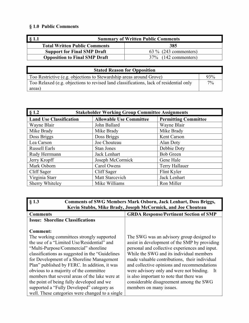
§ 1.0 Public Comments § 1.1 Summary of Written Public Comments
Total Written Public Comments 385 Support for Final SMP Draft 63 % (243 commenters)
Opposition to Final SMP Draft 37% (142 commenters)
Stated Reason for Opposition Too Restrictive (e.g. objections to Stewardship areas around Grove) 93% Too Relaxed (e.g. objections to revised land classifications, lack of residential only areas)
7%
§ 1.2 Stakeholder Working Group Committee Assignments Land Use Classification Allowable Use Committee Permitting Committee Wayne Blair John Ballard Wayne Blair Mike Brady Mike Brady Mike Brady Doss Briggs Doss Briggs Kent Carson Lea Carson Joe Chouteau Alan Doty Russell Earls Stan Jones Debbie Doty Rudy Herrmann Jack Lenhart Bob Green Jerry Kropff Joseph McCormick Gene Hale Mark Osborn Carol Owens Terry Hallauer Cliff Sager Cliff Sager Flint Kyler Virginia Starr Matt Starcevich Jack Lenhart Sherry Whiteley Mike Williams Ron Miller § 1.3 Comments of SWG Members Mark Osborn, Jack Lenhart, Doss Briggs, Kevin Stubbs, Mike Brady, Joseph McCormick, and Joe Chouteau Comments GRDA Response/Pertinent Section of SMP Issue: Shoreline Classifications Comment: The working committees strongly supported the use of a “Limited Use/Residential” and “Multi-Purpose/Commercial” shoreline classifications as suggested in the “Guidelines for Development of a Shoreline Management Plan” published by FERC. In addition, it was obvious to a majority of the committee members that several areas of the lake were at the point of being fully developed and we supported a “Fully Developed” category as well. These categories were changed to a single
The SWG was an advisory group designed to assist in development of the SMP by providing personal and collective experiences and input. While the SWG and its individual members made valuable contributions, their individual and collective opinions and recommendations were advisory only and were not binding. It is also important to note that there was considerable disagreement among the SWG members on many issues.

“Responsible Growth” category without the knowledge or support of the committees. Few, if any, of the FERC-approved comparative SMP’s from other projects reviewed by the applicable committees failed to recognize distinct classifications along the lines of our recommendations. Many reserved a “Responsible Growth”, or equivalent term for areas where extensive development and congestion was already present. A plan without clear zoning classifications invites controversy and, by definition, is arbitrary and capricious. In addition, the consultants from Kleinschmidt advised us that FERC was unlikely to approve a plan without a “Limited Use/Residential category.” However, in the final version of the SMP, the comments made at the public meeting are given credence over the eighteen-month long work of the committees. For example, the GRDA accepts the comments on page 12 at face value: “the majority of commentators argued that the limited/residential classification unnecessarily restricted the potential for future commercial development around the lake”. It is important to put these comments into proper perspective. The GRDA is anxious to point out the number of people (734) and the nature of their comments made at the public meetings. Notification of these meetings was provided only to those with dock permits and in free weekly newspapers around the lake area. Notification was not provided to the Resource Agencies, even those that were a part of the Working Committees or the various fish and wildlife federations and it was not posted in the Tulsa World or Daily Oklahoman (Oklahoma City) newspapers for either of the meetings held in those respective cities. It is of little surprise that the comments generated were pro-development or NIMBY-driven and were critical of the draft SMP. Rusty Fleming and the G.L.U.E. organization
In drafting the final SMP, GRDA considered the input and recommendations of all interested stakeholders, including all members of the SWG, the public, and resource agencies. GRDA publicized the public hearings extensively through a variety of media. It ran newspaper advertisements in several lake area publications including the Miami News-Record, the Grove Sun, and the Chronicle of Grand Lake. The hearings also received news coverage by these publications. GRDA posted notices about the hearings on its website and sent email notifications to over 1,000 stakeholders who signed up to receive news and announcements regarding lake management issues.
generated additional rhetoric primarily around the issues of the Vegetation Management Plan and limitation of development. As it turns out, Mr. Fleming is a paid employee of the G.L.U.E. organization whose major contributors are marina owners and commercial developers on the lake. His mailing list includes most of the GRDA executive staff, although he was unwilling to divulge the individuals who were paying members of his organization. The SMP, even in light of the above, contains contradictions. The introductory section of the revised version of the SMP says that “the majority of the shoreline of the lower section of the Lake is highly developed” and refers to “a high concentration of private docks”. Yet the SMP contradicts itself by saying “no shoreline areas are completely built out.” In the executive summary the SMP states that there is “Too little shoreline for future commercial development.” However, the allocation chart depicting current use (page 31) shows that only 0.3% (3.6 miles) of the 1200 mile shoreline is now in commercial development. The Working Committees classified 15% (180 miles), or a 5000% increase as a potential area for commercial development. Apparently, this was felt to be too restrictive by the GRDA staff. In respect to residential areas, 9.3% of the shoreline is currently classified as residential. Is it really necessary or appropriate to expand that potential to 70%, while ignoring the rights and needs of non property-owning lake enthusiasts? As for the concept of “Fully Developed”, in the Adaptive Management section on page 59, one finds the following statement: “Available data do not support listing any area of the lake as requiring special management because of negative environmental or social effects resulting from over-development or over-use.” Yet there are special rules in place on, for example, Duck Creek and Gray’s Hollow
As discussed in greater detail below, the commenters apparently do not understand the purpose and function of the Adaptive Management provisions found in SMP § 8.0. When read in context, the quoted statement is properly understood to mean that special management is not necessary beyond that which is currently in place or that is otherwise provided for in the SMP.
because of the over-use of those popular locations on Grand Lake. In response to the Working Committees preference for a “Fully Developed” shoreline classification, the staff completely removed this classification, stating that the new Carrying Capacity Study indicates that there are no areas of Grand Lake which are at greater than 11% of capacity on holiday weekends. While we will discuss the integrity of the Carrying Capacity Study in section 4 of these comments, this is obviously inconsistent with the experience of most of our committee members. Recommendation: Utilize the Shoreline Classifications as developed by the Working Committees in the SMP process. Add the classification of “Responsible Growth” for those areas already known to be in need of special monitoring including mitigation if new development is approved. Expand newspaper advertisement for all official GRDA notices to include the Tulsa and Oklahoma City major newspapers. Send specific notice to all Resource Agencies as well as the applicable wildlife and fishing NGO’s. Limit commercial development to a reasonable percentage increase compared to current levels realizing that these developments take up a disproportionate amount of recreational water space which will then no longer be available to other stakeholders.
GRDA will maintain a list of persons and organizations interested in receiving electronic notification of meetings/hearings. It will send press releases to media in Tulsa and Oklahoma City.
Issue: Habitable Structures Comment: Few elements of the SMP garnered more discussion from the Working Committees than “Habitable Structures”. The experience of other lakes, FERC policy, USACOE SMP’s, Oklahoma Water Resources Board comment, enforcement and oversight, as well as policy for existing unpermitted habitable structures were discussed extensively. Consistently and decidedly, the Committees recommended against permitting habitable structures and
See generally SMP § 10.6.1 At the time the comments were submitted, no decision had been made on habitable structures, as GRDA was awaiting the results of an environmental assessment on the potential impacts. Since then, GRDA received this report which concluded that Grand Lake can accommodate current and future structures.

recommended permitting only those which had been legally permitted as such. According to GRDA staff, none of the existent structures on the lake had been permitted as habitable structures. It was also felt that these structures are aesthetically unpleasing and they detract from the ability of sportsmen to use the lake, especially for night fishing, which is extremely popular on Grand Lake. The implication that they were “strongly supported” in the public meetings is misleading, as this statement is based upon a separate survey completed by twenty-eight people of whom only 12 out of 28 were supportive. The majority of support for these structures comes from those who currently own them without proper permits or commercial developers who see the advantage of a lake home sale without a land purchase. Recommendation: Provide clear language that “Habitable Structures” are not permissible on Grand Lake. Those now existing may be grandfathered in if they were previously permitted specifically as a habitable structure. If only permitted as a dock, they may remain as a dock and be given 24 months to remove umpermitted elements and be inspected by the GRDA. At the end of this period, the GRDA should have a complete list of where any legally grandfathered structures are located and should require annual inspections of these units thereafter.
The SMP states: “While some citizens believe the structures are inappropriate, others strongly support allowing them for both private residential structures or for commercial use.” GRDA does not believe this statement gives rise to an implication that habitable structures were strongly supported in public meetings. Rather, it is a description of the degree of passion expressed on the issue.
Issue: Resource Inventories Comment: The ODWC and USFWS conducted a very preliminary study of sensitive resources at no cost to the GRDA. The GRDA refused to fund more appropriate and thorough surveys. Kleinschmidt staff repeatedly told the committees that “this is not a science project” and insisted on using the limited and dated existing information. For example, the GRDA refused to fund an update of the National Wetlands Inventory maps, which are nearly 30 years old, in spite of the offer by the USFWS
Since 2004, GRDA has dedicated significant financial and human resources to ecosystems management generally and development of the SMP specifically. It has funded numerous studies and has created the Dept. of Ecosystems Management.

to do this for their cost of $2000. The lack of reliable information was a consistent problem throughout the process. Recommendation: Authorize and direct the Resource Agencies to provide a proper survey and update of environmentally sensitive project resources at a fee to be negotiated between the parties. Issue: Carrying Capacity Study Comment: Although contracted to professional firm, Kleinschmidt, at $41,000 plus expenses of $2,800, the area delineations, sampling times and data collection all appeared to be designed to create the impression of a lower level of lake use. In particular, the avoidance of methodology used in the 1996 Study prevented any comparative analysis of the trends identified and slated for careful monitoring in the 1996 Study. The Carrying Capacity Study also did not meet the GRDA contract conditions that clearly stated the Resource Agencies would approve the sampling method in advance. The USFWS and ODWC were never contacted. The calculation of usable acres for pleasure boating was incorrect, and did not delete: 1) No wake zones, 2) stationary structures, and 3) proper 150’ Coast Guard buffer requirements plus the 1/3 cove rule before calculating usable water for power boating capacity calculations. These factors lead to an underestimation of current use. The sampling did not begin until much of the summer was past and the number of samples (or flights) was far too low to support any meaningful statistical analysis or decisions. The data collected did not meet contract conditions of holiday over flights, using times in the morning or early afternoon, as well as using the Columbus Day weekend as a holiday weekend. In addition the data is numerically inconsistent in multiple areas. Finally, the effect of boat size was not factored in to density of use calculations. It is our opinion and that of Oklahoma State Professor, Dr. Lowell Caneday, who authored
In a letter dated February 15, 2008, FERC advised that the carrying capacity study was sufficient and does not need to be repeated or expanded.
the Recreation Plan now in effect since 1996, that the recent Carrying Capacity Study underlying this SMP is so fatally flawed as to be unusable as a management tool. Recommendation: Repeat the Carrying Capacity Study under the terms of the original contract with Kleinschmidt with the proper input from the Resource Agencies and provide the opportunity for the Working Committees to review the results. Issue: Permitting Issues Comment: This topic was never given to the Working Committees for discussion or input. The committees would have preferred to provide input on permitting as this is where the SMP transitions from intent to reality and confusion is possible if terminology and intent are not consistent. Recommendation: Provide existing Commercial Dock Permits, Residential Dock Permits, Dredging/Excavation Permits and Vegetation Management Permits to the Working Committees for review and reconciliation of the terms and policies of the Permits to the terms and policies of the SMP.
Upon approval of the SMP by FERC, GRDA intends to review, revise, and make additions to its permitting rules and procedures for the purpose of implementing the SMP. The commenters, as members of the public, will have ample opportunity to provide comments on these issues at that time.
Issue: Vegetation Management Plan Comment: While the source of much of the controversy surrounding the SMP, the VMP was conceived and implemented entirely by the GRDA staff. We were only asked for input after it had been instituted, prior to it being placed in the SMP. We are empathetic to the problems of instituting such a plan on an existing lake, but adamant in our support for a rational plan to protect the project boundary. It is of note that the focus of such plans is for the preservation of the appeal of the lake for those who look at the lake from the water in (sportsmen and recreational users), and not necessarily from the shoreline out (adjacent property owners).
See generally SMP § 10.6
However, what was most interesting about the interchange between the committees and the GRDA executive staff, was their defense to the crowd that such a plan had only been put in place because someone had reported them as failing to properly oversee shoreline VMP issues on the lake and the penalties and consequences had become too significant for them to ignore. This responsibility, no matter how unpopular, cannot be abdicated to the adjacent landowner without firm, appropriate and enforceable guidelines which protect all other stakeholders on the lake. Recommendation: Submit the VMP to the Resource Agencies (USFWS, ODWC, USACOE, and OWRB) for comment and revision, including shoreline classification-specific criteria.
The Vegetation Management Plan has been submitted to the agencies for comment. GRDA’s response to those comments is included in this appendix.
Issue: Adaptive Management Techniques Comment: The document states, the “SMP provides support and rationale for consistent land management policies and permitting decisions.” Yet the “adaptive management” approach advocated in Section 8 provides absolutely no consistent land management policies. Other than to identify certain environmentally sensitive areas, which the GRDA must do under Federal law, the SMP provides virtually no rationale to guide future development. GRDA makes the case for a need, but does not follow up that need with a plan. “Adaptive management” is a suitable approach when goals and objectives are clearly established. Regrettably, this SMP does not establish those goals and thereby becomes merely a vehicle for establishing the status quo. Along these lines the committees were not willing to simply “discard” all data and all trends identified since the 1996 Recreation Managment Plan was written. The Committee pressed for review of VERP- type monitoring data obtained from ’96 to ’07. Kleinschmidt refused to include an analysis of the last 11 years (even in areas specifically identified for more careful monitoring in Recreation Plan filed in 1996). Kleinschmidt was only willing
See generally SMP § 8.0 Apparently, the commenters are confused as to the purpose of SMP § 8.0 and its function in the context of the SMP as a whole. The “Adaptive Management” provisions are not intended to be the standard operating procedure for all management decisions. Rather, § 8.0 is intended to provide GRDA a mechanism for supplemental monitoring and management in response to extraordinary situations where existing SMP provisions do not provide adequate guidance or protection. Further, it enables GRDA to take corrective action without having to amend the existing SMP.

to include policy for monitoring the next six years, and a review in 2013 (which would make a total of seventeen years between the last review and next scheduled policy adjustment in lake management). If you don’t know where you are going, any road will take you there. Recommendation: Clearly define goals and methods of measurement which are easy to understand and easy to oversee. Include clear enforcement language for policy violations and a clearly stated appeal process. Issue: Water Quality/Heavy Metals Testing Comment: The SMP draft makes a compelling case for action on a variety of serious water quality concerns impacting Grand Lake. Yet, other than some guidelines under the Vegetation Management section, GRDA regrettably does not aggressively deal with those concerns, nor make the connection that the degree of development on Grand Lake contributes to those water quality problems. These are not simply potential future problems. Today, many portions of Grand Lake do not meet their beneficial uses, including those of “primary body contact.” Recent assessments by the OWRB, USFWS, and USGS provide ample justification for stronger measures involving phosphorus inputs, dredging, heavy metals testing, whole fish testing, and sedimentation due to shoreline clearing, dredging etc. The results of these tests and recommendations were reported to FERC in separate letters from these agencies in July of ’06. This is echoed in the SMP: Specifically, “concentrated development around the Lake, including resorts, has exacerbated phosphorous inputs.” Similar concerns are raised about sedimentation. The plan does not provide definitive language about the requirement for such testing, nor does it specify who shall pay for, direct, and interpret the results of any such tests. By not taking action decisive action
See generally SMP § 10.6.2 GRDA shares the commenters’ concern for water quality issues and their commitment to action on the same. However, GRDA does not believe the SMP is the proper venue for establishing detailed guidelines and requirements for the variety tests mentioned. Rather, these issues are better addressed in other plans such as the proposed Grand Lake Watershed Conservation and Restoration Plan, and GRDA’s administrative rules. That being said, the SMP requires all dredging applicants to provide sediments samples to the ODEQ laboratory for metal analysis and to a USFWS approved lab for particle analysis. Resource agencies will be provided results and the opportunity to comment. The SMP also identifies sample requirements and toxicity guidelines.

today, these problems will only become worse. Recommendation: Identify sampling intervals, methods, and agencies responsible for each type of testing through consultation with the Resource Agencies. Do not allow applicants to provide their own testing when required for permits. Issue: Density Model Calculations Comment: A numerical model using available G.I.S. data to calculate percentage of shoreline obstruction criteria (trigger points) for each Classification was suggested and preferred by the Working Committees. The use of such a model would avoid the arbitrary and capricious use of permitting and allow GRDA unbiased justification for its decisions within each shoreline classification. Kleinschmidt informed the committees that the GRDA staff would not consider density modeling for the stated reason that they felt it would be too hard to implement. We feel that the because the data required for density modeling is GIS-based, and already exists, the objection to cost of implementation is unfounded. The cost of density modeling is negligible and carries the benefit of providing a fair and equitable solution to the current arbitrary and capricious permitting by replacing personal influence and financial gain with visual, non-biased and reprouducible data in the application process. Recommendation: Incorporate the use of density model criteria for each land use classification and use these criteria in the permitting process as a fair and non-capricious method for qualifying new permit applications.
See generally SMP §§ 7.2 & 10.2 While the SMP does not identify specific density model criteria, it does require review and consideration of current use concentration and the effect of a proposed use on the immediate area.
Issue: Removal of Stewardship Areas Comment: Areas of a known sensitive nature were removed from the current Land Use Classification maps without knowledge of the committees or Resource Agencies most capable of their proper identification. In
GRDA sought to eliminate the opportunity for ‘arbitrary and capricious’ decisions by basing Stewardship Areas largely on land identified by USFWS as sensitive in its National Wetland Inventory.
addition, the SMP contains an obvious misstatement of fact when it refers to the 1630 acres of hardwood forest presently under management by the GRDA as a wildlife management area. The GRDA to date has been unable to locate, much less manage, such an area. Recommendation: Replace areas designated by the Resource Agencies as “Sensitive” and subsequently removed by GRDA staff back into the “Stewardship” classification until new surveys and maps can be drawn incorporating the recommended updated information from the Resource Agencies. § 1.4 Comments of SWG Member Rudolf Herrmann Comments Response/Pertinent SMP Provision Various comments in the introductory section of the Shoreline Management Plan suggest that the GRDA understands the issues on Grand Lake and therefore should feel compelled to provide responsible leadership in dealing with these issues. Yet other statements in the introductory section and throughout the document suggest that the GRDA is favoring commercial development at the expense of other shoreline uses. For example: . . . “Too little shoreline for future commercial development.” This statement is contradicted by data provided in the SMP that only 0.3% of the available shoreline is utilized for “commercial and services”. Certainly, tripling or even quadrupling the amount of shoreline available for “commercial and services” would accommodate future growth. This would amount to 0.9% to 1.2% of the shoreline being devoted to that land use. The much-criticized SMP draft that was based on input from the stakeholder working groups allowed 16.5% for multi-purpose and commercial use. This
provides substantial amounts of shoreline for future commercial growth. The GRDA accepted the comments on page 12 at face value: “the majority of commenters argued that the limited/residential classification unnecessarily restricted the potential for future commercial development around the lake”. Why would anyone other than commercial users “really” make those comments? The GRDA needs to understand the legitimacy and background of those comments before taking action. And once again, does dedicating 16.5% of the shoreline to multi-purpose and commercial use unnecessarily restrict future commercial development when 0.9% to 1.2% allows for a tripling or quadrupling from current levels? By categorizing some 70% of the lake as “responsible growth” opens up 70% of Grand Lake shoreline to commercial development. Is that REALLY what Grand Lake constituents want? “SMP provides support and rationale for consistent land management policies and permitting decisions.” Yet the “adaptive management” approach advocated in Section 8 provides absolutely no consistent land management policies. Other than to identify certain environmentally sensitive areas, which GRDA must do under federal law, the SMP provides virtually no rationale to guide future development. So GRDA makes the case for a need, but does not follow that up with a plan. “Adaptive management” is a suitable approach when goals and objectives are clearly established. Regrettably this SMP does not establish those goals so that the SMP is a rationale for maintaining the status quo. To quote an oft quoted saying, “Any road will take you there if you don’t care where you end up.” The SMP draft makes a compelling case for action on a variety of serious water quality problems impacting Grand Lake. Yet, other than some guidelines under the Vegetation
See generally SMP § 8.0 The “Adaptive Management Strategies” of § 8.0 are not intended to be the standard operating procedure for all management decisions. Rather, § 8.0 is intended to provide GRDA a mechanism for supplemental monitoring and management in response to extraordinary situations where existing SMP provisions do not provide adequate guidance or protection to a given area. Further, it enables GRDA to take corrective action without having to amend the existing SMP. See generally SMP § 10.6.2 GRDA shares the commenter’s concern for water quality issues and their commitment to
Management section, GRDA regrettably does not aggressively deal with those concerns, nor make the connection that the degree of development on Grand Lake contributes to those water quality problems. These are not potential future problems. Today, many portions of Grand Lake do not meet their beneficial uses, including those of “primary body contact.” By not taking action decisive action today, these problems will only become worse. The introductory section says that “the majority of the shoreline of the lower section of the Lake is highly developed” and refers to “a high concentration of private docks”. Yet the SMP contradicts itself by saying “no shoreline areas are completely built out.” Which is it? In the Adaptive Management section on page 59, one finds the following statement: “Available data do not support listing any area of the lake as requiring special management because of negative environmental or social effects resulting from over-development or over-use.” Yet there are special rules in place on Duck Creek because of the over-use on that major arm of Grand Lake. From a water quality perspective, many portions of Grand Lake do not meet their beneficial uses and are listed as impaired. This statement on page 59 is not consistent with reality. While all of the above is problematic, the bigger issue is the public policy decision making framework going forward. To be effective, public policy and corresponding regulations must be predictable, consistent and fair to all. Yet the “adaptive management strategy” is inherently flexible and, as described in the SMP, is not predictable to lake
action on the same. However, GRDA does not believe the SMP is the appropriate venue for establishing detailed guidelines and requirements related to water quality issues. Rather, these issues are better addressed in other plans such as the proposed Grand Lake Watershed Conservation and Restoration Plan, and GRDA’s administrative rules. The SMP requires all dredging applicants to provide sediments samples to the ODEQ laboratory for metal analysis and to a USFWS approved lab for particle analysis. Resource agencies will be provided results and the opportunity to comment. The SMP also identifies sample requirements and toxicity guidelines. When read in context, the quoted statement is properly understood to mean that special management is not necessary beyond that which is currently in place or that is otherwise provided for in the SMP.
users. This amounts to a “case by case” approach in evaluating future uses with the following major shortcomings: 1.)Is not predictable. 2.)Provides no real guidelines. 3.)Is inherently subjective and arbitrary. 4.)Leads to undue influence by a select few, private dealings, and potentially corrupt decision-making. Certainly GRDA has a greater obligation to its Oklahoma constituents than is reflected in the current version of the Shoreline Management Plan. Recommendation #1 Utilize the framework of Land Use Classifications as developed by the Stakeholder Working Groups.
Recommendation #2 Apply Adaptive Management Strategies to those classifications, realizing that there is room for much fine-tuning.
See response above regarding Adaptive Management Strategies.
Recommendation #3 Implement those Land Use Classifications on a “temporary basis, with the understanding that the next six years can be devoted to working out the details in a manner that is consistent, predictable, open, and fair to all.
The SMP is an amendment to GRDA’s hydroelectric license and is intended to last for the life of that 30 year license. Any changes to the SMP must be approved by FERC. This is a complicated, difficult process that renders temporary enactment unadvisable.
Recommendation #4 Develop clear strategies and action plans to deal with the water quality problems on Grand Lake.
See response regarding water quality above.
§ 1.5 Comments of SWG Members Kent & Lea Carson Comments GRDA Response/Pertinent Section of SMP In regard to the Final Draft SMP, I'd like to say that the VMP is very neighbor/adjacent property owner friendly. The tree trimming regulations are right on. The new lawn
See generally SMP § 10.6
regulation is right on. The 20 foot clearing, plus trimming is great. The driftwood clean-up with 30hp heavy equipment is right on. The only thing you could do to make the VMP better is, to send GRDA staff out to do the work! In regard to the Land Classification, I believe it is better to start with the lesser regulation as written, than to over regulate prematurely. As time passes, the SMP allows for more restrictive classification through neighborhood request, which is very neighborly. I would encourage registered mail notification of commercial development to all adjoining land owners when commercial entities apply for permits to GRDA. Other than that, it's a document your neighbors can and will support, if my neighbors are any indication. In Oklahoma everyone wears a black or a white Stetson hat. I'm so glad to see that GRDA has buried all their black hats and are now wearing white hats. The last two public meetings on the final SMP, GRDA demonstrated a very pleasant change from adversary to neighbor. Answering all the questions that came up, staying after the program to answer personal land issues, GRDA was very neighbor friendly. In Oklahoma everyone wears a black or white Stetson hat. I'm so glad to see GRDA staff has hung-up their black hats and is donning the neighborly white Stetson!
See generally SMP § 7.0 GRDA has incorporated the suggestion that notification be required for commercial use applicants.
§ 1.5 Comments of SWG Member Mike Williams Comment GRDA Response/Pertinent Section of SMP After such a long and oftentimes contentious and lake-threatening process, I cannot adequately express how pleased I am at the final Grand Lake Shoreline Management Plan Draft presented to the Grand River Dam Authority Board of Directors on September 12, 2007. As a member of the Stakeholders Working Group, I admit to much frustration at
the fact that a small group of people seemed to control the direction of SWG recommendations. I am so pleased that the numerous public hearings and town hall meetings were held, allowing the general public to provide input – and express their displeasure at the earlier drafts. Mostly, however, I am grateful to the GRDA staff for listening to the comments made by stakeholders from throughout the Grand Lake area, and amending the draft to more effectively represent the wishes of those who have lived and loved the Grand Lake life for so many years. The Land Use Classification categories and the related maps are far, far more representative of Grand Lakers’ opinions – and responsible growth in the future of the lake. The Vegetation Management is far more user-friendly. It allows necessary maintenance without undue restrictive burdens, while requiring plans – even permitting – for larger projects which need the eye of an environmental expert before unnecessary damage is inflicted. GREAT JOB by those GRDA staff members who worked so hard to hear what the public had to say – and put those wishes in a workable form! § 1.7 Comments of SWG Member Sherry Whiteley Comment GRDA Response/Pertinent Section of SMP I have read the draft SMP and find it to be adequate to control the undesirable activities, yet lenient enough for property owners and lake users to enjoy a measure of independence. It has been rewritten in the area of shoreline cleanup and property access to be especially useful to keep the shoreline free of trash and debris while preserving the natural beauty of the lake. Knowing that the dynamics are constantly changing and having the ability to adjust with

these changes is both smart and prudent. My congratulations on a job well done. § 1.8 Comments of SWG Members Alan & Debbie Doty Comment GRDA Response/Pertinent Section of SMP Signed petitions in support of Final SMP Land Classifications & Vegetation Management Plan
§ 1.9 Comments of SWG Member Bob Green Comment GRDA Response/Pertinent Section of SMP Signed petitions in support of Final SMP Land Classifications & Vegetation Management Plan
§ 1.10 Comments of Karl Blade, Shoreline Resident Comment Response/Pertinent Section of SMP Issue: Vegetation Management Plan Comment: I support the provisions of the current draft SMP that appear to allow adjacent property owners reasonable latitude in landscaping and maintaining the GRDA property between their private property and the lake. It doesn't seem to make sense that shoreline in front of residences must remain "natural," as opposed to neat and landscaped in a manner consistent with an adjacent residence.
See generally SMP § 10.6
Issue: Shoreline Classifications Comment: I believe the draft falls short of the public's needs in two areas. The most serious is the lack of designated residential areas, as opposed to the proposed mixed commercial
See generally SMP § 7.0 It is important to remember that the SMP only governs the use of GRDA property and GRDA has no authority to regulate the use of private property. Thus, the SMP could not prohibit

and residential land use classification. Allowing business use next to residences on a case-by-case basis to be decided by the GRDA board or some other GRDA-appointed authority without strict, well-understood rules is an invitation to capricious and arbitrary results. I do not want the GRDA, or any other body, to have the authority to allow some kind of business (a strip club, or even a bar and grill?) to locate next to my Grand Lake home. In fact, I would expect that if this specific question was put to the residents of Grand Lake, which it has not, overwhelming support would be found for protecting the residential nature of residential areas through a land use classification.
businesses from locating next to a home. The SMP provides protection for residential areas including the Allowable Use guidelines of § 7.2, the site specific analysis identified in § 10.2, and the requirement that surrounding land owners and the public at large be provided notice of proposed new commercial uses.
Issue: Habitable Structures The second deficiency in my view is the lack of a prohibition of further development of habitable structures over the water. I realize that the GRDA chose to take this issue out of the SMP process. This is in fact an important issue, and deserves to be addressed within the SMP in an unambiguous manner.
See generally SMP § 10.6.1 No decision has been made on habitable structures, as GRDA is awaiting the results of lake wide environmental assessment of the potential impacts. GRDA does not believe it would be prudent to make a decision prior to review of this study.
§ 1.11 Petition #1 in Support of SMP Final Draft We, the undersigned stakeholders, do strongly urge the GRDA Board of Directors and FERC, to support and implement the Final SMP Draft as it is written. We support the SMP Final Draft “Land Use Classifications” and “associated GRDA Maps”, finding them both acceptable and enforceable.
We support the SMP Vegetation Management Plan for responsible Growth Areas” and “Stewardship Areas” in the Final Draft, finding them both acceptable and enforceable.
142 Total Signatures 137 Total Signatures 144 unique commenters
§ 1.12 Petition #2 in Support of SMP Final Draft I support the following SMP Final Draft Land Use Classifications & accompanying maps, and do strongly urge the GRDA Board of Directors and FERC to accept and implement the following:
I support the following SMP Vegetation Management Plan for Responsible Growth, and do strongly urge the GRDA Board of Directors and FERC to accept and implement the following:
A. Use of the term “Stewardship Areas”, which include palustrine wetlands, islands, sensitive habitat, state & federally protected wildlife areas, cultural & aesthetic features. Stewardship Areas now account for 26.27% of Grand Lake on the Final SMP Maps. B. The term “Responsible Growth” which constitutes 71.98% of the Final Draft SMP Maps, contains existing residential and/or commercial use, and limited or undeveloped areas. These areas are available for uses detailed in the Commercial & Residential Allowable Uses Categories of the new Final draft. There are guidelines. This will allow for more responsible growth in the future, and allow the GRDA Board of Directors to supervise such growth without locking out future uses with a broad stroke of the pen today.
A. Some pruning of live growth will be allowed in the “Responsible Growth Areas”, by adjacent property owners without seeking a permit for up to 3” in diameter, this follows the rule that has been in place for many years. Removal of woody vegetation less than or equal to 3” in diameter. Trimming of non-woody vegetation to a height of 2”. B. The use of “Heavy Machinery” will be allowed by adjacent property owners in Responsible Growth Areas, with a maximum horsepower of without prior approval for driftwood and debris removal. The use of machinery with a horsepower of over 30 hp may be allowed with PRIOR approval from GRDA. C. The section that covers “Natural Disasters and Other Emergencies”. This would allow GRDA to issue a general vegetation management permi governing all management activities within a specific area, for a specified period of time, in lieu of requiring individual sit specific permits.
92 Total Signatures 93 Total Signatures 94 unique commenters
§ 1.13 Petition from Concerned Citizens of Grove* We the undersigned have serious concerns related to the SMP designation of the Wolf Creek and Carey Bay areas adjacent to the city of Grove. To ensure the future development of the City of Grove we strongly urge GRDA to designate the Wolf Creek and Carey Bay areas as multipurpose.
129 Total Signatures *This petition was originally collected and submitted in response to concerns with the classification of land pursuant to the Dec. 2006 SMP Draft. It has been resubmitted in response to the Final SMP Draft because the same concerns are still present. § 1.14 Summary of Public Meeting Attendance Cleora Grove Total 40 88 128

§ 2.0 Comments of Resource Agencies § 2.1 Table of Agencies Requested to Submit Comments Resource Agency: Comments: US Army Corps of Engineers, Tulsa District 1645 S 101 East Ave. Tulsa, Oklahoma 74128-4609
No comments received.
U.S. Fish and Wildlife Service 9014 E. 21st Street Tulsa, Oklahoma 74129-1428
See § 2.2. See also § 1.2.
Oklahoma Dept. of Wildlife 9097 N. 34th St. W. Porter, Oklahoma 74454-2743
See § 2.2.
Oklahoma Dept. of Environmental Quality P. O. Box 1677 Oklahoma City, Ok 73101-1677
The agency responded stating an updated 303(d) list of impaired waters is available.
State Historic Preservation Officer Oklahoma Historical Society 2401 N. Laird Avenue Oklahoma City, Oklahoma 73105-7914
The agency responded stating it had no objection to the plan.
Oklahoma Archeological Survey 111 East Chesapeake - Bldg 134 Norman, Oklahoma 73019-0575
No comments received.
Oklahoma Tourism & Recreation Dept. 120 N. Robinson, 6th Floor Oklahoma City, OK 73102
The agency responded stating it have no objection to the proposed plan.
Bureau of Indian Affairs Cherokee Nation P. O. Box 948 Tahlequah, Ok 74465
No comments received.
Ms. Marion Sizemore Bureau of Indian Affairs Miami Field Office P O Box 1283 Miami Ok 74355
No comments received.
Mr. John Dalgarn Environmental Protection Specialist P O Box 391 Miami, OK 74355
No comments received.
Delaware Co. Dept. of Environmental Quality 2096 South Main Street Grove, OK 74344
No comments received.
Wyandotte Tribe of OK 64700 E. Hwy 60 Wyandotte OK 74370
No comments received.
City of Grove 104 W. 3rd Grove, OK 74344
The City Council passed a resolution requesting reclassification of surrounding land as Responsible Growth.

Oklahoma Water Resources Board 3800 North Classen Boulevard Oklahoma City, OK 73118
No comments received.
Eastern Shawnee Tribe of OK P O Box 350 Seneca MO 64865
No comments received.
Miami Tribe of OK P O Box 1326 Miami OK 74355
The Miami Tribe responded saying it had no objection to the plan.
Modoc Tribe of OK 505 G Southeast Miami OK 74354
No comments received.
Peoria Tribe of OK P O Box 1527 Miami OK 74355
No comments received.
Ottawa Tribe of OK P O Box 110 Miami OK 74355
No comments received.
Quapaw Tribe of OK P O Box 765 Quapaw OK 74363
No comments received.
Shawnee Tribe of OK P O Box 189 Miami OK 74355
No comments received.
United Keetoowah Band of Cherokees P O Box 746 Tahlequah OK 74665
No comments received.
Seneca-Cayuga Tribe of Oklahoma P O Box 1283 Miami OK 74355
No comments received.
Delaware Co. Floodplain Administrator 429 South 9th Street Jay, OK 74346
No comments received.
Office of State Fire Marshal 2401 NW 23rd Street Suite 4 Oklahoma City OK 73107
No comments received.
Mayes County Flood Plain Manager P O Box 95 Pryor OK 74362
No comments received.
Oklahoma Corporation Commission 2101 North Lincoln Boulevard Oklahoma City, OK 73105
No comments received.
§ 2.2 Comments of the U.S. Fish & Wildlife Service and the Oklahoma Department of Wildlife Conservation Comment: Response/Pertinent SMP Provision Issue: Shoreline Management Classifications (SMC) Comments: The agencies expressed concern with the structure and implementation of the SMC system found in the Revised Draft. The agencies opined that the revised SMC do not provide adequate resource protection and fail to account for areas they believe cannot support additional uses. The agencies were concerned with the areas designated for protection. They thought the Stewardship Areas were too fragmented to provide meaningful protection. Recommendations: The agencies recommend a limited/residential classification be included in the SMC. In the proposed limited/residential area, new commercial uses would be prohibited generally while residential uses would be allowed. The agencies recommend that a unique classification for wildlife management areas be created. The proposed classification for wildlife management areas would afford greater protection than the current Stewardship SMC and no development would be allowed
See § 7.0 generally. GRDA believes the revised SMC provides significant resource protection, especially when viewed in light of the clear standards and procedures detailed in other parts of the Plan. See §§ 9.0 and 10.0 generally. Furthermore, the Plan provides for adaptive management practices, monitoring, and amendment to identify and address any shortcomings. GRDA opposes the creation of a limited/residential SMC because restricting areas to only residential uses and excluding commercial uses per se does not rationally advance the protection or enhancement of the Lake’s recreational, scenic, or environmental resources. Residential uses tend to be less efficient and in the aggregate occupy more space while providing minimized access. Furthermore, residential uses are by their very nature private and thus, do not promote public access. Commercial uses tend to be more efficient by concentrating uses and maximizing available space. Additionally, commercial uses generally provide greater public access and can enhance the recreational value of the lake. GRDA supports the creation of a new SMC for wildlife management areas. The WMA SMC will provide greater protection than that found in the Stewardship SMC. These areas will be maintained exclusively for habitat protection and enhancement and uses inconsistent with
without adequate mitigation and the consent of ODWC. Instead of the piecemeal protection of all wetlands, the agencies favored allowing development in wetlands located in areas that are already used and focusing preservation efforts on the north end of the lake. Additionally, the agencies suggested that protection should be focused on fish and wildlife habitat. The agencies recommended the use of density model calculations to determine appropriateness of new uses. Under a density modeling system, the amount of obstruction a use causes is the dispositive factor in whether it will be allowed or prohibited.
these purposes will be prohibited. While GRDA will consult with the resource agencies on management efforts, it will not grant decisional control to ODWC as was suggested by the agencies. GRDA agrees that the benefits of resource management can often be better realized through focusing efforts on larger contiguous tracts located in areas where the external pressures of competing uses are minimized. Similarly, GRDA agrees that efforts to manage habitat in areas that are impacted by competing uses or that are of limited size can have a diminished potential for benefit. Therefore, GRDA intends to consolidate protected areas (Stewardship and WMA) in the northern portion of the lake. While the SMP does not identify specific density model criteria, it does require review and consideration of current use concentration and the effect of a proposed use on the immediate area. GRDA believes that a density modeling system is inadequate because it fails to consider other relevant factors such as those identified in §§ 7.0 and 10.0.
Issue: Vegetation Management Plan (VMP) The agencies were concerned that the VMP did not provide adequate resource protection. Specifically, they were concerned that the practices allowed in the Responsible Growth SMC were too extensive for such a large area. Furthermore, They thought the Stewardship Areas were too fragmented to provide meaningful protection. The agencies recommended consolidation of Stewardship areas to provide more meaningful protection and creation of an off-site habitat to serve as mitigation.
GRDA has adopted these recommendations.
Issue: Existing Habitat and Carrying Capacity Study The agencies recommended that GRDA conduct more extensive surveys to determine fish and wildlife habitat values for project
GRDA decided not to seek a delay for the purpose of conducting additional surveys. GRDA based this decision on a letter from
lands and shoreline. They also recommended that the existing recreation plan and carrying capacity study be revised and expanded. The agencies recommended that submission of the SMP be delayed one year to allow time for additional studies.
FERC dated February 12, 2008, advising that GRDA efforts in this regard are sufficient and additional studies are not needed at this time.
Issue: Public Hearings Comments: The agencies argue that GRDA failed to adequately notify the public and interested stakeholders of the public hearings on the SMP. Specifically, they were concerned that notices of the Oklahoma City and Tulsa meetings were not advertised in the Oklahoma City and Tulsa media markets. Therefore, they claim the public responses do not accurately reflect the opinions of all interested parties. Recommendation: The agencies suggest GRDA advertise notice of hearings in the media markets in which the hearing is to take place.
GRDA went to great lengths to gather input on the SMP from the public at large and specific interest groups. GRDA held approximately 27 meetings on the SMP that were open to the public. This includes the SWG meetings, and the larger public hearings. GRDA publicized the public hearings extensively through a variety of media. It ran newspaper advertisements in several lake area publications including the Miami News-Record, the Grove Sun, and the Chronicle of Grand Lake. The hearings also received news coverage by these publications. GRDA posted notices about the hearings on its website and sent email notifications to over 1,000 stakeholders who signed up to receive news and announcements regarding lake management issues. GRDA will maintain a list of persons and organizations interested in receiving electronic notification of meetings/hearings. It will send press releases to media in the appropriate markets.
Issue: Sediment Testing Comments and Recommendations: USFWS’s primary concerns related to uniformity, accuracy, and reliability in sediment testing. The agency also wanted more specificity in the SMP’s description of the testing protocol. USFWS expressed concern about how samples would be gathered to avoid contamination and whether proper procedures would be followed in collecting samples.
See SMP § 10.6.2 GRDA has revised SMP § 10.6.2 to provide for more uniformity, accuracy, and reliability in sediment testing. Specific provisions include: - Allowing only GRDA approved personnel to gather samples and requiring those samples be gathered according to industry best practices. - Identifying the specific heavy metals for which tests will be conducted. - Limiting testing labs to OWRB and those labs

The agency wanted greater assurance that labs conducting the testing would be qualified and would use the same procedures. The agency opposed the homogenization of core samples, and instead wanted cores to tested in such a way that the location of a contaminant in a core could be identified. The agency recommended that GRDA contract with USGS to conduct a comprehensive, lakewide assessment for heavy metals as opposed to testing specific areas to be dredged.
approved by USFWS. The purpose of sediment testing is to determine whether dredging will cause the release of contaminants. Dredging results in the disturbance and mixing of multiple layers of sediment. The testing of non-homogenized cores serves no useful purpose. GRDA believes the most effective testing plan is to test the sites where dredging is to occur as opposed to expending significant resources on conducting the assessment suggested by the agency.
§2.3 Comments of Grove City Council Comment: Response/Pertinent SMP Provision Resolution #07-009 of the Grove City Council requesting the GRDA declare the shoreline abutting Grove’s corporate limits be classified as “Responsible Growth” within GRDA’s Shoreline Management Plan.
See generally SMP § 7.0 and Appendix B Maps entitled “Honey Creek” & “Shoal Islands”
APPENDIX B
SHORELINE MANAGEMENT CLASSIFICATION MAPS
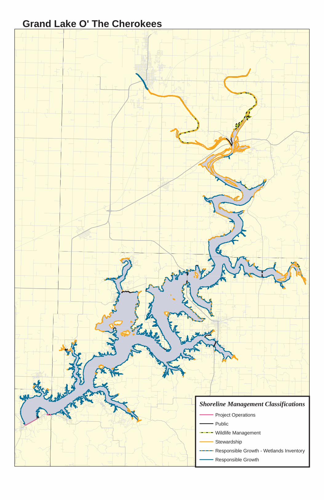
Grand Lake O' The Cherokees
0 3 61.5MilesShoreline Management Classifications
Project OperationsPublic Wildlife ManagementStewardship Responsible Growth - Wetlands InventoryResponsible Growth
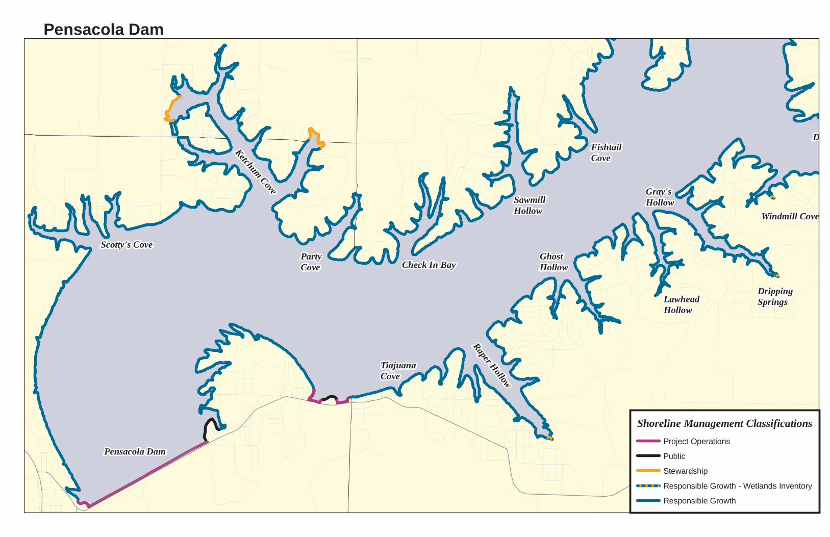
DrippingSprings
Windmill Cove
Scotty's Cove
Ketchum Cove
PartyCove
SawmillHollow
Check In Bay
TiajuanaCove
Raper Hollow
GhostHollow
Gray'sHollow
LawheadHollow
FishtailCove
Pensacola Dam
Drowning Creek
Pensacola Dam
Shoreline Management ClassificationsProject Operations Public Stewardship Responsible Growth - Wetlands InventoryResponsible Growth
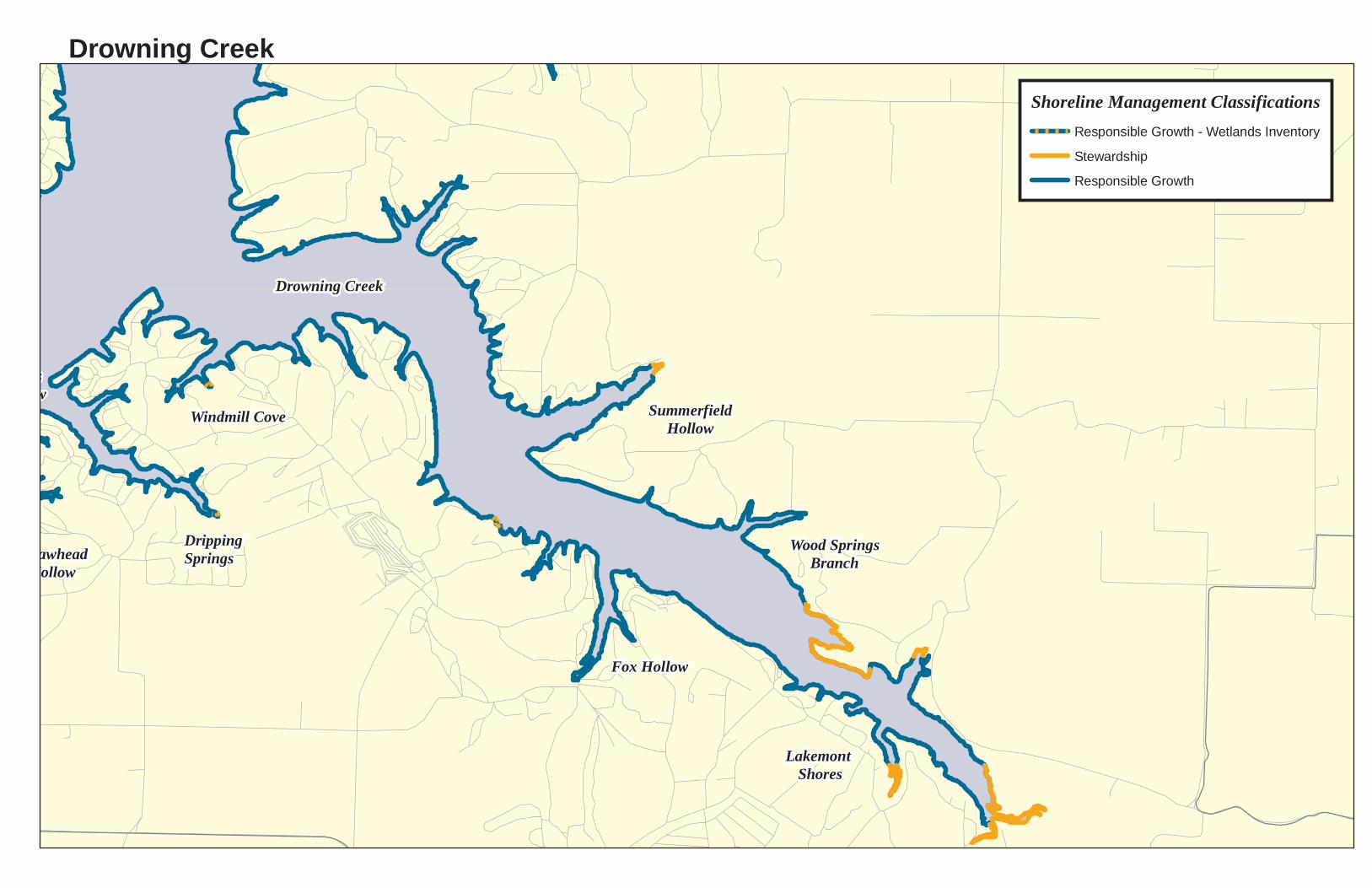
DrippingSprings
Windmill Cove
Fox Hollow
SummerfieldHollow
Wood SpringsBranch
Lakemont Shores
Dinosaur Point
Gray'sHollow
LawheadHollow
Drowning Creek
Drowning CreekShoreline Management Classifications
Responsible Growth - Wetlands InventoryStewardship Responsible Growth
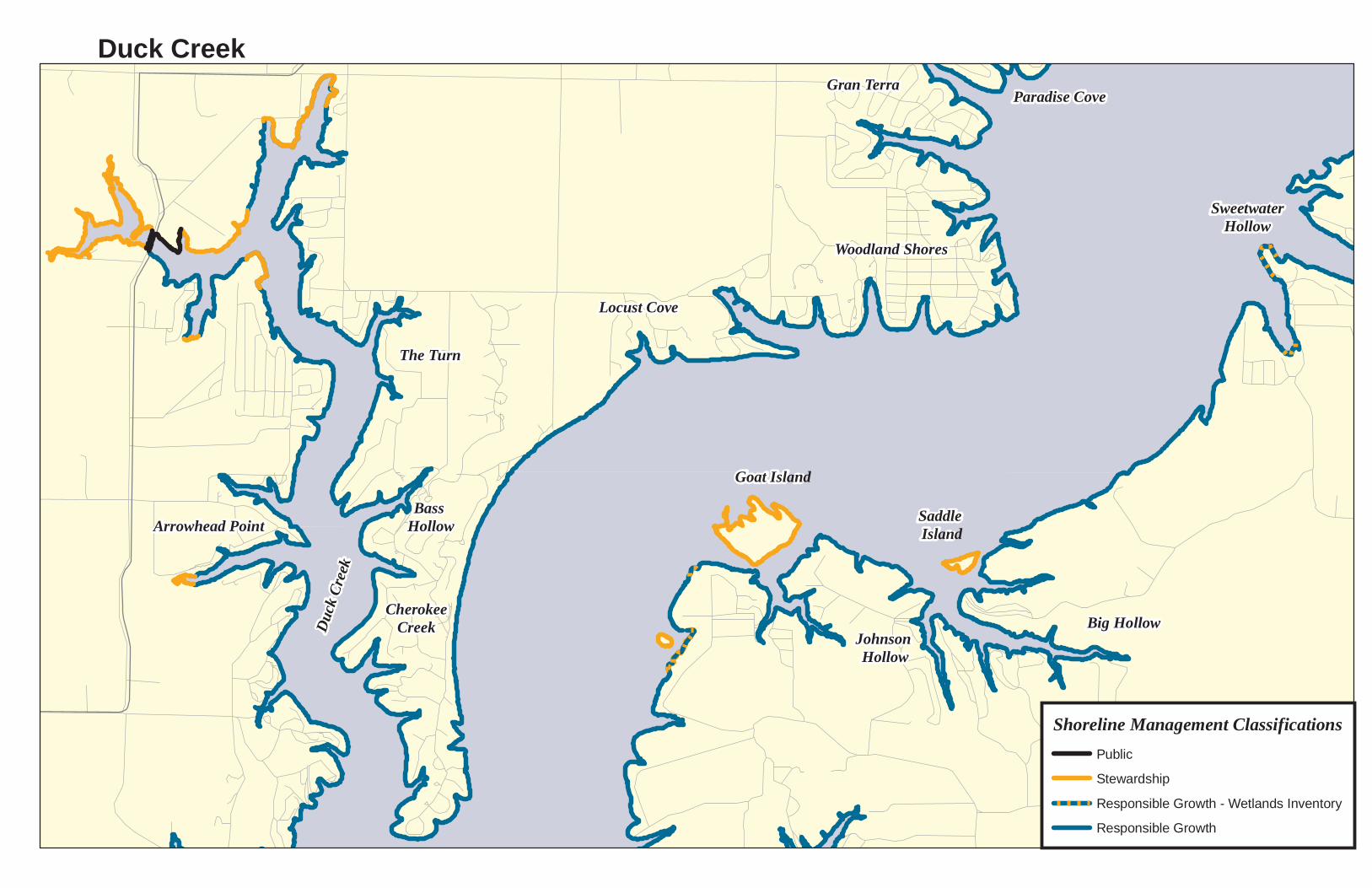
Goat Island
CherokeeCreek
Bass Hollow
The Turn
Arrowhead Point
Duck
Creek
Saddle Island
Johnson Hollow
Locust Cove
Woodland Shores
Gran Terra Paradise Cove
Big Hollow
SweetwaterHollow
Duck Creek
Shoreline Management ClassificationsPublic Stewardship Responsible Growth - Wetlands InventoryResponsible Growth
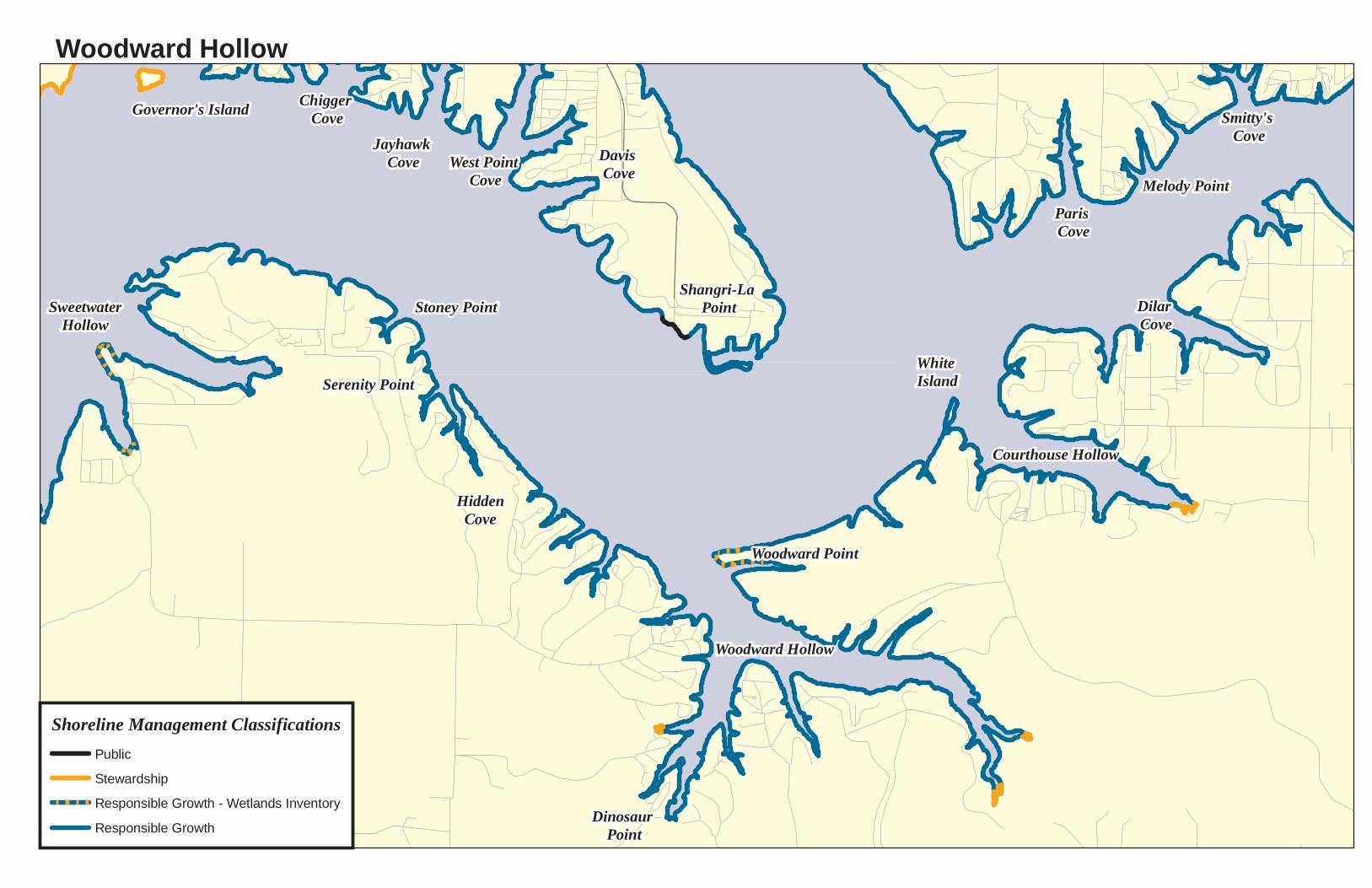
SweetwaterHollow
Serenity Point
Stoney Point
HiddenCove
Dinosaur Point
Woodward Hollow
Woodward Point
White Island
Courthouse Hollow
Dilar Cove
Paris Cove
Melody Point
Smitty's Cove
Governor's Island Chigger Cove
Jayhawk Cove West Point
CoveDavis Cove
Shangri-La Point
Woodward Hollow
Shoreline Management ClassificationsPublic Stewardship Responsible Growth - Wetlands InventoryResponsible Growth
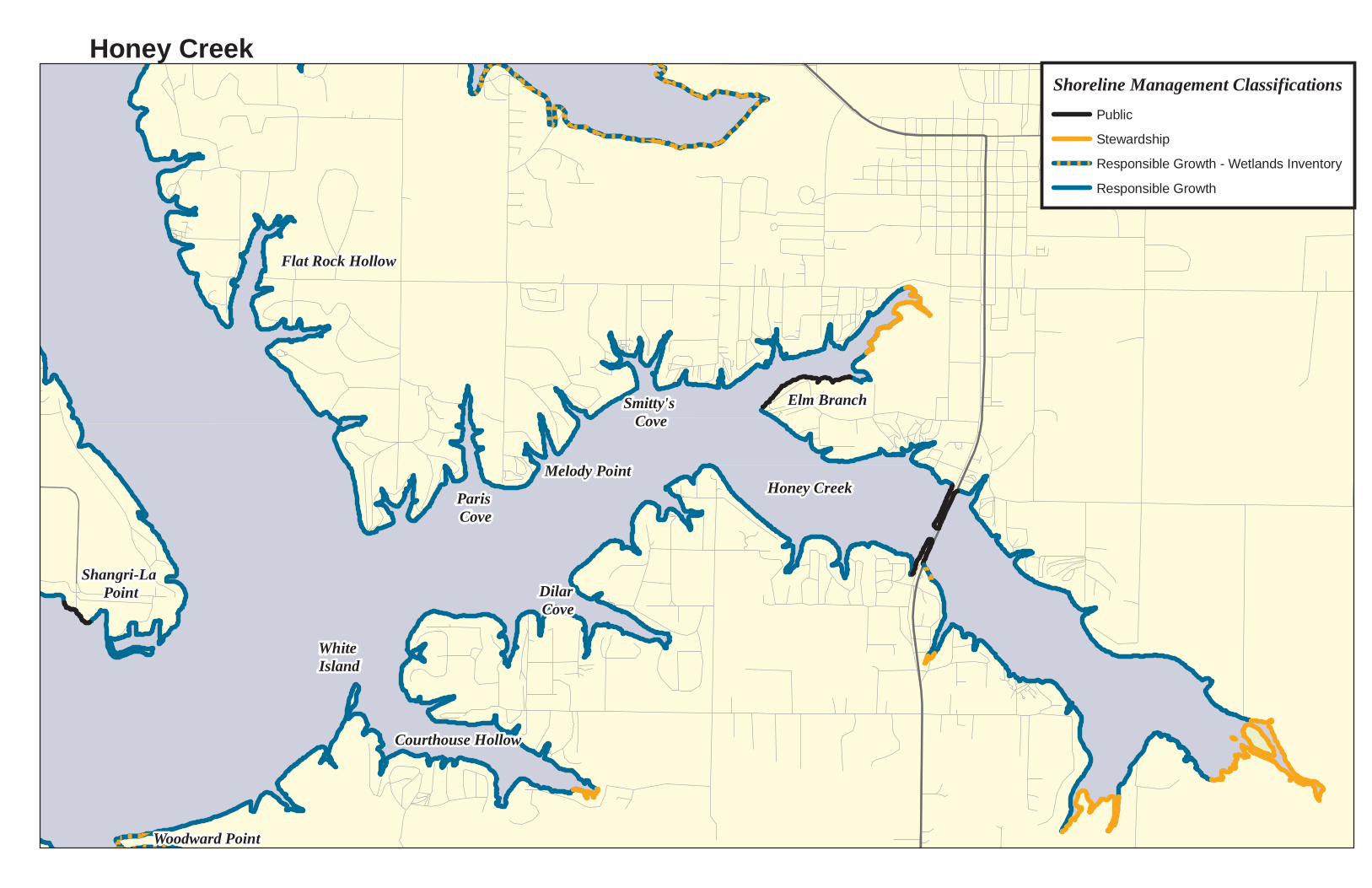
Woodward Point
White Island
Courthouse Hollow
Dilar Cove
Paris Cove
Melody Point
Smitty's Cove
Elm Branch
Honey Creek
Carey Bay
Port Duncan
Davis Cove
Shangri-La Point
Flat Rock Hollow
Honey CreekShoreline Management Classifications
Public Stewardship Responsible Growth - Wetlands InventoryResponsible Growth

Gran Terra Paradise Cove
Bad Island
Tera Miranda
Patricia Island
Snake Island
Governor's Island
Blackberry Island
West Bay
East Bay
Port Duncan
Chigger Cove
Jayhawk Cove West Point
CoveDavis Cove
BerniceBlackberry Island
Shoreline Management ClassificationsPublic Stewardship Responsible Growth - Wetlands InventoryResponsible Growth

Echo Bay
The Quarry
Bad Island
Horse Creek
Fly Creek
Bernice
Upper Horse CreekShoreline Management Classifications
Public Stewardship Responsible Growth - Wetlands InventoryResponsible Growth
Melody Point
Smitty's Cove
Elm Branch
Honey Creek
Carey Bay
Bad Island
Weed Island
Wolf CreekTera Miranda
Patricia Island
Governor's Island
West Bay
East Bay
Port Duncan
Chigger Cove
Jayhawk Cove West Point
CoveDavis Cove
Flat Rock Hollow
Monkey Island
Shoreline Management ClassificationsStewardship Responsible Growth - Wetland InventoryResponsible Growth
Carey Bay
Echo Bay
The Quarry
Catfish Cove
Bad Island
Weed Island
Shoal Islands
Grove Port
Hickory Island
Little Hickory
Hickory Point
Wolf CreekTera Miranda
Patricia Island
East Bay
Shoal IslandsShoreline Management Classifications
Public Stewardship Responsible Growth - Wetlands InventoryResponsible Growth
Catfish Cove
Shoal Islands
Grove Port
Hickory Island
Little Hickory
Hickory Point
Ice BoxPoint
BlueBluff
Cedar Cove
Hickory CreekShoreline Management Classifications
Public Stewardship Responsible Growth - Wetlands InventoryResponsible Growth
Elk River
Benbrook Cove
Cowskin Island
Ice BoxPoint
BlueBluff
Elk River
Elk RiverShoreline Management Classifications
Public Wildlife ManagementStewardship Responsible Growth - Wetlands InventoryResponsible Growth
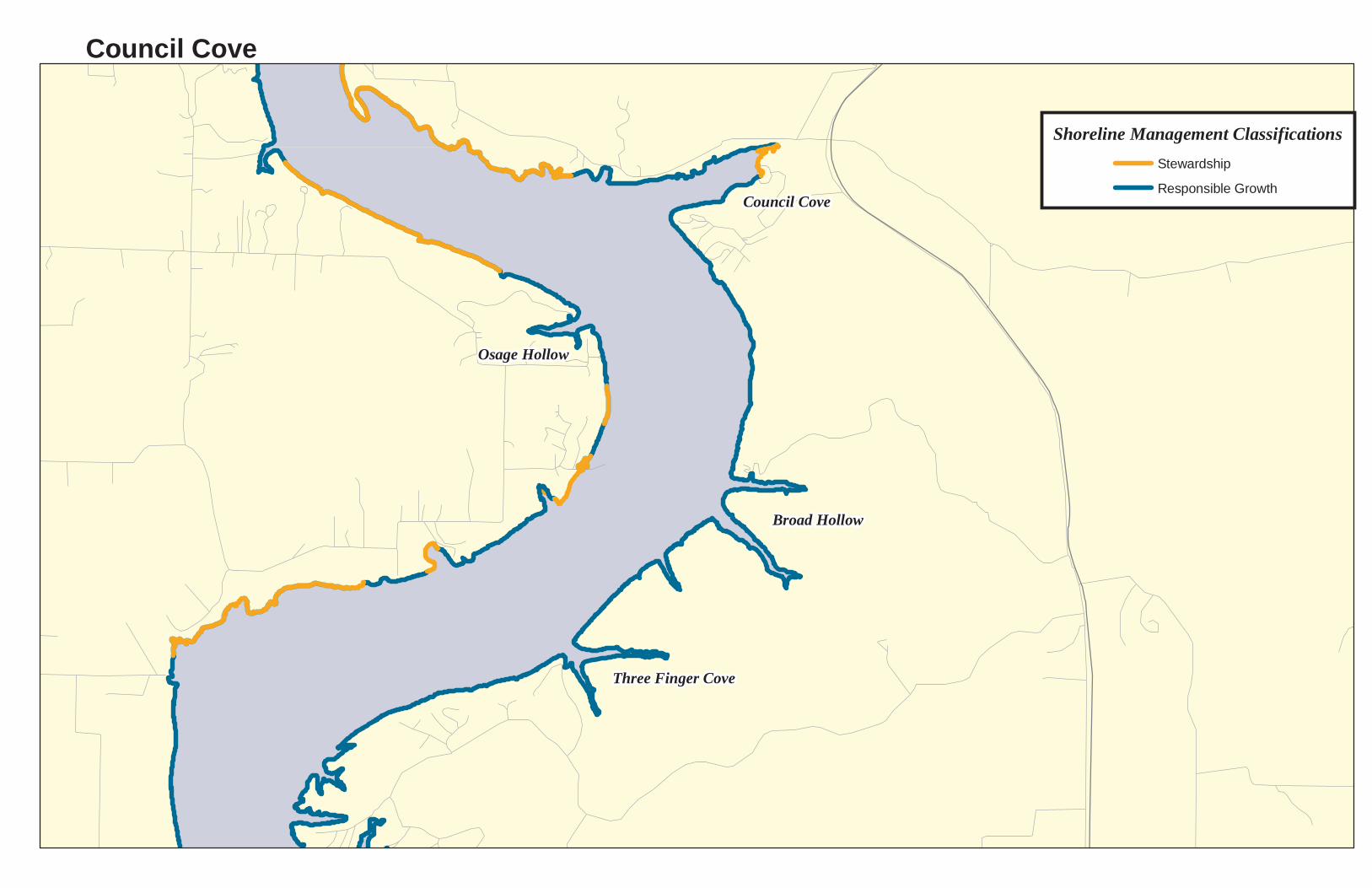
Three Finger Cove
Broad Hollow
Council Cove
Osage Hollow
Wilson PointCouncil Cove
Shoreline Management ClassificationsStewardship Responsible Growth
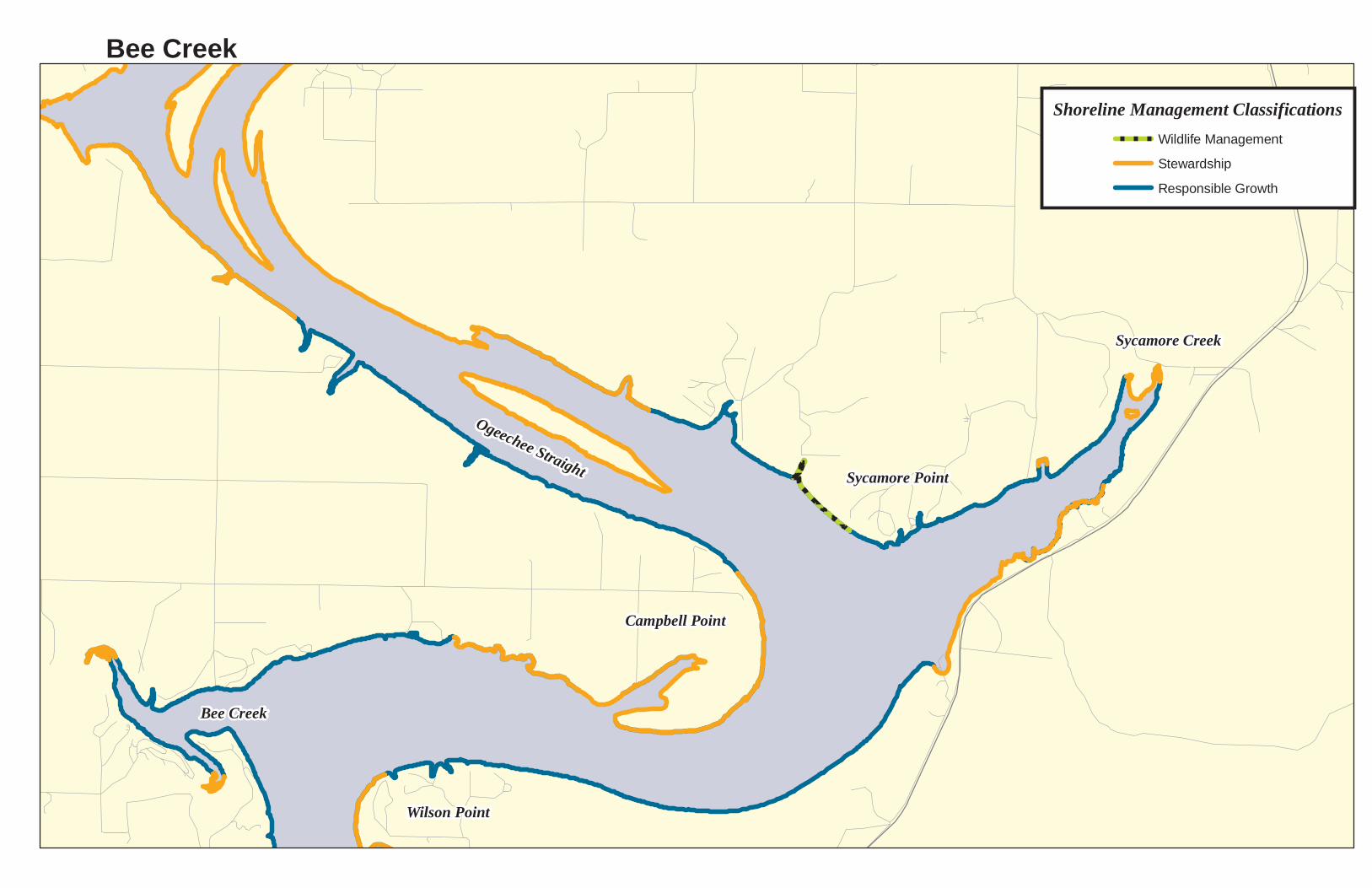
Bee Creek
Ogeechee Straight
Sycamore Creek
Sycamore Point
Campbell Point
Wilson Point
Bee CreekShoreline Management Classifications
Wildlife ManagementStewardship Responsible Growth

Wyandotte
Spring
River
Neosho River
Twin BridgesShoreline Management Classifications
Public Wildlife ManagementStewardship Responsible Growth

Spring
River
Neosho River
Neosho River
Spring RiverShoreline Management Classifications
Public Wildlife ManagementStewardship Responsible Growth - Wetland InventoryResponsible Growth
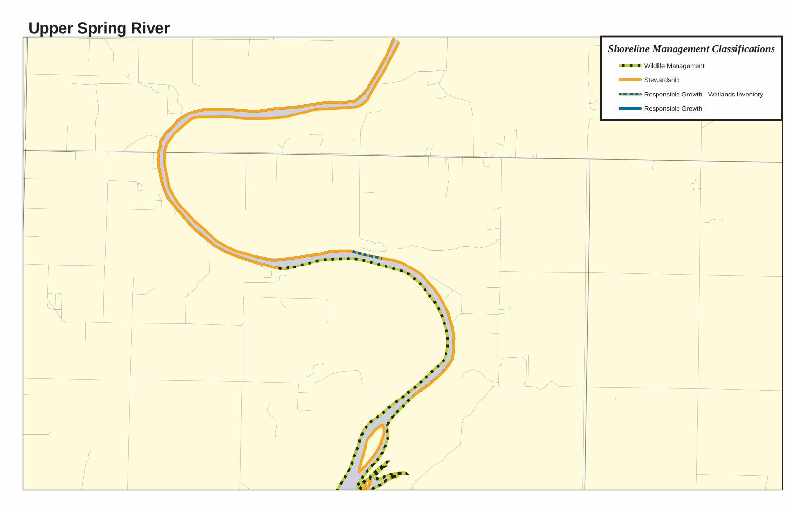
Upper Spring River
0 0.2 0.40.1 Miles
Shoreline Management ClassificationsWildlife ManagementStewardship Responsible Growth - Wetlands InventoryResponsible Growth
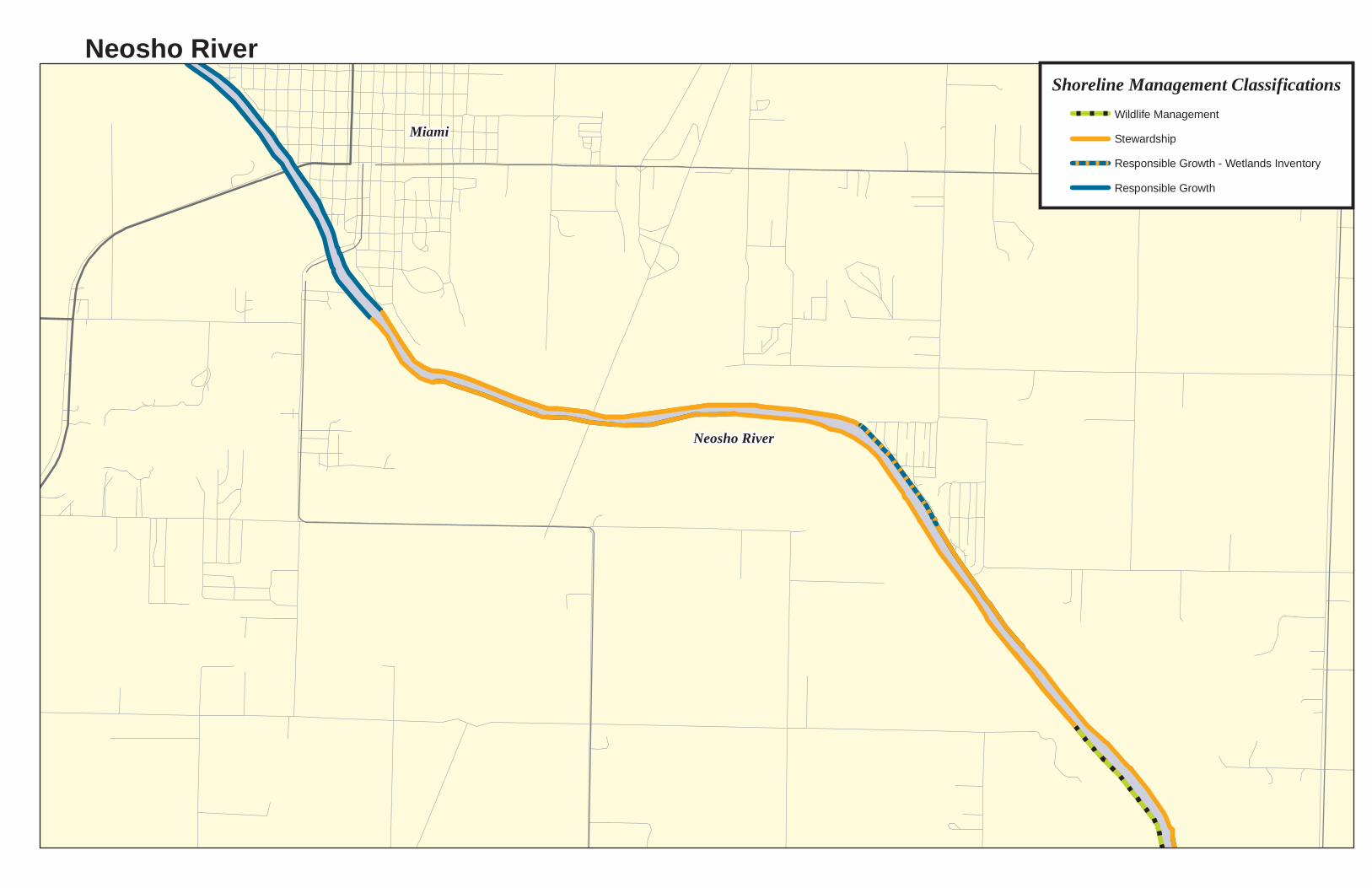
Neosho River
Miami
Neosho RiverShoreline Management Classifications
Wildlife ManagementStewardship Responsible Growth - Wetlands InventoryResponsible Growth

APPENDIX C
SUGGESTED BEST MANAGEMENT PRACTICES FOR NON-PROJECT LANDS

Buffer Zones and Vegetation Management
Vegetated shorelines are an important component of a healthy reservoir ecosystem.
These natural buffers act as filters, facilitating the absorption and processing of runoff
pollutants. This filtering reduces the amount of potentially harmful contaminants that enter the
lake and contribute to water quality degradation. In addition to filtering pollutants, vegetation
(preferably native species) works to preserve the physical integrity of the shoreline, preventing
excessive erosion that can lower water quality and degrade aquatic habitat. Naturally, vegetated
shorelines improve the aesthetic integrity of the reservoir and provide habitat for aquatic and
terrestrial species. The following practices are an integral part of GRDA’s efforts to maintain
and improve lands, water quality protection, shoreline stabilization, aesthetics, and wildlife
habitat within the Project boundary. As such, GRDA recommends these practices to property
owners outside the Project boundary as well.
1. Plant native trees, shrubs, and flowers for landscaping and gardens to reduce
watering as well as chemical and pesticide use.
2. Preserve or establish an unmanaged filter strip of natural vegetation along the
shoreline and keep clearing of native trees and vegetation to a minimum. GRDA
recommends a buffer measuring a minimum of xx feet horizontally from the top
of the normal pool elevation.
3. Plant a low maintenance, slow growing grass recommended for soil conditions
and climate.
4. Maintain the grass as high as possible to shade out weeds and improve rooting so
less fertilizing and watering are required.
5. Avoid dumping leaves or yard debris on or near the shoreline.
The introduction or planting of invasive plant species is prohibited on GRDA lands and
waters. In addition to any species designated by the Oklahoma Department of Wildlife
Conservation, a list of such species includes:

(1) Invasive or pest plants: Russian Olive; Sumac; Paper Mulberry; Saltcedar or Tamarisk;
Siberian Elm; Eastern Redcedar; Poison Ivy; Poison Oak; Poison Sumac.
(2) Noxious aquatic plants:
Azolla pinnata – Mosquito Fern (aka – Water Velvet, Water Fern); Caulerpa taxifolia –
Caulerpa (aka – Mediterranean Clone of Caulerpa); Eichhornia azure – Anchored Water
Hyacinth (aka – Rooted Water Hyacinth, Blue Water Hyacinth, Saw-petal Water
Hyacinth); Hydrilla verticillata – Hydrilla (aka – Florida Elodea, Star Vine, Oxygen
Plant, Oxygen Weed); Hygrophila polysperma – Hygro (aka – Miramar Weed, Green
Hygro, Oriental Ludwigia, East Indian Hygrophila); Ipomoea aquatica – Water Spinach
(aka - Swamp Morning Glory, Chinese Water Spinach, Water Bindweed, Aquatic
Morning Glory); Lagarosiphon major – African Elodea (aka – Oxygen Weed);
Limnophila species – Ambulia (aka – Asian Marshweed, Limno, Red Ambulia, Indian
Ambulia); Lythrum salicaria – Purple Loosestrife (aka – Loosestrife); Marsilea
quadrifolia – Marsilea (aka – European Waterclover, Four-leaf Clover Fern, Water Fern,
Water Clover, Hairy Pepperwort); Marsilea mutica – Australian Waterclover (aka –
Varigated Water-clover, Mardoo); Marsilea minuta – Waterclover; Melaleuca
quinquenervia – Paperbark Tree (aka – melaleuca, Cajeput, Punk); Monochoria hastate –
Cat’s Claw (aka – Monochoria); Ottellia alismoides – Duck Lettuce; Sagittaria
sagittifolia – Japanese Arrowhead (aka – Hawaiian Arrowhead, Common Arrowhead,
Chinese Arrowhead); Salvinia auriculata – Gian Salvinia (aka – Butterfly, Fern, Water
Fern, Water Moss); Salvinia biloba – Gioan Salvinia (aka – Salvinia); Salvinia herzogii –
Gian Salvinia (aka – Salvinia); Salvinia molesta – Gian Salvinia (aka – Salvinia, Water
Velvet, Karibaweed, Koi Kandy); Solanum tampicense – Wetland Nightshade;
Sparganium erectum – Exotic Bur-reed; Glossostigma diandrum – Mud Mat.
(3) Noxious non-aquatic plants: Musk Thistle; Canada Thistle; Scotch Thistle.
Water Quality
Water quality is an important indicator of the overall health of Grand Lake. Water
quality not only affects aquatic and terrestrial wildlife, but also the health and well-being of
individuals and communities that surround the Project. Water quality can be impaired in several
ways, one of which is through the introduction of pollutants from nonpoint sources (NPS).
Water run-off introduces NPS pollution into these reservoirs. Agriculture, forestry, construction,
and various other land use activities contribute to non-point pollution. As water runs off
surrounding lands, it picks up sediment, bacteria, oil, grease, and other pollutants as well as
nutrients such as nitrogen and phosphorus. Excessive levels of NPS pollution can overwhelm a
reservoir’s natural filtering abilities and can lead to a decrease in water quality levels. For a
complete technical reference concerning water quality on Grand Lake, please see the water
quality reports on the Oklahoma Office of the Secretary of the Environment website.

APPENDIX D
LICENSE ARTICLES RELEVANT TO THE PENSACOLA PROJECT’S SHORELINE MANAGEMENT
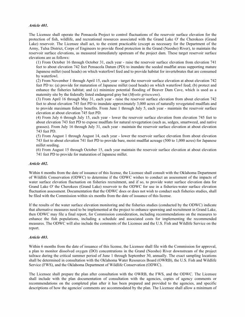
Article 401. The Licensee shall operate the Pensacola Project to control fluctuations of the reservoir surface elevation for the protection of fish, wildlife, and recreational resources associated with the Grand Lake O' the Cherokees (Grand Lake) reservoir. The Licensee shall act, to the extent practicable (except as necessary for the Department of the Army, Tulsa District, Corps of Engineers to provide flood protection in the Grand (Neosho) River), to maintain the reservoir surface elevations, as measured immediately upstream of the project dam. These target reservoir surface elevations are as follows:
(1) From October 16 through October 31, each year - raise the reservoir surface elevation from elevation 741 feet to about elevation 742 feet Pensacola Datum (PD) to inundate the seeded mudflat areas supporting mature Japanese millet (seed heads) on which waterfowl feed and to provide habitat for invertebrates that are consumed by waterfowl. (2) From November 1 through April 15, each year - target the reservoir surface elevation at about elevation 742 feet PD to: (a) provide for maturation of Japanese millet (seed heads) on which waterfowl feed; (b) protect and enhance the fisheries habitat; and (c) minimize potential flooding of Beaver Dam Cave, which is used as a maternity site by the federally listed endangered gray bat (Myotis grisescens). (3) From April 16 through May 31, each year - raise the reservoir surface elevation from about elevation 742 feet to about elevation 745 feet PD to inundate approximately 3,000 acres of naturally revegetated mudflats and to provide maximum fishery benefits. From June 1 through July 5, each year - maintain the reservoir surface elevation at about elevation 745 feet PD. (4) From July 6 through July 15, each year - lower the reservoir surface elevation from elevation 745 feet to about elevation 743 feet PD to expose mudflats for natural revegetation (such as, sedges, smartweed, and native grasses). From July 16 through July 31, each year - maintain the reservoir surface elevation at about elevation 743 feet PD. (5) From August 1 through August 14, each year - lower the reservoir surface elevation from about elevation 743 feet to about elevation 741 feet PD to provide bare, moist mudflat acreage (500 to 1,000 acres) for Japanese millet seeding. (6) From August 15 through October 15, each year maintain the reservoir surface elevation at about elevation 741 feet PD to provide for maturation of Japanese millet.
Article 402. Within 6 months from the date of issuance of this license, the Licensee shall consult with the Oklahoma Department of Wildlife Conservation (ODWC) to determine if the ODWC wishes to conduct an assessment of the impacts of water surface elevation fluctuation on fisheries recruitment, and if so, to provide water surface elevation data for Grand Lake O' the Cherokees (Grand Lake) reservoir to the ODWC for use in a fisheries-water surface elevation fluctuation assessment. Documentation that the ODWC does or does not wish to conduct such fisheries studies, shall be filed with the Commission within six months from the date of issuance of this license. If the results of the water surface elevation monitoring and the fisheries studies (conducted by the ODWC) indicate that alternative measures need to be implemented at the project to enhance spawning and recruitment in Grand Lake, then ODWC may file a final report, for Commission consideration, including recommendations on the measures to enhance the fish populations, including a schedule and associated costs for implementing the recommended measures. The ODWC will also include the comments of the Licensee and the U.S. Fish and Wildlife Service on the report. Article 403. Within 6 months from the date of issuance of this license, the Licensee shall file with the Commission for approval, a plan to monitor dissolved oxygen (DO) concentrations in the Grand (Neosho) River downstream of the project tailrace during the critical summer period of June 1 through September 30, annually. The exact sampling locations shall be determined in consultation with the Oklahoma Water Resources Board (OWRB), the U.S. Fish and Wildlife Service (FWS), and the Oklahoma Department of Wildlife Conservation (ODWC). The Licensee shall prepare the plan after consultation with the OWRB, the FWS, and the ODWC. The Licensee shall include with the plan documentation of consultation with the agencies, copies of agency comments or recommendations on the completed plan after it has been prepared and provided to the agencies, and specific descriptions of how the agencies' comments are accommodated by the plan. The Licensee shall allow a minimum of
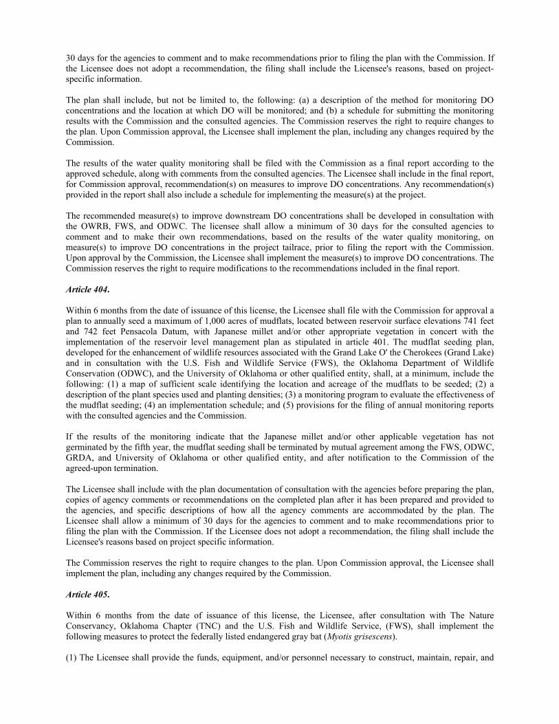
30 days for the agencies to comment and to make recommendations prior to filing the plan with the Commission. If the Licensee does not adopt a recommendation, the filing shall include the Licensee's reasons, based on project-specific information. The plan shall include, but not be limited to, the following: (a) a description of the method for monitoring DO concentrations and the location at which DO will be monitored; and (b) a schedule for submitting the monitoring results with the Commission and the consulted agencies. The Commission reserves the right to require changes to the plan. Upon Commission approval, the Licensee shall implement the plan, including any changes required by the Commission. The results of the water quality monitoring shall be filed with the Commission as a final report according to the approved schedule, along with comments from the consulted agencies. The Licensee shall include in the final report, for Commission approval, recommendation(s) on measures to improve DO concentrations. Any recommendation(s) provided in the report shall also include a schedule for implementing the measure(s) at the project. The recommended measure(s) to improve downstream DO concentrations shall be developed in consultation with the OWRB, FWS, and ODWC. The licensee shall allow a minimum of 30 days for the consulted agencies to comment and to make their own recommendations, based on the results of the water quality monitoring, on measure(s) to improve DO concentrations in the project tailrace, prior to filing the report with the Commission. Upon approval by the Commission, the Licensee shall implement the measure(s) to improve DO concentrations. The Commission reserves the right to require modifications to the recommendations included in the final report. Article 404. Within 6 months from the date of issuance of this license, the Licensee shall file with the Commission for approval a plan to annually seed a maximum of 1,000 acres of mudflats, located between reservoir surface elevations 741 feet and 742 feet Pensacola Datum, with Japanese millet and/or other appropriate vegetation in concert with the implementation of the reservoir level management plan as stipulated in article 401. The mudflat seeding plan, developed for the enhancement of wildlife resources associated with the Grand Lake O' the Cherokees (Grand Lake) and in consultation with the U.S. Fish and Wildlife Service (FWS), the Oklahoma Department of Wildlife Conservation (ODWC), and the University of Oklahoma or other qualified entity, shall, at a minimum, include the following: (1) a map of sufficient scale identifying the location and acreage of the mudflats to be seeded; (2) a description of the plant species used and planting densities; (3) a monitoring program to evaluate the effectiveness of the mudflat seeding; (4) an implementation schedule; and (5) provisions for the filing of annual monitoring reports with the consulted agencies and the Commission. If the results of the monitoring indicate that the Japanese millet and/or other applicable vegetation has not germinated by the fifth year, the mudflat seeding shall be terminated by mutual agreement among the FWS, ODWC, GRDA, and University of Oklahoma or other qualified entity, and after notification to the Commission of the agreed-upon termination. The Licensee shall include with the plan documentation of consultation with the agencies before preparing the plan, copies of agency comments or recommendations on the completed plan after it has been prepared and provided to the agencies, and specific descriptions of how all the agency comments are accommodated by the plan. The Licensee shall allow a minimum of 30 days for the agencies to comment and to make recommendations prior to filing the plan with the Commission. If the Licensee does not adopt a recommendation, the filing shall include the Licensee's reasons based on project specific information. The Commission reserves the right to require changes to the plan. Upon Commission approval, the Licensee shall implement the plan, including any changes required by the Commission. Article 405. Within 6 months from the date of issuance of this license, the Licensee, after consultation with The Nature Conservancy, Oklahoma Chapter (TNC) and the U.S. Fish and Wildlife Service, (FWS), shall implement the following measures to protect the federally listed endangered gray bat (Myotis grisescens). (1) The Licensee shall provide the funds, equipment, and/or personnel necessary to construct, maintain, repair, and
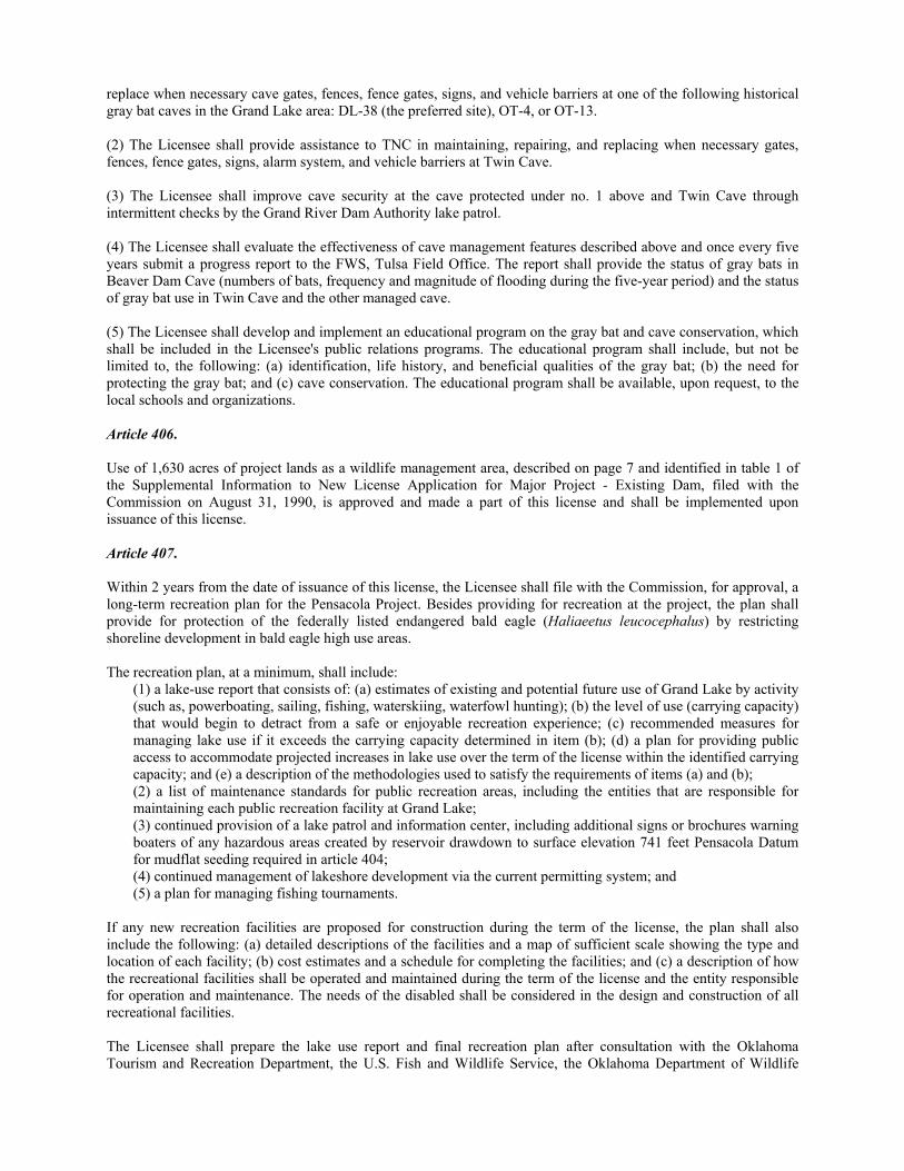
replace when necessary cave gates, fences, fence gates, signs, and vehicle barriers at one of the following historical gray bat caves in the Grand Lake area: DL-38 (the preferred site), OT-4, or OT-13. (2) The Licensee shall provide assistance to TNC in maintaining, repairing, and replacing when necessary gates, fences, fence gates, signs, alarm system, and vehicle barriers at Twin Cave. (3) The Licensee shall improve cave security at the cave protected under no. 1 above and Twin Cave through intermittent checks by the Grand River Dam Authority lake patrol. (4) The Licensee shall evaluate the effectiveness of cave management features described above and once every five years submit a progress report to the FWS, Tulsa Field Office. The report shall provide the status of gray bats in Beaver Dam Cave (numbers of bats, frequency and magnitude of flooding during the five-year period) and the status of gray bat use in Twin Cave and the other managed cave. (5) The Licensee shall develop and implement an educational program on the gray bat and cave conservation, which shall be included in the Licensee's public relations programs. The educational program shall include, but not be limited to, the following: (a) identification, life history, and beneficial qualities of the gray bat; (b) the need for protecting the gray bat; and (c) cave conservation. The educational program shall be available, upon request, to the local schools and organizations. Article 406. Use of 1,630 acres of project lands as a wildlife management area, described on page 7 and identified in table 1 of the Supplemental Information to New License Application for Major Project - Existing Dam, filed with the Commission on August 31, 1990, is approved and made a part of this license and shall be implemented upon issuance of this license. Article 407. Within 2 years from the date of issuance of this license, the Licensee shall file with the Commission, for approval, a long-term recreation plan for the Pensacola Project. Besides providing for recreation at the project, the plan shall provide for protection of the federally listed endangered bald eagle (Haliaeetus leucocephalus) by restricting shoreline development in bald eagle high use areas. The recreation plan, at a minimum, shall include:
(1) a lake-use report that consists of: (a) estimates of existing and potential future use of Grand Lake by activity (such as, powerboating, sailing, fishing, waterskiing, waterfowl hunting); (b) the level of use (carrying capacity) that would begin to detract from a safe or enjoyable recreation experience; (c) recommended measures for managing lake use if it exceeds the carrying capacity determined in item (b); (d) a plan for providing public access to accommodate projected increases in lake use over the term of the license within the identified carrying capacity; and (e) a description of the methodologies used to satisfy the requirements of items (a) and (b); (2) a list of maintenance standards for public recreation areas, including the entities that are responsible for maintaining each public recreation facility at Grand Lake; (3) continued provision of a lake patrol and information center, including additional signs or brochures warning boaters of any hazardous areas created by reservoir drawdown to surface elevation 741 feet Pensacola Datum for mudflat seeding required in article 404; (4) continued management of lakeshore development via the current permitting system; and (5) a plan for managing fishing tournaments.
If any new recreation facilities are proposed for construction during the term of the license, the plan shall also include the following: (a) detailed descriptions of the facilities and a map of sufficient scale showing the type and location of each facility; (b) cost estimates and a schedule for completing the facilities; and (c) a description of how the recreational facilities shall be operated and maintained during the term of the license and the entity responsible for operation and maintenance. The needs of the disabled shall be considered in the design and construction of all recreational facilities. The Licensee shall prepare the lake use report and final recreation plan after consultation with the Oklahoma Tourism and Recreation Department, the U.S. Fish and Wildlife Service, the Oklahoma Department of Wildlife
Conservation, and the National Park Service. The Licensee shall include with the final plan documentation of consultation and copies of comments and recommendations on the lake use report and final plan after they have been prepared and provided to the agencies, and specific descriptions of how the agencies' comments are accommodated. The Licensee shall allow a minimum of 30 days for the agencies to comment and to make recommendations prior to filing the final plan with the Commission. If the Licensee does not adopt a recommendation, the filing shall include the Licensee's reasons, based on project-specific information. The Commission reserves the right to require changes to the plan. Upon Commission approval, the Licensee shall implement the plan, including any changes required by the Commission. Article 408. Within 1 year from the date of issuance of this license, the Licensee shall upgrade or arrange for the upgrading of the Duck Creek boat launch facilities at the Ketchum Recreation Area. Specifically, the Licensee shall: (1) elevate, to at least reservoir surface elevation 746 feet Pensacola Datum, and gravel the parking area; (2) widen the access road to accommodate two vehicles; (3) trim the brush along the access road; and (4) place a sign at the entrance of the access road to designate the area. The Licensee shall upgrade these facilities after consultation with the Oklahoma Tourism and Recreation Department, the Oklahoma Department of Wildlife Conservation, and the Department of the Army, Tulsa District, Corps of Engineers. The Licensee shall, within 90 days of completion of construction of the recreation facilities, as improved, file as-built drawings of those recreation facilities. The Licensee shall file a statement with the as-built drawings, indicating the entity responsible for operation and maintenance of the facilities. Article 409. The Licensee, before starting any land-clearing or ground-disturbing activities within the project boundaries, other than those specifically authorized in this license, including recreation developments at the project, shall consult with the State Historic Preservation Officer (SHPO). If the Licensee discovers previously unidentified archeological or historic properties during the course of constructing or developing project works or other facilities (including recreation developments) at the project, the Licensee shall stop all land-clearing and land-disturbing activities in the vicinity of the properties and consult with the SHPO. In either instance, the Licensee shall file for Commission approval a cultural resource management plan prepared by a qualified cultural resource specialist after having consulted with the SHPO. The management plan shall include the following items: (1) a description of each discovered property indicating whether it is listed on or eligible to be listed on the National Register of Historic Places; (2) a description of the potential effect on each discovered property; (3) proposed measures for avoiding or mitigating effects; (4) documentation of the nature and extent of consultation; and (5) a schedule for mitigating effects and conducting additional studies. The Commission may require changes to the plan. The Licensee shall not begin land-clearing or ground-disturbing activities, other than those specifically authorized in this license, or resume such activities in the vicinity of a property, discovered during construction or operation, until informed that the requirements of this article have been fulfilled. Article 410. (a) In accordance with the provisions of this article, the Licensee shall have the authority to grant permission for certain types of use and occupancy of project lands and waters and to convey certain interests in project lands and waters for certain types of use and occupancy, without prior Commission approval. The Licensee may exercise the authority only if the proposed use and occupancy is consistent with the purposes of protecting and enhancing the scenic, recreational, and other environmental values (especially federally listed species) of the project. For those purposes, the Licensee shall also have continuing responsibility to supervise and control the use and occupancies for which it grants permission, and to monitor the use of, and ensure compliance with the covenants of the instrument of
conveyance for, any interests that it has conveyed, under this article. If a permitted use and occupancy violates any condition of this article or any other condition imposed by the Licensee for protection and enhancement of the project's scenic, recreational, or other environmental values, or if a covenant of a conveyance made under the authority of this article is violated, the Licensee shall take any lawful action necessary to correct the violation. For a permitted use or occupancy, that action includes, if necessary, canceling the permission to use and occupy the project lands and waters and requiring the removal of any noncomplying structures and facilities. (b) The type of use and occupancy of project lands and water for which the Licensee may grant permission without prior Commission approval are: (1) landscape plantings; (2) noncommercial piers, landings, boat docks, or similar structures and facilities that can accommodate no more than 10 watercraft at a time and where said facility is intended to serve single-family type dwellings; and (3) embankments, bulkheads, retaining walls, or similar structures for erosion control to protect the existing shoreline. To the extent feasible and desirable to protect and enhance the project's scenic, recreational, and other environmental values, the Licensee shall require multiple use and occupancy of facilities for access to project lands or waters. The Licensee shall also ensure, to the satisfaction of the Commission's authorized representative, that the use and occupancies for which it grants permission are maintained in good repair and comply with applicable state and local health and safety requirements. Before granting permission for construction of bulkheads or retaining walls, the Licensee shall: (1) inspect the site of the proposed construction, (2) consider whether the planting of vegetation or the use of riprap would be adequate to control erosion at the site, and (3) determine that the proposed construction is needed and would not change the basic contour of the reservoir shoreline. To implement this paragraph (b), the Licensee may, among other things, establish a program for issuing permits for the specified types of use and occupancy of project lands and waters, which may be subject to the payment of a reasonable fee to cover the Licensee's costs of administering the permit program. The Commission reserves the right to require the Licensee to file a description of its standards, guidelines, and procedures for implementing this paragraph (b) and to require modification of those standards, guidelines, or procedures. (c) The Licensee may convey easements or rights-of-way across, or leases of, project lands for: (1) replacement, expansion, realignment, or maintenance of bridges and roads for which all necessary state and federal approvals have been obtained; (2) storm drains and water mains; (3) sewers that do not discharge into project waters; (4) minor access roads; (5) telephone, gas, and electric utility distribution lines; (6) nonproject overhead electric transmission lines that do not require erection of support structures within the project boundary; (7) submarine, overhead, or underground major telephone distribution cables or major electric distribution lines (69 kV or less); and (8) water intake or pumping facilities that do not extract more than one million gallons per day from a project reservoir. No later than January 31 of each year, the Licensee shall file three copies of a report briefly describing for each conveyance made under this paragraph (c) during the prior calendar year, the type of interest conveyed, the location of the lands subject to the conveyance, and the nature of the use for which the interest was conveyed. (d) The Licensee may convey fee title to, easements or rights-of-way across, or leases of project lands for: (1) construction of new bridges or roads for which all necessary state and federal approvals have been obtained; (2) sewer or effluent lines that discharge into project waters, for which all necessary federal and state water quality certification or permits have been obtained; (3) other pipelines that cross project lands or waters but do not discharge into project waters; (4) nonproject overhead electric transmission lines that require erection of support structures within the project boundary, for which all necessary federal and state approvals have been obtained; (5) private or public marinas that can accommodate no more than 10 watercraft at a time and are located at least one-half mile from any other private or public marina; (6) recreational development consistent with an approved exhibit R or approved report on recreational resources of an exhibit E; and (7) other uses, if: (i) the amount of land conveyed for a particular use is five acres or less; (ii) all of the land conveyed is located at least 75 feet, measured horizontally, from the edge of the project reservoir at normal maximum surface elevation; and (iii) no more than 50 total acres of project lands for each project development are conveyed under this clause (d)(7) in any calendar year. At least 45 days before conveying any interest in project lands under this paragraph (d), the Licensee must submit a letter to the Director, Office of Hydropower Licensing, stating its intent to convey the interest and briefly describing the type of interest and location of the lands to be conveyed (a marked exhibit G or K map may be used), the nature of the proposed use, the identity of any federal or state agency official consulted, and any federal or state approvals required for the proposed use. Unless the Director, within 45 days from the filing date, requires the Licensee to file an application for prior approval, the Licensee may convey the intended interest at the end of that period. (e) The following additional conditions apply to any intended conveyance under paragraph (c) or (d) of this article:
(1) Before conveying the interest, the Licensee shall consult with federal and state fish and wildlife or recreation
agencies, as appropriate, and the State Historic Preservation Officer. (2) Before conveying the interest, the Licensee shall determine that the proposed use of the lands to be conveyed is not inconsistent with any approved exhibit R or approved report on recreational resources of an exhibit E; or, if the project does not have an approved exhibit R or approved report on recreational resources, that the lands to be conveyed do not have recreational value. (3) The instrument of conveyance must include covenants running with the land adequate to ensure that: (i) the use of the lands conveyed shall not endanger health, create a nuisance, or otherwise be incompatible with overall project recreational use; and (ii) the grantee shall take all reasonable precautions to insure that the construction, operation, and maintenance of structures or facilities on the conveyed lands will occur in a manner that will protect the scenic, recreational, and environmental values of the project. (4) The Commission reserves the right to require the Licensee to take reasonable remedial action to correct any violation of the terms and conditions of this article, for the protection and enhancement of the project's scenic, recreational, and other environmental values.
(f) The conveyance of an interest in project lands under this article does not in itself change the project boundaries. The project boundaries may be changed to exclude land conveyed under this article only upon approval of revised exhibit G or K drawings (project boundary maps) reflecting exclusion of that land. Lands conveyed under this article will be excluded from the project only upon a determination that the lands are not necessary for project purposes, such as operation and maintenance, flowage, recreation, public access, protection of environmental resources, and shoreline control, including shoreline aesthetic values. Absent extraordinary circumstances, proposals to exclude lands conveyed under this article from the project shall be consolidated for consideration when revised exhibit G or K drawings would be filed for approval for other purposes. (g) The authority granted to the Licensee under this article shall not apply to any part of the public lands and reservations of the United States included within the project boundary.