Embed Size (px)
Citation preview
CHAPTER II
SHILLONG IN ITS PHYSICAL SETTING
Page No.
2.1 Introduction 33
2.2 Geology 33
2.3 Geology of the Study Area 36
2.4 Topography 40
2.5 Drainage 44
2.6 Soils 46
2.7 Climate 48
2.8 Natural Vegetation 50
2.9 Morphometric Analysis 51
2.1 Introduction
In order to view the nature of the growth of Shillong urban agglomeration and
associated problems of waste disposal and water supply it becomes imperative to have an
insight into the physical/geographical setting of Shillong. In this chapter an attempt has
been made to have a general understanding of the underlying geology, topography, soil,
climate and vegetation of the Urban Agglomeration of Shillong.
Under the impact of urban growth the steep slopes are coming under constructional
activities thereby resulting to break of slopes,-soil erosion, enhancing landslides and mass
wasting. Hence an attempt has been made here for the morphometric analysis of the relief
and slope as this helps in identifying the areas not ideal for settlements. The major
drainage basins on which the urban units of Shillong are located have also been identified.
The present urban sprawl is affecting these drainage basins due to unscientific waste
disposal and land reclamation from the streams resulting to geo-environmental problems.
The underlying geology plays a significant role in the evolution of topography and
the hydrological characteristics. Hence an attempt is being made here to have an
understanding of the geology of Meghalaya in general and Shillong in particular
2.2 Geology
The first geological study of the Shillong Plateau was initiated by Oldham (1858)'
followed by systematic mapping of the region carried out by Medlicott (1869)^ who in
spite of all the limitations and heavy odds of the hostile terrain has critically examined the
geological occurrence of the area.
34
Other geological work in the area was carried out by Palmer (1923) followed by
Ghosh (1936-39)'* which led to the establishment of the strategraphic sequence of the
region. However, the compiled geological framework of Meghalaya plateau has been
provided by Murthy (1976)̂ and Mazumdar (1986) .̂ The generalised stratigraphic
sequence is given in the table 2.1 while the description of the lithographic groups are as
follows:
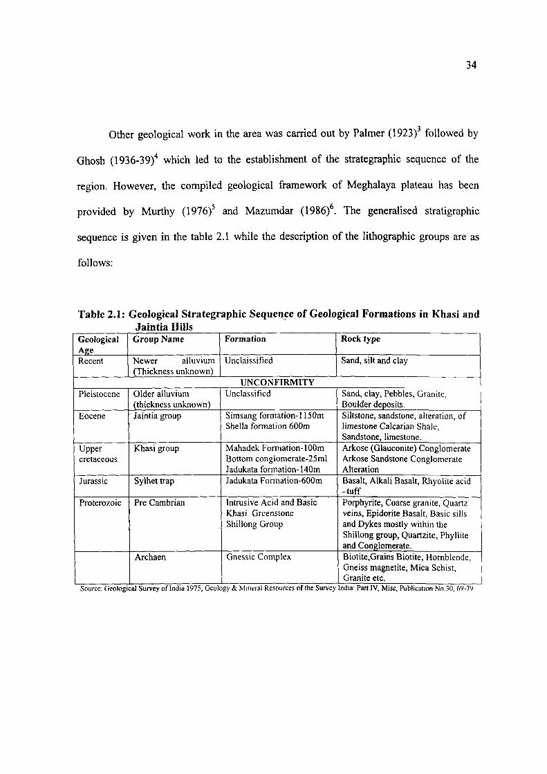
Table 2.1: Geological Strategraphic Sequence of Geological Formations in Khasi and Jaintia Hills
Geological Age Recent
Group Name
Newer alluvium (Thickness unknown)
Formation
Unclaissified
Rock type
Sand, silt and clay
UNCONFIRMITY Pleistocene
Eocene
Upper cretaceous
Jurassic
Proterozoic
Older alluvium (thickness unknown) Jaintia group
Khasi group
Sylhet trap
Pre Cambrian
Archaen
Unclassified
Simsang formation-1150m Sheila formation 600m
Mahadek Formation-100m Bottom conglomerate-25ml Jadukata formation-140m Jadukata Formation-600m
Intrusive Acid and Basic Khasi Greenstone Shillong Group
Gnessic Complex
Sand, clay, Pebbles, Granite, Boulder deposits. Siltstone, sandstone, alteration, of limestone Calcarian Shale, Sandstone, limestone. Arkose (Glauconite) Conglomerate Arkose Sandstone Conglomerate Alteration Basalt, Alkali Basah, Rhyolite acid -tuff Porphyrite, Coarse granite, Quartz veins, Epidorite Basalt, Basic sills and Dykes mostly within the Shillong group, Quartzite, Phyllite and Conglomerate. Biotite,Grains Biotite, Hornblende, Gneiss magnetite. Mica Schist, Granite etc.
Source, Geological Survey of India 1975, Geology & Mineral Resources of the Survey India- Part IV, Misc, Publication No.30, 69-79
35
The Gneissic complex
The Gneissic complex is exposed in the central and northern part of the Meghalaya
Plateau and comprises mainly of gneisses of various composition.
Structurally the Gneissic complex, which has been called the "Archean Gneiss
complex", shows a very complex and polyphase folding, currently with multi stage
metamorphism as has been identified by Murthy (1976)^.
Non-Perphyritic Nigmatitic Granitites
This class of rocks occurs through out the Gneissic complex in all scales as
vienlets, interspatial permeation, patches and smaller irregular bodies.
Shillong Group
This overlies the Gneissic complex with an unconformity, comprising of variable
quartzite amid phyllites, sandstones, siltstones, schist etc.
The Shillong group of rocks is weakly metamorphosed except at few places, which
show higher degree of metamorphism.
This group of rocks shows a zone of sub vertical dips with local reversals from
west of Mawphalang up to Barapani, away from this zone the dips show gentle rolling
disposition. Such folding represents "Intermediate crestal type folding", Beloussov
(1962f.
36
The Khasi Greenstone
This group occurs as isolated bodies in the Shillong group of rocks. These are
intrusive having both argillaceous and arenaceous character. The Khasi greenstones are
represented mainly by dolerite, epidorite and amphibolites. The overall structural pattern of
the Khasi Greenstone suggests a NE-SW axis.
The Sylhet Trap
This comprises predominantly of basalts, rhyolite etc. This type of rocks is found
along the southern border of the Shillong plateau. The maximum exposed thickness is
about 500-600m.
Cretaceous-Tertiary Sediments
These groups of rocks occupy the southern part of the Meghalaya plateau. They
occur as thick extensive sedimentary sequence comprising of sandstones, shales and
limestones that occur as- (a) Discrete outliers, (b) a continuous narrow belt fringing the
southern margin of the state bordering the Bangladesh plains.
The sediments here are divided into three major groups: (a) Khasi group, (b) Jaintia
group and (c) Garo group.
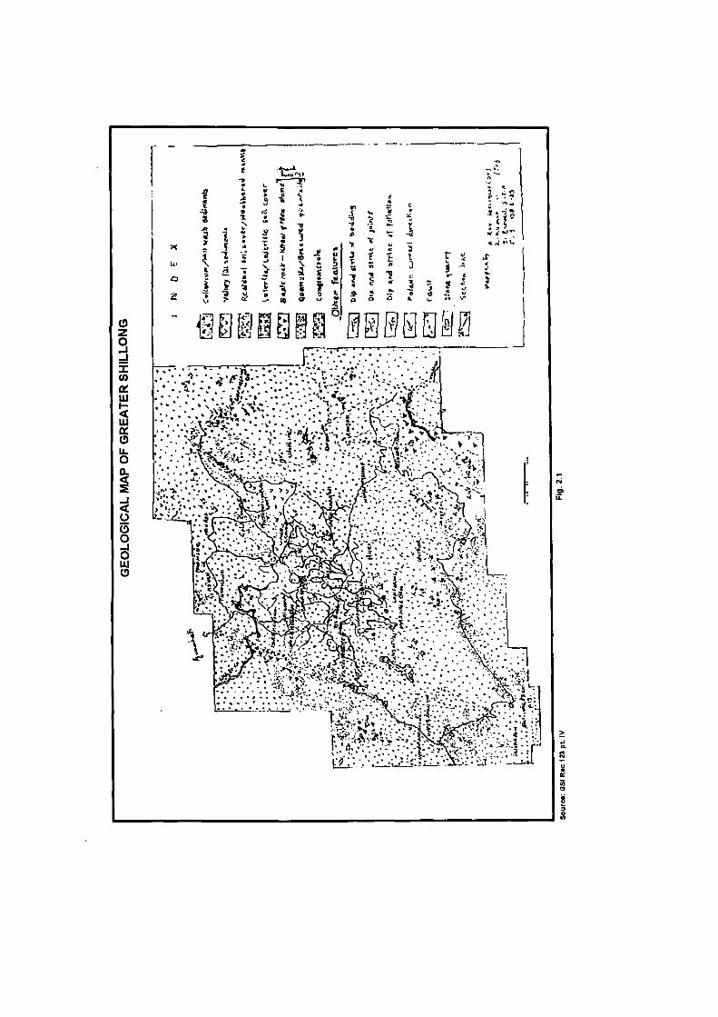
2.3 Geology of the Study Area
After discussing the geology of Meghalaya it becomes necessary to have an
understanding of the geology of the study area.
37
The Shillong city has a predominance of the Shillong group of rocks which
comprises of sub-metamorphosed phases of argillaceous and arenaceous members with a
distinct superimposition in the argillites underlying the arenites (Annon 1988-89)'.
The entire Shillong group of rocks lie over the basement of gneissic complex and
the geological succession of the different types of rocks (Table 2.2). The Mesozoic tertiary
sediments especially towards the south of the study area finally overlie the Shillong group
of rocks.
While the Khasi greenstone is concentrated in the southeastern section (along the
course of river Umkhen) western and northwestern section of the study area. (Fig 2.1).
Along the course of the river Umshirpi, Pologround and Golf course there is
presence of valley fill sediments, while residual soil cover is prevalent in and around
Mawprem.
The Shillong group of rocks comprises of phyllites, quartz schist, quartzite, and
intra formational conglomerates whose descriptions and distribution in the study area can
be enumerated as follows:
Phyllites
These are reddish brown, pinkish to purple in color and are fine grained with well-
preserved foliation and schistocity.
In the north they are exposed on the entire length of Shillong-Barapani road with
thick weathered cover(Roy 1989)'°.
o z o
z (0 Q£ lU H
2i a: o a. < s - I < o 5 o - J o IJU
• l i :
I 9
i
f l ^ ' ^ ^ ? ! ; ^ }-yKi-y^ *•' ^A' • .-^^
•̂ <r
> m •i#
(̂ ^
39
Quartz schist, quartz-sericite schist
These are well-foliated light grey to white colored rocks exposed along the
National Highways number 40 and 44 both in the north as well as south of the study area.
Quartzite
The quartzite is hard compact massive light grey to buff colored rocks exposed on
the roads and quarry sections of the study area. These rocks are coarse to granular in nature
with well-preserved sedimentary structures. Towards the north and north east of Beadon
Bishop falls as well as in the vicinity of the Phudmawri village the quartzite display an
acute tendency of oxidation resulting to thick lateritic cover.
Intra Formational Conglomerate
These occur as depositional pebble beds, usually found overlying the phyllites and
interbedded with quartz-schist as well as quartzite. These rocks are mainly composed of
flat elongated pebbles of one centimeter to about ten centimeter in size (Roy 1989)". This
variety of rock is exposed in the south and southwestern part of Beadon Bishop falls.
Basic Intrusive
These groups of rocks have undergone metamorphism and have a greenish to black
appearance hence the name Khasi green stone. The textures of this group of rocks vary
from fine, medium to coarse grained. Its composition varies from basalt to dolorite,
amphibolite to gabbroic. The composition of the Khasi Green stone varies from higher
40
elevation to lower elevation as well as from north to south. The Khasi Green stone has
undergone metamorphism in many places. It has been observed when the Khasi Green
stone have come into contact with quartzite that has undergone occasional assimilation
with the surrounding rocks due to contact metamorphism.
Granites
These are pink to light grey in colour and are found along with quartzite towards
the south of the study area.
Geologically Shillong presents an interesting study with varying rock groups (table
2.2) which were laid down as a thick pile of sediments possibly on a secondary basin over
the gneissic comple.x and the placement of granites as intrusive may be considered as the
end number of the tectonic phase (Roy 1989) .
Table 2.2: Stratigraphic sequence of the Shillong
Geological age Tertiary Upper cretaceous Pre Cambrian Archean
Group name Langpar formation Khasi group Shillong group Gneissic Complex
Rock types Brown sandstone and Shales Sandstones and conglomerates Quartzites, Conglomerates Gneiss, Hornblende etc.
2.4 Topography
Shillong and its suburbs falls on the central upland zone of Meghalaya plateau. The
Meghalaya plateau is but a part of the peninsular plateau separated from it by the Garo
Rajmahal gap. It stretches in an east -west direction abutting between the alluvial plains of
Bangladesh in the south and Assam plains in the north.
41
The plateau characteristics are more pronounced in the southern part of the area,
which has, numerous rises and steep wall descending into the Bangladesh plains. The
Shillong range and the Laitkor range situated in the southern part of the study area, i.e.,
Greater Shillong area is the highest part of the plateau. Some individual peaks like the
Shillong peak (1964 m) and the Laitkor Peak (1940 m) (Roy 1989)'^ above mean sea level
are situated here which acts as the water shed.
The city of Shillong lies in the earthquake belt and is a horst that has been uplifted
to its present height during the post Mesozoic era (Mazumdar 1976)'''. The region exhibits
numerous faults, fractures and troughs indicating active tectonic activities.
There are a large number of waterfalls in and around Shillong city, e.g.. Spread
Eagle falls on the course of river Umkhrah, Sweet falls on the course of the river Umkhen,
Elephant falls and Gunner falls lying in the south western section of the study area, Beadon
and Bishop falls also found in the south western section of the study area at an absolute
altitude of about 1400-1600 m above mean sea level. This indicates that there is also the
presence of youthful topography in an ancient pre-Cambrian shield.
The main city lies at an absolute altitude of about 1400-1600m above mean sea
level. Wah Umkhrah, Wah Umshyrpi and Wah Umkhen are the three main streams
draining the main city. While Wah Umshing drains the township of Mawlai. The Shillong
urban agglomeration can be divided into five physiographic units (Dympep 1998)'^, viz.,
(i) The northern slopes of the Shillong range found towards the southern part of the
Shillong urban agglomeration, consisting of the different localities of Upper
42
Shillong, Nongthymmai, Madanrting, Malki, Lumparing, Upper Laban and
Lawsohtun etc.
(ii) The Umshirpi valley is a narrow valley located towards the southwestern part of
the city occupied by the Cantonment area, Mawprem, Laban Kenchestrace,
Jhalupara, Rilbong, Dhankheti etc.
(iii) The Laitumkhrah -Mawkhar upland area is located at the central part of the city
and is largely occupied by the localities of Laitumkhrah, Police Bazaar, European
ward Jaiaw, Mawkhar etc.
(iv) The Umkhrah basin that has the lowest altitude of about 1420m (near
pologround) lies to the northeastern side of the Shillong urban agglomeration and
is mainly occupied by the township of Pynthorumkhrah, Nongmynsong etc.
(v) The Umkhrah Umshing water divides skirting the northern western edge of the
Shillong Urban Agglomeration, which is now occupied by parts of the township
of Mawlai.
Hence it is towards the north of upper Shillong that most of the localities of the
Shillong Urban Agglomeration lie. The topography comprises of rolling hills and valleys
with varying relief. It is also characterised by the presence of low relief hillocks with
gentle undulating valleys with varying relief characteristics.
The study area exhibits three structural terraces between Laitkor in the south and
Barapani in the north. This may be partly attributed to the fold movements and partly to the
later block movements, which has been suggested by abrupt scarps. In fact a conspicuous
scarp exists between Laitkor peak and Shillong city (Roy 1989)'^.
ro ^
44
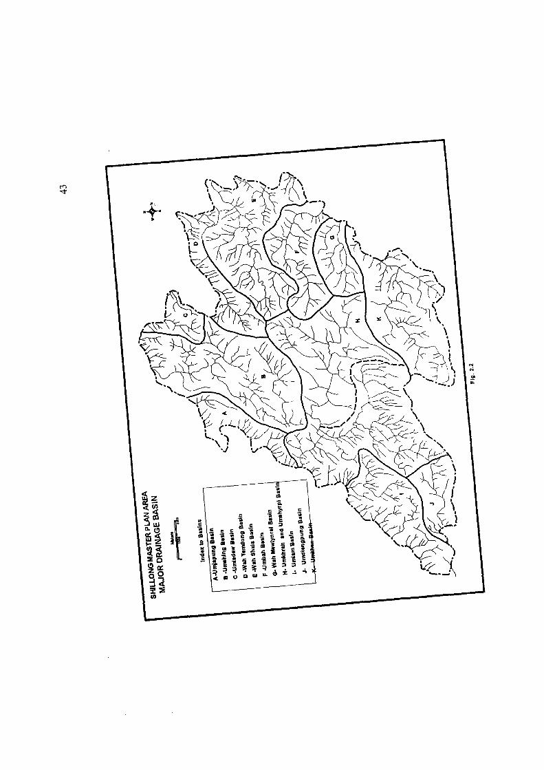
2.5 Drainage
The entire study area is divide into 11 river basins (Fig. 2.2) The Urban
Agglomeration is located within the following basins:
(i) The Umshirpi and Umkhrah basin occupies the southern and central part of the
study area, covers an area of about 51.62 sq km. The Shillong Municipality is
located here having an area of aboutlO.36 sq km. The Umshirpi starting from the
Crinolines falls in the Lumparing area located in the south western section of the
study area marks the southern boundary of the Shillong municipal limit. This
river takes a north westerly direction and joins the river Umkhrah near the
Beadon Bishop falls at Mawprem to form the Wah Ro-ro a tributary to Wah
umium which marks the western boundary of the study area.
The Umkhrah has its source at Nan Syiem, and flows down the steep slopes of
Nonghtymmai under the name of Demthring. Near Umpling it is joined by other primary
order streams and is called the Umkhrah river which starts from Umpling, located towards
the southeastern section of the Shillong city at an absolute altitude of aboui i 516m above
mean sea level. This river flows through the northern sector of the Shillong city and
roughly demarcates the northern boundary of the Shillong municipal limit. The Spread
Eagle falls located near Umpling the river Umkhrah takes a north westerly direction and
flows towards Beadon Bishop falls.
The streams feeding the Umshirpi and Umkhrah originate from the higher
altitudinal zone of Shillong ridge having an absolute relief of about 1800-1900 m whicli is
45
located to the south of the study area. According to Nongkhlaw (2003)'^ there are nine
over ground rivers viz. Umjasai, Ummawlong, Umsohkhlur, Umshynrut, Umshawshaw,
Umrisa, Umkdait, Umdienglieng and Umjynriew which ultimately meets to form the
Umshirpi and Umkhrah. However mention must be made here that both these streams have
been encroached by the urban activities so much, that much of the stream areas have been
filled up for constructional purposes. They can no longer be termed as rivers as they have
been turned into sewage and garbage drains to serve the growing population of Shillong
who dump their waste here.
(ii) The Umkhen basin drains the southeastern section of the study area. It occupies
an area of about 39.26 sq km of the study area. The township of Madanrting an
urban component of Shillong Urban Agglomeration is located
Happy valley cantonment is also located here.
(iii) The Umroh basin (fig.2.2) occupies a very small secUon of the study area of
about 4.56 sq km and lies in the outskirts of the Shillong Urban Agglomeration
towards the eastern part.
(iv) The Wah Sheila basin lies also in the eastern section of the study area on the
outskirts of the Shillong Urban Agglomerafion. It occupies an area of about 13.98
sqkm.
(v) The Wah Tamdong basin is situated next to Wah Sheila basin (Fig. 2.2)
occupying an area of about 8.28 sq km
46
(vi) The Umshing basin occupying an area of about 29.64 sq km. lies in the northern
sector of the Master plan area. The southern part of this river basin forms the
northern fringe of the Shillong Urban Agglomeration Mawlai township is located.
The new township of Shillong is to be situated towards the north eastern section in
the wah Sheila and Wah Umroh basin. Mention must be made here that the Umshing, Wah
Tamdong rises from the Mawpat ridges situated towards the north eastern part of Shillong
As the study area is characterised by a hilly topography, the first and second order
streams dominate the area. The drainage pattern is mainly sub-parallel to dendritic in
nature depicted in the drainage map of the area (Fig. 2.2) The streams tend to flow through
the joints and faults of the area, which is reflected in almost straight stream courier. "......
is also presence of numerous ' V shaped gullies in the study area. The major streams have
also have cut deep gorges which are often narrow and have a depth of more than 600 m
(Directorate of Urban Affairs 1991)'^
2.6 Soils
Like other regions the soils here too is influenced by various factors like geology,
relief climate and vegetation. There are four distinct categories of soils found here which
are as follows:
1. Soils over gneissic terrain, which has been further sub-divided into the following.
47
The red loamy soil, this type of soil is found in the upland zone of Khasi Hills. This
type of soil is derived from the weathering of granites, gneisses and diorites etc. In the
study area this type of soil is found towards the south. This type of soil is rich in silica
having a general loamy character, varying from clayey to sandy (Gopalakrishnan 1989)'^.
Soils over Shillong group- soils derived from rocks of Shillong group are medium
to fine textured. The depth of the soil horizon varies between 20cm-200cm (Agarwal
1989)^°. Due to continuous leaching the bases are leached out. The soil in general is
homogenous, granular, and loamy to clayey. The colour varies from very dark grayish
brown to yellow and brownish yellow. Due to the presence of evergreen forests the topsoil
is rich in humus however due to the constructional activities in the Shillong Urban
Agglomeration much of the humus content is lost.
Soils over Khasi Greenstone, this type of soil is typically lateritic giving a reddish
brown hue to the landscape around. The soil is clayey to loamy, moderately fine and
granular in characteristics. Its colour varies from yellow red to red.
2. The laterite soil this type of soil is found in broad belts extending from west to east
in the northern part of Meghalaya plateau. This type of soil has been formed auc LU
weathering of quartzites, schist, conglomerates etc. The soil is reddish or yellowish
in color and rich in iron.
3. Red and yellow soils which are largely found in the in the foothills regions along
the east and western belt of Meghalaya and as such is not an important soil
category of the study area.
48
4. Alluvial soil, this type of soil is found along the north western and southern fringes
of the plateau. In the study area it is found in the Pologround area, they vary from
sandy to clayey loam with varying nitrogen content (agarwal 1989)^'. They are rich
in potash but poor in phosphate. In general the soils are thin, immature and light in
colour.
Hence the soil of the study area reflects the geology, relief, climate and vegetation.
According to Prasad (1981)^^ steep slopes accelerate removal of soil coupled with various
agencies like high intensity of rainfall, and human activities. The study area being the
largest urban center of Meghalaya the soil profile has been affected by human activities
like constructional activities and jhum in the outskirts of the city that has resulted to high
degree of soil erosion.
2.7 Climate
Climate plays a significant role in determining the amount of water supply in any
area because it is the total amount and type of precipitation which will detenuinc ihc iiaiuic
and amoimt of surface runoff, this in turn will determines the amount of discharge in the
streams.
Climate also plays a significant role in regards to solid waste disposal. Shillong
situated in a plateau characterised by heavy rainfall most of the solid wastes dumped on the
streams and roadsides are washed away from the waxing slope thereby giving Shillong a
cleaner appearance.
49
The seasonal winds, i.e. southwest and northeast monsoon circulation as well as the
altitude of the area controls the climate of Shillong.
The Shillong range lying in the south of the study area having an absolute aUitude
of about 1800-1900+ m above m.s.l. and extending in an east west direction across the path
of the south west monsoon winds play a significant role in governing the weather condition
of the area.
Due to Shillong's location on the northern leeward side of the range it is in the rain
shadow zone, thus there is relatively less rainfall then Cheerapunji, Mawsynram areas
(Hussain 1984) . Shillong lies in the leeward side and thus receives less rainfall than
Cherrapunjee which is about 50 km. south of Shillong.
The climate of the study area can be described as a typical mountainous monsoon
climate with sufficient rains in summer.
Geographically the climate of Shillong can be classified under the humid sub
tropical climate, characterised by high rainfall mostly during summer.
According to Koppen's empirical classification of climate, with some minor
modification the climate of Shillong can be classified under C climatic scheme known as
Humid Mesothermal Climate (Hussain 1984)̂ '*.
On the basis of temperature and precipitation the climate of Shillong comes under
Cmk ( Hussain 1984)̂ ^ designation of Koppen's scheme where
C = Warm temperate rainy climate with mild winter m - Monsoon regime of precipitation with short dry season compensated by heavy rainfall
during rest of the year. k = Mean annual temperature below 18*̂ centigrade.
50
All these characteristics are found in the climate of the study area in the nature of
cold dry winter, heavy rains from June-August Mean annual temperature of the warmest
month above 18°, i.e., ranging around 20-25 .
2.8 Natural Vegetation
Meghalaya is endowed with rich and luxuriant vegetation cover and is regarded as
one of the biodiversity Hotspot of the country that supports dense natural forest cover. The
natural vegetation of Megualaya can be divided into three groups viz.
1. Mixed evergreen forests in the southern parts.
2. The rolling grasslands and the pine forests of the central upland zone.
3. Grasslands with scattered pine trees, which have been observed in the higher
altitudes.The hilltops are smooth with shallow sub-soil supporting the growth of
several species of grass (rao 1968)^ .̂
Pinus Khasiana is the principal flora of the Shillong Urban complex The pinus
khasia has fair to poor water retaining capacity and is found at an altitude of 950m- 1850m
(Directorate of Urban Affairs 1991)^ .̂ As the average altitude of Shillong is around 1500
m above m.s.l. almost all the area is covered by Pine forests.
Shrubs are more prevalent on the moderately steep slopes especially on the
absolute relief of more than 1900m, i.e. to the south of the study area.
The Pine forests dominate here. Forests of the study area occupy about 1220.40
hectares of the land accounting for 11.76 percent of the total Master plan aua. IAH ^f liiis
51
only 8 percent of the forests of Shillong is under the state control(Directorate of Urban
Affairs 1991)^*, while the rest is classified as private forests.
The rapid growth of Shillong Urban Agglomeration is leading to indiscriminate
felling of trees as more forested land is coming under constructional activities.
Due to the lack of sound plan and programme coupled with lack of scientific
management of the forests, the natural vegetation of Shillong is under threat, which may
have a serious repercussion not only on the water supply but also on the ecological balance
of the city. The southern part of Shillong is the water shed zone of the Meghalaya plateau.
Hence deforestation in such ,£irea can lead to serious natural hcizards like soil erosion loss
of soil nutrients reduction of the percolation capacity of the soil, increase of surface runoff
mass wasting and lowering of the stream discharge etc.
This makes it essential to analyse the relief and slope characteristics of Shillong.
The morphometric analysis of the terrain indicates that Shillong is not ideal Ibr urban
settlements and constructional activities.
2.9 Morphometric Analysis
(a) Absolute Relief
An initial step to study the geo-environment of any area is the analyses of Its relief
features. Variations of the earth's surface or part of it become the focus of any geographic
study especially in this case where the study highlights waste disposal; and water supply of
the Shillong Urban Agglomeration. Relief and other geomorphic elements on which the
geo-environmental analyses are dependent are absolute relief, relative relief ;iiid slope
52
which ultimately help in classifying and mapping of those areas which are not suitable for
settlements and other urban functions. Slope and relief analysis becomes significant
especially in this study as it indicates the water source region that needs to be protected
from urban activities. Here an attempt has been made to have an understanding of the relief
and average slope analysis of the area so that the problems associated with water supply
and waste disposal becomes minimal. The process of evolution of relative relief depends
much upon geological structure, types of rocks, climatic conditions and nature of the
original absolute relief of the area. The geology, types of rocks, climatic conditions have
already been discussed in the above paragraphs; hence an analysis of the absolute relief
becomes essential.
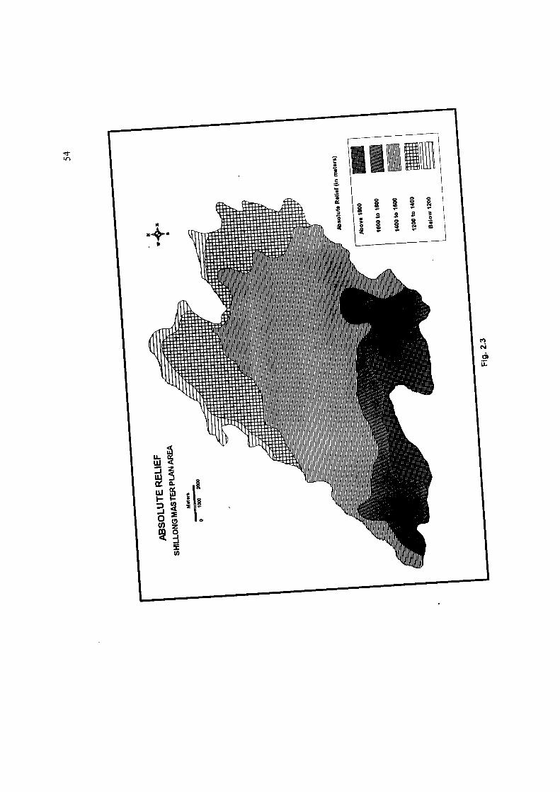
Distributional pattern of absolute Relief
The absolute relief of the study area varies from 1080m in the northwestern section
of the study area to 1964m i.e. the height of Shillong peak located in the extreme south.
The absolute relief of the study area varies from 1080 m to 1964 m (the height of Shillong
peak) above mean sea level. The absolute relief increases from north to south. The highest
part of the study area consists of a mildly undulating plateau top of limited width stretching
along east west direction and having an altitude of 1800 m and above. The approximate
area falling under this absolute relief category is about 10 sq. km. that is covering an area
of about 5.9 percent of the study area (Fig.2.2) It is here that both Shillong peak and
Laitkor peak are located . This marks the southern boundary of the study area.
53
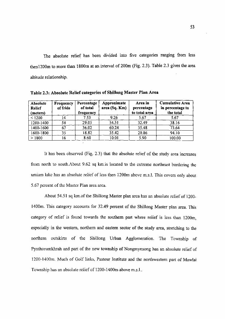
The absolute relief has been divided into five categories ranging from less
thenl200m to more than 1800m at an interval of 200m (Fig. 2.3). Table 2.3 gives the area
altitude relationship.
Table 2.3: Absolute Relief categories of Shillong Master Plan Area
Absolute Relief (meters) <I200 1200-1400 1400-1600 1600-1800 >1800
Frequency of frids
14 54 67 35 16
Percentage of total
frequency 7.53
29.03 36.02 18.82 8.60
Approximate area (Sq. Km)
9.26 54.51 60.24 35.42 10.01
Area in percentage
to total area 5.67
32.49 35.48 20.86 5.90
Cumulative Area in percentage to
the total 5.67
38.16 73.64 94.10 100.00
It has been observed (Fig. 2.3) that the absolute relief of the study area increases
from north to south.About 9.62 sq km.is located to the extreme northeast bordering the
umiam lake has an absolute relief of less then 1200m above m.s.l. This covers only about
5.67 percent of the Master Plan area area.
About 54.51 sq km.of the Shillong Master plan area has an absolute relief of 1200-
1400m. This category accounts for 32.49 percent of the Shillong Master plan area. This
category of relief is found towards the southern part where relief is less than 1200m,
especially in the western, northern and eastern sector of the study area, stretching to the
northern outskirts of the Shillong Urban Agglomeration. The Township of
Pynthorumkhrah and part of the new township of Nongmynsong has an absolute relief of
1200-1400m. Much of Golf links, Pasteur Institute and the northwestern part of Mawlai
Township has an absolute relief of 1200-1400m above m.s.l..
1/1
55
The next category of absolute relief ranging from 1400-1600m above m.s.l. covers
the maximum area. About 60.24 sqkm of the Master plan area comes under this category
of absolute relief and accounts for about 35.48 percent of the study area. This category of
relief is foimd in Shillong proper comprising of Mawlai, Jhalupara, Barabazar, Police bazar
Assembly complex, part of laban, part of Laitumkhrah, Umpling, Mawpat etc. in fact most
of the Shillong Municipal area and part of the Cantonment is located here.
This is a highly congested area where much of the land is under settlements and
roads. It is here that the numerous small streams have disappeared under constructional
activities.
The subsequent category of absolute relief ranges from 1600-1800m lies to the
south and occupies about 20.86 percent of the Master plan area (about 35.-+2 b4iMu; mis
category of relief is found in the localities of the southern part of Laitumkhrah, Risa
colony, Maiki, Lumpering, Tripura castle road, Kenchestrance, Madan Laban within the
Shillong Municipality and Lowsohtun, the townships of Nonthymmai and Madanrting
Due to population growth this area is now occupied by settlements. Deforestation
in this zone is having detrimental effect on the water supply of the Shillong Urban
Agglomeration. All the seven Municipal sources of water consisting of natural springs are
located here. This area has some reserved forests controlled by the State Government this
has restricted deforestation to some extent.
However field investigation shows that that area where the forest is under the
community there are rampant deforestation, no data is available on tlie idle of
56
deforestation. But it is evident that much of the previous forested area has been cleared for
human settlements and urban activities.
The populated Nongthymmai Township has the highest density in the Shillong
Urban Agglomeration ie.ll675 persons per sq km with a total population of 34207
(Census 2001)^^ in an area. Where 2.93 sq km has been deforested. This township consists
of eleven localities with an absolute relief of 1600-1800m above m.s.l. spread over an area
of 2.93 sq km. with certain localities like Lau-u-sib is only about a year old. Some of the
respondents of this area are of the view that over the years the water supply of these
localities which are usually spring fed are facing water scarcity especially in the dry
season because of deforestation in the upper slopes. The water supply source of Dumdum a
locality situated here, is shrinking and the community living here is looking for an alternate
source of water. Certain localities like Nong-Khyreim, Demthring, Upper Lawjheinriew,
are prone to mass wasting due to constructional activities.This is also a reason for water
crises in these localities.
The extreme southern part of the study area has an absolute relief of above 1800m.
This is the highest part of the study area where Shillong peak is located at an altitude of
1964m, which is also the highest part of the Meghalaya Plateau. The Laitkor peak located
at an altitude of 1941m is also located here. There is a small lake towards the north east of
Shillong peak; which has an absolute relief of above 1800m with an area of aboutlO.Ol sq
km. ie.This accounts for about 5.90 percent of the total study area. This area, acts as the
water shed zone of the Meghalaya plateau.
57
Hence an analysis of the absolute relief indicates that the height of the study area
decreases from south to north thus the slope is also from south to north. It is the southern,
southeastern and southwestern part of the study area, which is not geo-environmentally
suitable for massive urban construction and urban activities. This area acts as the source
region for Shillong's water supply. The river Umiew has its origin here and flows towards
the south to Bangladesh plains. This river is tapped at Mawphalang about 30 km from
Shillong proper,and supplied to the greater Shillong water supply scheme operating under
the Public Health Department, Government of Meghalaya. The total capacity at present of
this reservoir at Mawphlang is about 7.5 million gallons (PHE Report 2001)^° of water per
day whose total capacity will increase to about 11.3 million gallons (PHE Report 2001)^'
per day, i.e., after the completion of the project which was due by 2003 but still
incomplete. Hence deforestation due to urban sprawl in this zone should be restricted, as
deforestation will lessen the percolation capacity of the soil and may decrease the amount
of discharge in the streams.This may also increase the surface runoff and soil erosion rate
which may pollute the streams.
Moreover the seven natural springs and streams which are the sources of supplying
water to the Shillong Municipality are also located close here at an elevation of about
1800m and above, hence the urban expansion will result to the 'roofing over' of the
previous moisture retaining soils with concrete settlements, pavements and buildings. The
population residing here often discharges their solid wastes directly into the streams
affecting not only the quality of water but also the quantity.
58
(b) Relative relief
Relative relief is one of the techniques by which the three dimensional relief
characteristics may be represented in two-dimensional maps. It visualises the sharpness of
the relief that cannot be expressed by absolute relief maps, profiles and area height curves.
The term relative relief in general denotes the actual variation of height in an imit area with
respect to its local base level.
A scientific and system study of relative relief was done by Smith (1935)^^. There
has been frequent applications of relative relief concept since the time of Smith.
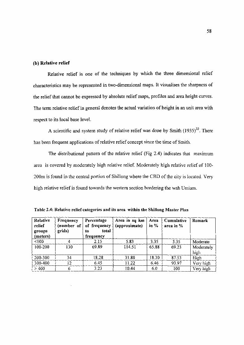
The distributional pattern of the relative relief (Fig 2.4) indicates that maximum
area is covered by moderately high relative relief Moderately high relative relief of 100-
200m is found in the central portion of Shillong where the CBD of the city is located. Very
high relative relief is found towards the western section bordering the wah Umiam.
Table 2.4: Relative relief categories and its area within the Shillong Master Plan
Relative relief groups (meters) <100 100-200
200-300 300-400 >400
Frequency (number of grids)
4 130
34 12 6
Percentage of frequency to total frequency
2.15 69.89
18.28 6.45 3.23
Area in sq km (approximate)
5.83 114.51
31.80 11.22 10.44
Area in%
3.35 65.88
18.30 6.46 6.0
Cumulative area in %
3.35 69.23
87.53 93.97 100
Remark
Moderate Moderately high High Very high Very high
ON in
60
(c) Average Slope
Slope is a function of relief inclination usually shovra in degrees. In the
development of slopes, various factors are involved including tectonic and climatic factors.
It is slopes, which often determine human activities, and it is again human activities, which
often modify the slopes. Since the very begirming of geographical studies, which
highlights man environment relationship, the slope analyses and its categorisation have
received remarkable attention. The scientific and systematic studies of slopes were started
in the late 19"̂ and 20"̂ centuries. Significant contribution in this field has been made by
Finster Walder (1890), Rich (1930), Wentworth (1930), Raiz and Henry (1937), Smith
(1938), Strahler (1956)" etc.
In this particular study a slope analyses becomes essential, as the study area is
characterised by a hilly topography where the absolute relief ranges from 1080m to 1964m
above m.s.l. Slopes are ubiquitous elements of the land surface. The slopes exert
tremendous control over human activities besides development of soil profile, loss of soil
due to erosion etc. A detailed analysis of slope of the study area becomes essential before
chartering any developmental activities catering to the urban expansion and related
activities of the city. The slope gradient of the study area has been analysed from a slope
map using the modified version of C.K. Wentworth's method.
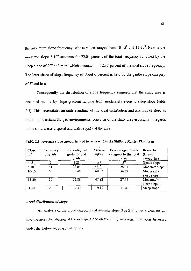
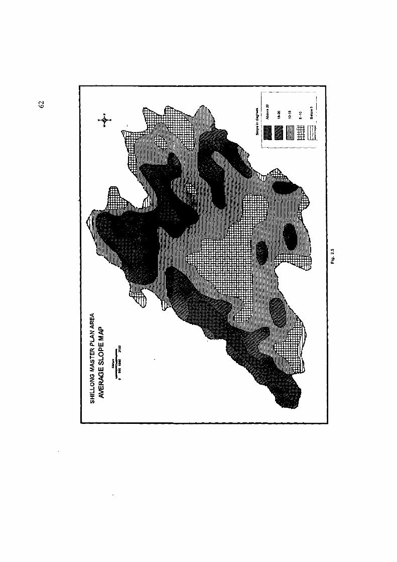
The study area has an average slope value ranging from 2° to 31°.
An analysis of the table 2.5 and fig 2.5 reveals a clear picture of the distributional
pattern of frequencies according to the slope categories. It highlights that the category of
moderately steep slope accounts for 62.36 percent of the total frequenc) u.j..o\ LO\ ji...^
61
the maximum slope frequency, whose values ranges from 10-15° and 15-20 . Next is the
moderate slope 5-10° accounts for 22.04 percent of the total frequency followed by the
steep slope of 20° and more which accounts for 12.37 percent of the total slope frequency.
The least share of slope frequency of about 6 percent is held by the gentle slope category
of 5° and less.
Consequently the distribution of slope frequency suggests that the study area is
occupied mainly by slope gradient ranging from moderately steep to steep slope (table
2.5). This necessitates an understanding of the areal distribution and analyses of slope in
order to understand the geo-environmental concerns of the study area especially in regards
to the solid waste disposal and water supply of the area.
Table 2.5: Average slope categories and its area within the Shillong Master Plan Area
Class in"
<5 5-10 10-15
15-20
>20
Frequency of grids
6 41 66
50
23
Percentage of grids to total
grids 3.23 22.04 35.48
26.88
12.37
Area in sqkm.
.99 45.01 60.02
47.82
19.19
Percentage of each category to the total
area 57
26.01 34.69
27.64
11.09
Remarks (Broad categories) Gentle slope Moderate slope Moderately steep slope Moderately steep slope Steep slope
Areal distribution of slope
An analysis of the broad categories of average slope (Fig 2.5) gives a clear insight
into the areal distribution of the average slope on the study area which has been discussed
under the following broad categories.
63
Gentle slope (^ and less)
This slope category records only for 0.99 sq km is found in small patches in the
south western part of the study area near upper Shillong. This gentle slope is also found in
the northwestern part of the city bordering the lake Umiam.
This slope is ideal for constructional and permanent settlements as it gives ample
land with gentle slope. However recently due to solid waste dumping on the bank of the
streams and filling up of the streams due to constructional activities these areas of gentle
slope is prone to flooding. A recent newspaper report suggests that these areas are flooding
annually'̂ '*.
Moderate slope (5-10 )
This slope indicates undulating uplands. However walking in this gradient requires
considerable effort. This category of slope occupies 45.01 sq km of the study area> That
accounts for about 26 percent of the total study area.
This slope category is found in patches to cover a large part of the study area and
usually includes pediment and hill slopes, boulder outcrops and rock surface with thin soil
cover.
Moderate slope is also found in patches in the northwestern part of the study area
bordering the Umiam Lake.
This category of slope is good for housing and other urban functions. It has been
observed that at this gradient the water supply to the individual settlements need special
effort. Hence each individual house is supplied water from the main tanks oi iiic localu\
64
by individual pipelines. This often results to severe wastage and contamination of water as
it becomes difficult to maintain so many pipes that often leak and usually passes through
the main drains of the localities.
Moderately steep slope (10-1 S"& 15-20P)
Maximum part of the study area falls under this category of slope. About 107.84 sq
km of the study area is under this category accounts for 62.33 percent of the total study
area. Here the slopes are fairly steep and walking uphill in these areas needs much effort.
This category of slope lies widely in the study area covering the localities of Lawsohtun,
Kenchestrance, Bishnupur, Lumpering, Laitkor, part of upper Shillong, Happy Valley,
Mawpat, Townships of Mawlai, Madanrting and upper Nongthymmai. Thus the eastern,
northwestern, some portion of the south and central part of the Shillong Urban
Agglomeration has a slope gradient of 10-20°.
As a result of urban expansion constructional activities are increasing This is due to
population pressure which ultimately is leading to deforestation. This in turn is leading to
increase in soil erosion due to surface runoff. This is results to the development of furrows
and gullies which are observed at the localities of Lumpering, Demthring and Laitkor
where the soil loss has resulted to the formation of lateritic crust in these area ((Directorate
of Urban Affairs 1991)^^
The settlements which have come up here especially in the townships of Mawlai,
Nongthymmai, Madanrting do not have any centralized system of waste disposal as they
are not under the Shillong Municipality. The field study on Nongthymmai Township has
65
been that about 45 percent of the surveyed households dispose off their wastes directly into
the streams. As regards to water supply most of the settlements have to meet their own
water requirement. This is usually managed and maintened by the local 'durbar'.
Steep slope (2(f and more)
This fifth category of slope imit accounts for 19.19 sq km of area, i.e., 11.09
percent of the total study area which has a very steep slope. The extent of this slope class is
limited (Fig 2.5). This category of slope is found in the south eastern, western and a small
portion of the northwestern part of the Shillong Urban Agglomeration, covering small
portions of Mawprem and the townships of Mawlai and Madanrting.
In this category the gradient of slope is formidable obstacle in leveling the ground
for settlements. Forests bordering the river Umiam in the west mainly occupy this category
of slope range. Physical constituents like slope, soil moisture content as well as forest litter
helps in the growth of thick vegetation here.
However under the impact of population growth and the resultant urban sprawl
these areas are coming under habitation thereby causing serious gco-cmiroini.ciUal
concerns. The loss of vegetation in these category of slope has accelerated high rate of run
off which in turn has led to gully formation. The first and second order streams that
dominate in these areas have been affected. Thus rill and gully erosion has enhanced here
which in turn has promoted rock fall as there is no binding matrix (Directorate of Urban
Affairs 1991)^^
66
Limitations
In the preparation of the average slope map (Fig 2.5) that the slope units selected to
express geographical significance are not rigidly true to angular scale,but a generalised
picture. As for example a slope instead of being uniform may be concave or convex or it
may be marked by knicks associated with rapids and waterfalls (this is found in large
numbers in the study area). These irregularities has been overlooked while preparing the
average slope map of the study area.
To conclude, this chapter basically highlights an understanding of how the physical
setting of the study area has an impact on the water distribution and waste disposal of the
study area. With population growth (discussed in chapter III of this thesis) the marginal
areas come under habitation, that are often not ideal for settlements and human activities.
These human activities habitually generate wastes when not properly disposed has a
negative impact on our geo-environmental resource especially on water resource.
References
' Oldham T. (1858): On the Geological Structure of a Portion of the Khasi Hills, Geological Survey India, Volume] pt-7.?p. 99-201.
^ Medlicott H.B. (1869;; Geological Sketch of Shillong Plateau, Geological Survey of India, Volume 7 Pt.7. Pp. 151-207.
^ Palmer R.W. (1923): Geology of a Part of Khasi & Jaintia Hills, Assam Record, Geological Survey of India, Volume 55 Pt. 2. Pp. 143-168.
" Ghosh A.M. (1936-39): General Report Record, Geological Survey of India, Vol 71-74, Pt. I. ^ Murthy M.N.V. (1976): Basement Controlled Volcanism, Sedimentation and Tectonics in Assam Plateau,
N.E. India, Paper Presented in Seminar on Geology of North E ast India. Shillong, 1976. * Mazumdar S.K. (1986): The Pre-Cambrain Framework of Part of the Khasi Hill Meghalaya Records,
Geological Survey of India Vol 117, Pt.2. Pp. 1-59. ' Murthy M.V.N. Op.cit. P. 4. * Beloussov V.V. (1962): Basic Problems in Geotectonics. McGraw Hill Co., New York. P. 809. ' Anon. (1988-89): Interim Progress Report, Geological Survey of India N.E. Region. P. 4. '° Roy.A. et al. (1989): Detailed Geological and Geomorphic Mapping of the Greater Shillong Area with
Special Reference to Environmental Aspects.East Khasi Hills District Meghalaya, Geological Survey of India. Pp. 6-12.
67
"Ibid. p. 10. '̂ Roy A. et. al. (1989): Extracts - Abstracts of Progress Report for Field Season (1988-89), Geological
Survey of India records Vol. 123 Part IV. P. 12. " Ibid. P. 10. '" Mazumdar S.K. (1976): Morphogenetic Evolution of the Khasi Hills Meghalaya, Geological Survey of
India. No. 30, Pt. 3. Pp. 208-213. ' ' Dympep S. (1998): Planning for Water Supply and Drainage for Shillong Urban Area. Unpublished thesis
for Master of City Planning, Dept. of Architecture and Planning, I.I.T. Kharagpur. Pp. 10. '* Roy A. et al. (1989). Op. cit. P. 11. " Nongkhlow D. (2003): Silent Death of Shillong River, Grassroots Options (June 2003). Shillong. P. 28. " Government of Meghalaya (1991): Untitled Report from Meghalaya Urban Development Authority.
Shillong. " Gopalakrishnan R. (1989): Geography of Meghalaya. Rajesh Publication, N.Delhi. Pp. 16-19. "̂ Agarwal M. (1989): Geomorphological Studies Around Umium Lake and Adjoining Areas East Khasi
Hills Meghalaya. Unpublished Ph.D. thesis, NEHU, Shillong. P. 109. ^'Ibid. P. 110. ^̂ Prasad. R.N. et al. (198i;.- Soil Fertility Management in NEH Region, ICAR Research Bull. No. 9. P.30. ^' Hussain Z. (1984/- Some Ecological Observation on Climatological Data of Shillong 1971-81, Shillong
1971-81. B. Pakem (ed.). Research India Publication, Calcutta. Pp. 11-24. ^* Ibid. P. 19. "Ibid. P. 21. *̂ Rao A.S. (1968): Vegetation of Khasi & Jaintia Hills, Proceedings of the Science Congress Symposium.
Gauhati University, Guwahati. P. 95. " Govt. Report (1991): Master Plan of Shillong 1991-2011. Directorate of Urban Affairs, Shillong . '' Ibid. ^' Census of India (2001): Meghalaya Series 18. ^̂ Government Report (2001): Action Plan for Integration of Municipal Water Sources in Shillong City.
PHE Department Vol. 1. P. 2. " Ibid. P. 2. " Smith G.H. (1935): The Relative relief of Ohio, Geographical Review Volume 25. Pp. 274-284. ^' Prasad H (1988): Mussoorie and its Environs A study in Applied Geomorphology. Amrawati Pubication,
Varanasi. P. 81. " The Telegraph (2003) (Notheast): Guwahati 11 oct. P. 15. ' ' Report form Directorate of Urban Affairs. op:cit. P. 13. '*Ibid. P. 15.