Embed Size (px)
Citation preview

VA DEQ STORMWATER DESIGN SPECIFICATION NO. 2 SHEET FLOW TO FILTER OR OPEN SPACE
Version 1.9, March 1, 2011 Page 1 of 20
VIRGINIA DEQ STORMWATER DESIGN SPECIFICATION No. 2
SHEET FLOW TO A VEGETATED FILTER STRIP OR
CONSERVED OPEN SPACE
VERSION 1.9 March 1, 2011
SECTION 1. DESCRIPTION Filter strips are vegetated areas that treat sheet flow delivered from adjacent impervious and managed turf areas by slowing runoff velocities and allowing sediment and attached pollutants to settle and/or be filtered by the vegetation. The two design variants of filter strips are (1) Conserved Open Space and (2) designed Vegetated Filter Strips. The design, installation, and management of these design variants are quite different, as outlined in this specification. In both instances, stormwater must enter the filter strip or conserved open space as sheet flow. If the inflow is from a pipe or channel, an engineered level spreader must be designed in accordance with the criteria contained herein to convert the concentrated flow to sheet flow.
SECTION 2. PERFORMANCE With proper design and maintenance, these practices can provide relatively high runoff reduction as shown in Table 2.1.

VA DEQ STORMWATER DESIGN SPECIFICATION NO. 2 SHEET FLOW TO FILTER OR OPEN SPACE
Version 1.9, March 1, 2011 Page 2 of 20
Table 2.1: Summary of Stormwater Functions Provided by Filter Strips 1
Stormwater Function
Conservation Area Vegetated Filter Strip
HSG Soils A and B
HSG Soils C and D
HSG Soils A
HSG Soils B 4, C and
D Assume no CA 2 in Conservation Area No CA 3 With CA 2
Annual Runoff Vol. Reduction (RR) 75% 50% 50% 50% Total Phosphorus (TP) EMC Reduction5 by BMP Treatment Process
0 0
Total Phosphorus (TP) Mass Load Removal 75% 50% 50% 50%
Total Nitrogen (TN) EMC Reduction by BMP Treatment Process 0 0
Total Nitrogen (TN) Mass Load Removal 75% 50% 50% 50%
Channel Protection and Flood Mitigation
Partial. Designers can use the RRM spreadsheet to adjust curve number for each design storm for the contributing drainage area; and designers can account for a lengthened Time-of-Concentration flow path in computing peak discharge.
1CWP and CSN (2008); CWP (2007) 2 CA = Compost Amended Soils (see Design Specification No. 4) 3 Compost amendments are generally not applicable for undisturbed A soils, although it may be advisable to incorporate them on mass-graded A or B soils and/or filter strips on B soils, in order to maintain runoff reduction rates. 4 The plan approving authority may waive the requirement for compost amended soils for filter strips on B soils under certain conditions (see Section 6.2 below) 5 There is insufficient monitoring data to assign a nutrient removal rate for filter strips at this time.
SECTION 3. DESIGN TABLE
Conserved Open Space and Vegetated Filter Strips do not have two levels of design. Instead, each must meet the appropriate minimum criteria outlined in Table 2.2 (next page) and Section 6 (below) to qualify for the indicated level of runoff reduction. In addition, designers must conduct a site reconnaissance prior to design to confirm topography and soil conditions.
SECTION 4. TYPICAL DETAILS Figure 1 shows a typical approach for sheetflow to a Conserved Open Space (Cappiella et al., 2006). Figures 2 and 3 provide standard details for an engineered level spreader developed by North Carolina State University (Hathaway and Hunt, 2006). An alternative design for an “energy dissipater” can be found in Henrico County’s Environmental Program Manual (Chapter 9, Minimum Design Standard 9.01) at: http://www.co.henrico.va.us/works/eesd/

VA DEQ STORMWATER DESIGN SPECIFICATION NO. 2 SHEET FLOW TO FILTER OR OPEN SPACE
Version 1.9, March 1, 2011 Page 3 of 20
Table 2.2. Filter Strip Design Criteria
Design Issue Conserved Open Space Vegetated Filter Strip Soil and Vegetative Cover (Sections 6.1 and 6.2)
Undisturbed soils and native vegetation
Amended soils and dense turf cover or landscaped with herbaceous cover, shrubs, and trees
Overall Slope and Width (perpendicular to the flow) (Section 5)
0.5% to 3% Slope – Minimum 35 ft width 3% to 6% Slope – Minimum 50 ft width The first 10 ft. of filter must be 2% or less in all cases 2
1% 1 to 4% Slope – Minimum 35 ft. width 4% to 6% Slope – Minimum 50 ft. width 6% to 8% Slope – Minimum 65 ft. width The first 10 ft. of filter must be 2% or less in all cases
Sheet Flow (Section 5)
Maximum flow length of 150 ft. from adjacent pervious areas; Maximum flow length of 75 ft. from adjacent impervious areas
Concentrated Flow (Section 6.3)
Length of ELS 6 Lip = 13 lin. ft. per each 1 cfs of inflow if area has 90% Cover 3 Length = 40 lin. ft. per 1 cfs for forested or re-forested Areas 4 (ELS 6 length = 13 lin.ft. min; 130 lin.ft. max.)
Length of ELS 6 Lip = 13 lin.ft. per each 1 cfs of inflow (13 lin.ft. min; 130 lni.ft. max.)
Construction Stage (Section 8)
Located outside the limits of disturbance and protected by ESC controls
Prevent soil compaction by heavy equipment
Typical Applications (Section 5)
Adjacent to stream or wetland buffer or forest conservation area
Treat small areas of IC (e.g., 5,000 sf) and/or turf-intensive land uses (sports fields, golf courses) close to source
Compost Amendments (Section 6.1)
No Yes (B, C, and D soils) 5
Boundary Spreader (Section 6.3) GD 6 at top of filter
GD 6 at top of filter PB 6 at toe of filter
1 A minimum of 1% is recommended to ensure positive drainage. 2 For Conservation Areas with a varying slope, a pro-rated length may be computed only if the first 10 ft. is 2% or less. 3 Vegetative Cover is described in Section 6.2. 4 Where the Conserved Open Space is a mixture of native grasses, herbaceous cover and forest (or re-forested area), the length of the ELS 6 Lip can be established by computing a weighted average of the lengths required for each vegetation type. Refer to Section 6.3 for design criteria 5 The plan approving authority may waive the requirement for compost amended soils for filter strips on B soils under certain conditions (see Section 6.1). 6 ELS = Engineered Level Spreader; GD = Gravel Diaphragm; PB = Permeable Berm.

VA DEQ STORMWATER DESIGN SPECIFICATION NO. 2 SHEET FLOW TO FILTER OR OPEN SPACE
Version 1.9, March 1, 2011 Page 4 of 20
Figure 2.1. Typical Sheetflow to Conserved Open Space
Figure 2.2. Level Spreader Forebay (Hathaway and Hunt 2006)

VA DEQ STORMWATER DESIGN SPECIFICATION NO. 2 SHEET FLOW TO FILTER OR OPEN SPACE
Version 1.9, March 1, 2011 Page 5 of 20
Figure 2.3: Plan and Cross Section of Engineered Level Spreader (ELS)
(Hathaway 2006)

VA DEQ STORMWATER DESIGN SPECIFICATION NO. 2 SHEET FLOW TO FILTER OR OPEN SPACE
Version 1.9, March 1, 2011 Page 6 of 20
Figure 2.4A: Section - Level Spreader with Rigid Lip

VA DEQ STORMWATER DESIGN SPECIFICATION NO. 2 SHEET FLOW TO FILTER OR OPEN SPACE
Version 1.9, March 1, 2011 Page 7 of 20
Figure 2.4B: Section - Alternative Level Spreader with Vegetated Lip

VA DEQ STORMWATER DESIGN SPECIFICATION NO. 2 SHEET FLOW TO FILTER OR OPEN SPACE
Version 1.9, March 1, 2011 Page 8 of 20
Figure 2.5 – Gravel Diaphragm – Sheet Flow Pre-treatment
Figure 2.6: Level Spreader: Pipe or Channel Flow to Filter Strip or Preserved Open Space
SHEET FLOW FROM IMPERVIOUS OR TURF

VA DEQ STORMWATER DESIGN SPECIFICATION NO. 2 SHEET FLOW TO FILTER OR OPEN SPACE
Version 1.9, March 1, 2011 Page 9 of 20
Figure 2.7: Simple Disconnection to downstream Preserved Open Space or Vegetated Filter Strip

VA DEQ STORMWATER DESIGN SPECIFICATION NO. 2 SHEET FLOW TO FILTER OR OPEN SPACE
Version 1.9, March 1, 2011 Page 10 of 20
SECTION 5. PHYSICAL FEASIBILITY & DESIGN APPLICATIONS 5.1 Conserved Open Space The most common design applications of Conserved Open Space are on sites that are hydrologically connected to a protected stream buffer, wetland buffer, floodplain, forest conservation area, or other protected lands. Conserved open space is an ideal component of the "outer zone" of a stream buffer, such as a Resource Protection Area (as is required in some parts of the state), which normally receives runoff as sheetflow. Care should be taken to locate all energy dissipaters or flow spreading devices outside of the protected area. Designers may apply a runoff reduction credit to any impervious or managed turf cover that is hydrologically connected and effectively treated by a protected Conserved Open Space that meets the following eligibility criteria: • The goal of establishing Conserved Open Space is to protect a vegetated area contiguous to a
receiving system, such as a stream or natural channel, for treating stormwater runoff. Establishing isolated Conserved Open Space pockets on a development site may not achieve this goal unless they effectively serve to connect the surface runoff to the receiving system. Therefore, a locality may choose to establish goals for minimum acreage to be conserved (in terms of total acreage or percentage of the total project site), and the physical location (adjacent to a stream, or other criteria) in order for the cumulative conserved open space to qualify for the RRM credit.
• No major disturbance may occur within the conserved open space during or after construction (i.e., no clearing or grading is allowed except temporary disturbances associated with incidental utility construction, restoration operations, or management of nuisance vegetation). The Conserved Open Space area shall not be stripped of topsoil. Some light grading may be needed at the boundary using tracked vehicles to prevent compaction.
• The limits of disturbance should be clearly shown on all construction drawings and protected by acceptable signage and erosion control measures.
• A long term vegetation management plan must be prepared to maintain the Conserved Open Space in a natural vegetative condition. Generally, Conserved Open Space management plans do not encourage or even allow any active management. However, a specific plan should be developed to manage the unintended consequences of passive recreation, control invasive species, provide for tree and understory maintenance, etc. Managed turf is not considered an acceptable form of vegetative management, and only the passive recreation areas of dedicated parkland are eligible for the practice (e.g., the actively used portions of ball fields and golf courses are not eligible), although conservation areas can be ideal treatment practices at the edges of turf-intensive land uses.
• The Conserved Open Space must be protected by a perpetual easement or deed restriction that assigns the responsible party to ensure that no future development, disturbance, or clearing may occur within the area.
• The practice does not apply to jurisdictional wetlands that are sensitive to increased inputs of stormwater runoff (e.g., bogs and fens).
VA DEQ STORMWATER DESIGN SPECIFICATION NO. 2 SHEET FLOW TO FILTER OR OPEN SPACE
Version 1.9, March 1, 2011 Page 11 of 20
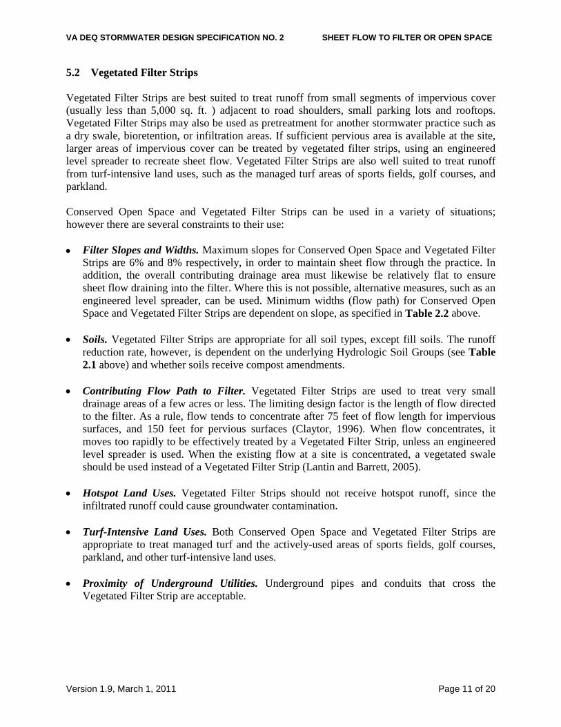
5.2 Vegetated Filter Strips Vegetated Filter Strips are best suited to treat runoff from small segments of impervious cover (usually less than 5,000 sq. ft. ) adjacent to road shoulders, small parking lots and rooftops. Vegetated Filter Strips may also be used as pretreatment for another stormwater practice such as a dry swale, bioretention, or infiltration areas. If sufficient pervious area is available at the site, larger areas of impervious cover can be treated by vegetated filter strips, using an engineered level spreader to recreate sheet flow. Vegetated Filter Strips are also well suited to treat runoff from turf-intensive land uses, such as the managed turf areas of sports fields, golf courses, and parkland. Conserved Open Space and Vegetated Filter Strips can be used in a variety of situations; however there are several constraints to their use: • Filter Slopes and Widths. Maximum slopes for Conserved Open Space and Vegetated Filter
Strips are 6% and 8% respectively, in order to maintain sheet flow through the practice. In addition, the overall contributing drainage area must likewise be relatively flat to ensure sheet flow draining into the filter. Where this is not possible, alternative measures, such as an engineered level spreader, can be used. Minimum widths (flow path) for Conserved Open Space and Vegetated Filter Strips are dependent on slope, as specified in Table 2.2 above.
• Soils. Vegetated Filter Strips are appropriate for all soil types, except fill soils. The runoff
reduction rate, however, is dependent on the underlying Hydrologic Soil Groups (see Table 2.1 above) and whether soils receive compost amendments.
• Contributing Flow Path to Filter. Vegetated Filter Strips are used to treat very small
drainage areas of a few acres or less. The limiting design factor is the length of flow directed to the filter. As a rule, flow tends to concentrate after 75 feet of flow length for impervious surfaces, and 150 feet for pervious surfaces (Claytor, 1996). When flow concentrates, it moves too rapidly to be effectively treated by a Vegetated Filter Strip, unless an engineered level spreader is used. When the existing flow at a site is concentrated, a vegetated swale should be used instead of a Vegetated Filter Strip (Lantin and Barrett, 2005).
• Hotspot Land Uses. Vegetated Filter Strips should not receive hotspot runoff, since the
infiltrated runoff could cause groundwater contamination. • Turf-Intensive Land Uses. Both Conserved Open Space and Vegetated Filter Strips are
appropriate to treat managed turf and the actively-used areas of sports fields, golf courses, parkland, and other turf-intensive land uses.
• Proximity of Underground Utilities. Underground pipes and conduits that cross the
Vegetated Filter Strip are acceptable.

VA DEQ STORMWATER DESIGN SPECIFICATION NO. 2 SHEET FLOW TO FILTER OR OPEN SPACE
Version 1.9, March 1, 2011 Page 12 of 20
SECTION 6. DESIGN CRITERIA 6.1. Compost Soil Amendments Compost soil amendments will enhance the runoff reduction capability of a vegetated filter strip when located on hydrologic soil groups B, C, and D, subject to the following design requirements: • The compost amendments should extend over the full length and width of the filter strip. • The amount of approved compost material and the depth to which it must be incorporated is
outlined in Stormwater Design Specification No. 4. • The amended area will be raked to achieve the most level slope possible without using heavy
construction equipment, and it will be stabilized rapidly with perennial grass and/or herbaceous species.
• If slopes exceed 3%, a protective biodegradable fabric or matting (e.g., EC-2) should be installed to stabilize the site prior to runoff discharge.
• Compost amendments should not be incorporated until the gravel diaphragm and/or engineered level spreader are installed (see Section 6.3).
• The local plan approval authority may waive the requirement for compost amendments on HSG-B soils in order to receive credit as a filter strip if (1) the designer can provide verification of the adequacy of the on-site soil type, texture, and profile to function as a filter strip, and (2) the area designated for the filter strip will not be disturbed during construction.
6.2. Planting and Vegetation Management Conserved Open Space . No grading or clearing of native vegetation is allowed within the Conserved Open Space. An invasive species management plan should be developed and approved by the local plan approval authority. Reforested Conserved Open Space. At some sites, the proposed stream buffer or Conserved Open Space may be in turf or meadow cover, or overrun with invasive plants and vines. In these situations, a landscape architect or horticulturalist should prepare a reforestation or restoration plan for the Conserved Open Space. The entire area can be planted with native trees and shrubs or planted to achieve a gradual transition from turf to meadow to shrub and forest. Trees and shrubs with deep rooting capabilities are recommended for planting to maximize soil infiltration capacity (PWD, 2007). Over-plant with seedlings for fast establishment and to account for mortality. Plant larger stock at desired spacing intervals (25 to 40 feet for large trees) using random spacing (Cappiella et al., 2006). Plant ground cover or a herbaceous layer to ensure rapid vegetative cover of the surface area. Vegetated Filter Strips. Vegetated Filter Strips should be planted at such a density to achieve a 90% grass/herbaceous cover after the second growing season. Filter strips should be seeded, not sodded. Seeding establishes deeper roots, and sod may have muck soil that is not conducive to infiltration (Wisconsin DNR, 2007). The filter strip vegetation may consist of turf grasses, meadow grasses, other herbaceous plants, shrubs, and trees, as long as the primary goal of at least 90% coverage with grasses and/or other herbaceous plants is achieved. Designers should

VA DEQ STORMWATER DESIGN SPECIFICATION NO. 2 SHEET FLOW TO FILTER OR OPEN SPACE
Version 1.9, March 1, 2011 Page 13 of 20
choose vegetation that stabilizes the soil and is salt tolerant. Vegetation at the toe of the filter, where temporary ponding may occur behind the permeable berm, should be able to withstand both wet and dry periods. The planting areas can be divided into zones to account for differences in inundation and slope. 6.3. Diaphragms, Berms and Level Spreaders Gravel Diaphragms: A pea gravel diaphragm at the top of the slope is required for both Conserved Open Space and Vegetated Filter Strips that receive sheetflow. The pea gravel diaphragm is created by excavating a 2-foot wide and 1-foot deep trench that runs on the same contour at the top of the filter strip. The diaphragm serves two purposes. First, it acts as a pretreatment device, settling out sediment particles before they reach the practice. Second, it acts as a level spreader, maintaining sheet flow as runoff flows over the Filter Strip. Refer to Figure 2.5. • The flow should travel over the impervious area and to the practice as sheet flow and then
drop at least 3 inches onto the gravel diaphragm. The drop helps to prevent runoff from running laterally along the pavement edge, where grit and debris tend to build up (thus allowing by-pass of the Filter Strip).
• A layer of filter fabric should be placed between the gravel and the underlying soil trench. • If the contributing drainage area is steep (6% slope or greater), then larger stone (clean bank-
run gravel that meets VDOT #57 grade) should be used in the diaphragm. • If the contributing drainage area is solely turf (e.g., sports field), then the gravel diaphragm
may be eliminated. Permeable Berm: Vegetated Filter Strips should be designed with a permeable berm at the toe of the Filter Strip to create a shallow ponding area. Runoff ponds behind the berm and gradually flows through outlet pipes in the berm or through a gravel lens in the berm with a perforated pipe. During larger storms, runoff may overtop the berm (Cappiella et al., 2006). The permeable berm should have the following properties: • A wide and shallow trench, 6 to 12 inches deep, should be excavated at the upstream toe of
the berm, parallel with the contours. • Media for the berm should consist of 40% excavated soil, 40% sand, and 20% pea gravel. • The berm 6 to 12 inches high should be located downgradient of the excavated depression
and should have gentle side slopes to promote easy mowing (Cappiella et al., 2006). • Stone may be needed to armor the top of berm to handle extreme storm events. • A permeable berm is not needed when vegetated filter strips are used as pretreatment to
another stormwater practice. Engineered Level Spreaders. The design of engineered level spreaders should conform to the following design criteria based on recommendations of Hathaway and Hunt (2006), or a locally approved standard that meets the intent of these criteria, in order to ensure non-erosive sheet flow into the vegetated buffer area. Figure 2.3 above represents a configuration that includes a bypass structure that diverts the design storm to the level spreader, and bypasses the larger storm events around the Conserved Open Space or Vegetated Filter Strip through an improved channel.

VA DEQ STORMWATER DESIGN SPECIFICATION NO. 2 SHEET FLOW TO FILTER OR OPEN SPACE
Version 1.9, March 1, 2011 Page 14 of 20
An alternative approach is that utilized by Henrico County, where pipe or channels discharge at the landward edge of a floodplain or stream (Resource Protection Area or RPA) buffer. The entire flow is directed through a stilling basin energy dissipater and then a level spreader such that the entire design storm for the conveyance system (typically a 10-year frequency storm) is discharged as sheet flow through the buffer. (Refer to Henrico County’s Environmental Program Manual; Chapter 9, Minimum Design Standard 9.01 “Energy Dissipator”: http://www.co.henrico.va.us/works/eesd/ .) Key design elements of the engineered level spreader, as provided in Figures 2 and 3, include the following: • High Flow Bypass provides safe passage for larger design storms through the filter strip. The
bypass channel should accommodate all peak flows greater than the water quality design flow.
• A Forebay should have a maximum depth of 3 feet and gradually transition to a depth of 1 foot at the level spreader lip (Figure 2). The forebay is sized such that the surface area is 0.2% of the contributing impervious area. (A forebay is not necessary if the concentrated flow is from the outlet of an extended detention basin or similar practice).
• The length of the level spreader should be determined by the type of filter area and the design flow: o 13 feet of level spreader length per every 1 cubic foot per second (cfs) of inflow for
discharges to a Vegetated Filter Strip or Conserved Open Space consisting of native grasses or thick ground cover;
o 40 feet of level spreader length per every 1 cfs of inflow when the spreader discharges to a Conserved Open Space consisting of forested or reforested buffer (Hathaway and Hunt, 2006).
o Where the Conserved Open Space is a mix of grass and forest (or re-forested), establish the level spreader length by computing a weighted average of the lengths required for each vegetation type.
o The minimum level spreader length is 13 feet and the maximum is 130 feet. o For the purposes of determining the Level Spreader length, the peak discharge shall be
determined using the Rational Equation with an intensity of 1-inch/hour. • The level spreader lip should be concrete, wood or pre-fabricated metal, with a well-
anchored footer, or other accepted rigid, non-erodible material. • The ends of the level spreader section should be tied back into the slope to avoid scouring
around the ends of the level spreader; otherwise, short-circuiting of the facility could create erosion.
• The width of the level spreader channel on the up-stream side of the level lip should be three times the diameter of the inflow pipe, and the depth should be 9 inches or one-half the culvert diameter, whichever is greater.
• The level spreader should be placed 3 to 6 inches above the downstream natural grade elevation to avoid turf buildup. In order to prevent grade drops that re-concentrate the flows, a 3-foot long section of VDOT # 3 stone, underlain by filter fabric, should be installed just below the spreader to transition from the level spreader to natural grade.

VA DEQ STORMWATER DESIGN SPECIFICATION NO. 2 SHEET FLOW TO FILTER OR OPEN SPACE
Version 1.9, March 1, 2011 Page 15 of 20
• Vegetated receiving areas down-gradient from the level spreader must be able to withstand the force of the flow coming over the lip of the device. It may be necessary to stabilize this area with temporary (VDOT EC-2) or permanent (VDOT EC-3) materials in accordance with the calculated velocity (on-line system peak, or diverted off-line peak) and material specifications, along with seeding and stabilization in conformance with the Virginia Erosion and Sediment Control Handbook.
6.4. Filter Design Material Specifications Table 2.3 describes materials specifications for the primary treatment within filter strips.
Table 2.3. Vegetated Filter Strip Materials Specifications
Material Specification Quantity
Gravel Diaphragm
Pea Gravel (#8 or ASTM equivalent) or where steep (6% +) use clean bank-run VDOT #57 or ASTM equivalent (1-inch maximum).
Diaphragm should be 2 feet wide, 1 foot deep, and at least 3 inches below the edge of pavement.
Permeable Berm
40% excavated soil, 40% sand, and 20% pea gravel to serve as the media for the berm.
Geotextile
Needled, non-woven, polypropylene geotextile meeting the following specifications: Grab Tensile Strength (ASTM D4632): > 120 lbs. Mullen Burst Strength (ASTM D3786): > 225 lbs./sq. in. Flow Rate (ASTM D4491): > 125 gpm/sq. ft. Apparent Opening Size (ASTM D4751): US #70 or #80 sieve
Engineered Level
Spreader
Level Spreader lip should be concrete, metal, timber, or other rigid material; Reinforced channel on upstream of lip: VDOT EC-2 (or EC-3 if velocities require permanent reinforcing). See Hathaway and Hunt (2006) or Henrico County Program Manual.
Erosion Control
Fabric or Matting
Where flow velocities dictate, use woven biodegradable erosion control fabric or mats that are durable enough to last at least 2 growing seasons. (e.g., VDOT Erosion Control matting EC-2).
Topsoil
If existing topsoil is inadequate to support dense turf growth, imported top soil (loamy sand or sandy loam texture), with less than 5% clay content, corrected pH at 6 to 7, a soluble salt content not exceeding 500 ppm, and an organic matter content of at least 2% shall be used. Topsoil shall be uniformly distributed and lightly compacted to a minimum depth of 6 to 8 inches
Compost Compost shall be derived from plant material and provided by a member of the U.S. Composting Seal of Testing Assurance (STA) program, as outlined in Stormwater Design Specification No. 4.

VA DEQ STORMWATER DESIGN SPECIFICATION NO. 2 SHEET FLOW TO FILTER OR OPEN SPACE
Version 1.9, March 1, 2011 Page 16 of 20
SECTION 7: REGIONAL & SPECIAL CASE DESIGN ADAPTATIONS 7.1. Karst Terrain Conserved Open Space areas are highly recommended in karst terrain, particularly when storm flow discharges to the outer boundary of a karst protection area (see CSN, 2009). Vegetated Filter Strips can also be used to treat runoff from small areas of impervious cover (e.g., less than 5,000 square feet). Some communities use wide grass filter strips to treat runoff from the roadway shoulder. In no case should the use of a Conserved Open Space or Vegetated Filter Strip be considered as a replacement for an adequate receiving system for developed-condition stormwater discharges, unless the adequacy of the design has been demonstrated consistent with the the Virginia Stormwater Management Handbook. 7.2. Coastal Plain The use of Conserved Open Space areas and Vegetated Filter Strips are highly recommended in the coastal plain, particularly when sheetflow (or concentrated flow with an appropriately-sized level spreader) discharges to the outer boundary of a shoreline, stream or wetland buffer. Vegetated Filter Strips can also be used to treat runoff from small areas of impervious cover (e.g., less than 5,000 square feet). In both cases, however, the designer must consider the depth to the water table. In general, shallow water tables may inhibit the function of Vegetated Filter Strips. 7.3. Linear Highway Sites Vegetated Filter Strips are highly recommended to treat highway runoff if the median and/or road shoulder is wide enough to provide an adequate flow path.
SECTION 8: CONSTRUCTION 8.1. Construction Sequence for Conserved Open Space Areas The Conserved Open Space must be fully protected during the construction stage of development and kept outside the limits of disturbance on the Erosion and Sediment (E&S) Control Plan. • No clearing, grading or heavy equipment access is allowed except temporary disturbances
associated with incidental utility construction, restoration operations or management of nuisance vegetation.
• The perimeter of the Conserved Open Space shall be protected by super silt fence, chain link fence, orange safety fence, or other measures to prevent sediment discharge.
• The limits of disturbance should be clearly shown on all construction drawings and identified and protected in the field by acceptable signage, silt fence, snow fence or other protective barrier.

VA DEQ STORMWATER DESIGN SPECIFICATION NO. 2 SHEET FLOW TO FILTER OR OPEN SPACE
Version 1.9, March 1, 2011 Page 17 of 20
• Construction of the gravel diaphragm or engineered level spreader shall not commence until the contributing drainage area has been stabilized and perimeter E&S controls have been removed and cleaned out.
• Some light grading may be needed at the Filter Strip boundary; this should be done with tracked vehicles to prevent compaction.
• Stormwater should not be diverted into the Vegetated Filter Strip until the gravel diaphragm and/or level spreader are installed and stabilized.
8.2. Construction Sequence for Vegetated Filter Strips Vegetated Filter Strips can be within the limits of disturbance during construction. The following procedures should be followed during construction: • Before site work begins, Vegetated Filter Strip boundaries should be clearly marked. • Only vehicular traffic used for Filter Strip construction should be allowed within 10 feet of
the Filter Strip boundary (City of Portland, 2004). • If existing topsoil is stripped during grading, it shall be stockpiled for later use. • Construction runoff should be directed away from the proposed Filter Strip site, using
perimeter silt fence, or, preferably, a diversion dike. • Construction of the gravel diaphragm or engineered level spreader shall not commence until
the contributing drainage area has been stabilized and perimeter E&S controls have been removed and cleaned out.
• Vegetated Filter Strips require light grading to achieve desired elevations and slopes. This should be done with tracked vehicles to prevent compaction. Topsoil and or compost amendments should be incorporated evenly across the filter strip area, stabilized with seed, and protected by biodegradable erosion control matting or blankets.
• Stormwater should not be diverted into the Filter Strip until the turf cover is dense and well established.
8.3. Construction Inspection Construction inspection is critical to obtain adequate spot elevations, to ensure the gravel diaphragm or ELS is completely level, on the same contour, and constructed to the correct design elevation. As-built surveys should be required to ensure compliance with design standards. Inspectors should evaluate the performance of the Filter Strip after the first big storm to look for evidence of gullies, outflanking, undercutting or sparse vegetative cover. Spot repairs should be made, as needed. An example construction phase inspection checklist for Sheet Flow to a Filter Strip or Conserved Open Space can be found on the Center for Watershed Protection website at:
http://www.cwp.org/Resource_Library/Controlling_Runoff_and_Discharges/sm.htm (scroll to Tool6: Plan Review, BMP Construction, and Maintenance Checklists)

VA DEQ STORMWATER DESIGN SPECIFICATION NO. 2 SHEET FLOW TO FILTER OR OPEN SPACE
Version 1.9, March 1, 2011 Page 18 of 20
SECTION 9. MAINTENANCE 9.1. Maintenance Agreements Section 4 VAC 50-60-124 of the regulations specifies the circumstances under which a maintenance agreement must be executed between the owner and the local program. This section sets forth inspection requirements, compliance procedures if maintenance is neglected, notification of the local program upon transfer of ownership, and right-of-entry for local program personnel. All Vegetated Filter Strips must be covered by a drainage easement to allow inspection and maintenance. If the filter area is a natural Conserved Open Space, it must be protected by a perpetual easement or deed restriction that assigns the responsible party to ensure that no future development, disturbance or clearing may occur within the area, except as stipulated in the vegetation maintenance plan. If the Vegetated Filter Strip is located on a residential private lot, the existence and purpose of the Filter Strip shall be noted on the deed of record. Homeowners will need to be provided a simple document that explains the purpose of the Filter Strip and routine maintenance needs. A deed restriction or other mechanism enforceable by the qualifying local program must be in place to help ensure that Filter Strips are maintained and Conserved Open Space Areas are not converted or disturbed. The mechanism should, if possible, grant authority for local agencies to access the property for inspection or corrective action. 9.2. Maintenance Inspections Annual inspections are used to trigger maintenance operations such as sediment removal, spot re-vegetation and level spreader repair. Ideally, inspections should be conducted in the non-growing season when it easier to see the flow path. Example maintenance inspection checklists for Sheet Flow to a Filter Strip or Conserved Open Space areas can be accessed in Appendix C of Chapter 9 of the Virginia Stormwater Management Handbook or at the Center for Watershed Protection’s website at:
http://www.cwp.org/Resource_Library/Controlling_Runoff_and_Discharges/sm.htm (scroll to Tool6: Plan Review, BMP Construction, and Maintenance Checklists)
Inspectors should check to ensure that: • Flows through the Filter Strip do not short-circuit the overflow control section; • Debris and sediment does not build up at the top of the Filter Strip; • Foot or vehicular traffic does not compromise the gravel diaphragm; • Scour and erosion do not occur within the Filter Strip; • Sediments are cleaned out of Level Spreader forebays and flow splitters; and • Vegetative density exceeds a 90% cover in the boundary zone or grass filter.

VA DEQ STORMWATER DESIGN SPECIFICATION NO. 2 SHEET FLOW TO FILTER OR OPEN SPACE
Version 1.9, March 1, 2011 Page 19 of 20
9.3. Ongoing Maintenance Once established, Vegetated Filter Strips have minimal maintenance needs outside of the spring clean up, regular mowing, repair of check dams and other measures to maintain the hydraulic efficiency of the strip and a dense, healthy grass cover. Vegetated Filter Strips that consist of grass/turf cover should be mowed at least twice a year to prevent woody growth.
SECTION 10. REFERENCES
Cappiella, K., T. Schueler, and T. Wright. 2006. Urban Watershed Forestry Manual, Part 2. Conserving and Planting Trees at Development Sites. Center for Watershed Protection. Prepared for United States Department of Agriculture, Forest Service. City of Portland, Environmental Services. 2004. Portland Stormwater Management Manual. Portland, OR. Available online at: http://www.portlandonline.com/bes/index.cfm?c=dfbbh Claytor, R. and T. Schueler. 1996. Design of Stormwater Filtering Systems. Center for Watershed Protection. Ellicott City, MD. CWP. 2007. National Pollutant Removal Performance Database Version 3.0. Center for Watershed Protection, Ellicott City, MD. Hathaway, J. and B. Hunt. 2006. Level Spreaders: Overview, Design, and Maintenance. Department of Biological and Agricultural Engineering. NC State University. Raliegh, NC. http://www.bae.ncsu.edu/stormwater/PublicationFiles/LevelSpreaders2006.pdf. Henrico County, Virginia. Henrico County Environmental Program Manual. Available online at: http://www.co.henrico.va.us/works/eesd/ North Carolina State University. Level Spreader Design Worksheet. Available online at: http://www.bae.ncsu.edu/cont_ed/main/handouts/lsworksheet.pdf North Carolina Department of Environment and Natural Resources, Division of Water Quality. “Level Spreader Design Guidelines.” January 2007. Available online at: http://h2o.enr.state.nc.us/su/Manuals_Factsheets.htm Northern Virginia Regional Commission. 2007. Low Impact Development Supplement to the Northern Virginia BMP Handbook. Fairfax, Virginia. Philadelphia Stormwater Management Guidance Manual. Available online at: http://www.phillyriverinfo.org/Programs/SubprogramMain.aspx?Id=StormwaterManual Schueler, T., D. Hirschman, M. Novotney and J. Zielinski. 2007. Urban Stormwater Retrofit Practices. Manual 3 in the Urban Subwatershed Restoration Manual Series. Center for Watershed Protection, Ellicott City, MD.

VA DEQ STORMWATER DESIGN SPECIFICATION NO. 2 SHEET FLOW TO FILTER OR OPEN SPACE
Version 1.9, March 1, 2011 Page 20 of 20
Schueler, T. 2008. Technical Support for the Baywide Runoff Reduction Method. Chesapeake Stormwater Network. Baltimore, MD. www.chesapeakestormwater.net Virginia Department of Environmental Quality (DEQ). 1999. Virginia Stormwater Management Handbook. Volumes 1 and 2. Division of Soil and Water Conservation. Richmond, VA.