Embed Size (px)
Citation preview
Shanwick (EGGX) & Gander (CZQO) Oceanic Control Procedures – Revision 2021/08 12 August 2021
Shanwick (EGGX) & Gander (CZQO)
Oceanic Control Procedures
REVISION 2021/08 – Effective 12 August 2021
Shanwick (EGGX) & Gander (CZQO) Oceanic Control Procedures – Revision 2021/08 Effective 12 August 2021
1
Contents
Contents ...................................................................................................................................... 1
PRE | Preface ............................................................................................................................... 1
Distribution and Scope ................................................................................................................................ 1
Exclusion of Liability .................................................................................................................................... 1
Acknowledgements and Mutual Agreement ............................................................................................... 1
Marked Changes .......................................................................................................................................... 2
Amendment History .................................................................................................................................... 2
Time References .......................................................................................................................................... 3
Understanding ‘VATSIMisms’ ...................................................................................................................... 3
Interpretation of Words .............................................................................................................................. 3
List of Figures............................................................................................................................................... 4
Validity of Procedures ................................................................................................................................. 4
GEN | Unit General Operating Procedures .................................................................................... 2
Chapter 1 Provision of Air Traffic Services ............................................................................................... 2
Chapter 2 Separation Standards ............................................................................................................. 6
Chapter 3 Altimeter Setting Procedures and Meteorology .................................................................... 12
Chapter 4 General Coordination Regulation.......................................................................................... 12
Chapter 5 Route Structures ................................................................................................................... 13
Shanwick (EGGX) & Gander (CZQO) Oceanic Control Procedures – Revision 2021/08 Effective 12 August 2021
2
SHW | Shanwick Oceanic Area Control ......................................................................................... 2
Chapter 1 General Operating Procedures ................................................................................................ 2
Chapter 2 Area of Responsibility ............................................................................................................. 3
Chapter 3 Coordination and Procedures with Adjacent Sectors .............................................................. 7
GAN | Gander Oceanic Area Control ............................................................................................. 2
Chapter 1 General Operating Procedures ................................................................................................ 2
Chapter 2 Area of Responsibility ............................................................................................................. 3
Chapter 3 Coordination and Procedures with Adjacent Sectors .............................................................. 4
Annex A | HF Phraseology ............................................................................................................ 2
Shanwick (EGGX) & Gander (CZQO) Oceanic Control Procedures – Revision 2021/08 Effective 12 August 2021
3
Glossary 8
Shanwick (EGGX) & Gander (CZQO) Oceanic Control Procedures – Revision 2021/08 Effective 12 August 2021
PRE-1
PRE | Preface
Distribution and Scope
This manual is for controllers of the Shanwick and Gander Oceanic Control Areas (OCA) and contains specific and local procedures relevant to these sectors.
Exclusion of Liability
This manual is for use on the VATSIM Network only and should never be adopted for real world use.
The information published within this document is made available without warranty of any kind; the Organisation accepts no responsibility or liability whether direct or indirect, as to the currency, accuracy or quality of the information, nor for any consequence of its use.
A number of procedures have been adapted or created using content published in the AIS of both countries. Any information in this document does not constitute as a real-world replacement for any official procedure and any similar procedures set out here or influenced by online content is written under the Limited License provided by the two AISs.
Acknowledgements and Mutual Agreement
This document is the product of the efforts of a number of people over the years. Without these efforts, this document would not have been possible to produce. On behalf of all the members of the VATSIM divisions involved, this acts as an acknowledgement and thanks for their work.
The contents of this document are agreed by:
• Jack Edwards – VATSIM UK – Operations Director
• Andrew Ogden – VATCAN – Gander OCA Chief
Shanwick (EGGX) & Gander (CZQO) Oceanic Control Procedures – Revision 2021/08 Effective 12 August 2021
PRE-2
Marked Changes
Changes made since the last release are marked with a black bar, as indicated, in the left-hand margin. They are also described briefly in the table below.
Amendment History
Revision Effective Date Notes
2021/08 12 Aug 2021
Minor formatting, spelling and grammar corrections throughout, NAT_FSS introduced as bandbox position, EGGX and CZQO FSS positions changed to CTR, Concorde, handoff and further example phraseology added to Annex A, separation minima added for external sectors.
2021/04 22 Apr 2021
Minor formatting, spelling and grammar corrections, Minor phraseology changes in Annex A, Brest Frequency Corrections, Multiple changes in Montreal & Gander (Domestic) Sectorisation to facilitate implementation of GOTA, References to CZQX changed to CZQO for Gander Oceanic, Shanwick and Gander HF & VHF frequency changes
2021/03 25 Mar 2021 Complete re-write
1 22 Dec 2013 First Publication
Shanwick (EGGX) & Gander (CZQO) Oceanic Control Procedures – Revision 2021/08 Effective 12 August 2021
PRE-3
Time References
All time references within this document are Coordinated Universal Time (UTC), or Zulu time, unless otherwise specified.
Understanding ‘VATSIMisms’
At various points in this document, text boxes have been added to help you, as a VATSIM controller, understand how and why real-world procedures might have been simplified, made redundant, or even more complex because of the nature of VATSIM.
Note that anything contained in these boxes is for information purposes only – procedures will always be in the main body of the text.
Interpretation of Words
To avoid any misunderstanding within this document, certain words are to be interpreted as having specific meanings when they are the operative words in an instruction.
‘shall’, ‘is to’, ‘are to’ and ‘must’
means that compliance with the instruction or requirement by the controller/pilot is mandatory.
‘should’ means that it is strongly advisable that an instruction is carried out; it is recommended or discretionary. It is applied where the more positive ‘shall’ is unreasonable but nevertheless a controller would have to have good reason for not doing so.
‘may’ means that the instruction is permissive, optional or alternative, e.g. ‘a controller may seek assistance…’ but would not if they did not need it.
‘will’ is used for informative or descriptive writing, e.g. ‘pilots will file…’, is not an instruction to the controller.
Useful information or explanations will be contained in text boxes with the same format as this. Note that information contained within these boxes are not procedures.
Shanwick (EGGX) & Gander (CZQO) Oceanic Control Procedures – Revision 2021/08 Effective 12 August 2021
PRE-4
List of Figures
Figure 1 – Shanwick and Gander VHF Frequency Range at FL350 .......................................................................... 4 Figure 2 – 19NM Lateral Separation ....................................................................................................................... 7 Figure 3 – Crossing Tracks (Same Direction) ........................................................................................................... 9 Figure 4 – Crossing Tracks (Opposite Direction) ................................................................................................... 10 Figure 5 – Crossing Tracks (Opposite Direction) Passed ....................................................................................... 10 Figure 6 – Longitudinal Separation on Parallel Tracks .......................................................................................... 11 Figure 7 – NTM Example ....................................................................................................................................... 14 Figure 8 – Concorde Tracks ................................................................................................................................... 15 Figure 9 – Shanwick Oceanic Control Area ............................................................................................................. 3 Figure 10 – Northern Oceanic Transition Area ....................................................................................................... 4 Figure 11 – Shannon Oceanic Transition Area ........................................................................................................ 5 Figure 12 – Brest Oceanic Transition Area.............................................................................................................. 6 Figure 13 – Santa Maria OACC Sectorisation .......................................................................................................... 7 Figure 14 – Reykjavík ACC Sectorisation ................................................................................................................. 8 Figure 15 – Scottish ACC Sectorisation ................................................................................................................. 10 Figure 16 – Shannon ACC Sectorisation ................................................................................................................ 12 Figure 17 – Brest ACC Sectorisation ..................................................................................................................... 14 Figure 18 – Gander Oceanic Control Area .............................................................................................................. 3 Figure 19 – Reykjavík ACC Sectorisation ................................................................................................................. 4 Figure 20 – New York Oceanic ARTCC Sectorisation............................................................................................... 5 Figure 21 – Santa Maria OACC Sectorisation .......................................................................................................... 6 Figure 22 – Montreal ACC Sectorisation Below FL290 ........................................................................................... 7 Figure 23 – Gander (Domestic) ACC Sectorisation FL290 and Above ..................................................................... 9 Figure 24 – Gander (Domestic) ACC Sectorisation Below FL290 .......................................................................... 10
Validity of Procedures
Amendments to Oceanic Procedures (Shanwick) Amendments to existing procedures and the introduction of new procedures will take place by the publication on the VATSIM UK forum in the Operations section.
• Procedure Changes (PC) are used for permanent changes
• Temporary Instructions (TI) are used for temporary changes
All published PCs and TIs shall have precedence over procedures published in this document. Any changes that affect both OCAs will be published by both divisions.
Amendments to Oceanic Procedures (Gander) TBN
Any changes that affect both OCAs will be published by both divisions.
AIP-Published Data Certain information included in this document is published in national AIPs. Where there are differences, the information published in the AIPs shall take precedence. VATSIM UK and Gander Oceanic vACC aim to notify controllers of any changes using the methods described above.
Letters of Agreement (LoAs) Letters of Agreement between VATSIM UK and Gander Oceanic vACC and adjacent FIRs/vACCs are published separately. Whilst both divisions aim to ensure the information in each is up to date, where there are conflicts, the LoA will override any procedures detailed in this document, except where instructions are otherwise promulgated as described above.
Section 1
General UNIT Operating Procedures
Gen
Shanwick (EGGX) & Gander (CZQO) Oceanic Control Procedures – Revision 2021/08 Effective 12 August 2021
GEN-2
GEN | Unit General Operating Procedures
The North Atlantic region consists of the Nuuk, Reykjavík, Bodø Oceanic, Shanwick Oceanic, Gander Oceanic, New York Oceanic and Santa Maria Oceanic FIRs. This document defines procedures for the Shanwick and Gander Oceanic Control Areas (OCAs).
Shanwick and Gander use a mix of space-based surveillance systems, satellite communication, and HF and VHF radios to manage aircraft within their respective OCAs. HF stations are staffed by Radio Operators at Gander (“Gander Radio”) in Canada and Ballygirreen (“Shanwick Radio”) in the Republic of Ireland. The Oceanic Area Control Centres are located respectively in Gander and Prestwick (Scotland), which act as the controlling authorities for their respective OCAs. On VATSIM, the distinction between Radio Operator and Controller is not made, with the Oceanic Controller responsible for the airspace and in contact with pilots.
Previously, ATS within the NAT Region was provided procedurally using position reports. Shanwick and Gander can now utilise space-based surveillance systems such as Automatic Dependent Surveillance (ADS). Communication can be over voice or via Controller-Pilot Datalink Communication (CPDLC) where aircraft equipment allows.
Chapter 1 Provision of Air Traffic Services
1.1 Roles and Responsibilities ▪ Provide the appropriate ATS within their stated AoR in order to ensure a safe, orderly and
expeditious flow of air traffic. ▪ Verify flight data including updating and managing the relevant datablock. ▪ Maintain a listening watch and conduct standard radiotelephony communication with
aircraft. ▪ Provide ATS to aircraft using ADS-B derived surveillance data within their area of
responsibility (AoR). ▪ Provide assistance to aircraft in a state of emergency. ▪ Coordinate the movement of aircraft into and out of the sector. ▪ Issue clearances to aircraft to join, leave or cross regulated airspace. ▪ When aircraft are accepted into the sector, ensure separation exists in accordance with this
document. ▪ Confirm all data transfer, revisions and estimates have been effected as required in local
instructions.
1.2 ATS Surveillance Systems On VATSIM, ADS coverage is assumed throughout the Shanwick & Gander OCAs. Simulated ADS-B data and position reports are assumed to be received through the VATSIM network which are then interpreted and displayed by controller clients or relevant plugins.
1.3 Assumptions of Aircraft Equipment In the real-world, a series of navigation, communications and surveillance standards are defined in order to enhance the provision of ATS within the shared Oceanic Control Area. These specifications allow for reduced separation standards to be implemented between suitably equipped aircraft pairs as well as reduce the need for voice communications. On VATSIM, these specifications are simplified and divided into 2 categories:
▪ ADS-B equipped aircraft; ▪ Non-ADS-B equipped aircraft (other aircraft).
Shanwick (EGGX) & Gander (CZQO) Oceanic Control Procedures – Revision 2021/08 Effective 12 August 2021
GEN-3
ADS-B equipped aircraft are assumed to: ▪ comply with the requirements and specifications of the Datalink Mandate (DLM); ▪ comply with the requirements for Performance Based Communication and Surveillance
(PBCS); ▪ comply with the requirements for Advanced Surveillance Enhanced Procedural Separation
(ASEPS); ▪ provide electronic position reports through ADS-C and/or CPDLC (are AGCS equipped)
Non-ADS-B equipped aircraft (other aircraft) are assumed to:
▪ not comply with the requirements and specifications of the Datalink Mandate (DLM); ▪ not comply with the requirements for Performance Based Communication and Surveillance
(PBCS); ▪ not comply with the requirements for Advanced Surveillance Enhanced Procedural
Separation (ASEPS); ▪ not provide electronic position reports through ADS-C and/or CPDLC.
The vNAAATS plugin indicates to controllers which category each aircraft falls into based on the equipment code. ADS-B equipped aircraft are marked as Air-Ground Communications System (AGCS) equipped
1.4 Position Reports On VATSIM, the requirement for voice position reports is dependent on aircraft equipment code.
▪ ADS-B equipped aircraft – position reports optional ▪ Other aircraft – position reports mandatory
Note: Aircraft that are not equipped with ADS-B are also considered to not be equipped with ADS-C or CPDLC, which would provide automatic/electronic position reporting functionality.
Note: For some events, it may be necessary to mandate that all pilots do not provide position reports due to frequency congestion.
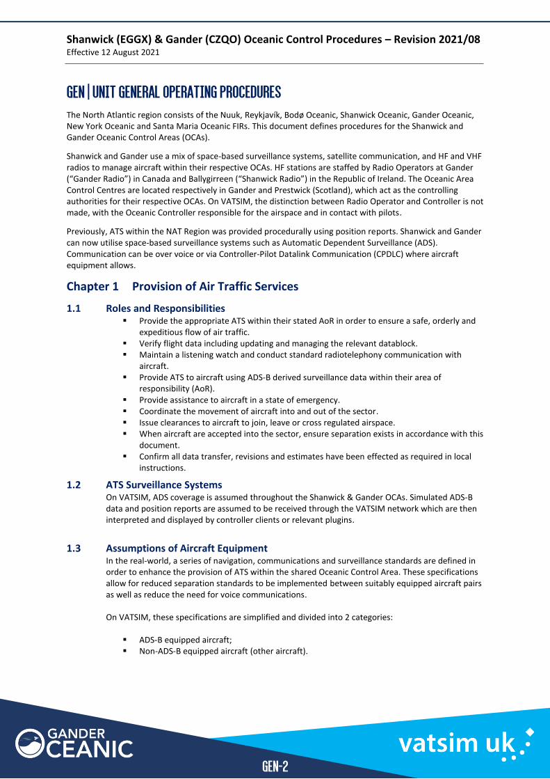
1.5 Oceanic Clearance Pilots must request oceanic clearance at least 30 minutes prior to the oceanic entry point. Clearance can be requested via:
▪ HF Voice Frequency ▪ VHF Voice Frequency - (Only available within range of VHF receivers – see chart below) ▪ natTRAK Website
Phraseology for oceanic clearances is provided in Annex A. When the delivery function is not split with another controller, track controllers may operate a second VHF clearance delivery frequency alongside HF to improve readability.
Shanwick (EGGX) & Gander (CZQO) Oceanic Control Procedures – Revision 2021/08 Effective 12 August 2021
GEN-4
Figure 1 – Shanwick and Gander VHF Frequency Range at FL350
Note: Audio for VATSIM (AfV) does not allow duplex coupling (XC) of HF and VHF frequencies, so pilots on one frequency will not be able to hear pilots on the other.
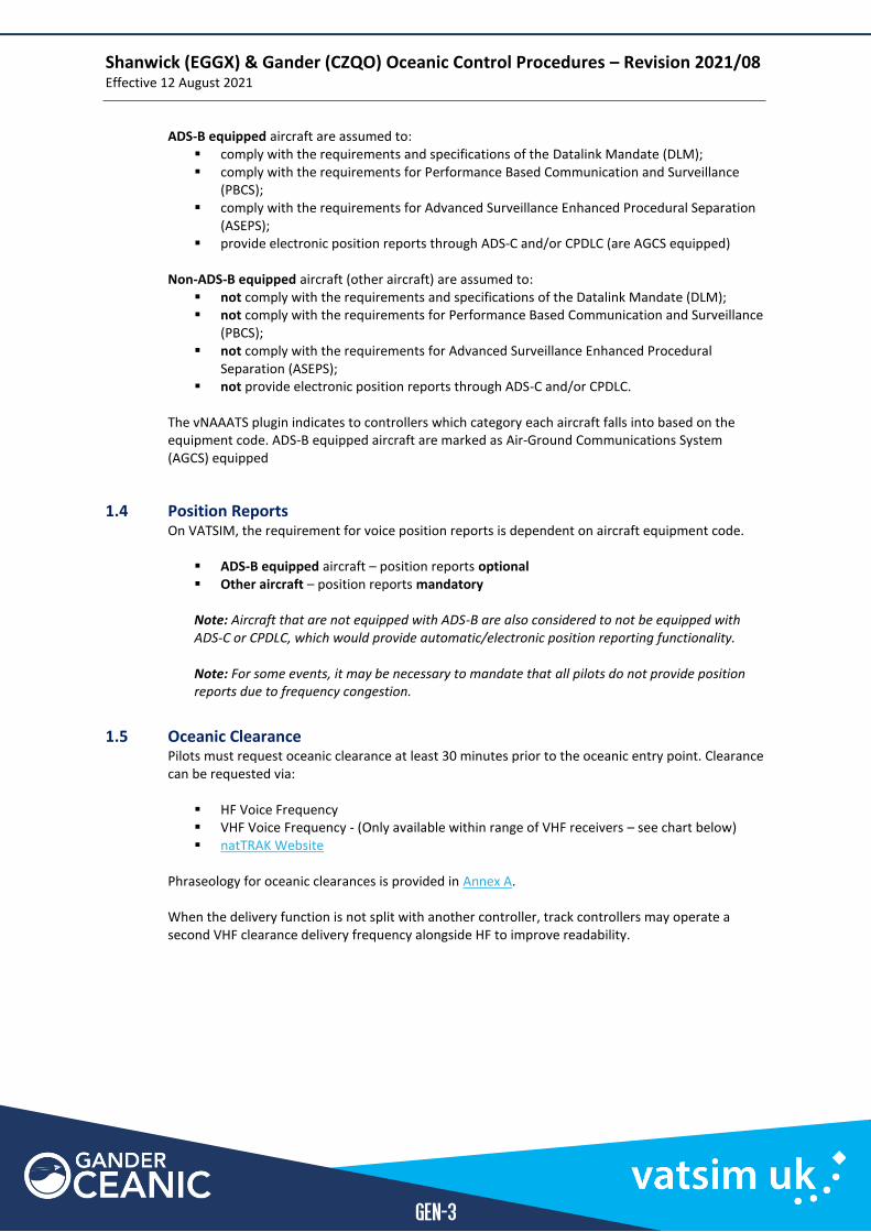
1.5.1 Oceanic Clearance Prior to Departure At some airfields proximate to the NAT HLA, an oceanic clearance is required prior to departure. On VATSIM, VHF coverage is assured at these airfields.
Departure Point Jet Departures Non-Jet Departures
EIDW
EIWT
EIME
For all Oceanic entry points request when airborne.
EICK If flight planned to enter Shanwick airspace via OMOKO, TAMEL or LASNO, Oceanic clearance required prior to departure.
All other Oceanic entry points, if the elapsed time to Shanwick Entry Point is 40 minutes or less, Oceanic clearance required prior to departure.
EGAA
EGAC
EGAE
EGPF
EGPK
If flight planned to enter Shanwick at GOMUP, oceanic clearance is required prior to departure.
For all other Oceanic entry points, request when airborne.
Request when airborne.
All other
aerodromes
If the elapsed time to the Shanwick entry point is 40 minutes or less oceanic clearance is required prior to departure.
Shanwick (EGGX) & Gander (CZQO) Oceanic Control Procedures – Revision 2021/08 Effective 12 August 2021
GEN-5
1.6 Selective Calling (SELCAL) Selective calling or SELCAL (pronounced “sell-call”) is a method by which pilots may be notified that a controller wishes to contact them on the voice frequency. SELCAL works by the controller triggering a series of 4 audio tones to play over the HF frequency, which are then received by the SELCAL units onboard all the aircraft tuned to that frequency. If these tones correspond to the code assigned to a specific aircraft, a notification is relayed to the pilots. SELCAL therefore allows pilots to reduce the volume of the tuned HF frequency since in real life, HF transmissions are subject to significant background static that is both tiring and distracting to listen to over longer periods of time. On VATSIM, pilot clients act in the same way as SELCAL units - when a SELCAL that corresponds to the code the pilot entered when they logged into the network is received, it will generate an alert to the pilot. The function of the SELCAL system shall be checked on first contact with each Oceanic Controller. In EuroScope, controllers can trigger a SELCAL tone (e.g. EM-DG) by using:
▪ “.selcal emdg” ▪ “SELCAL EM-DG” ▪ “.selcal”, then click on the aircraft
Shanwick (EGGX) & Gander (CZQO) Oceanic Control Procedures – Revision 2021/08 Effective 12 August 2021
GEN-6
Chapter 2 Separation Standards
2.1 General
Standard vertical or horizontal separation shall be provided between all flights in Class A airspace. At least one form of procedural separation must be maintained between all flights:
▪ Vertical ▪ Longitudinal ▪ Lateral
Note: “longitudinal” and “lateral” refer to aircraft orientation, not the lines of longitude or latitude.
The separation standards defined in this document are divided into two categories based on ADS-B equipage. In order to apply ADS-B based separation minima between two aircraft, both aircraft must be equipped with ADS-B. This requirement can be referred to with the phrase “suitably equipped aircraft pairs”.
2.2 Vertical Separation Vertical separation exists when the vertical distance between aircraft is never less than the prescribed minimum. The vertical separation minima are:
▪ Between aircraft flying subsonic: a. Up to FL290 apply 1000ft; b. Above FL290 apply 2000ft, except that between FL290 and FL410 inclusive, 1000ft
may be applied between RVSM approved aircraft operating in airspace designated as being notified for the application of this separation standard.
▪ Between aircraft flying supersonic and between aircraft flying supersonic and aircraft flying subsonic:
a. Up to FL450 apply 2000ft; b. Above FL450 apply 4000ft.
2.2.1 Cruise Climbs and Level Blocks During cruise climbs and level blocks aircraft are considered to occupy all levels specified in the clearance, regardless of ADS or verbal level reports. In a cruise climb, aircraft may only climb, whereas level blocks allow aircraft to climb or descend to any level within the block.
Separation on VATSIM is subject to some simplification. As such, an understanding of the separation requirements in this document will be sufficient for the purpose of oceanic control on VATSIM.
On VATSIM, all aircraft with an RFL above FL290 are assumed to be RVSM approved.
ADS-B does not allow controllers to assign headings to aircraft as they would in domestic, radar-controlled airspace. It merely allows for more accurate monitoring of aircraft position. The only practical way to intervene in order to prevent a conflict at a late stage is to apply vertical separation.
Shanwick (EGGX) & Gander (CZQO) Oceanic Control Procedures – Revision 2021/08 Effective 12 August 2021
GEN-7
2.2.1.1 Concorde Cruise Climb Concorde aircraft undertake a ‘cruise climb’ at supersonic speeds. As fuel is burnt, Concorde aircraft are able to climb slowly as they become lighter, whilst maintaining a constant speed. This equates to a constant climb rate of approximately 50 feet per minute. Clearance for cruise climb or a level block is therefore required, along with specified limits of which levels an aircraft is cleared within. This cruise climb generally starts at FL500 and clearance is provided up to FL600.
2.3 Lateral Separation Lateral separation is established distance between the routes of two aircraft (note: this is not the distance between aircraft at any given point, but distance between any 2 points along 2 different routes).
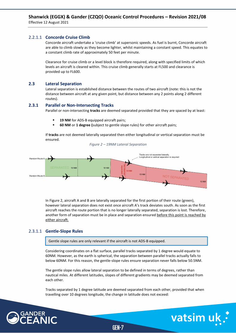
2.3.1 Parallel or Non-Intersecting Tracks Parallel or non-intersecting tracks are deemed separated provided that they are spaced by at least:
▪ 19 NM for ADS-B equipped aircraft pairs; ▪ 60 NM or 1 degree (subject to gentle slope rules) for other aircraft pairs;
If tracks are not deemed laterally separated then either longitudinal or vertical separation must be ensured.
Figure 2 – 19NM Lateral Separation
In Figure 2, aircraft A and B are laterally separated for the first portion of their route (green), however lateral separation does not exist once aircraft A’s track deviates south. As soon as the first aircraft reaches the route portion that is no longer laterally separated, separation is lost. Therefore, another form of separation must be in place and separation ensured before this point is reached by either aircraft.
2.3.1.1 Gentle-Slope Rules
Considering coordinates on a flat surface, parallel tracks separated by 1 degree would equate to 60NM. However, as the earth is spherical, the separation between parallel tracks actually falls to below 60NM. For this reason, the gentle-slope rules ensure separation never falls below 50.5NM. The gentle slope rules allow lateral separation to be defined in terms of degrees, rather than nautical miles. At different latitudes, slopes of different gradients may be deemed separated from each other. Tracks separated by 1 degree latitude are deemed separated from each other, provided that when travelling over 10 degrees longitude, the change in latitude does not exceed:
Gentle slope rules are only relevant if the aircraft is not ADS-B equipped.
Shanwick (EGGX) & Gander (CZQO) Oceanic Control Procedures – Revision 2021/08 Effective 12 August 2021
GEN-8
▪ 3 degrees at or below 58N ▪ 2 degrees between 58N and 70N ▪ 1 degree between 70N and 80N
Example Two aircraft travel on parallel tracks starting at 58N20W and 59N20W. We will look at the different parallel tracks they might take travelling west over the next 10° longitude (i.e. to 30W) Aircraft A (From 5820N) Aircraft B (From 5920N) Separated?
Aircraft A Aircraft B Separated? to 5530N to 5630N 3° - No to 5630N to 5730N 2° - Yes to 5730N to 5830N 1° - Yes to 5830N to 5930N 0° - Yes to 5930N to 6030N 1° - Yes to 6030N to 6130N 2° - Yes to 6130N to 6230N 3° - Yes to 6230N to 6330N 4° - No
As long as these tracks remain at or above 58N, then 3° of latitude change over the 10° longitude allows them to be deemed separated. At 4° change, lateral separation no longer exists. When the tracks travel below 58N, only 2° of latitude change over 10° longitude allows them to be deemed separated.
2.3.2 Lateral Separation of OTS All co-directional tracks published in a NAT Track Message are laterally separated for ADS-B equipped aircraft pairs. Performance Based Communication Surveillance (PBCS) tracks are separated by less than one degree of latitude (0° 30’ rather than 1° degree). Aircraft that are not ADS-B equipped that are operating on PBCS tracks are not considered laterally separated from aircraft operating on adjacent PBCS tracks. It is therefore recommended (but not mandatory on VATSIM) to re-clear non-ADS-B equipped aircraft via non-PBCS tracks. As aircraft on VATSIM often fly tracks outside of the published times, conflicts between aircraft on opposite direction published tracks are possible. The ‘Concorde Tracks’ are also deemed laterally separated for all aircraft.
2.3.3 Strategic Lateral Offset Procedure (SLOP) The Strategic Lateral Offset Procedure allows pilots to deviate from their route up to 2 NM right of track at any increment of 0.1 NM, remaining parallel to the centreline. The purpose of the SLOP is to reduce wake turbulence encounters and also to reduce the chance of a collision when aircraft are required to conduct emergency descents or deviate from their cleared route/level. Pilots will not deviate until entering oceanic airspace and will re-join their cleared track before leaving. Aircraft conducting SLOP do not require a clearance to do so and are not required to inform the controlling agency. For the purposes of ensuring separation, the effect of SLOP is not required to be considered by controllers – this information is included here for reference only
Shanwick (EGGX) & Gander (CZQO) Oceanic Control Procedures – Revision 2021/08 Effective 12 August 2021
GEN-9
2.4 Longitudinal Separation
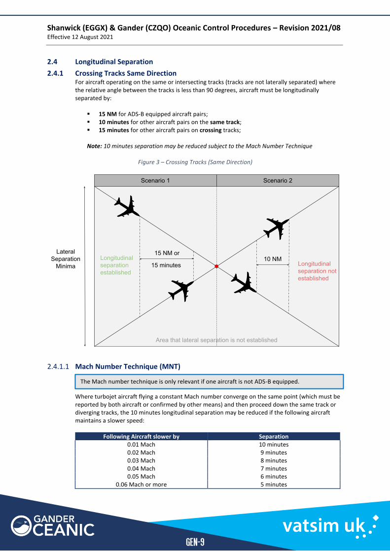
2.4.1 Crossing Tracks Same Direction For aircraft operating on the same or intersecting tracks (tracks are not laterally separated) where the relative angle between the tracks is less than 90 degrees, aircraft must be longitudinally separated by:
▪ 15 NM for ADS-B equipped aircraft pairs; ▪ 10 minutes for other aircraft pairs on the same track; ▪ 15 minutes for other aircraft pairs on crossing tracks;
Note: 10 minutes separation may be reduced subject to the Mach Number Technique
Figure 3 – Crossing Tracks (Same Direction)
2.4.1.1 Mach Number Technique (MNT)
Where turbojet aircraft flying a constant Mach number converge on the same point (which must be reported by both aircraft or confirmed by other means) and then proceed down the same track or diverging tracks, the 10 minutes longitudinal separation may be reduced if the following aircraft maintains a slower speed:
Following Aircraft slower by Separation 0.01 Mach 10 minutes 0.02 Mach 9 minutes 0.03 Mach 8 minutes 0.04 Mach 7 minutes 0.05 Mach 6 minutes
0.06 Mach or more 5 minutes
The Mach number technique is only relevant if one aircraft is not ADS-B equipped.
Shanwick (EGGX) & Gander (CZQO) Oceanic Control Procedures – Revision 2021/08 Effective 12 August 2021
GEN-10
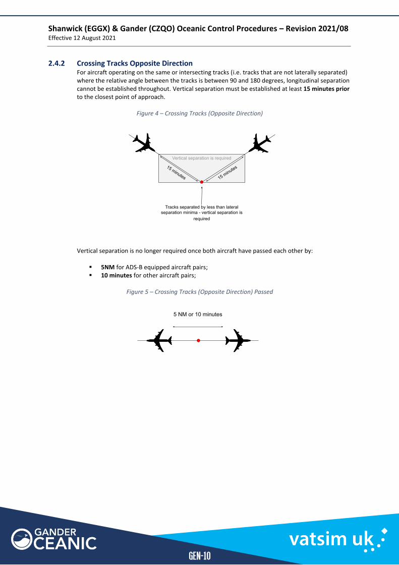
2.4.2 Crossing Tracks Opposite Direction For aircraft operating on the same or intersecting tracks (i.e. tracks that are not laterally separated) where the relative angle between the tracks is between 90 and 180 degrees, longitudinal separation cannot be established throughout. Vertical separation must be established at least 15 minutes prior to the closest point of approach.
Figure 4 – Crossing Tracks (Opposite Direction)
Vertical separation is no longer required once both aircraft have passed each other by:
▪ 5NM for ADS-B equipped aircraft pairs; ▪ 10 minutes for other aircraft pairs;
Figure 5 – Crossing Tracks (Opposite Direction) Passed
Shanwick (EGGX) & Gander (CZQO) Oceanic Control Procedures – Revision 2021/08 Effective 12 August 2021
GEN-11
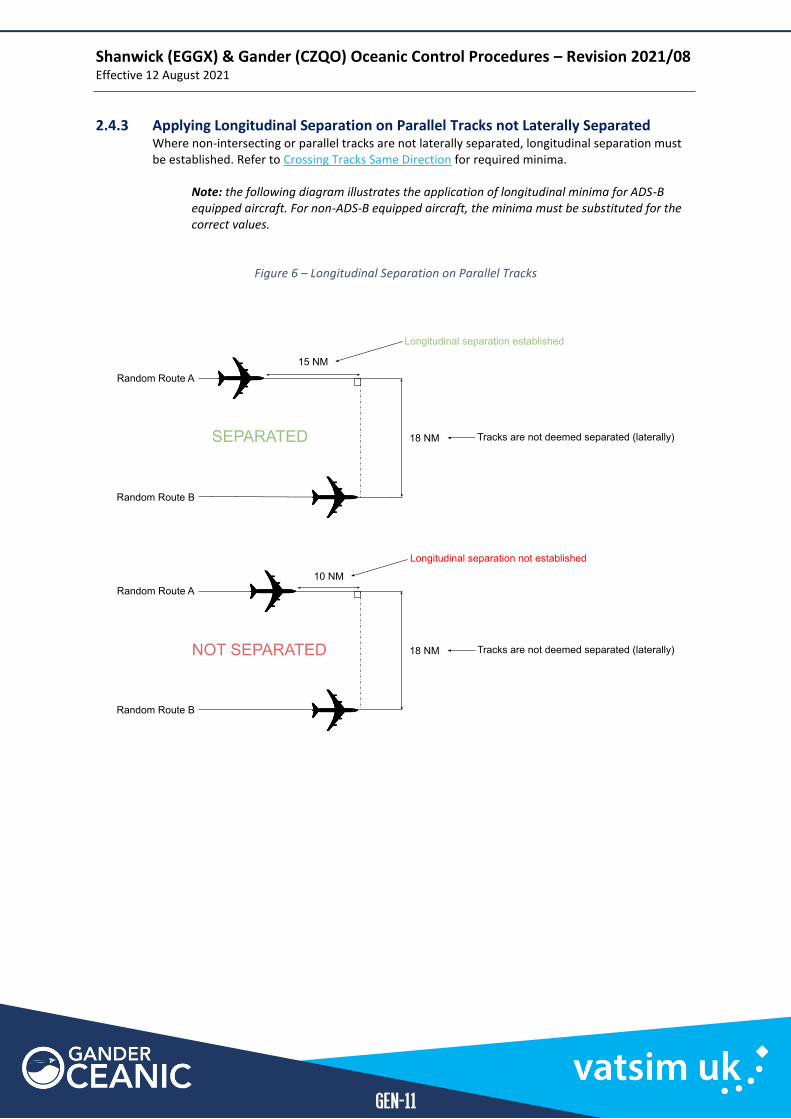
2.4.3 Applying Longitudinal Separation on Parallel Tracks not Laterally Separated Where non-intersecting or parallel tracks are not laterally separated, longitudinal separation must be established. Refer to Crossing Tracks Same Direction for required minima.
Note: the following diagram illustrates the application of longitudinal minima for ADS-B equipped aircraft. For non-ADS-B equipped aircraft, the minima must be substituted for the correct values.
Figure 6 – Longitudinal Separation on Parallel Tracks
Shanwick (EGGX) & Gander (CZQO) Oceanic Control Procedures – Revision 2021/08 Effective 12 August 2021
GEN-12
Chapter 3 Altimeter Setting Procedures and Meteorology
3.1 Altimeter Setting Procedures
3.1.1 Transition Level
Area Transition Level NAT Oceanic Control Areas FL55
Chapter 4 General Coordination Regulation
Any traffic that is not deemed coordinated under the terms of this chapter shall be individually coordinated.
4.1 Deemed Coordination of Traffic Between Shanwick and Gander Aircraft transferred between Shanwick and Gander shall be deemed coordinated provided:
▪ the aircraft is operating in compliance with their current oceanic clearance; ▪ if operating on a NAT Track, is at a level specified in the NTM for the direction of flight; ▪ the RFL has not been changed level within 15 minutes of the common sector boundary; ▪ no objection has been raised by the receiving controller.
4.2 Deemed Coordination of En-Route Traffic Entering the OCA Aircraft in receipt of an oceanic clearance shall be deemed coordinated provided that:
▪ the aircraft is at the level specified in the oceanic clearance; ▪ the aircraft will cross the oceanic entry point within 3 minutes of the most recently
received time estimate or according to a time restriction specified in the oceanic clearance and;
▪ no objection has been raised by the receiving controller.
4.3 Deemed Coordination of En-Route Traffic Leaving the OCA Cruising traffic which has reached the RFL indicated on the flight plan is deemed to have been coordinated provided that:
▪ the RFL has not been changed within 5 minutes of the oceanic exit point and; ▪ there is no known conflict and separation is maintained against OCA traffic; ▪ no objection has been raised by the receiving controller.
4.4 Transfer of Control and Communication Transfer of control and communications is at the receiving sector boundary except:
▪ For aircraft entering the Shannon (EISN) FIR (or NOTA/SOTA) from Shanwick between SUNOT and BEDRA (inclusive):
o Transfer of Control – sector boundary o Transfer of Communications – 1 degree prior to sector boundary
4.5 Coordination of Direct Routings Direct routings that cross sector boundaries must be coordinated. This coordination may be completed electronically via the COPX function of EuroScope.
Controllers should be aware that accepted coordination of a direct routing only appears in the datablock for the coordinating and receiving controller. It is therefore advisable for the current controller to re-enter/re-type any direct into the datablock after it has been agreed via electronic coordination.
Shanwick (EGGX) & Gander (CZQO) Oceanic Control Procedures – Revision 2021/08 Effective 12 August 2021
GEN-13
Chapter 5 Route Structures
5.1 Organised Track System (OTS)
5.1.1 North Atlantic (NAT) Tracks
Introduction To minimise flight time and thereby the cost of operating aircraft through oceanic airspace, all operators desire to operate in a relatively small portion of oceanic airspace. The optimum routings vary according to departure and destination airfields, enroute weather, winds aloft and aircraft performance.
Design To maximise the flow of traffic along the preferred, optimal routings, Shanwick & Gander publish a list of set North Atlantic (NAT) Tracks each day. The process of track design depends upon input from operators, upper wind conditions, limitations of airspace and feasibility for surrounding controlling authorities. This system can accommodate a higher flow of traffic than using ‘random routings’ for all aircraft.
The published tracks are defined by a list of permissible flight levels and series of waypoints, which include an oceanic entry and exit point. These are positioned on the domestic FIR boundaries and are generally named using the standard five-letter convention. Between the entry and exit points, waypoints are defined by Latitude and Longitude (e.g. 57N 040W, also written 5740N or 57/40) and are generally positioned every 10 degrees of longitude.
Validity In the real world, the tracks are only valid at certain times of day, with a westbound set published for use for aircraft crossing the 30 degrees west line between 1130 and 1900Z and an eastbound set for aircraft crossing the same line between 0100 and 0800Z. The two sets of tracks are not necessarily laterally separated as they are never valid at the same time.
Shanwick OAC (Prestwick) publishes the westbound tracks around 2200z before activation in the morning and Gander OAC publishes the eastbound tracks around 1400z in the afternoon.
Naming NATs are named using letters of the alphabet. Westbound tracks are named with the most northerly track designated ‘Alpha’ and working down the alphabet to the final westbound track. Eastbound tracks are identified with the most southerly track designated ‘Zulu’ and working up through the alphabet to the final eastbound track. These names are re-used every day when old tracks are removed and new tracks published, though the number of tracks each day may vary.
Random Routes The use of the OTS is not mandatory, pilots may file routes that over/under-fly, cross join or leave the system. Any route that does not follow the OTS for the entire track is referred to as a “random route”.
5.1.2 Track Message Identifier (TMI) The NAT Tracks are published in a single NAT Track Message (NTM) with a Track Message Identification (TMI) number. This is simply the Julian calendar day that the tracks are published. Checking this number confirms that both the pilot and the controller have the latest track information. “Track Alpha” from one day to another will be a different published route, however “Track Alpha, TMI 001” will only be repeated once every year (1st January). Occasionally if the NAT message is amended after publication, a letter will be appended to the TMI number (e.g. 001A) and the entire message is re-issued.
Shanwick (EGGX) & Gander (CZQO) Oceanic Control Procedures – Revision 2021/08 Effective 12 August 2021
GEN-14
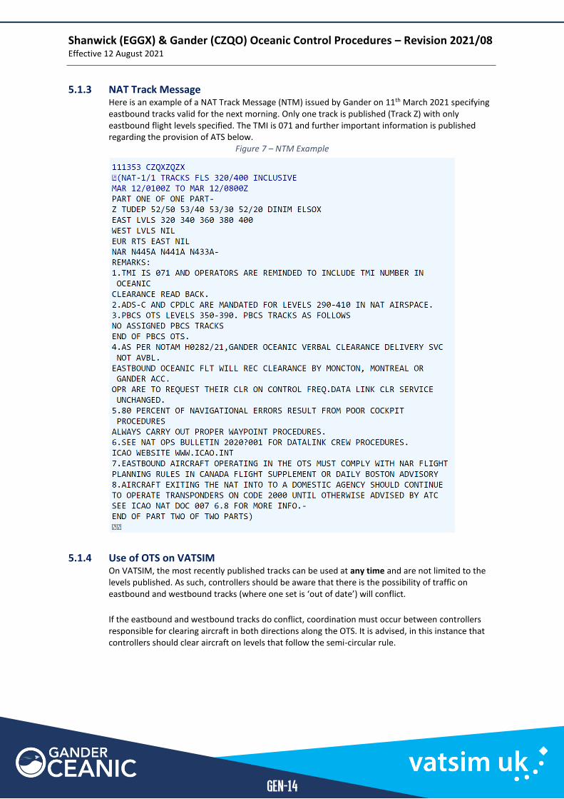
5.1.3 NAT Track Message Here is an example of a NAT Track Message (NTM) issued by Gander on 11th March 2021 specifying eastbound tracks valid for the next morning. Only one track is published (Track Z) with only eastbound flight levels specified. The TMI is 071 and further important information is published regarding the provision of ATS below.
Figure 7 – NTM Example
5.1.4 Use of OTS on VATSIM On VATSIM, the most recently published tracks can be used at any time and are not limited to the levels published. As such, controllers should be aware that there is the possibility of traffic on eastbound and westbound tracks (where one set is ‘out of date’) will conflict.
If the eastbound and westbound tracks do conflict, coordination must occur between controllers responsible for clearing aircraft in both directions along the OTS. It is advised, in this instance that controllers should clear aircraft on levels that follow the semi-circular rule.

Shanwick (EGGX) & Gander (CZQO) Oceanic Control Procedures – Revision 2021/08 Effective 12 August 2021
GEN-15
5.1.5 Concorde Tracks Concorde traffic still routes across the Atlantic on VATSIM. Three legacy tracks are utilised for the purpose of Concorde flight. These are all published for FL500 or above and supersonic flight. Concorde tracks are named NAT SM, NAT SN, NAT SO.
▪ SM: “Sierra Mike” for westbound flight only ▪ SN: “Sierra November” for eastbound flight only ▪ SO: “Sierra Oscar” overflow of supersonic traffic, as coordinated/cleared by ATC. ▪ SP: “Sierra Papa” bi-directional route to Caribbean
These tracks route via intermediate latitudes (i.e. degrees and minutes). For this reason, points on track are commonly abbreviated to the track name and their longitude. For example, Track SM is defined as the following points (with abbreviated names):
▪ 50° 41'N 15°W “Sierra Mike 15 West” ▪ 50° 50'N 20°W “Sierra Mike 20 West” etc.
Figure 8 – Concorde Tracks
Note: Supersonic flight on Concorde tracks is separated from flights via other Concorde tracks.
5.1.5.1 NAT-SM (Westbound) Waypoints SM15W (50.41N 15.00W) SM20W (50.50N 20.00W) SM30W (50.30N 30.00W) SM40W (49.16N 40.00W) SM50W (47.03N 50.00W) SM53W (46.10N 53.00W) SM60W (44.14N 60.00W) SM65W (42.46N 65.00W) SM67W (42.00N 67.00W)
5.1.5.2 NAT-SN (Eastbound) Waypoints SN67W (40.25N 67.00W) SN65W (41.40N 65.00W) SN60W (43.07N 60.00W) SN52W (45.10N 52.30W) SN50W (45.54N 50.00W) SN40W (48.10N 40.00W) SN30W (49.26N 30.00W) SN20W (49.49N 20.00W) SN15W (49.41N 15.00W)
5.1.5.3 NAT-SO (Alternate) Waypoints SO15W (48.40N 15.00W) SO20W (48.48N 20.00W) SO30W (48.22N 30.00W) SO40W (47.04N 40.00W) SO50W (44.45N 50.00W) SO52W (44.10N 52.00W) SO60W (42.00N 60.00W)
5.1.5.4 NAT-SP (Caribbean) Waypoints SP15W (48.49N 14.43W) SP20W (46.49N 20.00W) SP45N (45.00N 23.53W) SP30W (41.36N 30.00W) SP40W (34.22N 40.00W)
Shanwick (EGGX) & Gander (CZQO) Oceanic Control Procedures – Revision 2021/08 Effective 12 August 2021
GEN-16
5.2 Tango Routes The Tango routes are a fixed set of routes in the South Eastern of the Shanwick OCA. Clearance delivery must be conducted over HF for northbound aircraft (due to range requirements) but may be conducted on VHF for southbound aircraft.
5.2.1 T9 and T290 T9/T290 are unidirectional routes established just west of the BOTA. They connect the SOTA to the Madrid FIR and are generally used by aircraft from the British Isles to Portugal, the Canaries and Cape Verde Islands.
▪ T9 - Southbound - LASNO to BEGAS ▪ T290 - Northbound - ADVAT to GELPO
Note: T9/T290 are laterally separated from each other.
5.2.1.1 Transponder Operation on T9/T290 Pilots will reset their assigned SSR code to 2000, 10 minutes after passing LASNO, BEGAS, TAMEL or BERUX.
5.2.2 T213 T213 is a bi directional route established to the West of T290 and connecting the SOTA to the Madrid FIR.
▪ T213 – Bi-directional – TAMEL to BERUX
5.2.3 T13 and T16 T13/T16 are unidirectional routes established just west T213 and cross into Santa Maria Oceanic airspace eventually terminating just North of the Madeira Archipelago.
▪ T13 - Northbound – NILAV to OMOKO ▪ T16 - Southbound - OMOKO to GONAN
Note: T13/T16 share a common waypoint (OMOKO) and are therefore not laterally separated.
5.3 North American Routes The North American Routes (NARs) are fixed routes designed for application to aircraft flying oceanic random routes at and above FL290 to transition to domestic airspace. Occasionally the NAT Message will specify NARs which must be used in conjunction with certain tracks.
Note: Oceanic controllers do not assign NARs. This section is for information only. Westbound NARs consist of 2 portions;
1. The coastal fix is linked to an inland fix (INF) by what is termed the ‘common portion’. 2. The ‘non-common portion’ will then link the inland fix towards the system airports.
Where an airport does not have defined non-common portions, pilots should file the full route of the common portion to the inland fix. Eastbound NARs consist of a single portion - the ‘common portion’ which connect the inland fix to the coastal fix.
Shanwick (EGGX) & Gander (CZQO) Oceanic Control Procedures – Revision 2021/08 Effective 12 August 2021
GEN-17
All NARs are designated by N*, where ‘N’ is spoken “North American Route” and * is the published designator (usually a 1/2-digit number followed by a letter). Most of the routes are divided into two portions:
1. Common Portion - That portion of the route between a specified coastal fix or an oceanic entry/exit point and a specified Inland Navigation Fix (INF). Some routes have a common portion only (N598A-N700A);
2. Non-Common Portion - That portion of the route between a specified INF and a system airport. The routes are within the high-level airspace structure with a transition to/from system airports.
The routes are prefixed by the abbreviation "N" with the numbering for the common portions orientated geographically from south to north. The ODD numbers have eastbound application while the EVEN numbers apply to westbound. Aircraft can only join the NAR System:
▪ At the identified coastal fix or oceanic entry/exit point; or ▪ On departure from one of the identified system airports; or ▪ At an identified INF.
NARs may be assigned by ATC for the tactical management of air traffic in Canadian Domestic airspace.
Section 2
Shanwick Oceanic Area Control - SHW
SHW
Shanwick (EGGX) & Gander (CZQO) Oceanic Control Procedures – Revision 2021/08 Effective 12 August 2021
SHW-2
SHW | Shanwick Oceanic Area Control
Chapter 1 General Operating Procedures
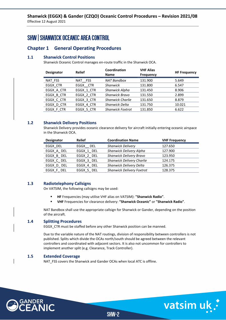
1.1 Shanwick Control Positions Shanwick Oceanic Control manages en-route traffic in the Shanwick OCA.
Designator Relief Coordination Name
VHF Alias Frequency
HF Frequency
NAT_FSS NAT__FSS NAT Bandbox 131.900 5.649
EGGX_CTR EGGX__CTR Shanwick 131.800 6.547
EGGX_A_CTR EGGX_1_CTR Shanwick Alpha 131.450 8.906
EGGX_B_CTR EGGX_2_CTR Shanwick Bravo 131.550 2.899
EGGX_C_CTR EGGX_3_CTR Shanwick Charlie 131.650 8.879
EGGX_D_CTR EGGX_4_CTR Shanwick Delta 131.750 10.021
EGGX_F_CTR EGGX_5_CTR Shanwick Foxtrot 131.850 6.622
1.2 Shanwick Delivery Positions Shanwick Delivery provides oceanic clearance delivery for aircraft initially entering oceanic airspace in the Shanwick OCA.
Designator Relief Coordination Name VHF Frequency
EGGX_DEL EGGX__ DEL Shanwick Delivery 127.650
EGGX_A_ DEL EGGX_1_ DEL Shanwick Delivery Alpha 127.900
EGGX_B_ DEL EGGX_2_ DEL Shanwick Delivery Bravo 123.950
EGGX_C_ DEL EGGX_3_ DEL Shanwick Delivery Charlie 124.175
EGGX_D_ DEL EGGX_4_ DEL Shanwick Delivery Delta 126.375
EGGX_F_ DEL EGGX_5_ DEL Shanwick Delivery Foxtrot 128.375
1.3 Radiotelephony Callsigns On VATSIM, the following callsigns may be used:
▪ HF Frequencies (may utilise VHF alias on VATSIM): "Shanwick Radio".
▪ VHF Frequencies for clearance delivery: “Shanwick Oceanic” or "Shanwick Radio".
NAT Bandbox shall use the appropriate callsign for Shanwick or Gander, depending on the position of the aircraft.
1.4 Splitting Procedures EGGX_CTR must be staffed before any other Shanwick position can be manned.
Due to the variable nature of the NAT routings, division of responsibility between controllers is not published. Splits which divide the OCAs north/south should be agreed between the relevant controllers and coordinated with adjacent sectors. It is also not uncommon for controllers to implement another split (e.g. Clearance, Track Controller).
1.5 Extended Coverage NAT_FSS covers the Shanwick and Gander OCAs when local ATC is offline.
Shanwick (EGGX) & Gander (CZQO) Oceanic Control Procedures – Revision 2021/08 Effective 12 August 2021
SHW-3
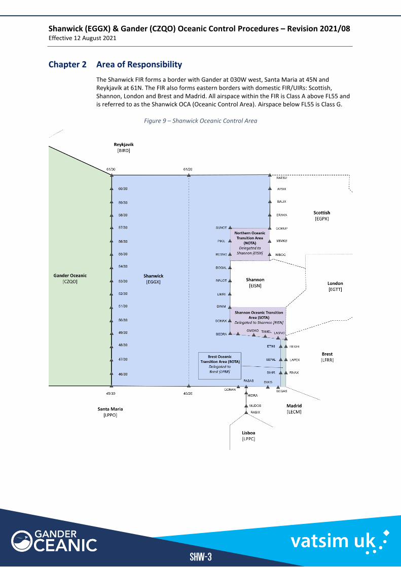
Chapter 2 Area of Responsibility
The Shanwick FIR forms a border with Gander at 030W west, Santa Maria at 45N and Reykjavík at 61N. The FIR also forms eastern borders with domestic FIR/UIRs: Scottish, Shannon, London and Brest and Madrid. All airspace within the FIR is Class A above FL55 and is referred to as the Shanwick OCA (Oceanic Control Area). Airspace below FL55 is Class G.
Figure 9 – Shanwick Oceanic Control Area
Shanwick (EGGX) & Gander (CZQO) Oceanic Control Procedures – Revision 2021/08 Effective 12 August 2021
SHW-4
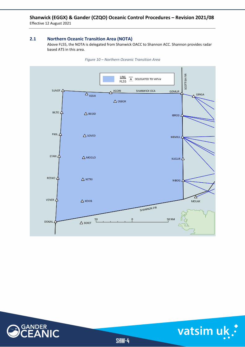
2.1 Northern Oceanic Transition Area (NOTA) Above FL55, the NOTA is delegated from Shanwick OACC to Shannon ACC. Shannon provides radar based ATS in this area.
Figure 10 – Northern Oceanic Transition Area
Shanwick (EGGX) & Gander (CZQO) Oceanic Control Procedures – Revision 2021/08 Effective 12 August 2021
SHW-5
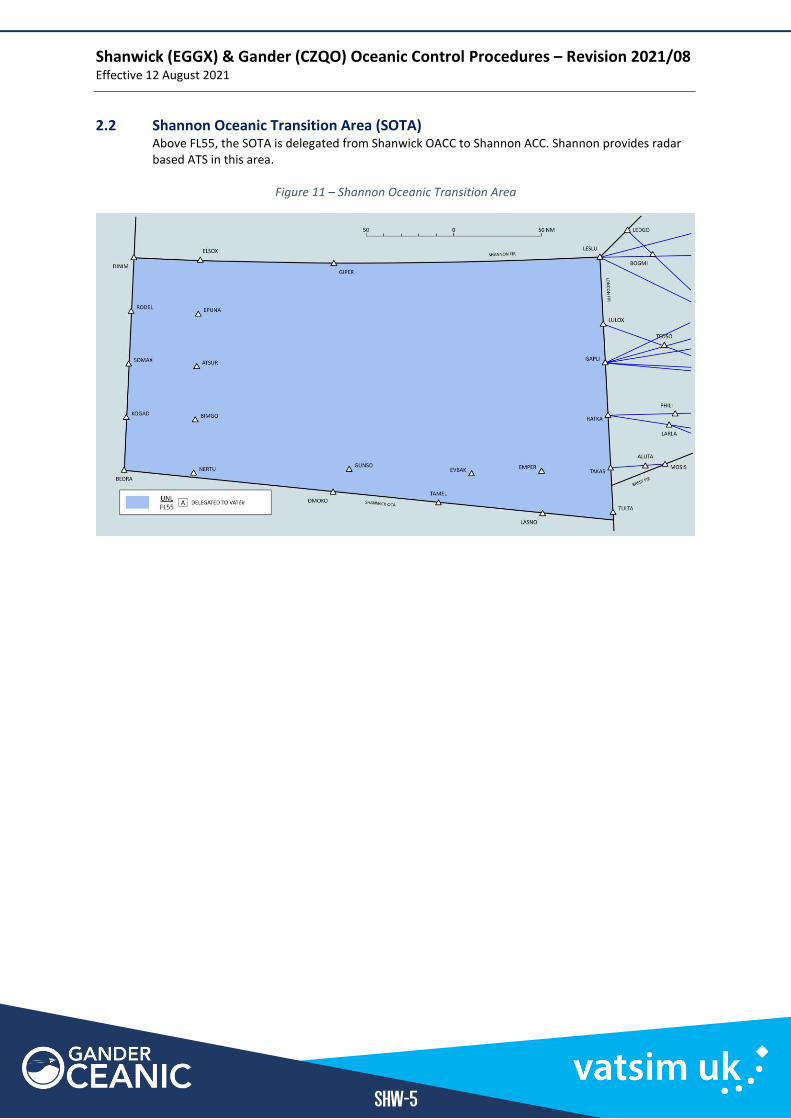
2.2 Shannon Oceanic Transition Area (SOTA) Above FL55, the SOTA is delegated from Shanwick OACC to Shannon ACC. Shannon provides radar based ATS in this area.
Figure 11 – Shannon Oceanic Transition Area
Shanwick (EGGX) & Gander (CZQO) Oceanic Control Procedures – Revision 2021/08 Effective 12 August 2021
SHW-6
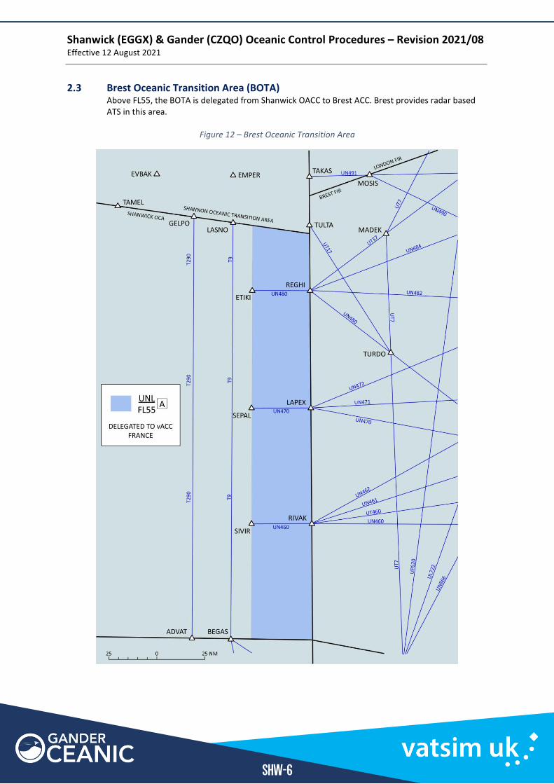
2.3 Brest Oceanic Transition Area (BOTA) Above FL55, the BOTA is delegated from Shanwick OACC to Brest ACC. Brest provides radar based ATS in this area.
Figure 12 – Brest Oceanic Transition Area
Shanwick (EGGX) & Gander (CZQO) Oceanic Control Procedures – Revision 2021/08 Effective 12 August 2021
SHW-7
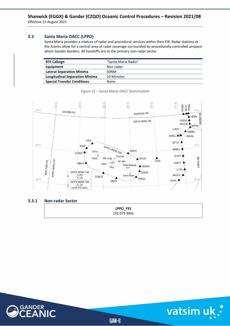
Chapter 3 Coordination and Procedures with Adjacent Sectors
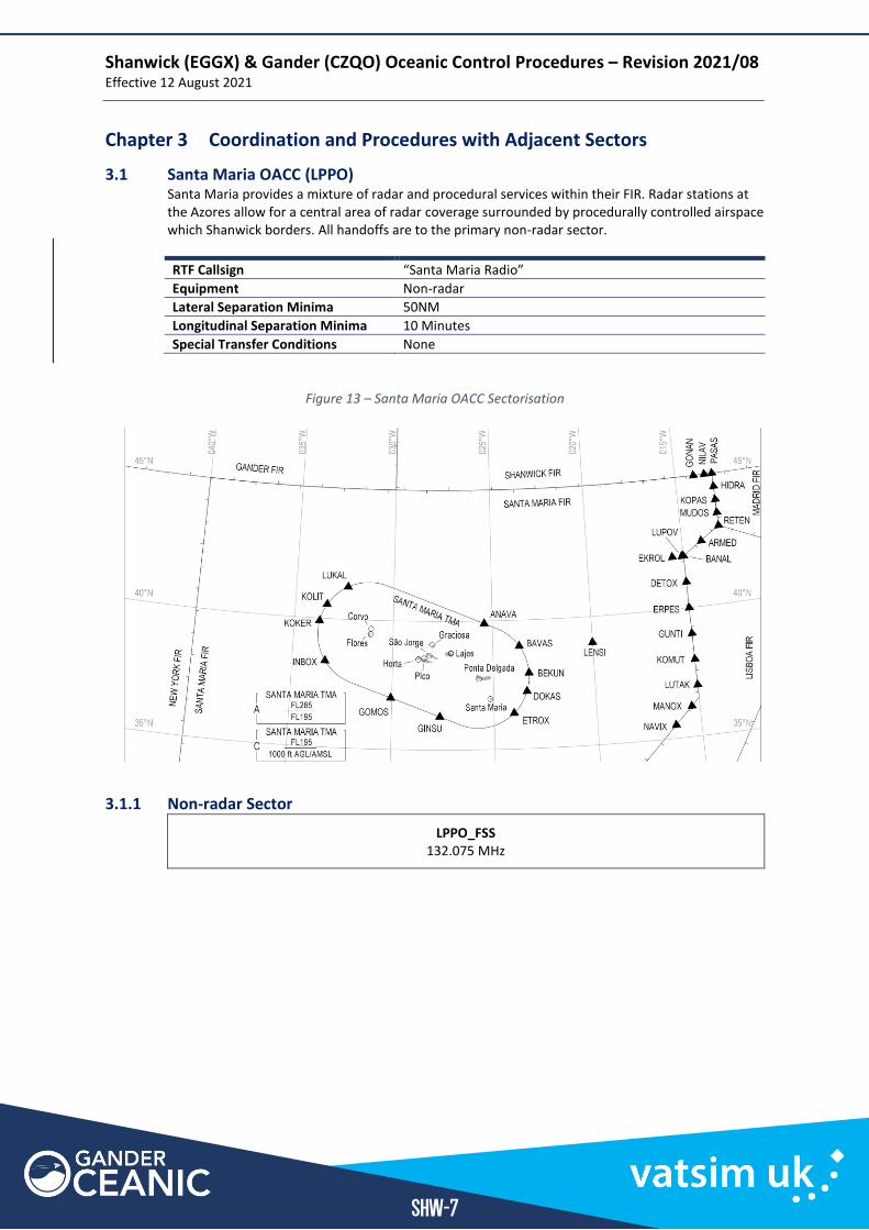
3.1 Santa Maria OACC (LPPO) Santa Maria provides a mixture of radar and procedural services within their FIR. Radar stations at the Azores allow for a central area of radar coverage surrounded by procedurally controlled airspace which Shanwick borders. All handoffs are to the primary non-radar sector.
RTF Callsign “Santa Maria Radio”
Equipment Non-radar
Lateral Separation Minima 50NM
Longitudinal Separation Minima 10 Minutes
Special Transfer Conditions None
Figure 13 – Santa Maria OACC Sectorisation
3.1.1 Non-radar Sector
LPPO_FSS 132.075 MHz
Shanwick (EGGX) & Gander (CZQO) Oceanic Control Procedures – Revision 2021/08 Effective 12 August 2021
SHW-8
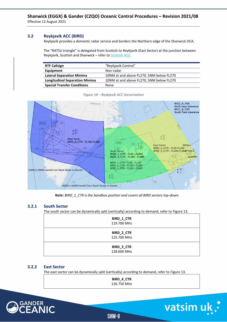
3.2 Reykjavík ACC (BIRD) Reykjavík provides a domestic radar service and borders the Northern edge of the Shanwick OCA. The “RATSU triangle” is delegated from Scottish to Reykjavík (East Sector) at the junction between Reykjavík, Scottish and Shanwick – refer to Scottish ACC.
RTF Callsign “Reykjavik Control”
Equipment Non-radar
Lateral Separation Minima 10NM at and above FL270, 5NM below FL270
Longitudinal Separation Minima 10NM at and above FL270, 5NM below FL270
Special Transfer Conditions None
Figure 14 – Reykjavík ACC Sectorisation
Note: BIRD_1_CTR is the bandbox position and covers all BIRD sectors top-down.
3.2.1 South Sector The south sector can be dynamically split (vertically) according to demand, refer to Figure 13.
BIRD_1_CTR 119.700 MHz
BIRD_2_CTR 125.700 MHz
BIRD_3_CTR 128.600 MHz
3.2.2 East Sector The east sector can be dynamically split (vertically) according to demand, refer to Figure 13.
BIRD_4_CTR 126.750 MHz
Shanwick (EGGX) & Gander (CZQO) Oceanic Control Procedures – Revision 2021/08 Effective 12 August 2021
SHW-9
BIRD_5_CTR 132.300 MHz
Shanwick (EGGX) & Gander (CZQO) Oceanic Control Procedures – Revision 2021/08 Effective 12 August 2021
SHW-10
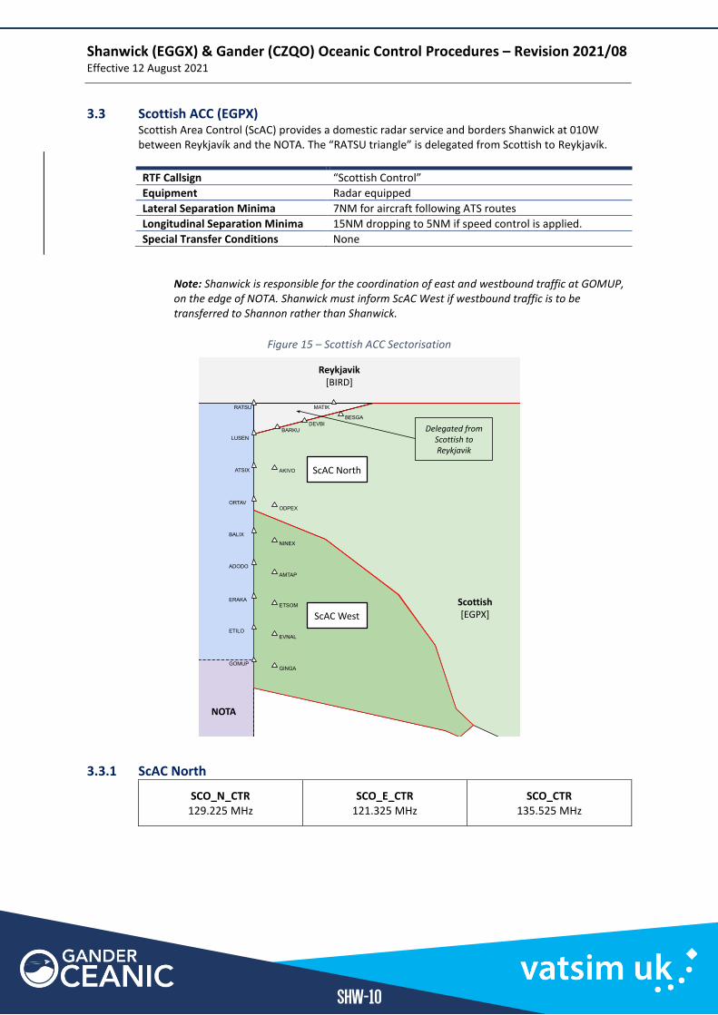
3.3 Scottish ACC (EGPX) Scottish Area Control (ScAC) provides a domestic radar service and borders Shanwick at 010W between Reykjavík and the NOTA. The “RATSU triangle” is delegated from Scottish to Reykjavík.
RTF Callsign “Scottish Control”
Equipment Radar equipped
Lateral Separation Minima 7NM for aircraft following ATS routes
Longitudinal Separation Minima 15NM dropping to 5NM if speed control is applied.
Special Transfer Conditions None
Note: Shanwick is responsible for the coordination of east and westbound traffic at GOMUP, on the edge of NOTA. Shanwick must inform ScAC West if westbound traffic is to be transferred to Shannon rather than Shanwick.
Figure 15 – Scottish ACC Sectorisation
3.3.1 ScAC North
SCO_N_CTR 129.225 MHz
SCO_E_CTR 121.325 MHz
SCO_CTR 135.525 MHz
Shanwick (EGGX) & Gander (CZQO) Oceanic Control Procedures – Revision 2021/08 Effective 12 August 2021
SHW-11
3.3.2 ScAC West
SCO_W_CTR 132.725 MHz
SCO_WD_CTR 133.875 MHz
SCO_CTR 135.525 MHz
Shanwick (EGGX) & Gander (CZQO) Oceanic Control Procedures – Revision 2021/08 Effective 12 August 2021
SHW-12
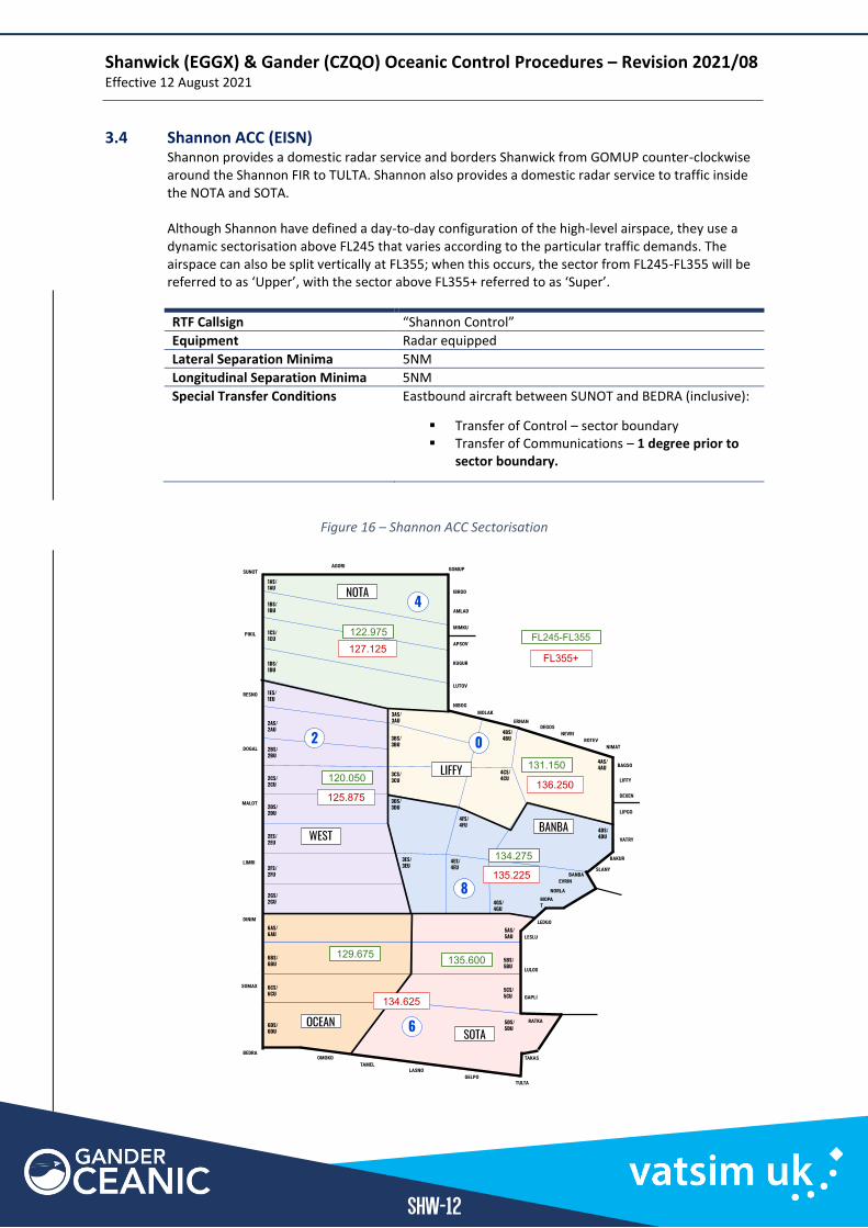
3.4 Shannon ACC (EISN) Shannon provides a domestic radar service and borders Shanwick from GOMUP counter-clockwise around the Shannon FIR to TULTA. Shannon also provides a domestic radar service to traffic inside the NOTA and SOTA. Although Shannon have defined a day-to-day configuration of the high-level airspace, they use a dynamic sectorisation above FL245 that varies according to the particular traffic demands. The airspace can also be split vertically at FL355; when this occurs, the sector from FL245-FL355 will be referred to as ‘Upper’, with the sector above FL355+ referred to as ‘Super’.
RTF Callsign “Shannon Control”
Equipment Radar equipped
Lateral Separation Minima 5NM
Longitudinal Separation Minima 5NM
Special Transfer Conditions Eastbound aircraft between SUNOT and BEDRA (inclusive):
▪ Transfer of Control – sector boundary ▪ Transfer of Communications – 1 degree prior to
sector boundary.
Figure 16 – Shannon ACC Sectorisation
Shanwick (EGGX) & Gander (CZQO) Oceanic Control Procedures – Revision 2021/08 Effective 12 August 2021
SHW-13
3.4.1 Shannon NOTA
Super (FL355+)
EISN_4_CTR 127.125 MHz
Shannon NOTA – Upper
Upper (FL245-FL355)
EISN_N_CTR 122.975MHz
Shannon West – Upper
3.4.2 Shannon West
Super (FL355+)
EISN_2_CTR 125.875 MHz
Shannon West – Upper
Upper (FL245-FL355)
EISN_W_CTR 120.050 MHz
EISN_CTR (EISN_E_CTR) 131.150 MHz
3.4.3 Shannon Ocean
Super (FL355+)
EISN_6_CTR 134.625 MHz
Shannon Ocean – Upper
Upper (FL245-FL355)
EISN_O_CTR 129.675 MHz
Shannon West – Upper
3.4.4 Shannon SOTA
Super (FL355+)
EISN_6_CTR 134.625 MHz
Shannon SOTA – Upper
Upper (FL245-FL355)
EISN_S_CTR 135.600 MHz
Shannon West – Upper
3.4.5 Shannon Low Level
Low Level (DB-FL245)
EISN_L_CTR 124.700 MHz
EISN_CTR (EISN_E_CTR) 131.150 MHz
Shanwick (EGGX) & Gander (CZQO) Oceanic Control Procedures – Revision 2021/08 Effective 12 August 2021
SHW-14
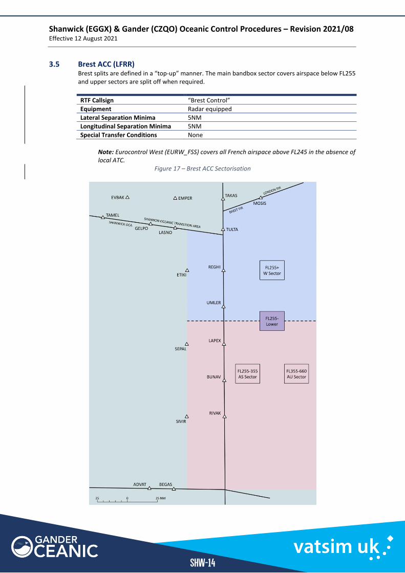
3.5 Brest ACC (LFRR) Brest splits are defined in a “top-up” manner. The main bandbox sector covers airspace below FL255 and upper sectors are split off when required.
RTF Callsign “Brest Control”
Equipment Radar equipped
Lateral Separation Minima 5NM
Longitudinal Separation Minima 5NM
Special Transfer Conditions None
Note: Eurocontrol West (EURW_FSS) covers all French airspace above FL245 in the absence of local ATC.
Figure 17 – Brest ACC Sectorisation
Shanwick (EGGX) & Gander (CZQO) Oceanic Control Procedures – Revision 2021/08 Effective 12 August 2021
SHW-15
3.5.1 Brest W (FL255+) Sector
LFRR_W_CTR 127.850 MHz
LFRR_CTR 125.500 MHz
3.5.2 Brest Lower (SFC-FL255) Sector
LFRR_CTR 125.500 MHz
3.5.3 Brest AU (FL355-FL660) Sector
LFRR_A_CTR 131.275 MHz
Brest AS (FL255-FL355) Sector
3.5.4 Brest AS (FL255-FL355) Sector
LFRR_S_CTR 124.675 MHz
LFRR_CTR 125.500 MHz
Shanwick (EGGX) & Gander (CZQO) Oceanic Control Procedures – Revision 2021/08 Effective 12 August 2021
SHW-16
3.6 Madrid ACC (LECM) All handoffs to/from Madrid come from the West Sector which is split at FL245.
RTF Callsign “Madrid Radar”
Equipment Radar equipped
Lateral Separation Minima 5NM
Longitudinal Separation Minima 5NM
Special Transfer Conditions None
Note: Eurocontrol West (EURW_FSS) covers all French airspace above FL245 in the absence of local ATC
3.6.1 Madrid W Upper (SFC-FL245) Sector
LECM_W_CTR 135.950 MHz
LECM_N_CTR 125.750 MHz
LECM_M_CTR 132.975 MHz
LECM_U_CTR 136.350 MHz
LECM_CTR 133.750 MHz
3.6.2 Madrid W Lower (FL245-FL660) Sector
LECM_W_CTR 135.950 MHz
LECM_N_CTR 125.750 MHz
LECM_M_CTR 132.975 MHz
LECM_CTR 133.750 MHz
Section 3
Gander Oceanic Area Control - GAN
GAN
Shanwick (EGGX) & Gander (CZQO) Oceanic Control Procedures – Revision 2021/08 Effective 12 August 2021
GAN-2
GAN | Gander Oceanic Area Control
Chapter 1 General Operating Procedures
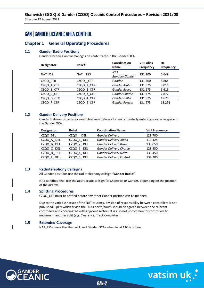
1.1 Gander Radio Positions Gander Oceanic Control manages en-route traffic in the Gander OCA.
1.2 Gander Delivery Positions Gander Delivery provides oceanic clearance delivery for aircraft initially entering oceanic airspace in the Gander OCA.
Designator Relief Coordination Name VHF Frequency
CZQO_DEL CZQO__ DEL Gander Delivery 128.700
CZQO_A_ DEL CZQO_1_ DEL Gander Delivery Alpha 119.425
CZQO_B_ DEL CZQO_2_ DEL Gander Delivery Bravo 135.050
CZQO_C_ DEL CZQO_3_ DEL Gander Delivery Charlie 128.450
CZQO_D_ DEL CZQO_4_ DEL Gander Delivery Delta 135.450
CZQO_F_ DEL CZQO_5_ DEL Gander Delivery Foxtrot 134.200
1.3 Radiotelephony Callsigns All Gander positions use the radiotelephony callsign “Gander Radio”.
NAT Bandbox shall use the appropriate callsign for Shanwick or Gander, depending on the position of the aircraft.
1.4 Splitting Procedures CZQO_CTR must be staffed before any other Gander position can be manned.
Due to the variable nature of the NAT routings, division of responsibility between controllers is not published. Splits which divide the OCAs north/south should be agreed between the relevant controllers and coordinated with adjacent sectors. It is also not uncommon for controllers to implement another split (e.g. Clearance, Track Controller).
1.5 Extended Coverage NAT_FSS covers the Shanwick and Gander OCAs when local ATC is offline.
Designator Relief Coordination Name
VHF Alias Frequency
HF Frequency
NAT_FSS NAT__FSS NAT BandboxGander
131.900 5.649
CZQO_CTR CZQO__CTR Gander 131.700 8.864
CZQO_A_CTR CZQO_1_CTR Gander Alpha 131.575 3.016
CZQO_B_CTR CZQO_2_CTR Gander Bravo 131.675 5.616
CZQO_C_CTR CZQO_3_CTR Gander Charlie 131.775 2.872
CZQO_D_CTR CZQO_4_CTR Gander Delta 131.875 4.675
CZQO_F_CTR CZQO_5_CTR Gander Foxtrot 131.975 13.291
Shanwick (EGGX) & Gander (CZQO) Oceanic Control Procedures – Revision 2021/08 Effective 12 August 2021
GAN-3
Chapter 2 Area of Responsibility
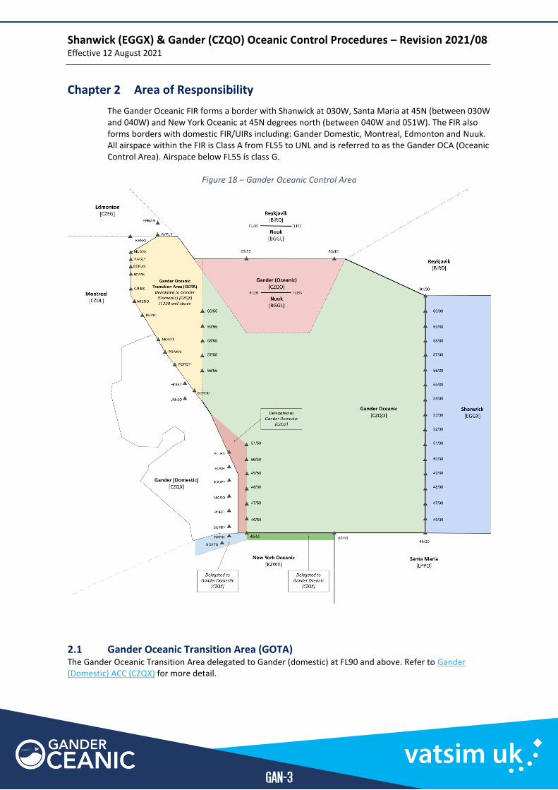
The Gander Oceanic FIR forms a border with Shanwick at 030W, Santa Maria at 45N (between 030W and 040W) and New York Oceanic at 45N degrees north (between 040W and 051W). The FIR also forms borders with domestic FIR/UIRs including: Gander Domestic, Montreal, Edmonton and Nuuk. All airspace within the FIR is Class A from FL55 to UNL and is referred to as the Gander OCA (Oceanic Control Area). Airspace below FL55 is class G.
Figure 18 – Gander Oceanic Control Area
2.1 Gander Oceanic Transition Area (GOTA) The Gander Oceanic Transition Area delegated to Gander (domestic) at FL90 and above. Refer to Gander (Domestic) ACC (CZQX) for more detail.
Shanwick (EGGX) & Gander (CZQO) Oceanic Control Procedures – Revision 2021/08 Effective 12 August 2021
GAN-4
Chapter 3 Coordination and Procedures with Adjacent Sectors
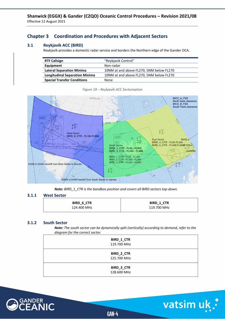
3.1 Reykjavík ACC (BIRD) Reykjavík provides a domestic radar service and borders the Northern edge of the Gander OCA.
RTF Callsign “Reykjavik Control”
Equipment Non-radar
Lateral Separation Minima 10NM at and above FL270, 5NM below FL270
Longitudinal Separation Minima 10NM at and above FL270, 5NM below FL270
Special Transfer Conditions None
Figure 19 – Reykjavík ACC Sectorisation
Note: BIRD_1_CTR is the bandbox position and covers all BIRD sectors top-down.
3.1.1 West Sector
BIRD_6_CTR 124.400 MHz
BIRD_1_CTR 119.700 MHz
3.1.2 South Sector Note: The south sector can be dynamically split (vertically) according to demand, refer to the diagram for the correct sector.
BIRD_1_CTR 119.700 MHz
BIRD_2_CTR 125.700 MHz
BIRD_3_CTR 128.600 MHz
Shanwick (EGGX) & Gander (CZQO) Oceanic Control Procedures – Revision 2021/08 Effective 12 August 2021
GAN-5
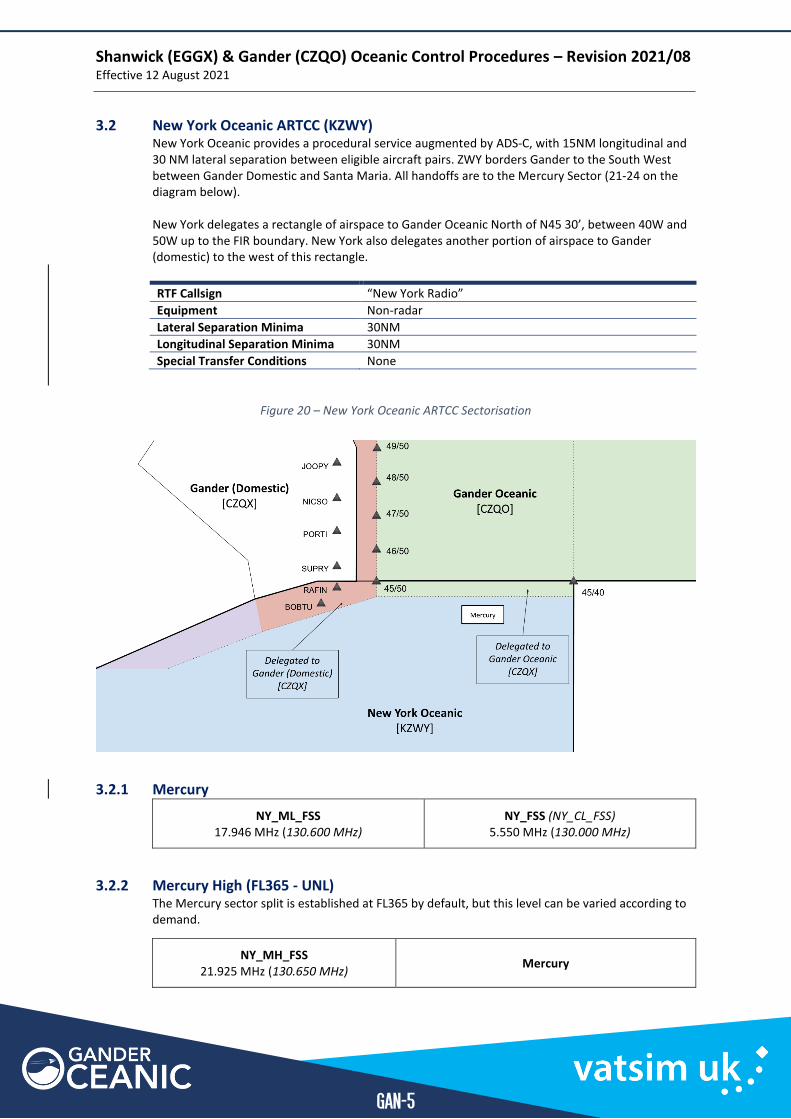
3.2 New York Oceanic ARTCC (KZWY) New York Oceanic provides a procedural service augmented by ADS-C, with 15NM longitudinal and 30 NM lateral separation between eligible aircraft pairs. ZWY borders Gander to the South West between Gander Domestic and Santa Maria. All handoffs are to the Mercury Sector (21-24 on the diagram below). New York delegates a rectangle of airspace to Gander Oceanic North of N45 30’, between 40W and 50W up to the FIR boundary. New York also delegates another portion of airspace to Gander (domestic) to the west of this rectangle.
RTF Callsign “New York Radio”
Equipment Non-radar
Lateral Separation Minima 30NM
Longitudinal Separation Minima 30NM
Special Transfer Conditions None
Figure 20 – New York Oceanic ARTCC Sectorisation
3.2.1 Mercury
NY_ML_FSS 17.946 MHz (130.600 MHz)
NY_FSS (NY_CL_FSS) 5.550 MHz (130.000 MHz)
3.2.2 Mercury High (FL365 - UNL) The Mercury sector split is established at FL365 by default, but this level can be varied according to demand.
NY_MH_FSS 21.925 MHz (130.650 MHz)
Mercury
Shanwick (EGGX) & Gander (CZQO) Oceanic Control Procedures – Revision 2021/08 Effective 12 August 2021
GAN-6
3.3 Santa Maria OACC (LPPO) Santa Maria provides a mixture of radar and procedural services within their FIR. Radar stations at the Azores allow for a central area of radar coverage surrounded by procedurally controlled airspace which Gander borders. All handoffs are to the primary non-radar sector.
RTF Callsign “Santa Maria Radio”
Equipment Non-radar
Lateral Separation Minima 50NM
Longitudinal Separation Minima 10 Minutes
Special Transfer Conditions None
Figure 21 – Santa Maria OACC Sectorisation
3.3.1 Non-radar Sector
LPPO_FSS 132.075 MHz
Shanwick (EGGX) & Gander (CZQO) Oceanic Control Procedures – Revision 2021/08 Effective 12 August 2021
GAN-7
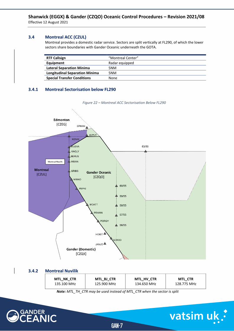
3.4 Montreal ACC (CZUL) Montreal provides a domestic radar service. Sectors are split vertically at FL290, of which the lower sectors share boundaries with Gander Oceanic underneath the GOTA.
RTF Callsign “Montreal Center”
Equipment Radar equipped
Lateral Separation Minima 5NM
Longitudinal Separation Minima 5NM
Special Transfer Conditions None
3.4.1 Montreal Sectorisation below FL290
Figure 22 – Montreal ACC Sectorisation Below FL290
3.4.2 Montreal Nuvilik
MTL_NK_CTR 135.100 MHz
MTL_BJ_CTR 125.900 MHz
MTL_HV_CTR 134.650 MHz
MTL_CTR 128.775 MHz
Note: MTL_TH_CTR may be used instead of MTL_CTR when the sector is split
Shanwick (EGGX) & Gander (CZQO) Oceanic Control Procedures – Revision 2021/08 Effective 12 August 2021
GAN-8
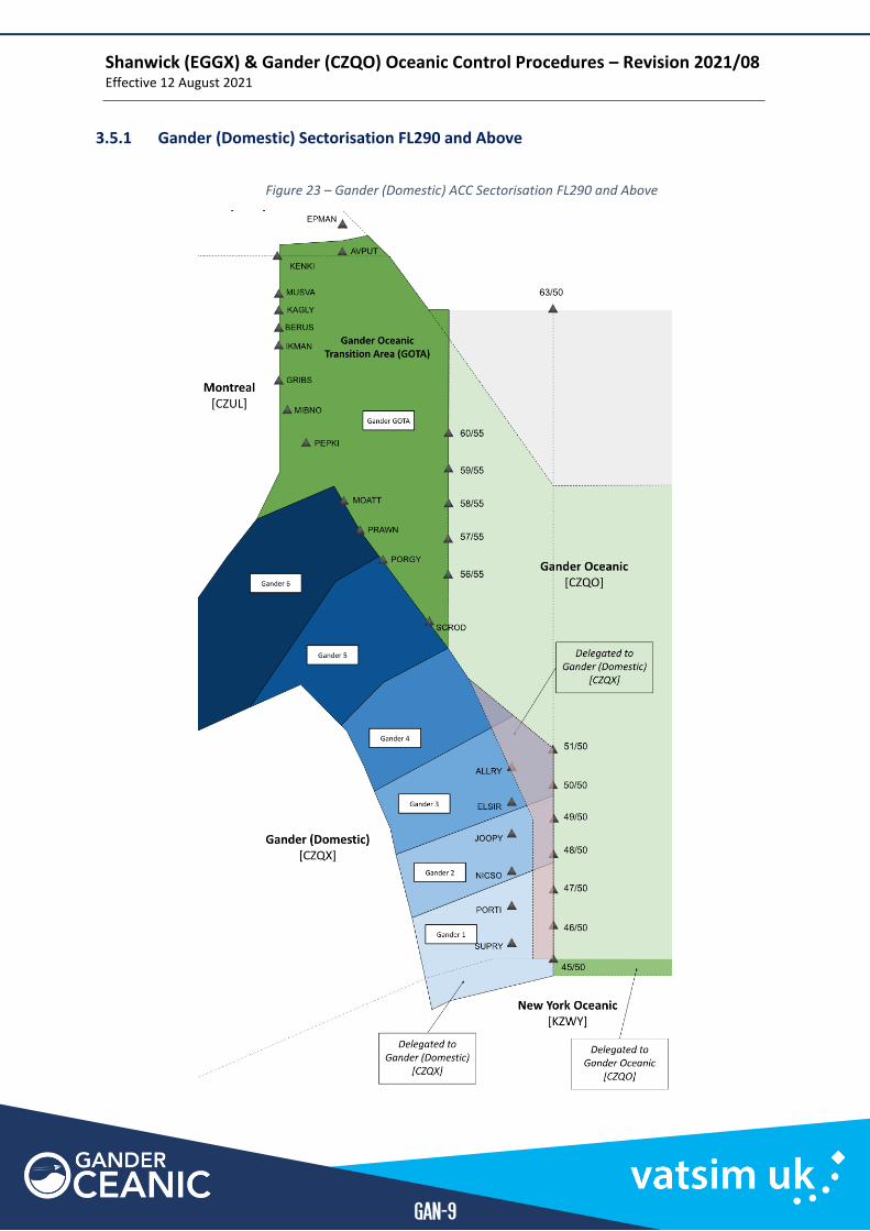
Gander (Domestic) ACC (CZQX) Gander (domestic) provides a domestic radar service. Gander (domestic) is delegated the following areas by adjacent sectors:
▪ The Gander Oceanic Transition Area (GOTA) at FL290 and above ▪ A small fillet of airspace west of 50W in the southwest corner of the Gander OCA by Gander
Oceanic ▪ An area of airspace south of 45N and west of 50W by New York Oceanic.
When Gander is offline, its airspace is covered top-down by Moncton Center.
RTF Callsign “Gander Center” for CZQX, “Moncton Center” for CZQM
Equipment Radar equipped
Lateral Separation Minima 5NM
Longitudinal Separation Minima 5NM
Special Transfer Conditions None
Shanwick (EGGX) & Gander (CZQO) Oceanic Control Procedures – Revision 2021/08 Effective 12 August 2021
GAN-9
3.5.1 Gander (Domestic) Sectorisation FL290 and Above
Figure 23 – Gander (Domestic) ACC Sectorisation FL290 and Above
Shanwick (EGGX) & Gander (CZQO) Oceanic Control Procedures – Revision 2021/08 Effective 12 August 2021
GAN-10
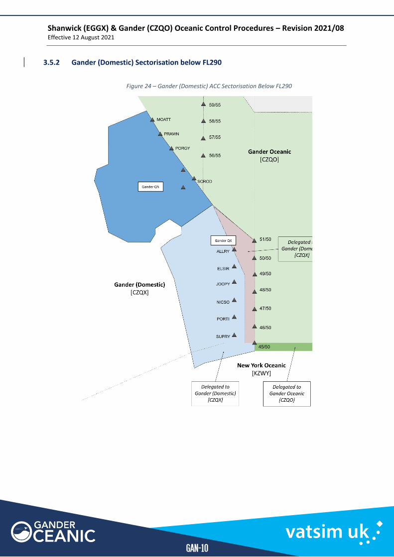
3.5.2 Gander (Domestic) Sectorisation below FL290
Figure 24 – Gander (Domestic) ACC Sectorisation Below FL290
Shanwick (EGGX) & Gander (CZQO) Oceanic Control Procedures – Revision 2021/08 Effective 12 August 2021
GAN-11
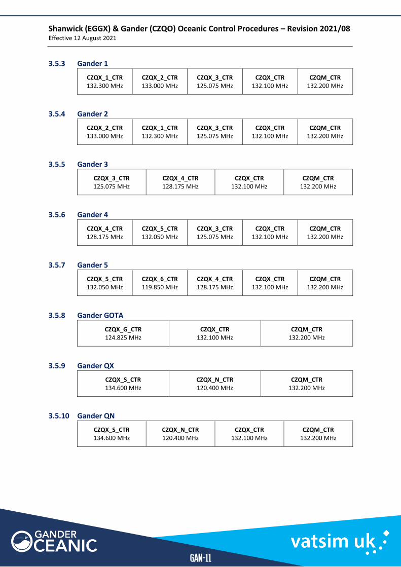
3.5.3 Gander 1
CZQX_1_CTR 132.300 MHz
CZQX_2_CTR 133.000 MHz
CZQX_3_CTR 125.075 MHz
CZQX_CTR 132.100 MHz
CZQM_CTR 132.200 MHz
3.5.4 Gander 2
CZQX_2_CTR 133.000 MHz
CZQX_1_CTR 132.300 MHz
CZQX_3_CTR 125.075 MHz
CZQX_CTR 132.100 MHz
CZQM_CTR 132.200 MHz
3.5.5 Gander 3
CZQX_3_CTR 125.075 MHz
CZQX_4_CTR 128.175 MHz
CZQX_CTR 132.100 MHz
CZQM_CTR 132.200 MHz
3.5.6 Gander 4
CZQX_4_CTR 128.175 MHz
CZQX_5_CTR 132.050 MHz
CZQX_3_CTR 125.075 MHz
CZQX_CTR 132.100 MHz
CZQM_CTR 132.200 MHz
3.5.7 Gander 5
CZQX_5_CTR 132.050 MHz
CZQX_6_CTR 119.850 MHz
CZQX_4_CTR 128.175 MHz
CZQX_CTR 132.100 MHz
CZQM_CTR 132.200 MHz
3.5.8 Gander GOTA
CZQX_G_CTR 124.825 MHz
CZQX_CTR 132.100 MHz
CZQM_CTR 132.200 MHz
3.5.9 Gander QX
CZQX_S_CTR 134.600 MHz
CZQX_N_CTR 120.400 MHz
CZQM_CTR 132.200 MHz
3.5.10 Gander QN
CZQX_S_CTR 134.600 MHz
CZQX_N_CTR 120.400 MHz
CZQX_CTR 132.100 MHz
CZQM_CTR 132.200 MHz
Section 4
Annexes
ANX
Shanwick (EGGX) & Gander (CZQO) Oceanic Control Procedures – Revision 2021/08 Effective 12 August 2021
ANX-2
Annex A | HF Phraseology
The following guidance is provided to highlight differences between domestic and oceanic phraseology. It is intended to complement phraseology examples in the North Atlantic Operations and Airspace Manual (NAT Doc 007).
1.1 General Component Standard Radiotelephony
Airports & ICAO Codes Individual phonetic letters, e.g. TBPB – “tango bravo papa bravo”
or
unique airport name, e.g. EGAA - “Belfast Aldergrove”
Mach Number “Mach decimal eight-five”
Times/Numbers Individual numbers, e.g. 1330 - “one three three zero”
NAT Track Phonetic letters e.g. Track A – “track alpha”
Latitudes 2 individual digits e.g. 51N – “five one north”
Longitudes 2 or 3 individual digits e.g. 030W – “(zero) three zero west”
1.2 Oceanic Clearance
General Notes ▪ If the NAT Track is the same one specified in the flight plan, it is not required to be
stated in the request. If it is not, pilots will add the phrase “now requesting track __”. ▪ Pilots may optionally add the phrase “second choice track __”. ▪ Maximum flight level may be the same as the requested level. ▪ If the clearance is not as requested, the pilot must be informed using the phrase
“oceanic clearance with a _____ change”. Refer to Changes to Requested Clearance. ▪ Whilst providing an oceanic clearance, aircraft are often still in domestic airspace where
the oceanic controller is not the controlling authority. ▪ The callsign “Shanwick (or Gander) Oceanic” is included in the clearance to indicate the
clearance came from the controlling authority. ▪ Controllers should not provide the TMI in the clearance but should ensure the pilot
provides it in the readback. TMI is not required from aircraft on a random routing.
1.2.1 Via NAT Tracks
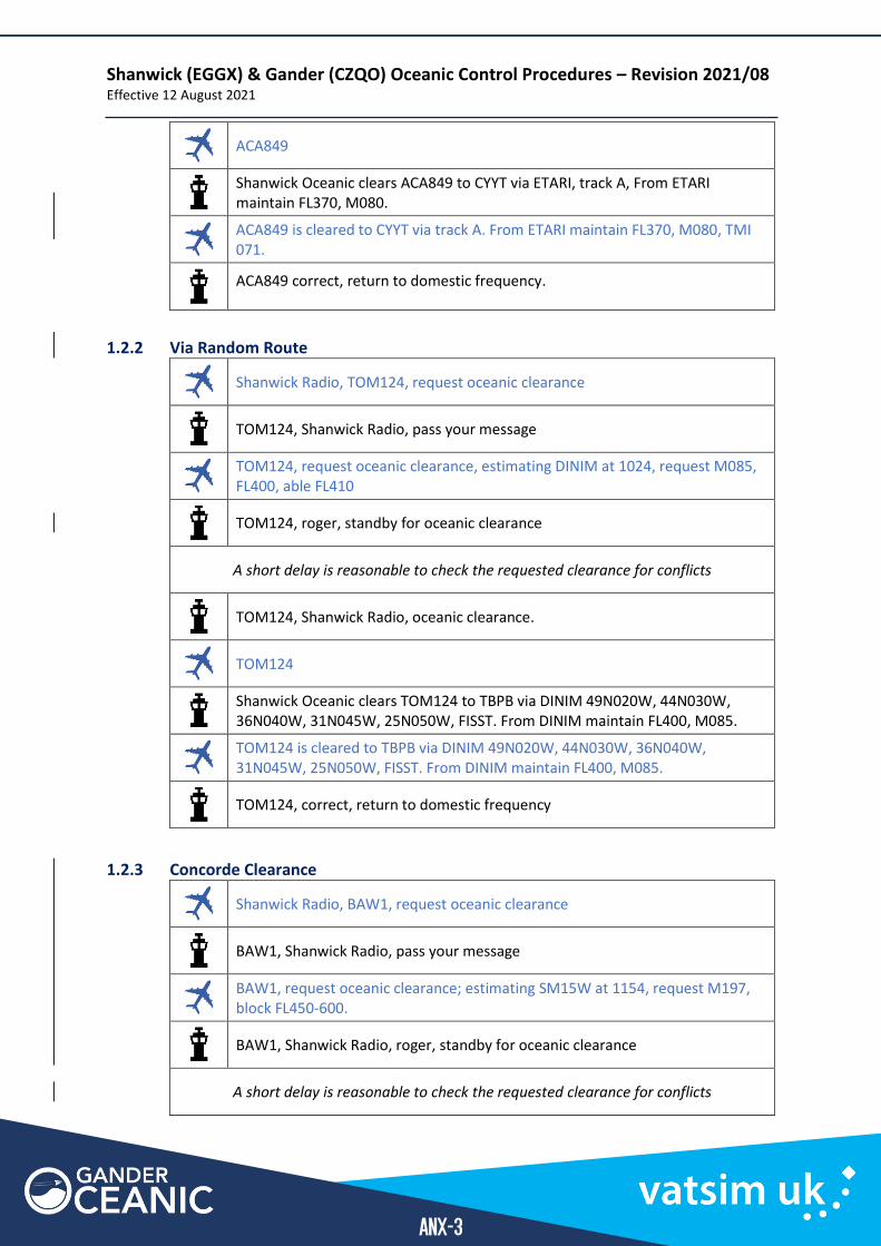
Shanwick Radio, ACA849, request oceanic clearance
ACA849, Shanwick Radio, pass your message
ACA849, request oceanic clearance; estimating ETARI at 1154, request M080, FL360, able FL370
ACA849, Shanwick Radio, roger, standby for oceanic clearance
A short delay is reasonable to check the requested clearance for conflicts
ACA849, Shanwick Radio, oceanic clearance with a level change”
Shanwick (EGGX) & Gander (CZQO) Oceanic Control Procedures – Revision 2021/08 Effective 12 August 2021
ANX-3
ACA849
Shanwick Oceanic clears ACA849 to CYYT via ETARI, track A, From ETARI maintain FL370, M080.
ACA849 is cleared to CYYT via track A. From ETARI maintain FL370, M080, TMI 071.
ACA849 correct, return to domestic frequency.
1.2.2 Via Random Route
Shanwick Radio, TOM124, request oceanic clearance
TOM124, Shanwick Radio, pass your message
TOM124, request oceanic clearance, estimating DINIM at 1024, request M085, FL400, able FL410
TOM124, roger, standby for oceanic clearance
A short delay is reasonable to check the requested clearance for conflicts
TOM124, Shanwick Radio, oceanic clearance.
TOM124
Shanwick Oceanic clears TOM124 to TBPB via DINIM 49N020W, 44N030W, 36N040W, 31N045W, 25N050W, FISST. From DINIM maintain FL400, M085.
TOM124 is cleared to TBPB via DINIM 49N020W, 44N030W, 36N040W, 31N045W, 25N050W, FISST. From DINIM maintain FL400, M085.
TOM124, correct, return to domestic frequency
1.2.3 Concorde Clearance
Shanwick Radio, BAW1, request oceanic clearance
BAW1, Shanwick Radio, pass your message
BAW1, request oceanic clearance; estimating SM15W at 1154, request M197, block FL450-600.
BAW1, Shanwick Radio, roger, standby for oceanic clearance
A short delay is reasonable to check the requested clearance for conflicts
Shanwick (EGGX) & Gander (CZQO) Oceanic Control Procedures – Revision 2021/08 Effective 12 August 2021
ANX-4
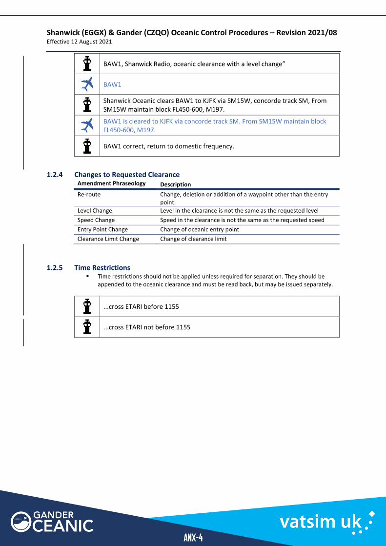
BAW1, Shanwick Radio, oceanic clearance with a level change”
BAW1
Shanwick Oceanic clears BAW1 to KJFK via SM15W, concorde track SM, From SM15W maintain block FL450-600, M197.
BAW1 is cleared to KJFK via concorde track SM. From SM15W maintain block FL450-600, M197.
BAW1 correct, return to domestic frequency.
1.2.4 Changes to Requested Clearance Amendment Phraseology Description
Re-route Change, deletion or addition of a waypoint other than the entry point.
Level Change Level in the clearance is not the same as the requested level
Speed Change Speed in the clearance is not the same as the requested speed
Entry Point Change Change of oceanic entry point
Clearance Limit Change Change of clearance limit
1.2.5 Time Restrictions ▪ Time restrictions should not be applied unless required for separation. They should be
appended to the oceanic clearance and must be read back, but may be issued separately.
...cross ETARI before 1155
...cross ETARI not before 1155

Shanwick (EGGX) & Gander (CZQO) Oceanic Control Procedures – Revision 2021/08 Effective 12 August 2021
ANX-5
1.3 Initial Check in with Oceanic Controller
1.3.1 ADS-B Equipped Aircraft
General Notes ▪ When requesting a SELCAL check, pilots are not required to state the SELCAL code. ▪ Frequencies for the next sector may be provided on first contact, although the risk of the
pilot incorrectly changing frequency immediately must be considered. If required, this can be delayed to a separate transmission closer to the next sector boundary.
▪ The phrase “monitor this frequency” can be used to highlight the requirement to maintain a listening watch on the current frequency prior to contacting the next sector.
▪ Aircraft that are not ADS-B equipped will check in with a position report and request for SELCAL check. After the last position report in the current sector is received, contact details for the next sector shall be provided.
Shanwick Radio, TOM124, Santa Maria next, request SELCAL check.
TOM124, Shanwick Radio, [at 45N contact Santa Maria on 132.075], standby for SELCAL check.
Selcal tone triggered
TOM124, SELCAL check OK.
Shanwick Radio.
1.1 Revisions/Amendments
General Notes ▪ The same format is used for speed changes
ACA849, Gander Radio, amended level clearance
ACA849
ACA849, correct.
Non-ADS-B Equipped Aircraft (Position Reports)
General Notes ▪ Aircraft that are not ADS-B equipped will check in with a position report and request for
SELCAL check, followed by position reports passing each waypoint. ▪ After the last position report in the current sector is received, contact details for the
next sector shall be provided. ▪ Pilots are not required to include their current/cleared Mach number in a position
report.
Shanwick (EGGX) & Gander (CZQO) Oceanic Control Procedures – Revision 2021/08 Effective 12 August 2021
ANX-6
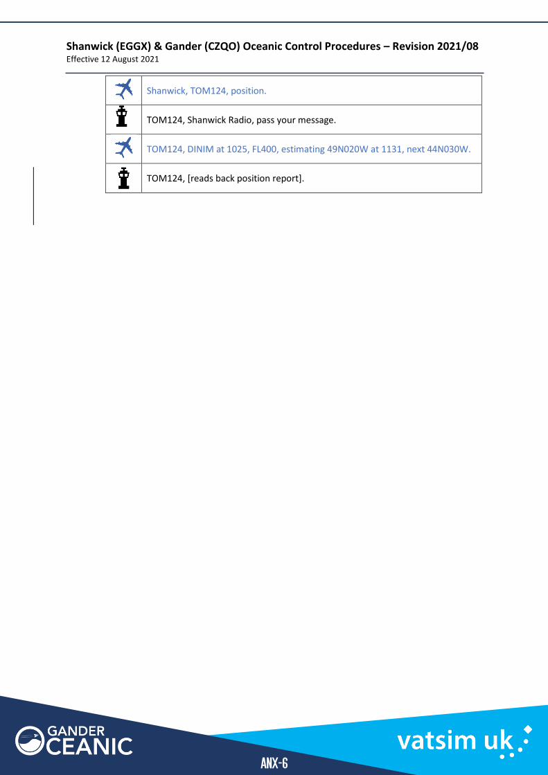
Shanwick, TOM124, position.
TOM124, Shanwick Radio, pass your message.
TOM124, DINIM at 1025, FL400, estimating 49N020W at 1131, next 44N030W.
TOM124, [reads back position report].
Shanwick (EGGX) & Gander (CZQO) Oceanic Control Procedures – Revision 2021/08 Effective 12 August 2021
ANX-7
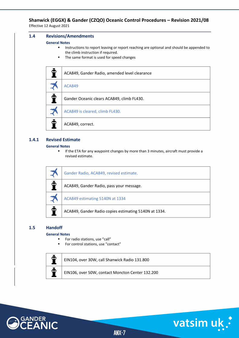
1.4 Revisions/Amendments
General Notes ▪ Instructions to report leaving or report reaching are optional and should be appended to
the climb instruction if required. ▪ The same format is used for speed changes
ACA849, Gander Radio, amended level clearance
ACA849
Gander Oceanic clears ACA849, climb FL430.
ACA849 is cleared, climb FL430.
ACA849, correct.
1.4.1 Revised Estimate
General Notes ▪ If the ETA for any waypoint changes by more than 3 minutes, aircraft must provide a
revised estimate.
Gander Radio, ACA849, revised estimate.
ACA849, Gander Radio, pass your message.
ACA849 estimating 5140N at 1334
ACA849, Gander Radio copies estimating 5140N at 1334.
1.5 Handoff
General Notes ▪ For radio stations, use “call” ▪ For control stations, use “contact”
EIN104, over 30W, call Shanwick Radio 131.800
EIN106, over 50W, contact Moncton Center 132.200
Shanwick (EGGX) & Gander (CZQO) Oceanic Control Procedures – Revision 2021/08 Effective 12 August 2021
ANX-8
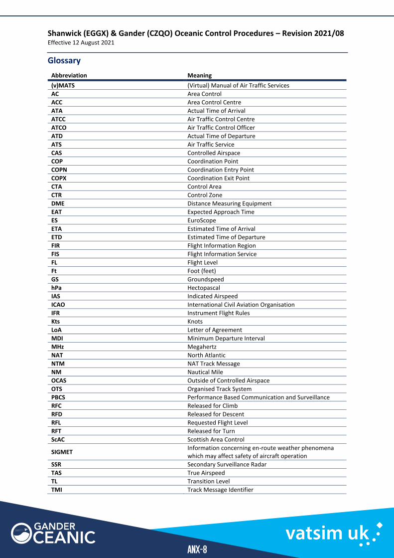
Glossary
Abbreviation Meaning
(v)MATS (Virtual) Manual of Air Traffic Services
AC Area Control
ACC Area Control Centre
ATA Actual Time of Arrival
ATCC Air Traffic Control Centre
ATCO Air Traffic Control Officer
ATD Actual Time of Departure
ATS Air Traffic Service
CAS Controlled Airspace
COP Coordination Point
COPN Coordination Entry Point
COPX Coordination Exit Point
CTA Control Area
CTR Control Zone
DME Distance Measuring Equipment
EAT Expected Approach Time
ES EuroScope
ETA Estimated Time of Arrival
ETD Estimated Time of Departure
FIR Flight Information Region
FIS Flight Information Service
FL Flight Level
Ft Foot (feet)
GS Groundspeed
hPa Hectopascal
IAS Indicated Airspeed
ICAO International Civil Aviation Organisation
IFR Instrument Flight Rules
Kts Knots
LoA Letter of Agreement
MDI Minimum Departure Interval
MHz Megahertz
NAT North Atlantic
NTM NAT Track Message
NM Nautical Mile
OCAS Outside of Controlled Airspace
OTS Organised Track System
PBCS Performance Based Communication and Surveillance
RFC Released for Climb
RFD Released for Descent
RFL Requested Flight Level
RFT Released for Turn
ScAC Scottish Area Control
SIGMET Information concerning en-route weather phenomena which may affect safety of aircraft operation
SSR Secondary Surveillance Radar
TAS True Airspeed
TL Transition Level
TMI Track Message Identifier
Shanwick (EGGX) & Gander (CZQO) Oceanic Control Procedures – Revision 2021/08 Effective 12 August 2021
ANX-9
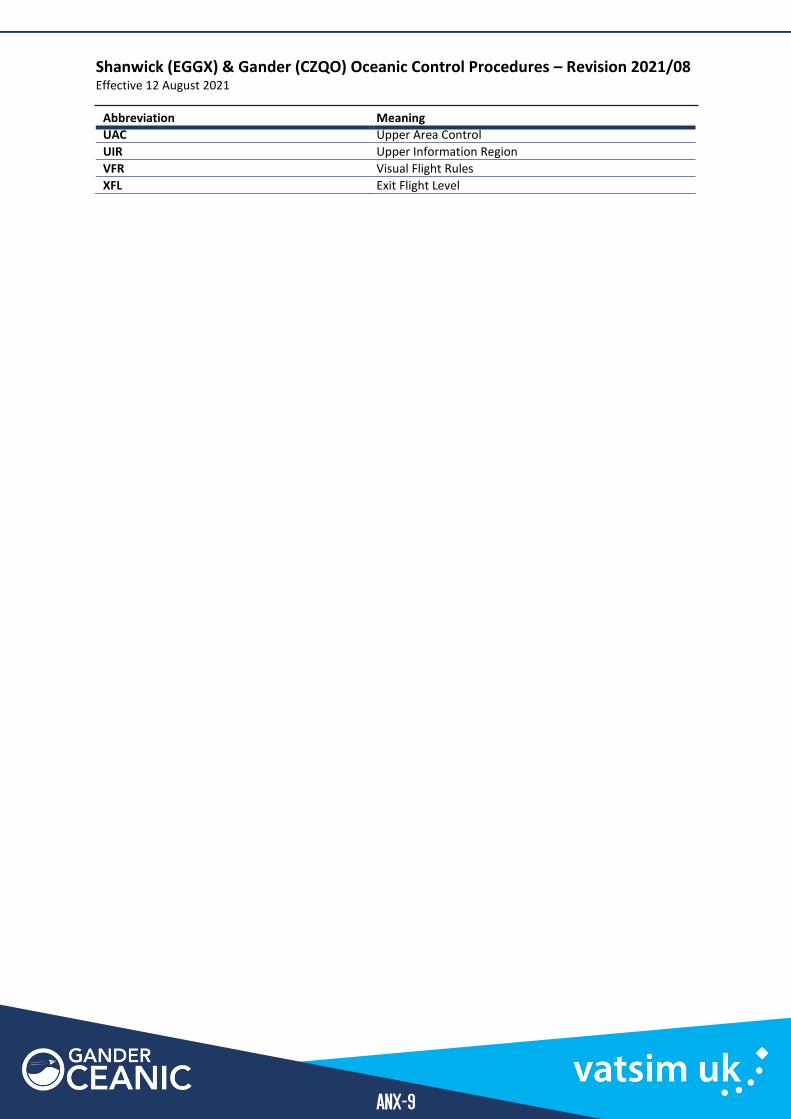
Abbreviation Meaning
UAC Upper Area Control
UIR Upper Information Region
VFR Visual Flight Rules
XFL Exit Flight Level