Embed Size (px)
Citation preview
FIN
AL
REP
OR
T
FELSBURGH O L T &U L L E V I G
prepared for:
prepared by:
February 2018
BOULDER COUNTY
SH7 PEL PLANNING and ENVIRONMENTALLINKAGES STUDY (75th Street to US 287)

STATE HIGHWAY 7
75TH STREET TO US HIGHWAY 287
PLANNING AND ENVIRONMENTAL LINKAGES STUDY
Prepared for: Boulder County 5201 St. Vrain Rd. Boulder, CO 80503
Prepared by:
Felsburg Holt & Ullevig 6300 South Syracuse Way, Suite 600
Centennial, CO 80111
February 2018
FHU Reference No. 115138‐01

THIS PAGE INTENTIONALLY LEFT BLANK

i
TABLE OF CONTENTS Page
List of Acronyms and Abbreviations ............................................................................................................... iii
Executive Summary ........................................................................................................................................ 1
1.0 Introduction ........................................................................................................................................ 7
1.1 Study Location and Description .................................................................................................................... 7
1.2 Purpose ......................................................................................................................................................... 9
1.3 Need ......................................................................................................................................................... 9
1.4 Project Goals ............................................................................................................................................... 11
2.0 Alternatives Development and Evaluation ........................................................................................ 13
2.1 Alternatives Development .......................................................................................................................... 13
2.2 Evaluation Criteria....................................................................................................................................... 15
2.3 No‐Action Alternative ................................................................................................................................. 18
2.4 Level 1 Evaluation ....................................................................................................................................... 18
2.5 Level 2 Evaluation ....................................................................................................................................... 20
2.6 Level 3 Packaging ........................................................................................................................................ 26
2.7 Level 3 Evaluation ....................................................................................................................................... 26
3.0 Retained Recommended Alternatives ............................................................................................... 29
3.1 Primary Alternatives Retained .................................................................................................................... 29
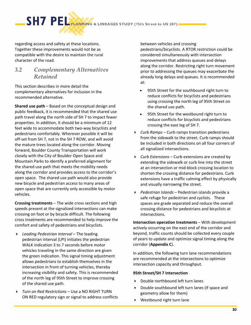
3.2 Complementary Alternatives Retained ...................................................................................................... 30
3.3 Phasing ....................................................................................................................................................... 31
4.0 Affected Environment, Environmental Consequences, and Mitigation Strategies .............................. 33
4.1 Environmental Analysis ............................................................................................................................... 33
4.2 Cumulative Impacts .................................................................................................................................... 33
5.0 Agency Coordination and Public Involvement ................................................................................... 42
5.1 Agency Coordination ................................................................................................................................... 42
5.2 Public Outreach Activities ........................................................................................................................... 43
5.3 Public Comments ........................................................................................................................................ 44
6.0 Implementation ................................................................................................................................ 45
6.1 General NEPA Requirements ...................................................................................................................... 45
6.2 Scoping, Preliminary, and Final Engineering Design ................................................................................... 46
6.3 Acquisition of Property for Right‐of‐Way ................................................................................................... 47
6.4 Construction ................................................................................................................................................ 47
7.0 References......................................................................................................................................... 49

ii
LIST OF APPENDICES Appendix A Corridor Conditions Assessment for State Highway 7 Planning and Environmental Linkages Study.
January 2017. Appendix B FHWA PEL Questionnaire Appendix C Technical Memorandum re: Intersection configurations and signal timing plans for the SH 7/US 287,
SH7/95th Street and SH 7/75th Street intersections. Appendix D PTAC Meeting Minutes, Agency and Public Coordination Appendix E Conceptual Design Plans
LIST OF FIGURES Page
Figure 1.1 Typical Cross‐Section .......................................................................................................................................... 8
Figure 1.2 Existing Bus Routes and Missing Sidewalks ....................................................................................................... 8
Figure 1.3 Safety Summary ................................................................................................................................................. 9
Figure 1.4 Existing (2016) Operational Conditions ........................................................................................................... 11
Figure 1.5 Future (2040) Operational Conditions ............................................................................................................. 12
Figure 1.5 Future (2040) Operational Conditions ............................................................................................................. 12
Figure 2.1 Alternatives Development and Evaluation Process ......................................................................................... 13
Figure 2.2 Proposed Cross‐Sections .................................................................................................................................. 16
Figure 2.3 Evaluation Criteria Summary ........................................................................................................................... 17
Figure 3.1 Reversible Transit Lane Cross‐Section ............................................................................................................. 29
Figure 3.1 Managed Lane Cross‐Section ........................................................................................................................... 29
LIST OF TABLES Page
Table 1.1 City of Boulder Existing (2012) and 2035 Proposed Mode Share .................................................................... 10
Table 2.1 Level 1 Evaluation ............................................................................................................................................ 19
Table 2.2 Level 2 Evaluation ............................................................................................................................................ 22
Table 2.3 Level 3 Evaluation ............................................................................................................................................ 27
Table 4.1 Summary of Affected Environment, Environmental Consequences, and Next Steps/Mitigation Strategies .. 34

iii
LIST OF ACRONYMS AND ABBREVIATIONSADT average daily traffic
AM morning
AST aboveground storage tank
AVC animal‐vehicle collision
BGPA Bald and Golden Eagle Protection Act
BMP best management practices
BRT bus rapid transit
CDOT Colorado Department of Transportation
CPW Colorado Department of Natural Resources Division of Parks and Wildlife
CFR Code of Federal Regulations
CNHP Colorado Natural Heritage Program
CWA Clean Water Act
dB decibels
DRCOG Denver Regional Council of Governments
EA Environmental Assessment
EDR Environmental Data Resources
EIS Environmental Impact Statement
ESA Endangered Species Act
FEMA Federal Emergency Management Agency
FHWA Federal Highway Administration
FIRM FEMA Flood Insurance Rate Map
FIS Flood Insurance Studies
FONSI Finding of No Significant Impact
GIS geographic information system
HCM Highway Capacity Manual
I‐25 Interstate 25
LF landfill
LOS level of service
LOSS level of service of safety
LUST leaking underground storage tank
MBTA Migratory Bird Treaty Act
MP milepost
MPH miles per hour
MVRTP DRCOG Metro Vision Regional Transportation Plan
NAC Noise Abatement Criteria
iv
NEPA National Environmental Policy Act
NDIS Natural Diversity Information
NR‐A Non‐Rural Principal Highway access category
NR‐B Non‐Rural Arterial access category
NR‐C Non‐Rural Arterial access category (least restrictive access category)
NRHP National Register of Historic Places
NUPUD Non‐Urban Planned Unit Development
NWI National Wetland Inventory
OSP Outfall Systems Plans
PDO property damage only
PEC potential environmental contaminant
PEL Planning and Environmental Linkages
PEM palustrine emergent
PM evening
PSS palustrine scrub/shrub
R‐A Regional Highway
REC recognized environmental condition
RTD Regional Transportation District
SH 7 State Highway 7
SH 119 State Highway 119
SHPO State Historic Preservation Officer
SPF safety performance function
SSS sideswipe (same direction) crash
SSO sideswipe (opposite direction) crash
TAZ transportation analysis zone
TWSC two‐way stop controlled intersection
US 36 US Highway 36
US 85 US Highway 85
US 287 US Highway 287
USACE United States Army Corps of Engineers
USC United States Code
USDOT United States Department of Transportation
USFWS United States Department of Interior Fish and Wildlife Service
UST underground storage tank
vpd vehicles per day

v
Acknowledgments Boulder County Marc Ambrosi, Project Manager Long‐Range Transportation Planner
Scott McCarey, PE, AICP, Multimodal Division Manager
George Gerstle, Transportation Director
City of Boulder Jean Sanson, AICP Senior Transportation Planner
Kathleen Bracke, PTP GO Boulder Manager
City of Lafayette Paul Rayl Planning Manager
Town of Erie Gary Behlen Public Works Director
Colorado Department of Transportation (CDOT) Region 4 Daniel Marcucci, PE Resident Engineer
Karen Schneiders Local Agency Planning and Environmental Manager
CDOT Environmental Programs Branch Lindsay Edgar PEL Manager
Federal Highway Administration (FHWA) Colorado Division Patricia Sergeson Transportation Specialist
Consultant Team Felsburg Holt & Ullevig Kevin Maddoux, AICP, CEP Principal
Holly Buck, PE, PTP Principal
Brian Fauver Environmental Scientist
Colleen Guillotte, PE Traffic and Safety Engineer
Tyler Spurlock, EIT Transportation Engineer
Kevin Hock, PE Roadway Engineer
Barry Novak Roadway Designer

1
EXECUTIVE SUMMARY Introduction State Highway 7 (SH 7) between 75th Street and US 287 is a critical east‐west arterial in the transportation system connecting Adams and Broomfield County commuters to the Town of Erie, the City of Lafayette, the City of Boulder and unincorporated Boulder County. Historical and anticipated residential and commercial growth in the North Denver Metropolitan area will continue to create mobility and safety challenges for this corridor. In 2016 in partnership with CDOT, FTA, FHWA and RTD the local agencies commenced a study on the corridor to recommend a set of transportation improvements to address the existing and forecasted mobility issues.
Similar planning efforts for parts of SH 7 to the west of 75th and to the east of US 287 are either completed or underway. In 2014, CDOT completed a planning study for SH 7 from US 287 east to US 85 in the City of Brighton. The City of Boulder is developing an East Arapahoe Transportation Plan for SH 7 between Folsom and 75th Street. Together these plans make comprehensive recommendations for multimodal transportation improvements on SH 7 between the Cities of Brighton and Boulder.
Each section of SH 7 is unique, and it is important that the section of the corridor between 75th St. and US 287 is planned consistent with applicable existing local and
regional plans. This includes the Boulder County Transportation Master Plan, the City of Boulder Transportation Master Plan, the Northwest Area Mobility Study, the Denver Regional Council of Governments (DRCOG) Metro Vision Regional Transportation Plan (RTP), and other local documents. The following policies from these existing plans were used to guide this project:
Maintain the rural character
Increase non‐single occupancy vehicle (SOV) mode share
Improve multimodal person capacity of the corridor
Develop intersection enhancements to improve safety and person throughput for all modes
Enhance transit operations and amenities
Have transit travel times compete with private car travel times
Reduce vehicle miles traveled (VMT)
Helping reduce greenhouse gases (GHGs) and other pollutants associated with transportation.
What is a PEL? Through conversations with CDOT it was determined that a Planning and Environmental Linkages (PEL) Study was the best planning format for this section of the corridor.
A PEL identifies the purpose and need for improvements in the corridor, evaluates the existing and projected future travel forecasts, as well as other important variables, and makes recommendations for transportation improvements that are able to address the transportation needs it identifies. A PEL includes stakeholder engagement and public participation as well as a natural resource inventory and analysis to help evaluate the feasibility and impacts of the alternative transportation improvements. This analysis evaluates and retained alternative improvements that meet the needs of the public and stakeholders. The intent of a

2
PEL is to narrow the range of alternatives prior to initiating the National Environmental Policy Act (NEPA) process.
For the SH 7 (75th Street to US 287) PEL Study, recommendations were made with a planning horizon year of 2040. Land use changes and transportation demands were projected out to 2040. A natural resource inventory and analysis document was developed for the study area to help understand potential impacts from a wide variety of alternatives. Throughout the process a team of stakeholders collaborated with the study team to help develop the alternatives and the study team worked with the public to help refine alternatives and ensure the communities’ transportation issues in study area were addressed.
Through this process, the study team was able to identify three potential Recommended Alternatives that will allow for phased improvements and will address the safety and mobility challenges in the SH 7 corridor. The study area for this PEL extends approximately 4 miles along SH 7 from the SH 7/75th Street intersection east to the SH 7 (Arapahoe Road)/US 287 intersection (milepost [MP] 60.68).
Problem Statement Transportation improvements are needed along SH 7 (75th Street to US 287) to address:
Safety: Compared to other two‐lane, rural roads in Colorado there is a higher than expected frequency of rear‐end vehicle crashes at the SH 7/75th Street, SH 7/95th Street, and SH 7/US 287 intersections along the corridor. The overall corridor also has a higher than expected frequency of rear‐end crashes, when compared to similar rural facilities. While this section of the corridor is largely rural in nature, the roadway functions similarly to urban roadways because it carries high traffic volumes. The frequency of rear‐end crashes is similar to the expected rate for comparable urban corridors. The majority of crashes in the corridor are related to queuing that occurs as a result of traffic congestion at these intersections and minor driveway access points along the corridor.
Mobility: SH 7 is a commuter corridor connecting the City of Boulder with the communities along SH 7
and the surrounding area. Single occupancy vehicles (SOV) are the predominant mode share. Single occupancy vehicles (SOV) are the predominant mode share on SH7 and the corridor experiences daily peak hour, peak direction vehicle congestion at the 75th, 95th and US 287 intersections. The cumulative effects of this existing mode share split are increased parking demand over existing parking capacity and roadway network congestion exceeding capacity within the City of Boulder, City of Lafayette, and Boulder County.
Access to Transit Facilities: First and final mile bike and pedestrian access to transit stops on the corridor is limited and often non‐existent. Of the pedestrian facilities that do exist, very few comply with Americans with Disabilities Act (ADA) requirements. Bus stop amenities, such as benches, lighting, and shelters at transit stops are not currently present on the corridor limiting passenger comfort, safety, and security.
Bicycle: Infrastructure for and connectivity with the existing and planned bicycle network does not exist along the corridor. On‐street bicycle lanes/shoulders are currently available on Baseline Road, a parallel facility that is one mile south of SH 7 and Valmont Road/Isabelle Road that is one to two miles north of SH 7. Bicyclists traveling on SH 7 must travel on shoulders of varying widths, primarily due to auxiliary lane configurations. Typical shoulder widths range between non‐existent and 12 feet. In areas with no shoulders, bicyclists travel in mixed traffic with vehicular traffic traveling at high speeds. The posted speed limits along SH 7 vary from 45 miles per hour (mph) to 50 mph. The bicycling facilities that exist on SH 7 today provide a low level of comfort, safety, and do not meet standards outlined in Boulder County planning documents for bicycle facilities.
The vision for Boulder County is to “provide high quality, safe, sustainable, and environmentally responsible transportation infrastructure and services across all modes, to meet the mobility and access needs of all users.”
‐Boulder County Transportation Master Plan, 2012

3
Pedestrian: Pedestrian facilities along the corridor consist of 8‐foot detached sidewalks in the immediate vicinity of the SH 7/95th Street intersection. Pedestrian facilities do not exist along the remaining portions of the corridor. Existing land use and land use densities along the corridor generate limited pedestrian trips. In areas without pedestrian facilities, pedestrians must travel on the shoulder or along the vegetated slope of the roadway, which creates a low level of comfort and perceived safety for the pedestrian.
Corridor Operations: Traffic (bus and vehicular) operations along the corridor and at the SH 7/75th Street, SH 7/95th Street, and SH 7/US 287 intersections are congested today and are expected to worsen by 2040 due to regional population and employment growth. Peak period peak direction queues are regularly 1,000 to 2,000 feet long and vehicles wait two to three signal cycles to be processed. Bus operations are affected by congestion at these intersections resulting in unreliable travel times and delays for buses.
Section 1.3 provides more information on the need for improvements in the corridor.
How were the retained Recommended Alternatives identified? The SH 7 (75th Street to US 287) PEL addresses safety and mobility for all modes of travel on this stretch of the corridor while recognizing the existing and future role of the facility as a primary commuting corridor. It identifies future transportation improvements that will enhance safety and meet the growing demand for mobility within and through the corridor for all modes of transportation. The retained Recommended Alternatives strive to address policies in local planning documents, such as improving mobility for all modes of transportation, and encouraging use of transportation options that can help minimize environmental impacts, and reduce overall VMT in Boulder County.
In identifying improvements, the study team sought input from the public about alternative improvements. Concerns identified by the public were safety at the intersections, preservation of the rural, natural, and historic characteristics, and ensuring the facility remains a viable transportation corridor able to address existing
and future mobility needs in an area. The alternatives development and evaluation process consisted of a three‐level iterative process (Level 1, 2, and 3) and focused on the diverse multimodal elements of the SH 7 cross‐section. The fundamental philosophy in the screening process was to systematically identify the notable positive and negative characteristics and tradeoffs among alternatives, and to evaluate each alternative. If a certain attribute (or attributes) of an alternative showed promise, an attempt was made to retain the individual attribute. Chapter 2.0 provides more information on the alternatives development and evaluation process.

4
How was the public involved in the SH 7 (75th Street to US 287) PEL Study? Coordination with all affected governmental agencies and input from the public was important throughout the PEL study. Key elements of the agency coordination and public involvement program are described below:
Conducted a series of agency scoping meetings with local, state, and federal resource agencies early in the planning process; local municipalities; the Colorado Department of Transportation (CDOT); and Federal Highway Administration (FHWA).
Conducted regular coordination meetings with a Technical Advisory Committee (TAC) to provide a forum for discussion and guidance in the decision‐making process. The TAC included representatives from: FHWA, CDOT Environmental Programs Branch, CDOT Region 4, Boulder County, City of Boulder, City of Lafayette, Town of Erie, Regional Transportation District (RTD), and DRCOG.
Conducted open house public meetings on April 26, 2017, and June 26, 2017, to provide information on the existing corridor conditions, Purpose and Need, the alternatives development and evaluation process, and retained alternatives.
Established a website that provided public access to information on the study.
Chapter 5.0 includes a more detailed description of the agency coordination and public involvement program.
What improvements are included in the retained Recommended Alternatives? The retained Recommended Alternatives were evaluated in the three‐level iterative process, address the Purpose and Need, and are retained for further consideration and potential phasing opportunities.
In the near term, improvements have been identified that address the most significant impediments to mobility and safety on the corridor. Safety and capacity for all modes through the major intersections at 95th Street and US 287 is the most pressing issue on the corridor. Congestion at these intersections results in poor mobility throughout the corridor, a higher than expected rear end crash rate, and prove to be a barrier
to bicyclists and pedestrians at intersections during peak traffic hour. Proposed improvements to these intersections would include adding additional general purpose lane on the east and west approaches to the intersections, adding queue jump lanes and Transit Signal Priority (TSP) to improve transit operations through the intersections, and improving bike and pedestrian safety at facilities at the intersections.
Safety improvements at minor driveway access and subdivisions intersections were another issue identified in the planning process. Constructing left turn pockets, and acceleration and deceleration lanes were identified as improvements to help safety and improve mobility through the corridor by moving left turning vehicles out of through traffic.
The addition of consistent shoulders to the roadway was identified as improvements that could be made over the near term that would provide moderate improvements for bicyclists and would make the highway safer for all users by providing a location out of the travel lanes for bicyclist, stopped and right turning vehicles.
Implementing these proposed three improvements are cost effective ways to incrementally address the needs along the corridor. These solutions were found to be most feasible in the near term due to their limited scope and high return on investment.
In the longer‐term, the managed lanes provide an uncongested alternative, and travel time advantage, for identified preferential uses, such as transit, carpoolers, and other technologically advanced vehicles. Management of the lanes can take many forms and could change over time to address the evolving mobility needs of the corridor because of growth in population and employment and the implementation of emerging technologies.
While a reversible transit/managed lane also has the potential to provide substantial improvement in travel time and transit service along the corridor in the peak direction, it would also result in the widest cross section of the alternatives considered, as must be paired with additional lanes through the intersection. In addition, current technology needed for safe operation of a
5
reversible bus would not be compatible with the desire to maintain the rural character of the road. The reversible transit/managed lane would not provide for all day bi‐directional BRT service with a high frequency reliable transit service. Future technologies, such as connected/autonomous vehicles may allow for implementation of this service while maintaining the rural character.
Chapter 3.0 discusses the retained Recommended Alternatives, and Section 3.1 discusses the complementary alternatives.
How will the proposed improvements be prioritized for implementation? Focus on Intersections First
Mobility for all modes through the major intersections at 95th Street and US 287 is the most pressing issue on the corridor. Intersection projects should be considered before corridor‐long cross‐section projects between the intersections as intersections are the locations where congestion initially becomes apparent. Proposed improvements to these intersections would include adding additional general purpose lanes on the east and west approaches and continuing through the intersections, adding queue jump lanes and TSP to improve transit operations through the intersections, and making bike and pedestrian safety improvements around intersections.
Safety improvements at minor intersections was another key issue identified in the planning process. Constructing left turn acceleration and deceleration
lanes at key unsignalized intersections can improve access and safety concerns of for residents along the corridor.
Focus on Improving Highway Cross Sections when Demand Increased and Funding Becomes Available
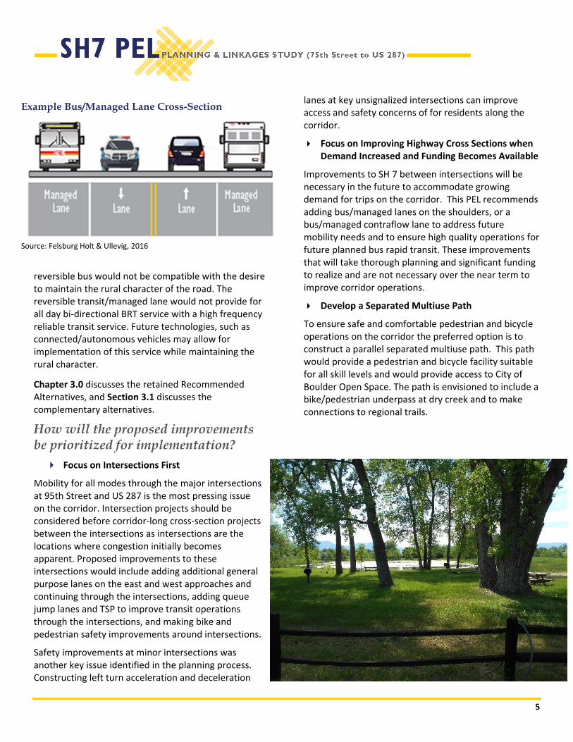
Improvements to SH 7 between intersections will be necessary in the future to accommodate growing demand for trips on the corridor. This PEL recommends adding bus/managed lanes on the shoulders, or a bus/managed contraflow lane to address future mobility needs and to ensure high quality operations for future planned bus rapid transit. These improvements that will take thorough planning and significant funding to realize and are not necessary over the near term to improve corridor operations.
Develop a Separated Multiuse Path
To ensure safe and comfortable pedestrian and bicycle operations on the corridor the preferred option is to construct a parallel separated multiuse path. This path would provide a pedestrian and bicycle facility suitable for all skill levels and would provide access to City of Boulder Open Space. The path is envisioned to include a bike/pedestrian underpass at dry creek and to make connections to regional trails.
Example Bus/Managed Lane Cross-Section
Source: Felsburg Holt & Ullevig, 2016

6
How will the proposed improvements be implemented? Implementation is typically determined during NEPA and final design; however, construction funding must be identified for each phase to meet the requirements of fiscal constraint for FHWA and CDOT to approve NEPA documentation.
As Boulder County and the other corridor stakeholders continue to pursue implementation of the retained Recommended Alternatives, this planning effort has identified several strategies that should be considered:
Keep Projects Advancing
It is important to continually have projects that are ready for funding because it positions the corridor well and because unanticipated funding opportunities often arise. Therefore, it is recommended to constantly keep a good balance of money dedicated to construction of projects, but at the same time allocate funding for design, acquisition of property for right‐of‐way, and utility phases to prepare future shelf ready projects.
Maximize the Use of Incremental Investments
Projects should be selected, designed, and phased to make maximum use of previous investments in infrastructure and to minimize “throw away” improvements included in the project.
How does the PEL study relate to future National Environmental Protection Act (NEPA) requirements? This PEL study provides the framework for the long‐term implementation of the retained Recommended Alternatives as a Preferred Alternative is identified and as funding becomes available. The study has identified issues that will require additional evaluation in any future NEPA documentation and can be used as a resource for such future documentation.
The identification of several Recommended Alternatives for the entire corridor in this PEL study is consistent with the FHWA’s objective of analyzing and selecting transportation solutions on a broad enough scale to provide meaningful analysis and avoid segmentation. Clearly, due to funding constraints, the improvements will be implemented in phases over time. Each phase
will require an appropriate level of NEPA analysis and documentation. As this work is conducted, each phase should meet these criteria:
Independent Utility/Logical Termini: Each phase should have independent utility and logical termini to the extent that the phase provides a functional transportation system even in the absence of other phases.
Elements of Purpose and Need: Each phase should contribute to meeting the Purpose and Need for the entire project.
Environmental Impacts: Individual phases should avoid the introduction of substantial additional environmental impacts that cannot be mitigated.
7
1.0 INTRODUCTION Boulder County, in coordination with the Colorado Department of Transportation (CDOT) and the Federal Highway Administration (FHWA), conducted this Planning and Environmental Linkages (PEL) study for the segment of State Highway 7 (SH 7) between US Highway 287 (US 287) and 75th Street. The SH 7 (75th Street to US 287) PEL Study was conducted by Boulder County to continue the planning efforts from the SH 7 PEL Study (CDOT, 2014), which extended from US Highway 85 (US 85) in the City of Brighton to US 287 in the City of Lafayette.
This SH 7 (75th Street to US 287) PEL addresses safety and person mobility on this stretch of SH 7 while recognizing the existing and future role of the corridor. It identifies future transportation improvements that will enhance safety and meet the growing demand for mobility within and through the corridor for all modes of transportation. In identifying improvements, the study respects local values by preserving the rural, natural, and historic characteristics of the area to the greatest extent possible while ensuring the route remains a viable transportation corridor that anticipates regional population and employment growth.
As part this PEL study, Boulder County prepared a Corridor Conditions Assessment Report, which documents current and anticipated future corridor conditions in regard to land use, the transportation system, and environmental resources. Information from the Corridor Conditions Assessment Report was used as a foundation for determining the transportation needs and potential improvements in the corridor. The Corridor Conditions Assessment Report is hereby incorporated by reference (Boulder County, 2016) into this PEL document; however, the Corridor Conditions Assessment Report is available electronically as
Appendix A to this document. In accordance with FHWA guidance, Appendix B contains the FHWA Colorado Division Planning/Environmental Linkages Questionnaire prepared for this PEL study.
1.1 Study Location and Description This section of SH 7 is a critical east‐west arterial in the transportation system serving the City of Boulder, the City of Lafayette, Boulder County, and the north Denver metropolitan area.
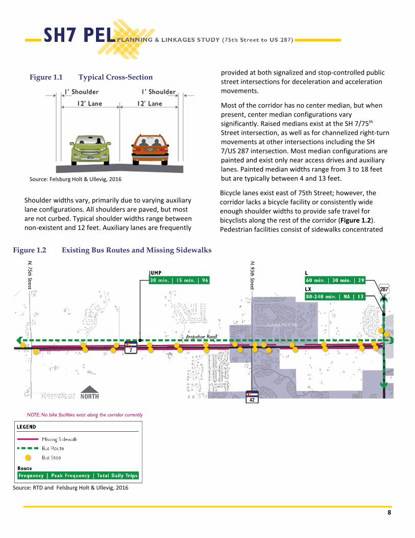
The existing roadway characteristics of SH 7 between 75th Street and US 287 are highly variable. SH 7 primarily consists of a two‐lane cross‐section with approximately 64 feet of right‐of‐way (Figure 1.1). Approaches from eastbound and westbound SH 7 at 75th Street are configured with two through lanes in each direction (four travel lanes), while the remainder of the corridor consists of a single travel lane in each direction (two travel lanes).
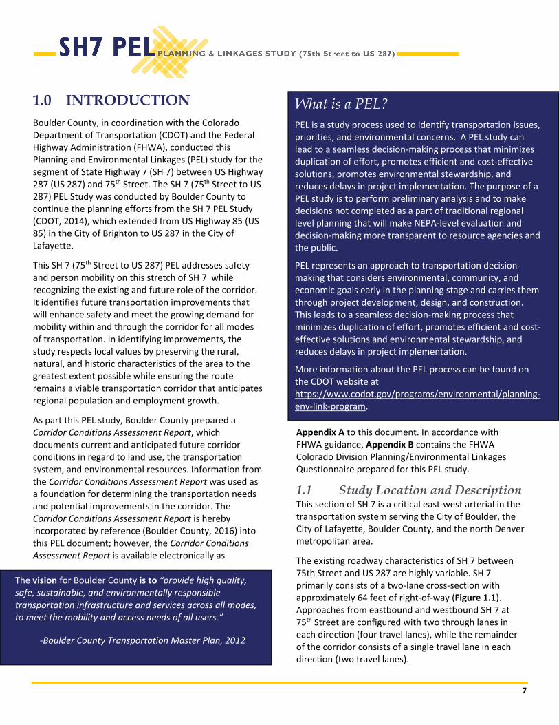
What is a PEL? PEL is a study process used to identify transportation issues, priorities, and environmental concerns. A PEL study can lead to a seamless decision‐making process that minimizes duplication of effort, promotes efficient and cost‐effective solutions, promotes environmental stewardship, and reduces delays in project implementation. The purpose of a PEL study is to perform preliminary analysis and to make decisions not completed as a part of traditional regional level planning that will make NEPA‐level evaluation and decision‐making more transparent to resource agencies and the public.
PEL represents an approach to transportation decision‐making that considers environmental, community, and economic goals early in the planning stage and carries them through project development, design, and construction. This leads to a seamless decision‐making process that minimizes duplication of effort, promotes efficient and cost‐effective solutions and environmental stewardship, and reduces delays in project implementation.
More information about the PEL process can be found on the CDOT website at https://www.codot.gov/programs/environmental/planning‐env‐link‐program.
The vision for Boulder County is to “provide high quality, safe, sustainable, and environmentally responsible transportation infrastructure and services across all modes, to meet the mobility and access needs of all users.”
‐Boulder County Transportation Master Plan, 2012
8
Shoulder widths vary, primarily due to varying auxiliary lane configurations. All shoulders are paved, but most are not curbed. Typical shoulder widths range between non‐existent and 12 feet. Auxiliary lanes are frequently
provided at both signalized and stop‐controlled public street intersections for deceleration and acceleration movements.
Most of the corridor has no center median, but when present, center median configurations vary significantly. Raised medians exist at the SH 7/75th Street intersection, as well as for channelized right‐turn movements at other intersections including the SH 7/US 287 intersection. Most median configurations are painted and exist only near access drives and auxiliary lanes. Painted median widths range from 3 to 18 feet but are typically between 4 and 13 feet.
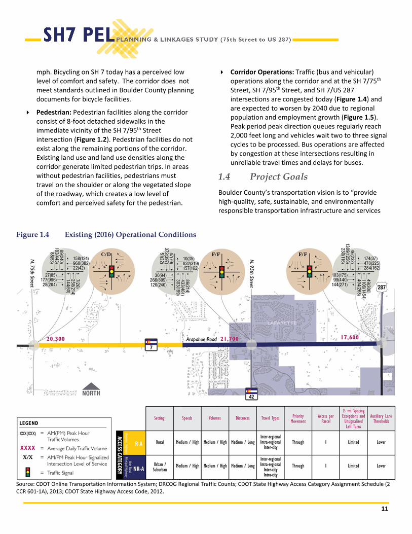
Bicycle lanes exist east of 75th Street; however, the corridor lacks a bicycle facility or consistently wide enough shoulder widths to provide safe travel for bicyclists along the rest of the corridor (Figure 1.2). Pedestrian facilities consist of sidewalks concentrated
Figure 1.2 Existing Bus Routes and Missing Sidewalks
Source: RTD and Felsburg Holt & Ullevig, 2016
Figure 1.1 Typical Cross-Section
Source: Felsburg Holt & Ullevig, 2016

9
around the three signalized intersections, with other sidewalk segments located where residential and commercial land use is adjacent to SH 7. Most of the corridor does not include sidewalks.
RTD provides transit service along and across the corridor via two fixed bus routes. The JUMP provides east‐west service between downtown Boulder, the University of Colorado in Boulder, and Lafayette/Erie along SH 7 (Arapahoe Road). The L/LX provides regional service between Longmont, Niwot, Lafayette, and downtown Denver via US 36 and US 287 (LX runs as a supplement to L during peak periods), with the nearest stop to the corridor located on US 287 just north of its intersection with SH 7.
1.2 Purpose
The purpose of the proposed multimodal transportation improvements is to address safety for all users and move people efficiently through the corridor.
1.3 Need
Transportation improvements are needed to address:
Safety: Compared to other two‐lane, rural roads in Colorado there is a higher than expected frequency of rear‐end vehicle crashes at the SH 7/75th Street, SH 7/95th Street, and SH 7/US 287 intersections
Figure 1.3 Safety Summary
Source: CDOT crash data accessed via Vision Zero Suite (VZS) – Crash Summary Program by DiExSys, LLC, 2010‐2014.

10
along the corridor (Figure 1.3). The overall corridor also has a higher than expected frequency of rear‐end crashes, when compared to similar rural facilities. While this section of the corridor is largely rural in nature, the roadway functions similar to urban roadways because it carries high traffic volumes. The frequency of rear‐end crashes is similar to the expected rate for comparable urban corridors. The majority of crashes in the corridor are related to queuing that occurs as a result of traffic congestion at these intersections and minor driveway access points along the corridor.
Mobility: SH 7 is a commuter corridor connecting the City of Boulder with the communities along SH 7 and the surrounding area. Single occupancy vehicles (SOV) are the predominant mode share. Single occupancy vehicles (SOV) are the predominant mode share on SH7 (Table 1.1) and the corridor experiences daily peak hour, peak direction vehicle congestion at the 75th, 95th and US 287 intersections. The cumulative effects of this existing mode share split are increased parking demand over existing parking capacity and roadway network congestion exceeding capacity within the City of Boulder, City of Lafayette, and Boulder County.
Access to Transit Facilities: First and final mile bike and pedestrian access to transit stops on the corridor is limited and often non‐existent. Of the pedestrian facilities that do exist, very few comply with Americans with Disabilities Act (ADA) requirements. Bus stop amenities, such as benches, lighting, and shelters at transit stops are not
currently present on the corridor limiting passenger comfort, safety, and security.
Bicycle: Infrastructure for and connectivity with the existing and planned bicycle network does not exist along the corridor (Figure 1.2). On‐street bicycle lanes/shoulders are currently available on Baseline Road, a parallel facility that is one mile south of SH 7 and Valmont Road/Isabelle Road that is one to two miles north of SH 7. Bicyclists traveling on SH 7 must travel on shoulders of varying widths, primarily due to auxiliary lane configurations. Typical shoulder widths range between non‐existent and 12 feet. In areas with no shoulders, bicyclists travel in mixed traffic with vehicular traffic traveling at high speeds. The posted speed limits along SH 7 vary from 45 miles per hour (mph) to 50
Table 1.1 City of Boulder Existing (2012) and 2035 Proposed Mode Share
Mode
Non‐Resident Trips
City of Boulder’s Current (2012) Mode Share
Proposed 2035 Mode Share Targets
Pedestrian 0% 0%
Bicyclist 1% 2%
Transit 9% 12%
Single‐occupancy vehicle 80% 60%
Multiple‐occupancy vehicle 10% 26%
Source: City of Boulder, 2014. Current Mode Share estimates are derived from the 2012 Travel Diary Survey. The Boulder Valley Employee Survey was also used to establish current mode share.
11
mph. Bicycling on SH 7 today has a perceived low level of comfort and safety. The corridor does not meet standards outlined in Boulder County planning documents for bicycle facilities.
Pedestrian: Pedestrian facilities along the corridor consist of 8‐foot detached sidewalks in the immediate vicinity of the SH 7/95th Street intersection (Figure 1.2). Pedestrian facilities do not exist along the remaining portions of the corridor. Existing land use and land use densities along the corridor generate limited pedestrian trips. In areas without pedestrian facilities, pedestrians must travel on the shoulder or along the vegetated slope of the roadway, which creates a low level of comfort and perceived safety for the pedestrian.
Corridor Operations: Traffic (bus and vehicular) operations along the corridor and at the SH 7/75th Street, SH 7/95th Street, and SH 7/US 287 intersections are congested today (Figure 1.4) and are expected to worsen by 2040 due to regional population and employment growth (Figure 1.5). Peak period peak direction queues regularly reach 2,000 feet long and vehicles wait two to three signal cycles to be processed. Bus operations are affected by congestion at these intersections resulting in unreliable travel times and delays for buses.
1.4 Project Goals
Boulder County’s transportation vision is to “provide high‐quality, safe, sustainable, and environmentally responsible transportation infrastructure and services
Figure 1.4 Existing (2016) Operational Conditions
Source: CDOT Online Transportation Information System; DRCOG Regional Traffic Counts; CDOT State Highway Access Category Assignment Schedule (2 CCR 601‐1A), 2013; CDOT State Highway Access Code, 2012.

12
across all modes, to meet the mobility and access needs of all users (Boulder County, 2012).” This PEL study is designed to establish a vision of how the future multimodal transportation system along SH 7 will fit with the County’s vision and serve the communities along the corridor. The objectives of the transportation improvements are to:
Provide a multimodal transportation system for all users.
Address inadequate first and final mile connectivity.
Provide mobility and corridor solutions that preserve the natural, rural, and historic character of the corridor to the greatest extent possible.
Figure 1.6 Future (2040) Operational Conditions
Source: Felsburg Holt & Ullevig, 2016
Figure 1.5 Future (2040) Operational Conditions
Source: Felsburg Holt & Ullevig, 2016
13
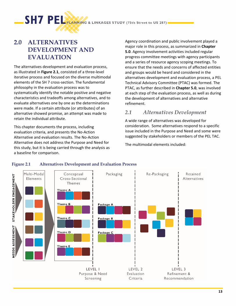
2.0 ALTERNATIVES DEVELOPMENT AND EVALUATION
The alternatives development and evaluation process, as illustrated in Figure 2.1, consisted of a three‐level iterative process and focused on the diverse multimodal elements of the SH 7 cross‐section. The fundamental philosophy in the evaluation process was to systematically identify the notable positive and negative characteristics and tradeoffs among alternatives, and to evaluate alternatives one by one as the determinations were made. If a certain attribute (or attributes) of an alternative showed promise, an attempt was made to retain the individual attribute.
This chapter documents the process, including evaluation criteria, and presents the No‐Action Alternative and evaluation results. The No‐Action Alternative does not address the Purpose and Need for this study, but it is being carried through the analysis as a baseline for comparison.
Agency coordination and public involvement played a major role in this process, as summarized in Chapter 5.0. Agency involvement activities included regular progress committee meetings with agency participants and a series of resource agency scoping meetings. To ensure that the needs and concerns of affected entities and groups would be heard and considered in the alternatives development and evaluation process, a PEL Technical Advisory Committee (PTAC) was formed. The PTAC, as further described in Chapter 5.0, was involved at each step of the evaluation process, as well as during the development of alternatives and alternative refinement.
2.1 Alternatives Development A wide range of alternatives was developed for consideration. Some alternatives respond to a specific issue included in the Purpose and Need and some were suggested by stakeholders or members of the PEL TAC.
The multimodal elements included:
Figure 2.1 Alternatives Development and Evaluation Process

14
Bicycle On‐street bicycle lanes – A designated bicycle facility located outside of both directions of the vehicular travel lanes; typically, at least 5 feet wide. It could have a painted buffer separating the bicycle lanes from the vehicular travel lanes.
Shared‐use path – A path distinctly separated from the vehicle travel way that is shared by bicyclists and pedestrians; typically, at least 12 feet wide to accommodate bidirectional travel of both pedestrians and bicyclists.
Protected bikeway (one‐way and two‐way) – A high ease of use bicycle facility that combines the comfortable/accessible user experience of a separated path with the on‐street infrastructure of a conventional bicycle lane. It would be physically separated from vehicular traffic and distinct from the sidewalk.
Pedestrian Sidewalks – A path distinctly separated from vehicle travel way that is most often used by pedestrians or leisurely bicyclist (although bicycle use is not encouraged). Typically, it is not wide enough to comfortably accommodate bidirectional travel of both bicyclists and pedestrians.
Shared‐use path – A path distinctly separated from the vehicle travel way that is shared by
bicyclists and pedestrians; typically, at least 12 feet wide to accommodate bidirectional travel of both pedestrians and bicyclists.
Crossing treatments – Strategies that include providing ADA compliant curb ramps, sidewalks that are well‐maintained and navigable by wheelchairs, and improvements that protect and increasing comfort for bicycles and pedestrians such as rectangular rapid flash beacons (RRFBs) or high‐intensity activated crosswalk beacons (HAWK signals) to warn vehicles of the presence of bicycles and pedestrians where appropriate.
Vehicle Additional general purpose lanes – A new vehicular travel lane in each direction along the corridor. These lanes would operate as general purpose lanes and would be available to all users.
Managed lanes ‐ A new vehicular travel lane in each direction along the corridor with use limited to select user types such as high occupancy vehicles, electric vehicles, or transit vehicles. These lanes could be managed full time or during identified peak periods.
Intersection operation treatments ‐ Signal timing and progression optimization treatments that reduce delay at signalized intersections, decrease emissions, increase vehicle throughput and decrease travel times through the corridor.
Travel demand management (TDM) ‐ Strategies intended to reduce reliance on single occupancy vehicles and explore incentives and/or disincentives to encourage new behaviors. Strategies could include free or discounted RTD transit passes, parking management, flexible working hours/ telecommute, peak period roadway access pricing, or private or public shuttle services.
Left turn treatments – The addition of left turn acceleration and/or deceleration lanes at unsignalized access points identified as meeting the requirements in CDOT’s State Highway

15
Access Code or having a higher than expected number of rear‐end crashes.
Additional general purpose lanes through intersections – Approaches to signalized intersections can be widened to increase the intersection throughput and reduce queuing and delays.
Speed reduction ‐ Strategies to decrease speeds and improve safety for all users of the corridor. Strategies could include geometric modifications to the corridor and/or reducing the posted speed limit along the corridor.
Increased shoulder width – Construction of a wider shoulder along the roadway to accommodate bicyclists.
Roundabouts – Roundabouts could replace signalized intersection control.
Access control – A strategy that limits full movement access points directly to the corridor to reduce conflicts and improve comfort and safety for all modes. This could be accomplished by consolidating access points and/or restricting movements at existing and planned access points.
Transit Bus‐only lanes – Travel lanes designated exclusively for bus/transit use. Design could include the addition of an outside lane in each direction, a median lane in each direction or a single median contra flow lane. A contraflow lane would operate inbound to the City of Boulder, in the westbound direction, in the AM peak periods and outbound to Lafayette and points east in the PM peak periods. Travel in the off‐peak direction would occur in the existing general purpose lanes.
Transit signal priority (TSP) – Traffic signal upgrades that communicate with the bus to extend green times or provide bus priority to assist the bus in meeting identified schedules and reduce travel time.
Queue jumps – A lane designated at signalized intersections for bus use only. The lane allows the bus to bypass queued vehicles and
therefore improves transit travel time reliability.
The study team evaluated and combined the roadway, transit, bicycle, and pedestrian elements to create proposed cross‐sections (Figure 2.2). Then the study team evaluated the proposed cross‐sections. The cross‐sections and the other elements were then joined to create Recommended Alternatives.
2.2 Evaluation Criteria
Criteria for developing and evaluating alternatives were established through a public process that was responsive to the Purpose and Need of the project, project goals that are consistent with Boulder County’s vision, DRCOG’s 2040 Metro Vision Regional Transportation Plan (DRCOG, April 2017; as amended), the potential for transportation benefits, and environmental resources within the study corridor (Figure 2.3).

16
Figure 2.2 Proposed Cross-Sections

17
Figure 2.3 Evaluation Criteria Summary

18
2.3 No-Action Alternative
The No‐Action Alternative would essentially leave SH 7 as it currently is and would not provide any major capacity improvements; however, the No‐Action Alternative would include safety and maintenance activities that would be required to sustain an operational transportation system. The No‐Action Alternative does not meet the Purpose and Need but is used as a baseline to compare alternatives for evaluation and environmental analysis purposes.
For the purpose of forecasting travel demand and identifying resource impacts directly related to traffic volume (such as noise), the No‐Action Alternative includes transportation projects currently planned in the project vicinity. These other transportation projects have committed or identified funds for construction and would be built regardless of any improvements that are identified as part of the SH 7 PEL study. Travel demand forecasting predicts traffic conditions that are expected to occur on the transportation system in the design year (2040).
2.4 Level 1 Evaluation
The Level 1 Evaluation assesses each alternatives’ ability to meet the Purpose and Need. While no single alternative could address the Purpose and Need in its entirety, each alternative should demonstrate its ability to address portions of the Purpose and Need to be retained for additional evaluation in Level 2. Level 1 evaluation criteria focused on the project’s Purpose and Need and include:
Does the alternative have the potential to address the higher than expected rear‐end vehicle crashes at intersections and along the corridor?
Does the alternative have the potential to reduce single‐occupant vehicle (SOV) demand along the corridor and parking within corridor destinations?
Does the alternative have the potential to improve comfort and safety of bicyclists along the corridor?
Does the alternative have the potential to address disconnected and missing pedestrian facilities along the corridor?
Does the alternative have the potential address reliability of transit service and the safety and comfort of transit users along the corridor?
Table 2.1 summarizes the Level 1 Evaluation and results.
Transportation improvements are needed to address:
Safety
Mobility
Access to Transit Facilities
Bicycle Travel
Pedestrian Travel
Corridor Operations

19
Table 2.1 Level 1 Evaluation
Does the alternative have the potential to:
Alternative
address the higher than
expected rear‐
end vehicle crashes at intersections
and along the corridor
reduce single‐occupan
t vehicle
deman
d along the corridor an
d parking
within corridor destinations?
improve
comfort and safety of
bicyclists along the corridor?
address disconnected and m
issing
pedestrian
facilities along the
corridor?
address reliability of tran
sit service
and the safety and comfort of tran
sit
users along the corridor?
Retain for Level 2
Evaluation?
Bicycle
On‐street bicycle lanes Yes
Shared‐use path Yes
Protected bikeway (one‐way) Yes
Protected bikeway (two‐way) Yes
Pedestrian
Sidewalk Yes
Shared‐use path Yes
Crossing treatments Yes
Vehicle/Bus Lanes
Additional general purpose lanes Yes
Managed lanes Yes
Bus‐only lanes Yes
Intersection Treatments
Intersection operation treatments Yes
Left turn treatments Yes
Additional through lanes through intersections Yes

20
Does the alternative have the potential to:
Alternative
address the higher than
expected rear‐
end vehicle crashes at intersections
and along the corridor
reduce single‐occupan
t vehicle
deman
d along the corridor an
d parking
within corridor destinations?
improve
comfort and safety of
bicyclists along the corridor?
address disconnected and m
issing
pedestrian
facilities along the
corridor?
address reliability of tran
sit service
and the safety and comfort of tran
sit
users along the corridor?
Retain for Level 2
Evaluation?
Roundabouts No
Transit signal priority Yes
Queue jumps Yes
Corridor‐wide Complementary Alternatives
Speed reduction No
Increased shoulder width Yes
Access control Yes
Travel demand management Yes
Notes: Green addresses Purpose and Need statement. Orange partially addresses Purpose and Need statement. Red does not have potential to address Purpose and Need statement.
Based on the Level 1 evaluation results transit treatments, managed lanes and shared use paths received the highest ratings. Increased shoulder widths and roundabouts do not appear to address the Purpose and Need and were eliminated from further consideration.
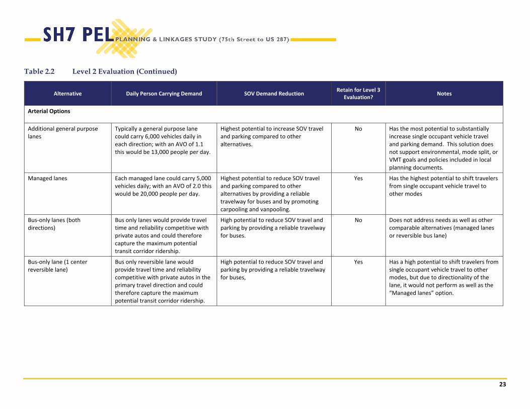
2.5 Level 2 Evaluation
The Level 2 Evaluation comparatively assesses each alternatives’ person carry capacity, SOV demand reduction, and bicycle/pedestrian safety and comfort. Table 2.2 summarizes the Level 2 Evaluation and results. Level 2 evaluation criteria included:
Person carrying capacity – A quantitative measure of the number of person trips each alternative can accommodate. This assumes 1.1 average vehicle occupancy (AVO) for improvements associated with general purpose lanes and an AVO of 2.0 for managed lanes. Transit service is assumed to be 15‐minute service four hours/day, 30 minutes for 16 hours/day and a maximum ridership of 5,000 passengers per day.
SOV Demand Reduction – A qualitative measure of how effective the alternative would be at shifting travel from single occupant vehicles to other modes to reduce traffic and parking demand. Alternatives that have the potential to provide travel times competitive with

21
private auto travel and those that are available to a wide range of users score the highest.
Bicycle/Pedestrian Safety and Comfort – A qualitative measure of how attractive and accommodating each bicycle and pedestrian alternative is. Alternatives that are available to a wide range of users score the highest.

22
Table 2.2 Level 2 Evaluation
Alternative Daily Person Carrying
Demand SOV Demand Reduction
Bicycle/Pedestrian Comfort Retain for Level 3
Evaluation? Notes
Bicycle and Pedestrian Options
On‐street bicycle lanes
Estimated to attract 1% of existing travel demand resulting in approximately 250 bicyclists/day.
Limited ability to shift travel from single occupant vehicles.
Low level of comfort and safety. A viable alternative only to very experienced riders willing and able to ride adjacent to high speed vehicle.
No Does not address needs as well as other comparable bicycle options.
Shared‐use path Estimated to attract 2% of existing travel demand resulting in approximately 500 bicyclists/day.
Somewhat higher potential to attract users and therefore shift travelers from single occupant vehicles than on‐street bicycle lanes.
Highest level of comfort for the widest range of bicycle users.
Yes Addresses local and regional bicycle and pedestrian mobility needs while retaining a narrow footprint and the existing rural character. It could provide non‐motorized access to Open Space Mountain Parks trail heads and open space along with corridor.
Protected bikeway Estimated to attract 1% of existing travel demand resulting in approximately 250 bicyclists/day.
Limited ability to shift travel from single occupant vehicles.
Low level of comfort and safety. A viable alternative only to very experienced riders willing and able to ride adjacent to high speed vehicle.
No Does not address needs as well as other comparable bicycle options.
Sidewalk in developed/urban areas, at major intersections, and around transit stops
Estimated to attract a nominal number of pedestrians due to the suburban and rural nature of the land uses.
Nominal ability to shift travel from single occupant vehicles
High level of comfort for pedestrians. Yes Retained as a complementary improvement to address pedestrian safety and comfort at spot locations such as crosswalks or bus stops, when needed.
Note: Estimates made by project team based on existing travel patterns and future travel demand projections.
23
Table 2.2 Level 2 Evaluation (Continued)
Alternative Daily Person Carrying Demand SOV Demand Reduction Retain for Level 3
Evaluation? Notes
Arterial Options
Additional general purpose lanes
Typically a general purpose lane could carry 6,000 vehicles daily in each direction; with an AVO of 1.1 this would be 13,000 people per day.
Highest potential to increase SOV travel and parking compared to other alternatives.
No Has the most potential to substantially increase single occupant vehicle travel and parking demand. This solution does not support environmental, mode split, or VMT goals and policies included in local planning documents.
Managed lanes Each managed lane could carry 5,000 vehicles daily; with an AVO of 2.0 this would be 20,000 people per day.
Highest potential to reduce SOV travel and parking compared to other alternatives by providing a reliable travelway for buses and by promoting carpooling and vanpooling.
Yes Has the highest potential to shift travelers from single occupant vehicle travel to other modes
Bus‐only lanes (both directions)
Bus only lanes would provide travel time and reliability competitive with private autos and could therefore capture the maximum potential transit corridor ridership.
High potential to reduce SOV travel and parking by providing a reliable travelway for buses.
No Does not address needs as well as other comparable alternatives (managed lanes or reversible bus lane)
Bus‐only lane (1 center reversible lane)
Bus only reversible lane would provide travel time and reliability competitive with private autos in the primary travel direction and could therefore capture the maximum potential transit corridor ridership.
High potential to reduce SOV travel and parking by providing a reliable travelway for buses,
Yes Has a high potential to shift travelers from single occupant vehicle travel to other modes, but due to directionality of the lane, it would not perform as well as the “Managed lanes” option.
24
Table 2.2 Level 2 Evaluation (Continued)
Alternative SOV Demand Reduction Bicycle/Pedestrian Comfort Retain for Level 3
Evaluation? Notes
Intersection Options
Intersection operation treatments
No potential to shift travel from single occupant vehicles.
Lowd potential to improve bicycle/pedestrian comfort and safety.
Yes Retained and recommended as a complementary improvement to support overall corridor mobility.
Transit signal priority/Queue jumps
Moderate potential to reduce SOV travel and parking compared to other alternatives by providing a reliable travelway for buses and travel time more competitive with private autos.
Low potential to improve bicycle/pedestrian comfort and safety.
Yes Retained and recommended as a complementary improvement to support implementation of reliable and fast bus service.
Left turn treatments No potential to shift travel from single occupant vehicles.
Low potential to improve bicycle/pedestrian comfort and safety.
Yes Retained and recommended as a complementary improvement to improve safety and overall corridor mobility.
Additional through lanes through intersection
No potential to shift travel from single occupant vehicles.
Low potential to improve bicycle/pedestrian comfort and safety.
Yes Has potential to address congestion and long queues along the corridor.
Crossing treatments Nominal potential to shift travel from single occupant vehicles.
High potential to improve comfort and safety of bicycles and pedestrians crossing SH 7 through the use of improvements such as curb extensions, leading pedestrian interval, and restricted right turn on red treatments.
Yes Retained and recommended as a complementary improvement to support safe and comfortable pedestrian and bicycle travel.

25
Table 2.2 Level 2 Evaluation (Continued)
Alternative Daily Person
Carrying Demand SOV Demand Reduction Bicycle/Pedestrian Comfort
Retain for Level 3 Evaluation?
Notes
Other Options
Travel demand management
Alone, TDM measures do not provide additional capacity or demand but are paired with other alternatives to supports shifts in travel modes.
Moderate potential to reduce SOV travel and parking compared to other alternatives by providing incentives to shifting travel modes.
Low potential to improve bicycle and pedestrian comfort.
Yes Retained and recommended for inclusion as a complementary improvement.
Increase Shoulder Width
Not anticipated to have a substantial impact on person carrying capacity.
Nominal potential to shift travel from single occupant vehicles.
Moderate potential to improve comfort for bicyclists.
Yes Retained but recommended only as an interim improvement for the corridor.
Access control Not anticipated to have a substantial impact on person carrying capacity.
No potential to shift travel from single occupant vehicles.
Consolidating access points reduces the number of conflict points for pedestsrians and bicyclsts.
Yes Retained and recommended for inclusion as a complementary improvement.

26
As shown, on‐street bicycle lanes, protected bikeways, and additional general purpose lanes were not retained for additional consideration in Level 3. These alternatives were eliminated because they could not address the project’s Purpose and Need as well as other comparable alternatives or because they have the potential to substantially increase single occupant vehicle demand along the corridor.
2.6 Level 3 Packaging
The first two levels of evaluation revealed that there are several complementary alternatives that have the potential to address the Purpose and Need and should be implemented as a part of all recommended improvements on the corridor. These include:
Shared use path
Crossing treatments
Intersection operation treatments
Travel demand management measures
Left turn treatments
Access control
Sidewalk (spot locations)
Additional details about how and where each of these alternatives will be incorporated into the final recommended alternative are included in Chapter 3.0.
The first two levels of evaluation also revealed that several other alternatives have the potential to meet the Purpose and Need and should be evaluated in more detail to help compare and contrast their efficacy.
Evaluation of the retained alternatives focuses on providing a multimodal transportation system for all users while preserving the natural, rural, and historic character of the corridor. The following alternatives were retained for additional evaluation.
1. Managed lanes
2. Reversible transit lane
3. Additional lanes through the intersection
4. Queue jumps/signal priority
5. No Action alternative
2.7 Level 3 Evaluation
Level 3 evaluation is a quantitative and qualitative screening of the alternatives retained for additional consideration through Level 1 and Level 2 evaluation. Evaluation criteria include the following:
Rural character – A qualitative measure that considers the alternative’s ability to maintain the corridor’s rural character. Rural character has been defined by the community as a two‐lane road.
Intersection operation – A quantitative measure of how well each alternative addresses long delays and queues along SH 7 at 95th Street and US 287.
Pedestrian comfort – A quantitative measure of the SH 7 crossing distance.
Future technologies – A qualitative measure of how well each alternative could accommodate future technologies such as connected and autonomous vehicles.
Ease of implementation – A qualitative measure that considers public support and relative right of way and cost.
Potential environmental/cultural resources effects – a qualitative measure that evaluates the alternatives potential effects on parks, open space, and trails; traffic noise; previously identified and potential historic sites; floodplains; wetlands and other waters of the U.S.; threatened and endangered species habitat; air quality; sites with hazardous materials.
Table 2.3 summarizes the Level 3 Evaluation and results.

27
Table 2.3 Level 3 Evaluation
Rural Character Intersection Operation
Intersection
Crossing Distance
(feet)
Future
Technologies
Ease of
Implementation
Potential Environmental/Cultural
Resource Effects
Managed Lanes
This alternative would add a through lane in each direction and therefore would not maintain the existing two‐lane rural character.
Would improve transit travel time and reliability of bus service along the corridor and long existing queues and delays. Potential to reduce 2,000 to 3,000 foot queues to less than 600 feet in 2040 (depending on management policies implemented).
72 feet Future technologies may be needed to enforce management of these lanes.
Would result in the widest cross section end to end on the corridor with highest potential to impact ROW.
Substantial public support for a reduction of queues and delays at signalized intersections.
Would result in potential acquisition of property from the Anderson North, Anderson Central, Williamson Moore Holmes, Audrey, Aweida, Woodley, Kolb Brothers, and Hunter Kolb open space properties. Would move edge of roadway closer to noise receptors along the corridor. Would potentially effect 13 potentially eligible NRHP Properties, including relocation of Road to Remembrance Gateway monument at the US 287/SH 7 intersection. Would potentially effect floodplains along Bull Head Gulch and Dry Creek. Would potentially affect wetlands and waters of the U.S. and wildlife movement along the Davidson Highline Lateral Ditch, Bullhead Gulch, McGinn Ditch, and Dry Creek. Would potentially affect Preble’s Meadow Jumping Mouse habitat along Dry Creek. Would potentially affect two black‐tailed prairie dog colonies. Would potentially be affected by six sites with potential hazardous material concerns.
Reversible Transit Lane
This alternative would add a center reversible lane and require widening and substantial signing and therefore would not maintain the existing two‐lane rural character.
Would improve transit travel time and reliability of bus service along the corridor but alone, this alternative would not address long existing queues and delays. Could be paired with additional lanes through the intersection to improve overall operation. Requires protected left turn signal phasing.
72 feet (96 feet with additional general purpose lanes through the intersection)
Future technologies may help reduce the substantial signing needed to safely operate a reversible lane.
Would result in a somewhat wider cross section than no action end to end on the corridor.
Limited public support for widening for bus‐only purposes.
Additional Lanes Through Intersection
By focusing capacity improvements at the existing signalized intersections, this alternative maintains rural two‐lane character along the stretches of road between signalized intersection.
Provides the most potential to reduce delay and queuing along SH 7. Potential to reduce 2,000 to 3,000 feet in peak periods to less than 500 feet in 2040.
72 feet ROW impacts would be focused at signalized intersections.
Substantial public support for reduction of queues and delays at signalized intersections.
Would move edge of roadway closer to noise receptors near signalized intersections. Would potentially be affected by two sites with potential hazardous material concerns.

28
Table 2.3 Level 3 Evaluation (Continued)
Rural Character Intersection Operation
Intersection
Crossing
Distance
(feet)
Future Technologies Ease of
Implementation
Potential Environmental/Cultural
Resource Effects
Queue Jumps/Transit Priority
By focusing improvements at the existing signalized intersections, this alternative maintains two‐lane rural character along the stretches of road between signalized intersection.
Would improve transit travel time and reliability of bus service along the corridor but alone, this alternative would not address long existing queues and delays. Could be paired with additional lanes through the intersection to improve overall operation.
72 (96 feet with additional general purpose lanes through the intersection)
Implementation of technology that connects the automated vehicle locator to the scheduled time and adjust signal timing appropriately to meet the schedule would improve on‐time performance.
ROW impacts would be focused at signalized intersections. When paired with additional lanes through the intersection would result in the widest cross section considered.
Limited public support for widening for bus‐only purposes.
Would move edge of roadway closer to noise receptors along the corridor. Would potentially be affected by two sites with potential hazardous material concerns.
No Action Fully maintains rural two‐lane character
Would not address long existing queues and delays.
48 feet (approx.) Autonomous/connected vehicles may improve intersection throughput but are not anticipated to fully address the excessive queues and delays currently experienced at signalized intersections on the corridor.
Nominal public support for not implementing measures to reduce existing delays and queues at signalized intersections.
Would not affect environmental and cultural resources along the corridor.

29
3.0 RETAINED RECOMMENDED ALTERNATIVES
All alternatives evaluated in the Level 3 analysis have the ability to address Purpose and Need and are retained for further consideration and potential phasing opportunities. This section describes the primary alternatives retained (those that have the potential to substantially address the Purpose and Need), complementary alternatives retained (those that support the primary alternatives), and potential phasing opportunities that can implemented in the near‐term to address the Purpose and Need. Appendix C contains the analysis of the various intersection configurations and signal timing plans were reviewed for the SH 7/US 287, SH7/95th Street and SH 7/75th Street intersections.
3.1 Primary Alternatives Retained
This section describes the alternatives that have the potential to substantially meet the Purpose and Need in the 2040 planning year.
Managed Lanes ‐ This alternative provides the most capacity and reliability for bus service while simultaneously addressing the existing queues and delays experienced at signalized intersections. Management of the lanes could take many forms and could change over time to address the evolving mobility needs of the corridor because of growth in population and employment and the implementation of emerging technologies. This alternative also reduces the need to add left turn acceleration lanes out of unsignalized side
streets (requested in numerous public comments) as gaps in traffic will be more readily available.
Reversible Transit Lane – this alternative has the potential to provide substantial improvement in travel time and reliability of transit service along the corridor in the peak direction, it must be paired with additional lanes through the signalized intersections to address the existing delays and queues as well as left turn acceleration lanes out of unsignalized side streets to address the public concerns regarding access and safety at these locations This would result in the widest cross section of the alternatives considered and is likely to require prohibition of access and egress at some existing unsignalized access points along the corridor. In addition, current technology needed for safe operation of a reversible bus would not be as compatible with the desire to maintain the rural character of the road.
Future technologies such as connected/autonomous vehicles may allow for implementation of this service.
Additional Lanes Through Intersection – This alternative addresses the existing and future queues and delays at signalized intersections. Alone however, the improvement would be realized largely by private single occupant vehicles. To create a travel time competitive environment for bus travel, it would need to be paired with queue jumps and transit signal priority at signalized intersections creating a seven to eight‐lane cross section at signalized intersections for pedestrians and bicycles to cross. It would also need to be paired with left turn acceleration lanes at unsignalized side streets to address the public concerns
Figure 3.1 Managed Lane Cross-Section
Source: Felsburg Holt & Ullevig, 2016
Figure 3.2 Reversible Transit Lane Cross-Section
Source: Felsburg Holt & Ullevig, 2016
30
regarding access and safety at these locations. Together these improvements would not be as compatible with the desire to maintain the rural character of the road.
3.2 Complementary Alternatives Retained
This section describes in more detail the complementary alternatives for inclusion in the recommended alternative.
Shared use path – Based on the conceptual design and public feedback, it is recommended that the shared use path travel along the north side of SH 7 to impact fewer properties. In addition, it should be a minimum of 12 feet wide to accommodate both two‐way bicyclists and pedestrians comfortably. Wherever possible it will be off‐set from SH 7, not in the SH 7 ROW, and will avoid the mature trees located along the corridor. Moving forward, Boulder County Transportation will work closely with the City of Boulder Open Space and Mountain Parks to identify a preferred alignment for the shared use path that meets the mobility needs along the corridor and provides access to the corridor’s open space. The shared use path would also provide new bicycle and pedestrian access to many areas of open space that are currently only accessible by motor vehicles.
Crossing treatments – The wide cross sections and high speeds present at the signalized intersections can make crossing on foot or by bicycle difficult. The following cross treatments are recommended to help improve the comfort and safety of pedestrians and bicyclists.
Leading Pedestrian Interval – The leading pedestrian interval (LPI) initiates the pedestrian WALK indication 3 to 7 seconds before motor vehicles traveling in the same direction are given the green indication. This signal timing adjustment allows pedestrians to establish themselves in the intersection in front of turning vehicles, thereby increasing visibility and safety. This is recommended of the north leg of 95th Street to improve crossing of the shared use path.
Turn on Red Restrictions – Use a NO RIGHT TURN ON RED regulatory sign or signal to address conflicts
between vehicles and crossing pedestrians/bicyclists. A RTOR restriction could be considered simultaneously with intersection improvements that address queues and delays along the corridor. Restricting right turn movement prior to addressing the queues may exacerbate the already long delays and queues. It is recommended at:
95th Street for the southbound right turn to reduce conflicts for bicyclists and pedestrians using crossing the north leg of 95th Street on the shared use path.
95th Street for the westbound right turn to reduce conflicts for bicyclists and pedestrians crossing the east leg of SH 7.
Curb Ramps – Curb ramps transition pedestrians from the sidewalk to the street. Curb ramps should be included in both directions on all four corners of all signalized intersections.
Curb Extensions – Curb extensions are created by extending the sidewalk or curb line into the street at an intersection or mid‐block crossing location to shorten the crossing distance for pedestrians. Curb extensions have a traffic calming effect by physically and visually narrowing the street.
Pedestrian Islands – Pedestrian islands provide a safe refuge for pedestrian and cyclists. These spaces are grade separated and reduce the overall crossing distance for pedestrians and bicyclists at intersections.
Intersection operation treatments – With development actively occurring on the east end of the corridor and beyond, traffic counts should be collected every couple of years to update and optimize signal timing along the corridor (Appendix C).
In addition, the following turn lane recommendations are recommended at the intersections to optimize intersection capacity and throughput.
95th Street/SH 7 Intersection
Double northbound left turn lanes
Double southbound left turn lanes (if space and geometry allow for them)
Westbound right turn lane

31
US 287/SH 7 Intersection
Double southbound left turn lanes
Double northbound left turn lanes
Double westbound left turn lanes
Travel demand management measures – Boulder County and other local agencies can help to reduce travel demand on the corridor by implementing TDM measures that provide incentives to encourage travelers to encourage carpool, vanpool, ride transit, and bicycle to help reduce travel demand on the corridor.
Left turn treatments – Several unsignalized intersections along the corridor are anticipated to meet CDOT’s requirements for acceleration or deceleration lanes. Left turn acceleration lanes were widely supported by the public to address the long wait times and lack of gaps in SH 7 traffic. Intersection noted include:
Park Lake
Willow Creek
White Rock
Aspen Ridge Drive
Access control – Development and execution of a SH 7 access control plan is recommended. CDOT classifies SH 7 as NR A, a Non‐Rural Principal Highway (NR‐A), from US 287 to approximately Park Lake Drive and R‐A, Rural Highway, from Park Lake Drive to 75th Street for the purposes of determining access control. While these classifications allow for one access per parcel, it would be useful to evaluate the corridor and prepare a plan that considers development needs and potential opportunities to consolidated, combined, and/or redirect access to local streets to improve traffic flow and safety, and reduce conflicts for bicyclists and pedestrians traveling along the corridor.
Sidewalk (spot locations) – While demand for corridor‐long sidewalks was not identified nor found to be well supported, there are several spot locations that sidewalks could be implemented. These could include locations adjacent to new development or providing access to the existing local bus service.
3.3 Phasing
For the near‐term, improvements were identified that address the most significant impediments to mobility and safety on the corridor.
Focus on Intersections First
Mobility for all modes through the major intersections at 95th Street and US 287 is the most pressing issue on the corridor. Intersection projects should be considered before corridor‐long cross‐section projects between the intersections as intersections are the locations where congestion initially becomes apparent. Proposed improvements to these intersections would include adding additional general purpose lanes on the east and west approaches and continuing through the intersections, adding queue jump lanes and TSP to improve transit operations through the intersections, and making bike and pedestrian safety improvements around intersections.
Safety improvements at minor intersections was another key issue identified in the planning process. Constructing left turn acceleration and deceleration lanes at key unsignalized intersections can improve access and safety concerns of for residents along the corridor.
Develop a Separated Multiuse Path
To ensure safe and comfortable pedestrian and bicycle operations on the corridor the preferred option is to construct a parallel separated multiuse path. This path would provide a pedestrian and bicycle facility suitable for all skill levels and would provide access to City of Boulder Open Space. The path is envisioned to include a bike/pedestrian underpass at dry creek and to make connections to regional trails.
In the near‐term, adding shoulders to SH 7 would provide major improvements for bicyclists, and would make the highway safer for all users. If designed with the long‐term cross section in mind, the shoulders could be repurposed to managed lanes in the long term.
Focus on Improving Highway Cross Sections as Demand Increases and Funding Becomes Available
Improvements to SH 7 between intersections will be necessary in the future to accommodate growing
32
demand for trips on the corridor. This PEL recommends adding managed lanes or a reversible transit lane contraflow lane to address future mobility needs and to ensure high quality operations for future planned bus rapid transit. These improvements will require thorough planning and significant funding to realize and may be implemented incrementally over time.
Implementing multimodal intersection improvements and shoulders along SH 7 are cost effective ways to incrementally improve the corridor. These solutions were found to be most feasible over the short term due to their limited scope and high return on investment.
33
4.0 AFFECTED ENVIRONMENT, ENVIRONMENTAL CONSEQUENCES, AND MITIGATION STRATEGIES
Chapter 4.0 summarizes the results of the environmental analyses conducted for this PEL study. The analyzed resource areas were selected based on the characteristics of the study area and on input from the stakeholders.
A separate SH 7 (75th Street to US 287) PEL Corridor Conditions Assessment Report (Appendix A) includes documentation of current and future conditions of the SH 7 corridor regarding environmental resources. The analyzed resources were considered “red flag” environmental resources with separate regulatory drivers, such as the Endangered Species Act (ESA) or Clean Water Act (CWA), or are typically resources of concern for the public, such as traffic noise. The SH 7 (75th Street to US 287) PEL Corridor Conditions Assessment Report presents the results of the analysis for each resource, as well as methodology and existing conditions along the corridor.
The following resources were not evaluated as part of the SH 7 PEL: Air Quality, Farmlands, Socio‐Economics and Community, Properties Acquired for Right‐of‐Way and Displacements, Archaeological Resources, Paleontology, Soils and Geology, and Water Resources. Additional environmental analysis will be required as part of future NEPA analysis and documentation.
4.1 Environmental Analysis
Table 4.1 presents the analysis results for each resource topic. Each resource subsection summarizes the environmental resource and includes information on the following:
Affected Environment: Summarizes the existing conditions of the environmental resource along the SH 7 corridor.
Environmental Consequences: Discusses the impacts on the resource that would be expected under the Recommended Alternative.
Next Steps/Mitigation Strategies: Describes the next steps that are necessary for assessing this environmental resource for NEPA and recommending mitigation strategies that have been identified to address adverse impacts that would be expected with the Recommended Alternative.
4.2 Cumulative Impacts
During the future NEPA process, additional analysis and agency coordination will need to be performed based on the environmental scan that was conducted. Resources that may be cumulatively impacted by future projects when combined with other past, present, and reasonably foreseeable future projects may include noise impacts to local residents, economic impacts to local businesses, and direct/indirect loss of wetlands due to surface disturbance and increased impervious surface area.
The resources that were considered and the analyses performed are generally consistent with NEPA, its implementing regulations, and FHWA and CDOT guidelines.
The following resources were identified for analysis:
Parks, Open Space, and Trails
Traffic Noise
Historic Resources
Floodways and 100‐year Floodplains/Water Quality
Wetlands and Other Waters of the U.S.
Wildlife/Threatened and Endangered Species
Hazardous Materials
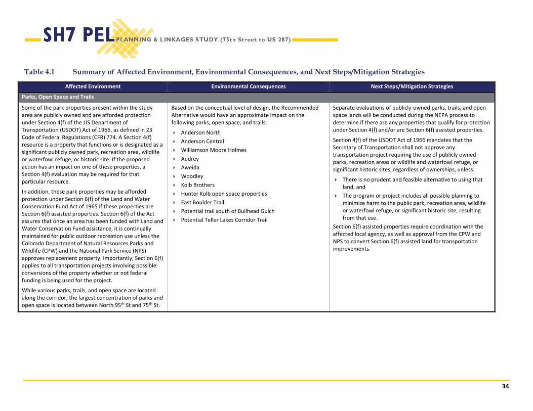
34
Table 4.1 Summary of Affected Environment, Environmental Consequences, and Next Steps/Mitigation Strategies
Affected Environment Environmental Consequences Next Steps/Mitigation Strategies
Parks, Open Space and Trails
Some of the park properties present within the study area are publicly owned and are afforded protection under Section 4(f) of the US Department of Transportation (USDOT) Act of 1966, as defined in 23 Code of Federal Regulations (CFR) 774. A Section 4(f) resource is a property that functions or is designated as a significant publicly owned park, recreation area, wildlife or waterfowl refuge, or historic site. If the proposed action has an impact on one of these properties, a Section 4(f) evaluation may be required for that particular resource.
In addition, these park properties may be afforded protection under Section 6(f) of the Land and Water Conservation Fund Act of 1965 if these properties are Section 6(f) assisted properties. Section 6(f) of the Act assures that once an area has been funded with Land and Water Conservation Fund assistance, it is continually maintained for public outdoor recreation use unless the Colorado Department of Natural Resources Parks and Wildlife (CPW) and the National Park Service (NPS) approves replacement property. Importantly, Section 6(f) applies to all transportation projects involving possible conversions of the property whether or not federal funding is being used for the project.
While various parks, trails, and open space are located along the corridor, the largest concentration of parks and open space is located between North 95th St and 75th St.
Based on the conceptual level of design, the Recommended Alternative would have an approximate impact on the following parks, open space, and trails:
Anderson North
Anderson Central
Williamson Moore Holmes
Audrey
Aweida
Woodley
Kolb Brothers
Hunter Kolb open space properties
East Boulder Trail
Potential trail south of Bullhead Gulch
Potential Teller Lakes Corridor Trail
Separate evaluations of publicly‐owned parks, trails, and open space lands will be conducted during the NEPA process to determine if there are any properties that qualify for protection under Section 4(f) and/or are Section 6(f) assisted properties.
Section 4(f) of the USDOT Act of 1966 mandates that the Secretary of Transportation shall not approve any transportation project requiring the use of publicly owned parks, recreation areas or wildlife and waterfowl refuge, or significant historic sites, regardless of ownerships, unless:
There is no prudent and feasible alternative to using that land, and
The program or project includes all possible planning to minimize harm to the public park, recreation area, wildlife or waterfowl refuge, or significant historic site, resulting from that use.
Section 6(f) assisted properties require coordination with the affected local agency, as well as approval from the CPW and NPS to convert Section 6(f) assisted land for transportation improvements.
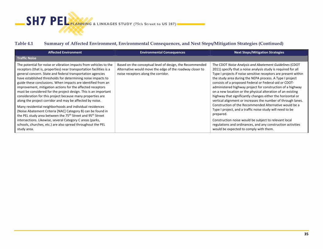
35
Table 4.1 Summary of Affected Environment, Environmental Consequences, and Next Steps/Mitigation Strategies (Continued)
Affected Environment Environmental Consequences Next Steps/Mitigation Strategies
Traffic Noise
The potential for noise or vibration impacts from vehicles to the receptors (that is, properties) near transportation facilities is a general concern. State and federal transportation agencies have established thresholds for determining noise impacts to guide these conclusions. When impacts are identified from an improvement, mitigation actions for the affected receptors must be considered for the project design. This is an important consideration for this project because many properties are along the project corridor and may be affected by noise.
Many residential neighborhoods and individual residences (Noise Abatement Criteria [NAC] Category B) can be found in the PEL study area between the 75th Street and 95th Street intersections. Likewise, several Category C areas (parks, schools, churches, etc.) are also spread throughout the PEL study area.
Based on the conceptual level of design, the Recommended Alternative would move the edge of the roadway closer to noise receptors along the corridor.
The CDOT Noise Analysis and Abatement Guidelines (CDOT 2011) specify that a noise analysis study is required for all Type I projects if noise sensitive receptors are present within the study area during the NEPA process. A Type I project consists of a proposed Federal or Federal‐aid or CDOT‐administered highway project for construction of a highway on a new location or the physical alteration of an existing highway that significantly changes either the horizontal or vertical alignment or increases the number of through lanes. Construction of the Recommended Alternative would be a Type I project, and a traffic noise study will need to be prepared.
Construction noise would be subject to relevant local regulations and ordinances, and any construction activities would be expected to comply with them.

36
Table 4.1 Summary of Affected Environment, Environmental Consequences, and Next Steps/Mitigation Strategies (Continued)
Affected Environment Environmental Consequences Next Steps/Mitigation Strategies
Historic Resources
Historic resources are afforded consideration by Section 106 of the National Historic Preservation Act of 1966, as amended, as well as Section 4(f) of the Department of Transportation Act of 1966. Significant historic resources are those that are listed or may be eligible for inclusion on the National Register of Historic Places (NRHP). Historical resources are buildings, structures, districts (groups of buildings or structures), sites, and objects meeting the minimum age criterion of 45 years. Typically, 50 years is used as an age threshold; however, a 45‐year threshold is often used in transportation projects to account for their protracted schedules including environmental clearance, design, and obtaining funding. For purposes of this study, only properties on the NRHP or officially eligible for the NRHP are listed as previously identified historic sites.
The SH 7 corridor includes 23 existing historic properties. Potential historic sites were also evaluated. Potential historic sites are properties over 45 years of age that have not yet been surveyed, but based on a visual reconnaissance appear to possess architectural qualities that may make them eligible for the NRHP under Criterion C – Distinctive Architecture and/or Construction.
Based on the conceptual level of design, the Recommended Alternative would potentially effect 13 potentially eligible NRHP Properties, including relocation of Road to Remembrance Gateway monument at the US 287/SH 7 intersection.
An additional intensive‐level inventory will be required to adequately assess these potential impacts. An intensive survey of cultural resources will be conducted, including preparation of a Cultural Resources Inventory Report, to facilitate official evaluations of NRHP‐eligibility and assess specific project impacts as required for National Historic Preservation Act Section 106 review.
If any archaeological materials (such as artifacts and faunal remains) or features are encountered or unearthed during construction, work would be immediately halted in the vicinity of the find, and the CDOT archaeologist and State Historic Preservation Officer (SHPO) would be promptly notified. The site of the find would be secured and work would remain halted until a qualified professional archaeologist could evaluate and/or remove the materials. If warranted, additional archaeological testing or data recovery may be necessary before work could be resumed in the vicinity of the find.
If bones of potential human origin are encountered during construction, ground‐disturbing work would be halted in the vicinity of the discovery, and the CDOT archaeologist would be promptly notified. The CDOT archaeologist would assess the find, and the county coroner would be summoned, if necessary, to determine the relative age and ethnicity of the individual(s) represented. Work would not resume in the vicinity of the find until CDOT grants clearance.

37
Table 4.1 Summary of Affected Environment, Environmental Consequences, and Next Steps/Mitigation Strategies (Continued)
Affected Environment Environmental Consequences Next Steps/Mitigation Strategies
Floodways and 100‐year Floodplains/Water Quality
Two drainageways have Federal Emergency Management Agency (FEMA) designated floodplains in the study area: Bull Head Gulch and Dry Creek.
Floodplains
Based on the conceptual level of design, the Recommended Alternative would have an approximate impact on the following floodplains:
Bull Head Gulch
Dry Creek
Floodplains
Bull Head Gulch and Dry Creek floodplains would be the most sensitive to any changes in the floodplain and would require a Conditional Letter of Map Revision (CLOMR) and Letter of Map Revision (LOMR) from FEMA. Floodplain modeling would be required to assess significant changes. Some relatively small changes may be incorporated in the floodplain without triggering the CLOMR/LOMR process. Floodplain modeling would be required to assess significant changes.
Engineering design will take into account the floodplain and floodway issues. The location of bridges and bridge piers within the floodplain and floodway will be considered in the engineering design. Piers located within the floodway will require a specialized hydrologic assessment and approval by FEMA and Colorado Water Conservation Board. The placement of piers within the active channel of Bull Head Gulch and Dry Creek will be avoided or placed in a position to reduce impacts on the stream channel, stream habitat, and biota.
38
Table 4.1 Summary of Affected Environment, Environmental Consequences, and Next Steps/Mitigation Strategies (Continued)
Affected Environment Environmental Consequences Next Steps/Mitigation Strategies
Floodways and 100‐year Floodplains/Water Quality (Continued)
Water Quality
Stormwater from the adjacent impervious areas (roadways, parking lots, etc.) currently discharges directly to Bull Head Gulch and Dry Creek Roadway runoff typically may contain the following pollutants:
Sediment: Solids such as sand, silt, and clays that are washed from paved surfaces or eroded from roadway slopes and become suspended in water. Sediment due to construction is a common water quality concern.
Heavy metals: Metals such as zinc and copper from fuels, brake pads, and vehicle wear. In the past, lead was a common pollutant, but the use of unleaded gasoline has now substantially reduced this roadway contaminant.
Magnesium chloride and salt: Deicers used on roads for winter maintenance.
Oil and grease: Petroleum hydrocarbons deposited by vehicles on roadways and parking lots.
Water Quality
CDOT has a Phase I Municipal Separate Storm Sewer System (MS4) permit from the Colorado Department of Public Health and Environment (CDPHE). Boulder County and the City of Lafayette also have Phase II MS4 permits. Jurisdictions that have Phase I or Phase II MS4 permits are required to provide permanent water quality facilities for new development or redevelopment where there will be 1 acre or greater of new paved (impervious) areas.
During construction, stormwater impacts will be minimized by using the appropriate CDOT standard construction best management practices (BMPs) as appropriate. Potential BMPs would include silt fence, inlet protection, stabilized construction entrances, slope stabilization, concrete washouts, erosion logs, inlet filters, sediment basins (at permanent water quality pond locations), vehicle tracking pads, and other BMPs. Specific temporary and permanent stormwater management strategies will be identified during preliminary/final design as part of a drainage/hydraulics assessment and development of a storm water management plan (SWMP). Construction‐related mitigation measures will be outlined in the SWMP and will include a detailed set of erosion control plans as part of the roadway design set.
39
Table 4.1 Summary of Affected Environment, Environmental Consequences, and Next Steps/Mitigation Strategies (Continued)
Affected Environment Environmental Consequences Next Steps/Mitigation Strategies
Wetlands and Waters of the US
Wetland resources are protected under Section 404 of the Clean Water Act (CWA) and Executive Order 11990 Protection of Wetlands. CDOT has incorporated FHWA environmental guidance into its NEPA Manual (CDOT, 2013), which emphasizes efforts to avoid and minimize wetland impacts. Most wetlands identified within the corridor are small palustrine emergent, palustrine scrub/shrub, and palustrine scrub/shrub‐emergent mix wetlands, with most occurring along existing waterways and drainages and in roadside ditches.
Based on the conceptual level of design, the Recommended Alternative would potential impact wetlands and other waters of the U.S. along the Davidson Highline Lateral Ditch, Bullhead Gulch, McGinn Ditch and Dry Creek.
A Wetland Delineation Report will be required during the NEPA process. A Wetland Findings Report will be prepared based on the recommended design included in the environmental document. FHWA and CDOT policy requires compensatory mitigation for permanent impacts on both jurisdictional and non‐jurisdictional wetlands. Wetland mitigation is typically done on a one‐to‐one basis; however, a CWA Section 404 permit, which the USACE will issue, may require higher ratios if unique or high‐quality wetlands are affected.
Wildlife/Threatened and Endangered Species
Various federal laws have been established to protect wildlife, including the Endangered Species Act (ESA); the Migratory Bird Treaty Act (MBTA); and the Bald and Golden Eagle Protection Act (BGPA). Threatened and endangered species habitat that is present in the study area includes habitat for the Colorado butterfly plant (Gaura neomexicana coloradensis), the Ute ladies’‐tresses orchid (Spiranthes divulialis), the common shiner (Notropis cornutus) and the Preble’s meadow jumping mouse (Zapus hudsonius preblei). The primary drainage that was identified from the field survey and that contained suitable habitat for these species was Dry Creek. A field survey noted major wildlife corridors that facilitate wildlife movement. These corridors include:
Davidson Highline Lateral Ditch
Bullhead Gulch
McGinn Ditch
Dry Creek
The SH 7 corridor crosses the Davidson Highline Lateral Ditch, Bullhead Gulch, McGinn Ditch and Dry Creek. Threatened and endangered species habitat may be present along Dry Creek. Several black‐tailed prairie dog colonies are located adjacent to the corridor, and migratory birds are present.
A biological survey of threatened and endangered species, including aquatic species, will be required during the NEPA process. Coordination with the US Department of Interior Fish and Wildlife Service (USFWS) and CPW would be necessary to mitigate potential impacts on special status species habitat. Also, Senate Bill 40 (SB 40) wildlife certification will be required for the crossing of riparian corridors in the project. CPW will determine if Formal or Programmatic certification may be required depending on SB 40 guidelines.
If proposed construction is planned to occur during the primary nesting season for migratory birds in eastern Colorado (typically April 1 – August 31, with some species nesting outside this period), a qualified biologist will resurvey the study area to verify if any active nests are present. If no active nests are present, trees can be removed. However, if active migratory bird nests are identified and cannot be avoided by proposed construction activities, the USFWS field office will be contacted to help determine the appropriate mitigation action, which may include removing nests before egg laying begins or ceasing construction until all nestlings have fledged.
40
Table 4.1 Summary of Affected Environment, Environmental Consequences, and Next Steps/Mitigation Strategies (Continued)
Affected Environment Environmental Consequences Next Steps/Mitigation Strategies
Hazardous Materials
For this hazardous materials assessment summary, sites within the study area were identified as having known (current and historic) soil or groundwater contamination and are distinguished in this report as sites with recognized environmental conditions. Sites with the potential for soil and/or groundwater contamination that could not be confirmed without additional inspection or investigation are distinguished as sites with potential environmental conditions.
A total of 16 sites with recognized and potential environmental conditions were identified within 500 feet of the SH 7 study area. Two of these sites were leaking underground storage tank (LUST) sites adjacent to the study area.
Based on the conceptual level of design, the Recommended Alternative would potentially be affected by six sites with potential hazardous material concerns.
Properties to be acquired will require a site‐specific Phase I Environmental Site Assessment or Initial Site Assessment with an updated search of environmental databases as part of the ROW acquisition process.
Contamination from hazardous materials is most likely to be encountered during ground‐disturbing activities in areas near properties with potential or recognized environmental conditions (hazardous materials). During the design process, the information concerning these properties can be used to identify avoidance options, if possible, and to assist with the development of materials management and worker health and safety plans. An asbestos‐containing materials survey is required for all structures to be demolished as part of this project and must be completed as part of the CDPHE demolition permit. Additionally, a lead‐based paint survey and regulated materials clearance survey are recommended for all structures to be demolished as part of this project.

41
Table 4.1 Summary of Affected Environment, Environmental Consequences, and Next Steps/Mitigation Strategies (Continued)
Affected Environment Environmental Consequences Next Steps/Mitigation Strategies
Other Resources
The following resources were not evaluated as part of the SH 7 PEL:
Air Quality
Farmlands
Socio‐Economics and Community
Properties Acquired for Right‐of‐Way and Displacements
Archaeological Resources
Paleontology
Soils and Geology
Water Resources
Potential impacts were not analyzed for these resources as part of this SH 7 PEL.
Additional environmental analysis will be required as part of future NEPA analysis and documentation.

42
5.0 AGENCY COORDINATION AND PUBLIC INVOLVEMENT
Boulder County committed to involving federal, state, and local agencies and the public throughout the SH 7 (75th Street to US 287) PEL process. Project success hinges on communication and cooperation among FHWA, CDOT, and the local communities. This includes coordination with and involvement of federal, state, and local government officials; regional transportation planning entities; community groups; civic and professional organizations; businesses; and residents. This project built on the agency coordination and public involvement previously conducted on the SH 7 (US 85 to US 287) PEL east of this project’s the study area.
5.1 Agency Coordination
The study team prepared an Agency Coordination and Public Outreach Plan for the PEL study at the outset of the study. The purpose of the agency coordination and public involvement program was to set forth the public involvement process for the SH 7 (75th Street to US 287) PEL study and to describe how federal, state, and local governmental officials; regional transportation planning entities; citizen groups; community groups; civic and professional organizations; businesses; citizens; and low‐income and minority populations would be involved in the process.
Resource Agency Consultation Resource agencies have specific technical expertise and regulatory oversight on various environmental issues and potential impacts associated with the project. Boulder County notified representatives from the U.S. Army Corps of Engineers (USACE), U.S. Fish and Wildlife Service (USFWS), U.S. Environmental Protection Agency (USEPA), Colorado Parks and Wildlife (CPW), State Historic Preservation Officer (SHPO), Boulder County Parks and Open Space, and City of Boulder Open Space and Mountain Parks of the SH 7 (75th Street to US 287) PEL study on July 29, 2017. The resource agencies were invited to comment on the SH 7 (75th Street to US 287) PEL Corridor Conditions Assessment Report on January 19, 2017. The study team received comments about the project from CDPHE, USACE, CDPHE APCD, USEPA, and USFWS (Appendix D). In addition, coordination meetings were held with Boulder County Parks and Open Space, and City of Boulder Open Space and Mountain Parks.
PEL Technical Advisory Committee (PTAC) Agency involvement activities included regular progress committee meetings held with FHWA, CDOT, Boulder County, and local community participants during the PEL study. The PTAC’s primary role was to provide input on a range of issue analyzed in the PEL study. The participating agencies and their representatives on the PTAC included: Marc Ambrosi, Boulder County
Scott McCarey, Boulder County
George Gerstle, Boulder County
43
Jean Sanson, City of Boulder
Kathleen Bracke, City of Boulder
Paul Rayl, City of Lafayette
Gary Behlen, Town of Erie
Daniel Marcucci, CDOT Region 4
Karen Schneiders, CDOT Region 4
Lindsay Edgar, CDOT Environmental Programs Branch
Patricia Sergeson, FHWA Colorado Division
The study team met with the PTAC regarding the following topics on:
June 30, 2016
o Study Overview and Schedule
o Corridor Conditions
o Draft Purpose and Need
o Draft Alternatives Development and Evaluation Process
September 12, 2016
o Purpose and Need
o Project Goals and Evaluation Criteria
o Preliminary Alternatives
February 9, 2017
o Alternatives Development and Evaluation Process
Vehicular Operations
Regional Bicycle Connectivity
Transit Service
o Preliminary Alternatives
o Preliminary Recommended Alternative(s)
August 9, 2017
o Public Meetings Summary
o Alternatives Development and Evaluation Process
o Retained Alternatives and Phasing
Meeting minutes from the PTAC meetings are included in Appendix D.
5.2 Public Outreach Activities
Corridor‐wide public open houses were held on April 26, 2017 at the YMCA of Boulder Valley at 2800 Dagny Way in Lafayette, CO, and on June 26, 2017 at the Boulder County Recycling Center – Education Room at 1901 63rd Street in Boulder, CO. There were approximately 75 attendees for the April open house, and approximately 85 attendees for the June meeting.
The April 26, 2017 open house focused on the:
Study Overview and Schedule
Corridor Conditions
Draft Purpose and Need
Draft Alternatives Development and Evaluation Process
Level 1 Evaluation Process
The June 26, 2017 open house focused on the:
Level 2 Evaluation Process
Retained Alternatives
Next Steps
The public provided feedback via comment forms at the meetings, one‐on‐one interactions with the

44
study team, online through the webpage, or over the phone by those who were unable to attend. Appendix D summarizes the outreach conducted and input collected at the public open houses. The following public outreach activities provided the public multiple ways of participating in the study:
E‐Mail, Mailing List, and Contact Database: The study team developed a contact database to include individuals who wanted to stay informed about the study. The database incorporated contact lists from previous studies. The database allowed the study team to communicate directly with the public, including sending notifications of the public open houses.
Project Web Page: Boulder County hosted a dedicated web page on its website to provide updated information about the study and to enable ongoing communication. The web page https://www.bouldercounty.org/transportation/multi‐modal/bus/sh7‐brt‐study/state‐highway‐7‐planning‐environmental‐linkages/ included study information, presentation materials, meeting summaries, and meeting announcements. The web page enabled the public to sign up for the study’s mailing list and to submit comments. The webpage also contained contact information for the public to be able to speak directly with the Boulder County Project Manager and the study team.
Media Outreach and Advisories: The Boulder County Transportation Department Communications Office distributed study‐related media advisories to announce the public open houses.
Social Media Outreach: The Boulder County Transportation Department Communications Office used Facebook and Twitter to communicate announcements about the study and to publicize public open houses.
Points of Contact: Stakeholders contacted Marc Ambrosi, Boulder County Project Manager, with comments or questions throughout the study.
Marc Ambrosi Boulder County, SH 7 (75th Street to US 287) PEL Project Manager
(720) 564‐2751 [email protected]
5.3 Public Comments
Throughout the study, the public had ongoing, accessible, and distinct opportunities to participate and provide input to inform the study. Over the course of the study, the public submitted approximately 164 comments that were reviewed and taken into consideration. Appendix D includes the comments submitted by members of the general public during the course of the study. The following is a summary of the comments received.
Supported land use that is compatible with transit
Supported investment in transit and transit amenities but not bus only lanes
Supported a separate multi‐use path along the corridor
Did not support adding additional general purpose lanes
Supported preserving the rural character along SH 7
Supported pedestrian improvements at intersections and evaluating possible grade separation of pedestrian movements
Supported TDM strategies
Supported a transportation system approach with improvements along Baseline Road, Isabelle/Valmont, and SH 7
Supported additional capacity at the intersections
Supported bicycle and pedestrian connections to transit stops
Supported roadway capacity improvements
Requested noise mitigation
Supported improvements, such as left‐turn lanes, for safety and accessibility

45
6.0 IMPLEMENTATION The true value of this process will become even more evident as progress is made along the corridor and there are projects in varying stages of development, including ones with environmental clearance, with adequate ROW, and with “shovel ready” plans and specifications at final engineering design for construction advertisement. Because funding for the corridor improvements has not been identified at this time, they will all require design funding to proceed. Projects that are farther along in preparation become magnets to available funding, particularly where there is broad support. Implementation is typically determined during NEPA and final design; however, construction funding must be identified for each phase to meet the requirements of fiscal constraint for FHWA and CDOT to approve NEPA documentation.
As Boulder County and the other corridor stakeholders continue to pursue implementation of the retained Recommended Alternatives, this planning effort has identified several strategies that should be considered:
Keep Projects Advancing
It is important to continually have projects that are ready for funding because it positions the corridor well and because unanticipated funding opportunities often arise. Therefore, it is recommended to constantly keep a good balance of money dedicated to construction of projects, but at the same time allocate funding for design, acquisition of property for right‐of‐way, and utility phases to prepare future shelf ready projects.
Maximize the Use of Incremental Investments
Projects should be selected, designed, and phased to make maximum use of previous investments in infrastructure and to minimize “throw away” improvements included in the project. The other incremental improvements that were identified in this PEL include: improving shoulders to allow for safer bicycling and motor vehicle operations on the corridor, and improving transit stops and amenities.
6.1 General NEPA Requirements
This PEL study provides a framework for the long‐term implementation of the transportation improvements as funding becomes available and is to be used as a resource for future NEPA documentation. This PEL study has identified issues, as presented in Table 4.1 that will require additional evaluation in any future NEPA documentation. According to the Managed Lanes Policy Directive 1603.0, during the NEPA process, managed lanes should be strongly considered for the planning and development of capacity improvements. The evaluation of managed lanes is included in Tables 2.1, 2.2, and 2.3.
Funding for the Recommended Alternative has not been identified at this time. However, the identification of a Recommended Alternative Concept for the entire project in this PEL study is consistent with FHWA’s objective of analyzing and selecting transportation solutions on a broad enough scale to provide meaningful analysis and avoid segmentation.
Phased implementation may be detailed during NEPA and final design. Fiscal constraint requirements must be satisfied for FHWA and CDOT to approve further NEPA documentation. Before FHWA and CDOT can sign a final NEPA decision document (Record of Decision, Finding of No Significant Impact, or programmatic or non‐programmatic Categorical Exclusion), the proposed project, as defined in the NEPA document, must meet the following specific fiscal‐constraint criteria (FHWA, 2011):
The proposed project or phases of the proposed project within the time horizon of the RTP must be included in the fiscally‐constrained RTP, and other phase(s) of the project and associated costs beyond the RTP horizon must be
Project Strategies
Keep projects advancing through pursuit of funding
Focus on improvements at the SH 7/US 287, SH 7/95th Street, and SH 7/75th Street intersections first before
Maximize use of incremental investments

46
referenced in the fiscally‐unconstrained vision component of the RTP.
The project or phase of the project must be in the fiscally‐constrained TIP, which includes:
At least one subsequent project phase, or the description of the next project phase (For project phases that are beyond the TIP years, the project must be in the fiscally‐constrained RTP and the estimated total project cost must be described within the financial element of the RTP and/or applicable TIP).
Federal‐aid projects or project phases and state/locally funded, regionally significant projects that require a federal action.
Full funding is reasonably available for the completion of all project phase(s) within the time period anticipated for completion of the project.
In cases where a project is implemented in more than one phase, care must be taken to ensure that the transportation system operates acceptably at the conclusion of each phase. This is referred to as “independent utility” – the ability of each phase to operate on its own. Additionally, it must be demonstrated that air quality conformity will not be jeopardized. Any mitigation measures needed in response to project impacts must be implemented with the phase in which the impacts occur, rather than deferred to a later phase.
The establishment of phases during NEPA for the Recommended Alternative Concept is required to meet the following criteria:
Independent Utility/Logical Termini: Each phase should have independent utility and logical termini to the extent that the phase provides a functional transportation system even in the absence of other phases.
Elements of Purpose and Need: Each phase should contribute to meeting the Purpose and Need for the entire project.
Environmental Impacts: Individual phases should avoid the introduction of substantial
additional environmental impacts that cannot be mitigated.
Once funding is secured, the environmental planning process can be initiated. The environmental process will build on the environmental work, public outreach, and agency outreach conducted by this PEL study.
To carry out any or all of the recommendations from this PEL, CDOT has committed to applying NEPA. The NEPA processes that would be anticipated could be either an Environmental Assessment (EA) or a Categorical Exclusion (CatEx).
CatExs are the most common NEPA documents and are for actions that do not individually or cumulatively have a significant environmental impact, are excluded from the requirement to prepare an EA or an EIS, and do not have substantial public controversy. CatExs are defined in 23 CFR 771.117 and meet the definition from the Council on Environmental Quality in 40 CFR 1508.4 and are based on the past experience with similar actions of FHWA.
An EA would be prepared and submitted through the successive review processes of CDOT Region 1, CDOT Environmental Programs Branch, and FHWA. The public would have 30 days to review and comment before FHWA makes its final decision. CDOT will consider use of a streamlined EA template for this project to accelerate the timeline for the environmental process, while still allowing for appropriate agency coordination and public involvement. If, at any point in the EA process, FHWA determines that the action would likely have a significant impact on the environment, that EA process would stop and the preparation of an EIS would be required. If FHWA agrees the action would have no significant impacts on the environment, FHWA would prepare a Finding of No Significant Impact to serve as the decision document for the proposed action.
6.2 Scoping, Preliminary, and Final Engineering Design
After project funding has been identified and the project is included in the TIP, a planning level estimate is prepared to determine how much funding is needed for each project phase: ROW, Utilities, Environmental, Design and Construction.
47
A project scoping meeting can be held before or after the selection of a project delivery method to establish the project objectives; to identify the design standards, funding sources and amounts, the required resources necessary to complete the project, and the schedule; and to complete the preliminary survey request.
Once the project goals and constraints are defined, the delivery schedule, complexity, and innovation opportunities can be used to determine the appropriate project delivery method. These methods may include Design‐Bid‐Build (DBB), Design‐Build (DB), and Construction Management/General Contractor (CM/GC). A risk assessment will be conducted given each delivery method’s opportunities and obstacles. Once the delivery method is selected, the level of design, contractor selection process, and participation can be initiated.
If the project delivery method is DBB, after the design level survey is received, the preliminary design phase of the project begins. A conceptual level of engineering design (approximately 10 percent) was prepared for the Recommended Alternative Concept (Appendix E) for the purposes of this PEL study. A Field Inspection Review (FIR) meeting is held to review the site conditions with 30 percent plans complete. The plans are reviewed with all of the specialty units, the local governments if applicable, and representatives from the utility companies to identify the tasks needed to complete the project. The preliminary cost estimate is developed and compared to the available budget. Once the design is at the stage that the ROW limits can be identified, plans can be prepared and acquisition initiated. Final Design proceeds until the Plans, Specification and Estimate package is 95 percent complete. A Final Office Review (FOR) meeting is then conducted to complete the review process. The project funding is then obligated and authorized once all clearances are obtained and then the project is advertised for construction.
If the project delivery method is DB and if the owners have the capabilities to perform the design effort, the plans are developed to approximately the 30 percent level to be used to select a DB team of designers and contractors to complete the project. An engineering firm may be contracted to develop the 30 percent design plans. The factors used in the selection of the DB
team include qualifications, duration, price, and innovation.
Finally, if the project delivery method is CM/GC, the agency contracts separately with a designer and a construction manager. The agency can perform design or contract with an engineering firm to provide a facility design. A contractor is selected to give construction management input during the design process, perform construction management services and construction work. The CM/GC contractor will negotiate with the agency for a mutually agreeable contract amount. If the CM/GC contractor and agency cannot reach a mutually agreeable negotiated contract amount or they choose not to negotiate, the project will be advertised for competitive bid.
6.3 Acquisition of Property for Right-of-Way
The limits of the existing ROW for the planned improvements will be determined from record information and field surveys. The preferred or final design alternatives will then be overlaid on the ROW base to determine impacts that will require additional ROW fee or easement acquisitions. When acquisitions are necessary, a title report is ordered and used to prepare property descriptions, exhibits, and ROW plans to support the acquisition process. Once these documents clearly define the impact, property appraisal is then ordered to determine the value of the property to be acquired. The acquisition process will commence after all of this information has been compiled. Typically, the timeframe between identification and transfer of ownership takes about 18 months to meet all of the requirements of the Uniform Relocation Act. However, it may be possible to obtain possession earlier based on project needs. In worst cases, if the property is rendered unusable or if it is a total take, relocation services may be necessary.
6.4 Construction
Construction delivery options include DBB, CM/GC, and DB. CM/GC and DB typically provide shortened delivery times. These two delivery methods usually start the procurement process during the end stages of the
48
environmental planning processes. The three delivery methods have different allocations of risk between the owner and contractor.
In the CM/GC process, CDOT contracts directly with the engineering consultant and, therefore, has more control over the design of the project, but also requires more robust coordination among CDOT and stakeholders, the
engineer, and the contractor. In the typical DB process, CDOT releases most of the risk to the contractor in designing the project but also establishes a stricter contracting process, leading to a longer procurement time. In DB, the engineering consultant is a member of the contractor’s team.

49
7.0 REFERENCES City of Boulder. 2014. City of Boulder Transportation Master Plan. Website accessed June 2016. https://www‐static.bouldercolorado.gov/docs/transportation‐master‐plan‐tmp‐2014‐1‐201408271459.pdf
Boulder County. 2016. Regional Trail Map. Website accessed June 2016. http://www.bouldercounty.org/find/maps/pages/parks.aspx
Carsey et al. 2003. Field Guide to the Wetland and Riparian Plant Associations of Colorado.
City of Boulder. 2010. Boulder Valley Comprehensive Plan. Website Accessed June 2016. https://www‐static.bouldercolorado.gov/docs/boulder‐valley‐comprehensive‐plan‐2010‐1‐201410091122.pdf
City of Boulder. 2016. Envision East Arapahoe. Retrieved June 2016. https://bouldercolorado.gov/planning/envision‐east‐arapahoe‐transportation
City of Lafayette. Website accessed June 2016. http://www.cityoflafayette.com/160/Open‐Space
Colorado Department of Transportation (CDOT). 2005. Environmental Stewardship Guide. Accessed online June 2016. https://www.codot.gov/programs/environmental/resources/guidance‐standards/esguide5‐12‐05prepress.pdf
Colorado Department of Transportation (CDOT). 2008. Technical Memorandum, Wetlands and Other Waters of the U.S. in North I‐25 Draft EIS. United States Department of Transportation, Federal Highway Administration, Federal Transit Administration and Colorado Department of Transportation.
Colorado Department of Transportation (CDOT). 2011. Technical Memorandum Addendum, Wetlands and Other Waters of the U.S. in Final North I‐25 EIS. United States Department of Transportation, Federal Highway Administration, Federal Transit Administration and Colorado Department of Transportation.
Colorado Department of Transportation (CDOT). 2015. CDOT Noise Analysis and Abatement Guidelines. June.
Colorado Natural Heritage Program (CNHP). 2016. College of Natural Resources, Colorado State University. Fort Collins, CO.
Colorado Parks and Wildlife (CPW). 2008. Colorado Division of Wildlife Raptor Guidelines. February.
Colorado Parks and Wildlife (CPW). 2016. CPW Species Profiles. Website accessed May 2016 http://cpw.state.co.us/learn/Pages/SpeciesProfiles.aspx
Cowardin, L.M., V. Carter, F.C. Golet, and E.T. LaRoe. 1979. Classification of Wetlands and Deepwater Habitats of the United States. (FWS/OBS‐79/31) United States Fish and Wildlife Service. Washington D.C.
Denver Regional Council of Governments (DRCOG). 2015. 2040 Metro Vision Fiscally Constrained Regional Transportation Plan.
Environmental Data Resources Inc. (EDR). 2016. EDR DataMap Area Study. Inquiry Number: 4616319.5s. May 13.
Environmental Laboratory. 2010. Regional Supplement to the Corps of Engineers Wetland Delineation Manual: Great Plains Region. Technical Report ERDC/EL TR‐10‐1, United States Army Corps of Engineers Waterways Experiment Station. Vicksburg, MS.
Federal Highway Administration (FHWA) and Colorado Department of Transportation (CDOT). 2008a. SH 7 (Cherryvale Rd. to 75th St.) Environmental Assessment and Draft Section 4(f) Evaluation. May.
50
Federal Highway Administration (FHWA) and Colorado Department of Transportation (CDOT). 2008b. SH 7 (Cherryvale Rd. to 75th St.) Finding of No Significant Impact and Final Section 4(f) Evaluation. October.
Federal Highway Administration (FHWA) and Colorado Department of Transportation (CDOT). 2011a. North I‐25 Final Environmental Impact Statement, Final Section 4(f) Evaluation. August.
Federal Highway Administration (FHWA) and Colorado Department of Transportation (CDOT). 2011b. North I‐25 Record of Decision. December.
Federal Transit Administration (FTA) and Regional Transportation District (RTD). 2011a. North Metro Corridor Final Environmental Impact Statement and Final Section 4(f) Evaluation. January.
Federal Transit Administration (FTA) and Regional Transportation District (RTD). 2011b. Record of Decision North Metro Corridor Project. April.
Felsburg Holt and Ullevig (FHU). 2009. SH 7 Corridor Study, Revised Initial Evaluation of Alternative Alignments Technical Memorandum. February 25.
Geocal, Inc. 2004. North I‐25 Front Range Environmental Impact Statement. Abandoned Mines Mapping, Preliminary Report. October 14.
Jointly Owned Boulder County‐Lafayette Open Space Management Plan. 2004 amended 2010. Website accessed June 2016. http://www.bouldercounty.org/doc/parks/jointlaflouismplan.pdf
Natural Diversity Information Source (NDIS). 2012. Website: http://ndis.nrel.colostate.edu/conservationcnty.asp?cnty=031 .
Oil and Public Safety (OPS). 2016. http://costis.cdle.state.co.us/home.asp. Date retrieved: June 2016.
Regional Transportation District of Denver (RTD). 2014. FastTracks Northwest Area Mobility Study. Date retrieved: June, 2016. http://www.rtd‐fastracks.com/nams_1
United States Fish & Wildlife Service (USFWS). 2016. Information, Planning, and Conservation System (IPaC) internet mapping tool website: http://ecos.fws.gov/ipac/wizard/trustResourceList!prepare.action
United States Environmental Protection Agency. Clean Water Act of 1972, 33 U.S.C. § 1251 et seq. (2002). Retrieved from http://epw.senate.gov/water.pdf
Town of Erie. 2008. Transportation Master Plan. January 8.
Town of Erie, City and County of Broomfield, and CDOT. 2002 (as amended). SH 7 Access Control Plan. July.

WWW.FHUENG.COM
FELSBURGH O L T &U L L E V I Gconnecting and enhancing communities
6300 South Syracuse Way, Suite 600
Centennial, CO 80111
303.721.1440