Embed Size (px)
Citation preview

FIELD TRIP: Contractional linkage zones and curved faults, Garden of the Gods, with illite geochronology exposé Presenters: Christine Siddoway and Elisa Fitz Díaz. With contributions from Steven A.F. Smith, R.E. Holdsworth, and Hannah Karlsson This trip examines the structural geology and fault geochronology of Garden of the Gods, Colorado. An enclave of ‘red rock’ terrain that is noted for the sculptural forms upon steeply dipping sandstones (against the backdrop of Pikes Peak), this site of structural complexity lies at the south end of the Rampart Range fault (RRF) in the southern Colorado Front Range. It features Laramide backthrusts, bedding plane faults, and curved fault linkages within subvertical Mesozoic strata in the footwall of the RRF. Special subjects deserving of attention on this SGTF field trip are deformation band arrays and younger-‐upon-‐older, top-‐to-‐the-‐west reverse faults—that well may defy all comprehension!
The timing of RRF deformation and formation of the Colorado Front Range have long been understood only in general terms, with reference to biostratigraphic controls within Laramide orogenic sedimentary rocks, that derive from the Laramide Front Range. Using 40Ar/39Ar illite age analysis of shear-‐generated illite, we are working to determine the precise timing of fault movement in the Garden of the Gods and surrounding region provide evidence for the time of formation of the Front Range monocline, to be compared against stratigraphic-‐biostratigraphic records from the Denver Basin. The field trip will complement an illite geochronology workshop being presented by Elisa Fitz Díaz on 19 June. If time allows, and there is participant interest, we will make a final stop to examine fault-‐bounded, massive sandstone-‐ and granite-‐hosted clastic dikes that are associated with the Ute Pass fault. These are newly demonstrated to be Neoproterozoic in age. There will be four hikes of short to moderate length, that entail off-‐trail walking and, in one instance, steep, rough terrain. SCHEDULE FOR THE DAY: 1 Depart Golden / CSM campus at 8 a.m., and drive on interstate highway to Colorado Springs. 2 Arrive Garden of the Gods Visitor Center at 9:15 am, with time for a restroom stop. INTRODUCTION TO FIELD TRIP from a vantage point at Visitor Center. 3 Drive in to Garden of the Gods, separating into two groups to visit two sites (~2 hours, with a ‘switch’ at the midway point: each group walks with a guide across the park to the other site).
a) Hidden Inn fault for Ar/Ar geochronology presentation and discussion with Elisa— example of successful "fault gouge" study , albeit one that poses challenges of detrital Kfs and mica, and b) curved faults, ‘backthrusts,’ and examination of fault linkage evidence, with Christine. 4 Deformation band arrays and Lunch on superb outcrops at the south end of the Garden (1.5 to 2 hours) 5 Leave Garden of the Gods. Short drive (with bathroom stop, en route) and visit to steep limb of FR Monocline, for direct observation of an opportune illite geochronology site in a carbonate-‐shale succession (40 min)
6) Sandstone dikes and "new" Neoproterozoic silicicastic that provides evidence of Neoproterozoic initiation of Front Range fault systems – with example of use of AMS to examine emplacement mechanisms
7) Return to Golden.

15 June 2014 / SGT Forum field trip
2
Figure 1 – Geology of Garden of the Gods.
a) Geological map upon aerial photographic base; and stereographic plots of b) bedding, c) faults and shears for four areas, with slickenline data.

15 June 2014 / SGT Forum field trip
3
Garden of the Gods offers access to diverse structures that illuminate the process of fault zone evolution in a contractional system. On this field trip we will examine a variety of structures that are better documented for extensional structures (e.g. Walsh et al., 1999, Fault relays, bends and branch-‐lines, JSG, v. 21, 1019-‐1026). These include: bypass faults, fault bends, damage zones, deformation band clusters, and comminution zones, to be observed and discussed at Stops 1 through 3 on the SGTF field trip. Descriptive characteristics of Garden of the Gods faults • Complex deformation in upper Pz-‐ Mz strata: considerations of mechanical stratigraphy • Footwall faults place younger upon older, with top-‐to-‐west displacement. Steep to overturned bedding indicates ~horizontal axis rotation upon curved fault planes • In plan view: extreme curviplanar geometry of footwall faults exists due to continuity between bedding-‐parallel and bedding-‐oblique segments • • Top-‐to-‐east Rampart Range fault (piercement ) forms western Linked, right-‐stepping faults Points of discussion include: -‐-‐ Evolved triangle zone model for Garden of the Gods (see below) -‐-‐ Question of compensation of 3D strain in footwall wedge -‐-‐ out of plane displacement -‐-‐ Geometrical relationship of structures developed in porous rocks to GOG fault linkage zones Figure 2 -‐ “Evolved” Triangle Zone model -‐ Sterne (2006): Garden of the Gods as a backthrust wedge

15 June 2014 / SGT Forum field trip
4
Figure 3 – Structural map of “South fault,” Garden of the Gods. The “lunch stop” for the field trip will be in this area, in the vicinity of the box labeled “Figure 11.”
Diagram: Steven A.F. Smith (U. Durham PhD, 2009) now at U. Otago. Stereoplots as follows (squares show poles to means): b) bedding, with mean bedding = 178/72 E c) BP=Bedding-‐parallel fault, mean plane: 013/59E and mean lineation: 25-‐031; BO=bedding-‐oblique fault, mean: 047/52 S and mean lineation : 22-‐069 (Mean, all faults: 040/52 E, Mean, all lineations, 24, 058)

15 June 2014 / SGT Forum field trip
5
Figure 5 -‐Diagrams that provide framework for illite geochronology and fault / shear deformation dating
Illite Ar-‐Ar Geochronology for determining time of formation of the Front Range monocline, Colorado Springs, CO Hannah Karlsson, Elisa Fitz-‐Diaz, & Christine Siddoway, Geological Society of America Abstracts with Programs, Vol. 45, No. 7, p.823 The Front Range Monocline (FRM) in Colorado Springs is considered a Laramide tectonic feature formed in Cretaceous-‐Paleogene times on the basis of stratigraphic constraints, which are based on the age of deposition of syn-‐tectonic clastic deposits in the foreland. Considering that deformation took place in the shallow upper crust, we took advantage of the of the Ar-‐Ar illite dating technique, which targets the age of authigenic illite precipitated during faulting/shear of fine grained rocks, to try to improve the resolution of the age of the FRM. For this purpose, we analyzed one fault gouge sample from the Hidden Inn fault (reverse faults affecting the steep limb of the FRM, sample 512HIF), and two shale layers interbedded with limestone (Fort Hayes Fm-‐sample 612Kn6) or between limestone and arenite (Leadville Fm-‐sample 612BC2). Significant shear parallel to bedding is evidenced by pervasive cleavage within the shale layers and the presence of lustrous anastomosed surfaces known as nanocoatings. Sample 612Kn6 was collected in the steep limb and sample 612BC2 in the sub-‐horizontal upper limb of the FRM. Illite Age Analysis, which considers the total gas ages and illite polytype quantification (% of 2M1illite, presumed as the detrital illite component) of at least three grain-‐size fractions of clay particles and York regression analysis, allowed estimation of age of authigenic illite in each sample as follows: 512HIF=57.5±5, 6132-‐Kn6=55.7±1.6, 612Kd2=67.7±209 and 612BC2 is =143.2±13.4 Ma. The closeness in age obtained in samples 512HIF and 612Kn6 indicates that shear-‐parallel to bedding and fault activity occurred about the same time, presumably during the FRM steep limb rotation.

15 June 2014 / SGT Forum field trip
6
Figure 4 -‐ -‐ Correlation of deformation band clusters to oblique (linking) faults
Figure 3 -‐ -‐ Correlation of deformation band clusters to oblique (linking) faults a and b) Photographs of Type C deformation bands (faulted defm band clusters) on the west side of ‘Grey rock’. In a) the deformation bands are visible as prominent, continuous fins which erode out from the cliff-‐face (approximately 80 metres in height). c) steronets showing the orientation of Type 3 deformation bands at 3 separate outcrops in Garden of the Gods. NE-‐SW striking, moderately SE-‐dipping deformation bands are prevalent.
left; Mean deformation band, 040/ 44 SE, Mean lineation, 42,055 Middle, Mean deformation band, 055/ 34 SE, Mean lineation, 13,076
Right, Mean deformation band, 040/ 54 SE, Mean lineation, 35, 064

15 June 2014 / SGT Forum field trip
7
The older age of authigenic illite in the sub horizontal upper limb implies that shear occurred prior to the Laramide Orogeny and the limb was inactive during FRM development. The most insightful finding through this exercise was the correspondence in timing of monocline formation (58±4Ma) with the Paleocene-‐Eocene Thermal Maximum at ca. 55 Ma, and event that was marked by changes in precipitation, weathering and massive sediment mobilization that could cause gravitational unloading and potentially trigger bedrock uplift and fault activation. LUNCH AND HANDS-‐ON ACTIVITY: Study of deformation band systems in the Upper Lyons Sandstone What is YOUR take on the crosscutting relationships, geometry, and successive development of the DBs? RESOURCES:
Planar structures in nonporous or low porosity rock vs. Tabular structures to accommodate strain in high porosity rock
YOUR NOTES:

15 June 2014 / SGT Forum field trip
8

15 June 2014 / SGT Forum field trip
9
Figure 6 -‐ Optional stop at end of afternoon: Remobilized sandstone and sandstone injectites along the Ute Pass fault Sutherland Creek locality (a.k.a., the Sugarcube)
C.S. Siddoway, 2014, A vestige of the Neoproterozoic comes to light: Detrital zircon provenance for basement-‐hosted injectites and remobilized sands, Colorado Front Range, GSA Abstracts with Programs Vol. 46, No. 5, Abstract no. 238381. Abstract: Detrital zircon (DZ) provenance analysis is used to resolve the time of emplacement of remobilized sandstones hosted by Mesoproterozoic plutono-‐metamorphic rocks of the Colorado Front Range (CFR). Informally named Tava sandstone, the formation represents a foremost example of sedimentary injectites within a non-‐sedimentary host, due to the scale of the system. Basement-‐hosted sandstones occur over a distance ≥75 km, with single dikes up to 6 meters in width, dike sets up to 7 km long, and putative parent bodies with volumes ≥6x10⁶ m3. Introduced to the geological community 130 years ago by Cross (1894), the sandstone dikes have been attributed to nearly every geological time period, including the Holocene, however paleomagnetic attributes constrain the dikes’ emplacement to Pennsylvanian or older. DZ attributes may be used to refine the age brackets yet further, under the assumption that proximal, same-‐aged siliciclastic units contain similar diagnostic age distributions. To this end, U-‐Pb DZ ages were obtained for three Tava sandstone dikes and one parent body, to be compared with new U-‐Pb DZ ages for mature sandstone beds from four Paleozoic units of differing age. All samples are mature quartz arenite. All four Tava samples exhibit a dominant broad peak of 0.93 -‐ 1.31 Ga in normalized relative age probability curves, indicative of detritus of the Grenville orogen that is prominent in mid-‐Cryogenian strata of the western USA. Two CFR samples exhibit pronounced peaks at ca. 1.45 and ca. 1.72 Ga, attributable to proximal sources in the Berthoud and Routt plutonic suites, that are absent in the other two samples. The DZ data from four CFR Paleozoic quartz arenite beds yield contrasting results. Basal Cambrian sandstone lacks DZs <1.30 Ga. Upper Paleozoic samples contain ca. 430 Ma zircons that are absent from remobilized sandstones, and only a small group of 0.97 -‐ 1.30 Ga recycled zircons. The lack of correlation in DZ characteristics allows a proposed Paleozoic age for sandstone remobilization to be ruled out. A statistical similarity to published DZ distributions for Cryogenian strata in the western USA suggests instead that the remobilized sandstones’ ancestry can be traced to the interval 770–740 Ma in Rodinia, opening avenues to deeper understanding of continental paleoenvironments and paleogeography of the time. See next page for use of AMS characterization for emplacement mechanism!
15 June 2014 / SGT Forum field trip
10
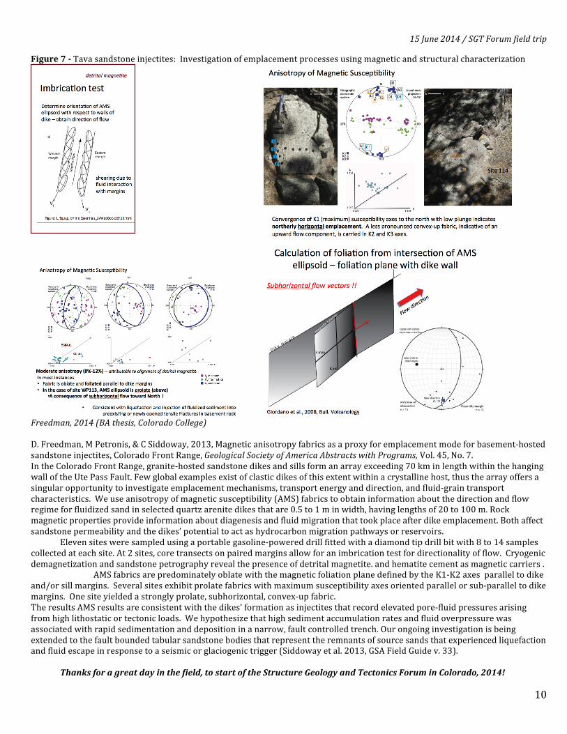
Figure 7 -‐ Tava sandstone injectites: Investigation of emplacement processes using magnetic and structural characterization
Freedman, 2014 (BA thesis, Colorado College) D. Freedman, M Petronis, & C Siddoway, 2013, Magnetic anisotropy fabrics as a proxy for emplacement mode for basement-‐hosted sandstone injectites, Colorado Front Range, Geological Society of America Abstracts with Programs, Vol. 45, No. 7. In the Colorado Front Range, granite-‐hosted sandstone dikes and sills form an array exceeding 70 km in length within the hanging wall of the Ute Pass Fault. Few global examples exist of clastic dikes of this extent within a crystalline host, thus the array offers a singular opportunity to investigate emplacement mechanisms, transport energy and direction, and fluid-‐grain transport characteristics. We use anisotropy of magnetic susceptibility (AMS) fabrics to obtain information about the direction and flow regime for fluidized sand in selected quartz arenite dikes that are 0.5 to 1 m in width, having lengths of 20 to 100 m. Rock magnetic properties provide information about diagenesis and fluid migration that took place after dike emplacement. Both affect sandstone permeability and the dikes’ potential to act as hydrocarbon migration pathways or reservoirs.
Eleven sites were sampled using a portable gasoline-‐powered drill fitted with a diamond tip drill bit with 8 to 14 samples collected at each site. At 2 sites, core transects on paired margins allow for an imbrication test for directionality of flow. Cryogenic demagnetization and sandstone petrography reveal the presence of detrital magnetite. and hematite cement as magnetic carriers .
AMS fabrics are predominately oblate with the magnetic foliation plane defined by the K1-‐K2 axes parallel to dike and/or sill margins. Several sites exhibit prolate fabrics with maximum susceptibility axes oriented parallel or sub-‐parallel to dike margins. One site yielded a strongly prolate, subhorizontal, convex-‐up fabric. The results AMS results are consistent with the dikes’ formation as injectites that record elevated pore-‐fluid pressures arising from high lithostatic or tectonic loads. We hypothesize that high sediment accumulation rates and fluid overpressure was associated with rapid sedimentation and deposition in a narrow, fault controlled trench. Our ongoing investigation is being extended to the fault bounded tabular sandstone bodies that represent the remnants of source sands that experienced liquefaction and fluid escape in response to a seismic or glaciogenic trigger (Siddoway et al. 2013, GSA Field Guide v. 33).
Thanks for a great day in the field, to start of the Structure Geology and Tectonics Forum in Colorado, 2014!

Age (Ma) Th. Formation DescriptionPa
leoz
oic
Mes
ozoi
cC
enoz
oic
Pennsylvanian
Holocene
Pleistocene
Miocene
Oligocene
Eocene
Paleocene
Cretaceous
Pliocene
JurassicTriassic
Permian
MississippianDevonian
Ordovician
Cambrian
65
34
23
5.3
1.8
0.01
145
200
251
299
318359
444
488542
>100
100
1000
-20
00
>340>300
3400
-520
0
>500
30010060225
180
>800
4400
>13030
65185
MiscellaneousGravels
Castle Rock Cglmt.
Gravels @ DivideCripple Creek Gold
Florissant Fossil Beds39-Mile Volcanics
Wall Mountain Tuff
Dawson Formation(Denver Fm)
Laramie FormationFox Hills Sandstone
Pierre Shale
Finely-laminated series of silts & clays w/insect impressions, ash.Basalt to rhyolite volcanic centers near Guffy, CO
Niobrara Formation
Benton GroupDakota SandstonePurgatoire Form.
Morrison Formation
Lykins Formation
Lyons Sandstone
Fountain Formation
Hardscrabble Lst.
Harding SandstoneManitou Limestone
Sawatch Sandstone
Keeton PorphyryPikes Peak Granite
Routt Plutonic SuiteCentral Front Range
Arc Sequence
Silurian416
Red/grey thick to massive bedding, dense to granular with some chert
(1450 Ma) Fine-grained granite, diorite, monzonite w/ abundant mica
Geologic Timescale and Stratigraphy of the Pikes Peak Region
* All ages given in million years before present, thicknesses given in feet. Updated 01/14 (Rasmussen).
56
O
C
SDM
PI
P
TR
J
K
Q
PC
(1670 Ma) Coarsely crystalline granodiorite w/ large kspar phenocrysts
(1080 Ma) Pink med-coarsely crystalline biotite or hornblende granite (1050 Ma) Red rhyolitic porphyry
Lower: 25' of red-brown, white, green fn to crs-grnd ss. Middle: 40' of dark red fn to crs xtline granular thin-bedded dolomite w/glauconite
Yellowish-grey-greenish/white fn-grnd thinly-bdd ss and red/brown sh
Pinkish thinly-bdd stromatolitic muddy limest. w/qtz. ss interbeds Lower: limestone breccia. Upper: muddy limest. w/ss interbeds
Reddish-brown arkosic conglomerate, grey coarse-grained arkosic sandstone, and thin layers of green and maroon shale
Glen Eyrie shale member at base consists of grey sandstone and grey, thin coal beds, about 100' thick
Red/yellowish-grey fine-grained ss consisting of upper and lower resistant, ridge-forming units separated by ss and conglomerate
Red/Green silty sh w/white, red, green fn-gnd ss & stromatolitic lst.
Varicolored grey, maroon, green silty sh and clayst. w/lst, ss, cglmt. Glencairn Sh organic-rich. Lytle Ss: coarse white ss w/chert pebbles Yellowish-brown, fn-grained, cross-bedded ss w/some black sh Graneros Sh(grey), Greenhorn Lst(thin-bdd), Carlisle Sh(grey), Codell Ss
Grey to black shl. interbedded w/ slst & ss. Contains cone-in-cone concretions and ironstone nodules, dark yellowish-brown ss & irregular grey limest. masses. Basal part of Pierre is black sh w/calcareous concretions, thin bentonites, & limest. beds. Above is grey-black sh w/ironstone beds. Next is dark sh w/numerous cylindrical columns of coarse, grey, fossil-rich limest. The next zone contains cone-in-cone beds in grey sh. At the top is buff-grey shl. with thin beds of fossiliferous ss and limestone w/a few chert pebbles. Fort Hayes Lst: 30-50' grey well-bdd w/sh partings. Forms a hogback. Smoky Hills Chalk Mbr: 400-500' of yellow-brown thin-bdd shl w/lst itbd.
Olive-brown massive friable fn-gnd ss & a sandy shl. Upper: white ss Greyish-brown/yellowish-grey fine-gnd ss, olive clayst, & coal beds
Coarse arkosic conglomerate and ss w/ minor slst and sh. Contains hard, thin ironstone layers and olive green ss. Deposited during the Laramide Orogeny and lithology is very irregular on a local scale.
A rhyolitic tuff with sanidine & qtz. phenocrysts as well as pumice.A bimodal conglomerate with angular fragments of WMT w/channels.
Brown clayey, silty, sandy gravel in extensive paleovalley.
Poorly-cemented arkosic gravels, conglomerates, and sandstoneswith average thickness of 40'. Several levels of mesa and terracegravels. Commonly overlain by sand dune and sheet deposits.
Colorado College Geology Department
Williams Canyon Lst.
(1750 Ma) Metased Rx & volcanics: schist, gneiss, quartzite, others
Great Unconformity
Quate
rnary
65
[no Silurian formations found in the Pikes Peak region]
Associated with subvolcanic rhyolites and phonolites.
[no Pliocene formations found in the Pikes Peak region]
[no Oligocene formations found in the Pikes Peak region]
Berthoud Plutonic Suite
Pale
ogen
eN
eoge
ne
Prec
ambr
ian
Tava Sandstone (circa 700 Ma) Conglomeratic, ‘structureless’ quartz ss in tabular beds
Prot
eroz
oic
Arc
hean
Had
ean
[no Archean formations found in the Pikes Peak region]
[no Hadean formations found in the Pikes Peak region]
Phan
eroz
oic
(Anthropocene?)

6400
640
0
6400
6816
660
0
640
0
680
0
Rid
ge
Road
Junip
erW
ayL
oop
Gar
den
Dri
ve
Gateway Road
Cam
pC
reek
Junip
erW
ayL
oop
30thStreet
Mesa Drive
Garden of the Gods
2000 feet
500 meters
0
0
Contour Interval 40 feet
Parking
N