Embed Size (px)
Citation preview
www.cpcs.ca
CPCS Ref: 16548 / DKCI Ref: 1206
January 10, 2018
GTHA Strategic Goods Movement Network
Final Report
Prepared for:
Metrolinx
Prepared by:
CPCS and David Kriger Consultants Inc.
FINAL REPORT | GTHA Strategic Goods Movement Network
Acknowledgements / Confidentiality
CPCS and DKCI acknowledge and are thankful for input provided by the study Steering Committee, the Review Group and other stakeholders consulted in the development of this report.
This report may include information that is deemed by some to be commercially sensitive and should be treated by recipients as confidential, unless otherwise approved for release by Metrolinx.
Cover image source: DKCI
FINAL REPORT | GTHA Strategic Goods Movement Network
| i
Executive Summary Overview Metrolinx is responsible for creating and maintaining a Regional Transportation Plan (RTP) for the Greater Toronto and Hamilton Area (GTHA). This responsibility is embodied in the Metrolinx Act, 2006. The RTP is part of an approach by the provincial government to prepare the GTHA for growth and sustainability. A formal review and update of the RTP is now underway, and its completion is expected in 2018.
The original RTP, entitled “The Big Move,” built upon nine “Big Moves,” or strategies. The eighth of these called for the development of a comprehensive strategy to improve goods movement within the GTHA and with adjacent regions. Metrolinx subsequently developed this strategy as part of the 2011 GTHA Urban Freight Study. The Study’s Action Plan in turn called for the development of a GTHA‐wide Strategic Goods Movement Network (SGMN).
Purpose of the Strategic Goods Movement Network This report develops a core road and rail SGMN for the GTHA. A SGMN can be characterized as a strategic, connected, and continuous network of multimodal corridors that facilitates the movement of freight. It features a hierarchy of facilities among all jurisdictions. It promotes reliability through redundancy; that is, alternative routes or modes are available through seamless connections. The SGMN connects all major intermodal terminals (rail, marine ports and airports) and major goods‐generating activity centres with each other and with the major road and rail networks. The term ‘core’ reflects the SGMN’s GTHA‐wide perspective, as opposed to being a compilation of existing upper‐tier SGMNs and roads that permit trucks.
The final SGMN comprises a map of the core road and rail networks, as well as a proposed implementation plan and monitoring program, a process to resolve future network conflicts, possible future data collection and research and a possible extended consultation – all of which are documented in this report. The SGMN also could incorporate future policies, actions and other initiatives that could result from future discussions among Metrolinx, the Ontario Ministry of Transportation (MTO) and other agencies.
It should also be noted that the SGMN is based on the GTHA’s existing road and rail networks, accounting for in large part for observed flows that are generated by major existing freight generators and intermodal terminals. While the SGMN accounts for designated future employment lands and planned rapid transit infrastructure, it does not identify or propose any new road or rail links. The Metrolinx SGMN will inform the MTO’s Greater Golden Horseshoe (GGH) Multimodal Plan, which is developing a future multimodal passenger and goods network to 2051 for the broader GGH region. The Metrolinx SGMN is intended to be updated periodically, to account for changes in conditions and new network improvements.
FINAL REPORT | GTHA Strategic Goods Movement Network
| ii
The SGMN supports and informs the updated RTP by ensuring the compatibility of the goods movement road and rail networks and intermodal terminal connections with the existing and planned rapid transit and commuter rail networks.
The SGMN builds on existing municipal SGMNs, providing a basis for adoption by upper‐tier municipalities in their own jurisdictions, in order to promote a consistently defined network across the GTHA and to inform the setting of priorities for road improvements. The SGMN, and any related future policies, will in no way supersede existing municipal SGMNs or other uses of the designated corridors by the responsible jurisdiction. The SGMN is intended to support, inform and complement other municipal transportation, land use, environmental, economic and other plans and aspirations, and to provide a reference for future urban corridor design, Complete Streets schemes and the like. As such, the SGMN should be updated regularly as conditions and needs change, as elaborated in the proposed SGMN implementation plan (Section Error! Reference source not found.).
Benefits of the SGMN Defining a GTHA‐wide SGMN has many benefits, because it allows goods movement to be better integrated into the individual planning, prioritization and budgeting processes of all levels of government. This GTHA‐wide approach recognizes that the movement of goods is independent of jurisdictions and boundaries, and that an efficient, multimodal network makes the best use of system capacity while reducing shipping costs and promoting economic competitiveness and quality of life. Moreover, while continued growth in truck traffic is a positive indicator of economic activity, there can also be impacts on congestion, greenhouse gas (GHG) emissions and air quality: a systematically‐defined, GTHA‐wide understanding and characterization of key goods movement corridors would aid in addressing these and other issues, and allow an improved understanding of the potential contributions of all goods movement modes to reducing congestion, GHG emissions and air pollutants to build on the many emissions‐reduction measures that the goods movement industry already is taking.
The SGMN uniquely provides an integrated GTHA‐wide perspective that shows how all key regional freight generators and intermodal terminals are connected. It thus provides the broad framework necessary for addressing issues that are not restricted to specific jurisdictions, from reducing GHGs and air pollutants and managing growth at the urban boundary, to reducing congestion and optimizing the use of the entire multimodal network, and providing policymakers with an improved understanding of which corridors to protect from encroachment.
The contribution of goods movement to economic wellbeing and quality of life is often not fully recognized in the perception of the public and in the prioritization of public policies. Identifying a regional SGMN helps to ensure that the needs of goods movement industries are recognized within the context of planning the broader transportation network.
FINAL REPORT | GTHA Strategic Goods Movement Network
| iii
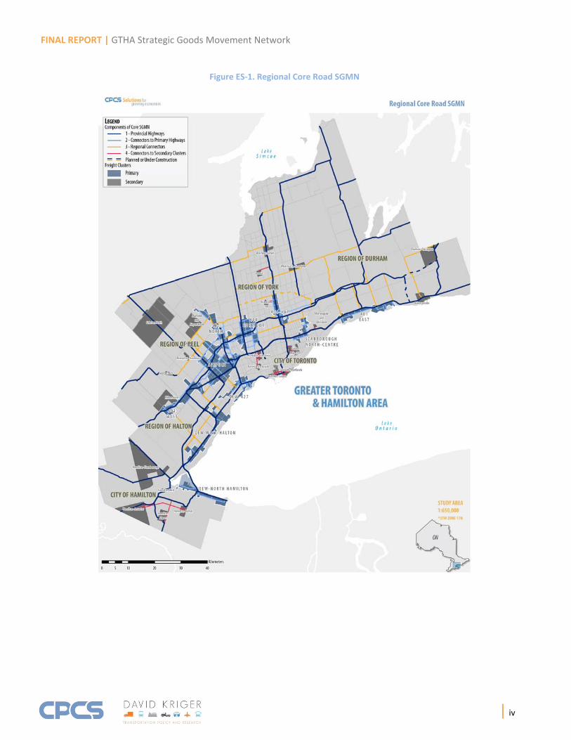
Approach The project was developed in two broad phases. Phase I developed initial, high‐level, RTP‐compatible SGMN concepts, drawing upon an analysis of flows among the GTHA’s major freight clusters and accounting for the existing upper‐tier SGMNs. Phase II refined the SGMN concepts into a single core road and rail SGMN. Metrolinx has presented the core road SGMN for public comment in its September 2017 Draft RTP. The core road and rail SGMN informed Metrolinx’s evaluation of its RTP rapid transit alternatives. The core network also provided the basis for identifying outstanding network conflicts for subsequent resolution ‐ for example, as rapid transit plans on some SGMN segments are further refined in the future. Phase II proposed an implementation and monitoring plan, as well as a plan for subsequent broader stakeholder consultation with the private sector and recommendations for further research and data collection.
Final Core Road and Rail SGMN The core road and rail SGMN derives from the Phase I network concepts. These concepts were based upon a data‐driven definition of a network that connects key freight‐generating clusters, overlaid with existing regional and municipal SGMNs. Note that the cluster geographies correspond to those associated with the data, and should not necessarily be construed as reflecting land uses that have been designated in municipal Official Plans. The core network now refines the concepts to develop a single consistent, GTHA‐wide network that connects the freight‐generating clusters and addresses several gaps in the initial compilation.
The derivation of the core SGMN takes into account three rounds of comments that were provided by Steering Committee members and by members of the study Review Group regarding the concepts; an initial circulation of a draft SGMN in June 2017; and a final circulation of the draft SGMN in August‐September 2017. The Steering Committee comprised Metrolinx, MTO’s Systems Analysis and Forecasting Office and Peel Region. The Review Group comprised the GTHA’s other five upper‐tier municipalities (Durham Region, Halton Region, York Region, City of Hamilton and the City of Toronto), other MTO offices, Transport Canada, Highway 407 ETR, Canadian National Railways and Canadian Pacific Railway, the Greater Toronto Airports Authority and Hamilton International Airport, the Hamilton Port Authority, the Port of Oshawa and Ports Toronto, and the Ontario Trucking Association. The City of Mississauga also provided comments.
Figure ES‐1 presents the final road SGMN. Figure ES‐2 presents the final rail SGMN.
Note that Metrolinx has included the final road SGMN in its September 2017 Draft Regional Transportation Plan (RTP), which has been made available for public comment. Comments on the Draft RTP are not due until late 2017, so any subsequent comments on the SGMN must be addressed separately.
FINAL REPORT | GTHA Strategic Goods Movement Network
| iv
Figure ES‐1. Regional Core Road SGMN

FINAL REPORT | GTHA Strategic Goods Movement Network
| v
Figure ES‐2. Regional Core Rail SGMN
FINAL REPORT | GTHA Strategic Goods Movement Network
| vi
Resolution of Outstanding Conflicts Conflicts can arise in the designation of a network such as the SGMN – for example, on corridors that are shared with rapid transit. However, because the core road and rail SGMNs were developed in consultation with the Review Group, most potential issues and conflicts have been anticipated and provisionally addressed provisionally. The multi‐faceted and iterative one‐on‐one consultation with individual agencies proved effective in identifying and accommodating Review Group comments.
As a result, only a few potential conflicts remain. These comprise eight SGMN corridors on which rapid transit is planned or is under construction, and three SGMN road sections in the City of Toronto that have load restrictions. In the case of the eight rapid transit corridors, potential conflicts should be addressed as corridor design progresses. In the case of the three segments with load restrictions, the extent to which any of these constitutes an actual constraint on the movement of goods is unclear, and might best be addressed if the City of Toronto identifies this as a constraint, or if the City proposes to rehabilitate any of the bridges in question.
In addition, it should be noted that Halton Region and the City of Toronto propose to review the need for possible additional SGMN segments, or possible changes to the core road SGMN, as part of future studies – notably, the planned update to the Halton Region Transportation Master Plan and a planned freight strategy for the City of Toronto.
Accordingly, this report proposes approaches to addressing these conflicts, if and as specific needs arise. The approaches are necessarily generic, drawing from best practices elsewhere, and serve as guidelines for future analyses and for the further development and refinement of the core road‐based SGMN.
The approaches can be described at three levels or steps. The approaches are progressively more focused on individual corridors and on actual implementation. These are:
At the master planning or strategic planning level, providing a municipality‐wide, network‐level perspective. The object is to coordinate the SGMN with transit and other major corridor improvements at a broad, strategic level.
At the corridor and sub‐area planning level, focusing on smaller numbers of corridors. The object is to integrate goods movement needs as corridor and area plans become more specific.
At the level of planning and design for individual corridors. The object is to ensure that truck circulation and parking are considered explicitly in road and intersection design, especially as Complete Streets and other shared corridor guidelines are implemented on individual roads.

FINAL REPORT | GTHA Strategic Goods Movement Network
| vii
Proposed Implementation Plan A plan was developed to implement the SGMN. The plan was based on a review of other recent practices. It recognizes that the implementation of the SGMN requires a cooperative approach among the relevant jurisdictions, and proposes potential participants for each component of the plan. However, the plan also recognizes that individual upper‐tier municipalities ultimately are responsible for implementing the SGMN for roads that are under their jurisdiction, and that they will do so in a manner consistent with their own policies and plans.
The proposed implementation plan has fifteen actions, which are listed below:
1. Give the SGMN status by encouraging the Councils of the upper‐tier municipalities to adopt it, or by encouraging upper‐tier municipalities to incorporate the SGMN into their own plans and policies.
2. Encourage the Province and upper‐tier municipalities to align and prioritize their individual operational, management and capital network improvements to support those elements of the SGMN that are under their individual jurisdictions. Coordinating initiatives across municipal boundaries also is encouraged.
3. Implement operational, management and capital network improvements that support the SGMN.
4. Prepare inventory of existing barriers such as load restrictions, turning radii, height requirements and inadequate pavement structures.
5. Establish a SGMN committee to coordinate and advance the implementation of SGMN initiatives.
6. Establish signage, route guidance and maps for the SGMN, covering the GTHA and possibly areas beyond.
7. Review and remove any existing upper‐tier municipal by‐law restrictions from the designated SGMN, where feasible.
8. Design and promote common approaches to set priorities for each implementation action, incorporating benefit‐cost analysis.
9. Develop and promote consistent guidelines and best practices for evaluating zoning and land use plans along the SGMN corridors, to ensure that goods movement needs are accommodated while maintaining compliance with individual agencies’ land use and transportation policies and aspirations.
10. Develop and promote common approaches and best practices for evaluating transportation proposals along the designated SGMN corridors and for assessing right‐
FINAL REPORT | GTHA Strategic Goods Movement Network
| viii
of‐way protection requirements, to ensure that goods movement needs are accommodated while maintaining compliance with individual agencies’ policies.
11. Encourage upper‐tier municipalities to develop their own secondary SGMNs in conjunction with lower‐tier municipalities, in order to ensure first/last kilometre connectivity.
12. Develop and promote Complete Streets guidelines and best practices that account for goods movement.
13. Review existing funding sources to ascertain their potential application to SGMN corridor improvements.
14. Consider creating P3 structures to implement at least some types of improvements.
15. Implement a GTHA‐wide performance‐monitoring program, and use this program for public information, to inform planning and investment decisions, and to help determine when a SGMN update is warranted.
Proposed Monitoring Program A plan was developed to monitor the performance of the SGMN and to measure its progress. The proposed monitoring plan has fourteen performance measures. These are listed below:
1. Truck volumes on SGMN corridors.
2. Value of goods carried on SGMN corridors, or average value of goods carried per truck.
3. Average truck travel times (along one or more corridors or on the entire SGMN).
4. Average truck travel speeds (along one or more corridors or on the entire SGMN).
5. Travel time reliability (along one or more corridors or on the entire SGMN).
6. Travel time delays (magnitude and duration) and costs of delays (monetary, fuel, GHG, air pollutants), along one or more corridors or on the entire SGMN.
7. Percent of the SGMN that has an acceptable pavement condition.
8. Percent of the SGMN that does not have restricted clearances or permanent or seasonal load restrictions.
9. Value of annual investments in SGMN network improvements.
10. Number of collisions involving trucks on the SGMN, per truck trip (volumes).
FINAL REPORT | GTHA Strategic Goods Movement Network
| ix
11. Number of fatal and serious injury collisions involving trucks on the SGMN, per truck trip (volumes).
12. Delays to freight trains and GO trains in the GTHA.
13. Delays incurred at at‐grade crossings, for all road traffic and separately for trucks, as measured in vehicle‐hours travelled.
14. Percent on‐time delivery (proportion of total trips that are made within a certain threshold, as measured by shippers).
Except for measure 13, which requires input from the Class I and short line freight railways, and measure 14, which requires data from the goods movement industry, all measures would be developed from data that are developed or have been purchased by MTO or the upper‐tier municipalities, as elaborated in Section Error! Reference source not found.. Incorporating some of these measures into a monitoring program may require additional data collection on an on‐going basis.
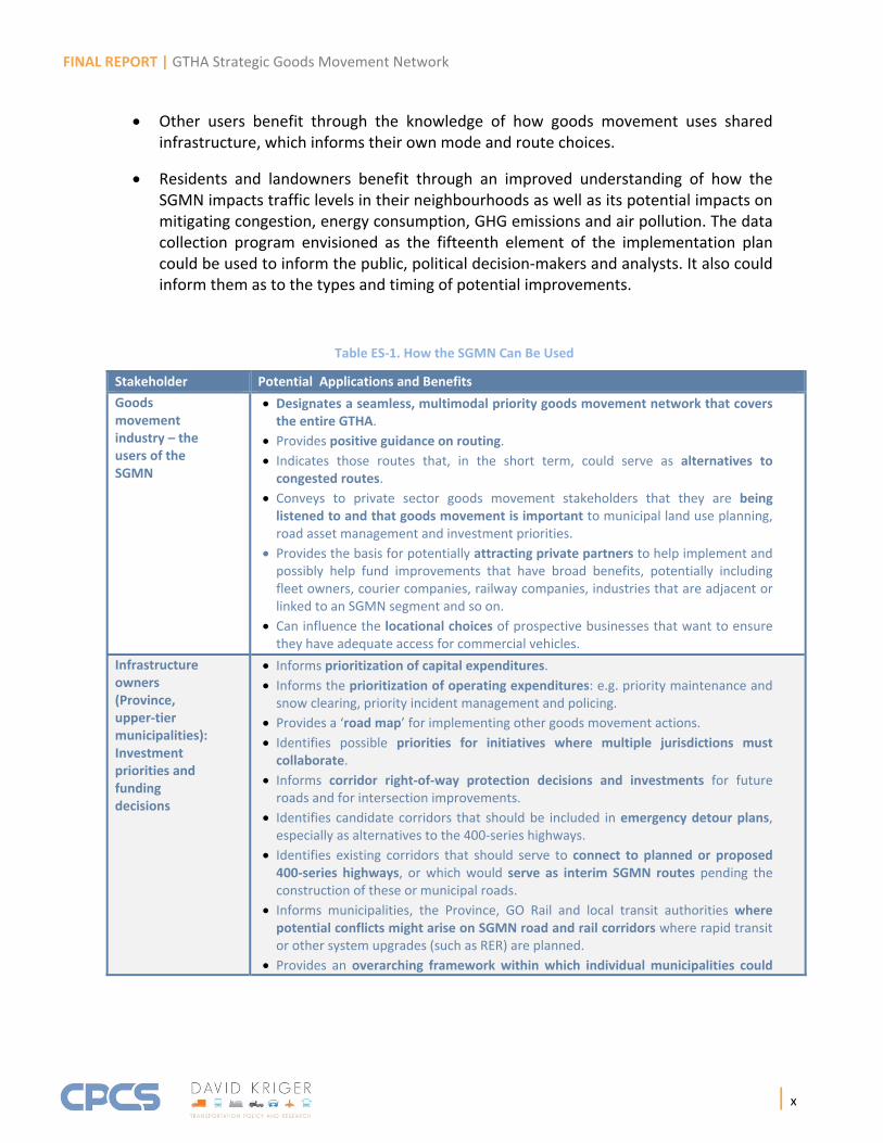
How the SGMN Can Be Used (Applications) The SGMN has a number of potential uses, which vary by stakeholder. The potential applications and benefits are described in Table ES‐1. The table categorizes perspectives from four stakeholder groups, namely, the goods movement industry, infrastructure owners, other corridor users, and residents and landowners.
The table shows that there are many potential benefits. Key points to note:
The goods movement industry benefits through the identification of a seamless, multimodal priority network across the GTHA, providing guidance on routes and alternatives. The SGMN also signals to industry that improvements will take place to further enhance the efficiency of goods movement in the GTHA.
Infrastructure owners benefit in several ways: The SGMN can serve as a road map for locating upgrades and improvements that will benefit the movement of both goods and people. The SGMN informs planning, right‐of‐way protection and investment decisions and priorities, as well as zoning and land use planning decisions. The SGMN enhances the integration of goods movement with Complete Streets schemes and other corridor improvements. The SGMN can serve as a tangible focus or starting point for a broader goods movement data collection initiative and for research in goods movement – for example, by serving as priority locations for new data collection or to evaluate new traffic control technologies. Finally, the SGMN informs political decision‐makers at all levels of government about the economic and other benefits of maintaining an efficient goods movement network in the GTHA.
FINAL REPORT | GTHA Strategic Goods Movement Network
| x
Other users benefit through the knowledge of how goods movement uses shared infrastructure, which informs their own mode and route choices.
Residents and landowners benefit through an improved understanding of how the SGMN impacts traffic levels in their neighbourhoods as well as its potential impacts on mitigating congestion, energy consumption, GHG emissions and air pollution. The data collection program envisioned as the fifteenth element of the implementation plan could be used to inform the public, political decision‐makers and analysts. It also could inform them as to the types and timing of potential improvements.
Table ES‐1. How the SGMN Can Be Used
Stakeholder Potential Applications and Benefits
Goods movement industry – the users of the SGMN
Designates a seamless, multimodal priority goods movement network that covers the entire GTHA.
Provides positive guidance on routing. Indicates those routes that, in the short term, could serve as alternatives to congested routes.
Conveys to private sector goods movement stakeholders that they are being listened to and that goods movement is important to municipal land use planning, road asset management and investment priorities.
Provides the basis for potentially attracting private partners to help implement and possibly help fund improvements that have broad benefits, potentially including fleet owners, courier companies, railway companies, industries that are adjacent or linked to an SGMN segment and so on.
Can influence the locational choices of prospective businesses that want to ensure they have adequate access for commercial vehicles.
Infrastructure owners (Province, upper‐tier municipalities): Investment priorities and funding decisions
Informs prioritization of capital expenditures.
Informs the prioritization of operating expenditures: e.g. priority maintenance and snow clearing, priority incident management and policing.
Provides a ‘road map’ for implementing other goods movement actions.
Identifies possible priorities for initiatives where multiple jurisdictions must collaborate.
Informs corridor right‐of‐way protection decisions and investments for future roads and for intersection improvements.
Identifies candidate corridors that should be included in emergency detour plans, especially as alternatives to the 400‐series highways.
Identifies existing corridors that should serve to connect to planned or proposed 400‐series highways, or which would serve as interim SGMN routes pending the construction of these or municipal roads.
Informs municipalities, the Province, GO Rail and local transit authorities where potential conflicts might arise on SGMN road and rail corridors where rapid transit or other system upgrades (such as RER) are planned.
Provides an overarching framework within which individual municipalities could
FINAL REPORT | GTHA Strategic Goods Movement Network
| xi
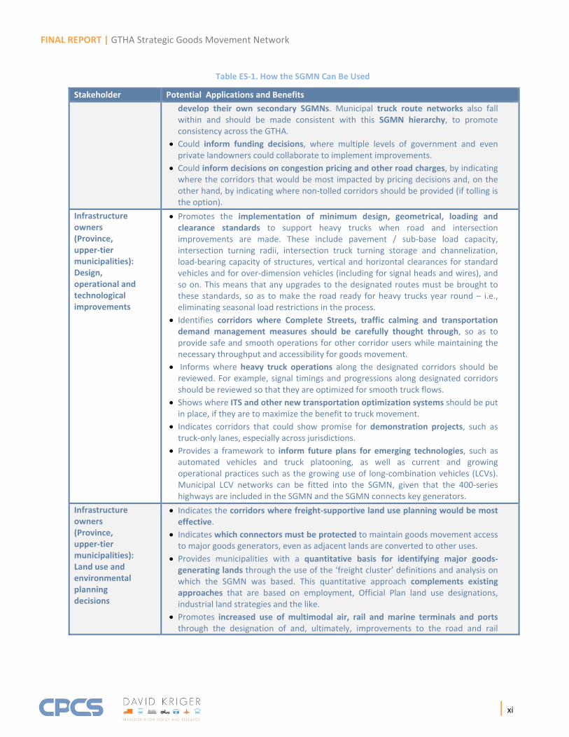
Table ES‐1. How the SGMN Can Be Used
Stakeholder Potential Applications and Benefits
develop their own secondary SGMNs. Municipal truck route networks also fall within and should be made consistent with this SGMN hierarchy, to promote consistency across the GTHA.
Could inform funding decisions, where multiple levels of government and even private landowners could collaborate to implement improvements.
Could inform decisions on congestion pricing and other road charges, by indicating where the corridors that would be most impacted by pricing decisions and, on the other hand, by indicating where non‐tolled corridors should be provided (if tolling is the option).
Infrastructure owners (Province, upper‐tier municipalities): Design, operational and technological improvements
Promotes the implementation of minimum design, geometrical, loading and clearance standards to support heavy trucks when road and intersection improvements are made. These include pavement / sub‐base load capacity, intersection turning radii, intersection truck turning storage and channelization, load‐bearing capacity of structures, vertical and horizontal clearances for standard vehicles and for over‐dimension vehicles (including for signal heads and wires), and so on. This means that any upgrades to the designated routes must be brought to these standards, so as to make the road ready for heavy trucks year round – i.e., eliminating seasonal load restrictions in the process.
Identifies corridors where Complete Streets, traffic calming and transportation demand management measures should be carefully thought through, so as to provide safe and smooth operations for other corridor users while maintaining the necessary throughput and accessibility for goods movement.
Informs where heavy truck operations along the designated corridors should be reviewed. For example, signal timings and progressions along designated corridors should be reviewed so that they are optimized for smooth truck flows.
Shows where ITS and other new transportation optimization systems should be put in place, if they are to maximize the benefit to truck movement.
Indicates corridors that could show promise for demonstration projects, such as truck‐only lanes, especially across jurisdictions.
Provides a framework to inform future plans for emerging technologies, such as automated vehicles and truck platooning, as well as current and growing operational practices such as the growing use of long‐combination vehicles (LCVs). Municipal LCV networks can be fitted into the SGMN, given that the 400‐series highways are included in the SGMN and the SGMN connects key generators.
Infrastructure owners (Province, upper‐tier municipalities): Land use and environmental planning decisions
Indicates the corridors where freight‐supportive land use planning would be most effective.
Indicates which connectors must be protected to maintain goods movement access to major goods generators, even as adjacent lands are converted to other uses.
Provides municipalities with a quantitative basis for identifying major goods‐generating lands through the use of the ‘freight cluster’ definitions and analysis on which the SGMN was based. This quantitative approach complements existing approaches that are based on employment, Official Plan land use designations, industrial land strategies and the like.
Promotes increased use of multimodal air, rail and marine terminals and ports through the designation of and, ultimately, improvements to the road and rail
FINAL REPORT | GTHA Strategic Goods Movement Network
| xii
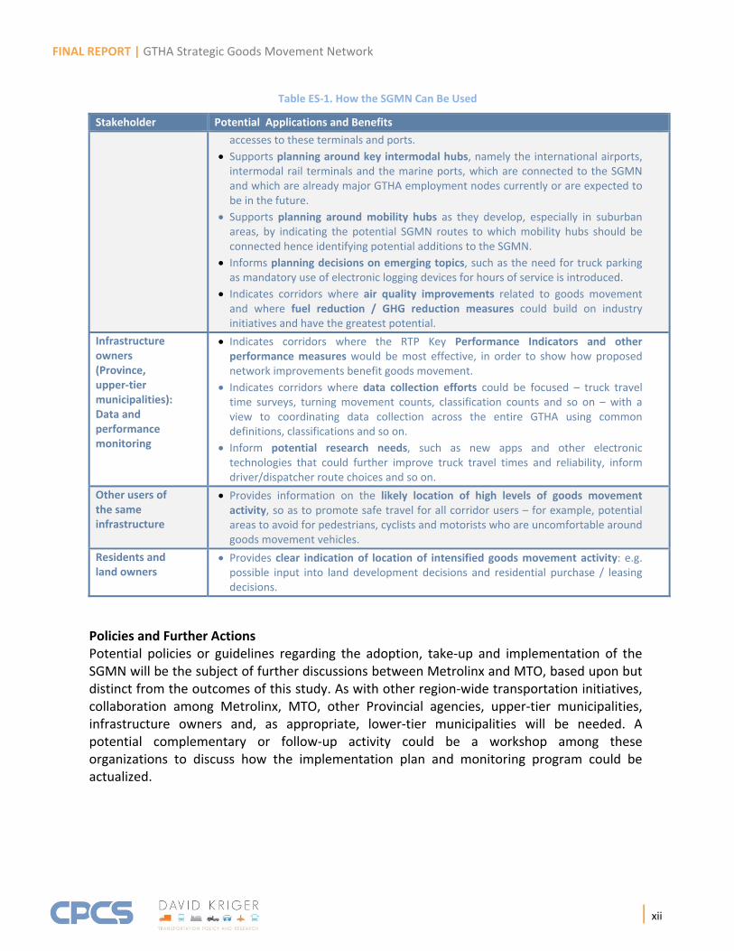
Table ES‐1. How the SGMN Can Be Used
Stakeholder Potential Applications and Benefits
accesses to these terminals and ports.
Supports planning around key intermodal hubs, namely the international airports, intermodal rail terminals and the marine ports, which are connected to the SGMN and which are already major GTHA employment nodes currently or are expected to be in the future.
Supports planning around mobility hubs as they develop, especially in suburban areas, by indicating the potential SGMN routes to which mobility hubs should be connected hence identifying potential additions to the SGMN.
Informs planning decisions on emerging topics, such as the need for truck parking as mandatory use of electronic logging devices for hours of service is introduced.
Indicates corridors where air quality improvements related to goods movement and where fuel reduction / GHG reduction measures could build on industry initiatives and have the greatest potential.
Infrastructure owners (Province, upper‐tier municipalities): Data and performance monitoring
Indicates corridors where the RTP Key Performance Indicators and other performance measures would be most effective, in order to show how proposed network improvements benefit goods movement.
Indicates corridors where data collection efforts could be focused – truck travel time surveys, turning movement counts, classification counts and so on – with a view to coordinating data collection across the entire GTHA using common definitions, classifications and so on.
Inform potential research needs, such as new apps and other electronic technologies that could further improve truck travel times and reliability, inform driver/dispatcher route choices and so on.
Other users of the same infrastructure
Provides information on the likely location of high levels of goods movement activity, so as to promote safe travel for all corridor users – for example, potential areas to avoid for pedestrians, cyclists and motorists who are uncomfortable around goods movement vehicles.
Residents and land owners
Provides clear indication of location of intensified goods movement activity: e.g. possible input into land development decisions and residential purchase / leasing decisions.
Policies and Further Actions Potential policies or guidelines regarding the adoption, take‐up and implementation of the SGMN will be the subject of further discussions between Metrolinx and MTO, based upon but distinct from the outcomes of this study. As with other region‐wide transportation initiatives, collaboration among Metrolinx, MTO, other Provincial agencies, upper‐tier municipalities, infrastructure owners and, as appropriate, lower‐tier municipalities will be needed. A potential complementary or follow‐up activity could be a workshop among these organizations to discuss how the implementation plan and monitoring program could be actualized.

FINAL REPORT | GTHA Strategic Goods Movement Network
| xiii
In the meantime, Metrolinx presented the core road SGMN plan in its September 2017 Draft RTP, which is now being reviewed for public comment. Among the actions that Metrolinx has proposed in its Draft RTP are two that relate specifically to the SGMN:
Metrolinx will “advance collaboration between the public and private sector to support implementation of the Regional Strategic Goods Movement Network to link goods‐generating activity centres, intermodal terminals and regional gateways.” (Priority Action 3.10, Draft RTP, p. 80)
Metrolinx will “study goods movement priority features for new and existing freight corridors, including but not limited to intelligent lane utilization and truck‐only lanes.” (Priority Action 3.10, Draft RTP, p. 80)
The proposed collaborative, cooperative approach recognizes that any future SGMN policies and actions will in no way supersede existing municipal SGMNs or other uses of the designated corridors by the responsible jurisdiction. The SGMN is intended to complement these uses in order to ensure that goods movement needs are explicitly considered when the responsible jurisdictions propose improvements or new infrastructure.
Recommendations This SGMN report concludes with several recommendations for Metrolinx’s consideration. These were:
A plan for further consultation.
Future data collection.
Additional research and best practice guides.