Embed Size (px)
Citation preview

PRELIMINARY DRAFT 1
SEWRPC Community Assistance Planning Report No. 316
A RESTORATION PLAN FOR THE ROOT RIVER WATERSHED
Chapter V
DEVELOPMENT OF TARGETS AND ALTERNATIVE MEASURES
INSERTS FOR AUGUST 7, 2013, MEETING
HORLICK DAM ALTERNATIVES
Introduction In Chapter IV an inventory of information on the Horlick dam was compiled. As was noted in Chapter IV, the Horlick dam spillway does not meet the requirements for a Significant Hazard dam.1 Therefore, in this chapter alternatives were developed to meet the regulatory requirements associated with the dam hazard rating and the effects of implementation of those alternatives on the Root River corridor in the vicinity of the dam were addressed. First, issues of concern for evaluating the current conditions and dam alternatives are summarized, next the baseline Horlick dam condition is described, and finally three potential categories of dam alternatives are detailed. Issues of Concern Water Quantity Water quantity issues for this dam evaluation encompass flooding events, normal flow, and groundwater contributions. Normally a dam provides some flood control benefit by reducing peak flows through utilization of the storage in the impoundment behind the dam.2 During nonflood or normal flow times, it is of interest to compare how the river corridor functions for the various alternatives. And finally, the impoundment may affect
_____________ 1An engineering consultant for Racine County has prepared a dam failure analysis and the consultant and WDNR are currently coordinating the WDNR review of that analysis. The final dam hazard rating will not be known until the analysis is accepted by WDNR, but preliminary indications are that a Significant Hazard Rating is appropriate.
2James H. Thrall and Rimas J. Banys, “Section 18, Environmental Aspects and Fish Facilities,” Davis’ Handbook of Applied Hydraulics, 4th Edition, McGraw-Hill, Inc., 1993.
2 PRELIMINARY DRAFT
the shallow groundwater table in its vicinity. The dam impoundment could either be a source to shallow groundwater or a sink for water from the shallow groundwater.3,4 Water Quality The water quality issues of concern for the Horlick dam alternatives include dissolved oxygen, nutrients, temperature, sediment, and large woody debris. Dissolved oxygen is an important characteristic for fish and aquatic biota health. For most impoundments dissolved oxygen levels decrease with thermal stratification, and then increase by aeration as water flows over the dam spillway.5 The limiting nutrient of greatest concern for water quality is phosphorus, and for most impoundments the main phosphorus input is the suspended sediment.6 Typically the dam impoundment raises water temperatures by slowing the water and increasing the water surface exposed to the sun.7 Contaminated sediments are of significant concern if they exist, as any modifications to the dam may alter sediment transport characteristics. Large woody debris is often caught at the dam crest during flood events, and then either removed or moved downstream during nonflood times. Large woody debris is considered vital for fish and wildlife habitat and disruption of the natural movement of the debris downstream would be considered a negative from a fishery standpoint.8 From the view of protection of downstream infrastructure, the large woody debris capture at the dam may be considered a positive. Natural Resources The natural resource considerations for the Horlick dam area include the fishery, terrestrial biota, and aquatic invasive species. In almost all cases, a dam is considered a barrier to aquatic species movement. The dam often blocks not only the river but the riverine corridor, disconnecting the system at the dam location.9 This system disconnection may also be considered positive by preventing upstream movement of aquatic invasive species, assuming that the dam provides sufficient obstruction during all flow events. Another consideration for aquatic invasive species is the ability to move upstream past the dam by another method, such as intentional or unintentional human actions or passage on another species. Unfortunately, this aided transport method is difficult to predict or control, but has been widespread in the dispersal of multiple invasive species including zebra mussel, quagga mussel, Eurasian water milfoil, and purple loosestrife, among others. This is why the WDNR has invested in programs such as Clean Boats, Clean Waters programs to promote information and education on invasive species and how to prevent their expansion into other waterbodies.
_____________ 3Nancy D. Gordon, Thomas A McMahon et al., Stream Hydrology, An Introduction for Ecologists, 2nd Edition, John Wiley & Sons, Ltd., 2004.
4Robert G. Wetzel, Limnology, 2nd Edition, Sanders College Publishing, 1983.
5James H. Thrall and Rimas J. Banys, op. cit.
6Gyles Randall et al., “Phosphorus Transport and Availability in Surface Waters,” University of Minnesota‐Extension Publication WW‐06796, 2002.
7James H. Thrall and Rimas J. Banys, op. cit.
8Jeff Operman et al., “Maintaining Wood in Streams: A Vital Action for Fish Conservation,” ANR Publication 8157, University of California, Division of Agriculture and Natural Resources, 2006.
9James H. Thrall and Rimas J. Banys, op. cit.
PRELIMINARY DRAFT 3
Social Social issues related to dams include aesthetics, safety, and recreation. Aesthetics encompasses how the river corridor looks in the area of the dam, and often are of a very personal nature. Safety includes both the safety of boaters and fisherman in the river, and those onshore and downstream. With the dam in place there is the danger that the dam will fail and a large amount of water and sediment will flow downstream suddenly. Recreational considerations include boating, fishing, biking, hiking, bird watching, and many other uses that can be enjoyed along a river corridor. Cost Two costs will be evaluated for each Horlick dam alternative: 1) the capital costs of construction/demolition and 2) maintenance costs. Construction or demolition costs are onetime costs incurred in the dam area to either modify or remove the dam structure. Maintenance costs associated with a structure remaining at the Horlick dam location may include inspections, repairs, studies, dredging, and instream debris management. Maintenance costs for dam removal may include habitat enhancements and impoundment area restoration. Future structural maintenance costs are somewhat difficult to accurately represent, as some work will depend on how the dam performs and the severity and frequency of future flood events. Baseline Condition This section discusses the existing state of the Horlick dam for the issues of concern described above. Surface Water and Groundwater Quantity Considerations The Horlick dam and impoundment as currently configured (Figure V-A) provides minimal flood control benefit, partially due to the lack of mechanisms for active control at the dam. The water surface profile during a flood drops significantly from the upstream side of the dam to the downstream side, but peak flows are not significantly reduced with the fixed dam crest and minimal storage available in the impoundment area. To evaluate peak and base flow profiles at the Horlick dam, a U.S. Army Corps of Engineers (USCOE) Hydrologic Engineering Center (HEC-RAS) river analysis system model10 was developed, using the USCOE HEC-2 water surface profiles model developed by the SEWRPC staff under a 1990 drainage and flood control plan for the Milwaukee Metropolitan Sewerage District.11 The hydraulic model was also modified to reflect a 1977 dam survey and WisDOT plans for STH 38 and STH 31. Model cross sections were modified in the impoundment area to match the 2012 SEWRPC channel soundings described in Chapter IV. Flows for which water surface profiles were computed are listed in Table V-A. The Horlick dam HEC-RAS model results were checked for reasonableness versus the observed June 2008 and April 2013 flood event elevations at STH 38, the Horlick dam, and USGS gage 04087240 just downstream of the dam. Hydraulic model results for the existing Horlick dam indicate that the current spillway capacity is equal to the peak flow rate during the 10-percent-annual-probability (10-year recurrence interval) event. This means that larger flood events are not contained by the Horlick dam spillway, overflowing the left12 and right abutments and walkways. Based on model results, the water surface elevation just downstream of the dam (also called the tailwater elevation) is approximately at the top of the existing spillway crest (629.9 feet above National Geodetic Vertical Datum, 1929 adjustment (NGVD 29)) for the 0.2-percent-annual-probability (500-year) event. The 0.2-percent-annual-probability velocity at the dam spillway crest is approximately 11.0 feet per second (fps). The one-
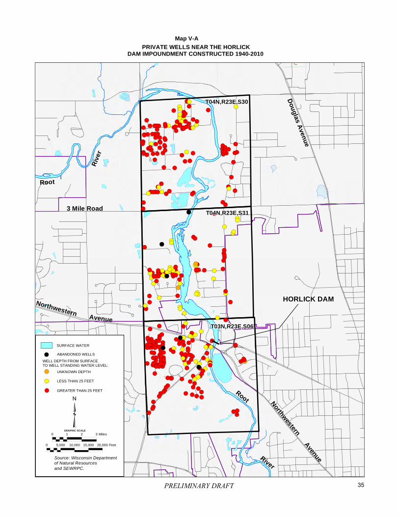
_____________ 10Version 4.1.0.
11SEWRPC Community Assistance Planning Report No. 152, A Stormwater Drainage and Flood Control System Plan for the Milwaukee Metropolitan Sewerage District, December 1990.
12References to left and right are based on looking downstream.
4 PRELIMINARY DRAFT
percent-annual-probability (100-year) event tailwater elevation is approximately three feet below the existing spillway crest, with a spillway crest velocity of approximately 9.0 fps. The two-percent-annual-probability (50-year) event tailwater elevation is approximately four feet below the existing spillway crest, with a spillway crest velocity of approximately 8.0 fps. Normal or base flows on the Root River are fairly small (10 to 56 cfs) as discussed in Chapter IV. What this means for the current Horlick dam configuration is that the residence time in the impoundment is between two and eight days. It also means that the dam is minimally overtopped during normal flow times (one to three inches), making fish passage downstream over the spillway difficult. During base flow conditions, the pool created by backwater from the Horlick dam extends upstream to STH 31, a length of approximately 3.4 miles. The Horlick dam impoundment most likely does raise the shallow groundwater table in the immediate area. Thus, maintenance of the dam in place may be beneficial to shallow private wells in the vicinity of the impoundment if they are still being utilized. However, if upgrading the spillway capacity of the dam to meet State requirements necessitates lowering the permanent pond elevation, as indicated by the alternatives that are described below, the positive effect of the permanent pond on groundwater levels would be reduced somewhat. Map V-A includes all private well log data found on the Wisconsin Department of Natural Resources (WDNR) website for the three U.S. Public Land Survey sections encompassing the Horlick impoundment.13 The numerous wells with standing water less than 25 feet below the ground surface (highlighted in yellow) are of particular concern because their water levels would be most likely to be affected by fluctuations in the impoundment level. It is unknown which wells included in Map V-A are still in use. Water Quality Water quality data for the Root River in the vicinity of the Horlick dam are set forth in Chapter IV. Unfortunately, the more comprehensive water quality data sets were at Johnson Park which is at approximate river mile 11.5 and at the gage just below the Horlick dam at river mile 5.9 (Table IV-10). Thus, there are no known water quality data explicitly representing the Horlick dam impoundment. What can be determined from the available water quality data is that dissolved oxygen concentrations are very good just downstream of the Horlick dam (Figure IV-17, Table IV-17). This may be due to re-aeration over the dam spillway or the fact that the flow over the dam is from the top layer of the impoundment which has direct interaction with the air surface. Root River total phosphorus levels both five miles upstream and just downstream of the Horlick dam are above the 0.075 mg/l warmwater fish and aquatic life criterion for a significant portion of the water quality dataset (Figure IV-28, Table IV-17). the river temperature dataset is not continuous, thus comparisons to the sublethal and acute standards for small warmwater communities is not possible (Tables IV-17, IV-12). However, if the temperature data in Figure IV-14 is compared between the upstream and downstream gages that are closest to the Horlick dam at river miles 11.5 (Johnson Park) and 5.9 (just downstream of Horlick dam) there does appear to be a consistent upward trend in temperature between the upstream and downstream gage. The only exception to this upward temperature trend between the two gages is the period from 1987 through 1993. The temperature data included in Figure IV-14 are from grab samples, thus is it assumed samples at the upstream and downstream gages were taken on the same day for comparison purposes. But the temperature data may hint at the expected rise in water temperatures in the Horlick dam impoundment.
_____________ 13http://dnr.wi.gov/topic/groundwater/data.html.
PRELIMINARY DRAFT 5
The Horlick dam impoundment has captured significant sediment since its original construction in 1834, as evidenced by the streambed/accumulated sediment profile shown in Figure IV-K. This sediment capture may have caused erosion downstream of the dam as the river attempted to regain sediment equilibrium.14 But sediment capture in the Horlick impoundment may have benefitted the harbor with reduced sediment volumes at the Root River mouth. It was documented in Chapter IV that contaminated sediment in the impoundment does not appear to be a concern based on testing to date. As evidenced by WDNR inspections, the Horlick dam does catch large woody debris at its crest, although an annual estimate of large woody debris accumulation at the Horlick dam is not available. Some large woody debris also settles in the upstream impoundment depending on flow conditions and the size of the debris. The WDNR has recommended facilitating downstream movement of debris caught at the dam crest on an ongoing basis. Thus, the Horlick dam does essentially pass large woody debris, albeit often after the flood flows have receded when downstream sections are less able to convey it further downstream until the next major flood event. Natural Resources A meeting was held between Commission staff and WDNR staff on June 13, 2013 to discuss the Horlick dam and the Root River. A summary of the meeting discussion can be found in Appendix G. Guidance from the WDNR related to the Horlick dam and the Root River fishery and aquatic invasive species discussed in subsequent sections is fully documented in those meeting notes. Lake Michigan aquatic invasive species are blocked from the upper Root River by the Horlick dam the majority of the time. The WDNR has indicated that the Root River Steelhead Facility, located downstream in Lincoln Park, is not considered a barrier as the flashboards are fully removed for most of the year. The Steelhead Facility flashboards are in place during the annual salmon spawning runs from about early September to November and then from early March to mid/late April. The WDNR considers both Viral Hemorrhagic Septicemia (VHS) and the aquatic invasive species of sea lamprey and round goby to be of greatest concern for the Root River. To stop the movement of the aquatic invasive sea lamprey, the WDNR has recommended at other dam facilities a height of at least 1.5 feet for a step ladder fishway design. To determine if the Horlick dam is a barrier, the WDNR has recommended utilizing the one-percent-annual-probability (100-year) event as was done for the USCOE Great Lakes and Mississippi River Interbasin Study.15 During the one-percent-annual-probability (100-year) event, the hydraulic modeling results indicate that the Horlick dam tailwater elevation is approximately three feet below the spillway crest. Thus, the dam appears to be a barrier to sea lamprey movement during floods up to, and including, the one-percent-probability event. It should be noted that the tailwater elevation is approximately at the top of the existing spillway crest (629.9 feet above NGVD 29) for the 0.2-percent-annual-probability (500-year) event, meaning that the dam is no longer a barrier for invasive aquatic species for this extreme flooding event. To determine if the dam is a barrier to fish passage for the 0.2- and one-percent-annual-probability events, a comparison of hydraulic modeling results to the swimming capacities of three fish species was completed. Smallmouth bass were selected as a smaller native sport species potentially occurring in the Root River. Based on recent dam modification analyses completed at other southeastern Wisconsin locations, northern pike were selected to represent the native fishery for the evaluation of fish passage conditions. Chinook salmon were the third species reviewed, as they are the largest WDNR stocked salmonid population in Lake Michigan. Available prolonged and burst speed data for these three fish species is included in Table V-B. Based on the burst speeds
_____________ 14Angela T. Bednarek, “Undamming Rivers: A Review of the Ecological Impacts of Dam Removal,” Environmental Management, Vol. 27, No. 6, 2001.
15U.S. Army Corps of Engineers-Chicago District, Great Lakes and Mississippi River Interbasin Study, http://glmris.anl.gov/.

6 PRELIMINARY DRAFT
listed in Table V-B, both the northern pike and Chinook salmon could pass the Horlick dam spillway for the modeled 0.2-percent-annual-probability (500-year) event, while the smallmouth bass most likely could not get past the dam spillway. Based on the leaping ability of Chinook salmon and the Horlick dam spillway configuration, Chinook should also be able to jump the dam during a two-percent-annual-probability (50-year) event and any larger event. A summary of fish passage issues for the Baseline Condition and all alternatives is included in Table V-C. Social The Horlick dam is not in a high profile location in the City of Racine and a bit difficult to view, with the best view being from the STH 38 bridge immediately downstream. Views of the dam and impoundment can also be enjoyed by patrons of the Riverside Inn on the right side of the dam as well. Views and access from Horlick Park on the left side of the dam are limited, with difficult foot access to the walkway over the former fishway via a narrow unmarked path along the park fence line. Access to the impoundment is good, with a boat launch and pier in Horlick Park. Immediately downstream of the dam, access is again difficult along an unmarked path at the end of Rapids Court behind the River Run Family Restaurant. Safety issues at the current Horlick dam include periodic high flows, the possibility of dam failure, boater and fisherman safety, and access hazards by the public. During high flows, the water can approach the walkways on either end of the dam and be quite turbulent downstream of the dam. Falling or being swept into the Root River at the Horlick dam during high flows would be dangerous. Dam failure could be caused by instability during large floods, resulting in a structural failure. The possible significant downstream effects to property resulting from loss of the dam are described in Chapter IV. Boater safety is a concern near the crest of the dam, which is marked with warning signs only. Fishermen predominately fish downstream of Horlick dam during the salmon runs in spring and fall. The water is typically very shallow during the salmon runs, and most fisherman use waders and walk along the River bottom. Foot access below the dam is probably the biggest safety concern for fisherman. As previously discussed, recreational opportunities at the Horlick dam and impoundment include small watercraft use in the impoundment, fishing, and bird watching. Although birds are attracted to the impoundment and river corridor, bird hunting is not allowed. For most individuals, the almost complete obstruction of fish movement across the dam from downstream to upstream as discussed previously would be considered a negative, but for those enjoying the salmon run, the downstream side of the Horlick dam is a popular fishing spot. Land ownership along the Root River corridor upstream of the Horlick dam to STH 31 is indicated on Map V-B. Publicly owned lands are shaded in green, and property boundaries are shown in black. Privately-owned property that includes a portion of the Horlick dam impoundment is indicated with a yellow boundary. It is important to note that the majority of the Horlick dam impoundment is not in private ownership, and the majority of the private property lines end at the water’s edge of the current impoundment. Costs The Horlick dam was reconstructed in late 1975, making the current configuration of the dam 38 years old. Based on recent inspections by WDNR, there do not appear to be any substantial concerns with the condition of the dam. Maintenance and future study costs (in 2013 dollars) for the current Horlick dam were estimated by Racine County and SEWRPC staff as outlined below. The majority of these items were called for in the 2008 and 2011 WDNR inspection reports (Appendix C). The cost of implemented actions called for under the WDNR Horlick dam inspection totals $6,000, the ongoing yearly costs are estimated at $1,000, and efforts yet to be completed as required by WDNR total $68,000.
Woody debris passage—ongoing cost estimated at $1,000/year
Dam break analysis—(completed 2013) $5,000
Take out sign and benchmark establishment—(completed) $1,000
PRELIMINARY DRAFT 7
Outstanding requested actions from WDNR inspections:
o Preparation of plans and a condition report for stop logs, sill plate, and embedded slots—$5,000
o Installation of a bridge operation deck and mechanism for stop log removal—$25,000
o Development of an Emergency Action Plan—$5,000
o Development of an Inspection, Operation, and Maintenance Plan—$3,000
o Investigation of concrete condition—$10,000
o Preparation of scour study—$10,000
o Bank Repairs—$10,000
Conceptual Alternatives Three categories of conceptual alternatives for the Horlick dam were developed as outlined below, with the goals of enhancing spillway capacity, providing fish passage, or removing the dam. Four specific alternatives are described, and additional information needs to be addressed during preliminary engineering are identified. As documented in Chapter IV, the preliminary analyses presented in this report assume that the dam has a Significant Hazard rating. For a Significant Hazard dam, Chapter NR 333, “Dam Design and Construction,” of the Wisconsin Administrative Code requires that the spillway safely convey the 0.2-percent-annual-probability (500-year) flood flow. Under the current Horlick dam configuration, the 0.2-percent-annual-probability flow is not contained within the spillway as discussed above, overtopping the right and left observation decks at the dam and causing erosion and failure concerns at both locations. Due to the inadequate Horlick dam spillway capacity discussed in the Baseline Condition section and regardless of the final hazard rating determination, structural modifications to the dam would be necessary if the dam is to be maintained. Thus, a “no action” alternative is not a viable option for the Horlick dam. The WDNR staff has indicated that Racine County will have 10 years to implement modifications to the dam to meet spillway requirements, or to remove the dam. As described in the Baseline Condition section, the Horlick dam is currently a barrier to fish passage to the upstream watershed for all but the most extreme flood events. Downstream fish passage may occur over the dam crest, but during normal flow times is also difficult due to the shallow overtopping depth. The hydraulic effects of each of the alternatives were evaluated using the HEC-RAS model developed for the Baseline Condition. Modifications to the hydraulic model were made only at the dam location to represent each of the alternative configurations. Alternatives that Modify the Dam to Enhance Spillway Capacity Alternative 1—Full Notch of Current Dam Spillway for 500-Year Flood Capacity SURFACE WATER AND GROUNDWATER QUANTITY CONSIDERATIONS This alternative modifies the dam to safely pass the 0.2-percent-annual-probability (500-year) event. Lowering the entire dam spillway by 3.9 feet to elevation 626.0 feet above NGVD 29 would enable safe conveyance of the
8 PRELIMINARY DRAFT
0.2-percent-annual-probability (500-year) event within the dam spillway (Figure V-B).16 This modification would significantly alter both the flood and normal flow profiles upstream of the dam to STH 31. The 0.2-percent-annual-probability (500-year) profile would be lowered approximately three feet at the dam crest from Baseline Conditions, while the one-percent-annual-probability (100-year) event would be lowered approximately 3.6 feet. Dam tailwater elevations associated with this alternative would remain the same as the Baseline Condition. The one-percent-annual-probability (100-year) flood effects of Alternative 1 are not as pronounced upstream at STH 31, with water surface elevation upstream of the bridge for Alternative 1 only 0.3 foot lower than the elevations for the Baseline Condition. The 0.2-percent-annual-probability (500-year) water surface elevation upstream of the STH 31 bridge for Alternative 1 would be only 0.4-foot lower than the Baseline Condition. Based on hydraulic model results, the tailwater elevation for Alternative 1 is approximately at the top of the lowered spillway crest (626.0 feet above NGVD 29) for the two-percent-annual-probability (50-year) event. The two-percent-annual-probability velocity at the dam spillway crest is approximately 8.9 fps. The significance of the tailwater elevation being at or just above the Alternative 1 spillway crest is that the dam structure would essentially no longer be a barrier to fish and aquatic species passage for the two-percent-annual-probability (50-year) flood. The one-percent-annual-probability (100-year) event tailwater elevation is approximately one foot above the modified spillway crest, with a spillway crest velocity of approximately 9.4 fps. The 0.2-percent-annual-probability (500-year) event tailwater elevation is approximately 3.9 feet above the modified spillway crest, with a spillway crest velocity of approximately 11.2 fps. And finally, the 10-percent-annual-probability (10-year) event tailwater elevation is approximately 1.9 feet below the modified spillway crest, with a crest velocity of approximately 7.8 fps. With the reduction in spillway elevation to 626.0 feet above NGVD 29, the extent of the impoundment area will be significantly reduced during normal, or base, flow times. It is estimated that the impoundment will extend approximately 1.5 miles upstream, or only encompass the lower half of the original impoundment area. This means that base flow residence times will be lower in the impounded area, which should improve water quality overall. And the upper reach between the alternative impounded area and STH 31 will experience flooded overbanks less frequently, which may allow surface vegetation to establish and improve terrestrial habitat in this area. With a reduced impoundment area at a lower elevation during normal flow times, shallow groundwater levels most likely will also be lowered. This may adversely affect the still active groundwater wells developed in the shallow aquifer previously discussed and depicted in Map V-A. WATER QUALITY Water quality impacts associated with Alternative 1cannot be definitively predicted, but as was discussed earlier, the size of the impoundment would be reduced with this alternative, which should reduce base flow residence times and reduce phosphorus deposition and water temperature in the impoundment area. Dissolved oxygen concentrations may not change dramatically as there would still be an opportunity for aeration over the lower dam spillway. It is very likely that the sediment which has accumulated on the bed of the impoundment over time may be partially flushed out of the downstream portion of the impoundment under this alternative with the lower spillway elevation. It is difficult to predict if this sediment flush would happen all at once or over time, but in all likelihood there would be an adverse impact to downstream reaches. It would be best to lower the dam in small increments over time in such a way as to minimize the potential for a large-scale loss of
_____________ 16The requirement to safely pass the 0.2-percent-annual-probability (500-year) event could also be attained by a gate-type system modification to the Horlick dam. But this would be significantly more expensive to construct, and would also require active operation to safely convey flood flows. Such active operation normally is not desirable as timing of operations can be difficult to predict, so this is not considered a viable option and was not considered further in this study.
PRELIMINARY DRAFT 9
settled sediment downstream. The lower spillway crest will also more easily facilitate large woody debris passage during high flow times which may be an adverse impact for downstream reaches as compared to the Baseline Condition. NATURAL RESOURCES Based on the one-percent-annual-probability (100-year) event criteria discussed under the Baseline Condition, the hydraulic modeling results indicate that the Alternative 1 tailwater elevation is approximately one foot above the spillway crest. Thus, Alternative 1 is not a barrier to sea lamprey or round goby movement from downstream to upstream of the dam. It should be noted that the tailwater elevation is approximately at the top of the altered spillway crest (626.0 feet above NGVD 29) for the two-percent-annual-probability (50-year) event, meaning that the dam is most likely no longer a barrier for invasive aquatic species for this extreme flooding event or anything larger. Based on the fish burst speeds listed in Table V-B, northern pike and Chinook salmon could pass the modified Horlick dam spillway for the modeled two-percent-annual-probability (50-year) event, while smallmouth bass most likely could not get past the dam spillway. Based on the leaping ability of Chinook salmon and the modified Horlick dam spillway configuration of Alternative 1, Chinook should also be able to jump the modified dam for the 50-percent-annual-probability (2-year) event and any event larger. A summary of fish passage issues for the baseline and all alternatives is included in Table V-C. SOCIAL Alternative 1 does leave a portion of the dam spillway in place, thus the cascading nature of the flows is maintained to a smaller degree. Thus the aesthetics are not changed dramatically at the dam. Upstream impoundment area changes will occur as discussed previously. Boating and paddling safety issues are still a concern for this alternative as a portion of the dam will remain in place and the drop between the impoundment and the downstream reach will still occur. Thus the safety concerns that were included in the Baseline Condition still exist, but perhaps to a smaller degree with 3.9 feet less of dam height. The original hydraulic height of the dam is approximately 12 feet, so Alternative 1 would have a hydraulic height of eight feet which is still significant from a safety perspective. Alternative 1 would alter recreational opportunities in the dam and impoundment area in numerous ways. Small watercraft use would still be viable, but on a much smaller impoundment area. Fishing would also be somewhat altered in the smaller impoundment, and under high flow conditions the dam may no longer be a full barrier to fish passage and fish normally stopped at the dam may now move farther upstream. This would be considered a positive from a fishery perspective, but possibly a negative for salmon fishing just downstream of the dam. Alternative 1 may affect watercraft access at River Bend Nature Center, but should not adversely affect the access at Horlick Park. With the lowered and reduced extent of the area impounded under Alternative 1, land ownership in this area would be affected. The nine properties highlighted in yellow on Map V-B would gain some dry land with Alternative 1, which would most likely be considered a positive effect. However, the majority of the private landowners between the dam and STH 31, would most likely would no longer have their properties abut the Root River under normal flow conditions. This effect would be most pronounced in the immediate impoundment area, and less so upstream where the River is more confined. A final determination of changes to Horlick impoundment property boundaries would require a review of the individual deed language.
10 PRELIMINARY DRAFT
COST A systems planning-level cost estimate for Alternative 1 was completed in 2013 dollars. Construction cost information was obtained from R.S. Means Heavy Construction Cost Data.17 Components included in the preliminary cost estimate for Alternative 1 include concrete removal, seeding of impoundment area, and final finishing to elevation 626.0 feet above NGVD 29. It was assumed that seeding would only be required in the bays of the existing impoundment as depicted in Map V-C. Base costs were increased by 35-percent to account for engineering, administration, and contingencies. Based on these assumptions, the systems-level present worth cost estimate, including capital cost and operation and maintenance is $435,000. While a significant effort has been made under this system-plan to collect field data and to characterize the anticipated costs associated with this alternative, at the systems-planning level there are many uncertainties in estimating costs relative to alterations of existing dams. Those uncertainties are reduced and estimated costs are refined after an alternative is selected for implementation and preliminary engineering and final design are conducted; however, it should be noted that the WDNR has indicated, that even after the final design stage, the average dam reconstruction change order amount is 40 percent of the initial capital cost estimate, mainly due to unforeseen site conditions once construction begins. Under Alternative 1 a portion of the dam structure is retained, thus ongoing maintenance costs will also be incurred for this conceptual alternative. Maintenance costs assumed include debris passage, inspection every four years, the development of an emergency action plan, an operation and maintenance plan, and minor bank repairs. A summary of all Alternative 1 costs are included in Table V-D. The above preliminary cost estimate does not include dredging of sediment from the Horlick impoundment. It was assumed the Alternative 1 dam lowering would be done in small increments over time or in such a way as to minimize the potential for a large-scale loss of settled sediment downstream. If dredging were required, it was calculated that approximately 72,300 cubic yards (CY) would need to be removed above elevation 620.0 feet above NGVD 29 for an Alternative 1 pilot channel. The elevation of 620.0 feet above NGVD 29 was chosen as that is the elevation of the observed natural shelf upstream of the Horlick dam. With the above assumptions, the preliminary cost estimate in 2013 dollars to dredge the upstream impoundment ranges from $1.5 to $3.6 million. The estimated cost range of sediment removal is only provided for information because different approaches to minimizing sediment release downstream of the dam site are recommended for all alternatives. Alternative 1a—Full Notch of Current Dam Spillway for 100-Year Capacity WATER QUANTITY Lowering the Horlick dam spillway crest to accommodate the 0.2-percent-annual-probability (500-year) event may reduce the dam to a Low Hazard rating. This cannot be determined for certain without another dam break evaluation, but a limited check of what modifications to the dam would be required to meet the Low Hazard criteria was completed (Alternative 1a). A Low Hazard dam must have a one-percent-annual-probability (100-year) event spillway capacity. The HEC-RAS model was modified to determine how much the Horlick dam spillway crest would have to be lowered to meet the one-percent-annual-probability capacity. Based on the hydraulic modeling, the entire spillway crest would have to be lowered two feet to elevation 627.9 feet above NGVD 29. A limited assessment of the model results indicate that this lowering would also allow invasive aquatic species passage for the one-percent-annual-probability (100-year) event as was the case for Alternative 1. Thus Alternative 1a also eliminates the aquatic invasive species barrier. Alternative 1a is included in Table V-C for comparison purposes only. No additional assessment work was completed for this alternative study. If implementation of an alternative that would increase the spillway capacity was selected by Racine County, additional dam failure analyses to assess the dam hazard rating would have to be conducted during preliminary engineering.
_____________ 17R.S. Means Company, Inc., RSMeans Heavy Construction Cost Data, 23rd Annual Edition, 2009.
PRELIMINARY DRAFT 11
Alternatives that Modify the Dam to Enable Fish Passage under Low and High Flow Conditions Alternative 2—Modify Current Fishway in Addition to Alternative 1 Changes To provide full fish passage at the Horlick dam, this alternative examines how the current fishway could be modified to allow fish passage during base flow conditions. Alternative 2 includes the modifications of Alternative 1for providing additional spillway capacity, as it was envisioned that the modified fishway gate would be closed during flood times (Figure V-C). As was noted in the preceding section, the dam configuration under Alternative 1 does not present a barrier to aquatic invasive species passage during the one-percent-annual-probability (100-year) event, which is the criterion applied by the USCOE for assessing whether or not a hydraulic structure is a barrier to passage. The gated fishway evaluated under this alternative would be a stair-step structure six feet wide with 10 one-foot high drops, spaced approximately 16 feet apart. The overall fishway length would be approximately 160 feet. The current fishway is approximately 100 feet long, so under this alternative, the fishway would be extended and its alignment modified as indicated on Figure V-C. The upstream elevation for the fishway sill at the gated structure would be 625.0 feet above NGVD 29, which would be one foot below the dam spillway crest elevation of 626.0 feet above NGVD 29. This would allow base flows to be conveyed through the fishway, bypassing the spillway. This configuration would require blasting through approximately four feet of rock along most of the existing fishway alignment, and then creating the lower 60 feet of fishway using concrete and large rocks. SURFACE WATER AND GROUNDWATER QUANTITY CONSIDERATIONS The hydraulic model results for flood flows for Alternative 2 are the same as for Alternative 1, as it was assumed the fishway gate would be closed during high flow times to protect the structure. An evaluation of normal or base flow conditions was done for Alternative 2 to evaluate adequate fish passage conditions for smallmouth bass. The smaller flows in Table V-A were applied to evaluate velocities and depths over the fishway steps. For the 90-percent-exceedance flow18 (10 cfs) the velocity over the steps is approximately 2.6 fps with a water depth of approximately 8 inches. The 90-percent-exceedance flow would not pass over the main spillway, while for all larger flows the main dam spillway is utilized along with the Alternative 2 fishway. For the 50-percent-exceedance flow (56 cfs) the velocity over the steps is approximately 3.6 fps at a depth of 1.2 feet. For the March-June maximum mean daily flow (1,000 cfs) which would be split between the spillway and the fishway, the depth over the steps is 2.7 feet with a velocity of 5.5 fps. WATER QUALITY The reduction in impoundment area and upstream impact of the dam for water quality would be the same as Alternative 1 during for floods. A slight reduction in impoundment area from that estimated under Alternative 1 would be expected under baseflow conditions as the controlling elevation (the elevation of the spillway crest under Alternative 1, but the elevation of the sill at the upstream end of the fishway under this alternative) has been lowered one foot. As is the case for all of the other alternatives, under this alternative it is envisioned that the dam would be lowered in small increments over time in such a way as to minimize the potential for a large-scale loss of settled sediment downstream, thus, dredging of accumulated sediment in the impoundment is not called for. Shallow groundwater effects would also essentially be the same as Alternative 1. NATURAL RESOURCES Based on the fish burst speeds listed in Table V-B, all three fish species could pass the modified fishway for the base flow conditions of 10 to 1,000 cfs. The shallower overtopping depth for the 10 cfs event may be a concern, but the velocities are all below or within listed burst speeds.
_____________ 18This is the Root River flow that would occur 10 percent or less of the time (90 percent of the flows exceed this value), based on long-term streamflow gaging by the USGS.
12 PRELIMINARY DRAFT
SOCIAL Aesthetic changes to the dam and impoundment are similar to Alternative 1, with the only exception being the fishway protruding into the Root River. Under extremely low flow conditions (10 cfs) flow may only be through the fishway, with a dry downstream face at the main dam spillway. Safety considerations are similar to Alternative 1, with the added complication of the fishway structure. The fishway structure may be an attraction to fisherman as well as children, and may pose a slip/trip/fall hazard if walked along. Recreational opportunities under Alternative 2 would be changed from those under Alternative 1 by the ability of fish to bypass the dam during a larger range of flow conditions. The impoundment size reduction would be very similar to Alternative 1, thus the use of small watercraft would still be viable on the smaller impoundment. Fishing would change dramatically as fish would no longer be completely stopped at the downstream side of the dam, and they could travel upstream along the main stem and tributaries. Opening up additional habitat to the native and sport fishery would be considered positive. Private property ownership changes would be very similar under Alternatives 1 and 2, with a slightly smaller impoundment footprint due to the lower controlling elevation at the Alternative 2 fishway. COSTS A preliminary cost estimate for Alternative 2 was completed in 2013 dollars. Components included in the preliminary cost estimate for Alternative 2 include the features called for under Alternative 1 plus creation of the gated fishway. The base cost was increased by 35 percent to account for engineering, administration, and contingencies. Based on these assumptions, the systems-level present worth cost estimate, including capital cost and operation and maintenance is $529,000. While a significant effort has been made under this system-plan to collect field data and to characterize the anticipated costs associated with this alternative, at the systems-planning level there are many uncertainties in estimating costs relative to alterations of existing dams. Those uncertainties are reduced and estimated costs are refined after an alternative is selected for implementation and preliminary engineering and final design are conducted; however, it should be noted that the WDNR has indicated, that even after the final design stage, the average dam reconstruction change order amount is 40 percent of the initial capital cost estimate, mainly due to unforeseen site conditions once construction begins. Under Alternative 2 a portion of the dam structure is retained in addition to enhancement of the fishway, thus ongoing maintenance costs will also be incurred for this conceptual alternative. Maintenance costs assumed include debris passage, inspection every four years, the development of an emergency action plan, an operation and maintenance plan, and minor bank repairs. A summary of all Alternative 2 costs is included in Table V-D. The above preliminary cost estimate does not include dredging of sediment from the Horlick impoundment. As noted above, different approaches to minimizing sediment release downstream of the dam site are called for under this alternative. Alternative for Partial and Full Removal of the Dam Two dam removal options were evaluated, one that retained a portion of each end of the dam to protect the hotel and park abutments (Alternative 3), and the other being full removal of the dam structure (Alternative 4). Both of these alternatives set the controlling elevation to the top of the existing channel bottom at 620.0 feet above NGVD 29.19 No additional survey of streambed elevations was made downstream of the existing Horlick dam from what was included in the original CAPR 152 HEC-2 model. Thus the exact slope of the Root River bottom between the dam crest and the model cross section 25 feet downstream is not known and the ability of fish to swim upriver is only evaluated based on tailwater heights and crest velocities at the former dam location.
_____________ 19This was determined to be the approximate top of the shelf immediately upstream of the Horlick dam as well.

PRELIMINARY DRAFT 13
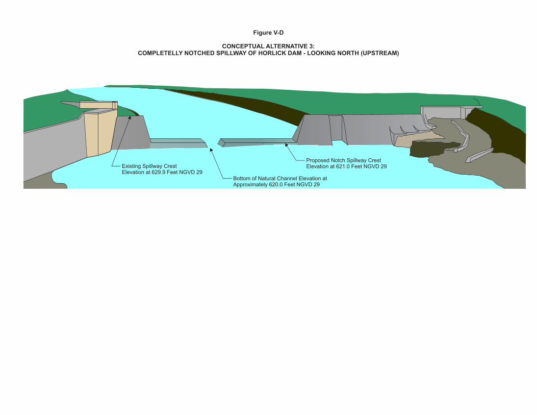
Alternative 3—Complete Notch of Current Dam Spillway Alternative 3 includes a two level notch to both contain the 0.2-percent-annual-probability (500-year) flood within the original dam spillway and allow fish passage at the natural channel invert elevation of 620.0 feet above NGVD 29 (Figure V-D). The shape of the spillway opening is a Cipolletti notch, with the sloping portion of the notch openings designed to offset the contraction of the water around the structure. This design would include approximately 54 feet of the original spillway at elevation 629.9 feet above NGVD 29, 50 feet of crest length at elevation 621.0 feet above NGVD 29, and a 6-foot opening at the Root River bottom of 620.0 feet above NGVD 29. The notch would all be to the right of the stoplog structure. Under this design the remaining dam structure would no longer serve as a control for base flow events, and it would have a significantly reduced effect at flood flows as compared to the Baseline Condition or Alternatives 1 and 2. The tailwater elevations would remain the same as the Baseline Condition. SURFACE WATER AND GROUNDWATER QUANTITY CONSIDERATIONS Based on hydraulic model results, the tailwater elevation for Alternative 3 is approximately at the top of the natural ledge (620.0 feet above NGVD 29) for the March-June maximum mean daily flow of 1,000 cfs. This flow is between the 99-percent-annual-probability (one-year) and 50-percent-annual probability (two-year) events. This flow would pass over both the low notch at 620.0 and mid-level notch at 621.0 feet above NGVD 29. The mean velocity at the Alternative 3 opening for the March-June mean daily flow is approximately 6.0 fps. Only the 90 percent exceedance flow of 10 cfs is wholly contained within the six-foot-wide low opening, with a velocity of approximately 2.6 fps. A review of tailwater elevations indicates that the 10-percent exceedance flow (410 cfs) has a tailwater elevation approximately 1.5 feet below the crest at elevation 620.0 feet above NGVD 29, which meets the preliminary WDNR criterion for inhibiting passage of sea lamprey. Based on hydraulic model results the one-percent-annual-probability (100-year) water surface elevation at the dam under Alternative 3 is approximately four feet lower than the Baseline Condition and one foot lower than under Alternative 1. The one-percent-annual-probability (100-year) flood effects of Alternative 3 are not as pronounced upstream at STH 31, with water surface elevations upstream of the bridge for Alternative 3 being only 0.3 foot lower than the Baseline Condition and essentially the same as Alternative 1. With the removal of a structural barrier on the Root River, the impoundment area will essentially be eliminated. The natural shelf at elevation 620.0 feet above NGVD 29 that extends upstream of the dam for approximately 1,000 feet will control hydraulic profiles for smaller flow events, based on hydraulic modeling. Along the entire corridor between the Horlick dam location and STH 31, flow would be expected to be within the banks for more events, allowing overbank vegetation to establish and improve terrestrial habitat. Elimination of the impoundment during normal flow times would most likely lower shallow groundwater levels in the immediate area. This may adversely affect the still active groundwater wells developed in the shallow aquifer previously discussed and depicted in Map V-A. WATER QUALITY With the elimination of the impoundment under Alternative 3, water quality should improve for all the constituents of concern (dissolved oxygen, phosphorus, and temperature). Normal flows will no longer be impounded and the conversion to a free-flowing river should result in better aeration of the water in the formerly-impounded reach upstream from the dam site. This should help improve water quality during larger events as well, with filtering through and deposition of sediments in overbank vegetation now a viable option to remove and store sediments and contaminants during higher overbank flows. Under Alternative 3 the notched configuration may provide the added benefit of helping to prevent settled sediment from being transported downstream and to maintain a vegetated flood bench. Nevertheless, it is very likely that some of the settled sediment may be flushed out of the impoundment area for this alternative with the elimination of a complete barrier. It is difficult to predict if this sediment flush would happen all at once or over time, but in all likelihood in the absence of mitigation would be an adverse impact to downstream reaches. It
14 PRELIMINARY DRAFT
would be best to lower the dam in small increments over time in such a way as to minimize the potential for a large-scale loss of settled sediment downstream. Thus, dredging of sediment accumulated in the impoundment is not called for under this alternative. The two level spillway crest with a large section set at elevation 621.0 feet above NGVD 29 will also more easily facilitate large woody debris passage during high flow times, which may be an adverse impact for downstream reaches as compared to the Baseline Condition. NATURAL RESOURCES Based on the one-percent-annual-probability (100-year) event fish passage criterion discussed under the Baseline Condition, the hydraulic modeling results indicate that the Alternative 3 tailwater elevation is approximately seven feet above the low sill elevation of 620.0 feet above NGVD 29. Thus, the structure configuration under Alternative 3 would not be a barrier to sea lamprey or round goby movements. As was indicated earlier, the tailwater elevation is approximately at the top of the natural shelf (620.0 feet above NGVD 29) for the March-June maximum mean daily flow of 1,000 cfs,20 indicating that the dam would most likely no longer be a barrier for invasive aquatic species for anything larger than this flow rate. Using the WDNR preliminary 1.5 foot criterion for sea lamprey passage, under Alternative 3 the structure would no longer be a barrier to sea lamprey for the 10-percent-exceedance flow rate of 410 cfs. Using the fish burst speeds listed in Table V-B, all three fish species could pass the modified Horlick dam spillway for the March-June maximum mean daily flow of 1,000 cfs when the tailwater elevation would be above the spillway crest. To allow sufficient depth downstream for Chinook salmon to jump, it was assumed that a minimum of two feet of depth was required, which translates to the 50-percent exceedance flow rate of 56 cfs under Alternative 3. The 90 percent exceedance flow of 10 cfs is wholly contained within the six-foot-wide low opening, with a velocity of approximately 2.6 fps, which should be passable for all three fish species. Unfortunately, the streambed configuration immediately downstream of the dam is not fully known, thus depths at this low flow rate may minimize fish passage. In other words, this area downstream may be too wide under baseflow conditions to provide adequate water depths for fish passage. This area may need to be reconstructed to promote fish passage for Alternative 3. A summary of fish passage issues for all alternatives is set forth in Table V-C. SOCIAL Alternative 3 does leave a portion of the dam structure in place, thus the cascading nature of the flows is maintained for larger flood events. For smaller events, the flows will utilize the Root River channel bottom only. Thus, the aesthetics of the dam will change significantly for Alternative 3. The upstream impoundment area will also be eliminated and the corridor between the dam and STH 31 will have a more riverine look. Safety issues are a relatively small concern for this alternative as a portion of the dam structure will remain in place but the abrupt drop between the impoundment and the downstream reach will be eliminated. The original hydraulic height of the dam is approximately 12 feet and, under Alternative 3, there would be a naturally sloping five-foot streambed drop between the dam location and STH 38 downstream, which is a significantly-reduced safety hazard compared to Alternatives No. 1 and 2. Implementation of Alternative 3 would significantly alter recreational opportunities at the dam and impoundment area. With the elimination of the impoundment, the ability to float small watercraft would be dependent on flow conditions. Fishing would become riverine exclusive and under most flow conditions the structure configuration under Alternative 3 would no longer present a full barrier to fish passage and fish normally stopped at the dam might now move farther upstream. Fishing would change dramatically as fish would no longer be completely stopped at the downstream side of the dam, and they could travel upstream along the main stem and tributaries. Opening up additional habitat to the native and sport fishery would be considered positive. This would be
_____________ 20This flow is between the 99-percent-annual-probability (one-year) and 50-percent-annual probability (two-year) events.
PRELIMINARY DRAFT 15
considered a positive from a general fishery perspective and the ecological integrity of the entire Root River system,21 but possibly a negative for salmon fishing just downstream of the Horlick dam where the dam would no longer serves as a barrier that concentrates the fish. Under Alternative 3 recreational boat access would also be adversely affected at River Bend Nature Center and Horlick Park as under most flow conditions there would be no impoundment and the current launch locations would be farther from the Root River. With the elimination of the impoundment area, land ownership in this area would be affected. The nine properties highlighted in yellow on Map V-B would gain some dry land under Alternative 3, which would most likely be considered a positive effect. But for the majority of the private landowners between the dam and STH 31, their properties would most likely no longer be immediately adjacent to the Root River. This effect would be most pronounced in the impoundment area nearest the former dam site, and less so upstream where the Root River is narrower. A final determination of changes to Horlick impoundment property boundaries would require a review of the individual deed language. COSTS A preliminary cost estimate for Alternative 3 was completed in 2013 dollars. Sources of cost information included RSMeans Heavy Construction Cost Data and summary dam removal costs received from WDNR. Components included in the preliminary cost estimate for Alternative 3 include concrete removal, removal of the old dam, seeding of impoundment area, and final finishing to elevation 620.0 feet above NGVD 29. It was assumed that seeding would only be required in the bays of the existing impoundment as depicted in Map V-C. The base cost was increased by 35 percent to account for engineering, administration, and contingencies. Based on these assumptions, the systems-level present worth cost estimate, including capital cost and operation and maintenance is $447,000. While a significant effort has been made under this system-plan to collect field data and to characterize the anticipated costs associated with this alternative, at the systems-planning level there are many uncertainties in estimating costs relative to alterations of existing dams. Those uncertainties are reduced and estimated costs are refined after an alternative is selected for implementation and preliminary engineering and final design are conducted; however, it should be noted that the WDNR has indicated, that even after the final design stage, the average dam reconstruction change order amount is 40 percent of the initial capital cost estimate, mainly due to unforeseen site conditions once construction begins. Under Alternative 3, a portion of the dam structure is retained, thus ongoing maintenance costs will be incurred for this conceptual alternative. Maintenance costs assumed include debris passage, inspection every ten years (assuming a Low Hazard designation), and minor bank repairs. A summary of all Alternative 3 costs are included in Table V-D. The above preliminary cost estimate does not include dredging of sediment from the Horlick impoundment. As noted above, different approaches to minimizing sediment release downstream of the dam site are called for under this alternative. Alternative 4—Full Removal of Dam Alternative 4 calls for removal of the Horlick dam as depicted in Figure V-E. The left side walkway and portion of the spillway were retained as they are somewhat integral with the natural rock on that side of the Horlick dam. Under this alternative, the structure would be removed as a control for all flow events. This means that the natural 1,000-foot shelf at elevation 620.0 feet above NGVD 29 would control the flow profiles upstream from the site of the former dam. The tailwater elevations would remain the same as the Baseline Condition. SURFACE WATER AND GROUNDWATER QUANTITY CONSIDERATIONS Based on hydraulic model results, the tailwater elevation for Alternative 4 is approximately at the top of the natural ledge (620.0 feet above NGVD 29) for the March-June maximum mean daily flow of 1,000 cfs. This flow
_____________ 21Reference to be added.
16 PRELIMINARY DRAFT
is between the 99-percent-annual-probability (one-year) and 50-percent-annual probability (two-year) events. The mean velocity for Alternative 4 for the March-June mean daily flow is approximately 6.8 fps. The 90 percent exceedance flow (10 cfs) is very shallow across the fully exposed natural ledge with a depth at the dam location of less than a tenth of a foot. A review of tailwater elevations indicates that the 10-percent exceedance flow (410 cfs) has a tailwater elevation approximately 1.5 feet below the natural ledge at elevation 620.0 feet above NGVD 29, which meets the preliminary WDNR criterion for inhibiting passage of sea lamprey. Based on hydraulic model results the one-percent-annual-probability (100-year) water surface elevation at the dam for Alternative 4 is approximately eight feet lower than the Baseline Condition or four feet lower than Alternative 3. The one-percent-annual-probability (100-year) flood effects of Alternative 4 are not as pronounced upstream at STH 31, with water surface elevations upstream of the bridge for Alternative 4 only 0.3 foot lower than the Baseline Condition and essentially the same as Alternatives 1 and 3. With the full removal of a structural barrier on the Root River, the impoundment area will be eliminated. Based on hydraulic modeling, the natural shelf at elevation 620.0 feet above NGVD 29 that extends approximately 1,000 feet upstream of the dam location would control hydraulic profiles for all flow events. Along the entire corridor between the Horlick dam location and STH 31, flow will be within the banks for more events, allowing overbank vegetation to establish and improve terrestrial habitat. Elimination of the impoundment during normal flow times would most likely lower shallow groundwater levels in the immediate area. This may adversely affect the still active groundwater wells developed in the shallow aquifer previously discussed and depicted in Map V-A. WATER QUALITY With the elimination of the impoundment, water quality should improve for all the constituents of concern (dissolved oxygen, phosphorus, temperature) for Alternative 4. Normal flows will no longer be impounded and should be better aerated by movement through the corridor in a more stream-like setting. This should improve water quality for larger events as well, with filtering through and deposition of sediments in overbank vegetation now a viable option to remove and store sediments and contaminants during higher overbank flows. It is very likely that the Baseline Condition settled sediment may be flushed out of the impoundment area for this alternative with dam removal. It is difficult to predict if this sediment flush would happen all at once or over time, but in all likelihood in the absence of mitigation would be an adverse impact to downstream reaches. It would be best to lower the dam in small increments over time in such a way as to minimize the potential for a large-scale loss of settled sediment downstream. Thus, dredging of sediment accumulated in the impoundment is not called for under this alternative. Alternative 4 will also not impede large woody debris passage, which may be an adverse impact for downstream reaches as compared to the Baseline Condition. Hence, now the Root River will function like a natural river. NATURAL RESOURCES Based on the USCOE one-percent-annual-probability (100-year) event fish passage criteria discussed under the Baseline Condition, the hydraulic modeling results indicate that the Alternative 4 tailwater elevation is approximately seven feet above the controlling natural ledge elevation of 620.0 feet above NGVD 29. Thus, under Alternative 4 the ledge does not present a barrier to sea lamprey or round goby movements. As was noted previously, the tailwater elevation is approximately at the top of the natural shelf (620.0 feet above NGVD 29) for the March-June maximum mean daily flow of 1,000 cfs indicating that the dam would most likely no longer be a barrier for invasive aquatic species for anything larger than this flow rate. Using the WDNR 1.5 foot criteria for sea lamprey, Alternative 4 conditions would not present a barrier to passage for the 10-percent-exceedance flow rate of 410 cfs. Using the fish burst speeds listed in Table V-B, all three fish species could pass the former dam site for the tailwater-submerged March-June maximum mean daily flow of 1,000 cfs. To allow sufficient depth downstream for Chinook salmon to jump, it was assumed that a minimum of two feet of depth was required, which translates to the 50-percent exceedance flow rate of 56 cfs for Alternative 4. The 90 percent exceedance flow of 10 cfs has
PRELIMINARY DRAFT 17
minimal depth at the controlling ledge as discussed previously, thus, the ledge may be impassible for all three fish species. A summary of fish passage issues for all alternatives is included in Table V-C. SOCIAL Alternative 4 removes the dam structure from the river corridor, thus the cascading nature of the flows is most likely no longer possible for even larger flood events. For smaller events, the flows will utilize the Root River channel bottom only for Alternative 4. Map V-D includes a comparison of the approximate Baseline Condition for the impoundment as represented on the 2010 SEWRPC digital color orthophotograph, and the estimated extent of the River during normal flow conditions with Alternative 4 implemented. Also shown on Map V-D are several field-surveyed cross sections along the impoundment for comparison purposes between the existing impoundment and estimated normal water surface elevations under Alternative 4. The comparison indicates that the aesthetics of the former impoundment area will change significantly under Alternative 4 with a more riverine look to the corridor between the site of the former dam and STH 31. Safety issues would be minimal for this alternative, as only the left side portion of the dam structure will remain in place. The abrupt drop between the impoundment and the downstream reach will be eliminated, improving safety at the dam. The original hydraulic height of the dam is approximately 12 feet and Alternative 4 has a naturally sloping five-foot hydraulic height between the dam location and STH 38 downstream, which would represent a significantly reduced safety hazard as well. Implementation of Alternative 4 would significantly alter recreational opportunities at the dam and impoundment area. With the elimination of the impoundment, the ability to float small watercraft would be dependent on flow conditions. Fishing would become riverine exclusive and under all flow conditions the minimal structure configuration under Alternative 4 would no longer present a barrier to fish passage and fish and other aquatic life normally stopped at the dam might now move farther upstream and downstream as necessary. Fishing would change dramatically as fish would no longer be completely stopped at the downstream side of the dam, and they could travel upstream along the main stem and tributaries. Opening up additional habitat to the native and sport fishery would be considered positive. This would be considered a positive from the perspective of the general fishery and the ecological integrity of the entire Root River system, but possibly a negative for salmon fishing just downstream of the Horlick dam where the dam would no longer serves as a barrier that concentrates the fish. Under Alternative 4 recreational boat access would also be adversely affected at River Bend Nature Center and Horlick Park as under most flow conditions there would be no impoundment and the current launch locations would be farther from the Root River. With the elimination of the impoundment area, land ownership in this area would be affected. The nine properties highlighted in yellow on Map V-B would gain some dry land under Alternative 4, which would most likely be considered a positive effect, but the properties of the majority of the private landowners between the dam and STH 31would most likely no longer be immediately adjacent to the Root River. This effect would be most pronounced in the impoundment area closest to the former dam site, and less so upstream where the Root River is more confined. A final determination of changes to Horlick impoundment property boundaries would require a review of the individual deed language. COSTS A preliminary cost estimate for Alternative 4 was completed in 2013 dollars. Sources of cost information included RSMeans Heavy Construction Cost Data and summary dam removal costs received from WDNR. Components included in the preliminary cost estimate for Alternative 4 include concrete removal, removal of the old dam, and seeding of impoundment area. It was assumed that seeding would only be required in the bays of the existing impoundment as depicted in Map V-C. A contingency of 35-percent was added to the base cost estimate to account for minor items, engineering, and permitting. Based on these assumptions, the systems-level present worth cost estimate, including capital cost and operation and maintenance is $526,000. While a significant effort has been made under this system-plan to collect field data and to characterize the anticipated costs associated with this alternative, at the systems-planning level there are many uncertainties in estimating costs relative to
18 PRELIMINARY DRAFT
alterations of existing dams. Those uncertainties are reduced and estimated costs are refined after an alternative is selected for implementation and preliminary engineering and final design are conducted. Under Alternative 4 almost all of the dam structure would be removed, thus structural maintenance requirements have essentially been eliminated. It was assumed that reseeding of portions of the former impoundment area would be required after structural removal. A summary of all Alternative 4 costs are included in Table V-D. The above preliminary cost estimate does not include dredging of sediment from the Horlick impoundment. As noted above, different approaches to minimizing sediment release downstream of the dam site are called for under this alternative. Comparison of Alternative Plans A summary of all four conceptual alternatives for the major issues of concern is included in Table V-E. Additional Work/Information Required The decision regarding which of the Horlick dam alternatives is to be implemented ultimately rests with Racine County as the owner of the dam. There are numerous additional elements of information to be considered during the preliminary engineering phase for whichever alternative the County chooses to pursue. The informational needs listed below are not meant to be comprehensive, but are a good starting point for future analysis:
Determination by WDNR of aquatic invasive species of concern
Additional sampling of impoundment sediment for potential contamination
Evaluation of Structural integrity of right dam abutment at Riverside Inn
Evaluation of structural issues related to lowering or notching the current Horlick dam structure
Investigation of the structural integrity of the rock in the fishway area
Determination of the prevalence of active shallow private wells in the impoundment area that would be affected by impoundment modifications.
The exact nature of the natural 1,000-foot shelf—related to unknowns for impoundment area to predict sediment movement and riparian restoration potential.
Collection of additional detailed survey data in the reach between the dam and STH 38 to determine if water depths and streambed slopes will allow fish and aquatic invasive species to migrate upstream.
CAPR-316 CH-5 HORLICK DAM ALTERNATIVES (08/07/13 MTG) (00212555).DOC 300-1106 MGH/LLK/pk 07/31/13
PRELIMINARY DRAFT 19
SEWRPC Community Assistance Planning Report No. 316
A WATERSHED RESTORATION PLAN FOR THE ROOT RIVER WATERSHED
Chapter V
DEVELOPMENT OF TARGETS AND ALTERNATIVE MEASURES
TABLES FOR AUGUST 7, 2013, MEETING
CAPR-316 CH-5 HORLICK DAM ALTERNATIVES TABLES (08/07/13 MTG) (00212557).DOC 300-1106 MGH/LLK/pk 07/30/13

PRELIMINARY DRAFT
(This Page Left Blank Intentionally)
PRELIMINARY DRAFT 21
Table V-A
MODELED FLOW RATES FOR THE ROOT RIVER AT HORLICK DAM
Annual Probability of Occurrence (recurrence interval) or Description Flow Rate (cfs) Source
99-Percent (1-year) ......................................... 686 SEWRPC Gage Analysis 2013
50-Percent (2-year) ......................................... 1,900 SEWRPC Gage Analysis 2013
10-Percent (10-year) ....................................... 3,500 SEWRPC Gage Analysis 2013
2-Percent (50-year) ......................................... 5,200 2012 FIS
1-Percent (100-year) ....................................... 6,380 2012 FIS
0.2-Percent (500-year) .................................... 10,200 2012 FIS
90 Percent Exceeds ........................................ 10 USGS Water-Data Report 2012
50 Percent Exceeds ........................................ 56 USGS Water-Data Report 2012
10 Percent Exceeds ........................................ 410 USGS Water-Data Report 2012
March-June Maximum Mean Daily .................. 1,000 USGS Gage Summary Statistics 1963-2011
Source: U.S. Geological Survey gage 04087240, 2012 Racine County FIS, and SEWRPC.
Table V-B
ADULT FISH SWIMMING SPEEDS AND LEAPING DATA FOR HORLICK DAM
Fish species Prolonged Speed (fps) Burst Speed (fps) Maximum Leap
Height/Distance (feet)
Northern Pike .......................................... - - 5.0-13.0a - -
Chinook Salmon ...................................... 3.4-10.8b 10.8-22.4b 7.0/5.0b
Smallmouth Bass .................................... 1.8-3.9c 3.6-7.8c - - aLuther P. Aadland, Reconnecting Rivers: Natural Channel Design in Dam Removals and Fish Passage, Minnesota Department of Natural Resources, January 2010 and S.J. Peake, Swimming Performance and Behaviour of Fish Species Endemic to Newfoundland and Labrador: A Literature Review, Canadian Manuscript Report of Fisheries and Aquatic Sciences No. 2843, 2008. bGregory T. Ruggerone, Evaluation of Salmon and Steelhead Migration Through the Upper Sultan River Canyon Prior to Dam Construction, City of Everett, July 2006. cStephan Peake, An Evaluation of the Use of Critical Swimming Speed for Determination of Culvert Water Velocity Criteria for Smallmouth Bass, Transactions of the American Fisheries Society 133: 1472-1479, 2004 and Normandeau Associates, Inc., Claytor Hydroelectric Project Fish Entrainment and Impingement Assessment, Appalachian Power Company, R-20979.001, January 2009. Source: SEWRPC.
22 PRELIMINARY DRAFT
Table V-C
HORLICK DAM ALTERNATIVE SUMMARY—FISH PASSAGE AND INVASIVE SPECIES
Alternative
Spillway Crest Elevation (feet
above NGVD 29)
Tailwater Elevation
Event at Crest (recurrence
interval)
Chinook Passage Event
(recurrence interval)
Invasive Species Passage Event
(recurrence interval)
Barrier to Invasive Species
Baseline Condition................................. 629.9 500-year 50-year 500-year Yes
Alternative 1–500-Year Capacity ........... 626.0 50-year 2-year 50-year No
Alternative 1a–100-Year Capacity ......... 627.9 Between 100 and 500-year
50-year 100-year No
Alternative 2a–Alt 1 with Fishway .......... 626.0 50-year 2-year 50-year No
Alternative 3–Full Notch of Dam ............ 620.0 Between 1 and 2-yearb
50 percent exceeds
10 percent exceeds
No
Alternative 4–Dam Removal .................. 620.0 Between 1 and 2-yearb
50 percent exceeds
10 percent exceeds
No
aAssumes fishway closed for larger flood events. bThis condition represents the March through June maximum mean daily flow of 1,000 cfs. Source: SEWRPC.
Table V-D
HORLICK DAM ALTERNATIVE SUMMARY—COSTS
Alternative Capital Costa
(dollars) Annual Operation and Maintenance (dollars)b
Total Present Worth Cost
(dollars)
Alternative 1–500-Year Capacity ............ $370,000 $4,100 $435,000
Alternative 2–Alt 1 with Fishway ............. $460,000 $4,400 $529,000
Alternative 3–Full Notch of Dam ............. $420,000 $1,700 $447,000
Alternative 4–Dam Removal ................... $520,000 $ 400 $526,000
aCapital costs based upon year 2013 conditions. Engineering News-Record Construction Cost Index: 12,208. bBased on an interest rate of 6 percent and a project life of 50 years. Source: SEWRPC.
23
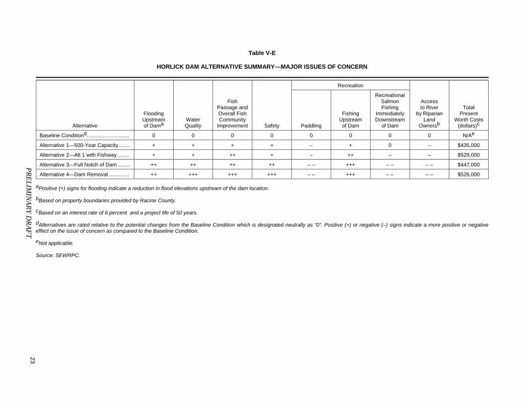
Table V-E
HORLICK DAM ALTERNATIVE SUMMARY—MAJOR ISSUES OF CONCERN
Alternative
Flooding Upstream of Dama
Water Quality
Fish Passage andOverall FishCommunity
Improvement Safety
Recreation
Access to River
by Riparian Land
Ownersb
Total Present
Worth Costs(dollars)c Paddling
Fishing Upstream of Dam
RecreationalSalmon Fishing
ImmediatelyDownstream
of Dam
Baseline Conditiond............................. 0 0 0 0 0 0 0 0 N/Ae
Alternative 1—500-Year Capacity ....... + + + + – + 0 – $435,000
Alternative 2—Alt 1 with Fishway ........ + + ++ + – ++ – – $529,000
Alternative 3—Full Notch of Dam ........ ++ ++ ++ ++ – – +++ – – – – $447,000
Alternative 4—Dam Removal .............. ++ +++ +++ +++ – – +++ – – – – $526,000
aPositive (+) signs for flooding indicate a reduction in flood elevations upstream of the dam location. bBased on property boundaries provided by Racine County. cBased on an interest rate of 6 percent and a project life of 50 years. dAlternatives are rated relative to the potential changes from the Baseline Condition which is designated neutrally as “0”. Positive (+) or negative (–) signs indicate a more positive or negative effect on the issue of concern as compared to the Baseline Condition. eNot applicable. Source: SEWRPC.
PR
EL
IMIN
AR
Y D
RA
FT


PRELIMINARY DRAFT 25
SEWRPC Community Assistance Planning Report No. 316
A WATERSHED RESTORATION PLAN FOR THE ROOT RIVER WATERSHED
Chapter V
DEVELOPMENT OF TARGETS AND ALTERNATIVE MEASURES
FIGURES FOR AUGUST 7, 2013, MEETING
CAPR-316 CH-5 HORLICK DAM ALTERNATIVES FIGURES (TITLES ONLY) 08/07/13 MTG (00212561).DOC 300-1106 MGH/LLK/pk 07/30/13

PRELIMINARY DRAFT
(This Page Left Blank Intentionally)
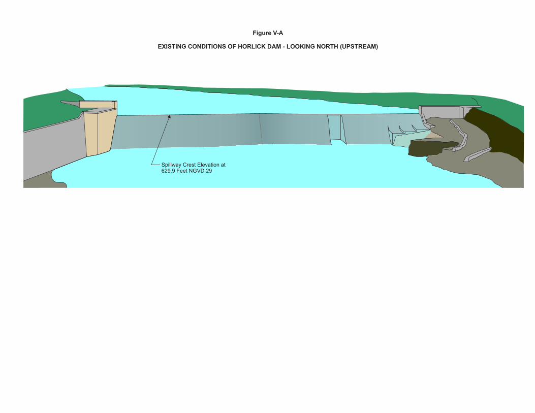
Spillway Crest Elevation at629.9 Feet NGVD 29
Figure V-A
EXISTING CONDITIONS OF HORLICK DAM - LOOKING NORTH (UPSTREAM)
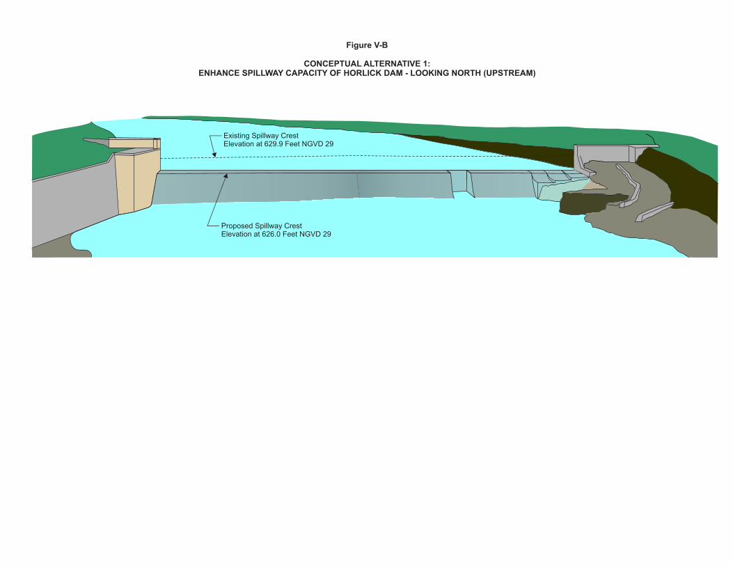
Existing Spillway CrestElevation at 629.9 Feet NGVD 29
Proposed Spillway CrestElevation at 626.0 Feet NGVD 29
Figure V-B
CONCEPTUAL ALTERNATIVE 1:ENHANCE SPILLWAY CAPACITY OF HORLICK DAM - LOOKING NORTH (UPSTREAM)
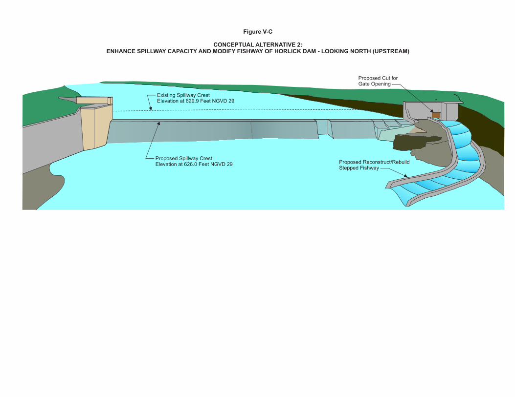
Proposed Spillway CrestElevation at 626.0 Feet NGVD 29
Figure V-C
CONCEPTUAL ALTERNATIVE 2:ENHANCE SPILLWAY CAPACITY AND MODIFY FISHWAY OF HORLICK DAM - LOOKING NORTH (UPSTREAM)
Existing Spillway CrestElevation at 629.9 Feet NGVD 29
Proposed Cut forGate Opening
Proposed Reconstruct/RebuildStepped Fishway
Existing Spillway CrestElevation at 629.9 Feet NGVD 29
Proposed Notch Spillway CrestElevation at 621.0 Feet NGVD 29
Bottom of Natural Channel Elevation atApproximately 620.0 Feet NGVD 29
Figure V-D
CONCEPTUAL ALTERNATIVE 3:COMPLETELLY NOTCHED SPILLWAY OF HORLICK DAM - LOOKING NORTH (UPSTREAM)
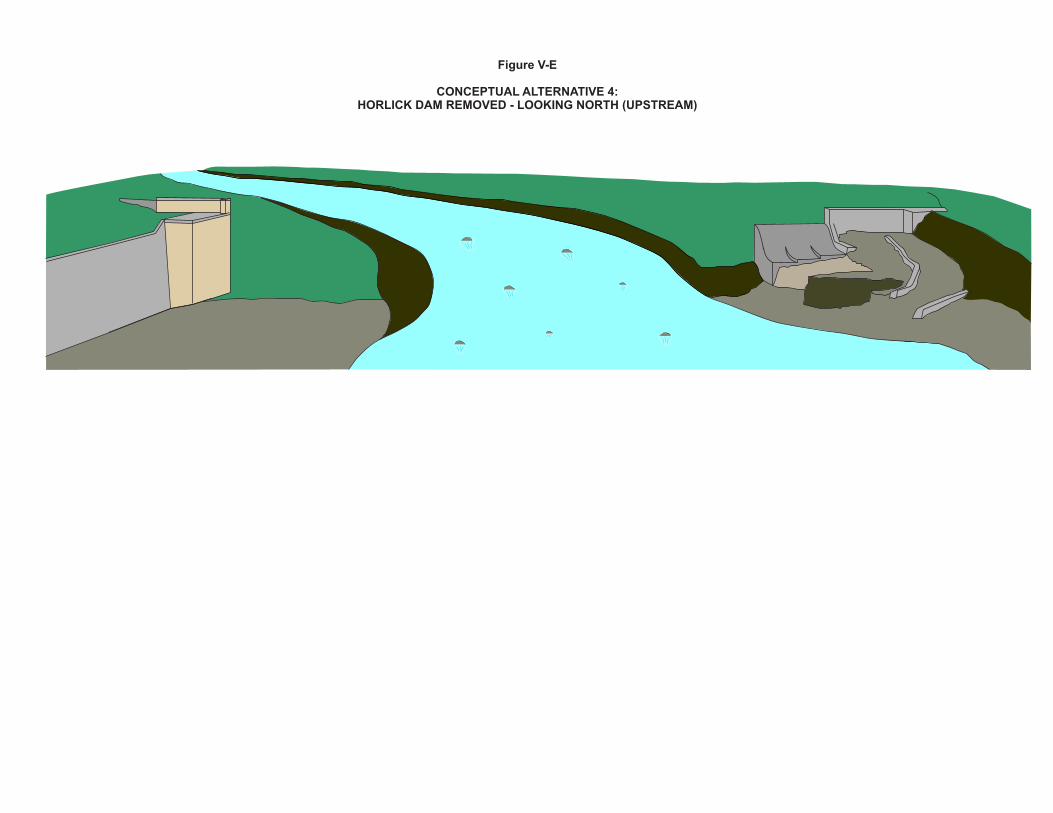
Figure V-E
CONCEPTUAL ALTERNATIVE 4:HORLICK DAM REMOVED - LOOKING NORTH (UPSTREAM)

PRELIMINARY DRAFT 33
SEWRPC Community Assistance Planning Report No. 316
A WATERSHED RESTORATION PLAN FOR THE ROOT RIVER WATERSHED
Chapter V
DEVELOPMENT OF TARGETS AND ALTERNATIVE MEASURES
MAPS FOR AUGUST 7, 2013, MEETING
CAPR-316 CH-5 HORLICK DAM ALTERNATIVES MAPS (TITLES ONLY) 08/07/13 MTG (00212560).DOC 300-1106 MGH/LLK/pk 07/30/13

PRELIMINARY DRAFT
(This Page Left Blank Intentionally)
!(!(
!( !(
!(
!(
!(!(
!(!(
!(
!(
!(
!(
!(
!(!(
!(
!(!(!(
!(!(!(
!(!(
!(
!(
!(
!(!(
!(
!(!(
!(
!(
!(!(
!(
!(
!(
!(
!(
!(
!(
!(
!(!(!(!(
!(
!(
!(
!(
!(
!(
!(
!(!(
!(
!(
!(
!(
!(!(!( !(
!(!(
!(
!(
!(!(
!(
!(!(!(
!(
!(
!(!(
!(
!(!(
!(!(
!(
!(
!(
!(
!(!(
!(
!(
!( !(!(
!( !(
!(
!(!(
!(
!(
!(
!(
!(!(
!(
!(
!( !(!( !(
!( !(
!(!(
!(
!(
!(
!(
!(
!(!(!(!(!(!(!(
!(
!(
!(
!(
!(!(
!(
!(
!(
!(
!(
!(
!(
!(!(
!(
!(
!(
!(
!(
!(
!(
!(
!( !(!( !(!(!(
!(
!(!(!(
!(!( !(!( !(
!(!(
!(
!(
!(
!(!(
!(
!(
!(!( !(
!(
!(
!(
!(
!(!(
!( !(
!(
!(
!(!(!(
!(
!(
!(!(
!(!(!(!(
!(!(
!(!(
!(!(!(
!(!(
!(!(
!(!(
!(!(!(
!(
!(
!(
!(!(
!(
!(
!(
!(!(
!(
!(!(!( !(
!(
!(
!(
!(
!(
!(
!(
!(
!(
!(
!(
!(
!(
!(!(!(!(!(
!(
!(
!(!(
!(!(!(!(
!(
!(
!(
!(!(!( !(!(
!(!(
!(
!(!(
!(
!(!(
!(
!(!( !(!(
!(
!(
!(
!(
!(
!(
!(
!(
!(
!(!(!(!(
!(
!(!(!(!(!(!(!(!(
!(
!(
!(!(
!(
!(!(
!(
!(
!(
!(
!(!(!(
!(
!(
!(
!(
!(
!(
!(!(
!(
!(!(
!(!(!(
!(
!(
!(
!(
!(
!(
!(
!(
!(
!(
!( !(!(
!(
!(
!(
!(
!(!(
!(
!(
!(
Source: Wisconsin Departmentof Natural Resourcesand SEWRPC.
³GRAPHIC SCALE
0 5,000 10,000 15,000 20,000 Feet
0 1 2 3 Miles
SURFACE WATER
Root
Root
Douglas Avenue
3 Mile Road
Northwestern
Northwestern AvenueRiv
er
Avenue
River
T04N,R23E,S30
T04N,R23E,S31
T03N,R23E,S06
!(
!(
!(
WELL DEPTH FROM SURFACE TO WELL STANDING WATER LEVEL:
LESS THAN 25 FEET
GREATER THAN 25 FEET
UNKNOWN DEPTH
!( ABANDONED WELLS
PRIVATE WELLS NEAR THE HORLICKDAM IMPOUNDMENT CONSTRUCTED 1940-2010
HORLICK DAM
Map V-A
PRELIMINARY DRAFT 35
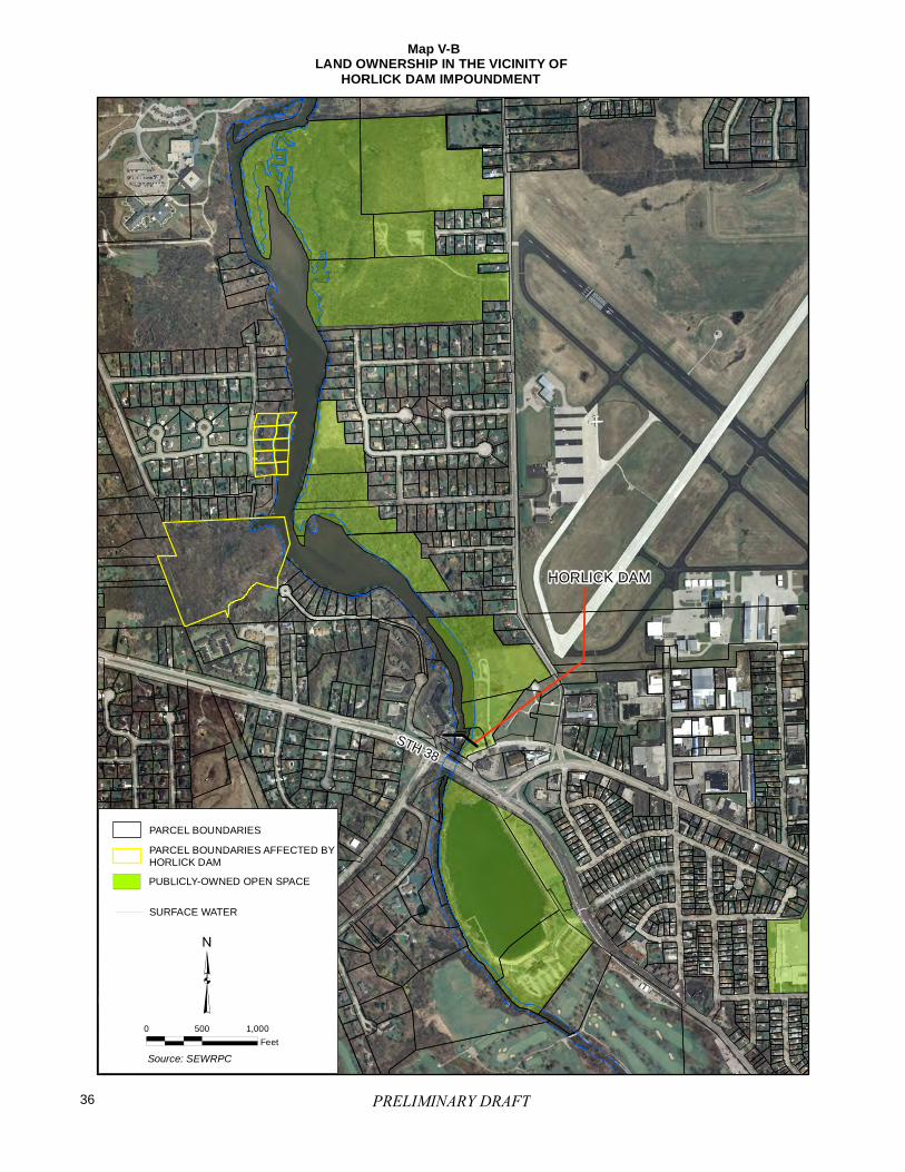
HORLICK DAM
0 500 1,000
Feet
³
PARCEL BOUNDARIES
PUBLICLY-OWNED OPEN SPACE
SURFACE WATER
STH 38
Source: SEWRPC
PARCEL BOUNDARIES AFFECTED BYHORLICK DAM
LAND OWNERSHIP IN THE VICINITY OF HORLICK DAM IMPOUNDMENT
Map V-B
PRELIMINARY DRAFT36
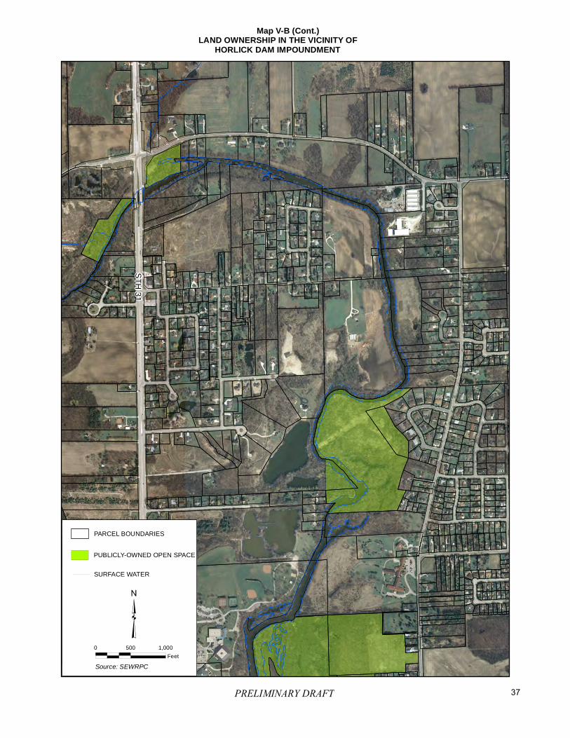
0 500 1,000
Feet
³
PARCEL BOUNDARIES
PUBLICLY-OWNED OPEN SPACE
SURFACE WATER
ST
H 3
1
Source: SEWRPC
Map V-B (Cont.)LAND OWNERSHIP IN THE VICINITY OF HORLICK DAM IMPOUNDMENT
PRELIMINARY DRAFT 37
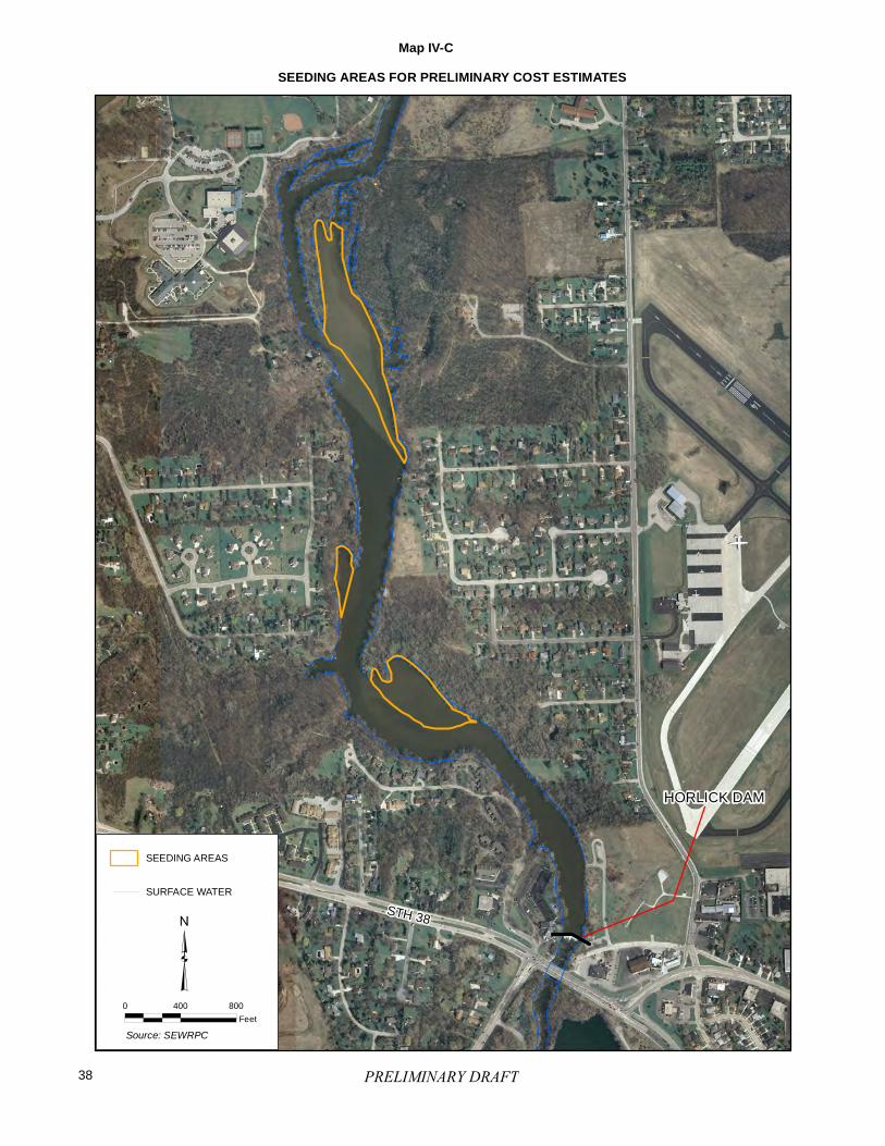
0 400 800
Feet
³SURFACE WATER
STH 38
Source: SEWRPC
SEEDING AREAS
SEEDING AREAS FOR PRELIMINARY COST ESTIMATESMap IV-C
HORLICK DAM
PRELIMINARY DRAFT38
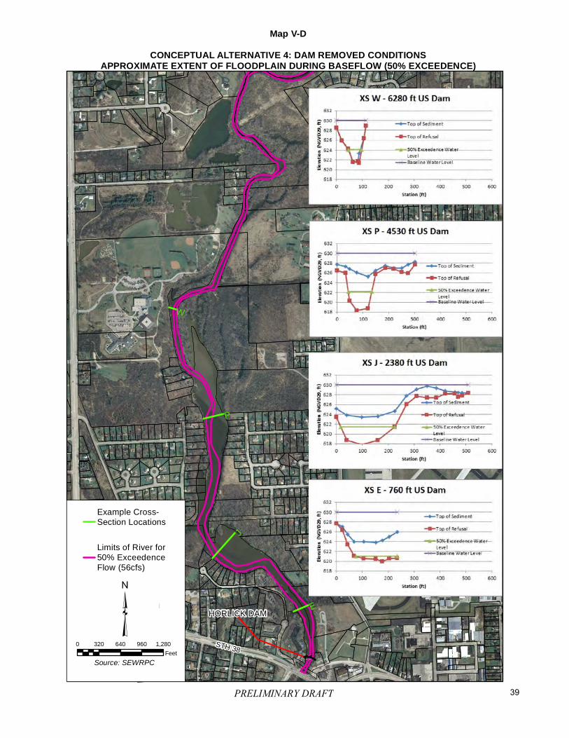
STH 38
HORLICK DAM
J
P
E
W
Map V-DCONCEPTUAL ALTERNATIVE 4: DAM REMOVED CONDITIONS
APPROXIMATE EXTENT OF FLOODPLAIN DURING BASEFLOW (50% EXCEEDENCE)
Example Cross-Section Locations
Limits of River for50% ExceedenceFlow (56cfs)
³³0 320 640 960 1,280
Feet
Source: SEWRPC
PRELIMINARY DRAFT 39