Embed Size (px)
Citation preview
Settlement Sites to 1500
On 1st April 2015 the Historic Buildings and Monuments Commission for England changed its common name from English Heritage to Historic England. We are now re-branding all our documents. Although this document refers to English Heritage, it is still the Commission's current advice and guidance and will in due course be re-branded as Historic England.
Please see our website for up to date contact information, and further
advice.
We welcome feedback to help improve this document, which will be periodically revised. Please email comments to [email protected]
We are the government's expert advisory service for England's historic environment. We give constructive advice to local authorities, owners and the public. We champion historic places helping people to understand, value and care for them, now and for the future.
HistoricEngland.org.uk/advice
DesignationScheduling Selection Guide
Settlement Sites to 1500
April 2013
2
SCHEDULING SELECTION GUIDE: SETTLEMENT SITES TO 1500
Contents
INTRODUCTION AND DEFINITIONS ....................2
HISTORICAL SUMMARY ..............................................2
Prehistoric ............................................................................. 2
Neolithic ................................................................................ 3
Bronze Age ............................................................................ 4
Iron Age .................................................................................. 5
Roman .................................................................................... 6
Anglo-Saxon .......................................................................... 8
Medieval ............................................................................... 10
OVERARCHING DESIGNATION CONSIDERATIONS .....................................................12
Scheduling and protection ............................................... 12
Selection criteria ................................................................ 13
SPECIFIC CONSIDERATIONS WHEN ASSESSING SETTLEMENT REMAINS FOR DESIGNATION....................................................14
Period ................................................................................... 14
Rarity and representativity .............................................. 14
Documentation .................................................................. 14
Group value ......................................................................... 14
Survival and condition ....................................................... 14
Diversity ............................................................................... 14
Archaeological potential ................................................... 14
Extensive landscapes ......................................................... 14
Towns, cities and other active settlements .................. 15
DESIGNATION CONSIDERATIONS BY PERIOD .....................................................................16
Prehistoric ........................................................................... 16
Roman .................................................................................. 16
Anglo-Saxon and Viking .................................................... 16
Medieval ............................................................................... 16
SELECT BIBLIOGRAPHY ............................................17
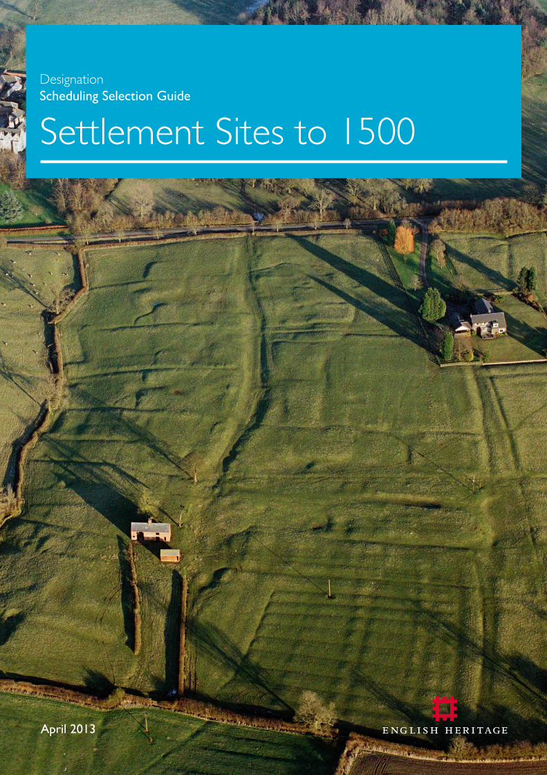
Cover Image: The scheduled settlement remains of Carlton Curlieu, Leicestershire.Probably depopulated soon after 1600 as arable land was converted to sheep pasture.
INTRODUCTION AND DEFINITIONS This selection guide offers an overview of the sorts of archaeological monument or site associated with settlements up to about 1500 which are likely to be deemed to have national importance, and for which of those scheduling may be appropriate. It aims to do two things: to set these within their historical context, and to give an introduction to the designation approaches employed.
Settlement, as here understood, embraces the entire range of dwellings, from individual houses to the larger places which we today call towns and cities. Their remains have a particular importance and resonance, as the most direct, and intimate, evidence of how our forebears lived in England over approximately the last 950,000 years.
In terms of their archaeology, settlements can be placed under two headings. First, the majority, are sites which have been abandoned. Most of these (where they survive) lie in open countryside, although some are buried beneath later settlements. Second are ‘living’ settlements – the places where we live today – with ancestries of varying time depth. Some were new-founded in recent decades or centuries, whereas others can trace their origins back a thousand years – or in some cases even longer. Given the enormous range of settlement types treated, this is inevitably a long and complex guidance document. Nevertheless, it must be stressed that each case will require independent assessment and the deployment of professional judgement both as to whether it is reckoned of national importance, and if so whether scheduling is the most appropriate management solution. After about 1500 listing becomes increasingly to the fore as a designation option, as treated in the four listing selection guides on Domestic structures.
One nationally-important group of sites, those of early prehistoric date which evidence where our earliest ancestors lived, are not presently eligible for designation by scheduling for legal reasons. Those reasons, the nature of the evidence and possible management approaches, are set out in the scheduling selection guide on Sites of Early Human Habitation without Structures. For certain specific later settlement types an up-to-date summaries of understanding are set out in English Heritage’s Introductions to Heritage Assets (IHAs), available at http://www.english-heritage.org.uk/caring/listing/criteria-for-protection/IHAs/. Individual IHAs are referenced below, where relevant.
HISTORICAL SUMMARYPREHISTORICEarly dwellingsThe long-held understanding of the archaeological landscape of Palaeolithic (before 10,000 BC) and Mesolithic (10,000-4500 BC) Britain has been one of a transient population of hunter-gatherers who obtained food by hunting, fishing and gathering wild resources and lived in temporary camps or shelters. Settlement evidence has come from both caves and open sites. The prevalence of material from caves in the
Settlement Sites to 1500Scheduling Selection GuideEnglish Heritage 3
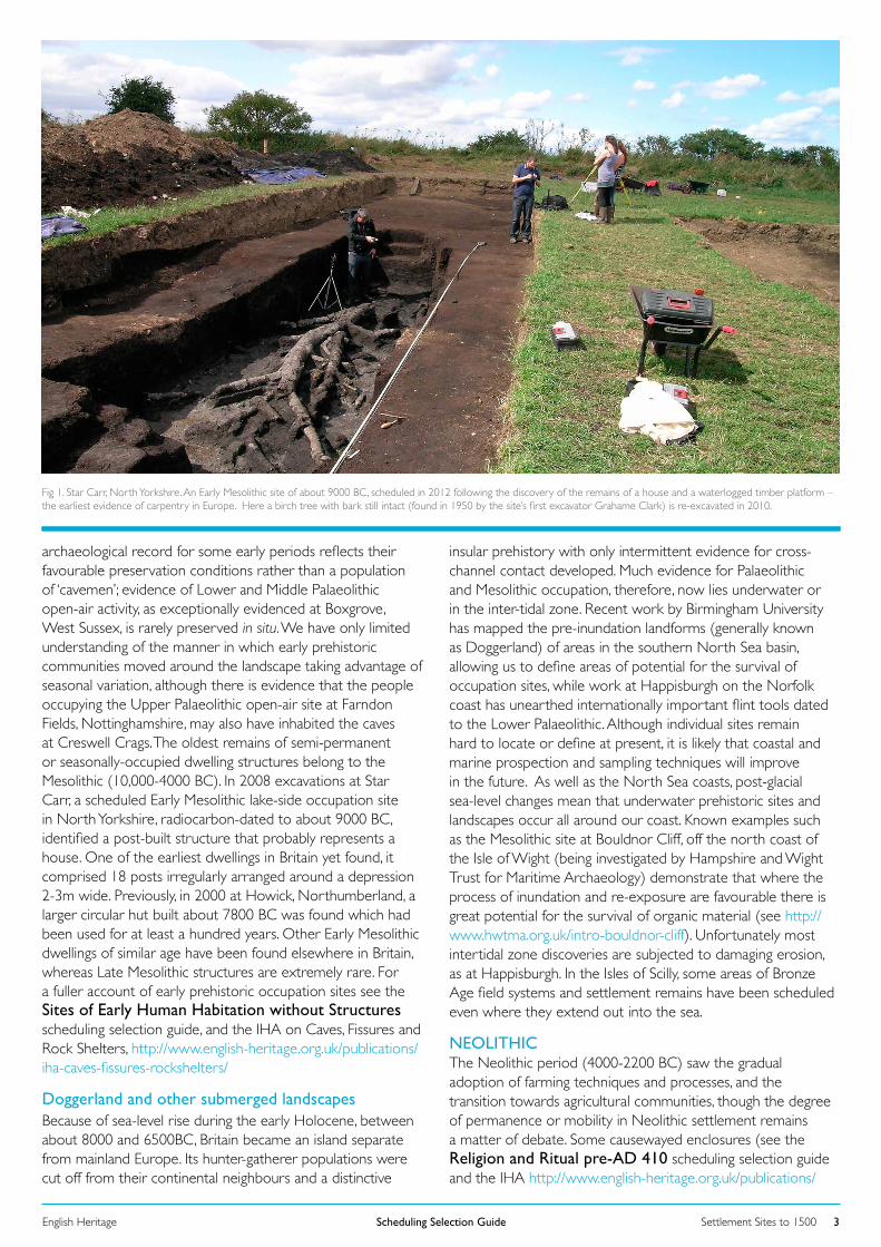
archaeological record for some early periods reflects their favourable preservation conditions rather than a population of ‘cavemen’; evidence of Lower and Middle Palaeolithic open-air activity, as exceptionally evidenced at Boxgrove, West Sussex, is rarely preserved in situ. We have only limited understanding of the manner in which early prehistoric communities moved around the landscape taking advantage of seasonal variation, although there is evidence that the people occupying the Upper Palaeolithic open-air site at Farndon Fields, Nottinghamshire, may also have inhabited the caves at Creswell Crags. The oldest remains of semi-permanent or seasonally-occupied dwelling structures belong to the Mesolithic (10,000-4000 BC). In 2008 excavations at Star Carr, a scheduled Early Mesolithic lake-side occupation site in North Yorkshire, radiocarbon-dated to about 9000 BC, identified a post-built structure that probably represents a house. One of the earliest dwellings in Britain yet found, it comprised 18 posts irregularly arranged around a depression 2-3m wide. Previously, in 2000 at Howick, Northumberland, a larger circular hut built about 7800 BC was found which had been used for at least a hundred years. Other Early Mesolithic dwellings of similar age have been found elsewhere in Britain, whereas Late Mesolithic structures are extremely rare. For a fuller account of early prehistoric occupation sites see the Sites of Early Human Habitation without Structures scheduling selection guide, and the IHA on Caves, Fissures and Rock Shelters, http://www.english-heritage.org.uk/publications/iha-caves-fissures-rockshelters/
Doggerland and other submerged landscapesBecause of sea-level rise during the early Holocene, between about 8000 and 6500BC, Britain became an island separate from mainland Europe. Its hunter-gatherer populations were cut off from their continental neighbours and a distinctive
insular prehistory with only intermittent evidence for cross-channel contact developed. Much evidence for Palaeolithic and Mesolithic occupation, therefore, now lies underwater or in the inter-tidal zone. Recent work by Birmingham University has mapped the pre-inundation landforms (generally known as Doggerland) of areas in the southern North Sea basin, allowing us to define areas of potential for the survival of occupation sites, while work at Happisburgh on the Norfolk coast has unearthed internationally important flint tools dated to the Lower Palaeolithic. Although individual sites remain hard to locate or define at present, it is likely that coastal and marine prospection and sampling techniques will improve in the future. As well as the North Sea coasts, post-glacial sea-level changes mean that underwater prehistoric sites and landscapes occur all around our coast. Known examples such as the Mesolithic site at Bouldnor Cliff, off the north coast of the Isle of Wight (being investigated by Hampshire and Wight Trust for Maritime Archaeology) demonstrate that where the process of inundation and re-exposure are favourable there is great potential for the survival of organic material (see http://www.hwtma.org.uk/intro-bouldnor-cliff). Unfortunately most intertidal zone discoveries are subjected to damaging erosion, as at Happisburgh. In the Isles of Scilly, some areas of Bronze Age field systems and settlement remains have been scheduled even where they extend out into the sea.
Fig 1. Star Carr, North Yorkshire. An Early Mesolithic site of about 9000 BC, scheduled in 2012 following the discovery of the remains of a house and a waterlogged timber platform – the earliest evidence of carpentry in Europe. Here a birch tree with bark still intact (found in 1950 by the site’s first excavator Grahame Clark) is re-excavated in 2010.
NEOLITHICThe Neolithic period (4000-2200 BC) saw the gradual adoption of farming techniques and processes, and the transition towards agricultural communities, though the degree of permanence or mobility in Neolithic settlement remains a matter of debate. Some causewayed enclosures (see the Religion and Ritual pre-AD 410 scheduling selection guide and the IHA http://www.english-heritage.org.uk/publications/
Settlement Sites to 1500Scheduling Selection GuideEnglish Heritage 4
iha-causewayed-enclosures/) may have been used for seasonal occupation but most settlement sites are marked by scatters of struck flint, sometimes accompanied by clusters of pits. While the vast majority of these sites lack clear evidence for structures, the last few decades have seen a sharp rise in the discovery of Neolithic buildings widely considered to be ‘houses’ (though debate continues about whether they were domestic or ritual in nature – and whether such distinctions are even valid in prehistory). Excavated examples include rectangular Early Neolithic buildings at Fengate, Cambridgeshire, and near White Horse Stone, Kent. In 2005 ten Late Neolithic ‘houses’ were discovered at Durrington Walls, near Stonehenge. One (House 851) retained the base of a chalk cob wall. These bear some resemblance in layout to the well-known stone-built houses from Skara Brae and other sites in Orkney. They seem to indicate seasonal occupation of a ceremonial site that was subsequently transformed into a henge monument.
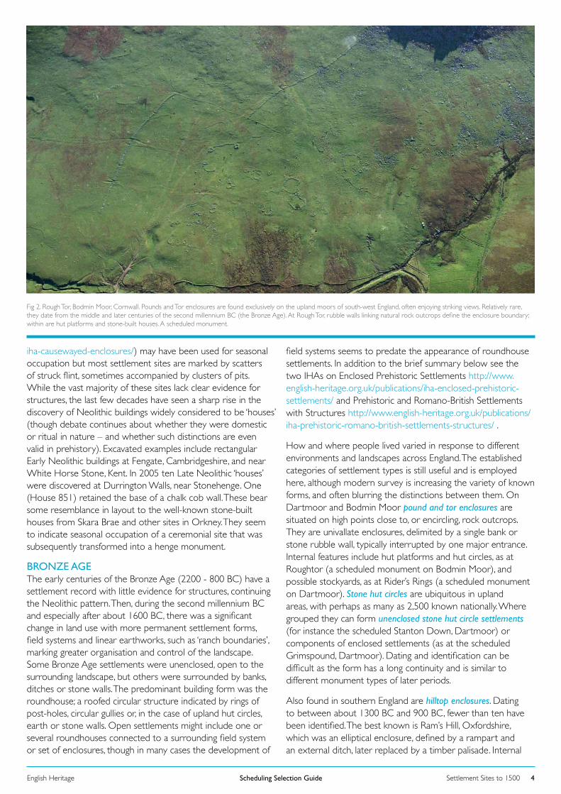
Fig 2. Rough Tor, Bodmin Moor, Cornwall. Pounds and Tor enclosures are found exclusively on the upland moors of south-west England, often enjoying striking views. Relatively rare, they date from the middle and later centuries of the second millennium BC (the Bronze Age). At Rough Tor, rubble walls linking natural rock outcrops define the enclosure boundary; within are hut platforms and stone-built houses. A scheduled monument.
BRONZE AGE The early centuries of the Bronze Age (2200 - 800 BC) have a settlement record with little evidence for structures, continuing the Neolithic pattern. Then, during the second millennium BC and especially after about 1600 BC, there was a significant change in land use with more permanent settlement forms, field systems and linear earthworks, such as ‘ranch boundaries’, marking greater organisation and control of the landscape. Some Bronze Age settlements were unenclosed, open to the surrounding landscape, but others were surrounded by banks, ditches or stone walls. The predominant building form was the roundhouse; a roofed circular structure indicated by rings of post-holes, circular gullies or, in the case of upland hut circles, earth or stone walls. Open settlements might include one or several roundhouses connected to a surrounding field system or set of enclosures, though in many cases the development of
field systems seems to predate the appearance of roundhouse settlements. In addition to the brief summary below see the two IHAs on Enclosed Prehistoric Settlements http://www.english-heritage.org.uk/publications/iha-enclosed-prehistoric-settlements/ and Prehistoric and Romano-British Settlements with Structures http://www.english-heritage.org.uk/publications/iha-prehistoric-romano-british-settlements-structures/ .
How and where people lived varied in response to different environments and landscapes across England. The established categories of settlement types is still useful and is employed here, although modern survey is increasing the variety of known forms, and often blurring the distinctions between them. On Dartmoor and Bodmin Moor pound and tor enclosures are situated on high points close to, or encircling, rock outcrops. They are univallate enclosures, delimited by a single bank or stone rubble wall, typically interrupted by one major entrance. Internal features include hut platforms and hut circles, as at Roughtor (a scheduled monument on Bodmin Moor), and possible stockyards, as at Rider’s Rings (a scheduled monument on Dartmoor). Stone hut circles are ubiquitous in upland areas, with perhaps as many as 2,500 known nationally. Where grouped they can form unenclosed stone hut circle settlements (for instance the scheduled Stanton Down, Dartmoor) or components of enclosed settlements (as at the scheduled Grimspound, Dartmoor). Dating and identification can be difficult as the form has a long continuity and is similar to different monument types of later periods.
Also found in southern England are hilltop enclosures. Dating to between about 1300 BC and 900 BC, fewer than ten have been identified. The best known is Ram’s Hill, Oxfordshire, which was an elliptical enclosure, defined by a rampart and an external ditch, later replaced by a timber palisade. Internal
Settlement Sites to 1500Scheduling Selection GuideEnglish Heritage 5
occupation is indicated by post-holes of circular and rectangular buildings, pottery, bronze metalwork and debris associated with feasting and textile production. Although resembling early univallate Iron Age hillforts (that is, ones surrounded by a single bank and ditch), these enclosures are thought to have been important Bronze Age gathering places or ceremonial centres, rather than defensive sites.
Ringworks are particularly distinctive later Bronze Age defended settlements found in eastern parts of the country. They are defined by concentric circles of bank and outer ditch and contain large circular timber buildings, one of which often takes a central position facing the main entrance. There are perhaps no more than ten confirmed examples with some other candidates not yet investigated. Built in elevated positions, they can be on a monumental scale as at Mucking North Ring and Springfield Lyons in Essex. In contrast, small embanked enclosures are domestic settlements comprising low earthworks and platforms forming small banked compounds. These compounds contain remains of roundhouses and ancillary buildings dating to the Mid-Late Bronze Age. Principally surviving on the Sussex downland, they are sometimes linked to surrounding field systems by tracks and hollow ways as at Plumpton Plain, a scheduled monument in East Sussex.
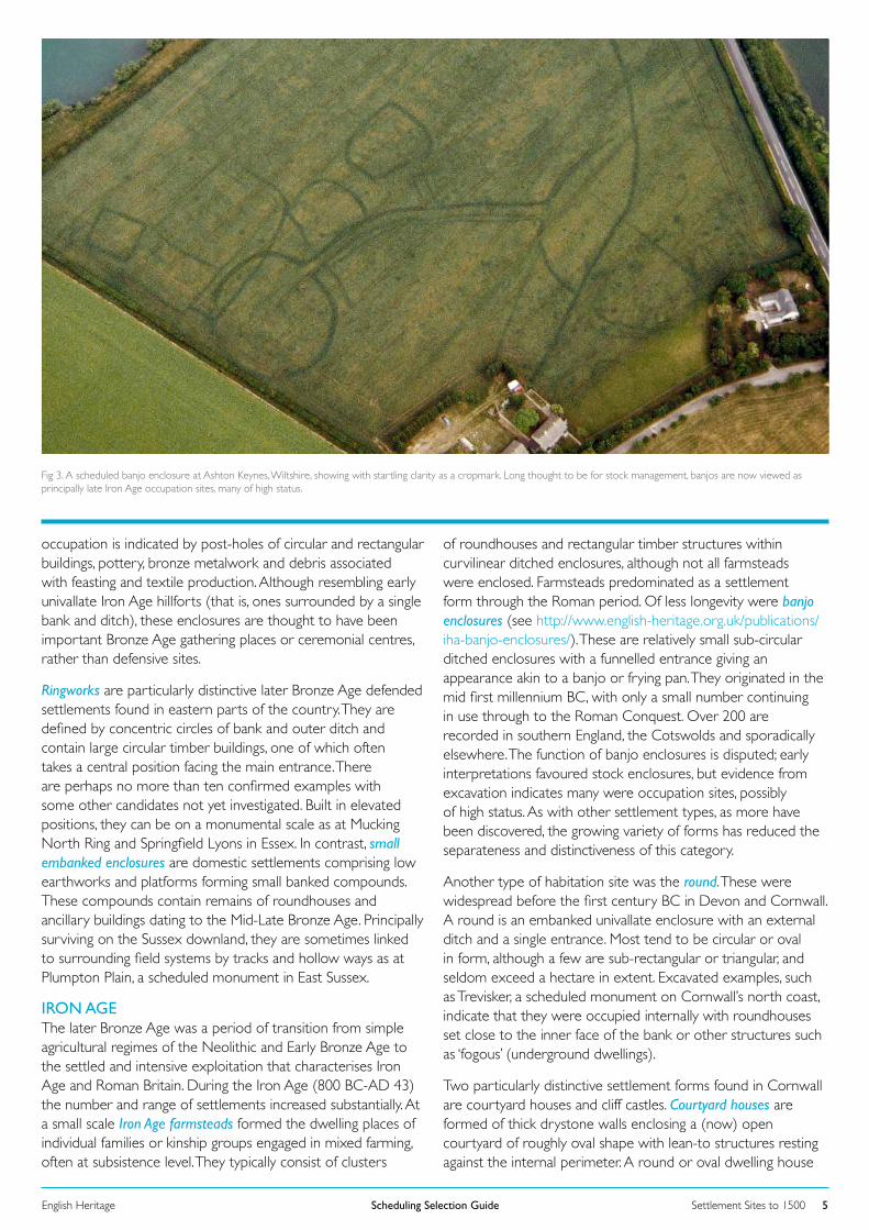
Fig 3. A scheduled banjo enclosure at Ashton Keynes, Wiltshire, showing with startling clarity as a cropmark. Long thought to be for stock management, banjos are now viewed as principally late Iron Age occupation sites, many of high status.
IRON AGE The later Bronze Age was a period of transition from simple agricultural regimes of the Neolithic and Early Bronze Age to the settled and intensive exploitation that characterises Iron Age and Roman Britain. During the Iron Age (800 BC-AD 43) the number and range of settlements increased substantially. At a small scale Iron Age farmsteads formed the dwelling places of individual families or kinship groups engaged in mixed farming, often at subsistence level. They typically consist of clusters
of roundhouses and rectangular timber structures within curvilinear ditched enclosures, although not all farmsteads were enclosed. Farmsteads predominated as a settlement form through the Roman period. Of less longevity were banjo enclosures (see http://www.english-heritage.org.uk/publications/iha-banjo-enclosures/). These are relatively small sub-circular ditched enclosures with a funnelled entrance giving an appearance akin to a banjo or frying pan. They originated in the mid first millennium BC, with only a small number continuing in use through to the Roman Conquest. Over 200 are recorded in southern England, the Cotswolds and sporadically elsewhere. The function of banjo enclosures is disputed; early interpretations favoured stock enclosures, but evidence from excavation indicates many were occupation sites, possibly of high status. As with other settlement types, as more have been discovered, the growing variety of forms has reduced the separateness and distinctiveness of this category.
Another type of habitation site was the round. These were widespread before the first century BC in Devon and Cornwall. A round is an embanked univallate enclosure with an external ditch and a single entrance. Most tend to be circular or oval in form, although a few are sub-rectangular or triangular, and seldom exceed a hectare in extent. Excavated examples, such as Trevisker, a scheduled monument on Cornwall’s north coast, indicate that they were occupied internally with roundhouses set close to the inner face of the bank or other structures such as ‘fogous’ (underground dwellings).
Two particularly distinctive settlement forms found in Cornwall are courtyard houses and cliff castles. Courtyard houses are formed of thick drystone walls enclosing a (now) open courtyard of roughly oval shape with lean-to structures resting against the internal perimeter. A round or oval dwelling house
Settlement Sites to 1500Scheduling Selection GuideEnglish Heritage 6
is normally situated against the face of the wall opposite the entrance. These settlements are confined exclusively to the lands end peninsula and Isles of Scilly with perhaps fewer than 50 known examples. Among those excavated are Carn Euny and Chysauster, scheduled monuments to the west of Penzance in Cornwall. Cliff castles are situated on rugged headlands jutting into the sea and protected from landward approach by lines of banks, or walls, and ditches. Those excavated, such as The Rumps (a scheduled monument in Cornwall, to the west of Tavistock), have uncovered traces of roundhouses, although their purpose is far from certain; they make precarious settlement locations.
Wetland settlements These were a response to an entirely different environment, with domestic structures, such as roundhouses, having living areas artificially raised to keep them dry. At Glastonbury, Somerset, a ‘lake village’ of up to 80 circular buildings was built on a foundation of brushwood and timber packed with bracken, rubble and clay (a scheduled monument). Anaerobic conditions at these sites can allow for exceptional preservation of organic remains. However, wetland settlements are rare, and there are few known locations. Other than those at Meare and at Glastonbury in Somerset, there are examples at Cold Ash, Berkshire, and – beyond England – Ballacagan on the Isle of Man.
No crannogs have been found in England.
Fortified settlements The development of fortified settlements, certainly the large hillforts of the later Iron Age, implies a degree of social cohesion and organisation, even hierarchy, not seen in settlements of earlier periods. Hillforts are amongst the most impressive and evocative (see http://www.english-heritage.org.uk/publications/iha-hillforts/). They were preceded by other forms of defended settlements such as palisaded enclosures, which, as the name suggests, were protected by a timber stockade. The earliest hillforts were relatively slight univallate enclosures defended by a single bank and external ditch. The main building phase was between about 800 BC and 700 BC. From about 400 BC, ‘developed’ hillforts with bivallate and multivallate earthworks, forming several lines of defences, were constructed. These earthworks could be monumental in scale with ramparts over 10m high and with complex entranceways such as those at Maiden Castle, a scheduled monument in Dorset. The communal effort required to build them must have been very considerable indeed. The shape of hillforts varied in response to the contours of the land they occupied. Those situated at the ends of spurs are called promontory forts.
Hillfort interiors could be intensively occupied. Excavation at Danebury (a scheduled monument in Hampshire, to the south of Andover), for example, has revealed numerous roundhouses and storage pits as well as post holes associated with agricultural stores. Others are altogether lacking in firm settlement evidence. In all likelihood hillforts served a range of functions, such as providing central places for storage and redistribution of products, or being the focus for religious communities. Their distribution is most concentrated in central and southern England, in a broad swathe running from the south coast to North Wales, and in Northumberland. Many were abandoned in about 100 BC, following the appearance of
oppida (see below), but it has been suggested some were re-defended in response to the Roman invasion.
Another variant of the fortified settlement is multiple-enclosure forts. Densely scattered in lowland areas of Devon and eastern Cornwall, they date to between 350 BC and the mid first century AD. They comprise two or more enclosed areas, either concentrically arranged (for instance, the scheduled Denbury, south-west of Newton Abbot in Devon) or conjoined (for instance, the scheduled Helsbury Castle, north of Bodmin, in Cornwall), defined by sets of earthworks over 15m apart. In plan the enclosures are sub-circular or sub-rectangular. Given their siting, on hill slopes or at the end of ridges overlooking springs and rivers, they have been closely associated with pastoral farming. The widely held view is that the inner enclosures formed the main inhabited area, occupied by roundhouses, whilst the outer enclosures were designed to protect the homestead pastures and their watering places.
OppidaIn the later Iron Age, from the late second century BC, a group of settlements developed which might be regarded as the forerunners of Roman towns. These oppida (the plural form of the Latin oppidum, meaning the main settlement in an administrative area) have been categorised into three types: enclosed oppida, territorial oppida and, the highly contentious, unenclosed oppida. Some 24 major oppida have been recorded, mainly in central and eastern areas of England following a pattern also witnessed on the Continent. They are enclosed or unenclosed settlements, varying widely in scale, which display indicators of political centralisation, industrial growth, and craft specialisation. At a large scale the scheduled Chichester Dykes (West Sussex), a territorial oppidum, encompassed at least 150 sq km. The few excavations on these sites provide evidence for coin production and a material culture indicative of close trade links with the wider Roman world. Stanwick (North Yorkshire; a scheduled monument) represents the most northerly recognised example. Excavations have demonstrated considerable external contacts. At Silchester (a scheduled monument on Hampshire’s northern border) traces of a deliberate grid layout have been uncovered marking a proto-urban site that was a precursor to the later Roman town. For a more detailed overview see http://www.english-heritage.org.uk/publications/iha-oppida/ .
ROMANThe Roman Conquest (AD 43) brought a significant growth in urbanisation with the establishment, for the first time, of a network of towns, linked by well-constructed roads. Nevertheless, the provincial economy remained essentially agrarian; an estimated 90 per cent of the population lived in rural settlements such as farmsteads, villas and villages. A recent study has identified some 28,000 rural settlements of Roman date in England and, other than in some upland areas, most of the country was well dotted with farms and farming settlements.
Rural settlementRomano-British farmsteads were the most numerous type of settlement in the first four centuries AD (for overviews see http://www.english-heritage.org.uk/publications/iha-prehistoric-
Settlement Sites to 1500Scheduling Selection GuideEnglish Heritage 7
romano-british-settlements-structures/ and http://www.english-heritage.org.uk/publications/iha-roman-settlements/). Their form and function shows a high degree of continuity with the Iron Age. Large groups of five or more farmsteads within a single enclosure or close proximity (0.5km) to each other are termed ‘polyfocal farmsteads’ (formerly ‘aggregate villages’). These small farming communities existed prior to and throughout the Roman period. Their remains are rare with approximately 20 recorded examples, mostly in northern England. Other small-scale nucleated settlements include linear villages and compact villages. Linear villages (or ‘ladder settlements’) are groups of homesteads aligned along a single axis ‘street’ or trackway surrounded by associated enclosures, paddocks and fields. There are over 50 examples across England, spread towards the Severn Estuary, the Wash, East Riding and North Yorkshire. Compact villages are more densely concentrated rectilinear compounds, with structures and open components linked by a series of streets and lanes.
Romano-British villas are amongst the most characteristic settlements of the Roman period, distinguished by an adoption of Roman traits such as rectilinear building types featuring wall-paintings, mosaics, hypocausts and bath suites. Villas often lay at the heart of extensive rural estates, alongside domestic, agricultural and occasionally industrial buildings. The main buildings were generally constructed of local materials, sometimes directly on the sites of Iron Age farmsteads. Indeed, most villas are considered to have been owned by affluent descendants of the native population. A typical villa took the form of a well-appointed house, usually a rectangular, with an adjoining or separate bath suite, and a number of ancillary buildings enclosed within a rectilinear yard. Villas vary considerably in size. The smallest amount to little more than farmsteads (for instance, Park Street, Hertfordshire)
while others could be palatial in scale (such as Fishbourne, a scheduled monument in West Sussex). Some 600 villas have been recorded nationally, concentrated largely in central and southern England, although an increasing number of minor villas are being recognised in the Tees Valley, County Durham and Cheshire. Fewer than ten are classified as major villas, consisting of substantial and substantially embellished buildings with a formal layout. These include the scheduled examples at Bignor (West Sussex) and Darenth (Kent).
The origins and development of villas vary widely. Some appear to develop from pre-Roman settlements, for example The Ditches villa, Gloucestershire. Others, such as Holme House, North Yorkshire, seem to be entirely new foundations, although in some cases this may reflect a lack of excavation of potential earlier deposits. Many show a gradual development over time, possibly reflecting developing agricultural success. A series of new creations in the south-west from the mid to late third century has been ascribed to the migration of members of the Gallic elite in the face of increasing insecurity on the Continent. In terms of decline or abandonment, some villas, for example Great Witcombe (Gloucestershire) appear to be occupied into the fifth century, although other sites come to an end in the fourth, for example Groundwell Ridge, Swindon. Whichever, in most cases sites show a decline in the quality of occupation before they ceased to be occupied, with well-appointed domestic rooms often being turned to industrial activities, as at Swalcliffe Lea villa, Oxfordshire.
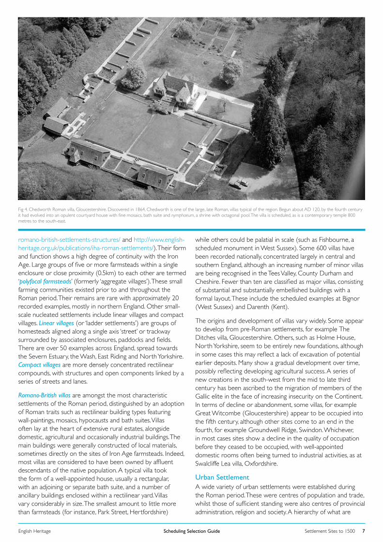
Fig 4. Chedworth Roman villa, Gloucestershire. Discovered in 1864, Chedworth is one of the large, late Roman, villas typical of the region. Begun about AD 120, by the fourth century it had evolved into an opulent courtyard house with fine mosaics, bath suite and nymphaeum, a shrine with octagonal pool. The villa is scheduled, as is a contemporary temple 800 metres to the south-east.
Urban SettlementA wide variety of urban settlements were established during the Roman period. These were centres of population and trade, whilst those of sufficient standing were also centres of provincial administration, religion and society. A hierarchy of what are
Settlement Sites to 1500Scheduling Selection GuideEnglish Heritage 8
conventionally termed major towns was brought into existence: Coloniae, Municipia and Civitas Capitals. These were chartered towns with a formal legal status, the names of which appear, with those of other settlements, in the Antonine Itinerary and the Ravenna Cosmography, these being third- and seventh-century lists of official way-stations. They possessed a regular grid plan, defences, public buildings and amenities, a forum, basilica, public bath house, with in some cases an amphitheatre and/or theatre, aqueduct and public latrines (for amphitheatres, theatres and circuses see http://www.english-heritage.org.uk/publications/iha-roman-amphitheatres-theatres-circuses/). Some were ports, whether coastal or up-river, and at several (most notably London) impressive evidence has been found of waterfronts, quays and warehouses. Most eventually acquired defences, such as town walls, which also served as civic monuments marking their status. The highest ranking towns were Coloniae; settlements of retired legionary soldiers rewarded with grants of land and full citizenship following 25 years’ service. The earliest examples were at Camulodunum (Colchester, founded AD 49), Lindum (Lincoln, AD 95) and Glenvum (Gloucester, AD 97). Later, Eboracum (York) and, most probably, Londinium (London) were given the title as an honour. A municipium was a chartered town of lesser status, Verulamium (a scheduled monument, outside St Albans in Hertfordshire) being the only certain example. Civitas Capitals were centres of regional government created following the division of the province into civitates, administrative areas based on Iron Age tribes. At least fifteen civitas capitals are thought to have been established.
Civilian settlements also grew up around military establishments (for which see http://www.english-heritage.org.uk/publications/iha-roman-forts-fortresses/), which include canabae associated with legionary fortresses (for instance, York) and vici associated with auxiliary forts (such as Vindolanda, a scheduled monument in Northumberland on Hadrian’s Wall). These extra-mural settlements comprised roughly rectangular building plots, housing workshops and domestic residences, set alongside the main exit roads from a fort. They developed out of, and flourished upon, the trade created by the Roman army, selling manufactured goods and services and possibly producing and/or repairing military equipment. A large concentration of vici developed along the northern frontier zone near Hadrian’s Wall. Some, such as the canabae at York, expanded to become major towns.
In addition to major towns and vici were local market centres now termed minor towns. These generally lacked the formal layout, public buildings and amenities of the chartered towns, although they could be large and important centres in their own right. Vagniacae (a scheduled monument at Springhead, Kent), for example, was a major religious settlement with at least seven temples and shrines situated next to Watling Street Roman road. Indeed, minor towns often developed on main communication routes, at road junctions and river crossings. Some grew up around the mansiones (official guest houses) of the cursus publicus (Imperial messenger system). Others were specialized industrial settlements such as Salinae (a scheduled monument in Droitwich, Worcestershire) where salt was extracted or Durobrivae (Water Newton, Cambridgeshire; a scheduled monument), which was a major pottery-producing centre.
Once a settlement’s basic street plan was established, it was generally retained throughout the Roman period. Buildings might be rebuilt within plot boundaries, although plots were sometimes amalgamated to allow the development of larger buildings or complexes of buildings, as in the case of Insula VII at Cataractonium (Catterick, North Yorkshire). A few towns, such as Verulamium , received earthwork defences in the first century, while most of the major towns, such as Viroconium (Wroxeter, Shropshire), acquired them in the second century. Initial earthwork and timber defences were in due course generally replaced in stone. In the later Roman period many minor towns, too, were walled. However, in many cases only a relatively small part of the built-up area was included in the defences leaving, in some cases, the majority of the occupied area as extra-mural, as for example at Alauna (Alcester, Warwickshire). Many settlements, defended or not, incorporated ribbon development along approach roads, although such developments were often constrained by the presence of cemeteries.
ANGLO-SAXON Rural settlementIt is clearly to over-simplify matters to state that in lowland England Roman settlements, urban and rural, saw rapid abandonment in the years around 400 AD. Undeniably some were, but others had been given up long before, while others saw some degree of occupation continue for many decades into the fifth century and even beyond. In other parts of the country any veneer of Romanisation had always been thin, and in these places dislocation of where and how people lived and worked the land is likely to have been least felt. What we see both before and after the Roman period is that settlement forms are fluid; they are always likely to evolve, irrespective of any regime change.
That said, the arrival of Germanic settlers – here for convenience termed Anglo-Saxons – in and after the early fifth century did coincide with the introduction of new types of building, notably Grubenhäuser (sunken-featured buildings, many apparently workshops or store-sheds). These are known on earlier and contemporary sites on the continental homelands, there typically alongside aisled longhouses – which for whatever reason were not introduced to England. Here, instead, simpler, smaller and less timber-hungry buildings (houses, barns) were ‘earth-fast’, that is with lines of wall-posts set in individual post-holes. In the early Anglo-Saxon period (fifth to seventh century) such buildings were found in settlements which favoured lighter soils, were typically small (although there are exceptions, like Mucking, Essex), and lacked spatial organisation or ‘edges’. From the seventh century better spatial definition is seen with ditched enclosures, repeatedly re-cut, around properties and associated closes and droveways: Catholme (Staffordshire) is an excavated example. From about AD 600 some exceptionally large (that is with floor areas over 100 square metres), one-room, buildings appear, presumably halls reflecting a more hierarchical society and the emergence of strong local lords (from the later ninth century termed thegns). Together these things suggest bigger populations, legally defined (or ancestral) property rights, and a more intensively farmed landscape. At the same time, new building techniques including the use of sill-beams (horizontal ground-beams which lifted timber uprights out of the earth) meant
Settlement Sites to 1500Scheduling Selection GuideEnglish Heritage 9
that buildings – with secular ones still exclusively of wood – were longer-lived. In the later Anglo-Saxon period, from the ninth century, some places were laid out, or replanned, with the thegn’s hall, and perhaps a church (this was the great period of local church foundation: see the scheduling selection guide on Religion and Ritual post-410 AD) typically set alongside one another at the end of the settlement, and farms all set within carefully-measured, regular, and well-defined properties: the close-by excavated examples of Raunds and West Cotton (Northamptonshire) are clear demonstrations of this. Substantial ditches often define what seem to be higher-status settlements; these include the 193 places described in documentary sources including the Anglo-Saxon Chronicle as Anglo-Saxon royal centres. Building types were varied, with post-in-trench and plank-in-trench foundations enabling larger, and especially wider, buildings.
Within a general national picture of variety and evolution, the identification of explicitly Viking settlements in the English Danelaw (that part of midland and northern England under Danish rule) has proved elusive; current thinking favours the idea that Scandinavian immigrants were rapidly assimilated into English society in the later ninth century, creating an hybrid ‘Anglo-Scandinavian’ culture. That is not to say Viking settlement did not precipitate change. At Raunds, for instance, it is argued that settlement nucleation and the establishment of an Anglo-Scandinavian farm with a high-status focus (predecessor of the later manorial complex) came at much this time. The agency of ethnic Scandinavians is possible, if unproven.
In general the two centuries before the Norman Conquest saw the emergence across the greater part of England of the medieval rural landscape of settlements, sometimes nucleated, sometimes not, typically set within arable land organised
in common (or open) field systems (for which see the Agriculture scheduling selection guide). Whether this was due to organic processes of change, or community-led initiatives, or as a result of rural reorganisation by kings and thegns intent on increasing revenue (put crudely, people being moved to same-sized plots and farms each of which owed the same rent) is unclear.
Landscapes where individual farms and hamlets predominate, notably to the west, north and south-east have always been thought to be longer established, and Oliver Rackham has labelled these zones the ‘Ancient Countryside’. But while these may not have seen the massive change which the midland countryside did in the century or two before 1066, or parts of the north did with reconstruction after the ruthless Harrying of the North by William I in 1069-70, we must not assume settlements and field systems in these huge areas of England have been fixed and immutable. Many saw considerable modification in the eighteenth and nineteenth centuries, and of course the twentieth; earlier centuries, too, may prove to have seen settlement fluidity.
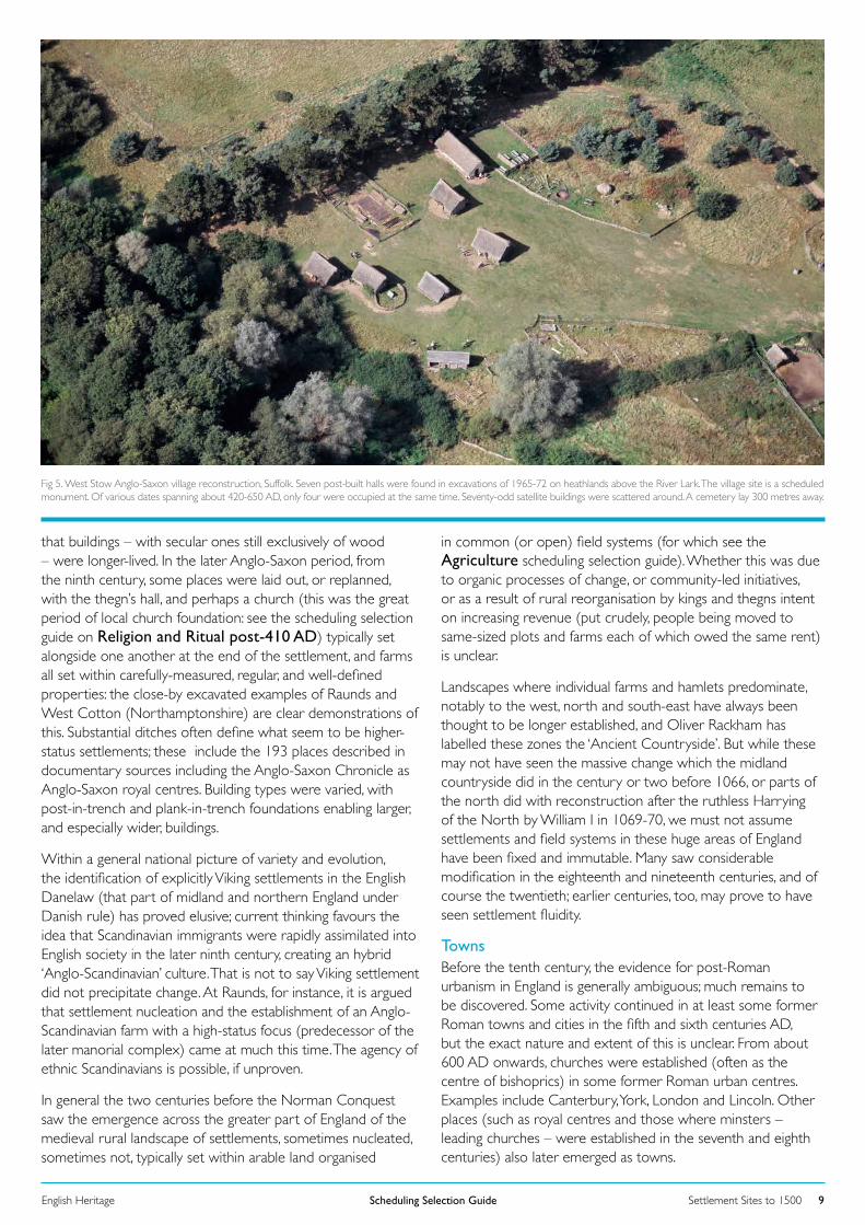
Fig 5. West Stow Anglo-Saxon village reconstruction, Suffolk. Seven post-built halls were found in excavations of 1965-72 on heathlands above the River Lark. The village site is a scheduled monument. Of various dates spanning about 420-650 AD, only four were occupied at the same time. Seventy-odd satellite buildings were scattered around. A cemetery lay 300 metres away.
Towns Before the tenth century, the evidence for post-Roman urbanism in England is generally ambiguous; much remains to be discovered. Some activity continued in at least some former Roman towns and cities in the fifth and sixth centuries AD, but the exact nature and extent of this is unclear. From about 600 AD onwards, churches were established (often as the centre of bishoprics) in some former Roman urban centres. Examples include Canterbury, York, London and Lincoln. Other places (such as royal centres and those where minsters – leading churches – were established in the seventh and eighth centuries) also later emerged as towns.
Settlement Sites to 1500Scheduling Selection GuideEnglish Heritage 10
The late seventh and early eighth century saw the appearance of wics – trading centres – along the south and east coasts of England as part of a wider development on either side of the North Sea. Ipswich (Suffolk), London (Lundenwic), Southampton (Hamwic) and York (Eorforwic) are examples. These places later became major trading centres, whereas other wics, such as Fordwich and Sandwich in Kent, some perhaps no more than periodic beach-markets, did not. Place-names, like Greenwich, suggest the location of other such sites along the Thames. Further evidence for the revival of trade at this time is the re-emergence of coinage in the late seventh century. Excavations at some sites, like Southampton, have revealed layouts of metalled roads, numerous buildings and evidence of crafts, industry and overseas trade. The wics seem to have been abandoned by the mid ninth century; in some cases, such as London, their population may have moved into the walled area of the adjacent former Roman town.
In the mid-late ninth century, coinciding with the period of Scandinavian settlement, there was a new phase of urban growth. At the start of the period there were fewer than a dozen places which might be reckoned urban; by 1066 there were over a hundred. Part of the Anglo-Saxon response to the Scandinavian threat was burhs, fortified centres, many of which were already, or developed into towns. These seem to have been initiated by King Alfred (ruled 871-99), to ensure that no part of his kingdom was more than twenty miles from such a place. As Edward the Elder (ruled 899-924) re-conquered England in 911-19 more were added. Around fifty burhs are known, concentrated in southern and midland England, with a few further north. Some were created by refurbishing the defences of former Roman towns (such as Winchester), while others were established on new sites (such as Wallingford, Oxfordshire). The defences are generally the most significant surviving feature of burhs – Wareham (Dorset) is a good example – while excavations (as at Oxford and Northampton) have revealed grid-plan streets, buildings, pits, industries and other features. Many burhs expanded in the tenth century; at Winchester, to take a well-studied example, urban life was so vibrant that the numerous traders and manufacturers were found grouped together in streets like Tanner Street, Fleshmonger Street and Wheelwright Street. The evidence of archaeology complements that of the documentary sources, with the laws of Edward the Elder (899-924) and Athelstan (924-39) clearly showing the official regulation of marketing in towns.
In the Danelaw area of central and eastern England, the area settled by the Viking Great Army, the Anglo-Saxon Chronicle for 942 names the ‘Five Boroughs’ of Derby, Leicester, Lincoln, Nottingham and Stamford: places which had emerged (or were promoted) as places of administration and trade. Another reference notes the Seven Boroughs, thought to include Manchester, and Doncaster or Torksey (Lincolnshire). It was long thought these provided the model for Edward the Elder’s burhs; it is now argued they may not have become Danish strongholds until 910-20, suggesting that the Wessex burhs were the model for them, and not vice versa.
In the tenth century towns were also established, or grew up, at places which had major monasteries. Examples include
Glastonbury, Ely and Peterborough. Town plan analysis indicates episodes of deliberate planning of elements such as streets, market places and boundaries defining long, narrow, properties.
By the time of the Domesday survey in 1086, most of the former Roman coloniae and civitas capitals were once again flourishing urban centres, and a significant number of other places also had urban attributes such as markets and mints. Domesday lists over a hundred boroughs. Some towns had populations of significant size by the late eleventh century, and the urban hierarchy (of regional capitals, county towns and smaller places) which is evident in the medieval period seems to have originated before the Norman Conquest.
MEDIEVAL Rural settlement In the Middle Ages settlements took many different forms. The most basic division is between the so-called Central Province, the north-south zone running through midland England where relatively large and compact, or nucleated, villages predominate – which, as noted, seem to largely originate in the later Saxon period – and the hillier upland counties of the north and west (and also the Wealden and surrounding landscapes of the south-east) where hamlets and single farms (dispersed settlement) are the norm. Within each of these two main landscape and settlement divisions there is a wide variety of forms (for further detail see http://www.english-heritage.org.uk/publications/iha-medieval-settlements/). Especially distinctive among villages, for instance, are the regular or planned types, with uniform tofts and crofts (house plots and gardens) running back from a main road, often with a back lane linking the rear of the crofts, and typically with the church and manor house in larger compartments at the end of the village. These are found especially in northern England, a proportion dating from re-occupation and re-investment after the Norman Conquest and especially the Harrying of the North of 1069-70.
One of the more immediately recognisable elements of dispersed settlement is the moats dug around isolated farmsteads in the thirteenth and early fourteenth centuries, especially in counties with heavy soils such as Essex and Suffolk. To date, roughly 6,000 moated sites are known. Sometimes East Anglian moats lie within areas where greens were historically a common feature: extensive areas of rough grazing with cottages around their edge, very different from the classic village green of popular imagination. The transition from one settlement type to another is sometimes sudden, and explicable in part by the underlying geology and soils. Elsewhere change is more gradual, and explanation debatable or elusive. That quest for understanding of settlement form remains a constant of modern research.
Whatever the settlement type, the basic components of the individual family holdings – peasant farms – tend to be fairly constant. The house and usually some barns or sheds for crops and animals stood within a hedged or walled plot typically called a toft (although there is rich variety in regional terminology). Behind was an often lengthy garden for vegetable cultivation and other agricultural or industrial/craft activity, usually termed a croft. In a regular or planned village (as in a post-medieval estate village), or in a planned extension to a pre-existing one, these
Settlement Sites to 1500Scheduling Selection GuideEnglish Heritage 11
tofts and crofts would be of the same size, and share common front and rear boundaries. Smaller places, or ones with a more organic form, lack this regularity but still tend to be groupings of tofts and crofts although there are regions (like the south-west) where hamlets have farmsteads whose yards and gardens are clustered more irregularly around the dwellings. Like all specialist subjects, medieval settlement attracts and requires a specialist vocabulary. For instance, relatively large, irregular, places are said to be ‘agglomerated’, while settlements which comprise clusters of houses strung together (sometimes with suffixes like ‘End’, as in Duck End, or Parva [Little] and Magna [Great]) have been termed polyfocal villages: here Wollaston (Northants) is the type site.
Standing apart from villages, hamlets and farms were specialist outlying centres of agricultural production, such as sheep cotes (bercarie) on the Cotswolds and the cattle farms (vaccaries) found, for instance, in the Yorkshire Dales. The best known, and generally largest of such centres, with chambers for accommodation of a permanent workforce, barns, and beast houses, are the granges via which Cistercian monasteries exploited their outlying estates and lands from the twelfth century onwards. Some of these survive as farms today, while others have been deserted to remain only as archaeological sites. Shielings, temporary habitations associated with the seasonal upland grazing of animals, are treated in an IHA (http://www.english-heritage.org.uk/publications/iha-shielings/).
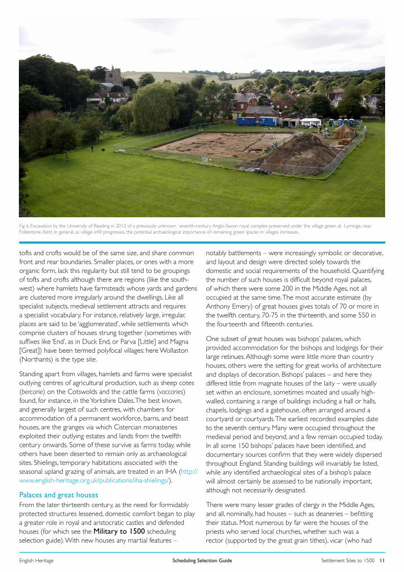
Fig 6. Excavation by the University of Reading in 2012 of a previously unknown seventh-century Anglo-Saxon royal complex preserved under the village green at Lyminge, near Folkestone, Kent. In general, as village infill progresses, the potential archaeological importance of remaining green spaces in villages increases.
Palaces and great housesFrom the later thirteenth century, as the need for formidably protected structures lessened, domestic comfort began to play a greater role in royal and aristocratic castles and defended houses (for which see the Military to 1500 scheduling selection guide). With new houses any martial features –
notably battlements – were increasingly symbolic or decorative, and layout and design were directed solely towards the domestic and social requirements of the household. Quantifying the number of such houses is difficult beyond royal palaces, of which there were some 200 in the Middle Ages, not all occupied at the same time. The most accurate estimate (by Anthony Emery) of great houses gives totals of 70 or more in the twelfth century, 70-75 in the thirteenth, and some 550 in the fourteenth and fifteenth centuries.
One subset of great houses was bishops’ palaces, which provided accommodation for the bishops and lodgings for their large retinues. Although some were little more than country houses, others were the setting for great works of architecture and displays of decoration. Bishops’ palaces – and here they differed little from magnate houses of the laity – were usually set within an enclosure, sometimes moated and usually high-walled, containing a range of buildings including a hall or halls, chapels, lodgings and a gatehouse, often arranged around a courtyard or courtyards. The earliest recorded examples date to the seventh century. Many were occupied throughout the medieval period and beyond, and a few remain occupied today. In all some 150 bishops’ palaces have been identified, and documentary sources confirm that they were widely dispersed throughout England. Standing buildings will invariably be listed, while any identified archaeological sites of a bishop’s palace will almost certainly be assessed to be nationally important, although not necessarily designated.
There were many lesser grades of clergy in the Middle Ages, and all, nominally, had houses – such as deaneries – befitting their status. Most numerous by far were the houses of the priests who served local churches, whether such was a rector (supported by the great grain tithes), vicar (who had
Settlement Sites to 1500Scheduling Selection GuideEnglish Heritage 12
the small, lesser-value, tithes such as piglets and eggs), or stipendiary curate. The priest’s house (for which parsonage became a catch-all term in later centuries) typically lay alongside (or originally in) the churchyard. These ancient and modest structures were often replaced in the mid nineteenth century with residences felt more befitting the status of the clergy. Large numbers of earlier priest-house sites survive archaeologically, although they are probably under-represented in local authorities’ Historic Environment Records (HERs), not least because the majority of sites lie within (or under) modern settlements. Those which are already scheduled generally form part of area designations of medieval settlement remains.
Towns Conventionally, the division between the Anglo-Saxon and medieval periods is placed at 1066. In terms of the establishment and development of towns in England, this date is of little significance, as processes of urbanisation which began before the Norman Conquest continued into the later eleventh century (although the Norman Conquest did result in much urban castle-building, and the rebuilding of many cathedrals and monastic houses). Taken overall, the Domesday Book of 1086 recorded about 110 places as ‘boroughs’, places with urban functions. Particularly significant was the period from about 1100 to 1300, which saw a phase of fairly intense urbanisation with the foundation of hundreds of new towns, as well as the expansion of existing ones by lords keen to benefit financially from expanding rent rolls, tolls and dues. By 1310 town numbers had grown to about 650, and almost 20 per cent of the population was urban. A clear hierarchy can be seen in the towns and cities of medieval England. At its head was London, pre-eminent from the eleventh century onwards. Around twenty places served as important provincial centres; other, smaller, county towns were also significant hubs for religious and secular administration, or in the cases of Oxford and Cambridge were university towns. In some regions, like East Anglia with places like Long Melford and Lavenham (both Suffolk), particular crafts or industries predominated, and sometimes brought prosperity. In other instances a single town had a specialised function, such as Droitwich with its salt-making. Other places (including some of the most important towns in the kingdom, such as Bristol and Great Yarmouth) were ports. Markets – often held weekly in larger villages, and nominally requiring a licence – proliferated, and some 1,200 places gained a market charter between 1227 and 1350, typically these lying six or seven miles apart. Many also had the right to hold a fair. However, a relatively small percentage of these places had urban characteristics, other than perhaps a market-place.
A high proportion of England’s towns and cities had planned streets lined with long, thin, plots (burgages). Often the new towns, such as Salisbury (Wiltshire) and New Winchelsea (East Sussex), had very regular street grids. In others, the evidence for planning is less obvious but nonetheless present. A very typical arrangement was a long ‘cigar-shaped’ market place (usually on a main road) with burgages running back to smaller back access lanes (for example, Marlborough, Wiltshire). Some towns are single-phase, whereas others evidence a complex development over many decades or centuries (Ludlow, Shropshire, is the classic example). Commerce was increasingly facilitated by the provision of paved market places (Shrewsbury, for instance,
gained a new one in 1261), covered spaces including market halls, and market crosses (for which see the Commercial Archaeological Selection Guide). Other civic and institutional structures which became commonplace include town walls, gates, and castles; churches, chapels and religious houses; town halls and guildhalls; and bridges. Coastal or riverine ports possessed harbours, wharves or waterfronts, and typically specialist storage facilities such as warehouses.
With individual houses, commercial and mercantile activity is evidenced by features such as shuttered ground-floor shop windows (for which see also the Commerce and Exchange buildings selection guide) and undercrofts (cellars). Chester has perhaps the richest collection of these. Undercrofts were mainly for storage, although sometimes goods were displayed and sold. Others were used as alehouses: in both Chester and Winchester there were taverns named ‘Helle’, presumably because they were underground and dark. In larger towns and cities particular types of vendor, trades and industries tended to congregate together, either of their own volition for commercial reasons or because zoning – especially of noxious shops and activities, like butchers and tanners – was imposed by civic authorities. Such spatial separation is evidenced in many ways, from documents and street names, via building types, to below-ground archaeology.
In the late Middle Ages, after the crises and calamities of the middle decades of the fourteenth century including the successive visitations of the Black Death, new town foundation ended, and most existing places saw stagnation. But not all; Oxford, Bristol, York, and many others, saw the construction of ever-larger and taller town houses, some of them commercial investments to let. Elsewhere, houses became more substantial, built in stone or brick, thereby tending to fix property boundaries which previously may have been more fluid. All have ramifications for the nature of the archaeological record.
Leaving aside the new towns which failed entirely, or which like New Winchelsea never became much more than villages, the great majority of England’s medieval towns still thrive, with street plans, town walls, plots and buildings reminders of their long histories. Archaeological work in many towns has yielded abundant evidence of medieval urban life and development, and has shown how much still survives beneath the ground. In addition, the documentary evidence for many towns is good, and in some cases of outstanding richness and interest.
OVERARCHING DESIGNATION CONSIDERATIONSSCHEDULING AND PROTECTION Archaeological sites can be protected in many ways: through positive management by owners, through policy, and through designation. Our designation system is complex, as it consists of several separate statutory approaches which operate alongside each other. In short, our aim is to recommend the most appropriate sort of protection for each asset. Our approach towards designation will vary, depending on the asset in question: our Selection Guides aim to indicate our broad approaches, but are subordinate to DCMS guidance.
Settlement Sites to 1500Scheduling Selection GuideEnglish Heritage 13
Scheduling, through triggering careful control and the involvement of English Heritage, ensures that the long-term heritage interests of a site are placed first. It is warranted for sites with real claims to national importance in terms of their overarching cultural value, their key place in telling the national story, and the need for close management of their potential. Scheduled monuments possess a high order of significance: they have archaeological interest, and derive their importance (in whole or in part) from their evidential values. Scheduled sites are not generally suited to adaptive re-use.
Scheduling is discretionary: the Secretary of State has a choice as to whether to add a site to the schedule or not. Scheduling is deliberately selective: given the ever-increasing numbers of archaeological remains which continue to be identified and interpreted, this is unavoidable. The schedule aims to capture a representative sample of nationally important sites, rather than be an inclusive compendium of such assets.
Given that archaeological sensitivity is all around us, it is therefore important that all means of protecting archaeological remains are recognised. Other designations such as listing can play an important part here. Some sites may be identified as being of national importance, but not scheduled: Government policy affords them protection through the planning system (see http://www.communities.gov.uk/planningandbuilding/planningsystem/planningpolicy/planningpolicyframework/), and local authorities play a key part in managing them through their archaeological services and Historic Environment Records. Policies for protecting non-scheduled heritage assets of equivalent significance to scheduled monuments are explicitly encouraged via the National Planning Policy Framework (March 2012; http://www.communities.gov.uk/documents/planningandbuilding/pdf/2116950.pdf ) One of
its twelve core principles is that planning should conserve heritage assets in a manner appropriate to their significance (para 17). It further states that non-designated archaeological sites of demonstrable equivalence to scheduled monuments should be treated as designated heritage assets (para 139). This makes the identification of such sites all the more important. Archaeological remains are thus protected by various means alongside scheduling.
The schedule has evolved over 120 years, and some entries fall short of modern standards. We are striving to upgrade these older records as part of our programme of upgrading the National Heritage List for England. Where appropriate, we may revise the designations and improve their mapping as well.
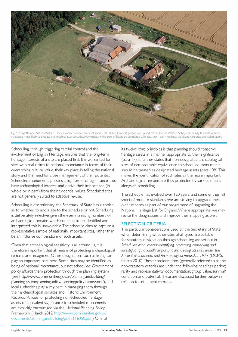
Fig 7. St Aylotts, near Saffron Walden, Essex, a moated manor house of about 1500 (listed Grade I), perhaps an upland retreat for the Walden Abbey community. It stands within a scheduled moat, likely to predate the house by two centuries. Many moats in this part of Essex are associated with assarting – early medieval woodland clearance and colonisation.
SELECTION CRITERIAThe particular considerations used by the Secretary of State when determining whether sites of all types are suitable for statutory designation through scheduling are set out in Scheduled Monuments: identifying, protecting, conserving and investigating nationally important archaeological sites under the Ancient Monuments and Archaeological Areas Act 1979 (DCMS, March 2010). These considerations (generally referred to as the non-statutory criteria) are under the following headings: period; rarity and representativity; documentation; group value; survival/condition; and potential. These are discussed further below in relation to settlement remains.
Settlement Sites to 1500Scheduling Selection GuideEnglish Heritage 14
SPECIFIC CONSIDERATIONS WHEN ASSESSING SETTLEMENT REMAINS FOR DESIGNATION As much of the country has been settled for thousands of years, the number of known settlement sites is enormous, and constantly increasing. As discussed above, the variety of sites is considerable, from individual huts used on an occasional basis by hunters or herdsmen, via individual farms, small clusters of dwellings, to major cities occupied over many hundreds of years. Notably within upland areas, which are lightly (if at all) cultivated, relatively large numbers of settlement sites are scheduled, sometimes together with associated agricultural or industrial remains, producing spatially extensive designations. Elsewhere, particularly in lowland England, scheduling has tended to be reserved for more discrete sites. A reasonable proportion of these are evidenced by upstanding earthworks, and sometimes by ruinous or even surviving structures such as a single working farm (which may be listable) on the site of a deserted village. Many other sites are invisible to the eye at ground level, but have been located either from the air as crop-marks or soil-marks, or through field walking which has recovered pottery or artefact scatters, or geophysical survey, or – increasingly – as a result of metal detecting. Whatever the date or type of site, there will need to be specific assessments of which sites are deemed nationally important, and of which of those ought to be recommended for scheduling according to the following non-statutory criteria and other relevant considerations.
PERIOD Being strongly representative of a period is likely to be an important claim to special interest. Settlements which survive from periods about which relatively little is known (such as the post-Roman period) will have particular importance. Scheduling has rarely been deployed for post-medieval settlement sites, which tend to be protected through listing.
Complex sites demonstrating different phases of development, perhaps over a long period, may be favoured for designation – by reason of their greater archaeological potential - over those which have simplicity of form perhaps indicating relatively short-term occupation.
RARITY AND REPRESENTATIVITYIn most periods, settlement sites exhibit marked regional variation, responding (among other variables) to local traditions, economies, building materials and terrain. It is important that candidates for scheduling reflect this variation. In the case of frequently encountered site-types, the aim of designation will be to identify for scheduling a selection of the best and most representative examples. Conversely, with rare site types a far more inclusive approach will be taken.
Where surviving sites are so numerous that selection is required for designation, those which are complete – notably in terms of their spatial extent, but also in terms of fabric – will generally be favoured for designation over those which survive only partially.
DOCUMENTATIONA site which has good documentation (whether contemporary, such as medieval manorial surveys or early estate maps; or modern surveys or excavation records) leading to its fuller understanding will be more likely to be designated than one with sparse records.
GROUP VALUESettlements rarely stood alone: they typically lie alongside, or within walking distance, of the places where the inhabitants worked: such as farmland, or an industrial complex. The claim to designation will tend to be strengthened where settlement remains lie alongside at least a representative sample of such agricultural or industrial remains, as this juxtaposition of dwellings with means of livelihood can tell a fuller story of how past lives were led. Sites can also have group value where they lie within a wider local cluster of contemporary sites, or are part of a sequence of sites that developed through time.
SURVIVAL AND CONDITIONEspecially with rarer site types, completeness is not a requirement for designation. Survival rates are likely to vary considerably, and an assessment should be undertaken comparing the survival of the candidate site with other examples. Condition can, however, affect the overall importance of a site very considerably. Normally the scheduled area will encompass the full extent of the known settlement area, where this survives in a condition to merit such a high level of protection. In cases where a field system or industrial remains lie alongside settlement remains (as noted above, under Group Value), a representative sample of the latter may be included within the scheduled area, even if scheduling of the whole cannot be supported using the relevant criteria for that type of site.
DIVERSITYDiversity, in the scheduling sense, refers to the range of features that are generally found in a site of a certain kind. The importance of a site is likely to be enhanced if it possesses a wide range of those components which may be anticipated in a site of a certain kind. Occasionally, an exceptional survival of one feature can be enough to warrant scheduling, however.
ARCHAEOLOGICAL POTENTIALOne of the key purposes of scheduling is to offer protection to high-quality archaeological remains which have the potential to yield information about the site and its period. This potential needs to be considered, and relevant factors weighed up, such as soil conditions and intactness. True significance is not always readily apparent: some sites which are superficially the most legible and compelling are not necessarily the most important. For instance, well-defined earthworks on a medieval settlement site may be of a late phase of activity (perhaps a post-desertion farm) rather than being representative of the settlement itself. Equally, highly legible crop- or soil-marks of a prehistoric or Romano-British site may indicate it has been largely ploughed-out, leaving little undisturbed archaeology.
EXTENSIVE LANDSCAPESIn recent years scientific survey techniques such as rapid geophysical survey and lidar (Light Detection And Ranging) have revealed apparently well-preserved landscapes combining
Settlement Sites to 1500Scheduling Selection GuideEnglish Heritage 15
settlements and their surrounding fields, sometimes with multiple phases suggesting considerable time-depth. Some stretch for miles: West Heslerton (North Yorkshire) is one spectacular discovery of this type. While there is little doubt about the importance of these extensive landscapes, and the recognition that significance can also reside in the areas between the more obvious sites, it has not been our general practice to schedule huge tracts of land. Where broad areas of land are being proposed for scheduling, careful steps will be taken to ensure appropriate management responses are in hand too.
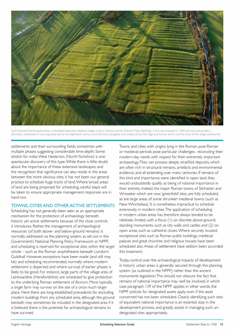
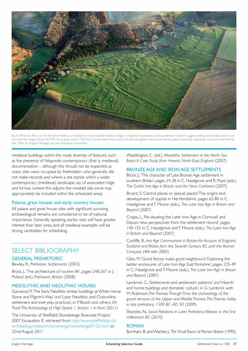
Fig 8. Nobold, Northamptonshire, a scheduled deserted medieval village. Lying in Clipston parish, Nobold (‘New Building’) is first documented in 1284 and was presumably a secondary settlement. It was long-deserted by the eighteenth century, and had been ploughed over, evidenced by the ridge and furrow which overlies most of the village earthworks.
TOWNS, CITIES AND OTHER ACTIVE SETTLEMENTSScheduling has not generally been seen as an appropriate mechanism for the protection of archaeology beneath historic yet active settlements because of the close controls it introduces. Rather, the management of archaeological resources (of both above- and below-ground remains) is normally addressed via the planning system, as set out in the Government’s National Planning Policy Framework or NPPF, and scheduling is reserved for exceptional sites within the larger whole – such as the Roman amphitheatre beneath London’s Guildhall. However, exceptions have been made (and still may be) and scheduling recommended, normally where modern settlement is dispersed and where survival of earlier phases is likely to be good. For instance, large parts of the village area of Leintwardine (Herefordshire) are scheduled to give protection to the underlying Roman settlement of Bravium. More typically, a single farm may survive on the site of a once much larger place. Here there are long-established precedents for excluding modern buildings from any scheduled area, although the ground beneath may sometimes be included in the designated area if it is believed there is the potential for archaeological remains to have survived.
Towns and cities with origins lying in the Roman, post-Roman or medieval periods pose particular challenges: reconciling their modern-day needs with respect for their extremely important archaeology. They can possess deeply stratified deposits, which are often rich in structural remains, artefacts and environmental evidence, and all extending over many centuries. If remains of this kind and importance were identified in open land, they would undoubtedly qualify as being of national importance in their entirety. Indeed, the major Roman towns of Silchester and Wroxeter which are now ‘greenfield’ sites, are fully scheduled, as are large areas of some shrunken medieval towns (such as New Winchelsea). It is nonetheless impractical to schedule extensively in modern cities. The application of scheduling in modern urban areas has therefore always tended to be relatively limited, with a focus (1) on discrete above-ground, standing monuments, such as city walls and castles and (2) on open areas, such as cathedral closes. Where securely located, exceptional sites such as Roman public buildings, medieval palaces and great churches and religious houses have been scheduled also. Areas of settlement have seldom been accorded this treatment.
Today, control over the archaeological impacts of development in historic urban areas is generally secured through the planning system (as outlined in the NPPF) rather than the ancient monuments legislation. This should not obscure the fact that remains of national importance may well be involved, in which case paragraph 139 of the NPPF applies: in other words, the NPPF policies for designated assets apply, even if the asset concerned has not been scheduled. Clearly identifying such sites of equivalent national importance is an essential step in the development process, and greatly assists in managing such un-designated sites appropriately.
Settlement Sites to 1500Scheduling Selection GuideEnglish Heritage 16
Some protection for below-ground urban archaeological remains is provided incidentally by conservation area designation (which provides particular controls over the nature of development which can take place), by listing (the presence of designated buildings also helps to protect any underlying remains from development) and by the presence of public open spaces such as parks, which leaves at least some areas of early occupation intact.
Areas of Archaeological ImportanceFinally, mention must also be made of Part II of the 1979 Act. This allows for the designation of ‘Areas of Archaeological Importance’ (AAIs), in which notice of proposed works which will disturb the ground must be given to an Investigating Authority, and time allowed for archaeological investigation if needed. This provision has only been implemented in five places (Exeter, York, Canterbury, Hereford and Chester). The AAI has not been proposed since 1979, and is no longer a current designation option. Local authorities may, however, declare a decreed zone to be an archaeological priority area for planning and investigation purposes.
Urban Archaeological Surveys and HERsProtection and management of the archaeological resource in urban areas is aided by three major survey programmes which English Heritage has been supporting since the early 1990s. Urban Archaeological Databases (UADs) provide detailed information and mapping on the archaeology of around thirty of England’s most important historic towns and cities. Extensive Urban Surveys (EUS) cover smaller towns on a county-by-basis. For the large ‘metropolitan’ conurbations, a form of Historic Landscape Characterisation (HLC) provides detailed information on character and land-use history. The results of all of these surveys are held in the relevant local authority Historic Environment Records (HERs); many of the reports are available on-line. Maintaining information on early settlements through an Historic Environment Record is essential if due safeguards are to be put in place for development in an urban context; HERs are also essential for any designation assessments.
For further information, including details of coverage see the following links.
Information about UAD and EUS projects: http://www.english-heritage.org.uk/professional/research/landscapes-and-areas/characterisation/townscape-character/
For on-line EUS town assessment reports: http://archaeologydataservice.ac.uk/archives/view/EUS/
Information about HLC: http://www.english-heritage.org.uk/professional/research/landscapes-and-areas/characterisation/historic-landscape-character/
For on-line HLC reports and data: http://archaeologydataservice.ac.uk/archives/view/HLC/
DESIGNATION CONSIDERATIONS BY PERIODPREHISTORICGeneralBecause of their rarity most prehistoric settlement sites of Bronze Age and earlier date will be reckoned of national importance and strong candidates for scheduling. With later prehistoric settlement sites, some types, such as Iron Age farmsteads in the east midlands, are relatively common; while many are likely to be assessed as nationally significant, here there will need to be discrimination in scheduling recommendations and considerations such as condition, group value and potential will need evaluation.
DoggerlandAs yet no Doggerland site has been considered for designation via scheduling. The selection criteria set out in this selection guide would form a basis for assessment were scheduling to be proposed, although it would need to be additionally considered if any identified national importance could be sustained through positive management.
ROMANWhere they retain reasonable archaeological potential, Roman settlement sites will be deemed to have national importance. However, in some areas, both upland and lowland, certain types of settlement are sufficiently common to require discrimination in terms of scheduling recommendations. Again, considerations such as condition, group value and potential will require evaluation.
ANGLO-SAXON AND VIKINGIt has only been in the last 30 years that survey has successfully located rural settlements of the period 400-1066, and identified sites with known archaeological potential remain relatively rare. All such will be reckoned nationally important and strong candidates for scheduling.
MEDIEVAL There was wide variety in medieval rural settlement types, both through time and geographically. Roberts and Wrathmell’s English-Heritage sponsored An Atlas of Rural Settlement in England (2003) plotted regional variation, and offered classifications. Surviving medieval settlement remains whose quality and potential gives them national importance are sufficiently common in many parts of the country that discrimination is needed when making scheduling assesments. Such will be influenced, especially in terms of assessing rarity and representativity, by the Atlas, but the other non-statutory criteria such as group value, documentation and especially potential will be at least equally important.
Moated sitesSo many moated sites are known (some 6,000) that some additional scheduling guidance is desirable, especially for areas where they are fairly commonplace, such as parts of East Anglia. Factors which may favour designation include good quality earthworks; the demonstrable or likely survival of medieval archaeological deposits; the presence of listed
medieval buildings within the moat; diversity of features, such as the presence of fishponds; contemporary (that is, medieval) documentation – although this should not be expected, as many sites were occupied by freeholders who generally did not make records; and where a site stands within a wider, contemporary (medieval), landscape, say of associated ridge and furrow (where this adjoins the moated site some may appropriately be included within the scheduled area).
Palaces, great houses and early country housesAll palace and great house sites with significant surviving archaeological remains are considered to be of national importance. Generally speaking, earlier sites will have greater interest than later ones, and all medieval examples will be strong candidates for scheduling.
Settlement Sites to 1500Scheduling Selection GuideEnglish Heritage 17
Fig 9. Wharram Percy, on the Yorkshire Wolds, is probably the most-studied medieval village in England. Excavations and documentary research suggest existing farmsteads were recast as a planned village around AD 900. At its peak, about 1300, forty families lived here. Later it shrank, ploughland was converted to pasture, and only shepherds may have lived here by the 1540s. An English Heritage site and scheduled monument.
SELECT BIBLIOGRAPHY GENERAL PREHISTORICBewley, R., Prehistoric Settlements (2003)
Brück, J., ‘The architecture of routine life’, pages 248-267 in J. Pollard (ed.), Prehistoric Britain (2008)
MESOLITHIC AND NEOLITHIC HOUSESGarwood, P., ‘The Early Neolithic timber buildings at White Horse Stone and Pilgrim’s Way’ and ‘Later Neolithic and Chalcolithic settlement and everyday practices’, in P. Booth and others, On Track: The Archaeology of High Speed 1, Section 1 in Kent (2011)
The University of Sheffield.,’Stonehenge Riverside Project: 2007 Excavation II’, retrieved from http://www.sheffield.ac.uk/archaeology/research/stonehenge/stonehenge07-02.html on 22nd August 2011
Waddington, C. (ed.), Mesolithic Settlement in the North Sea Basin: A Case Study from Howick, North-East England (2007)
BRONZE AGE AND IRON AGE SETTLEMENTSBrück, J., ‘The character of Late Bronze Age settlement in southern Britain’, pages 24-38 in C. Haselgrove and R. Pope (eds.), The Earlier Iron Age in Britain and the Near Continent (2007)
Bryant, S. ‘Central places or special places? The origins and development of oppida in Hertfordshire’, pages 62-80 in C. Haselgrove and T. Moore (eds.), The Later Iron Age in Britain and Beyond (2007)
Cripps, L., ‘Re-situating the Later Iron Age in Cornwall and Devon: new perspectives from the settlement record’, pages 140-155 in C. Haselgrove and T. Moore (eds.), The Later Iron Age in Britain and Beyond (2007)
Cunliffe, B., Iron Age Communities in Britain: An Account of England, Scotland and Wales from the Seventh Century BC until the Roman Conquest (4th edn 2005)
Giles, M. ‘Good fences make good neighbours? Exploring the ladder enclosures of Late Iron Age East Yorkshire’, pages 235-49 in C. Haselgrove and T. Moore (eds.), The Later Iron Age in Britain and Beyond (2007)
Lambrick, G., ‘Settlements and settlement patterns’ and ‘Hearth and home: buildings and domestic culture’, in G. Lambrick with M. Robinson,The Thames Through Time: the archaeology of the gravel terraces of the Upper and Middle Thames. The Thames Valley in late prehistory: 1500 BC–AD 50 (2009)
Sharples, N., Social Relations in Later Prehistory: Wessex in the first millennium BC (2010)
ROMANBurnham, B. and Wacher, J., The ‘Small Towns’ of Roman Britain (1990)
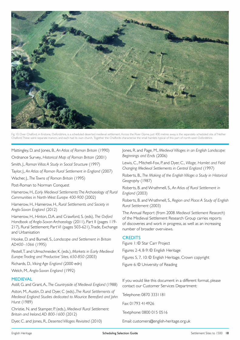
Settlement Sites to 1500Scheduling Selection GuideEnglish Heritage 18
Fig 10. Over Chalford, in Enstone, Oxfordshire, is a scheduled deserted medieval settlement. Across the River Glyme, just 400 metres away, is the separately scheduled site of Nether Chalford. These were separate manors, and each had its own church. Together the Chalfords characterise the small hamlets typical of this part of north-west Oxfordshire.
Mattingley, D. and Jones, B., An Atlas of Roman Britain (1990)
Ordnance Survey., Historical Map of Roman Britain (2001)
Smith, J., Roman Villas: A Study in Social Structure (1997)
Taylor, J., An Atlas of Roman Rural Settlement in England (2007)
Wacher, J., The Towns of Roman Britain (1995)
Post-Roman to Norman Conquest
Hamerow, H., Early Medieval Settlements: The Archaeology of Rural Communities in North-West Europe 400-900 (2002)
Hamerow, H., Hamerow, H., Rural Settlements and Society in Anglo-Saxon England (2012)
Hamerow, H., Hinton, D.A. and Crawford, S. (eds), The Oxford Handbook of Anglo-Saxon Archaeology (2011), Part II (pages 119-217), Rural Settlement; Part VI (pages 503-621), Trade, Exchange and Urbanisation
Hooke, D. and Burnell, S., Landscape and Settlement in Britain AD400–1066 (1995)
Pestell, T. and Ulmschneider, K. (eds.), Markets in Early Medieval Europe: Trading and ‘Productive’ Sites, 650-850 (2003)
Richards, D., Viking Age England (2000 edn)
Welch, M., Anglo-Saxon England (1992)
MEDIEVALAstill, G. and Grant, A., The Countryside of Medieval England (1988)
Aston, M., Austin, D. and Dyer, C (eds).,The Rural Settlements of Medieval England: Studies dedicated to Maurice Beresford and John Hurst (1989)
Christie, N. and Stamper, P. (eds.), Medieval Rural Settlement: Britain and Ireland, AD 800-1600 (2012)
Dyer, C. and Jones, R., Deserted Villages Revisited (2010)
Jones, R. and Page, M., Medieval Villages in an English Landscape: Beginnings and Ends (2006)
Lewis, C., Mitchell-Fox, P. and Dyer, C., Village, Hamlet and Field Changing Medieval Settlements in Central England (1997)
Roberts, B., The Making of the English Village: a Study in Historical Geography (1987)
Roberts, B. and Wrathmell, S., An Atlas of Rural Settlement in England (2003)
Roberts, B. and Wrathmell, S., Region and Place: A Study of English Rural Settlement (2003)
The Annual Report (from 2008 Medieval Settlement Research) of the Medieval Settlement Research Group carries reports of discoveries and work in progress, as well as an increasing number of broader overviews.
CREDITSFigure 1: © Star Carr Project
Figures 2-4, 8-9: © English Heritage
Figures 5, 7, 10: © English Heritage, Crown copyright
Figure 6: © University of Reading
If you would like this document in a different format, please contact our Customer Services Department:
Telephone: 0870 3331181
Fax: 01793 414926
Textphone: 0800 015 0516
Email: [email protected]