Embed Size (px)
Citation preview

Summer Field Research Grants for Graduate Students in Latin America, the Caribbean, and the
Iberian Peninsula
Settlement Patterns at the Pre-Classic Maya Site of Xtobo, Yucatán
Scott A. J. Johnson
Department of Anthropology
Tulane University
The Pre-Classic Maya site of Xtobo on the Northwestern Yucatan peninsula is currently
being excavated by David Anderson, a Ph.D. candidate of Tulane’s Anthropology department. His
doctoral dissertation research is focused on the internal activities and structures of this site. My
work this summer was taking part in the mapping the settlement pattern of architectural mounds
surrounding the site center. The study of commoner structures at Maya sites has recently become a
popular aim of archaeological research. By collecting data on the size, shape, and location of
architectural features in relation to each other and the site center, archaeologists can draw many
conclusions about the site. For instance, the size and density of house mounds can be used to
extrapolate population estimates for the site. The size of house mounds or compounds can also be
interpreted as socio-economic class indicators. The arrangement of structures around the site center
can also be used to define the edges of the site proper.
The Site of Xtobo: Located in the Northwest corner of the Yucatan Peninsula, the site of Xtobo was only first
recorded in 2002, along with hundreds of other newly found sites (Robles C. and Andrews 2003;
cited in Anderson 2005: 2). Based on a 2004 survey and the initial recording (Anderson 2004: 2-4),
the site covers approximately 1 km2 and dates from the middle Pre-Classic period (700-300 BCE).
The site has more monuments than suggested by it size, boasting a plaza on a low platform, a small
ballcourt, a large pyramid (35x27m basal, 7.5m high), a number of smaller pyramids, and a
surprisingly high number of sacbe’ob (causeways) (Anderson 2004: 4). Although it was only
recently found, there have been interesting discussions about regional site hierarchies and
interaction with the nearby sites of Kintunich and Nuevo Chalmuch suggesting Xtobo was a small
regional center (Anderson 2004: 10-14 & 2005: 16-20). These discussions have been based on data
gleaned from the initial 2002 and subsequent 2004 surveys. The possibility of future interpretation
is wide open for research.
Before this summer, only surface survey and test pits had been dug at the site (Anderson
2004: 1). The first step of the project is to create an accurate topographic/site map and second, to
begin more extensive excavations (Anderson 2007: personal communication). Previously
recovered ceramics have been analyzed and the monumental site center has been mapped, as can be
seen in Figure 1. Figure 1 shows the current mapped region of Xcopte. The area highlighted in red
was mapped in a previous field season. The mounds (indicated on the map by the concentric
topographic circles) which are found outside of the shaded area were mapped during this field
season. The areas to the West and North are still in the process of being mapped, as there was not
enough time to complete this aspect during my field season.
Fieldwork: The primary goal of the summer was to create a topographic map of the settlement
architecture outside of the site center of Xtobo. After clearing permit hurdles with the Instituto
Nacional de Arqueologia e Historia (INAH), David Anderson, 8-10 Yucatec Maya-speaking
workers, and I began to create a grid of trails over the entire 1 square kilometer of the site. This
was done by use of a total station (surveying equipment) and brute force. David and I laid out
stakes to guide the workmen as they used machetes and axes to cut absolutely straight trails through
the entire site. Each trail ran directly North/South or East/West and were spaced at 100 meter

intervals. The resulting criss-crossing of trails created a grid of 100 by 100 meter squares, seen in
Figure 2. Each of these squares was systematically searched by David, our workers, and myself,
looking for the low mounds of rubble that indicated a 2000 year-old building had stood there.
When a new mound was encountered everybody would work to clear it off. After which, David and
I would use the total station to map in topographic points (points taken in three-dimensions), which
would later be entered into the computer to create the map seen below. As with all archaeological
fieldwork, the method is rather straightforward but is a matter of repetition, as hundreds of new
mounds have been encountered.
Findings: I would like to first introduce the expected findings of this summer's research, and then
contrast this with what we have been observing on the ground. First, I had hoped that with the data
gleaned from this mapping season, I would be able to present results on the decrease of of large,
elite houses, as distance from the site center decreased. Second, I was interested in looking at how
the nearby centers affected the settlement pattern around Xcopte. My final goal would have been a
predictive model of fall off of settlement density at greater distances from the site center.
Unfortunately, a number of factors prevented me from collecting all of the necessary data for such
analysis. Luckily, however, a number of other significant findings can be reported in their place.
As to why my initial research goals cannot be fully addressed: There are innumerable factors
that can impede and slow the collection of archaeological data. First, delay in acquiring the
permission of the national government of the host country is an unfortunately common occurrence
in archaeology. In our case, this caused a minor delay in the official start of our field season, but lab
work kept us busy at the project house. Second, we encountered a further short delay because the
municipality which owned the land on which Xcopte sits, Ucu, wanted to have a town meeting
before the project could begin. Once we started, opening the 20 linear kilometers of grid trail took a
considerable amount of time, before we could even begin to map in new mounds. After we
completed the grid system, we began to find larger and more mounds than expected. This was of
course a boon for statistical significance of the data we were collecting, but it also slowed our
progress. By the time I returned, after 12 weeks in Mexico, we had only been able to map about
half of what we had expected. Therefore, I am only able to draw conclusions from the South and
Western portions of the site. My initial questions should be answerable when David has concluded
the mapping portion of the site, sometime in mid-October. I hope to report on them during my oral
presentation.
Regarding my hypothesis, a number of observations can be made. Structures do appear to
generally decrease in size and density although even at great distance from the center, there are
relatively large structures. In regards to elite houses decreasing in quantity at greater distances from
the center, it will be difficult to comment on this until excavation data are available to better assign
mounds to their correct social strata.
Even the preliminary data have indicated a few surprising results. Unlike the vast majority
of sites in Latin America, the structures at Xcopte are oriented radially, facing the site plaza instead
of alignment along a site axis. This is true of structures that are far enough from the center that it
may not have been visible. Furthermore, the expected total of outlying structures was 250 but with
half of the outside mapped looks like this figure should be doubled, suggesting that the population
of this early site was extremely high and dense. Another significant finding this summer was the
identification of more sacbeob (causeways), the majority of which lead to the site center (recently,
however, a perpendicular sacbe has been found, confounding all current theories).

Figures:
Figure 1: Current Topographic map of Xtobo (work still in progress, after map courtesy of David
Anderson)
1°
TN
Marsh Land
Permanent, Dry Land
Pueblo
1°
TN
Marsh Land
Permanent, Dry Land
Pueblo
1°
TN
Marsh Land
Permanent, Dry Land
Pueblo
1°
TN
Marsh Land
Permanent, Dry Land
Pueblo
1°
TN
Marsh Land
Permanent, Dry Land
Pueblo
1°
TN
0 100m 200m
Previously Surveyed Area
1°
TN Key
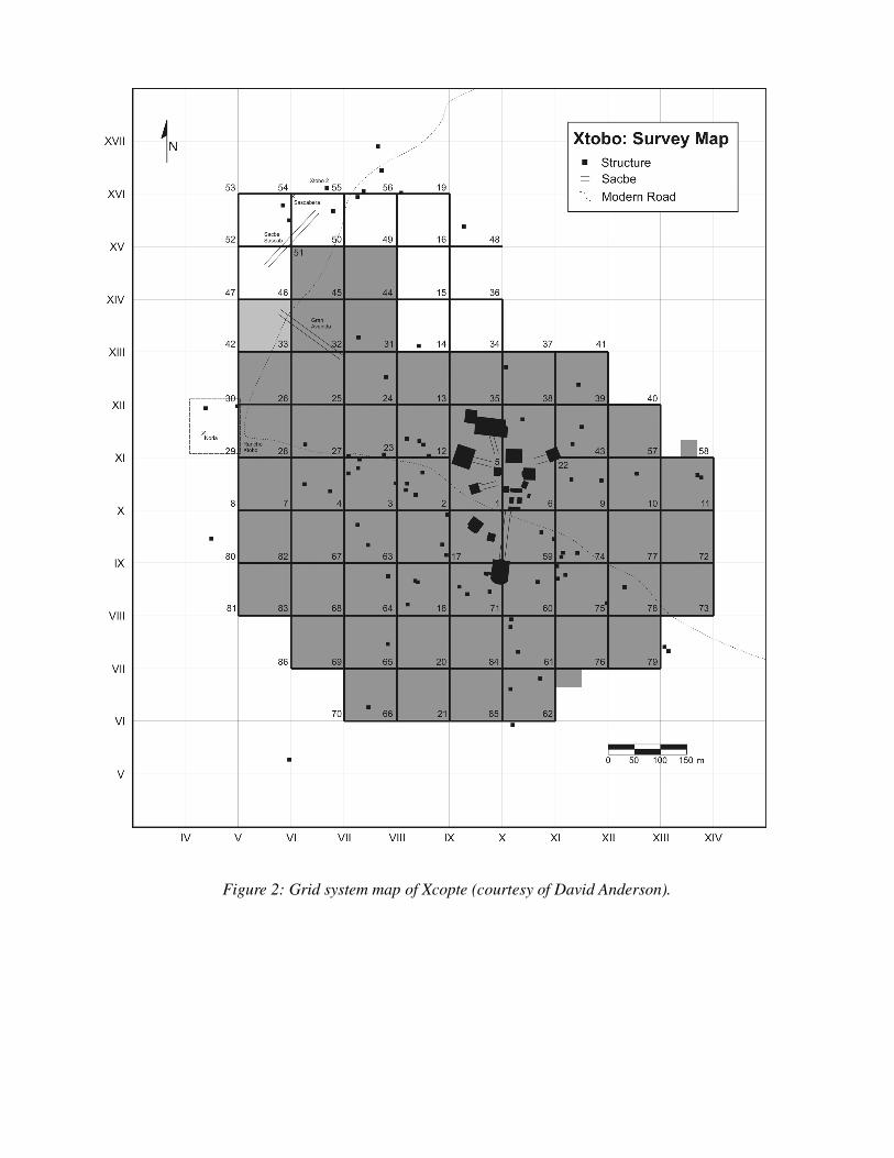
Figure 2: Grid system map of Xcopte (courtesy of David Anderson).


Works Cited:
Anderson, David S.
2004 A Report on Activities at Xtobo, Yucatán, México. Electronic document,
http://studentweb.tulane.edu/~danders3/papers/Report2004.pdf, accessed February
13, 2007.
2005 Xtobo and New Visions of the Maya Preclassic. Paper presented at the Archaeology
Lunch Talk Series, Peabody Museum, Harvard University.
Robles C., Fernando and Anthony P. Andrews (editors)
2003 Proyecto Costa Maya: Reporte interino, Temporada 2002: Reconocimiento
arqueológico de la esquina noroeste de la peninsula de Yucatan. Instituto Nacional
de Antropología e Historia, Centro INAH Yucatán, Mérida.