Embed Size (px)
Citation preview
Exploration: Then and Now NASA and Jamestown Education ModuleEG-2006-09-25-LaRC Settlement Page 1 of 21
SettlementExploration: Then and Now
Grade Level: 6–8
Connections to Curriculum:
Science and Geography
Teacher Preparation Time:
20 MinutesLesson Duration:
Five 50-Minute Class Periods
(See Pacing Chart for Options)
National Science Education Standards
Science as Inquiry
Physical Science
Earth Science
Science and Technology
National Geography Standards
The World in Spatial Terms
Human Systems
The Uses of Geography
Essential QuestionHow do an area’s location, soil, andweather affect settlement?
Lesson OverviewThis lesson compares the location, soil,and weather of early Jamestown to theMoon as each site is considered forsettlement. Students use maps andgraphs to look for patterns and thenmake inferences about ways thatlocation and weather affect settlements.Students also conduct experiments togather data about space radiationshielding and Moon regolith formationand then compare their findings toEarth’s weather and soil.
Background InformationSettlement is affected by location, soil,weather, and access to naturalresources.
From the 17th century to the 21stcentury, all explorers begin with onebasic need: a suitable place to live.
Instructional ObjectivesStudents will:
• look for patterns in the location of New World colonies;• plot the Apollo landings on the Moon and identify lunar surface features of
each landing site;• make correlations between rainfall and mortality in Jamestown from 1604
through 1615;• interpret and make inferences about rainfall based upon tree rings;• gather data on space radiation shielding by observing a flashlight beam as
it shines through different materials;• investigate the effects of micrometeoroid bombardment on regolith
formation;• make inferences about properties of regolith based upon observations;• compare samples of the Earth’s soil with simulated lunar regolith; and• compare the differences in challenges faced by 17th-century and 21st-
century explorers.
Exploration: Then and Now NASA and Jamestown Education ModuleEG-2006-09-25-LaRC Settlement Page 2 of 21
Materials(Students will need journals and class charts in order to organizeinformation throughout this lesson.)
EngagePer class:
• Overhead transparency of “Map of Original 13 Colonies”• Atlases and United States maps• Overhead projector
Per student:• “Map of the Moon”• “Apollo Landing Sites Chart”
ExploreActivity One: WeatherPer class:
• Overhead transparency of “Jamestown Rainfall Index and Mortality Rate”• Overhead projector• Cross sections of tree limbs or trunks (optional)
Per student:• “Tree-Ring Cross Section Drawing”
Activity Two: Space WeatherPer group:
• Flashlight• Metric ruler• Materials to test (all materials should be the same color and about the
same size)*several sheets of unlined copy paper*several sheets of tissue paper*several sheets of construction paper*several sheets of card stock paper
ExplainPer student:
• “NASA and Jamestown Settlement Chart: Location”• “NASA and Jamestown Settlement Chart: Weather”• “NASA and Jamestown Settlement Chart: Soil”
ExtendPer group:
• Microscope or magnifier• Box lid (shoe-box size)• Larger box or lid (must be able to fit shoe-box-size lid inside this box or lid)• Cinnamon sugar graham crackers (enough to line the bottom of the small
shoe-box lid)• Three to four white-powdered sugar and cake mini-donuts (day-old works
best)• Three index cards
Exploration: Then and Now NASA and Jamestown Education ModuleEG-2006-09-25-LaRC Settlement Page 3 of 21
• Clear packing tape• Two different-sized wire strainers (colander, tea strainer, etc.) or two
pieces of different-sized wire screens• One pair of scissors• Four containers for holding sifted regolith• One-hole punch• Marker• Earth’s soil samples
Vocabularyabiotic: not living
basalt: dark gray to black, dense igneous rock
bay: an inlet of the ocean partly surrounded by land
biotic: living
dendrochronology: the science of dating events by comparative study of growthrings in trees
drought: a long period of dry weather
geologic terrains: physical features of a piece of land
highland: elevated land on the Moon
impact craters: craters caused by asteroids and meteorites
isthmus: a narrow strip of land connecting two larger land areas
magnetosphere: that region of space around Earth affected by Earth’s magneticfield such that charged particles are trapped in it
maria: mostly flat, dark areas on the surface of the Moon
mortality: the rate of death in a given population
ozone: the layer of Earth’s atmosphere at about 32 to 48 kilometers (20 to 30miles) that helps block most solar ultraviolet radiation from entering the loweratmosphere
peninsula: a portion of land surrounded by water on three sides
Exploration: Then and Now NASA and Jamestown Education ModuleEG-2006-09-25-LaRC Settlement Page 4 of 21
rainfall index: the amount of rainfall from a series of observations; used as anindicator or measure
rays: the material that is scattered on the Moon’s surface when craters arecreated
regolith: a mixture of fine dust and rocks that covers the Moon’s surface
rilles: long, narrow valleys on the Moon that formed as underground lavachannels collapsed once the hot lava flowed away
solar wind: streams of particles from the Sun
topography: the physical or natural features of the land’s surface
ultraviolet rays: electromagnetic radiation that has a wavelength shorter thanwavelengths of visible light and longer than x-rays; rays that have more energythan visible light and can cause chemical reactions
wetlands: land or area, such as a tidal flat or swamp, containing much moisture
5 classperiods
Suggested Pacing: Engage Explore Explain Extend Evaluate Total
50-minuteclass
period
Completedthroughoutthe lesson
1 classperiod
2 classperiods
1 classperiod
1 classperiod
Instructional ProcedureTeaching Suggestion: Prior to beginning this lesson, create a chart that will bedisplayed throughout the lesson to help organize student learning. Ask thestudents to create similar charts in their journals. The charts may be formatted asfollows, but must be large enough to organize information.
How do location, weather, and soil affect settlement?
JAMESTOWN MOON
LOCATION
WEATHER
SOIL
Exploration: Then and Now NASA and Jamestown Education ModuleEG-2006-09-25-LaRC Settlement Page 5 of 21
Engage1. Discuss the following questions as a class or ask students to write theirthoughts in their journals:
• How does the place where you live affect:o the clothes you wear?o the materials you use to build your homes?o the types of food you can grow?o your leisure activities?
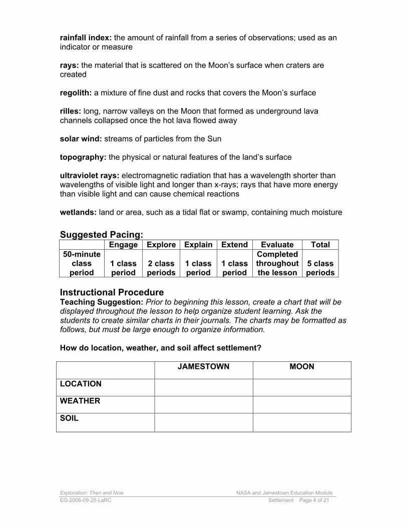
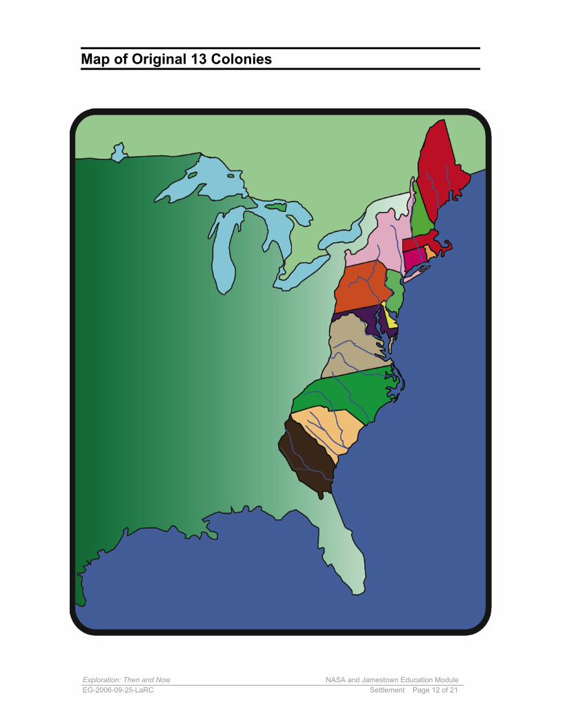
2. A settlement’s location affects the quality of life for that settlement. Remindstudents that the first settlers traveled by ship to the New World. Make anoverhead transparency of the “Map of the Original 13 Colonies”. Ask students tolocate the Chesapeake Bay and the Massachusetts Bay. Review with studentsthe definition of a bay. (A bay is an inlet of the ocean partly surrounded by land.)
Map of the Original 13 Colonies
3. Explain that colonial towns were built close to the water because access to aport was important. Discuss why ports were important to the development of acolonial town. (Major towns and cities needed access to ships bringing peopleand goods to and from Europe.)4. Ask students to use maps and atlases to locate the following colonial cities:
• Boston, MA• Plymouth, MA• Philadelphia, PA• Baltimore, MD• Williamsburg, VA• Jamestown, VA
5. Discuss the following questions as a class or ask students to write theirthoughts in their journals:
• What is similar about the locations of all of these colonial cities?• How does location affect settlement?
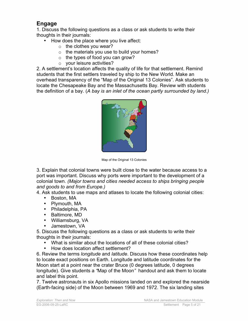
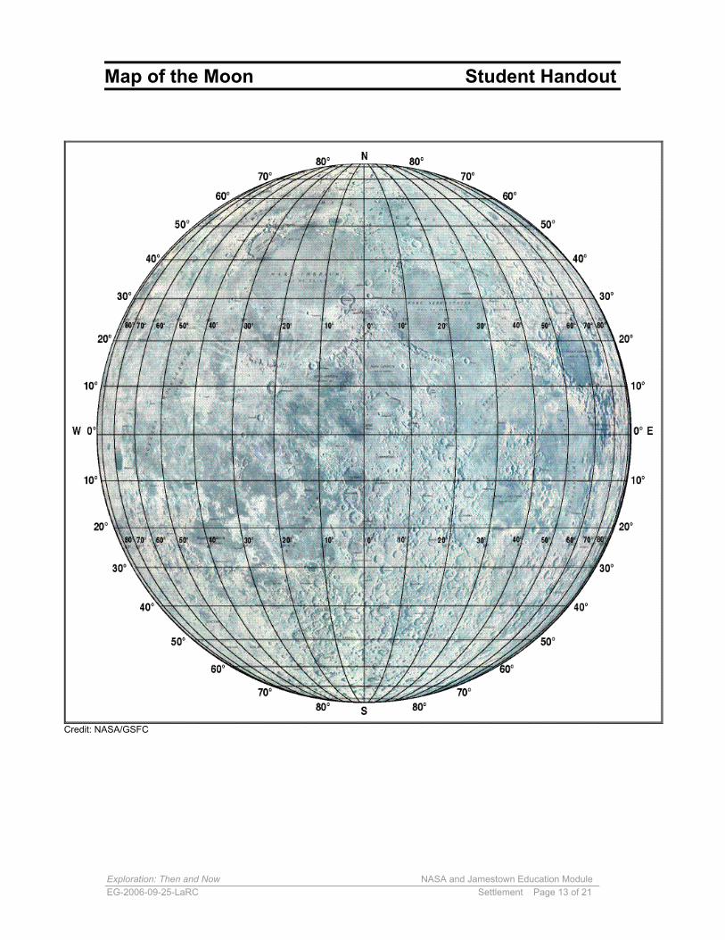
6. Review the terms longitude and latitude. Discuss how these coordinates helpto locate exact positions on Earth. Longitude and latitude coordinates for theMoon start at a point near the crater Bruce (0 degrees latitude, 0 degreeslongitude). Give students a “Map of the Moon” handout and ask them to locateand label this point.7. Twelve astronauts in six Apollo missions landed on and explored the nearside(Earth-facing side) of the Moon between 1969 and 1972. The six landing sites
Exploration: Then and Now NASA and Jamestown Education ModuleEG-2006-09-25-LaRC Settlement Page 6 of 21
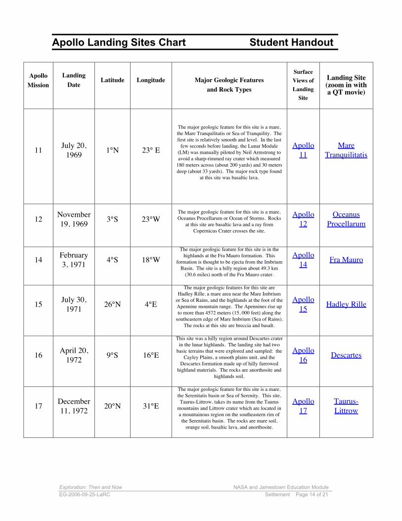
were chosen to explore different geologic terrains. Give each student a copy ofthe “Apollo Landing Sites Chart.” Ask the students to locate the Apollo landingsites on their map of the Moon and to mark these sites with the number of theApollo mission. Ask students to identify the topography of the site usinginformation in the chart and from the map.
Map of the Moon
Apollo Landing Sites Chart
Technology Insertion Point: Sections of the Apollo Landing Sites Chart arelinked to images and QuickTime movies. To maintain active links, students mustaccess this chart on the computer. If the instructor uses paper copies of thechart, information on the links should be printed.
8. Discuss the following questions as a class or ask students to write theirthoughts in their journals:
• How would you describe the lunar landing sites?• Identify similar terrain on the map.• Why do you think these six sites were chosen?• If you were to choose the next lunar landing site, what site would you
choose? Why?• How does a site’s location, on the Moon or on Earth, affect settlement?
9. Ask students to add information to the charts they created earlier in theirjournals. Return to the class chart and add information learned during theseactivities.
Teaching Suggestion: The Apollo Landing Sites activity was modified fromExploring the Moon: a Teacher’s Guide with Activities. Additional activities maybe found in this document, http://lunar.arc.nasa.gov/education/lesson.htm
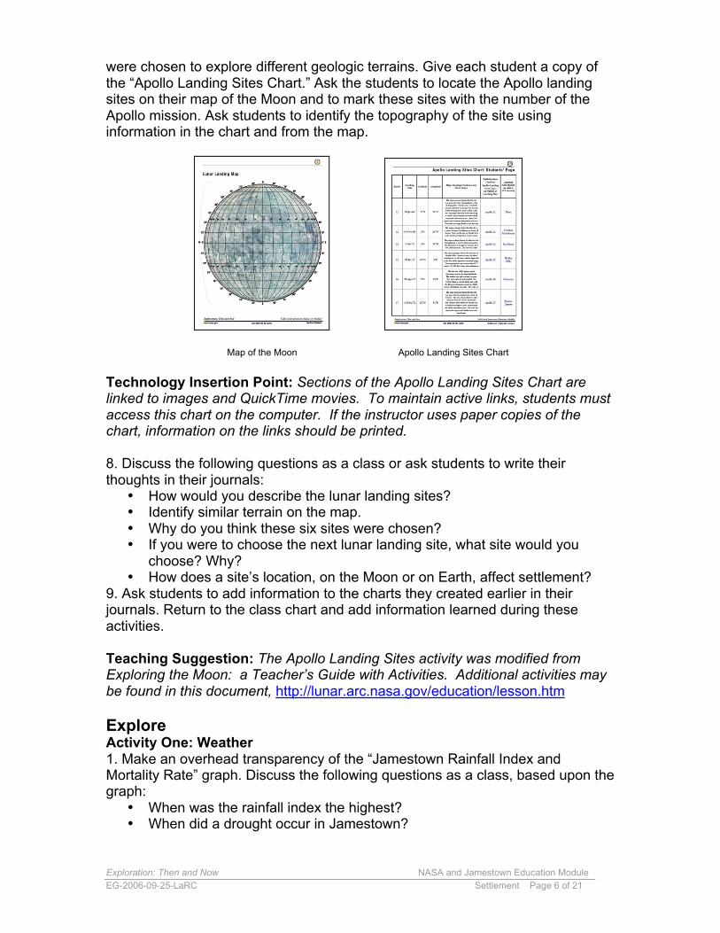
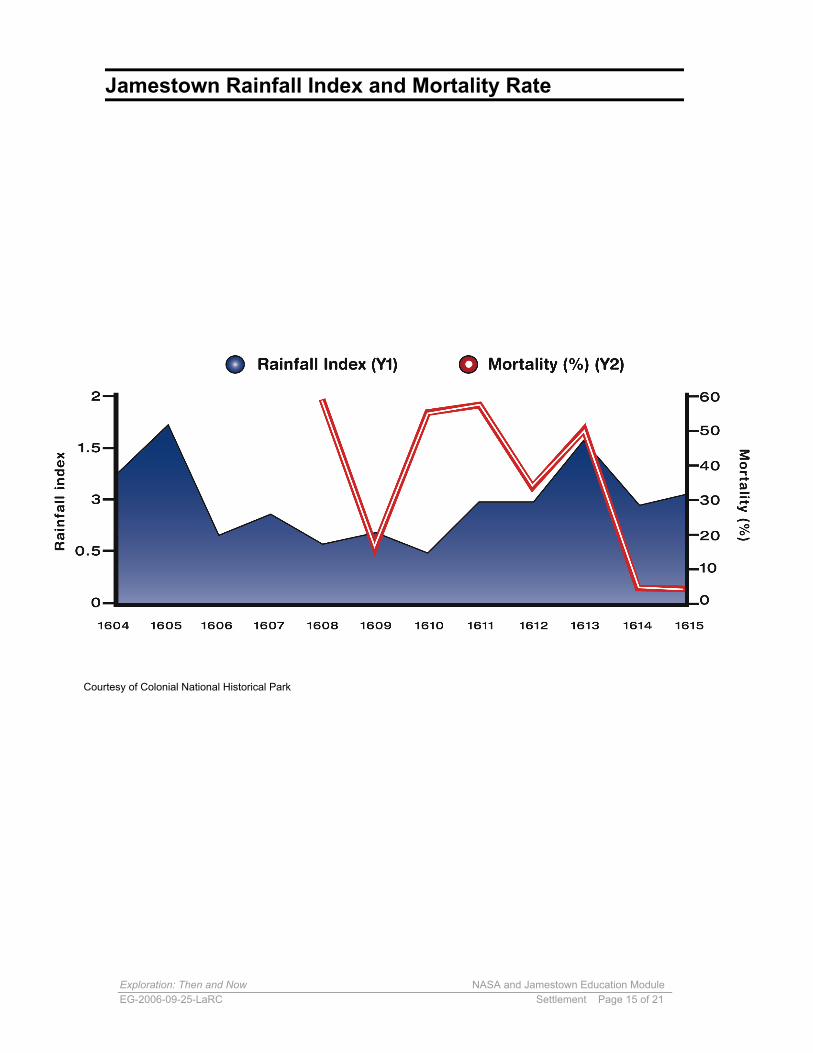
ExploreActivity One: Weather1. Make an overhead transparency of the “Jamestown Rainfall Index andMortality Rate” graph. Discuss the following questions as a class, based upon thegraph:
• When was the rainfall index the highest?• When did a drought occur in Jamestown?
Exploration: Then and Now NASA and Jamestown Education ModuleEG-2006-09-25-LaRC Settlement Page 7 of 21
• What is the correlation between low rainfall and mortality? Explain thiscorrelation.
Jamestown Rainfall Index and Mortality Rate
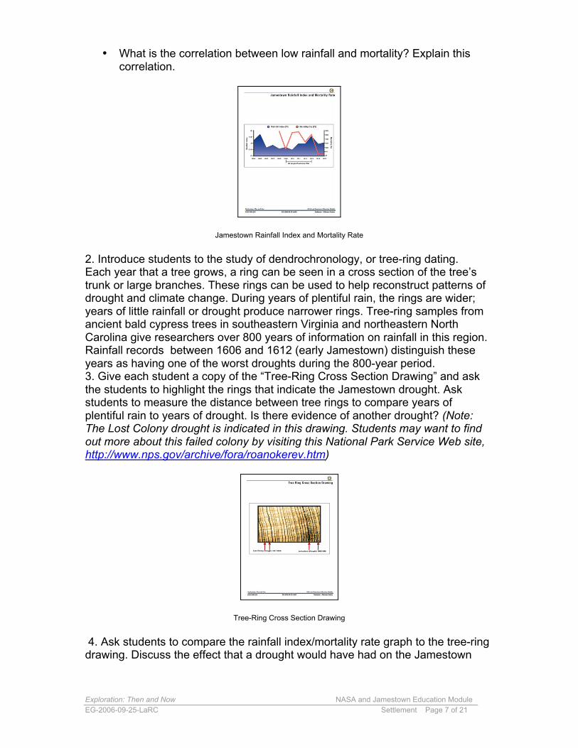
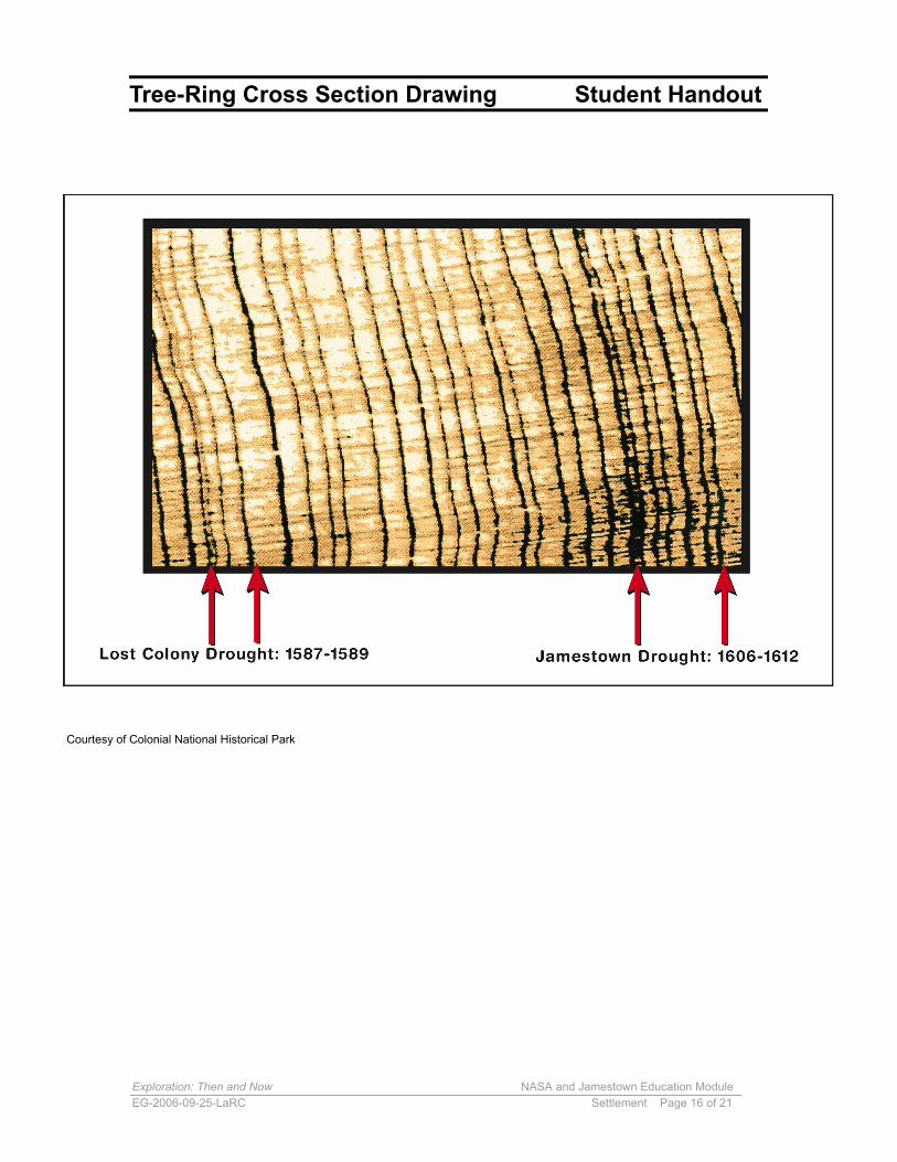
2. Introduce students to the study of dendrochronology, or tree-ring dating.Each year that a tree grows, a ring can be seen in a cross section of the tree’strunk or large branches. These rings can be used to help reconstruct patterns ofdrought and climate change. During years of plentiful rain, the rings are wider;years of little rainfall or drought produce narrower rings. Tree-ring samples fromancient bald cypress trees in southeastern Virginia and northeastern NorthCarolina give researchers over 800 years of information on rainfall in this region.Rainfall records between 1606 and 1612 (early Jamestown) distinguish theseyears as having one of the worst droughts during the 800-year period.3. Give each student a copy of the “Tree-Ring Cross Section Drawing” and askthe students to highlight the rings that indicate the Jamestown drought. Askstudents to measure the distance between tree rings to compare years ofplentiful rain to years of drought. Is there evidence of another drought? (Note:The Lost Colony drought is indicated in this drawing. Students may want to findout more about this failed colony by visiting this National Park Service Web site,http://www.nps.gov/archive/fora/roanokerev.htm)
Tree-Ring Cross Section Drawing
4. Ask students to compare the rainfall index/mortality rate graph to the tree-ringdrawing. Discuss the effect that a drought would have had on the Jamestown
Exploration: Then and Now NASA and Jamestown Education ModuleEG-2006-09-25-LaRC Settlement Page 8 of 21
settlers. Consider factors such as availability of food, fresh water, willingness ofthe Powhatan Indians to trade food to the settlers, and disease.
Teaching Suggestion: Before beginning this activity, cut cross sections of treelimbs or trunks to bring to class so students may analyze “real” tree rings.
Activity Two: Space WeatherThe Moon has basically no atmosphere. With no atmosphere, there can be noweather similar to that on Earth and no ozone to protect humans from the Sun’sultraviolet rays. Although Jamestown’s weather was harsh, Earth’s atmosphereprotected the Jamestown settlers from ultraviolet rays. The Earth’smagnetosphere and atmosphere also protected the settlers from solar particlesand other forms of what is known as “space weather.”
Space weather is made of many components including solar particles, magneticstorms, and radiation from outside our solar system. Solar storms are one sourceof space weather. Space is filled with solar wind, debris from comets, andparticles of dust. Space radiation comes from the Sun and from other stars fromoutside our solar system.
Because the Moon has no protective atmosphere or magnetosphere, it is notprotected from space weather. When astronauts live and work in space, awayfrom Earth’s protective atmosphere, they are exposed to more radiation than theaverage person is exposed to on Earth. Current spacecraft materials cannotblock all of the radiation in space weather.
For long-duration missions, especially those taking astronauts far away from low-Earth orbit, more protection from space radiation will be needed. NASA is alreadyworking on how to make spacecraft safer by using different materials to provideprotection.
1. Follow this procedure to help students test and compare different materials asthey are used to block simulated space radiation. Materials to be tested include:unlined copy paper, tissue paper, construction paper, and card-stock paper.Students may suggest other paper products to test, if time permits. The light froma flashlight will represent space radiation.
a. Before testing the materials, ask the students to predict how manypieces of that material it will take to completely block the light. Askstudents to record their predictions in their science journals.b. Ask one student in each group to hold the flashlight. He or she shouldsteady the flashlight on the tabletop so it points up at the ceiling, turn it on,and keep holding it. Caution: Remind students NOT to look directly intothe flashlight beam.
Exploration: Then and Now NASA and Jamestown Education ModuleEG-2006-09-25-LaRC Settlement Page 9 of 21
c. Ask another member of the group to stack paper on top of the flashlight,one sheet at a time, to block the light. As each piece of paper is added,the transmitted light should become weaker. Instruct students to continueadding sheets until the light is completely blocked, and then record thisnumber in their journals.d. Repeat steps a–c with another material until all materials have been
tested.2. Discuss the following questions as a class or ask students to write theirthoughts in their journals:
• Which material provided the best shielding from the simulatedspace radiation? Explain your choice.
• Compare the mass of the materials. How does the mass of thematerial that was the best shield compare to the mass of the othermaterials?
• Why would mass be important in choosing materials for spacecraftand shelters? (Mass is a consideration for NASA due to fuel, space,and cost issues.
3. Ask students to add any new information to the class/student charts theycreated earlier.
Teaching Suggestion: You may want to show the 30-second NASA KSNN™(Kids Science News Network) video, “What would you hear in a weather reportfrom Mars?” found at http://ksnn.larc.nasa.gov/21Century/p11.html. You will alsofind an expanded version of this activity and more explanations about spaceweather on this site.
ExplainA living community depends upon the nonliving, or abiotic, factors in itsenvironment. Abiotic factors include water, topography, landforms, climate, soils,sunlight, and air quality.
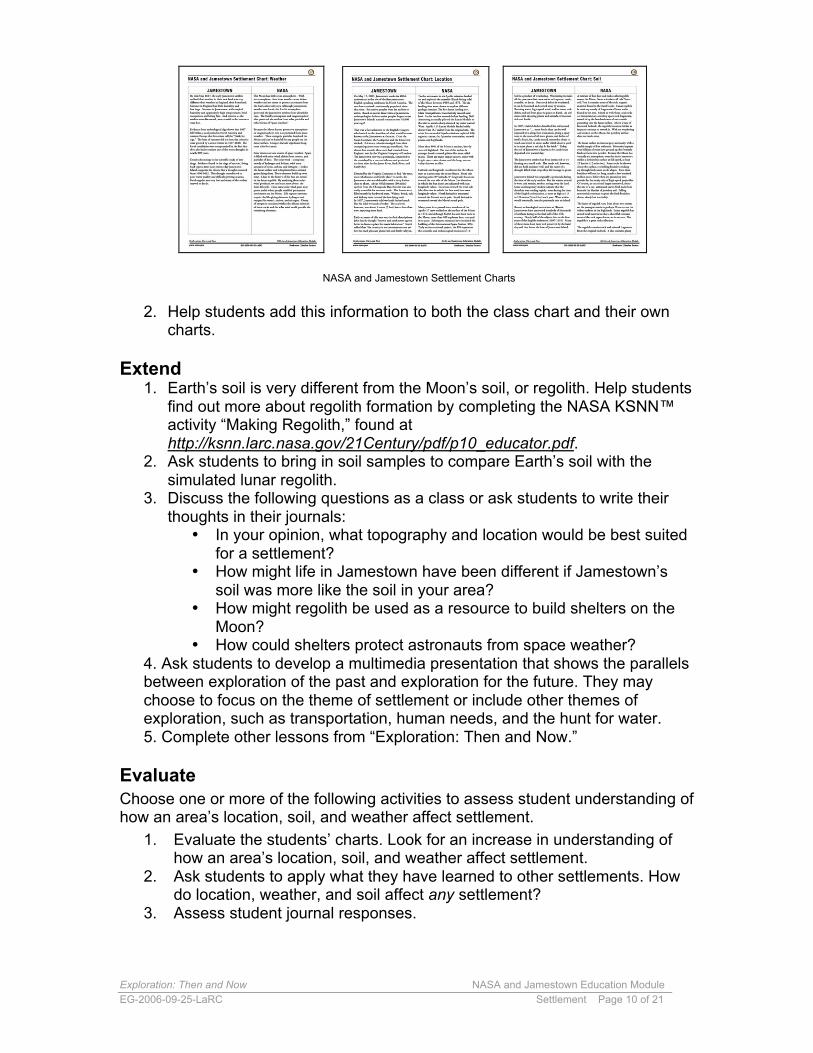
1. Ask students to read the three “NASA and Jamestown Settlement Charts”to find out more about the abiotic factors of location, soil, and weather;how they affected the early Jamestown settlement; and how they wouldaffect possible lunar settlements.
Exploration: Then and Now NASA and Jamestown Education ModuleEG-2006-09-25-LaRC Settlement Page 10 of 21
NASA and Jamestown Settlement Charts
2. Help students add this information to both the class chart and their owncharts.
Extend1. Earth’s soil is very different from the Moon’s soil, or regolith. Help students
find out more about regolith formation by completing the NASA KSNN™activity “Making Regolith,” found athttp://ksnn.larc.nasa.gov/21Century/pdf/p10_educator.pdf.
2. Ask students to bring in soil samples to compare Earth’s soil with thesimulated lunar regolith.
3. Discuss the following questions as a class or ask students to write theirthoughts in their journals:
• In your opinion, what topography and location would be best suitedfor a settlement?
• How might life in Jamestown have been different if Jamestown’ssoil was more like the soil in your area?
• How might regolith be used as a resource to build shelters on theMoon?
• How could shelters protect astronauts from space weather?4. Ask students to develop a multimedia presentation that shows the parallelsbetween exploration of the past and exploration for the future. They maychoose to focus on the theme of settlement or include other themes ofexploration, such as transportation, human needs, and the hunt for water.5. Complete other lessons from “Exploration: Then and Now.”
EvaluateChoose one or more of the following activities to assess student understanding ofhow an area’s location, soil, and weather affect settlement.
1. Evaluate the students’ charts. Look for an increase in understanding ofhow an area’s location, soil, and weather affect settlement.
2. Ask students to apply what they have learned to other settlements. Howdo location, weather, and soil affect any settlement?
3. Assess student journal responses.
Exploration: Then and Now NASA and Jamestown Education ModuleEG-2006-09-25-LaRC Settlement Page 11 of 21
4. Work with students to create a rubric to evaluate the multimediapresentations created to characterize past and to predict futureexploration.
Additional NASA ResourcesSections of this lesson were adapted from existing NASA educational products.These additional NASA resources may extend student understanding about howan area’s topography, weather, and soil affect settlement.
TopographyNASA CONNECT™ Landscape Archaeology: Hidden TreasuresUse a coordinate plane system to create a topographic map of a mysteryplanet landscape.http://connect.larc.nasa.gov/programs/2004-2005/treasures/index.html
WeatherModeling Solar Wind CollectionModel how different materials collect different solar wind particles. http://solarsystem.nasa.gov/educ/docs/ModelSolarWindColTG.pdf
Space WeatherSun-Earth Connection Education ForumThis site provides additional resources to learn more about space weather.http://sunearth.gsfc.nasa.gov/
SoilClay Lava FlowsSimulate surface lava flows in this experiment to understand some of thegeological processes and structures that form as lava flows across theMoon's landscape.http://ares.jsc.nasa.gov/Education/Activities/ExpMoon/LavaFlows.pdf
Exploration: Then and Now NASA and Jamestown Education ModuleEG-2006-09-25-LaRC Settlement Page 12 of 21
Map of Original 13 Colonies
Exploration: Then and Now NASA and Jamestown Education ModuleEG-2006-09-25-LaRC Settlement Page 13 of 21
Map of the Moon Student Handout
Credit: NASA/GSFC
Exploration: Then and Now NASA and Jamestown Education ModuleEG-2006-09-25-LaRC Settlement Page 14 of 21
Apollo12
Apollo Landing Sites Chart Student Handout
ApolloMission
LandingDate
Latitude Longitude Major Geologic Featuresand Rock Types
SurfaceViews ofLanding
Site
Landing Site(zoom in witha QT movie)
11 July 20,1969 1°N 23° E
The major geologic feature for this site is a mare,the Mare Tranquilitatis or Sea of Tranquility. Thefirst site is relatively smooth and level. In the last
few seconds before landing, the Lunar Module(LM) was manually piloted by Neil Armstrong toavoid a sharp-rimmed ray crater which measured
180 meters across (about 200 yards) and 30 metersdeep (about 33 yards). The major rock type found
at this site was basaltic lava.
Apollo11
MareTranquilitatis
12 November19, 1969 3°S 23°W
The major geologic feature for this site is a mare,Oceanus Procellarum or Ocean of Storms. Rocks
at this site are basaltic lava and a ray fromCopernicus Crater crosses the site.
OceanusProcellarum
14 February3, 1971 4°S 18°W
The major geologic feature for this site is in thehighlands at the Fra Mauro formation. This
formation is thought to be ejecta from the ImbriumBasin. The site is a hilly region about 49.3 km
(30.6 miles) north of the Fra Mauro crater.
Apollo14 Fra Mauro
15 July 30,1971 26°N 4°E
The major geologic features for this site areHadley Rille, a mare area near the Mare Imbrium
or Sea of Rains, and the highlands at the foot of theApennine mountain range. The Apennines rise upto more than 4572 meters (15, 000 feet) along the
southeastern edge of Mare Imbrium (Sea of Rains).The rocks at this site are breccia and basalt.
Apollo15 Hadley Rille
16 April 20,1972 9°S 16°E
This site was a hilly region around Descartes craterin the lunar highlands. The landing site had two
basic terrains that were explored and sampled: theCayley Plains, a smooth plains unit, and the
Descartes formation made up of hilly furrowedhighland materials. The rocks are anorthosite and
highlands soil.
Apollo16 Descartes
17 December11, 1972 20°N 31°E
The major geologic feature for this site is a mare,the Serenitatis basin or Sea of Serenity. This site,Taurus-Littrow, takes its name from the Taurus
mountains and Littrow crater which are located ina mountainous region on the southeastern rim ofthe Serenitatis basin. The rocks are mare soil,
orange soil, basaltic lava, and anorthosite.
Apollo17
Taurus-Littrow
Exploration: Then and Now NASA and Jamestown Education ModuleEG-2006-09-25-LaRC Settlement Page 15 of 21
Jamestown Rainfall Index and Mortality Rate
Courtesy of Colonial National Historical Park
Exploration: Then and Now NASA and Jamestown Education ModuleEG-2006-09-25-LaRC Settlement Page 16 of 21
Tree-Ring Cross Section Drawing Student Handout
Courtesy of Colonial National Historical Park
Exploration: Then and Now NASA and Jamestown Education ModuleEG-2006-09-25-LaRC Settlement Page 17 of 21
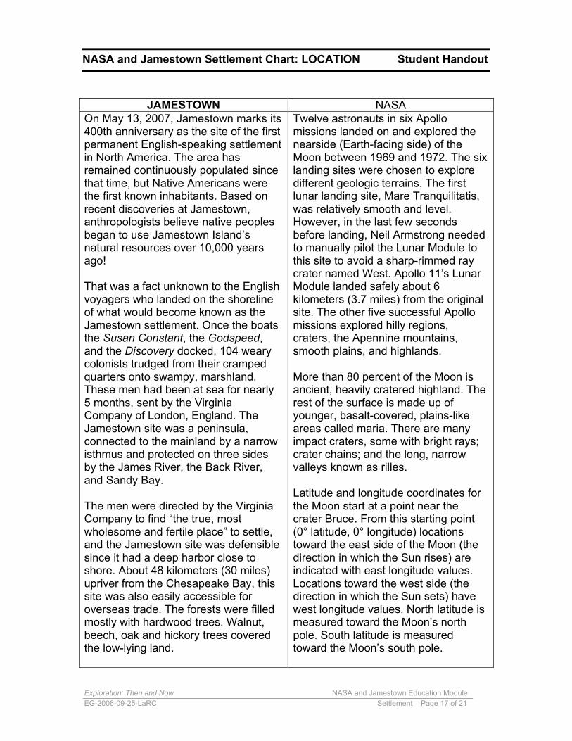
On May 13, 2007, Jamestown marks its400th anniversary as the site of the firstpermanent English-speaking settlementin North America. The area hasremained continuously populated sincethat time, but Native Americans werethe first known inhabitants. Based onrecent discoveries at Jamestown,anthropologists believe native peoplesbegan to use Jamestown Island’snatural resources over 10,000 yearsago!
That was a fact unknown to the Englishvoyagers who landed on the shorelineof what would become known as theJamestown settlement. Once the boatsthe Susan Constant, the Godspeed,and the Discovery docked, 104 wearycolonists trudged from their crampedquarters onto swampy, marshland.These men had been at sea for nearly5 months, sent by the VirginiaCompany of London, England. TheJamestown site was a peninsula,connected to the mainland by a narrowisthmus and protected on three sidesby the James River, the Back River,and Sandy Bay.
The men were directed by the VirginiaCompany to find “the true, mostwholesome and fertile place” to settle,and the Jamestown site was defensiblesince it had a deep harbor close toshore. About 48 kilometers (30 miles)upriver from the Chesapeake Bay, thissite was also easily accessible foroverseas trade. The forests were filledmostly with hardwood trees. Walnut,beech, oak and hickory trees coveredthe low-lying land.
Twelve astronauts in six Apollomissions landed on and explored thenearside (Earth-facing side) of theMoon between 1969 and 1972. The sixlanding sites were chosen to exploredifferent geologic terrains. The firstlunar landing site, Mare Tranquilitatis,was relatively smooth and level.However, in the last few secondsbefore landing, Neil Armstrong neededto manually pilot the Lunar Module tothis site to avoid a sharp-rimmed raycrater named West. Apollo 11’s LunarModule landed safely about 6kilometers (3.7 miles) from the originalsite. The other five successful Apollomissions explored hilly regions,craters, the Apennine mountains,smooth plains, and highlands.
More than 80 percent of the Moon isancient, heavily cratered highland. Therest of the surface is made up ofyounger, basalt-covered, plains-likeareas called maria. There are manyimpact craters, some with bright rays;crater chains; and the long, narrowvalleys known as rilles.
Latitude and longitude coordinates forthe Moon start at a point near thecrater Bruce. From this starting point(0° latitude, 0° longitude) locationstoward the east side of the Moon (thedirection in which the Sun rises) areindicated with east longitude values.Locations toward the west side (thedirection in which the Sun sets) havewest longitude values. North latitude ismeasured toward the Moon’s northpole. South latitude is measuredtoward the Moon’s south pole.
JAMESTOWN NASA
NASA and Jamestown Settlement Chart: LOCATION Student Handout
Exploration: Then and Now NASA and Jamestown Education ModuleEG-2006-09-25-LaRC Settlement Page 18 of 21
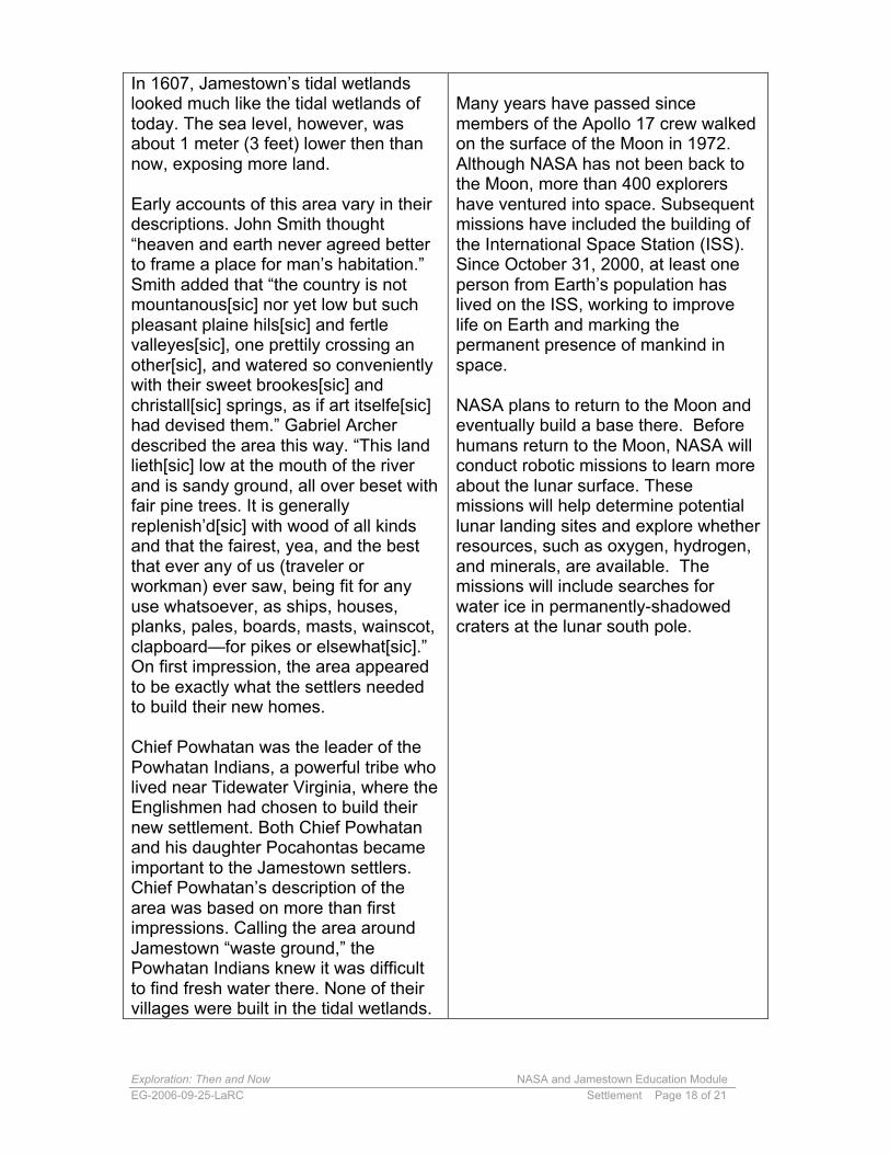
In 1607, Jamestown’s tidal wetlandslooked much like the tidal wetlands oftoday. The sea level, however, wasabout 1 meter (3 feet) lower then thannow, exposing more land.
Early accounts of this area vary in theirdescriptions. John Smith thought“heaven and earth never agreed betterto frame a place for man’s habitation.”Smith added that “the country is notmountanous[sic] nor yet low but suchpleasant plaine hils[sic] and fertlevalleyes[sic], one prettily crossing another[sic], and watered so convenientlywith their sweet brookes[sic] andchristall[sic] springs, as if art itselfe[sic]had devised them.” Gabriel Archerdescribed the area this way. “This landlieth[sic] low at the mouth of the riverand is sandy ground, all over beset withfair pine trees. It is generallyreplenish’d[sic] with wood of all kindsand that the fairest, yea, and the bestthat ever any of us (traveler orworkman) ever saw, being fit for anyuse whatsoever, as ships, houses,planks, pales, boards, masts, wainscot,clapboard—for pikes or elsewhat[sic].”On first impression, the area appearedto be exactly what the settlers neededto build their new homes.
Chief Powhatan was the leader of thePowhatan Indians, a powerful tribe wholived near Tidewater Virginia, where theEnglishmen had chosen to build theirnew settlement. Both Chief Powhatanand his daughter Pocahontas becameimportant to the Jamestown settlers.Chief Powhatan’s description of thearea was based on more than firstimpressions. Calling the area aroundJamestown “waste ground,” thePowhatan Indians knew it was difficultto find fresh water there. None of theirvillages were built in the tidal wetlands.
Many years have passed sincemembers of the Apollo 17 crew walkedon the surface of the Moon in 1972.Although NASA has not been back tothe Moon, more than 400 explorershave ventured into space. Subsequentmissions have included the building ofthe International Space Station (ISS).Since October 31, 2000, at least oneperson from Earth’s population haslived on the ISS, working to improvelife on Earth and marking thepermanent presence of mankind inspace.
NASA plans to return to the Moon andeventually build a base there. Beforehumans return to the Moon, NASA willconduct robotic missions to learn moreabout the lunar surface. Thesemissions will help determine potentiallunar landing sites and explore whetherresources, such as oxygen, hydrogen,and minerals, are available. Themissions will include searches forwater ice in permanently-shadowedcraters at the lunar south pole.
Exploration: Then and Now NASA and Jamestown Education ModuleEG-2006-09-25-LaRC Settlement Page 19 of 21
NASA and Jamestown Settlement Chart: WEATHER Student Handout
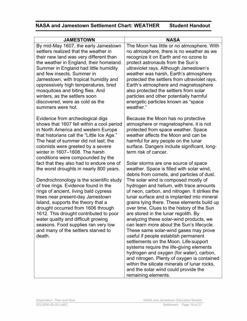
JAMESTOWN NASABy mid-May 1607, the early Jamestownsettlers realized that the weather intheir new land was very different thanthe weather in England, their homeland.Summer in England had little humidityand few insects. Summer inJamestown, with tropical humidity andoppressively high temperatures, bredmosquitoes and biting flies. Andwinters, as the settlers soondiscovered, were as cold as thesummers were hot.
Evidence from archeological digsshows that 1607 fell within a cool periodin North America and western Europethat historians call the “Little Ice Age.”The heat of summer did not last; thecolonists were greeted by a severewinter in 1607–1608. The harshconditions were compounded by thefact that they also had to endure one ofthe worst droughts in nearly 800 years.
Dendrochronology is the scientific studyof tree rings. Evidence found in therings of ancient, living bald cypresstrees near present-day JamestownIsland, supports the theory that adrought occurred from 1606 through1612. This drought contributed to poorwater quality and difficult growingseasons. Food supplies ran very lowand many of the settlers starved todeath.
The Moon has little or no atmosphere. Withno atmosphere, there is no weather as werecognize it on Earth and no ozone toprotect astronauts from the Sun’sultraviolet rays. Although Jamestown’sweather was harsh, Earth’s atmosphereprotected the settlers from ultraviolet rays.Earth’s atmosphere and magnetospherealso protected the settlers from solarparticles and other potentially harmfulenergetic particles known as “spaceweather.”
Because the Moon has no protectiveatmosphere or magnetosphere, it is notprotected from space weather. Spaceweather affects the Moon and can beharmful for any people on the lunarsurface. Dangers include significant, long-term risk of cancer.
Solar storms are one source of spaceweather. Space is filled with solar wind,debris from comets, and particles of dust.The solar wind is composed mostly ofhydrogen and helium, with trace amountsof neon, carbon, and nitrogen. It strikes thelunar surface and is implanted into mineralgrains lying there. These elements build upover time. Clues to the history of the Sunare stored in the lunar regolith. Byanalyzing these solar-wind products, wecan learn more about the Sun’s lifecycle.These same solar-wind gases may proveuseful if people establish permanentsettlements on the Moon. Life-supportsystems require the life-giving elementshydrogen and oxygen (for water), carbon,and nitrogen. Plenty of oxygen is containedwithin the silicate minerals of lunar rocks,and the solar wind could provide theremaining elements.
Exploration: Then and Now NASA and Jamestown Education ModuleEG-2006-09-25-LaRC Settlement Page 20 of 21
perhaps 20 meters on the oldestsurfaces in the highlands. Lunarregolith has mixed local material sothat a shovelful contains most of therock types that occur in an area. Theregolith is a great rock collection.
NASA and Jamestown Settlement Chart: SOIL Student Handout
JAMESTOWN NASASoil is a product of weathering.Weathering includes all the processesthat cause rocks to fragment, crack,crumble, or decay. Once rock debris isweathered, it can be loosened andcarried away by erosion. Runningwater, high-speed wind, and ice moverock debris and soil from place to placeon Earth. As soil mixes with decayingplants and animals, it becomes rich andfertile.
In 1607, Gabriel Archer described thesoil around Jamestown as “… morefertile than can be well express’d[sic]; itis altogether aromatical[sic], giving aspicy taste to the roots of all trees,plants, and herbs, of itself a black, fat,sandy mould[sic], somewhat slimy totouch and sweet in savor, under whichabout a yard is in most places a redclay fit for brick.” Today, the soil ofJamestown is known to be sandy loamdeposited over packed clay.
The Jamestown settlers had beeninstructed to try farming on a smallscale. The sandy soil, however, did nothold moisture well, and the onset of adrought killed what crops they didmanage to plant.
Jamestown Island was originally apeninsula during the time of the earlysettlers. But the waters around it were,and remain, restless, eating away theland. Some contemporary studiesindicate that the shoreline was erodingrapidly, even during the time of theEnglish colonization, at rates as high as1.5 to 1.8 meters (5 to 6 feet) eachyear. Wave action would eventually turnthe peninsula into an island.
A mixture of fine dust and rocks calledregolith covers the Moon. Somescientists call this “lunar soil,” but itcontains none of the rich, organicmaterial found in Earth’s soils. Lunarregolith is made up mostly offragments of lunar rocks found in thearea. Mixed in with these local rocksare interplanetary and deep-space rockfragments, tossed in by thebombardment of meteoroids poundinginto the lunar surface. Above a base offractured bedrock, the regolithbecomes thicker as impacts continueto rework it. With no weathering anderosion on the Moon, the powderysurface does not wash away.
The lunar surface is charcoal gray andsandy, with a sizable supply of finesediment. Meteorite impacts overbillions of years have ground up theformerly fresh surfaces into powder.Because the Moon has virtually noatmosphere, even the tiniest meteoritestrikes a defenseless surface at fullspeed, at least 20 kilometers/second(12 miles/second). Some rocks liethrown about the surface, resemblingboulders sticking up through freshsnow on ski slopes. Even theseboulders will not last long, maybe a fewhundred million years, before they areground up into powder by the steadyrain of high-speed projectiles. Ofcourse, an occasional largermeteoroid, about the size of a car,arrives and carves fresh rock frombeneath the blanket of powdery soil.Falling meteoroids continue to grindthe fresh boulders down, slowly butinevitably.
The layers of regolith vary, from about2 meters on the youngest maria to
Exploration: Then and Now NASA and Jamestown Education ModuleEG-2006-09-25-LaRC Settlement Page 21 of 21
Recent archaeological excavations atHistoric Jamestowne have uncoveredhundreds of thousands of artifactsdating to the first half of the 17thcentury. Nearly half of the objects dateto the first years of the Englishsettlement (1607–1610). Many of theseitems have been well preserved by thehard clay soil that forms the base ofJamestown Island.
Most people had believed that the siteof the original fort had washed into theJames River as the shoreline receded.Archaeologists, however, haveuncovered large sections of theJamestown triangular fort, built soonafter the first colonists landed. As theartifacts are cleaned and studied, newinformation about Jamestown and thepeople who settled there is beingdiscovered.
perhaps 20 meters on the oldestsurfaces in the highlands. Lunarregolith has mixed local material sothat a shovelful contains most of therock types that occur in an area. Theregolith is a great rock collection.
The regolith contains rock and mineralfragments from the original bedrock. Italso contains glassy particles formedby the impacts. In many lunar regoliths,half of the particles are composed ofmineral fragments that are boundtogether by impact glass. The chemicalcomposition of the regolith is similar tothe composition of the bedrock.Regolith in the highlands is rich inaluminum, as are the highland rocks.Regolith in the maria is rich in iron andmagnesium, which are elements alsofound in basalt.