Embed Size (px)
Citation preview

1
Eastleigh Borough Local Plan
2016-2036
DRAFT
Background Paper
Settlement Gap Policy Review
July 2017
(Updated November 2017)

2
CONTENTS PAGE
1.0 Introduction 4
o Purpose of Review
PHASE ONE
2.0 Policy Context 7
o Origin of Gaps in the borough of Eastleigh
o Adopted Local Plan and Submitted Local Plan Review 2016-2029
o Partnership for Urban South Hampshire (PUSH)
o National Planning Policy Framework (NPPF
o
3.0 Recent Local Plan Reviews – Planning Inspectorate position 12
o Overview
o Fareham Local Plan Review 2011-2029
o Test Valley Local Plan Review 2011-2029
PHASE TWO
4.0 Landscape, Physical and Visual Appraisal of Existing Gaps 16
o Methodology
5.0 Analysis of planning applications and decisions 18
o Development pressure within gaps
6.0 Comparison of size and distribution of Gaps in South Hampshire 22
7.0 Feedback from public consultation 24
PHASE THREE
8.0 Consideration of alternative policy approaches 26
o Recommendations
9.0 Gap boundaries 28
o Recommended changes
10.0 Gap policy wording 30
o Considerations
o Recommendations
PHASE FOUR
11.0 Implications of the eight ‘Spatial Options’ (2016-2036) in terms of Settlement
Gaps 40
12.0 APPENDICES
o Appendix 1: Landscape and Visual Appraisal of Existing Gaps
o Appendix 2: Assessment Matrices

3
o Appendix 3: Electronic records of Major Applications in Gaps
o Appendix 4: Policy S9 of the Submitted Eastleigh Local Plan 2011-2029
o Appendix 5: Assessment of Green Value
o Appendix 6: Summary of the Implications of Spatial Options on
Settlement Gaps

4
1.0 Introduction
1.1 The borough of Eastleigh, encompassing 79.8km2 (7980 hectares), is centrally
located within South Hampshire with a population of 125,2001. Adjacent to the City
of Southampton it also borders the Winchester District and shares administrative
boundaries with Test Valley Borough Council and Fareham Borough Council. The
main centre is Eastleigh with other larger urban areas being Chandlers Ford and
Hedge End. There are eight smaller, mainly residential settlements: Bishopstoke,
Botley, Boorley Green, Bursledon, Fair Oak, Hamble-le-Rice, Horton Heath, Netley
and West End.
1.2 We know from previous consultation exercises that many communities consider
maintaining separation between these settlements to be an important issue. These
concerns have been expressed consistently over many years and through a number
of consultation exercises. This support for maintaining settlement character and
identity has been reflected in previous Local Plan ‘Gap policies’ which seek to
prevent settlement coalescence between urban areas by maintaining a clear visual
and physical break in the built environment.
1.3 Settlement gap policies in Hampshire dates back at least 30 years when they were
included within the South and Mid Hampshire Structure Plans (1988 and 1989).
They were carried forward into the Hampshire County Structure Plan 1994 and the
Hampshire County Structure Plan 1996-2011.
1.4 The need and pressure for development in the borough (indeed South East England)
over time has meant that distances between settlements have diminished. Indeed
some coalescence has historically occurred between a number of settlements,
specifically;
West End is physically attached to Southampton, although it continues to have a
character which is distinctive and it is distinct from other neighbourhoods or
suburbs of the city, as well as from other settlements in the borough.
Eastleigh, Chandler’s Ford, Boyatt Wood and Hiltingbury have coalesced
into a single contiguous urban area.
Bishopstoke and Fair Oak are conjoined, although the former Brookfield Fruit
Farm site, south of Fair Oak Road, opposite Sandy Lane, may provide a vestige
of separation.
1.5 The Adopted Local Plan Review 2001-2011 designates a number of ‘Strategic’ and
‘Local’ Gaps which cover approximately half of the total area of countryside2 in the
borough. The distinction between ‘Strategic’ and ‘Local’ relates to whether or not they
were acknowledged in County level or sub-regional planning documents. The
1 According to the 2011 Census.
2 Area outside of defined settlement boundaries

5
housing policies for the Adopted Plan are deemed out of date and there has been
recent pressure on ‘Gaps’ to meet housing need. Indeed a number of sites within
Gaps were allocated for housing in the submitted Local Plan Review 2011-2029,
whilst others have been approved at appeal based on site-specific arguments that
the proposed development accords with the National Planning Policy Framework’s
(NPPF) presumption in favour of Sustainable Development (paragraph 14 and 49 –
refer to section 2 for more discussion on this).
Purpose of Gap Review:
1.6 This paper details the review of Local and Strategic ‘Gaps’ in the borough of
Eastleigh. The purpose of the gap review has been to support the preparation of a
sound Local Plan Review 2016-2036, in particular;
1. to ensure any future gap policy is in accordance with national policy and is robust;
and
2. to inform the selection of preferred options for development that meets the
required level of growth for the Plan period by assessing the implication of the
development on settlement pattern, character and identity.
1.7 The first phase of this gap review was to determine the value and precedent for a
Local Plan Gap policy in Eastleigh in planning terms. This involved:
a) Reviewing the policy context of Gaps from the introduction of Gaps in early
Structure Plans through references in sub-regional strategies prepared by
Partners for Urban South Hampshire (PUSH)3 to the current position of Gaps in
terms of the NPPF.
b) Reviewing the position taken in recent Local Plan Reviews in South Hampshire
1.8 The second phase was to carry out an appraisal of all of the areas between existing
settlements in Eastleigh to see if they met the ‘criteria for gaps’ recommended by the
Partners for Urban South Hampshire (PUSH)4 being that;
a) The designation is needed to retain the open nature and/or sense of
separation between settlements;
b) The land to be included within the gap performs an important role in defining
the settlement character of the area and separating settlements at risk of
coalescence;
3 PUSH is a partnership of Hampshire County Council, the unitary authorities of Portsmouth, Southampton, Isle
of Wight and district authorities of Eastleigh, East Hampshire, Fareham, Gosport, Havant, New Forest, Test Valley, Winchester
4 As published in the ‘South Hampshire Strategy – A framework to guide sustainable development and change to
2026’ in October 2012

6
c) The Gap’s boundaries should not preclude provision being made for the
development proposed in this (PUSH) Strategy;
d) The Gap should include no more land than is necessary to prevent the
coalescence of settlements having regard to maintaining their physical and
visual separation.
1.9 Assessment against criterion a, b, and d was informed by a landscape appraisal of
the physical and visual attributes of the gaps and a comparison of planning
applications and decisions within gaps and the general countryside. The appraisal of
gaps was also informed by a comparison of Eastleigh’s settlement pattern with other
neighbouring authorities and reviewing the feedback from public consultation on the
Issues and Options document published in December 2015.
1.10 The third phase was to consider alternatives to a gap policy to inform whether a gap
policy should be taken forward into the Eastleigh Local Plan Review 2016-2036.
Using the findings of the review, a Gap policy and boundaries for the Eastleigh Local
Plan Review 2016-2036 were developed and are presented in this paper.
1.11 The fourth phase was to build on the assessment of the eight spatial options (A-H) for
development within the new Plan period 2016-2036 in terms of their impact on
settlement pattern which was carried out as part of the Sustainability Appraisal
published in December 2015. Areas where gaps are likely to be diminished and
areas where new gaps may be appropriate have been identified. Whilst it has been
demonstrated that settlement coalescence can be avoided whilst also providing for
the required level of development, this assessment may also help inform where
planned coalescence would be more appropriate if desirable. Once a preferred option
is decided, further work will be required to refine the boundaries of the gaps.

7
PHASE ONE:
Reviewing the precedence for Gaps in the borough of Eastleigh.
2.0 Policy Context
Origin of Gaps in the borough of Eastleigh
2.1 ‘Strategic Gaps’ between Eastleigh’s settlements and Southampton were recognised
in Hampshire Structure Plans from the mid 1980’s. Structure plans were first
introduced by the 1968 Town and Country Planning Act, as strategic level
development plans, prepared either by a county council or by local authorities
working jointly together. They consisted of a broad framework of policies looking
forward up to 20 years ahead, supported by a "key diagram" showing land use,
transport and environmental proposals (including gaps) diagrammatically. Local
district councils were required to accord with the overall strategy set out in the
structure plan in their Local Plans, which were more locationally specific. This gave
rise to the identification of additional gaps by local district councils which were
described as ‘Local Gaps’ to distinguish them from those identified in the Structure
Plans.
2.2 Structure plans were increasingly criticised in the 1980s and 1990s for the length of
time taken in their preparation and adoption, their often abstract nature, and for
imposing an unnecessary level of policy above the level of the local district council.
Structure plans were abolished as part of the new development plan system
introduced following the 2004 legislation, and were replaced by Regional Spatial
Strategies and by Local Development Documents, particularly Core Strategies.
2.3 The Draft South East Plan included a policy (SH3) for sub-regional gaps across the
region and also listed the sub-regional gaps in South Hampshire to be defined in
detail within Local Development Frameworks (LDF). However, this policy was deleted
in finalising the Plan, though reference was made to them in paragraph 16.6. PUSH
objected to this proposed change on the basis that it did not give sufficient weight to
the importance of gaps and would leave planning authorities with insufficient statutory
guidance, especially where such gaps might cross administrative boundaries. PUSH
published a Policy Framework for Gaps in 2008. The approach recommended by
PUSH is detailed in paragraph 2.9 below. Regional level planning frameworks were
revoked in 2010.
Adopted Local Plan
2.4 The Adopted Eastleigh Local Plan Review (2001-2011) prepared when the
Hampshire Structure Plan 1996 – 2011 Review was operative includes both Strategic
Gaps and Local Gaps. The Strategic Gaps are between:
Southampton – Eastleigh (446 Ha) and

8
Southampton - Hedge End/Bursledon/Netley (720 Ha).
In accordance with Policy 2.CO,
“Planning permission will not be granted for development which would physically or
visually diminish a strategic gap as identified on the proposals map”.
2.5 Local Gaps were defined between:
Eastleigh – Bishopstoke (180 Ha)
Boyatt Wood – Otterbourne Hill and Allbrook (60 Ha)
Hedge End- Horton Heath (178 Ha)
Botley – Boorley Green (25 Ha)
Hedge End – Botley (210 Ha)
Hedge End - Bursledon (186 Ha)
Bursledon – Hamble – Netley Abbey (373 Ha)
Fair Oak – Horton Heath (74 Ha)
In accordance with Policy 3.CO,
“Planning permission will only be permitted for appropriate development in a local
gap, if: i. it cannot be acceptably located elsewhere; and
ii. it would not diminish the gap, physically or visually”.
2.6 There is little distinction in policy wording between Strategic and Local Gaps, the
reference in Policy 3.CO to ‘appropriate development’ does little to distinguish how
the local planning authority should assess development proposals in Local Gaps
differently from development proposals in Strategic Gaps. In practice it is not evident
any distinction has been applied.
2.7 Maintaining the individual identity of settlements in the Borough is a strong priority
among residents (evident in Parish Plans and through consultation as part of Local
Plan Reviews). Growth across the sub-region is placing pressure on the existing
settlement pattern to accommodate development, consequently settlement gap
policies have been tested in a number of recent planning application decisions.
During the preparation of the Local Plan Review 2011-2029 a number of sites within
settlement gaps were put forward for development and approved with Council
support or through appeal to meet the demand for housing.
Submitted Eastleigh Local Plan Review 2011-2029
2.8 The submitted Eastleigh Local Plan 2011-2029 revised the gap boundaries to reflect
these permissions and ‘allocations’. The two tier classification of gaps was also
removed and changes were made to the description of the gaps to better reflect the
identity of settlements. Gaps were referenced as part of a general Countryside Policy
S9. Refer to Appendix 4 for proposed wording of policy S9.
2.9 The Eastleigh Borough Local Plan Review 2011 – 2029 was submitted to the
Secretary of State for formal Examination on Tuesday 15 July 2014. Following
examination, the Inspector, Mr Simon Emerson, concluded that the Plan was not

9
sound because it did not provide sufficient housing, expressing particular
concerns about affordable housing. In his Post Hearing Note 3 – Other Matters to
the Council, Mr Emerson stated that, although he had not considered gap policy
at the Hearing, he would set out some preliminary concerns so that the Council
could consider how to address the matter. In particular he was concerned that he
saw: “nothing in the Council’s evidence base which seeks to justify on a rigorous
and comprehensive basis the need for a gap designation; the choice of location
for gaps or the extent of the designated area of any of the gaps identified in the
Plan”. He recommended that if gaps were accepted in principle, the criteria in
Policy 15 of the ‘South Hampshire Strategy – A framework to guide sustainable
development and change to 2026’ in October 2012 would seem a good starting
point to consider their extent.
2.10 This review seeks to address these concerns. Given that the Submitted Local Plan
Review 2011-2029 was not accepted by the Planning Inspector the starting point for
this review was the Adopted Local Plan Strategic and Local Gaps shown on the plan
below.
Map of Adopted Local Plan 2001-2011 Strategic and Local Gaps

10
Partnership for Urban South Hampshire (PUSH)
2.11 The PUSH Policy Framework for Gaps 2008 prepared to counteract the loss of a Gap
policy in the South East Plan makes the following assertions:
‘Gaps are spatial planning tools designed to shape the pattern of
settlements’(paragraph 2.1);
‘They command wide public support and have been used with success in
successive strategic plans to influence the settlement pattern of south
Hampshire’ (paragraph 2.1);
‘PUSH believes that the designation of gaps within South Hampshire is essential to help shape the future settlement pattern, so that … 80,000 new homes 2006 – 2026 can be accommodated but in ways which will avoid the coalescence of settlements and the loss of settlement identify’ (paragraph 2.3); and
‘‘Gaps can have other positive aspects: in retaining open land adjacent to urban areas which can be used for new/enhanced recreation and other green infrastructure purposes’ (paragraph 2.4).
2.12 Over the past 20 years South Hampshire has seen significant growth, and will
continue to do so over the next 20 years. In order to accommodate the required level
of growth and plan for the necessary infrastructure the PUSH published the ‘South
Hampshire Strategy – A framework to guide sustainable development and change to
2026’ in October 2012. This recognised the importance of maintaining the separation
of existing settlements to avoid the sub-region becoming a single amorphous urban
sprawl and reinforced the approach to designating Gaps recommended in their 2008
Policy Framework for Gaps. Criteria were provided to help member authorities
identify strategically important areas to be protected from development that would
diminish gaps between settlements. The purpose was to ensure consistency across
South Hampshire and to avoid any proliferation of gaps which could prevent sufficient
land being made available for employment and housing development. Four Gaps
which cross authority boundaries were identified as needing a coordinated approach
to ensure that their designation and their extent is aligned across the boundary. Two
of these relate to the Eastleigh Borough, namely;
between Southampton and Eastleigh/Chandlers Ford
between Southampton and Hedge End/Bursledon/Netley
The other two were;
between Fareham and Fareham Western Wards/Whiteley
between Fareham/Gosport and Stubbington/Lee on Solent.
2.13 Policy 15 of the 2012 PUSH ‘South Hampshire Strategy – A framework to guide
sustainable development and change to 2026’, states that these four Gaps would be
designated by PUSH authorities. Policy 15 also includes criteria for PUSH authorities
to use to designate the location of other Gaps and to define the boundaries of all
Gaps – as follows:

11
“a) The designation is needed to retain the open nature and/or sense of
separation between settlements;
b) The land to be included within the gap performs an important role in defining
the settlement character of the area and separating settlements at risk of
coalescence;
c) The Gap’s boundaries should not preclude provision being made for the
development proposed in this Strategy;
d) The Gap should include no more land than is necessary to prevent the
coalescence of settlements having regard to maintaining their physical and
visual separation”.
2.14 Once designated, Policy 15 of the PUSH South Hampshire Strategy 2012 states that
the multifunctional capacity of Gaps should be strengthened wherever possible. This
recognises that Gaps can also play a role in providing ‘Green Infrastructure’, by
providing opportunities for enhancing biodiversity, recreation and amenity.
2.15 PUSH have been are working together to consider new housing needs and other
development requirements. In June 2016 the Partnership published a Position
Statement setting out the work that had been done to date on considering how those
requirements could be responded to in Local Plans. The principle and continuing
relevance of Gaps was confirmed in the Key Principle E and Policy S1 of the 2016
PUSH Position Statement.
National Planning Policy Framework (NPPF)
2.16 The National Planning Policy Framework was published in March 2012, replacing the
various Planning Policy Guidance Notes. Paragraph 2 states that ‘the NPPF must be
taken into account in the preparation of local and neighbourhood plans and is a
material consideration in planning decisions’. This is reinforced in paragraph 12 and
196 of the NPPF.
2.17 The requirement in paragraph 49 to consider housing applications in the context of
the presumption in favour of sustainable development (which is set out in paragraph
14 of the NPPF) and the requirement for local planning authorities to demonstrate a
five year housing land supply (paragraph 47) in order for housing policies to be
considered up to date has put ‘Gap policies’ under scrutiny in recent Local Plan
Reviews and planning application decisions.
2.18 Sections of the NPPF that provide support for a ‘Gap policy’ include:
Paragraph 1 sets out that its underlying purpose is to provide:
‘… a framework within which local people and their accountable Councils can
produce their own distinctive local and neighbourhood plans, which reflect the
needs and priorities of their own communities.’

12
Paragraphs 7-10 sets out what is meant by sustainable development.
Paragraph 7 describes the 3 dimensions of sustainable development –
economic, social and environmental – and requires the planning system to
perform a number of related roles, namely an economic role, a social role
and an environmental role. Paragraph 8 makes it clear that: ‘These roles
should not be undertaken in isolation, because they are mutually
dependent… Therefore, to achieve sustainable development, economic,
social and environmental gains should be sought jointly and simultaneously
through the planning system.’
Paragraph 17 sets out various core planning principles which should
underpin both plan-making and decision-taking. It states, among other things,
that planning should: ‘… be genuinely plan-led, empowering local people to
shape their surroundings…’ It goes on to state that planning should: ‘…
proactively drive and support sustainable … development to deliver the
homes… that the country needs. Every effort should be made objectively to
identify and then meet the housing … needs of an area… Plans should take
account of market signals, such as land prices and housing affordability, and
set out a clear strategy for … allocating sufficient land which is suitable for
development in their area…’ It also states that planning should: ‘… take
account of the different roles and character of different areas, promoting the
vitality of our main urban areas, protecting the Green Belts around them,
recognising the intrinsic character and beauty of the countryside and
supporting thriving rural communities within it’, and ‘…contribute to
conserving and enhancing the natural environment and reducing pollution…’
Paragraph 61 requires that ‘Planning policies and decisions should
address… the integration of new development into the natural, built and
historic environment.’ Consistent with this, paragraph 109 of the NPPF
makes it clear that the planning system should ‘… contribute to and enhance
the natural and local environment by protecting and enhancing valued
landscapes’.
Paragraph 114 states that local planning authorities should set out a strategic
approach in their local plans, planning positively for the creation, protection,
enhancement and management of networks of biodiversity and green
infrastructure.
Paragraph 152 of the NPPF states (in the plan-making context) that Local
Planning Authorities should aim to achieve net gains in all dimensions of
sustainable development (economic, social and environmental). It goes on to
state that ‘Significant adverse impacts on any of these dimensions should be
avoided and, wherever possible, alternative options which reduce or
eliminate such impacts should be pursued.’

13
Paragraph 156 of the NPPF states that the Local Plan should have policies to
deliver conservation of the natural environment, including landscape and at
paragraph 157 the NPPF requires Local Plans to ‘… identify land where
development would be inappropriate, for instance because of its
environmental… significance.’
2.19 Paragraph 158 of the NPPF states that each local planning authority should
ensure that the Local Plan is based on adequate, up-to-date and relevant
evidence about the economic, social and environmental characteristics and
prospects of the area. This review aims to assist in meeting this requirement.
2.20 National Planning Practice Guidance which provides additional guidance on how the
NPPF should be applied states that ’one of the core principles in the NPPF is that
planning should recognise the intrinsic character and beauty of the countryside. Local
Plans should include strategic policies for the conservation and enhancement of the
natural environment, including landscape. This includes designated landscapes, but
also the wider countryside’ (PPG - Natural Environment Paragraph: 001 Reference
ID: 8-001-20140306). Evidence presented in recent Local Plan Examinations in
South Hampshire5 suggest that these references provide sufficient endorsement for a
settlement gap type policy provided the justification of gap boundaries are well
evidenced and sufficiently robust.
3.0 Recent Local Plan Reviews – Planning Inspectorate position
3.1 The principle of settlement gaps has been discussed in recent Local Plan Reviews in
the South Hampshire area. Planning Inspectors have given a strong direction in two
recent Final Reports including one for Test Valley Local Plan Review 2011-2029
dated 15 December 2015 and another for Fareham Borough Local Plan Review Part
Two (Development Sites and Policies Plan) dated 15 May 2015. These are discussed
below:
Test Valley Local Plan Review 2011-2029
3.2 The Sustainable Appraisal for the Test Valley Borough Council Revised Local Plan
2011-2029 considers two options with regards to retaining separation between
settlements;
1. Establish Local Gaps to protect against coalescence of settlements and
2. To not identify Local Gaps and consider each proposal on its own merits in line
with national guidance and countryside policies.
3.3 Test Valley prepared a Topic Paper on Local Gaps as a background to the policy
preparation (2014) (EB/ENV15). The outcome of Inspector’s decisions at appeals
within Test Valley, were taken into account when considering the principle and
individual merits of local gaps. Overall the paper concluded that the first option
5 In particular Test Valley Local Plan Review 2011-2029 and Fareham Local Plan Review 2011-2026,

14
performed more favourably in terms of impact on settlement character considerations
including preventing coalescence and place setting and therefore was the preferred
option.
3.4 The Inspectors report on the examination into the Test Valley Revised Local Plan
dated 15 December 2015, refers to policy in the (NPPF) Framework that enables
Local Plans to “identify land where development would be inappropriate, for instance
because of its environmental significance”. Inspector Ware refers to the NPPF
recommending that a ”strategic approach should be adopted in local plans, planning
positively for the creation, protection, enhancement and management of networks of
biodiversity and green infrastructure. The inspector considers that “the coalescence
of adjoining settlements, caused by development in the largely undeveloped gaps,
would clearly have an environmental effect”, and concludes that “The principle of
such a designated area is therefore in line with national policy” (PINS/C1760/429/5,
page 31, paragraph 191).
3.5 Inspector Ware broadly supported the overall approach taken by Test Valley Borough
Council in relation to gaps and concluded that the boundaries of the gaps themselves
are justified. In reference to the NPPF, the Inspector notes “This (gap) policy, which
is broadly restrictive in nature, runs counter to the general national approach to
enabling development. However that approach is qualified by the (NPPF) Framework
policy that such development should be located in the right place, and that the natural
environment should be protected”. (Ref: PINS/C1760/429/5, page 31, paragraph
194).
3.6 A Local Gap Policy and supporting text has been included in the Test Valley Borough
Local Plan 2011-2029 adopted on the 27 January 2016 as follows:
Policy E3: Local Gaps Development within Local Gaps (see Maps 48 - 56) will be permitted provided that: a) it would not diminish the physical extent and/or visual separation; and b) it would not individually or cumulatively with other existing or proposed
development compromise the integrity of the gap.
3.7 All nine Local Gaps are retained from the previously adopted 2006 Local Plan,
though four of them have revised boundaries as a result of their review. The
supporting text for Policy E3 refers to the important role that countryside around
settlements plays in helping to define their character and in shaping the settlement
pattern of an area. It states that the purpose of the policy is not to prevent all
development within a local gap, indicating where the proposal is of a rural character
and has a minimal impact on the purpose of the gap, these may be permitted. The
supporting text advises that in assessing development on the edge of settlements the
Council will take into account both the individual effects of the proposal and the
cumulative effects of existing and proposed development. Reference is given to the
Local Gap background paper for further justification and details of each of the defined
gaps. It is stated that no more land than is necessary to prevent coalescence and
retain separate identities of settlement has been included, and physical boundaries

15
have been used to define their extent to ensure that the local gaps can be easily
identified.
3.8 In reference to what is included in the Local Gap Inspector Ware notes “Local Gaps
include some limited developed areas, but there is no inherent reason why these
should not be included in the defined area, and any redevelopment proposal can be
dealt with on its merits – the reasoned justification to the policy makes it clear that the
purpose of the policy is not to prevent all development within a defined gap”. (Ref:
PINS/C1760/429/5, page 31, paragraph 194).
Fareham Borough Local Plan 2011-2026
3.9 Fareham Borough Council commissioned David Hares Landscape Architecture to
review the strategic gap policy designation in October 2012. At the hearing sessions
for the Fareham Borough Local Plan in 2014, Inspector Hogger raised concerns
regarding the justification of the methodology of the Gap Review. A response from
David Hares Landscape Architecture was submitted with the Inspector confirming in
his final report dated 12 May 2015 that the Council’s approach was sound (Ref.
PINS/A1720/429/4). Part 2 (Development Sites and Policies Plan) of the Fareham
Local Plan was adopted in June 2015.
3.10 The designation of Defined Urban Settlement Boundaries and Strategic Gaps are
recognised as key mechanisms for directing growth to the most sustainable locations
in the Borough. In the Fareham Local Plan 2011-2026 the purpose of strategic gaps
between towns and villages are to define the separate identity of individual
settlements and prevent coalescence and also help to provide opportunities for green
infrastructure and green corridors providing opportunities for recreation and
biodiversity.
3.11 The review focussed on a survey and analysis of the areas outside of the defined
urban settlement boundaries within the Borough and assessed whether or not the
gaps were in accordance with the PUSH criteria for gaps set out in the Core Strategy
policy CS22: Development in Strategic Gaps. This was assessed in the field using a
structured method, based on the completion of a survey pro forma. The information
was subsequently analysed using a matrix to assess both the suitability of land for
inclusion within a Gap, and the broader level of functionality that the land provided.
Whilst David Hares’s evidence demonstrated that gaps between the smaller
settlements met the PUSH criteria, it was concluded that there was no policy basis in
the Core Strategy for designating any Local Gaps (CS22: Development in Strategic
Gaps provided a policy basis for Strategic Gaps only). Consequently, Local Gaps
have not been retained in the Fareham Local Plan 2011-2026.

16
PHASE TWO:
Appraisal of settlement gaps within the Eastleigh Borough
4.0 Landscape Physical and Visual Appraisal of Existing Gaps
Methodology
4.1 A landscape and visual appraisal of the areas between settlements in the borough of
Eastleigh was undertaken to inform the Sustainability Appraisal of Spatial Options for
Development prepared for consultation in December 2015. The total area appraised
broadly comprised the 2452 hectares currently designated as Strategic or Local ‘Gap’
in the Adopted Local Plan 2001-2011. These adopted Gaps cover approximately
50% of the total area of ‘countryside’ (outside of settlement boundaries) and is
considered to represent a comprehensive coverage of all the gaps between
settlements in the Eastleigh Borough. In addition the areas appraised included
additional land (not currently protected by existing Gap) between Fair Oak,
Bishopstoke and Horton Heath and additional land between Boorley Green and
Botley. The total appraised area was broken down into 12 separate areas (shown on
the map on the following page) but in reality it was recognised that there were
seamless links and overlaps with adjoining areas. These areas were described in the
terms of Landscape and Urban Character, Key Features, Pressures, Inter-visibility,
Severance, and Urban Form. A copy of these appraisals are included in Appendix 1
titled ‘Landscape and Visual Appraisal of Gaps’.
4.2 The following physical attributes were identified as supporting the definition of
character and separation of settlements:
The land lies between settlements
The land is predominantly undeveloped
The land is predominantly open
The land has a coherent land management pattern
The land has clearly defined boundaries
The land contains major roads, rivers or railway lines that serve as physical
barriers between settlements
The land includes public footpaths or roads which provide a transition from
one settlement to another
The individual settlements shows a distinctive character/urban form
The individual settlement have a strong urban edge

17
Figure 1. Existing Adopted Local Plan 2001-2011 Gaps divided into areas for the purposes of the review.

18
4.3 The individual areas were assessed according to whether they exhibited these
physical attributes (listed in paragraph 4.2 above) in terms of ‘Yes’ ‘In Part’ and ‘No’
with comments providing more clarification where necessary. Parts of the defined
gap which did not display these attributes or which had been permitted for
development to meet housing demand were identified. The landscape and visual
appraisals (in Appendix 1) were used to inform this assessment. Copies of the
completed matrices are provided in Appendix 2.
4.4 All of the gaps were found to have a high proportion of these attributes and therefore
overall were considered to ‘play an important role in defining settlement character
and separating settlements at risk of coalescence’, with some exceptions.
5.0 Analysis of planning applications and decisions
5.1 To obtain a sense of whether the areas were at risk of coalescence either due to
pressure from large scale development or pressure and incremental ‘urbanisation’,
an analysis of the type and number of planning applications and decisions (based on
available electronic records which go back to the 1980’s) was undertaken. The
results showed that the number of full and outline planning applications within gaps
was less than 20% of those in the general countryside (see Figure 2) even though
the size of the application areas were broadly the same (see Figure 3).
Figure 2: Records of Full and Outline Planning Applications Figure 3: Comparative size of countryside designated gap
5.2 Whilst this may indicate there is less pressure for development within Gaps it may
also demonstrate that the Gap policy has been effective in directing the location of
development to avoid settlement coalescence. It probably also reflects that there is a
significant amount of existing development within areas of countryside for which
planning approval has been legitimately sought and obtained. It could also be that
there were fewer but larger applications submitted in the Gap.
5.3 In terms of the type of applications a greater proportion of ‘other’ applications
including applications for advertising, trees and temporary activities were submitted
within Gaps (approximately 40% of all applications) than in the countryside, where
these applications comprised just over 20% of the total, as shown in figure 4 below.
02000400060008000
10000120001400016000
Number of full and
outline planning applicati
ons
Refused
Granted
0
1000
2000
3000
4000
5000
6000
Hectares
Total Countryside
Total Gaps
CountrysideExcl Gaps

19
Granted 83%
Refused 17%
Within Countryside excl Gaps
Figure 4: Comparison of type of planning applications within gaps and in general Countryside.
5.4 A comparison of decisions on full and outline planning applications showed that they
were more likely to be refused if they were in a Gap than if they were in the general
countryside, 26% compared with 17% as shown below.
Figure 5: Comparison of Full and Outline Planning Decisions
5.5 A comparison of planning appeal decisions suggests that appeals were slightly more
likely to be allowed at appeal if they were in a gap designation than if they were in the
general countryside. (see Figure 6).
Granted 74%
Refused 26%
Within Gaps

20
Figure 6: Comparison of Planning Appeal Decisions
5.7 Whilst the statistical differences are small the 5% difference may be attributed to
recent decisions where the Council and Planning Inspectors have been minded to
approve development within gaps on balance with the overriding need to provide for
new housing in the absence of a 5 year land supply. To check this assumption
conclusion a comparison of planning applications pre and post the NPPF was made
which more or less coincided with Eastleigh’s Adopted Local Plan 2001-2011 being
deemed ‘out of date’. This analysis found that pre NPPF 27% of all decisions on full
and outline planning applications in gaps were refused compared with 17% in the
general countryside. Whilst post NPPF 20% of full and outline planning applications
within Gaps were refused. This was more similar to the percentage refused in the
general countryside (18%) which appears to have been less influenced by the NPPF
than applications within Gaps.
Figure :7 Comparison of Planning Application (Full and Outline) Decisions Pre and Post NPPF
83% 82%%
17% 18%
0%10%20%30%40%50%60%70%80%90%
100%
Refused
Granted 73% 80%
27% 20%
0%
10%
20%
30%
40%
50%
60%
70%
80%
90%
100%
Within GapsPre NPPF
Within GapsPost NPPF
Refused
Granted

21
5.8 This trend is also reflected in the number of full and outline applications pre and post
the NPPF, where the number within Gaps was 15% prior to the NPPF but increased
to 18% post the NPPF.
5.9 From the electronic records available (dating back to the mid 1980s) there have been
a total of 79 applications for 10 or more dwellings within Gaps. These are listed in
Appendix 3. 56% of them were refused pre NPPF, this reduced to 42% post the
NPPF (refer to Figure 8).
Figure :8 Comparison of Major Application Decisions Pre and Post NPPF
5.10 In terms of which area has been subjected to the most ‘pressure’ a comparison of
applications per hectare (size of area) was made. The results shown on the following
graph (Figure 9) illustrate that the areas between Fair Oak and Horton Heath and
Hedge End and Botley have been subjected to the most ‘pressure’. There is no
evidence that a strategic Gap was given any different consideration in the
determination of planning applications than a local Gap.
Granted 44%
Refused 56%
Major Applications (10 or more dwellings Pre NPPF)
Granted 58%
Refused 42%
Major Applications (10 or more dwellings) Post NPPF

22
Figure 9: Applications per hectare in various parts of Gap
5.11 What this analysis of planning applications and decisions demonstrates is that
settlements are at risk of coalescence and that if maintaining the separate identity
and character of settlements is a priority then a strong Gap policy is needed to retain
their separation. This conclusion is supported by a comparison of Eastleigh’s
settlement pattern with other areas in South Hampshire discussed below.
6.0 Comparison of size and distribution of Gaps in South
Hampshire
6.1 The following is a comparison of the Local Authorities neighbouring Eastleigh
Borough Council in terms of rural and urban percentages and population densities
(figures obtained from 2015 HCC Small Area Population Forecasts).
Figure 10: Comparison of Local Authority population densities
0.00
0.50
1.00
1.50
2.00
2.50
Refused
Granted
05
101520253035404550
Density people/hectare

23
Figure 11: Percentage of population living in Urban/Rural areas
6.2 What these graphs illustrate is that the borough of Eastleigh is comparable with
Fareham in terms of population density (Figure 10). However the proportion of
people considered to be living in ‘rural’ areas is significantly greater in Eastleigh than
in Fareham (see figure 12). This reflects the more distinct pattern of individual
smaller settlements (less than 10,000 inhabitants) in Eastleigh compared with
Fareham which is more of a conglomeration of larger settlements.
6.3 A comparison of the size and distribution of designated ‘Gaps’ in the area
surrounding the Eastleigh borough was undertaken to identify if there was any
relationship to settlement pattern described above.
Spatial Distribution of ‘Gaps’ in adjoining Local Authority areas.
6.4 The following map illustrates the size and distribution of Gaps in South Hampshire. In
Southampton, which is predominantly urban, Gaps are limited to the edge of the
boundary; small slivers of Gaps adjoin the boundary with the borough of Eastleigh.
In Test Valley and Winchester, where a higher proportion of the area is ‘rural’ the
designated Gaps are fewer and larger. There are Test Valley Gaps which adjoin the
boundary with Eastleigh. Whilst they come close, no Gaps in the Winchester District
adjoin the boundary with Eastleigh. No Gaps in Fareham adjoin the boundary with
Eastleigh, though the River Hamble provides a strong physical separation for most of
this boundary.
6.5 Overall it may be concluded that the relatively high number and intertwined
distribution of gaps in Eastleigh compared with neighbouring authorities reflects the
‘tight’ settlement pattern within Eastleigh and the greater risk of settlement
coalescence this creates.
0
20
40
60
80
100
Southampton Fareham Eastleigh Test Valley Winchester
Percentage Urban/Rural Population
Rural
Urban
24
Figure 12. Spatial Distribution of ‘Gaps’ in South Hampshire

25
7.0 Public Feedback from Local Plan Reviews
7.1 The Regulation 18 Issues and Options document in December 2015 identified three
key issues to be resolved regarding Gaps –
• How to take on the PUSH principle of identifying specific gaps between
major settlements at a sub-regional scale;
• The desire to protect the individual identity of settlements in the
Borough at a more local level; and
• The need to reconcile emerging development options with gap
principles.
7.2 Three options for the new Local Plan were considered –
1. Follow the principles described in the previous Local Plan
2. Combine gap policy with countryside policy to prevent development which would
cause settlements to merge
3. Review gaps between all settlements in Eastleigh Borough to retain only the
minimum land required to maintain their separate identity.
7.3 There was strong community support for the principle of maintaining gaps between
settlements6.
6 Further details on the Council’s website at
http://meetings.eastleigh.gov.uk/ieListDocuments.aspx?CId=254&MId=5623&Ver=4
26
PHASE THREE:
Developing recommendations for a Policy Approach for the
Eastleigh Local Plan Review 2016-2036
8.0 Consideration of Alternatives
8.1 Following on from the Issues and Options consultation the alternatives which have
been considered as part of this review are:
A. Retain two tiers of Gaps i.e. Strategic and Local (existing scenario)
B. Designate one tier of Gaps; (no distinction between Strategic and Local)
C. No designated Gaps but maintaining gaps between settlements would be
emphasised through other policies such as countryside policy, design quality and
spatial strategy. Some reliance would be placed on other designations such as
nature conservation and open space designations to maintain gaps between
settlements.
D. No designated gaps; allowing for some planned merging of settlements where it
can be demonstrated it is appropriate. Emphasis may be given to ensuring
distinctive ‘neighbourhood identity’ is achieved.
8.2 The appraisal of these alternative approaches has been made in terms of their
relative merits for Development Management and compatibility with the settlement
pattern and community aspirations in Eastleigh.
8.3 The four alternative policy options for gaps between settlements have been appraised
as follows:
Option Relative merits for DM
Practice
Relative merits for Eastleigh
context.
Two tier designation;
Strategic and Local (as
existing).
Defined boundaries provide
greater certainty for applicants
and DM officers of where
settlement gap considerations
should be given due weight.
Having defined boundaries can
also improve efficiency in
terms of identifying relevant
policies to apply.
There is no evidence that a
Strategic Gap was given any
different consideration in the
Designations provide greater
certainty that settlement gap
considerations will be taken
into account. Though this
could be more ‘perceived’
certainty that ‘actual’.
A high proportion of Gap
designations in land outside of
defined settlement boundaries
suits the Eastleigh context in
terms of population density,
tight settlement pattern, and
community desire to maintain

27
determination of planning
applications than a local gap.
individual settlement character
and identity.
Single tier designation;
(no strategic or local
distinction)
Defined boundaries provide
greater certainty for applicants
and DM officers of where
settlement gap considerations
should be given due weight.
Having defined boundaries can
also improve efficiency in
terms of identifying relevant
policies to apply.
Avoids any confusion as to
whether a Strategic Gap
should be given greater weight
than a Local Gap.
Gap designations provide
greater certainty that
settlement gap considerations
will be taken into account.
A high proportion of Gap
designations in land outside of
defined settlement boundaries
suits the Eastleigh context in
terms of population density,
tight settlement pattern, and
community desire to maintain
individual settlement character
and identity.
A single tier of Gap should
cause less confusion when in
practice little distinction was
ever intended to be made
between Strategic and Local
Gaps. Having a designated
Gap defined on a plan will
assist in maintaining a
coherent settlement pattern,
character and identity,
particularly if the Local
Planning Authority is able to
demonstrate a five year land
supply.
No settlement gap
designation; rely on
other policies to
maintain gaps between
settlements.
Would reduce the number of
policies in a Local Plan but not
necessarily the detail or
complexity of policies as they
may be required to perform
multiple functions.
Reliance on nature
conservation or open space
designations to maintain
settlement separation could
prove limiting as land
management and development
Could possibly result in a loss
of coherent settlement pattern,
character and identity as it
relies on implementing and
enforcing a multitude of
policies and strategies.
Communities would need
convincing that gaps between
settlements could effectively
be maintained without a
special purpose policy and
defined boundaries.

28
on these sites could effectively
reduce the physical or visual
separation between
settlements and contribute to a
loss of individual settlement
character and identity.
Would increase uncertainty for
applicants and officers over
the appropriate protection of
settlement identity.
No Gap designation;
provide for some
merging of settlements
where appropriate.
May seek to encourage
distinctive
neighbourhoods to
promote a sense of
place and local
character and identity.
Would increase uncertainty for
applicants and officers of when
settlement gap considerations
should be given due weight.
Design issues which can be
considered more subjective
(not to every ones taste) would
become more critical as
applicants and officers would
seek to achieve and maintain
distinctive neighbourhoods.
This would be very hard given
that the majority of sites come
forward from major
housebuilders using standard
house types.
Is more likely to result in a loss
of coherent settlement pattern,
character and identity and
thereby create concern and
disharmony amongst
residents. Faith in the
planning system could be
undermined through the lack of
certainty and inconsistency.
Recommendation
8.4 Based on the analysis of relevant policy and appraisal of alternative options
described above it is recommended that the Eastleigh Borough Local Plan 2016-2036
considers the designation a single tier of Gaps between main settlements. These
Gaps should be consistent with sub regional advice set out in the PUSH criteria for
gaps as described in the 2012 South Hampshire Strategy – A framework to guide
sustainable development and change to 2026 and Key Principle D - “Protecting and
Enhancing Countryside Gaps” and Policy S1 “Strategic Countryside Gaps” of the
2016 PUSH Position Statement
9.0 Revisions to Gap Boundaries
9.1 To accord with the 4th criteria of PUSH Policy 15 of the South Hampshire Strategy
2012, any Gap shall include ‘no more land than is necessary to prevent the
29
coalescence of settlements’. The Landscape and Visual Appraisal of Existing Gaps in
Eastleigh (Appendix 1) and the Assessment Matrices (Appendix 2) were used to
identify areas that don’t contribute to the physical or visual separation of settlements.
These include areas which have been permitted for development (or with a resolution
to permit). The following table lists recommended changes to the Adopted Local
Plan Review (2001-2011) Gap boundaries.
9.2 In total these changes represent a 27 % reduction (equivalent to 665 hectares) in the
area previously covered by a Gap designation. These are illustrated in Figure 14 and
Figure 15 below. Two areas of minor additions are recommended, one being at the
northern end of the Southampton Airport runway to better follow ground features
(Map ID 3), the other to take account of the permitted development in Grange Park,
Hedge End and the proximity to existing development on Moorgreen Road (Map ID
6).
Map
ID
Recommended
Boundary Changes to
Adopted Local Plan
Gaps
Comment
Southampton and Eastleigh
1. Exclude Approved
Development land south
of Chestnut Avenue,
Eastleigh
Strategic development location E1 in the
2014 submitted Local Plan and need to
take into account further urbanisation of
land west of the M27.
2. Exclude small areas
south of South Street
Areas which are now associated with the
South Street development
3. Add and adjust small
area at northern end of
runway.
To better follow ground features
4. Exclude strip of lane
between Wide Lane and
Airport
Does not contribute to the visual and
physical separation of Southampton and
Eastleigh
Southampton and Hedge End
5. Extend to include land
between Bubb Lane and
Burnetts Lane adjoining
crematorium
To take account of the proximity of
existing development on Moorgreen
Road in West End to existing
development in Grange Park, Hedge
End

30
6. Exclude Berrywood
Business Village
Existing development on the road side
off Bubb Lane accessed off Tollbar Way
makes no contribution to the gap
7. Exclude Ageas Bowl The complex is now highly urbanised
and makes no contribution to the gap,
can use Telegraph Woodland boundary
as an alternative edge
8. Exclude Kings
Community Church on
Upper Northam Road
Large building makes no contribution to
the gap
9. Exclude small area north
east of Moorgreen
Hospital
Area forms part of a proposed
redevelopment site
10. Exclude areas at St
Johns Road/Foord Road
Land has consent for housing
development (location HE2 in the 2014
submitted Local Plan)
Southampton and Bursledon/ Netley
11. Exclude area west of
Hamble Lane
This includes land for housing
development opposite Jurd Way granted
on appeal and associated sites north and
south
12. Exclude area at Abbey
Fruit Farm, Grange Road
Netley
Land with resolution to permit for
housing and employment,(development
site HO1 in the 2014 submitted Local
Plan)
13. Exclude pub and
associated buildings on
Grange Road
Existing development makes no
contribution to gap
14. Exclude existing houses
south west of Grange
Farm
Existing ribbon development off Grange
Road adjoining Netley Abbey makes no
contribution to gap
Eastleigh and Bishopstoke
15. Exclude Land associated
with the former Mount
hospital site
New development east of Church Road
(location Bi1 in the 2014 submitted Local
Plan)

31
16. Exclude Breach Sling
Copse and Stoke
Common Copse
Not necessary to the function of the gap
35. Exclude land south of
Fair Oak Road, west of
Oakgrove Road
This site has been granted outline
planning permission
Boyatt Wood and Otterbourne Hill
17. Exclude land at
Porchester Rise/Boyatt
Lane and land now in
allotment use
Development site with consent (location
AL1 in the 2014 submitted Local Plan)
the land now used for allotments is not
necessary to the function of the gap
18. Exclude strip of land
between Boyatt Lane
boundary north of
Allbrook Way
Not necessary to the function of the gap
19. Exclude undeveloped
land between Allbrook
Knoll and Portchester
Rise
Not necessary to the function of the gap
20. Exclude narrow strip of
land between Allbrook
Way and Knowle Hill
Not necessary to the function of the gap
Hedge End and Horton Heath
21. Exclude area between
Horton Heath and Blind
Lane
This is partly land with consent for
development, taken to Blind Lane as a
clear boundary (location W1 in the 2014
submitted Local Plan)
Hedge End and Botley
22. Exclude area of existing
development west of
Holmesland Lane
Existing development makes no
contribution to gap
23. Exclude development
land north of Hedge End
Railway Station and West
of Woodhouse Lane
Site north of Hedge End Railway Station
approved at appeal. Land west of
Woodhouse Lane allocated in policy HE1
of submitted Local Plan.
24. Exclude Land east of Includes development granted at appeal,

32
Precosa Road and
Sovereign Drive
together with adjoining recreation ground
and woodland which is not necessary to
the function of the gap
25. Exclude land east of
Brook Lane
Land east of Brook Lane forms a clear
boundary that is not necessary to the
function of the gap (includes some
conservation area)
Hedge End and Bursledon
26. Exclude Land east of
Dodwell Lane and north
of Pylands lane and other
undeveloped land north
of the M27
This includes land with consent for
development (location BU3 in the 2014
submitted Local Plan) together with
woodland and fields which are not
necessary to the function of the gap.
The gap will follow the boundary of the
road.
27. Exclude land south of
M27, north of Bridge
Road
Land with consent for development (BU1
and BU2 in the submitted 2011-2029
Local Plan)
28. Exclude land south of
M27, north of Providence
Hill
Land with consent for development rear
of Orchard Lodge
Botley and Boorley Green
29. Exclude land east of
Crow’s Nest Lane, south
of Maddoxford Lane
Land with consent for development at
junction of Crow’s Nest Lane and
Maddoxford Lane
37. Exclude land north east
of Winchester Street
Allocated in policy BO2 of the submitted
Local Plan
Bursledon and Hamble/ Netley
30. Exclude strip of land
between Ingleside and
Woolston Road
Not necessary to the function of the gap
between the main settlements
31. Exclude saltmarsh
between Lincegrove
Marsh and Land’s End
Road
Not necessary to the function of a gap,
use railway line, river and creeks as
boundaries
Fair Oak and Horton Heath

33
32. Exclude land between
White Tree Close and
Knowle Lane
Part existing housing development , part
Knowle Park, not necessary to the
function of a gap
33. Exclude land north of Fir
Tree Lane
This forms part of the site with a
resolution to permit west of Horton Heath
(WE1 in the submitted 2011-2029 Local
Plan)
Boyatt Wood and Allbrook
34. Exclude land east of
Allbrook Way, north of
Allbrook Hill
Not necessary to the function of the gap
Potential New Gap (Based on final decision on Strategic Growth Option)
Note: This gap is only a suggestion at this stage. Allocation of this gap is
dependent on the final decision of the Council regarding the preferred
Strategic Growth Option.
36. Add gap between
Crowdhill Copse and
Upperbarn Copse
To prevent settlement coalescence
between Fair Oak and potential new
development

34
Figure 13. Proposed Changes to Existing Gaps in the North of the Borough

Settlement Gap Policy Review DRAFT Updated November 2017
Figure 14. Proposed Changes to Existing Gaps in the South of the Borough

Settlement Gap Policy Review DRAFT Updated November 2017
10.0 Gap policy wording:
Considerations
10.1 In recommending a suitable policy to accompany designated Gaps in the Eastleigh
Borough consideration has been given to:
PUSH gap criteria (c) that gaps should not preclude provision being made for
development in the Borough
PUSH recommendation to strengthen the multifunctional capacity of Gaps
Inspectorate advice that the purpose of the policy should not be to prevent all
development within a defined Gap.
10.2 In reviewing approaches adopted by neighbouring local authorities in the South
Hampshire area (including the approach taken in the Adopted Eastleigh Local Plan
2001-2011 and the submitted Eastleigh Local Plan 2011-2029) consideration has
also been given to:
Having either a separate Gaps policy or combined with a general countryside
policy (as in Policy S9 of the Submitted Eastleigh Local Plan Review 2011- 2029
in Appendix 4).
Avoiding confusion as to whether a Gaps policy should be read alongside
countryside policies or instead of these.
Having either a list of activities that may be suitable within a Gap and/or general
countryside, or a shorter policy that is more criteria based.
Having appropriate cross references to other policies in the plan to
a) recognise the importance of Gaps (maintaining settlement character and
identity) in the spatial strategy (which sets out where new development has
been provided through the Local Plan).
b) promote opportunities for improving the function of Gaps through appropriate
references to general design quality and landscape improvement policies.
The need for boundaries and the description of Gaps to be inclusive to reflect
areas of overlap and seamless transition between ‘areas’ which perform a gap
function.
10.3 The policy approach recommended for the Eastleigh Local Plan 2016-2036 is outlined
below. Reasons for these recommendations are also provided:

Settlement Gap Policy Review DRAFT Updated November 2017
Settlement Gap Policy
10.4 As discussed in paragraph 8.4 of this review it is recommended that there is a single
tier of Gaps with no reference as to whether they are ‘Strategic’ or ‘Local’. It is
recommended that the policy is referred to as a ‘Settlement Gap Policy’ which is
separate from a countryside policy. This is considered to be preferable to combining it
into a countryside policy as proposed in the submitted Eastleigh Local Plan 2011-
2029 (refer to Appendix 4) for reasons of clarity and keeping policies concise.
10.5 It should be clear that the Settlement Gap Policy should be read alongside other
policies relating to development outside of urban boundaries for example – any
policies relating to agriculture, forestry, re-use of buildings, replacement dwellings,
outdoor recreation and open space, public utilities, rural exception policies. It may
also need to be read alongside a ‘special area policy’ such as established
commercial or educational establishments within gaps (e.g. Southampton Airport).
Proposals within Gaps will be required to demonstrate that they meet the criteria of
the ‘Settlement Gap Policy (see below for recommended criteria). This clarification
should help to avoid confusion and contradictions.
10.6 The description of individual settlement gaps should be inclusive to reflect areas of
overlap and seamless transition between adjoining Gaps. This should follow the
description in the ‘Landscape and Visual Appraisal of Existing Gaps’ in Appendix 1 as
follows:
In order to maintain the separate identity of settlements and separation from
Southampton, a Settlement Gap is defined between:
-- Eastleigh and Southampton;
-- Eastleigh and Bishopstoke;
-- Boyatt Wood, Otterbourne Hill and Allbrook;
-- Bishopstoke, Fair Oak and Horton Heath;
-- Horton Heath, Boorley Green and Hedge End;
-- Botley and Boorley Green;
-- Hedge End and Botley;
-- West End and Hedge End;
-- Hedge End and Bursledon;
-- Bursledon and Southampton, Netley and Hamble;
-- Netley and Hamble;
-- Netley and Southampton;
as set out in the Key Diagram and on the policies maps.
10.7 The extent of Settlement Gap should be defined on the Local Plan Proposals Map.
However the boundaries of the individual areas (described above) should not be
delineated, particularly where the Landscape Appraisal has identified the boundaries
as ‘seamless and overlapping’. This should avoid having to defend any suggestion
that part of a gap is not relevant to the separation of specific named settlements. To
assist with interpretation of the Settlement Gap Policy it may be helpful to include a
‘Key Diagram’ highlighting the settlements in the borough that the designated Gaps

Settlement Gap Policy Review DRAFT Updated November 2017
should maintain a physical and visual separation between. Using a similar base to
the following plan may be worthwhile considering.
Figure 15 Baseline map for possible ‘key diagram’
10.8 The ‘Landscape and Visual Appraisal of Existing Gaps’ (in Appendix 1) will be
available as a background to the Settlement Gap Policy.
Settlement Gap Policy Review DRAFT Updated November 2017
Criteria for a ‘Settlement Gap Policy’
10.9 A ‘Settlement Gap Policy’ should be concise and criteria based similar to that in the
and recently adopted Test Valley Local Plan 2011- 2029 (policy E3) as follows;
Policy: Settlement Gap Development within a Settlement Gap (see Maps) will be permitted provided that: a) it would not diminish the physical extent of the gap and/or visual separation
of settlements; and b) it would not individually or cumulatively with other existing or proposed
development compromise the integrity of the gap. Proposals for development within gaps will also be assessed against other relevant policies but will be resisted where criteria (a) and (b) are not met. Consideration will be given to how the proposed siting, design, colours, materials and any storage of materials, lighting, boundary treatment, landscape features, landscape improvements and/or appropriate long term management arrangements serves to ensure the proposed development does meet these criteria.
10.10 Supporting text for a ‘Settlement Gap Policy’
It is recommended that the supporting text for the policy refer to the important role
that ‘physical and visual gaps’ between settlements play in helping to define the
individual character of settlements and in shaping the settlement pattern of an area. It
should acknowledge that areas within a Gap have an established land use pattern -
particular to its physical and historic context described in the ‘Landscape Appraisal of
Existing Gaps’ which should be available as a background document. It should state
that any new development within a Gap should not physically and/or visually diminish
the gap between settlements. Any new development including the intensification/
redevelopment of existing activities within Gaps should seek opportunities for
enhancing the function of the gap through appropriate land and facilities
management e.g. storage of materials, lighting, colours, management of trees and
hedgerows and other boundary features.
10.11 The multi-functionality of gaps in terms of open space and biodiversity value should
be acknowledged and reference made to the Assessment of the ‘Green Value’ of
Settlement Gaps (Appendix 5) which could assist in identifying opportunities for
enhancement. Reference should be made to the Local Planning Authority’s desire to
secure long-term beneficial management practices that will enhance the landscape
and biodiversity of a Gap.
10.12 Given the pressure in the borough for ‘urban fringe’ activities it may be appropriate to
indicate that temporary or ephemeral activities such as car-boot sales and festivals
may be appropriate in Gap locations - particularly where it can be demonstrated that
they are sustainable in terms of access and Public Transport. For established uses
within a Gap it may also be worth requiring that any application is submitted with a
long term site strategy to avoid incremental development eroding the quality of the
Gap over time, for which mitigation is more difficult to secure.
10.13 Reference should be made to this Gap review, in particular that Gap boundaries have

Settlement Gap Policy Review DRAFT Updated November 2017
been reviewed and consideration given to including no more land than is necessary
to prevent coalescence and following physical boundaries. Also, that in preparing the
spatial strategy consideration was given to the strong community priority to maintain
distinctive settlement identities. Whilst edge of settlement may be seen to be
sustainable locations for new development due to making efficient use of existing
infrastructure - this has been weighed up against residents priorities and avoiding
adverse effects of urban sprawl. It should also state that the purpose of the policy is
not to prevent all development within a Gap and indicate that where the proposal is of
a rural character or has a minimal impact on the purpose of the Gap, it may be
permitted.
10.14 The importance of maintaining Gaps between settlements should be made in the
introduction to the Plan and in reference to the spatial strategy for allocations within
the Plan. This would provide greater recognition of the important role of designated
Settlement Gaps but also to demonstrate consistency with PUSH criteria (c) for Gaps
that ‘the Gap boundaries should not preclude provision being made for the
development’ (as required by relevant assessments of need).

Settlement Gap Policy Review DRAFT Updated November 2017
PHASE FOUR:
Further Revisions to Gap boundaries
11.0 Landscape and Visual Appraisal of ‘Spatial Options’
11.1 The total amount of housing identified in the Local Plan 2016-2036 includes 5,200
homes in addition to what has already received planning approval (or resolution to
permit), at 1st April 2016, or was allocated in the previous version of the Local Plan.
Eight spatial options for new development were presented for public consultation in
The Eastleigh Borough Local Plan 2016-2036 Issues and Options document
(December 2015), consisting of;
Option A Extensions to settlements (5000 homes plus 16,000m2 employment)
Option B Expansion of Fair Oak and Bishopstoke to the north/north-east with
related development in Allbrook village (3700 homes plus 29,000m2
employment)
Option C Expansion of Fair Oak to the east and north (2500 homes)
Option D Expansion of Bishopstoke to the south and Horton Heath to the west
(2300 homes plus 16,000m2 employment)
Option E Extension of West End to the north of the M27 (2250 homes plus
10,000m2 employment)
Option F Extending Hedge End to the north-east and Botley to the north (1300
homes plus 6,000m2 employment)
Option G Hamble Airfield (600 homes plus 10,000m2 employment)
Option H Redevelopment of Eastleigh River Side for employment uses (200
homes plus 40,000m2 employment)
Figure 17. Strategic Housing Site Options. December 2015

Settlement Gap Policy Review DRAFT Updated November 2017
11.2 None of the Spatial Options are in designated Countryside Gaps. However the scale
of the potential developable areas are such that consideration is required as to where
a risk of future coalescence between towns and villages may arise, and any required
mitigation in response in the form new countryside gap designations. An assessment
of how these different options may affect existing settlement gaps and settlement
patterns has been carried out and forms part of the Sustainability Appraisal Report
accompanying the Eastleigh Issues and Options Document (Tables 6.4-6.10). The
constituent parts for each spatial option were assessed. This assessment has been
further developed and used to identify areas where new gaps may be appropriate for
each Spatial Option.
11.3 Summaries of these Assessments are provided in Appendix 6, suggesting new gap
designations in response to Options A –D and F, with a suggestion for an extension
of the existing gap at Hedge End in response to Option E.
In more detail, with regard to options B/C it is considered that appropriate countryside
gaps can be achieved, proportionate to the scale of settlements for which separation
is sought. This relates to the gaps between options B/C, Colden Common and Lower
Upham, and is discussed further below. With regard to options D or E, it is
considered important to maintain a strong countryside gap between the major urban
area of Southampton and West End, and the Bishopstoke/Fair Oak/Horton Heath
area. Therefore if either option were to be chosen a countryside gap should be
designated in this area as well. It is considered that this gap needs to be sufficiently
wide to be proportionate to the scale of these urban areas, including the city of
Southampton. This is needed to form a strong perception of a clear gap separating a
large urban area from wider and expanding suburban development to the north. It is
considered this will maintain a strong pattern of town and countryside. If Option D
were selected a countryside gap with Southampton and West End could be formed to
the south with strong boundaries formed by the railway and motorway. If Option E
were selected a countryside gap could be formed with Bishopstoke/Fair Oak to the
north, with a strong boundary on one, but only one, side formed by the railway line.
However, this gap is already being encroached upon by the permitted expansion of
Horton Heath. This erodes the potential of the remaining area to form a strong gap,
and if option E were developed would also have the potential result of an extensive
band of urban influence extending from central Southampton to Horton Heath, and
with only a small gap, to Fair Oak. On this basis it is considered that option E would
have more impact on the ability to maintain an appropriate pattern of town and
countryside with an appropriately strong countryside gap.
11.4 A preferred Strategic Growth Option (SGO) was recommended to Council on 11
December 2017 . The basis for the selection of the preferred option is set out in the
Strategic Growth Option background paper, of the same date. The preferred option,
known as North Bishopstoke SGO comprises a refinement of Spatial Options B and
C.
11.5 Within this context the following proposals for Countryside Gaps are made for
consideration to ensure appropriate separation of settlements is retained. The SGO

Settlement Gap Policy Review DRAFT Updated November 2017
is being developed into a spatial masterplan as part of the Local Plan process
therefore the proposals outlined below will be refined as the design progresses.
i) Countryside Gap between the two new communities north of Bishopstoke and
north of Fair Oak.
The Council considers there should be a small gap between options B and C.
This will help create two distinct communities. It will also fulfil the wider
purposes of helping to maintain ecological networks between two sets of
woodland, and space for green infrastructure. The gap should be sufficiently
wide to achieve these aims. Equally it should not be so wide that residents of
option E are located further away from the wider range of facilities in option C;
or that effective use is not made of development land.
The form and boundaries of a designated countryside Gap between the
proposed Spatial Options B and C would evolve as part of the masterplan
design process for the development areas. The Gap should be informed by
landscape scale context, and may be combined with ecological mitigation and
buffers or contribute to Green Infrastructure in the provision of accessible
natural green space, footpaths and bridleways.
ii) Countryside Gap between the SGO and Colden Common.
The proposed gap should be appropriate to the scale of the settlements it is
separating. The scope available to achieve this within the Local Plan is
limited by the borough boundary, however it is considered that a suitable
designation could be made, by also extending into the wider area. This would
be a decision for Winchester City Council, and the two Councils continue to
discuss this matter. Scope for this should also be considered as part of the
SGO Masterplan process.
iii) Countryside Gap between the eastern boundary of the SGO and Lower
Upham
The purpose of this gap is to help protect the distinct identity of the two
settlements. Lower Upham lies within the South Downs National Park and
views from this designated area need to be considered as having a higher
sensitivity.
Depending on the precise proposals in the masterplan for the eastern edge of
the SGO, there is a potential risk to perceptual separation between
settlements, particularly along the route of Mortimers Lane, however any
development east of Stroudwood Lane would be of detriment to
distinctiveness between settlements. The topography is broadly flat between
the eastern boundary of the SGO area and Lower Upham and combined with
its relatively close proximity to the latter could in theory result in visual
intrusion with a notable effect on the separation of the two settlement as
distinct entities.

Settlement Gap Policy Review DRAFT Updated November 2017
The Scope to provide this Gap within the Local Plan is limited by the borough
boundary. The Council and National Park Authority will continue to discuss
this matter. The SGO masterplan may have scope to contribute to the
designation or to the perceptual gap due to the ecological buffers that are
expected in the east of the SGO site. In any case, the SGO Masterplan
should actively respond to potential visual impacts by proposing appropriate
landscape mitigation at this boundary.
iv) East of Knowle Lane
A Gap east of Knowle Lane could be considered to prevent the coalescence
of Horton Heath and the Fair Oak SGO. This could extend north of Durley
Road, inclusive of the prominent landform of the former landfill site up to a
boundary line adjacent to the Fair Oak North SGO. This would effectively be
an extension east of the existing proposed gap north of Horton Heath. It
should be noted that whilst there is existing development along Knowle Lane
within the area proposed to be designated as Countryside Gap, this has a
rural character with a strong hedge line and glimpsed views to fields beyond,
thereby having the function of a perceptual gap.
11.6 As part of the consideration of strategic spatial options and smaller sites it may be
appropriate in some locations to consider urban extensions within countryside gaps
which might lead to a narrowing of the gap or in part even lead to settlements
merging, if there are strong arguments that can be made that locating near to
existing settlements can make more efficient use of existing infrastructure and
capacities in networks. This will need to be balanced against the Landscape and
Visual Appraisal of Existing Gaps (Appendix 1) which has demonstrated that all of the
gaps between settlements contribute to the physical and visual separation of
settlements and hence the identity and character of individual settlements which is
prized by residents and elected members. This balance is considered further in the
Strategic Growth Options Background Paper and the Small and Medium Greenfield
Site Assessment Background Paper. A review of the eight spatial options also
demonstrates that these could each individually be accommodated whilst maintaining
a physical and visual separation between settlements albeit some extensions or new
gaps would need to be considered, as discussed above.

Settlement Gap Policy Review DRAFT Updated November 2017
Appendix 1: Landscape and Visual Appraisal of Existing Gaps
Note, numbers in brackets refer to the areas shown on the map on page 17 of the Review.
As with table under para 9.2 there needs to be a consistent approach to how sites that are allocations, have permissions or
have resolutions to permit, are referred to, e.g. HCC sites are referred to in various ways in this Appendix.
(1) Boyatt Wood-Otterbourne Hill and Allbrook
Landscape and Urban Character-Key features
o Broom Hill Farmland and Woodland (EBC landscape character area No 17)
o Ridgetop character
o Pasture divided by dense hedges and trees
o Partly abandoned flooded claypits
o ELAC 1,2,3,4,30,31,32 and Chandler’s Ford Urban Character Areas (EBC)
o Late 1980’s cul de sac and loop development of Boyatt Wood ,Older predominantly ribbon development of Allbrook, Pitmoor Road and Otterbourne Hill,
Pressures
o Development proposals on either side of the Allbrook Link Road
o Development pressure on the remaining countryside
o De facto access and recreation (mainly to the area associated with the flooded claypits)
Development changes since last adopted plan
o Housing development agreed on Boyatt Lane
Intervisibility, Severance, Urban Form
o Elevated land to the east of the brickworks offers long views across the
Itchen valley and some views of open land east of Allbrook Way, with
reciprocal views from the land to the north west of Allbrook.
o The lower part of Allbrook is connected to Otterbourne Hill by Pitmore Road
with no break at all between the two places.
o The existing roundabout at the south end of Allbrook Lane effectively lies
between the two settlements of Allbrook and Boyatt Wood at which point
there is little perceptible gap between the two areas.
o The Allbrook Way in cutting at the lower end effectively severs the area
physically and reinforces the separation of urban form on each side, with
Boyatt Lane (now downgraded to bridleway status) running under Allbrook
Way at the northern end maintaining an historical connection between the
land at Boyatt Wood and Otterbourne Hill (partly in Winchester District)
7 Landscape Character Assessment for Eastleigh Borough Published 2011 and Urban Character Area Appraisals
(within the borough) SPD, adopted 2008

Settlement Gap Policy Review DRAFT Updated November 2017
o The separate identity of settlements on either side of Allbrook Way is
further reinforced by the woodland belt to the rear of houses on Pitmore
Lane
o The settlements of Chandler’s Ford (characterised in this area by school and
hospital institutional development) and Otterbourne Hill/Allbrook are
separated by the M3 corridor and linked by the road connecting Allbrook
Way with Winchester Road north of junction 12
Other considerations
o Flooded claypits, SINC on part of site
o Separation of Chandler’s Ford from Otterbourne Hill/Allbrook
o Views from right of way (n-s on the western side of Allbrook Way)
o Areas not contributing to the gap include a small area of woodland north of
Boyatt Lane east of Allbrook Way(19), allotments west of Boyatt Lane and
the new housing site east of Boyatt Lane(18) and the open space south of
the SINC site between existing housing at the northern edge of Boyatt Wood
(20).
o Other minor adjustments are suggested to follow existing landscape
features at Knowle Hill (21)
Conclusions
o The potential for coalescence between the settlements of Boyatt Wood and
Allbrook/Otterbourne Hill appears to be concentrated in particular at the
north end of Allbrook Way, where the perception of leaving one settlement
before entering another is evident from Boyatt Lane bridleway and at the
southern end of Allbrook Way where the two areas run into one another on
each side of the existing roundabout
o The intervisibility of the settlements is also a consideration, in particular
from the land east of the former brickworks and from land close to the
allotments north west of Allbrook.
o The areas identified which do not contribute to the function of the gap
should be removed from the designation.

Settlement Gap Policy Review DRAFT Updated November 2017
(2) Eastleigh - Southampton
Landscape and Urban Character-Key features
o Southampton Airport (EBC landscape character area No 4)
o Itchen Valley Sports Pitches (EBC landscape character area No 5)
o North Stoneham Park (small part of EBC landscape character area No6)
o Mainly flat, tree belts and stream corridor
o Prominent airport structures, roads including M27 and Junction 5, distinctive
residential urban edge, sports pitches, enclosed former Stoneham Rectory
o Partly abandoned flooded claypits
o ELAC 15 and New area north of Lakeside Country Park: Urban Character
Areas (EBC)23, 22,21,15 are largely separated from the gap by recent 21st
Century development up to 3 storeys in height overlooking the Lakeside
Country Park
Pressures
o Development pressure on land on the Southampton Road/Wide Lane
corridor
o Land allocations for development adjoining the M3 (including the relocated
Eastleigh household waste recycling centre), Land at North Stoneham (for
residential use and a local centre)
o Land allocations for employment development north of the airport.
o Intensification of ancillary facilities for sports ground uses including more
changing facilities, parking, lighting and spectator stands.
o Road infrastructure development.
o Overall loss of trees and significant vegetation.
Development changes since last adopted plan
o Consent granted for strategic development of housing, school, district
centre south of Chestnut Avenue
o Consent granted for household waste recycling centre north west of M27
o Completion of development south of South Street
Intervisibility, Severance, Urban Form
o Middle distance views are had from the elevated section of the M27 of
Southampton and the sports pitches with associated ancillary structures and
buildings around the airport including the Parkway Station car park. Views
across the airfield towards the Itchen Valley are also evident.
o Overall, the M27 serves to reinforce the severance between development in
the borough of Eastleigh and that in Southampton, with a comparatively

Settlement Gap Policy Review DRAFT Updated November 2017
small area of open land in the airport north of the M27 lying within the SCC
administrative area and a similar amount of recreational land south of the
M27 within the borough of Eastleigh.
o The existing residential urban edge is evident from Southampton Road and
Wide Lane, comprising the older Victorian/Edwardian frontages and the new
3 storey ‘urban wall’ overlooking Lakeside.
o Because the existing airport buildings penetrate the gap northwards from
Southampton, at close quarters there is little perceived break in
development on the eastern side of Southampton Road /Wide Lane
o Travelling between the settlements east of Monks Brook the
predominantly undeveloped playing fields and Lakeside Country Park
dominate at close quarters, including the land south of Chestnut Avenue
which has permission for residential development and a local centre.
o The undeveloped small areas within the borough boundary on either side of
the M3 travelling north or south may be glimpsed from the motorway but
the main area of undeveloped land which contributes to the gap between
Eastleigh and Southampton at this point comprises woodland outside the
southern edge of the borough in Test Valley.
Other considerations
o SINCs and historic parkland at North Stoneham
o Green infrastructure at Lakeside Country Park providing informal recreation
at a local and wider level
o Existing rights of way and potential to create new links
o Sensitive conservation issues in the Itchen valley including the SAC adjoining
the airport
o Areas not contributing to the gap include land north west of the M3 being
developed for a household waste recycling centre and land with consent for
strategic development south of Chestnut Avenue (1)
o The small residual areas in the existing gap north west of the M3 do not
make a viable contribution to the gap on their own (1)
o The completed development at South Street overlaps with the existing gap
designation in places (2)
o The strip of land in the gap between Wide Lane and the airport boundary is
extensively developed with decked and surface parking (5)
o Land in the edge of the gap north of the airport buildings and the runway
does not always follow clear ground features (3)
o The large area of undeveloped land in the Itchen Valley east of the airport
(4) makes no direct contribution to the function of a gap between
Southampton and Eastleigh

Settlement Gap Policy Review DRAFT Updated November 2017
Conclusions
o The perceived gap between Eastleigh and Southampton is in danger of being
gradually eroded in a number of locations, in particular on the Southampton
Road/Wide Lane corridor on the eastern side where there is a gap of only
around 300m between the existing urban edge on the west side of
Southampton Road and airport related development on the opposite side
o The allocation of large scale development west of Stoneham Lane /south of
Chestnut Avenue brings into question the value of any residual gap
designation in this area, particularly as the danger of coalescence between
the settlements here appears to be less significant than it is in the rest of the
area
o Overall the pressure in this area for intensification of recreational uses and
road infrastructure improvements should be balanced by ensuring that lost
mature vegetation is replaced and new green infrastructure provided
o This gap has value in continuing to provide accessible high quality multi use
recreational facilities in addition to its primary function in preventing the
coalescence of settlements.
o The areas identified which do not contribute to the function of the gap
should be removed from the designation.
o Minor adjustments should be made to pick up recognizable ground features
where possible to rationalise the edges of the gap.
(3) Eastleigh and Bishopstoke
Landscape and Urban Character-Key features
o Upper Itchen Valley (EBC landscape character area No 2)
o Flat floodplain contrasting with partially wooded steeper valley sides
o Wooded valley sides partly concealing development
o Natural and artificial water courses
o Pasture and sports fields separating Eastleigh from Bishopstoke
o The urban edge of Eastleigh characterised here by railway sidings and
industrial buildings north of Bishopstoke Road, with more industrial sheds
and the Chickenhall sewage works to the south.
o The edge of Bishopstoke comprises a variety of residential character areas
including the conservation area and BIFOHH areas 1,5,8,9,12,31,32,33,34
representing the Victorian core area of the settlement right through to the
21st Century.
o The most recent development is based around the grounds of the former
Mount Hospital site, on the western edge of the settlement.

Settlement Gap Policy Review DRAFT Updated November 2017
o The Bishopstoke Road forms the apparent edge of the countryside to the
south travelling east until sporadic development begins at the River Inn on
the south side of this road.
Pressures
o Development pressure on the western side of Bishopstoke which might
expose the urban edge as seen from across the valley.
o New development on the eastern edge of Eastleigh which is of such a scale
that it is detrimental to the predominantly open character of the gap.
o Intensification of ancillary facilities for sports ground uses including more
changing facilities, parking, lighting and spectator stands.
o Intensification of other ancillary buildings within gap.
o Development of remaining open land adjoining the Bishopstoke Road/Fair
Oak Road corridor.
o Expansion of the existing road infrastructure
o Loss of trees and hedges
Development changes since last adopted plan
o Development associated with the former Mount Hospital site
Intervisibility, Severance, Urban Form
o Long views across the Itchen Valley in both directions between the higher
ground in Bishopstoke and Allbrook are limited by mature tree cover.
o The close proximity of the industrial edge of Eastleigh is apparent from
footpaths in the river valley on both sides of the Bishopstoke Road
o Ancillary buildings, lighting and other structures associated with the playing
fields to the north and the former Coniger Nursery site to the south of the
Bishopstoke Road are very apparent in the landscape.
o Overall, the undeveloped Itchen Valley serves to reinforce the separation of
the two settlements, although the gap narrows to about 250m along the
main road between the buildings at the Chickenhall Lane roundabout and
the first houses in Bishopstoke.
Other considerations
o Existing rights of way and potential to create new links.
o Sensitive conservation issues in the Itchen valley including the SAC status of
the watercourses and associated land.
o Areas not contributing to the gap includes land associated with the
development of the former Mount Hospital site (16)and land at Breach Sling
Copse and Stoke Common Copse (17)
Conclusions

Settlement Gap Policy Review DRAFT Updated November 2017
o The narrow perceived gap between Eastleigh and Bishopstoke from the
main road is particularly vulnerable to urban pressures, in particular to
maximise the recreational value of the area to serve a growing population.
o Overall the pressure in this area for intensification of recreational uses and
road infrastructure improvements should be balanced by strictly controlling
the demand for more buildings, lighting and parking and lost mature
vegetation should be replaced and new green infrastructure provided.
o This gap has value in continuing to provide accessible high quality multi use
recreational facilities and legitimate access to the valley alongside the
protection of biodiversity in addition to its primary function in preventing
the coalescence of settlements.
o Development on either side of the gap should be sensitively designed and
located to avoid increasing intervisibility between the settlements.
o The areas identified which do not contribute to the function of the gap
should be removed from the designation.
o The southern end of the gap should be aligned with the railway
embankment which forms a clearly defined ground feature
(4) Bishopstoke, Fair Oak and Horton Heath
Landscape and Urban Character-Key features
o Knowle Hill Farmland and Woodland (small part of EBC landscape character
area No 8);
o Enclosed undulating valley landform and ridge
o Varied pattern of field sizes and management
o Clusters of buildings and small fields along lanes
o Views across valley to wooded horizons north and east
o Urban influence on western edge
o Horton Heath Undulating Farmland (EBC landscape character area No9);
o Undulating landform with low ridges
o Medium sized fields with treed hedges and copses
o Intrusive urban development evident in places
o Mainly agricultural and recreational uses at edge of development
o The edges of Bishopstoke and Fair Oak comprise a variety of residential
character areas ; BIFOHH areas 21 and 24 representing the inter-war and
post war areas of the settlements, the core older areas being enclosed by
more recent character areas 39,40,43,47and 51.

Settlement Gap Policy Review DRAFT Updated November 2017
o The settlement of Horton Heath appears to comprise mainly post war
development, with the BIFFOHH areas 25, 53, 54 and 48 adjoining small
parts of the gap.
Pressures
o Pressure for development north of Fir Tree Lane and north west of Allington
Lane
o Pressure for new development south of Bishopstoke
o Pressure for new development north of Stoke Park Woods and Upperbarn
Copse
o Pressure for new development East of Fair Oak off Mortimers Lane
o Intensification of other ancillary built development within gap.
o Loss of trees and hedges.
Development changes since last adopted plan
o Development at Whitetree Farm, with associated parkland and proposed
parish offices
o Application F/15/77500 for 67 dwellings on land to the west of Hammerley
Farm got a resolution to grant from BIFOH LAC on 22.6.16
o Resolution to permit strategic development West of Horton Heath
Intervisibility, Severance, Urban Form
o On the northern side of Fair Oak Road the settlements of Bishopstoke and
Fair Oak run into one another without a break, on the southern side of the
road late 20th Century development is set back from the road, with some
public open space and a large private paddock bounded by high hedges
between the edge of the development and Allington Lane.
o This area can also be appreciated from the public right of way running from
Allington Lane towards Fair Oak.
o Any separation between these settlements is clearly limited to the area
south of Fair Oak Road and the edge of each settlement can be quite clearly
seen from a number of local vantage points on Fair Oak Road, Sandy Lane
and Blackberry Drive. At the narrowest there is a gap of only about 200m
between the edge of the development at Damson Crescent and Dean Road.
o The settlement of Fair Oak narrows at its southernmost end, concentrated
in a linear form on the western side of the Botley Road, although there are a
few individual houses in large plots and the Lapstone public house on the
eastern side of the road.
o At present development in Fair Oak on the eastern side of the Botley Road
nominally finishes at White Tree Farm.

Settlement Gap Policy Review DRAFT Updated November 2017
o At the narrowest point the settlements of Fair Oak and Horton Heath are
separated by a gap of only about 200m and clearly intervisible.
o East of Botley Road and the existing houses the Knowle Park open space
defines the edge of the settlement pattern.
o The public open space between the two settlements continues on the
opposite side of Botley Road and includes the community orchard, the
Lapstone playing fields and playing fields used by the schools campus.
o Allocation of development to the west of Horton Heath will reduce the
perceived separation of Fair Oak and Horton Heath from both settlements
and the rights of way between the two.
o Allocation of land for new Parish Council offices and associated housing on
the site of White Tree Farm may reduce the perception of separation
between Fair Oak and Horton Heath.
o The roofs of buildings in both settlements are visible from the network of
footpaths running within the gap.
o Further large scale development south of Bishopstoke would undermine
separation between the proposed development west of Horton Heath and
the edge of Bishopstoke
o Further large scale development north of Stoke park Wood and Upperbarn
Copse could undermine separation between Bishopstoke, Fair
Oak/Crowdhill and the southern edge of Colden Common
o Further large scale development East of Fair Oak off Mortimers Lane could
undermine the separation between Fair Oak and Lower Upham
Other considerations
o Existing rights of way and potential to create new links.
o Sensitive conservation issues associated with wetland.
o The developed land at Whitetree Farm no long contributes to the gap and
the associated new park at Knowle Hill is not actually required to contribute
to the separation of settlements (32)
o Land with resolution to permit for development west of Horton Heath will
no longer contribute to the function of the gap (33)
Conclusions
o Detailed development proposals for land west of Horton Heath should seek
to reduce the perception of development from within the gap as far as
possible and help to clearly define the urban edge of Horton Heath.
o Development proposals around the White Tree Farm area should secure a
firm new urban edge adjoining public open space.

Settlement Gap Policy Review DRAFT Updated November 2017
o The areas identified which do not contribute to the function of the gap
should be removed from the designation.
(5) Horton Heath, Boorley Green and Hedge End
Landscape and Urban Character-Key features
o Horton Heath Undulating Farmland (EBC landscape character areas No9 and
9B)
o Undulating landform with low ridges
o Medium sized fields with treed hedges and copses
o Intrusive urban development evident in places
o Mainly agricultural uses at edge of development
o The edges of Horton Heath comprise a variety of residential character areas;
BIFOHH areas 26 representing the inter-war and post war development,
with area 27 of Victorian and Edwardian origins extending south from
Horton Heath, merging into larger individual plots in area 30 and more
recent development adjoining Burnetts Lane in character area 29. Character
areas 40, 41 and 45 comprising Victorian to present day development in
Boorley Green east of Winchester Road. More recent development from
the 80s and 90s in character area 64 adjoins the railway on the north
eastern edge of the former Hedge End Growth area.
Pressures
o Further pressure for development between Winchester Road and the north
eastern edge of Hedge End which would greatly reduce the perceived
separation between the 3 settlements and in particular Boorley Green and
Hedge End.
o Proposals to construct a new link from development west of Horton Heath
to Winchester Road across undeveloped countryside, and associated road
improvements.
o Development proposals to extend a small part of the development west of
Horton Heath east, across Burnetts Lane.
o Proposals to construct the Botley Bypass from Woodhouse Lane, north east
across the Hamble valley.
o Loss of trees and hedges, particularly in Character area 9B which has a
parkland character between Winchester Road and the railway track.
Development changes since last adopted plan
o Resolution to permit strategic development west of Horton Heath which
extends south from Horton Heath into the gap

Settlement Gap Policy Review DRAFT Updated November 2017
o Consent for development of land north east of Boorley Green (not in the
gap)
Intervisibility, Severance, Urban Form
o Visibility from the existing edge of Horton Heath towards Hedge End and
Boorley Green is limited by topography and established vegetation.
o The proposed extension of Horton Heath to the south will reduce its physical
separation from the northern corner of Hedge End.
o Proposals to improve pedestrian links parallel to the railway may also reduce
the perceived separation of the proposed development west of Horton
heath and the northern corner of Hedge End.
o The distance (over 1Km) between Horton Heath and the proposed extension
of Boorley Green, the intervening established vegetation and the
topography all contribute to clearly perceived separation between these
settlements.
o Roofs in Boorley Green and the most easterly edge of Hedge End can be
seen from Winchester Road and the footpath between the two settlements
in the winter months when the screening effect of vegetation is reduced.
o The railway track (in cutting) with its associated vegetation, with the
buildings set back behind a linear open space corridor all define the north
eastern edge of Hedge End.
o The local topography contributes to the enclosure of the existing Boorley
Green settlement where it adjoins the railway close to Crows Nest Lane.
o The perception of a gap between Boorley Green and Hedge End is likely to
be reduced when the proposed Boorley Green extension and development
at Woodhouse Lane is built.
o At the narrowest point the existing settlement of Boorley Green and the
proposed development at Woodhouse Lane are under 300m apart, with
some existing sporadic development in the countryside between the two
areas.
o As proposed the built element of the Woodhouse Lane development would
be drawn back from Winchester Road to maintain the existing minimum
separation distance between the two settlements?
Other considerations
o Seamless links/overlap with the gaps between Boorley Green and Botley and
the gap between Hedge End and Botley.
o Development south of Horton Heath will no longer contribute to the gap
(22)
o Although not in the gap, consent for development north of Boorley Green
will bring the settlements of Horton Heath and Boorley Green closer

Settlement Gap Policy Review DRAFT Updated November 2017
together and increase the value of the existing gap in separating Hedge End
and Boorley Green
Conclusions
o Although the whole of the undeveloped area between Horton Heath, Hedge
End and Boorley Green is vulnerable to erosion by development, the most
sensitive area appears to be the land between the proposals for
development off Woodhouse Lane and Boorley Green where the gap
between settlements is at its narrowest.
o Detailed proposals for development off Woodhouse Lane should strictly
limit ancillary facilities on the open land on the eastern corner of the site
which could urbanise its undeveloped character.
o Detailed new road proposals should include a corridor wide enough to
establish substantial new planting to mitigate its impact.
o The areas identified which do not contribute to the function of the gap
should be removed from the designation.
(6) Botley and Boorley Green Gap
Landscape and Urban Character-Key features
o Horton Heath Undulating Farmland, EBC landscape character areas No9.
o Undulating landform with low ridges
o Medium sized fields with treed hedges and copses
o Intrusive urban development evident in places
o Mainly agricultural uses at edge of development
o The edges of Boorley Green adjoining the undeveloped countryside
comprise the urban character areas HEWEB 44, Victorian to present day
development and HEWEB 78 comprising development built between the
1980s and the present. The other character areas in Botley are separated
from the undeveloped countryside between the two settlements by
development proposals between Winchester Street and the railway track.
Pressures
o Scattered urbanising development in the countryside.
o Further pressure for development between Maddoxford Lane and the
railway corridor which would leave no physical gap between the two
settlements apart from the railway corridor.
o Proposals to construct the Botley Bypass from Woodhouse Lane, north east
across the Hamble valley and in particular through the narrowest area of
undeveloped land between the junction of Winchester Street with the
access to Uplands Nursery.

Settlement Gap Policy Review DRAFT Updated November 2017
o Loss of trees and hedges.
Development changes since last adopted plan
o Consent for development at Boorley Green (not in the gap)
Intervisibility, Severance, Urban Form
o Visibility towards the existing edge of Botley from the edge of Boorley Green
from Crows Nest Lane on the northern side of the railway track is limited by
the existing topography and vegetation.
o At present the development within the urban edge at Botley is concentrated
on the south-western side of Winchester Street, which helps to emphasize
the undeveloped character of the land on the opposite side of the road
when travelling between the Woodhouse Lane junction and the northern
end of the ribbon development at 110 Winchester Road.
o The existing railway embankment and the associated vegetation also
contribute to the separation of the two settlements.
o There are views across the railway embankment in places through gaps in
the tree belt on Winchester Road looking north east.
o The existing scattered development in the countryside off Crows Nest Lane
and at the confluence of the railway corridor with the Winchester Road
/B3354 already diminishes the perception of open, undeveloped countryside
between the settlements.
o Development of land on the northern edge of Botley and at Boorley Green
will reduce the perception of leaving one settlement before entering
another as perceived from Crows Nest Lane and the footpath running north
–south between the two areas.
o The perceived gap between the two settlements will also be reduced as
seen from Winchester Street when development takes place in and around
the Uplands Nursery site on the north eastern side of Winchester Street.
o Development of the land north of Botley will be also be visible from the
railway and development of this area will also reduce the perception of a
gap between the two settlements as seen from the rail corridor.
Other considerations
o Seamless links/overlap with the gap between Horton Heath, Hedge End and
Boorley Green and also the gap between Botley and Hedge End
o If development happens between Botley and the railway consideration
should be given to gap designation between the railway and Maddoxford
Lane

Settlement Gap Policy Review DRAFT Updated November 2017
o If development happens between Winchester Street and the railway then
this will need to be omitted from the gap
Conclusions
o Although the whole of the countryside between Horton Heath, Hedge End
and Boorley Green is vulnerable to erosion by development, the most
sensitive area appears to be the land between the proposals for
development on Woodhouse Lane (HE1), the southern tip of the existing
development at Boorley Green and the north western end of Botley,
together with the adjoining proposals on the north eastern side of
Winchester Street, where all the development described is separated by a
gap of only 100-200m.
o It is not really possible to separate the gap between Boorley Green and
Botley from the gap between Botley and Hedge End.
o Detailed new road proposals should include a corridor wide enough to
establish substantial new planting to mitigate its impact.
o In the narrowest part of the countryside area between the existing and
proposed development it would be beneficial to identify and encourage
countryside uses which will be viable and sustainable in the long term.
o The areas identified which do not contribute to the function of the gap
should be removed from the designation.
(7) Hedge End and Botley
Landscape and Urban Character-Key features
o EBC landscape character area No9 Horton Heath Undulating Farmland;
Undulating landform with low ridges
o Medium sized fields with treed hedges and copses
o Intrusive urban development evident in places
o Mainly agricultural uses at edge of development
o Area 12 Farmland and Woodland;
o Gently undulating landform
o Arable in large fields (to the southern part of the area)
o Large area of ancient woodland and steeply undulating edge (mainly south
of the gap between settlements, the wooded areas in the gap being slightly
smaller)
o Smallholdings around Botley village

Settlement Gap Policy Review DRAFT Updated November 2017
o Some fragmentation of fields into pony paddocks and disused land between
Botley and Hedge End
o The edges of Botley adjoining the undeveloped countryside comprise the
urban character areas HEWEB 46, Victorian to post war dwellings.47, 60s to
70s development. 79, 70s and later dwellings and the properties on the High
Street within the conservation area backing onto the countryside.
o Community buildings, school development, a commercial garage and post
war development at Cobbett Way extend into the countryside west from the
playing fields south of the A334.
o The edge of the Hedge End settlement (actually partly within Botley Parish),
south of Woodhouse Lane comprises residential character areas 39, Pre-
Victorian to present linear low density development (extending east into the
countryside). 77, 70s-80s culs de sac development.75, 70s culs de sac
development
o The proposed development (HE1) off Woodhouse Lane is located between
the existing development at Hedge End south west of the railway.
o Linear low density dwellings are also located in the countryside between
Botley and Hedge End on Brook Lane.
Pressures
o Proposals to construct the Botley Bypass from Woodhouse Lane, north east
across the Hamble valley and in particular through the land between the
proposed new development at Hedge End (HE2) And Botley (BO2)
o Loss of trees and hedges
o Intensification of existing development on the Broad Oak /A334 between
Hedge End and Botley
o Development pressures between Holmesland Lane and Woodhouse Lane
o Development pressures to extend the eastern edge of Hedge End
Development changes since last adopted plan
o Development granted at appeal at land east of Sovereign Drive
Intervisibility, Severance, Urban Form
o From Broad Oak/A334 connecting Botley with Hedge End the extent of the
gap between the 2 settlements is unclear because of the linear development
on the southern side of the road and the sporadic development on the
northern side. The perception of leaving one settlement before entering
another relies more on the apparent change in character experienced
between the two settlements as on the lack of development.
o The gap between settlements is very fragile as experienced from Broad
Oak/A334 and would be seriously undermined by intensification of the

Settlement Gap Policy Review DRAFT Updated November 2017
existing development immediately adjoining this road corridor, or the
removal of associated mature tree cover.
o The separation of the two settlements is more evident from the bridleway
connection between Marls Road and Brook Lane, during the summer
months there is little or no intervisibility here between the two settlements.
o The land east of Brook Lane has a predominantly rural character and actually
makes little contribution to the perceived gap between the two settlements,
being too far from the edge of the Hedge End settlement to fulfil this
function.
o Future planned development north east of Hedge End on Woodhouse Lane
(HE1) and north East Of Botley (BO2) will reduce the separation between the
settlements as perceived from existing rights of way, the railway corridor
and the proposed Botley by pass.
Other considerations
o Seamless links/overlap with the gap between Horton Heath, Hedge End and
Boorley Green and the gap between Botley and Hedge End.
o Existing ribbon development at the northern end of Holmesland Lane does
not contribute to the gap (23)
o Land associated with recreational and residential use south of Bottom Copse
on Woodhouse Lane is not necessary to the function of the gap (24)
o If development goes ahead on HCC owned land west of Woodhouse Lane
then the extent of the gap in this area will need to be reviewed
o If development is agreed at Upland Farm this area will no longer contribute
to the gap
o Development granted at appeal east of Sovereign Drive together with
adjoining recreational land which is not necessary to the function of the gap
(25)
o Land east of Brook Lane, which forms a clear boundary, is not necessary to
the function of the gap (partly in the conservation area) (26)
Conclusions
o The most vulnerable parts of the gap between the two settlements are the
land north and south of the Broad Oak/A334 corridor and the narrow area
between the proposed new extensions at Hedge End and Botley.
o Any intensification of built development along the Broad Oak/A334 corridor
should be resisted.
o Detailed new road proposals Botley By-Pass should include a corridor wide
enough to establish substantial new planting to mitigate its impact.

Settlement Gap Policy Review DRAFT Updated November 2017
o In the narrowest part of the countryside area between the existing and
proposed development it would be beneficial to identify and encourage
countryside uses which will be viable and sustainable in the long term.
o The (not agreed yet) extension to the eastern edge of Hedge End will reduce
the separation between the two settlements and will need to be mitigated
with planting to establish a clearly defined settlement edge.
o The existing gap designation is quite wide east of Brook Lane and could be
reduced in scale in this location.
o The areas identified which do not contribute to the function of the gap
should be removed from the designation.
(8) West End and Hedge End
Landscape and Urban Character-Key features
o A small part of EBC landscape character area No9 (extending south west of
the railway) Horton Heath Undulating Farmland; Undulating landform with
low ridges
o Medium sized fields with treed hedges and copses
o Intrusive urban development evident in places
o Mainly agricultural uses at edge of development
o Area 11 M27 Corridor;
o Presence of motorway
o Proximity of urban edge and large areas of significant woodland
o High ground to the west of the motorway, undulating to north and east
o Small pasture field often with unmanaged hedges
o Pockets of relatively quiet rural areas shielded by woodland and landform
o The edges of Hedge End adjoining the undeveloped countryside comprise
the urban character areas HEWEB 64, 1980s to present day dwellings on culs
de sacs, adjoining Tollbar Way. New development of perimeter block mixed
housing post 2000 at Dowds Farm adjoining Tollbar Way. Commercial retail
sheds and other employment uses adjoining the M27. HEWEB 70 and 71
comprising 1980s to present day dwellings on culs de sacs +off Upper
Northam Road
o From West End the urban character areas 21 (60s-90s development in 3
short culs de sacs) and area 22 (Victorian to post war linear development
fronting Moorgreen Road) extend across the M27 from the main part of the
West End settlement on the western side of the motorway into the
countryside to the east

Settlement Gap Policy Review DRAFT Updated November 2017
o North of the Moorgreen Hospital around the St James school site a small
area of 1980s-1990s development runs almost up to the motorway, with
very recent development below it, fronting the south side of Moorgreen
Road. Below this , on the boundary of the hospital site is the urban character
area 63 comprising a 1970s-1980s cul de sac
o The Ageas Bowl is located south of Moorgreen hospital and the Botley Road
with associated infrastructure adjoining the countryside
o Further south west where the settlements of West End and Southampton
merge, linear development of predominantly large inter war plots (houses
and flats) runs along the western side of the Moorhill Road/Kanes Hill/A27
to the edge of a wooded area which dominates the landscape until just
south of the Botley Road
o Between Watts Way/A334 and the Upper Northam Drive the countryside is
interrupted by large commercial sheds (The strategic park development)
needs to be clarified and a few houses
o Below Upper Northam Road to Bert Betts Way (A3024) the partially wooded
countryside is interspersed with small scale commercial and residential
development
Pressures
o The narrow gap between the settlements of West End and Hedge End is very vulnerable to further development pressures in the countryside between Bubb Lane and Tollbar Way,
o Further urbanisation of the narrow gap between The Moorgreen Hospital site , the developed part of the Ageas Bowl and the M27
o Intensification of existing development in the countryside on either side of
the M27 below Junction 7
o Further extension of proposed development north of St Johns Road Hedge
End
o Loss of trees and hedges
Development changes since last adopted plan
o Further development of the land associated with the Ageas Bowl
o Commitment to develop a small part of the gap associated with the Mount
Hospital site
Intervisibility, Severance, Urban Form
o To the south of West End the settlements of Southampton and West End merge and have become indistinguishable visually, physically and in their urban character along the A27 corridor.

Settlement Gap Policy Review DRAFT Updated November 2017
o The M27 undoubtedly contributes to the perceived separation between the settlements of West End/Southampton and Hedge End, reinforced in many places by vegetation which provides visual screening, except where Moorgreen Road continues over the M27 and is considered to be part of West End.
o In places the former minor road structure has been severed by the motorway but elsewhere at Moorgreen Road and Botley Road/B3035 the links between the urban settlements are very short, with little perception of leaving one settlement before entering another.
o The linear development on Moorgreen Lane extends part of the West End settlement across the M27.
o Views of the open countryside here are clearly evident from Tollbar Way, Bubb Lane, Moorgreen road and the public rights of way running across the countryside northwest from Hedge End.
o The development of the Ageas Bowl and its related facilities on the west of
the M27 and the proximity of large commercial sheds to the motorway on
the eastern side effectively pinch the apparent gap between settlements at
this point.
o Further development planned at the eastern end of the Moorgreen Hospital
site and north of the Botley Road motorway bridge will add to the
urbanisation of the gap between settlements at this point.
o Although extensive commercial development of different kinds is clearly
evident in the countryside east and west of junction 7 of the M27, the scale
of the junction, the presence of mature vegetation and the length of the
Charles Watts Way link on the western side of the motorway help to protect
the identities of the settlements at this point.
o Further south, the pedestrian connection under the M27 from Upper
Northam Close to Upper Northam Drive, reinforces the separation of Hedge
End and West End, although this is undermined by various visible urban
fringe uses on either side of Upper Northam Drive.
o The St Johns Road connection across the M27 at present provides a clear
break between settlements with some small scale scattered development
on the eastern side ,with the impression of a densely vegetated landscape
travelling between the M27 crossing and the West End Road /A27
o Planned development and road construction between St Johns Road and
Dodwell Lane will reduce the area of undeveloped land apparent from these
links, pinching the developed area north east of the motorway junction 8
much closer to the M27.
o Although more development is planned on the eastern side of Junction8 of
the M27, the perceived separation of settlements is assisted on the western
side by the length of the Bert Betts Way link road, the undulating
topography and mature vegetation limiting views of scattered development
to the north and south.
Settlement Gap Policy Review DRAFT Updated November 2017
Other considerations
o The transition between the Hedge End-West End gap and that between the
3 settlements of Hedge End, Southampton and Bursledon is fairly seamless,
arguably aligned with St Johns Road.
o The large building of Kings Community Church off Upper Northam Road
makes no contribution to the gap function (9)
o Development at the Ageas Bowl makes no contribution to the gap and the
adjoining undeveloped area of Telegraph Wood is not necessary to the
function of the gap (8)
o The developed Berrywood Business village off Tollbar Way makes no
contribution to the function of the gap (7)
o Land between Bubb Lane and Burnetts Lane adjoining and around the
crematorium does contribute to the gap function as perceived from Bubb
Lane in particular, taking account of the ribbon development in West End
extending northeast (6)
Conclusions
o It is evident that the formerly designated gap between Bubb lane and
Tollbar Way represents the minimum area of land required to provide
reasonable separation between the two existing settlements on the basis
that the linear development north of Moorgreen Road forms part of the
settlement of West End.
o The very narrow separation of the settlements across the Botley Road
motorway crossing could easily be eroded by further incremental
development on the western side of the M27 and existing mature tree cover
which contributes to the undeveloped character of the land should be
retained and strengthened.
o Development which is ancillary to existing uses in the countryside (like
extensive new parking or open storage) should be strictly controlled
o Where such development is agreed as an exception to policy efforts should
be made to mitigate its visual impact.
o The areas identified which do not contribute to the function of the gap
should be removed from the designation.
o The land between Bubb Lane and Burnetts Lane (6) should be added to the
gap.
(9) Hedge End and Bursledon
Landscape and Urban Character-Key features

Settlement Gap Policy Review DRAFT Updated November 2017
o This gap includes parts of character areas 11,12 and 19
o Small part of Area 11 M27 Corridor;
o Presence of motorway
o Proximity of urban edge
o Small pasture field often with unmanaged hedges
o Pockets of relatively quiet rural areas shielded by woodland and landform
o Very small part of Area 12 Farmland and Woodlands;
o Gently undulating land form
o Very small part of Area 19 Hamble Valley;
o Saltmarsh and tidal character
o Views from the river across the verdant settlements of Hamble and
Bursledon
o Woodland at water/saltmarsh edge for stretches of the river
o Planned development off Foord Road and Pylands Lane/Heath House Lane is
proposed which will effectively wrap around the southern edge of Hedge
End between existing urban development and the countryside.
o The northern edge of Bursledon comprises BHH Area 15 inter-war/post war
housing extending from the southern end of Windmill Lane along the A27
southeast, running around the Bursledon Mill Conservation Area. The
northern end of BHH Area 17 inter-war /post war development off Dodwell
Lane adjoins the M27 corridor and elsewhere new development proposals
are indicated between the existing development north of the A27 and the
M27 corridor
o There is also a scattering of individual properties in countryside off Peewit
Hill, Pylands Lane, Dodwell Lane, Windmill Lane and Blundell Lane, between
the two settlements and further residential development is proposed at
Providence Hill south of the Bursledon Windmill
Pressures
o Incremental development on either side of Bert Betts Way and the removal of roadside vegetation.
o Intensification of existing development in the countryside along Dodwell
Lane and Blundell Lane.
o Loss of trees and hedges.
Development changes since last adopted plan
o Land with consent for housing at St Johns Road/Foord Road
o Land with consent for housing off Pyland Lane
Settlement Gap Policy Review DRAFT Updated November 2017
o Land with consent for housing off Providence Hill, south of the M27
Intervisibility, Severance, Urban Form
o Local topography, vegetation and the distance of over 750m between the main built up edges of the two settlements (taking into account proposed development allocations HE2,HE4 on the edge of Hedge End and BU1,BU2 between the M27 and the A27) limit intervisibility
o The M27 undoubtedly contributes to the perceived separation between the settlements of Hedge End and Bursledon , reinforced in places by vegetation which provides visual screening
o The gap between the M27 and the edge of Hedge End widens considerably toward the East, with the heavily wooded landscape of Manor farm Country Park interposed between the River Hamble and the settlement
o Between M27 and A27 the proposed development allocations will reduce the area of undeveloped land on the edge of Bursledon
o In places the former minor road structure has been severed by the motorway but elsewhere at Bert Betts Way in particular the impression of leaving one settlement before entering another will be reduced by the new development allocations at HE4 north of junction 8 of the M27
o Scattered development south east of Bert Betts Way is presently screened from view by roadside vegetation and a small woodland copse
o Both Dodwell Lane and Blundell Lane running between the two settlements retain a more enclosed rural character for much of their length and provide a less direct connection between the settlements, reinforcing the impression of leaving one before entering another
o Where both the M27 and the railway cross the river, some views of new
development off the lower end of Blundell Lane (BU2) will be visible
o The St Johns Road connection across the M27 at present provides a clear
break between settlements with some small scale scattered development
on the eastern side ,with the impression of a densely vegetated landscape
travelling between the M27 crossing and the A27
o Planned development and road construction between St Johns Road and
Dodwell Lane will reduce the area of undeveloped land apparent from these
links, pinching the developed area north east of the motorway junction 8
much closer to the M27
o Although more development is planned on the eastern side of Junction8 of
the M27, the perceived separation of settlements is assisted on the western
side by the length of the Bert Betts Way link road, the undulating
topography and mature vegetation limiting views of scattered development
to the north and south
Other considerations

Settlement Gap Policy Review DRAFT Updated November 2017
o The transition between the Hedge End-Bursledon gap and that between the
3 settlements of Hedge End, Southampton and Bursledon is fairly seamless,
arguably aligned with St Johns Road.
o Land with consent for housing at St Johns Road/Foord Road will make no
contribution to the gap function (11).
o Land with consent for development off Pylands Lane (27) will make no
contribution to the gap function, associated woodland and fields to the
south running down to the river are not essential to the gap function either.
o Land with consent for development off Providence Hill south of the M27
(28) will make no contribution to the gap function.
Conclusions
o The most vulnerable part of the gap is at the northern end, in particular on
either side of the Bert Betts Way link road, where consideration should be
given to the long term use of the remaining open fields and tree cover.
o The predominately rural landscape off Dodwell Lane and Blundell lane
should be protected from incremental urbanisation
o The gap is comparatively wide at the eastern end and could effectively
exclude the wooded parts of the Manor Farm Country Park without
compromising the identity of the two settlements.
o The areas identified which do not contribute to the function of the gap
should be removed from the designation.
(10) Bursledon and Southampton, Netley and Hamble
Landscape and Urban Character-Key features
o This gap includes parts of character areas 13and a very small part of 19
o Area 13 Hound Plain;
o Gently domed landform
o Open character interrupted by intermittent hedges and fences
o Mixed farming land use
o Woodland defining boundaries (in places)
o Roads and roadside vegetation prominent
o Prominent urban edges
o Gently undulating land form
o Very small part of Area 19 Hamble Valley;
o Saltmarsh and tidal character

Settlement Gap Policy Review DRAFT Updated November 2017
o Views from the river across the verdant settlements of Hamble and
Bursledon
o Woodland at water/saltmarsh edge
o The western settlement edge of Bursledon comprises BHH Area 30 inter-
war/post war housing extending north to meet with a small area of more
recent housing, which then runs into large plots in the countryside on the
western side of Green Lane.
o Between Green Lane and Hamble Lane new housing is planned. BHH Area 29
comprises inter war/post war linear development backing onto playing fields
and open space on the south western corner of the settlement. BHH Area 54
comprises 1980s properties adjoining countryside on the eastern side of
Hamble Lane.
o The older part of Bursledon mainly within a conservation area comprises
loose knit buildings in mostly large individual plots within the countryside,
running down to the river to the south east and the countryside to the south
west.
o Elsewhere new development is already planned between the surrounding
countryside and the existing settlement edge.
o The western edge of the gap adjoining Southampton is marked by the Botley
Road and a wooded stream course separating mixed development in
Southampton City from the countryside.
o The northern edge of the settlement of Netley is marked by an allocated
development site between Woolston Road and the railway track, BHH area
45, 46, and 49, 1970-80s development, BHH area 13, Victorian/Edwardian
development backing onto playing fields and BHH area 14 Inter war/post
war development.
o None of the existing residential areas in Hamble –Le-Rice adjoin the gap in
question. There are proposals for an hotel , marina, and other holiday
accommodation at Mercury Marina on the River Hamble (HA2)
Pressures
o Development proposals between the northern edge of Old Netley and Bursledon Road
o Intensification of existing development in the countryside along Portsmouth
Road
o Development proposals between the northern edge of Netley and Grange
Road
o Development on either side of Hamble Lane south of Bursledon
o Intensification of development around the Hamble Lane College Loss of
trees and hedges

Settlement Gap Policy Review DRAFT Updated November 2017
Development changes since last adopted plan
o Development approved at appeal and associated proposals west of Hamble
Lane
o Land with resolution to permit at Abbey Fruit Farm, Grange Road Netley
Intervisibility, Severance, Urban Form
o Between the Tesco store on the northernmost tip of the built up part of Bursledon and the edge of Southampton the urban edges are under 700m apart and there is a prospect of this gap being reduced further if further development by the Windhover roundabout is permitted. At present the tower blocks on the edge of Southampton are visible from a number of vantage points within the gap to the north west, with the Tesco store visible to the southeast. Elsewhere intervisibility between the 4 settlements is limited by distance, topography and vegetation.
o The Bursledon Road, Shop Lane and the Portsmouth Road provide an impression of leaving and entering Bursledon/Southampton, with some sporadic development and ancillary facilities along Portsmouth Road beginning to reduce the undeveloped character of the route.
o Although partially obscured by vegetation from Grange Road, the solar farm sited on the raised ground of the former landfill site introduces an alien use into otherwise undeveloped countryside west of Grange Road.
o The existing edges of Netley and Bursledon are separated by woodland and open fields, the edge of Netley only becoming visible from Hamble Lane South of Hound Corner and from rights of way in close proximity.
o Although the urban edge of Hamble as designated in the adopted local plan is about 2Km south of the built up edge of Bursledon, there is a distinct small area of development in the open countryside between the two settlements north and south of the Hound Corner/Satchell Lane junctions with Hamble Lane, comprising the health centre, Hamble College and residential ribbon development.
o For the most part the coastal plain between Bursledon and Hound Corner is relatively open, punctuated with shelter belts, hedges and scrub on both sides of the Hamble Lane corridor between the woodland lining Spear Pond Gully at Priors Hill Copse to the west and the woodland lining the stream course running along the edge of Mallards Moor.
o From public rights of way between the two settlements and the River Hamble glimpses of the Mercury Marina (scheduled for further development) and roofs in Old Bursledon are visible in places.
o At the closest point the northern tip of the land around the Mercury Marina in Hamble is about 400m from houses in Salterns Lane in Bursledon, although the risk of coalescence is limited by the river, mature vegetation and the railway corridor.
Other considerations
o The transition between the Bursledon and Southampton, Netley and
Hamble gap and that between the edge of Southampton and Netley and
Settlement Gap Policy Review DRAFT Updated November 2017
between Hamble and Netley is actually quite seamless but can be separated
using the railway to the west, the existing northern urban edge of Netley
and the Hound Road as recognizable features on the ground.
o Development associated with the consent for housing west of Hamble Lane
will not contribute to the gap function(12)
o Land with resolution to permit at Abbey Fruit Farm, Grange Road Netley (13)
will not contribute to the gap function
o Saltmarsh south east of the railway is not necessary to the function of the
gap between Bursledon and Hamble (31)
o Land at the northern end of the former airfield and land around Hamble
College is not necessary to the function of the gap between Hamble and
Bursledon (29)
Conclusions
o If development proceeds west of Hamble Lane between Cranbury Gardens
and Bursledon Road consideration needs to be given to bringing the
remaining undeveloped land south of Bursledon Road into public control to
protect the remaining residual gap between Southampton and Bursledon
from further urbanisation.
o Incremental development of land between Woolston Road and Portsmouth
Road will ultimately reduce the separation of Bursledon and Netley and
Netley/Bursledon and Southampton if it extends north much beyond
Longacre Farm.
o The generally open coastal plain landscape between Bursledon and Satchell
Lane /Hound Road is more sensitive to erosion in terms of gap function than
the former airfield site south of the railway.
o If development is permitted south of Bursledon, east or west of Hamble
Lane, a firm new defensible urban edge should be established utilising
existing and recognisable features on the ground and incremental
urbanisation of the remaining land between Bursledon, Hound Road and
Satchell Lane strongly resisted.
o The existing gap south of the railway east of Hamble Lane makes little
contribution to the separation of Hamble and Bursledon and its removal
from the designation would result in a more credible and defensible gap
designation.
o The areas identified which do not contribute to the function of the gap
should be removed from the designation.

Settlement Gap Policy Review DRAFT Updated November 2017
(11) Netley and Hamble
Landscape and Urban Character-Key features
o This gap includes parts of character areas 13 and 16
o Area 13 Hound Plain;
o Gently domed landform
o Open character interrupted by intermittent hedges and fences
o Mixed farming land use
o Woodland defining boundaries (in places)
o Roads and roadside vegetation prominent
o Prominent urban edges
o Gently undulating land form
o Area 16 Victorian Parkland;
o Victorian Buildings
o Parkland Character
o Coastal Character (south)
o Wooded Edges
o Busy Country Park
o The eastern edge of Netley comprises Urban Character Area BHH 4, 1970’s
development near the coast, BHH 10, inter war/post war development, BHH
11, 1970’s development, and BHH areas 41, 42 and 43 comprising more
recent development. Most residential development backs onto the adjoining
undeveloped land.
o Between Green Lane and Hamble Lane new housing is planned. BHH Area 29
comprises inter war/post war linear development backing onto playing fields
and open space on the south western corner of the settlement. BHH Area 54
comprises 1980s properties adjoining countryside on the eastern side of
Hamble Lane.
o None of the existing residential areas in Hamble –Le-Rice adjoin the gap in
question, although some of the ribbon development on Hamble Lane,
educational uses, the police training college and the works off Kings Avenue
all sit along its eastern edge.
o A number of historic buildings in the country park and a cluster of buildings
at Hound Corner all sit within the gap between the settlements
Pressures

Settlement Gap Policy Review DRAFT Updated November 2017
o Development proposals south west of Hound Corner
o Intensification of sporadic development around Hound Corner and on Hamble Lane
o Development proposals between the northern edge of Netley and Grange
Road.
o Development on either side of Hamble Lane south of Bursledon
o Intensification of development around the Hamble Lane College and the
Police Training Centre
o Development between Satchell Lane and Hamble Lane on the former airfield
site.
o Loss of trees and hedges
Development changes since last adopted plan
o None noted
Intervisibility, Severance, Urban Form
o At present there is no direct intervisibility between the main settlements of Hamble and Netley.
o The ribbon development at Broadway off Hamble Lane together with the educational buildings between Satchell lane and the railway already urbanise part of the designated gap in close proximity to houses on the eastern edge of Netley.
o Apart from the Royal Victoria Country Park, the most sensitive part of the remaining gap between the two settlements comprise the open fields south west of Hound Corner
o In contrast, the former airfield makes little contribution to the perceived gap between the settlements and south of the railway this function is mainly achieved through the presence of the predominantly undeveloped RVCP and its hinterland, heavily enclosed by mature tree cover towards the northern end.
Other considerations
o The transition between the Bursledon and Southampton, Netley and
Hamble gap and that between the edge of Southampton and Netley and
between Hamble and Netley is actually quite seamless but can be separated
using the railway to the west, the existing northern urban edge of Netley
and the Hound Road as recognizable features on the ground.
o Development between Satchell Lane and Hamble Lane on the former airfield
site would significantly change the urban form of Hamble but would not
fundamentally undermine the separation between Hamble and Netley
providing the fields south west of Hound Corner remain undeveloped.

Settlement Gap Policy Review DRAFT Updated November 2017
o Land on either side of Hound Way, Netley (30) is not necessary to the
function of the gap between Hamble and Netley
Conclusions
o The fields south west of Hound Corner should be regarded as a critical part
of the gap (subject to the outcome of the appeal re this site).
o Assuming the fields south west of Hound Corner remain undeveloped, the
land east of Hamble Lane on the former airfield site should be taken out of
the gap.
o In the event of development proceeding south west of Hound Corner, there
is some argument for retaining the gap designation at the northern end of
the former airfield.
o Efforts should be made to resist intensification of existing development
within the gap west of Hamble Lane
o The areas identified which do not contribute to the function of the gap
should be removed from the designation.

Settlement Gap Policy Review DRAFT Updated November 2017
(12) Netley and Southampton
Landscape and Urban Character-Key features
o This gap includes Landscape Character Area 15, Netley Abbey Coastland
o Coastal views with some elevated open land
o Woodland Character
o Scattered old buildings through the conservation area
o Historic interest of Netley Abbey and fish ponds
o The western edge of Netley comprises Urban Character Area BHH 1,
Victorian/Edwardian houses east of the conservation area, BHH 3 post war
development fronting part of Grange Road and a school site by Grange
Road.
Pressures
o Intensification of low density development off Abbey Hill
o Urbanisation of countryside on either side of Woolston Road north of Abbey
Fruit Farm
o Loss of trees and hedges
Development changes since last adopted plan
o No significant changes recorded
Intervisibility, Severance, Urban Form
o Topography and intervening vegetation prevent direct intervisibility between the two settlements with the exception of
o Glimpses of the tower blocks on Weston Shore may be had from parts of Grange Road and the higher, open parts of the West Wood Country Park
o The scattered (mainly historic buildings) including dwellings, the Abbey and Netley Castle off Abbey Hill and Grange Road have a well treed setting and sufficiently low density to mitigate their effect on the gap at present
o The change in character from the open landscape of Weston Shore to the pine dominated shoreline between Tickleford Gully and the Castle Recreation Ground in Netley is marked and helps to reinforce the separate identity of the two settlements
o The gap between the two settlements is narrowest between the agreed development site off Woolston Road at the Abbey Fruit Farm site and houses in Southampton of Tickleford Drive, west of Newtown Road
Other considerations
o The transition between the Bursledon and Southampton, Netley and
Hamble gap and that between the edge of Southampton and Netley is

Settlement Gap Policy Review DRAFT Updated November 2017
actually quite seamless on either side of Woolston Road and the railway
track
o Existing ribbon development east of Netley Abbey on Grange Road is not
necessary to the function of the gap between Netley and Southampton (15)
o The existing Grange Farm Pub (14) is not necessary to the function of the
gap between Netley and Southampton
Conclusions
o The part of the gap most sensitive to change through future development is
the short section of Woolston Road between the edges of the two
settlements
o Further incremental development off Abbey Hill could also begin to erode
the separation between the two settlements
o Trees along Tickleford Gulley and the foreshore are a very important and
distinctive feature of the area and efforts should be made to ensure
replacement of older trees in due course to maintain a healthy long term
age structure
o The areas identified which do not contribute to the function of the gap
should be removed from the designation.

Settlement Gap Policy Review DRAFT Updated November 2017
Appendix 2: Assessment Matrices
Boyatt Wood- Otterbourne Hill and
Allbrook Local Gap (1)
Yes In
part
No Comment
Does the land lie between the settlements? With minor exceptions
Is the land predominantly undeveloped? Land on part of Boyatt Lane
has consent for housing
development.
Is there a coherent land management
pattern? (may include a number of different
uses).
Clear pattern incl a number
of different uses, woodland,
allotments, grazing.
Are there clearly defined coherent
boundaries?
Back gardens, roads, tree
belts
Is there distinct settlement character/urban
form?
Varied typology
Is there a strong urban edge? Not obvious from public
vantage points.
Is the land predominantly open between
settlements?
Woodland and topography
and road cutting intervene
Is there a major road, river or railway
between the settlements?
Road
Are the settlements linked by road or
footpath?
Linked by the Woodside
Avenue –Allbrook Hill
junction, and the Boyatt
Lane footpath/cycleway and
connecting footpaths.
Meet Criteria for Designation? Yes No

Settlement Gap Policy Review DRAFT Updated November 2017
Eastleigh-Southampton Gap (2) Yes In
part
No Comment
Does the land lie between the settlements? With the exception of land
east of the airport.
Is the land predominantly undeveloped? Land at North Stoneham
has consent for large scale
development. There is
ancillary development
associated with recreation
uses and the airport.
Is there a coherent land management
pattern? (may include a number of different
uses).
Clear pattern including a
number of different uses,
sports pitches, parkland,
airfield.
Are there clearly defined coherent
boundaries?
Roads, development edge.
Is there distinct settlement character/urban
form?
Varied typology, associated
with different land uses.
Is there a strong urban edge? Clearly visible at South
street.
Is the land predominantly open between
settlements?
Airport and M27 intervene.
Is there a major road, river or railway
between the settlements?
M27
Are the settlements linked by road or
footpath?
Stoneham Lane, Stoneham
Way, Wide Lane
Meet Criteria for Designation? Yes No

Settlement Gap Policy Review DRAFT Updated November 2017
Eastleigh-Bishopstoke (3) Yes In
part
No Comment
Does the land lie between the settlements?
Is the land predominantly undeveloped? Land at the former Mount
hospital and to the north of
this site is being developed.
Is there a coherent land management
pattern? (may include a number of different
uses).
Clear pattern dominated by
grazed floodplain and
associated woodland.
Are there clearly defined coherent
boundaries?
Water courses, woodland
edges, roads.
Is there distinct settlement character/urban
form?
Varied typology, mainly
industrial to the west,
residential to the east.
Is there a strong urban edge? partially obscured in places
by intervening vegetation.
Is the land predominantly open between
settlements?
Mainly open across the
Itchen Valley.
Is there a major road, river or railway
between the settlements?
River Itchen, Navigation
and railway.
Are the settlements linked by road or
footpath?
Linked by Bishopstoke
Road and less directly by
footpaths.
Meet Criteria for Designation? Yes No

Settlement Gap Policy Review DRAFT Updated November 2017
Bishopstoke, Fair Oak and
Horton Heath (4)
Yes In
part
No Comment
Does the land lie between the
settlements?
Is the land predominantly
undeveloped?
Part of the existing gap is a development
site west of Horton Heath there is new
development at Whitetree Farm and
there are proposals to develop a parish
office south of this site in the existing
gap.
Is there a coherent land
management pattern? (may
include a number of different
uses).
Clear pattern including a number of
different uses, woodland, recreation land.
Are there clearly defined
coherent boundaries?
Roads, hedgerows, woodland.
Is there distinct settlement
character/urban form?
Varied typology.
Is there a strong urban edge? Unclear from many vantage points.
Is the land predominantly open
between settlements?
There is a scattering of existing buildings
in the gap at the narrowest point.
Is there a major road, river or
railway between the
settlements?
Road (Knowle Lane) in part only.
Are the settlements linked by
road or footpath?
By road and footpaths.
Meet Criteria for
Designation?
Yes No
Horton Heath – Boorley Green – Hedge Yes In No Comment

Settlement Gap Policy Review DRAFT Updated November 2017
End (5) part
Does the land lie between the settlements?
Is the land predominantly undeveloped? Small area south of Horton
Heath has planning consent
for housing, some existing
scattered development.
Is there a coherent land management
pattern? (may include a number of different
uses).
Clear pattern, mainly
grazing with some small
copses.
Are there clearly defined coherent
boundaries?
Roads, railway, hedgerows.
Is there distinct settlement character/urban
form?
Varied typology.
Is there a strong urban edge? Formed by the railway at
Hedge End, less clear at
Horton Heath.
Is the land predominantly open between
settlements?
Some vegetation
intervenes.
Is there a major road, river or railway
between the settlements?
Bubb Lane and railway.
Are the settlements linked by road or
footpath?
Linked by Botley Road.
Meet Criteria for Designation? Yes No

Settlement Gap Policy Review DRAFT Updated November 2017
Botley-Boorley Green (6) Yes In
part
No Comment
Does the land lie between the settlements? The existing gap does not
take account of the
development proposed at
Boorley Green.
Is the land predominantly undeveloped? Some existing scattered
development.
Is there a coherent land management
pattern? (may include a number of different
uses).
Mainly grazing.
Are there clearly defined coherent
boundaries?
Mainly frontage
development and roads.
Is there distinct settlement character/urban
form?
Varied typology and
distinctive form
Is there a strong urban edge? Clear frontage development
Is the land predominantly open between
settlements?
Topography and railway
intervene
Is there a major road, river or railway
between the settlements?
Winchester Street and
railway.
Are the settlements linked by road or
footpath?
Linked by Winchester
Street.
Meet Criteria for Designation? Yes No

Settlement Gap Policy Review DRAFT Updated November 2017
Hedge End –Botley (7) Yes In part No Comment
Does the land lie between the settlements? Some land is not strictly
between the settlements,
some has planning
permission for
development.
Is the land predominantly undeveloped? There is scattered
development through the
area and some is along the
main road (Broadoak/High
St), there is development
approved at Sovereign
Drive.
Is there a coherent land management
pattern? (may include a number of different
uses).
Variety of uses including
residential, grazing,
commercial, recreational.
Are there clearly defined coherent
boundaries?
Roads, gardens, hedges.
Is there distinct settlement character/urban
form?
Varied typology.
Is there a strong urban edge? Inconsistent.
Is the land predominantly open between
settlements?
More open to north, (as
existing) to south buildings,
trees, hedges intervene.
Is there a major road, river or railway
between the settlements?
Woodhouse Lane, Brook
Lane and Holmesland Lane.
Are the settlements linked by road or
footpath?
Linked by Broad Oak/High
St and footpath/bridleways.
Meet Criteria for Designation? Yes No

Settlement Gap Policy Review DRAFT Updated November 2017
West End-Hedge End (8) (part of the
‘Southampton-Hedge End/Bursledon/
Netley strategic gap’)
Yes In
part
No Comment
Does the land lie between the settlements?
Is the land predominantly undeveloped? Includes the Ageas Bowl,
commercial development
and scattered houses.
Some land is identified for
development near
Moorgreen Hospital.
Is there a coherent land management
pattern? (may include a number of different
uses).
Pattern includes a number
of different uses,
woodland, allotments,
recreational land, grazing.
Are there clearly defined coherent
boundaries?
Roads, woodlands, urban
development.
Is there distinct settlement character/urban
form?
Difficult to identify, varied
typology
Is there a strong urban edge? In limited locations-on part
of A27, and part of M27
Is the land predominantly open between
settlements?
Trees, topography,
buildings and M27
intervene
Is there a major road, river or railway
between the settlements?
M27, part of A 27.
Are the settlements linked by road or
footpath?
Linked by roads and a
footpath.
Meet Criteria for Designation? Yes No

Settlement Gap Policy Review DRAFT Updated November 2017
Hedge End-Bursledon(9) (Part of this is in
the ‘Southampton-Hedge End/
Bursledon/Netley’ strategic gap and part is
in the ‘Hedge End – Bursledon’ local gap)
Yes In
part
No Comment
Does the land lie between the settlements?
Is the land predominantly undeveloped? Scattered development is
evident and land off St
Johns Road and north of
Providence Hill/Bridge Road
has planning consent for
development.
Is there a coherent land management
pattern? (may include a number of different
uses).
Pattern includes a number
of different uses, woodland,
grazing, scattered
residential.
Are there clearly defined coherent
boundaries?
Roads, woodland, gardens.
Is there distinct settlement character/urban
form?
Varied typology but not
always associated with a
particular place.
Is there a strong urban edge? Not obvious from public
vantage points.
Is the land predominantly open between
settlements?
Woodland and topography
and M27 intervene.
Is there a major road, river or railway
between the settlements?
M27
Are the settlements linked by road or
footpath?
Linked by roads
Meet Criteria for Designation? Yes No

Settlement Gap Policy Review DRAFT Updated November 2017
Bursledon-Southampton, Netley and
Hamble (10) (part of the ‘Southampton
- Hedge End /Bursledon’ strategic gap
and partly including the ‘Bursledon-
Hamble –Netley Abbey’ local gap)
Yes In
part
No Comment
Does the land lie between the
settlements?
Part of the existing Bursledon-
Hamble-Netley Abbey Local
Gap includes an area of land
between the north and south
parts of Netley which does not
contribute to the wider gap
Is the land predominantly
undeveloped?
Part of the land west of Hamble
Lane has consent for housing
development. There are
residential, agricultural and
commercial buildings scattered
through the gap, with a cluster
concentrated around Hamble
college.
Is there a coherent land management
pattern? (may include a number of
different uses).
Clear pattern including a
number of different uses,
woodland, grazing, horticulture.
Are there clearly defined coherent
boundaries?
Roads, copses, hedges, railway
line, rear gardens.
Is there distinct settlement
character/urban form?
Varied typology.
Is there a strong urban edge? Only clear in places.
Is the land predominantly open
between settlements?
Vegetation intervenes in places.
Is there a major road, river or railway
between the settlements?
Railway and roads
Are the settlements linked by road or
footpath?
Linked by several roads and
footpaths.
Meet Criteria for Designation? Yes No
Netley and Hamble (11) (part of the
‘Bursledon-Hamble-Netley Abbey’ local
Yes In No Comment

Settlement Gap Policy Review DRAFT Updated November 2017
gap) part
Does the land lie between the settlements?
Is the land predominantly undeveloped? Except for (mainly historic)
buildings in the Royal
Victoria Country Park
Is there a coherent land management
pattern? (may include a number of different
uses).
Clear pattern including open
space, sports pitches,
woodland.
Are there clearly defined coherent
boundaries?
Woodland, railway, road.
Is there distinct settlement character/urban
form?
Varied typology
Is there a strong urban edge? Not obvious from public
vantage points.
Is the land predominantly open between
settlements?
Woodland intervenes.
Is there a major road, river or railway
between the settlements?
Road between settlements
Are the settlements linked by road or
footpath?
Linked by footpaths and
indirectly by road.
Meet Criteria for Designation? Yes No

Settlement Gap Policy Review DRAFT Updated November 2017
Netley and Southampton (12) (part of the
‘Southampton-Hedge
End/Bursledon/Netley’ strategic gap)
Yes In
part
No Comment
Does the land lie between the settlements?
Is the land predominantly undeveloped? Scattered development
(some historic) and ribbon
development on part of
Grange Road.
Is there a coherent land management
pattern? (may include a number of different
uses).
Clear pattern including a
number of different uses,
woodland, open space,
large private gardens.
Are there clearly defined coherent
boundaries?
Roads and tree belts.
Is there distinct settlement character/urban
form?
Very different character.
Is there a strong urban edge? Visible from Grange Road
and footpaths.
Is the land predominantly open between
settlements?
Woodland and topography
intervene.
Is there a major road, river or railway
between the settlements?
Grange Road
Are the settlements linked by road or
footpath?
Linked by road and
footpaths.
Meet Criteria for Designation? Yes No

Settlement Gap Policy Review DRAFT Updated November 2017
Appendix 3: Electronic Records of Major Applications in Gaps (Reviewed January 2017)
Application Reference Site Address 1 Address 2 Proposal
Decision Date
Decision Type
Appeal Decision
Z/30158/000/00
Land North Side Of Alan Drayton Way
And Fronting Abbotsbury Road Bishopstoke
OUTLINE: ERECTION OF 17 DWELLINGS - REGULATION 5 CONSULTATION 12/05/1988 RNO NULL
Z/31254/000/00
Land Adjoining Sandy Lane And North Of Harding Lane
Fair Oak Eastleigh Hants
OUTLINE: RESIDENTIAL DEVELOPMENT AND OPEN SPACE 13/07/1990 REF
Outline Planning App
Z/31254/001/00
Sandy Lane/Harding Lane
Fair Oak Eastleigh Hants
OUTLINE: RESIDENTIAL DEVELOPMENT AND OPEN SPACE (DUPLICATE APPLICATION ) 13/07/1990 REF
Outline Planning App
Z/16276/008/00
Land Between Cutbush Lane And Townhill Way
To The South Of Frome Road
Townhill Farm West End
ERECTION OF 98 HOUSES AND 10 FLATS WITH ASSOCIATED ROADS, LANDSCAPING AND PLAY AREAS. 03/09/1990 PER
Full Planning App
Z/17252/013/00 Lapstone Farm Botley Road Horton Heath
Eastleigh Hants
OUTLINE: RESIDENTIAL DEVELOPMENT,PLAYING FIELDS AND CAR PARK FOR SCHOOL 31/01/1991 REF
Outline Planning App
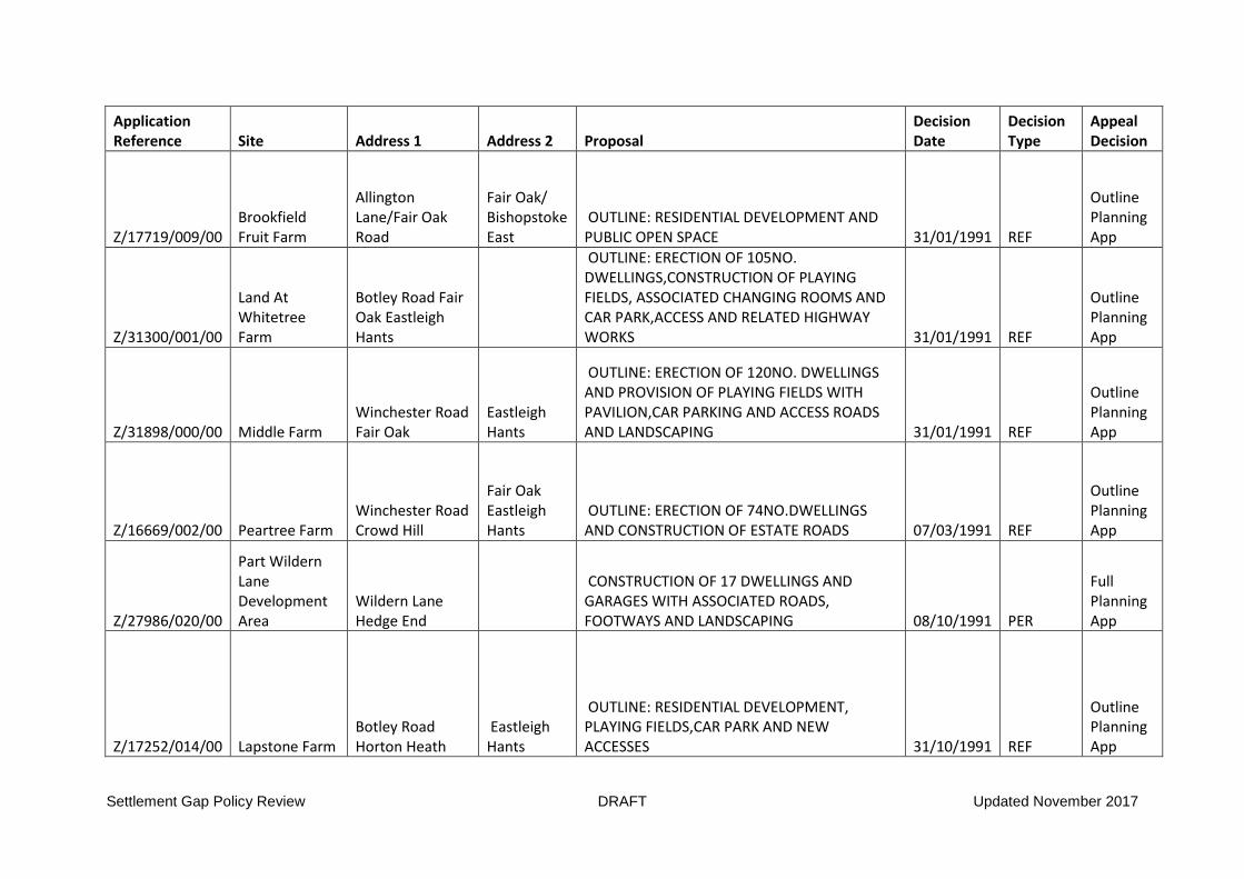
Settlement Gap Policy Review DRAFT Updated November 2017
Application Reference Site Address 1 Address 2 Proposal
Decision Date
Decision Type
Appeal Decision
Z/17719/009/00 Brookfield Fruit Farm
Allington Lane/Fair Oak Road
Fair Oak/ Bishopstoke East
OUTLINE: RESIDENTIAL DEVELOPMENT AND PUBLIC OPEN SPACE 31/01/1991 REF
Outline Planning App
Z/31300/001/00
Land At Whitetree Farm
Botley Road Fair Oak Eastleigh Hants
OUTLINE: ERECTION OF 105NO. DWELLINGS,CONSTRUCTION OF PLAYING FIELDS, ASSOCIATED CHANGING ROOMS AND CAR PARK,ACCESS AND RELATED HIGHWAY WORKS 31/01/1991 REF
Outline Planning App
Z/31898/000/00 Middle Farm Winchester Road Fair Oak
Eastleigh Hants
OUTLINE: ERECTION OF 120NO. DWELLINGS AND PROVISION OF PLAYING FIELDS WITH PAVILION,CAR PARKING AND ACCESS ROADS AND LANDSCAPING 31/01/1991 REF
Outline Planning App
Z/16669/002/00 Peartree Farm Winchester Road Crowd Hill
Fair Oak Eastleigh Hants
OUTLINE: ERECTION OF 74NO.DWELLINGS AND CONSTRUCTION OF ESTATE ROADS 07/03/1991 REF
Outline Planning App
Z/27986/020/00
Part Wildern Lane Development Area
Wildern Lane Hedge End
CONSTRUCTION OF 17 DWELLINGS AND GARAGES WITH ASSOCIATED ROADS, FOOTWAYS AND LANDSCAPING 08/10/1991 PER
Full Planning App
Z/17252/014/00 Lapstone Farm Botley Road Horton Heath
Eastleigh Hants
OUTLINE: RESIDENTIAL DEVELOPMENT, PLAYING FIELDS,CAR PARK AND NEW ACCESSES 31/10/1991 REF
Outline Planning App
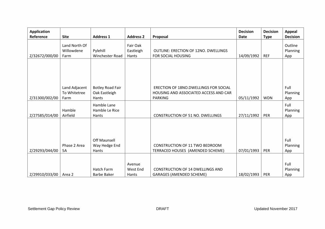
Settlement Gap Policy Review DRAFT Updated November 2017
Application Reference Site Address 1 Address 2 Proposal
Decision Date
Decision Type
Appeal Decision
Z/32672/000/00
Land North Of Willowdene Farm
Pylehill Winchester Road
Fair Oak Eastleigh Hants
OUTLINE: ERECTION OF 12NO. DWELLINGS FOR SOCIAL HOUSING 14/09/1992 REF
Outline Planning App
Z/31300/002/00
Land Adjacent To Whitetree Farm
Botley Road Fair Oak Eastleigh Hants
ERECTION OF 18NO.DWELLINGS FOR SOCIAL HOUSING AND ASSOCIATED ACCESS AND CAR PARKING 05/11/1992 WDN
Full Planning App
Z/27585/014/00 Hamble Airfield
Hamble Lane Hamble Le Rice Hants CONSTRUCTION OF 51 NO. DWELLINGS 27/11/1992 PER
Full Planning App
Z/29293/044/00 Phase 2 Area 5A
Off Maunsell Way Hedge End Hants
CONSTRUCTION OF 11 TWO BEDROOM TERRACED HOUSES (AMENDED SCHEME) 07/01/1993 PER
Full Planning App
Z/29910/033/00 Area 2 Hatch Farm Barbe Baker
Avenue West End Hants
CONSTRUCTION OF 14 DWELLINGS AND GARAGES (AMENDED SCHEME) 18/02/1993 PER
Full Planning App
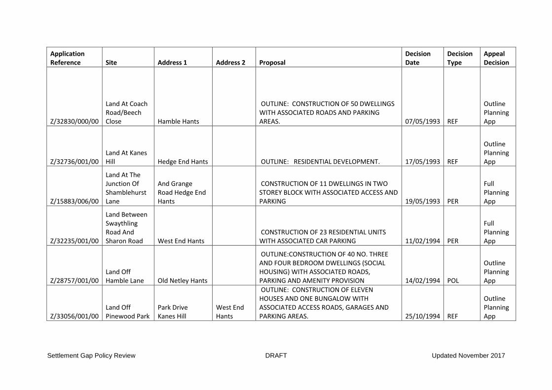
Settlement Gap Policy Review DRAFT Updated November 2017
Application Reference Site Address 1 Address 2 Proposal
Decision Date
Decision Type
Appeal Decision
Z/32830/000/00
Land At Coach Road/Beech Close Hamble Hants
OUTLINE: CONSTRUCTION OF 50 DWELLINGS WITH ASSOCIATED ROADS AND PARKING AREAS. 07/05/1993 REF
Outline Planning App
Z/32736/001/00 Land At Kanes Hill Hedge End Hants OUTLINE: RESIDENTIAL DEVELOPMENT. 17/05/1993 REF
Outline Planning App
Z/15883/006/00
Land At The Junction Of Shamblehurst Lane
And Grange Road Hedge End Hants
CONSTRUCTION OF 11 DWELLINGS IN TWO STOREY BLOCK WITH ASSOCIATED ACCESS AND PARKING 19/05/1993 PER
Full Planning App
Z/32235/001/00
Land Between Swaythling Road And Sharon Road West End Hants
CONSTRUCTION OF 23 RESIDENTIAL UNITS WITH ASSOCIATED CAR PARKING 11/02/1994 PER
Full Planning App
Z/28757/001/00 Land Off Hamble Lane Old Netley Hants
OUTLINE:CONSTRUCTION OF 40 NO. THREE AND FOUR BEDROOM DWELLINGS (SOCIAL HOUSING) WITH ASSOCIATED ROADS, PARKING AND AMENITY PROVISION 14/02/1994 POL
Outline Planning App
Z/33056/001/00 Land Off Pinewood Park
Park Drive Kanes Hill
West End Hants
OUTLINE: CONSTRUCTION OF ELEVEN HOUSES AND ONE BUNGALOW WITH ASSOCIATED ACCESS ROADS, GARAGES AND PARKING AREAS. 25/10/1994 REF
Outline Planning App

Settlement Gap Policy Review DRAFT Updated November 2017
Application Reference Site Address 1 Address 2 Proposal
Decision Date
Decision Type
Appeal Decision
Z/33538/000/00 Land North Of Maunsell Way Hedge End Hants
OUTLINE: RESIDENTIAL DEVELOPMENT AND ANCILLARY USES. 20/02/1996 POL
Outline Planning App
Z/32672/004/00 Land At Pyle Hill
Winchester Road Fair Oak Eastleigh
CONSTRUCTION OF 23NO. TWO AND THREE BEDROOM HOUSES ACCESS ROAD AND AMENITY SPACE 02/12/1996 REF
Full Planning App
Z/29571/003/00
Land At Farling House Brickfield Lane And 80 82 And
84 Bournemouth Road Chandlers
Ford Eastleigh
ERECTION OF 24 NO. DWELLINGS AFTER DEMOLITION OF EXISTING BUILDINGS 03/02/1997 REF
Full Planning App
Z/31256/000/00
Land At And Adjacent To 'Sunny Bank'
Botley Road Fair Oak Eastleigh Hants OUTLINE: RESIDENTIAL DEVELOPMENT 18/06/1997 ROL
Outline Planning App
Z/34489/000/00
Land At Lawnswood And Oakfield House Botley Road
Fair Oak Eastleigh
ERECTION OF 11NO. HOUSES WITH NEW ACCESSES FOLLOWING DEMOLITION OF EXISTING DWELLINGS 23/06/1997 REF
Full Planning App
Z/34489/002/00
Land At Lawnswood And Oakfield House Botley Road
Fair Oak Eastleigh
ERECTION OF 10NO. HOUSES WITH TWO ACCESSES FOLLOWING DEMOLITION OF EXISTING DWELLINGS 23/09/1997 PER
Full Planning App

Settlement Gap Policy Review DRAFT Updated November 2017
Application Reference Site Address 1 Address 2 Proposal
Decision Date
Decision Type
Appeal Decision
Z/32672/005/00 Land At Pyle Hill
Winchester Road Fair Oak Eastleigh OUTLINE: RESIDENTIAL DEVELOPMENT 30/03/1998 ROL
Outline Planning App
Z/34078/002/00 Glover Webb Premises
Spitfire Way Hamble Hants OUTLINE: RESIDENTIAL DEVELOPMENT 16/11/1998 POL
Outline Planning App
Z/15334/002/00
Site Of Farling House And Land Adj Brickfield Lane
Chandler's Ford Eastleigh
ERECTION OF 23 NO. 2 BEDROOM FLATS IN TWO BLOCKS AND CONSTRUCTION OF NEW SCOUT HUT WITH CAR PARKING, LANDSCAPING AND VEHICULAR ACCESS FROM BRICKFIELD LANE, FOLLOWING DEMOLITION OF EXISTING SCOUT HUT 12/10/2000 WDN
Full Planning App
Z/36574/000/00
Former Itchen Mead Hostel Church Road Bishopstoke Eastleigh
ERECTION OF 11NO. DETACHED DWELLINGS WITH GARAGES, CAR PARKING, LANDSCAPING AND FORMATION OF NEW VEHICULAR ACCESS 11/12/2000 PER
Full Planning App
Z/30736/009/00
Landacres (Formerly Angry Copse) Heath House Lane Bursledon Hants
OUTLINE: CONSTRUCTION OF 21NO. TWO BEDROOM APARTMENTS IN TWO BLOCKS AND 5NO. DWELLINGS WITH ACCESS FROM HEATH HOUSE LANE AND HEATH HOUSE CLOSE 11/12/2002 ROL
Outline Planning App
O/04/52365 Land West of Hamble Lane Bursledon
Outline: Residential development of 600 dwellings, park and ride car park for 850 spaces, health centre, care home, public open space and cycle/pedestrian links, with vehicular accesses from Hamble Lane, Bursledon Road and Green Lane 06/01/2005 WDN
Outline Planning App

Settlement Gap Policy Review DRAFT Updated November 2017
Application Reference Site Address 1 Address 2 Proposal
Decision Date
Decision Type
Appeal Decision
O/05/53274
Land West of Allington Lane and South of Hogwood Lane West End
Outline: Construction of 90 dwellings following demolition of existing buildings 29/04/2005 ROL
Outline Planning App
F/04/50803
Land To The Front Of Moonrakers And Rear Of Nakururoot Botley Road
Fair Oak SO507PS
Erection of 4 no. flats (2 no. one bed and 2 no. two bed) to the front of Moonrakers, and erection of 4 no. one bed flats in a two storey block, 2 no. four bed detached houses and 4 no. three bed detached bungalows, with associated car parking and landscaping to the rear of Nakuru Root and to Moonrakers 19/05/2005 PER
Full Planning App
R/05/55285 Land South of South Street SO505BG
Reserved Matters pursuant to outline planning permission Z/39705/000/00 for the erection of 432 dwellings (of 2, 3 and 4 storeys in height), 638 square metres of B1 (business) floor space with associated highway works, landscaping and public open space. 23/05/2006 ARM
Reserved Matters
O/12/71828
Land to West of Hamble Lane
Outline: Residential development (up to 150 houses) with access off the Hamble Lane/Jurd Way roundabout. All matters to be reserved except for access. 28/05/2013 ROL
Outline Planning App

Settlement Gap Policy Review DRAFT Updated November 2017
Application Reference Site Address 1 Address 2 Proposal
Decision Date
Decision Type
Appeal Decision
O/13/72490 Land at the
Corner of Knowle Lane and Mortimers Lane
Fair Oak SO50 7EA
Outline: Residential development for up to 78 dwellings with access from Knowle Lane with associated roads, parking, open space and landscaping (access only reserved matter to be considered) 05/12/2013 ROL
Outline Planning App
O/13/73660 Land at Stoke Park Farm
Stoke Common Road
Bishopstoke SO50 6DW
Outline application for residential development of up to 60 dwellings, allotments, extension to existing cemetery and public open space with access off Stoke Common Road including additional bridleway link(All matters reserved except access). 05/06/2014 POL
Outline Planning App
F/13/73606
Land to the East of Sovereign Drive and Precosa Road Botley
Residential development comprising 106 dwelling units, new access from Sovereign Drive, new roads, public open space, landscaping and drainage works following demolition of 47 Sovereign Drive, 1 Precosa Road and Hatts Copse House (net 103 dwellings) 09/07/2014 REF
Full Planning App
O/14/73948 Berry Farm Hamble Lane Bursledon SO31 8JD
Outline planning application with all matters reserved (apart from access) for up to 125 dwellings and a 70 unit extra care facility with associated access with new right turn lane, two pedestrian refuge islands and new roundabout at junction of Portsmouth Road and Hamble Lane, parking, landscaping and open space following demolition of existing buildings. 09/07/2014 ROL
Outline Planning App

Settlement Gap Policy Review DRAFT Updated November 2017
Application Reference Site Address 1 Address 2 Proposal
Decision Date
Decision Type
Appeal Decision
O/13/73479
Land at Hamble Station Hamble Lane
Netley Abbey
Outline planning application with all matters reserved (apart from access) for up to 225 residential units plus 60 bed care home and 40 bed extra care units. One new vehicular access and one emergency access, provision of public open space, woodland and improvements to Hamble Station including new car parking, station kiosk/farm shop/café and public transport interchange with taxi and drop off facilities along with all associated landscaping and access. 17/07/2014 ROL
Outline Planning App
O/13/73701
Land to the north of Bridge Road and west of Blundell Lane Bursledon
Outline: Construction of up to 90 dwelling units, new vehicular access from Bridge Road, drainage works, landscaping & public open space (access only to be considered). 31/07/2014 POL
Outline Planning App
O/13/73707
Land off Winchester Road
Fair Oak SO50 8GL
Outline: Residential development of up to 330 new dwelling units, new community building, public open space, and provision of new vehicular access from Winchester Road following demolition of existing buildings and stopping up of existing access. 25/09/2014 POL
Outline Planning App
O/14/74322 Land at Providence Hill Bursledon
Outline application: Erection of up to 62 dwellings, new access from Providence Hill, drainage works, footway link to Dodwell Lane and public open space (access only to be considered). 15/10/2014 POL
Outline Planning App

Settlement Gap Policy Review DRAFT Updated November 2017
Application Reference Site Address 1 Address 2 Proposal
Decision Date
Decision Type
Appeal Decision
F/14/74686 Land east of Pitmore Road Allbrook
Construction of 50 dwellings together with associated access, car parking, landscaping and provision of public open space. 31/10/2014 PER
Full Planning App
O/14/74617
Land at the corner of Knowle Lane and Mortimers Lane Fair Oak
Outline: Residential development for up to 78 dwellings with access from Knowle Lane with associated roads, parking, open space and landscaping (access only reserved matters to be considered). 13/02/2015 WDN
Outline Planning App
O/14/74849
Land at Portchester Rise/ Boyatt Lane
Outline Application for up to 24 dwellings and associated access, open space and landscaping (access only to be considered). 04/03/2015 POL
Outline Planning App
O/14/75166 Land off Bubb Lane West End
Outline application: Residential development comprising up to 328 dwellings, public open space and children's play area, land for doctors surgery and associated car parking, with accesses off Bubb Lane and Moorgreen Road, structural planting and landscaping and surface water attenuation and ancillary works, with all matters reserved for future determination. 12/03/2015 ROL
Outline Planning App
F/14/74943
Dog Kennel Farm and land adjacent Telegraph Road
West End SO30 3EX
Construction of 14no. dwellings, public open space, parking, landscaping and new access off Telegraph Road following demolition of all buildings on site and closure of the existing access 20/04/2015 PER
Full Planning App
F/13/73644 Moorgreen Dairy Farm Botley Road
West End SO30 3JB
Erection of 5 no. 3 bedroom terraced dwellings & 9 no. 5 bedroom detached dwellings following demolition of existing farm buildings with access from Botley Road. 26/05/2015 WDN
Full Planning App

Settlement Gap Policy Review DRAFT Updated November 2017
Application Reference Site Address 1 Address 2 Proposal
Decision Date
Decision Type
Appeal Decision
R/14/75595 Pylands Lane Bursledon SO31 1BH
Reserved matters application for appearance, landscaping, layout and scale pursuant to outline planning permission O/12/71522 for the construction of 189 dwellings (Phase 1) with ancillary road, landscaping, car parking, drainage and sewage pumping station 12/06/2015 ARM
Reserved Matters
O/15/75953 Land at Hedge End North Winchester Road Botley
Outline application for up to 680 residential units, mixed use comprising of retail and/or community/healthcare use, land for two-form entry primary school, formal and informal open space and sports pitches. New access off Winchester Road, associated on-site roads, infrastructure and footpaths/cycleways. Detailed matters for determination access (all other matters reserved - scale, appearance, landscaping and layout). This application is the subject of an Environmental Impact Assessment, is a departure from the Development Plan, is Major Development and affects the setting of a Right of Way. 06/07/2015 ROL
Outline Planning App
R/15/76606 Pylands Lane Bursledon SO31 1BH
Reserved Matters: application for appearance, landscaping, layout and scale pursuant to outline planning permission O/12/71522 for the construction of 61 dwellings (Phase 2) with ancillary road, landscaping, car parking, drainage and sewage pumping station. 11/09/2015 ARM
Reserved Matters

Settlement Gap Policy Review DRAFT Updated November 2017
Application Reference Site Address 1 Address 2 Proposal
Decision Date
Decision Type
Appeal Decision
O/15/76418 Land off Botley Road West End
Outline application for up to 100 dwellings (including up to 35% affordable housing), structural planting and landscaping, informal public open space, surface water attenuation, vehicular access off Botley Road and associated ancillary works. All matters to be reserved except for access. 16/09/2015 ROL
Outline Planning App
O/15/77112 Land off Bubb Lane West End
Outline: Residential development of up to 200no. dwellings with all matters reserved. 14/01/2016 ROL
Outline Planning App
R/15/77286
Land at Portchester Rise SO50 4QS
Reserved matters pursuant to outline planning permission O/14/74849 for the construction of 24 dwellings consisting of 4No. 2bed flats, 2No. 2bed, 11No. 3bed and 7No. 4bed dwellings (matters to be considered are appearance, landscaping, layout and scale) 21/01/2016 ARM
Reserved Matters
C/14/74932
Land to the rear of Orchard Lodge Windmill Lane
Bursledon SO31 8BG
Outline application: Residential development of up to 29 houses with associated parking, public open space and enhancement of existing vehicular access off Windmill Lane (access, appearance, layout & scale to be considered). (Amended description) 28/01/2016 POL
Outline Planning App
X/15/77329 Dog Kennel Farm Telegraph Road
West End SO30 3EX
Alternative site and house design plans to those approved under planning permission F/14/74943 for the construction of 14 dwelling units (variation to Condition 1 of permission F/14/74943 which specifies the approved plans). 29/02/2016 PER
Relief of Condition

Settlement Gap Policy Review DRAFT Updated November 2017
Application Reference Site Address 1 Address 2 Proposal
Decision Date
Decision Type
Appeal Decision
O/15/76491
Land to the South of Mallards Road
Bursledon SO31 8EH
Outline: Construction of up to 80 dwellings including public open space with access as only detailed matter for consideration following demolition of nos. 1 and 3 Mallards Road. 10/03/2016 ROL
Outline Planning App
F/15/76582 Berry Farm Hamble Lane Bursledon SO31 8JD
Construction of 166 dwellings with associated access off Hamble Lane, parking, landscaping and open space, and highway works at the junction of Portsmouth Road and Hamble Lane following demolition of existing dwelling and former agricultural buildings/workshop. 11/03/2016 PER
Full Planning App
F/15/77211 Land at White Tree Farm Botley Road
Fair Oak SO50 7AP
Erection of 17no. dwellings and a new parish office and compound and associated car parking, public open space and new site access following demolition of existing buildings. 27/05/2016 PER
Full Planning App
C/16/77959
Land to the rear of Orchard Lodge Windmill Lane
Bursledon SO31 8BG
Reserved matters application: Residential development of 29no. dwellings with associated parking and public open space (landscape to be considered). NULL NULL
Reserved Matters
F/13/73606
Land to the East of Sovereign Drive and Precosa Road Botley
Residential development comprising 106 dwelling units, new access from Sovereign Drive, new roads, public open space, landscaping and drainage works following demolition of 47 Sovereign Drive, 1 Precosa Road and Hatts Copse House (net 103 dwellings) NULL OVE
Full Planning App

Settlement Gap Policy Review DRAFT Updated November 2017
Application Reference Site Address 1 Address 2 Proposal
Decision Date
Decision Type
Appeal Decision
F/13/73648
Land to the north of Mortimers Lane and to the west of Hall Lands Lane Fair Oak
Residential development of 46 no. dwellings with new vehicular access to Mortimers Lane, public open space, landscaping and drainage works NULL PER
Full Planning App
F/15/77500
Land to the west of Hammerley Farm Burnetts Lane
Horton Heath SO50 7DJ
Construction of 67 dwellings with associated car parking, open space, landscaping and enhancements of access from Anson Road and provision of vehicle link to land to the west following demolition of existing buildings NULL NULL
Full Planning App
F/15/77718 Land at Hatch Farm
North of Barbe Baker Avenue West End
Construction of 98no. dwellings with access from Barbe Baker Avenue and Barnsland, associated landscaping, parking, new footpath, childrens' play area, attenuation pond and diversion of 3no. public rights of way. NULL NULL
Full Planning App
O/13/72490 Land at the
Corner of Knowle Lane and Mortimers Lane
Fair Oak SO50 7EA
Outline: Residential development for up to 78 dwellings with access from Knowle Lane with associated roads, parking, open space and landscaping (access only reserved matter to be considered) NULL AAA
Outline Planning App
O/13/72490 Land at the
Corner of Knowle Lane and Mortimers Lane
Fair Oak SO50 7EA
Outline: Residential development for up to 78 dwellings with access from Knowle Lane with associated roads, parking, open space and landscaping (access only reserved matter to be considered) NULL NULL
Outline Planning App

Settlement Gap Policy Review DRAFT Updated November 2017
Application Reference Site Address 1 Address 2 Proposal
Decision Date
Decision Type
Appeal Decision
O/14/75086 Land at Fair Oak Road
Bishopstoke SO50 6QF
Outline: Construction of 16no. dwellings to include 6no. affordable units with access off Fair Oak Road (access only detailed matter for consideration).(Amended description) NULL NULL
Outline Planning App
O/14/75435 Land to the east of Grange Road
Netley Abbey SO31 5FE
Outline: Residential development of up to 250 dwellings, including allotments and public open space, with associated means of access off Woolston Road with other matters reserved. NULL NULL
Outline Planning App
O/14/75435 Land to the east of Grange Road
Netley Abbey SO31 5FE
Outline: Residential development of up to 250 dwellings, including allotments and public open space, with associated means of access off Woolston Road with other matters reserved. NULL NULL
Outline Planning App
O/15/75953 Land at Hedge End North Winchester Road Botley
Outline application for up to 680 residential units, mixed use comprising of retail and/or community/healthcare use, land for two-form entry primary school, formal and informal open space and sports pitches. New access off Winchester Road, associated on-site roads, infrastructure and footpaths/cycleways. Detailed matters for determination access (all other matters reserved - scale, appearance, landscaping and layout). This application is the subject of an Environmental Impact Assessment, is a departure from the Development Plan, is Major Development and affects the setting of a Right of Way. NULL NULL
Outline Planning App

Settlement Gap Policy Review DRAFT Updated November 2017
Application Reference Site Address 1 Address 2 Proposal
Decision Date
Decision Type
Appeal Decision
O/15/76147 Land to the east of Grange Road
Netley Abbey
Outline: Residential development of up to 230 dwellings, including allotments and public open space, with associated means of access off Woolston Road with other matters reserved. NULL REF
Outline Planning App
O/15/77190 Pembers Hill Farm Mortimers Lane
Fair Oak SO50 7EA
Outline: Construction of up to 250no. Dwellings with access from Mortimers Lane and pedestrian/cycle links, open space and landscaping, all matters other than access reserved. (This application is subject to an Environmental Impact Assessment and is a departure from the development plan, is a major development and affects a setting of a listed building.) NULL NULL
Outline Planning App
O/16/78014
Land on the north side of Grange Road Netley Abbey
Outline: Residential development of up to 93no. dwellings with all matters reserved except for access. NULL NULL
Outline Planning App
O/16/78389 Crows Nest Lane Botley SO32 2DD
Outline Application: Residential development of up to 50no. dwellings with green infrastructure, hard and soft landscape and associated infrastructure, including internal access roads, footpaths/cycle routes, play space and relocation of gas governor and creation of new access on to Maddoxford Lane. NULL NULL
Outline Planning App

Settlement Gap Policy Review DRAFT Updated November 2017
PER Permitted REF Refused RNO Raise No Objection WDN Withdrawn POL Permit Outline ROL Refuse Outline ARM Approve Reserved Matters AAA Approved At Appeal OVE Overturned At Appeal

Settlement Gap Policy Review DRAFT Updated November 2017
Appendix 4:Submitted Local Plan 2016-2029, Policy S9:
Strategic policy S9, Countryside and countryside gaps
Countryside is defined as all the areas outside the urban edge as defined on the policies map,
including river valleys and the undeveloped coast. In the countryside, there is a presumption against
new development, subject to other policies of this local plan.
In order to maintain the separate identity of settlements and separation from Southampton,
countryside gaps are defined between:
Eastleigh and Southampton;
Eastleigh and Bishopstoke;
Pitmore Road and the M3, Allbrook;
Bishopstoke, Fair Oak and Horton Heath;
Horton Heath, Boorley Green and Hedge End;
Botley and Boorley Green;
Hedge End/ Botley West and Botley;
West End and Hedge End;
Hedge End and Bursledon;
Bursledon and Southampton, Netley and Hamble;
Netley and Hamble;
Netley and Southampton;
as set out in the Key Diagram and on the policies maps.
Planning permission will be granted for new development in the countryside provided it is related to:
i. The provision of employment through agricultural development (policy DM14), the extension and
replacement of existing employment uses (policy DM16) and the re-use of existing buildings
(policy DM17);
ii. Residential extensions and replacement buildings (policies DM16 and DM26), limited residential
conversions (policy DM17), rural workers’ dwellings (policy DM27) and accommodation for
gypsies, travellers and travelling showpeople (policy DM30);
iii. community, tourist, or visitor uses through the re-use of buildings including facilities for the
interpretation of heritage assets (policies DM10 and DM17);
iv. limited car boot sales and markets (policy DM22);
v. outdoor recreation and open space (policies DM33 and DM34);
vi. allotments and community farms (policy DM33);
vii. cemeteries (policy DM36); and
viii. essential public utilities (policy DM8).
In countryside gaps as defined on the policies map, development which physically or visually
diminishes the gap, or has an urbanising effect detrimental to the openness of the gap, the character
of the countryside or the separate identity of the adjoining settlements will not be permitted.
In permitting new development in the countryside the Borough Council will wherever possible seek to:
a. avoid adverse impacts on the rural, river valley or coastal character, the intrinsic character of the
landscape including the avoidance of adverse landscape impacts on areas adjoining national
parks and their settings, and on the biodiversity of the area;
b. secure long-term beneficial management practices that will enhance the landscape and
biodiversity of the countryside and coast; and
c. c. avoid sterilisation of mineral resources, in accordance with the Hampshire Minerals and Waste
Plan.

Settlement Gap Policy Review DRAFT Updated November 2017
Appendix 5: Assessment of ‘Green Value’ of Settlement Gaps
1. Boyatt Wood, Otterbourne Hill and Allbrook Local Gap
High Med Low Comments
Levels of permitted public rights of way Limited footpath network
Amount of recreational facilities Private fishing but de-facto access
Intactness / integrity of landscape character
Severed by Allbrook Way
Cultural heritage / Historic association value
Former brick works SE of Allbrook Way
Nature conservation / Earth science value
SINC woodland and wetlands
Flood attenuation (EA Maps) N/A
Agricultural productivity Small areas grade 3 and 4
Target Area for Enhancement Yes No
2 Eastleigh-Southampton Gap High Med Low Comments
Levels of permitted public rights of way Footpath network concentrated to the north
Amount of recreational facilities Extensive range of sports pitches and parkland
Intactness / integrity of landscape character
Severed by Monks BrookM27/ J5, airport and railway
Cultural heritage / Historic association value
Mainly limited to landscape associated with Brown (within development site)
Nature conservation / Earth science value
SINCs associated with Monks Brook and Lakeside
Flood attenuation (EA Maps) Associated with Monks Brook corridor and Lakeside
Agricultural productivity Only relevant to proposed development site (mainly grade4)
Target Area for Enhancement Yes No
3. Eastleigh-Bishopstoke High Med Low Comments

Settlement Gap Policy Review DRAFT Updated November 2017
Levels of permitted public rights of way Limited footpath network
Amount of recreational facilities Some playing fields,
otherwise private
Intactness / integrity of landscape
character
Dominated by grazed
floodplain
Cultural heritage / Historic association
value
Itchen Navigation
Nature conservation / Earth science
value
SAC and SINC woodlands
Flood attenuation (EA Maps) Dominated by floodplain
Agricultural productivity Grade 4 (mainly
floodplain)
Target Area for Enhancement Yes No
4. Bishopstoke, Fair Oak and Horton
Heath Gap
High Med Low Comments
Levels of permitted public rights of way Extensive footpath
network
Amount of recreational facilities Extensive area of
recreational land
Intactness / integrity of landscape
character
Dominated by recreational
use but severed by ribbon
development and the
Botley Road
Cultural heritage / Historic association
value
No significant value
recorded
Nature conservation / Earth science
value
SINC woodland and
wetlands
Flood attenuation (EA Maps) N/A
Agricultural productivity Grade 4, some in
recreational use
Target Area for Enhancement Yes No

Settlement Gap Policy Review DRAFT Updated November 2017
5. Horton Heath-Boorley Green-
Hedge End
High Med Low Comments
Levels of permitted public rights of
way
Limited footpath network
Amount of recreational facilities None
Intactness / integrity of landscape
character
Crossed by some roads
Cultural heritage / Historic association
value
No significant association
Nature conservation / Earth science
value
Some tree cover
Flood attenuation (EA Maps) Localised flooding by
stream
Agricultural productivity Grade 2 and 3 land
Target Area for Enhancement Yes No
6. Botley-Boorley Green High Med Low Comments
Levels of permitted public rights of
way
None in the existing gap,
but footpath to the east
may be included if the gap
is widened
Amount of recreational facilities None here
Intactness / integrity of landscape
character
Severed by railway
Cultural heritage / Historic association
value
None known
Nature conservation / Earth science
value
Not within the existing gap
but may include wetland
habitat if gap is widened
Flood attenuation (EA Maps) Not in present gap but
may include some flood
zone 2 areas if gap is
extended
Agricultural productivity Small area, grade 3 land
Target Area for Enhancement Yes No

Settlement Gap Policy Review DRAFT Updated November 2017
7. Hedge End -Botley High Med Low Comments
Levels of permitted public rights of way Footpaths and bridleways
Amount of recreational facilities Some sports pitches and
recreational areas
Intactness / integrity of landscape
character
Less intact to south
Cultural heritage / Historic association
value
Part of existing gap
overlaps with conservation
area
Nature conservation / Earth science
value
SINCs mainly associated
with stream corridors
Flood attenuation (EA Maps) Limited flooding potential
along stream corridors
Agricultural productivity Grade 3 land
Target Area for Enhancement Yes No
8. West End-Hedge End (part of the
‘Southampton-Hedge
End/Bursledon/Netley gap’)
High Med Low Comments
Levels of permitted public rights of way Limited footpath network
mainly east of the M27
Amount of recreational facilities
Includes golf provision and
at present cricket and
woodland (which may not
remain in the gap if
amended)
Intactness / integrity of landscape
character
M27 and urbanising land
uses have impacted on
the character
Cultural heritage / Historic association
value
None known
Nature conservation / Earth science
value
Nature reserve and SINC
(though woodland may not
remain in gap if amended)
Flood attenuation (EA Maps) Zone 2 on land by
Moorgreen nature reserve
Agricultural productivity Mainly Grade 3 and 4
Target Area for Enhancement Yes No

Settlement Gap Policy Review DRAFT Updated November 2017
9. Hedge End-Bursledon High Med Low Comments
Levels of permitted public rights of way Limited footpath network
in present gap, but this
would reduce if gap is
amended
Amount of recreational facilities Associated with public
access and links to Manor
Farm country park which
would reduce if gap is
amended.
Intactness / integrity of landscape
character
Severed by M27
Cultural heritage / Historic association
value
Bursledon Windmill and
land adjoining River
Hamble (river side area
may be excluded if gap is
amended)
Nature conservation / Earth science
value
SINC woodland and
saltmarsh (may be
reduced if gap is
amended)
Flood attenuation (EA Maps) Limited tidal zone 2 (may
be excluded if gap is
amended)
Agricultural productivity Mix of grade 2,3,4
Target Area for Enhancement Yes No
10 Bursledon-Southampton, Netley
and Hamble
High Med Low Comments
Levels of permitted public rights of way Widespread footpath
network
Amount of recreational facilities Some sports pitches
Intactness / integrity of landscape
character
Severed by roads
Cultural heritage / Historic association
value
Riverside former boat
industry heritage (some
would be excluded if gap
is amended)
Nature conservation / Earth science
value
SINC woodland and
wetlands (some would be

Settlement Gap Policy Review DRAFT Updated November 2017
excluded if gap is
amended)
Flood attenuation (EA Maps) Some stream courses and
tidal flood zone 2 (some
may be excluded if gap is
amended)
Agricultural productivity Includes grade 1 and 3
land
Target Area for Enhancement Yes No
11. Netley and Hamble High Med Low Comments
Levels of permitted public rights of way Footpath network
connects to coast
Amount of recreational facilities Royal Victoria Country
Park and coast
Intactness / integrity of landscape
character
Generally intact
Cultural heritage / Historic association
value
Includes historic buildings
in the Royal Victoria
Country Park
Nature conservation / Earth science
value
SINC woodland
Flood attenuation (EA Maps) Very small area of tidal
flood zone 2
Agricultural productivity Small area of grade1 land
but mainly not in
agricultural use
Target Area for Enhancement Yes No
12. Netley and Southampton (part High Med Low Comments

Settlement Gap Policy Review DRAFT Updated November 2017
of the Southampton-Hedge
End/Bursledon /Netley Strategic
Gap)
Levels of permitted public rights of
way
Footpath network and
access within West Wood
and along the coast
Amount of recreational facilities Country Park and coast
Intactness / integrity of landscape
character
Fairly intact
Cultural heritage / Historic association
value
Netley Abbey, associated
ponds and Castle
Nature conservation / Earth science
value
SINC woodland
Flood attenuation (EA Maps) Small area of tidal flood
zone 2
Agricultural productivity Very small area of grade
1 land but mainly in non-
agricultural use
Target Area for Enhancement Yes No

Settlement Gap Policy Review DRAFT Updated November 2017
Appendix 6:
Summary of the Implications of Spatial Options on Settlement Gaps
A: Extensions to settlements
With the exception of an extension East of Fair Oak (Fair Oak 7) all settlement
extensions are likely to have some adverse effect on the separation of settlements
though it is uncertain in scale until further consideration of design and layout.
A new gap designation between the agreed development west of Horton Heath and
proposed development south of Bishopstoke may be required to retain the separate
identity of Horton Heath and Bishopstoke, although this would inevitably reduce the
area of potential development at Fir Tree Farm east of Allington Lane (Fair Oak 5). This
has been illustrated in Figure 18.

Settlement Gap Policy Review DRAFT Updated November 2017
B: Expansion of Fair Oak and Bishopstoke and Allbrook
There is potential for coalescence between the settlements of Boyatt Wood and
Allbrook/Otterbourne Hill.
Development proposals north of Stoke Park Woods on elevated countryside are likely to
result in a marked physical and visual erosion of the countryside between Bishopstoke and
Colden Common.
Collectively, development north of Stoke Park Woods and north and east of Fair Oak would
further intensify sporadic development, particularly between Fair Oak and Crowdhill. It
would contribute to the erosion of the physical and visual gap between Fair Oak and
Crowdhill, and Fishers Pond and Colden Common.
There are therefore likely to be significant negative effects with regard to separation of
settlements. The overall effect is uncertain and is subject to consideration of design/layout
and mitigation measures.
The gap function of remaining countryside between new development and Colden
Common /Fishers Pond may need to be protected with a new gap designation between
Land to the north of Stoke Park Wood and Colden Common/Fishers Pond although scope
to achieve this within the borough boundary is limited. This has been illustrated below.

Settlement Gap Policy Review DRAFT Updated November 2017
C: Expansion of Fair Oak to east and north
Development in these locations is likely to erode the separation between Fair Oak and
Lower Upham.
A new gap designation between land to the east of Fair Oak and Lower Upham may be
required to protect the identity of the two settlements, although scope to achieve this within
the borough boundary is limited. This has been illustrated below.

Settlement Gap Policy Review DRAFT Updated November 2017
D: Expansion of Bishopstoke to the south and Horton Heath to the west
There would be significant erosion of the remaining gap between Bishopstoke/Fair Oak and Horton
Heath.
Particularly in combination with development proposed west of Horton Heath which
currently has resolution to permit. A new gap designation between the agreed development
west of Horton Heath and proposed development south of Bishopstoke may be required to
retain the separate identity of Horton Heath and Bishopstoke, although this would
inevitably reduce the area of potential development at Fir Tree Farm and East of Allington
Lane, however, the extent to which the developable area is reduced will be determined by
the extent to which crucial green infrastructure which would be required to support a
development of this scale can be effectively located within the gap. This has been
illustrated below.

Settlement Gap Policy Review DRAFT Updated November 2017
E: Extension to West End north of M27
Development in these locations would reduce the existing gap between West End and
Hedge End. As the gap is likely to be reduced, it would also have an impact upon the
openness of the landscape character, which is predominantly agricultural. These effects
are, however, uncertain because the site specific design and layout details would not be
ascertained until decision-making stage.
There could be some erosion of separation between West End/Hedge End as perceived
from the local road network and it may be necessary to extend the existing gap to include
land between Bubb Lane and Burnetts Lane to protect the identity of West End and Hedge
End. This would remove the development potential of the site between Bubb Lane and
Burnetts Lane. However, the extent to which the developable area is reduced will be
determined by the extent to which crucial green infrastructure which would be required to
support a development of this scale can be effectively located within the gap.

Settlement Gap Policy Review DRAFT Updated November 2017
F: Extending Hedge End to the north east and Botley to the north
Development in these locations is likely to diminish the separation between Hedge End,
Boorley Green and Botley. The eastern part of Hedge End 1 is located at the
narrowest part of the gap between settlements which may be further eroded by the
construction of the Botley bypass which is likely to erode the gap at Botley 1 also. Until
site specific design and layout details are known, however, this negative effect is
uncertain.
A new gap may be required to help protect the identity of the settlement of Botley and
Boorley Green north of land east of Uplands Farm between the railway and
Maddoxford Lane. This has been illustrated below. It would be more effective if it
continued into the Winchester District.
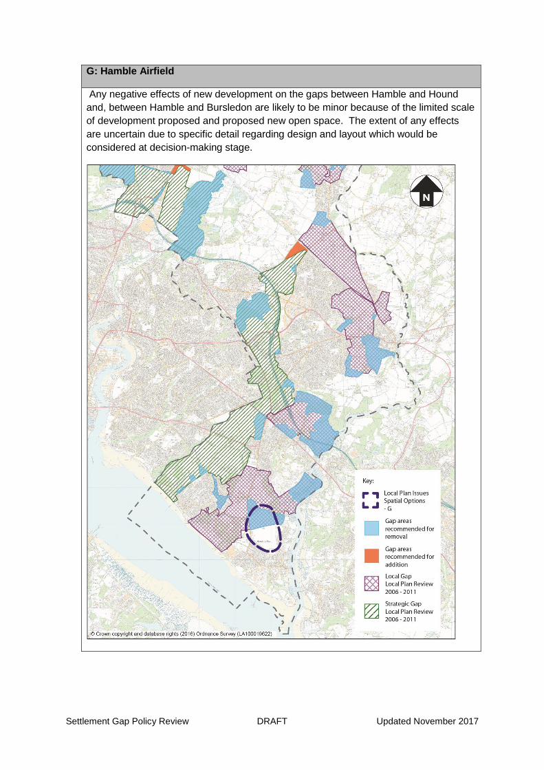
Settlement Gap Policy Review DRAFT Updated November 2017
G: Hamble Airfield
Any negative effects of new development on the gaps between Hamble and Hound
and, between Hamble and Bursledon are likely to be minor because of the limited scale
of development proposed and proposed new open space. The extent of any effects
are uncertain due to specific detail regarding design and layout which would be
considered at decision-making stage.

Settlement Gap Policy Review DRAFT Updated November 2017
H: Redevelopment of Eastleigh Riverside for employment uses
These locations are heavily influenced by the character of the airport and have limited
visibility therefore development is unlikely to result in significant effects on the identity
of settlements.