Embed Size (px)
Citation preview
The Leys School
Cambridge 13+ Scholarship
Revision Guidance for Scholarship Examination in January 2016
Now that the scholarship examination is nearly upon us, it is important that you know exactly what to revise.
Time: Your examination paper lasts 40 minutes.
Structure of the paper:-
The paper is divided into two parts:-
Section A – the map based section(usually you would spend 15 minutes on this section).
Section B – the thematic section (usually you would spend 25 minutes answering ONE question in this section).
Although Section A is map based and tests your map skills, there could be questions on river features and processes, coastal features and processes, settlement (sites, hierarchies and urban land use) and Economic Activities.
Together with Tectonic Processes, these topics will form the main part of your revision for Section B as well.
Below is a revision List for your scholarship examination.
Make sure you know and understand the concepts and you are able to use appropriate examples.
Please note!!! Due to the lack of time before your scholarship examination in January, we will not be looking at environmental issues but you have an A4 revision sheet on the Yorkshire Dales which can act as back up to your main
revision topics.
Remember to look at the November trial paper you completed for comments and areas you can improve on.
Section A: Map SillsRemember to revise:-
‘Map Skills - the essentials!’
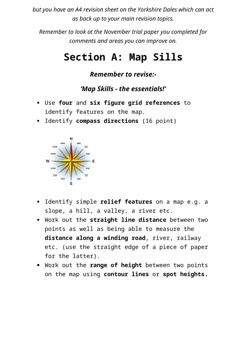
Use four and six figure grid references to identify features on the map. Identify compass directions (16 point)
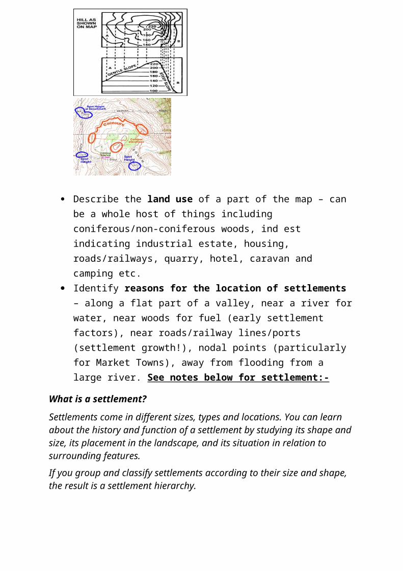
Identify simple relief features on a map e.g. a slope, a hill, a valley, a river etc.
Work out the straight line distance between two points as well as being able to measure the distance along a winding road, river, railway etc. (use the straight edge of a piece of paper for the latter).
Work out the range of height between two points on the map using contour lines or spot heights.
Describe the land use of a part of the map – can be a whole host of things including coniferous/non-coniferous woods, ind est indicating industrial estate, housing, roads/railways, quarry, hotel, caravan and camping etc.
Identify reasons for the location of settlements – along a flat part of a valley, near a river for water, near woods for fuel (early settlement factors), near roads/railway lines/ports (settlement growth!), nodal points (particularly for Market Towns), away from flooding from a large river. See notes below for settlement:-
What is a settlement?
Settlements come in different sizes, types and locations. You can learn about the history and function of a settlement by studying its shape and size, its placement in the landscape, and its situation in relation to surrounding features.
If you group and classify settlements according to their size and shape, the result is a settlement hierarchy.
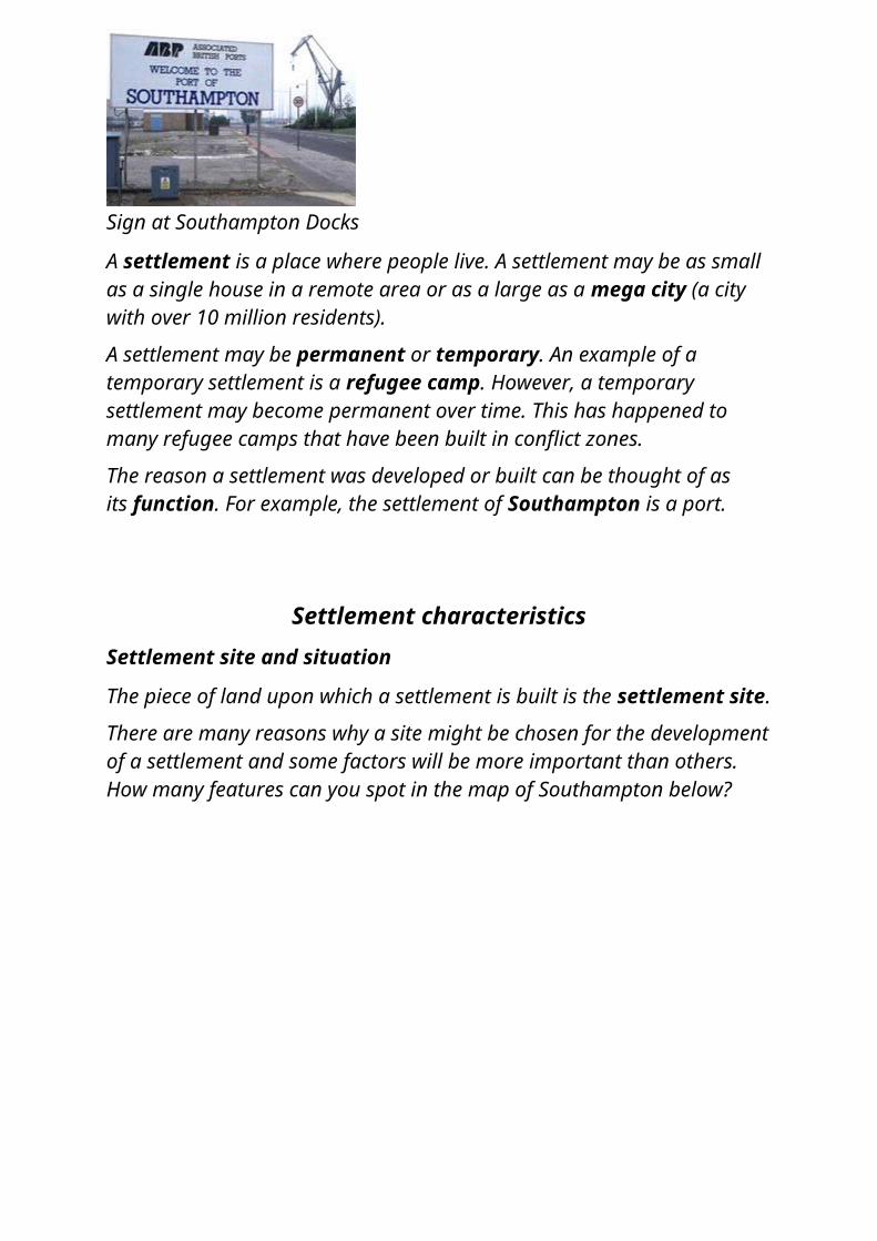
Sign at Southampton Docks
A settlement is a place where people live. A settlement may be as small as a single house in a remote area or as a large as a mega city (a city with over 10 million residents).
A settlement may be permanent or temporary. An example of a temporary settlement is a refugee camp. However, a temporary settlement may become permanent over time. This has happened to many refugee camps that have been built in conflict zones.
The reason a settlement was developed or built can be thought of as its function. For example, the settlement of Southampton is a port.
Settlement characteristicsSettlement site and situation
The piece of land upon which a settlement is built is the settlement site.
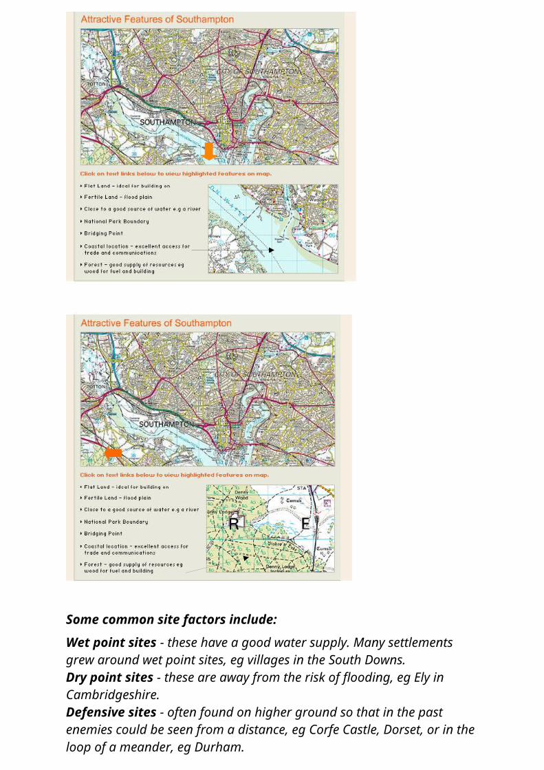
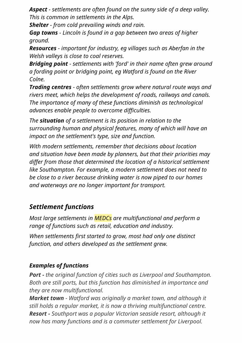
There are many reasons why a site might be chosen for the development of a settlement and some factors will be more important than others. How many features can you spot in the map of Southampton below?

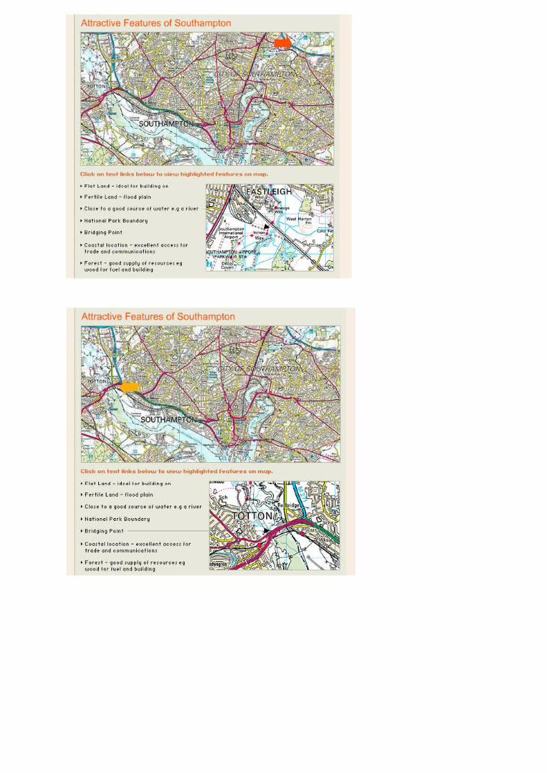
Some common site factors include:
Wet point sites - these have a good water supply. Many settlements grew around wet point sites, eg villages in the South Downs.Dry point sites - these are away from the risk of flooding, eg Ely in Cambridgeshire.Defensive sites - often found on higher ground so that in the past enemies could be seen from a distance, eg Corfe Castle, Dorset, or in the loop of a meander, eg Durham.
Aspect - settlements are often found on the sunny side of a deep valley. This is common in settlements in the Alps.Shelter - from cold prevailing winds and rain.Gap towns - Lincoln is found in a gap between two areas of higher ground.Resources - important for industry, eg villages such as Aberfan in the Welsh valleys is close to coal reserves.Bridging point - settlements with 'ford' in their name often grew around a fording point or bridging point, eg Watford is found on the River Colne.Trading centres - often settlements grow where natural route ways and rivers meet, which helps the development of roads, railways and canals.The importance of many of these functions diminish as technological advances enable people to overcome difficulties.
The situation of a settlement is its position in relation to the surrounding human and physical features, many of which will have an impact on the settlement's type, size and function.
With modern settlements, remember that decisions about location and situation have been made by planners, but that their priorities may differ from those that determined the location of a historical settlement like Southampton. For example, a modern settlement does not need to be close to a river because drinking water is now piped to our homes and waterways are no longer important for transport.
Settlement functionsMost large settlements in MEDCs are multifunctional and perform a range of functions such as retail, education and industry.
When settlements first started to grow, most had only one distinct function, and others developed as the settlement grew.
Examples of functionsPort - the original function of cities such as Liverpool and Southampton. Both are still ports, but this function has diminished in importance and they are now multifunctional.Market town - Watford was originally a market town, and although it still holds a regular market, it is now a thriving multifunctional centre.Resort - Southport was a popular Victorian seaside resort, although it now has many functions and is a commuter settlement for Liverpool.Natural resources in the area enabled Sheffield to develop as an important centre in the iron and steel industry. Although steel is still produced, its prominence has declined and Sheffield is a thriving multifunctional city.
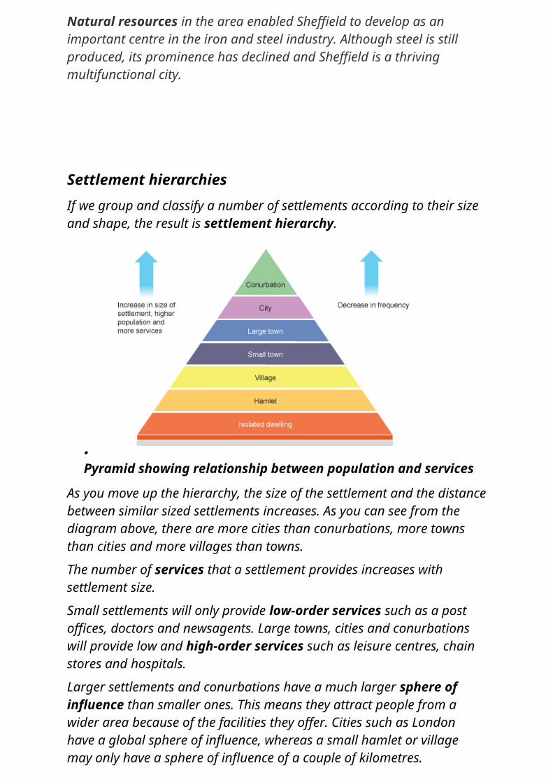
Settlement hierarchiesIf we group and classify a number of settlements according to their size and shape, the result is settlement hierarchy.
Pyramid showing relationship between population and services
As you move up the hierarchy, the size of the settlement and the distance between similar sized settlements increases. As you can see from the diagram above, there are more cities than conurbations, more towns than cities and more villages than towns.
The number of services that a settlement provides increases with settlement size.
Small settlements will only provide low-order services such as a post offices, doctors and newsagents. Large towns, cities and conurbations will provide low and high-order services such as leisure centres, chain stores and hospitals.
Larger settlements and conurbations have a much larger sphere of influence than smaller ones. This means they attract people from a wider area because of the facilities they offer. Cities such as London have a global sphere of influence, whereas a small hamlet or village may only have a sphere of influence of a couple of kilometres.
Services such as department stores selling high order goods have a higher threshold than those selling low order goods such as newsagents. This means they need a higher number of people to support them and make them profitable, therefore they will only be found in larger settlements. It also means that there are fewer big department stores than small newsagents.
The range of a service or product is the maximum distance people are prepared to travel to purchase it. The range of a newspaper is much lower than an item of furniture for example.
Identify reasons for the location of land use such as industrial estates, airports, sea ports, retail parks, business parks etc. – flat land for space and expansion, near urban area for source of labour, not too near an urban area as to cause too much disruption, near transport routes for bringing supplies/raw materials in and transporting finished products to other towns/cities, away from potential flooding of large rivers etc.
Identify different types of economic activity on a map e.g. Primary (farm, Quarry, Coalmine, fishing port ), Secondary (Ind for Industry, Wks for Works , Ind Est for Industrial Estate), Tertiary (PO for Post Office, Hotel, Leisure Centre, Museum, Shopping Centre etc.).
Describe the course of a river on a map from the source (where land is higher indicated by tighter contour lines), through the middle stage (where land becomes gentler indicated by wider contour lines) to the final mature stage (where the land is virtually flat indicated by very wide spacing in contour lines on a map). Please note that you may be asked to describe the changing shape of the channel as well as the changing shape of the valley. You may be asked to describe and explain features along the course of the river – ‘V’ shaped valley, Waterfall, Gorge, Meander and Floodplain.
Identify which way a river is flowing on a map – look at spot heights/contour heights along the course of the river; the river will always flow from the higher points towards the lower points.
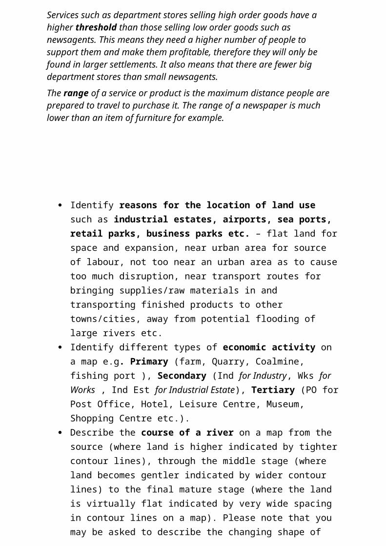
Identify general symbols (your map will probably come with a key but it would be useful to know the more common symbols):-
Identify coastal features in case you get a map extract which includes coastline – headlands, bays, beaches, spits etc.
Rivers How rivers erode the landscape, transport eroded material (load) and
deposit this material. Changes in the river channel and valley shape from the source of the
river, through the middle stage and onto the mouth of the river (i.e. small, narrow channel in a ‘V’ shaped valley at the source; wider, deeper channel in a larger, gently sloping valley during the middle course; very wide, shallow channel in a wide, flat floodplain near to the mouth of the river as it enters the sea).
Describe and explain the formation of V shaped valleys, Waterfalls (in the upper course), Meanders (in the middle course) and Floodplains and Deltas (in the lower course).
BE PREPARED TO DRAW DIAGRAMS EVEN IF THE QUESTION DOES NOT ASK FOR DIAGRAMS!!!!
How do people use rivers? – How does man benefit from running water? We benefit in a number of ways including using water domestically and at work (Treated water from Reservoirs used in the home and in Industry), transporting raw materials and goods in boats and ships along rivers (e.g. the Rhine in Germany is still used for transporting coal in river/canal barges), producing Hydro-electric power from Dams (e.g. the Aswan Dam in Egypt), using attractive parts of the river as a focus for Tourism (e.g. pubs and cafes along rivers benefit from people walking dogs etc. and, finally, rivers are areas of leisure for millions of fishermen throughout the world.
Problems created by rivers – principally Flooding. What damage can a river bring to rural and urban (town/city) areas in particular (your recent case study on the 2007 flood in Bangladesh would be useful here – you completed an assessment piece on it! You also completed a Google slide show on the Somerset Floods of 2013/14).
Remember to look through the revision sheets on Rivers – ‘Rivers – the Essentials!’
How can the threat of flooding and the damage caused by flooding be reduced? – methods include building Levees, flood gates across roads etc., Dams to limit the flow (e.g. Aswan Dam), sandbags, not building on
floodplains and looking at alternative ‘soft’ engineering methods. See notes below:-
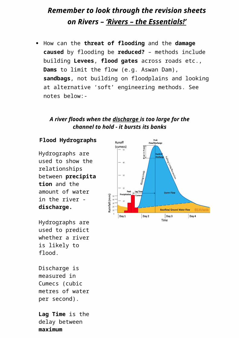
A river floods when the discharge is too large for the channel to hold - it bursts its banks
Flood Hydrographs
Hydrographs are used to show the relationships between precipitation and the amount of water in the river -discharge.
Hydrographs are used to predict whether a river is likely to flood.
Discharge is measured in Cumecs (cubic metres of water per second).
Lag Time is the delay between maximum precipitation and peak river discharge.
Short Lag Times are caused by steep slopes, impermeable rock, sparse vegetation and a small drainage basin.
Long Lag Times are caused by gentle slopes, permeable rock, dense vegetation and a large drainage basin
The Causes of Flooding Precipitation - Heavy rainfall over a long period results in
saturated soil and surface run-off Flash Flood - Hot dry areas where the land is baked hard causes
flooding if there is an intense burst of heavy rainfall - water cannot infiltrate and results in rapid run-off.
Snowmelt - When temperatures rise and snow melts the stored precipitation is released as run off as infiltration will be low as the ground is still frozen.
Deforestation - When trees are cut down this reduces interception, transpiration and utilisation by the trees. This results in increased run-off
Urbanisation - When land is urbanised vegetation is removed and the land is covered in concrete and tarmac. Storm drains are used to transfer the water from the surface of the land to the river which increases the chance of flash floods.
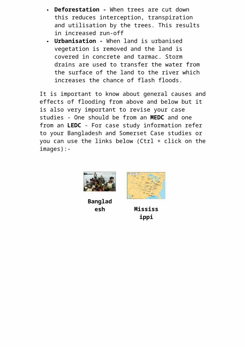
It is important to know about general causes and effects of flooding from above and below but it is also very important to revise your case studies - One should be from an MEDC and one from an LEDC - For case study information refer to your Bangladesh and Somerset Case studies or you can use the links below (Ctrl + click on the images):-
Bangladesh Mississipp
i
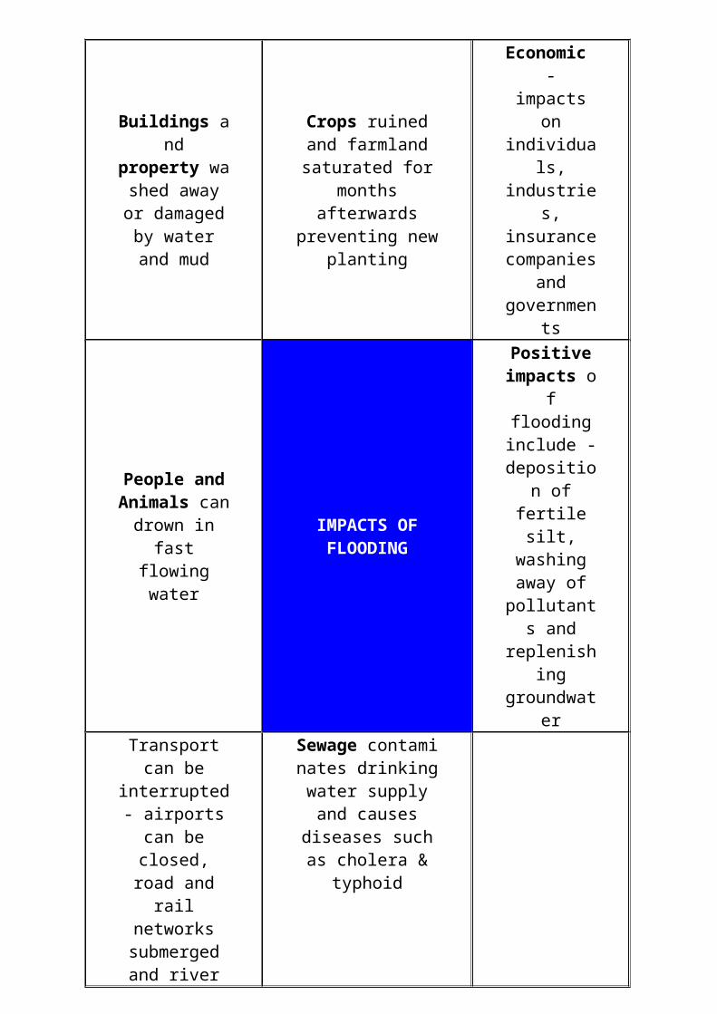
Buildings and property washe
d away or damaged by
water and mud
Crops ruined and farmland saturated
for months afterwards
preventing new planting
Economic - impacts on individuals, industries, insurance
companies and
governments
People and Animals can drown in fast flowing water
IMPACTS OF FLOODING
Positive impacts of
flooding include -
deposition of fertile silt,
washing away of pollutants
and replenishing groundwater
Transport can be interrupted -
airports can be closed, road and
rail networks submerged and
river traffic closed down.
Sewage contaminates drinking water
supply and causes diseases such as
cholera & typhoid
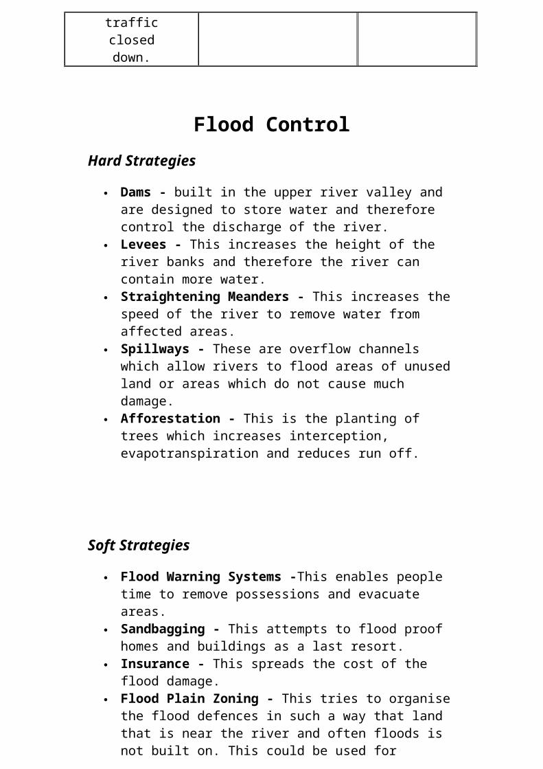
Flood ControlHard Strategies
Dams - built in the upper river valley and are designed to store water and therefore control the discharge of the river.
Levees - This increases the height of the river banks and therefore the river can contain more water.
Straightening Meanders - This increases the speed of the river to remove water from affected areas.
Spillways - These are overflow channels which allow rivers to flood areas of unused land or areas which do not cause much damage.
Afforestation - This is the planting of trees which increases interception, evapotranspiration and reduces run off.
Soft Strategies
Flood Warning Systems -This enables people time to remove possessions and evacuate areas.
Sandbagging - This attempts to flood proof homes and buildings as a last resort.
Insurance - This spreads the cost of the flood damage. Flood Plain Zoning - This tries to organise the flood defences in
such a way that land that is near the river and often floods is not built on. This could be used for farming. The areas that rarely get flooded therefore would be used for houses, transport and industry.
Coasts Processes of Weathering - Physical (Freeze/Frost shattering, onion-skin),
Chemical and Biological weathering. Wave formation – Constructive and Destructive Waves. Mass Movement – cliff collapse. Processes of erosion along the coast – Hydraulic Action, Abrasion,
Corrosion and Attrition. Processes of Deposition along the coast – Longshore Drift. Wave formation – Constructive and Destructive Waves. Coastal landforms and processes – the formation of Caves, Arches,
Stacks, Stumps and Spits. Coastal protection – Hard and Soft Engineering options.
Make sure you revise ‘Coasts – the Essentials!’ sheets.
Weather and Climate
Microclimate – what is it? Causes of temperature and rainfall variations from place to place in the
British Isles the main temperature and rainfall patterns in the British Isles the influence of latitude (how far North and South of the Equator),
altitude (how low/high), relief (which direction a slope faces – North colder/South warmer), prevailing (usual) winds (from the SW in the UK bringing warm, moist air), distance from coast and the basic impact of the North Atlantic Drift.
The Water Cycle – make sure you know what each component (e.g. precipitation) means.
Rainfall – relief, convectional, frontal. How to draw or annotate a diagram and explain the formation of different types of rainfall.
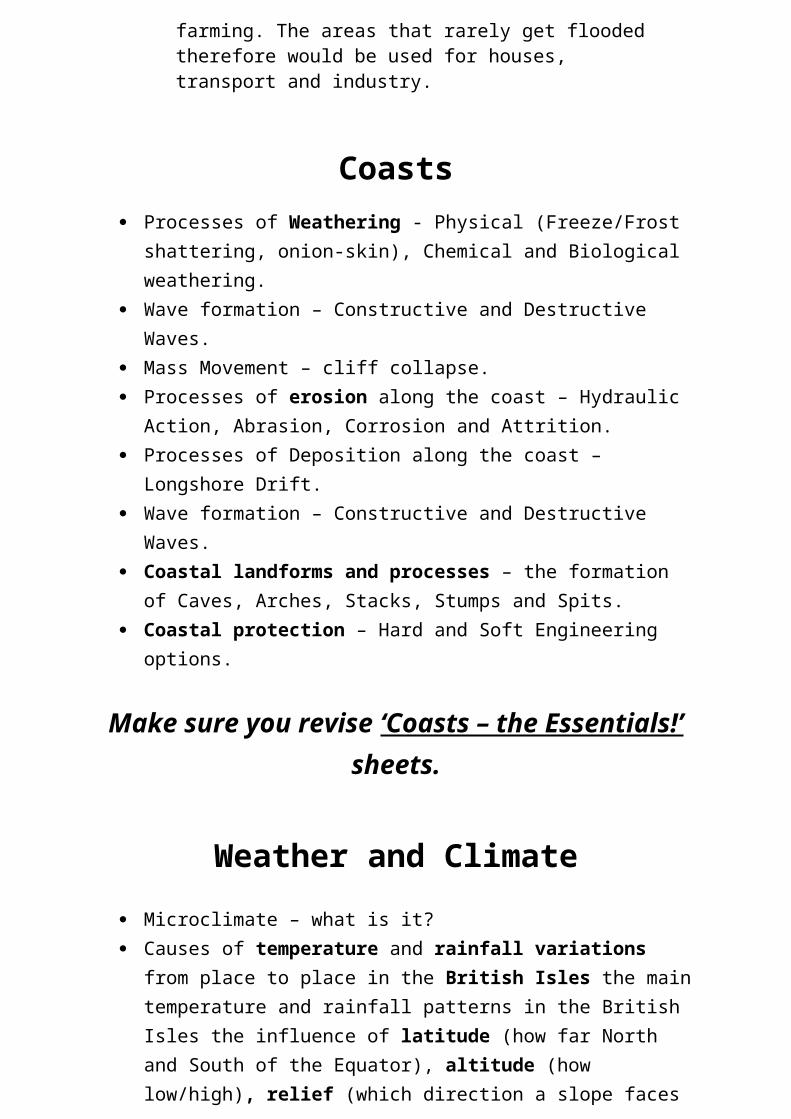
Differences in the European Climate – now this one is not in the Common Entrance syllabus but there have been questions on this in ‘The Leys’ scholarship paper. For this purpose, here is a quick summary of what you need to know:-
Make sure you also revise:-
‘Weather and Climate – the Essentials!’
+
‘Weather and Climate of the British Isles- QUICK REVISION SHEET’
Much of the west is affected by the North Atlantic Drift which warms western Europe in winter and brings lots of rain in winter and a considerable amount in summer to.
Places further north in Europe are colder due to Latitude – distance from the Equator.
Mountainous areas in Europe such as the Alps and Pyrenees are colder than lowland areas.
Much of southern Europe experience long, hot summers due to Tropical air masses coming north from the Sahara.
Much of inland Europe can become bitterly cold during Winter because the warming affect of the Atlantic cannot reach these areas.
Much of western Russia and Scandinavia are affected by Polar Continental air masses which brings dry cold air.
Settlement – see notes above (in the map work section)
Site, Function and Situation of a settlement. Relief of land which a settlement is built on. Each settlement has attractive site features e.g. flat land to build and expand, near to a river for easy access to drinking water and transport for early settlers etc.
Settlement patterns – nucleated, linear and dispersed. Settlement Hierarchy – the ordering of settlements based on size of
population and the amount of low, middle and high order services available. The Hierarchy ranges from thousands of smaller settlements (Hamlets with few services) to just a few cities and conurbations.
Urbanisation and Urban Land Use – Urbanisation means an increase in the proportion of people living in urban areas compared to rural areas. An urban area is a built-up area such as a town or city. A rural area is an area of countryside.
As a country industrialises, the number of people living in urban areas tends to increase. The UK and many other MEDCs urbanised during the 18th and 19th centuries. People migrated from rural areas (due to the mechanisation in farming) to urban areas where there was employment in the new factories. The area of cities known as the inner city developed during this time as rows of terraced housing were built for workers.
Today the UK is a mostly urban society, with 90 per cent of the population living in towns or cities.
On a global scale, urbanisation is taking place rapidly, particularly in LEDCs.
Although the UK is an urban society, more and more people are choosing to live on the edge of urban areas - with many relocating to the countryside. This is called counter-urbanisation.
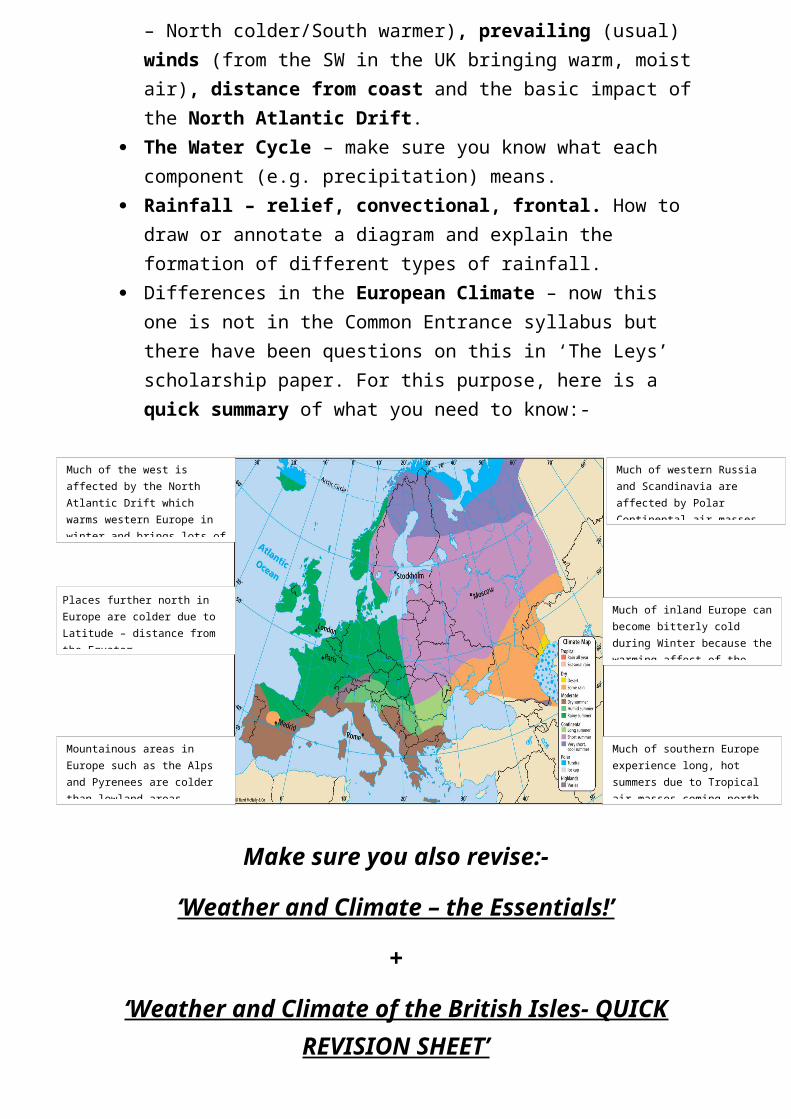
Urban Land Use – Urban Land Use models (for MEDCs and LEDCs):-
Tectonic Processes The global distribution of earthquakes and volcanoes. How the three main types of Rocks – Igneous, Sedimentary and
Metamorphic – are formed. The structure of the earth and what moves the Tectonic Plates (i.e.
Convection Currents in the Mantle). The four different types of Plate Boundaries – you need to know how to
draw the Destructive Boundary in particular. The causes of earthquakes and Volcanoes. Advantages and Disadvantages of Earthquakes and Volcanoes. The reasons for the different impacts of Earthquakes and Volcanoes
throughout the world (differences between MEDCs and LEDCs very important).
Man’s responses to Earthquakes and Volcanoes both in LEDCs (the Developing World) and MEDCs (the Developed World).
An example both of an earthquake and a volcano to show the nature, causes, environmental and human effects, and human responses - one example from an MEDC (Mount St Helens in the USA) and one from an LEDC (The Asian Tsunami of 2004 – yes the Tsunami was caused by an earthquake).
MEDCs
LEDCs
Make sure you also revise:-
‘Earthquakes and Volcanoes – the Essentials!’
+
‘Case Study of a Volcanic Eruption in an MEDC - Mount St. Helens’ (A4 revision sheet)
+
‘Case Study of an Earthquake event in an LEDC - the Asian Tsunami 2004’ (A4 revision sheet)
Economic Activities Employment structure. Reasons for the location of an industry. Globalisation. Case study of a changing industrial area – the Swansea Valley:-
What affects changes in the location of manufacturing?The location of secondary industry has always been effected by factors such as
materials energy labour markets transport and land ( space and whether it is flat enough)
These factors are still influential but some less so and some new ones have become more important
TNCs some of which have a bigger turnover than the total GDP of a medium-sized country, are the most influential in deciding where new industry should be located. Their prime motivation is to find the cheapest places to work from, so making the most profit from the factory that they can
Governments can also influence where factories are located. If they have a low tax regime and can supply cheap educated labour that are controlled by strict labour laws, then these are all + points. If they make sure that the road, port and airport system is good, this helps too.
So the availability of the right sort of labour is also very important. For mass production of goods that require simple process, large scale cheap labour is very important. But for higher-tech production, cost is not the main issue, but high skill and access to modern technology is far more important. This is why, despite losing a lot of mass production industry in the UK, we are still 6th most important country for industrial output in the world.
But certain other factors have slipped down the pecking order:Transport - is fast and efficient to anywhere in the world and so is not a bonus to any particular place.And in consequence, being close to the market is rarely an issue with possibly the exception of a product like bread that needs to be freshly made and thus must be close to the market.
Communications ( as in telecoms) are good nearly everywhere - even LEDCs have good mobile phone networks, this too is no longer important.Energy, mostly supplied by electricity, is also almost universally available.A nearby source of materials is now rarely an issue, unlike in the early days of the Industrial revolution - see South Wales below:-
But again there is an exception or 2.Where the raw materials are easily damaged, like soft fruit for example, then jam and preserve makers do tend to be located near the where the fruit is produced e.g. Wilkins of Tiptree in Essex or Baxters in Perthshire, Scotland.A few industries still tend to be near their source of raw materials where the raw materials are very bulky. One such is cement works
Using a case study of recent employment changes within an area of an MEDC
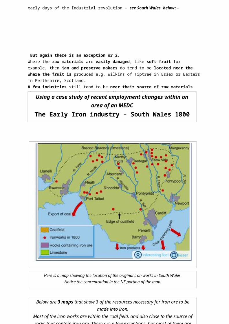
The Early Iron industry – South Wales 1800 onwards
Here is a map showing the location of the original iron works in South Wales.Notice the concentration in the NE portion of the map.
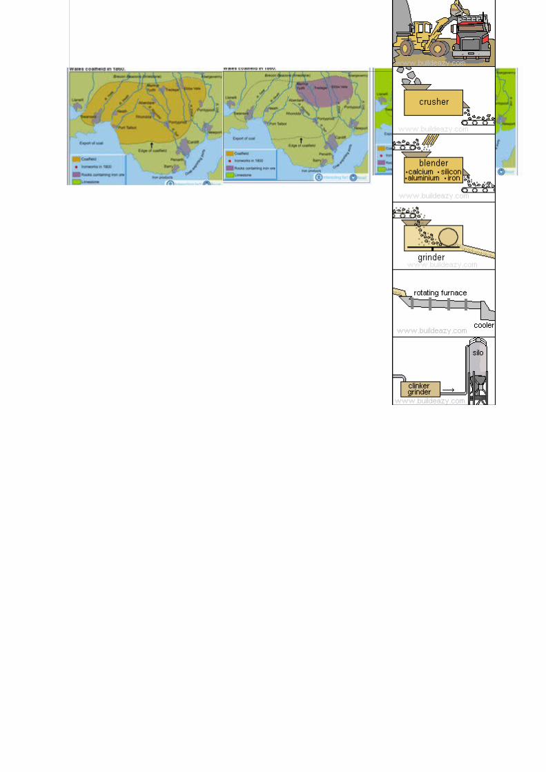
Below are 3 maps that show 3 of the resources necessary for iron ore to be made into iron.
Most of the iron works are within the coal field, and also close to the source of rocks that contain iron ore. There are a few exceptions, but most of them are within boating distance of ore – except for that little anomaly right in the centre – we can only guess
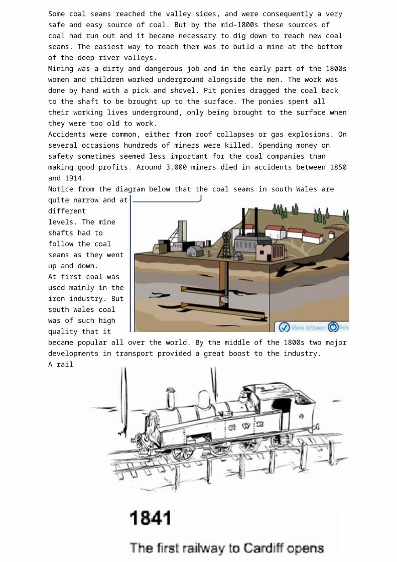
Some coal seams reached the valley sides, and were consequently a very safe and easy source of coal. But by the mid-1800s these sources of coal had run out and it became necessary to dig down to reach new coal seams. The easiest way to reach them was to build a mine at the bottom of the deep river valleys.Mining was a dirty and dangerous job and in the early part of the 1800s women and children worked underground alongside the men. The work was done by hand with a pick and shovel. Pit ponies dragged the coal back to the shaft to be brought up to the surface. The ponies spent all their working lives underground, only being brought to the surface when they were too old to work.Accidents were common, either from roof collapses or gas explosions. On several occasions hundreds of miners were killed. Spending money on safety sometimes seemed less important for the coal companies than making good profits. Around 3,000 miners died in accidents between 1850 and 1914.Notice from the diagram below that the coal seams in south Wales are quite narrow and at different levels. The mine shafts had to follow the coal seams as they went up and down.At first coal was used mainly in the iron industry.
But south Wales coal was of such high quality that it became popular all over the world. By the
middle of the 1800s two major developments in transport provided a great boost to the industry.A rail network was built throughout Britain and Europe - the steam trains ran on coal and south
Wales coal was in much demand. The rail network made it easier to transport coal to the rest of Britain. Railways in far away British colonies such as India and in Africa used coal from Wales.Ships switched from sail to steam power. As early as 1851 the British navy decided that Welsh coal was the best coal for its ships. Navies and merchant ships around the world used coal from south Wales.In the early 1800s canals were used to transport coal from the valleys down to the dock. But when rail replaced canals the industry really took off. Railways from the Rhondda valley and other coal-mining valleys ran fairly short distances down to the booming docks at Cardiff, Newport and Swansea.Notice how the river valleys naturally provided routes down to the coast. By 1870, 50% of the coal was
being exported overseas.The basic physical geography of south Wales had given the region a great advantage over other coal-producing areas. The river valleys gave transport routes and the steep valleys made it easy to mine down to the coal.Coal mining depended on hard, physical labour. The industry was hungry for workers. The boom in the south Wales coal industry attracted people to move to the area from other parts of Wales and from the rest of Britain.The Rhondda valleys became the centre of the coal industry. In 1860 they had a population of around 3,000 people.This had jumped to 160,000 by 1910. People migrated from the rural parts of Wales, but also in great numbers from Ireland, Scotland and England.The English speakers far outnumbered the Welsh speakers. The south Wales coalfield became a "melting pot" of different cultures and people.The mining valleys developed their own unique culture. Strong communities grew up with people sharing the hardships that mine work brought. By and large the coal companies did little to help their workers. There were frequent disputes over pay and conditions. The miners formed unions to try and look after their interests and improve their pay and conditions.Faced by conditions of poor quality housing, outbreaks of disease and the grinding hard work and danger of mining, communities organised themselves to make things better. The mining communities of the south Wales valleys became famous for their strength, and for their choirs, chapels, clubs and rugby teams!
Summary of the factors that helped industry flourish in South WalesRaw materials: coal, limestone, ore-bearing rocksFuel: coalMarket for the coal: railways, shipping, the navy, factories were cola powered as well, export to Africa and IndiaLabour: many people who lacked work from all over Britain. Once there, they formed into strong and effective communities that supported each other and had generations of skilled.Transport links:
river/canals for barges to transport coal and iron from 1841 trains arrived in the valleys new deep water ports at Cardiff, Swansea and Newport
1914 – what next?The period up to the First World War was the boom period for the south Wales coalfield. Coal production had reached its peak and the industry continued to make profits. At times there had been periods of depression when the price of coal had fallen and miners had lost their jobs or had their pay reduced. But the industry always seemed to be able to bounce back.But things were starting to change. Just as steam had replaced sail in ships, steam was now being replaced by oil. Other countries were producing more of their own coal and didn't need to import it from Wales.But its dependence on coal was very real. 70% of its production was exported. The whole area, mining settlements and the docks, depended on coal. But demand for coal was falling and there were few other industries in south Wales. Iron and steel making, and the manufacture of other metals, were also in decline because other countries had developed their own industries.The 1920s and 1930s were decades of economic depression and poverty in the coalfields. In 1934 unemployment rates of 60% were recorded in parts of the south Wales coalfield. People started to move away. Between 1931 and 1939, 160,000 people migrated from south Wales to look for work in the new industries being developed in other parts of Britain.The decline continued after the Second World War up until the present day. The coal industry was nationalised in 1947 - that means it was taken over by the government. To modernise the industry, machines were needed instead of manual workers. However, many of the coal seams in south Wales weren't suited to the use of modern mining machinery.
Impact of closuresAt its peak nearly 300,000 miners had been employed in the coal industry. In 1945 there were 125,000 miners working in 135 pits in south Wales. By the early 1980s that had shrunk to 22,000, and by the early 1990s to below 1,000.Whole communities were devastated when their pit closed. Families lost their income and without the miners' wages, shops and businesses lost trade. People moved away to look for work, and those who stayed found it hard to find a decent job.Ever since the 1930s the government has been trying to attract new industry to the valleys. The Welsh Development Agency continues this work today. But the valleys offer few attractions as a location for modern factories.New companies setting up in Wales over the last 20 years or so have chosen locations near the M4, rather than in the narrow, built-up former mining settlements such as the Rhondda valley.Today, the visible signs of the coal industry have largely been removed. Collieries have been replaced by supermarkets and small industrial units; the old slag heaps of waste rocks have been landscaped and planted with grass and trees. But the scars on the community are slow to heal, and most former mining communities face a range of social and economic problems.Geographers at Cardiff and other universities have recently conducted a study of former mining communities in several coalfield areas in Wales and England.Besides those already mentioned, the researchers found social problems (poor school attendance, family breakdown, teenage pregnancy among others) and health was a bit issue that still hangs over the valleys today. Those who worked in the mines are plagued by emphysema (chronic chest complaint) and those who have had few life chances since have been brought up with a poor diet and obesity is a big issue here too. Petty crime and drug abuse is also a big problem. The housing, old and Victorian or new and built post war are of poor quality; cold and damp being a major problem and environment that exacerbate conditions like asthma and brochettes in children. The people live there have a poor image of themselves and their environment. It feels like a rundown, no hope sort of place. As the researchers say ‘ There is a poor image of the area.’
The steel industry:
But not all the industries died at once, and the steel industry kept going longer. Now, steel works (as against iron works) need a lot of water for cooling and other processes. New steel works were integrated – a lot of different processes on one site – need a lot of space. They also involve bulk materials both as inputs and of products produced, so the sites of the old ironworks were not any good. Besides the raw materials that the old ironworks had been based had run out long ago. The raw materials by and large had to be imported, so near to the coast was a better place for the steel works to be for a number of reasons. Can you think of 3 of the main one?
Here is one sit of a steel works – Margam Works at Port Talbot
Close to the motorway for internal transportA big dock for importing raw materialsA large labour force nearby that was used to hard manual labour
Plenty of water for coolingPlenty of flat land for an integrated steel works
But since the 1980s, even steel works have moved to LEDCs, where the materials are closer and the costs much lower. Also there is a ready market in many of them in the form of the car industry.
But Wales has not given up!
While the deep mines have now all closed, Ffos-y-Fran in Merthyr Tydfil, an open cast mine has recently open to the consternation of many of the local residents. Admittedly it has provided much needed jobs in an area of high unemployment but:It is within 100s of metres of housingIt has permission to operate from 7am to 10pm and until 5pm Saturdays – this noise can be heard in the local houses and some people say they cannot sleep until it stopsThere is a lot of dust in the airMerthyr Tydfil has among the worst health in Wales and the dust makes it worseIt is uglyIt will be there for the next 15 yearsOpening when it did in 2005, it rather contradicts the government policy of pulling out of fossil fuels for electricityThe company say that they are removing coal from the area closest to the houses first and will then landscape that area quickly
The question has to be, should we be investing in large scale coalmining any more?
But the Welsh development Agency is trying to raise the image and the aspirations of Wales. They want to encourage new high tech footloose industry into the area. In the 1980s some ‘white goods’ (kitchen stuff like cookers, fridges, washing machines etc)manufactures did move in providing low paid assembly jobs, but many of these have now moved elsewhere, such as China and the Far East or Eastern Europe where bigger profits can be made. But the Welsh Assembly is trying to encourage green, low carbon
activities and have several schemes that they hope will encourage new ideas to blossom and grow..
Sustainable technology in the motor trade for exampleWales is now focusing on sustainable technologies and its academic capability is recognised as providing leading Research and Development in relation to low carbon vehicle technology.Wales' focus on sustainable transport goes beyond vehicle technologies to encompass all associated issues such as:
integrated transport energy storage future fuel/charging infrastructure technologies & related transport planning
Wales is recognised as a European Leader in Research & Development of low-emissions technology.
Access Wales – another example of innovationAccess Wales is a new pilot project that offers hi tech and knowledge based companies the opportunity to test the market before making any long term decision about expanding into new markets. Access Wales is a new service from International Business Wales- the trade and investment arm of the Welsh Assembly Government and participating businesses will have access to the Assembly Government’s fully integrated business support service.Qualify for free desk space for up to 12 months in a choice of 15 high tech innovation centres but a unique package of benefits tailored to the needs of emerging technology companies.
This free service includes fast, straightforward access to information, advice and support on grants and finance, property, innovation support, technology, marketing assistance, sourcing suppliers and skills development.In addition companies are also eligible for specialist business support from professional consultancy partners worth in the region of £10,000.This covers areas such as business strategy, market and competitor intelligence, sales consultancy, Intellectual Property, recruitment, HR and training, health and safety as well as access to local business networks.The 15 innovation centres each specialising in particular aspects of hi-tech business such as digital media, performance engineering, sustainable technologies, opto-electronics, biosciences, IT and software, and bioscience. The desk spaces offered come equipped with telephones and high speed internet connection and are typically located within open-plan shared business units with access to shared facilities such as reception services, meeting rooms and conference facilities.
TourismThe industrial heritage is becoming big business. Although tourism tends to be a low paid occupation, it does make use of the skills and local knowledge.For examplethe Big Pit at Blaenafon - underground tripRhondda Heritage Park offers underground experience and period village street.
Ironwork
Case study of a TNC (Trans National Company) – Nike. Case Study of a modern industry in the UK – The Toyota car plant in
Derby.
You have A4 case study sheets on the above.
Make sure you also revise:-
‘Economic Geography – the Essentials!’
As a back up to the above topics read through:-
‘Environmental Issues - the essentials!’
+
‘The Yorkshire Dales National Park Sustainability Case Study A4’
It is important for you to adopt an effective way to revise which suits you. Given my experience to date, I find that those students using a card system
tend to fare better in examinations. This is where the student writes key
points/draws diagrams from his or her notes/revision guide onto a small card (size of a postcard) and revises these.
It is impossible to revise everything so you have to be smart – identify the key points!
REMAIN CALM AND GOOD LUCK!