Embed Size (px)
Citation preview
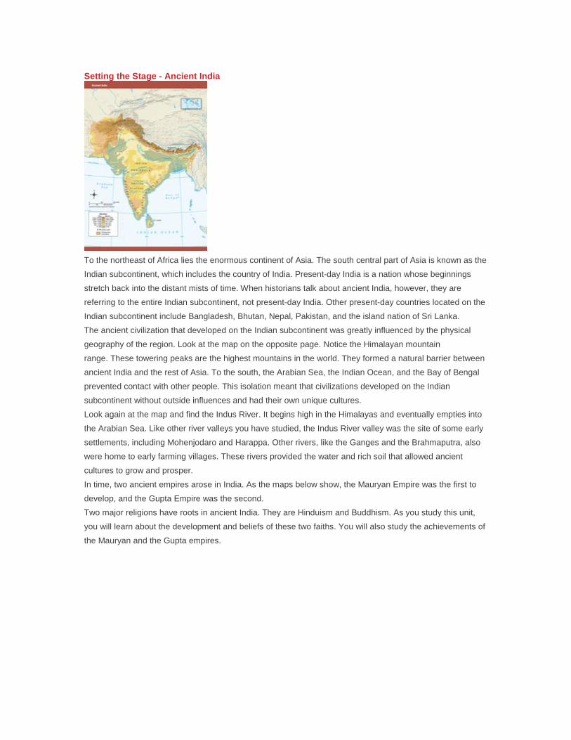
Setting the Stage - Ancient India
To the northeast of Africa lies the enormous continent of Asia. The south central part of Asia is known as the
Indian subcontinent, which includes the country of India. Present-day India is a nation whose beginnings
stretch back into the distant mists of time. When historians talk about ancient India, however, they are
referring to the entire Indian subcontinent, not present-day India. Other present-day countries located on the
Indian subcontinent include Bangladesh, Bhutan, Nepal, Pakistan, and the island nation of Sri Lanka.
The ancient civilization that developed on the Indian subcontinent was greatly influenced by the physical
geography of the region. Look at the map on the opposite page. Notice the Himalayan mountain
range. These towering peaks are the highest mountains in the world. They formed a natural barrier between
ancient India and the rest of Asia. To the south, the Arabian Sea, the Indian Ocean, and the Bay of Bengal
prevented contact with other people. This isolation meant that civilizations developed on the Indian
subcontinent without outside influences and had their own unique cultures.
Look again at the map and find the Indus River. It begins high in the Himalayas and eventually empties into
the Arabian Sea. Like other river valleys you have studied, the Indus River valley was the site of some early
settlements, including Mohenjodaro and Harappa. Other rivers, like the Ganges and the Brahmaputra, also
were home to early farming villages. These rivers provided the water and rich soil that allowed ancient
cultures to grow and prosper.
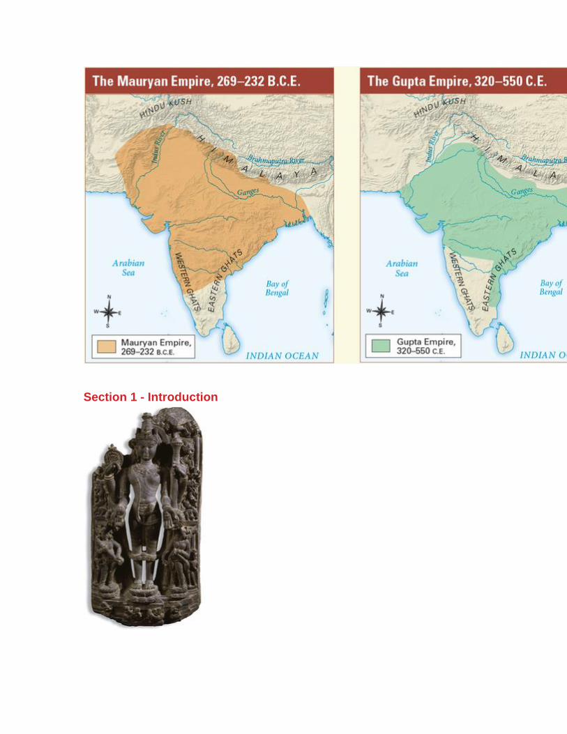
In time, two ancient empires arose in India. As the maps below show, the Mauryan Empire was the first to
develop, and the Gupta Empire was the second.
Two major religions have roots in ancient India. They are Hinduism and Buddhism. As you study this unit,
you will learn about the development and beliefs of these two faiths. You will also study the achievements of
the Mauryan and the Gupta empires.
Section 1 - Introduction
In this unit, you will learn about the civilization of ancient India. First, in this chapter, you will explore the
geography of the area, including its rivers, mountains, plains, plateaus, deserts, and valleys. These physical
features influenced where ancient India’s civilization arose.
Early towns began to appear in India in about 2500 B.C.E. Over the next 2,000 years, a unique civilization
developed in India.
According to an ancient Indian story, a river god and a river goddess once lived in the snow-covered
Himalayas (him-uh-LAY-uhz), a mountain range extending through northern India. One day, the two decided
to race down the mountains to the plains below. The river goddess sped straight down and won the
race. But her joy soon turned to worry. Where was the river god?
The river god had slowed down to admire the snowcapped mountains and the rich brown earth in the
valleys. In time, he flowed down to meet his goddess. The two rivers became one, joined forever on India’s
plains. The rivers made the land good for farming.
In this chapter, you will learn about India’s rivers and other physical features. You’ll explore eight key
features and their effects on the settlement of ancient India.
Section 2 - Brahmaputra River
The land of India is a subcontinent of Asia. Looking at a map of Asia, you can see that India is attached to
this continent. Many geographers call this part of Asia the Indian subcontinent. It is a large, triangular
landmass that juts out from the southern part of Asia.Mountain ranges separate much of the Indian
subcontinent from the rest of Asia.
Our exploration of India begins with the Brahmaputra (brah-muh-POO-truh) River. This river runs through
the steep Himalayas, the mountains along the northern border of India.From there, the Brahmaputra winds
through snowcapped mountains and narrow canyons.The water is clear and cold as it rushes over the sharp
rocks.
The river becomes slower and deeper as it flows into its valley. Every summer, this part of the river receives
added water from heavy monsoon rains. A monsoon is a strong wind that often brings huge amounts of
rain. These rains can cause the river to overflow its banks. As the river recedes, the rich minerals that have
been carried down from the Himalayas remain in the soil of the valley.
Eventually, the Brahmaputra River joins another river, the Ganges (GAN-jeez), on the plains. The land
where the two rivers meet is very fertile.
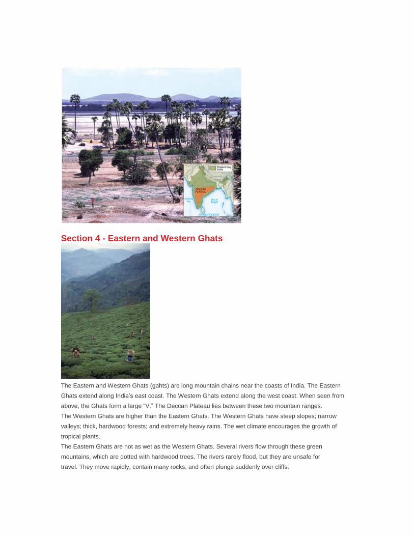
Section 4 - Eastern and Western Ghats
The Eastern and Western Ghats (gahts) are long mountain chains near the coasts of India. The Eastern
Ghats extend along India’s east coast. The Western Ghats extend along the west coast. When seen from
above, the Ghats form a large “V.” The Deccan Plateau lies between these two mountain ranges.
The Western Ghats are higher than the Eastern Ghats. The Western Ghats have steep slopes; narrow
valleys; thick, hardwood forests; and extremely heavy rains. The wet climate encourages the growth of
tropical plants.
The Eastern Ghats are not as wet as the Western Ghats. Several rivers flow through these green
mountains, which are dotted with hardwood trees. The rivers rarely flood, but they are unsafe for
travel. They move rapidly, contain many rocks, and often plunge suddenly over cliffs.
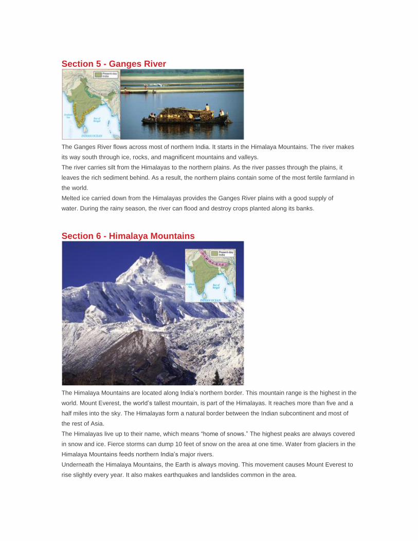
Section 5 - Ganges River
The Ganges River flows across most of northern India. It starts in the Himalaya Mountains. The river makes
its way south through ice, rocks, and magnificent mountains and valleys.
The river carries silt from the Himalayas to the northern plains. As the river passes through the plains, it
leaves the rich sediment behind. As a result, the northern plains contain some of the most fertile farmland in
the world.
Melted ice carried down from the Himalayas provides the Ganges River plains with a good supply of
water. During the rainy season, the river can flood and destroy crops planted along its banks.
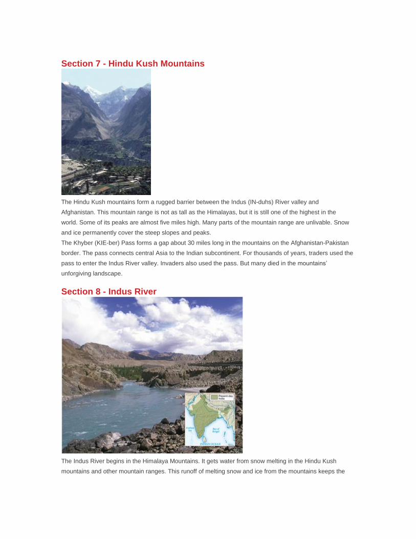
Section 6 - Himalaya Mountains
The Himalaya Mountains are located along India’s northern border. This mountain range is the highest in the
world. Mount Everest, the world’s tallest mountain, is part of the Himalayas. It reaches more than five and a
half miles into the sky. The Himalayas form a natural border between the Indian subcontinent and most of
the rest of Asia.
The Himalayas live up to their name, which means “home of snows.” The highest peaks are always covered
in snow and ice. Fierce storms can dump 10 feet of snow on the area at one time. Water from glaciers in the
Himalaya Mountains feeds northern India’s major rivers.
Underneath the Himalaya Mountains, the Earth is always moving. This movement causes Mount Everest to
rise slightly every year. It also makes earthquakes and landslides common in the area.
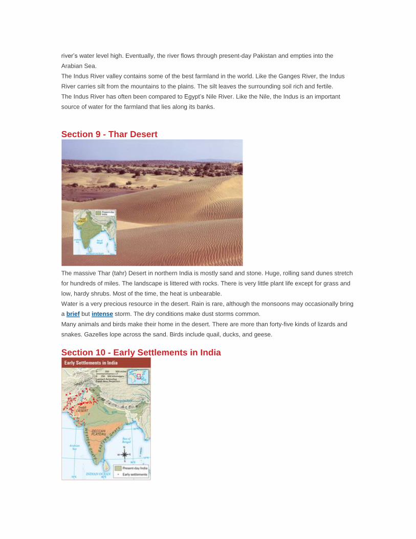
Section 7 - Hindu Kush Mountains
The Hindu Kush mountains form a rugged barrier between the Indus (IN-duhs) River valley and
Afghanistan. This mountain range is not as tall as the Himalayas, but it is still one of the highest in the
world. Some of its peaks are almost five miles high. Many parts of the mountain range are unlivable. Snow
and ice permanently cover the steep slopes and peaks.
The Khyber (KIE-ber) Pass forms a gap about 30 miles long in the mountains on the Afghanistan-Pakistan
border. The pass connects central Asia to the Indian subcontinent. For thousands of years, traders used the
pass to enter the Indus River valley. Invaders also used the pass. But many died in the mountains’
unforgiving landscape.
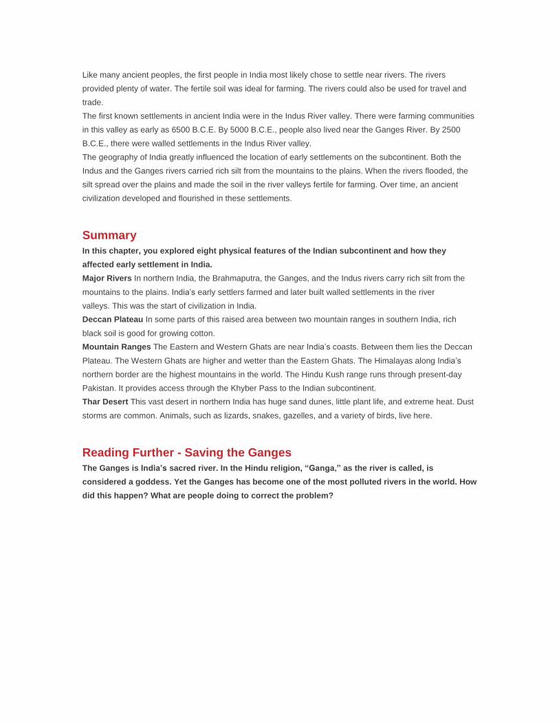
Section 8 - Indus River
The Indus River begins in the Himalaya Mountains. It gets water from snow melting in the Hindu Kush
mountains and other mountain ranges. This runoff of melting snow and ice from the mountains keeps the
river’s water level high. Eventually, the river flows through present-day Pakistan and empties into the
Arabian Sea.
The Indus River valley contains some of the best farmland in the world. Like the Ganges River, the Indus
River carries silt from the mountains to the plains. The silt leaves the surrounding soil rich and fertile.
The Indus River has often been compared to Egypt’s Nile River. Like the Nile, the Indus is an important
source of water for the farmland that lies along its banks.
Section 9 - Thar Desert
The massive Thar (tahr) Desert in northern India is mostly sand and stone. Huge, rolling sand dunes stretch
for hundreds of miles. The landscape is littered with rocks. There is very little plant life except for grass and
low, hardy shrubs. Most of the time, the heat is unbearable.
Water is a very precious resource in the desert. Rain is rare, although the monsoons may occasionally bring
a brief but intense storm. The dry conditions make dust storms common.
Many animals and birds make their home in the desert. There are more than forty-five kinds of lizards and
snakes. Gazelles lope across the sand. Birds include quail, ducks, and geese.
Section 10 - Early Settlements in India
Like many ancient peoples, the first people in India most likely chose to settle near rivers. The rivers
provided plenty of water. The fertile soil was ideal for farming. The rivers could also be used for travel and
trade.
The first known settlements in ancient India were in the Indus River valley. There were farming communities
in this valley as early as 6500 B.C.E. By 5000 B.C.E., people also lived near the Ganges River. By 2500
B.C.E., there were walled settlements in the Indus River valley.
The geography of India greatly influenced the location of early settlements on the subcontinent. Both the
Indus and the Ganges rivers carried rich silt from the mountains to the plains. When the rivers flooded, the
silt spread over the plains and made the soil in the river valleys fertile for farming. Over time, an ancient
civilization developed and flourished in these settlements.
Summary
In this chapter, you explored eight physical features of the Indian subcontinent and how they
affected early settlement in India.
Major Rivers In northern India, the Brahmaputra, the Ganges, and the Indus rivers carry rich silt from the
mountains to the plains. India’s early settlers farmed and later built walled settlements in the river
valleys. This was the start of civilization in India.
Deccan Plateau In some parts of this raised area between two mountain ranges in southern India, rich
black soil is good for growing cotton.
Mountain Ranges The Eastern and Western Ghats are near India’s coasts. Between them lies the Deccan
Plateau. The Western Ghats are higher and wetter than the Eastern Ghats. The Himalayas along India’s
northern border are the highest mountains in the world. The Hindu Kush range runs through present-day
Pakistan. It provides access through the Khyber Pass to the Indian subcontinent.
Thar Desert This vast desert in northern India has huge sand dunes, little plant life, and extreme heat. Dust
storms are common. Animals, such as lizards, snakes, gazelles, and a variety of birds, live here.
Reading Further - Saving the Ganges
The Ganges is India’s sacred river. In the Hindu religion, “Ganga,” as the river is called, is
considered a goddess. Yet the Ganges has become one of the most polluted rivers in the world. How
did this happen? What are people doing to correct the problem?
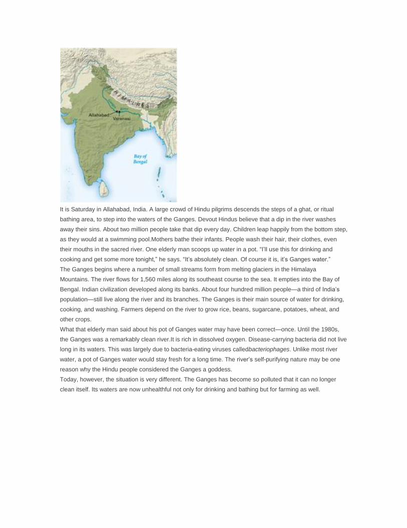
It is Saturday in Allahabad, India. A large crowd of Hindu pilgrims descends the steps of a ghat, or ritual
bathing area, to step into the waters of the Ganges. Devout Hindus believe that a dip in the river washes
away their sins. About two million people take that dip every day. Children leap happily from the bottom step,
as they would at a swimming pool.Mothers bathe their infants. People wash their hair, their clothes, even
their mouths in the sacred river. One elderly man scoops up water in a pot. “I’ll use this for drinking and
cooking and get some more tonight,” he says. “It’s absolutely clean. Of course it is, it’s Ganges water.”
The Ganges begins where a number of small streams form from melting glaciers in the Himalaya
Mountains. The river flows for 1,560 miles along its southeast course to the sea. It empties into the Bay of
Bengal. Indian civilization developed along its banks. About four hundred million people—a third of India’s
population—still live along the river and its branches. The Ganges is their main source of water for drinking,
cooking, and washing. Farmers depend on the river to grow rice, beans, sugarcane, potatoes, wheat, and
other crops.
What that elderly man said about his pot of Ganges water may have been correct—once. Until the 1980s,
the Ganges was a remarkably clean river.It is rich in dissolved oxygen. Disease-carrying bacteria did not live
long in its waters. This was largely due to bacteria-eating viruses calledbacteriophages. Unlike most river
water, a pot of Ganges water would stay fresh for a long time. The river’s self-purifying nature may be one
reason why the Hindu people considered the Ganges a goddess.
Today, however, the situation is very different. The Ganges has become so polluted that it can no longer
clean itself. Its waters are now unhealthful not only for drinking and bathing but for farming as well.
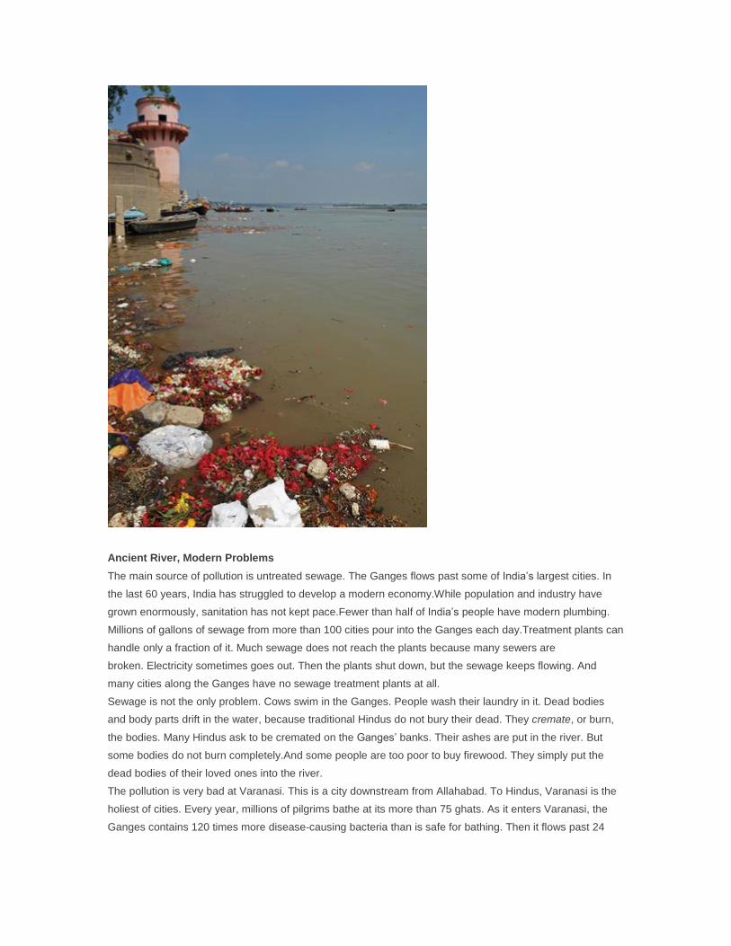
Ancient River, Modern Problems
The main source of pollution is untreated sewage. The Ganges flows past some of India’s largest cities. In
the last 60 years, India has struggled to develop a modern economy.While population and industry have
grown enormously, sanitation has not kept pace.Fewer than half of India’s people have modern plumbing.
Millions of gallons of sewage from more than 100 cities pour into the Ganges each day.Treatment plants can
handle only a fraction of it. Much sewage does not reach the plants because many sewers are
broken. Electricity sometimes goes out. Then the plants shut down, but the sewage keeps flowing. And
many cities along the Ganges have no sewage treatment plants at all.
Sewage is not the only problem. Cows swim in the Ganges. People wash their laundry in it. Dead bodies
and body parts drift in the water, because traditional Hindus do not bury their dead. They cremate, or burn,
the bodies. Many Hindus ask to be cremated on the Ganges’ banks. Their ashes are put in the river. But
some bodies do not burn completely.And some people are too poor to buy firewood. They simply put the
dead bodies of their loved ones into the river.
The pollution is very bad at Varanasi. This is a city downstream from Allahabad. To Hindus, Varanasi is the
holiest of cities. Every year, millions of pilgrims bathe at its more than 75 ghats. As it enters Varanasi, the
Ganges contains 120 times more disease-causing bacteria than is safe for bathing. Then it flows past 24
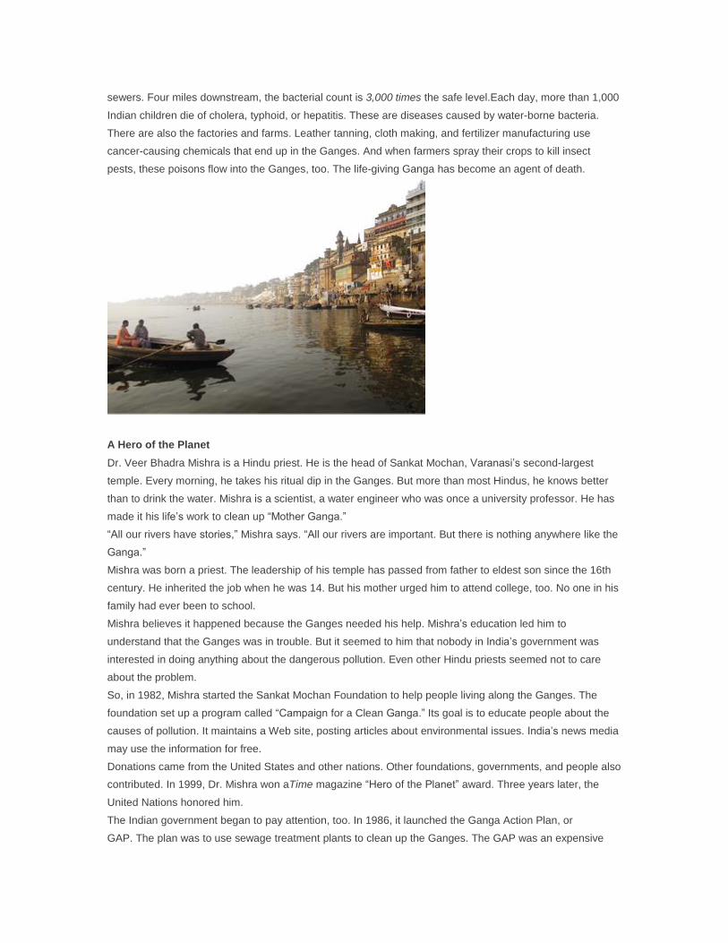
sewers. Four miles downstream, the bacterial count is 3,000 times the safe level.Each day, more than 1,000
Indian children die of cholera, typhoid, or hepatitis. These are diseases caused by water-borne bacteria.
There are also the factories and farms. Leather tanning, cloth making, and fertilizer manufacturing use
cancer-causing chemicals that end up in the Ganges. And when farmers spray their crops to kill insect
pests, these poisons flow into the Ganges, too. The life-giving Ganga has become an agent of death.
A Hero of the Planet
Dr. Veer Bhadra Mishra is a Hindu priest. He is the head of Sankat Mochan, Varanasi’s second-largest
temple. Every morning, he takes his ritual dip in the Ganges. But more than most Hindus, he knows better
than to drink the water. Mishra is a scientist, a water engineer who was once a university professor. He has
made it his life’s work to clean up “Mother Ganga.”
“All our rivers have stories,” Mishra says. “All our rivers are important. But there is nothing anywhere like the
Ganga.”
Mishra was born a priest. The leadership of his temple has passed from father to eldest son since the 16th
century. He inherited the job when he was 14. But his mother urged him to attend college, too. No one in his
family had ever been to school.
Mishra believes it happened because the Ganges needed his help. Mishra’s education led him to
understand that the Ganges was in trouble. But it seemed to him that nobody in India’s government was
interested in doing anything about the dangerous pollution. Even other Hindu priests seemed not to care
about the problem.
So, in 1982, Mishra started the Sankat Mochan Foundation to help people living along the Ganges. The
foundation set up a program called “Campaign for a Clean Ganga.” Its goal is to educate people about the
causes of pollution. It maintains a Web site, posting articles about environmental issues. India’s news media
may use the information for free.
Donations came from the United States and other nations. Other foundations, governments, and people also
contributed. In 1999, Dr. Mishra won aTime magazine “Hero of the Planet” award. Three years later, the
United Nations honored him.
The Indian government began to pay attention, too. In 1986, it launched the Ganga Action Plan, or
GAP. The plan was to use sewage treatment plants to clean up the Ganges. The GAP was an expensive
failure. There were not enough plants to handle the amount of sewage. There was not enough power to run
the plants. By 2002, the Ganges was more polluted than ever.
Dr. Mishra did not give up. He had another plan that would use simpler technology. With a group of
California scientists, he developed a system that did not need electricity. It used gravity to divert pollutants
from the Ganges into ponds where they would be stored for 45 days. Helpful bacteria, algae, and sunlight
would break the pollutants down into harmless substances.
Mishra wanted to try out this plan in Varanasi. He believed it would be cheaper and more effective than the
government’s plan. The Varanasi city council accepted the idea. But the state and national governments
turned it down.
Mishra knew that it would take time to gain acceptance for his plan. In the meantime, he began to educate
the people of his city. He wanted to change their age-old habits that harmed the river. His foundation met
with priests and pilgrims. It organized citizens and children. Young workers cleaned up litter from the banks
of the Ganges. But the problem was so huge that these efforts had little effect.
Scientists from other countries heard about Mishra’s project. Steve Hamner, a scientist from Montana State
University, traveled to India in 2003. He met with Dr. Mishra and other Indian scientists. Hamner and an
Indian government lab made detailed studies of Ganges water. The pollution was measured in a scientific
way. The Indian lab brought the findings to India’s Supreme Court.
This time the government listened. In 2007, India’s prime minister met with Dr. Mishra. A year later, Mishra
heard what he called “the best news in 20 years.” The government was agreeing to support a pilot program
of his plan in Varanasi. If it worked there, it could be put into effect all along the Ganges.
The Ganges’ story is not over. Time will tell whether it is too late to restore India’s sacred river. But Dr.
Mishra seems to have no doubts. As he confidently puts it, “Mother Ganges will help me to save her.”