Embed Size (px)
Citation preview
3/1/2015 Central Iowa Tornadoes of Nov. 12, 2005
http://www.crh.noaa.gov/dmx/?n=stratford-woodward-11122005 1/10
National Weather Service Weather Forecast OfficeDes Moines, IA
Damage rating (F-scale) for the Stratford tornado has been raised to an F3 upon further examination of photos. The damage rating for the Woodward tornado is stillpreliminarily an F2. Additional information will be posted later today (Monday) on the Woodward tornado.
Eight (8) tornadoes touched down across portions of central Iowa Saturday (Nov. 12, 2005) afternoon and into the early evening hours causing damage, some significant, in thetowns of Stratford (Hamilton county) and Woodward (Dallas county). Unfortunately, there was one death and one other person with injuries of unknown severity in Stratford. Elsewhere, no other injuries have been reported.
Two National Weather Service Storm Damage Assessment Teams from the local NWS Office in Des Moines/Johnston, IA travelled to the most damaged areas Sunday morning(Nov. 13, 2005) to assess the damage and assign damage ratings (Fujita Damage Scale-click here for details) on the tornado tracks. One survey team covered areas fromMinburn through Woodward, then north of Madrid and finally Ames to Gilbert. The second team covered from northwest Boone county and Pilot Mound, into Stratford and as farnortheast as Williams.
Preliminary Local Storm Reports for this event can be found by clicking here.
Eight tornadoes occurred in the following counties:
BooneDallasHamiltonHardinMonroe (A brief, short track tornado that damaged a barn.)StoryWebster
Images and Maps
The following is an image capture of the NWS Des Moines WSR-88D radar reflectivity about the time one of the tornadoes was hitting the south side of Woodward, which is aboutin the center of the image:
The following image is a screen capture of storm relative velocity at the same time:
Boone-Webster-Hamilton County Tornadoes (Stratford)

3/1/2015 Central Iowa Tornadoes of Nov. 12, 2005
http://www.crh.noaa.gov/dmx/?n=stratford-woodward-11122005 2/10
A long-lived tornado tracked through several counties across central Iowa during the late afternoon hours of Nov. 12, 2005. The tornado path is estimated at 15.1 miles long andbetween 100 and 150 yards wide along the damage path.
Tornado (1) initially touched down just west of E Avenue (just south of Boxholm in northwest Boone county), one half mile south of Boone county Highway E18 at approximately4:27 p.m as an F1 tornado. The tornado then tracked northeast across E Avenue, hitting a farm just north of E18, damaging the home and some out buildings. It also flipped overone pickup truck and killed two horses at this location.
The tornado continued northeast, spreading debris across F Avenue just north of 125th Street as it maintained F1 intensity. Two additional homes were damaged withoutbuildings destroyed as the tornado tracked northeast across G and H Avenues near 105th Avenue. It then intensified to an F2 tornado as it crossed the Boone/Webster countyline. Another home was heavily damaged and a large outbuilding destroyed just north of the Boone/Webster county line. The tornado quickly moved northeast, crossing 390thStreet and headed toward the Des Moines River, weakening to an F1 tornado.
A continuous, but weak damage path was observed crossing the river as the tornado tracked across open farmland and land adjacent the Des Moines River. The tornado hasbeen rated an F1 tornado during this time. After crossing County D64 in Webster county, the tornado struck another farm near 370th Street and Washington Avenue, damagingthe residence and destroying a machine shed along with most of its contents. The tornado again intensified to an F2 at this location.
The tornado then headed toward Stratford, crossing the Webster and Hamilton county line just west of County Road D54. The tornado entered Stratford at 4:46 p.m. on the west-central end of town, heavily damaging many homes with F2 intensity. The tornado crossed the city park and then exited the city near the north-central portion of Stratford. Additional homes were damaged in north-central Stratford, with an F3 rating at the home where one fatality occurred.
As the tornado left Stratford, it continued on a northeast track, lifting and dropping to the ground several times as an F0 and F1 tornado. It damaged three additional farmsnortheast of Stratford with the last damaged farm north of 320th Street and west of County Road R21 in Hamilton county.
Tornado (7) was a brief touchdown just south of Williams in Hamilton county. No damage was found from this brief tornado and it is not shown here.
The following image depicts the damage survey for the "Stratford" tornado. Again, any damage or F-scale ratings are still preliminary.
Damage path and start/stop end-points courtesy of John McLaughlin of Iowa Helicopter - thanks John!
NWS photos of damage along the path of the "Stratford" tornado follow:
Overturned vehicle near E18 and Highway 169 west of Pilot Mound in Boone county.

3/1/2015 Central Iowa Tornadoes of Nov. 12, 2005
http://www.crh.noaa.gov/dmx/?n=stratford-woodward-11122005 3/10
Damage to outbuilding and grain bin near E18/US 169 in Boone county.
Board embedded through roof of home near H Ave. northwest of Pilot Mound in Boone county.
Machine shed roof damage near H Ave. northwest of Pilot Mound in Boone county.
3/1/2015 Central Iowa Tornadoes of Nov. 12, 2005
http://www.crh.noaa.gov/dmx/?n=stratford-woodward-11122005 4/10
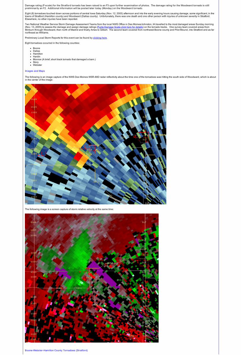
Home heavily damaged near 6 Avenue north of Pilot Mound in Webster county.
Belt buckle split post and became embedded in it near G Avenue in Webster county.
Large machine shed destroyed near G Avenue north of Pilot Mound in Webster county.

3/1/2015 Central Iowa Tornadoes of Nov. 12, 2005
http://www.crh.noaa.gov/dmx/?n=stratford-woodward-11122005 5/10
Homes heavily damaged throughout west central and northern sections of Stratford. F2 damage (preliminary).
Debris accumulating from heavily damaged homes in Stratford.
Cinder block bathroom in Stratford city park destroyed from tornadic winds.

3/1/2015 Central Iowa Tornadoes of Nov. 12, 2005
http://www.crh.noaa.gov/dmx/?n=stratford-woodward-11122005 6/10
Home heavily damaged in Stratford on northern part of town. Preliminary F2 damage.
Dallas-Boone County Tornadoes (Woodward)
Tornado (2) touched down one mile west of Minburn in Dallas county according to the aerial survey. The tornado tracked northeast for about eight miles, producing F0-F1damage before intensifying near Highway 141. The tornado produced F2 damage at a farm one mile southwest of Woodward, and continued to produce F2 damage through thesouth and east portions of Woodward. The tornado dissipated one mile northeast of Woodward. Severel houses slid off their foundations in Woodward, and a double-wide homewas flipped upside down into the street. Total path length was 11 miles.
Tornado (3) touched down in open fields one mile northwest of Madrid. It hit a home three miles north of Madrid on Highway 17, producing F1 damage. One other farm sitesustained damage as the tornado moved northeast. The tornado dissipated after a six mile track.
The following image depicts the damage survey for the "Woodward" tornado. Again, any damage or F-scale ratings are still preliminary.
Damage path and start/stop end-points courtesy of John McLaughlin of Iowa Helicopter - thanks John!
NWS photos of damage along the path of the "Woodward" tornado follow:

3/1/2015 Central Iowa Tornadoes of Nov. 12, 2005
http://www.crh.noaa.gov/dmx/?n=stratford-woodward-11122005 7/10
Flattened garages and damaged homes in south Woodward. F2 damage.
Garage offered no protection for this car in Woodward.

3/1/2015 Central Iowa Tornadoes of Nov. 12, 2005
http://www.crh.noaa.gov/dmx/?n=stratford-woodward-11122005 8/10
House slid off foundation in Woodward. F2 damage.
Double-wide home flipped on top in Woodward. F2 damage.
Boone-Story-Hamilton-Hardin County Tornadoes (Ames & Gilbert)
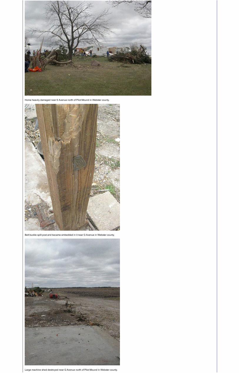
Tornado (4) started just west of Ames near the Highway 30 and Lincoln Way Split, according to the aerial survey. The tornado produced F1-F2 damage on the northwest fringe ofAmes. It weakened as it moved northeast, before intensifying again and produced F2 damage to a farm site just south of Gilbert. F1 damage occurred as the tornado crossedhighway 69. The tornado dissipated three miles south of Story City after a 10 mile track.
Tornado (5) was a short-lived satellite tornado that was on the ground for 1.6 miles ending at the southwest edge of Story City. The aerial survey showed very minor damage.
Tornado (6) developed one mile west of Roland and tracked across the extreme southeast corner of Hamilton county before entering Hardin county. The tornado produceddamage up to F1 intensity to rural farm sites in far northern Story county and five miles south of Radcliffe in Hardin county. The KCCI-TV aerial survey indicated the track was ninemiles in length.
3/1/2015 Central Iowa Tornadoes of Nov. 12, 2005
http://www.crh.noaa.gov/dmx/?n=stratford-woodward-11122005 9/10
Tornado (8) was briefly sighted near Blakesburg in Monroe county. The tornado produced minor damage to a farm building but was not surveyed and is not on any of thefollowing maps.
The following image depicts the damage survey for the "Ames-Gilbert’ tornado. Again, any damage or F-scale ratings are still preliminary.
Damage path and start/stop end-points courtesy of John McLaughlin of Iowa Helicopter - thanks John!
One NWS photo of damage along the path of the "Ames-Gilbert" tornado follows:
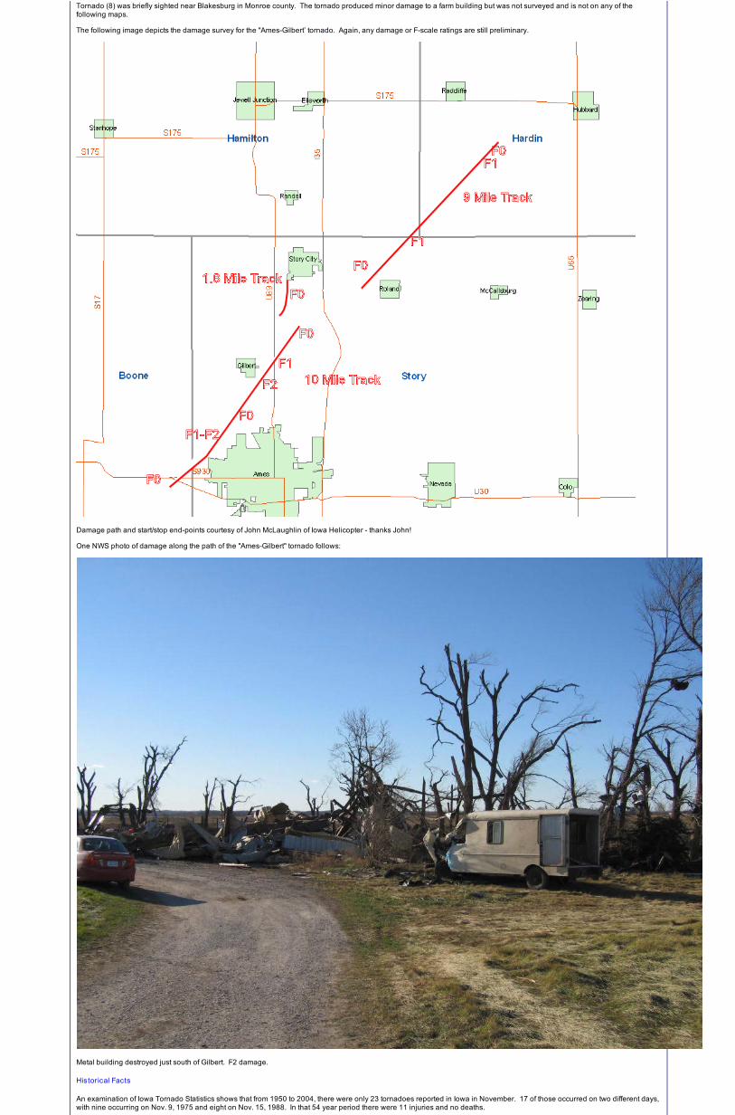
Metal building destroyed just south of Gilbert. F2 damage.
Historical Facts
An examination of Iowa Tornado Statistics shows that from 1950 to 2004, there were only 23 tornadoes reported in Iowa in November. 17 of those occurred on two different days,with nine occurring on Nov. 9, 1975 and eight on Nov. 15, 1988. In that 54 year period there were 11 injuries and no deaths.
Web Site Owner: Disclaimer Privacy Policy


![[4] - Noise Moines, Iowa.pdf · 6/11/2016 Des Moines, IA Code of Ordinances](https://img.pdfslide.us/doc/110x75/60110284a0cad57a063f2773/4-noise-moines-iowapdf-6112016-des-moines-ia-code-of-ordinances.jpg)