Embed Size (px)
Citation preview
658 The Leading Edge June 2009
SPECIAL SECTION: L a t i n A m e r i c aL a t i n A m e r i c a
Seriously southerly seismic: 3D acquisition in Tierra del Fuego
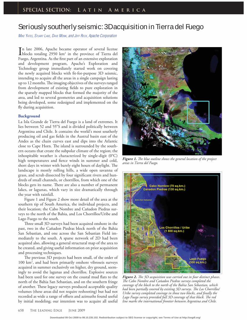
In late 2006, Apache became operator of several license blocks totaling 2950 km2 in the province of Tierra del
Fuego, Argentina. As the fi rst part of an extensive exploration and development program, Apache’s Exploration and Technology group immediately started work on covering the newly acquired blocks with fi t-for-purpose 3D seismic, intending to acquire all the areas in a single campaign lasting up to 12 months. Th e imaging objectives of the surveys ranged from development of existing fi elds to pure exploration in the sparsely mapped blocks that formed the majority of the area, and led to several geometries and acquisition solutions being developed, some redesigned and implemented on the fl y during acquisition.
Background
La Isla Grande de Tierra del Fuego is a land of extremes. It lies between 52 and 55°S and is divided politically between Argentina and Chile. It contains the world’s most southerly producing oil and gas fi elds in the Austral basin east of the Andes as the chain curves east and dips into the Atlantic close to Cape Horn. Th e island is surrounded by the south-ern oceans that create the subpolar climate of the region; the inhospitable weather is characterized by single-digit (0°C) high temperatures and fi erce winds in summer and cold, short days in winter with barely eight hours of daylight. Th e landscape is mostly rolling hills, a wide open savanna of grass, and scrub dissected by four signifi cant rivers and hun-dreds of small channels, or chorrillos, from which one of the blocks gets its name. Th ere are also a number of permanent lakes, or lagunas, which vary in size dramatically through the year with rainfall.
Figure 1 and Figure 2 show more detail of the area at the southern tip of South America, the individual projects, and their location; the Cabo Nombre and Cañadon Piedras sur-veys to the north of the Bahia, and Los Chorrillos/Uribe and Lago Fuego to the south.
Th ree small 3D surveys had been acquired onshore in the past, two in the Cañadon Piedras block north of the Bahia San Sebastian, and one across the San Sebastian Field im-mediately to the south. A sparse network of 2D had been acquired also, allowing a general structural map of the area to be created, and giving useful information on prior acquisition and processing techniques.
Th e previous 3D projects had been small, of the order of 100 km2, and had been primarily onshore vibroseis surveys acquired in summer exclusively on higher, dry ground, seem-ingly to avoid the lagunas and chorrillos. Explosive sources had been used for one survey on the coastal mud fl ats to the north of the Bahia San Sebastian, and on the southern fringe of another. Th ese legacy surveys produced acceptable quality volumes (these areas did not require reshooting) but had not recorded as wide a range of off sets and azimuths found useful by initial modeling; our intention was to acquire all useful
MIKE YATES, STUART LAKE, DAVE MONK, and JEFF RECK, Apache Corporation
SPECIAL SECTION: L a t i n A m e r i c a
Figure 1. Th e blue outline shows the general location of the project areas in Tierra del Fuego.
Figure 2. Th e 3D acquisition was carried out in four distinct phases. Th e Cabo Nombre and Cañadon Piedras surveys completed the coverage of the block to the north of the Bahia San Sebastian, which had been partially covered by existing 3D surveys. Th e Los Chorrillos/Uribe survey completed coverage in those two blocks, and fi nally the Lago Fuego survey provided full 3D coverage of that block. Th e red line marks the international frontier between Argentina and Chile.
Downloaded 09 Oct 2009 to 99.10.235.102. Redistribution subject to SEG license or copyright; see Terms of Use at http://segdl.org/
June 2009 The Leading Edge 659
L a t i n A m e r i c a
off sets at all azimuths, requiring much higher channel counts than had previously been utilized.
Timing and scouting
Discussing optimum start dates with contractors revealed a distinct polarization of opinions. Th ere were those who insist-ed that winter was the best time to work, when the ground is frozen and vibrator mobility is high, and those who believed that the long days and dryer ground of summer were better suited to acquisition, despite the stronger winds. Landown-ers told us of past cold winters with months of continuous freeze, but also that in recent years the frozen ground had been limited to only the highest points. Facing a recording program that would outlast any single season, it was decided to equip the crew with both explosive and vibroseis sources, and changing ground conditions would be handled by ad-justing the division of eff ort between the two.
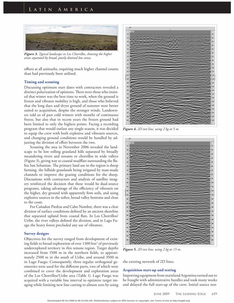
Scouting the area in November 2006 revealed the land-scape to be low rolling grassland hills separated by broadly meandering rivers and streams or chorrillos in wide valleys (Figure 3), giving way to coastal mudfl ats surrounding the Ba-hia San Sebastian. Th e primary land use in the region is sheep farming, the hillside grasslands being irrigated by man-made channels to improve the grazing conditions for the sheep. Discussions with contractors and analysis of satellite imag-ery reinforced the decision that these would be dual-source programs, taking advantage of the effi ciency of vibroseis on the higher, dry ground with apparently fi rm soils, and using explosive sources in the softer, broad valley bottoms and close to the coast.
For Cañadon Piedras and Cabo Nombre, there was a clear division of surface conditions defi ned by an ancient shoreline that separated upland from coastal fl ats. In Los Chorrillos/Uribe, the river valleys defi ned the division, and in Lago Fu-ego the heavy forest precluded any use of vibrators.
Survey designs
Objectives for the survey ranged from development of exist-ing fi elds to broad exploration of over 1300 km2 of previously underexplored territory in this remote region. Target depths increased from 1500 m in the northern fi elds, to approxi-mately 2500 m in the south of Uribe, and around 3500 m in Lago Fuego. Consequently, three regular orthogonal ge-ometries were used for the diff erent parts, two of which were combined to cover the development and exploration areas of the Los Chorrillos/Uribe area (Table 1). Lago Fuego was acquired with a variable line interval to optimize target im-aging while limiting new line cutting to almost zero by using
the existing network of 2D lines.
Acquisition start-up and testing
Importing equipment from mainland Argentina turned out to be fraught with administrative hurdles and took many weeks and delayed the full start-up of the crew. Initial source test-
Figure 3. Typical landscape in Los Chorrillos, showing the higher areas separated by broad, poorly drained low areas.
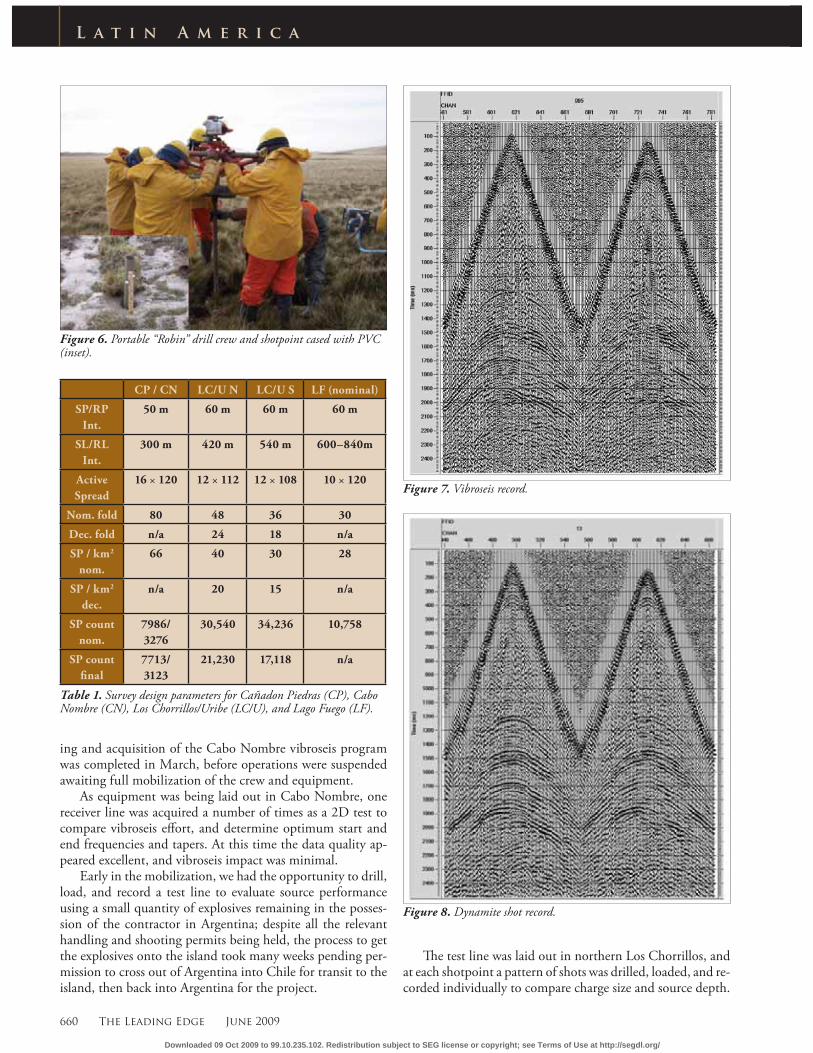
Figure 4. 2D test line, using 2 kg at 5 m.
Figure 5. 2D test line, using 2 kg at 15 m.
Downloaded 09 Oct 2009 to 99.10.235.102. Redistribution subject to SEG license or copyright; see Terms of Use at http://segdl.org/
660 The Leading Edge June 2009
L a t i n A m e r i c a
ing and acquisition of the Cabo Nombre vibroseis program was completed in March, before operations were suspended awaiting full mobilization of the crew and equipment.
As equipment was being laid out in Cabo Nombre, one receiver line was acquired a number of times as a 2D test to compare vibroseis eff ort, and determine optimum start and end frequencies and tapers. At this time the data quality ap-peared excellent, and vibroseis impact was minimal.
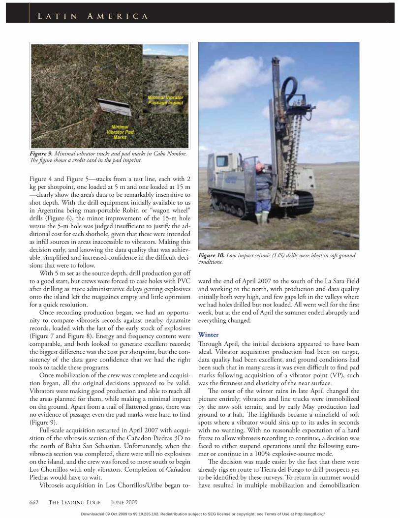
Early in the mobilization, we had the opportunity to drill, load, and record a test line to evaluate source performance using a small quantity of explosives remaining in the posses-sion of the contractor in Argentina; despite all the relevant handling and shooting permits being held, the process to get the explosives onto the island took many weeks pending per-mission to cross out of Argentina into Chile for transit to the island, then back into Argentina for the project.
Th e test line was laid out in northern Los Chorrillos, and at each shotpoint a pattern of shots was drilled, loaded, and re-corded individually to compare charge size and source depth.
Figure 6. Portable “Robin” drill crew and shotpoint cased with PVC (inset).
Figure 7. Vibroseis record.
Figure 8. Dynamite shot record.
CP / CN LC/U N LC/U S LF (nominal)
SP/RP
Int.
50 m 60 m 60 m 60 m
SL/RL
Int.
300 m 420 m 540 m 600–840m
Active
Spread
16 × 120 12 × 112 12 × 108 10 × 120
Nom. fold 80 48 36 30
Dec. fold n/a 24 18 n/a
SP / km2
nom.
66 40 30 28
SP / km2
dec.
n/a 20 15 n/a
SP count
nom.
7986/
3276
30,540 34,236 10,758
SP count
fi nal
7713/
3123
21,230 17,118 n/a
Table 1. Survey design parameters for Cañadon Piedras (CP), Cabo Nombre (CN), Los Chorrillos/Uribe (LC/U), and Lago Fuego (LF).
Downloaded 09 Oct 2009 to 99.10.235.102. Redistribution subject to SEG license or copyright; see Terms of Use at http://segdl.org/
662 The Leading Edge June 2009
L a t i n A m e r i c a
Figure 4 and Figure 5—stacks from a test line, each with 2 kg per shotpoint, one loaded at 5 m and one loaded at 15 m —clearly show the area’s data to be remarkably insensitive to shot depth. With the drill equipment initially available to us in Argentina being man-portable Robin or “wagon wheel” drills (Figure 6), the minor improvement of the 15-m hole versus the 5-m hole was judged insuffi cient to justify the ad-ditional cost for each shothole, given that these were intended as infi ll sources in areas inaccessible to vibrators. Making this decision early, and knowing the data quality that was achiev-able, simplifi ed and increased confi dence in the diffi cult deci-sions that were to follow.
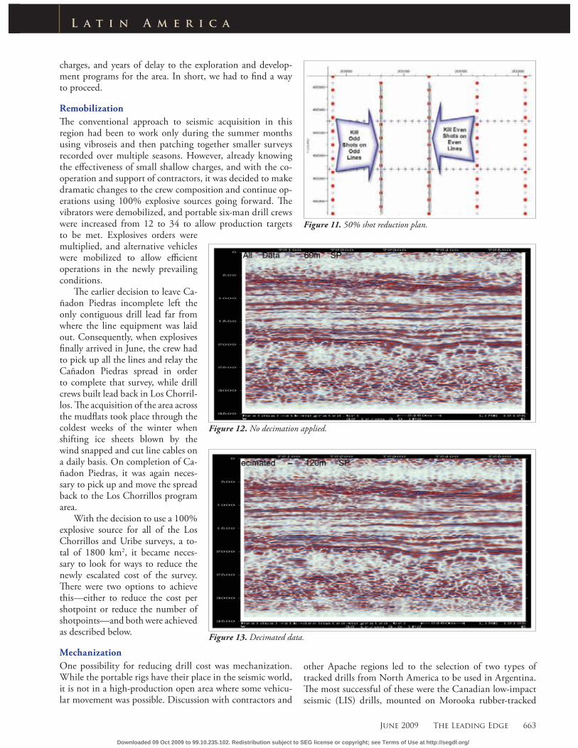
With 5 m set as the source depth, drill production got off to a good start, but crews were forced to case holes with PVC after drilling as more administrative delays getting explosives onto the island left the magazines empty and little optimism for a quick resolution.
Once recording production began, we had an opportu-nity to compare vibroseis records against nearby dynamite records, loaded with the last of the early stock of explosives (Figure 7 and Figure 8). Energy and frequency content were comparable, and both looked to generate excellent records; the biggest diff erence was the cost per shotpoint, but the con-sistency of the data gave confi dence that we had the right tools to tackle these programs.
Once mobilization of the crew was complete and acquisi-tion began, all the original decisions appeared to be valid. Vibrators were making good production and able to reach all the areas planned for them, while making a minimal impact on the ground. Apart from a trail of fl attened grass, there was no evidence of passage; even the pad marks were hard to fi nd (Figure 9).
Full-scale acquisition restarted in April 2007 with acqui-sition of the vibroseis section of the Cañadon Piedras 3D to the north of Bahia San Sebastian. Unfortunately, when the vibroseis section was completed, there were still no explosives on the island, and the crew was forced to move south to begin Los Chorrillos with only vibrators. Completion of Cañadon Piedras would have to wait.
Vibroseis acquisition in Los Chorrillos/Uribe began to-
ward the end of April 2007 to the south of the La Sara Field and working to the north, with production and data quality initially both very high, and few gaps left in the valleys where we had holes drilled but not loaded. All went well for the fi rst week, but at the end of April the summer ended abruptly and everything changed.
Winter
Th rough April, the initial decisions appeared to have been ideal. Vibrator acquisition production had been on target, data quality had been excellent, and ground conditions had been such that in many areas it was even diffi cult to fi nd pad marks following acquisition of a vibrator point (VP), such was the fi rmness and elasticity of the near surface.
Th e onset of the winter rains in late April changed the picture entirely; vibrators and line trucks were immobilized by the now soft terrain, and by early May production had ground to a halt. Th e highlands became a minefi eld of soft spots where a vibrator would sink up to its axles in seconds with no warning. With no reasonable expectation of a hard freeze to allow vibroseis recording to continue, a decision was faced to either suspend operations until the following sum-mer or continue in a 100% explosive-source mode.
Th e decision was made easier by the fact that there were already rigs en route to Tierra del Fuego to drill prospects yet to be identifi ed by these surveys. To return in summer would have resulted in multiple mobilization and demobilization
Figure 9. Minimal vibrator tracks and pad marks in Cabo Nombre.Th e fi gure shows a credit card in the pad imprint.
Figure 10. Low impact seismic (LIS) drills were ideal in soft ground conditions.
Downloaded 09 Oct 2009 to 99.10.235.102. Redistribution subject to SEG license or copyright; see Terms of Use at http://segdl.org/
June 2009 The Leading Edge 663
L a t i n A m e r i c a
Figure 11. 50% shot reduction plan.
Figure 13. Decimated data.
Figure 12. No decimation applied.
charges, and years of delay to the exploration and develop-ment programs for the area. In short, we had to fi nd a way to proceed.
Remobilization
Th e conventional approach to seismic acquisition in this region had been to work only during the summer months using vibroseis and then patching together smaller surveys recorded over multiple seasons. However, already knowing the eff ectiveness of small shallow charges, and with the co-operation and support of contractors, it was decided to make dramatic changes to the crew composition and continue op-erations using 100% explosive sources going forward. Th e vibrators were demobilized, and portable six-man drill crews were increased from 12 to 34 to allow production targets to be met. Explosives orders were multiplied, and alternative vehicles were mobilized to allow effi cient operations in the newly prevailing conditions.
Th e earlier decision to leave Ca-ñadon Piedras incomplete left the only contiguous drill lead far from where the line equipment was laid out. Consequently, when explosives fi nally arrived in June, the crew had to pick up all the lines and relay the Cañadon Piedras spread in order to complete that survey, while drill crews built lead back in Los Chorril-los. Th e acquisition of the area across the mudfl ats took place through the coldest weeks of the winter when shifting ice sheets blown by the wind snapped and cut line cables on a daily basis. On completion of Ca-ñadon Piedras, it was again neces-sary to pick up and move the spread back to the Los Chorrillos program area.
With the decision to use a 100% explosive source for all of the Los Chorrillos and Uribe surveys, a to-tal of 1800 km2, it became neces-sary to look for ways to reduce the newly escalated cost of the survey. Th ere were two options to achieve this—either to reduce the cost per shotpoint or reduce the number of shotpoints—and both were achieved as described below.
Mechanization
One possibility for reducing drill cost was mechanization. While the portable rigs have their place in the seismic world, it is not in a high-production open area where some vehicu-lar movement was possible. Discussion with contractors and
other Apache regions led to the selection of two types of tracked drills from North America to be used in Argentina. Th e most successful of these were the Canadian low-impact seismic (LIS) drills, mounted on Morooka rubber-tracked
Downloaded 09 Oct 2009 to 99.10.235.102. Redistribution subject to SEG license or copyright; see Terms of Use at http://segdl.org/
664 The Leading Edge June 2009
L a t i n A m e r i c a
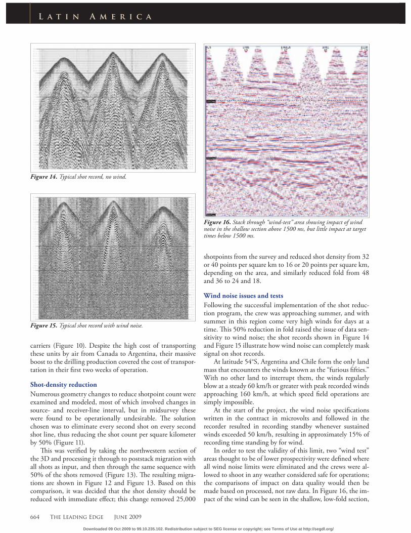
Figure 14. Typical shot record, no wind.
Figure 15. Typical shot record with wind noise.
Figure 16. Stack through “wind-test” area showing impact of wind noise in the shallow section above 1500 ms, but little impact at target times below 1500 ms.
carriers (Figure 10). Despite the high cost of transporting these units by air from Canada to Argentina, their massive boost to the drilling production covered the cost of transpor-tation in their fi rst two weeks of operation.
Shot-density reduction
Numerous geometry changes to reduce shotpoint count were examined and modeled, most of which involved changes in source- and receiver-line interval, but in midsurvey these were found to be operationally undesirable. Th e solution chosen was to eliminate every second shot on every second shot line, thus reducing the shot count per square kilometer by 50% (Figure 11).
Th is was verifi ed by taking the northwestern section of the 3D and processing it through to poststack migration with all shots as input, and then through the same sequence with 50% of the shots removed (Figure 13). Th e resulting migra-tions are shown in Figure 12 and Figure 13. Based on this comparison, it was decided that the shot density should be reduced with immediate eff ect; this change removed 25,000
shotpoints from the survey and reduced shot density from 32 or 40 points per square km to 16 or 20 points per square km, depending on the area, and similarly reduced fold from 48 and 36 to 24 and 18.
Wind noise issues and tests
Following the successful implementation of the shot reduc-tion program, the crew was approaching summer, and with summer in this region come very high winds for days at a time. Th is 50% reduction in fold raised the issue of data sen-sitivity to wind noise; the shot records shown in Figure 14 and Figure 15 illustrate how wind noise can completely mask signal on shot records.
At latitude 54°S, Argentina and Chile form the only land mass that encounters the winds known as the “furious fi fties.” With no other land to interrupt them, the winds regularly blow at a steady 60 km/h or greater with peak recorded winds approaching 160 km/h, at which speed fi eld operations are simply impossible.
At the start of the project, the wind noise specifi cations written in the contract in microvolts and followed in the recorder resulted in recording standby whenever sustained winds exceeded 50 km/h, resulting in approximately 15% of recording time standing by for wind.
In order to test the validity of this limit, two “wind test” areas thought to be of lower prospectivity were defi ned where all wind noise limits were eliminated and the crews were al-lowed to shoot in any weather considered safe for operations; the comparisons of impact on data quality would then be made based on processed, not raw data. In Figure 16, the im-pact of the wind can be seen in the shallow, low-fold section,
Downloaded 09 Oct 2009 to 99.10.235.102. Redistribution subject to SEG license or copyright; see Terms of Use at http://segdl.org/
June 2009 The Leading Edge 665
L a t i n A m e r i c a
but the deeper interval of interest (below 1.5 s) is relatively unaff ected.
Analysis of the recorded wind-speed data by area and study of the fi eld cube from those areas led to a relaxation of the noise limit to allow recording to continue in winds up to 75 km/h even with the reduced shotpoint density, thus in-creasing the productivity of the crew by reducing time lost to wind noise. From this point forward, the noise specifi cations were written in kilometers per hour, and not microvolts.
Lago Fuego 3D
At 54°S, the Lago Fuego gas fi eld represents the world’s most southerly hydrocarbon production. Following completion of the Los Chorrillos/Uribe survey, the drilling and recording crews moved south to acquire an additional 500 km2 of 3D data. Because of all the experiences of the program to date,
the crews were well equipped to deal with most aspects of the area, the main exception being the heavi-ly wooded terrain. Th e program was designed with variable line spacing to optimize coverage in target areas while taking advantage of existing 2D lines and open spaces to allow maximum usage of the mechanized drills. Th e existing lines were bull-dozed through the forest by a pre-vious operator in the 1950s and no signifi cant regrowth has occurred. Apache wished to avoid this scale of environmental impact, and did so through the use of these exist-ing lines and access. In the forests, the portable drills were used with air compressors instead of water to boost mobility and limit the need for vehicle access. Recording crew mobility was improved with the re-placement of the original recorder with a lighter, more fl exible system more suited to a portable operation through the forests.
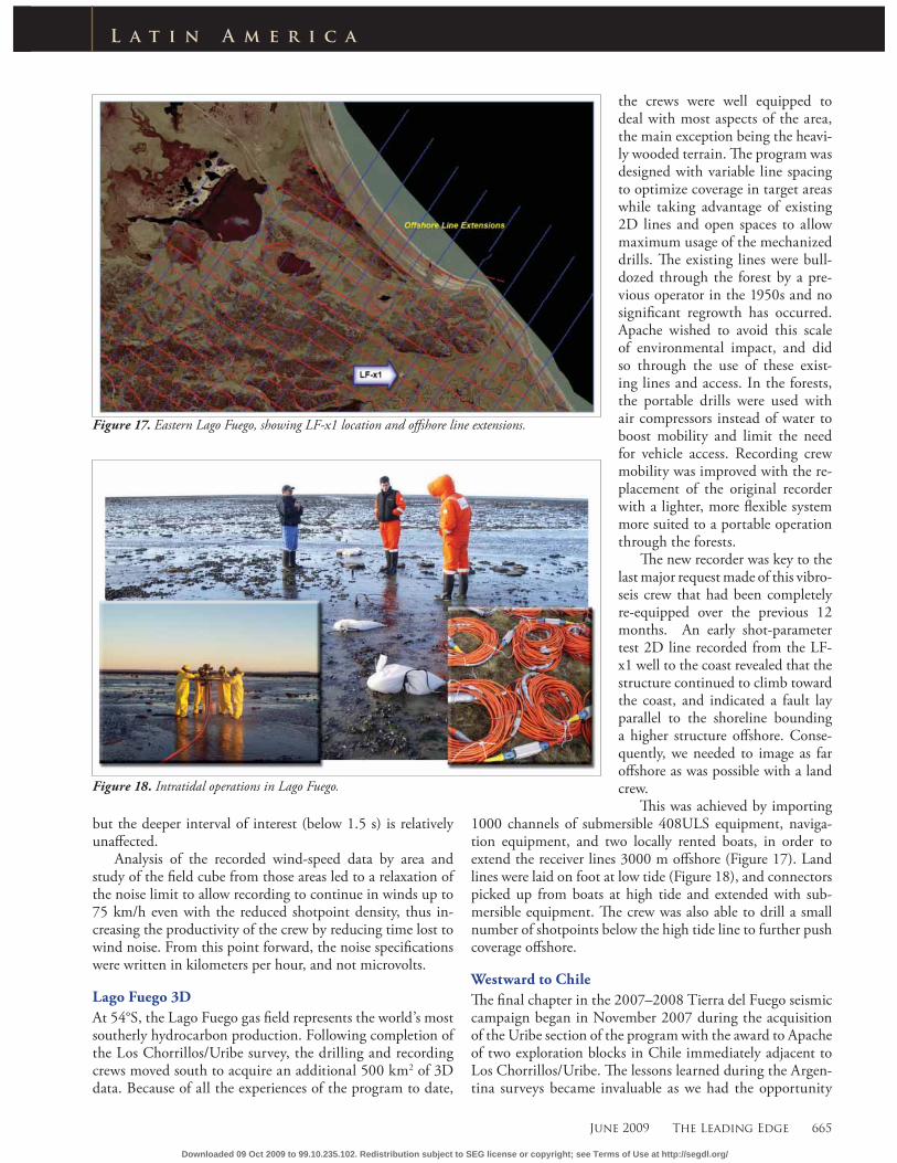
Th e new recorder was key to the last major request made of this vibro-seis crew that had been completely re-equipped over the previous 12 months. An early shot-parameter test 2D line recorded from the LF-x1 well to the coast revealed that the structure continued to climb toward the coast, and indicated a fault lay parallel to the shoreline bounding a higher structure off shore. Conse-quently, we needed to image as far off shore as was possible with a land crew.
Th is was achieved by importing 1000 channels of submersible 408ULS equipment, naviga-tion equipment, and two locally rented boats, in order to extend the receiver lines 3000 m off shore (Figure 17). Land lines were laid on foot at low tide (Figure 18), and connectors picked up from boats at high tide and extended with sub-mersible equipment. Th e crew was also able to drill a small number of shotpoints below the high tide line to further push coverage off shore.
Westward to Chile
Th e fi nal chapter in the 2007–2008 Tierra del Fuego seismic campaign began in November 2007 during the acquisition of the Uribe section of the program with the award to Apache of two exploration blocks in Chile immediately adjacent to Los Chorrillos/Uribe. Th e lessons learned during the Argen-tina surveys became invaluable as we had the opportunity
Figure 17. Eastern Lago Fuego, showing LF-x1 location and off shore line extensions.
Figure 18. Intratidal operations in Lago Fuego.
Downloaded 09 Oct 2009 to 99.10.235.102. Redistribution subject to SEG license or copyright; see Terms of Use at http://segdl.org/
666 The Leading Edge June 2009
L a t i n A m e r i c a
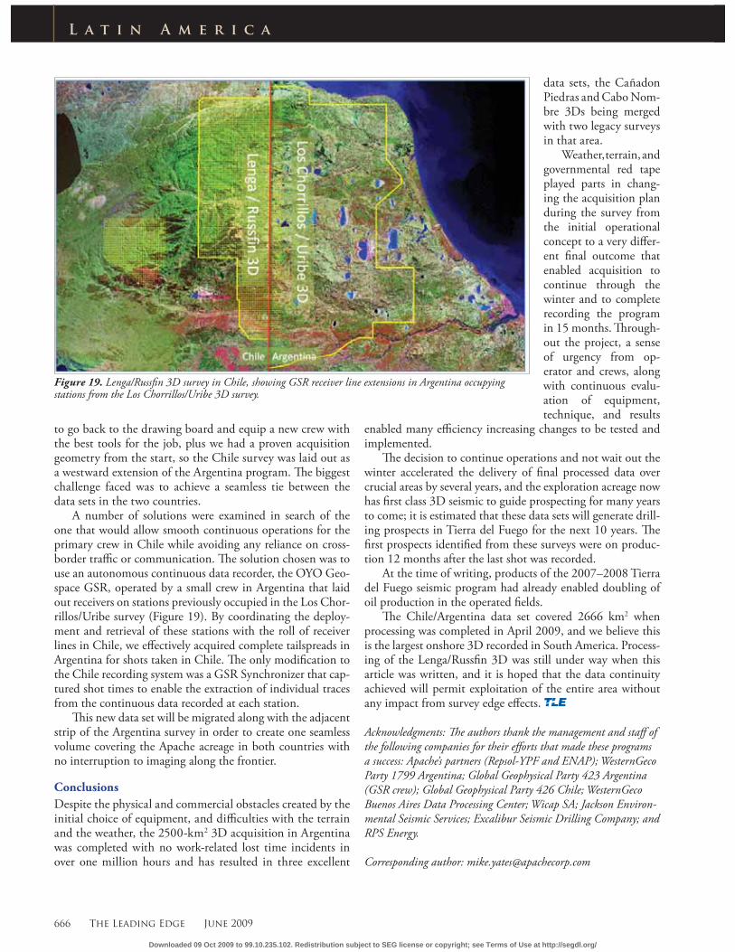
Figure 19. Lenga/Russfi n 3D survey in Chile, showing GSR receiver line extensions in Argentina occupying stations from the Los Chorrillos/Uribe 3D survey.
to go back to the drawing board and equip a new crew with the best tools for the job, plus we had a proven acquisition geometry from the start, so the Chile survey was laid out as a westward extension of the Argentina program. Th e biggest challenge faced was to achieve a seamless tie between the data sets in the two countries.
A number of solutions were examined in search of the one that would allow smooth continuous operations for the primary crew in Chile while avoiding any reliance on cross-border traffi c or communication. Th e solution chosen was to use an autonomous continuous data recorder, the OYO Geo-space GSR, operated by a small crew in Argentina that laid out receivers on stations previously occupied in the Los Chor-rillos/Uribe survey (Figure 19). By coordinating the deploy-ment and retrieval of these stations with the roll of receiver lines in Chile, we eff ectively acquired complete tailspreads in Argentina for shots taken in Chile. Th e only modifi cation to the Chile recording system was a GSR Synchronizer that cap-tured shot times to enable the extraction of individual traces from the continuous data recorded at each station.
Th is new data set will be migrated along with the adjacent strip of the Argentina survey in order to create one seamless volume covering the Apache acreage in both countries with no interruption to imaging along the frontier.
Conclusions
Despite the physical and commercial obstacles created by the initial choice of equipment, and diffi culties with the terrain and the weather, the 2500-km2 3D acquisition in Argentina was completed with no work-related lost time incidents in over one million hours and has resulted in three excellent
data sets, the Cañadon Piedras and Cabo Nom-bre 3Ds being merged with two legacy surveys in that area.
Weather, terrain, and governmental red tape played parts in chang-ing the acquisition plan during the survey from the initial operational concept to a very diff er-ent fi nal outcome that enabled acquisition to continue through the winter and to complete recording the program in 15 months. Th rough-out the project, a sense of urgency from op-erator and crews, along with continuous evalu-ation of equipment, technique, and results
enabled many effi ciency increasing changes to be tested and implemented.
Th e decision to continue operations and not wait out the winter accelerated the delivery of fi nal processed data over crucial areas by several years, and the exploration acreage now has fi rst class 3D seismic to guide prospecting for many years to come; it is estimated that these data sets will generate drill-ing prospects in Tierra del Fuego for the next 10 years. Th e fi rst prospects identifi ed from these surveys were on produc-tion 12 months after the last shot was recorded.
At the time of writing, products of the 2007–2008 Tierra del Fuego seismic program had already enabled doubling of oil production in the operated fi elds.
Th e Chile/Argentina data set covered 2666 km2 when processing was completed in April 2009, and we believe this is the largest onshore 3D recorded in South America. Process-ing of the Lenga/Russfi n 3D was still under way when this article was written, and it is hoped that the data continuity achieved will permit exploitation of the entire area without any impact from survey edge eff ects.
Acknowledgments: Th e authors thank the management and staff of the following companies for their eff orts that made these programs a success: Apache’s partners (Repsol-YPF and ENAP); WesternGeco Party 1799 Argentina; Global Geophysical Party 423 Argentina (GSR crew); Global Geophysical Party 426 Chile; WesternGeco Buenos Aires Data Processing Center; Wicap SA; Jackson Environ-mental Seismic Services; Excalibur Seismic Drilling Company; and RPS Energy.
Corresponding author: [email protected]
Downloaded 09 Oct 2009 to 99.10.235.102. Redistribution subject to SEG license or copyright; see Terms of Use at http://segdl.org/