Embed Size (px)
Citation preview
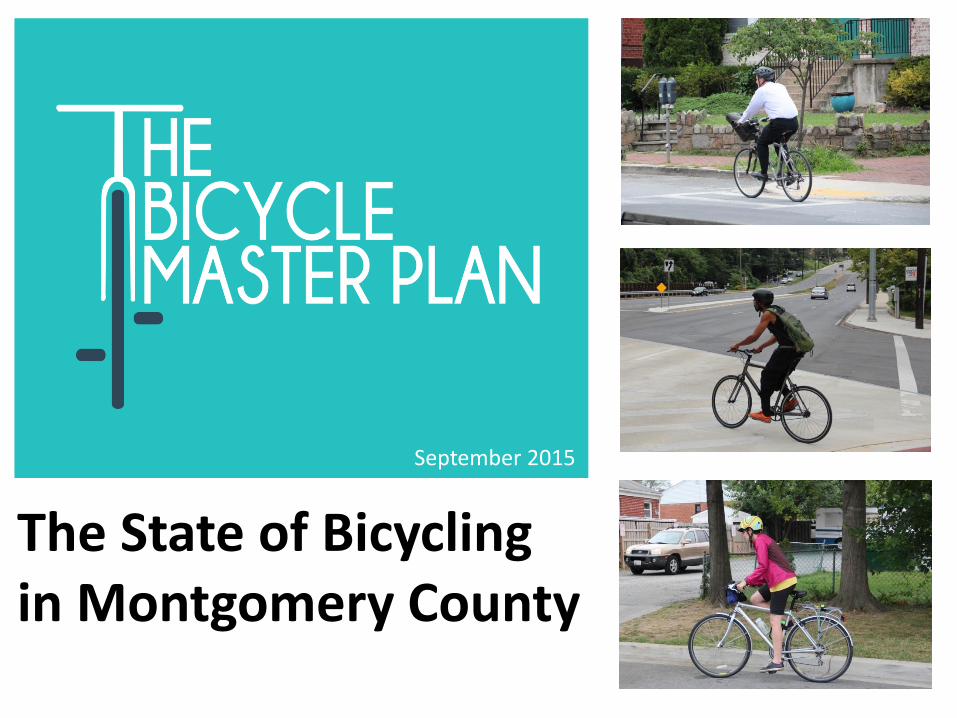
The State of Bicycling in Montgomery County
September 2015
The State of Bicycling in Montgomery County
Abstract:
This report documents the state of bicycling in Montgomery County as of
September 2015. It presents recent data on bicycling in Montgomery
County and the length of existing and master-planned bicycle facilities.
Source of Copies:
Montgomeryplanning.org/bikeplan
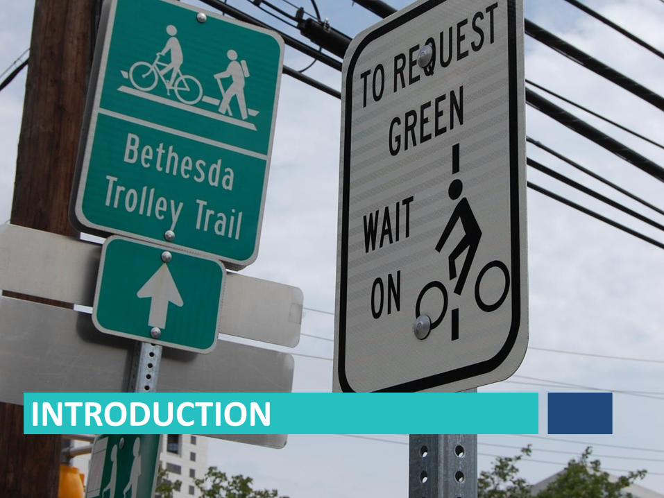
INTRODUCTION

Silver Spring Metro Station Georgetown Branch Trail Takoma Park
North Bethesda Trail
Woodglen Drive Cycle Track
OVERVIEW Bicycling is gaining popularity as a mode of transportation throughout the United States, especially in urbanized areas. Driven by changing travel patterns, investments in low-stress bicycling infrastructure and increasing popularity of bikeshare programs, the share of trips by bicycle has grown steadily over the past 15 years. Montgomery County continues to make substantial investments in bicycling infrastructure and is well-positioned to emerge as a leader in bicycling among suburban jurisdictions.
4
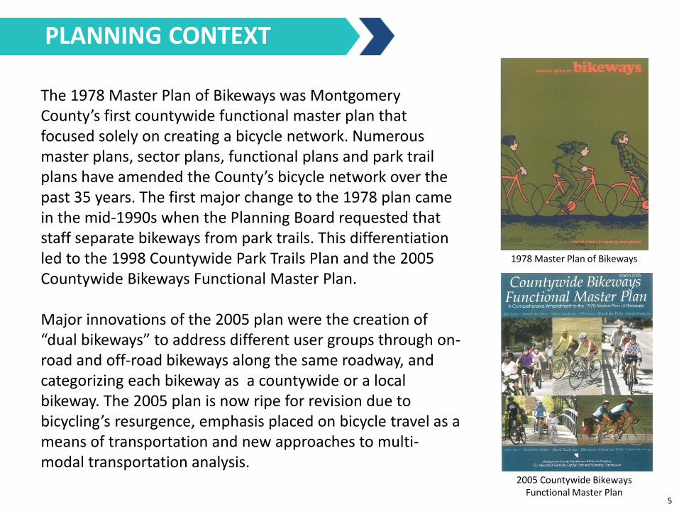
The 1978 Master Plan of Bikeways was Montgomery County’s first countywide functional master plan that focused solely on creating a bicycle network. Numerous master plans, sector plans, functional plans and park trail plans have amended the County’s bicycle network over the past 35 years. The first major change to the 1978 plan came in the mid-1990s when the Planning Board requested that staff separate bikeways from park trails. This differentiation led to the 1998 Countywide Park Trails Plan and the 2005 Countywide Bikeways Functional Master Plan. Major innovations of the 2005 plan were the creation of “dual bikeways” to address different user groups through on-road and off-road bikeways along the same roadway, and categorizing each bikeway as a countywide or a local bikeway. The 2005 plan is now ripe for revision due to bicycling’s resurgence, emphasis placed on bicycle travel as a means of transportation and new approaches to multi-modal transportation analysis.
1978 Master Plan of Bikeways
2005 Countywide Bikeways Functional Master Plan
PLANNING CONTEXT
5
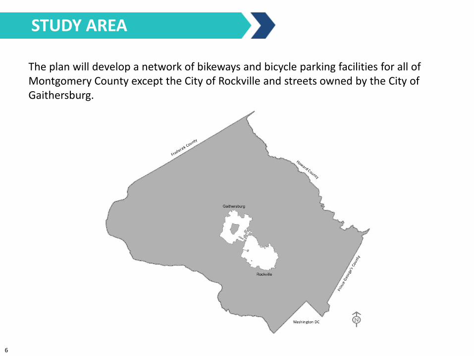
The plan will develop a network of bikeways and bicycle parking facilities for all of Montgomery County except the City of Rockville and streets owned by the City of Gaithersburg.
STUDY AREA
6
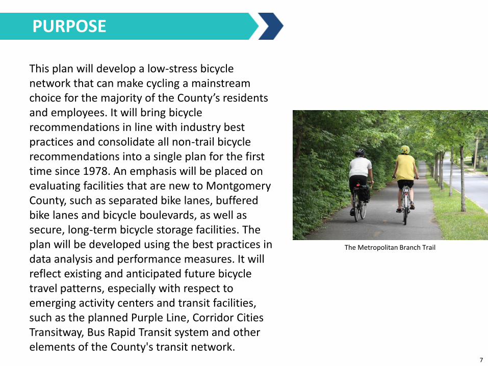
This plan will develop a low-stress bicycle network that can make cycling a mainstream choice for the majority of the County’s residents and employees. It will bring bicycle recommendations in line with industry best practices and consolidate all non-trail bicycle recommendations into a single plan for the first time since 1978. An emphasis will be placed on evaluating facilities that are new to Montgomery County, such as separated bike lanes, buffered bike lanes and bicycle boulevards, as well as secure, long-term bicycle storage facilities. The plan will be developed using the best practices in data analysis and performance measures. It will reflect existing and anticipated future bicycle travel patterns, especially with respect to emerging activity centers and transit facilities, such as the planned Purple Line, Corridor Cities Transitway, Bus Rapid Transit system and other elements of the County's transit network.
The Metropolitan Branch Trail
PURPOSE
7
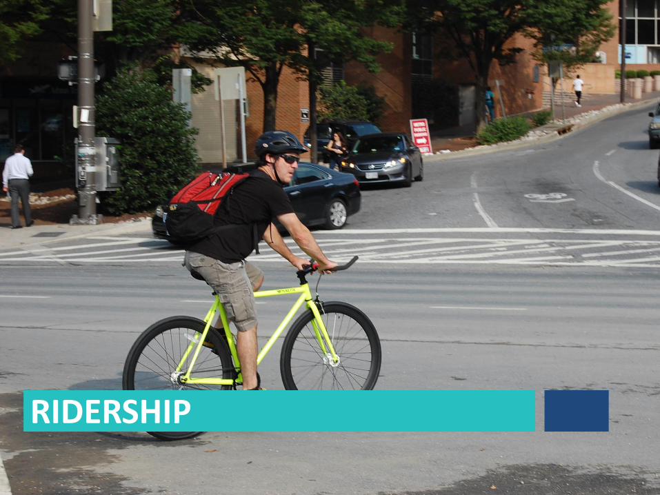
RIDERSHIP
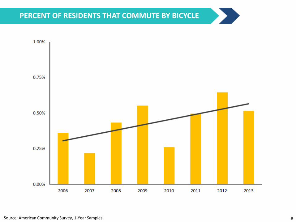
Source: American Community Survey, 1-Year Samples
PERCENT OF RESIDENTS THAT COMMUTE BY BICYCLE
9
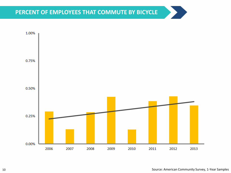
Source: American Community Survey, 1-Year Samples
PERCENT OF EMPLOYEES THAT COMMUTE BY BICYCLE
10

EXISTING AND PLANNED BIKEWAYS
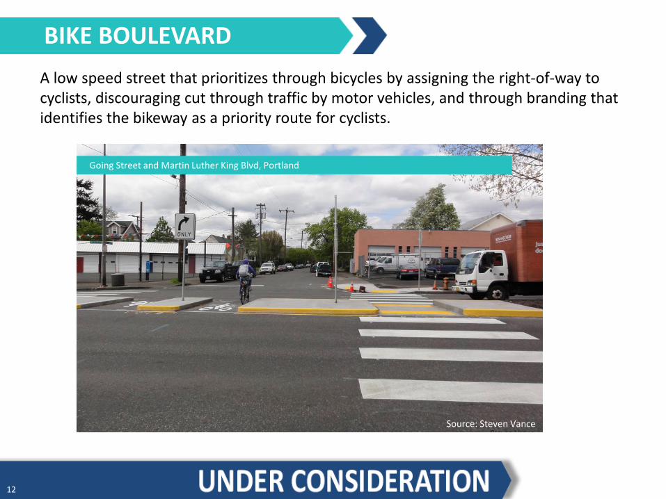
A low speed street that prioritizes through bicycles by assigning the right-of-way to cyclists, discouraging cut through traffic by motor vehicles, and through branding that identifies the bikeway as a priority route for cyclists.
Status in Montgomery County Existing: 0 miles Master Plan: 0 miles
BIKE BOULEVARD
Going Street and Martin Luther King Blvd, Portland
Source: Steven Vance
12
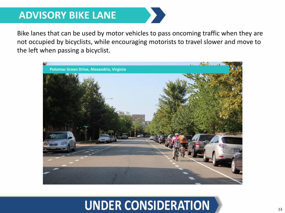
Bike lanes that can be used by motor vehicles to pass oncoming traffic when they are not occupied by bicyclists, while encouraging motorists to travel slower and move to the left when passing a bicyclist.
Status in Montgomery County Existing: 0 miles Master Plan: 0 miles
ADVISORY BIKE LANE
Potomac Green Drive, Alexandria, Virginia
13
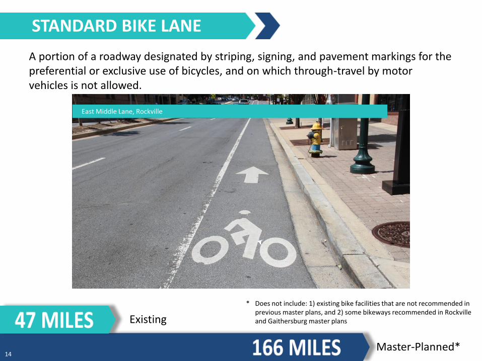
A portion of a roadway designated by striping, signing, and pavement markings for the preferential or exclusive use of bicycles, and on which through-travel by motor vehicles is not allowed.
Status in Montgomery County Existing: 58 miles Planned: 166 miles
STANDARD BIKE LANE
East Middle Lane, Rockville
Existing
Master-Planned*
* Does not include: 1) existing bike facilities that are not recommended in previous master plans, and 2) some bikeways recommended in Rockville and Gaithersburg master plans
14

A bikeway separated from a motor vehicle travel lane with an area of striped pavement.
Status in Montgomery County Existing: 0 miles Master Plan: 0 miles
BUFFERED BIKE LANE
1st Avenue, Minneapolis
15

A bikeway that is physically separated from motor vehicles and pedestrian facilities. The separation may be vertical, such as a curb; horizontal, such as a landscape panel or parking lane; or a combination. A separated bike lane may be in a one-way or two-way configuration.
Status in Montgomery County Existing: 0.3 miles Master Plan: 7.7 miles
SEPARATED BIKE LANE
Two-Way Separated Bike Lanes on Woodglen Drive, White Flint
Existing
Master-Planned* 16
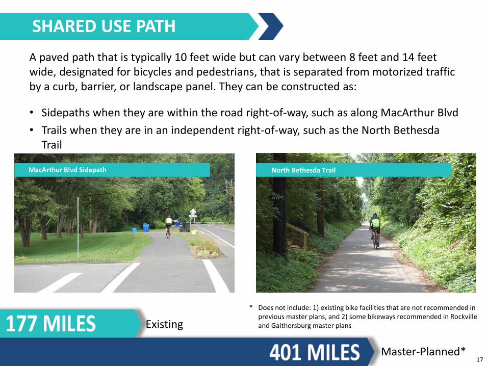
A paved path that is typically 10 feet wide but can vary between 8 feet and 14 feet wide, designated for bicycles and pedestrians, that is separated from motorized traffic by a curb, barrier, or landscape panel. They can be constructed as:
• Sidepaths when they are within the road right-of-way, such as along MacArthur Blvd
• Trails when they are in an independent right-of-way, such as the North Bethesda Trail
Status in Montgomery County Existing: 175 miles Master Plan: 401 miles
SHARED USE PATH
MacArthur Blvd Sidepath North Bethesda Trail
Existing
Master-Planned*
* Does not include: 1) existing bike facilities that are not recommended in previous master plans, and 2) some bikeways recommended in Rockville and Gaithersburg master plans
17
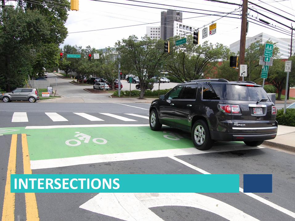
INTERSECTIONS
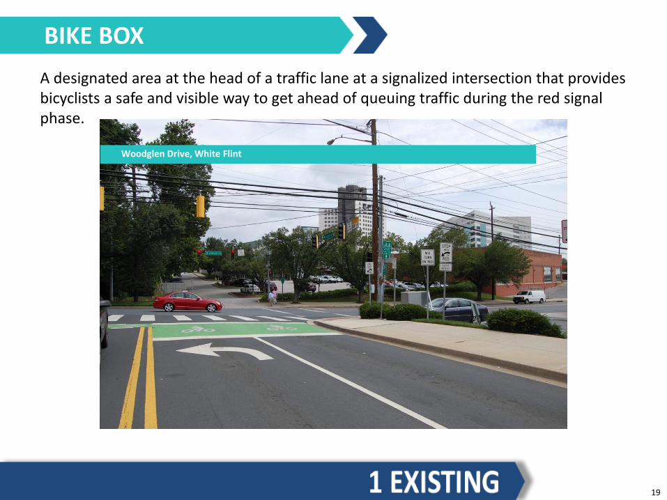
A designated area at the head of a traffic lane at a signalized intersection that provides bicyclists a safe and visible way to get ahead of queuing traffic during the red signal phase.
BIKE BOX
Woodglen Drive, White Flint
19

An intersection treatment that facilitates left turns at multi-lane intersections from a standard bike lane or separated bike lane on the right side of the road.
Status in Montgomery County Existing: 0
TWO-STAGE QUEUE BOX
Broadway, Seattle
20
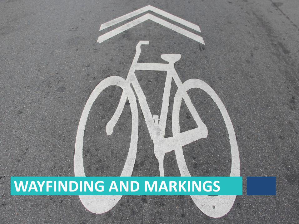
WAYFINDING AND MARKINGS

Signs that provide wayfinding for cyclists.
DIRECTIONAL SIGNAGE
North Bethesda Trail, White Flint
22
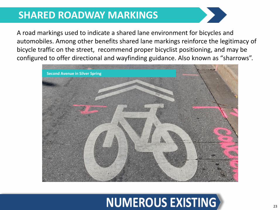
A road markings used to indicate a shared lane environment for bicycles and automobiles. Among other benefits shared lane markings reinforce the legitimacy of bicycle traffic on the street, recommend proper bicyclist positioning, and may be configured to offer directional and wayfinding guidance. Also known as “sharrows”.
SHARED ROADWAY MARKINGS
Second Avenue in Silver Spring
23
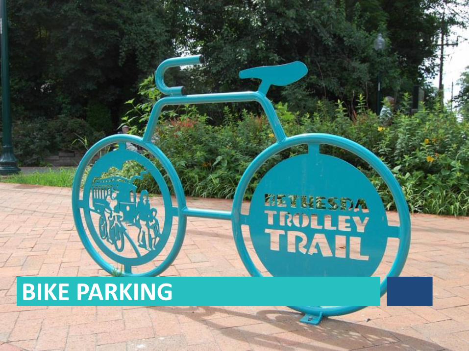
BIKE PARKING
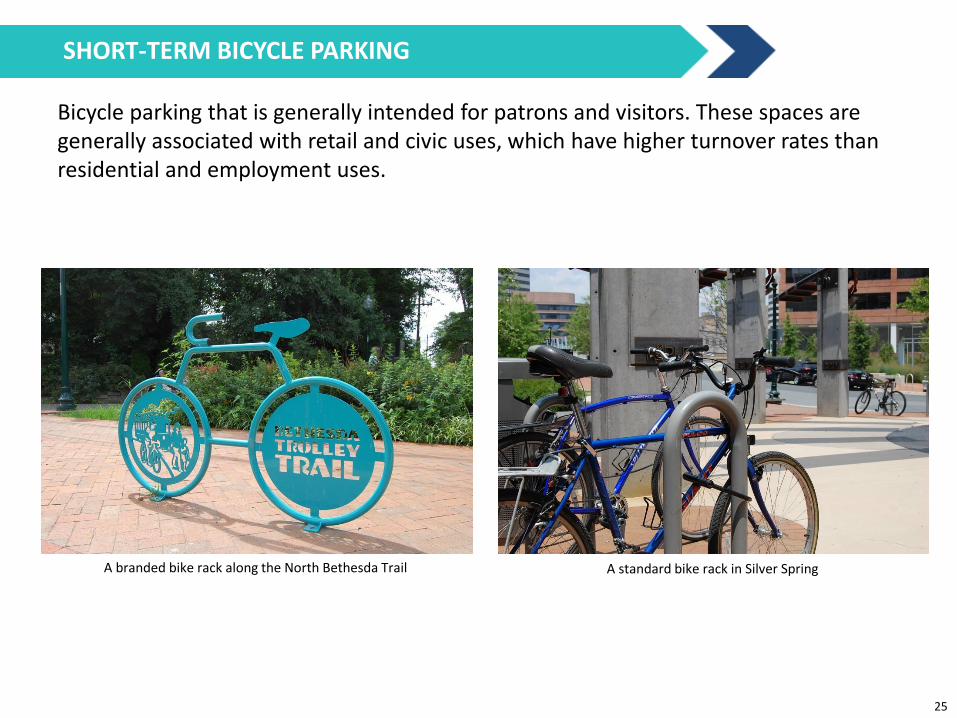
Bicycle parking that is generally intended for patrons and visitors. These spaces are generally associated with retail and civic uses, which have higher turnover rates than residential and employment uses.
A branded bike rack along the North Bethesda Trail A standard bike rack in Silver Spring
SHORT-TERM BICYCLE PARKING
25
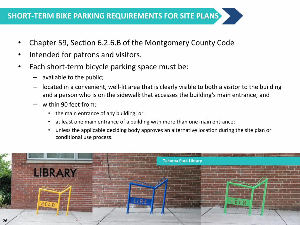
• Chapter 59, Section 6.2.6.B of the Montgomery County Code
• Intended for patrons and visitors.
• Each short‐term bicycle parking space must be: – available to the public;
– located in a convenient, well‐lit area that is clearly visible to both a visitor to the building and a person who is on the sidewalk that accesses the building’s main entrance; and
– within 90 feet from:
• the main entrance of any building; or
• at least one main entrance of a building with more than one main entrance;
• unless the applicable deciding body approves an alternative location during the site plan or conditional use process.
SHORT-TERM BIKE PARKING REQUIREMENTS FOR SITE PLANS
Takoma Park Library
26
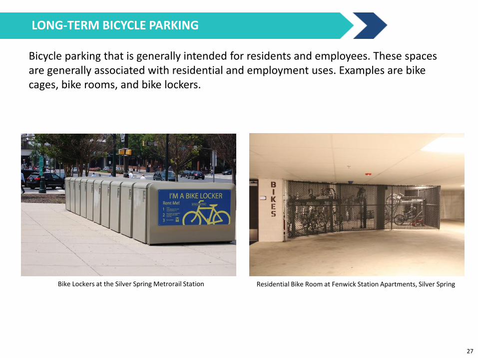
Bicycle parking that is generally intended for residents and employees. These spaces are generally associated with residential and employment uses. Examples are bike cages, bike rooms, and bike lockers.
Bike Lockers at the Silver Spring Metrorail Station Residential Bike Room at Fenwick Station Apartments, Silver Spring
LONG-TERM BICYCLE PARKING
27

• Chapter 59, Section 6.2.6.A of the Montgomery County Code
• Intended for residents and employees.
• Must be provided within a building, covered parking garage, or bicycle locker located near the building or structure and the street or other bicycle right‐of‐way.
• Must be accessible for all building tenants during the building's hours of operations.
• A long‐term bicycle parking space in a garage: – must be located no lower than the first complete parking level below grade, and no
higher than the first complete parking level above grade
– must be in a well‐lit, visible location near the main entrance or elevators
• If a long‐term bicycle parking space is in an enclosed area, the facility must not be accessible to anyone without authorized access.
LONG-TERM BIKE PARKING REQUIREMENTS FOR SITE PLANS
28
Showers & Changing Facilities
Any individual tenant space with more than 50,000 square feet of nonresidential gross floor area (excluding retail or uses with less than 50 employees during the largest shift), must have one shower changing facility for each gender, unless the development has shower and changing facilities in a common area that is available to all tenants. One additional shower and changing facility per gender must be installed for every additional 50,000 square feet of nonresidential gross floor area (excluding retail), up to a maximum of 3 for each gender.
Lockers
If a long‐term bicycle storage facility is required for a nonresidential use, the facility must have a minimum of 0.3 clothing lockers for each required long‐term storage space for each gender.
Bicycle Supportive Facilities
29

A secure and covered bicycle parking facility that can include amenities such as showers, changing rooms, lockers, bicycle repair, and bicycle rental. Bicycle stations are often located at transit stations.
BICYCLE TRANSIT CENTERS / BIKE STATIONS
Union Station Bike Station, Washington, DC
30
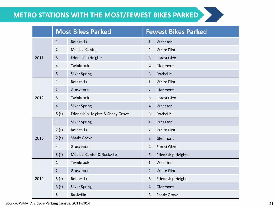
Most Bikes Parked Fewest Bikes Parked
2011
1 Bethesda 1 Wheaton
2 Medical Center 2 White Flint
3 Friendship Heights 3 Forest Glen
4 Twinbrook 4 Glenmont
5 Silver Spring 5 Rockville
2012
1 Bethesda 1 White Flint
2 Grosvenor 2 Glenmont
3 Twinbrook 3 Forest Glen
4 Silver Spring 4 Wheaton
5 (t) Friendship Heights & Shady Grove 5 Rockville
2013
1 Silver Spring 1 Wheaton
2 (t) Bethesda 2 White Flint
2 (t) Shady Grove 3 Glenmont
4 Grosvenor 4 Forest Glen
5 (t) Medical Center & Rockville 5 Friendship Heights
2014
1 Twinbrook 1 Wheaton
2 Grosvenor 2 White Flint
3 (t) Bethesda 3 Friendship Heights
3 (t) Silver Spring 4 Glenmont
5 Rockville 5 Shady Grove
Source: WMATA Bicycle Parking Census, 2011-2014
METRO STATIONS WITH THE MOST/FEWEST BIKES PARKED
31
CAPITAL BIKESHARE

A service in which bicycles are made available for shared use, allowing people to borrow a bike from one location and return it to another.
BIKESHARE
Spring Street & First Street, Silver Spring
33
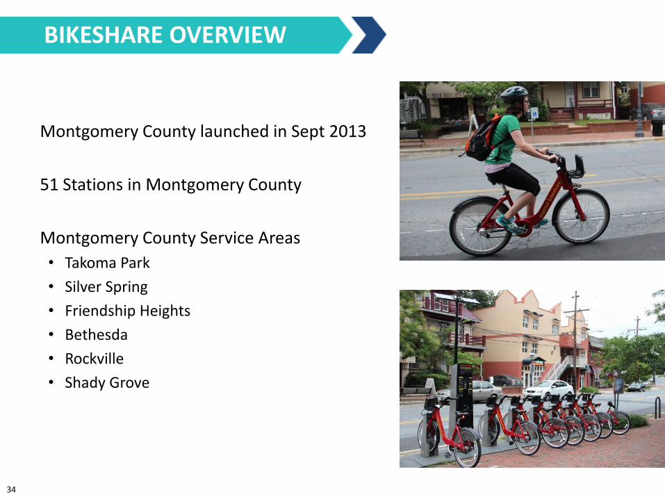
Overview
Montgomery County launched in Sept 2013
51 Stations in Montgomery County
Montgomery County Service Areas
• Takoma Park
• Silver Spring
• Friendship Heights
• Bethesda
• Rockville
• Shady Grove
BIKESHARE OVERVIEW
34
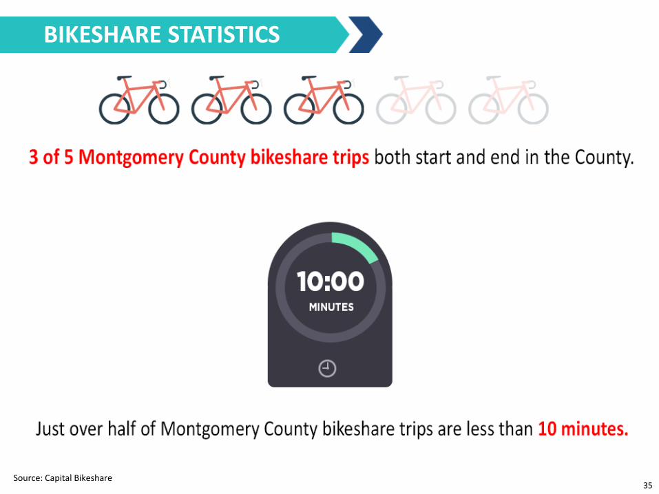
Interesting stats…
Source: Capital Bikeshare
BIKESHARE STATISTICS
35
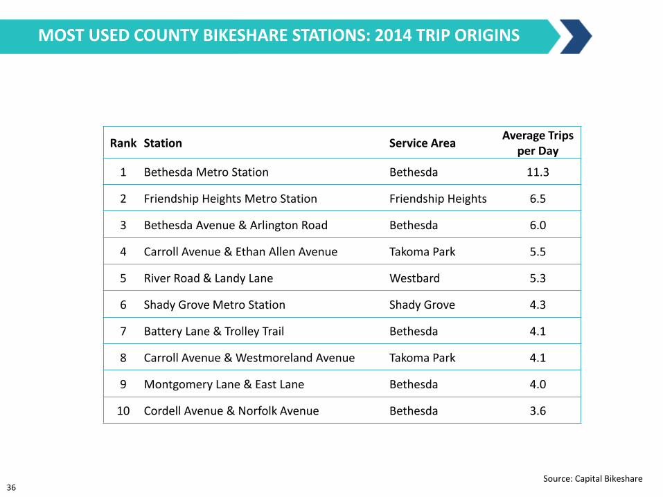
Rank Station Service Area Average Trips
per Day
1 Bethesda Metro Station Bethesda 11.3
2 Friendship Heights Metro Station Friendship Heights 6.5
3 Bethesda Avenue & Arlington Road Bethesda 6.0
4 Carroll Avenue & Ethan Allen Avenue Takoma Park 5.5
5 River Road & Landy Lane Westbard 5.3
6 Shady Grove Metro Station Shady Grove 4.3
7 Battery Lane & Trolley Trail Bethesda 4.1
8 Carroll Avenue & Westmoreland Avenue Takoma Park 4.1
9 Montgomery Lane & East Lane Bethesda 4.0
10 Cordell Avenue & Norfolk Avenue Bethesda 3.6
Source: Capital Bikeshare
MOST USED COUNTY BIKESHARE STATIONS: 2014 TRIP ORIGINS
36
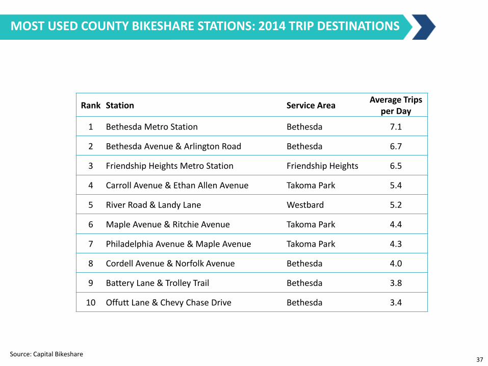
Most Heavily Used Stations MOST USED COUNTY BIKESHARE STATIONS: 2014 TRIP DESTINATIONS
Rank Station Service Area Average Trips
per Day
1 Bethesda Metro Station Bethesda 7.1
2 Bethesda Avenue & Arlington Road Bethesda 6.7
3 Friendship Heights Metro Station Friendship Heights 6.5
4 Carroll Avenue & Ethan Allen Avenue Takoma Park 5.4
5 River Road & Landy Lane Westbard 5.2
6 Maple Avenue & Ritchie Avenue Takoma Park 4.4
7 Philadelphia Avenue & Maple Avenue Takoma Park 4.3
8 Cordell Avenue & Norfolk Avenue Bethesda 4.0
9 Battery Lane & Trolley Trail Bethesda 3.8
10 Offutt Lane & Chevy Chase Drive Bethesda 3.4
Source: Capital Bikeshare 37
Source: Capital Bikeshare
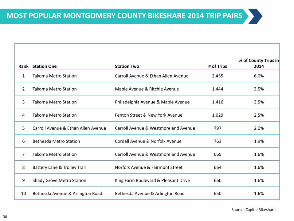
Rank Station One Station Two # of Trips % of County Trips in
2014
1 Takoma Metro Station Carroll Avenue & Ethan Allen Avenue 2,455 6.0%
2 Takoma Metro Station Maple Avenue & Ritchie Avenue 1,444 3.5%
3 Takoma Metro Station Philadelphia Avenue & Maple Avenue 1,416 3.5%
4 Takoma Metro Station Fenton Street & New York Avenue 1,029 2.5%
5 Carroll Avenue & Ethan Allen Avenue Carroll Avenue & Westmoreland Avenue 797 2.0%
6 Bethesda Metro Station Cordell Avenue & Norfolk Avenue 763 1.9%
7 Takoma Metro Station Carroll Avenue & Westmoreland Avenue 665 1.6%
8 Battery Lane & Trolley Trail Norfolk Avenue & Fairmont Street 664 1.6%
9 Shady Grove Metro Station King Farm Boulevard & Pleasant Drive 660 1.6%
10 Bethesda Avenue & Arlington Road Bethesda Avenue & Arlington Road 650 1.6%
MOST POPULAR MONTGOMERY COUNTY BIKESHARE 2014 TRIP PAIRS
38
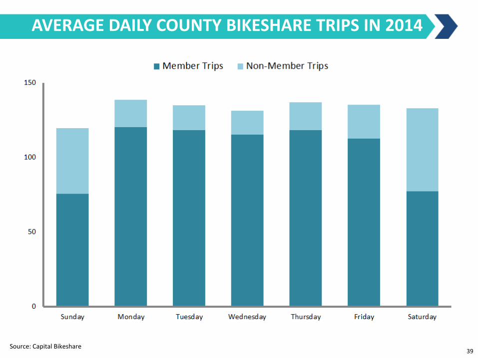
AVERAGE DAILY COUNTY BIKESHARE TRIPS IN 2014
Source: Capital Bikeshare 39

MONTHLY COUNTY BIKESHARE TRIPS IN 2014
Source: Capital Bikeshare
40
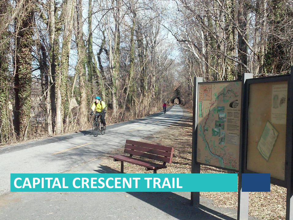
CAPITAL CRESCENT TRAIL

COUNT LOCATIONS
Bethesda Ave Opened 11/13/2014
200 yards south of
Bethesda Avenue
MacArthur Blvd Opened 2/11/2015
100 yards south of
Dalecarlia Tunnel
42

Bicyclists by Month TOTAL CCT USERS PER MONTH
MacArthur Blvd counter began operating on Feb 11, 2015
* *
*
January February March April May June
Bethesda Ave
MacArthur Blvd
43
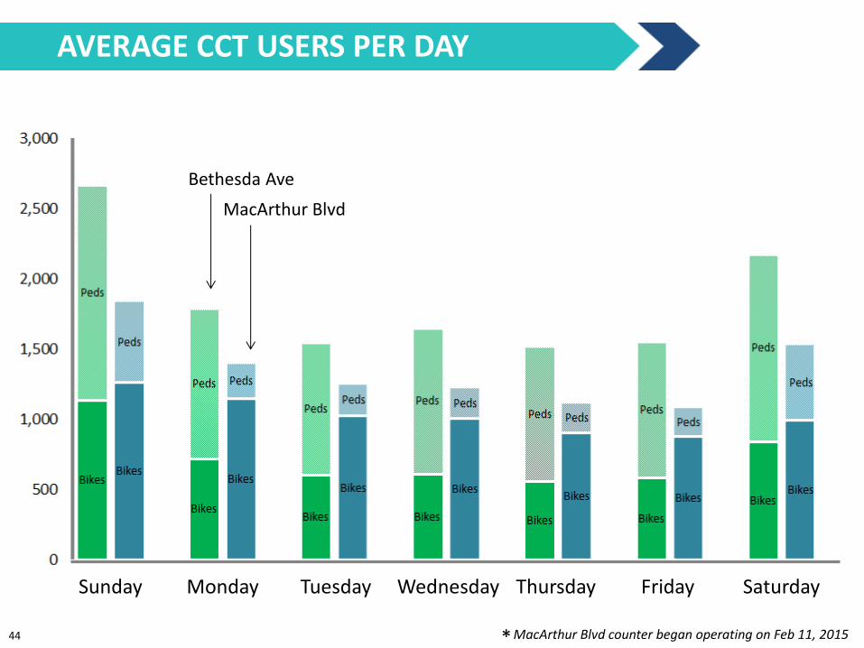
Bicyclists by Day of Week AVERAGE CCT USERS PER DAY
Bethesda Ave
MacArthur Blvd
Sunday Monday Tuesday Wednesday Thursday Friday Saturday
MacArthur Blvd counter began operating on Feb 11, 2015 * 44
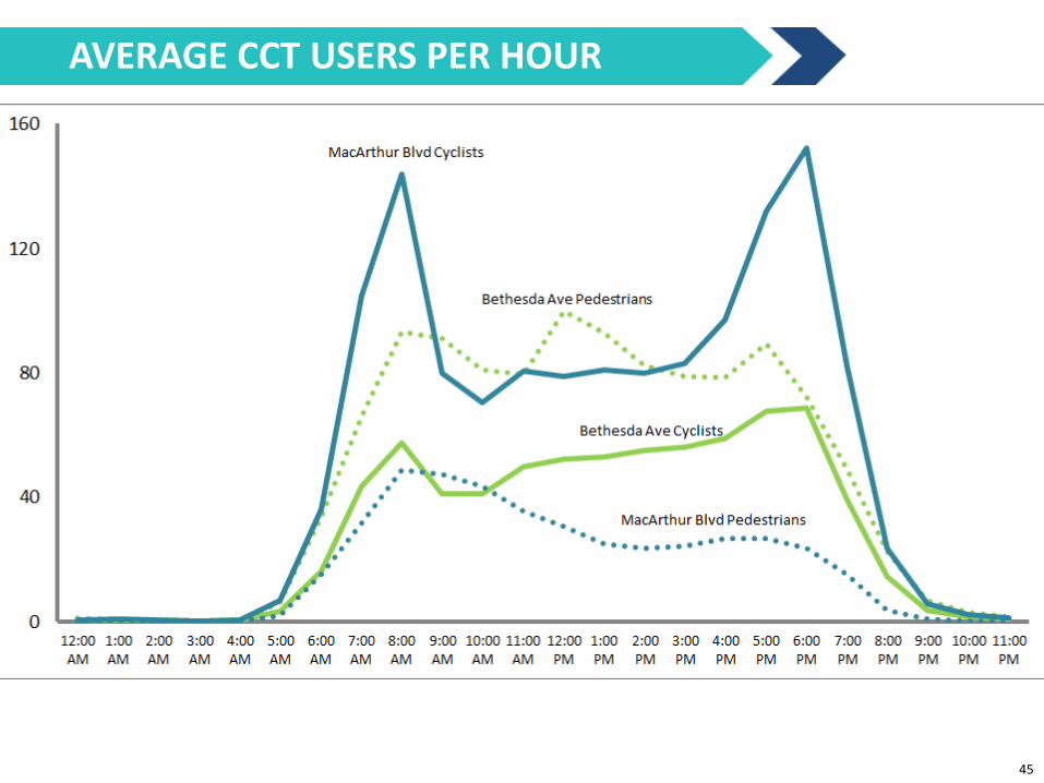
Bicyclists by Time of Day AVERAGE CCT USERS PER HOUR
45
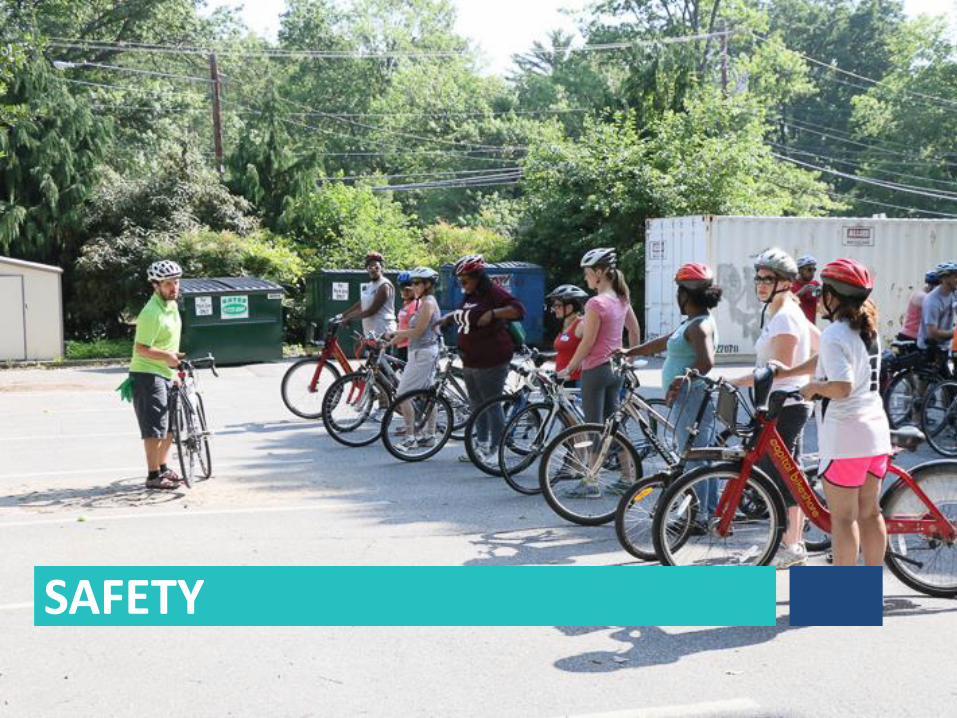
SAFETY
Bicyclists by Time of Day
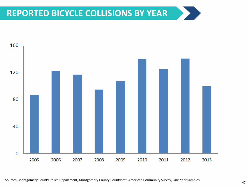
Sources: Montgomery County Police Department, Montgomery County CountyStat, American Community Survey, One-Year Samples
REPORTED BICYCLE COLLISIONS BY YEAR
47
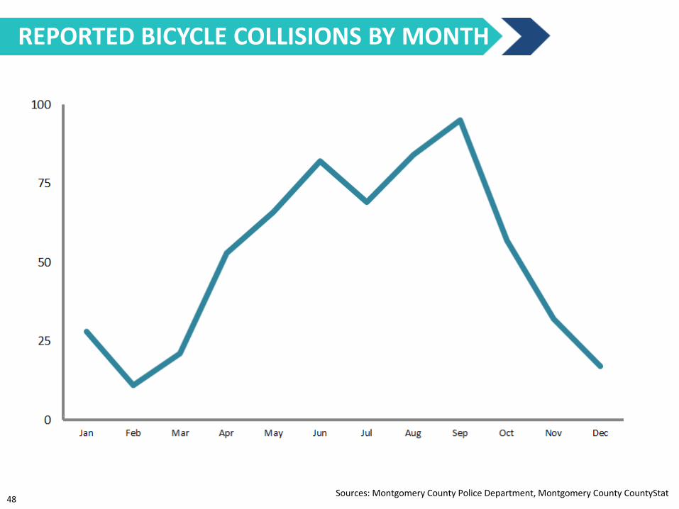
Bicyclists by Time of Day REPORTED BICYCLE COLLISIONS BY MONTH
Sources: Montgomery County Police Department, Montgomery County CountyStat 48

Bicyclists by Time of Day BICYCLE COLLISIONS BY TIME OF DAY
Sources: Montgomery County Police Department, Montgomery County CountyStat, 2009-2013 49
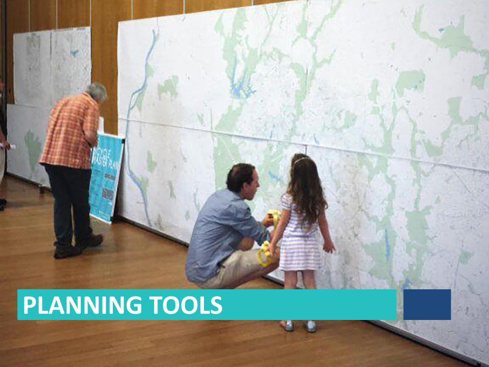
PLANNING TOOLS
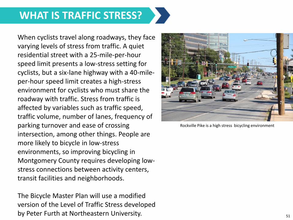
When cyclists travel along roadways, they face varying levels of stress from traffic. A quiet residential street with a 25-mile-per-hour speed limit presents a low-stress setting for cyclists, but a six-lane highway with a 40-mile-per-hour speed limit creates a high-stress environment for cyclists who must share the roadway with traffic. Stress from traffic is affected by variables such as traffic speed, traffic volume, number of lanes, frequency of parking turnover and ease of crossing intersection, among other things. People are more likely to bicycle in low-stress environments, so improving bicycling in Montgomery County requires developing low-stress connections between activity centers, transit facilities and neighborhoods. The Bicycle Master Plan will use a modified version of the Level of Traffic Stress developed by Peter Furth at Northeastern University.
Rockville Pike is a high stress bicycling environment
WHAT IS TRAFFIC STRESS?
51
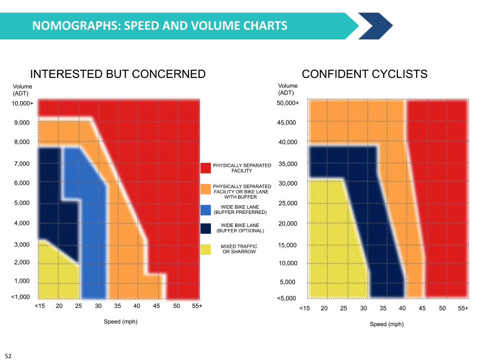
NOMOGRAPHS: SPEED AND VOLUME CHARTS
52
53
CONNECT WITH THE BICYCLE MASTER PLAN
Montgomeryplanning.org/bikeplan Website
@MCBikePlan Twitter