Embed Size (px)
Citation preview

TECHNICAL PUBLICATION 80-7
September 1980
PLANT COMMUNITIES OF THE KISSIMMEE RIVER VALLEY
This public document was promulgated at an annual cost of $291.76 or $.58 per copy to document the existing condition of vegetation patterns in the Kissimmee River Valley. RPD 219 R586 150
Resource Planning Department South Florida Water Management District
West Palm Beach, Florida 33402
James F. Milleson Robert L. Goodrick Joel A. Van Arman
I

TABLE OF CONTENTS
List of Tables
List of Figures
Acknowledgement
Introduction
Materials and Methods
Results and Discussion
Descriptions
Summary
Plates 1-21
References
LIST OF TABLES
Table 1. Plant Communities of the Kissimmee River Floodplain and Tributaries, 1978 Summary Totals by Pool
LIST OF FIGURES
Figure 1. Location of Kissimmee River, Structures and Major Tributaries.
Figure 2. Conceptual Cross-section (North to South) Through a Kissimnee River Impoundment (Pool) Illustrating General Relationship Among Some of the Plant Communities.
Figure 3. Conceptual Cross-section (West to East) Through the Kissimnee River Floodplain Illustrating General Relationship Among Some of the Plant Communities
ACKNOWLEDGEMENTS
J. Walter Dineen, Director, Environmental Sciences Division, initiated
a series of research programs in 1970 to investigate Kissimnee River flood-
plain ecology and the effects of channelization. This mapping effort is
an outgrowth of those projects and reflects much of the insight gained
from those field experiences.
Gene Vaughn, Highlands County Tax Appraiser's Office, provided the
majority of the aerial photography which was used as the basis of the
vegetation mapping. The Land Resources Division staff undertook the tedious
and demanding task of transferring the vegetation maps into a computerized
storage and output system.
Funding of the printing costs for the accompanying map series "Plant
Communities of the Kissimmee River Floodplain - 1978" (Pools A-E) was
provided by the Coordinating Council on the Restoration of the Kissimmee
River Valley and Taylor Creek - Nubbin Slough Basin.

INTRODUCTION
Historically, the Kissinmee River meandered through an approximately
mile-wide floodplain between Lake Kissimmee and Lake Okeechobee in south-
central Florida. The distance along the floodplain between these two
lakes is about 56 miles, but the length of the main river channel was
estimated to be more than 90 miles. The vegetation of the Kissimmee River
floodplain prior to channelization was described by the United States Fish
and Wildlife Service (1958), "In the lower basin, the Kissimmee River
occupies a flood channel that is about one mile wide, and is characteris
tically a buttonbush shrub swamp. The succession of common plants, from
the wetter to dryer sites are: pickerelweed, arrowhead, maidencane, water
purslane, buttonbush, Bermuda grass, buttonweed, rushes, torpedo grass,
carpet grass and cordgrass."
Flood protection of the agricultural and urban areas of the Kissimmee
basin was part of the comprehensive Central and Southern Florida Flood
Control Project presented to Congress in 1948 (House Document No. 643,
80th Congress, 2nd Session) and was authorized by the Flood Control Act
(Public Law 858) in 1948. Included in this project was a plan to chan
nelize the Kissimmee River from Lake Kissimmee southward to Lake
Okeechobee. The primary purpose of this canal, C-38, was to transport
floodwaters and reduce flood damage in the Upper Kissimmee Basin.
The original proposal for the design of C-38 was for a canal to be
constructed along the general route of the Kissimnee River channel with
continuous spoil banks placed along both sides of the canal, and secondary
drainage structures to regulate local inflow (U.S. Army, 1956). Based
upon recommendations provided primarily by the Florida Game and FreshWater
Fish Commission (GFC) and the United States Fish and Wildlife Service,
the Corps of Engineers modified the original design proposal to one which
provided for the present alignment of C-38, the placement of spoil on
alternate sides of the canal, and the preservation of some continuous
oxbows (U.S. Army, 1958), Construction of C-38 and control structures
required six years and was completed in 1971.
Six water control structures (S-65 series) in C-38 lowered the water
levels between the canal segments in 6 or 7 foot increments, and created
a series of impoundments, or pools, upstream of each water control
structure (i.e., Pool A lies upstream of S-65A, Pool B is downstream of
S-65A and upstream of S-65B, etc.). A tieback levee was built from each
structure across the floodplain to higher ground to prevent water from
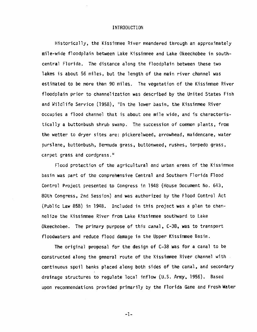
flowing around the structure. Figure 1 shows the location of the
Kissimmee River and C-38 in south-central Florida, the water control
structures and the major tributaries.
Water levels were stabilized in the canal behind each water control
structure. Consequently, the southern (downstream) portion of each pool
was permanently inundated with as much as 3 feet of water, and the northern
portion of each pool remained dry. The constant inundation and lack of
water level fluctuation in the lower portions of each pool selected for
only a limited number of marsh plant species that were adapted to these
conditions. Other species that were intolerant of the flooded conditions
were eliminated or outcompeted by tolerant species (Goodrick and Milleson,
1974). In the northern portion of each pool where the floodplain was
drained, wetland vegetation was replaced by terrestrial species. Much
of this dry area has been utilized for improved or unimproved pastures.
-2-
-3-
C-38 has had a pronounced effect on the ecology of the Kissimmee
River floodplain. The aquatic habitat once available for small fishes,
crustaceans and aquatic insects has been reduced. Because water levels
are stabilized there is little or no seasonal concentration of forage
organisms in the dry season for larger fish and wading birds (Dineen,
et al., 1974).
Preliminary studies of the effects of C-38 on the Kissimmee River
floodplain marshes were begun by the South Florida Water Management District
(SFWMD) in 1970. The responses of marsh flora and fauna to water level
fluctuations, fire, herbicide treatment and other management techniques
were investigated (Goodrick and Milleson, 1974; Milleson, 1976; VanArman
and Goodrick, 1979). Other field investigations by the SFWMD in the
Kissimmee River valley have included measurements of the nutrient assim
ilation capability of freshwater marshes (Federico, et al., 1978).
Several additional investigations have been conducted since the
excavation of C-38. Heaney and Huber (1975) conducted extensive resource
management studies. Results obtained by the Special Project to Prevent
Eutrophication of Lake Okeechobee (Florida Department of Administration,
1976) led, in part, to the creation of the Coordinating Council on the
Restoration of the Kissimmee River Valley and Taylor Creek - Nubbin
Slough Basin. The major purpose of this committee is to explore the
means, methods, costs and benefits of the various alternatives to restore
some or all of the Kissimmee River and adjacent marshes. As part of the
Special Project, generalized land cover maps were prepared (Florida
Department of Administration, 1976; Pruitt and Gatewood, 1976).
The primary purpose of the current study was to prepare a compre
hensive and detailed map of the plant communities of the Kissimmee River
-4-
floodplain. This report and accompanying maps describe the floodplain
vegetation after completion of C-38, and provides a baseline so that
the effects of future alternative management plans can be meaningfully
evaluated.
MATERIALS AND METHODS
The floodplain boundaries for mapping purposes were considered to
be the more or less continuous tree lines of oaks or cabbage palms which
parallel the river. Tributary sloughs, swamps and marshes were mapped
to the first distinct upland feature, usually a road crossing. The
north and south limits of the study area were S-65 at SR 60 and S-65E
with its tieback levees, respectively (Figure 1).
Aerial photographs of the Kissimnee River valley were used as
base maps. Two sets of photographs were required to completely cover
the floodplain; U.S. Department of Agriculture ASCS photographs taken
in 1974 (1:4800) and Mark Hurd photographs taken in 1973 (1 :24,000).
Plant communities that were discernible on the photographs were
delineated, and then checked in the field during 1978. Changes in
vegetation which occurred since the photography were also incorporated
in the mapping procedures. Ground truthing was accomplished by low
altitude aerial inspection from a helicopter, and supplemented by
numerous observations of selected areas by personnel using airboats,
outboard motor boats, and on foot.
Descriptions of the plant communities were based on the predominant
and common plant species observed which influenced the general community
form. Some grouping of similar vegetation communities was necessary.
-5-
The original vegetation maps were entered into a Computervision
Automated Mapping System (Computervision Corp., Bedford, Mass.) by
means of a large, highly accurate, table digitizer. The resulting data
base was used to calculate the area of each vegetation community and
to plot the vegetation maps.
RESULTS AND DISCUSSION
Twenty-five plant communities or land use categories were described,
mapped and measured within the Kissimmee River floodplain. These commun
ities include those which have been affected by the construction of C-38
and subsequent water impoundment and stabilization, and those located in
upland and tributary areas which still respond to seasonal fluctuating
hydroperiods.
The species composition of a plant community depends on a variety
of environmental factors such as ground elevation, water depth, type of
soil, amount of cattle grazing, and season of the year. For example, a
wet prairie species like beakrush, Rhynchospora inundata, is a rather
nondescript plant during most of the year; however, during the summer
R. inundata puts out a distinctive inflorescence and becomes the apparent
characteristic species in that particular wet prairie. Several other
conspicuous species which are seasonally abundant in several of the
other plant communities include bladderpods, Sesbania exaltata and Glot-
tidium vesicaria, dogfennel, Eupatorium sp. and marsh hibiscus, Hibiscus
grandiflorus.
The twenty-five communities are classified into five major categories
Agricultural and Urban, Terrestrial Forested, Wetland Forested, Marsh,
and Spoil and Barren. Table 1 provides a summary of the area occupied
by each plant community.
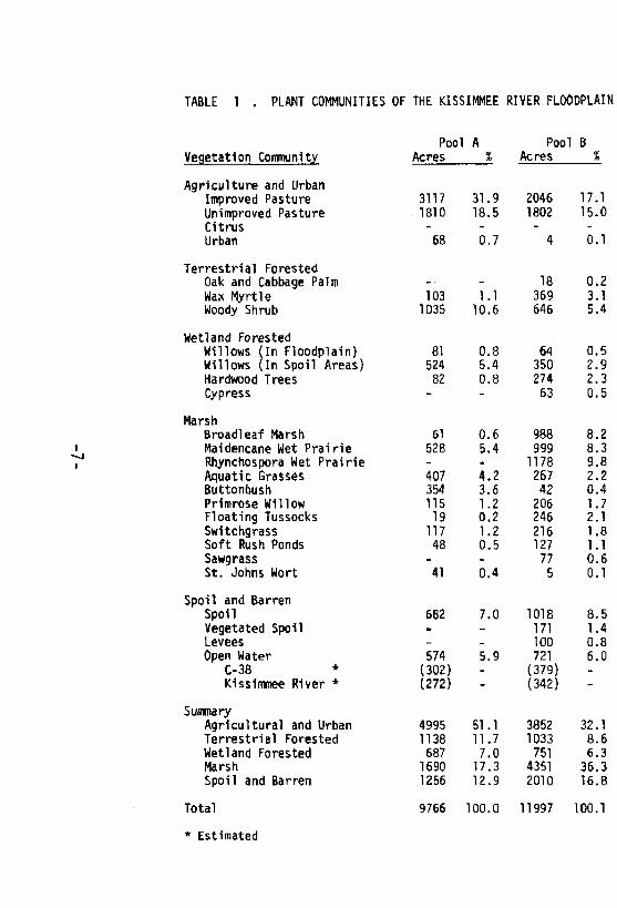
TABLE 1 . PLANT COWIUNITIES OF THE KISSIMMEE RIVER FLOODPLAIN
Vegetation CommunityPool
AcresA
%Pool
AcresB
%
Agriculture and UrbanImproved Pasture 3117 31.9 2046 17.1Unimproved Pasture 1810 18.5 1802 15.0Citrus - - - -
Urban 68 0.7 4 0.1
Terrestrial ForestedOak and Cabbage Palm - ■ - 18 0.2Wax Myrtle 103 1.1 369 3.1Woody Shrub 1035 10.6 646 5.4
Wetland ForestedWillows (In Floodplain) 81 0.8 64 0.5Willows (In Spoil Areas) 524 5.4 350 2.9Hardwood Trees 82 0.8 274 2.3Cypress - - 63 0.5
MarshBroadleaf Marsh 61 0.6 988 8.2Maidencane Wet Prairie 528 5.4 999 8.3Rhynchospora Wet Prairie - - 1178 9.8Aquatic Grasses 407 4.2 267 2.2Buttonbush 354 3.6 42 0.4Primrose Willow 115 1.2 206 1.7Floating Tussocks 19 0.2 246 2.1Switchgrass 117 1.2 216 1.8Soft Rush Ponds 48 0.5 127 1.1Sawgrass - - 77 0.6St. Johns Wort 41 0.4 5 0.1
Spoil and BarrenSpoil 662 7.0 1018 8.5Vegetated Spoil - - 171 1.4Levees - - 100 0.8Open Water 574 5.9 721 6.0
C-38 * (302) - (379) -
Kissimmee River * (272) - (342) -
SummaryAgricultural and Urban 4995 51.1 3852 32.1Terrestrial Forested 1138 11.7 1033 8.6Wetland Forested 687 7.0 751 6.3Marsh 1690 17.3 4351 36.3Spoil and Barren 1256 12.9 2010 16.8
Total 9766 100.0 11997 100.1
* Estimated
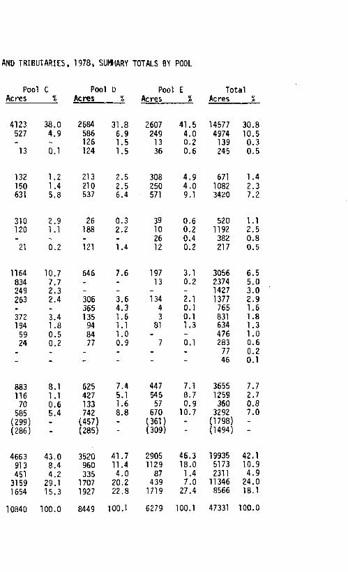
W D TRIBUTARIES, 1978, SUW1ARY TOTALS BY POOL
Pool t: Pool D Pool E TotalAcres % Acres 3£ Acres % Acres %
4123 38.0 2584 31,8 2607 41.5 14577 30.8527 4.9 586 6.9 249 4.0 4974 10.5- - 126 1,5 13 0.2 139 0.313 0.1 124 1.5 36 0.6 245 0.5
132 1,2 213 2.5 308 4,9 671 1.4150 1.4 210 2.5 250 4.0 1082 2.3631 5,8 537 6.4 571 9.1 3420 7.2
310 2.9 26 0.3 39 0,6 520 1.1120 1.1 188 2.2 10 0.2 1192 2.5- - - - 26 0.4 382 0.821 0.2 121 1.4 12 0.2 217 0.5
1164 10.7 646 7.6 197 3.1 3056 6.5834 7.7 - - 13 0.2 2374 5.0249 2.3 - - - - 1427 3.0263 2.4 306 3.6 134 2.1 1377 2.9. - 365 4.3 4 0.1 765 1.6372 3.4 135 1.6 3 0.1 831 1.8194 1.8 94 1.1 81 1.3 634 1.359 0.5 84 1.0 - - 476 1.024 0.2 77 0.9 7 0,1 283 0.6
_ _ - - - 77 0.2. . - - - 46 0.1
883 8.1 625 7.4 447 7.1 3655 7.7116 1.1 427 5,1 545 8.7 1259 2.770 0.6 133 1.6 57 0.9 360 0.8
585 5.4 742 8.8 670 10.7 3292 7.0(299) (457) - (361) - (1798) -
(286) - (285) - (309) - (1494) -
4663 43.0 3520 41.7 2905 46.3 19935 42,1913 8,4 960 11.4 1129 18.0 5173 10.9451 4.2 335 4.0 87 1.4 2311 4.9
3159 29.1 1707 20.2 439 7.0 11346 24.01654 15.3 1927 22.8 1719 27.4 8566 18.1
Nearly one half (42.1%) of the total area was included in the
Agriculture and Urban category. Urban development within the Kissimmee
River floodplain was minimal, and pastures constituted the majority of
this area. Improved pasture was the largest single designated plant
community, comprising 14,577 acres (22.8 mi^) or 30.8% of the total
47,331 acres of floodplain and tributaries that were mapped.
Terrestrial Forested vegetation communities accounted for 10.9%
of the total area measured. Acreages of these communities were similar
in the five pools and ranged from 913 acres (Pool C) to 1138 acres
(Pool A). However, the 1129 acres of terrestrial forested vegetation
in Pool E comprised 18.0% of that areas' total, compared with 8.4% to
11.7% in the other pools.
The Wetland Forested plant communities comprised the smallest
portion of the floodplain. Cypress and swamp hardwoods each accounted
for less than one percent of the total area, whereas willows comprised
3.6% of the total. About two-thirds of the willow community was located
within the spoil retention areas alongside C-38.
Eleven communities of Marsh vegetation were described, which
collectively included 11,346 acres, or 24.0% of the total area. Broad-
leaf marshes were the most abundant community (3056 acres; 6.5%) in
this category. The wet prairie communities, characterized by maidencane
(Panicum hemitomon), beakrush (Rhynchospora inundata), or aquatic grasses,
especially torpedo grass (Panicum repens), collectively totalled 5178
acres (10.9%). Pools B and C contained the greatest amounts and largest
percentages of Marsh plant communities in the Kissimmee River valley.
Spoil and Barren communities included the spoil deposited from
the construction of C-38, levees and roadways, and open water. A
total of 5274 acres (8.2 mi^) was occupied by spoil and levees. Open
water within the floodplain totalled 3292 acres, of which an estimated
1798 acres (2.8 mi2) or 54.6% was C-38.
Pool B was the only impoundment with less than one half of its
area devoted to agricultural, urban, or spoil detention land uses.
Nearly 43% of Pool B is still designated as wetland plant comrtunities.
In contrast, 63.0% of the area measured in Pool E is devoted to agri
culture, urban, or spoil, while only 8.4% remains wetlands.
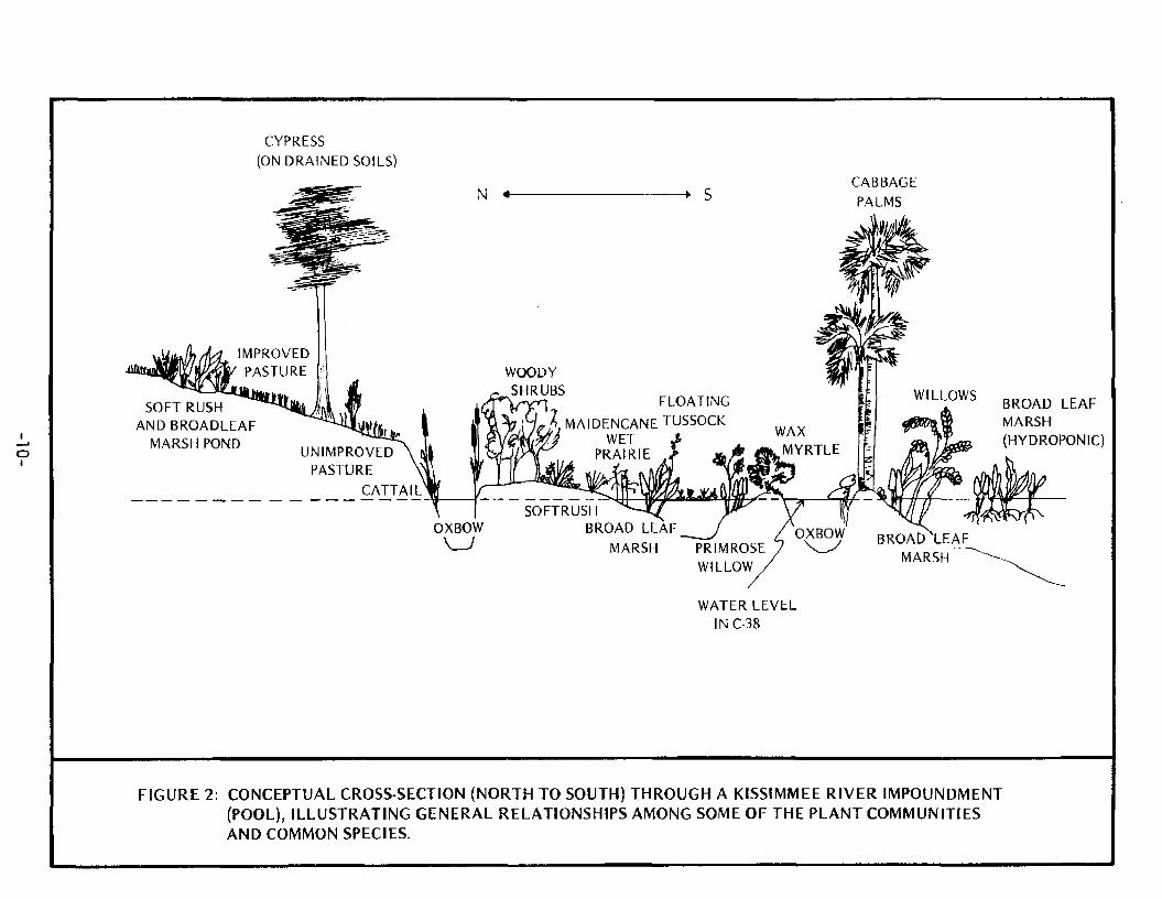
Figure 2 depicts a diagrammatic cross section from north to south
through a Kissimmee River impoundment. Note that while the ground
contours generally slope downward from north to south, impoundment of
the water by the S-65 structures maintains a flat water level. Conse
quently, the southern portion of each pool is permanently flooded and
the northern portion has been permanently drained.
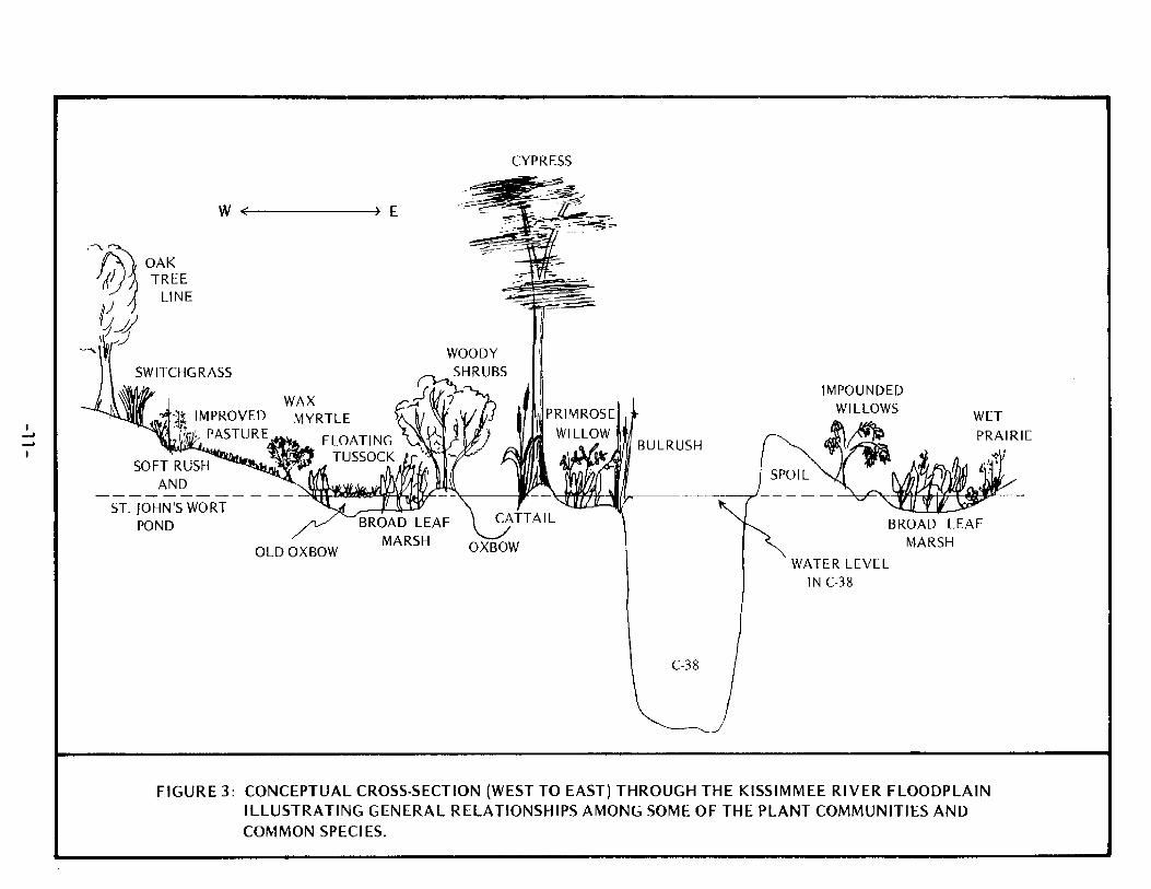
Figure 3 is a conceptual illustration of the Kissimmee River flood-
plain and C-38 from west to east in the southern half of an impoundment.
Neither of these figures is drawn to scale, and only a few of the indi
cator species from each plant community are depicted.
A description of each of the communities of the floodplain is
provided below.
AGRICULTURAL AND URBAN
Improved Pasture (Plate 1)
Improved pastures in the Kissimnee River valley are generally
located at elevations from about one foot above the stabilized water
level of C-38 to the edge of the floodplain. Improved pastures are
-9-
CYPRESS(ON DRAINED SOILS)
01
SOFT RUSH AND BROADLEAF
MARSH POND
-+ SCABBAGEPALMS
OXBOWW
SOFTRUSHBROAD
WOODYSHRUBS
FLOATING /?. MAIDENCANE TUSSOCK
WET PRAIRIE
BROAD LEAF MARSH(HYDROPONIC)
LEAF MARSH
WATER LEVEL INC-38
FIGURE 2: CONCEPTUAL CROSS-SECTION (NORTH TO SOUTH) THROUGH A KISSIMMEE RIVER IMPOUNDMENT (POOL), ILLUSTRATING GENERAL RELATIONSHIPS AMONG SOME OF THE PLANT COMMUNITIES AND COMMON SPECIES.
CYPRESS
SOFT RUSH _______AND______
ST. JOHN'S WORT POND
IMPOUNDEDWILLOWS
BULRUSH
WETPRAIRIE
OLD OXBOW
CATTAIL
OXBOW
BROAD LEAF MARSH
WATER LEVEL IN C-38
FIGURE 3: CONCEPTUAL CROSS-SECTION (WEST TO EAST) THROUGH THE KISSIMMEE RIVER FLOODPLAIN ILLUSTRATING GENERAL RELATIONSHIPS AMONG SOME OF THE PLANT COMMUNITIES AND COMMON SPECIES.
lands which have been altered to increase the growth of grasses and forbs
for the purpose of feeding livestock. Some of the methods employed to
create improved pastures include mechanical clearing of native vegetation,
periodic burning or mowing of native vegetation, planting of specialized
grasses for feed, supplemental additions of fertilizers and herbicides,
and implementation of irrigation and/or drainage practices.
Probably the most abundant plant found in improved pastures is
Bahia grass (Paspalum notatum). Other common plants include Panicum
repens, soft rush (Juncus effusus), and bladderpod (Glottidium vesicaria).
Unimproved Pasture (Plate 2)
Unimproved pasture is a terrestrial habitat typified by a ground
cover of grasses, sedges and small herbs, with low shrubs, and which is
subjected to grazing by range cattle. The creation of unimproved pasture
or rangeland within the Kissimmee River floodplain is a direct consequence
of water level stabilization by the S-65 structures. Unimproved pastures
are generally located in the central and northern portion of each impoundment
where the floodplain has been permanently drained.
Towards the middle of each pool, and near C-38 and river oxbows where
ground water levels are fairly close to the surface, vegetation in unim
proved pastures consists of a ground cover of water tolerant species such
as false pimpernel (Lindernia anaqallidea), coinwort (Centella asiatica),
Panicum repens, aromatic figwort (Bacopa caroliniana), Juncus effusus,
pennywort (Hydrocotyle umbel!ata) and numerous sedges. These plants are
associated with terrestrial species like Sesbania exaltata, Glottidium
vesicaria, some terrestrial grasses, scattered wax myrtles (M.yrica
cerifera), broomsedges (Andropogan spp.) and switchgrass (Spartina
bakerii). At higher elevations, native rangeland becomes dominated by
-12-
saw palmetto (Serenoa repens) and terrestrial grasses.
Range cattle are not restricted to unimproved pastures and graze
in most of the other plant communities in the valley.
Urban (Plate 3)
Urban development in the Kissimmee River valley is limited and
consists primarily of commercial fishing camps and resorts. There are
also two small residential areas, one with an airstrip, located in
Pool D. Locktender residences are also classified urban.
Citrus (Plate 4)
The only croplands encountered within the Kissimmee River valley
floodplain were 139 acres of citrus groves in Pools D and E.
TERRESTRIAL FORESTED VEGETATION
Woody Shrub (Plate 5)
Assorted comnunities of woody shrubs are located on elevated ridges
along Kissimmee River oxbows, low lying edges of spoil banks, and drained
areas in the north and central portions of each pool. These communities
are dominated by saltbush (Baccharis halimifolia) and elderberry (Sambucus
simpsonii), although other species that are occasionally present include
wax rriyrtle, guava (Psidium guajava), dahoon holly (Ilex cassine), willow
(Salix caroliniana), and brazilian pepper (Schinus terebinthifolius).
Saltbush* elderberry and wax myrtle are most common in the northern
portion of the valley, but the exotic brazilian pepper is the predominant
species in many portions of the lower valley, particularly Pools D and E.
Understory vegetation in this zone includes dogfennel (Eupatorium sp.)
and terrestrial grasses and sedges. Some vines, such as muscadine grape
-13-
(Vitis rotundifolia), greenbrier (Smi1 ax sp.), and morning glory (Ipomea
S£.), are occasionally present and ferns are often abundant.
The woody shrub community generally occurs on drained soils, although
it is sometimes found in transition zones and may contain some aquatic
species such as Panicum repens, F\ hemitomon, water primrose (Ludwigia
peruviana), and arrowhead (Sagittaria lancifolia).
Wax Myrtle (Plate 6)
Wax myrtle (Nlyrica cerifera) is a shrubby tree that occasionally
grows to heights of 20 feet or more in the Kissimmee River valley.
Myrtles often occur in areas that had previously been flooded for part
of the year but are now drained.
The largest concentrations of wax myrtle communities occur about
midway in each pool, along the upper edges of the floodplain, or along
river banks and spoil piles.
Wax myrtle communities usually take either of two forms. Along
riverbanks and in well-drained sites, wax myrtle and other associated
shrubs are quite dense and grow to heights of 10-20 feet. These plants
are frequently associated with Vitis rotundifol ia, Ipomea sp., Smilax sp.,
and white vine (Sarcostemma clausa), and have a limited understory due
to the dense canopy. In the other form, stands of young wax myrtle plants
or stunted individuals often cover several acres. Individual plants
seldom exceed 3-4 feet in height, and form a less complete canopy. The
associated plant species are more diverse and include Centella asiatica,
Hydrocotyle umbel lata, P_. repens, frogbit (Lippia nodiflora), alligator
weed (Alternanthera philoxeroides), Eclipta alba, meadow beauty (Rhexia
sp.), Paspalum notatum, Sesbania exaltata, Juncus effusus, and Eupatorium
-14-
sp.. On occasion some of these areas may be covered with a few inches of
standing water.
Wax myrtle prefers dry sites with adequate soil moisture. Established
plants can tolerate seasonal flooding to some degree, and in some cases
they have even been observed growing on floating tussocks of Scirpus
cubensis.
Oaks and Cabbage Palm (Plate 7)
The boundaries of the Kissimmee River floodplain are defined as
the tree line containing water oaks and live oaks (Quercus nigra and
Quercus virginiana). In a few locations the floodplain is delineated
by cabbage palms (Sabal palmetto) and saw palmetto. This tree line has
not been included as part of the vegetation communities of the area,
but is shown on the maps to define the floodplain.
Oaks and cabbage palms are found on elevated ridges and knolls
and on high river banks within the limits of the floodplain.
When a distinct oak hammock is present, the nearly complete canopy
formed by the leaves, and the leaf litter on the ground, limits the
growth of other plant species. Understory vegetation usually consists
of cabbage palm, saw palmetto, wild blackberry (Rubus cuneifolius),
caeser weed (Urena lobata), and terrestrial grasses. Several species
of vines (Smilax sp., Momordica charantia, Vitis rotundifolia) and
ferns (Phlebodium aureum, Blechnum serrulatum) are common to theie areas.
WETLAND FORESTED VEGETATION
Willows (Plate 8)
Salix carol ini ana, southern coastal plain willow, is the dominant
-15-
plant in this community and grows to heights in excess of 20 feet.
Willows are found scattered throughout broadleaf marsh areas and
may form willow heads of several acres in size. Two of the largest
concentrations of willows occur in the southwest portion of Pools C
and D. Understory vegetation includes most of the common broadleaf
marsh plants.
The willows encountered in the inundated portions of each pool
have been flooded for several years. These trees are stunted and have
spindly trunks and few leaves. It was observed that experimental water
level drawdowns in Pool C stimulated growth of the willows and increased
their size and foliage.
Large willow heads may be used as rookeries for a variety of birds
including cattle egret, snowy egret, American egret, great blue heron,
Louisiana heron, little blue heron, anhinga, and cormorant. Rookeries
in large willow heads were observed in the south end of Pool C in 1975
and 1978.
A considerable portion (1192 acres) of the willow community encoun
tered in the Kissimmee River valley is located along the back portion of
the spoil piles lining C-38. During the construction of C-38, spoil
areas were designated and a small borrow canal and levee were built
around the perimeter of these designated areas to contain the fill. In
many areas the spoil did not completely fill these enclosures, leaving
an impounded area near ground level. These impoundments have apparently
provided environmental conditions favorable for the growth of Salix
caroliniana. Impounded willow communities are found in all of the pools
but are most abundant in the north end of the valley. In one such
-16-
impounded corrmunity, the density of willows was estimated at about
2000/acre. These plants range up to 20 feet in height and have a trunk
diameter of 2 to 4 inches. Associated understory vegetation included
ragweed (Ambrosia artemisiifolia), Urena lobata, buttonbush (Cephalanthus
occidental is)« and ferns.
Cypress Community (Plate 9)
Bald cypress (Taxodium distichum) is the dominant plant in this
zone. The most dense cypress stands occur in sloughs or strands which
flow from the uplands into C-38. The density of cypress in one strand
was estimated at 850/acre. Other cypress areas within the river flood-
plain are limited to a few strands alongside the original river channels
in the southern portion of the valley.
Most of these cypress trees were established under natural fluc
tuating water levels that existed prior to the construction of C-38,
and their distribution in the floodplain is not indicative of present
water conditions. These cypress may be found in 1 to 2 feet of water,
or may be growing on exposed river banks or on drained, improved pastures.
The cypress community in upland sloughs and tributaries exists in a
regime of naturally fluctuating water levels.
The understory vegetation in dense cypress zones is usually sparse,
and includes Sagittaria spp., smartweed (Polygonum sp.), and prairie
ir-*s (I^s hexagona). Occasionally, water hyacinths (Eichhornia crassipes)
become very dense and trapped among the cypress trunks and knees.
Several species of epiphytes grow on the cypress, including Tillandsia
spp. and Encyclia tampensis. Other trees that often occur in dense
cypress strands are pop ash (Fraxinus caroliniana) and buttonbush.
-17-
Several species of swamp hardwood trees are found in the Kissinmee
River valley. The most common of these trees are red maple (Acer rubrum),
pop ash, tupelo (Nyssa sylvatica), persimmon (Diospyros virqiniana) and
dahoon holly. Groups of these hardwood trees that are large enough to
be classified are usually located along elevated river banks, or in
elongated strands in sloughs. The largest of these hardwood strands is
in Pine Island Slough in the north end of Pool B. Other significant
areas of hardwood trees occur in Pools A and E, although scattered, in
dividual trees are present in all of the pools.
Under natural water conditions, most of these trees experience
periodic flooding and drying. Once established, the trees will survive
without being flooded if they have ample soil moisture. Several areas
that are dominated by red maples occur in Pool E where ground elevations
are about 3 feet above the stabilized water levels. Associated under
story vegetation includes Urena lobata, Eupatorium sp., Sabal palmetto,
pokeweed (Phytolacca americana), Rhexia sp., Vitis rotundifolia and
Florida trema (Trema micrantha). In the upland sloughs and tributaries
associated plants include many of the marsh and aquatic grass species.
AQUATIC VEGETATION
Broadleaf Marsh (Plate 11)
The largest wetland plant community in the Kissimnee River valley
is the broadleaf marsh. This community is dominated by pickerel weed
(Pontederia lanceolata) and arrowhead (Sagittaria lancifolia), and is
comprised of several wetland plant associations. Species commonly
Hardwood Trees (Plate 10)
-18-
associated with pickerelweed and arrowhead include buttonbush, maidencane,
torpedo grass, smartweed, Ludwigia leptocarpa, Hydrocotyle umbel lata,
Sagittaria latifolia, arrowroot (Thaiia geniculata), and swamp hibiscus
(Hibiscus grandiflorus). Spatterdock (Nuphar luteum), bulrush (Scirpus
spp.), and cattail (Typha latifolia) often form large stands along the
river's edge or in lagoon areas and are grouped in this category.
Most broadleaf marshes are found in the southern portion of each
impoundment where water depths are between 1 and 3 feet. Prolonged
inundation in some areas has led to a condition where this plant com
munity is growing hydroponically, with the roots of the plant suspended
above the substrate.
As water depths become more shallow, species composition in the
broadleaf marsh zone shifts towards a greater percentage of grasses
and sedges and fewer broadleaf plants.
Small depressions in upland pasture areas frequently contain
broadleaf marsh plants. Because these depressions may be subjected
to seasonal inundation, they often provide feeding habitat for wading
birds when forage is concentrated.
Some pastures in the northern portions of Pools B, C and D contain
a distinctive pattern of meandering swales marking old river channels
and oxbows that have changed course. These swales receive local rain
fall and runoff. Most of the species in these old oxbows are typical
of broadleaf marsh communities and include pickerelweed, arrowhead,
torpedo grass, maidencane, water grass (Hydrochloa carol iniensis),
smartweed, and alligator-weed.
The lack of water level flucutations in the Kissimmee River pools
has caused ecological changes in the majority of this marsh community.
-19-
These changes include a shift in species composition, reduction of
annual plant growth, increase in undecayed plant litter, and a decrease
in available habitat for aquatic invertebrates and small fishes. Some
of these ecological changes can be minimized through the use of water
level management techniques (Goodrick and Milleson, 1974).
Maidencane Wet Prairie (Plate 12)
Large wet prairies that are dominated by maidencane (Panicum hemi-
tomon) are located in Pool C north of the Istokpoga Canal, in the Avon
Park Wildlife Management Area of Pool B, and in the southeast portion
of Pool A.
Field measurements have shown that maidencane comprises about
50-60% of the wet plant biomass in this community (VanArman and Goodrick,
1979). Associated plant species also include pickerelweed, arrowhead,
floating orchid (Habenaria repens), Hydrocotyle umbel lata, Polygonum
sp., and Rhynchospora inundata.
The water depth in the maidencane wet prairies ranges from about
6 to 18 inches and averages about one foot. Panicum hemitomon generally
grows from 1 to 3 feet in height.
The stabilization of water levels in C-38 has caused a considerable
buildup of maidencane detritus in these wet prairies. VanArman and
Goodrick (1979) found that a drawdown followed by burning was a useful
management technique which did not alter the plant species composition,
but increased secondary productivity of aquatic invertebrates.
Maidencane is a common constituent in the broadleaf marsh community,
but is generally found in the more shallow portions of that zone.
Maidencane is also a common component of the marsh areas of several
tributaries to C-38 such as Chandler Slough and Pine Island Slough.
-20-
Maidencane wet prairies were distinguished from the other aquatic
grass communities primarily due to the distinct nature and appearance
Panicum hemitomon. Aquatic grass communities are often located in
sloughs or marshes which drain into C-38, and are subjected to a seasonal
cycle of flooding and drying. The dominant species is torpedo grass,
with maidencane, broomsedges, cut grass (Leersia hexandra), and false
maidencane (Sacciolepis striata) sometimes present. Understory vege
tation is diverse and includes Hydrochioa caroliniensis, Aster sp., Bacopa
caroliniana, Centella asiatica, Cyperus haspan, white top sedge (Dichromena
colorata), Hydrocotyle umbel 1ata, and Lindernia anaqal1 idea. Scattered
patches of broadleaf marsh vegetation or wax myrtles often occur.
In the southern portions of some of the pools, aquatic grass
communities are comprised primarily of Panicum repens or Panicum paludi-
vagum. Many of the depressions in upland pastures are also dominated by
these aquatic grasses.
Rhynchospora (Beakrush) Wet Prairie
Rhynchospora inundata is a sedge that grows to about 3 feet in
height, with a distinct seed head that may reach 5 feet in height. f?.
inundata wet prairies are similar to maidencane wet prairies and contain
many of the same species such as maidencane, pickerelweed, arrowhead,
torpedo grass, buttonbush, white water lily (Nymphaea odorata), and
Dichromena colorata. It is during the summer months, when the Rhynchospora
inundata inflorescence is present, that this community obtains its
characteristic appearance.
Two major Rhynchospora inundata wet prairies exist in the Kissimmee
Aquatic Grasses (Plate 13)
River valley. The western portion of Pine Island Slough in northeast
Pool B contains an extensive R_. inundata wet prairie about 800 acres
in area. Another _R. inundata wet prairie is located just north of a
large maidencane wet prairie in Pool C. During the wet season in Pine
Island Slough water may be several feet deep whereas in the stabilized
portions of the pools, water depth is constantly only a few inches.
Buttonbush Community (Plate 14)
Buttonbush (Cephalanthus occidental is) is a woody shrub with waxy
leaves 2-4 inches in length and is the dominant plant species in this
zone. Two extensive buttonbush communities occur in the Kissimmee
River valley. One of these is in Chandler Slough, a tributary which
flows into Pool D and the other is in the southeast portion of Pool A.
Buttonbush is commonly found in the broadleaf marsh zones through
out the valley, although most plants in that community tend to be small
and spindly where water levels have been stabilized. Water levels in
Chandler Slough are dependent on runoff from the upland watershed and
exhibit characteristic seasonal fluctuations. Water levels generally
range from below ground elevation in the winter to over 3 feet during
the wet season. Buttonbush growing under a natural hydroperiod tends
to be considerably larger and exhibits more vigorous growth than under
stabilized conditions. In Chandler Slough buttonbush shrubs average
3 to 5 feet in height and the canopy measures 10 to 11 feet in circum
ference.
The understory in the buttonbush community contains many of the
species found in the broadleaf marshes including pickerelweed, arrow
head, maidencane, Ludwigia repens, Polygonum sp., and Aster sp.
-22-
Climbing hempweed (Mikania scandens) is also frequently found growing
on the buttonbush shrubs.
Cephalanthus occidental is is deciduous and loses its leaves in
the autumn and winter. New growth of the plant begins in the late
winter or early spring and its biomass is greatest around the beginning
of the wet season.
Primrose Willow (Plate 15)
The primrose willow (Ludwigia peruviana) and the water primrose
(Ludwigia leptocarpa) are two species that are well adapted to the
stabilized and continuously inundated water conditions in the southern
portions of each Kissimmee River impoundment. Both species commonly
inhabit roadside ditches, drainage ditches an" other sites that are
disturbed and full of water and water hyacinth. These two species
develop long, slender, underwater adventitious roots as an adaptation
to constant inundation.
Primrose willows are a dominant feature in some areas where they
invade and become established in other plant communities, primarily
broadleaf marshes and floating tussocks. In some instances, the broad
leaf marsh communities that are invaded are growing hydroponically.
The largest primrose willow community comprises about 100 acres, and
is located just south of the Istokpoga Canal in Pool C. The water
depth in this area averages about 1 foot.
From observations over the past several years in the Kissimmee
River valley, it appears that primrose willow invasion may be a suc-
cessional stage in the deep, stabilized marshes. Primrose willows
readily become established in hydroponic pickerelweed and arrowhead
marshes and grow on floating mats of water hyacinths and/or Scirpus cubensis.
-23-
Many old oxbows and river runs in the Kissimee River valley are
covered with floating mats of two species of exotic plants, water hyacinth
and Scirpus cubensis. In the southern portion of the pools, the tussock
communities often appear as light colored "grassy" areas winding through
broadleaf marsh communities. Water depths in adjacent broadleaf marsh
areas may be less than 3 feet whereas water depth under the tussock can
be 6 to 8 feet.
In the northern portion of the pools where these floating tussocks
cover old oxbows, the adjacent land area is dry and supports woody
vegetation or unimproved pasture.
These floating tussocks are apparently created when water hyacinths
accumulate, form a solid mat, and are then invaded by Scirpus cubensis.
The Scirpus cubensis eventually covers the hyacinths and forms a dense
floating mat of roots and decaying vegetation which forms the substrate
for growth of a variety of other plants. The resulting community may be
a monospecific mat of Scirpus cubensis or it may support a variety of
other species including Ludwigia leptocarpa, Ludwigia peruviana, cattail,
pickerelweed, arrowhead, willow, camphorweed (Pluchea purpurascens), or
Eupatorium sp.. Sacciolepis striata is another invader of hyacinths
and water lettuce (Pistia stratiotes), which in some areas forms rather
extensive floating mats.
Water level manipulations that have been employed by SFWMD (1 to
3 foot drawdowns for 60-120 days) usually have little effect on these
communities due to the water depths under the mats. Even in areas
where Scirpus cubensis mats were drawn down to ground surface, sprayed
Floating Tussocks ( P l a t e 16)
-24-
with diesel fuel and burned in experimental treatments, the matted
roots persisted and some S_. cubensis growth returned. However, seeds
of other plant species also germinated on the exposed mat and those
plants thrived (Goodrick and Milleson, 1974).
Floating tussocks completely cover the water surface, block sun
light, contribute decaying organic material, and provide virtually no
useful aquatic habitat.
Switchgrass (Plate 17)
Switchgrass, Spartina bakerii, grows in large, spreading clumps up
to 6 feet in height. Switchgrass will not tolerate flooding for long
periods of time. Under natural conditions S bakerii is located in
areas which seasonally dry. The switchgrass community occurs most
frequently along the edge of the floodplain in the southern and mid
portions of the stabilized pools. S. bakerii also occurs along the edge
of some of the tributaries to C-38 which still experience fluctuating
water levels.
Switchgrass is frequently covered with climbing heinpweed. Associ
ated ground cover includes small grasses and sedges, and Lindernia
anagal1 idea, Hypericum mutilum, Hydrocotyle umbel!ata, water hyssop
(Bacopa monnieri), and Centella asiatica. Small wax parties are some
times scattered throughout the switchgrass communities.
Soft Rush (Plate 18)
Soft rush (Juncus effusus) grows in large, dense tufts up to 3
feet in height. Under natural fluctuating water conditions, J. effusus
is frequently found growing at elevations which are occasionally inundated.
-25-
In the stabilized Kissimmee River pools, soft rush is usually
located about 0.5 foot above the water level in areas where the soils
are saturated and ground water is near the surface. In these zones
effusus is fairly dense and understory vegetation consists of low
growing, water tolerant species such as Hydrochioa carol iniensis, Lindernia
anagal1 idea, Centel1 a asiatica, Hydrocotyle umbel lata, Bacopa caroliniana,
Dichromena colorata, and Rhexia sp.
At higher elevations in the floodplain, J_. effusus communities are
often found in depressions in improved or unimproved pastures. In these
areas, soft rush forms an outer ring around a deeper marsh area of
broadleaf emergent vegetation. Due to seasonal rainfall and fluctuating
water levels, these ponds retain several inches of water for part of the
year, and CL effusus is growing under more natural inundation conditions.
These intermittent upland effusus ponds provide feeding areas for
wading birds when water levels are low and the forage is concentrated.
Sawgrass
Sawgrass (Cladium jamaicensis) occurs infrequently in the Kissimmee
River valley and is found in only a few scattered areas in Pool B.
Major sawgrass stands are located in the maidencane wet prairie in the
Avon Park Wildlife Management Area and in the Rhynchospora inundata
wet prairie of Pine Island Slough at the north end of the pool. These
stands are dense, circular pockets that contain primarily sawgrass;
however, other species present include Hibiscus grandiflora, Sagittaria
lancifolia, Cephalanthus occidental is, Ludwigia peruviana, and several
ferns.
-26-
St. John's Wort (Plate 19)
St. John's wort, Hypericum fasciculatum, is a small, woody shrub
which occupies shallow, sandy upland ponds in the northern portions
of Pools A and B. Within the Kissimmee River floodplain this is the
least abundant plant community, accounting for only 46 acres. In the
palmetto upland areas to the east of the river, however, ephemeral
ponds and wet prairies dominated by Hypericum fasciculatum are very
common.
Vegetation in St. John's wort ponds is generally sparse, consisting
of emergent species such as maidencane, spikerush (Eleocharis spp.),
and yellow-eyed grass (Xyris sp.). Water levels in these upland ponds
fluctuate seasonally and the ponds are usually dry, or nearly so, during
much of the winter. Wading birds often feed on the concentrated forage
of these ponds during periods of falling water levels.
SPOIL AND BARREN
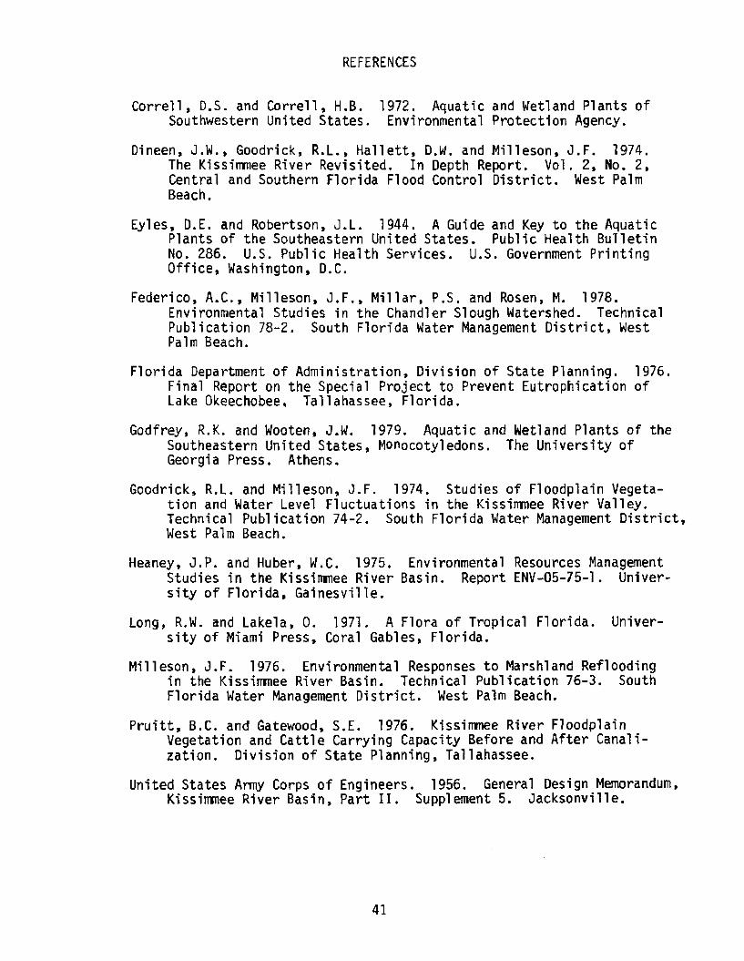
Spoil (Plate 20)
C-38 ranges from about 200 to 350 feet in width and is approximately
30 feet deep. The dredging of this canal resulted in the deposition of
a considerable amount of spoil along the side of the canal. The composi
tion of this spoil is primarily sand, with some shell, clay and limerock
which is alkaline in nature. Spoil is piled as high as 25 feet above
the water level, resulting in a very dry and porous substrate.
Much of the spoil supports few, if any, species of terrestrial
vegetation. In those locations where vegetation is present, the density
of plants is low and the amount of barren land is high. The character
istic appearance of the spoil piles is white, bare, sandy mounds.
-27-

The starkness of the spoil piles lining C-38 is perhaps the most
obvious feature discernible in high altitude aerial photography of
the Kissimmee River valley.
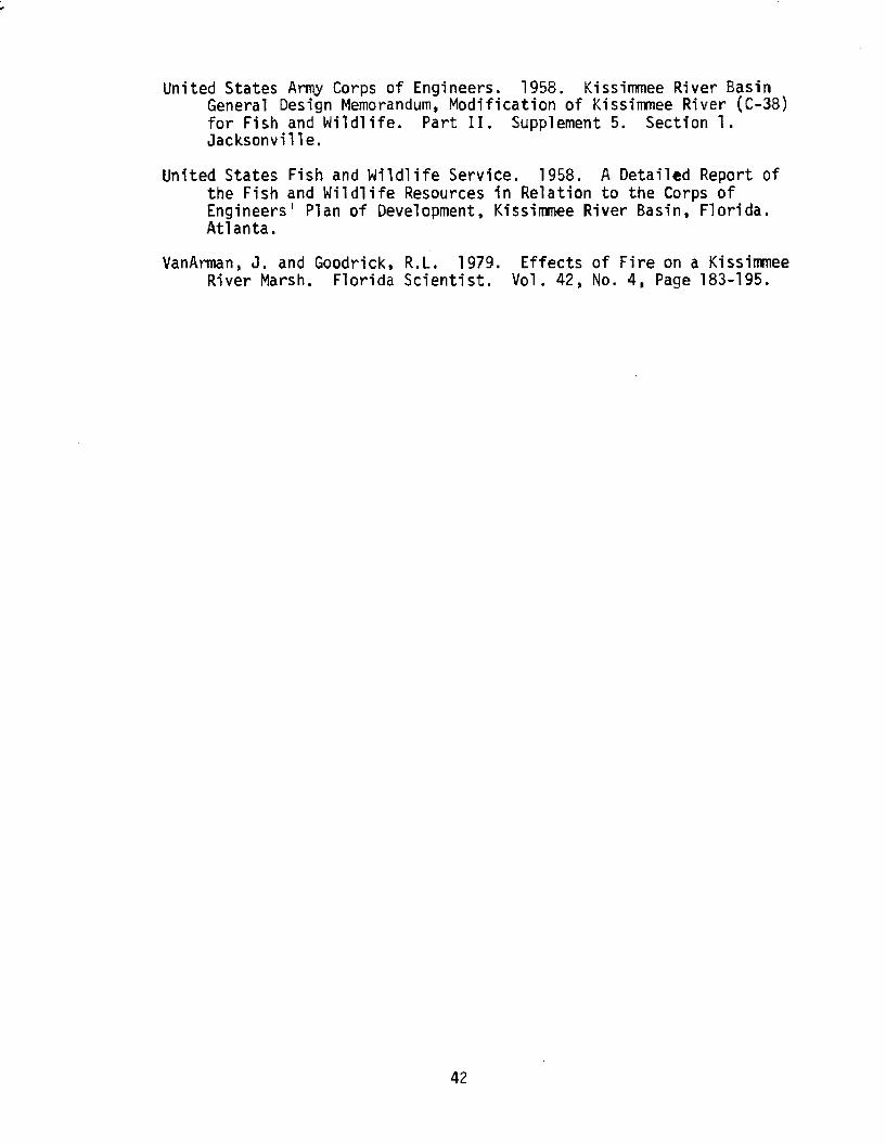
Vegetated Spoil (Plate 21)
The spoil mounds which parallel C-38 reach their maximum height
immediately adjacent to the canal and slope downward towards the flood-
plain (Figure 3). Vegetation is more likely to exist along the lower,
back edges of the spoil piles, probably because soil moisture is higher
than at the top of the mound.
Plants frequently encountered on spoil piles include natal grass
(Rhynchelytrum repens), broom sedge, thistles, Aster sp., and some un
identified grasses and sedges.
Another factor affecting the amount of vegetation growing on spoil
piles is the age of the spoil. The proportion of the mounds which have
been vegetated is greatest in Pool E and decreases to the north. This
corresponds with the construction sequence for C-38.
Levees
This category consists of tieback levees, service roads, and other
filled areas constructed exclusively to enhance the operation and/or
maintenance of C-38 and the S-65 water control structures. In addition,
other levees were constructed throughout the floodplain by local ranchers
prior to the channelization of the Kissimmee River. These levees were
generally designed to dike the Kissimmee floodwaters off of pasture
land.
-28-
Open Water
Open water areas include those portions of C-38, the Kissimmee
River, and any backwater areas which are devoid of emergent aquatic
vegetation. Submergent vegetation occurs in some of the shallow water
areas of the Kissimmee River and consists of southern naiad (Najas
guadalupensis) and eel grass (Val1isneria americana). Hydri11 a verti-
cillata, an exotic plant that is capable of attaining nuisance levels,
is found in a few locations in the southern portion of Pool E.
-29-

SUMMARY
1. A total of 25 plant communities or land use categories were identified,
described and mapped within the Kissimmee River floodplain and major
tributaries during 1978.
2. These categories were grouped within five major classifications:
Agriculture and Urban; Terrestrial Forested; Wetland Forested; Marsh;
Spoil and Barren. Agricultural and Urban categories represented the
largest portion of the study area and accounted for 19,935 acres (42.1%).
Improved pastures alone comprised 14,577 acres and 30.8% of the total
area. Marsh plant communities accounted for 11 ,346 acres (24.0"%};
Spoil and Barren categories covered 8566 acres (18.1%); Terrestrial
Forested communities comprised 5173 acres (10.9%); and Wetland Forested
areas accounted for 2311 acres (4.9%).
3. The descriptions and maps in this report represent the condition of
the Kissimmee River floodplain after the construction and operation
of C-38 and the five water control structures. Many of the plant
communities have been influenced or altered by the channelization
of the floodplain and consequent stabilization of water levels.
Other plant communities, especially those in tributaries, still respond
to seasonal fluctuating water levels.
4. These maps and descriptions will provide a reasonable data baseline
from which to measure the effects of any future water management
alternatives.
-31-


PLANT COMMUNITIES OF THE
KISSIMMEE RIVER FLOODPLAIN
PLATES 1-21
-33-
PLATE 1
IMPROVED PASTURES often contain grassed swale systems for irrigation and drainage. The pastures may be planted with forage grasses and mainta ined. C a ttle d e n s ity is generally high.
PLATE 2
UNIMPROVED PASTURES often result from permanently lowered water levels and generally occur in the central and northern portions of each pool. Broomsedges (Andro- pogan sp.) and scattered wax myrtles (Myrica cerifera) are common.
PLATE 3
Small residential areas, fish camps and buildings associated w i t h w a t e r c o n t r o l s tructu res are typ ica l of URBAN land use categories found in the floodplain.
PLATE 4
A few groves of CITRUS trees are located near the edge of the historic river floodplain in pools D and E.
PLATE 5
WOODY SHRUBS such as elderberry (Sambucus slmp- sonii), salt bush (Baccharls halimifolia) and wax myrtles (Myrica ceiifera) have become dense in areas where the stabilization of water levels in th e i m p o u n d m e n t s has exposed the ground in the north and central portions of each pool and in disturbed areas throughout the pools.
PLATE 6
WAX M Y R T L E ( M y r i c a cerifera) has colonized river banks that were left permane n t l y e x p o s e d by t he stabilization of water levels. S c a t t e r e d b r o o m s e d g e ( A n d r o p o g a n s p . ) and b l adde rpo ds ( G lo t t i d iu m vesicaria) are evident in the photo.
35
PLATE 7
OAKS (Quercus spp.) andCABBAGE PALMS (Sabal p a lm e t to ) o c c u p y some natural ridges and riverbanks alongside the original river channels.
PLATE 8
WILLOW (Satix caroliniana)heads occur within various wetland communities, such as this broadleaf marsh.
PLATE 9
CYPRESS trees (Taxodium distichum) dominate some of the large watersheds, such as Chandler Slough. Understory marsh vegetation includes p i ckere lweed (Ponteder ia l a n c e o l a t a ) , s m a r t w e e d (Polygonum spp.) and water hyacinth (Eichhornia crass- ipes).
36
PLATE 10
Maples (Acer rubrum) arecommon swamp HARDWOOD trees and are usually found in small heads or strands along Kissimmee River banks or tributaries.
PLATE 11
Pickere lweed (Ponteder ia l a n c e o l a t a ) , a r r o w h e a d (Sagi t tar ia lanci fo l ia) and cattail (Typha latifolia) aredom inant species in th is BROADLEAF MARSH. Due to stabilization of water levels in C-38 i mpoundments , ex cessive plant l i t ter often accumulates.
PLATE 12
MAIDENCANE WET PRAIRIE is comprised of a vast, uniform growth of Panicum hem- itom on. Some associated s p e c i e s are a r r o w h e a d (Sagi ttaria la n c ifo lia ) and p i ckere lweed (Ponteder ia lanceolata).
37
\3*v MTTI ' - i i t PLATE 13
T h e A Q U A T I C G R A S S community includes torpedo grass (Pan icum repens), maidencane (Panicum hem- ttomon) and cutgrass(Leer*la hexandra). Associated with the grasses are p ickere lweed (Pontederia lanceolata) and buttonbush (Cephalanthus occidentalis).
PLATE 14
BUTTONBUSH (Cephalanthus occidentalis) shrubs grow to 12 feet in height. The understory includes broadleaf m a r s h p l a n t s s u c h as p i ckere lweed (Ponteder ia lanceolata) pictured here.
PLATE 15
T h i c k e t s o f P R I M RO S E WILLOW (Ludwigia peruviana) often form a complete canopy over broadleaf marsh species such as Sagittaria latifolia and Pontederia lanceolata.
PLATE 16
Old river runs or oxbows sometimes become colonized by FLOATING TUSSOCKS composed primarily of Scirpus cubensis and water hyacinth (Eichhornla crasslpes). Other species which have colonized the mats include Ludwigia leptocarpa and Pontederia lanceolata. Water let tuce (Pistla stratoltes) is accumulating along the edge of the tussock.
PLATE 17
SWITCHGRASS (Spar t ina bakerii) forms a distinctive community slightly downgrad- ient from the oak tree line along the floodplain edge. Ground cover in the foreground of the switchgrass tufts i n c l u d e s t o r p e d o g r ass (Panicum repens), coinwort ( C e n t e l l a a s i a t i c a ) and p e n n y w o r t ( H y d r o c o t y le umbellata).
PLATE 18
SOFT RUSH (Juncus effusus)is usually found at elevations slightly above the stabilized water levels in the Kissimmee River im poundm ents. The o a k t r e e - l i n e in t he b a c k g r o u n d m a r k s the h i s t o r i c a l l im i t s of the floodplain.
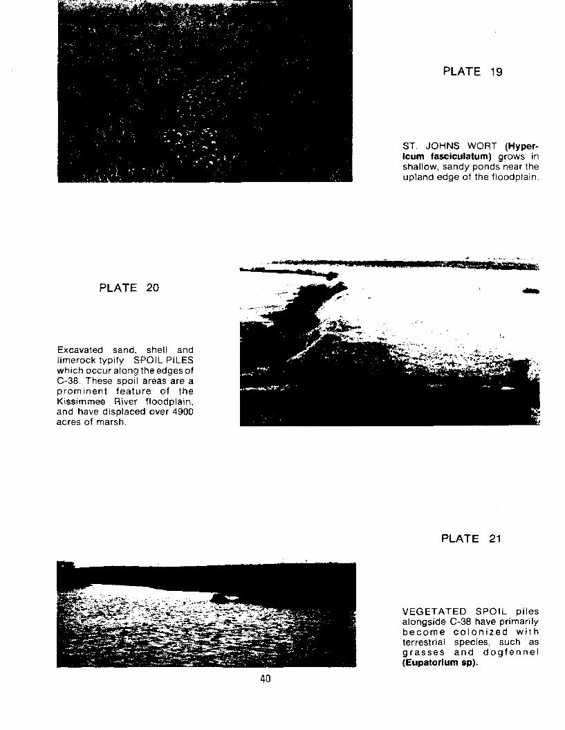
PLATE 19
ST. JOHNS WORT (Hypericum fasciculatum) grows in shallow, sandy ponds near the upland edge of the floodplain.
PLATE 20
Excavated sand, shell and limerock typify SPOIL PILES which occur along the edges of C-38. These spoil areas are a prominent feature of the Kissimmee River floodplain, and have displaced over 4900 acres of marsh.
PLATE 21
VEGETATED SPOIL piles alongside C-38 have primarily b e c o m e c o l o n i z e d w i t h terrestrial species, such as g r a ss es and d o g f e n n e l (Eupatorium sp).
REFERENCES
Correll, D.S. and Correll, H.B. 1972. Aquatic and Wetland Plants of Southwestern United States. Environmental Protection Agency.
Dineen, J.W., Goodrick, R.L., Hallett, D.W. and Milleson, J.F. 1974.The Kissimmee River Revisited. In Depth Report. Vol. 2, No. 2, Central and Southern Florida Flood Control District. West Palm Beach.
Eyles, D.E. and Robertson, J.L. 1944. A Guide and Key to the Aquatic Plants of the Southeastern United States. Public Health Bulletin No. 286. U.S. Public Health Services. U.S. Government Printing Office, Washington, D.C.
Federico, A.C., Milleson, J.F., Millar, P.S. and Rosen, M. 1978.Environmental Studies in the Chandler Slough Watershed. Technical Publication 78-2. South Florida Water Management District, West Palm Beach.
Florida Department of Administration, Division of State Planning. 1976. Final Report on the Special Project to Prevent Eutrophication of Lake Okeechobee, Tallahassee, Florida.
Godfrey, R.K. and Wooten, J.W. 1979. Aquatic and Wetland Plants of the Southeastern United States, Monocotyledons. The University of Georgia Press. Athens.
Goodrick, R.L. and Milleson, J.F. 1974. Studies of Floodplain Vegetation and Water Level Fluctuations in the Kissimmee River Valley. Technical Publication 74-2. South Florida Water Management District, West Palm Beach,
Heaney, J.P. and Huber, W.C. 1975. Environmental Resources Management Studies in the Kissimmee River Basin. Report ENV-05-75-1. University of Florida, Gainesville.
Long, R.W. and Lakela, 0. 1971, A Flora of Tropical Florida. University of Miami Press, Coral Gables, Florida.
Milleson, J.F. 1976. Environmental Responses to Marshland Reflooding in the Kissimmee River Basin. Technical Publication 76-3. South Florida Water Management District. West Palm Beach.
Pruitt, B.C. and Gatewood, S.E. 1976. Kissimmee River Floodplain Vegetation and Cattle Carrying Capacity Before and After Canalization. Division of State Planning, Tallahassee.
United States Artny Corps of Engineers. 1956. General Design Memorandum, Kissimmee River Basin, Part II. Supplement 5. Jacksonville.
41
United States Anrty Corps of Engineers. 1958, Kissimmee River Basin General Design Memorandum, Modification of Kissimmee River (C-38) for Fish and Wildlife. Part II. Supplement 5. Section 1. Jacksonville.
United States Fish and Wildlife Service. 1958. A Detailed Report of the Fish and Wildlife Resources in Relation to the Corps of Engineers' Plan of Development, Kissimmee River Basin, Florida. Atlanta.
VanArman, J. and Goodrick, R.L. 1979. Effects of Fire on a Kissimmee River Marsh. Florida Scientist. Vol. 42, No. 4, Page 183-195.
42