Embed Size (px)
Citation preview

CIVISA
SENTINELS AND COPERNICUS IN SUPPORT OF GEOLOGICAL HAZARDS MONITORING AND
EMERGENCY MANAGEMENT
Teresa Ferreira(1,2), João Luís Gaspar(1,2), Gabriela Queiroz (1,2)
(1) CVARG (Centre for Volcanology and Geological Risks Assessment), Azores University(2) CIVISA (Centre for Information and Seismovolcanic Surveillance of the Azores)
CIVISA
1

CIVISA
1 – Why are the Azores one of the geologically active regions of Europe
prone to natural hazards?
2

CIVISA
AZORES ARCHIPELAGOGeographic and Geodynamic setting
Workshop ESA/NEREUS “Land and Marine planning and management using Sentinel data - Small Oceanic Islands as a Model” 28.set.2015 - Ponta Delgada, Açores
3

CIVISA
AZORES ARCHIPELAGOGeographic and Geodynamic setting
Workshop ESA/NEREUS “Land and Marine planning and management using Sentinel data - Small Oceanic Islands as a Model” 28.set.2015 - Ponta Delgada, Açores
4

CIVISA
AZORES ARCHIPELAGOGeographic and Geodynamic setting
American PlateEuro-asian Plate
Núbia Plate
MAR
EAFZ
TR
Workshop ESA/NEREUS “Land and Marine planning and management using Sentinel data - Small Oceanic Islands as a Model” 28.set.2015 - Ponta Delgada, Açores
5

CIVISA
Major destructive earthquakes in historical time
Workshop ESA/NEREUS “Land and Marine planning and management using Sentinel data - Small Oceanic Islands as a Model” 28.set.2015 - Ponta Delgada, Açores
6
CIVISA
Seismic activity 1980-2013
Workshop ESA/NEREUS “Land and Marine planning and management using Sentinel data - Small Oceanic Islands as a Model” 28.set.2015 - Ponta Delgada, Açores
CIVISA
7

CIVISA
Historical Eruptions
Workshop ESA/NEREUS “Land and Marine planning and management using Sentinel data - Small Oceanic Islands as a Model” 28.set.2015 - Ponta Delgada, Açores
8
CIVISA
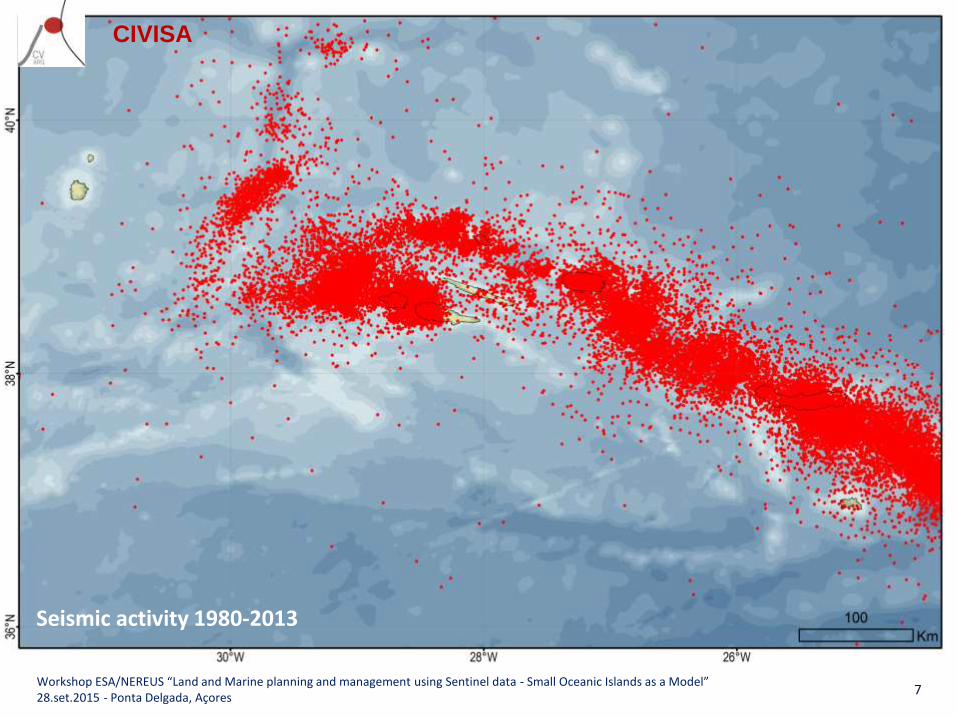
Active Volcanic Systems
Sete Cidades VolcanoPicos Volcanic SystemFogo VolcanoCongro Volcanic SystemFurnas Volcano
Santa Bárbara VolcanoFissural V. S.Pico Alto Volcano
Vitória V. S.Caldeira Central Volcano
Capelo V. S.Central VolcanoHorta-Flamengos V. S. (?)
Pico VolcanoFissural V. S.
Manadas V. S.
Lagoas V. S.
Workshop ESA/NEREUS “Land and Marine planning and management using Sentinel data - Small Oceanic Islands as a Model” 28.set.2015 - Ponta Delgada, Açores
9

CIVISA
Some Recent Geological Events
S. Miguel – Landslides - Ribeira Quente, 1997 Faial – Earthquake and lanslides, 1998
Faial – Capelinhos eruption, 1957-58 NW Terceira – Serreta eruption 1998-2001
Flores – Mudflows - Fajãzinha, 2010
S. Miguel – Volcanic unrest episode, 2005
Workshop ESA/NEREUS “Land and Marine planning and management using Sentinel data - Small Oceanic Islands as a Model” 28.set.2015 - Ponta Delgada, Açores
10

CIVISA
Geological Hazards in the Azores
• Azorean population is exposed to more than one natural hazard;
• Earthquakes, volcanic eruptions, landslides and tsunamis can occur as coupled events;
• The combined action of these events should always be considered when modelling scenarios for emergency planning;
LandslidesVolcanic
Eruptions
Earthquakes
Tsunamis
Workshop ESA/NEREUS “Land and Marine planning and management using Sentinel data - Small Oceanic Islands as a Model” 28.set.2015 - Ponta Delgada, Açores
11

CIVISA
2 – PREVIOUS PROJECTS INVOLVING SPACE TECHNOLOGIES
12
CIVISA
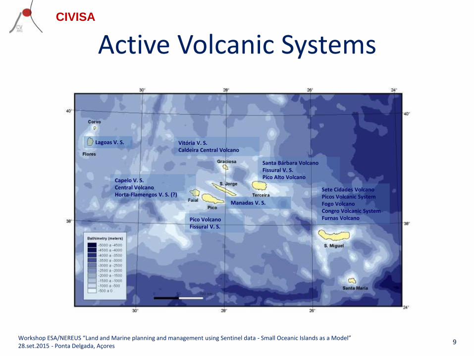
Ground deformation InSAR
Differential PALSAR L-band interferogramsCong, X. et al (2008) - Ground deformation measurement with radar interferometry in Exupéry Project
Workshop ESA/NEREUS “Land and Marine planning and management using Sentinel data - Small Oceanic Islands as a Model” 28.set.2015 - Ponta Delgada, Açores
13

CIVISA
GlobVolcano Information Service
Ground deformation using images for DINSAR and ALOS PALSAR
Workshop ESA/NEREUS “Land and Marine planning and management using Sentinel data - Small Oceanic Islands as a Model” 28.set.2015 - Ponta Delgada, Açores
14

CIVISA
Main problems for EO monitoring
• Reduced number of pair images for SAR interferometry
• Slow strain rates
• Dense vegetation coverage
• Very poor time series
Poor coherence for images
Workshop ESA/NEREUS “Land and Marine planning and management using Sentinel data - Small Oceanic Islands as a Model” 28.set.2015 - Ponta Delgada, Açores
15

CIVISA
3 – How can the Sentinels contribute for the geological hazards monitoring of the Azores
Archipelago?
16

CIVISA
Workshop ESA/NEREUS “Land and Marine planning and management using Sentinel data - Small Oceanic Islands as a Model” 28.set.2015 - Ponta Delgada, Açores
https://sentinel.esa.int/web/sentinel/missions/sentinel-1/observation-scenario
17

CIVISA
What changes with Sentinel-1?
• The Azores are one target area for Sentinels;• Sentinel-1 is an imaging radar mission providing continuous
all-weather, day-and-night imagery at C-band.• Sentinel-1 was specifically designed to monitor ground
deformation; new scanning mode TOPS; • Sentinel-1A revisits any point on Earth surface every 12 days • The Sentinel-1 constellation will reduce revisit cycles to 6 days• Systematic image acquisition every 6/12 days or more,
allowing high coherence• Long term programme for InSAR (20 years) → long time series• Free and open data access
Workshop ESA/NEREUS “Land and Marine planning and management using Sentinel data - Small Oceanic Islands as a Model” 28.set.2015 - Ponta Delgada, Açores
18

CIVISA
USA, Napa Earthquake
Elliott et al., EOS 2015
Mw = 6.0 South Napa earthquake, 24 August 2014
First geophysical event caught by Sentinel-1A. Interferogramgenerated with scans from 7 August 2014 and31 August 2014
Workshop ESA/NEREUS “Land and Marine planning and management using Sentinel data - Small Oceanic Islands as a Model” 28.set.2015 - Ponta Delgada, Açores
19

CIVISA
“Chile earthquake on the radar”
Elliott et al., EOS 2015
Interferogramgenerated with Sentinel-1A radar scans from 24 August and 17 September
Released 21/09/2015 http://linkis.com/OvRHh
Workshop ESA/NEREUS “Land and Marine planning and management using Sentinel data - Small Oceanic Islands as a Model” 28.set.2015 - Ponta Delgada, Açores
Mw = 8.3 near the coast of central Chile, 16 September 2015
Copernicus Sentinel data (2015)/ESA SEOM INSARAP study PPO.labs/NORUT
20

CIVISA
Cape Verde, Fogo island eruption
Copernicus data (2014)/ESA/Norut-PPO.labs–COMET-SEOM InSARap study
Interferogram generated with images acquired on 3 November and 27 November 2014
Workshop ESA/NEREUS “Land and Marine planning and management using Sentinel data - Small Oceanic Islands as a Model” 28.set.2015 - Ponta Delgada, Açores
21
CIVISA
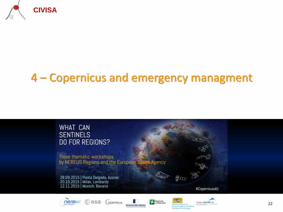
4 – Copernicus and emergency managment
22

CIVISA
Workshop ESA/NEREUS “Land and Marine planning and management using Sentinel data - Small Oceanic Islands as a Model” 28.set.2015 - Ponta Delgada, Açores
23

CIVISA
Copernicus emergency service
As stated by ESA:• The Copernicus emergency service (Copernicus EMS) is targeted to provide information
that facilitates the mitigation of and response to many types of disasters or crises including:– natural disasters (floods, fires, landslides, storms, earthquakes, etc.)– technological accidents– humanitarian crises (for instance after a period of severe drought), famine etc.)– civil crises.
• The SENTINEL missions support emergency management providing timely, continuous and independent data on a near-real-time basis.
• SENTINEL-1 - produces high resolution, co-seismic maps of earthquake deformations. • SENTINEL-2 - supports rapid mapping for the GMES/Copernicus Emergency Response
Support Service (ERSS). Rapid mapping is dedicated to the response management of civil protection and rescue services
• The service is provided in two modules: Rapid Mapping and Risk & Recovery Mapping.
Workshop ESA/NEREUS “Land and Marine planning and management using Sentinel data - Small Oceanic Islands as a Model” 28.set.2015 - Ponta Delgada, Açores
24
CIVISA
Copernicus
For the first time a long-term frame for continuous
monitoring of the environment
Workshop ESA/NEREUS “Land and Marine planning and management using Sentinel data - Small Oceanic Islands as a Model” 28.set.2015 - Ponta Delgada, Açores
25

CIVISA
THANK YOU
Workshop ESA/NEREUS “Land and Marine planning and management using Sentinel data - Small Oceanic Islands as a Model” 28.set.2015 - Ponta Delgada, Açores
Sentinel-1 (Credits: ESA)
26