Embed Size (px)
Citation preview
20th November 2008 Medspiration/GlobColour symposiumESA - ESRIN
Sentinel-3 OLCI and SLSTR
Craig DonlonESA/ESTEC, Mission Science Division
B. Berruti, J. Frerick, C. Mavrocordatos, J. Nieke, H. Rebhan, J. Stroedeand the S3 Team,
European Space Agency, ESTEC, Keplerlaan 1, 2200AG Noordwijk ZH, The Netherlands
20th November 2008 Medspiration/GlobColour symposiumESA - ESRIN
Outline
• Overview of User Requirements• Overview of OLCI instrument• Overview of SLSTR instrument• Current activities • Timeline• Summary
20th November 2008 Medspiration/GlobColour symposiumESA - ESRIN
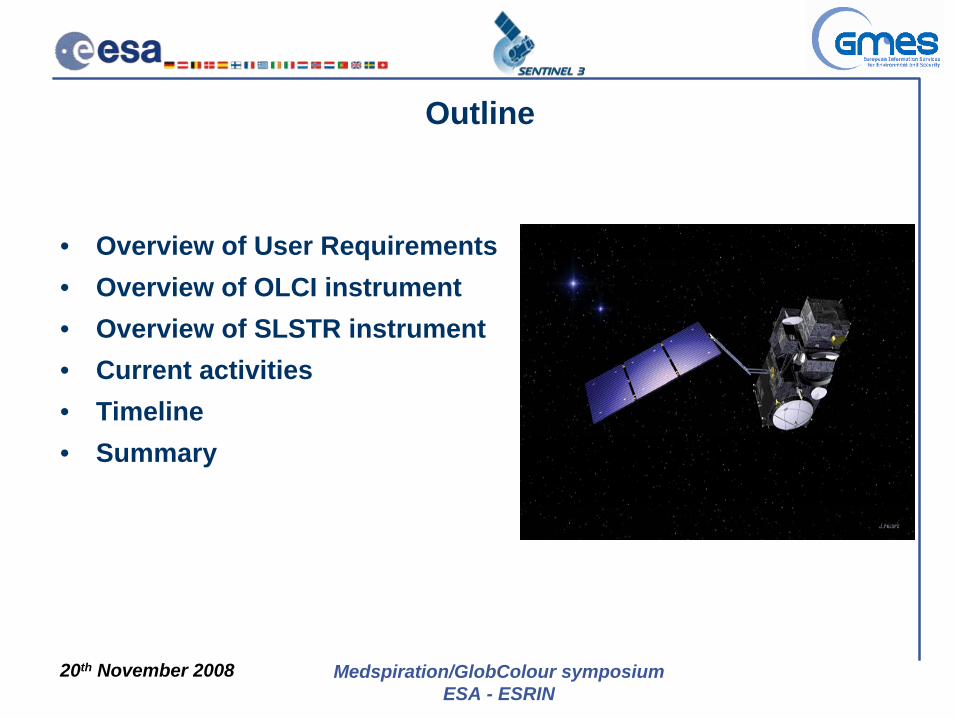
GMES Observational Infrastructure• The GMES initiative federates a wide
range of observations from space and in situ infrastructures.
• The space component :– Shall ensure sustainable provision of
satellite derived Earth observation data to all GMES services.
– Shall ensure that the architecture of the component is derived from service requirements
• ESA and EUMETSAT are two main European actors in this area who play the major role in co-ordination, implementation and operating the GMES space infrastructure.

20th November 2008 Medspiration/GlobColour symposiumESA - ESRIN
• ESA is currently developing 3 satellite systems forming part of the Space Component of GMES programme (Global Monitoring for Environment and Security):
– S1: C-band SAR,– S2: Multispectral high resolution optical imager,– S3: Wide-swath, low resolution VIS - IR spectro-
radiometers and a radar altimeter package.
• Each Sentinel mission has stringent revisit, coverage and mission life cycle requirements (>15 years), which require the deployment of several satellites for each mission.
GMES Sentinel-3 Mission Overview
20th November 2008 Medspiration/GlobColour symposiumESA - ESRIN
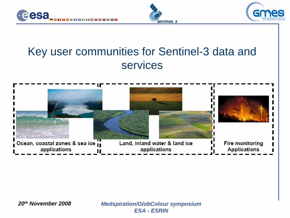
Key user communities for Sentinel-3 data and services
20th November 2008 Medspiration/GlobColour symposiumESA - ESRIN 6
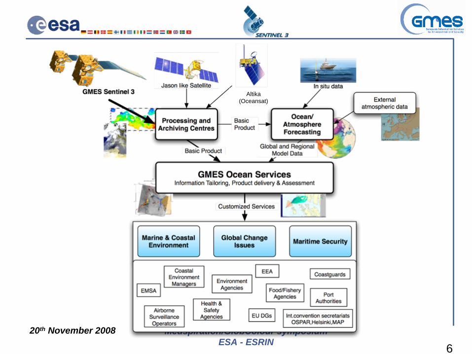
Altika (Oceansat)
20th November 2008 Medspiration/GlobColour symposiumESA - ESRIN
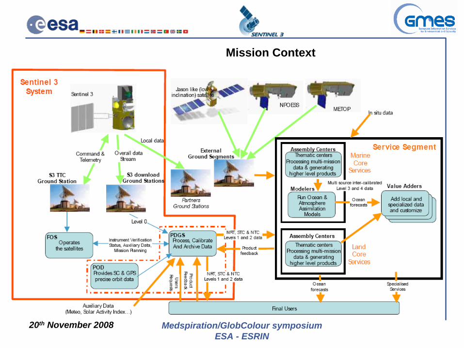
Mission Context
20th November 2008 Medspiration/GlobColour symposiumESA - ESRIN
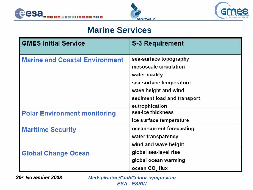
Marine Services
20th November 2008 Medspiration/GlobColour symposiumESA - ESRIN
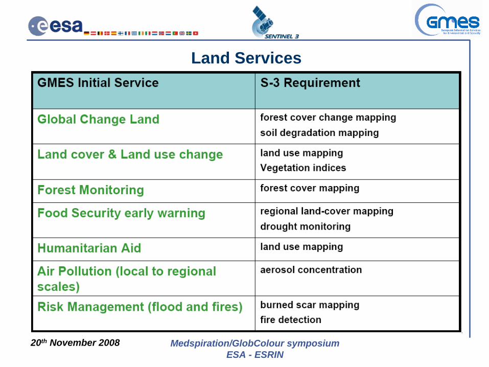
Land Services
20th November 2008 Medspiration/GlobColour symposiumESA - ESRIN
Sentinel-3 Spacecraft
SRAL Antenna
S-band Antenna
Laser Retro- Reflector DORIS
Antenna
Microwave Radiometer
Ocean and Land Colour Instrument
Sea and Land Surface
Temperature Radiometer
X-band Antenna
Solar Panel
Sentinel-3 Spacecraft
20th November 2008 Medspiration/GlobColour symposiumESA - ESRIN
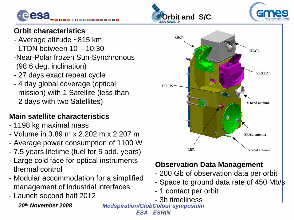
Main satellite characteristics- 1198 kg maximal mass- Volume in 3.89 m x 2.202 m x 2.207 m- Average power consumption of 1100 W- 7.5 years lifetime (fuel for 5 add. years)- Large cold face for optical instruments- thermal control- Modular accommodation for a simplified- management of industrial interfaces- Launch second half 2012
Observation Data Management- 200 Gb of observation data per orbit- Space to ground data rate of 450 Mb/s- 1 contact per orbit - 3h timeliness
Orbit characteristics- Average altitude ~815 km - LTDN between 10 – 10:30-Near-Polar frozen Sun-Synchronous-(98.6 deg. inclination)- 27 days exact repeat cycle- 4 day global coverage (optical- mission) with 1 Satellite (less than- 2 days with two Satellites)
Orbit and S/C
S band antenna
SRAL antenna
X band antenna
LRR
MWR
SRAL antenna
X band antenna
SLSTR
OLCI
LRR
DORIS
MWR

20th November 2008 Medspiration/GlobColour symposiumESA - ESRIN
Sentinel-3 Data Chains
Synergy Products
20th November 2008 Medspiration/GlobColour symposiumESA - ESRIN
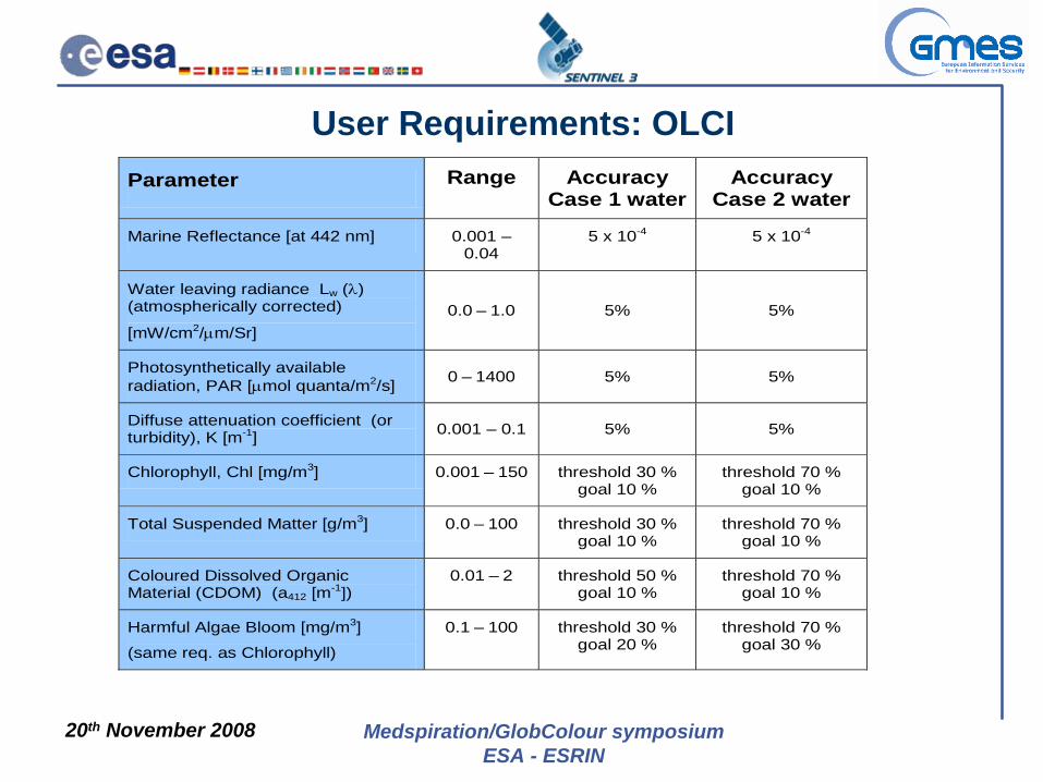
User Requirements: OLCIParameter Range Accuracy
Case 1 waterAccuracy
Case 2 water
Marine Reflectance [at 442 nm] 0.001 – 0.04
5 x 10⁻⁴ 5 x 10⁻⁴
Water leaving radiance Lw (λ) (atmospherically corrected)
[mW/cm2/μm/Sr] 0.0 – 1.0 5% 5%
Photosynthetically available radiation, PAR [μmol quanta/m2/s] 0 – 1400 5% 5%
Diffuse attenuation coefficient (or turbidity), K [m-1] 0.001 – 0.1 5% 5%
Chlorophyll, Chl [mg/m3] 0.001 – 150 threshold 30 % goal 10 %
threshold 70 % goal 10 %
Total Suspended Matter [g/m3] 0.0 – 100 threshold 30 % goal 10 %
threshold 70 % goal 10 %
Coloured Dissolved Organic Material (CDOM) (a412 [m-1])
0.01 – 2 threshold 50 % goal 10 %
threshold 70 % goal 10 %
Harmful Algae Bloom [mg/m3]
(same req. as Chlorophyll)
0.1 – 100 threshold 30 % goal 20 %
threshold 70 % goal 30 %
20th November 2008 Medspiration/GlobColour symposiumESA - ESRIN
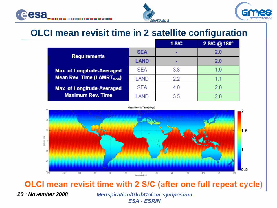
OLCI mean revisit time in 2 satellite configuration

20th November 2008 Medspiration/GlobColour symposiumESA - ESRIN
Data Acquisition Geometry
Instrument operations are repetitive according to the satellite position- SLSTR incl. nadir & backward view- OLCI FOV optimised to avoid sun glint- SLSTR & OLCI will be available as L1C co-registered product- SLSTR (IR channels) and TOPO are always acquiring data

20th November 2008 Medspiration/GlobColour symposiumESA - ESRIN
Ocean & Land Color Instrument (OLCI)VIS-NIR programmable imaging spectrometer:
– 5 cameras in fan-shaped form, – overall instrument FoV is 68.5 degrees, i.e., ~1300km– instrument assembly tilted by about 12 deg across-track away
from Sun avoiding sun-glint effects.

20th November 2008 Medspiration/GlobColour symposiumESA - ESRIN
OLCI
Technical:Basic set-up:5 fan-arranged Camera Optical Sub Assemblies (COSA), 5 Focal Plane Assemblies (FPA), 1 Scrambling Window Assembly (SWA), 5 Video Acquisition Modules (VAM), 1 OLCI Electronic Unit (OEU) managing all the instrument functions, 1 calibration assembly allowing a radiometric and spectral calibration.
OLCI Optical layout
20th November 2008 Medspiration/GlobColour symposiumESA - ESRIN
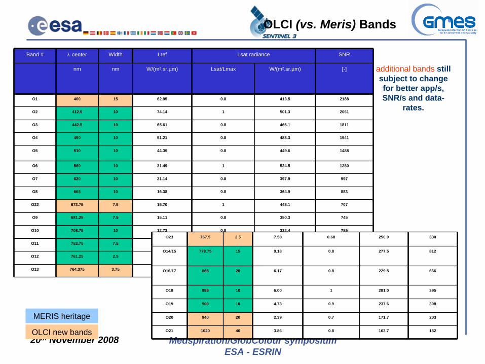
additional bands still subject to change for better app/s, SNR/s and data-
rates.
Band # λ
center Width Lref Lsat radiance SNR
nm nm W/(m².sr.µm) Lsat/Lmax W/(m².sr.µm) [-]
O1 400 15 62.95 0.8 413.5 2188
O2 412.5 10 74.14 1 501.3 2061
O3 442.5 10 65.61 0.8 466.1 1811
O4 490 10 51.21 0.8 483.3 1541
O5 510 10 44.39 0.8 449.6 1488
O6 560 10 31.49 1 524.5 1280
O7 620 10 21.14 0.8 397.9 997
O8 665 10 16.38 0.8 364.9 883
O22 673.75 7.5 15.70 1 443.1 707
O9 681.25 7.5 15.11 0.8 350.3 745
O10 708.75 10 12.73 0.8 332.4 785
O11 753.75 7.5 10.33 1 377.7 605
O12 761.25 2.5 6.09 1 369.5 232
O13 764.375 3.75 7.13 1 373.4 305
O23 767.5 2.5 7.58 0.68 250.0 330
O14/15 778.75 15 9.18 0.8 277.5 812
O16/17 865 20 6.17 0.8 229.5 666
O18 885 10 6.00 1 281.0 395
O19 900 10 4.73 0.9 237.6 308
O20 940 20 2.39 0.7 171.7 203
O21 1020 40 3.86 0.8 163.7 152
OLCI (vs. Meris) Bands
MERIS heritage
OLCI new bands
20th November 2008 Medspiration/GlobColour symposiumESA - ESRIN
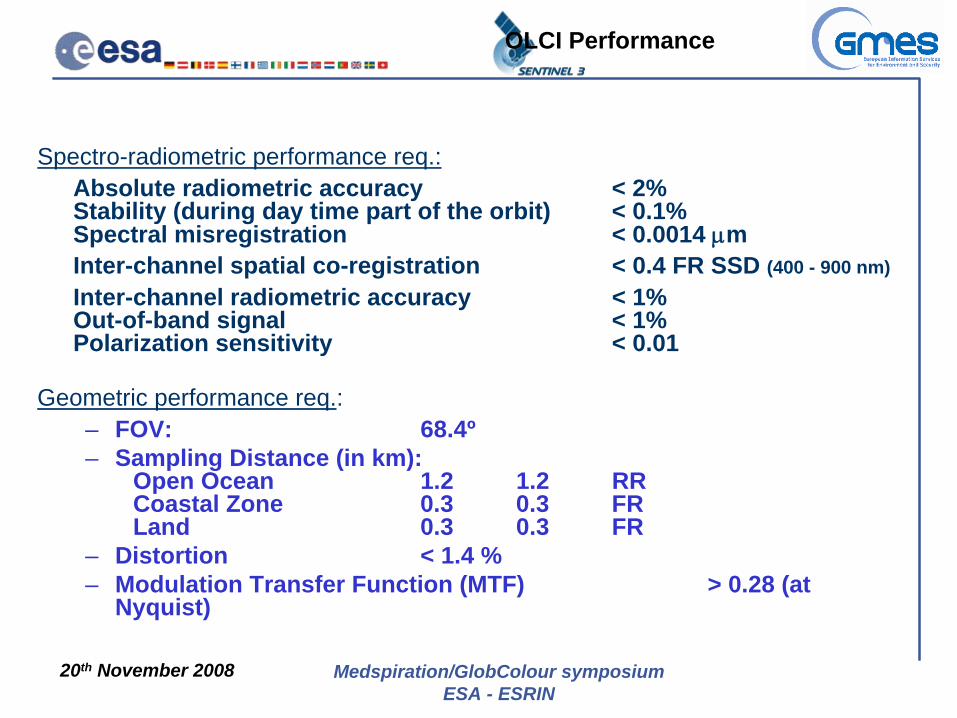
Spectro-radiometric performance req.:Absolute radiometric accuracy < 2% Stability (during day time part of the orbit) < 0.1% Spectral misregistration < 0.0014 μm Inter-channel spatial co-registration < 0.4 FR SSD (400 - 900 nm)Inter-channel radiometric accuracy < 1% Out-of-band signal < 1% Polarization sensitivity < 0.01
Geometric performance req.:– FOV: 68.4º– Sampling Distance (in km):
Open Ocean 1.2 1.2 RR Coastal Zone 0.3 0.3 FR Land 0.3 0.3 FR
– Distortion < 1.4 %– Modulation Transfer Function (MTF) > 0.28 (at
Nyquist)
OLCI Performance
20th November 2008 Medspiration/GlobColour symposiumESA - ESRIN
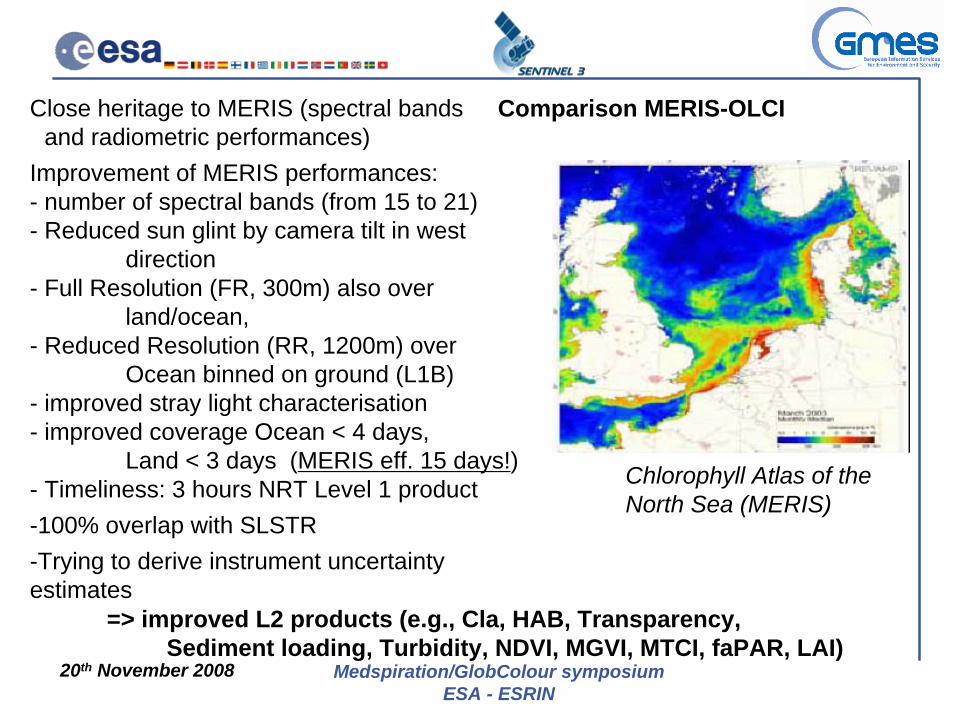
Chlorophyll Atlas of the North Sea (MERIS)
Close heritage to MERIS (spectral bands- and radiometric performances)Improvement of MERIS performances:- number of spectral bands (from 15 to 21)- Reduced sun glint by camera tilt in west
direction- Full Resolution (FR, 300m) also over
land/ocean, - Reduced Resolution (RR, 1200m) over
Ocean binned on ground (L1B) - improved stray light characterisation- improved coverage Ocean < 4 days,
Land < 3 days (MERIS eff. 15 days!)- Timeliness: 3 hours NRT Level 1 product-100% overlap with SLSTR-Trying to derive instrument uncertainty estimates
=> improved L2 products (e.g., Cla, HAB, Transparency, Sediment loading, Turbidity, NDVI, MGVI, MTCI, faPAR, LAI)
Comparison MERIS-OLCI
20th November 2008 Medspiration/GlobColour symposiumESA - ESRIN
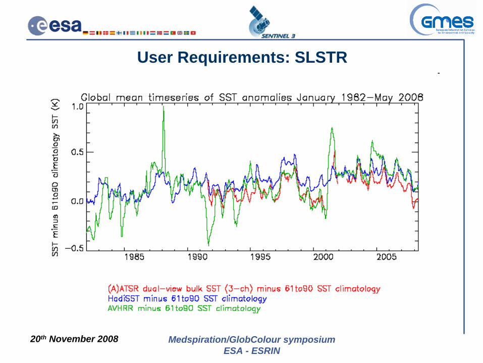
User Requirements: SLSTR
Threshold Goal Range
Resolution 0.06 K 0.025 210 – 350 K
Absolute Accuracy (related to 100% diffuse reflectance)
0.3 K 0.1 K 270 – 320 K
Relative Accuracy (expressed as NEΔT)*
0.08 K 0.05 K 210 – 350 K
Temporal stability 0.2 K / decade 0.1 K / decade 270 – 320 K
20th November 2008 Medspiration/GlobColour symposiumESA - ESRIN
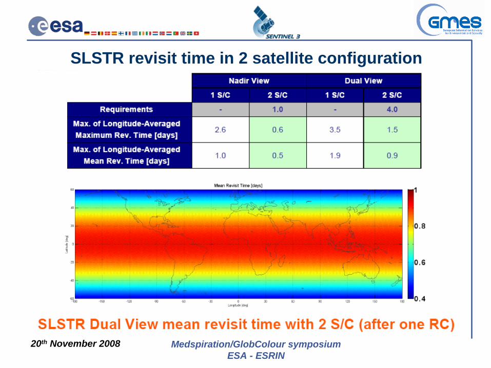
SLSTR revisit time in 2 satellite configuration
20th November 2008 Medspiration/GlobColour symposiumESA - ESRIN
SLSTR Objectives
- Strong heritage from- A(A)TSR (spectral- channels and rad.- performances)- Continue high precision IR SST series from A(A)TSR!- Land Surface- Temperatures- Surface albedo over- water/land- Synergy between OLCI and SLSTR (new products)- For Level 2 products, same or better performance as ENVISAT- Support of VEGETATION-type products (option)- IR channels adapted to support Fire Monitoring (option)
Sea and Land Surface Temperature Radiometer (SLSTR)
20th November 2008 Medspiration/GlobColour symposiumESA - ESRIN
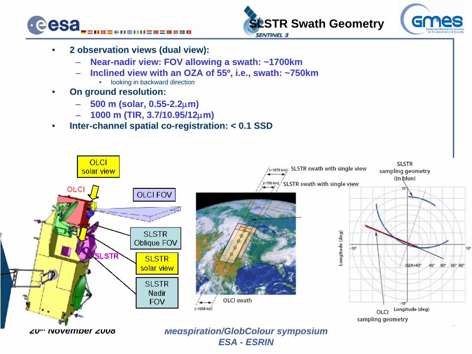
• 2 observation views (dual view):– Near-nadir view: FOV allowing a swath: ~1700km– Inclined view with an OZA of 55º, i.e., swath: ~750km
• looking in backward direction• On ground resolution:
– 500 m (solar, 0.55-2.2μm) – 1000 m (TIR, 3.7/10.95/12μm)
• Inter-channel spatial co-registration: < 0.1 SSD
SLSTR Swath Geometry

20th November 2008 Medspiration/GlobColour symposiumESA - ESRIN
SLSTR Instrument• 2 Blackbodies• 2 scan mirrors• 1 flip mirror• viscal• Cooled detectors• Dedicated fire channels

20th November 2008 Medspiration/GlobColour symposiumESA - ESRIN
- dual view, each having its own scanner (flat scan mirrors)- scan of 2 x Earth and calibration sources (BBs, VISCAL) - views are seen by the front collecting and refocusing optics (Primary Mirrors) - recombination optics to bring 2 optical paths into a single set of Focal Plane
Assemblies (FPA) after a common field plane used as intermediate field stop- FPA consists of a cryogenically cooled dewar, hosting the 6 (SW)IR and 3 VIS bands
SLSTR Instrument Principle
20th November 2008 Medspiration/GlobColour symposiumESA - ESRIN
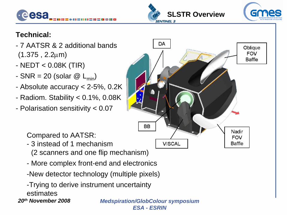
Technical:- 7 AATSR & 2 additional bands-(1.375 , 2.2μm)- NEDT < 0.08K (TIR)- SNR = 20 (solar @ Lmin )- Absolute accuracy < 2-5%, 0.2K- Radiom. Stability < 0.1%, 0.08K- Polarisation sensitivity < 0.07
Compared to AATSR:- 3 instead of 1 mechanism- (2 scanners and one flip mechanism)- More complex front-end and electronics-New detector technology (multiple pixels)-Trying to derive instrument uncertainty estimates
SLSTR Overview

20th November 2008 Medspiration/GlobColour symposiumESA - ESRIN
• absolute rad. accuracy (S1-S6) : <5% (EOL) <2% (BOL)
• absolute rad. accuracy (S7/8/9) : 0.2 K • polarisation sensitivity < 0.07 (S1-S6)
or < 0.10 (S7/8/9) • stability (S1-S6): <0.1%• stability (S7/8/9): <0.08K
Band λcenter [μm]
Δλ [μm] SNR [-] / NeΔT [mK]
SSD [km]
S1 0.555 0.02 20 0.5
S2 0.659 0.02 20 0.5
S3 0.865 0.02 20 0.5
S4 1.375 0.015 20 0.5
S5 1.61 0.06 20 0.5
S6 2.25 0.05 20 0.5
S7 3.74 0.38 80 mK 1.0
S8 10.95 0.9 80 mK 1.0
S9 12 1.0 80 mK 1.0
Band λcenter [μm] Δλ [μm] Tmax [K] SSD [km]
F1 3.74 0.38 500 1.0
F2 10.95 0.9 400 1.0
Sea & Land Surface Bands
Active Fire Bands
final decision on F1 & F2 implementation after PDR
AATSR heritage
SLSTR new bands
20th November 2008 Medspiration/GlobColour symposiumESA - ESRIN
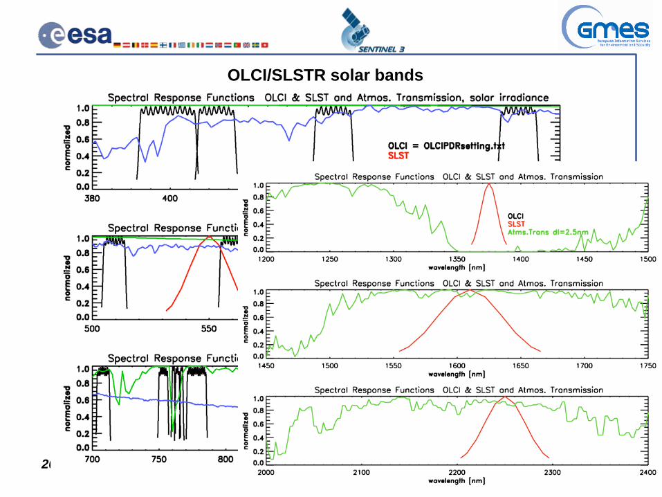
OLCI/SLSTR solar bands

20th November 2008 Medspiration/GlobColour symposiumESA - ESRIN
Ground Processor Prototype
-To develop a prototype for the final operation processor generating Level 1-2 products
-- to test overall instrument performance:
-> part of a larger Instrument Performance Simulator
L2 Ocean/Land rad. products
L2 VGT products
L2 Ocean/Land temp. products
SLSTLevel 1B product
OLCIraw data
OLCI Level 0
processingOLCILevel 0 product
OLCI Level 1B
processingOLCI
Level 1B product
SLSTraw data
SLST Level 0
processing SLSTLevel 0 product
SLST Level 1B
processing
OpticalLevel 1C
processing
VegetationLevel 1C product
SERVIC
E MO
DU
LE
NAVATT packets
20th November 2008 Medspiration/GlobColour symposiumESA - ESRIN
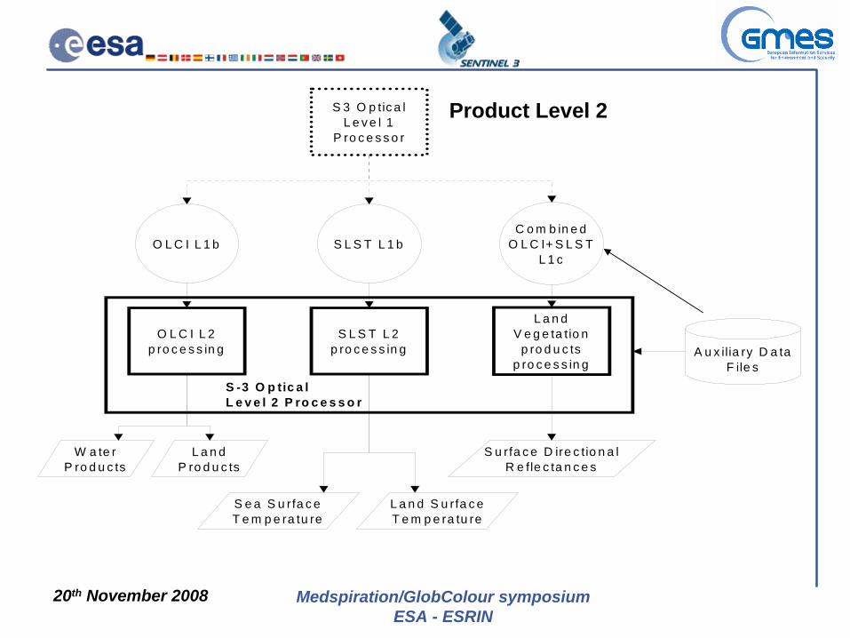
Product Level 2
O L C I L 1 b S L S T L 1 bC o m b in e d
O L C I+ S L S T L 1 c
O L C I L 2 p ro c e s s in g
S L S T L 2 p ro c e s s in g
L a n d V e g e ta tio n
p ro d u c ts p ro c e s s in g
W a te rP ro d u c ts
L a n dP ro d u c ts
S e a S u rfa c eT e m p e ra tu re
L a n d S u rfa c eT e m p e ra tu re
S u rfa c e D ire c tio n a l R e fle c ta n c e s
S 3 O p tic a lL e v e l 1
P ro c e s s o r
S -3 O p tic a l L e v e l 2 P ro c e s s o r
A u x ilia ry D a ta F ile s
20th November 2008 Medspiration/GlobColour symposiumESA - ESRIN
Sentinel-3 Status: General• Sentinel-3 Prime Phase B2 Kicked-Off on 16th of October 2007
– All other Industrial Core and Key Partners (17) Kicked-Off by the end of November 2007
• Cooperation agreement between ESA and the EC signed in Feb 2008: approx 45% of Segment 1 (up to Sentinel’s FAR) financed by EC
• Main Contract signed between ESA and TAS-F on 14th of April• Definition of remaining procurements on-going
– Need to setup about 110 subcontracts(!)– Process amended to reflect requirements coming from the
Preliminary Design Review ongoingreview of all requirement for instruments and satellite platform

20th November 2008 Medspiration/GlobColour symposiumESA - ESRIN
Sentinel-3 Schedule Summary
20th November 2008 Medspiration/GlobColour symposiumESA - ESRIN
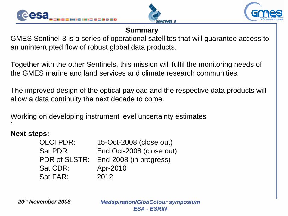
SummaryGMES Sentinel-3 is a series of operational satellites that will guarantee access to an uninterrupted flow of robust global data products.
Together with the other Sentinels, this mission will fulfil the monitoring needs of the GMES marine and land services and climate research communities.
The improved design of the optical payload and the respective data products will allow a data continuity the next decade to come.
Working on developing instrument level uncertainty estimates`Next steps:
OLCI PDR: 15-Oct-2008 (close out)Sat PDR: End Oct-2008 (close out)PDR of SLSTR: End-2008 (in progress)Sat CDR: Apr-2010Sat FAR: 2012