Embed Size (px)
Citation preview

SENTENCED TO DISPUTE;THE AEGEAN ISSUE
H. Tahsin Ulus

OPPOSITE APPROACHES OF GREECE AND TURKEY
According to Greece; Aegean Sea is an ordinary sea, so 12 miles of UNCLOS 1982 provisions should be applicable.
According to Turkey; Aegean Sea is a semi-closed Sea and has a very unique situation where groups of islands of one state are very close to the mainland of the other’s. Besides bearing important ports, international passages from Black sea to the Mediterranean through straits makes it unlike throughout the world. Additionally, Turkey does not recognize UNCLOS 1982.
According to Greek scholars the nature of the disputes are pure legal, where Turkish academics think that Aegean disputes are political or at least bears multi aspects, tangled to that nature. Greek-Turkish disputes are originated in law, though they are bearing political aspects.
The word “binding” has different meanings for Greece and Turkey. While Greece says “yes” it may renege on its acceptations, though if Turkey undertakes any obligation it keeps its world.
Another discussion is over “revisionist” blaming. In that point both parties blame each other to challenge the status quo in the region.

Although Turkish approach is in favor of “negotiations” by cumulative or pocket deal means, Greece is searching “third party intervention” and prefers step-by step or piecemeal resolution.
Due to Greek thesis; every conflict has its own distinct features and can not be linked.
However Turkish approach defends the inescapable affect of each consequence over the others in Aegean conflicts.
According to Greece; legal based issues must be solved before the court, with binding decisions.
Contrarily, Turkey fears the risky nature of international adjudication which relies on a “zero-sum game.”
The possibility of political influence over international court decision is another reality which makes Turkey to think.

THE MEDITERRANEAN SEA
Relatively small sea of; 4000 km long and 800 km. width It is a semi-closed sea. It also bears several semi-closed seas, such as; ALBORAN ALGERO-PROVENCAL LIGURIAN TYRRHENIAN IONIAN ADRIATIC LEVANTINE AEGEAN SEA, which have 21 costal states.
THE AEGEAN SEA
Part of Mediterranean between the main lands of Turkey and Greece,
Lies from Mora peninsula to the South-west Anatolia,
Framed by the Çuha, Küçük Çuha, Girit, Kaşot, Kerpe and Rodos islands from the South.
Bearing thousands of islands, isles and rocks,
A semi-closed sea
Has a sui generic status.
Beyond its geographical complexity,
Bears various disputes between its littoral states; as Turkey and Greece

AEGEAN DISPUTES
TERRITORIAL WATERS.
THE OWNERSHIP OF THE ISLETS AND THE ROCKS
EXTENT OF THE GREEK AIR SPACE
FLIGHT INFORMATION REGION,
DELIMITATION OF THE CONTINENTAL SHELF ISSUE
DEMILITARIZATION OF SOME GREEK ISLANDS CLOSE TO THE TURKISH MAINLAND
TERRITORRIAL SEA EXTENTS
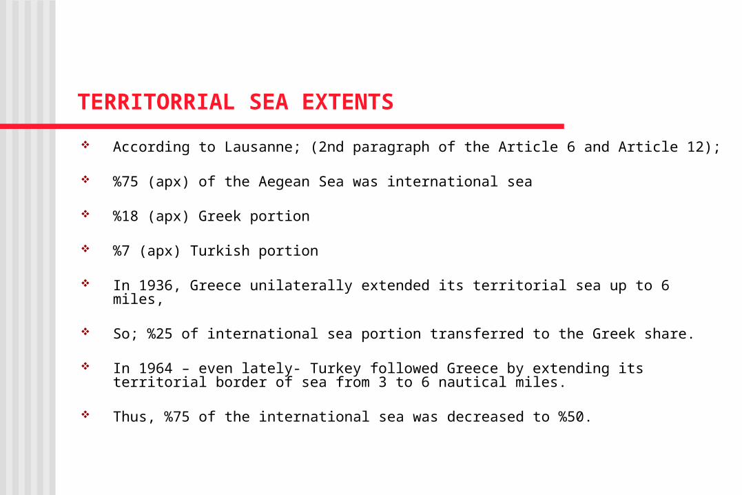
According to Lausanne; (2nd paragraph of the Article 6 and Article 12);
%75 (apx) of the Aegean Sea was international sea
%18 (apx) Greek portion
%7 (apx) Turkish portion
In 1936, Greece unilaterally extended its territorial sea up to 6 miles,
So; %25 of international sea portion transferred to the Greek share.
In 1964 – even lately- Turkey followed Greece by extending its territorial border of sea from 3 to 6 nautical miles.
Thus, %75 of the international sea was decreased to %50.

If Greece would succeed to extend its territorial breath to 12 nautical miles;
The international sea portion will decrease up to %20,
Greek territory would have extended to %60.33,
Turkish territory would be as %9- %10,65 ( maximum, with the island and isles which have not transferred to Greece) %90 of the Aegean continental shelf would be in Greece
sovereignty

In current situation of 6 nautical miles practice;
Greece has the %35
Turkey has the %8.8 of the Aegean Sea.
Greece insist on the right of twelve miles breath due to the 3rd article of the UNCLOS
UNITED NATIONS COVENTION ON LAW OF THE SEA (UNCLOS) 1982
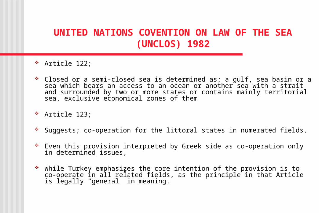
Article 122;
Closed or a semi-closed sea is determined as; a gulf, sea basin or a sea which bears an access to an ocean or another sea with a strait and surrounded by two or more states or contains mainly territorial sea, exclusive economical zones of them
Article 123;
Suggests; co-operation for the littoral states in numerated fields.
Even this provision interpreted by Greek side as co-operation only in determined issues,
While Turkey emphasizes the core intention of the provision is to co-operate in all related fields, as the principle in that Article is legally “general” in meaning.

Article 70;
Determines the “geographically inconvenient states” -Littoral states in the closed or semi-closed sea presented as “inconvenient states”
All supports Turkey’s thesis, on the complex status of Aegean Sea.

If Greek claims would have been implicated;
It would prepare imprisonment for Turkey by reducing its territorial sea,
Also obstruct the peaceful movement of the ships of other states through international sea, without entering Greek territorial waters.
General principles of law; which considers the limitation of “the performance or the enjoyment of any right -even ownership- should not be exceeded in order to violate the right of others” would be ignored.
“Golden balance” of Lausanne constructed between Turkey and Greece to benefit equally in the Aegean Sea in economical, commercial, navigation and security fields could not be preserved.
The Turkish sovereignty over the all Aegean islands has continued until that time;
The Aegean islands of;
Eğriboz,
North Sporades,
The Cyclades group was ceded to Greece by the Ottoman Empire.
Çuha and Küçük Çuha islands transferred by Britain in l864,
Girit was transferred in 1913 to Greece.
By the emergence of Greece in 24th July 1830
The Lausanne Treaty (by Articles 12 and 15 of this Treaty)
Turkey’s sovereignty over Gökçeada, Bozcaada and Tavşan islands was confirmed.
All islands within 3 miles to the Turkish coast was left to Turkey,
Except; Limni, Semadirek, Midilli, Sakız, Sisam and Ahikerya islands.
Islands of Taşoz, Bozbaba, and Ispara ,
Meis and other 13 islands with their dependent islets and rocks were also ceded to Greece.
Menteşe islands and their dependents were, however ceded to Italy.
By Article 16, Turkey reserved its right on their future situation.
The 28th December 1932 Protocol;
Between subordinate officials of the Turkey and Italy
Unaccepted, non ratified and unimplemented

The Paris Treaty, in 1947
Contains the transfer of the all islands, and adjacent isles and rocks under Italian territory that had obtain from Turkey with the Lausanne Treaty, to Greece
Turkey was not a part of it.
It has also limited contain of islands in legal means.
So as a result; all islands, isles and rocks which have not been included that transfer facility are still supposed to be under the Turkish sovereignty.
A CONTINENTAL MARGIN
Continental shelf Continental slope Continental rise Continental shelf begins in the shores of the continent and continues
up to the 200 meters deep. However the determination in UNCLOS 1982 was made according to
cover all those 3 concepts. To Greece the breath of its continental shelf, as lying from its own
continent up to the mid line which will drawn between the east edge of its islands and the western coasts of Turkish continent.
To Turkey, due to “equity” means; East Aegean islands should not
have continental shelf of their own.
THE INTERNATIONAL COURT DECISIONS
Both in “negotiations” or “third party involvement” processes;
There are two main methods;
Delimitation due to the median line
Delimitation due to the equity
Those principles are only guidelines, rather than solid conditions.
Greece is relying on the median line (equal distance) principle of the 1958 Treaty,
Turkey defends that provision will not be implicated under the special circumstances.
Thus, the presence of that situation of number of Greek islands, which are very close to its coasts, in that semi-closed sea region should be evaluated as “special circumstances.”

IN BRITISH v. FRANCE CASE Geographical and political entirety has not implicated. Delimitation has initially drawn between the continents Then granted specific 12 miles of spheres for Channel
Islands. Due to the Article 6 of the 1958 Geneva Continental-shelf
Treaty; a joint provision which is the compilation of the rule of median line and specific circumstances is determined.

IN LIBYA v. MALTA CASE Bears similar procedure like British Channel case
ICJ first drew a line for a continental delimitation between the Italy and Libya assuming Malta as an island of Italy
Only after that, evaluated the island’s situation.
ICJ declared that delimitation of the sea territories between the neighbor states was the inevitable consequences of the geographical situation in Mediterranean Sea
There are examples of the application of equity principle; in order to prevent the violation of one state’s extension to other, or as a matter of not possible to form the geography.

IN GULF OF MAINE CASE
Its Between United States and Canada,
ICJ rejected the customary law conversion of the principle of equal distance, as not preferable to give that principle a key implication
Equity method discussed intensively.
In that case, the court declared the core principle, in 3 parts;
1. Realizing a consequence, constructed upon equity by implication of fair criteria
2. Using practical methods in the frame of the geographical situation,
3. Caring other related conditions of the region
IN NORDIC SEA CASE
Germany has insisted on the equity method,
Denmark and Holland defended the median line process,
ICJ has been rejected both claims.
According to the Court, the median line method is just one of the applicable methods and it might be used only it provides equity and fairness.

IN THE JAN MAYEN CASE
Its between the Myen island of Norway and Denmark’s Greenland
ICJ delimitated the fisheries between them with two main lines which touches each other at the end.

IN ERITREA v. YEMEN CASE
“The equal distance” applied with a “median line” between the continents, has been ignored to tolerate any effect of islands due to the non-encroachment principle.
IN QATAR v. BAHRAIN CASE
The court relied on the equal distance principle
It modified the border line due to the islands situation
Also cared even the ebb and flow regime in the region

IN CAMEROON v. NIGERIA CASE
There would not be any requirement of specific application, because of the absence of islands,
Though the court declared that it would be started by equal distance principle and than search particular conditions.
AIRSPACE & FIR In Aegean Sea both littoral states have 6 nautical miles of airspace,
beginning from their continental coasts, just over their territorial waters.
Contrarily Greece thinks that its airspace is ten nautical miles, which extends beyond its territory
Turkey refused to recognize that breadth of airspace and solidify its declaration by sending its aircraft into that four miles zone.
In ICAO meeting in 1952, the Flight Information Region (FIR) for the west of the Turkish-Greek territorial sea boundary was decided to leave Athens and East of that border line to Istanbul.

4 August 1974, issuing a well known NOTAM 714 –Notice to Airmen- Turkey unilaterally declared every aircraft which might pass the median line in Aegean Sea had to submit their positions and flight plans to Turkey.
As a reply, Greece declared its rejection and also issued its own NOTAM 1157; that air corridor to Turkey was not safe anymore because of the contradicting controls, so all international direct flights canceled between two states.
After reducing the tension of Cyprus issue Turkey was withdrawn it’s NOTAM and Greece followed it in response.
Greece also creating fiction areas such as; “terminal control area” around the island of Lemnos of 3000 square miles breadth.

MILITARIZATION OF THE EAST AEGEAN ISLANDS
(There are 3 categories of Greek islands subjected to demilitarization in the Eastern part of Aegean Sea according to the international treaties)
1. Limni (Lemnos) and Semadirek (Samothrace) islands of Greece which (also called Boğazönü islands) are demilitarized by Article 12 of Lausanne Treaty and also Article 4 of the Lausanne Convention Relating the Regime of the Straits, as being closed to the Turkish Straits. (Turkey’s Bozcaada and Gökçeada islands are included in that limitation as well)
2. Midilli, Sakız, Sisam Nikaria (Mytilene, Samos, Chios, and Nikaria) islands of Northeastern, where only police and gendarmerie forces are permitted by Article 12 and 13 of the Lausanne Treaty.
3. The last category is Onikadalar (Dodecanese) islands, which comprise 14 islands only sufficient amount of force for keeping order can be installed, due to the Article 14 of Paris Peace Treaty.
Greece has militarized those islands violating the provisions of those treaties utilizing every possibility in the past.