Embed Size (px)
Citation preview
Sensitive and Rare Plant Species Inventory
in the Salt River and Wyoming Ranges,
Bridger-Teton National Forest
Prepared for
Bridger-Teton National Forest
P.O. Box 1888
Jackson, WY 83001
by
Bonnie Heidel
Wyoming Natural Diversity Database
University of Wyoming
Dept 3381, 1000 E. University Avenue
University of Wyoming
Laramie, WY
21 February 2012
Cooperative Agreement No. 07-CS-11040300-019

ii
ABSTRACT
Three sensitive and two other Wyoming species of concern were inventoried in the
Wyoming and Salt River Ranges at over 20 locations. The results provided a significant set
of trend data for Payson’s milkvetch (Astragalus paysonii), expanded the known distribution
of Robbin’s milkvetch (Astragalus robbinsii var. minor), and relocated and expanded the
local distributions of three calciphilic species at select sites as a springboard for expanded
surveys. Results to date are presented with the rest of species’ information for sensitive
species program reference. This report is submitted as an interim report representing the
format of a final report. Tentative priorities for 2012 work include new Payson’s milkvetch
surveys in major recent wildfires, and expanded Rockcress draba (Draba globosa) surveys,
both intended to fill key gaps in status information that contribute to maintenance of sensitive
plant resources and information on the Forest.
ACKNOWLEDGEMENTS
All 2011 field surveys of Payson’s milkvetch (Astragalus paysonii) were conducted
by Klara Varga. These and the rest of 2011 surveys built on the 2010 work of Hollis
Marriott and the earlier work of she and Walter Fertig as lead botanists of Wyoming Natural
Diversity Database. This project was initially coordinated by Faith Ryan (Bridger-Teton
National Forest), with the current coordination and consultation of Gary Hanvey and Tyler
Johnson. Lara Oles provided a Geographic Information System (GIS) layer of wildfires
mapped on Bridger-Teton National Forest and collaborated in the survey of Payson’s
bladderpod (Lesquerella paysonii) on Deadline Ridge. The interest and support of Bridger-
Teton NF staff and Teresa Prendusi (Intermountain Region of U.S. Forest Service) are
acknowledged with appreciation. Joy Handley (Wyoming Natural Diversity Database) set up
the GIS project used in planning and carrying out 2010-2011 field surveys. Tables of all
species’ record locations, associated species, and population data were constructed with the
help of Victoria Pennington. The assistance of two strangers and three tire companies is also
acknowledged. Use of Rocky Mountain Herbarium resources and facilities was essential to
this project. This report is dedicated to Edwin and Lois Payson, who first discovered or
described four of the five species addressed in this study.
Literature citation:
Heidel, B. 2012. Sensitive and rare plant species inventory in the Salt River and Wyoming
Ranges, Bridger-Teton National Forest. Wyoming Natural Diversity Database. Laramie, WY.
iii
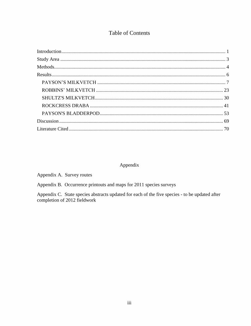
Table of Contents
Introduction ..................................................................................................................................... 1
Study Area ...................................................................................................................................... 3
Methods........................................................................................................................................... 4
Results ............................................................................................................................................. 6
PAYSON’S MILKVETCH ........................................................................................................ 7
ROBBINS’ MILKVETCH ....................................................................................................... 23
SHULTZ'S MILKVETCH ........................................................................................................ 30
ROCKCRESS DRABA ............................................................................................................ 41
PAYSON'S BLADDERPOD .................................................................................................... 53
Discussion ..................................................................................................................................... 69
Literature Cited ............................................................................................................................. 70
Appendix
Appendix A. Survey routes
Appendix B. Occurrence printouts and maps for 2011 species surveys
Appendix C. State species abstracts updated for each of the five species - to be updated after
completion of 2012 fieldwork

iv
TABLES AND FIGURES
Table 1. Sensitive and rare plant species in the Bridger-Teton National Forest; known or potentially
in the Wyoming or Salt River Ranges
Table 2. Climate conditions east and west of the Wyoming and Salt River Ranges
Table 3. Occurrences of Payson’s milkvetch (Astragalus paysonii) in Wyoming
Table 4. Plants associated with Payson’s milkvetch (Astragalus paysonii) in Wyoming
Table 5. Population information for Payson’s milkvetch (Astragalus paysonii) in Wyoming
Table 6. Occurrences of Robbins’ milkvetch (Astragalus robbinsii var. minor) in Wyoming
Table 7. Plants associated with Robbins’ milkvetch (Astragalus robbinsii var. minor)
Table 8. Population information for Robbins’ milkvetch (Astragalus robbinsii var. minor)
Table 9. Occurrences of Shultz’s milkvetch (Astragalus shultziorum) in Wyoming
Table 10. Plants associated with Shultz’s milkvetch (Astragalus shultziorum) in Wyoming
Table 11. Population information for Shultz’s milkvetch (Astragalus shultziorum) in Wyoming
Table 12. Occurrences of Rockcress draba (Draba globosa) in Wyoming
Table 13. Plants associated with Rockcress draba (Draba globosa) in Wyoming
Table 14. Population information for Rockcress draba (Draba globosa) in Wyoming
Table 15. Occurrences of Payson’s bladderpod (Lesquerella paysonii) in Wyoming
Table 16. Plants associated with Payson’s bladderpod (Lesquerella paysonii) in Wyoming
Table 17. Population information for Payson’s bladderpod (Lesquerella paysonii) in Wyoming
Figure 1. Study area in the Salt River and Wyoming Ranges, Bridger-Teton National Forest
Figure 2. Astragalus paysonii illustration
Figure 3. Astragalus paysonii in flower
Figure 4. Astragalus paysonii in fruit
Figure 5. Distribution of Payson’s milkvetch (Astragalus paysonii)
Figures 6 and 7. Wildfire habitat of Astragalus paysonii on North Horse Creek
Figure 8. Clearcut habitat of Astragalus paysonii
Figure 9. Astragalus robbinsii var. minor illustration
Figure 10. Astragalus robbinsii var. minor in flower
Figure 11. Astragalus robbinsii var. minor, whole plant, in fruit
Figure 12. Distribution of Robbins’ milkvetch (Astragalus robbinsii var. minor)
Figures 13 and 14. Riparian habitat of Astragalus robbinsii var. minor
Figure 15. Astragalus shultziorum illustration
Figure 16. Astragalus shultziorum in flower
Figure 17. Distribution of Shultz’s milkvetch (Astragalus shultziorum)
Figures 18-20. Habitat of Astragalus shultziorum in the study area
Figure 21. Habitat of Astragalus shultziorum in the Teton Range
Figure 22. Draba globosa illustration
Figure 23. Draba globosa specimen in fruit
Figure 24. Distribution of Rockcress draba (Draba globosa)
Figures 25 and 26. Habitat of Draba globosa in the Salt River Range
Figure 27. Lesquerella paysonii illustration
Figure 28. Lesquerella paysonii in flower
Figure 29. Lesquerella paysonii in fruit
Figure 30. Distribution of Payson’s bladderpod (Lesquerella paysonii)
Figure 31. Habitat of Lesqerella paysonii on Deadline Ridge
Figure 32. Habitat of Lesquerella paysonii in the Teton Range
Figure 33. Topographic position of Lesquerella paysonii on the landscape
Figure 34. Lesquerella paysonii in bladed roadside
Figure 35. Lesquerella paysonii in pipeline corridor

1
Introduction
The purpose of the project was to systematically survey sensitive and other rare plant
species targets in the Wyoming and Salt River Ranges, on the Big Piney, Kemmerer and
parts of the Greys River Districts of the Bridger-Teton National Forest. The project began in
2009 by concerted updating and digitizing of rare plant records in the study area. In 2010,
select areas and zones above 9000 feet were made the target of pilot surveys for a suite of
species in the Sheep Pass, Cottonwood Creek, and Swift Creek areas (Marriott 2010). In
2011, four species in select places were identified as priorities for surveys based on existing
documentation and information needs.
The sensitive plant list is that of the U.S. Forest Service – Intermountain Region
(USFS R4 1994). The sensitive species lists and policies by USFS R4 have been developed
to address management needs for plant species that might qualify for listing under the
Endangered Species Act (USDA FS 1994) in order to prevent agency actions from leading to
the further endangerment of sensitive species and subsequent need for listing them under the
Act. Other rare species targets include all other Wyoming plant species of concern (Heidel
2007) known or suspected from the Wyoming and Salt River Ranges (Table 1), with 2011
priorities and other status information added.
The state of current knowledge about rare plants species in the study area draws from
floristic documentation that provided information on the common and rare flora alike (Shultz
and Shultz 1979, Hartman and Nelson 1993, 1994) and on earliest rare species surveys
(Shultz and Shultz 1978). It also reflects the work of local expert, Orval Harrison (Harrison
2010), and builds on systematic surveys that were previously conducted in the area for three
rare species for the Bridger-Teton National Forest: Payson’s bladderpod (Fertig 1997),
Payson’s milkvetch (Astragalus paysonii) and Boreal draba (Draba borealis; Fertig and
Marriott 1993) and other targets (Fertig 1999). Surveys in 1994 and 1997-1998 focused
primarily on potential rare plant habitats in alpine calcareous sites outside the study area in
the northern Wind River and Gros Ventre ranges and montane slopes in the Hoback Canyon
area, with new data produced for Rockcress draba (Draba globosa) and Woolly fleabane
(Erigeron lanatus), and negative data and new hypotheses for Soft aster (Aster mollis;
Symphyotrichon molle)(Fertig 1999). In 2000, status overview information was compiled on
the 127 Wyoming plant species of concern known or suspected from the Intermountain
Region of the U.S. Forest Service in Wyoming, including Bridger-Teton, Ashley, Caribou-
Targhee and Wasatch-Cache National Forests (Fertig 2000). Finally, in 2004, a literature
review of Draba globosa rangewide status was prepared for the U.S. Forest Service – Rocky
Mountain Region (Ladyman 2004).
The overall project goal is to identify and address gaps in the status information
among sensitive species in the Wyoming and Salt River Ranges in particular. This report is
submitted as an interim document for review, highlighting the new information as it sheds
light on the current species’ status, and setting the balance of survey priorities in 2012. After
the 2012 field season, the report will be updated and submitted as a final. Tentative priorities
for 2012 surveys are presented in the Discussion section.
2
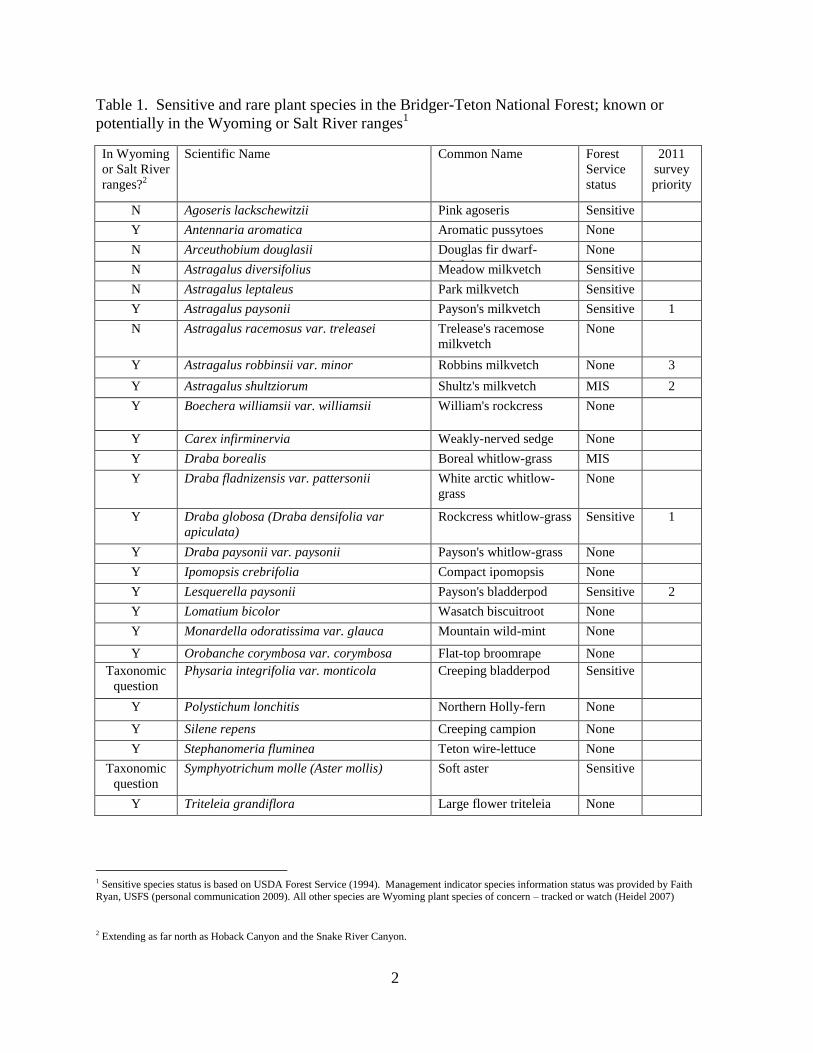
Table 1. Sensitive and rare plant species in the Bridger-Teton National Forest; known or
potentially in the Wyoming or Salt River ranges1
In Wyoming
or Salt River
ranges?2
Scientific Name Common Name Forest
Service
status
2011
survey
priority
N Agoseris lackschewitzii Pink agoseris Sensitive
Y Antennaria aromatica Aromatic pussytoes None
N Arceuthobium douglasii Douglas fir dwarf-
mistletoe
None
N Astragalus diversifolius Meadow milkvetch Sensitive
N Astragalus leptaleus Park milkvetch Sensitive
Y Astragalus paysonii Payson's milkvetch Sensitive 1
N Astragalus racemosus var. treleasei Trelease's racemose
milkvetch
None
Y Astragalus robbinsii var. minor Robbins milkvetch None 3
Y Astragalus shultziorum Shultz's milkvetch MIS 2
Y Boechera williamsii var. williamsii William's rockcress None
Y Carex infirminervia Weakly-nerved sedge None
Y Draba borealis Boreal whitlow-grass MIS
Y Draba fladnizensis var. pattersonii White arctic whitlow-
grass
None
Y Draba globosa (Draba densifolia var
apiculata)
Rockcress whitlow-grass Sensitive 1
Y Draba paysonii var. paysonii Payson's whitlow-grass None
Y Ipomopsis crebrifolia Compact ipomopsis None
Y Lesquerella paysonii Payson's bladderpod Sensitive 2
Y Lomatium bicolor Wasatch biscuitroot None
Y Monardella odoratissima var. glauca Mountain wild-mint None
Y Orobanche corymbosa var. corymbosa Flat-top broomrape None
Taxonomic
question
Physaria integrifolia var. monticola Creeping bladderpod Sensitive
Y Polystichum lonchitis Northern Holly-fern None
Y Silene repens Creeping campion None
Y Stephanomeria fluminea Teton wire-lettuce None
Taxonomic
question
Symphyotrichum molle (Aster mollis) Soft aster Sensitive
Y Triteleia grandiflora Large flower triteleia None
1 Sensitive species status is based on USDA Forest Service (1994). Management indicator species information status was provided by Faith Ryan, USFS (personal communication 2009). All other species are Wyoming plant species of concern – tracked or watch (Heidel 2007)
2 Extending as far north as Hoback Canyon and the Snake River Canyon.

3
Figure 1. Study area in the Salt River and Wyoming Ranges, Bridger-Teton National Forest
in west-central Wyoming
Study Area
The Salt River and Wyoming Ranges are major landforms in the Thrust Belt, part of
the North American Overthrust Belt. The stratigraphy, structural style of deformation, and
geologic history of the Thrust Belt differs from other mountains in the state. The Thrust Belt
mountains were not formed as major uplifts in Precambrian basement core. Instead, the
Thrust Belt contains a thick (more than 40,000 feet) sequence of Precambrian, Paleozoic, and
Mesozoic sedimentary rocks with no crystalline basement involved in the deformation.
Essentially, the Belt was formed “…during an episode of mountain building called the Sevier
Orogeny, from 150 to about 55 million years ago. In it, continental crust on the westward-
moving North American plate collided with oceanic crust of the eastward-moving Pacific
plate forcing large sheets of rock eastward, deforming and uplifting them in a series of
overlapping, low-angle thrust faults, arranged much like shingles on a roof “(Wyoming
Geological Survey 2012). The resulting series north-south trending landforms comprised of
resistant Paleozoic rocks, mainly shallow-water marine limestone, dolomite, and fine-grained
sandstone, that are the dominant structural component of all major thrust sheets (Royse
1993). These are generally thrust over less resistant Mesozoic marine shales and sandstones
in the footwall by the thrusts (Royse 1993). The Thrust Belt is comprised of five major
thrust fault systems, and the three easternmost thrust fault systems, including the Darby,
Absaroka and Crawford (east to west, youngest to older) make up the Wyoming and Salt
River Ranges. A geologic map of the Afton Quadrangle (1:52,500; Rubey 1973) and the
SS SAA A
LL LTT T
RR R
II IVV V
EE ERR R
RR R
AA ANN N
GG GEE E
WW WYY Y
OO OMM M
II INN N
GG G RR R
AA ANN N
GG GEE E
National Forest boundaries

4
bedrock geology of Wyoming (Love and Christianson 1984) represent the geology of both
ranges. The Wyoming and Salt River Ranges extend as far north as the Snake River Canyon
and Hoback Canyon, respectively; though for purposes of this project, the later was excluded.
The prevailing vegetation types are dominated by lodgepole pine (Pinus contorta)
spanning much of the montane zone (7000-9000 ft). An overview of disturbance regimes in
lodgepole pine systems of Wyoming is presented by Knight (1994). There are not studies
available on fire return intervals in the study area but wildfire boundaries have been digitized
by the Forest (USDA Forest Service 2011), and major recent fires (1991-2010) cover ca. 5 %
of the study area as mapped. The history of fire suppression on one hand and the current
spread of bark beetles and blister rust on the other potentially alter the natural disturbance
regime.
The annual hydrologic budget of lodgepole pine systems in Wyoming is strongly
influenced by snowfall, as also presented by Knight (1994). The mean annual precipitation
ranges from 30.5-152.5 cm (12-60 in), increasing with elevation and in moving northward.
There are very steep precipitation gradients and lower values on the east side of the
Wyoming Range compared to the west side of the Salt River Range. There are no National
Oceanic and Atmospheric Administration (NOAA) climate stations within the ranges, but
there are ten standard SNOTEL sensors with the ranges, and the nearest NOAA stations at
Afton and Big Piney provide an overview of foothills conditions and east-west contrasts
(Table 2; USDI NOAA 2005).
Table 2. Climate conditions east and west of the Wyoming and Salt River Ranges
Climate variable Afton
(1957-2005)
Big Piney
(1948-2005)
Mean annual precipitation
cm (in)
50.5
(19.9)
19.1
(7.5)
Average total snowfall
cm (in)
293.1
(115.4)
72.6
(28.6)
Mean % contribution of snowfall
to total annual ppt.
94.5% 64.3%
Mean monthly temperature
Cº (Fº)
3.9
(39.0)
1.7
(35.1)
January mean minimum temperature
Cº (Fº)
-15.3
(4.5)
-20.7
(-5.3)
July mean maximum temperature
Cº (Fº)
27.4
(81.4)
26.7
(80.0)
Methods
Surveys were conducted by two botanists working independently for a total of 15
days in July and August 2011. Each of the four species targets had a different slate of
background information and survey objectives.

5
Payson’s milkvetch (Astragalus paysonii) is a sensitive species of forested habitat
that is currently known from two areas in the country, one being the study area. More than
any other target species, it is almost restricted to the study area. It was first discovered in the
Wyoming Range when it was collected in 1922 “from burned areas in forest.” Surveys in
1992 documented that it was widespread in the study area but in extremely low numbers at
all but a few places, and in an array of disturbed habitat (Fertig 1993). No subsequent
information on it has come from the study area, though it was recently surveyed in the Snake
River Canyon. It has been hypothesized that Payson’s milkvetch is a successional species
adapted to natural disturbances such as wildfire, such that its viability hinges on fire regime
and on the interchangeability of man-made disturbance for natural disturbance.
Therefore, the 2011 objectives were to survey all the largest populations identified in
previous survey sites, i.e., those reported as having more than 100 plants (Fertig and Marritt
1993), and all known records in the vicinity of recent wildfires. Information on Payson’s
milkvetch was compiled and Geographic Information System (GIS) shapefiles were
incorporated representing all wildfire mapping in the study area for wildfires that had burned
since the 1992 surveys. Surveys were conducted by Klara Varga from 12-18 July.
Rockcress draba (Draba globosa) is a sensitive species of alpine habitat that extends
from southwestern Montana to northern Utah and central Colorado. It had not been
systematically surveyed in the study area but was known from one collection made by Orval
Harrison, who also provided detailed field notes describing the original locations. Rockcress
draba is one of the few sensitive species in sheep allotments, and so this record was identified
as a priority for relocating and surveying as basis for allotment management planning.
Therefore, the 2011 objective was to relocate the known locale and determine its
extent in the surroundings for potential application elsewhere in the study area. Information
on the one Rockcress draba record, including field notes from 2010 surveys (Appendix B in
Marriott 2010), was compiled with GIS mapping of it. Rockcress draba is a calciphile, so
digital information representing bedrock geology (Love and Christianson 1984, Rubey 1973)
with known distribution was superimposed to help identify suitable habitat. Survey was
conducted by Bonnie Heidel on 22 August.
Payson’s bladderpod (Lesquerella paysonii) is a sensitive species of open montane to
alpine habitat that is known from limited areas of Idaho and Wyoming, and the study area
constitutes a large part of the latter. Many collections of it were made in the course of
floristic documentation. The most recent surveys for it were conducted in the Teton Range
of the Targhee National Forest where keeled bladderpod (Lesquerella carinata var. carinata)
was found instead (Mancuso and Heidel 2008). Payson’s bladderpod is one of the few
sensitive species known in an area of the Forest currently being considered for prescribed
burn treatment, where it was only known from a single collection record. So this area was
made a test case priority for relocating and surveying it.
Therefore, the 2011 objective was to relocate the known record and determine its
extent in the surroundings, using it as a springboard for evaluating the merit of expanded

6
surveys at other collection sites. Information on the Payson’s bladderpod record on Deadline
Ridge was compiled. Payson’s bladderpod is a calciphile, so digital information representing
bedrock geology (Love and Christiansen 1984) with known distribution was superimposed to
help identify suitable habitat. Survey was conducted by Bonnie Heidel on 22-23 August.
Robbins’ milkvetch (Astragalus robbinsii var. minor) is a taxon of riparian habitat
with no USFS status. Though it extends from Alaska to New Mexico, it has a discontinuous
range and is only known in Wyoming from the study area. It had not been systematically
surveyed but documented by a few collections. Robbins milkvetch was identified by
WYNDD as a state priority species to include in surveys.
Therefore, the 2011 objective was to conduct new surveys to expand its distribution
within and between watersheds. Information on Robbins’ milkvetch was compiled and
incorporated with a Geographic Information System (GIS) shapefile representing National
Wetland Inventory mapping (USDI Fish and Wildlife Service 2011). Survey was conducted
by Bonnie Heidel on 23-26 July.
In preparation for fieldwork, the known distribution of the four species targets was
superimposed on digital orthophotographs and printed out as quarter-quads at about the same
scale as USGS topographic maps, along with other information (wildfire and geology
mapping) for reference in field surveys. The survey form used to record species of concern
information is presented in Appendix A. All 2011 survey routes are represented in Appendix
B. Vouchers were collected of target species and associated species, and deposited in the
Rocky Mountain Herbarium.
Results
New survey information was collected on the four target species, plus a fifth species
of interest that was documented incidental to Rockcress draba surveys and among those
addressed by Marriott (2010). All of the five species have been addressed in previous
WYNDD reports, and the reader is referred to the earlier work for the original status
interpretation and lengthier treatments in some cases. The following treatments for the five
species are presented as Region 4 status compilations with emphasis on the Wyoming and
Salt River ranges.
In addition, one field day was used to survey wetland habitat for sensitive species not
currently known from the Wyoming and Salt River Ranges, including Pink agoseris
(Agoseris lackschewitzii) and Park milkvetch (Astragalus leptaleus). Survey was
concentrated in a series of wetlands near Poison Meadows. No target species were found.
The following pages present the most current available information on the
identification, distribution and habitat information of the five documented species,
highlighting their distribution and habitat in the study area, supported by tables and maps that
provide status information at a glance. Printouts of all occurrences documented in 2011
surveys are presented in Appendix C.

7
PAYSON’S MILKVETCH
Astragalus paysonii (Rydb.) Barneby
Classification
Scientific name: Astragalus paysonii (Rydb.) Barneby
First described as Hamosa paysonii by Rydberg (1927) and transferred to the Astragalus
genus by Barneby (1944).
Synonyms: none
Common name: Payson’s milkvetch
Family: Fabaceae
Size of genus: There are 62 species of Astragalus reported for Wyoming in Dorn (2001), not
including distinctions at the variety level. The Astragalus genus is comprised of 375 species
(Barneby 1964) plus at least 20 more recent additions (Isely 1998). This does not include
taxa below the species level.
Phylogenetic relationships: A member of sect. Miselli (Barneby 1964), most closely related
to A. umbraticus of California and Oregon.
Present legal or other formal status
U.S. Fish & Wildlife Service: None (Former C2 candidate for listing under the Endangered
Species Act.)
U.S. Forest Service – Intermountain Region: sensitive
Global Heritage rank: G3
State Legal status: none
State Heritage rank: The more recent list update (Heidel 2007) reported a state rank of S2.
Wyoming contribution rank: Conservation of Payson’s milkvetch as a regional endemic in a
core part of its distribution is High. It was similarly identified as a high priority for USFS
conservation attention by Fertig (2000) as a regional endemic under potential threats.
Description
Technical description: Payson's milkvetch is an upright, multi-stemmed perennial herb
growing to 50 cm tall. Stem leaves are 4-9 cm long and pinnately compound with 7-15 oval
to wedge-shaped leaflets. Stipules are free to the base. The small, pea-like flowers are white
with a tinge of lilac and are borne in numerous, loose, axillary racemes. Fruit pods are
crescent-shaped, 10-17 mm long, and glabrous or white-hairy. Each fruit has a distinct
groove on the upper side and has two separate locules. At maturity, fruits are straw-colored
and deflexed (Hitchcock and Cronquist 1961, USDA Forest Service 1991, Dorn 2001, Fertig
and Marriott 1993, Fertig et al. 1994).
Similar species: Astragalus agrestis has a congested inflorescence and ascending fruits. A.
canadensis has cream or pale yellow flowers, a congested inflorescence, and erect fruits. A.
alpinus has black-haired fruit and fused stipules. In the absence of fruits or flowers,
Hedysarum spp. can be distinguished by their united stipules and conspicuously veiny
leaflets (Dorn 2001; Fertig and Marriott 1993; Fertig et al. 1994).
Prominent field characters: Thin textured, bi-colored leaflets with notched tips. White
flowers and black hairs on the calyx. Crescent-shaped pendulous pods on slender stipes

8
(Shultz and Shultz 1978). The pods are flat-looking, even though they are triquetrous in
cross-section.
Figure 3: Astragalus paysonii in flower,
by K. Varga
Figure 2. Astragalus paysonii illustration, by Jane Dorn,
from Dorn & Dorn (1980)
Figure 4. (right) Astragalus paysonii in fruit, by B. Heidel
Phenology: Flowers from late June to early August.
Fruits produced from July-October. The plant is most
readily located when in flower. Fruits fall to the ground
when they dry out and plants sometimes completely desiccate
in the latter part of the growing season.
The phenology at any one place varies with setting and climate. In 2011, a particularly wet
year, only flowering plants were found during the first half of July. However, in early July of
2007, only late fruiting plants were found in the Snake River population, representing a more
typical year and the lowest-elevation Wyoming population (Mancuso and Heidel 2008).
L08AC14952

9
Geographical distribution
Range: Regional endemic of the Clearwater Mountains of north-central Idaho, historically
from the Palisades Reservoir area of east-central Idaho, and from western Wyoming,
including the Wyoming, Salt River, Snake and Gros Ventre ranges (Lincoln, Teton, and
Sublette counties; Barneby 1964, Rocky Mountain Herbarium 2011).
The Salt River and the Wyoming Ranges include most of species’ distribution in Wyoming.
Its discovery on the Gros Ventre Range was made in 1994, where it was found along Little
Granite Creek. It might also be considered as extending to the Snake River Range because it
is known from the Snake River corridor, where it was recently surveyed in 2007. There it
appears to be completely restricted to roadsides and other zones of human disturbance. It
may have been an upstream extension of the historic occurrences around the Palisades
Reservoir area of Idaho.
All known Wyoming occurrences3 are on the Bridger-Teton National Forest, except for those
that are located in a unit of the Targhee National Forest that is under management of Bridger-
Teton National Forest, or extend into the federal highway corridor of U.S. Hwy. 26/89 in the
Snake River Canyon. In Idaho, Payson’s milkvetch has been documented from Nez Perce
National Forest (Idaho Co.), Challis National Forest (Custer Co.) and Targhee National
Forest (Bonneville CO.) as well as lands managed by the Couer d’Alene District of the BLM
and the state (Lorain 1990; unpublished records of the Idaho Natural Heritage Program). The
Challis and Targhee national forests are in Region 4 of the U.S. Forest Service. One
occurrence is protected within the proposed Fall Creek Special Botanical Area (Bridger-
Teton NF). All other occurrences are on National Forest lands managed for multiple use.
Extant sites: It is now known from 34 extant records documented since 1970 (Figure 5,
Table 3), if we assume that all recent records are extant and exclude the two that could not be
relocated in 2011. However, this successional species may be prone to local extirpation
where present in low numbers. With this level of uncertainty, its state rank was calculated
using different occurrence number tallies (4 large populations vs. 20 vs. 34 total extant
populations). The outcome ranged from S1-S3, and the species’ state rank remains ranked at
S2. Thirty-three of the extant occurrences are on Bridger-Teton National Forest.
Of the two occurrences on the Targhee National Forest, one was on a highway right-of-way
where there has since been widening, and it is considered extirpated (Mancuso and Heidel
2008).
In 2011, surveys targeted six of these recent occurrences and the one historic occurrence.
Two of the six could not be relocated and may be extirpated, but the historic occurrence was
relocated. This leaves the status of 28 occurrences unknown.
Historical sites: Prior to 2011, there was one record (#004) known only from a historical
collection, representing the 1922 discovery and type locality collected by Edwin and Lois
3 The term occurrence refers to best professional approximation of a population, based on interpretations that
integrates information sources over time and space.

10
Payson. The location was described as North Horse Creek, about 7 miles west of Merna.
The setting was described as “burned areas in forest”. The first attempt to search for it was
made in 1978 by John and Leila Shultz, who reported:
“In searching for the very place where Payson collected Astragalus paysonii in 1922, we
were guided by the type description itself. Early on we realized that the road crossing of
North Horse Creek had been changed and in fact the fill for the new road might possibly
have over-covered the exact site. However, we were able to find the traces of the old road as
it approached the river. Following the type description and fosuing on the granitic soil and
burned site destiption, we devoted three days to searching the general area but with no
success. We concluded with considerable confidence that this locality was no longer a site
for Astragalus paysonii” (Shultz and Shultz 1978).
In 2011, a GIS layer mapping of recent wildfires (1991-2010; USDA Forest Service 2011)
was provided by the Forest and it was determined that part of the North Horse Creek
landscape had burned (Mule Fire of 2003 and Horse Creek Fire of 2007). The area was
therefore included among those targeted for 2011 survey, where Payson’s milkvetch was
successfully documented at scattered North Horse Creek drainage locations within areas that
had burned by crownfire.
Unverified/Undocumented reports: None known.
Figure 5. Distribution of Payson’s milkvetch (Astragalus paysonii) in Region 4 of the U.S.
Forest Service (Wyoming)

11
Table 3. Occurrences of Payson’s milkvetch (Astragalus paysonii) in Wyoming
EO# Directions County Legal
Description
Elevation
m (ft)
USGS 7.5’
Quad
Public
Land
BRIDGER-TETON NATIONAL FOREST
001 Wyoming Range; Darby Creek
Basin, adjacent to Forest Service
Road 10141, ca 1.5 miles east of
south summit of Mount Darby, ca
22 air miles west of Big Piney.
Sublette T29N R115 Sec.
4, 9
2499-
2611
(8200-
8565)
Wyoming
Peak
Big Piney
RD
002 East slope Wyoming Range;
foothills due north of Edwards
Creek, ca 1 mile east of summit of
Mount Schidler, ca 22.5 air miles
west of Big Piney.
Sublette
T31N R115W
Sec. 22, 23, 26,
27
2591-
2731
(8500-
8960)
Mount
Schidler
Big Piney
RD
003 Wyoming Range; Middle Fork
Creek.
Lincoln,
Sublette
T30N R115W
Sec. 19, 30;
T30NR116W
Sec. 13, 23, 24,
25, 26
2926
(9600)
Wyoming
Peak
Big Piney
RD
004 Wyoming Range; along slopes
just east of Prospect Peak, along
North Horse and Pass creeks, ca
4-7.5 miles west of Merna.
Sublette
T34N R114W
Sec. 8, 9, 11, 17
2438-
2560
(8000-
8400)
Prospect
Peak
Big Piney
RD
005 Wyoming Range; Clear Creek. Lincoln T29N R116W
Sec. 14, 15, 16,
20, 21, 22, 23,
26, 27, 28
2195-
2804
(7200-
9200)
Graham
Peak, Mount
Thompson
Kemmerer
RD
006 Wyoming Range; Thompson Pass,
ca 1 mile south of summit of
Mount Thompson, ca 24 air miles
west of Big Piney.
Lincoln,
Sublette
T29N R115W
Sec. 19, 30;
T29N R116W
Sec. 24, 25
2621
(8600)
Mount
Thompson
Big Piney
RD,
Kemmerer
RD
007 East slope Wyoming Range; east
slope of Mount Darby, 0.1-0.5
miles west of Coal Creek Road, ca
22 air miles west of Big Piney.
Sublette T29N R115W
Sec. 4; T30N
R115W Sec. 28,
33
2530-
2682
(8300-
8800)
Wyoming
Peak
Big Piney
RD
008 Northern Wyoming Range; Bailey
Creek drainage, 1-1.5 miles south
of south shore of Bailey Lake,
1.75 miles north of McCain Guard
Station, ca 15 air miles east of
Alpine.
Lincoln T37N R116W
Sec. 23, 26, 27
2042-
2256
(6700-
7400)
Bailey Lake Greys
River RD
009 East slope Salt River Range; ca
0.5 air miles east of Murphy
Lakes, ca 0.75 miles north of Star
Peaks, ca 11 air miles southeast of
Alpine.
Lincoln T35N R117W
Sec. 6; T35N
R118W Sec. 1;
T36N R118W
Sec. 36
2048-
2073
(6720-
6800)
Deer Creek Greys
River RD
010 Northern Wyoming Range;
around Water Dog Lake and lake
to the southwest and along trail ca
0.3 mile west of the lake, ca 1
mile north of McCain Guard
Station, ca 16 air miles east of
Alpine.
Lincoln T36N R116W
Sec. 5; T37N
R116W Sec. 36
2134-
2256
(7000-
7400)
Bailey Lake,
Pickle Pass
Greys
River RD

12
011 Northern Wyoming Range; west
and southeast shore of Bailey
Lake, ca 14 air miles east of
Alpine.
Lincoln T37N R116W
Sec. 14, 15
1981-
2225
(6500-
7300)
Bailey Lake Greys
River RD
012 Sublette Range; Smith Fork Road,
ca 0.4 mile west of CCC Camp, ca
15.8 air miles south of Afton, ca
8.8 air miles south of Smoot.
Lincoln T29N R118W
Sec. 15, 16
2399
(7870)
Mount
Wagner,
Porcupine
Creek, Salt
Flat, Smoot
Greys
River RD
013 Salt River Range; Bear Creek, ca
1.3 miles west of Greys River, ca
15 air miles northeast of Afton.
Lincoln T33N R116W
Sec. 4, 5, 6, 7, 8,
9, 16, 17, 18, 19
2210
(7250)
Blind Bull
Creek, Park
Creek
Greys
River RD
014 West slope Wyoming Range;
Blind Bull Creek drainage, ca 1.75
air miles east of Greys River, ca
19 air miles northeast of Afton.
Lincoln T34N R116W
Sec. 9
2134
(7000)
Blind Bull
Creek
Greys
River RD
015 East slope Salt River Range;
South Three Forks Creek, ca 1.5
air miles west of Greys River, ca
11 air miles east-northeast of
Afton.
Lincoln T32N R117W
Sec. 12, 13
2316
(7600)
Park Creek Greys
River RD
016 East slope Wyoming Range;
Prospect Canyon, ca 1.5 miles east
of summit of Fish Creek
Mountain, ca 22 air miles west of
Big Piney.
Sublette T30N R115W
Sec. 21
2646
(8680)
Wyoming
Peak
Big Piney
RD
017 East slope Wyoming Range;
Dutch Dans Gulch Road, ca 3.5
air miles northeast of Middle
Piney Lake Campground, ca 21
air miles west-northwest of Big
Piney.
Sublette T31N R115W
Sec. 26
2658-
2670
(8720-
8760)
Mount
Schidler
Big Piney
RD
018 East slope Wyoming Range; Irene
Creek drainage, upper northeast
slopes and lower southeast slopes
of peak 8627, ca 1.5 mile
northeast of summit of Lander
Peak, ca 27 air miles northwest of
Big Piney.
Sublette T33N R115W
Sec. 25
2560-
2621
(8400-
8600)
Triple Peak Big Piney
RD
019 East slope Wyoming Range; ridge
0.5 miles south of Maki Creek, ca
31 air miles northwest of Big
Piney.
Sublette T33N R114W
Sec. 8
2591-
2621
(8500-
8600)
Maki Creek Big Piney
RD
020 Tunp Range; adjacent to Nugent
Park Road (Forest Service Road
10069), 2 locations (1) ca 0.6
miles west of Big Spring, ca 1.5
miles south of Kelley Guard
Station, (2) ca 0.6 miles southwest
of Big Spring, ca 2 air miles south
of Kelley Guard Station, ca 13.5
air miles northeast of Cokeville.
Lincoln T26N R117.5W
Sec. 13; T26N
R118W Sec. 13
2512-
2524
(8240-
8280)
Nugent Park Kemmerer
RD
021 East slope Salt River Range;
Greys River Valley, slopes ca 0.5
mile south of Corral Creek, ca 1
Lincoln T31N R116W
Sec. 17
2377
(7800)
Box Canyon
Creek
Greys
River RD

13
air mile west-southwest of Corral
Creek Guard Station, ca 13 air
miles east-southeast of Afton.
022 West slope Wyoming Range;
ridge between Greys River and
Box Canyon Creek, 1.5 air miles
south of Corral Creek Guard
Station.
Lincoln T31N R116W
Sec. 21
2560
(8400)
Box Canyon
Creek
Greys
River RD
023 Wyoming Range; northern end of
Absaroka Ridge, ca 1 miles west
of Scaler Guard Station, ca 26 air
miles west-southwest of Big
Piney.
Lincoln T28N R116W
Sec. 9
2743
(9000)
Mount
Thompson
Kemmerer
RD
024 East slope Wyoming Range;
South Beaver Creek and ridge to
the south, ca 3.5 air miles
northwest of Sherman Guard
Station, ca 19.5 air miles west-
northwest of Daniel Junction.
Sublette T35N R114W
Sec. 14, 23
2512-
2602
(8240-
8536)
Prospect
Peak
Big Piney
RD
025 Wyoming Range; 2 locations (1)
Deadman Mountain Trail, 1-2
miles south of trailhead, 3-3.5 air
miles north-northwest of
Deadman Mountain summit, (2)
adjacent to Little Greys River, ca
0.25 miles northwest of Hunting
Camp, ca 2 miles southeast of
Steer Creek.
Lincoln T36N R116W
Sec. 21, 22, 27,
28, 33, 34
2134-
2256
(7000-
7400)
Pickle Pass Greys
River RD
026 Wyoming Range; Deadman
Mountain Trail, ca 1.5-2.5 air
miles north of Deadman Mountain
summit.
Lincoln T35N R116W
Sec. 2, 3, 9, 10,
11, 14, 15;
T36N R116W
Sec. 34, 35
2469-
2804
(8100-
9200)
Pickle Pass Greys
River RD
027 Wyoming Range; "The Rim" and
area to southwest, ca 13 air miles
southeast of Bondurant.
Sublette T36N R112W
Sec 3; T37N
R111W Sec 31,
32
2426-
2451
(7960-
8040)
Pass Peak,
Signal Hill
Big Piney
RD
028 Wyoming Range; Stump Lake, ca
12 air miles southeast of Alpine
Junction.
Lincoln T36N R117W
Sec. 32, 33
2036-
2109
(6680-
6920)
Deer Creek Greys
River RD
029 Wyoming Range; at the fork of
Clark Draw, ca 3 air miles south
of Bondurant, ca 36 air miles
northwest of Pinedale.
Sublette T37N R113W
Sec. 20
2195
(7200)
Bondurant Big Piney
RD
030 Wyoming Range; ridge between
Buck and Sheep creeks, adjacent
to Buck Creek logging road, 1.9
road miles east-northeast of Greys
River Road.
Lincoln T33N R116W
Sec. 9, 10, 15,
16
2256
(7400)
Park Creek Greys
River RD
031 Tunp Range; 0.2-1 road miles
north of National Forest boundary,
ca 9 air miles northeast of
Cokeville.
Lincoln T25N R118W
Sec. 12
2493-
2512
(8180-
8240)
Nugent Park Kemmerer
RD
032 Salt River; southwest flank Lincoln T25N R116W 2499- Pole Creek Kemmerer
14
Comissary Ridge and ridge
between Pole and East Fork Pole
creeks.
Sec. 6, 7, 8, 17,
18; T25N
R117W Sec. 1,
12, 13
2591
(8200-
8500)
RD
033 Gros Ventre Mountains; (1) along
the Little Granite Creek Pack
Trail, between trailhead and Gros
Ventre Wilderness boundary, (2)
west-facing ridge near Boulder
Creek and Gros Ventre
Wilderness boundary, ca 3-4.5
miles north of U.S. Highway 189
at the confluence of Little Granite
Creek and the Hoback River.
Teton T39N R114W
Sec. 13, 14, 15,
22, 23, 24, 26,
27
2042-
2200
(6700-
7218)
Bull Creek,
Granite Falls
Jackson
RD
034 Southern Wyoming Range; ridge
on east side of Big Fall Creek
along 2-track logging road to
abandoned clearcut just below the
summit rim, ca 1.8 air miles north
of the Bridger-Teton National
Forest boundary, ca 2 air miles
northeast of confluence of Big
Fall Creek and LaBarge Creek.
Sublette T28N R115W
Sec. 20, 29
2621
(8600)
Mount
Thompson
Kemmerer
RD
037 Salt River/Wyoming Ranges; Cliff
Creek [ca 6 miles west of
Bondurant].
Sublette T37N R114W
Sec. 3, 4, 5, 8, 9,
10; T38N
R114W Sec. 21,
27, 28, 29
2073-
2499
(6800-
8200)
Clause Peak Big Piney
RD
OUTSIDE OF BRIDGER-TETON NATIONAL FOREST
035 Snake River Range; west bank of
the Snake R along US Hwy 26/89
from mouth of Cabin Cr Canyon
north ca 1 mile, ca 5 air miles
southwest of Hoback Junction.
Teton T38N R116W
Sec. 17, 20
1780-
1786
(5840-
5860)
Munger
Mountain,
Pine Creek
Targhee
NF
036 Snake River Range; Grand
Canyon of the Snake River, on
north side of US Highway 26/89
across from turnout to the Station
Creek Campground.
Lincoln T37N R117W
Sec. 2
1768
(5800)
Pine Creek Targhee
NF
Sites where present status not known: It is not known whether the 28 sites that have not been
collected or surveyed since 1992 persist.
Habitat
Settings and associated vegetation: Occurs primarily in disturbed areas such as recovering
burns, clear cuts, road cuts, and blow downs. Usually found on sandy soils with low cover of
forbs and grasses. Elevation 5850-9600 feet (Fertig and Marriott 1993, Mancuso and Heidel
2008).
Most of the past Wyoming surveys for this species have focused on man-made disturbance
(Shultz and Shultz 1978, Dorn 1978, Fertig and Marriott 1993)(Figure 10). The 2011 surveys
provided an initial opportunity to address fire response (Figures 6 and 7).

15
Figures 6 and 7. Wildfire habitat of Astragalus paysonii on North Horse Creek, by K. Varga
Figure 8. Clearcut habitat of
Astragalus paysonii, by Jane & Robert
Dorn, from Fertig et al. (1994)
Note: Astragalus paysonii plants in
dense patches in foreground
Geology of Astragalus paysonii habitats vary widely within the study area. It generally
decays to coarse sediment, often sandy, and appears to include the following mapping units:
Ankareh Formation, Thaynes Limestone, Woodside Shale and Dinwoody Formation
Aspen Shale Formation
Blind Bull Formation
Gannet Group
Nugget sandstone, Chugwater and Dinwoody Formations
Stump Formation, Preuss Sandstone or redbeds, and Twin Creek Limestone
Wasatch Formation
Quaternary deposits including: Glacial; Gravel pediment and fan; and Landslide
deposits.

16
Without precise location information, some of these geological units remain to be
confirmed, but they collectively represent large segments of the landscape and indicate that
its distribution is not limited by substrate.
Frequently associated species: Common associates of Astragalus paysonii are reported in
Table 4, as cited in three studies that represent different times and places of survey. It appears
to be associated more closely with environmental conditions than with a consistent guild of
species.
Table 4. Plants associated with Payson’s milkvetch (Astragalus paysonii) in Wyoming
Scientific name Common name Exotic/
Native
Rep
ort
ed i
n
20
11
surv
eys
Rep
ort
ed i
n
19
92
surv
eys
Rep
ort
ed i
n
19
78
surv
eys
Achillea millefolium Common yarrow Native X X X
Astragalus agrestis Cock's-head [Field milkvetch]
Native
Astragalus miser var.
hylophilus
Timber milkvetch
Native
Bromus inermis Smooth brome Exotic X X As B. anomalus?
Bromus carinatus Large mountain brome
[California brome]
Native X
Calamagrostis rubescens Pinegrass [Pine reedgrass]
Native X
Carduus nutans Musk thistle Exotic X X
Cirsium arvense Canada thistle Exotic X X
Cirsium foliosum Elk thistle
Native X
Cirsium vulgare Bull thistle
Exotic X
Collinsia parviflora Blue-eyed Mary Native X
Epilobium angustifolium Fireweed Native X
Eriophllyym lanatum Common woolly sunflower Native X
Geranium viscossisum Sticky geranium Native X X
Hedysarum occidentale Western sweet-vetch Native X
Iliamna rivularis Streambank globemallow
Native X X
Koeleria macrantha (K.
nitida)
Junegrass Native X
Lupinus argenteus Silver-stem lupine Native X X X As L. caudatus?
Mahonia repens Oregon grape Native X
Monarda pectinata Plains beebalm Native X
Poa compressa Flat-stem bluegrass [Canada bluegrass]
Exotic X
Poa pratensis Kentucky bluegrass Exotic X
Senecio integerrimus Western groundsel [Lamb-tongue
ragwort]
Native X
Taraxacum officinale Common dandelion Exotic X X
Thalictrum fendleri Fendler's meadow-rue
Native X
Trisetum spicatum Narrow false oat [Spike trisetum]
Native X
Vaccinium scoparium Grouseberry [Grouse whortleberry] Native X

17
It appears to be negatively-correlated with A. miser var. hylophilus, another legume adapted
to disturbed sites in the Wyoming/Salt River ranges (Shultz and Shultz 1978), which has
been characterized as a more successful competitor, particularly in open canopy sites (Fertig
and Marriott 1993).
Topography: Found mainly on gentle to moderate, well-drained slopes and benches.
Water and soil relationships: On North Horse Creek, which was the largest population
surveyed in 2011, it was noted as almost always present in microhabitats where the ground
was very bare and there were uncompacted mineral soils without duff (Varga survey notes).
However, it is not consistently found where there is bare ground, and may be present at only
5% of the places with apparently suitable substrate (Varga survey notes). The soils are often
sandy, derived from a variety of bedrock and deposits (discussed in Geology).
Population biology
Population size and condition: Average occurrences are extremely small and restricted in
area, often with fewer than 20 plants in 1/2 acre of habitat. Up until 1992, only four
Wyoming occurrences have ever been reported as containing over 100 plants (Table 5; Fertig
and Marriott 1993).
Table 5. Population information for Payson’s milkvetch (Astragalus paysonii) in Wyoming
EO# Population size Documentation Last Observed Date
BRIDGER-TETON NATIONAL FOREST
001 2 subpopulations of app. 200 plants spanning ca. 1 mile
in 1992; persisting at essentially 3 points of at least 12
plants in 2011. 2011-07-12: This area has been logged.
(Sec 4, 9; line) 25% in flower, 75% vegetative. 12 plants.
(Sec 9 S2) Failed to find. Surveyed by K. Varga.
1992-07-22: (both polygons) In fruit. 47 Plants observed
in SW4 on west fork of road. 115 plants observed in open
site along road and clearcut in NE4. 25 plants found in
wooded site in NE4 and 10 plants observed in new
clearcut debris in NE4. Spread thinly over entire area.
Does not occur in areas with high cover of grasses or in
sagebrush. Some evidence of grazing (topped stems).
Surveyed by W. Fertig.
1979-06-26: (Sec 9 S2) In flower. Corolla white tinged
with pink. Collected by R. Dorn.
1978-08-30: (Sec 9 E2) In flower and fruit. Most
abundant species in new clearcut. Collected by J.S.
Shultz.
1978-08-16: (Sec 9 E2) Collected by F. Smith.
Survey 12 July 2011
002 1 main subpopulation with at least 3000 plants in 1992,
persisting as one point with 2 plants in 2011.
2011-07-12: (Sec 22) 100% in flower. 2 plants. This area
has been logged. Surveyed by K. Varga.
1992-07-27: (Sec 22) In flower and fruit. Minimum of
3000 plants. Very abundant along sandy banks of logging
Survey 12 July 2011

18
roads. Also present in low numbers in open patches in
mature lodgepole pine forest and in young pine stands.
Sparsely populated in open meadows and recently logged
sites. Surveyed by W. Fertig. 1979-06-26: (Sec 26) In
flower and fruit. Corolla white tinged with pink.
Collected by R. Dorn.
003 1978-08-31: Collected by A. Holmgren. Specimen 31 August 1978
004 4 subpopulations in ca 3.5 miles, >250 plants.
2011-07-14: (Sec 11) 75% in flower, 25% vegetative. 55
plants. Surveyed by K. Varga.
2011-07-13: (3 subpopulations) (Sec 8, 17) 25% in
flower, 75% vegetative. 60 plants. (Sec 8 NE4) 15% in
flower, 85% vegetative. 33 plants. (Sec 9) 70% in flower,
30% vegetative. 108 plants. Surveyed by K. Varga.
1922-07-18: Collected by E. and L. Payson.
Survey 14 July 2011
005 1980-07-03: In flower. Collected by R. Lichvar. Specimen 3 July 1980
006 1 plant found in 1992, in the vicinity of a 1980
collection.
Survey 22 July 1992
007 Ca 65 plants in 5 patches found in 1992, in the vicinity of
a 1980 collection.
Survey 21 July 1992
008 4 subpopulations in ca 1 mile over 1979 and 1992. Only
1 of 3 subpopulations persisting in 2011.
2011-07-17: (Sec 23) 100% in flower. 1 plant.
2011-07-17: (Sec. 26 - both) Failed to find. Surveyed by
K. Varga.
1992-07-29: (all subpopulations) In flower and fruit.
Subpopulations very small. Surveyed by W. Fertig.
1979-08-06: (Sec 27) In fruit. Collected by L. and J.
Shultz.
1979-07-19: (Sec 26 W2) In flower and fruit. Rare.
Collected by L. and J. Shultz.
Survey 17 July 2011
009 2 subpopulations in ca 0.5 mile.
1992-07-24: (Sec 6) 9 plants (4 in fruit) adjacent to road,
(Sec 1-36) 20 plants (10 in fruit, 5 with heavy loss of
branches due to grazing by unknown herbivore) in semi-
shade adjacent to road. Surveyed by W. Fertig.
Survey 24 July 1992
010 2 subpopulations in ca 1 mile estimated at 600-1000
plants in 1992; 2 additional subpopulations located and
population censused at 234 plants in 2011.
2011-07-16: (all subpopulations) (Sec 36 SW4) No
plants found in meadow. (Sec 36 W2) 100% in flower.
32 plants. (east side Waterdog Lake) 100% in flower in
south; 90% in flower, 10% vegetative in north. 3 plants
in south; 9 plants in north. (west side Waterdog Lake)
Most of this subpopulation is gone. (Sec 36, 5) 80% in
flower, 20% vegetative on east side; 100% in flower on
west side. 128 plants on east side, 62 plants on west side.
Surveyed by K. Varga.
1992-07-29: (SW4 and west side of Waterdog
subpopulations) In flower and fruit. Estimated population
of 600-1000. (SW4) 130 plants observed in meadow at
edge of trail with high vegetative cover (100%). Many
plants were chlorotic and several dead. Site may be
becoming overgrown in absence of recent disturbance.
Absent from adjacent from aspen groves. Surveyed by
Survey 16 July 2011

19
W. Fertig.
1986-06-30: (SW4) In bud, flower, and fruit. 24 plants.
Loose clumps with few stems, widely scattered.
Surveyed by O. Harrison.
1979-07-19: (west side of Waterdog) In flower and fruit.
Collected by L. and J. Shultz.
011 2 subpopulations in ca 0.5 mile.
1992-07-29: (Sec 14) 3 plants observed only at edge of
trail. Not found in tall, thick vegetation on hillside.
Surveyed by W. Fertig.
1979-08-25: (Sec 15) In fruit. Collected by L. and J.
Shultz.
Survey 29 July 1992
012 1985-07-06: In flower and fruit. Only a few plants.
Surveyed by O. Harrison.
Survey 6 July 1985
013 1982-07-17: In flower and fruit. Only 10 plants in large
clumps of many stems. Surveyed by O. Harrison.
Survey 17 July 1982
014 1992-07-24: In flower and fruit. 13 large plants observed
at edge of roadcut. Total population estimated at 30-40
plants. Many plants with grazed tops. No plants observed
in adjacent undisturbed pine forest nor in areas of active
cutting and road-building. Surveyed by W. Fertig.
Survey 24 July 1992
015 1992-07-25: (3 patches along roadside) (1) 4 plants in
fruit and 2 immature, 1 plant badly grazed. (2) 19 plants,
most producing good fruit, none grazed. (3) 13 plants,
many grazed. Surveyed by W. Fertig.
Survey 25 July 1992
016 1992-07-20: In flower and fruit. Only 2 plants observed.
Numerous Astragalus miser var. hylophilus plants.
Surveyed by W. Fertig.
Survey 20 July 1992
017 1992-07-27: (2 patches) In flower and fruit. (1) 4 plants
near slash pile. No evidence of grazing. (2) 3 plants
scattered in 10-12 year old lodgepole pine grove.
Surveyed by W. Fertig.
Survey 27 July 1992
018 1992-07-28: (2 subpopulations) In flower and fruit. Total
estimated at 50-100 plants. (1) 14 plants observed in
overgrown roadbed of old logging road. (2) 6 plants
observed at edge of main logging road. Surveyed by W.
Fertig.
Survey 28 July 1992
019 1992-07-28: 2 immature plants found in area of timber
salvage in recent burn. No plants found in adjacent
burned sites. Some Astragalus miser also present.
Surveyed by W. Fertig.
Survey 28 July 1992
020 1992-08-07: (2 subpopulations) In flower and fruit. (1)
28 plant in ca 1 acre. 1 large clump of 12 plants covering
5 square feet observed. Densest patch yet seen. (2) 11
plants scattered in roadbed in clearcut and among slash.
Total numbers probably higher. Slash has been burned at
both sites. Surveyed by W. Fertig and J. Struttmann.
Survey 7 August 1992
021 1992-08-09: In flower and fruit. 35 plants observed at
one small site covering ca 1 acre. Potential habitat is
extensive, but underpopulated. Most plants chlorotic and
with evidence of being grazed (some cattle grazing does
occur near this site). No Astragalus miser in area.
Surveyed by W. Fertig.
Survey 9 August 1992
022 1992-08-09: Poor fruit production. 4 sickly-yellow
plants, observed on west-facing slope, all heavily grazed.
Survey 9 August 1992
20
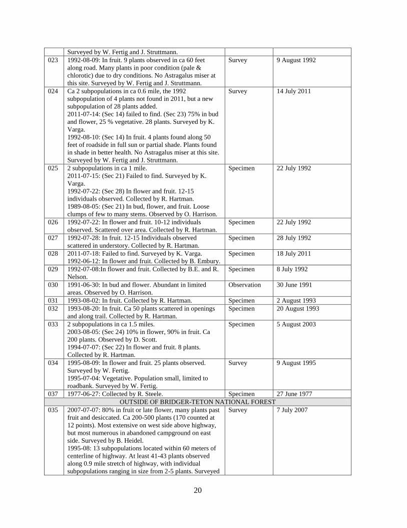
Surveyed by W. Fertig and J. Struttmann.
023 1992-08-09: In fruit. 9 plants observed in ca 60 feet
along road. Many plants in poor condition (pale &
chlorotic) due to dry conditions. No Astragalus miser at
this site. Surveyed by W. Fertig and J. Struttmann.
Survey 9 August 1992
024 Ca 2 subpopulations in ca 0.6 mile, the 1992
subpopulation of 4 plants not found in 2011, but a new
subpopulation of 28 plants added.
2011-07-14: (Sec 14) failed to find. (Sec 23) 75% in bud
and flower, 25 % vegetative. 28 plants. Surveyed by K.
Varga.
1992-08-10: (Sec 14) In fruit. 4 plants found along 50
feet of roadside in full sun or partial shade. Plants found
in shade in better health. No Astragalus miser at this site.
Surveyed by W. Fertig and J. Struttmann.
Survey 14 July 2011
025 2 subpopulations in ca 1 mile.
2011-07-15: (Sec 21) Failed to find. Surveyed by K.
Varga.
1992-07-22: (Sec 28) In flower and fruit. 12-15
individuals observed. Collected by R. Hartman.
1989-08-05: (Sec 21) In bud, flower, and fruit. Loose
clumps of few to many stems. Observed by O. Harrison.
Specimen 22 July 1992
026 1992-07-22: In flower and fruit. 10-12 individuals
observed. Scattered over area. Collected by R. Hartman.
Specimen 22 July 1992
027 1992-07-28: In fruit. 12-15 Individuals observed
scattered in understory. Collected by R. Hartman.
Specimen 28 July 1992
028 2011-07-18: Failed to find. Surveyed by K. Varga.
1992-06-12: In flower and fruit. Collected by B. Embury.
Specimen 18 July 2011
029 1992-07-08:In flower and fruit. Collected by B.E. and R.
Nelson.
Specimen 8 July 1992
030 1991-06-30: In bud and flower. Abundant in limited
areas. Observed by O. Harrison.
Observation 30 June 1991
031 1993-08-02: In fruit. Collected by R. Hartman. Specimen 2 August 1993
032 1993-08-20: In fruit. Ca 50 plants scattered in openings
and along trail. Collected by R. Hartman.
Specimen 20 August 1993
033 2 subpopulations in ca 1.5 miles.
2003-08-05: (Sec 24) 10% in flower, 90% in fruit. Ca
200 plants. Observed by D. Scott.
1994-07-07: (Sec 22) In flower and fruit. 8 plants.
Collected by R. Hartman.
Specimen 5 August 2003
034 1995-08-09: In flower and fruit. 25 plants observed.
Surveyed by W. Fertig.
1995-07-04: Vegetative. Population small, limited to
roadbank. Surveyed by W. Fertig.
Survey 9 August 1995
037 1977-06-27: Collected by R. Steele. Specimen 27 June 1977
OUTSIDE OF BRIDGER-TETON NATIONAL FOREST
035 2007-07-07: 80% in fruit or late flower, many plants past
fruit and desiccated. Ca 200-500 plants (170 counted at
12 points). Most extensive on west side above highway,
but most numerous in abandoned campground on east
side. Surveyed by B. Heidel.
1995-08: 13 subpopulations located within 60 meters of
centerline of highway. At least 41-43 plants observed
along 0.9 mile stretch of highway, with individual
subpopulations ranging in size from 2-5 plants. Surveyed
Survey
7 July 2007

21
by J. Ozenberger.
1995-06: Observed by J. Ozenberger.
036 2007-07-07: Not found on either side of highway; both
east and west of campground entrance, at trailhead, and
east and west of boat ramp access. Surveyed by B.
Heidel.
1995-08: 6 individuals observed on north side of
highway within 20 meters of the roadside, the scattered
individuals spreading to the east. Surveyed by J.
Ozenberger.
Survey
7 July 2007
Trends: Historically, this species is probably in decline due to fire suppression in western
national forests (Fertig and Marriott 1993). Most populations are very small and probably are
unable to persist over long periods of time without some form of disturbance. In 1992, the
plants were found to thrive best in human-disturbed sites, such as road cuts and recovering
clear-cuts. According to Shultz and Shultz (1978), the age of clear-cut appears to influence
population size and density. Plants are most numerous in cuts that are more than 15 years old
and which have semi-open canopies with exposed sand or mineral soils. Populations are
progressively smaller in younger cuts with open canopies and in older cuts with dense growth
of grasses or herbs.
The surveys conducted in 2011 were revisits to prior survey sites to document trend. They
provide some evidence that the species’ persistence is not entirely contingent on human-
disturbed sites, but that it also thrives in recent wildfires and in heterogenous landscapes with
a complex of both upland and wetland openings. Three of the four populations that have
ever been documented as large (over 100 plants) were revisited, and all were relocated.
However, two of the three had declined in population size by one or two orders of magnitude
and appeared to have much less than 100 plants in 2011. This included the Darby Mountain
area population (#001) where the species was reported as “the most abundant species in new
clearcut, rapidly decreasing with time” (Shultz and Shultz 1978), later reported as having 187
plants in three locations (Fertig and Marriott 1993), which by 2011 had 12 plants despite
recent new logging in the area. The one large occurrence that had not declined was in the
Waterdog Lake area (#010), where portions of the occurrence had disappeared, but
occurrence boundaries were expanded with the expanded scope of survey in 2011.
Three populations previously reported as small were revisited in 2011, and only one was
found to have the species persisting. The most significant update is that the species was
discovered in a population of over 250 plants in the area of the type locality on North Horse
Creek (last observed in 1922), despite the apparent absence of the species in 1978 surveys
(Shultz and Shultz 1978). Results from these seven surveys support the hypothesis that the
species declines with succession and only three populations have recently been documented
to have over 100 plants. Though not all small populations are viable, the North Horse Creek
discovery suggests that the species has a seed bank or else has a capacity to persist in low
numbers between disturbance cycles.
The other “large” population was surveyed in 2007, confined to highway right-of-way and
abandoned roads and campground pads (Mancuso and Heidel 2007). With rediscovery of a

22
large population on Horse Creek, there are still at least three “large” populations (over 100
plants) on the Forest although none are known to have more than 1000 plants.
Trend might be further evaluated in surveys and in controlled experiments. The scope of
survey would ideally be expanded, possibly at the Horse Creek and Mule fires, and at the
four other major wildfires in recent years. .” It might also be expanded at select
heterogenous landscapes with multiple upland and wetland opening ecotones that resemble
Waterdog Lake. It might also be expanded to include what may had been “intermediate” size
populations, including the two populations that were reported as having numbers over 50
plants and a third where it was reported as “locally abundant”. Previous researchers have
also recommended that a monitoring program be built into logging and prescribed burn
treatments and wildfire response strategies in the vicinity of known populations. Perhaps
some of the greatest unknowns are species’ response to the dual disturbances of bark beetle
and blister rust that are spreading in the study area. They might be added to controlled
experiment research. In any case, the elevated levels of bark beetle and blister rust are likely
to have bearing on the fire regime for decades to come and hence on Astragalus paysonii
viability. It bears repeating that no survey results to date address the interchangeability of
man-made disturbance with wildfire disturbance. This would be better analyzed in
controlled experiments than in surveys.
Threats
Astragalus paysonii is threatened primarily by succession which makes habitats unsuitable
for long-term persistence. This species requires periodic disturbances to create new habitat
and keep competing late-seral species and weeds at bay. It has been speculated that forest
succession associated with years of fire suppression contributed to the extirpation of several
occurrences in north-central Idaho (Lorain 1990). Seed production appears to be low, at least
in some years, but seed bank dynamics and fire response are unknown (Lorain 1990). The
2011 surveys similarly indicate that two Wyoming populations may have become extirpated,
but they were small and associated with human disturbance as best we know.
More importantly, the 2011 surveys support the hypothesis that fire can continue to play a
role in the species’ distribution. Furthermore, it is possible, but not proven, that increased
levels of bark beetle and blister rust infestations can also play a role in the species’
distribution. But there are several management issues associated with wildfire, pests and
pathogens. Salvage logging, allotment management changes, and calls for soil stabilization
or replanting may all arise in the wake of wildfire and such. Astragalus paysonii is generally
restricted to exposed mineral soil and is likely a nitrogen-fixer in its early seral habitats
(Clark and Dorn 1981). The specific action may not be as important as the magnitude of
vegetation shift and competition that results among native or non-native plants. Noxious
weeds are sometimes in the vicinity, and on Horse Creek, they were noted as present on
lower, flatter areas where cattle use is high. Noxious weeds may also spread along the same
corridors that mark habitat for Astragalus paysonii. Weed invasion has the potential to
become a more serious threat than current extent would indicate.

23
ROBBINS’ MILKVETCH
Astragalus robbinsii (Oakes) Gray var. minor (Hook.) Barneby
Classification
Scientific name: Astragalus robbinsii (Oakes) Gray var. minor (Hook.) Barneby
Synonyms: none
Common name: Robbins’ milkvetch
Family: Fabaceae
Size of genus: There are 62 species of Astragalus reported for Wyoming in Dorn (2001), not
including distinctions at the variety level. The Astragalus genus is comprised of 375 species
(Barneby 1964) with at least 20 more recent additions (Isely 1998), not including taxa below
the species level.
Phylogenetic relationships: The variety minor is the most widespread variety of the species,
with a disrupted range that suggests fragmentation of a once widely-distributed taxa, thought
to resemble the ancestral form of the taxon (Isely 1998).
Present legal or other formal status
U.S. Fish & Wildlife Service: None
U.S. Forest Service: none
Note: Astragalus robbinsii var. occidentalis (Lamoille Canyon milkvetch) is endemic to
Nevada and is designated sensitive on the U.S. Forest Service Intermountain Region list.
Global Heritage rank: G5T5
State Legal status: none
State Heritage rank: The more recent list update (Heidel 2007) reported a state rank of S1.
Current status information supports a change in rank to S2 with the latest information.
Wyoming contribution rank: Conservation of Robbins’ milkvetch as a widespread species at
the edge of its range appears to be Low. It was likewise placed in a low conservation priority
category by Fertig (2000).
Description
Technical description: Robbins milkvetch is a perennial forb with weakly erect, leafy stems
10-45 cm long. Leaves are 4.5-10 cm long and once-pinnately compound with 7-13 ovate-
elliptic leaflets Leaflets are finely pubescent with straight, basally-attached hairs below and
glabrate above. Stipules are 1.5-6 mm long, mostly connate-sheathing, and often have ciliate
margins. The inflorescence is a loose raceme of 5-25 purple or whitish, drooping, pea-like
flowers. The calyx is 4-6.8 mm long and has black and white appressed hairs. The banner
petal is 7.5-11 mm long. Wing petals are obtuse at the tip and shorter than the keel. Fruits are
densely pubescent, drooping, 3-sided pods 10-25 mm long with an elongate basal stalk
(stipe) up to 2.5 mm long that often exceeds the calyx tube (Barneby 1989; Welsh et al.
2008).
Similar species: Astragalus eucosmus has a keel that is 6 mm or less long and sessile pods
that are 2.3-5.5 mm wide and less than 13 mm long. A. australis has notched wing petals and
stipules that are hairy on the back. A. alpinus has a keel that is longer than the wing petals
(Dorn 2001).

24
Fig. 9 (above). Astragalus robbinsii var. minor from: Britton, N.L., and A. Brown. 1913. An illustrated
flora of the northern United States, Canada and the
British Possessions. 3 vols. Charles Scribner's Sons,
New York. Vol. 2: 382. Courtesy of
Kentucky Native Plant Society.
Scanned by Omnitek Inc.
Figure 10 (upper right): Astragalus robbinsii
var. minor, in flower, by B. Heidel
Figure 11 (lower right): Astragalus robbinsii
var. minor, whole plant in fruit, by B. Heidel
There are many other legumes that grow in riparian zones in the study area, and some of
them are directly associated with A. robbinsii. The one that might be most readily confused
is A. eucosmus. Others present include Astragalus agrestis, A. canadensis var. brevidens,
Astragalus miser var. hylophilus, Lupinus pusillus var. intermonatnus,and Oxytropis deflexa
var. sericea.
Prominent field characteristics: Purple flowers and black hairs on the calyx. Open elongate
inflorescence. Drooping pods.

25
Phenology: Flowers from July to August. Fruit produced from August-September. The plant
is most readily located when in flower.
Figure 12. Distribution of Robbins’ milkvetch (Astragalus robbinsii var. minor) in Region 4
of the U.S. Forest Service (Wyoming)
Geographical distribution
Range: Var. minor occurs from Alaska and the Yukon Territories to northern Utah and New
Mexico, and with an isolated distribution in eastern North America from Labrador to
Vermont (Barneby 1964, NatureServe 2011). In Wyoming, this taxon is found in the Gros
Ventre and Wyoming ranges in Lincoln, Teton, and Sublette counties.
Extant sites: There are 11 extant sites (Figure 12, Table 6). All occurrences are on Bridger-
Teton National Forest.
One occurrence is found within the Gros Ventre Research Natural Area (formerly named
Horse Creek RNA), established in 1996 (Fertig and Jones 1994a).
Historical sites: None.

26
Unverified/Undocumented reports: None known.
Table 6. Occurrences of Robbins’ milkvetch (Astragalus robbinsii var. minor) in Wyoming
EO# Directions County Legal
Description
Elevation
m (ft)
USGS 7.5’
Quad
Public
Land
BRIDGER-TETON NATIONAL FOREST
001 Wyoming Range; South Piney
Creek at base of Riley Ridge,
ca 0.5 mile E of Snider Basin
Guard Stn., upstream from
Darby Cr., downstream S of
fishing access, ca 21 air miles
W of Big Piney.
Sublette T29N R115W
Sec. 15
2408-
2420
(7900-
7940)
Mount
Thompson,
Wyoming
Peak
Big Piney
RD
002 Wyoming Range; along Sheep
Creek, 0.25 mile east of Bug
Cr., ca 16 air miles NE of
Afton.
Lincoln T33N R116W
Sec. 10
2128
(6980)
Park Creek Greys
River RD
003 Wyoming Range; Forks of
Greys River above bridge
[vicinity of the junction of the
main stem of the Greys R. and
the Little Greys R.].
Lincoln
T37N R117W
Sec. 21, 22, 26,
27, 28, 29, 32,
33, 34, 35
1707-
1829
(5600-
6000)
Ferry Peak,
Pine Creek
Greys
River RD
004 Gros Ventre Range; Big Horse
Creek Valley, ca 5 air miles
northeast of Hoback Jct.
Teton
T39N R115W
Sec. 4, 5, 8, 9
1951
(6400)
Camp Davis Jackson
RD
005 Wyoming Range; Hunter
Creek, a tributary of Willow
Cr., ca 10.6 miles south of
confluence with Hoback R., ca
12 air miles SSE of Hoback
Jct.
Lincoln T37N R115W
Sec. 14, 15, 16,
21, 22, 23, 27,
28
2109
(6920)
Bailey Lake,
Clause Peak
Jackson
RD
006 Wyoming Range; along
Kilgore Creek, ca 5 air miles
east-northeast of Hoback Peak,
ca 7.5 air miles SSW of
Bondurant.
Sublette T36N R114W
Sec. 8, 9, 17
2225-
2286
(7300-
7500)
Noble Basin Jackson
RD
007 Wyoming Range; South
Cottonwood Cr. at confluence
of South Fk South Cottonwood
Cr., ca 28 air miles SW of
Daniel Jct.
Sublette T32N R115W
Sec. 7, 17, 18,
19;T32N
R116W Sec. 13,
24
2560-
2591
(8400-
8500)
Triple Peak Big Piney
RD
008 Wyoming Range; along Cliff
Creek East of Burnt Creek, ca
40 air miles northwest of
Pinedale.
Sublette T37N R114W
Sec. 3, 9, 10,
11, 14, 15, 16,
22
2073
(6800)
Bondurant,
Clause Peak
Jackson
RD
009 Wyoming Range; on South
Cottonwood Cr., directly NE of
northeastern-most lake in Soda
Lake area.
Sublette T32N R115W
Sec. 15
2524
(8280)
Triple Peak Big Piney
RD
010 Wyoming Range; Middle
Piney Cr. below Sacajawea
Sublette T30N R115W
Sec. 2, 3, 12
2469-
2536
Springman
Creek,
Big Piney
RD

27
Campground and on lower
Indian Cr., south of FS Rds.
10024 and 10046, ca. 19-21 air
miles WNW of Marbleton.
(8100-
8320)
Wyoming
Peak
012 Wyoming Range; South Piney
Cr. at Forest boundary, south
of FS Rd 10128, mainly east of
jack-legged fence, ca 18.5 air
miles WSW of Marbleton.
Sublette T29N R115W
Sec. 7, 12
2371
(7780)
Springman
Creek
Big Piney
RD and
BLM
Pinedale
OUTSIDE OF BRIDGER-TETON NATIONAL FOREST
None
Sites where present status not known: None known.
Areas surveyed but species not located: The confluence between South Cottonwood Creek
and the South Forth of South Cottonwood Creek was surveyed without relocating it. The
prior collection record was vague and the river covered parts of upland habitat in the area at
the time of survey (late July), and so the timing may not have been suitable in the wet 2011
growing season. Habitats were generally searched upstream and downstream from known
occurrences. It was located several miles downstream (#009) without finding any intervening
locations. The only drainages that were surveyed where it was not found were on Coal Creek
and Fish Creek.
Figures 13 and 14. Riparian habitat of Astragalus robbinsii var. minor in the Bridger-Teton
National Forest, on the Middle Piney and South Piney creeks, respectively.
Habitat
Settings and associated vegetation: Wyoming populations are found in broad montane
valleys on gravel or sand alluvium, often at the edge of willow thickets or streambanks, at
5600-8000 feet.

28
The surface geology varies widely but the riparian wetland habitat is generally mapped as
Forested/ Shrubland Wetland (PSSA) in the National Wetlands Inventory (USFWS 2011).
Frequently associated species: Common associates of Astragalus robbinsii var. minor are
presented in Table 7.
Table 7. Plants associated with Robbins’ milkvetch (Astragalus robbinsii var. minor) in
Wyoming
Scientific name Common name Native/ Exotic
Antennaria anaphaloides Tall pussytoes
Native
Antennaria microphylla Small-leaf pussyoes
Native
Astragalus agrestis Cock's-head [Field milkvetch] Native
Astragalus canadensis var. brevidens Canadian milkvetch Native
Astragalus miser var. decumbens Timber milkvetch Native
Betula glandulosa Swamp birch [Bog birch] Native
Carex pellita Woolly sedge Native
Carex utriculata Northwest Territory sedge [Beaked sedge] Native
Castilleja miniata Great red Indian-paintbrush [Scarlet paintbrush]
Native
Deschampsia cespitosa Tufted hairgrass Native
Dodecatheon pulchellum Dark-throat shooting-star Native
Elymus trachycaulus Slender wild-rye Native
Fragaria virginiana Virginia strawberry Native
Juncus balticus Baltic rush Native
Linum lewisii Wild blue flax Native
Lonicera involucrata Four-line honeysuckle Native
Lupinus pusillus var. intermontanus Rusty lupine Native
Oxytropis deflexa var. sericea Pendant-pod locoweed Native
Poa pratensis Kentucky bluegrass Exotic
Potentilla fruticosa Shrubby cinquefoil Native
Potentilla graclis Graceful cinquefoil Native
Salix melanopsis Dusky willow Native
Taraxacum officinale Common dandelion Exotic
Trifolium repens White clover Exotic
Topography: Restricted to low-gradient montane riparian systems.
Water and soil relationships: The montane valleybottom flats are subject to flooding early in
the growing season. There was prolonged mid-summer flooding in occupied habitat in some
2011 survey settings. Soils are well-drained coarse alluvium of sand and gravel.
Population biology
Population size and condition: Astragalus robbinsii var. minor is typically found in low
numbers (Table 8). There were a couple places surveyed along the Middle Fork of Big Piney
(#010) in 2011 where numbers appeared to exceed 20 plants, but census figures are wanting.

29
Table 8. Population information for Robbins’ milkvetch (Astragalus robbinsii var. minor) in
Wyoming
EO# Population size Documentation Last
Observed
Date
BRIDGER-TETON NATIONAL FOREST
001 2011-07-24: (Sec. 15). Two spots. In late flower and fruit.
Uncommon. Surveyed by B. Heidel.
1992-07-21: (Sec. 15) In fruit. Collected by W. Fertig.
Survey 24 July 2011
002 1987-06-15: In flower and fruit. (# 473). Few plants. Collected by O.
Harrison.
Specimen 15 June 1987
003 1926-06-16: In flower and fruit. Patchy distribution. Collected by C.
McDonald.
Specimen 16 June 1926
004 1993-08-13: In fruit. Population appears small, but formal census not
conducted. Surveyed by W. Fertig and G. Jones.
Survey 13 August
1993
005 1978-08-02: In fruit. Locally common. Collected by N. and P.
Holmgren.
Specimen 2 August
1978
006 1992-07-15: In fruit. B.E. and R. Nelson. Specimen 15 July 1992
007 2011-07-23: Failed to find in surveying spectrum of valleybottom
habitats on south side; standing water covered some valleybottom
flats. Surveyed by B. Heidel.
1992-08-13: In fruit. Collected by R. Hartman.
Specimen 23 July 2011
008 1992-07-08: In fruit. Collected by B.E. and R. Nelson. Specimen 8 July 1992
009 2011-07-23: In late flower and fruit. Uncommon. Surveyed by B.
Heidel.
Survey 23 July 2011
010 2011-07-26: In late flower and fruit. Locally common but patchy in at
least four places along 3 miles of valleybottom. Surveyed by B.
Heidel.
Survey 26 July 2011
012 2011-07-24: In flower and fruit. Uncommon. Surveyed by B. Heidel. Survey 24 July 2011
OUTSIDE OF BRIDGER-TETON NATIONAL FOREST
None
Threats: May be moderately threatened by development of streamside habitats and possibly
by gravel quarrying. The Middle Fork Pine Creek occurrence (#010) is downstream over a
mile from a drop structure impounding Middle Piney Lake, as well as both above and below
summer homes, but the separation distances may buffer it. Two occurrences lie along the
route of the Oregon Trail – Lander Cutoff, one of which has the microtopography that
suggests it may have been a wagon stream crossing. Roads, trailer camping and fishing
accesses are located close to some occurrences.
Grazing signs were not noted at the time of survey. Stream channel and vegetation cover
conditions indicated that grazing is generally limited. It is not known whether this species is
palatable, but it is apt to be affected by grazing levels that favor increaser species. In general,
any practice that contributes to an incised streamcourse or fosters development of continuous
sod-forming grass may affect habitat suitability. At present, threats appear low.

30
SHULTZ'S MILKVETCH
Astragalus shultziorum Barneby
Classification
Scientific name: Astragalus shultziorum Barneby
Synonyms: Astragalus molybedenus Barneby var. shultziorum (Barneby) S.L. Welsh
Common name: Shultz’s milkvetch
Family: Fabaceae
Size of genus: There are 62 species of Astragalus reported for Wyoming in Dorn (2001), not
including distinctions at the variety level. The Astragalus genus is comprised of 375 species
(Barneby 1964) with at least 20 more recent additions (Isely 1998), not including taxa below
the species level.
Phylogenetic relationships: There are relatively few other alpine Astragalus taxa. The two
closest relatives are A. molybdenus (a Colorado endemic) and A. lackschewitzii (a Montana
endemic). Welsh (1998) treats all three as varieties of A. molybdenus and this is the likely
treatment in the upcoming Flora of North America volume with Welsh and Spellenberg as
genus authors. Isely (1998) recognizes A. shultziorum as a distinct species from the other
two, which he treated as are A. molybdenus.
Present legal or other formal status
U.S. Fish & Wildlife Service: None (Former C2 candidate for listing under the Endangered
Species Act.)
U.S. Forest Service – Bridger-Teton National Forest: Management Indicator Species (Ryan
pers. commun.); previously a sensitive species and recommended for dropping in 1990
(Marriott 1990)
Global Heritage rank: G3Q; the taxonomic question in its rank reflecting debate whether to
recognize it at the species or the variety level.
State Legal status: none
State Heritage rank: The more recent list update (Heidel 2007) reported a state rank of S3.
Wyoming contribution rank: Conservation of Shultz’s milkvetch as a regional endemic in the
core of its range is Very High. As a limited distribution species almost restricted to
Wyoming, it is maintained on the Watch List.
Description
Technical description: Schultz's milkvetch is a low perennial herb with slender, elongate
subterranean stems arising from a branched rootcrown. Leaves are 1.5-8 cm long and
alternate on the 1-2 cm of exposed stem; the petiole length of leaves is reduced toward the
top. Leaves have 11-17 green leaflets that are lanceolate to ovate-elliptic, and pubescent on
both surfaces or smooth above. The pale, translucent stipules encircle the stem, have 2 teeth,
and cover the leaf bases. The cream-colored, lavender-tinged flowers typically are in pairs
(1-4) surmounting a 1-4 cm tall flowering stalk. The banner is 11-12 mm long, longer than
the wings, sometimes streaked, and the keel has a purple-tip. The calyx is 5.7-6.7 mm long,
with slender teeth and short, black hairs. The pod is lance-ovate, 10-12 mm x 3-3.5 mm, with
a prolonged narrow beak, sessile, keeled on back, 3-sided in cross-section and becomes
papery-thin when ripe (Barneby 1981, Dorn 1989, Fertig 1992, Lavin and Marriott 1997,
Isely 1998.)

31
Figure 15 (left): Astragalus shultziorum
by Walter Fertig
Figure 16 (above): Astragalus
shultziorum by B. Heidel
Similar species: Astragalus alpinus has pendulous pods and more than 5 flowers.
A. bodinii has more than 5 flowers and a thick taproot. A. leptaleus has pendulous pods. Both
of the latter two species are found in wet habitats below the subalpine zone.
Phenology: Flowers from July to August. Fruit produced from August-September. The plant
is most readily located when in flower.
Local field characters: In alpine and subalpine settings, this is the only milkvetch that
ordinarily has flowers and fruits in pairs.
Geographical distribution
Range: Teton, Salt River, Wind River and Wyoming ranges of Teton, Lincoln and Sublette
counties, Wyoming; reported in the Teton Range of Idaho.
Extant sites: Known from 26 occurrences in Wyoming, all of which have been surveyed or
discovered since 1987 (Figure 17, Table 9). Systematic surveys were previously conducted
(Dorn 1989, Marriott 1990). Almost all of these occurrences are on Bridger-Teton National
Forest (23 of 26). In 2011, there was just expansion of one known occurrence (#008).
At least 3 occurrences are protected within the Bridger and Gros Ventre Wilderness Areas
(Bridger-Teton NF), one is protected in Swift Creek Research Natural Area (Fertig and Jones
1994b) and parts of 4 other occurrences are within Grand Teton National Park. All other
reports are from public lands managed for multiple use.

32
Figure 17. Distribution of Shultz’s milkvetch (Astragalus shultziorum) in Region 4 of the
U.S. Forest Service (Wyoming), its rangewide distribution
Historical sites: None.
Unverified/Undocumented reports: None known.
Sites where present status not known: None known.
Table 9. Occurrences of Shultz’s milkvetch (Astragalus shultziorum) in Wyoming
EO# Directions County Legal
Description
Elevation
m (ft)
USGS 7.5’
Quad
Public
Land
BRIDGER-TETON NATIONAL FOREST
001 Salt River Range; head of Corral
Cr east of divide in vicinity of
trail from Cottonwood Lake,
south to divides with Spring and
Dick creeks, ca 4.5-6 miles west
of Corral Creek Guard Stn, ca 9-
10 miles east-southeast of Afton.
Lincoln T31N R117W
Sec. 16, 21, 22,
27, 28
2841-
3200
(9320-
10500)
Red Top
Mountain
Greys
River RD

33
004 Teton Range; along the boundary
between Grand Teton National
Park and Targhee and Bridger-
Teton NFs, from Devils Stair
Trail and Alaska Basin, to Death
Canyon Shelf, northwest slopes of
Spearhead Peak, headwaters of
Granite and Moose Cr, and
cirques on the east/southeast side
of Rendezvous Mtn from top of
tram, north of ski boundary, south
to Rendezvous Peak.
Teton T42N R117W
Sec. 5, 6, 7, 15,
16
2682-
3170
(8800-
10400)
Grand Teton,
Mount
Bannon,
Rendezvous
Peak, Teton
Village
Jackson
RD, Teton
Basin RD
006 Salt River Range; Upper Swift
Creek from divide with Upper
Corral Creek north to due east of
Dry Creek Lake, on west side of
drainage.
Lincoln T31N R117W
Sec. 5; T32N
R117W Sec.
32
2896
(9500)
Red Top
Mountain
Greys
River RD
008 Salt River Range; Sheep Pass and
vicinity, ca 8 air miles east-
southeast of Smoot.
Lincoln T30N R117W
Sec. 3, 4, 9, 10,
15
2926-
3178
(9600-
10680)
Mount
Wagner
Greys
River RD,
Kemmerer
RD
011 Northwest Wind River Range;
southeast end of White Rock
ridge, divide south of Slide Lake,
east-southeast of upper Green
River Lake.
Sublette T38N R108W
Sec. 13, 14, 23,
24
3399
(11150)
Green River
Lakes
Pinedale
RD
013 Wyoming Range; middle and
north peaks of Triple Peak, ca 26
air miles southwest of Daniel
Junction.
Sublette T33N 115W
Sec. 33
3292-
3392
(10800-
11127)
Triple Peak Big Piney
RD
014 Wyoming Range; south end of
Mount McDougal on Peak
Lincoln T33N R115W
Sec. 5
3231-
3286
(10600-
10780)
Triple Peak Greys
River RD
015 Wyoming Range; just northeast of
Gunsight Pass, ca 4 air miles
north-northwest of McDougal
Pass
Lincoln T34N R115W
Sec. 20
2926-
3048
(9600-
10000)
Lookout
Mountain
Big Piney
RD
016 Salt River Range; ridge on north
side of Mount Wagner and along
trail between Wagner and
Cottonwood lakes, ca 1 mile north
of summit, ca 2 air miles south of
Cottonwood Lake, ca 11 air mile
southeast of Afton.
Lincoln T30N 117W
Sec. 7, 8
2804-
2859
(9200-
9380)
Mount
Wagner
Greys
River RD
017 Salt River Range; above Mink
Creek along LaBarge Creek
Divide, ca 10.5 air miles east-
southeast of Smoot, ca 15 air
miles southeast of Afton.
Lincoln T30N R117W
Sec. 10, 11, 14,
15
2890
(9480)
Poison
Meadows
Greys
River RD
019 Salt River Range; Commissary
Ridge, between Peak 10315 and
Graham Peak at top of cirque.
Lincoln T29N R116W
Sec. 32
3103
(10180)
Graham Peak Kemmerer
RD
020 Gros Ventre Range; upper Swift
Creek and west slope of Corner
Teton T39N R113W
Sec. 3, 4;
2438-
3109
Crystal Peak,
Granite Falls
Jackson
RD

34
Peak, ca 2 miles east of Granite
Falls.
T40N R113W
Sec. 33, 34
(8000-
10200)
021 Gros Ventre Mountains; ridge
southeast of Pinnacle Peak and
slopes below, just east of Little
Granite Creek, ca 4 miles west of
Granite Creek Campground.
Teton T39N R114W
Sec. 3, 4, 9, 10;
T40N R114W
Sec. 33, 34
2804-
3231
(9200-
10600)
Bull Creek,
Turquoise
Lake
Jackson
RD
022 Gros Ventre Mountains; peak ca 1
air mile north of Cache Peak.
Teton T40N R115W
Sec. 10, 11, 12,
13, 14, 15
2926-
3127
(9600-
10258)
Turquoise
Lake
Jackson
RD
023 Gros Ventre Mountains; ridge 1
air mile southeast to 2 air miles
south-southeast of Pyramid Peak.
Teton T40N R113W
Sec. 5, 6, 7, 8,
17, 18; T40N
R114W Sec. 1,
12, 13
3139-
3316
(10300-
10879)
Crystal Peak Jackson
RD
024 Gros Ventre Mountains; northeast
edge of Tosi Creek Basin,
headwaters of Clear and Tosi
Creeks southwest of the Red
Hills.
Sublette T39N R111W
Sec. 7, 18, 19;
T39N R112W
Sec. 10, 11, 12,
13, 14, 15, 22
2987-
3200
(9800-
10500)
Doubletop
Peak, Tosi
Peak
Jackson
RD,
Pinedale
RD
025 Gros Ventre Range; west and
southeast flanks of Darwin Peak,
north slopes of Triangle Peak, and
northeast -facing slopes of peak
11118 between Steamboat and
Palmer peaks, ca 2-3.5 miles
south of Gros Ventre River.
Sublette,
Teton
T39N R112W
Sec. 3, 4, 5, 6,
7, 8; T39N
R113W Sec. 1,
12; T40N
R112W Sec.
29
2987-
3353
(9800-
11000)
Darwin Peak,
Doubletop
Peak
Jackson
RD
028 Wyoming Range; east-facing
slope of ridge south of Deadman
Peak, ca 18 miles east of Etna.
Lincoln T35N R116W
Sec. 22, 23
2957
(9700)
Blind Bull
Creek, Pickle
Pass
Greys
River RD
OUTSIDE OF BRIDGER-TETON NATIONAL FOREST
004 Teton Range; along the boundary
between Grand Teton National
Park and Targhee and Bridger-
Teton national forests, from
Devils Stair Trail and Alaska
Basin, to Death Canyon Shelf,
northwest slopes of Spearhead
Peak, headwaters of Granite and
Moose creeks, and cirques on the
east/southeast side of Rendezvous
Mtn from top of tram, just north
of ski boundary, south to
Rendezvous Peak.
Teton T42N R117W
Sec. 5, 6, 7, 15,
16
2682-
3170
(8800-
10400)
Grand Teton,
Mount
Bannon,
Rendezvous
Peak, Teton
Village
Grand
Teton NP,
Targhee
NF
012 Teton Range; on switchbacks
below Hurricane Pass, on western
boundary of Grand Teton NP, ca
0.2 mile north of Schoolmarm
Glacier, ca 6 miles north-
northwest of Phelps Lake.
Teton T44N R117W
Sec. 35
2926-
3078
(9600-
10100)
Grand Teton Grand
Teton NP
026 West slope Teton Range; summit
ridge of Taylor Mtn, ca 2.5 air
miles north of Teton Pass, ca 10
air miles WNW of Jackson.
Teton T41N R118W
Sec. 11
3048-
3155
(10000-
10352)
Rendezvous
Peak
Targhee
NF

35
Figures 18-20. Astragalus shultziorum
habitat in study area (#008; 22 Aug):
Above – south aspect of Greysalt Peak
(common), by B. Heidel
Upper right – north-facing slope at
dip in ridgeline (abundant), by
B. Heidel
Right – east-facing ridgecrest (sparse),
by B. Heidel
Figure 21. Astragalus shultziorum habitat (toe slope) in Teton Range, by Hollis Marriott
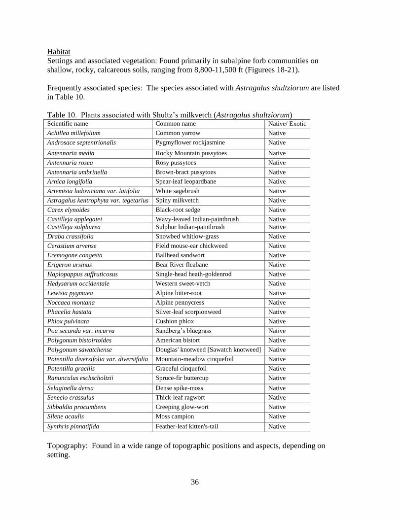
36
Habitat
Settings and associated vegetation: Found primarily in subalpine forb communities on
shallow, rocky, calcareous soils, ranging from 8,800-11,500 ft (Figurees 18-21).
Frequently associated species: The species associated with Astragalus shultziorum are listed
in Table 10.
Table 10. Plants associated with Shultz’s milkvetch (Astragalus shultziorum) Scientific name Common name Native/ Exotic
Achillea millefolium Common yarrow Native
Androsace septentrionalis Pygmyflower rockjasmine Native
Antennaria media Rocky Mountain pussytoes Native
Antennaria rosea Rosy pussytoes Native
Antennaria umbrinella Brown-bract pussytoes Native
Arnica longifolia Spear-leaf leopardbane
Native
Artemisia ludoviciana var. latifolia White sagebrush
Native
Astragalus kentrophyta var. tegetarius Spiny milkvetch
Native
Carex elynoides Black-root sedge Native
Castilleja applegatei Wavy-leaved Indian-paintbrush Native
Castilleja sulphurea Sulphur Indian-paintbrush
Native
Draba crassifolia Snowbed whitlow-grass Native
Cerastium arvense Field mouse-ear chickweed Native
Eremogone congesta Ballhead sandwort Native
Erigeron ursinus Bear River fleabane Native
Haplopappus suffruticosus Single-head heath-goldenrod Native
Hedysarum occidentale Western sweet-vetch Native
Lewisia pygmaea Alpine bitter-root Native
Noccaea montana Alpine pennycress Native
Phacelia hastata Silver-leaf scorpionweed Native
Phlox pulvinata Cushion phlox Native
Poa secunda var. incurva Sandberg’s bluegrass Native
Polygonum bistoirtoides American bistort Native
Polygonum sawatchense Douglas' knotweed [Sawatch knotweed] Native
Potentilla diversifolia var. diversifolia Mountain-meadow cinquefoil Native
Potentilla gracilis Graceful cinquefoil Native
Ranunculus eschscholtzii Spruce-fir buttercup Native
Selaginella densa Dense spike-moss Native
Senecio crassulus Thick-leaf ragwort Native
Sibbaldia procumbens Creeping glow-wort Native
Silene acaulis Moss campion Native
Synthris pinnatifida Feather-leaf kitten's-tail Native
Topography: Found in a wide range of topographic positions and aspects, depending on
setting.

37
Water and soil relationships: The substrate of Astragalus shultziorum is almost always
calcareous (Marriott 1990). In the study area, it is associated mainly with the following
geological mapping units:
Madison and Darby Formations
Phosphoria, Wells and Amsden Formations
Ankareh Formation, Thaynes Limestone, Woodside Shale and Dinwoody Formations
In 2011 surveys at Greysalt Peak, it was often found near remnant snow banks (Figures 18-
20). One portion of the Greysalt Peak occurrence was present in abundance on a non-
calcareous substrate …
Population biology and demography
Population size and condition: Individual populations may be extremely abundant locally or
cover large areas of suitable ridge-top alpine habitat (Table 11). The rhizomatous growth
form makes it impossible to discern individuals and there are spots where it has higher
canopy cover than any other species present.
Table 11. Population information for Shultz’s milkvetch (Astragalus shultziorum) in
Wyoming
EO#
Population size Documentation Last
Observed
Date
BRIDGER-TETON NATIONAL FOREST
001 6 subpopulations in ca 1.5 x 1.5 miles.
1989-08-30: (Sec 28) In fruit, mostly vegetative. Surveyed by H. Marriott.
1987-08-29: (Sec 16, 21; 3 subpopulations) Mostly vegetative (few with
buds, flowers, or fruit). Locally abundant, at times the dominantant
species. Ca 10,000+ plants (genets difficult to count due to vegetative
reproduction). Surveyed by H. Marriott.
1987-08-28: (Sec 22, 27; 2 subpopulations) A few in flower and fruit. Ca
5000-10,000 plants, although genets difficult to distinguish due to
vegetative growth. A co-dominant in places. Surveyed by H. Marriott.
1980-09-30: (Probably Sec 21) In fruit. Collected by J. Shultz.
1980-09-17: (Sec 16) In fruit. Common. Surveyed by R. Lichvar and R.
Dorn.
1980-08-21/22: (Sec 16) In flower. Common. Collected by R. Lichvar and
R. Dorn.
1980-08-11: (probably Sec 21) Collected by L., J. and K. Shultz, and R.
Hartman.
1923-07-31: (probably Sec 21) In flower. Collected by E. Payson and G.
Armstrong.
Survey 30 Aug
1989
004 Ca 14 subpopulations in ca 5.5 x 10 miles.
2007-08-20: (Sec 21 NW4) In flower and fruit. Collected by R. Hartman.
2007-08-11: (Sec 21 SE4, NE4; 2 subpopulations) In flower and fruit.
Collected by R. Hartman and D. Scott.
2000-08-20: (Rendezvous Mountain) In flower. Collected by C.
Delmatier.
2000-07-26: (Rendezvous Mountain) In flower. Collected by C.
Delmatier.
Survey 20 Aug
2007

38
1999-08-03: (Rendezvous Mountain) In flower. Collected by C.
Delmatier.
1995-09-01: (Rendezvous Mountain) In flower. Collected by N. and P.
Holmgren.
1989-09-12: (Death Canyon Shelf) Mostly vegetative, but good flowering
and fruiting in vicinity of Mount Meek Pass. Abundant (many 1,000s of
plants, though genets difficult to distinguish due to vegetative growth).
(Alaska Basin) Dried flowers. 1,000s of plants in limited survey. Surveyed
by H. Marriott.
1989-09-11: (Spearhead Peak) Dried flowers and a few in fruit. Abundant
(ca 10,000+ but genets difficult to distinguish due to vegetative growth).
Surveyed by H. Marriott.
1989-09-10: (headwaters of Granite & Moose creeks; 7 subpopulations)
Dried flowers. Abundant (ca 10,000s of plants, although genets are
difficult to distinguish due to vegetative growth), at times a co-dominant.
Surveyed by H. Marriott.
1989-09-07: (Rendezvous Mountain) Few flowers, no fruit. Abundant (ca
10,000s of plants, although genets are difficult to distinguish due to
vegetative reproduction), at times a co-dominant. Surveyed by H. Marriott.
1988-06-26: (Rendezvous Mountain) In bud and and flower. L. and K.
Shultz.
1987-08-21: (Rendezvous Mountain) Few flowers, no fruit. Observed by
H. Marriott.
1987-08-20: (Spearhead Peak) In flower and fruit, mostly vegetative.
(Death Canyon Shelf) In flower and fruit. Collected by H. Marriott.
1987-08-19: (headwaters of Granite & Moose creeks; 7 subpopulations)
Mostly vegetative, but good flowering and fruiting material in some areas.
Surveyed by H. Marriott.
1987-07-24: (Rendezvous Mountain) In flower. Collected by L. and J.
Shultz, and J. Reynolds.
1986-07-26: (Rendezvous Mountain) In flower. Collected by L. and J.
Shultz, and C. Palmer.
1986-07-24: (Rendezvous Mountain) In flower. Collected by L. Shultz and
TSS class.
1985-08-11: (Devils Stairs Trail) In fruit. Collected by E. Evert.
1983-09-01: (Rendezvous Mountain) In flower. Collected by A.
Youngblood and W. Padgett(?).
006 Common, but not as abundant as at other sites. Estimated at 2000-5000
plants (Genets difficult to distinguish due to vegetative growth). No
flowering individuals seen in lat Aug 1987, very few (dried) seen in early
Sep 1989
Survey 5 Sept 1989
008 7 subpopulations in ca 2 miles.
2011-08-22: (south and west of Sheep Pass) In early flower and
vegetative. Occasional to abundant in 4 discrete areas and settings.
Surveyed by B. Heidel.
2010-08-02: (north of Sheep Pass) In flower and vegetative. Locally
abundant over a large area. Surveyed by H. Marriott.
1992-07-10: (south of Sheep Pass) In flower and fruit. Forming thick mats.
Collected by B.E. and R. Nelson, and O. Harrison.
1989-08-30: (north and south of Sheep Pass) In fruit, mostly vegetative.
Abundant (ca 10,000+, but genets difficult to distinguish due to vegetative
growth), a co-dominant in places. Surveyed by H. Marriott.
1989-08-13: (probably north of Sheep Pass) In flower and fruit. Collected
by R. Dorn.
1989-07-30: (south and west of Sheep Pass) In flower and fruit. Collected
by O. Harrison.
Survey 22 Aug
2011

39
1988-07-16: (north of Sheep Pass) In flower and fruit. Collected by O.
Harrison.
011 1991-08-13: In flower. Locally abundant in ca 5 X 10 meters (in a much
larger area of potential habitat), probably one genet. Surveyed by H.
Marriott and D. Horning.
Survey 13 Aug
1991
013 1992-08-14: In fruit. Collected by R. Hartman. Specimen 14 Aug
1992
014 250-300 patches, likely much more. 19 Aug
1992
015 Patches often continuous for many feet. 19 Aug
1992
016 2 subpopulations in ca 0.2 mile.
2010-08-05: (Sec 7, 8) 20% in flower, 80% vegetative. Abundant in ca 1
acre. Surveyed by H. Marriott.
1992-07-23: (Sec 7) In flower. Collected by W. Fertig.
Survey 5 Aug 2010
017 1992-07-25: In flower. Well established population in limited area.
Collected by O. Harrison.
Specimen 25 Jul 1992
019 1993-08-17: In flower. Several square meters. Collected by R. Hartman. Specimen 17 Aug
1993
020 Ca 2 subpopulations in ca 1 mile.
1997-08-07: (Sec 3 NE4) In flower. Collected by W. Fertig.
1994-06-28: (Sec 3-4) In flower. Collected by R. Hartman.
Specimen 7 Aug 1997
021 2 subpopulations in ca 1 mile.
1994-07-07: (both subpopulations) In flower. Collected by R. Hartman.
Specimen 7 Jul 1994
022 1994-07-12: In flower and fruit. Collected by R. Hartman. Specimen 12 Jul 1994
023 1994-07-27: In flower. Collected by R. Hartman and T. Cramer. Specimen 27 Jul 1994
024 1994-08-02: In fruit. Collected by R. Hartman and T. Cramer. Specimen 2 Aug 1994
025 Ca 5 subpopulations in 1.5 x 3.5 miles.
1998-08-04: (Sec 3 NW4) 30% in flower, 70% vegetative. Ca 500 plants.
Surveyed by L. Welp. (Sec 3 SW4) In flower and fruit. Collected by W.
Fertig.
1994-08-17: (Sec 33) In fruit. Collected by R. Hartman and T. Cramer.
1994-08-05: (Sec 6) In flower and fruit. (Sec 32) In fruit. Collected by R.
Hartman.
Specimen 4 Aug 1998
028 1979-08-05: In flower. Collected by L. and J. Shultz. Specimen 5 Aug 1979
OUTSIDE OF BRIDGER-TETON NATIONAL FOREST
004 Ca 14 subpopulations in ca 5.5 x 10 miles.
2007-08-20: (Sec 21 NW4) In flower and fruit. Collected by R. Hartman.
2007-08-11: (Sec 21 SE4, NE4; 2 subpopulations) In flower and fruit.
Collected by R. Hartman and D. Scott.
2000-08-20: (Rendezvous Mountain) In flower. Collected by C.
Delmatier.
2000-07-26: (Rendezvous Mountain) In flower. Collected by C.
Delmatier.
1999-08-03: (Rendezvous Mountain) In flower. Collected by C.
Delmatier.
1995-09-01: (Rendezvous Mountain) In flower. Collected by N. and P.
Holmgren.
1989-09-12: (Death Canyon Shelf) Mostly vegetative, but good flowering
and fruiting in vicinity of Mount Meek Pass. Abundant (many 1,000s of
plants, though genets difficult to distinguish due to vegetative growth).
(Alaska Basin) Dried flowers. 1,000s of plants in limited survey. Surveyed
by H. Marriott.
1989-09-11: (Spearhead Peak) Dried flowers and a few in fruit. Abundant
(ca 10,000+ but genets difficult to distinguish due to vegetative growth).
Survey 20 Aug
2007

40
Surveyed by H. Marriott.
1989-09-10: (headwaters of Granite & Moose creeks; 7 subpopulations)
Dried flowers. Abundant (ca 10,000s of plants, although genets are
difficult to distinguish due to vegetative growth), at times a co-dominant.
Surveyed by H. Marriott.
1989-09-07: (Rendezvous Mountain) Few flowers, no fruit. Abundant (ca
10,000s of plants, although genets are difficult to distinguish due to
vegetative reproduction), at times a co-dominant. Surveyed by H. Marriott.
1988-06-26: (Rendezvous Mountain) In bud and flower. L. and K. Shultz. 1987-08-21: (Rendezvous Mountain) Few flowers, no fruit. Observed by
H. Marriott.
1987-08-20: (Spearhead Peak) In flower and fruit, mostly vegetative.
(Death Canyon Shelf) In flower and fruit. Collected by H. Marriott.
1987-08-19: (headwaters of Granite & Moose creeks; 7 subpopulations)
Mostly vegetative, but good flowering and fruiting material in some areas.
Surveyed by H. Marriott.
1987-07-24: (Rendezvous Mountain) In flower. Collected by L. and J.
Shultz, and J. Reynolds.
1986-07-26: (Rendezvous Mountain) In flower. Collected by L. and J.
Shultz, and C. Palmer.
1986-07-24: (Rendezvous Mountain) In flower. Collected by L. Shultz and
TSS class.
1985-08-11: (Devils Stairs Trail) In fruit. Collected by E. Evert.
1983-09-01: (Rendezvous Mountain) In flower. Collected by A.
Youngblood and W. Padgett(?).
012 1992-08-06: Only 1% in flower, mostly vegetative. Locally common but
sporadic. 1000-3000 plants observed. Surveyed by H. Marriott.
Survey 6 Aug 1992
026 2007-07-09: In early flower; most plants in bud or vegetative. Common on
gentle northwest-facing slopes at north end of ridge. Ca 500-1000 plants.
Surveyed by B. Heidel.
Survey 9 Jul 2007
Trends: Trend data are lacking, but most populations appear to be stable.
Threats: Sheep grazing has been identified as a potential threat at some sites, but most
occurrences are at sufficiently high elevation, low productivity habitat or physically protected
sites that receive little use or impacts.

41
ROCKCRESS DRABA
Draba globosa Payson
Classification
Scientific name: Draba globosa Payson
Synonyms: Draba apiculata, D. densifolia var. apiculata, D. densifolia var. globosa
Common name: Rockcress draba
Family: Brassicaceae
Size of genus: There are 25 species of Draba reported for Wyoming in Dorn (2001), not
including distinctions at the variety level. The Draba genus is the largest one in the
Brassicaceae, comprised of about 121 species in North America; 380 worldwide (Al-Shehbaz
et al. 2010).
Phylogenetic relationships: Draba globosa is an apomictic species closely related to D.
burkei (Al-Shehbaz et al. 2010), and treated by some as related to D. densifolia, but
maintained as morphologically and phyletically distinct in the most current literature (Al-
Shehbaz et al. 2010).
Present legal or other formal status
U.S. Fish & Wildlife Service: None
U.S. Forest Service – Region 4: sensitive. It was recommended for de-listing by Stone
(1995).
Global Heritage rank: G3
State Legal status: none
State Heritage rank: The more recent list update (Heidel 2007) reported a state rank of S3.
Wyoming contribution rank: Conservation of Rockcress draba as a regional endemic at the
core of its range is generally a High conservation priority, though it has many occurrences
over a wide area. Nevertheless, as a limited distribution species with a significant portion of
its distribution in Wyoming, it is maintained on the Watch List.
Description
Technical description: Rockress draba is a mat forming perennial herb with stems 0.5-3 cm
tall. Leaves are lance-shaped, 3-6 mm long, less than 3 mm wide, and crowded in a basal
rosette. The leaves are glabrous except for the margins which have unbranched (simple)
hairs. The inflorescence consists of 2-5 yellow (rarely white) flowers with 4 petals. The fruits
are egg shaped and glabrous with styles less than 0.5 mm long (Dorn 2001; Fertig et al. 1994;
Hitchcock and Cronquist 1964, Al-Shehbaz et al. 2010).
Similar species: Draba densifolia var. densifolia usually has hairy fruits with styles over 0.5
mm long. D. crassa has leaves over 10 mm long and 5 mm broad. Other alpine Draba spp. in
Wyoming have more densely pubescent leaves with forked or pectinate (comb-like) hairs.
A list of alpine species of Draba in the Salt River Range include Draba albertina, D. aurea,
D. cana, D. crassifolia, D. fladnizensis, D. incerta, D. lonchocarpa, D. *D. oligosperma, D.
paysonii var. paysonsii, D. praelta, and D. ventosa (Rocky Mountain Herbarium 2011).
Those that are asterisked are on the same ridgeline as the Draba globosa where found on
Greysalt Peak.

42
Figure 22 (above). Draba globosa, by Margorie
Leggitt, from Spackman et al. (1997)
Figure 23 (upper right). Specimen of Draba globosa collected
on Greysalt Peak, 2011, by B. Heidel
Phenology: Flowers June-August. Fruits present in August. Fruits are needed for positive
identification.
Local field characters: The lack of leaves on the stem, and the glabrous fruits, inflorescence
and dorsal leaf surface distinguish it from many other species. Style length and other
technical characteristics are needed for positive determination.
Geographical distribution
Range: Regional endemic of southwestern Montana, central Colorado, eastern Idaho,
northern Utah and western and southern Wyoming. In Wyoming, known from the Absaroka,
Teton, Wind River, Beartooth, Medicine Bow, Gros Ventre, and Salt River ranges in Albany,
Fremont, Lincoln, Park, Sublette, and Teton counties.
Extant sites: Known from 25 extant occurrences in Wyoming, most of which have been
documented since 1990 (most recently surveyed in 2011) (Figure 24, Table 12). Ten are on
the Bridger-Teton NF, but only one is in the study area and was the subject of 2011 surveys
(#012). There is also a record from BLM lands just outside the study area (Deadline Ridge
#023).
At least 13 occurrences are found in designated Wilderness Areas (Bridger, North Absaroka,
Gros Ventre, and Popo Agie), Grand Teton National Park, and the Osborn Mountain
Research Natural Area (Bridger-Teton NF; Fertig and Jones 1994c). An additional

43
population is in the potential Beartooth Butte RNA (Shoshone NF). All other populations are
on public lands managed for multiple use.
Figure 24. Distribution of Rockcress draba (Draba globosa) in Region 4 of the U.S. Forest
Service (Wyoming)
Table 12. Occurrences of Rockcress draba (Draba globosa) in Wyoming
EO# Directions County Legal
Description
Elevation
m (ft)
USGS 7.5’
Quad
Public
Land
BRIDGER-TETON NATIONAL FOREST
003 Northwest Wind River Range;
summit of Gypsum Mountain,
ca 3 air miles southwest of
Lower Green River Lake, ca
28 air miles north of Pinedale.
Sublette T38N R109W
Sec. 10, 11, 14,
15
3505
(11500)
Big Sheep
Mountain
Pinedale
RD
004 Northwest Wind River Range;
west slope of Lost Eagle Peak
and saddle connecting to the
southeast end of White Rock
Mountain, ca 0.75 miles south
of Slide Lake, ca 2.4 miles
east of Upper Green River
Lake, ca 26 air miles north of
Pinedale.
Sublette T38N R108W
Sec. 13, 14, 23,
24
3231-
3414
(10600-
11200)
Green River
Lakes
Pinedale
RD

44
005 West Slope Wind River
Range; summit of Big Sheep
Mountain, ca 1.5 air miles
west of Lower Green River
Lake, ca 28.5 air miles north
of Pinedale.
Sublette T38N R109W
Sec. 12
3414-
3475
(11200-
11400)
Big Sheep
Mountain
Pinedale
RD
008 Northwest Wind River Range;
summit of Osborn Mountain
on north side and head of Mill
Creek, ca 3 air miles northeast
of Lower Green River Lake.
Sublette T39N R108W
Sec. 22, 23
3475-
3536
(11400-
11600)
Green River
Lakes
Pinedale
RD
010 Wind River Range; 1 mile
southeast of Lee Lake,
between Pronghorn Peak and
Nylon Peak [ca 1 mile east of
Dragonhead Peak near the
Continental Divide].
Sublette T34N R105W
Sec. 25, 26, 36
3353
(11000)
Roberts
Mountain
Pinedale
RD
012 Salt River Range; West Sheep
Pass area immediately north of
Greysalt Peak summit, and at
lowest ridgeline outcrop west
of pass; ca 12 air miles
southeast of Afton.
Lincoln T30N R117W
Sec. 3, 4, 9, 10,
15, 16
3109-
3267
(10200-
10720)
Mount
Wagner,
Poison
Meadows
Greys
River RD,
Kemmerer
RD
014 Teton Range; Jackson Hole
Mountain Resort, top of tram
and immediately north,
Tensleep Bowl, and
Rendezvous Mountain on
ridge between Granite Canyon
and Jackson Hole ca 1 mile
southwest of Aprez Vous Peak
and ca 1.5 air miles northwest
of Teton Village, ca 11-12 air
miles north-northwest of
Jackson.
Teton T42N R117W
Sec. 14, 15, 22,
23
2743-
3185
(9000-
10450)
Rendezvous
Peak, Teton
Village
Jackson
RD
015 Gros Ventre Mountains; head
of Swift Creek Trail to ca 0.25
mile northeast of top of Corner
Mountain.
Teton T39N R113W
Sec. 2, 3; T40N
R113W Sec.
25, 26, 27, 28,
33, 34, 35, 36
3292
(10800)
Crystal Peak,
Darwin Peak,
Doubletop
Peak, Granite
Falls
Jackson
RD
016 Gros Ventre Range; slopes
and saddles interconnecting
Palmer, Darwin, Triangle, and
Doubletop Peaks, ca 6-8.5
miles east of Granite Hot
Springs, 12.5-15 miles west of
the Green River, and 14.5-16.5
miles north of US Highway
189 at "The Rim", 4
subpopulations within a 2 x
2.5 mile area (1) slopes of
Palmer Peak, ca 0.75 miles
east of the Teton/Sublette
county line, (2) south end of
the Darwin Peak massif, at top
of steep talus slopes ca 0.1
Sublette,
Teton
T39N R112W
Sec. 3, 4, 5, 6,
7, 8, 9; T40N
R112W Sec. 33
3170-
3353
(10400-
11000)
Darwin Peak,
Doubletop
Peak
Big Piney
RD
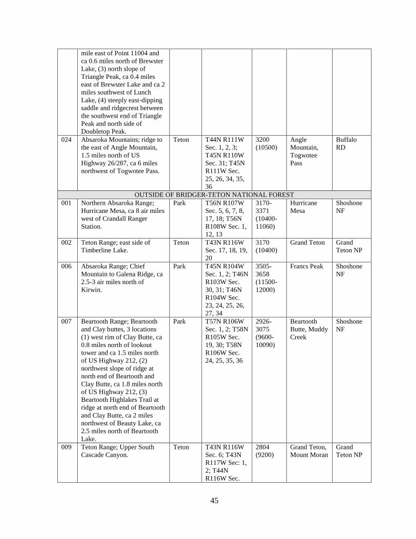
45
mile east of Point 11004 and
ca 0.6 miles north of Brewster
Lake, (3) north slope of
Triangle Peak, ca 0.4 miles
east of Brewster Lake and ca 2
miles southwest of Lunch
Lake, (4) steeply east-dipping
saddle and ridgecrest between
the southwest end of Triangle
Peak and north side of
Doubletop Peak.
024 Absaroka Mountains; ridge to
the east of Angle Mountain,
1.5 miles north of US
Highway 26/287, ca 6 miles
northwest of Togwotee Pass.
Teton T44N R111W
Sec. 1, 2, 3;
T45N R110W
Sec. 31; T45N
R111W Sec.
25, 26, 34, 35,
36
3200
(10500)
Angle
Mountain,
Togwotee
Pass
Buffalo
RD
OUTSIDE OF BRIDGER-TETON NATIONAL FOREST
001 Northern Absaroka Range;
Hurricane Mesa, ca 8 air miles
west of Crandall Ranger
Station.
Park T56N R107W
Sec. 5, 6, 7, 8,
17, 18; T56N
R108W Sec. 1,
12, 13
3170-
3371
(10400-
11060)
Hurricane
Mesa
Shoshone
NF
002 Teton Range; east side of
Timberline Lake.
Teton T43N R116W
Sec. 17, 18, 19,
20
3170
(10400)
Grand Teton Grand
Teton NP
006 Absaroka Range; Chief
Mountain to Galena Ridge, ca
2.5-3 air miles north of
Kirwin.
Park T45N R104W
Sec. 1, 2; T46N
R103W Sec.
30, 31; T46N
R104W Sec.
23, 24, 25, 26,
27, 34
3505-
3658
(11500-
12000)
Francs Peak Shoshone
NF
007 Beartooth Range; Beartooth
and Clay buttes, 3 locations
(1) west rim of Clay Butte, ca
0.8 miles north of lookout
tower and ca 1.5 miles north
of US Highway 212, (2)
northwest slope of ridge at
north end of Beartooth and
Clay Butte, ca 1.8 miles north
of US Highway 212, (3)
Beartooth Highlakes Trail at
ridge at north end of Beartooth
and Clay Butte, ca 2 miles
northwest of Beauty Lake, ca
2.5 miles north of Beartooth
Lake.
Park T57N R106W
Sec. 1, 2; T58N
R105W Sec.
19, 30; T58N
R106W Sec.
24, 25, 35, 36
2926-
3075
(9600-
10090)
Beartooth
Butte, Muddy
Creek
Shoshone
NF
009 Teton Range; Upper South
Cascade Canyon.
Teton T43N R116W
Sec. 6; T43N
R117W Sec: 1,
2; T44N
R116W Sec.
2804
(9200)
Grand Teton,
Mount Moran
Grand
Teton NP

46
19, 30, 31;
T44N R117W
Sec. 23, 24, 25,
26
011 Medicine Bow Mountains; ca
1 mile north-northeast of
Brooklyn Lake.
Albany,
Carbon
T16N R79W
Sec. 2, 3, 10,
11; T17N
R79W Sec. 35
3292
(10800)
Centennial,
Morgan,
Sand Lake
Medicine
Bow NF
013 East slope Wind River Range;
"cirque above High Meadow
Lake, west of Lander" [ca 3
miles east of the Cirque of the
Towers] and north and west
slopes of peak 12539.
Fremont T33N R103W
Sec. 26, 27, 28,
29, 32, 33, 34,
35
3429-
3703
(11250-
12150)
Lizard Head
Peak
Shoshone
NF
014 Teton Range; Jackson Hole
Mountain Resort, top of tram
and immediately north,
Tensleep Bowl, and
Rendezvous Mountain on
ridge between Granite Canyon
and Jackson Hole ca 1 mile
southwest of Aprez Vous Peak
and ca 1.5 air miles northwest
of Teton Village, ca 11-12 air
miles north-northwest of
Jackson.
Teton T42N R117W
Sec. 14, 15, 22,
23
2743-
3185
(9000-
10450)
Rendezvous
Peak, Teton
Village
Grand
Teton NP
017 Teton Range; near Hurricane
Pass, along divide between
Grand Teton National Park
and Targhee National Forest
on the Teton Crest Trail [near
Schoolroom Glacier, ca 2.2
miles west-southwest of the
Grand Teton].
Teton T43N R117W
Sec. 2; T44N
R117W Sec. 35
3194
(10480)
Grand Teton Grand
Teton NP,
Targhee
NF
018 East slope Wind River Range;
Arrow Mountain and vicinity,
ca 5 miles south of Torrey
Lake.
Fremont T39N R106W
Sec. 2, 3, 10
2664-
3523
(8740-
11560)
Ink Wells,
Torrey Lake
Shoshone
NF
019 East slope Wind River Range;
Mount Chevo, ca 15 air miles
west-southwest of Lander.
Fremont T32N R102W
Sec. 7, 8, 17
3005-
3392
(9860-
11130)
Dickinson
Park
Shoshone
NF
020 East slope Wind River Range;
between Angel Pass and
Dennis Lake, ca 11 air miles
southeast of Gannett Peak.
Fremont T35N R106W
Sec. 7, 8
3283-
3502
(10770-
11490)
Fremont Peak
South
Shoshone
NF
021 East slope Wind River Range;
ridge between Snowbridge
Lake and Big Milky Lake, ca
7 air miles east-southeast of
Gannett Peak.
Fremont T36N R106W
Sec. 10, 11, 14,
15
3307-
3792
(10850-
12440)
Alpine Lake Shoshone
NF
022 East slope Wind River Range;
northwest slope of peak
12431, ca 0.5 mile east of lake
10743, ca 2 miles southwest of
Fremont T36N R106W
Sec. 4
3158-
3344
(10360-
10970)
Fremont Peak
North,
Fremont Peak
South
Shoshone
NF

47
Little Milky Lake, ca 1.5 miles
south of North Fork Bull Lake
Creek.
023 Overthrust Belt; drainage off
Deadline Ridge [above Rock
Creek].
Sublette T27N R114W
Sec. 5, 8, 17;
T27N R115W
Sec. 12, 13
2469-
2865
(8100-
9400)
Lake
Mountain
BLM
Pinedale
Historical sites: Also known from 3-4 vague historical records cited by Hitchcock (1941).
Unverified/Undocumented reports: None known, apart from historic records (above).
Sites where present status not known: One of the records is based on a specimen collected
from Timberline Lake in Grand Teton National Park (#002) and it has immature fruit. The
growth form and beak length are consistent with Draba globosa, but the whitish petals have
lead one botanist to annotate it as D. fladnizensis. It may warrant field surveys.
Areas surveyed but species not located: There were surveys made to find the species or its
habitat on Deadline Ridge, including in the area of the original collection. Neither the
species nor its habitat was found. Surveys earlier in the season are recommended.
In addition, about 3 miles of ridge were surveyed south of Greysalt Peak, as recommended
by Marriott (2010). The ridge crest was surveyed, but not the upper east-facing slopes below,
nor the continuation of the ridge to the north beyond the summit. A survey loop might be
developed to fill gaps and expand surveys onto connecting ridges. The ridges run mainly
north-south, and if the species is locally restricted to north-facing microhabitat, then there is
little suitable habitat.
Habitat
Settings and associated vegetation: Moist, gravelly alpine meadows, slopes, summits, swales,
talus, and tundra, often on limestone derived soils at elevations of 9600-12000 feet.
Frequently associated species: The species associated with Draba globosa are listed in Table
13.
Table 13. Plants associated with Rockcress draba (Draba globosa) in Wyoming
Scientific name Common name Native/Exotic
Antennaria aromatica Scented pussytoes Native
Antennaria media Rocky Mountain pussytoes Native
Artemisia scopulorum Alpine sagebrush Native
Astragalus shultziorum Shultz’s milkvetch Native
Boechera lemmonii Soldier rockcress Native
Boechera lyallii Lyall's rockcress Native
Carex breweri Brewer’s sedge Native
Carex elymoides Black-root sedge Native
Carex nardina Nard sedge [Spikenard sedge] Native
Carex rupestris Curly sedge Native
Cerastium beeringianum var. capillare Bering Sea mouse-ear chickweed Native

48
Douglasia montana Rocky Mountain dwarf-primrose Native
Draba cana Cushion whitlow-grass Native
Draba incerta Yellowstone whitlow-grass Native
Draba lonchocarpa Lance-pod whitlow-grass Native
Draba oligosperma Common draba Native
Dryas octopetala Eight-petal mountain avens
Native
Erigeron radicatus Tap-root fleabane Native
Erigeron simplex One-stem fleabane Native
Eritrichium nanum Alpine forget-me-not Native
Festuca brachyphylla Alpine sheep-fescue Native
Geum rossii Alpine avens Native
Hymenoxys grandiflora Old man of the mountain Native
Lesquerella paysonii Payson's bladderpod Native
Lloydia serotina Common Alp-lily Native
Minuartia austromontana (Arenaria rossii) Columbian stitchwort Native
Minuartia obtusiloba Alpine stitchwort Native
Myosotis alpestris Asian forget-me-not [Mountain forget-me-not] Native
Oxyria digyna Mountain-sorrel Native
Oxytropis borealis var. viscida Boreal locoweed Native
Oxytropis deflexa Pendant-pod locoweed Native
Parrya nudicaulis Naked-stem false wallflower Native
Pedicularis pulchella Mountain lousewort Native
Phlox pulvinata Cushion phlox Native
Poa alpine Alpine bluegrass Native
Poa secunda var. incurve Curly bluegrass Native
Polemonium viscosum Sticky Jacob's-ladder [Sky-pilot] Native
Polygonum bistortoides American bistort Native
Potentilla diversifolia Mountain-meadow cinquefoil Native
Potentilla gracilis Graceful cinquefoil Native
Potentilla uniflora One-flower cinquefoil Native
Saxifraga oppositifolia Purple mountain saxifrage Native
Saxifraga rivularis Alpine brook saxifrage Native
Saxifraga rhomboidea Diamond-leaf saxifrage Native
Sedum lanceolatum Lance-leaf stonecrop Native
Selaginella densa Dense spike-moss Native
Senecio fremontii Dwarf mountain ragwort Native
Sibbaldia procumbens Creeping glow-wort Native
Silene acaulis Moss campion Native
Smelowskia calycina Fern-leaf false candytuft Native
Solidago multiradiata Rocky Mountain goldenrod Native
Townsendia alpigena Wyoming Townsend-daisy
Native
Valeriana edulis Tobacco-root
Native

49
The Salt River Range occurrence was found on in two locations on north-facing limestone
slopes, where there were outcrops along the summit or crest of the finger ridge and rocky
rubble below. The elevation ranged from 10,200 ft -10,720 ft. It is possible that it is
restricted to these kinds of sheltered microhabitats at its lower elevation limits. Directly
below the populations were steep, unstable, continuous talus slopes with almost no soil, but
which might catch and occasionally support the germination of seeds.
The Salt River Range occurrence was also found where three geological mapping units come
together. It appears to lie on the first two of the following:
Phosphoria, Wells and Amsden Formations (summit)
Madison and Darby Formations (finger ridge)
Ankareh Formation, Thaynes Limestone, Woodside Shale and Dinwoody Formations
Figures 25 and 26. Lower and
upper habitats of
Draba globosa in the Salt River
Range, respectively, by B. Heidel
Topography: Almost all occurrences are on mountaintops or on upper slopes. The Salt River
Range occurrence is found within 10 m of the Greysalt Peak summit (Figure 26), and on the
finger ridge over 150 m lower that connects to Sheep Pass (Figure 25).

50
Water and soil relationships: The fractured limestone parent material and inceptisols derived
from them hold moisture, particularly on the more sheltered slopes. The Draba globosa
taproot draws from subsurface moisture. It is not known whether its alpine habitat is
susceptible to drought, or to increased and decreased growing seasons from year to year.
Population biology and demography
Population size and condition: Few populations of Draba globosa have been surveyed. Fertig
and Welp observed two large populations in the Bridger-Teton National Forest that
numbered 500-3000 plants (Table 14). Individual colonies may contain 10-30 plants in small
clusters. The Greysalt Peak population had an estimated 40+ plants, but it is possible there
are scattered individuals on loose talus that was not surveyed. In a review of status
information from throughout its range, Ladyman (2004) noted that “D. globosa appears to be
a naturally uncommon species that is well-adapted to its fragile alpine habitat.”
Table 14. Population information for Rockcress draba (Draba globosa) in Wyoming EO# Population size Documentation Last
Observed
Date
BRIDGER-TETON NATIONAL FOREST
003 1990-08-09: In fruit. Collected by W. Fertig. Specimen 9 August
1990
004 1991-08-17: In fruit. Collected by W. Fertig. Specimen 17 August
1991
005 1992-08-04: One plant in fruit. Collected by W. Fertig. Specimen 4 August
1992
008 1998-08-02: 75% in flower, 20% in bud, and 5% in fruit. Ca 500-1000.
Largest colony 217 plants in 25 square meter area. 2-3 plants per clump.
Surveyed by W. Fertig and L. Welp.
1984-08-17: Collected by E. Evert.
Survey 2 August
1998
010 1982-08-17: Collected by B. Neely and A. Carpenter. Specimen 17 August
1982
012 Small groups of plants at 2 or more spots along steep slope.
2011-08-22 (Sections 9, 10): In fruit and vegetative. Uncommon,
possibly over 40 plants total. Surveyed by B. Heidel.
1988-07-16 (Sec. 9): In fruit. Observed by O. Harrison.
1978-07-30 (Sec. 10): In flower and early fruit. Uncommon. Only 12
plants seen. Collected by O. Harrison.
Survey 16 July
1988
014 Ca 5 subpopulations in ca 0.75 x 1 mile. Along ridge and upper slopes.
2000-08-03: (Sec 15 SE4, tram top) Collected by C. Delmatier.
2000-08-01: (Sec 15 SE4, Tensleep Bowl) Collected by C. Delmatier.
1999-07-13: (Sec 15 center of S4) Collected by C. Delmatier.
1996-07-31: (Sec 14) 90% in flower, 10% in fruit. 20-40 plants.
Surveyed by S. Markow.
1996-07-10: (Sec 15, 22) In flower and fruit. Collected by E. and Y.
Evert.
Survey 3 August
2000
015 1994-06-28: In fruit. Collected by R. Hartman. Specimen 28 June
1994
016 4 subpopulations in 2.5 x 2 miles.
1998-08-04: 3 subpopulations (Sec 33) In flower and fruit. Intermixed
with Draba oligosperma. Surveyed by L. Welp. (Sec 3) In fruit. Sparse.
10 plants observed on rocky edge of tundra meadow. (Sec 9) In flower
Survey 4 August
1998

51
and fruit. Ca 1000-3000 individuals. Plants typically in scattered clusters
of 25-50 plants. Surveyed by W. Fertig
1994-08-05: (Sec 7) In fruit. Collected by R. Hartman.
024 1994-07-07: In flower. Collected by E. Evert. Specimen 7 July1994
OUTSIDE OF BRIDGER-TETON NATIONAL FOREST
001 1988-07-05: In fruit. Collected by R. Hartman and T.J. Poll. Specimen 5 July
1988
002 1967-08-08: In flower and very immature fruit. Rare. Petals appear
white, and immature fruits are very short-beaked. Collected by R. Shaw.
Specimen 8 August
1967
006 1984-08-22: In fruit. Collected by R. Hartman. Specimen 22 August
1984
007 3 subpopulations in ca 1 x 2 miles.
1996-07-15: (Sec 2) In flower and fruit. Locally uncommon. Surveyed
by S. Mellmann-Brown.
1996-07-11: (Sec 36) Only 1 fruiting plant observed in brief survey.
Very uncommon. Surveyed by W. Fertig, J. Walford, and S. Mellmann-
Brown.
1996-07-10: (Sec 2) In flower and fruit. 5 plants observed in small patch
(population estimated at 20-40 plants). Surveyed by W. Fertig, J.
Walford, and S. Mellmann-Brown.
1996-07-09: (Sec 2) In flower and fruit. Collected by S. Mellmann-
Brown, J. Walford.
1980-08-10: (Sec 25) In fruit. Collected by R. Dorn.
1951-08-17: (Sec 2) In flower and fruit. Collected by C.L. Porter.
1951-08-01: (Sec 2) In fruit. Collected by R. Rollins and C.L. Porter.
1939-07-17: (Sec 2) Collected by R. Rollins and C. Munoz.
Survey 15 July
1996
009 1952-07-08: In flower and fruit. Collected by J. French. Specimen 8 July
1952
011 1985-07-27: In fruit. Collected by R. Dorn.
1898-08-29: In fruit. Collected by E. Nelson.
Specimen 27 July
1985
013 Ca 2 subpopulations in ca 1.5 miles.
2006-07-19: (Sec 29, 28) Collected by R. Massatti.
1975-08-10: (Sec 27, 34) Collected by B. Albee.
Specimen 19 July
2006
014 Ca 5 subpopulations in ca 0.75 x 1 mile. Along ridge and upper slopes.
2000-08-03: (Sec 15 SE4, tram top) Collected by C. Delmatier.
2000-08-01: (Sec 15 SE4, Tensleep Bowl) Collected by C. Delmatier.
1999-07-13: (Sec 15 center of S4) Collected by C. Delmatier.
1996-07-31: (Sec 14) 90% in flower, 10% in fruit. 20-40 plants.
Surveyed by S. Markow.
1996-07-10: (Sec 15, 22) In flower and fruit. Collected by E. and Y.
Evert.
Survey 3 August
2000
017 1995-09-16: In fruit. Collected by B. Heidel. Specimen 16 Sep
1995
018 2006-06-11: Collected by R. Massatti. Specimen 11 June
2006
019 2006-06-24: Collected by R. Massatti. Specimen 24 June
2006
020 2006-07-25: Extends for over a mile. Collected by R. Massatti and A.
Wells.
Specimen 25 July
2006
021 2006-07-27: Collected by R. Massatti and A. Wells. Specimen 27 July
2006
022 2006-07-27: Collected by R. Massatti and A. Wells. Specimen 27 July
2006
023 1995-07-02: Collected by J. and J. Jewell. Specimen 2 July
1995

52
Trend: There is little basis for evaluating trends because none of the repeat visits have been
made by the same investigator or to the identical place. Populations are generally assumed to
be stable due to low threats.
Threats: The same generalizations about threats to Shultz’s milkvetch are even more
pertinent for Rockcress draba. In Wyoming it is generally protected from human threats by
its inaccessible habitat (Fertig 2000). Past impacts from sheep grazing at high elevations are
poorly known, but most occurrences are at sufficiently high elevation, low productivity
habitat or physically protected sites that receive little use or impacts. This would certainly be
the case in the study area west of Sheep Pass, where Draba globosa is confined to rocky
rubble.
Elsewhere in its distribution, Draba globosa might be threatened by recreational use,
invasive species, mountain goat introduction, and wet nitrogen deposition (acid rain) as it
potentially impacts forb communities in alpine tundra (Ladyman 2004).

53
PAYSON'S BLADDERPOD
Lesquerella paysonii Rollins
Classification
Scientific name: Lesquerella paysonii Rollins
Synonyms: Physaria carinata (Rollins) O’Kane and Al-Shehbaz ssp. paysonii (Rollins)
O’Kane. Note: This nomenclatural change will be incorporated in the 2012 species of
concern list update.
Common name: Payson’s bladderpod
Family: Brassicaceae
Size of genus: There are 12 species of Lesquerella reported for Wyoming in Dorn (2001), not
including distinctions at the variety level. The Lesquerella genus is a New World genus
consisting of over 80 species (Rollins 1993). However, recent molecular and morphological
work supports the union of this genus with the Physaria genus, which had been published
earlier than the Lesquerella genus (see Al-Shebaz and O’Kane 2002).
Phylogenetic relationships: There has also been taxonomic research that has resulted in new
combinations and status changes for Lesquerella paysonii and two other regional endemics of
the Greater Yellowstone area. Lesquerella paysonii is reduced to a subspecies of L. carinata,
the same as is Lesquerella pulchella of southwestern Montana (O’Kane 2007). They are
transferred to the Physaria genus, with O’Kane (2007) stating: “All three taxa can easily be
accommodated in an expanded concept of P. carinata at the subspecific level.” He developed
a key for them and reports that they are all three often sympatric (this sympatry has not been
reported from Wyoming to date). In Wyoming, Physaria carinata ssp. carinata (Lesquerella
carinata) and P. c. ssp. paysonii are both present in Teton County, outside the study area.
Present legal or other formal status
U.S. Fish & Wildlife Service: None (Former C2 candidate under the Endangered Species
Act)
U.S. Forest Service – Region 4 – sensitive. It has been previously recommended for de-
listing by Fertig (1997).
Global Heritage rank: G3
State Legal status: none
State Heritage rank: The more recent list update (Heidel 2007) reported a state rank of S3.
Wyoming contribution rank: Conservation of Payson’s bladderpod as a regional endemic at
the core of its range is a High conservation priority. As a limited distribution species with a
significant portion of its distribution in Wyoming, it is maintained on the Watch List.
Description
Technical description: Payson's bladderpod is a densely pubescent perennial herb with
decumbent stems 5-15 cm long from an unbranched caudex. Basal leaves are silvery-hairy
with elliptic to triangular blades and short petioles. Stem leaves are shorter, with nearly
sessile elliptic blades. Flowers have 4 yellow petals 8-10 mm long. The pubescent, elliptic
fruits are borne on S-curved stalks and are slightly flattened at a right angle to the partition
separating the two halves of the fruit (the margins and face of the fruit are rounded, rather
than sharp-pointed from a raised keel). The styles in fruit are 2-4 mm long (Rollins 1950,
1993; Rollins and Shaw 1973; Fertig et al. 1994, O’Kane 2010).

54
Figure 27 (above). Lesquerella paysonii,
by W. Fertig, from Fertig et al. 1994
Figure 28 (upper right). Lesquerella paysonii
in flower, by B. Heidel
Figure 29 (right). Lesquerella paysonii,
in fruit, by B. Heidel
Similar Species: Lesquerella carinata has stongly flattened fruits with keeled margins and
faces. L. fremontii has recurved fruit stalks and smaller flowers and styles. Other Lesquerella
spp. in Wyoming differ in having inflated fruit pods (Fertig et al. 1994).
Flowering/Fruiting Period: Flowering occurs from mid-April to late June. Fruits are
produced from late June to late August.
There was a very late growing season in 2011 and high winter snowfall, such that snow
banks were late to melt. Some of the Deadline Ridge population was apparently buried for
an extended time by snow, because segments of a couple subpopulations were found in full
flower during late August survey (Figure 28) while the rest were in fruit (Figure 29).
Local field characters: The elliptic to triangular leaf blade is a cluster of basal leaves are
fairly distinctive (see both shapes in Figures 28 and 29). Fruits are needed for positive
determination.

55
Geographical distribution
Range: Regional endemic of west-central Wyoming, eastern Idaho, and southwestern
Montana. In Wyoming, this species is found in the Gros Ventre, Salt River, Snake River,
Teton, Wind River, and Wyoming ranges, the northern Green River Basin, and Jackson Hole
in Lincoln, Sublette, and Teton counties. Scott (1997) also reports populations from the east
slope of the Wind River Range in Fremont County, but these may represent L. fremontii.
Extant sites: Known from 41 extant occurrences, 31 of which are on the Bridger-Teton
National Forest; 31 occurrences have been discovered or relocated since 1990 (Figure 30,
Table 15). The Deadline Ridge occurrence (#028) surveyed in 2011 is the southernmost
known record (Figure 30).
They are known from lands managed by Grand Teton National Park, Bridger-Teton and
Targhee National Forests, and the BLM Pinedale Field Office.
Historical sites: There are six occurrences based on historical collection records.
Unverified/Undocumented reports: None known.
Figure 30. Distribution of Payson’s bladderpod (Lesquerella paysonii) in Region 4 of the
U.S. Forest Service (Wyoming)

56
Table 15. Occurrences of Payson’s bladderpod (Lesquerella paysonii) in Wyoming
EO# Directions County Legal
Description
Elevation
m (ft)
USGS 7.5’
Quad
Public
Land
BRIDGER-TETON NATIONAL FOREST
001 Wyoming Range; Hoback
Canyon.
Sublette T38N R113W
Sec. 7, 18, 19;
T38N R114W
Sec. 1, 2, 3, 9,
10, 11, 12
1951-
2164
(6400-
7100)
Bondurant,
Bull Creek,
Clause Peak,
Granite Falls
Big Piney
RD,
Jackson
RD
002 West slope Wind River Range;
Kendall Warm Springs and
warm springs north of Stinky
Spring on east side of Green
River, adjacent to Green River
Lakes Road, ca 29 air miles
north of Pinedale. Also along
Lime Creek on west side of the
Green River directly across
from Kendall Warm Springs.
Sublette T38N R110W
Sec. 2, 3, 4, 5, 8,
9, 10, 11, 12, 14
2377-
2682
(7800-
8800)
Klondike Hill Pinedale
RD
003 Gros Ventre Range; Tepee
Creek Ridge west to Red Hills,
6-9 air miles southwest of
Mosquito Lake (in vicinity of
Payson's general collection
locality "15 miles northeast of
Bondurant").
Sublette,
Teton
T39N R111W
Sec. 3, 4, 5, 6, 7,
8, 9, 10, 11, 14
2926-
3170
(9600-
10400)
Ouzel Falls,
Tosi Peak
Jackson
RD,
Pinedale
RD
004 Wyoming Range; east and
south slopes of Mount
McDougal and McDougal Gap,
38 air miles west of Daniel.
Lincoln,
Sublette
T33N R115W
Sec. 3, 4, 5, 8, 9,
10, 11, 15, 16,
17; T34N
R115W
2573-
2926
(8440-
9600)
Triple Peak Big Piney
RD, Greys
River RD
005 Salt River Range; Greys River
at Lost Creek, ca 22.5 miles
north-northeast of Afton.
Lincoln T35N R117W
Sec. 3, 4, 5, 8, 9,
10, 16, 17
1914
(6280)
Deer Creek Greys
River RD
006 Gros Ventre Range; Lower
Slide Lake.
Teton T42N R114W
Sec. 3, 4, 5, 6, 7,
8, 9, 10; T43N
R114W Sec. 28,
29
2164
(7100)
Blue Miner
Lake, Shadow
Mountain
Jackson
RD
008 Salt River Range; near Murphy
Creek and western slopes of
peak 9988, in vicinity of Star
Peaks.
Lincoln T35N R118W
Sec. 14, 15, 22,
23, 26, 27
2377-
3044
(7800-
9988)
Deer Creek,
Stewart Peak,
Thayne East
Greys
River RD
011 Wyoming Range; Grayback
Ridge, 2.5-3.5 air miles east-
southeast of McCain Guard
Station.
Lincoln T36N R116W
Sec. 2, 3, 10, 11,
14, 15
2835-
2865
(9300-
9400)
Pickle Pass Greys
River RD,
Jackson
RD
012 Salt River Range; above Crow
Creek Lakes, 9 air miles east of
Afton.
Lincoln T32N R117W
Sec. 21, 22, 23,
26, 27, 28, 33,
34, 35
2713
(8900)
Box Canyon
Creek, Red
Top Mountain
Greys
River RD
013 Northern Salt River Range;
Squaw Flat [along the Greys
River, ca 5 air miles east of
Lincoln T36N R118W
Sec. 4, 5; T37N
R117W Sec. 19,
1676
(5500)
Ferry Peak Greys
River RD

57
Alpine and ca 3.5 miles south of
the Grand Canyon of the Snake
River].
30, 31; T37N
R118W Sec. 35,
36
014 Salt River Range; Strawberry
Creek, 3/8 miles below dam, ca
13 air miles north-northeast of
Afton, ca 1.5 air miles east of
Bedford.
Lincoln T34N R118W
Sec. 24, 25
2097
(6880)
Man Peak Greys
River RD
015 Salt River/Wyoming Ranges;
Greys River, in area of Forest
Park, ca 15 air miles northeast
of Afton.
Lincoln T33N R116W
Sec. 16, 20, 21,
22, 28
2126
(6975)
Park Creek Greys
River RD
016 Salt River Range; mountains
near Cottonwood Lake, east of
Smoot.
Lincoln T30N R117W
Sec. 2, 3, 4, 5;
T31N R117W
Sec. 8, 9, 10, 11,
13, 14
3048
(10000)
Box Canyon
Creek, Mount
Wagner,
Poison
Meadows, Red
Top Mountain
Greys
River RD
017 Southern Teton Range; 2
locations (1) east slope of
Rendezvous Mountain ridge on
ridge between Granite Canyon
and Jackson Hole and (2) along
crest of Rendezvous Peak (in
the vicinity of the tram) and
continuing along the trail into
the basin to the south west
(Cody Bowl).
Teton T42N 117W
Sec. 14, 15, 21,
22, 28
2896-
3139
(9500-
10300)
Rendezvous
Peak, Teton
Village
Jackson
RD
018 Northern Wind River Range;
Gypsum Creek Road, ca 1-1.5
miles southeast of Red Hill.
Sublette T38N R109W
Sec. 17, 18, 19,
20
2469-
2499
(8100-
8200)
Big Sheep
Mountain,
Kendall
Mountain
Pinedale
RD
021 Wyoming Range; Deadman
Mine [Vail Mine, at head of
Deadman Creek].
Lincoln T35N R116W
Sec. 25, 26, 35,
36
2402-
2805
(7880-
9202)
Blind Bull
Creek
Greys
River RD
022 Wyoming Range; Cliff Creek,
ca 0.7 miles south of the
junction of Cliff Creek Road
and US Highway 189-191, also
juncture of Kerr, Little Cliff,
and Cliff creeks.
Sublette T38N R114W
Sec. 22, 23, 26,
27, 34, 35
1963-
2057
(6440-
6750)
Bondurant,
Clause Peak
Big Piney
RD
023 Salt River Range; Prater
Canyon [ca 6.5 air miles
northeast of Thayne, ca 7 air
miles north of Bedford].
Lincoln T35N R118W
Sec. 17, 18, 19,
20, 21, 28, 29,
30, 31, 32
1999-
2499
(6560-
8200)
Stewart Peak,
Thayne East
Greys
River RD
024 Salt River Range; ridge north
and west of Corral Creek Lake
and pass between two forks of
Dry Creek Lake.
Lincoln T31N R117W
Sec. 5, 8, 9;
T32N R117W
Sec. 29, 30, 31,
32
2911-
3170
(9550-
10400)
Red Top
Mountain
Greys
River RD
025 Salt River Range; Man Peak,
along ridge from summit for 0.5
miles south and ridge 1-2 air
miles southwest.
Lincoln T34N R117W
Sec. 4, 5, 6, 8, 9;
T35N R117W
Sec. 32
2804-
3090
(9200-
10139)
Man Peak Greys
River RD

58
026 Salt River Range; McDougal
Pass and ridge for 0.5 miles
south.
Lincoln T33N R117W
Sec. 9, 16
2926-
2987
(9600-
9800)
Rock Lake
Peak
Greys
River RD
027 Salt River Range; ca 0.5 mile
west of North Fork Swift Creek
mouth, on north-south trending
ridge dividing the Star Valley
and Swift Creek Canyon
drainage, ca 2 air miles
northeast of Afton.
Lincoln T32N R118W
Sec. 16
2621
(8600)
Grover Greys
River RD
028 Wyoming Range; Deadline
Ridge and southwest corner of
Riley Ridge, ca 21 air miles
southwest of Big Piney.
Sublette T28N R115W
Sec. 3, 9, 16, 22;
T29N R115W
Sec. 36
3078-
3109
(9680-
10280)
Pine Grove
Ridge
Big Piney
RD
029 Gros Ventre Mountains; along
ridge southeast 0.25 mile from
Pinnacle Peak, just east of Little
Granite Creek, ca 2.5 mile east
of Gros Ventre RNA, ca 6.5
miles north of US Highway
191-189.
Teton T39N R114W
Sec. 3, 4; T40N
R114W Sec. 33,
34
3109-
3231
(10200-
10600)
Bull Creek,
Turquoise Lake
Jackson
RD
030 Gros Ventre Range; ridges 1.3
air miles north of Cache Peak
northwest to base of Jackson
Peak.
Teton T40N R115W
Sec. 2, 3, 10, 11,
14, 15
2926-
3078
(9600-
10100)
Cache Creek,
Turquoise Lake
Jackson
RD
031 Gros Ventre Range; summit of
ridge extending south from
Packsaddle Pass and Pyramid
Peak.
Teton T40N R113W
Sec. 7, 8, 17, 18
2621-
3109
(8600-
10200)
Crystal Peak Jackson
RD
032 Gros Ventre Range; Hodges
Peak and along base of east
side.
Sublette T39N R112W
Sec. 22, 23, 26,
27
3170-
3597
(10400-
11800)
Doubletop
Peak
Jackson
RD
033 Snake River Range; ridge and
upper slopes extending for ca
0.5 miles south of Teton Pass
on Wyoming Highway 22, ca
9.5 air miles west of Jackson.
Teton T41N R118W
Sec. 23, 24, 25,
26
2591-
2743
(8500-
9000)
Rendezvous
Peak, Teton
Pass
Jackson
RD, Teton
Basin RD
036 Gros Ventre Mountains; Swift
Creek trail from Wilderness
Boundary north-northeast ca 1.5
air miles, ca 1 mile east of "The
Open Door", ca 2 air miles east
of Granite Creek Campground,
also west slope of Corner Peak,
ca 1 air mile west of MacLeod
Lake.
Teton T39N R113W
Sec. 3, 4, 5, 8, 9,
10; T40N
R113W Sec. 33,
34
2438
(8000)
Crystal Peak,
Granite Falls
Jackson
RD
037 Gros Ventre Mountains; Sheep
Mountain, ca 14 miles northeast
of Jackson.
Teton T41N R114W
Sec. 1, 2, 3, 4, 5,
6, 7, 8, 9, 10
3048
(10000)
Blue Miner
Lake, Grizzly
Lake
Jackson
RD
038 Jackson Hole; Turpin
Meadows, east of Moran [north
of the Buffalo Fork River in
vicinity of Turpin Meadows
Teton T45N R112W
Sec. 13, 14, 15,
22, 23, 24
2103
(6900)
Rosies Ridge Buffalo
RD

59
Lodge, ca 3-3.5 air miles north
of US Highway 26-287].
039 Salt River Range; Mink Creek
drainage along LaBarge Creek
Divide, and headwaters of
Spring Creek and Smith Fork,
ca 9 miles east-northeast of
Smoot.
Lincoln T30N R117W
Sec. 1, 2, 3, 4,
10, 11, 12, 13,
14, 15
2819-
2896
(9250-
9500)
Mount
Wagner,
Poison
Meadows
Greys
River RD
040 Gros Ventre Range; east slope
and southeast flank of Darwin
Peak, ca 0.3-1.5 miles north of
Brewster Lake.
Sublette,
Teton
T39N R112W
Sec. 3, 4; T40N
R112W Sec. 28,
29, 32, 33, 34
3072-
3475
(10080-
11400)
Darwin Peak Jackson
RD
042 Gros Ventre Range; Dry Fork
Trail by junction with Ouzel
Falls Trail and on north side of
Clear Creek just before
footbridge, ca 0.3 and 2.5 miles
west of Darwin Ranch.
Teton T40N R111W
Sec. 21, 28, 30
2499-
2804
(8200-
9200)
Ouzel Falls Jackson
RD
043 Wind River Range; Limestone
Mountain [ridge just west of
Osbourne Mountain].
Sublette T38N R108W
Sec. 4, 5; T39N
R108W Sec. 20,
21, 27, 28, 29,
32, 33, 34
3139
(10300)
Green River
Lakes
Pinedale
RD
044 Gros Ventre Range; south side
of Triangle Peak and North side
of Doubletop Peak, ca 0.5-1.5
miles south of Brewster Lake.
Sublette T39N R112W
Sec. 3, 4, 9, 10,
16
3261-
3536
(10700-
11600)
Doubletop
Peak
Jackson
RD
046 Wyoming Range; south end of
ridge between Hunter and
Willow creeks, ca 1.5 miles
northwest of Horse Heaven
Meadows, ca 2.5 miles east of
Grayback Ridge.
Lincoln T36N R115W
Sec. 5, 6, 7, 8;
T36N R116W
Sec. 1, 12; T37N
R115W Sec. 33,
34, 35
2499-
2804
(8200-
9200)
Bailey Lake,
Clause Peak,
Hoback Peak,
Pickle Pass
Greys
River RD,
Jackson
RD
047 Salt River Range; along Greys
River at Mink Creek, ca 12 air
miles east of Smoot, ca 16 air
miles southeast of Afton.
Lincoln T30N R116W
Sec. 7, 8, 17
2438
(8000)
Poison
Meadows
Greys
River RD
048 Wyoming Range; Hoback
Canyon, road cut on US
Highway 189-191, just north of
Granite Creek turnoff.
Sublette T38N R114W
Sec. 4
1925
(6315)
Bull Creek Big Piney
RD
OUTSIDE OF BRIDGER-TETON NATIONAL FOREST
007 Jackson Hole; near mouth of
Pacific Creek.
Teton T45N R114W
Sec. 14, 15, 22,
23
2042-
2057
(6700-
6750)
Moran Grand
Teton NP
010 Green River Basin; 2 locations:
(1) east bank of "The Narrows"
of the Green River, 1-1.5 miles
northeast of Warren Bridge, 16
air miles northwest of Pinedale;
(2) Warren Bridge Campground
on the east bank of the Green
River, just south of US Hwy
191-189.
Sublette T35N R111W
Sec. 2, 3, 4, 5, 8,
9, 10, 11, 15, 16;
T36N R111W
2316
(7600)
Warren Bridge BLM
Pinedale

60
017 Southern Teton Range; 2
locations (1) east slope of
Rendezvous Mountain ridge on
ridge between Granite Canyon
and Jackson Hole and (2) along
crest of Rendezvous Peak (in
the vicinity of the tram) and
continuing along the trail into
the basin to the south west
(Cody Bowl).
Teton T42N 117W
Sec. 14, 15, 21,
22, 28
2896-
3139
(9500-
10300)
Rendezvous
Peak, Teton
Village
Grand
Teton NP
019 Teton Range; 0.5-1.5 miles
west and south of Marion Lake,
adjacent to Game Creek and
Teton Crest trails.
Teton T42N R117W
Sec. 7, 18
2713-
2957
(8900-
9840)
Rendezvous
Peak
Grand
Teton NP
020 Teton Range; Mount Hunt
Divide, adjacent to Open
Canyon Trail, ca 0.5 miles east-
southeast of summit of Mount
Hunt.
Teton T42N R117W
Sec. 2
2957
(9700)
Grand Teton Grand
Teton NP
033 Snake River Range; ridge and
upper slopes extending for ca
0.5 miles south of Teton Pass
on Wyoming Highway 22, ca
9.5 air miles west of Jackson.
Teton T41N R118W
Sec. 23, 24, 25,
26
2591-
2743
(8500-
9000)
Rendezvous
Peak, Teton
Pass
Targhee
NF
034 Teton Mountains; west slope,
summit of Freds Mountain, ca
0.3 miles southeast of ski lift
tower, ca 1.4 miles east of
Grand Targhee Resort, ca 2
miles north of the Teton
Canyon Road.
Teton T44N R117W
Sec. 7, 18
3018
(9900)
Granite Basin Targhee
NF
035 Snake River Range; ridge
leading to and 0.5 miles
southwest of Powder Peak, ca
12 air miles north of Alpine,
near the head of tributary of
Box Canyon, 1.5 air miles east
of the Idaho State line, ca 6.5
air miles northeast of Palisades
Reservoir.
Teton T39N R118W
Sec. 29
2804
(9200)
Mount Baird Targhee
NF
041 Teton Range; along Webb
Canyon Trail, ca 0.5 mile
northwest of Moose Basin
patrol cabin, ca 0.7 mile east of
Moose Basin Divide, ca 27
miles from Jackson.
Teton T46N R116W
Sec. 7, 18, T46N
R117W Sec. 12,
13
2792-
2896
(9160-
9500)
Ranger Peak Grand
Teton NP
045 Overthrust Belt; Hams Fork
Plateau, just north of upper
Schuster Basin and slopes south
of Fish Creek where it bends to
the north, ca 2 miles from
Emigrant Springs.
Lincoln T22N R117W
Sec. 5, 6; T22N
R118W Sec. 1;
T23N R117W
Sec. 18, 29, 30,
31, 32, 33; T23N
R118W Sec. 13
2256-
2377
(7400-
7800)
Kemmerer
Reservoir, The
Rock Slide
State of
Wyoming
Sites where present status not known: None known.

61
Areas surveyed but species not located: None.
Figure 31. Habitat of Lesquerella paysonii on Deadline Ridge (#028), at arrows, Bridger-
Teton National Forest, by B. Heidel
Figure 32. Habitat of Lesquerella paysonii in the Teton Range, Grand Teton National Park,
by H. Marriott

62
Habitat
Setting and associated vegetation: In Wyoming, Lesquerella paysonii is found primarily on
windswept, gravelly, calcareous ridgecrests and semi-open slopes (Fertig 1997), typically on
crest and upper slope positions, and with other breaks in topography (Figures 31-32). He
goes on to describe the surrounding vegetation as typically dominated by Artemisia
tridentata var. vaseyana but populations have also been reported from talus slopes, disturbed
roadsides, dried stream channels, and rocky clearings in lodgepole pine and subalpine fir
forests (Fertig 1997).
It is mainly found on the following two geology mapping units but not restricted to them:
Madison and Darby Formations
Phosphoria, Wells and Amsden Formations
Frequently associated species: The species associated with Lesquerella paysonii are listed in
Table 16.
Table 16. Plants associated with Payson’s bladderpod (Lesquerella paysonii) in Wyoming
Scientific name Common name Native/ Exotic
Achillea millefolium Common yarrow Native
Allium brandegei Brandegee onion Native
Anemone tetonense Teton thimbleweed Native
Antennaria dimorpha Cushion pussytoes Native
Antennaria microphylla Small-leaf pussytoes Native
Antennaria umbrinella Umber pussytoes Native
Astragalus kentrophyta var. tegetarius Thistle milkvetch Native
Astragalus miser Weedy milkvetch Native
Astragalus shultziorum Shultz’s milkvetch Native
Boechera holboellii Holboell’s rockcress Native
Carex nardina Spikenard sedge Native
Cymopterus terebinthinus Turpentine cymopterus Native
Eremogone congesta Ballhead sandwort Native
Elymus elymoides Bottlebrush squirreltail Native
Erigeron compositus Cut-leaved daisy Native
Erigeron eatonii Eaton’s daisy Native
Erigeron ursinus Bear River fleabane Native
Eriogonum umbellatum Sulfur buckwheat Native
Frasera speciosa Green gentian Native
Hedysarum occidentale Western sweetvetch Native
Leucopoa kingii Spike-fescue Native
Linum lewisii Wild blue flax Native
Lupinus lepidus Stemless dwarf lupine Native
Macranthera canescens Hoary aster Native
Penstemon montanus Mountain beardtongue Native
Phacelia sericea Silky phacelia Native

63
Phlox hoodii Hood’s phlox Native
Pinus albiculis Whitebark pine Native
Poa secunda var. incurva Sandberg’s bluegrass Native
Potentilla fruticosa Shrubby cinquefoil Native
Potentilla glandulosa Glandular cinquefoil Native
Potentilla ovina Sheep cinquefoil Native
Sedum lanceolatum Lance-leaved stonecrop Native
Senecio crassulus Thick-leaf ragwort Native
Townsendia alpigena Wyoming Townsend-daisy Native
Taraxacum officinale Common dandelion Exotic
Topography: The topographic position of Lesquerella paysonii varies. It is often on exposed
ridgecrests or upper slopes but is also known from gravelly stream terrace bottomland. A
schematic diagram of its topographic position is reprinted from Fertig (1997) in Figure 33.
Water and soil relationships: Lesquerella paysonii populations are found primarily on
calcareous substrates derived from limestone or dolomite. Soils are usually well-drained,
poorly developed, thin, and coarse textured (Fertig 1997). Occasionally, populations have
been reported from sandstones, shales, alluvium, and travertine.
Figure 33. Topographic position of Lesquerella paysonii on the landscape, by W. Fertig,
from Fertig (1997)
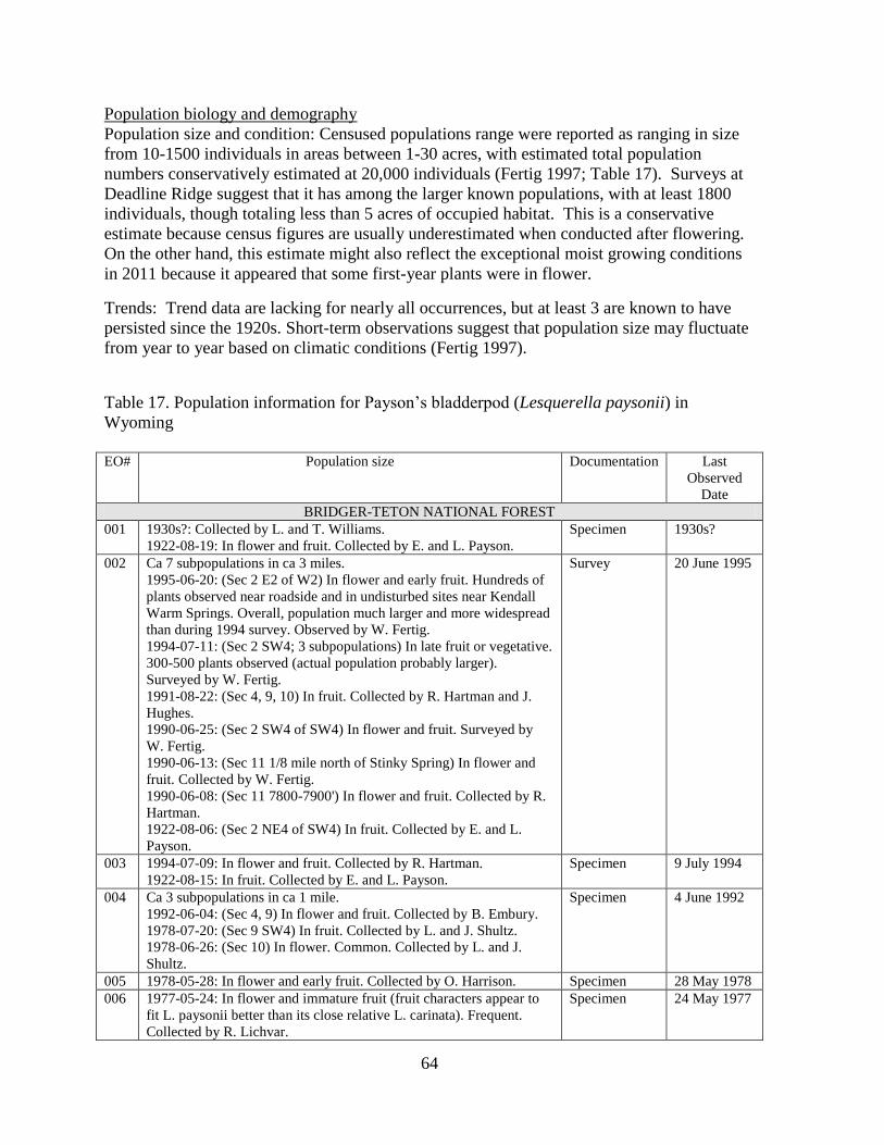
64
Population biology and demography
Population size and condition: Censused populations range were reported as ranging in size
from 10-1500 individuals in areas between 1-30 acres, with estimated total population
numbers conservatively estimated at 20,000 individuals (Fertig 1997; Table 17). Surveys at
Deadline Ridge suggest that it has among the larger known populations, with at least 1800
individuals, though totaling less than 5 acres of occupied habitat. This is a conservative
estimate because census figures are usually underestimated when conducted after flowering.
On the other hand, this estimate might also reflect the exceptional moist growing conditions
in 2011 because it appeared that some first-year plants were in flower.
Trends: Trend data are lacking for nearly all occurrences, but at least 3 are known to have
persisted since the 1920s. Short-term observations suggest that population size may fluctuate
from year to year based on climatic conditions (Fertig 1997).
Table 17. Population information for Payson’s bladderpod (Lesquerella paysonii) in
Wyoming
EO# Population size Documentation Last
Observed
Date
BRIDGER-TETON NATIONAL FOREST
001 1930s?: Collected by L. and T. Williams.
1922-08-19: In flower and fruit. Collected by E. and L. Payson.
Specimen 1930s?
002 Ca 7 subpopulations in ca 3 miles.
1995-06-20: (Sec 2 E2 of W2) In flower and early fruit. Hundreds of
plants observed near roadside and in undisturbed sites near Kendall
Warm Springs. Overall, population much larger and more widespread
than during 1994 survey. Observed by W. Fertig.
1994-07-11: (Sec 2 SW4; 3 subpopulations) In late fruit or vegetative.
300-500 plants observed (actual population probably larger).
Surveyed by W. Fertig.
1991-08-22: (Sec 4, 9, 10) In fruit. Collected by R. Hartman and J.
Hughes.
1990-06-25: (Sec 2 SW4 of SW4) In flower and fruit. Surveyed by
W. Fertig.
1990-06-13: (Sec 11 1/8 mile north of Stinky Spring) In flower and
fruit. Collected by W. Fertig.
1990-06-08: (Sec 11 7800-7900') In flower and fruit. Collected by R.
Hartman.
1922-08-06: (Sec 2 NE4 of SW4) In fruit. Collected by E. and L.
Payson.
Survey 20 June 1995
003 1994-07-09: In flower and fruit. Collected by R. Hartman.
1922-08-15: In fruit. Collected by E. and L. Payson.
Specimen 9 July 1994
004 Ca 3 subpopulations in ca 1 mile.
1992-06-04: (Sec 4, 9) In flower and fruit. Collected by B. Embury.
1978-07-20: (Sec 9 SW4) In fruit. Collected by L. and J. Shultz.
1978-06-26: (Sec 10) In flower. Common. Collected by L. and J.
Shultz.
Specimen 4 June 1992
005 1978-05-28: In flower and early fruit. Collected by O. Harrison. Specimen 28 May 1978
006 1977-05-24: In flower and immature fruit (fruit characters appear to
fit L. paysonii better than its close relative L. carinata). Frequent.
Collected by R. Lichvar.
Specimen 24 May 1977

65
008 Ca 3 subpopulations in ca 1 mile.
1992-08-22: (Sec 23 western slopes of peak 9988) In fruit. Collected
by R. Hartman.
1986-08-02: (Sec 23 rocky basin) In flower and fruit. Collected by O.
Harrison.
1986-07-21: (Sec 22) In flower and fruit. Collected by O. Harrison.
Specimen 22 August
1992
011 2 subpopulations in ca 1.5 miles.
1990-07-16: (Sec 14) Collected by B.E. Nelson.
1979-08-06: (Sec 10) In fruit. Collected by L. and J. Shultz.
Specimen 16 July 1990
012 1979-07-05: In flower and fruit. Collected by J. Shultz. Occurs with
Douglas-fir and whitebark pine.
Specimen 5 July 1979
013 1926-05-16: In flower and immature fruit. Distribution patchy.
Collected by C. McDonald.
Specimen 16 May 1926
014 1985-05-18: In flower. Collected by O. Harrison. Specimen 18 May 1985
015 1980-07-16: In flower and fruit. Collected by O. Harrison. Specimen 16 July 1980
016 1923-08-13: In flower and fruit. Collected by E. Payson and G.
Armstrong.
Specimen 13 August
1923
017 Ca 4 subpopulations in ca 2 miles.
2000-08-22: (Sec 22 center of N4) In fruit. Collected by C. Delmatier.
2000-08-02: (Sec 21 SE4, 22 SW4 of NW4; 2 subpopulations) In
fruit. Collected by C. Delmatier.
2000-07-26: (Sec 21 NE4) In fruit. Collected by C. Delmatier.
1996-07-31: (Sec 14; ridge above Granite Canyon) Ca 10% in flower,
90% in fruit. 200-500 individuals in 1-2 acres. Surveyed by S.
Markow.
1994-07-10: (Sec 15, 21, 22; along trail) In flower and fruit.
Moderately common. Surveyed by Wyoming Native Plant Society
annual field trip.
1990-08-26: (Sec 22 center of N4, NE4 of NW4; 2 subpopulations) In
fruit. Collected by H. Marriott.
Survey 20 August
2000
018 1990-06-08: In flower and fruit. Collected by R. Hartman. Specimen 8 June 1990
021 1992-06-06: In flower and fruit. Collected by B. Embury. Specimen 6 June 1992
022 2 subpopulations in ca 1.5 miles.
1995-06-20: (Sec 22, 23) Ca 70% of all plants with fruit, 50% also in
flower, and ca 30% vegetative. Ca 500+ plants in limited area
(additional habitat in the vicinity in the floodplain of Cliff Creek).
Surveyed by W. Fertig.
1992-05-09: (Sec 26, 27) In flower and fruit. Collected by R. Hartman
and B. Embury.
Survey 20 June 1995
023 1992-06-19: In flower and fruit. Collected by R. Hartman and B.
Embury.
Specimen 19 June 1992
024 2 subpopulations along ca 2 miles of same ridge system.
1992-06-19: (Sec 8) In flower and fruit. Collected by R. Hartman.
1990-07-07: (Sec 31) Collected by O. Harrison.
Specimen 19 June 1992
025 2 subpopulations in ca 0.75 mile.
1992-08-16: (both subpopulations) In fruit. Collected by R. Hartman.
Specimen 16 August
1992
026 1992-07-24: In fruit. Collected by R. Hartman. Specimen 24 July 1992
027 1993-07-16: In flower and mature fruit. Surveyed by W. Fertig. Survey 16 July 1993
028 7 main subpopulations along ca 3 miles of ridge, plus 2 northern
outliers.
2011-08-22, 23: In fruit, flower and vegetative. Ca 1800-5000 plants.
Surveyed by B. Heidel, later revisited with Forest staff.
1993-07-24: In flower and fruit. Collected by R. Hartman.
Specimen 23 August
2011
029 1994-07-07: In flower and immature fruit. Collected by R. Hartman. Specimen 7 July 1994
030 1994-07-12: In fruit. Collected by R. Hartman. Specimen 12 July 1994

66
031 1994-07-27: In fruit. Collected by R. Hartman and T. Cramer. Specimen 27 July 1994
032 1994-08-02: In fruit. Collected by R. Hartman and T. Cramer. Specimen 2 August
1994
033 1999-08-21: (Sec 25 W2) In fruit. Collected by N . and P. Holmgren
1999-07-27: (Sec 25 W2) Collected by E. Evert.
1997-08-19: (Sec 25 NW4) Ca 1% in flower, 80% fruiting, 19%
vegetative. 1000-5000 plants. Surveyed by S. Markow.
1995-09-01: (Sec 2
5 W2, 24 SW4) 100% in fruit. 500-1000 individuals. Surveyed by S.
Markow.
1992-07-08: (near microwave station) In fruit. Collected by E. Evert.
1979-06-25: (Ca Sec 24 SW4) In flower and fruit. Collected by
Dieffenbach.
1920-07-25: (Teton Pass mountains) In fruit. Collected by E. and L.
Payson.
Survey 21 August
1999
036 2 subpopulations in ca 0.5 mile.
1997-08-07: (Sec 3) In fruit. Collected by W. Fertig.
1994-06-28: (Sec 3, 4, 9) In flower and fruit. Collected by R.
Hartman.
Specimen 7 August
1997
037 1957-07-30: In fruit. Collected by J.H. Beaman and K.J. Store. Literature 30 July 1957
038 1940s: Collected by H.D.D. Ripley and R. Barneby. Literature 1940s
039 3 subpopulations in ca 2.3 miles.
2010-08-03: (Sec 14 SW4) 95% in fruit, 5% vegetative. Ca 200 plants
in ca 1 acre. Surveyed by H. Marriott.
2010-08-02: (Sec 3, 4) 80% in fruit, 20% vegetative. Ca 25 plants on
3 outcrops. <100 square meters of occupied habitat. Surveyed by H.
Marriott.
1978-08-11: (Mink Creek drainage) Collected by F. Smith and J.
Shultz.
Specimen 3 August
2010
040 2 subpopulations in ca 1.5 miles.
1998-08-04: (both subpopulations) In fruit. (Sec 32) 100 plants in 50
x 50 meters. Collected by L. Welp.
Specimen 4
August1998
042 2 subpopulations in ca 2.5 miles.
1998-08-03: (both subpopulations) In flower and fruit. (Sec 30) 400-
500 plants. Locally numerous. Collected by W. Fertig and L. Welp.
Specimen 3 August
1998
043 1925-08-05: In flower. Collected by E. and L. Payson. Specimen 5 August
1925
044 2 subpopulations in ca 1 mile.
1998-08-05: (Sec 10) In flower and fruit. Collected by W. Fertig.
1998-08-04: (Sec 9) In flower and fruit. Collected by W. Fertig.
Specimen 5 August
1998
045 2 subpopulations in ca 3 miles.
1994-06-29: (Sec 13) In fruit. Collected by R. Hartman and C.
Refsdal.
1994-05-26: (Sec 31, 32, 36) In flower. Collected by R. Hartman, T.
Cramer, and C. Refsdal.
Specimen 29 June 1994
046 1990-08-21: Collected by R. Hartman. Specimen 21 August
1990
047 1990-05-27: In flower and immature fruit. Collected by O. Harrison. Specimen 27 May 1990
048 2002-05-27: In flower. Infrequent. Collected by N. and P. Holmgren. Specimen 27 May 2002
OUTSIDE OF BRIDGER-TETON NATIONAL FOREST
007 1971-06-07: In flower and fruit. Moderately abundant. Collected by
R. Dorn.
1948-06-02: In flower and fruit. Collected by J. and M. Reed.
Specimen 7 June 1971
010 2 subpopulations in ca 1.5 miles.
1992-04-18: (campground) In flower. Moderately common. Petals
Specimen 18 April
1992

67
yellow. Collected by W. Fertig and J. Struttmann.
1990-06-10: (The Narrows) In flower and fruit. Collected by R.
Hartman.
017 Ca 4 subpopulations in ca 2 miles.
2000-08-22: (Sec 22 center of N4) In fruit. Collected by C. Delmatier.
2000-08-02: (Sec 21 SE4, 22 SW4 of NW4; 2 subpopulations) In
fruit. Collected by C. Delmatier.
2000-07-26: (Sec 21 NE4) In fruit. Collected by C. Delmatier.
1996-07-31: (Sec 14; ridge above Granite Canyon) Ca 10% in flower,
90% in fruit. 200-500 individuals in 1-2 acres. Surveyed by S.
Markow.
1994-07-10: (Sec 15, 21, 22; along trail) In flower and fruit.
Moderately common. Surveyed by Wyoming Native Plant Society
annual field trip.
1990-08-26: (Sec 22 center of N4, NE4 of NW4; 2 subpopulations) In
fruit. Collected by H. Marriott.
Survey 20 August
2000
019 4 subpopulations in ca 1.5 mile.
2007-08-11: (Sec 18) In fruit. Collected by D. Scott.
1992-08-12: (Sec 7; 3 subpopulations) In fruit and producing lots of
seed. A total of 500-1000 plants. Occasional to locally common.
Surveyed by H. Marriott.
Survey 11 August
2007
020 1992-08-13: 50-200 plants in small area. Locally common but
restricted in distribution. Surveyed by H. Marriott.
Survey 13 August
1992
033 1999-08-21: (Sec 25 W2) In fruit. Collected by N. and P. Holmgren
1999-07-27: (Sec 25 W2) Collected by E. Evert.
1997-08-19: (Sec 25 NW4) Ca 1% in flower, 80% fruiting, 19%
vegetative. 1000-5000 plants. Surveyed by S. Markow.
1995-09-01: (Sec 2
5 W2, 24 SW4) 100% in fruit. 500-1000 individuals. Surveyed by S.
Markow.
1992-07-08: (near microwave station) In fruit. Collected by E. Evert.
1979-06-25: (Ca Sec 24 SW4) In flower and fruit. Collected by
Dieffenbach.
1920-07-25: (Teton Pass mountains) In fruit. Collected by E. and L.
Payson.
Survey 21 August
1999
034 1995-08-19: 100% in fruit. Fewer than 10 individuals. Surveyed by S.
Markow.
Survey 19 August
1995
035 1995-08-15: 100% in fruit. Ca 100+ individuals. Surveyed by S.
Markow.
Survey 15 August
1995
041 2002-08-21: Collected by Valerie Kurth, Cory Bolen, and Erica Lee.
2000-07-24: 100% in fruit. 100-500 plants. Widely and intermittently
scattered along side of trail for over 1 mile. Surveyed by S. Markow
and S. Fedorchak.
Survey 21 August
2002
045 2 subpopulations in ca 3 miles.
1994-06-29: (Sec 13) In fruit. Collected by R. Hartman and C.
Refsdal.
1994-05-26: (Sec 31, 32, 36) In flower. Collected by R. Hartman, T.
Cramer, and C. Refsdal.
Specimen 29 June 1994
Protection status: Thirteen occurrences are found within the Gros Ventre Wilderness Area,
Grand Teton National Park, Kendall Warm Springs Special Interest Area, and Afton Front
Research Natural Area. Three other occurrences are found just outside of other RNAs and
SIAs on Bridger-Teton National Forest.

68
Threats: Impacts from recreation (hiking and off-road vehicles), ski development, grazing,
mining, oil and gas development and forest management practices are potential threats,
especially in lower elevation populations. Overall, however, threats are low to most
occurrences.
Unusual settings for Lesquerella paysonii were documented north of Deadline Ridge at the
corner of Riley Ridge (Figures 34 and 35). Small fruiting plants of it were found in very low
numbers in settings that appeared to have been created within the past few years, less than a
half mile from one another, included a bladed-off ridgetop (Figure 34) and a pipeline corridor
segment that ran along a roadway connecting the two (Figure 35). They were associated with
Idaho fescue (Festuca idahonis) that was not present in any adjoining habitat, which was
apparently seeded to restore the disturbed habitat. The area outcrops and parent material
appeared to be metamorphic. It is not known whether L. paysonii was introduced with fill or
adherence to machinery. The subpopulation numbers of L. paysonii plants were very low.
These two subpopulations are in the database as outliers of the large Deadline Ridge
population, but might also be considered unrelated waifs that do not contribute to species’
viability, whether or not they persist. Their presence in these disturbed conditions indicate
that there is L. paysonii habitat that is being quarried, or at least, that there is heavy
machinery moving through L. paysonii habitat elsewhere.
Figure 34 (above). Lesquerella paysonii in
bladed roadside ridgetop
Figure 35 (right). Lesquerella paysonii in pipeline
corridor. Note: The location of the above photo
is on the skyline of the right photo.

69
Discussion
Four of the five target species have robust status reports (all except Astragalus
robbinsii var. minor) so the compounded challenge was to represent this already massive
amount of information, and identify key information gaps within each that are appropriately
translated into survey objectives in the Wyoming and Salt River Ranges. Without
duplicating the reports that have already been done, the reader is referred to all prior works
for original data and interpretations, but to this report for the most current synthesis.
The 2011 Astragalus paysonii survey results offer the first trend data produced for
this species in Wyoming. Previous researchers compared species’ numbers in a multi-aged
series of clearcuts as basis for interpreting trend (Shultz and Shultz 1978). Major decline
was documented in 2011 for two of the four populations that had ever been reported as
having over 100 plants (Fertig and Marriott 1993). However, major increase was
documented in relocating it in the vicinity of the 1922 type locality where it could not be
found in 1978 but apparently persisted in low numbers or in the seed bank in the general area
until the Horse Creek fire in 2007. The Horse Creek Fire and the earlier but contiguous Mule
Fire represent one of five major wildfires areas burned between 1991-2010 on the Forest.
Survey might be expanded further in the North Horse Creek landscape that burned. In
addition, the other four major wildfire areas might be considered for A. paysonii survey. One
of the most far-reaching questions might be species’ response to bark beetle and blister rust
outbreak. Considering that they do not expose the soil to the mineral layer, they may only
have indirect affects for A. paysonii in that they ultimately include fuel load for fires.
It appeared that Astragalus paysonii is found on the broadest range of parent
materials of any of the five species, so it is not a habitat specialist so much as a successional
species. The adequacy of wildfire policy and associated practices for maintaining species’
viability warrant further consideration. The practices instituted in wildfire areas, including
logging, revegetation, grazing, and inadvertent invasion by noxious weeds potentially alter
habitat suitability and may warrant further investigation.
Three of the five species are calciphiles, at varying degrees of habitat breadth or
narrowness. Draba globosa appears to have the narrowest habitat specificity among
calciphiles, restricted to sheltered alpine microhabitats. The single known occurrence in the
study area, at Greysalt Peak, is in sloping rocky rubble little affected by management actions.
Additional surveys are warranted before drawing all interpretation of study area management
impacts from the single population.
Lesquerella paysonii appears to have some of the widest ecological amplitude among
calciphiles, spanning the greatest elevation range and perhaps less restricted to limestone and
dolomite than the other three species. Almost half of all known Wyoming occurrences are in
the Salt River and Wyoming Ranges. There is little prospect for it being directly affected by
prescribed burn treatment because its habitat has low fuel load. But any machinery,
chemicals or access development used in the treatment could have potential affects. It might
be appropriate to conduct monitoring of any population segments that adjoin burns, at least

70
by mapping boundaries if not also establishing a transect closest to the burn. For purposes of
this study, additional surveys might be appropriate in select areas.
No followup survey tasks were identified for Astragalus shultziorum, but it is the
regional endemic species most restricted to the Bridger-Teton National Forest among the five
species. Any surveys for Draba globosa would be covering potential habitat of Astragalus
shultziorum.
The fifth species, Astragalus robbinsii var. minor, may also be a poor competitor
even though it occupies mesic habitat. It occurs at vegetation transition bands below willows
and on stream banks, sometimes under partial shade and sometimes in the open, but where
there are often pockets of bare ground. It was found only in low numbers, and might be
favored by the process of stream meanders. It was not found in any of the settings where old
beaver dams were evident, whether because beaver dams changed successional processes or
because this habitat was never suited for beaver activity. It appeared to favor low-gradient
streamcourses on fairly broad valleys. Further surveys are warranted as time and priorities
allow.
The three different species of milkvetch addressed in 2011 surveys are striking
studies in contrast, with fundamentally different distribution (widespread vs regional
endemic), habitats (dry vs mesic) and the vegetation stage of development (successional vs
edaphic climax). As such, they hint at the multi-faceted nature of species richness in the
Wyoming and Salt River Ranges and the biogeographic significance of the flora.
Literature Cited
Al-Shehbaz, I.A., and S.L. O’Kane. 2002. Lesquerella is united with Physaria. Novon
12:319–329.
Al-Shehbaz, I.A., Windham, M.D. and R. Elven. 2010. Draba. In: Flora of North America
Editorial Committee, eds. 1993+. Flora of North America North of Mexico. Vol. 7.
Magnoliophyta: Salicaceae to Brassicaceae. Oxford University Press, New York and Oxford.
pp. 269- 347.
Barneby, R.C. 1944. Pugillus Astragalorum III. Leaflets of Western Botany 4:50.
Barneby, R. C. 1964. Atlas of North American Astragalus. Memoirs of the New York
Botanical Garden 13(II):1-1188.
Barneby, R.C. 1981. Dragma Hippomanicum VII: A new alpine Astragalus (Leguminosae)
from western Wyoming. Brittonia 33:156-158.
Barneby, R.C. 1989. Fabales, Vol. 3 Part B. IN: A. Cronquist, A. H. Holmgren, N.H.
Holmgren, J.L. Reveal, and P.K. Holmgren. Vascular Plants of the Intermountain West,
USA. New York Botanical Garden, Bronx, NY. 279 pp.

71
Clark, T.W., A.H. Harvey, R.D. Dorn, D.L. Genter, and C. Groves, (eds). 1989. Rare,
Sensitive, and Threatened Species of the Greater Yellowstone Ecosystem. Northern Rockies
Conservation Cooperative, Montana Natural Heritage Program, The Nature Conservancy,
and Mountain West Environmental Services.
Dorn, R.D. and J.L. Dorn. 1980. Illustrated Guide to Special Interest Vascular Plants of
Wyoming. Published by US Fish and Wildlife Service and Bureau of Land Management.
Dorn, R.D. 1989. Report on the status of Astragalus shultziorum, a Candidate Threatened
species. Prepared for the US Fish and Wildlife Service by Mountain West Environmental
Services, Cheyenne, WY.
Dorn, R.D. 2001, 3rd
ed.. Vascular Plants of Wyoming, second edition. Mountain West
Publishing, Cheyenne, WY.
Fertig, W. and H. Marriott. 1993. Field survey for Astragalus paysonii (Payson's milkvetch)
and Draba borealis (Boreal draba), Bridger-Teton National Forest, Final Report.
Unpublished report prepared for the Bridger-Teton National Forest by the Wyoming Natural
Diversity Database, Laramie, Wyoming.
Fertig, W., C. Refsdal, and J. Whipple. 1994. Wyoming Rare Plant Field Guide. Wyoming
Rare Plant Technical Committee, Cheyenne Wyoming.
Fertig, W. and G. Jones. 1994a. Establishment record for Horse Creek Research Natural Area
within Bridger-Teton National Forest, Teton County, Wyoming. Unpublished report prepared
for US Forest Service, Region 4, by the Wyoming Natural Diversity Database, 2 September
1994.
Fertig, W. and G. Jones. 1994b. Establishment record for Swift Creek Research Natural Area
within Bridger-Teton National Forest, Lincoln County, Wyoming. Unpublished report
prepared for the US Forest Service, Region 4, by the Wyoming Natural Diversity Database,
Laramie, Wyoming, 2 September 1994.
Fertig, W. and G. Jones. 1994c. Establishment record for Osborn Mountain Research Natural
Area within Bridger-Teton National Forest, Sublette County, Wyoming. Unpublished report
prepared for US Forest Service Region 4, by the Wyoming Natural Diversity Database,
Laramie, WY.
Fertig, W. 1996. Biological report on the Big Fall Creek potential Special Management Area.
Unpublished report prepared for Bridger-Teton National Forest by the Wyoming Natural
Diversity Database, Laramie, WY.
Fertig, W. 1997. Status report on Lesquerella paysonii in northwest Wyoming. Unpublished
report prepared for Bridger-Teton National Forest by the Wyoming Natural Diversity
Database, Laramie Wyoming.

72
Fertig, W. 1999. Sensitive plant surveys and status of rare plant species on Bridger-Teton
National Forest, 1997-1998. Report prepared by the Wyoming Natural Diversity Database,
Laramie, Wyoming.
Fertig, W. 2000. Status of plant species of special concern in US Forest Service Region 4 in
Wyoming. Report prepared for the US Forest Service by the Wyoming Natural Diversity
Database, Laramie, Wyoming.
Harrison, O.C. 2010. Wildflowers of Star Valley and the Tri-Basin Country. Artistic Printing
Company. Copyright by the author, Salt Lake City, UT.
Hartman, R.L. and B.E. Nelson. 1993. General floristic/sensitive plant species survey of the
Wyoming and Salt River ranges, northern portions, Wyoming. Unpublished report prepared
for Bridger-Teton National Forest by the Rocky Mountain Herbarium, University of
Wyoming, Laramie, WY.
Hartman, R.L. and B.E. Nelson. 1994. General floristic/sensitive plant species survey of the
Wyoming and Salt River ranges, southern portions, Wyoming and concluding remarks on the
entire area. Unpublished report prepared for Bridger-Teton National Forest by the Rocky
Mountain Herbarium, University of Wyoming, Laramie, WY.
Heidel, B. 2007. Wyoming plant species of concern. Wyoming Natural Diversity Database,
Laramie, WY.
Hitchcock, C.L. 1941. A revision of the Drabas of western North America. University of
Washington Publ. Biology 11:1-132.
Hitchcock, C.L. and A. Cronquist. 1964. Pt. 2. Family: Salicaceae to Saxifragacea. In:
Hitchcock, C.L., A. Cronquist, M. Ownbey, and J.W. Thompson. Vascular Plants of the
Pacific Northwest. University of Washington Publications in Biology 17(1): 1-914.
Hitchcock, C.L. and A. Cronquist. 1961. Pt.3. Saxifragaceae to Ericaceae. In: C.L Hitchcock,
A. Cronquist, M. Ownbey, and J.W. Thomas. Vascular Plants of the Pacific Northwest.
University of Washington Publication in Biology 17(12): 1-597.
Isely, D. 1998. Native and Naturalized Leguminosae (Fabaceae) of the United States
(exclusive of Alaska and Hawaii). Monte L. Bean Life Science Museum, Brigham Young
Univ., Provo, UT.
Knight, D. H. 1994. Mountains and Plains. Yale University Press, New Haven, CT.
Ladyman, J.A.R. (2004, February 27). Draba globosa Payson (beavertip draba): a technical
conservation assessment. [Online]. USDA Forest Service, Rocky Mountain Region.
Available: http://www.fs.fed.us/r2/projects/scp/assessments/drabaglobosa.pdf. [date of
access].

73
Lavin, M. and H. Marriott. 1997. Astragalus molybdenus s.l. (Leguminosae): Higher
taxonomic relationships and identity of constituent species. Systematic Botany 22(2): 199-
217.
Lorain, C. C. 1990. Field investigations of Astragalus paysonii (Payson's milk-vetch), a
Region 1 Sensitive species, on the Nez Perce National Forest. Unpublished report prepared
by the Idaho Natural Heritage Program, Idaho Department of Fish and Game.
Maguire, B. 1950. Lesquerella collected by H.D. Ripley and R.C. Barneby. Leaflets of
Western Botany 6: 73-75.
Mancuso, M. and B. Heidel. 2008. Wyoming plant species of concern on Caribou-Targhee
National Forest: 2007 Survey Results. Prepared for Caribou-Targhee National Forest.
Wyoming Natural Diversity Database, Laramie, WY.
Marriott, H.J. 1990. Survey and taxonomic study of Astragalus shultziorum (Shultz's
milkvetch). Prepared for Bridger-Teton and Targhee National Forests by the Wyoming
Natural Diversity Database, Laramie, WY.
Marriott, H. 2010. Rare plant inventory in Bridger-Teton National Forest. Prepared for
Wyoming Natural Diversity Database. Laramie, WY.
O’Kane, S.L. 2007. Physaria scrotiformis (Brassicaceae), a new high-elevation species from
southwestern Colorado and new combinations in Physaria. Novon 17:376–382.
O'Kane, S.L. 2010. Physaria. In: Flora of North America Editorial Committee, eds. 1993+.
Flora of North America North of Mexico. Vol. 7. Magnoliophyta: Salicaceae to
Brassicaceae. Oxford University Press, New York and Oxford. pp. 616-665.
Rocky Mountain Herbarium. 2011. On-line specimen database. Posted electronically at:
http://www.rmh.uwyo.edu/ .
Rollins, R.C. 1950. Studies on some North American Cruciferae. Contributions Gray
Herbarium 171: 42-53.
Rollins, R.C., and E.A. Shaw. 1973. The genus Lesquerella (Cruciferae) in North America.
Harvard Univ. Press. Cambridge, MA.
Rollins, R.C. 1993. The Cruciferae of Continental North America, Systematics of the
Mustard Family from the Arctic to Panama. Stanford Univ. Press, Stanford, CA.
Royse, F. 1993. An overview of the geologic structure of the thrust belt in Wyoming,
northern Utah, and eastern Idaho, in Snoke, A.W., J.R. Steidtmann, and S.M. Roberts, eds.
Geology of Wyoming: Geological Survey of Wyoming Memoir No. 5, pp. 272-311.
Rydberg, P.A. 1927. Bull. Torr. Bot. Club 54:22.

74
Scott, R.W. 1997. The Alpine Flora of the Rocky Mountains. Volume 1 The Middle Rockies.
University of Utah Press, Salt Lake City, UT.
Shultz, J.S. and L.M. Shultz. 1979. Floristic survey of the Greys River drainage and Salt
River Range of Wyoming. Unpublished report prepared for the USDA Forest Service by
Western Wildland Resources, Logan UT.
Shultz, J.S. and L.M. Shultz. 1978. Report on the botanical survey of Endangered and
Threatened plants, Bridger-Teton National Forest. Unpublished report prepared for USDA
Forest Service Region 4.
Spackman, S., B. Jennings, J. Coles, C. Dawson, M. Minton, A. Kratz, and C. Spurrier. 1997.
Colorado Rare Plant Field Guide. Prepared for the Bureau of Land Management, US Forest
Service, and US Fish and Wildlife Service by the Colorado Natural Heritage Program, Ft.
Collins, CO.
Stone, R.D. 1995. Status review of Draba globosa Payson (Family: Brassicaceae) [= D.
densifolia var. apiculata (C. L. Hitchcock) Welsh] and related species [D. densifolia Nutt. ex
Torrey & Gray, D. daviesiae (C. L. Hitchcock) Rollins]. Final report for 1994 challenge cost
share project. Unpublished report prepared for USDA Forest Service, Intermountain Region
by the Utah Natural Heritage Program, Salt Lake City, UT.
Welsh et al. 1993
USDA Forest Service. 1994. Region 4 Sensitive plant list. Memo from the Acting Regional
Forester, Robert C. Joslin to Forest Supervisors in Region 4 on April 29, 1994.
USDA Forest Service. 2011. Digital wildfire mapping on Bridger-Teton National Forest.
Unpublished.
USDI Fish and Wildlife Service. 2011. National Wetlands Inventory. Wetlands mapping,
available at http://www.fws.gov/wetlands/data/ . Washington, D.C.
USDI National Oceanic and Atmospheric Association. 2005. Wetland climate summaries,
available at: http://www.wrcc.dri.edu/summary/climsmwy.html.