Embed Size (px)
Citation preview
ROBOTICS RESEARCH LAB
DEPARTMENT OF COMPUTER SCIENCE
UNIVERSITY OF KAISERSLAUTERN
Seminar Report
Technical Overview of RoboticMapping
Jonas Mitschang
July 14, 2007

Contents
1 Introduction 3
1.1 Motivation . . . . . . . . . . . . . . . . . . . . . . . . . . . . . . . . . 3
1.2 Historical Overview . . . . . . . . . . . . . . . . . . . . . . . . . . . . 3
2 Challenge in Robotic Mapping 5
3 Types of Maps 9
3.1 Metrical Maps . . . . . . . . . . . . . . . . . . . . . . . . . . . . . . . 9
3.1.1 Simultaneous Localization and Mapping . . . . . . . . . . . . 10
3.1.2 Kalman Filters for Robotic Mapping . . . . . . . . . . . . . . 10
3.1.3 Expectation Maximization Algorithms . . . . . . . . . . . . . 10
3.1.4 Incremental Maximum Likelihood Method and Hybrid Ap-proaches . . . . . . . . . . . . . . . . . . . . . . . . . . . . . . 11
3.1.5 Discrete Segment Evolution . . . . . . . . . . . . . . . . . . . 12
3.1.6 Occupancy Grid Maps . . . . . . . . . . . . . . . . . . . . . . 13
3.1.7 Object Maps . . . . . . . . . . . . . . . . . . . . . . . . . . . 14
3.2 Topological Maps . . . . . . . . . . . . . . . . . . . . . . . . . . . . . 15
3.2.1 Spatial Semantic Hierarchy . . . . . . . . . . . . . . . . . . . 16
3.3 Metrical-Topological Hybrids . . . . . . . . . . . . . . . . . . . . . . 17
3.3.1 Hybrid Spatial Semantic Hierarchy . . . . . . . . . . . . . . . 18
3.3.2 Cognitive Maps . . . . . . . . . . . . . . . . . . . . . . . . . . 18
4 Conclusion 21
Bibliography 22

2 Contents
1. Introduction
1.1 Motivation
Mobile robots navigate in their environment trying to reach their point of interest.The idea is to store knowledge for improving their performance and their flexibility.This knowledge is gathered by different sensors mounted on the robot. Goal ofrobotic mapping is to exploit the robot’s sensorial capabilities to learn a model ofits surrounding environment. Nowadays the problem of exploring and mapping anunknown environment is becoming increasingly important and is a highly activeresearch area in robotics and artificial intelligence (AI). Building an accurate mapof the real environment is essential for mobile robots that should interact trulyautonomous. The problem could be solved really simple if the robot had idealizederror-free perceptual capabilities. But as this is not the case (and maybe it will neverbe the case) one has to refine several mapping algorithms for getting the best out ofthe sensor measurements the robot acquires. The robot should be able to acquire amodel of the environment in real-time by itself. Map building algorithms allow theacquisition of spatial models of physical environments using mobile robots.
Despite all the achievements in this area in the last two decades, it still presentsgreat challenges. One problem is large-scale space maps that extend beyond sensoryhorizon of the robot. Large-scale space may include large nested loops and structuralambiguities between different places in environment. This paper gives a historicaloverview over robotic mapping and presents several mapping approaches with itsadvantages and disadvantages.
1.2 Historical Overview
Historically there are two methods for differentiating classes of maps. On the onehand mapping was divided into metric and topological approaches. This differen-tiation was state of the art when robotic mapping was in the fledging stages inthe 1980s. Nowadays there is a smooth transition between metric and topologicalmapping. Both types have advantages and disadvantages that are discussed later.
4 1. Introduction
Modern attempts try to implement hybrids between both types for combining theirstrengths and avoiding their weaknesses.
On the other hand robotic mapping algorithms were classified into world-centric androbot-centric. World-centric maps are stored as global spatial unit and the robotpose has global coordinates on this map. Objects in this map in generic do notcarry information about sensor inputs. By contrast robot-centric maps store theinformation about sensor measurements relative to the robot pose. Robot-centricmaps can be built easier because there are no transitions between different coordinatesystems needed but they suffer from disadvantages: It is difficult to project the localsensor measurements to the measurements in another nearby spatial location. Inrobot-centric mapping it is more difficult to decide if the robot has already been atthis place. And it is also hard to disambiguate between places that produce similarsensor measurements. These two problems are caused by lack of geometry in thesensor measurements. Caused by these disadvantages nowadays mapping approachesgenerate world-centric maps.
In the 1990s the robotic mapping developed towards probabilistic techniques. Themobile robot was supposed to be able to localize itself on the map and proceedmapping with the given data. This probabilistic approach is called simultaneouslocalization and mapping (SLAM, see 3.1.1) or sometimes concurrent mapping andlocalization (CML). Different algorithms are used to achieve the goal of simultane-ous localization and mapping like Kalman filters (see 3.1.2 page 10) or expectationmaximization algorithms (chapter 3.1.3).
2. Challenge in Robotic Mapping
Robotic mapping can be compared to the ”chicken and egg” problem. On the onehand there exist many very useful algorithms for determining the robot’s pose ina given (fully modeled) map just by analyzing the actual measurements. On theother hand it would also be really simple to construct a reliable map if one knowsthe actual robot’s pose in the environment.
The main problems in robotic mapping are the sensors that the robot uses for ob-serving its environment. These sensors are not ideal but are victims of measurementnoise (that cannot be avoided for analog measurements and data conversion) andrange limitations (they can only sense the environment next to them). The sensorissue and the additional certainty of limited computational power on mobile robotsystems lead to different problems:
Correspondence Problem
The correspondence problem or data association problem addresses the difficultyof determining which sensor measurements at different time belong to the sameobject and respectively the same location in the space-time continuum of the robot’senvironment. The problem comes into fore when the mobile robot has to close alarge cyclic loop. It has to detect which measurements belong to the same locationin the built map for closing the loop. Caused by the inaccuracy of localization(odometry sensors) and the exponential growing number of hypotheses over time,the correspondence problem is the hardest problem in robotic mapping especially onenvironments with large cyclic loops (see figure 3.1).
Measurement Noise
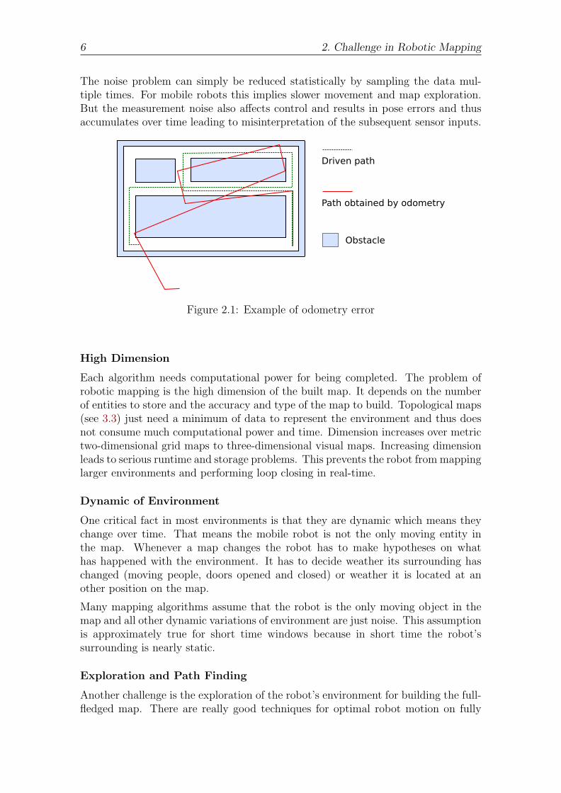
As stated before, sensors are no ideal parts. The measurements they make sufferfrom different uncertainties (see figure 2.1). All electronic devices generate moreor less noise which influences the measurements. The sensor inputs (environment)are time- and space-continuous but after signal processing and conversion to digitalsignals are both time- and value-discrete.
6 2. Challenge in Robotic Mapping
The noise problem can simply be reduced statistically by sampling the data mul-tiple times. For mobile robots this implies slower movement and map exploration.But the measurement noise also affects control and results in pose errors and thusaccumulates over time leading to misinterpretation of the subsequent sensor inputs.
Figure 2.1: Example of odometry error
High Dimension
Each algorithm needs computational power for being completed. The problem ofrobotic mapping is the high dimension of the built map. It depends on the numberof entities to store and the accuracy and type of the map to build. Topological maps(see 3.3) just need a minimum of data to represent the environment and thus doesnot consume much computational power and time. Dimension increases over metrictwo-dimensional grid maps to three-dimensional visual maps. Increasing dimensionleads to serious runtime and storage problems. This prevents the robot from mappinglarger environments and performing loop closing in real-time.
Dynamic of Environment
One critical fact in most environments is that they are dynamic which means theychange over time. That means the mobile robot is not the only moving entity inthe map. Whenever a map changes the robot has to make hypotheses on whathas happened with the environment. It has to decide weather its surrounding haschanged (moving people, doors opened and closed) or weather it is located at another position on the map.
Many mapping algorithms assume that the robot is the only moving object in themap and all other dynamic variations of environment are just noise. This assumptionis approximately true for short time windows because in short time the robot’ssurrounding is nearly static.
Exploration and Path Finding
Another challenge is the exploration of the robot’s environment for building the full-fledged map. There are really good techniques for optimal robot motion on fully

7
modeled maps but this is not the case for partial maps. The mapping algorithm hasto construct the map in real-time in order to be able to explore the environmentreasonable.
One always has to keep in mind that every movement of the mobile robot (everyalternation of the robot’s pose) produces a loss of information because the newpose is not hundred percent known and thus the successional measurement may bemisinterpreted.

8 2. Challenge in Robotic Mapping
3. Types of Maps
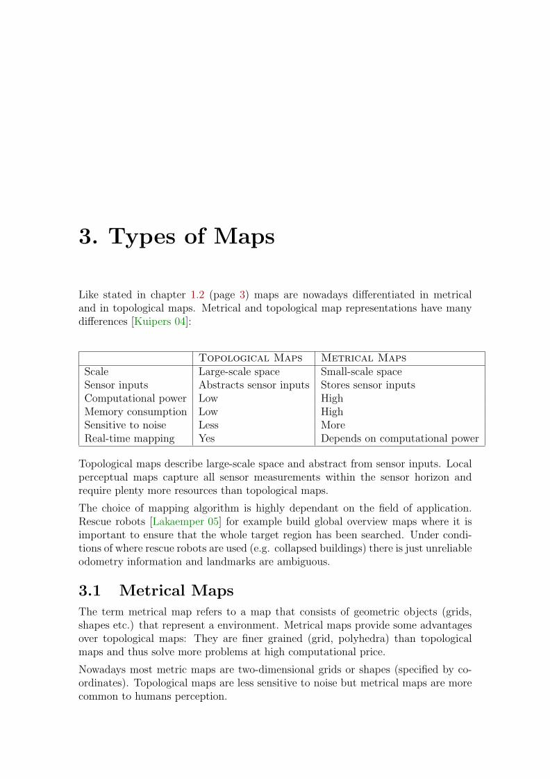
Like stated in chapter 1.2 (page 3) maps are nowadays differentiated in metricaland in topological maps. Metrical and topological map representations have manydifferences [Kuipers 04]:
Topological Maps Metrical MapsScale Large-scale space Small-scale spaceSensor inputs Abstracts sensor inputs Stores sensor inputsComputational power Low HighMemory consumption Low HighSensitive to noise Less MoreReal-time mapping Yes Depends on computational power
Topological maps describe large-scale space and abstract from sensor inputs. Localperceptual maps capture all sensor measurements within the sensor horizon andrequire plenty more resources than topological maps.
The choice of mapping algorithm is highly dependant on the field of application.Rescue robots [Lakaemper 05] for example build global overview maps where it isimportant to ensure that the whole target region has been searched. Under condi-tions of where rescue robots are used (e.g. collapsed buildings) there is just unreliableodometry information and landmarks are ambiguous.
3.1 Metrical MapsThe term metrical map refers to a map that consists of geometric objects (grids,shapes etc.) that represent a environment. Metrical maps provide some advantagesover topological maps: They are finer grained (grid, polyhedra) than topologicalmaps and thus solve more problems at high computational price.
Nowadays most metric maps are two-dimensional grids or shapes (specified by co-ordinates). Topological maps are less sensitive to noise but metrical maps are morecommon to humans perception.
10 3. Types of Maps
3.1.1 Simultaneous Localization and Mapping
Simultaneous localization and mapping (SLAM) describes the problem of buildinga map within unknown environment while at the same time keeping track of themobile robot’s pose. Caused by several uncertainties described above in chapter2 the task of SLAM is complex. SLAM uses mostly probabilistic techniques likeKalman filters or Monte Carlo methods and is only used for metrical maps. It canuse very different types of sensors to acquire the required data for building the map.
3.1.2 Kalman Filters for Robotic Mapping
In the beginning of robotic mapping (1985) Kalman filters were used for simultaneouslocalization and mapping and they are still used nowadays [Thrun 02]. The Kalmanfilter was invented 1960 by Rudolf Kalman and is referred to as linear quadraticestimation (LQE). In general it is an efficient recursive filter that estimates the stateof a dynamic system from a series of incomplete and noisy measurements. Kalmanfilters work incrementally and pertain to the SLAM approaches.
Kalman filters are Bayes filters and thus rely on basic assumptions:
• The sensor measurements must be linear with added Gaussian noise. Conse-quential the measurement noise (εmeasure) must not be correlated. Nonlineari-ties may be accommodated by linearization using e.g. Taylor series expansion.
• The initial uncertainty must also be independent Gaussian.
These assumptions are limitations to the Kalman filter approaches: Considering, forexample, an environment with two indistinguishable landmarks. Measuring such alandmark will induce dependant noise which is not Gaussian. Thus Kalman filtersare not able to cope the correspondence problem.
As a solution for the correspondence problem specially for laser range scanners anextension called Lu/Milios algorithm [Scott 00] has to be presented. It combinestwo basic estimation phases:
• In the first phase Kalman filters are used to calculate posteriors over the map.
• The second phase associates data of multiple scans with each other. Thecorrespondence is achieved using maximum likelihood data association.
This improved version works well as long as errors in the initial pose estimate small(e.g., smaller than 2 meters). Larger pose errors can not be accommodated.
3.1.3 Expectation Maximization Algorithms
Expectation maximization algorithms (EM) are an alternative for Kalman filtersalso belonging to SLAM approaches. Nowadays they are the best solution to thecorrespondence problem described in chapter 2. A huge advantage over Kalmanfilters is achieved by repeatedly relocalizing the robot relative to the present map.EM algorithms perform hill climbing on all maps in order to find the best fittingmap. That is why they cannot build the maps incrementally like the Kalman filters.
3.1. Metrical Maps 11
As stated before it is really simple to construct a reliable map if one knows the actualrobot’s pose in the environment and it is also no big deal to localize the robot’s posein a given map. The expectation maximization algorithm solves the SLAM problemby iterating between the following two steps to make the resulting map (mi) moreand more accurate with each step i:
• Expectation step: Generate all possible robot poses in the actual map mi (thefirst map m0 is empty).
• Maximization step: Calculates the most likely map for these given pose expec-tations.
The result of the expectation maximization algorithm are increasingly accurate mapsm0, m1, ..., mn.
3.1.4 Incremental Maximum Likelihood Method and Hy-brid Approaches
Both Kalman filters and expectation maximization algorithms have several disad-vantages. The errors in control accumulate over time which affect future sensorinterpretations and disturbs the built map. Kalman filters are not able to solve thecorrespondence problem while expectation maximization algorithms are not workingincrementally. A common approach is the incremental maximum likelihood method.
The basic idea is to incrementally build a single map as the sensor data arrives.Mathematically a series of maximum likelihood maps, m∗1, m∗2, ..., and a series ofmaking likelihood poses s∗1, s∗2, ..., is maintained. Map m∗t and pose s∗t are built fromthe map m∗t−1 and pose s∗t−1 incrementally via maximization of the marginal likeli-hood. The incremental maximum likelihood method can be viewed as a expectationmaximum algorithm without expectation-step, just consisting of a maximization-step. Although this approach is very simple it can build maps in real-time likeKalman filters and it maximizes likelihood like expectation maximization algorithmsand thus is really popular. But it suffers from one big disadvantage: Like all algo-rithms that do not consider uncertainty when building maps it is not able to mapcyclic environments. In cyclic environments the error in the pose s∗t may grow with-out bounds (see figure 3.1).
To overcome this limitation hybrid approaches try to combine their strengths andavoid their weaknesses by maintaining uncertainty during mapping (see figure 3.2).Unlike the incremental maximum likelihood method, hybrid algorithms are able tocorrect maps backwards in time whenever an inconsistency is detected. But alsohybrid approaches have disadvantages:
• The decision to change the map backwards in time is discrete which meansthat it may destroy the map if the decision is wrong.
• It can not handle complex ambiguities like multiple nested loops.
• It is not really real-time because the time needed for closing loops depends onthe size of the loop. But if environment is limited to a specific size (e.g. officebuildings) hybrid approaches work well.
12 3. Types of Maps
Figure 3.1: Incremental maximum likelihood method mapping is not able to handlecycles.
Figure 3.2: Hybrid approaches use probabilities and are able to close loops whichare not too complex.
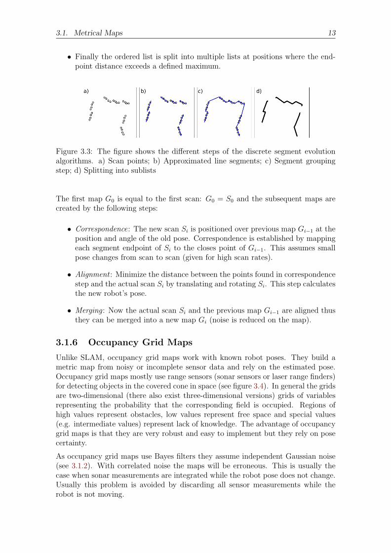
3.1.5 Discrete Segment Evolution
The goal of Discrete Segment Evolution is to build a global map from range sensors(two-dimensional) without using the odometry information. Discrete segment evo-lution solves the problem of statistically dependant measurement data without anyassumptions about the error characteristics. In [Lakaemper 05] the application arerescue robots (no odometry, ambiguous landmarks) that should localize victims incatastrophe scenarios.
Following steps are performed for converting the measured data into a scan Si (seefigure 3.3):
• Scan points are approximated with line segments. These line segments don’tneed to be connected because this would imply additional noise in the approx-imation.
• Segment grouping step: An ordered list of segments if constructed by minimiz-ing the sum of the distances of their endpoints.
3.1. Metrical Maps 13
• Finally the ordered list is split into multiple lists at positions where the end-point distance exceeds a defined maximum.
Figure 3.3: The figure shows the different steps of the discrete segment evolutionalgorithms. a) Scan points; b) Approximated line segments; c) Segment groupingstep; d) Splitting into sublists
The first map G0 is equal to the first scan: G0 = S0 and the subsequent maps arecreated by the following steps:
• Correspondence: The new scan Si is positioned over previous map Gi−1 at theposition and angle of the old pose. Correspondence is established by mappingeach segment endpoint of Si to the closes point of Gi−1. This assumes smallpose changes from scan to scan (given for high scan rates).
• Alignment : Minimize the distance between the points found in correspondencestep and the actual scan Si by translating and rotating Si. This step calculatesthe new robot’s pose.
• Merging : Now the actual scan Si and the previous map Gi−1 are aligned thusthey can be merged into a new map Gi (noise is reduced on the map).
3.1.6 Occupancy Grid Maps
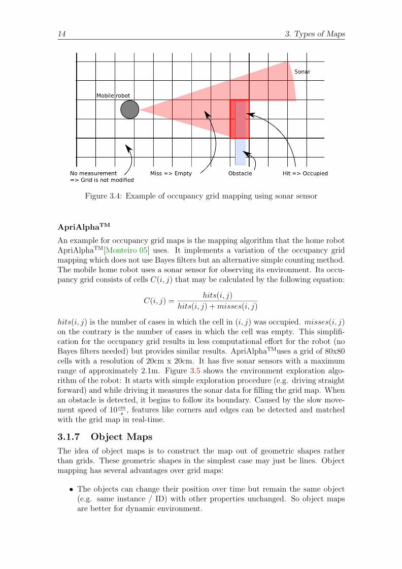
Unlike SLAM, occupancy grid maps work with known robot poses. They build ametric map from noisy or incomplete sensor data and rely on the estimated pose.Occupancy grid maps mostly use range sensors (sonar sensors or laser range finders)for detecting objects in the covered cone in space (see figure 3.4). In general the gridsare two-dimensional (there also exist three-dimensional versions) grids of variablesrepresenting the probability that the corresponding field is occupied. Regions ofhigh values represent obstacles, low values represent free space and special values(e.g. intermediate values) represent lack of knowledge. The advantage of occupancygrid maps is that they are very robust and easy to implement but they rely on posecertainty.
As occupancy grid maps use Bayes filters they assume independent Gaussian noise(see 3.1.2). With correlated noise the maps will be erroneous. This is usually thecase when sonar measurements are integrated while the robot pose does not change.Usually this problem is avoided by discarding all sensor measurements while therobot is not moving.
14 3. Types of Maps
Figure 3.4: Example of occupancy grid mapping using sonar sensor
ApriAlphaTM
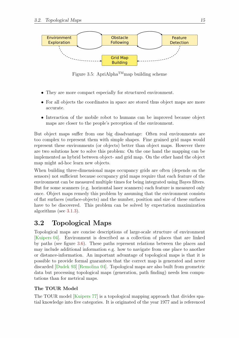
An example for occupancy grid maps is the mapping algorithm that the home robotApriAlphaTM[Monteiro 05] uses. It implements a variation of the occupancy gridmapping which does not use Bayes filters but an alternative simple counting method.The mobile home robot uses a sonar sensor for observing its environment. Its occu-pancy grid consists of cells C(i, j) that may be calculated by the following equation:
C(i, j) =hits(i, j)
hits(i, j) + misses(i, j)
hits(i, j) is the number of cases in which the cell in (i, j) was occupied. misses(i, j)on the contrary is the number of cases in which the cell was empty. This simplifi-cation for the occupancy grid results in less computational effort for the robot (noBayes filters needed) but provides similar results. ApriAlphaTMuses a grid of 80x80cells with a resolution of 20cm x 20cm. It has five sonar sensors with a maximumrange of approximately 2.1m. Figure 3.5 shows the environment exploration algo-rithm of the robot: It starts with simple exploration procedure (e.g. driving straightforward) and while driving it measures the sonar data for filling the grid map. Whenan obstacle is detected, it begins to follow its boundary. Caused by the slow move-ment speed of 10 cm
s, features like corners and edges can be detected and matched
with the grid map in real-time.
3.1.7 Object Maps
The idea of object maps is to construct the map out of geometric shapes ratherthan grids. These geometric shapes in the simplest case may just be lines. Objectmapping has several advantages over grid maps:
• The objects can change their position over time but remain the same object(e.g. same instance / ID) with other properties unchanged. So object mapsare better for dynamic environment.
3.2. Topological Maps 15
Figure 3.5: ApriAlphaTMmap building scheme
• They are more compact especially for structured environment.
• For all objects the coordinates in space are stored thus object maps are moreaccurate.
• Interaction of the mobile robot to humans can be improved because objectmaps are closer to the people’s perception of the environment.
But object maps suffer from one big disadvantage: Often real environments aretoo complex to represent them with simple shapes. Fine grained grid maps wouldrepresent these environments (or objects) better than object maps. However thereare two solutions how to solve this problem: On the one hand the mapping can beimplemented as hybrid between object- and grid map. On the other hand the objectmap might ad-hoc learn new objects.
When building three-dimensional maps occupancy grids are often (depends on thesensors) not sufficient because occupancy grid maps require that each feature of theenvironment can be measured multiple times for being integrated using Bayes filters.But for some scanners (e.g. horizontal laser scanners) each feature is measured onlyonce. Object maps remedy this problem by assuming that the environment consistsof flat surfaces (surface-objects) and the number, position and size of these surfaceshave to be discovered. This problem can be solved by expectation maximizationalgorithms (see 3.1.3).
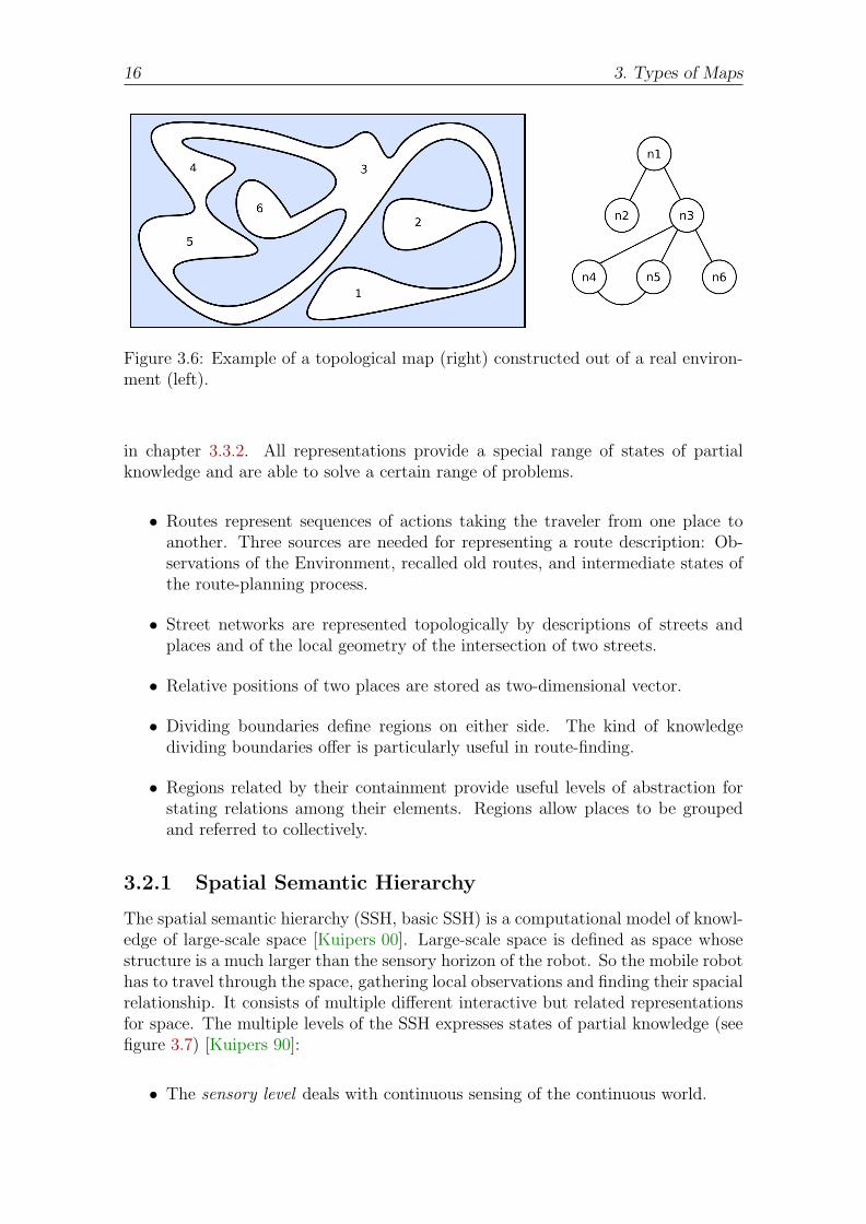
3.2 Topological MapsTopological maps are concise descriptions of large-scale structure of environment[Kuipers 04]. Environment is described as a collection of places that are linkedby paths (see figure 3.6). These paths represent relations between the places andmay include additional information e.g. how to navigate from one place to anotheror distance-information. An important advantage of topological maps is that it ispossible to provide formal guarantees that the correct map is generated and neverdiscarded [Dudek 93] [Remolina 04]. Topological maps are also built from geometricdata but processing topological maps (generation, path finding) needs less compu-tations than for metrical maps.
The TOUR Model
The TOUR model [Kuipers 77] is a topological mapping approach that divides spa-tial knowledge into five categories. It is originated of the year 1977 and is referenced
16 3. Types of Maps
Figure 3.6: Example of a topological map (right) constructed out of a real environ-ment (left).
in chapter 3.3.2. All representations provide a special range of states of partialknowledge and are able to solve a certain range of problems.
• Routes represent sequences of actions taking the traveler from one place toanother. Three sources are needed for representing a route description: Ob-servations of the Environment, recalled old routes, and intermediate states ofthe route-planning process.
• Street networks are represented topologically by descriptions of streets andplaces and of the local geometry of the intersection of two streets.
• Relative positions of two places are stored as two-dimensional vector.
• Dividing boundaries define regions on either side. The kind of knowledgedividing boundaries offer is particularly useful in route-finding.
• Regions related by their containment provide useful levels of abstraction forstating relations among their elements. Regions allow places to be groupedand referred to collectively.
3.2.1 Spatial Semantic Hierarchy
The spatial semantic hierarchy (SSH, basic SSH) is a computational model of knowl-edge of large-scale space [Kuipers 00]. Large-scale space is defined as space whosestructure is a much larger than the sensory horizon of the robot. So the mobile robothas to travel through the space, gathering local observations and finding their spacialrelationship. It consists of multiple different interactive but related representationsfor space. The multiple levels of the SSH expresses states of partial knowledge (seefigure 3.7) [Kuipers 90]:
• The sensory level deals with continuous sensing of the continuous world.
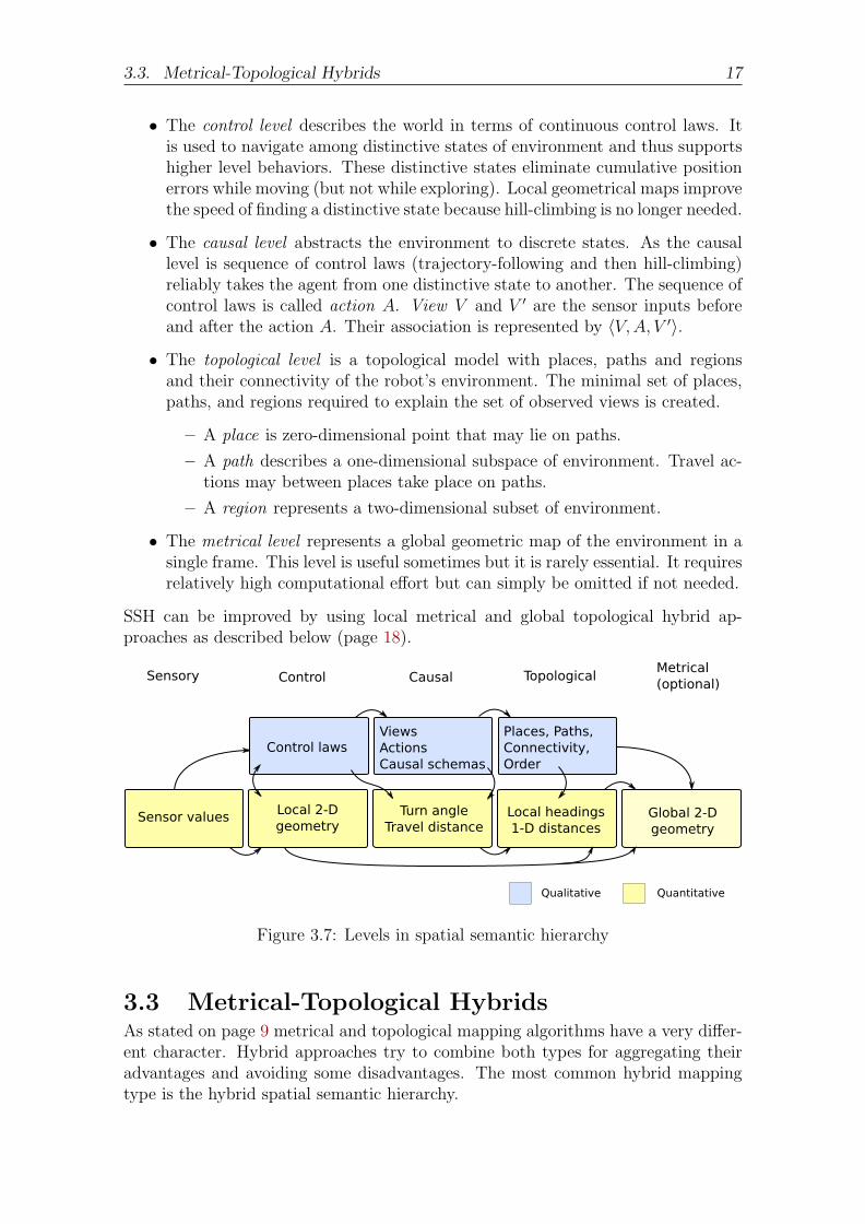
3.3. Metrical-Topological Hybrids 17
• The control level describes the world in terms of continuous control laws. Itis used to navigate among distinctive states of environment and thus supportshigher level behaviors. These distinctive states eliminate cumulative positionerrors while moving (but not while exploring). Local geometrical maps improvethe speed of finding a distinctive state because hill-climbing is no longer needed.
• The causal level abstracts the environment to discrete states. As the causallevel is sequence of control laws (trajectory-following and then hill-climbing)reliably takes the agent from one distinctive state to another. The sequence ofcontrol laws is called action A. View V and V ′ are the sensor inputs beforeand after the action A. Their association is represented by 〈V, A, V ′〉.
• The topological level is a topological model with places, paths and regionsand their connectivity of the robot’s environment. The minimal set of places,paths, and regions required to explain the set of observed views is created.
– A place is zero-dimensional point that may lie on paths.
– A path describes a one-dimensional subspace of environment. Travel ac-tions may between places take place on paths.
– A region represents a two-dimensional subset of environment.
• The metrical level represents a global geometric map of the environment in asingle frame. This level is useful sometimes but it is rarely essential. It requiresrelatively high computational effort but can simply be omitted if not needed.
SSH can be improved by using local metrical and global topological hybrid ap-proaches as described below (page 18).
Figure 3.7: Levels in spatial semantic hierarchy
3.3 Metrical-Topological HybridsAs stated on page 9 metrical and topological mapping algorithms have a very differ-ent character. Hybrid approaches try to combine both types for aggregating theiradvantages and avoiding some disadvantages. The most common hybrid mappingtype is the hybrid spatial semantic hierarchy.
18 3. Types of Maps
3.3.1 Hybrid Spatial Semantic Hierarchy
The hybrid spatial semantic hierarchy extends the basic SSH by a local perceptualmap (LPM) which is a metrical map resulting from applying an online SLAM methodto a simple local region. This local metrical map can be used for local motion planingand obstacle avoidance and can utilize any reliable metrical mapping, preferablyoccupancy grids. Hybrid SSH suffers from several advantages that aid online map-building:
• Local motion and collision avoidance can take place within the LPM.
• Metrical localization can be done quickly when searching for a distinctive point.The SSH hill-climbing is not needed any longer. If the mobile robot is out ofresources for processing the local perceptual map it can still fall back to basichill-climbing.
• Ambiguities caused by closing large loops or false positive place matches canbe represented by a set of alternative topological maps which may be discardedby future observations.
3.3.2 Cognitive Maps
Cognitive maps are related to the human perception if its environment [Kuipers 01].They combine metrical and topological maps for avoiding their weaknesses. Cogni-tive maps describe the knowledge of large-scale environment that is acquired by inte-grating observations gathered over time, and are used to determine relative positionsof places for finding routes. Thus the mobile robot integrates local observations inthe large-scale environment rather than being perceived from a single vantage point.
As usual in robotic mapping the robot must be simultaneously building the map,planning its activities (path planning), solving problems, and dealing with inter-rupts (hazards / collision avoidance during travel). Thus the cognitive mappingalgorithm must operate under limitations of resources: The map is initially createdanalog to the environment into a two dimensional map that is called ”Map in theHead” [Kuipers 83b]. While traveling the robot will add more places to its store ofknowledge, drawing a progressively more complete map of its environment. Thistwo dimensional analog map is not sufficiently powerful to serve as cognitive mapbecause is has too few states of partial knowledge that causes several problems:
• Errors of odometry propagate over time and become very serious so the mapmust offer probabilistic methods.
• If an error is detected (which is only a question of time) no corrections can beworked out.
• Large computational effort for correcting the analog map when erroneous ori-entation is detected.
• During correction process the map could be left in inconsistent state.
3.3. Metrical-Topological Hybrids 19
So it is necessary to store spatial relationships between certain places while toleratingignorance of relationships between others. This leads to the topological mappingapproach. The idea is to build multiple two dimensional maps of the environment indifferent places (”Map in the Head”) and connect them via topological information(”Atlas in the Head”). These topological information can be described like stated inTOUR model [Kuipers 77] (see section 3.2). While exploring the environment therobot creates links among places to connect the several maps in the atlas to oneunified structure.
Cognitive maps have several advantages:
• If further resources become available or if new observations are made the topo-logical connections between the metrical maps can be strengthened.
• When the topological connection between metrical maps is strong enough (ex-actly known) the maps may be joined together.
• Topological connections that are learned incorrectly can be easily modifiedwithout needing to analyze and process metrical data.

20 3. Types of Maps
4. Conclusion
Several mapping approaches have been presented in this paper and their relativestrengths and weaknesses were pointed out. All approaches are different versions ofBayes filters and thus they are probabilistic. Of course they have to be probabilisticto deal with the real environment. Most algorithms assume a static world but the realworld is really dynamic. They approximate the static world by evaluating small timedifferences which is far away from reality. We need technologies for understandingenvironment dynamics rather than just adapting changes.
Although the situation encouraged over the last two decades of research there is stillmuch to do. Unstructured outdoor environment like vegetation or water (underwa-ter) environments are problematic. As computational power of embedded devices isbecoming bigger and bigger and the resources available for mapping algorithms alsoincreases in future other mapping approaches might be thought of.
In future there will be new application domains for other mapping approaches likee.g. multi robot mapping, thus the emerging correspondence problem will be muchmore complex than nowadays. Robot control has to be improved so that robotsjust have the function to ”do the right thing” [Thrun 02]. So in future mapping willcontinue to be a highly active research area in robotics and artificial intelligence.

22 4. Conclusion
Bibliography
[Dudek 93] Gregory Dudek, Paul Freedman, Souad Hadjres. Using Local Informa-tion in a Non-Local Way for Mapping Graph-Like Worlds. 1993.
[Kuipers 00] B. J. Kuipers. The Spatial Semantic Hierarchy. Artificial Intelligence,119, 2000. http://www.cs.utexas.edu/users/qr/papers/Kuipers-aij-00.html.
[Kuipers 01] Benjamin Kuipers. The Skeleton in the Cognitive Map: A Computa-tional Hypothesis. 2001.
[Kuipers 04] B. Kuipers, J. Modayil, P. Beeson, M. MacMahon, F. Savelli. Localmetrical and global topological maps in the hybrid spatial semantic hierarchy,2004.
[Kuipers 77] Benjamin Kuipers. Modeling Spatial Knowledge. In IJCAI, 1977.
[Kuipers 83b] B. J. Kuipers. The cognitive map: Could it have been any other way?1983b.
[Kuipers 90] Benjamin Kuipers, Yung-Tai Byun. A Robot Exploration and MappingStrategy Based on a Semantic Hierarchy of Spatial Representations. TechnischerBericht AI90-120, 1, 1990.
[Lakaemper 05] Rolf Lakaemper, Longin Jan Latecki, Xinyu Sun, Diedrich Wolter.Geometric Robot Mapping, 2005.
[Monteiro 05] Sidomar T. Monteiro, Hideichi Nakamoto, Hideki Ogawa, NobutoMatsuhira. Robust mobile robot map building using sonar and vision. 2005.
[Remolina 04] E. Remolina, B. Kuipers. Towards a general theory of topologicalmaps, 2004.
[Scott 00] A. Scott. Quantitative and qualitative comparison of three laser-rangemapping algorithms using two types of laser scanner data, 2000.
[Thrun 02] S. Thrun. Robotic Mapping: A Survey. In G. Lakemeyer, B. Nebel(Hrsg.), Exploring Artificial Intelligence in the New Millenium. Morgan Kauf-mann, 2002. to appear.

24 Bibliography