Embed Size (px)
Citation preview
__________PCGIAP, O
SEMINAR ON
‘IMPLEMENTATTION MODELS OF ASIA ANDTHE PACIFIC SPATIAL DATAINFRASTRUCTURE (APSDI)
CLEARINGHOUSE’
17th APRIL 2002, CENTERPOINT HOTEL, NEGARA BRUNEI DARUSSALAM
________________________________________________________________________________pen Seminar, Brunei Darussalam April 17 2002 1/23
Land Administration and Spatial DataInfrastructures Trends and Developments
Ian WILLIAMSONDirector
Center for Spatial Data Infrastructures and LandAdministration

__________________________________________________________________________________________PCGIAP, Open Seminar, Brunei Darussalam April 17 2002 2/23
LAND ADMINISTRATION AND SPATIAL DATA INFRASTRUCTURES –TRENDS AND DEVELOPMENTS
Ian WILLIAMSON
DirectorCentre for Spatial Data Infrastructures and Land Administration
Keywords: Land administration, Spatial Data Infrastructure (SDI), Cadastral systems,Geodetic Framework, Wireless Communication technologies, Benchmarking, Decision SupportSystems.
ABSTRACT
Historically, the strength of a land surveyor lies in the ability to use and understand bothmeasurement science and land management, and to apply these skills in a wide range of landrelated activities ranging from sustainable development to environmental management.
It is proposed that a major dimension of the measurement science skill is reflected in the growingimportance of spatial data infrastructures (SDI) and the land related skills are reflected in the re-discovery that the role of land administration plays in serving economic, environmental andsocial priorities in society. While SDI play a much broader role than supporting landadministration, land administration could be considered a key driver in SDI evolution.
The objective of this paper is to identify SDI and land administration trends and developmentsby drawing on the research of past, current and future projects undertaken by researchers in theCentre for SDI and Land Administration (the Centre) at The University of Melbourne.
CONTACT
Department of Geomatics,The University of Melbourne,Victoria,Australia 3010Phone: +61 3 8344 4431 Fax: +61 3 9347 4128Email: [email protected]: http://www.geom.unimelb.edu.au/research/SDI_research/

__________________________________________________________________________________________PCGIAP, Open Seminar, Brunei Darussalam April 17 2002 3/23
1. INTRODUCTION
This paper considers how the surveyors’ ability to use and understand both the measurementscience and land management disciplines have evolved and are evolving within the broadsurveying or geomatics discipline. The ability to apply these skills in a wide range of land relatedactivities ranging from land development to environmental management, has long been an areaof strength for professional land surveyors. It is therefore proposed that a major dimension of thetraditional measurement science skill of surveying professionals is reflected in the growingimportance of spatial data infrastructures (SDI) and the land related skills are reflected in the re-discovery of the role that land administration plays in serving economic, environmental andsocial priorities in society. While SDI play a much broader role in a modern economy thansupporting land administration, land administration could be considered a key driver in SDIevolution.
The objective of this paper is to identify current trends in SDI and land administration inAustralia with a view to identifying future roles for the spatial information discipline. In order toachieve this objective past, current and future projects undertaken by researchers in the Centrefor SDI and Land Administration in the Department of Geomatics, University of Melbourne<http://www.geom.unimelb.edu.au/research/SDI_research/> are reviewed.
The Centre consists of 12 full-time personnel from a wide range of backgrounds comprisingsurveying, engineering, geography, law, computer science and science graduates. The focus ofthe Centre ranges from economic, social, and environmental policy through to spatial datamanagement and technical issues concerned with GPS and the impact of wireless communicationtechnologies.
The Centre has major support from the Victorian Government (Land Victoria), as well as fromthe New South Wales (NSW) Government Support (Land and Property Information NSW), theAustralian Federal Government (Geoscience Australia), the Australian Research Council, inaddition to overseas organisations such as The World Bank and the United Nations. As a resultof the particularly strong strategic alliance with Land Victoria, researchers in the Centre are ableto test their research within the Victorian Government treating it as a “working laboratory”.
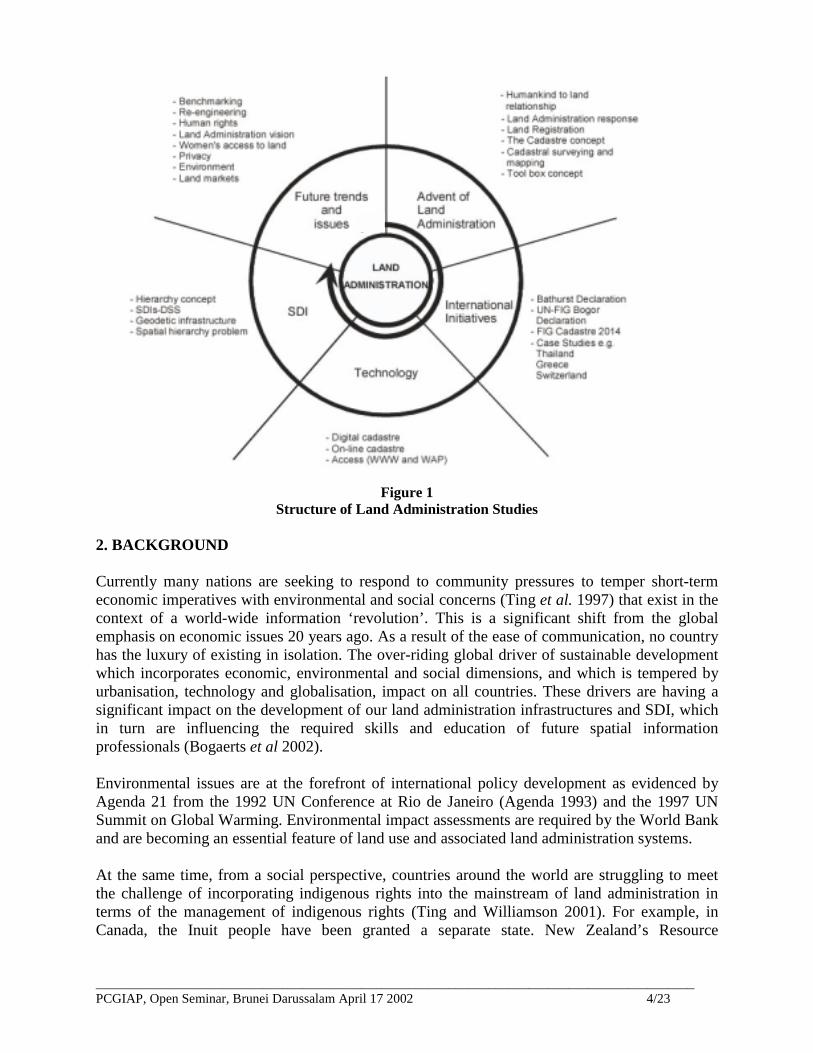
The focus and breadth of the Centre can be seen in Figure 1, which shows the structure of LandAdministration studies taught in the Bachelor of Geomatic Engineering course at The Universityof Melbourne (http://www.geom.unimelb.edu.au/subjects/451/418/index.html). Many membersof the Centre are involved in the delivery of the course.
The paper concludes by summarising key lessons and issues arising from the review of trendsand developments in land administration and SDI.
__________________________________________________________________________________________PCGIAP, Open Seminar, Brunei Darussalam April 17 2002 4/23
Figure 1Structure of Land Administration Studies
2. BACKGROUND
Currently many nations are seeking to respond to community pressures to temper short-termeconomic imperatives with environmental and social concerns (Ting et al. 1997) that exist in thecontext of a world-wide information ‘revolution’. This is a significant shift from the globalemphasis on economic issues 20 years ago. As a result of the ease of communication, no countryhas the luxury of existing in isolation. The over-riding global driver of sustainable developmentwhich incorporates economic, environmental and social dimensions, and which is tempered byurbanisation, technology and globalisation, impact on all countries. These drivers are having asignificant impact on the development of our land administration infrastructures and SDI, whichin turn are influencing the required skills and education of future spatial informationprofessionals (Bogaerts et al 2002).
Environmental issues are at the forefront of international policy development as evidenced byAgenda 21 from the 1992 UN Conference at Rio de Janeiro (Agenda 1993) and the 1997 UNSummit on Global Warming. Environmental impact assessments are required by the World Bankand are becoming an essential feature of land use and associated land administration systems.
At the same time, from a social perspective, countries around the world are struggling to meetthe challenge of incorporating indigenous rights into the mainstream of land administration interms of the management of indigenous rights (Ting and Williamson 2001). For example, inCanada, the Inuit people have been granted a separate state. New Zealand’s Resource
__________________________________________________________________________________________PCGIAP, Open Seminar, Brunei Darussalam April 17 2002 5/23
Management Act aims to bring Maori issues into the mainstream of economic planning and landuse (Ting and Williamson 2001). In Australia, the High Court’s decisions in Mabo (Mabo vQueensland (No.2) (1992) 175 CLR 1) and now Wik (Wik Peoples and Thayorre People vQueensland (1996) 141 ALR 129) and legislation such as the Aboriginal Land Rights (NT) Act1976 (Cth), will impact on Australian state land administration systems.
The influence of economic philosophies on land administration policies saw a significant shift ineconomic thought in the 1980s, away from Keynesianism towards privatisation. In responseAustralia commenced a path of minimising government intervention and reassessing competitionpolicies within land administration (Lanphier and Parker 1997). This shift in economic thinkinghas coincided with a growing movement calling for centralised and coordinated global action onthe environment and greater consideration of social attitudes to issues that transcend borders(Ting and Williamson 2001). These trends can be clearly seen in the 2001 World Bank electronicLand Policy Conference (http://www.worldbank.org/landpolicy).
3. LAND ADMINISTRATION
Over the last decade there has been a lot of attention internationally on what constitutes “bestpractice” in land administration and particularly cadastral systems in both developed anddeveloping countries (Williamson 2002, Williamson and Ting 2001). In undertaking landadministration reform by drawing on “best practices” in land administration, it is important toconsider the factors that drive or affect the reform and the choice of the specific strategiesadopted. These factors are many and varied which re-enforces the statement that the landadministration system for each country requires its own individual strategy. On the other handstrategies can be developed using the “tool box” approach. That is each specific strategy andresulting system can be made up of many separate, well understood, proven and generallyaccepted principles and concepts.
3.1 “Best Practices” and Reform
In designing a strategy it is first important to recognise that almost every country will require arange of different strategies depending on the relationship of people to land in each individualregion in the specific country. In simple terms these arrangements include:• Cities and urban areas, where active land markets operate on titled land,• Cities and urban areas, occupied by informal settlements (squatter, illegal or low cost
systems outside the formal or regulatory structures),• High value agricultural lands which are titled and are part of the formal land market,• Private untitled lands in rural areas and villages,• Informal or illegal settlements in rural areas, especially in government forests,• Lands which are subject to indigenous rights,• Lands in all categories which are the subject of claims from previously dispossessed persons,
and• Government or state lands, reserves and forests and usually many other forms of common
property
To some degree these categories are common to all developing (and many developed) countries.
__________________________________________________________________________________________PCGIAP, Open Seminar, Brunei Darussalam April 17 2002 6/23
The second consideration is that the relationship of people to land is dynamic with the result thatthere is an evolution in each of these categories. None of these relationships stay the same in thelong term. They are affected by the impact of the global drivers on the relationship of people toland such as sustainable development, urbanisation, globalisation, localisation, economic reformand environmental management, as discussed above. As a result a different land administrationresponse is required for each area or situation, within an overall national vision or strategy. Thecategories of land tenure can be considered a continuum of land tenure relationships in a countrywhere, to some degree, tenures evolve from undocumented customary or informal tenures todocumented or formal individual private rights.
Third, the stage of development of the specific country has a major impact on the appropriateform of land administration response, and what is considered “best practice” for the individualcountry. As an example, in simple terms in the Asia-Pacific area, there are four generalcategories of countries:
• Developed countries, such as Japan, Korea, Australia, New Zealand and Singapore,• Newly industrialised countries or countries in transition, such as China (PRC), Indonesia,
Thailand, Malaysia and the Philippines,• Countries at an early stage of development such as Vietnam and Laos, and• Island states such as Fiji, Tonga and Vanuatu.
While each country has different development priorities, those in each group do share somesimilar priorities (Williamson 1994, Rajabifard and Williamson 1999). A complication is thatmany countries do not fit easily into these categories with some countries having aspects of allcategories. But in general the stage of development overall of an individual country doessignificantly influence the choice of which land administration strategies are adopted.
The combination of all these factors determine, or at least strongly influence, the specificstrategy(ies) adopted in reforming or establishing the land administration system.
3.2 A Land Administration “Tool Box”
These strategies draw on the land administration “tool box” for their institutional, legal, technicaland administrative solutions (Williamson 2002). The “tool box” therefore includes a whole rangeof surveying and mapping technologies and approaches depending on the stage of developmentof the country and the major human-land relationship which is being surveyed or mapped. Theseoptions include sporadic and systematic approaches, graphical and mathematical surveys,different positioning technologies such as satellite positioning or scaling off photomaps, differentmapping technologies such as photomaps, topographic mapping and simple cadastral maps.
In addition there are a range of options for recording land tenure relationships, which areimportant administrative and institutional “tools”. There are government guaranteed land titles,deeds registration systems, title insurance systems, qualified titles (both to boundaries and title),individual ownership and communal or customary ownership.

__________________________________________________________________________________________PCGIAP, Open Seminar, Brunei Darussalam April 17 2002 7/23
For all these arrangements there are a range of technologies which are again strongly influencedby the wealth and development of the country. For example whether titles or deeds and cadastralmaps will be computerised or held as paper records or whether the Internet can be utilised toaccess land records. Institutional arrangements are influenced by the same factors. Whether thesystem is decentralised, deconcentrated or centralised.
3.3 Benchmarking
The question as to what constitutes a good landadministration system, cadastre or SDI is of greatinterest to international aid agencies, policy makersand administrators in both developed and developingcountries. Similar questions relate to whether ajurisdiction warrants land administration reform and ifa project does eventuate, how do you evaluate whetherit has been a success or not. The InternationalFederation of Surveyors (FIG) has been involved instarting to address such questions (Steudler et al.1997). In this context a Land Administration Systemmay be considered to be the processes of recording and disseminating information aboutownership, value, and use of land, whereby a spatial information infrastructure links andunderpins these processes (see figure 2).
As a result of this interest, research is underway to develop a framework and methodology forbenchmarking and evaluating Land Administration Systems. The methodology will use a casestudy approach to assist in developing a standardised country report, to help understand andanalyse the overall network of the organisations and their impact on the whole LandAdministration System. The methodology will provide indicators for use by policy-makers andoperational managers. Indicators for policy makers will be developed dealing with economic,social and environmental issues, and will include:• Economic issues such as land market performance, agricultural productivity, access to credit
revenue;• Social issues such as security of ownership, reduced land disputes; and• Environmental issues such as protection against encroachment and sustainable development.Indicators for operational managers will be developed dealing with information management,people and infrastructure and will include:• Information management such as use of information and data standards;• People such as staff, academia and professional association; and• Infrastructure such as legislation, organisations, operational links and budgets.
These investigations of the dimensions and components of land administration systems hasformed a basis for more detailed research into spatial data infrastructures and associated legal,technical and institutional issues.
Spatial Information on LAND
AttributeInforma-tion onLand
Owner-ship
AttributeInforma-tion onLand
Value
AttributeInforma-tion onLandUse
Social System
Figure 2: A Land Administration System
__________________________________________________________________________________________PCGIAP, Open Seminar, Brunei Darussalam April 17 2002 8/23
4. SPATIAL DATA INFRASTRUCTURES
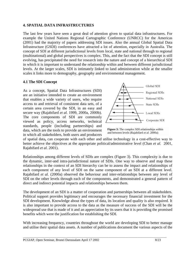
The last few years have seen a great deal of attention given to spatial data infrastructures. Forexample the United Nations Regional Cartographic Conference (UNRCC) for the Americas(2001) had the majority of papers addressing SDI issues. Also the annual Global Spatial DataInfrastructure (GSDI) conferences have attracted a lot of attention, especially in Australia. Theconcept of SDI at different jurisdictional levels from local, state and national through to regional(multinational) and global perspectives is complex. This, and the fact that the SDI concept is stillevolving, has precipitated the need for research into the nature and concept of a hierarchical SDIin which it is important to understand the relationship within and between different jurisdictionallevels. At the larger scales, SDI is intimately linked to land administration while at the smallerscales it links more to demography, geography and environmental management.
4.1 The SDI Concept
As a concept, Spatial Data Infrastructures (SDI)are an initiative intended to create an environmentthat enables a wide variety of users, who requireaccess to and retrieval of consistent data sets, of acertain area covered by the SDI, in an easy andsecure way (Rajabifard et al. 1999, 2000a, 2000b).The core components of SDI are commonlyviewed as policy, access networks, technicalstandards, people (including partnerships) anddata, which are the tools to provide an environmentin which all stakeholders, both users and producersof spatial data, can cooperate with each other and utilise technology in a cost-effective way tobetter achieve the objectives at the appropriate political/administrative level (Chan et al. 2001,Rajabifard et al. 2001).
Relationships among different levels of SDIs are complex (Figure 3). This complexity is due tothe dynamic, inter-and intra-jurisdictional nature of SDIs. One way to observe and map theserelationships in the context of an SDI hierarchy can be to assess the impact and relationships ofeach component of any level of SDI on the same component of an SDI at a different level.Rajabifard et al. (2000a) observed the behaviour and inter-relationships between any level ofSDI on the other levels through each of the components, and demonstrated a general pattern ofdirect and indirect potential impacts and relationships between them.
The development of an SDI is a matter of cooperation and partnerships between all stakeholders.Political support provides legitimacy and encourages the necessary financial investment for theSDI development. Knowledge about the types of data, its location and quality is also required. Itis also important to provide access to the data as the measure of success of the SDI will be thewidespread use that is made of it and an appreciation by its users that it is providing the promisedbenefits which were the justification for establishing the SDI.
With increasing frequency, countries throughout the world are developing SDI to better manageand utilise their spatial data assets. A number of publications document the various aspects of the
Figure 3: The complex SDI relationships withinand between levels (Rajabifard et al. 2000a)

__________________________________________________________________________________________PCGIAP, Open Seminar, Brunei Darussalam April 17 2002 9/23
development of national SDIs in recent years (Masser 1998, Onsrud 1998). These countries arealso finding it necessary to cooperate with other countries to develop regional and global(multinational) SDIs to assist in decision-making that has an important impact across nationalboundaries. The key factors that facilitate the development of regional (multinational) SDIsinvolve complex social, technical, institutional and political research, which is being conductedin association with AUSLIG and the Permanent Committee on GIS in Asia and the Pacific(Rajabifard and Williamson 2000a, 2000b).
4.2 SDI Development: State and National
Automated systems, such as land title systems and digital cadastral or property maps, are beingseen increasingly as an integral part of developing a state’s or nation’s SDI and demonstrate thepotential for land administration and cadastral systems evolution driven by advances intechnology.
The management of a cadastral system’s digital spatial data has consequently promptedconsiderable research, generally with a focus limited to the organisation maintaining thecadastral map. Yet, the approach of viewing the maintenance of cadastral maps as a systemencompassing the entire cadastral industry has not been comprehensively studied anddocumented (Hunter and Williamson 1990). This approach is seen as essential to transformcadastral mapping from its current organisation specific isolation, into a form that is trulyinteroperable with the processing of spatial cadastral information in a digital environment and aSDI.
To this effect research has been conducted (Effenberg et al. 1999) which substantiates theexistence, analysis and design of a spatial cadastral system within the overall cadastral system.Comparative analysis of a number of international, western spatial cadastral systems, wasconducted to establish the boundaries of a spatial cadastral system as well as methodologies tostructure and document such a system, which was then undertaken for the spatial cadastralsystems of the Australian state of Victoria. The developments of existing spatial cadastralsystems, provides the basis for the presentation of a range of solution alternatives to manage thespatial data associated with the maintenance of the multipurpose cadastral map in a digital andInternet enabled environment.
4.3 SDI Development: Data Integration
At a more local level, one of the most fundamental problems restricting the integration,comparison and transfer of data within and between jurisdictions in SDIs is the fragmentation ofdata between non-coterminous boundary systems. Many administrative boundaries have beencreated by individual agencies to meet their specific needs with very little coordination. Due tothis lack of co-ordination, current technologies for analysing geospatial information, such asGeographic Information Systems (GIS), cannot provide accurate results. As a result, there is afragmentation of information over a series of boundary units. This fragmentation of informationnot only limits the potential uses for data collected but also the potential scope of GIS analysispossible between boundary layers.
__________________________________________________________________________________________PCGIAP, Open Seminar, Brunei Darussalam April 17 2002 10/23
To this effect research is being conducted towards the hierarchical reorganisation ofadministration boundaries to enhance data integration and exchange between agencies in bothmetropolitan (Eagleson et al. 2000, 1999) and ruralenvironments (Eagleson et al. 2001a, 2001b). The methodologyadopted utilises the principles of Hierarchical Spatial Reasoning(HSR) theory and incorporates them into the automated designof administrative boundaries.
4.4 Developing Business-Infrastructure Relationships
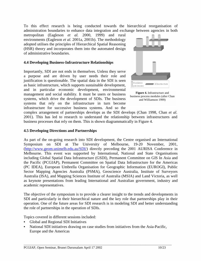
Importantly, SDI are not ends in themselves. Unless they servea purpose and are driven by user needs their role andjustification is questionable. The spatial data in the SDI is seenas basic infrastructure, which supports sustainable development,and in particular economic development, environmentalmanagement and social stability. It must be users or businesssystems, which drive the development of SDIs. The businesssystems that rely on the infrastructure in turn becomeinfrastructure for successive business systems. And so thecomplex arrangement of partnerships develops as the SDI develops (Chan 1998, Chan et al.2001). This has led to research to understand the relationship between infrastructures andbusiness processes that rely on them. This is shown diagrammatically in Figure 4.
4.5 Developing Directions and Partnerships
As part of the on-going research into SDI development, the Centre organised an InternationalSymposium on SDI at The University of Melbourne, 19-20 November, 2001,(http://www.geom.unimelb.edu.au/SDI/) directly preceding the 2001 AURISA Conference inMelbourne. This event was supported by International, National and State Organisationsincluding Global Spatial Data Infrastructure (GSDI), Permanent Committee on GIS In Asia andthe Pacific (PCGIAP), Permanent Committee on Spatial Data Infrastructure for the Americas(PC IDEA), European Umbrella Organisation for Geographic Information (EUROGI), PublicSector Mapping Agencies Australia (PSMA), Geoscience Australia, Institute of SurveyorsAustralia (ISA), and Mapping Sciences Institute of Australia (MSIA) and Land Victoria, as wellas keynote presentations from leading International and Australian government, industry andacademic representatives.
The objective of the symposium is to provide a clearer insight to the trends and developments inSDI and particularly in their hierarchical nature and the key role that partnerships play in theiroperation. One of the future areas for SDI research is in modeling SDI and better understandingthe role of partnerships in the operation of SDIs.
Topics covered in different sessions included:• Global and Regional SDI Initiatives• National SDI initiatives drawing on case studies from initiatives from the Asia-Pacific,
Europe and the Americas
Infrastruc tureB usinessprocesses
Figure 4. Infrastructure andbusiness process modules (after Chan
and Williamson 1999)

__________________________________________________________________________________________PCGIAP, Open Seminar, Brunei Darussalam April 17 2002 11/23
• Elements of National SDI Development –State, Local and Corporate SDIs, taking examplesfrom Australia and the United States
• Socio-political, Economic and Cultural dimensions of SDI Development• Technical Manifestations of the SDI Concept
5. TECHNICAL FRAMEWORKS
Communication technologies such as the Internet and wireless are revolutionising methods ofmaintaining, disseminating and accessing spatial data. To fully utilise these technologies theremust be a clear understanding of how they impact on and assist in implementation of a SDI thatsupports the human-land relationship.
The integration, and subsequent querying of spatial datasets, the locating and obtaining ofdatasets across a network, and the transfer of dissimilar spatial datasets across networks are allconcepts that have arisen in an attempt to better utilise the spatial datasets that are in existence(Phillips et al. 1998). Wireless, Internet, GIS and the Global Positioning System (GPS) areapplications seeking to tap into mainstream markets where the common underlying concept is ageoinformation system that has a combination of spatial and aspatial information useful in arange of contexts (Polley et al. 1997, Polley and Williamson 1999a). Research is on-going tounderstand the impact and potential of these technologies.
5.1 Positioning Technologies
Satellite positioning, and the GPS in particular, has established itself internationally as a majortool for spatial data acquisition. This is evidenced by the widespread implementation ofpermanent, Continuously Operating (GPS) Reference Station (CORS) networks. Germany,Sweden, United States, Netherlands, Great Britain, Japan, Hong Kong, Singapore and Australiaare just some examples of countries that have established geodetic CORS networks in addition toany networks intended for safety of life, marine navigation, and fleet management for example.
It is recognised that for spatial data to be used correctly and wisely metadata that describes dataquality, in addition to other attributes, should accompany it (Nebert 2000). Data quality forpositional information is generally given in terms of a standard deviation and is a result of thedata capture process. Mis-specification of this quality parameter may result in inappropriate useor reduced utility of the data. At present, the measures of GPS quality given by commonsoftware packages are either over-optimistic, or conversely, are overly conservative andtherefore have low fidelity (Keenan and Cross 2001, Barnes et al. 1998, Wang 1999).
Research (Brown et al. 2001, Millner et al. 2001) being conducted by analysis of error at knownreference stations aims to develop a general stochastic model that will provide higher fidelity andhigher precision results over medium length static GPS baselines. Development of such a modelwill lead to an increased understanding of the stochastic properties of the double-differencedobservables and, hence, to more correct stochastic modeling in other conditions. This willinclude estimates of the true errors at Victoria’s GPSnet base stations and the relationshipsbetween the observing conditions and the stochastic behaviour of the observables in theVictorian Geodetic framework.
__________________________________________________________________________________________PCGIAP, Open Seminar, Brunei Darussalam April 17 2002 12/23
5.2 Communication Technologies
There has been great optimism about the potential of information and communicationtechnologies in revolutionising land administration and the use of spatial data. The convergenceof wireless communications, positioning technology and networking computing is now capableof providing new facilities, new applications and as a result, new challenges for spatial dataproviders and users.
Wireless access to data is a rapidly emerging field, particularly with the recent escalation andprominence of the wireless Internet and technologies such as the Wireless Application Protocol(WAP), I-mode and the upcoming General Packet Radio System (GPRS) and Universal MobileTelecommunications System (UMTS). Wireless communication is inherently linked to location,and already many wireless providers are using GIS to supplement their services to clients.Relevant information, with respect to time and location, can now be delivered to users viadevices such as mobile phones and Personal Digital Assistants.
However, the infrastructure requirements for wireless applications that utilise spatial informationneed to be determined and integrated into the future design of SDIs so that they may reflect andsupport the changing nature of spatial information use. Many applications that have beendeveloped to date use and/or deliver spatial information to mobile users, however none of theapplications currently access data through established SDIs. Rather than individual organisationsduplicating and maintaining their own data sets, accessing them through some standard SDIwould be most beneficial and would ensure that fundamental data sets would remain theresponsibility of the custodian. Naturally, different applications will have varying spatial datausage requirements, however it is envisaged that there will be common infrastructure elements(such as query and delivery mechanisms) for a range of applications (Millner et al. 2001, Smithet al. 2001a and 2001b).
5.3 The Internet
The World Wide Web (WWW) is now a reliable and efficient source of information worldwide.With this in mind, traditional cadastral systems have been looking to the WWW as a tool thatwill better serve the users of land information. The motivations include reducing the cost of thecadastral system; extending the applications and marketable uses of registered cadastral surveyinformation; improving overall efficiencies of lodgment, registration, examination and use ofcadastral survey information; and ensuring that the system can take full advantage of developingtechnology (Falzon and Williamson 2001). The development of a digital environment to manageland information, in particular, cadastral data, seems to be the most logical solution (Falzon andWilliamson 2001). This research and the research of Scheu et al. (2001) highlight the need for amore sophisticated form of digital lodgment of spatial cadastral data so that surveyors lodge theirdata through a QA process which incorporates adjustment routines thereby allowing the stateDCDB to be updated automatically.
The advent of the Internet as a medium for cadastral data transactions has led to a great deal ofconjecture about the solutions that could be produced to improve data transfers. Polley and
__________________________________________________________________________________________PCGIAP, Open Seminar, Brunei Darussalam April 17 2002 13/23
Williamson (1999b) discuss how the combination of GIS technology and WWW presentationtechnology provides new uses for the cadastre and cadastral data and similarly provides for awider and more diverse audience, especially though the ability to provide information tools thathide the underlying technology and provide a mix of spatial and non-spatial information. Themove to providing widely useable information tools has seen GIS, Cadastral and Internetindustries move closer together. As a result, GIS are becoming simpler information systems, thecadastral dataset is becoming a key portion of data within these information systems, and theWWW is presenting these information systems to new user bases.
One of the more significant improvements in the last few years was the adaptation of the WWWas the medium of integration and presentation of the cadastre (Majid and Williamson 1999). MapServer software extends GIS functionality across the WWW and enables the creation of livemaps based on user queries. Map Servers allow developers to produce geographic information bygathering data from several sources simultaneously, thus behaving as a server to the users acrossthe WWW (Majid and Williamson 1999).
The work of Phillips (Phillips et al. 1998, 1999) commenced research along this directionthrough the role of metadata engines in discovering and presenting information from multiplesources to users within a SDI. In terms of information discovery metadata engines have gone along way toward creating collections of individual data sets located over a network from manydifferent, and differently located, databases (Phillips et al. 1998, 1999). The importance ofmetadata engines is that they can be used to create virtual databases to be used in planning anddecision making processes, with the support of spatial data base technologies including datawarehouses, data marts, clearinghouses and addressing issues of interoperability, which arecentral to the concepts and achievement of SDI. Research into this area required modifying thepublic domain metadata search system “ISITE” to act as a metadata engine and test therelationship of these current data base and discovery technologies within the concept ofdeveloping SDIs (Phillips et al. 1998, 1999).
The trends towards developing multi-purpose cadastres to address planning for sustainabledevelopment issues as well as fiscal and economic imperatives is evident in a range of Westernnations such as Australia (Williamson 1996); Canada (MacLauchlan and McLaughlin 1998);Denmark (Enemark 1994); Germany, Austria and Switzerland (Hawerk 1995); New Zealand(Robertson 1996); and USA (NRC 1983). Cadastral data is really but one important layer in thevariety of datasets that would be useful for the complex decision making needed for sustainabledevelopment. There are therefore many benefits to the realisation of a Multi-Purpose Cadastreconcept through the use of metadata engines, WWW, distributed databases and Map Servers.This has fuelled research into Australian and international developments on bringing cadastralsystems online and assisting in managing complex land tenure systems (Majid and Williamson2001). By developing a prototype of a multipurpose cadastre based on the trends and features ofexisting system developments many implementation issues were explored including data, spatialprocessing, data delivery and clients (Majid and Williamson 2001).
6. INSTITUTIONAL AND ADMINISTRATIVE FRAMEWORKS
__________________________________________________________________________________________PCGIAP, Open Seminar, Brunei Darussalam April 17 2002 14/23
People are the key to transaction processing and decision-making. All decisions require data andas data becomes more volatile human issues of data sharing, security, accuracy and access forgethe need for more defined relationships between people and data. The rights, restrictions andresponsibilities influencing the relationship of people to data become increasingly complex,through compelling and often competing issues of social, environmental and economicmanagement. Facilitating the role of people and data in governance that appropriately supportsdecision-making and sustainable development objectives is central to the concept of SDI.
6.1 Land Administration Infrastructure
Land administration has a significant role to play in supporting sustainable development. It isproposed that sustainable development objectives can only be achieved when there is active co-operation between civil society and the information industry in a way that produces data that isable to alleviate the tension in decision-making between immediate economic priorities andsustainability concerns for key decision-makers.
However, current infrastructures for land administration do not adequately address the complexand dynamic relationship between public and private rights, restrictions and responsibilities inland use that arise from the competing priorities inherent in sustainable development objectives.Land administration infrastructure for sustainable development requires appropriate principlesfor integrated legal and institutional infrastructures (Ting and Williamson 2001).
The definition of such legal and institutional infrastructures has required tracing the evolutionarypath of societies, the commerce of land and the emergence of land administration infrastructures,particularly with respect to the dynamic balancing act between individual right, public interestand the State (Ting and Williamson 2001). These justify the need for appropriate, integrated landadministration systems to better support sustainable development. They also stimulate the needto develop key principles for a framework of legal and institutional infrastructures for landadministration that will facilitate the necessary dialogue between private and public interests inland and land use to better support sustainable development (Ting and Williamson 2001).
These issues have been extensively researched with an example of this work being the jointUnited Nations – International Federation of Surveyors Workshop and Conference on LandTenure and Cadastral Infrastructures for Sustainable Development. This was organised inBathurst, Australia and was followed by an international conference in Melbourne, Australia inOctober 1999 (UN-FIG 1999, Williamson et al. 1999).
These initiatives resulted in The UN-FIG Bathurst Declaration on Land Administration forSustainable Development. The workshop brought together 40 leading experts and researchersfrom around the world, from a wide range of disciplines, including six UN agencies, the WorldBank, and the UN Director of Sustainable Development. They confirmed the pressing need to re-engineer land administration systems to manage the competing economic, environmental andsocial priorities that constitute sustainable development as described in the UN’s Agenda forDevelopment. The Declaration has been presented in the UN and other international forumsaround the world including at the UN Headquarters in New York and has been translated intoseveral languages. The Bathurst Declaration builds on other cadastral initiatives such as the FIG
__________________________________________________________________________________________PCGIAP, Open Seminar, Brunei Darussalam April 17 2002 15/23
Statement on the Cadastre (FIG 1995) and the joint UN-FIG Bogor Declaration on CadastralReform (UN-FIG 1996).
The application of these ideas in the future will be the extrapolation of land administrationsystem principles to managing the competing economic, environmental and social priorities forthe marine environment. This includes the requirements for a marine SDI and a system toadminister the wide range of rights, restrictions and responsibilities in the marine environment.This research will become more urgent as countries start meeting the requirements of the UnitedNations Law of the Sea, which initially comes into effect in 2004.
6.2 Legislation
Legislative and administrative frameworks for addressing different problems related to theresolution of land ownership are imperative to developing the clear rights, restrictions andresponsibilities, in human-land relationships, necessary for an integrated land administrationsystem.
One problem arising in Australia in relation to this issue is that discrepancies in the location ofboundaries of land parcels is widespread and appears inevitable. Alternative solutions are torestore the "paper" boundary, notwithstanding expectations of landholders founded uponoccupation at the time of acquisition of parcel, or to permit occupational boundaries to becomethe new "paper" boundary. Where the occupational boundary prevails the "traditional" manner ofbringing this into effect has been adverse possession as in Victoria. The less traditional method isto permit an assessment of the competing interests with the most "just" outcome being statutoryencroachment, as in NSW.
A comprehensive land information management system should ideally disclose the completelegal status of all land with disclosure of all public and private rights and restrictions, includingrights acquired under adverse possession. Adverse possession of part parcels permits thevariation, rectification, and re-adjustment of boundaries with boundary definition being essentialto parcel based spatial data sets (Park and Williamson 1999b). Recognising trends to developnational spatial data sets, if a national cadastre is ever to be considered a basic requirement willbe a unified national law regarding land ownership. In turn this will require a unified approach tothe issue of adverse possession of registered title land, and particularly adverse possession of partof a land parcel, which is a major obstacle in achieving this vision (Park and Williamson 1999a,1999b).
According to the research of Park (Park and Williamson 1999a, 1999b) the best approach to theinevitable problem is to favour the occupational boundary over the paper boundary. The bestavailable method to permit the occupational boundary is then via statutory encroachment, asadverse possession can be capricious, create much tension and does not necessarily permit areduction in the transaction costs of the land market dealings.
The ideal outcome would therefore be a scheme suitable for adoption Australia-wide as an initialstep towards the unification of an Australian Real Property law. Such a scheme would also besuitable for other jurisdictions that have a registered land title system, or which are in the process
__________________________________________________________________________________________PCGIAP, Open Seminar, Brunei Darussalam April 17 2002 16/23
of introducing such a system. Adoption of a uniform scheme for Australia is conjectured tosimplify the Australian land market and contribute to a less expensive comprehensive landinformation system or SDI.
Issues concerned with adverse possession and methods of addressing differences betweenoccupational and mathematical boundaries are important but only one of several key researchissues based in legislation or the law. For example research into the statutory control of spatialdata requires attention, as does the issue of regulation of professionals in the spatial area(Ristevski and Williamson 2001).
6.3 Land Tenure Integration
It has been acknowledged that two land tenure systems exist within Australia, customaryAboriginal land tenure and the system of tenure based on English Common Law, generallyreflected in the Australian Torrens System. Both land tenure systems are diverse by nature andare not overly compatible. The vastly different characteristics of Aboriginal land tenure to theAustralian Torrens systems makes it difficult for the integration of the two tenure systems intoone land registration system.
The unique relationship Aboriginal peoples have with the land has been highlighted in recentyears with the passing and implementation of the Native Title Act 1993. This Act has endeavoredto recognise traditional Aboriginal interests in land, previously recognised by the Common Lawof Australia. An integral element of administering the native title process is the requirement thata map and a worded description of the claim area be supplied as part of the initial application.
Aboriginal land tenure boundaries have been mapped in the past by various anthropologists andhistorians. Mapping and definition of Aboriginal land boundaries by ‘surveyors’ are likely toprovide alternative ways in which native title boundaries are determined, offering a differentperspective on the spatial extent of Aboriginal land tenure. There is a need to accurately andunambiguously define the spatial extent of native title within the Australian cadastral system tosupport land-based infrastructure and the future of native title.
Brazenor et al. (1999) identified that a better understanding of Aboriginal land tenure andassociated boundary definition is a vital first step towards mapping and documenting boundariesfor the purposes of resolving native title disputes and developing institutional infrastructures thatcan better address the duality of tenure systems. This research explored:• The characteristics and similarities/differences between the two tenure systems in a spatial
context;• The current methods employed in defining and mapping Aboriginal land tenure boundaries
and the appropriateness for the purpose of native title determination;• Possible ways in which Aboriginal land tenure could be defined and mapped in the future;
and• Possible incorporation of Aboriginal land tenure into the current land administration and land
registration systems of Australia (see for example Brazenor et al.1999).
__________________________________________________________________________________________PCGIAP, Open Seminar, Brunei Darussalam April 17 2002 17/23
The difficulties of integrating customary or traditional tenure systems with “western” land tenuresystems has been an ongoing research focus of the Centre as seen in Rakai and Williamson(1995), Ezigbalike et al. (1995) and Iatau and Williamson (1997).
6.4 Institutional Frameworks for Decision Support
Expanding human requirements and economic activities are placing ever increasing pressures onland resources, creating competition and conflicts and resulting in suboptimal use of both land andland resources. By examining all uses of land in an integrated manner, it makes it possible tominimize conflicts, to make the most efficient trade-offs and to link social and economicdevelopment with environmental protection and enhancement, thus helping to achieve theobjectives of sustainable development (Article 10.1 Agenda 21, UNDSD 2001).
Agenda 21 (1993) confirms the need for institutional tools to facilitate equity, accountability andtransparency in land-based decision-making processes, as well as structuring themultidisciplinary and multi-participant environments that characterise decision making forsustainable development and the operational environments of SDIs. Chapter 40 (Agenda 21,1993) further states there is a need to strengthen capacity to collect and use multisectoral dataacross the different levels of government/community; to develop means of ensuring planning atdifferent levels and sectors is based on sound information; and to make relevant informationaccessible in the form and at the time required.
As decision making for natural resource management increasingly involves multiple criteria,cross-disciplinary and multi-stakeholder consultation, the capacity for individuals, departmentsand organisations to make decisions alone becomes increasingly challenging. Government has animportant role to play in developing infrastructure that supports the discovery, access andapplications of tools for decision support.
In this context decision support refers to the automation, modeling and/or analysis that enablesinformation to be shaped from data which is useful to decision making and enables improvementin the decision-process. Decision support can be used to structure, filter and integrateinformation, model information where gaps occur in data, can generate alternative solutionscenarios as well as weight these as priorities, and importantly enable group as well asdistributed participation in decision-making, usually by means of Decision Support Systems(DSS). DSS can be generally defined as an interactive, computer-based tool or collection of toolsthat uses information and models to improve both the process and the outcomes of decisionmaking.
DSS are thus becoming important institutional tools for providing a structured, transparent andauditable record for the decision making process (including participants, identified stakeholders,preferences, values and priorities). They are tools which may facilitate an equity of access to thedecision making process by relevant stakeholders, by people with different levels of experiencewith geographic information and to forums within which many stakeholders involved in an issuecan collaborate.
For spatial decision making, there is significant capacity for institutional tools like DSS tosupport integrated decision making for land-based planning and management, and in the support
__________________________________________________________________________________________PCGIAP, Open Seminar, Brunei Darussalam April 17 2002 18/23
of sustainable development objectives (Feeney et al. 2000, 2001). Internationally the importanceof providing more communication and cooperation among developers and users of decisionsupport tools and services aimed at land, natural resource and environmental management(Gunther 1998) has been recognised in the United States by the Interagency Group on DecisionSupport for land, environmental and natural resource management (IGDS) which was developedin 1997. However, there has been little research beyond this into the relationship between SDIand DSS, particularly the growing number and diversity of users. This has recently beenrecognised by the Global Spatial Data Infrastructure Steering Committee, who have established aworking group on the relationship of GSDI to DSS (GSDI 2001). It also encouraged the Centrefor SDI and Land Administration to commence investigating, at the end of 1999, the relationshipbetween SDI and DSS and the frameworks by which SDI can support the discovery, access andapplication of DSS for natural resource planning and management.
7. CONCLUSION
The objective of this paper was to identify trends and developments in land administration andSDIs by reviewing the past, present and future research undertaken by the Centre for SDI andLand Administration at The University of Melbourne.
So what can we learn from this review?
1. SDI and land administration build on the traditional strengths of the land surveyor ofmeasurement science and land management, and as such are critically important areas for thesurveying discipline and for education of surveyors.
2. Global drivers, and particularly environmental and social drivers, are tempering thetraditional economic driver in the evolution of SDIs and land administration systems.
3. The different dimensions and components of land administration as reflected in differenthuman-land relationships are now better understood. In this context land administrationreform can draw on a “tool box” of legal, tenure, institutional and technical initiatives.
4. The evaluation of the performance of land administration systems is difficult with noaccepted international processes or strategies. Benchmarking and related strategies provideone promising approach.
5. Jurisdictions require a comprehensive and holistic land administration vision and strategy inorder to address current sustainable development objectives.
6. The most significant impact on the development of future land administration systems will bethe clarification and implementation of SDIs. The SDI concept is still evolving. However akey component of SDIs is that they are dynamic in nature due to the intra- and inter-jurisdictional partnerships they are based on. These partnerships are important betweenjurisdictions, between urban and regional environments, between users and suppliers ofspatial data in the industry, as well as in the implementation and reform of the administration,integration and reform of land administration systems.
7. Within this framework the relationship between infrastructures and the business systems theysupport is not sufficiently appreciated. SDIs without users or business systems that rely onthem have little justification.
8. Communication and positioning technologies, such as the Internet, wireless applications andGPS, are revolutionising methods of maintaining, disseminating and accessing spatial data.
__________________________________________________________________________________________PCGIAP, Open Seminar, Brunei Darussalam April 17 2002 19/23
To fully utilise these technologies there must be a clear understanding of how they impact onand assist in implementation of a SDI that supports the human-land relationship, particularlyland administration systems, yet surprisingly little research is undertaken within thesurveying discipline in this domain.
9. Recognising the very significant impact of technology on the evolving land administrationsystems and SDIs, without appropriate legal, land tenure and institutional infrastructures, thedevelopment of appropriate systems will be difficult, if not impossible. As a result a reformstrategy must consider both technical and non- technical solutions equally, and integratethese wherever possible.
10. Developing frameworks for decision support is a very important aspect of incorporatingsocial, environmental and economic priorities in the integration of technical and non-technical solutions to complex questions and situations. Decision Support Systems can bedeveloped as key institutional tools to facilitate equity, accountability and transparency in thedecision-making process, as well as structuring the multidisciplinary and multi-participantenvironments that characterise decision making for sustainable development and theoperational environments of SDIs.
ACKNOWLEDGEMENTS
This paper is substantially the same as a paper presented by Ian Williamson and Mary-Ellen Feeney to the 42nd
Australian Surveyor’s Congress 2001 A Spatial Odyssey, 25-28 September, Brisbane, Australia. The author wishesto gratefully acknowledge the support of the following institutions: Land Victoria (LV) of the VictorianGovernment, Land and Property Information New South Wales (LPI) and the Australian Research Council (ARC).Thanks are due to the aforementioned institutions and the members of The University of Melbourne (UM)Department of Geomatics’ Centre for Spatial Data Infrastructure and Land Administration(http://www.geom.unimelb.edu.au/research/SDI_research/) in the preparation of this paper and the associatedresearch. However, the views expressed in the paper are those of the author and do not necessarily reflect the viewsof LV, LPI, ARC or UM.
REFERENCES
Agenda 21. 1993 The Earth Summit: the United Nations Conference on environment and development, UnitedNations Conference on Environment and Development (1992), Rio de Janeiro, Brazil, Graham &Trotman/Martinus Nijhoff, London.
Barnes, J.B., Ackroyd, N., and Cross, P.A. 1998 Stochastic Modelling for Very High Precision Real-TimeKinematic GPS in an Engineering Environment, Proceedings of FIG XXI International Conference, 21-25 July,Brighton, UK, Commission 6, 61-76.
Bogaerts, T., Williamson, I.P. and E.M.Fendel. 2002. The role of land administration in the accession of CentralEuropean countries to the European Union. Journal of Land Use Policy 19 (2002) 29-46.
Brazenor, C., Ogleby, C., and Williamson, I.P. 1999. The Spatial Dimension of Aboriginal Land Tenure. Presentedat the 6th South East Asian Surveyors Congress, Fremantle, 1-6 November 1999
Brown, N, Kealy, A., and Millner, J. 2001 Detection and Implications of Antenna Movements in Permanent GPSReference Station Networks, 5th International Symposium on Satellite Navigation Technology and Applications,24-27 July, 2001, Canberra.
Chan, T. O. and Williamson, I. P.1999 Spatial Data Infrastructure Management: Lessons from corporate GISdevelopment, Proceedings of AURISA 99, Blue Mountains, NSW, Australia, 22-26 November 1999. CD- ROM
Chan, T.O., Feeney, M., Rajabifard, A. and Williamson, I.P. 2001 The Dynamic Nature of Spatial DataInfrastructures: A Method of Descriptive Classification. GEOMATICA 55(1):65-72
Eagleson S., Escobar F., and Williamson I. 2000 Hierarchical Spatial Reasoning Applied to Automated Design ofAdministrative Boundaries URISA 2000, Orlando, 19-23 August 2000.

__________________________________________________________________________________________PCGIAP, Open Seminar, Brunei Darussalam April 17 2002 20/23
Eagleson, S., Escobar, F. and Williamson, I.P. 1999 Spatial Hierarchical Reasoning Applied to AdministrativeBoundary Design Using GIS. Presented at the 6th South East Asian Surveyors Congress, Fremantle, 1-6November 1999.
Eagleson, S., Escobar, F. and Williamson, I.P. 2001a Hierarchical Spatial Reasoning Theory and GIS TechnologyApplied to the Automated Delineation of Administrative Boundaries. GIS Research in the UK Conference,Glamorgan, Wales, 18-20 April, 18p.
Eagleson, S., Escobar, F. and Williamson, I.P. 2001b Developing a theoretical framework for the delineation ofadministrative boundaries within a rural context. AURISA 2001 - The 29th Annual Conference of AURISA,Melbourne, VIC, 19-23 November (to be presented)
Effenberg, W., Enemark, S. and Williamson, I.P. 1999 Framework for Discussion of digital spatial data flow withincadastral systems. The Australian Surveyor 44(1):35-43.
Enemark, S. 1994 Evaluation of the Cadastral reform in Denmark - Training the old lady for the skateboard. FIG XXInternational Congress, Melbourne, Australia, Commission VII, International Federation of Surveyors, TS703.3,11p.
Ezigbalike, I., Rakai, M.E.T. and Williamson, I.P.1995. Cultural Issues in Land Information Systems. Position papercommissioned by the UN Food and Agriculture Organisation, Rome (26p).
Falzon, K., and Williamson, I.P. 2001 Digital Lodgment of Cadastral Survey Data in Australia: Issues and Options.The Australian Surveyor 46(1): 62-71
Feeney, M. and Williamson, I.P. 2000 Researching Frameworks for Evolving Spatial Data Infrastructures.Proceedings of SIRC 2000 The 12th Annual Colloquium of the Spatial Information Research Centre,University of Otago, Dunedin, New Zealand. December 10-13th 2000. 93-105.
Feeney, M., Rajabifard, A. and Williamson, I.P. 2001 Spatial Data Infrastructure Frameworks to SupportDecision-Making for Sustainable Development. Presented at the 5th Global Spatial Data InfrastructureConference, Cartagena de Indias, Columbia, 21-25 May 2001, 14p. http://www.gsdi.org
FIG, 1995. Statement on the Cadastre. Report prepared for the International Federation of Surveyors by Commission7 (Cadastre and Land Management). http://www.geom.unimelb.edu.au/research/publications/IPW_publ.html
Gunther, T. 1998 The Interagency Group on Decision Support. Proceedings of the Decision Support SystemsWorkshop. Denver, Colorado. 18-20 February 1998.
GSDI 2001 Resolutions of the 5th Global Spatial Data Infrastructure Conference, Cartagena, Colombia, May 21-24,2001 http://www.gsdi.org/docs/240501.htm
Hawerk, W. 1995 Grundbuch and Cadastral Systems in Germany, Austria and Sweden. Proceedings of Seminar onModern Cadastres and Cadastral Innovations, Delft, The Netherlands, Commission VII, InternationalFederation of Surveyors, 16 May, 13-26.
Hunter, G.J. and Williamson, I.P. 1990. The Development of a Historical Digital Cadastral Database. InternationalJournal of Geographical Information Systems, 4(2): 169-179.
Iatau, M.D. and Williamson, I.P. 1997 Using the Case Study Methodology to Review Cadastral Reform in PapuaNew Guinea. The Australian Surveyor 42(4): 157-165.
Keenan, C.R. and Cross, P.A. 2001 Stochastic Modelling: The Crucial Element in High-Fidelity DGPS QualityAssessment? Proceedings of Hydro'2001, Conference of The Hydrographic Society, University of East Anglia inNorwich, 26-30 March 2001, 12 pp.
Lanphier, G, & Parker, J. 1997 Private Sector Participation in Land Information System Development andAdministration, Paper at UNFAO High-Level Technical Seminar, Bologna, Italy, 1-5 April.
Majid, S., Williamson, I.P. 1999. Cadastral Systems on the World Wide Web: A Multi-Purpose Vision. Proceedingsof AURISA 99, Blue Mountains, NSW, Australia. 22-26 November 1999. CD ROM
Majid, S. and Williamson, I.P. 2001 Understanding On-line Geospatial Systems. The Australian Surveyor 46(1):33-41
Masser, I. 1998 Governments and Geographic Information, Taylor & Francis, London, 1998.Millner, J., Hale, M., Brown, N, Kealy, A., Smith, J., and Williamson, I. 2001 The Influence of Emerging Location-
Based Technologies and Electronic Commerce Business Models on Victoria’s Geodetic Strategy, 5thInternational Symposium on Satellite Navigation Technology and Applications, 24-27 July, 2001, Canberra, P33,CD-ROM.
MacLauchlan, W. and J. McLaughlin 1998 Environmental democracy and stewardship through land and resourceinformation: The Case of the Land Gazette. International Conference on Land Tenure in the Developing World,Cape Town, South Africa, University of Cape Town.
NRC 1983 Procedures and Standards for a Multi-Purpose Cadastre. Washington D.C., USA, National AcademyPress.

__________________________________________________________________________________________PCGIAP, Open Seminar, Brunei Darussalam April 17 2002 21/23
Nebert, D.D. (ed.) 2000 Developing Spatial Data Infrastructures: The SDI Cookbook, Global Spatial DataInfrastructure Technical Working Group, Draft 1.0 June 2000.
Onsrud, H. 1998 Survey of national and regional spatial data infrastructure activities around the globe. Proceedingsof Selected Conference Papers of the Third Global Spatial Data Infrastructure Conference, November 1998,Canberra
Park, M. and Williamson I.P. 1999a The Effect of Adverse Possession to Part on a Future Australian Cadastre.Proceedings of the 6th South East Asian Surveyors Congress, Fremantle, Western Australia, 1-6 November, 143-151
Park, M. and Williamson, I.P. 1999b Australian Cadastres: the Role of Adverse Possession of Part Parcels. TheAustralian Surveyor 4(2):151-158
Phillips, A., Williamson, I.P. and Ezigbalike, I.C. 1998 The Importance of Metadata Engines in Spatial DataInfrastructures. Proceedings of AURISA '98, Perth, Western Australia, 23-27 November, CD-ROM.
Phillips, A., Williamson, I.P. and Ezigbalike, I.C. 1999 Spatial Data Infrastructure Concepts. The AustralianSurveyor, 44(1):20-28
Polley I. Williamson, I.P. Effenberg W. 1997 Suitability of Internet Technologies for Access, Transmission andUpdating Digital Cadastral Databases on the Web. Proceedings of AURISA 97, Christchurch, 17-21 November,12p.
Polley, I. and Williamson, I.P. 1999a Facilitating Digital Data Transactions Using an On-line Tool. GEOMATICA,53(4): 415-425
Polley, I. and Williamson, I.P. 1999b GIS, the Internet and the Cadastre: Coming Together. The AustralianSurveyor, 44(2): 183-188
Rajabifard, A., Chan, T.O. and Williamson, I.P. 1999 The Nature of Regional Spatial Data Infrastructures.Presented at the AURISA `99 Conference, Blue Mountains, Australia, 22-26 November 1999.
Rajabifard, A. Escobar, F. and Williamson, I.P. 2000a Hierarchical Spatial Reasoning Applied to Spatial DataInfrastructures. Cartography Journal 29(2): 41-50
Rajabifard, A., Escobar, F., and Williamson, I.P. 2000b Hierarchical Spatial Reasoning Applied to Spatial DataInfrastructures. Mapping Science National Conference, Sydney, December 3-6.
Rajabifard, A., Feeney, M., and Williamson, I.P. 2001 Future Directions for the Development of Spatial DataInfrastructure. International Journal of Applied Earth Observation and Geoinformation, The Institute forAerospace Survey and Earth Sciences, The Netherlands (forthcoming)
Rajabifard, A. and Williamson I.P. 2000a Report on Analysis of Regional Fundamental Datasets Questionnaire.Prepared for Permanent Committee on GIS Infrastructure for Asia and the Pacific, March. (unpublished) 32p.
Rajabifard, A. and Williamson, I.P.2000b Summary Report on Analysis of Regional Fundamental DatasetsQuestionnaire. 15th United Nations Regional Cartographic Conference for Asia and the Pacific,E/CONF.92/L.13, Kuala Lumpur, Malaysia, 11-14 April, 5p.
Rajabifard, A. and Williamson, I. P. 1999 Status report of research on: Asia-Pacific Regional Spatial DataInfrastructure (APSDI). 5th Meeting of the Permanent Committee on GIS Infrastructure for Asia and the Pacific(PCGIAP), Beijing, China (unpublished).
Rajabifard, A., Williamson, I.P., Holland P. and Johnstone, G. 2000 From Local to Global SDI Initiatives: a pyramidto building blocks. 4th Global Spatial Data Infrastructure Conference, Cape Town, South Africa, 13-15 March2000, 11p.
Rakai, M.E.T. and Williamson, I.P. 1995 Implications of incorporating customary land tenure data into a landinformation system. Trans Tasman Surveyor 1(1): 29-38.
Ristevski, J.A. and Williamson, I.P. 2001 The reform of statutory regulations relating to the surveying profession.The Australian Surveyor 46(1):42-53
Robertson, W.A. 1996 Sustainable Resource Management and the Cadastre, Symposia Papers, FIG Conference:Developing the Profession in a Developing World
Scheu, M. Effenberg, W. and Williamson, I.P. 2000 Incremental Upgrade and update of spatial data. Zeitschrift furVermessungwesen 125(4): 115-120
Smith, J., Kealy, A. and I. P. Williamson 2001a Assessing Spatial Data Infrastructure Architecture for Integrationwith Wireless Location Services. The 5th International Symposium on Satellite Navigation Technology andApplications, July 24-27, Canberra, P42, CD-ROM
Smith, J., Kealy, A. and I. P. Williamson 2001b Adapting Spatial Data Infrastructures to Support Location BasedWireless Applications. AURISA 2001 - The 29th Annual Conference of AURISA, November 19-23, Melbourne(to be presented).
__________________________________________________________________________________________PCGIAP, Open Seminar, Brunei Darussalam April 17 2002 22/23
Steudler, D., Williamson, I.P., Kaufmann, J. and Grant, D.M. 1997 Benchmarking Cadastral Systems. TheAustralian Surveyor 42(3): 87-106.
Ting, L., Williamson, I., Grant, D., & Parker, J. 1997 Lessons from the Evolution of Western land AdministrationSystems, International Land Tenure Conference, Cape Town, 27-29 January.
Ting, L. and Williamson, I.P. 2001 Land Administration and Cadastral Trends: the impact of the changinghumankind-land relationship and major global drivers: the NZ Experience. Survey Review 36(281): 154-174.
UN-FIG 1996 Bogor Declaration on Cadastral Reform. Report from United Nations Interregional Meeting ofExperts on the Cadastre, Bogor, Indonesia, 18-22 March, 1996. A joint initiative of the International Federationof Surveyors (FIG) and the United Nations.http://www.geom.unimelb.edu.au/research/publications/IPW_publ.html
UN-FIG 1999 The Bathurst Declaration on Land Administration for Sustainable Development. Report from the UN-FIG Workshop on Land Tenure and Cadastral Infrastructures for Sustainable Development, Bathurst, NSW,Australia, 18-22 October, 1999. A joint initiative of the United Nations and the International Federation ofSurveyors. http://www.geom.unimelb.edu.au/UNConf99/ Also see at this WWW address the Findings of theWorkshop and the background papers prepared for the Workshop and presented at the subsequent InternationalConference on Land Tenure and Cadastral Infrastructures for Sustainable Development, 25-27 October, 1999Melbourne.
UNDSD 2001 Land Management; About Commission on Sustainable Development. United Nations Division forSustainable Development. http://www.un.org/esa/sustdev/ Accessed 26 March 2001
Wang, J. 1999 Modelling and Quality Control for Precise GPS and GLONASS Satellite Positioning, PhD Thesis,School of Spatial Sciences, Curtin University of Technology.
Williamson, I.P. 2002 Land Administration “Best Practice” - providing the infrastructure for land policyimplementation. Journal of Land Use Policy, Volume 18, Issue 4, 297-307, October 2001.
Williamson, I.P. 1996 A Land Information Vision For Victoria, Report for Geographic Policy and Coordination,Victoria. http://www.geom.unimelb.edu.au/research/publications/IPW/ipw_paper15.html
Williamson, I.P. 1994. Cadastral Systems in the Asia-Pacific Region -Experiences and Lessons. FIG Land RecordsConference/Geomatics Atlantic`94 Conference, Fredericton, Canada, 11-14 October, 13p.
Williamson, I.P., Ting, L. and Grant, D. 1999 The Evolving Role of Land Administration in Support of SustainableDevelopment. The Australian Surveyor 44(2): 126-135.
Williamson, I.P. and Ting, L. 2001 Land administration and cadastral trends – a framework for re-engineering.Computers, Environment and Urban Systems, Vol. 25, 339-366.
BIOGRAPHICAL NOTE
Professor Ian WilliamsonPhD (NSW), DrHC (Olsztyn), FTSE, FISAust, FIEAust, HonMFIG, HonFMSIAust, LS, CPEng
Ian Williamson is Professor of Surveying and Land Information, Head, Department of Geomatics and Director,Centre for Spatial Data Infrastructures and Land Administration at the University of Melbourne. His teaching andresearch is concerned with designing, building and managing land administration, cadastral, and land andgeographic information systems in both developed and developing countries. He is a Licensed Land Surveyor andChartered Professional Engineer.
He has undertaken research and consultancies worldwide including for Australian governments, AusAID, manyindividual country governments, the United Nations and the World Bank. He was Chairperson of Commission 7(Cadastre and Land Management) of the International Federation of Surveyors 1994-98, and is currently Director,FIG/UN Liaison 1998-2002. He is an Honorary Member of the FIG. At the University of Melbourne he has beenPresident of the Academic Board and Pro-Vice-Chancellor. He is currently Chairperson of the VictorianGovernment’s Geospatial Information Reference Group and Chairperson of Working Group 3 (Cadastre) of theUnited Nations sponsored Permanent Committee for GIS Infrastructure for Asia and the Pacific (2001-2004).


![BRUNEI DARUSSALAM[1]](https://img.pdfslide.us/doc/110x75/577d24101a28ab4e1e9b8871/brunei-darussalam1.jpg)
![SURVEY SPATIAL DATA INFRASTRUCTURE [SSDI] BRUNEI DARUSSALAM](https://img.pdfslide.us/doc/110x75/56812c34550346895d90bbaa/survey-spatial-data-infrastructure-ssdi-brunei-darussalam.jpg)