Embed Size (px)
Citation preview

4th ESA CHRIS PROBA Workshop ESA-ESRIN, Frascati, 19-21 September 2006
Semi-arid Wetlands: Assessment of theirDegradation Status and Monitoring by Multi-Sensor
Remote Sensing
Thomas Schmid1, Jose Gumuzzio2, Magaly Koch3 and Paul Mather4
1CIEMAT, Av. Complutense 22, 28040, Madrid, Spain.2Autonomous University of Madrid, Science Faculty, Madrid, Spain.3Centre for Remote Sensing, Boston University, Boston, MA, USA.
4School of Geography, The University of Nottingham, [email protected]
Centro de Investigaciones Energéticas,Medioambientales y Tecnológicas
Boston University

4th ESA CHRIS PROBA Workshop ESA-ESRIN, Frascati, 19-21 September 2006
Presentation overview
• Objectives
• Project background
• Project team
• Study area
• Methodology
• Field work
• Available EO data
• Application of CHRIS data

4th ESA CHRIS PROBA Workshop ESA-ESRIN, Frascati, 19-21 September 2006
Objectives
The aim is to apply a multi-sensor and multi-scale approach to study semi-arid wetlands in Spain using advanced Earth Observation Systems with the support of field spectroradiometry, and ancillary field and laboratory data.
Specific objectives:
• Explore complex wetland characteristics -> shallow water bodies, hygrophyticvegetation, soil conditions (humidity) and characteristics (crusts, iron oxides).
• Identifying open water lamina and flooded vegetated areas.• Determining wetland plant communities and invasive vegetation species.• Detecting anthropogenic influences (agricultural management).• Implementing CHRIS information to improve results obtained with multisensor
data and to enhance monitoring studies.
In this case, data from the Compact High Resolution Imaging Spectrometer (CHRIS) aboard ESA's Proba will be used to obtain environmental information from target scenes within the different wetland areas in contrasting seasons (wet and dry) within the same year.

4th ESA CHRIS PROBA Workshop ESA-ESRIN, Frascati, 19-21 September 2006
Project background• Wetlands in semi-arid regions are complex and fragile ecosystems and are
especially important because of their role in maintaining and controlling the environmental quality and biodiversity and undergo extreme changes from the wet to the dry season.
• These wetlands are saline or non-saline and are very dynamic systems subject to natural (seasonal) as well as man-induced changes which produce alterations in wetland ecosystems.
• A reduction or disappearance of wetland areas are linked to the development of large irrigation systems in the regions with a significant reduction of the ground water resources, land use changes, water drainage, waste deposition and waste water effluence.
• The research presented for this project forms part of a greater ongoing investigation in wetlands that was initiated in 1995.
1) Advance our knowledge in detecting, understanding and monitoringenvironmental changes occurring to these types of ecosystems.
2) Develop new methods for extracting indicators from multi-sensor data to determine their degradation status and trend in a timely and spatial manner.
Combining traditional and well-established research methods with cutting-edge technology will:

4th ESA CHRIS PROBA Workshop ESA-ESRIN, Frascati, 19-21 September 2006
Project teamThis project is within the framework of the Spanish National project “Multidisciplinaranalysis of geoindicators of degradation in protected wetlands (Las Tablas de Daimiel National Park” (CGL22005-06458-C02-02/HID).
Coordinator: Dr. Jose Gumuzzio from the Autonomous University of Madrid.
Team: 12 members -> multi-disciplinary (geology, hydrology, geomorphology, pedology, biology, remote sensing, geo-thematic mapping).
National collaboration: • Geological Survey of Spain (IGME)• Centro de Estudios y Experimentación de
Obras Públicas (CEDEX)• Research Centre for Energy, Environment
and Technology (CIEMAT)
International collaboration: • Centre for Remote Sensing, Boston University (USA)• School of Geography, Nottingham University (UK)

4th ESA CHRIS PROBA Workshop ESA-ESRIN, Frascati, 19-21 September 2006
Study area
Las Tablas de Daimiel
Madrid
SPAIN
FRANCE
POR
TUG
AL
MOROCCO
0 100 200 km
0 100 200 mi
NorthAtlanticOcean
Mediterranean Sea
Bay ofBiscay
Los Monegros
These test sites exemplify a global problem affecting many wetland areas, namely that population growth and expansion of agricultural areas are the main reasons for these wetlands to disappear and with them a valuable natural resource supporting biodiversity and wildlife habitats.
4th ESA CHRIS PROBA Workshop ESA-ESRIN, Frascati, 19-21 September 2006
1997
1984
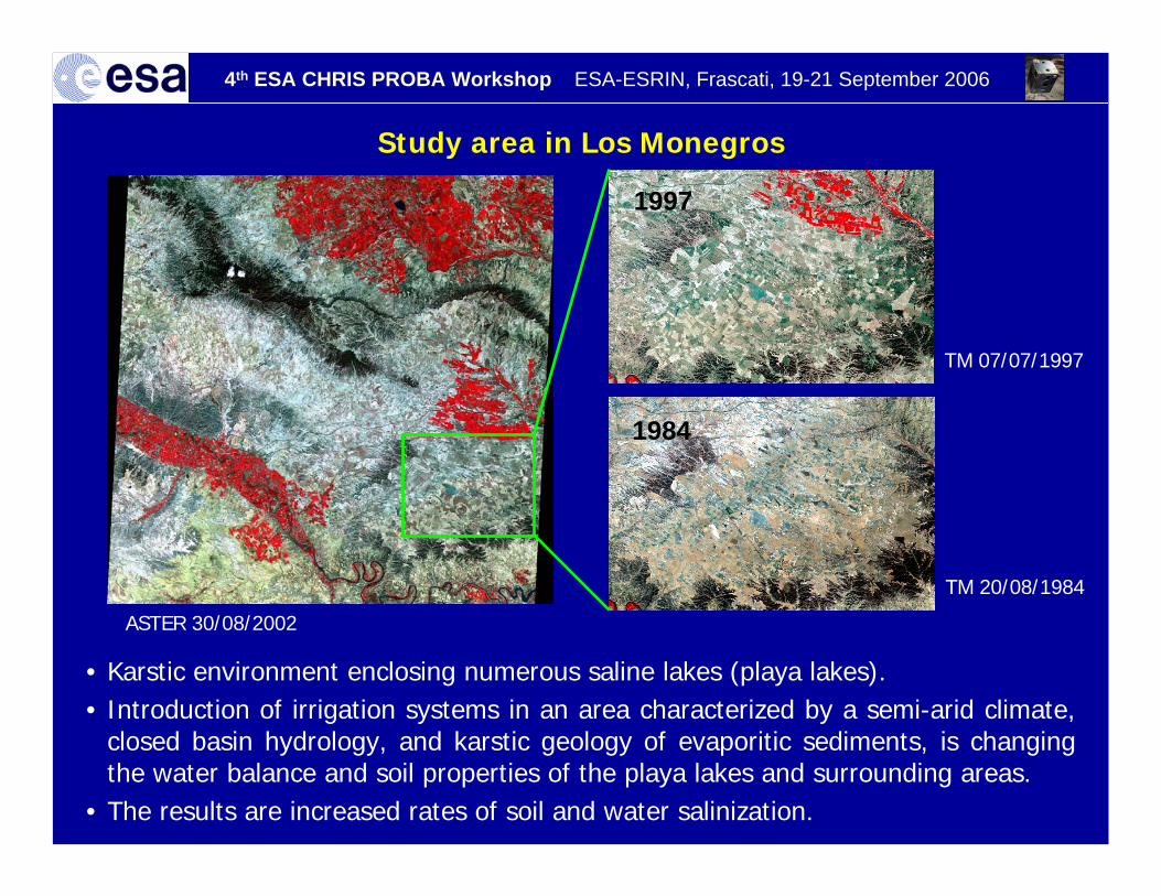
• Karstic environment enclosing numerous saline lakes (playa lakes).• Introduction of irrigation systems in an area characterized by a semi-arid climate,
closed basin hydrology, and karstic geology of evaporitic sediments, is changing the water balance and soil properties of the playa lakes and surrounding areas.
• The results are increased rates of soil and water salinization.
Study area in Los Monegros
ASTER 30/08/2002
TM 20/08/1984
TM 07/07/1997

4th ESA CHRIS PROBA Workshop ESA-ESRIN, Frascati, 19-21 September 2006
Salt efflorescence.Crop cultivation with intensive irrigation surrounding wetlands.
Diminishing water level.
Areas with temporal flooding.
0 5 km
Study area Las Tablas de Daimiel
• National Park (UNESCO Man and Biosphere Reserve and Ramsar Convention)• The area is in a depressed basin filled with Tertiary sediments, mainly of limestone
and calcareous clays.• Water sources: (1) Guadiana River (freshwater) and Cigüela River (brackish)
(2) Upwelling groundwater from underlying karstic aquifer.

4th ESA CHRIS PROBA Workshop ESA-ESRIN, Frascati, 19-21 September 2006
Methodology
• Unsupervised and supervised classification• Pool of endmembers• Spectral unmixing
Data processing
• Field campaigns• Surface sample analyses (sediment, soil, water)
Ground-truth data
Validation of results• Selected surface covers• Over a greater
Monitoring• Hyperspectral (HyMap, CHRIS) • Multispectral (ASTER, ETM+, TM)
Data acquisition
System, atmospheric, radiometric and geometric Calibration procedures
Hyperspectral and multispectral• Wet (spring) and dry (autumn) season
Database management• Georeferenced (field data, EO data)• Thematic maps

4th ESA CHRIS PROBA Workshop ESA-ESRIN, Frascati, 19-21 September 2006
Multispectral andmultitemporal dataTM, ETM+ y ASTER
Field data
Cartographic andancillary data
Methodology
Hyperspectral dataCHRIS, HyMap
Detecting changes in wetland areas
Spectral unmixing
Abundance maps
Image-derivedendmembers
Endmemberpool
III
Spectrallibrary
Sediment, soil, water studies
Field spectrometercampaign
Determination of vegetation
I
Identify endmember
Image-derivedendmembers
II

4th ESA CHRIS PROBA Workshop ESA-ESRIN, Frascati, 19-21 September 2006
Field workSpectral sampling
Soil characterisation and sampling
Water sampling
4th ESA CHRIS PROBA Workshop ESA-ESRIN, Frascati, 19-21 September 2006
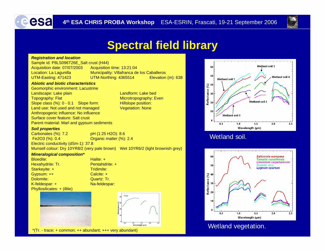
Registration and locationSample id: P8LS096T26E_Salt crust (H44)Acquisition date: 07/07/2003 Acquisition time: 13:21:04Location: La Lagunilla Municipality: Villafranca de los CaballerosUTM-Easting: 471423 UTM-Northing: 4365514 Elevation (m): 638Abiotic and biotic characteristicsGeomorphic environment: LacustrineLandscape: Lake plain Landform: Lake bedTopography: Flat Microtropography: EvenSlope class (%): 0 - 0.1 Slope form: Hillslope position:Land use: Not used and not managed Vegetation: NoneAnthropogenic influence: No influenceSurface cover feature: Salt crustParent material: Marl and gypsum sedimentsSoil propertiesCarbonates (%): 7.2 pH (1:25 H2O): 8.6Fe2O3 (%): 0.4 Organic matter (%): 2.4Electric conductivity (dSm-1): 37.8Munsell colour: Dry 10YR8/2 (very pale brown) Wet 10YR6/2 (light brownish grey)Mineralogical composition* Bloedite: Halite: +Hexahydrite: Tr. Pentahidrite: +Starkeyite: + Tridimite:Gypsum: ++ Calcite: +Dolomite: Quartz: Tr.K-feldespar: + Na-feldespar:Phyllosilicates: + (illite)
*(Tr. - trace; + common; ++ abundant; +++ very abundant)
Spectral field library
Wetland soil.
Wetland vegetation.

4th ESA CHRIS PROBA Workshop ESA-ESRIN, Frascati, 19-21 September 2006
Natural area with Steppe vegetation
Degraded area with invasive vegetation Land use change
Wetland status
Invasive vegetation

4th ESA CHRIS PROBA Workshop ESA-ESRIN, Frascati, 19-21 September 2006
Available EO data
Los Monegros Las Tablas de Daimiel
Hyperspectral
Multispectral
4 ASTER 2003 - 2005 4 ASTER 2003 - 2005
5 ETM+ 2001 - 2003
5 TM 1985 - 2003 2 TM 1984 - 1997
2 ETM+ 2002 - 2003
4 HyMap Scenes 2004
1 CHRIS scene 2006 1 CHRIS scene 2006
Further CHRIS scenes

4th ESA CHRIS PROBA Workshop ESA-ESRIN, Frascati, 19-21 September 2006
ASTER 29/5/03

4th ESA CHRIS PROBA Workshop ESA-ESRIN, Frascati, 19-21 September 2006
HyMap17 May 2004
HyMap12 August 2004

4th ESA CHRIS PROBA Workshop ESA-ESRIN, Frascati, 19-21 September 2006
Soil Classes – SAM classificationIsoData Classification
ASTER 16 June 2004
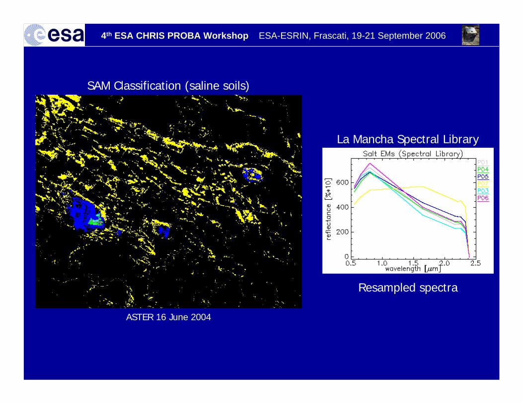
4th ESA CHRIS PROBA Workshop ESA-ESRIN, Frascati, 19-21 September 2006
ASTER 16 June 2004
SAM Classification (saline soils)
Resampled spectra
La Mancha Spectral Library

4th ESA CHRIS PROBA Workshop ESA-ESRIN, Frascati, 19-21 September 2006
CHRIS acquisition
C1 C2 C3 C4 C5
Las Tablas de Daimiel (Chris-LT-060703-6F45-41)
C1 C2 C3 C4 C5
Los Monegros (Chris-LN-060607-6D92-41)
Further acquisition: Las Tablas de Daimiel 6 October 2006
Los Monegros 13 October 2006
Las Tablas de Daimiel (22 May 2006) Cloudy

4th ESA CHRIS PROBA Workshop ESA-ESRIN, Frascati, 19-21 September 2006
Application of CHRIS data
• Spectral information to determine complex wetland characteristics.
• Angular information to obtain structure of vegetation and the water body.
• Detect wetland changes between the dry and wet seasons.
• Monitoring these ecosystems by integrating the CHRIS data to historical EO data.

4th ESA CHRIS PROBA Workshop ESA-ESRIN, Frascati, 19-21 September 2006
Acknowledgements
Thank ESA for providing the data and this especially goes to Peter Fletscher and Bianca Hoersch.
Thanks go to Ramón Peña Martínez andJosé Antonio Domínguez Gómez from the CEDEX.