Embed Size (px)
Citation preview
Tectonophysics 640–641 (2015) 70–79
Contents lists available at ScienceDirect
Tectonophysics
j ourna l homepage: www.e lsev ie r .com/ locate / tecto
Seismotectonics of Mindoro, Philippines
Po-Fei Chen a,⁎, Erlinton Antonio Olavere b, Chen-Wei Wang a, Bartolome C. Bautista b,Renato U. Solidum Jr. b, Wen-Tzong Liang c
a Department of Earth Sciences, National Central University, Jhongli, Taiwanb Philippine Institute of Volcanology and Seismology, Quezon City, Philippinesc Institute of Earth Sciences, Academia Sinica, Taipei, Taiwan
⁎ Corresponding author. Tel.: +886 3 4227151 65647.E-mail address: [email protected] (P.-F. Chen).
http://dx.doi.org/10.1016/j.tecto.2014.11.0230040-1951/© 2014 Elsevier B.V. All rights reserved.
a b s t r a c t
a r t i c l e i n f oArticle history:Received 11 June 2014Received in revised form 16 November 2014Accepted 23 November 2014Available online 17 December 2014
Keywords:SeismotectonicsMindoroSlab stress and geometryMacolod Corridor
Mindoro Island is located where the Palawan Continental Block indented into the Philippine Mobile Belt duringthe Early Miocene and where the Manila Trench terminates, having ceased convergence due to collision. Theseismotectonics ofMindoro are crucial to understanding the processes of arc-continent collision and slab dynamicresponses of convergence cessation. This study was conducted using data from both the EHB and Global CentroidMoment Tensor catalogues. It is shown that following the southeasterly reduction of convergence rates from theManila Trench offshore NW Mindoro to onshore SW Mindoro, the slab dipping angles steepen, were initiated atdepth (~200 km) and propagate upwards. The horizontal distances of the trench and slab, as measuredfrom the Wadati–Benioff zone at 200 km depth, also reduce in a southeasterly direction. Observations ofintermediate-depth earthquakes that exhibit predominantly down-dip extensional stress patterns attest that thesteepening of slab dipping angles is due to the negative buoyancy of the slab. In contrast, a broad region coveredby central and south Mindoro, the Romblon group, and NW Panay, is characterized by a sporadic distribution ofshallow earthquakes of mostly strike-slip type. Among these, the significantly sized events (Mw N 5.5) tend to dis-tribute around the borders suggesting that the region roughly acts as a unit block, moving or rotating coherently.Events in the vicinity of the Wawa–Mamburao valley exhibiting normal faulting of NW–SE horizontal extensionsuggest rifting of the Macolod Corridor extending southwestward to NWMindoro.
© 2014 Elsevier B.V. All rights reserved.
1. Introduction
Mindoro Island in the west-central Philippines is located where thePalawan Continental Block (PCB) indented into the Philippine MobileBelt (PMB) during the Miocene (Yumul et al., 2003) and where thesouthern Manila Trench currently terminates and progressively turnsinto vague surface expressions southeastward from offshore NWMindoro to onshore SW Mindoro (Marchadier and Rangin, 1990)(Fig. 1). The seismically active PMB and the aseismic PCB together con-stitute the Philippine archipelagowhere the Sundaland Plate (SUND) tothewest and the Philippine Sea Plate (PSP) to the east converge at a rateof ~9 cm/year, trending NW–SE (DeMets et al., 2010). The oppositepolarity of subduction systems on two sides of the PMB—predominantlyeast-dipping SUND slab along the Manila–Negros–Cotabato trenches tothewest andwest-dipping PSP slab along the East LuzonTrough and thePhilippine Trench to the east—together with the Philippine Faultsystems mostly accommodate the SUND-PSP relative plate motions.The Philippine Fault, which transects the PMB in a generally NNW–
SSE direction, mainly absorbs components of oblique convergence and
is occasionally ruptured by left-lateral strike–slip earthquakes (Barrieret al., 1991).
The PMB represents accreted terranes of ophiolites, island arcs, andcontinental fragments,whereas the PCB is essentially a continental frag-ment that rifted off the Eurasia continents during the mid-Tertiary andsubsequently drifted southward with the opening up of the SouthChina Sea (Karig, 1983). According to tectonic reconstruction of tectonicterranes based on paleomagnetic and stratigraphic studies (Holloway,1982; Karig, 1983; Sarewitz and Karig, 1986), the Oligocene counter-clockwise rotation and northward movements of the PMB, togetherwith the southward drift of the PCB, have resulted in collision in thevicinity of Mindoro during the Miocene. The Miocene collision playeda key role in the geological evolution of the Philippine archipelago.Several of its impacts have been inferred, including the initiation ofsinistral strike–slip movements in the central PMB, resulting in thePhilippine Fault Systems (Holloway, 1982); inception of double polaritysubductions (Holloway, 1982; Yumul et al., 2003); counterclockwise ro-tation of Mindoro–Marinduque and clockwise rotation of Panay and theWestern Visayan block (Holloway, 1982; Yumul et al., 2000); and steepdipping of the Wadati–Benioff zone beneath NW Mindoro and SWLuzon (Bautista et al., 2001).
Understanding the processes of the PCB–PMB collision is thus criticalfor the study of the complex tectonics and geological characteristics of

115˚
115˚
120˚
120˚
125˚
125˚
5˚ 5˚
10˚ 10˚
15˚ 15˚
20˚ 20˚
−8000 −6000 −4000 −2000 0 2000 4000
Bathymetry(meter)
Luzon
Mindoro
Panay
MindanaoPalawan
Neg
Ce
Boh
South China SeaPhilippine Sea
Sulu Sea
P.T.
M.T.
E.L.T.
C.T.
N.T.
S.T.
P.F.
S.V.P.F.
?
Fig. 1. Tectonic settings of the Philippine archipelago. Blue lines are trenches, with dipping polarities shown in triangles. Gray solid lines are fault traces. Black dashed lines are the conti-nent–ocean-boundary from Yumul et al. (2009) and red triangles are distributions of Quaternary volcanoes. Abbreviations: E.L.T. (East Luzon Trough), P.T. (Philippine Trench), M.T.(Manila Trench), N.T. (Negros Trench), C.T. (Cotabato Trench), S.T. (Sulu Trench), P.F. (Philippine Fault), S.V.P.F. (Sibuyan Verde Passage Fault), Neg (Negros), Ce (Cebu), Boh (Bohol).
71P.-F. Chen et al. / Tectonophysics 640–641 (2015) 70–79
the Philippines and may help identify areas that are prone to earth-quake, volcano, and tsunami hazards. In this regard, Mindoro Island,situated at the site of the collision, provides crucial data. However, thelocations of the Miocene PCB–PMB collision boundaries in the vicinityof Mindoro are difficult to ascertain geologically due to multiple colli-sion episodes, as shown by various ophiolite belts on the island, withthe earlier imprints often blurred by later ones (Marchadier andRangin, 1990; Yumul et al., 2003). As a result, proposals of the PCB–PMB boundary vary from offshore east Mindoro (Dimalanta et al.,2009), through central Mindoro (Sarewitz and Karig, 1986) to south-west Mindoro (Karig, 1983; Marchadier and Rangin, 1990).
On the other hand, the Quaternary crustal deformations and relativeblock motions in the vicinity of Mindoro as revealed by geodeticand seismological studies may help understand the processes of theMiocene collision, by which they are strongly influenced. Joint inver-sions of recent geodetic and focal mechanism data indicate thatSundaland, Mindoro, and Central Visayas are movingwestward relativeto the Central Luzon Block (SUND, MIND, CENV, and CLUZ, respectively,
in Fig. 8 of Galgana et al., 2007). However, as recognized by Galganaet al. (2007), the results are based on a first-order approximation ofblock identification, due to the limited density of GPS sites, whereassome blocks still exhibit internal deformation as shown by earthquakeoccurrence (e.g., MIND). In this study, we decipher patterns of crustaldeformations and block movements in and around Mindoro usingseismological data. Unlike previous similar studies dealing with a rela-tively broad area (e.g., Galgana et al., 2007; Hamburger et al., 1983;Ramos et al., 2005), we focus on regions in and around Mindoro anduse two types of datasets to study various aspects of the Mindoroseismotectonics: (1) overall seismic distributions from the EHB globalcatalogue (Engdahl et al., 1998), (2) states of stress, slip directions,and distributions of earthquakes from the Global Centroid MomentTensor (GCMT) catalogue (Dziewonski et al., 1981; Ekström et al.,2012).We concluded from the lack of significant interplate thrust earth-quakes offshore NW Mindoro that convergence rates across the south-ernmost segment of the Manila Trench are in a transition from minorto total cessation. Coupledwith the transition, EHB seismic distributions

72 P.-F. Chen et al. / Tectonophysics 640–641 (2015) 70–79
exhibit a southeasterly trend of steepening slab dip, initiated from deep(~200 km) and eventually reaching shallow depths (~100 km), and atrend of shortening trench–slab distances, reducing from ~160 km to~100 km as measured from the slab at 200 km depth.
2. Tectonics and geology in and around Mindoro
The two main tectonic lineaments in the vicinity of Mindoro are theManila trench bounding the west and the Sibuyan Verde Passage Faultpassing through north and northeast offshore Mindoro (Fig. 2). TheManila trench terminates offshore near west central Mindoro (nearMamburao) and dies out southward as marked by parallel folds andthrusts on land in SW Mindoro (Marchadier and Rangin, 1990). Basedon stratigraphical analysis, Karig (1983) proposed that the SWMindorothrust belt is likely to represent a section of PCB–PMB collisionboundary. The Sibuyan Verde Passage Fault branches out of thePhilippine Faults near Masbate and extends westward near theManila trench (Fig. 2). Pubellier et al. (2000) pointed out that as aresult of reducing convergence at both the southern Manila trench
120˚
120˚
121˚
121˚
122˚
122˚
11˚
12˚
13˚
14˚
−4000 −2000
Bathymetry(m
Mindoro
Marinduqu
SW Mindoro thrust belt
Upper Miocene Punso Conglomerate
Middle Oligocene Amnay Ophiolitic Complex
Upper Eocene Caguray Formation
Eocene Puerto Galera Ophiolitic Complex
Sibuyan Verde Passage
MacolodCorridor
Wawa
Mamburao
East M
indoro Fault Zone
Fig. 2. Tectonic settings around Mindoro and geological stratigraphy inMindoro edited from Yudashed line is the Wawa–Mamburao valley. Arrows indicate relative motions across structures
and the northern Philippine trench, a northwest shearing, probablypartitioned by the Philippine and Sibuyan Verde Passage Faults, isnecessary to accommodate the residual PCB–PMB plate motionsand that a transtensional motion along the NE–SWMacolod Corridormay be predicted (Fig. 2). Pubellier et al. (2000) further argued thatthe Sibuyan Verde Passage Fault and the Manila trench must be con-nected for the accommodation to be sustained, despite the fault tracebeing obscured beneath sediments of the forearc basin. The islands ofMarinduque, the Romblon island group, and the Panay are located tothe east of Mindoro. The Marinduque basin offshore eastern Marindu-que island is a marine intra-arc basin formed by a process analogousto sea-floor spreading (Sarewitz and Lewis, 1991). The Romblon islandgroup comprising Tablas, Romblon, and Sibuyan is dominated by ametamorphic suite and ophiolite complex, which are believed to beemplaced along east-verging thrust faults developed consequent toPCB–PMB collision (Dimalanta et al., 2009). On Panay island, the meta-morphic complex on the NW corner (Buruanga peninsula) and theAntique ophiolite to the west (Antique Range) are believed to be locatedalong northwest-verging thrust faults (Yumul et al., 2009).
123˚
123˚
124˚
124˚
11˚
12˚
13˚
14˚
0
eter)
Panay
RIG
e
Masbate
Eocene Lasala Formation
Cretaceous Mangyan Ophiolitic Complex
Upper Jurassic Mindoro Metamorphics
Jurassic Mansalay Formation
Thrust fault
Fault
mul et al. (2009). Black dashed lines and red triangles are the same as those in Fig. 1. Blue.

73P.-F. Chen et al. / Tectonophysics 640–641 (2015) 70–79
Tectonic configurations in Mindoro generally trend NW–SE parallelto that of the Manila trench, including the Central Range and the SanJose Platform (Fig. 2). The mid-Oligocene Amnay, Cretaceous Mangyan,and Eocene Lubang-Puerto Galera complexes are three Ophiolite beltsdistributed distantly from the Manila trench that have been emplacedthrough strike–slip faulting, spreading ridge thrusting, and/or scissor-type collision (Yumul et al., 2009) (Fig. 2). The basement rock of NWMindoro is Upper Jurassic HalconMetamorphics overlain by the EoceneLasala Formation (Canto et al., 2012). On South Mindoro, the JurassicMansalay Formation is the oldest sedimentary sequence overlain bythe Eocene Caguray Formation. The Punso Conglomerate outcrops alarge NW–SE belt on SW Mindoro (Marchadier and Rangin, 1990).Karig (1983) reported the PCB–PMB collision boundary to be the SWMindoro thrust belt and suggested that the Upper Miocene to LowerPliocene Punso Conglomerate on top of the colliding blocks indicatethe termination of collision by Pliocene time.
116˚
116˚
118˚
118˚
120˚
120˚
122˚
122˚
6˚
8˚
10˚
12˚
14˚
16˚
18˚
20˚
22˚
0 40 80
depth(
Fig. 3.Distributions of significant thrust earthquakes (Mw N 5.9 and 45° b rake b 135°) in the Phcolor-coded. Most of focal mechanisms are representative of interplate thrust earthquakes. Notlack of events offshore NWMindoro.
3. Data and methods
Both the EHB and the GCMT global catalogues of earthquakes wereused in this study. The EHB catalogue (1960–2008) first uses P andlater phases (pP, sP) to relocate earthquakes and is more complete forminor earthquakes (up to mb ~ 3.0), whereas the GCMT catalogue(since 1976) uses normal modes of the Earth to invert for earthquakecentroid and moment tensors, is only complete for greater earthquakes(Mc = 5.8; Kagan and Jackson, 2011), but contains more related infor-mation such as focal mechanisms, P and T axes, and slip vectors.Moments greater than 1025 dyne-cm (Mw N 5.9) with rakes between45° and 135° were selected from the GCMT catalogue to show the fre-quencies of significant interplate thrust earthquakes along trenches inthe Philippine archipelago (Fig. 3). To study the seismotectonics associ-ated with Mindoro, a region bounded by 119°E/123°E and 11°N/15°Nwas selected (Fig. 4). Distributions of overall seismicity are shown
124˚
124˚
126˚
126˚
128˚
128˚
130˚
130˚
6˚
8˚
10˚
12˚
14˚
16˚
18˚
20˚
22˚
120 160
km)
ilippine archipelago from the GCMT catalogue with symbols scaled tomoment and depthse the significant accumulative seismic moment release along the Philippine trench and the

˚221˚021
12˚
14˚
0 50 100 150 200 250
depth(km)
-30000
3000
-30000
3000
-30000
3000
-30000
3000
-30000
3000
-30000
3000
1
1’
2
2’
3
3’
4
4’
5
5’
6
6’
1 1’
2 2’
3 3’
4 4’
5 5’
6 6’
0
100
200
0
100
200
0
100
200
0
100
200
0
100
200
0
100
200
-40 0 40 80 120 160
-40 0 40 80 120 160 200
-40 0 40 80 120 160 200
0 40 80 120 160 200
0 40 80 120 160 200
0 40 80 120 160 200
-40 0 40 80 120 160
-40 0 40 80 120 160 200
-40 0 40 80 120 160 200
0 40 80 120 160 200
0 40 80 120 160 200
0 40 80 120 160 200
Fig. 4.Distributions of earthquakes from the EHB catalogue (left) categorized into three groups—those associatedwith east-dipping subduction north of 14°N (group I), those clustered inNWMindoro and SW Luzon (group II), and those sporadically covering central and south Mindoro, the Romblon group, and west Panay (group III). Group II seismicity is projected on sixprofiles northeasterly to show the variations of Wadati–Benioff zones and distance relative to the trench (red lines), taken as reference points (right).
74 P.-F. Chen et al. / Tectonophysics 640–641 (2015) 70–79
using earthquakes from the EHB catalogue. Earthquakes offshore NWMindoro and SW Luzon were projected on six profiles roughly normalto the Manila Trench. Positions of the projected trench were taken asreference points to measure horizontal distances relative to the slab atdepths or to volcanoes on the surface. The horizontal distances of theWadati–Benioff zones at 200 km depth to the trench are indicated inFig. 4.
Based on the double-couple components of focal mechanisms, thecalculated P, N, T axes of the GCMT earthquakes in the region werecategorized into normal, strike–slip, or thrust type according to theangles between the vertical and the three axes. Categorization wasbased on a ternary diagram with pure normal (vertical P axis), purestrike–slip (vertical N axis), and pure thrust (vertical T axis) as endmember plots (Frohlich and Apperson, 1992). Events projected in themiddle sub-triangle of the ternary diagram are those where all threeangles between the vertical and the P, N, T axes were greater than45°, and are grouped into none of the above categories (Fig. 5). Fig. 6shows the distributions of earthquakes in each group, with symbolsize proportional to magnitude and depth color-coded.
There are no deep earthquakes (depth N300 km). The associations ofintermediate-depth earthquakes (80 ~ 300 km) with the subductingslab were investigated. To mimic the geometry of the Wadati–Benioffzone offshore NW Mindoro, a slab coordinate system (strike N305°E,dip 70°) was constructed using along strike, slab normal, and down-dip as the x, y, and z directions in Cartesian coordinates. The coordinateswere used to project the P and T axes of non-shallow earthquakes(here, mostly intermediate-depth) from the GCMT catalogue (Chenet al., 2004a) (Fig. 7). The associations of shallow earthquakes(depth b 80 km) with the geodynamics of Mindoro are shown in
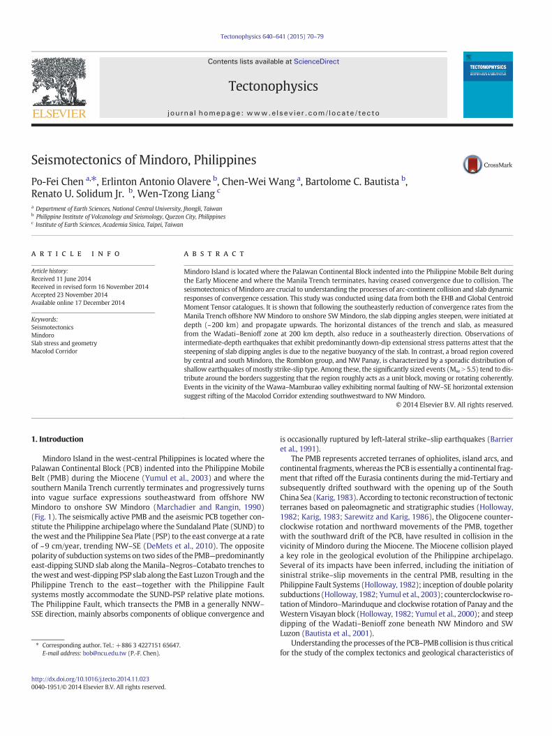
Fig. 8, displaying focal mechanisms on earthquake locations withdepth color-coded. As we focused on the seismotectonics of Mindoroin analyzing the spatial distributions of focal mechanism, those northof 14°N and west of 120°E were ignored (Fig. 8).
4. Results
Significant thrust earthquakes (Mw N 5.9) tend to distribute alongknown trenches of the Philippine archipelago (Fig. 3). The majority ofthese, especially those with depths of less than 20 km and exhibitingone plane shallowly dipping to the direction of subduction with strikesresembling those of trenches, belong to the type of interplate thrustearthquakes. Their occurrence represents a release of strain energyaccumulated by relative platemotions, which in turn suggests that con-vergences across the trenches are currently active and their sizes aresignificant (Mw N 5.9). The Philippine Trench is the areawith the highestfrequency of occurrences, followed by the Manila Trench, the CotabatoTrench, and the East Luzon Trough (Fig. 3). We draw attention to thesegment of the South Manila Trench offshore NW Mindoro whereinterplate thrust earthquakes are absent (Fig. 3). Given that majorearthquakes dominate the majority of seismic moment release, thelack of significant interplate earthquakes suggests insignificant seismicslip in the segment over the past 40 years. The causes could be attribut-ed to aseismic slip, accumulation of stain energy, or reduction of conver-gence rates. The latter appears to be themost likely explanation becauseGPS data show a southward decrease of the western Luzon movementsrelative to the Sundaland Block (Yu et al., 2011) and because theManilatrench terminates to the south, where PCB has indented into PMB sincethe Early Miocene.

Mw=7
Mw=6
Mw=5
0 30 60 90 120 150 180 210 240 270
Depth(km)
NF
SF
TF
Fig. 5. Ternary diagram of earthquake focal mechanisms with symbol size scaled to earth-quake magnitude and depth color-coded. The three apexes indicate a pure strike–slip(top), a pure normal fault with 45° dipping plane (left), and a pure reverse fault with45° dipping plane (right). The three solid lines inside the ternary represent N (top), P(left), T (right) axes of earthquakes being 45° from the vertical, respectively, which arethe boundaries used to define the strike–slip fault (SF) group (triangles), the normalfault (NF) group (diamonds), the thrust fault (TF) group (circles), and others (squares).
75P.-F. Chen et al. / Tectonophysics 640–641 (2015) 70–79
The distributions of seismicity from the EHB catalogue in the bound-ed region can be roughly categorized into three groups of patterns(Fig. 4). Group I is associated with subduction along the Manila Trenchnorth of 14°N and is relatively far away from Mindoro, and will there-fore be disregarded in the following. Group II refers to the cluster inNWMindoro and SW Luzon and displays distinctive features of a steep-ly dippingWadati–Benioff zone (Fig. 4). There is a progressive variationsoutheasterly from profiles 66′ to 11′: the slab dipping angles steepeninitially at the deep section (~200 km, profiles 33′ and 22′), followedby upward propagation and eventually the entire slab dipping steeply(profile 11′). Coupled with the upward propagation of steep dip anglesis the progressive shortening of trench–slab horizontal distances asmeasured from the trench to slab at 200 km depth (Fig. 4)—reducedfrom 160 km (profile 44′), to 120 km (profiles 33′ and 22′), and eventu-ally to 100 km (profile 11′). There is a gap of intermediate-depth earth-quakes to the NWof profile 55′ (Fig. 4).Whether it is caused by absenceof slab or presence of an aseismic slab (Chen et al., 2004b) remains anopen queston. Group III is characterized by a broad region ofwidespreadsporadic shallow seismicity covering central and south Mindoro, theSibuyan Sea, the Romblon Island Group, the NW Panay, and the South-west Mindoro Thrust Belt (Figs. 2 and 4). It is notable that other thanMindoro, the major areas covered by Group III are marine intra-arc ba-sins (e.g., the Marinduque basin; Fig. 4).
Earthquakes from theGCMT catalogue bounded by 119°E/123°E and11°N/15°N projected on the ternary diagram (Fig. 5) demonstrate thatthe majority are thrust fault and strike–slip fault type. The former arepredominantly non-shallow (depth N 80 km) and the latter shallow(depth b 40 km). Plotting the distributions of each type of earthquakewith corresponding symbols (Fig. 6) shows that thrust fault type
earthquakes tend to cluster to form Group I and Group II, suggestingtheir associationwith subduction processes. In contrast, Group III earth-quakes are constitutedmainly of strike–slip type earthquakes. The shal-low earthquakes (depth b 40 km) of normal fault type are those of outer-rise events inGroup I, onNWMindoro inGroup II (see discussion below),and in centralMindoro roughly on the EastMindoro Fault Zone (Fig. 2). Itis clear that earthquakeswith depths greater than 80kmonly occurred inGroup II and are associated with a steeply dipping slab. The associationscan be attested by projections ofP and T axes of thoseGCMT earthquakes(Fig. 7) using slab coordinates constructed from distributions of the EHBearthquakes (Fig. 4). Results reveal that patterns of stresses within theslab are of predominantly down-dip extension (Fig. 7), which in turnindicates that the negative buoyancy of the steeply dipping slab is themain cause of those intermediate-depth earthquakes.
More detailed analyses on patterns of crustal seismic deformationswere conducted investigating the focal mechanisms of shallowearthquakes, MW greater than 5.5, and bounded by 120°E/123°E and11°N/14°N (Fig. 8). In the Group II region, there remain a fewmoderateearthquakes (Mw b 6), potentially of interplate thrust type but at depthsbetween 40 and 80 km. A feature of interest is the three shallow (lessthan 20 km) normal fault type earthquakes in this region, with NW–
SE horizontal T axes resembling the pull-apart direction of the MacolodCorridor located just to the northeast. In the Group III region, the rela-tively large earthquakes (Mw N 5.5) tend to be distributed around theborder of the Group III area, which can be roughly divided into twosoutheast-trending lineaments to the north and south (Fig. 8). Whilemost of the northern ones likely ruptured on the NW–SE trendingnodal planes of the Sibuyan Verde Passage Fault, the southern onesseem to rupture on trending planes similar to the Southwest MindoroThrust Belt. In this regard, both the Sibuyan Verde Passage Fault andSouthwest Mindoro Thrust Belt are moving in a left-lateral sense. How-ever, the November 14th, 1994 Mindoro earthquake (Mw = 7.1) in theVerde Island Passage remains a notable exception to the overall patterndue to its right-lateral slip on the Agluban fault, as based on surfaceruptures (Tanioka and Satake, 1996) (Fig. 8).
5. Discussion
The PCB–PMB collision during the Miocene not only terminatesthe Manila trench but also caused a southward reduction of Luzon–Sundaland Block relative motions. In this study, we point out that theseismic slips across the segment of the Manila trench offshore NWMindoro have been insignificant for the past 40 years. We concludethat themanila trench fromoffshore SWLuzon toNWMindoro currentlyexperiences a decrease in convergence rates that approaches total cessa-tion. Consequently, southeastward variations of seismic features exhibita modern evolution of the subducting slab upon collision of an island arcwith continental fragments. First, the majority of intermediate-depthearthquakes exhibit down-dip extension (Fig. 7), suggesting that thesteep dipping of the slab exerts significant negative buoyancy andinduces abundantWadati–Benioff seismicities, despite the fact that con-vergences are inferred to be minor. Secondly, southeasterly variations ofconvergence from minor to total cessation (profile 66′ to 11′ in Fig. 3)compared with those of Wadati–Benioff geometries illustrate that thenegative buoyancy of the subducting slab dominates in shaping slabgeometrywhen convergence rates become insignificant and the process-es are initiated at the deep section propagating upwards. It is interestingto note that the two deepest earthquakes have T axes pointing steeply tothe SW, and exhibit rollback opposite to subduction and not in thedown-dip direction (Fig. 7). Thirdly, as slab dipping angles steepen,horizontal distances relative to the trench as measured from theWadati–Benioff zone at 200 km depth also decrease in a southeasterlymanner (Fig. 8). Assuming that the island arcs were formed prior tothe reduction of convergence rates and initiation of slab steepening,the positions of those calc-alkaline volcanoes (DeBoer et al., 1980)were regarded as fixed; we then investigated whether the trench–arc

118˚
118˚
120˚
120˚
122˚
122˚
124˚
124˚
10˚ 10˚
12˚ 12˚
14˚ 14˚
16˚ 16˚
0 40 80 120 160 200 240
depth(km)
Mw=7
Mw=6Mw=5
Fig. 6.Distributions of earthquakes from theGCMT cataloguewith different symbols (scaled tomoment) representing different types of earthquakes. Note that areas of the three groups asshown in Fig. 3 are more distinctively covered by corresponding types of earthquakes, i.e., thrust type for Groups I and II and strike–slip type for Group III.
76 P.-F. Chen et al. / Tectonophysics 640–641 (2015) 70–79
distances vary as a result of slab steepening, by projecting profiles rough-ly normal to theManila Trench (Fig. 9). Results also show a southeasterlyshortening of trench–arc distances, indicating that trenches advancedtoward the arc once convergence reduced and slab steepening was initi-ated. We further propose that the bending of the Manila Trench near13.5°N may be caused by the advance of the trench. The concludedpatterns of seismicity and stresses exhibit spatial consistence and areunlikely to be biased by data uncertainties.
TheMacolod Corridor in SW Luzon, transecting the island NE–SW, isa zone of approximately 40 kmwidth that is pervaded by extensive vol-canism, faulting, and crustal thinning (Föster et al., 1990; Galgana et al.,2007) andmay represent a pull-apart rift zone between theManila andPhilippine Trenches (Defant et al., 1988). However, the neotectonicallyactive Macolod Corridor is devoid of seismic activity due to high geo-thermal activity underneath the Taal/Laguna de Bay volcanic field(Pubellier et al., 2000). The normal-faulting shallow earthquakes inthe Group II region with significant magnitudes (Mw: 5.5, 5.7, and 5.9)indicate in situ NW–SE tensional stress regimes. Such trench-paralleltensional axes are uncommon in subduction zones. Given that theearthquakes are located on the SW extension of the Macolod Corridorwith T axes roughly parallel to its pull-apart zone, we propose that theearthquakes result from rifting of the Macolod Corridor extendingbeyond the Sibuyan Verde Passage Fault southwesterly to reach NWMindoro. In other words, the normal-faulting earthquakes in NW
Mindoro, like the left-lateral strike–slip earthquakes along the SibuyanVerde Passage Fault, is the seismic expressions of accommodating thetransfer of SUND-PSP relative motions (Pubellier et al., 2000). Further-more, if the valley topography between Wawa and Mamburao in NWMindoro (Fig. 2) is a result of pull-apart rifting, it may serve as astructural boundary, as the part of Mindoro to the south representsalready amalgamated terranes due to arc-continent collision sincethe Miocene. This theory is supported by the distinctive seismic pat-terns (Group II versus Group III) on the two sides of the valley. It isalso interesting to note that significant strike–slip earthquakes on theSibuyan Verde Passage Fault almost die out northwesterly passing thevalley (Fig. 8).
However, the amalgamations of collision terranes cannot explain theearthquakes on the SouthwestMindoro Thrust Belt and their southeast-erly linear extension with similar left-lateral strike–slip focal mecha-nisms, which correspond to the transpressive regime active at leastsince the Late Pliocene (Marchadier and Rangin, 1990).We hypothesizethat the normal component of the oblique convergences during PCB–PMB collision was accommodated by the processes of amalgamation,which diffuse over a wide zone that probably covers most of the GroupIII region. Judging by lack of thrust-faulting earthquakes, the amalgam-ation is presently inactive to the south of the Wawa–Mamburao valley(Fig. 6). The shear components are jointly released by left-lateralstrike–slip earthquakes along the Southwest Mindoro Thrust Belt, the

AS
SN
AS
SN
t-axes
p-axeskm
1024
1025
1026
1027
dyne•cm
80
120
160
200
240
280
Fig. 7. Projection of T (upper) and P (lower) axes of earthquakeswith depth greater than 80 km from theGCMT catalogue using local slab coordinates (strike 305° and dip 70°). The along-strike (AS) is pointing to the north, slab-normal to the east, and down-dip vertically down at the center. The intermediate-depth earthquakes are exclusively from the Group II areaassociated with Sundaland subduction. Note that stress patterns are predominantly of down-dip extension.
77P.-F. Chen et al. / Tectonophysics 640–641 (2015) 70–79
Sibuyan Verde Passage Fault, and the Philippine Fault. Rifting of theMacolod Corridor was explained by Pubellier et al. (2000) as a kinemat-ical requirement to accommodate the NW–SE shear components of theSUND-PSP plate motion at the trench-trench transformation. To a lesserextent, this also applies to the normal-faulting earthquakes in NWMindoro. The SUND-PSP NW–SE shear motions released at diffusedzones with different mechanisms illustrate various degrees of amalgam-ations by the PCB–PMB collision. However, the normal-faulting earth-quakes on the East Mindoro Fault Zone (Fig. 6) and the 1994 Mw7.1Mindoro earthquakes do not belong to this category and probably reflectthe transitions from rifting to left-lateral movements on strike–slipfaults.
The overall distribution of major earthquakes (mostly strike–slip)in the Group III area seems to indicate that the terrane encircledby the Wawa–Mamburao valley, the Sibuyan Verde Passage Fault, off-shore east of the Romblon Group, the NW Panay, and the SouthwestMindoro Thrust Belt acts as a relatively rigid unit and shears with the
surroundings. Note that the SE boundary is coincident with the areawhere crustal thickness jumps to greater than 30 km (Dimalanta andYumul, 2004). It is thus reasonable to hypothesize that the Group IIIarea is a terrane unit isolated by the PCB–PMB collision. Interestingly,the major strike–slip earthquakes distribute offshore east of theRomblon group of islands and NW Panay (Fig. 6), coincident with theproposed PCB–PMB collision boundary based on geological, gravitational,and magnetic observations (Dimalanta et al., 2009; Yumul et al., 2003).Near Mindoro, seismic distributions suggest that the boundaryfollows the Sibuyan Verde Passage Fault (Fig. 6). In contrast, earth-quakes along the Southwest Mindoro Thrust Belt coincide with theproposed PCB–PMB collision boundary based on the reported forelandthrust belt in SW Mindoro (Karig, 1983; Marchadier and Rangin,1990). However, the GCMT catalogue currently contains no majorearthquakes that occurred in the Mindoro Suture Zone, which has alsobeen proposed as the boundary between PCB and PMB (Sarewitz andKarig, 1986).
˚321˚221˚121˚02111˚
12˚
13˚
14˚
5.6
5.7
5.8
5.7
5.9
5.55.6
5.9
5.85.5
5.6
6.2 5.6
7.1
5.7
5.6
7.1
5.5
5.5
5.7
5.5
5.8
5.6
5.85.5
5.9
5.9
5.5
5.6
5.85.9
5.55.8
6.0
08040
depth(km)
Fig. 8. Spatial distributions of focal mechanisms (depth color-coded) for earthquakes withMw greater than 5.5 and depth less than 80 km from the GCMT catalogue. The analysis region iswithin 120°E/123°E and 11°N/14°N, slightly smaller than in Fig. 6 to allow focus on the vicinity of Mindoro. White dashed lines are traces of the Sibuyan Verde Passage Fault and thePhilippine Fault.
78 P.-F. Chen et al. / Tectonophysics 640–641 (2015) 70–79
6. Conclusions
In this study, we use data from the EHB and GCMT catalogue tostudy the seismotectonics of Mindoro and are able to draw severalwell-founded conclusions, otherwise not constrained by geodeticand geological observations. First, a lack of significant interplatethrust earthquakes, a southward decrease of Luzon–SundalandBlock relative motions, and the PCB–PMB collision since the Mio-cene, together suggest that convergences across the Manila Trenchvary southeasterly fromminor offshore SW Luzon to total cessationin Southwest Mindoro Thrust Belt. Secondly, the comparison ofvariations between convergence rates and Wadati–Benioff geome-tries illustrates that the negative buoyancy of the subducting slabdominates in shaping slab geometry when convergence ratesbecome insignificant and the processes are initiated at the deepsection propagating upwards. Thirdly, the same negative buoyantforces are attributed to intermediate-depth earthquakes, both becauseof their abundance and their predominant down-dip extensiontype.
Fourthly, shallow earthquakes not associated with subduction(mostly strike–slip type) are sporadically distributed in a broad regionbordered by the Wawa–Mamburao valley, the Sibuyan Verde Passage
Fault, east of the Romblon group and NW Panay, and the SouthwestMindoro Thrust Belt. We hypothesize that the region may be isolatedby the PCB–PMB collision and acts as a unit block moving in unison,based on the observations that significant strike–slip earthquakes(Mw N 5.5) tend to distribute around the border and the border coin-cides with the boundary of thick crust (thickness N 30 km). Finally,observations of many significant-sized normal-faulting earthquakesin NW Mindoro with horizontal extension in NW–SE direction sug-gest that the driving mechanisms that rift the Macolod Corridor ina similar NW–SE azimuth actually apply southwesterly beyond theSibuyan Verde Passage Fault and dominate crustal deformation inNW Mindoro.
Acknowledgments
Thisworkwas supported by the Taiwan Earthquake Research Center(TEC) funded through National Science Council (NSC) with grantnumbers 100-2116-M-008-011 and 101-2116-M-008-016. The TECcontribution number for this article is 00112.Many of the figures hereinwere preparedwith the Generic Mapping Tool (GMT) software (Wesseland Smith, 1998).

120˚ 122˚
12˚
14˚
1
1’
2
2’
3
3’
4
4’
5
5’
6
6’
-1000
0
1000
2000
-2000
-1000
0
1000
2000
-3000
-2000
-1000
0
1000
-5000
-4000
-3000
-2000
-1000
0
1000
-5000
-4000
-3000
-2000
-1000
0
1000
-5000
-4000
-3000
-2000
-1000
0
1000
-40 0 40 80 120 160
-40 0 40 80 120 160
-40 0 40 80 120 160
-40 0 40 80 120 160 200
0 40 80 120 160 200
0 40 80 120 160 200
1 1’
2 2’
3 3’
4 4’
5 5’
6 6’
Fig. 9. (Left) Six cross-sections roughly normal to the trench align northwesterly to project topography and the calc-alkaline volcanoes (red stars). (Right) Results of the projectionwith thepositions of the trench taken as reference. Trench–arc distances are determined by the projected locations of volcanoes shown in vertical dashed lines. Note that the trench–arc distancesprogressively decrease southeasterly, coupled with an decrease of trench–slab distance and an increase of slab dip angle.
79P.-F. Chen et al. / Tectonophysics 640–641 (2015) 70–79
References
Barrier, E., Huchon, P., Aurelio, M., 1991. Philippine fault—a key for Philippine kinematics.Geology 19, 32–35.
Bautista, B.C., Bautista, M.L.P., Oike, K., Wu, F.T., Punongbayan, R.S., 2001. A new insight onthe geometry of subducting slabs in northern Luzon, Philippines. Tectonophysics 339(3), 279–310.
Canto, A.P.B., Padrones, J.T., Concepcion, R.A.B., Perez, A.D.C., Tamayo Jr., R.A., Dimalanta,C.B., Faustino-Eslava, D.V., Queaño, K.L., Yumul Jr., G.P., 2012. Geology of northwesternMindoro and its offshore islands: implications for terrane accretion in west CentralPhilippines. J. Asian Earth Sci. 61, 78–87.
Chen, P.-F., Bina, C.R., Okal, E.A., 2004a. A global survey of stress orientations insubducting slabs as revealed by intermediate-depth earthquakes. Geophys. J. Int.159, 721–733.
Chen, P.-F., Huang, B.-S., Liang, W.-T., 2004b. Evidence of a slab of subducted lithospherebeneath central Taiwan from seismic waveforms and travel times, Earth Planet. Sci.Lett. 229, 61–71.
De Boer, J., Odom, L.A., Ragland, P.C., Snider, F.G., Tilford, N.R., 1980. The Bataan orogene: east-ward subduction, tectonic rotations and volcanism in western Pacific (Philippines).Tectonophysics 67, 251–282.
Defant, M.L., De Boer, J.Z., Oles, D., 1988. The western Central Luzon Arc, two arcs dividedby rifting? Tectonophysics 145, 305–317.
DeMets, C., Gordon, R.G., Argus, D.F., 2010. Geologically current plate motions. Geophys.J. Int. 181, 1–80.
Dimalanta, C.B., Yumul Jr., G.P., 2004. Crustal thickening in an active margin setting(Philippines): The whys and the hows. Episodes 27, 260–264.
Dimalanta, C.B., Ramos, E.G.L., Yumul, G.P., Bellon, H., 2009. New features from theRomblon Island Group: key to understanding the arc–continent collision in CentralPhilippines. Tectonophysics 479, 120–129.
Dziewonski, A.M., Chou, T.-A., Woodhouse, J.H., 1981. Determination of earthquake sourceparameters from waveform data for studies of global and regional seismicity.J. Geophys. Res. 86, 2825–2852. http://dx.doi.org/10.1029/JB086iB04p02825.
Ekström, G., Nettles, M., Dziewonski, A.M., Nettles, M., 2012. The global CMT project2004–2010: centroid-moment tensors for 13,017 earthquakes. Phys. Earth Planet.Inter. 200-201, 1–9. http://dx.doi.org/10.106/j.pepi.2012.04.002.
Engdahl, E.R., van der Hilst, R., Buland, R., 1998. Global teleseismic earthquake relocationwith improved travel times and procedures for depth determination. Bull. Seismol.Soc. Am. 88, 722–743.
Föerster, H., Oles, D., Knittel, U., Defant, M.J., Torres, R.C., 1990. TheMacolod corridor: a riftcrossing the Philippine island arc. Tectonophysics 183, 265–271.
Frohlich, C., Apperson, K.D., 1992. Triangle diagrams: ternary graphs to display similarityand diversity of earthquake focal mechanisms. Phys. Earth Planet. Inter. 75 (1),193–198.
Galgana, G., Hamburger, M., McCaffrey, R., Corpuz, E., Chen, Q.Z., 2007. Analysis of crustaldeformation in Luzon, Philippines using geodetic observations and earthquake focalmechanisms. Tectonophysics 432, 63–87.
Hamburger, M., Cardwell, R., Isacks, B., 1983. Seismotectonics of the Northern PhilippineIsland Arc. In: Hayes, D.E. (Ed.), The tectonics and geologic evolution of SoutheastAsian Seas and Islands, Part II American Geophysical Union. Geophysical Monograph27, pp. 1–22.
Holloway, N.H., 1982. The stratigraphy and tectonic relationship of Reed Bank NorthPalawan and Mindoro to the Asian Mainland and its significance in the evolution ofthe South China Sea. Bull. Am. Assoc. Pet. Geol. 66, 1357–1383.
Kagan, Y.Y., Jackson, D.D., 2011. Global earthquake forecasts. Geophys. J. Int. 184,759–776.
Karig, D.E., 1983. Accreted terranes in the northern part of the Philippine archipelago.Tectonics 2 (2), 211–236.
Marchadier, Y., Rangin, C., 1990. Polyphase tectonics at the southern tip of the Manilatrench, Mindoro-Tablas Islands, Philippines. Tectonophysics 183 (1), 273–287.
Pubellier, M., Garcia, F., Loevenbruck, A., Chorowicz, J., 2000. Recent deformation at thejunction between the Visayas and the North Luzon blocks, from ERS-1 images. In:Yumul, J. (Ed.), The Island Arc. vol. 9 (4), pp. 599–611.
Ramos, N.T., Dimalanta, C.B., Besana, G.M., Tamayo Jr., R.A., Yumul Jr., G.P., Maglambayan,V.B., 2005. Seismotectonic reactions to the arc-continent convergence in CentralPhilippines. In: Imai, A., et al. (Eds.), Achievements on Earth Resources from AUN/SEED-Net. Resource Geology vol. 55, pp. 199–206.
Sarewitz, D.R., Karig, D.E., 1986. Geologic evolution of western Mindoro Island and theMindoro suture zone, Philippines. J S. E. Asian Earth Sci. 1 (2), 117–141.
Sarewitz, D.R., Lewis, S.D., 1991. The Marinduque intra-arc basin, Philippines:Basingenesis and in situ ophiolite development in a strike-slip setting. Geol. Soc.Am. Bull. 103, 597–614.
Tanioka, Y., Satake, K., 1996. Tsunami generation by horizontal displacement of oceanbottom. Geophys. Res. Lett. 23 (8), 861–864.
Wessel, P., Smith, W.H.F., 1998. New, improved version of the Generic Mapping ToolsReleased. Eos, Trans. Am. Geophys. Union 79, 579.
Yu, S.-B., Hsu, Y.-J., Bacolcol, T., Yang, C.-C., Tsai, Y.-C., Solidum, R., 2011. Present-day crustaldeformation along the Philippine Fault in Luzon, Philippines. J. Asian Earth Sci. 65,64–74. http://dx.doi.org/10.1016/j.jseaes.2010.12.007.
Yumul Jr., G.P., Dimalanta, C.B., Tamayo Jr., R.A., Barretto, J.L., 2000. Contrasting morpho-logical trends of islands in Central Philippines: speculation on their origin. IslandArc 9, 627–637.
Yumul, G.P., Dimalanta, C.B., Tamayo, R.A., Maury, R.C., 2003. Collision, subduction andaccretion events in the Philippines: a synthesis. Island Arc 12 (2), 77–91.
Yumul Jr., G.P., Dimalanta, C.B., Marquez, E.J., Queaño, K.L., 2009. Onland signatures of thePalawan microcontinental block and Philippine mobile belt collision and crustalgrowth process: a review. J. Asian Earth Sci. 34 (5), 610–623.


![Seismotectonics - CaltechAUTHORS...Seismotectonics is the synthesis of earthquake, geophysical, geodetic and geological data to deduce the tectonic framework of a region [Scholz, 1990]](https://img.pdfslide.us/doc/110x75/5f0e6bc67e708231d43f299a/seismotectonics-caltechauthors-seismotectonics-is-the-synthesis-of-earthquake.jpg)