Embed Size (px)
Citation preview
Seismic Hazard, Critical Facilities andSlow Active Faults
Proceedings of the 4th International INQUA Meeting onPaleoseismology, Active Tectonics and Archeoseismology
9-15 October 2013
EditorsChristoph Grützner
Andreas RudersdorfRaúl Pérez-LópezKlaus Reicherter
Published byGrützner & Reicherter Geosolutions UG (haftungsbeschränkt)Schönrathstraße 68, 52066 Aachen, Germanyhttp://www.gr-geo.com
Edited byChristoph Grützner, Andreas Rudersdorf, Klaus ReicherterRWTH Aachen UniversityNeotektonik und GeorisikenAachen, Germanyhttp://www.nug.rwth-aachen.de&Raúl Pérez-LópezInstituto Geológico y Minero de EspañaMadrid, Spainhttp://www.igme.es
ISBN: 978-3-00-042796-11st edition, 150 pcs.Printed in Aachen, Germany.
Vol. 4: Seismic Hazard, Critical Facilities and Slow Active Faults (C. Grützner, A. Rudersdorf, R. Pérez-López &K. Reicherter, eds.). ISBN 978-3-00-042796-1. Printed in Germany, 2013. 4th International INQUA Meeting onPaleoseismology, Active Tectonics and Archeoseismology, Aachen (Germany).
Vol. 3: Earthquake Geology and Archaeology: Science, Society and Seismic Hazard (R. Pérez-López,P.G. Silva, M.A. Rodríguez Pascua, V.H. Garduno Monroy, G. Suarez & K. Reicherter, eds.). Printed inMexico, 2012. 3rd INQUA-IGCP 567 International Workshop on Earthquake Geology, Palaeoseismology andArchaeoseismology, Morelia (Mexico).
Vol. 2: Earthquake Geology and Archaeology: Science, Society and Critical facilities (C. Grützner, R. Pérez-López, T. Fernández-Steeger„ I. Papanikolaou, K. Reicherter, P.G. Silva & A. Vött, eds.). ISBN 978-960-466-093-3.Printed in Greece, 2011. 2nd INQUA-IGCP 567 International Workshop, Corinth (Greece).
Vol. 1: Archaeoseismology and Palaeoseismology in the Alpine-Himalayan collisional Zone (R. Pérez-López,C. Grützner, J. Lario, K. Reicherter & P.G. Silva, eds.). ISBN 978-84-7484-217-3. Printed in Spain, 2009. 1stINQUA-IGCP 567 International Workshop, Baelo Claudia, Cádiz (Spain).
This event was supported by:.
INQUAInternational Union for
Quaternary Research
4th International INQUA Meeting on Paleoseismology, Active Tectonics and Archeoseismology (PATA), 9-14 October 2013, Aachen, Germany
INQUA Focus Group on Paleoseismology and Active Tectonics
A new methodology for the critical assessment of earthquake – related damage in archaeological contexts: a proof of concept for the 13th century BC
in Minoan Crete (Late Minoan IIIB)
Simon Jusseret (1), Charlotte Langohr (1), Manuel Sintubin (2)
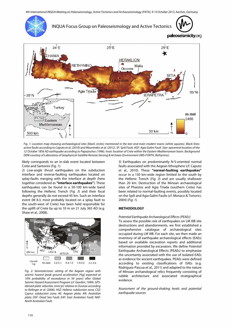
(1) F.R.S.-FNRS Postdoctoral Researcher, Université catholique de Louvain, Aegean Interdisciplinary Studies Research Group (AegIS-CEMA- INCAL), Place B. Pascal 1, L3.03.13, 1348 Louvain-la-Neuve, Belgium. Email: [email protected] (2) KU Leuven, Geodynamics and Geofluids Research Group, Celestijnenlaan 200E, 3001 Leuven, Belgium. Email: [email protected] Abstract: The 13th century BC (Late Minoan IIIB) represents a crucial period in the history of Crete (Greece), heralding the transition from the Bronze Age to the Iron Age through a series of destructions and abandonments. In this paper, we investigate the possibility that some of these events are related to earthquakes. For this purpose, we present a new methodology based on the recognition of Potential Earthquake Archaeological Effects (PEAEs) in archaeological sites. Reliability of PEAEs as indicators of seismic shaking is assessed based on empirical ground-motion relationships proposed for the three main types of earthquakes occurring in the area of Crete. At the sites of Malia and Sissi (north-eastern Crete), this methodology allows us to suggest that seismic shaking may represent a reasonable explanation for the observed PEAEs. A “12 October 1856 AD”-type earthquake located within the subducting African plate is suggested as a possible source for the observed damage. Key words: archaeoseismology, Minoan civilization, Late Bronze Age collapse, Potential Earthquake Archaeological Effects. INTRODUCTION In Eastern Mediterranean archaeology, the 13th century BC is traditionally recognised as a major turning point marking the final demise of Bronze Age palatial societies and the shift towards a period of decreased social complexity conventionally called the Dark Ages (c. 1200-700 BC). Although the succession of events that led to this cultural crisis remain poorly understood, invasion of foreign populations (the so-called Sea People), internal social conflicts, climate change and earthquakes may all have played a significant role. Repeated seismic events (“seismic storm”) have, in particular, been identified by Nur & Cline (2000) as responsible for site destruction and abandonment throughout the Eastern Mediterranean c. 1225-1175 BC – the so-called “Late Bronze Age paroxysm” (cf. Jusseret & Sintubin, 2013). However, Nur & Cline’s (2000) hypothesis is based on a generalised model of seismic storms that may not apply to the entire Eastern Mediterranean basin. Moreover, their analysis relies on a restricted number of archaeological sites corresponding mainly to large settlements. These limitations are obvious in the context of Crete (Fig. 1), where three main earthquake mechanisms have been recognised (normal-faulting earthquakes, earthquakes on the subduction interface and earthquakes located within the subducting African slab, cf. Shaw & Jackson, 2010) and where numerous 13th century (Late Minoan (LM) IIIB) archaeological sites are known (cf. Langohr, 2009). In this paper, we present a new methodology for the critical assessment of earthquake-related damage in LM IIIB archaeological contexts taking better account of the seismotectonic setting of the island (cf. Jusseret et al., accepted for publication, for an extensive discussion of
our results). The study is based on a reappraisal of available archaeological data and on empirical ground-motion relationships corresponding to the three main earthquake mechanisms identified in the context of Crete. Our results indicate that most Potential Earthquake Archaeological Effects (PEAEs) identified in LM IIIB contexts cannot be confidently related to seismic shaking. Nevertheless, archaeological damage documented at the sites of Malia and Sissi (north-eastern Crete) may have been realistically caused by earthquake ground motions. A “12 October 1856 AD”-type earthquake located within the subducting African slab is suggested as a possible source of the earthquake-related damage at Malia and Sissi. SEISMOTECTONIC CONTEXT The seismotectonic context of the Aegean is dominated by the Hellenic subduction zone resulting from the Africa-Eurasia convergence. The region is one of the most seismically active in Europe with high intermediate-magnitude seismic activity (Papazachos & Papazachou, 1997) (Fig. 2). In the area of Crete, examination of focal mechanisms indicates three main types of earthquakes (Fig. 3). 1) Earthquakes in the subducting African lithosphere with approximately E-W P axes (here referred to as “in-slab earthquakes”). These earthquakes can be found in a 200 km-wide band parallel to the main bathymetric scarp of the Hellenic Trench (Fig. 3). Focal depths vary between 100 km in the western part of the Hellenic subduction zone and 170 km in its eastern sector. The destructive earthquake of 12 October 1856 AD (M 7.6 ± 0.3; cf. Papadopoulos, 2011) in the Aegean region most
109
4th International INQUA Meeting on Paleoseismology, Active Tectonics and Archeoseismology (PATA), 9-14 October 2013, Aachen, Germany
INQUA Focus Group on Paleoseismology and Active Tectonics
likely corresponds to an in-slab event located between Crete and Santorini (Fig. 1). 2) Low-angle thrust earthquakes on the subduction interface and reverse-faulting earthquakes located on splay-faults merging with the interface at depth (here together considered as “interface earthquakes”). These earthquakes can be found in a 50-100 km-wide band following the Hellenic Trench (Fig. 3) and their focal depths generally do not exceed 45 km. Such an interface event (M 8.3, most probably located on a splay fault to the south-west of Crete) has been held responsible for the uplift of Crete by up to 10 m on 21 July 365 AD (e.g. Shaw et al., 2008).
3) Earthquakes on predominantly N-S-oriented normal faults associated with the Aegean lithosphere (cf. Caputo et al., 2010). These “normal-faulting earthquakes” occur in a 150 km-wide region limited to the south by the Hellenic Trench (Fig. 3) and are usually shallower than 20 km. Destruction of the Minoan archaeological sites of Phaistos and Agia Triada (southern Crete) has been related to normal-faulting events, possibly located on the Spili and Agia Galini Faults (cf. Monaco & Tortorici, 2004) (Fig. 1). METHODOLOGY Potential Earthquake Archaeological Effects (PEAEs) To assess the possible role of earthquakes on LM IIIB site destructions and abandonments, we first established a comprehensive catalogue of archaeological sites occupied during LM IIIB. For each site, we then made an inventory of all earthquake archaeological effects (EAEs) based on available excavation reports and additional information provided by excavators. We define Potential Earthquake Archaeological Effects (PEAEs) to emphasize the uncertainty associated with the use of isolated EAEs as evidence for ancient earthquakes. PEAEs were defined according to existing classifications of EAEs (e.g. Rodríguez-Pascua et al., 2011) and adapted to the nature of Minoan archaeological relics frequently consisting of rubble architecture and associated stratigraphical evidence. Assessment of the ground-shaking levels and potential earthquake sources
Fig. 1: Location map showing archaeological sites (black circles) mentioned in the text and main modern towns (white squares). Black lines: active faults according to Caputo et al. (2010) and Mountrakis et al. (2012). SF: Spili Fault, AGF: Agia Galini Fault. Star: epicentral location of the 12 October 1856 AD earthquake according to Papazachos (1996). Inset: location of Crete within the Eastern Mediterranean basin. Background DEM courtesy of Laboratory of Geophysical-Satellite Remote Sensing & Archaeo-Environment (IMS-FORTH, Rethymno).
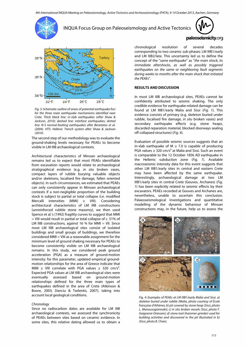
Fig. 2: Seismotectonic setting of the Aegean region with seismic hazard (peak ground acceleration [%g] expected at 10% probability of exceedance in 50 years) after Global Seismic Hazard Assessment Program (cf. Giardini, 1999). GPS-derived plate velocities (mm/yr) relative to Eurasia according to Reilinger et al. (2006). HSZ: Hellenic subduction zone; CSZ: Cyprus subduction zone; AE: Aegean plate; AN: Anatolian plate; DSF: Dead Sea Fault; EAF: East Anatolian Fault; NAF: North Anatolian Fault.
110
4th International INQUA Meeting on Paleoseismology, Active Tectonics and Archeoseismology (PATA), 9-14 October 2013, Aachen, Germany
INQUA Focus Group on Paleoseismology and Active Tectonics
The second step of our methodology was to evaluate the ground-shaking levels necessary for PEAEs to become visible in LM IIIB archaeological contexts. Architectural characteristics of Minoan archaeological remains led us to expect that most PEAEs identifiable from excavation reports would relate to archaeological stratigraphical evidence (e.g. in situ broken vases, compact layers of rubble burying valuable objects and/or skeletons, localised fire damage, fallen oriented objects). In such circumstances, we estimated that PEAEs can only consistently appear in Minoan archaeological contexts if a non-negligible proportion of the building stock is subject to partial or total collapse (i.e. modified Mercalli intensities (MMI) ≥ VIII). Considering architectural characteristics of LM IIIB constructions (unreinforced rubble stone masonry), we then used Spence et al.’s (1992) fragility curves to suggest that MMI = VIII would result in partial or total collapse of c. 51% of LM IIIB constructions, against 16 % for MMI = VII. Since most LM IIIB archaeological sites consist of isolated buildings and small groups of buildings, we therefore considered MMI = VIII as a reasonable assignment for the minimum level of ground shaking necessary for PEAEs to become consistently visible on LM IIIB archaeological remains. In this study, we considered peak ground acceleration (PGA) as a measure of ground-motion intensity: for this parameter, updated empirical ground-motion relationships for the area of Greece indicate that MMI ≥ VIII correlate with PGA values ≥ 320 cm/s². Expected PGA values at LM IIIB archaeological sites were eventually assessed based on ground-motion relationships defined for the three main types of earthquakes defined in the area of Crete (Atkinson & Boore, 2003; Danciu & Tselentis, 2007), taking into account local geological conditions. Chronology Since no radiocarbon dates are available for LM IIIB archaeological contexts, we assessed the synchronicity of PEAEs between sites based on ceramic evidence. In some sites, this relative dating allowed us to obtain a
chronological resolution of several decades corresponding to two ceramic sub-phases: LM IIIB1/early and LM IIIB2/late. This uncertainty led us to define the concept of the “same earthquake” as “the main shock, its immediate aftershocks, as well as possibly triggered earthquakes on the same or neighboring fault segments during weeks to months after the main shock that initiated the PEAEs”. RESULTS AND DISCUSSION In most LM IIIB archaeological sites, PEAEs cannot be confidently attributed to seismic shaking. The only credible evidence for earthquake-related damage can be found at LM IIIB1/early Malia and Sissi (Fig. 1). This evidence consists of primary (e.g. skeleton buried under rubble, localised fire damage, in situ broken vases) and secondary earthquake effects (e.g. stone heaps, discarded reparation material, blocked doorways sealing off collapsed structures) (Fig. 4). Evaluation of possible seismic sources suggests that an in-slab earthquake of M ≥ 7.0 is capable of producing PGA values ≥ 320 cm/s² at Malia and Sissi. Such an event is comparable to the 12 October 1856 AD earthquake in the Hellenic subduction zone (Fig. 1). Available macroseismic intensity data for this event suggests that other LM IIIB1/early sites in central and eastern Crete may have been affected by the same earthquake. Interestingly, archaeological damage at two LM IIIB1/early sites in central Crete (Gouves, Archanes) (Fig. 1) has been explicitly related to seismic effects by their excavators. PEAEs recorded at Gouves and Archanes are, nevertheless, unable to ascertain this conclusion. Palaeoseismological investigations and quantitative modelling of the dynamic behaviour of Minoan constructions may, in the future, help us to assess the
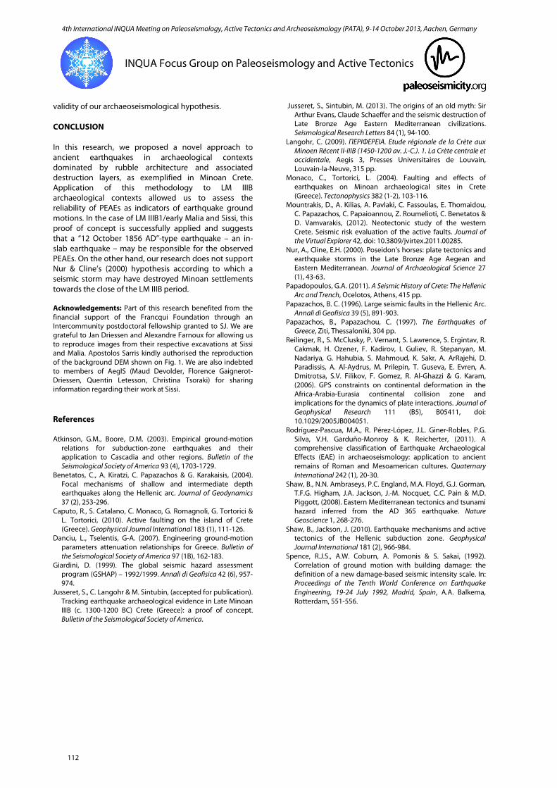
Fig. 4: Examples of PEAEs at LM IIIB1/early Malia and Sissi. a) skeleton buried under rubble (Malia, photo courtesy of École française d’Athènes; b) pit covered by stone heap (Sissi, photo L. Manousogiannaki); c) in situ broken vessels (Sissi, photo F. Gaignerot-Driessen); d) stone tool (hammer-grinder) used for building activities and discovered in the pit illustrated in b) (Sissi, photo B. Chan).
Fig. 3: Schematic outline of areas of potential earthquake foci for the three main earthquake mechanisms identified near Crete. Thick black line: in-slab earthquakes (after Shaw & Jackson, 2010); dashed line: interface earthquakes; dotted line: N-S normal-faulting earthquakes after Benetatos et al. (2004). HTS: Hellenic Trench system after Shaw & Jackson (2010).
111
4th International INQUA Meeting on Paleoseismology, Active Tectonics and Archeoseismology (PATA), 9-14 October 2013, Aachen, Germany
INQUA Focus Group on Paleoseismology and Active Tectonics
validity of our archaeoseismological hypothesis. CONCLUSION In this research, we proposed a novel approach to ancient earthquakes in archaeological contexts dominated by rubble architecture and associated destruction layers, as exemplified in Minoan Crete. Application of this methodology to LM IIIB archaeological contexts allowed us to assess the reliability of PEAEs as indicators of earthquake ground motions. In the case of LM IIIB1/early Malia and Sissi, this proof of concept is successfully applied and suggests that a “12 October 1856 AD”-type earthquake – an in-slab earthquake – may be responsible for the observed PEAEs. On the other hand, our research does not support Nur & Cline’s (2000) hypothesis according to which a seismic storm may have destroyed Minoan settlements towards the close of the LM IIIB period. Acknowledgements: Part of this research benefited from the financial support of the Francqui Foundation through an Intercommunity postdoctoral fellowship granted to SJ. We are grateful to Jan Driessen and Alexandre Farnoux for allowing us to reproduce images from their respective excavations at Sissi and Malia. Apostolos Sarris kindly authorised the reproduction of the background DEM shown on Fig. 1. We are also indebted to members of AegIS (Maud Devolder, Florence Gaignerot-Driessen, Quentin Letesson, Christina Tsoraki) for sharing information regarding their work at Sissi. References Atkinson, G.M., Boore, D.M. (2003). Empirical ground-motion
relations for subduction-zone earthquakes and their application to Cascadia and other regions. Bulletin of the Seismological Society of America 93 (4), 1703-1729.
Benetatos, C., A. Kiratzi, C. Papazachos & G. Karakaisis, (2004). Focal mechanisms of shallow and intermediate depth earthquakes along the Hellenic arc. Journal of Geodynamics 37 (2), 253-296.
Caputo, R., S. Catalano, C. Monaco, G. Romagnoli, G. Tortorici & L. Tortorici, (2010). Active faulting on the island of Crete (Greece). Geophysical Journal International 183 (1), 111-126.
Danciu, L., Tselentis, G-A. (2007). Engineering ground-motion parameters attenuation relationships for Greece. Bulletin of the Seismological Society of America 97 (1B), 162-183.
Giardini, D. (1999). The global seismic hazard assessment program (GSHAP) – 1992/1999. Annali di Geofisica 42 (6), 957-974.
Jusseret, S., C. Langohr & M. Sintubin, (accepted for publication). Tracking earthquake archaeological evidence in Late Minoan IIIB (c. 1300-1200 BC) Crete (Greece): a proof of concept. Bulletin of the Seismological Society of America.
Jusseret, S., Sintubin, M. (2013). The origins of an old myth: Sir Arthur Evans, Claude Schaeffer and the seismic destruction of Late Bronze Age Eastern Mediterranean civilizations. Seismological Research Letters 84 (1), 94-100.
Langohr, C. (2009). ΠΕΡΙΦΕΡEΙΑ. Etude régionale de la Crète aux Minoen Récent II-IIIB (1450-1200 av. J.-C.). 1. La Crète centrale et occidentale, Aegis 3, Presses Universitaires de Louvain, Louvain-la-Neuve, 315 pp.
Monaco, C., Tortorici, L. (2004). Faulting and effects of earthquakes on Minoan archaeological sites in Crete (Greece). Tectonophysics 382 (1-2), 103-116.
Mountrakis, D., A. Kilias, A. Pavlaki, C. Fassoulas, E. Thomaidou, C. Papazachos, C. Papaioannou, Z. Roumelioti, C. Benetatos & D. Vamvarakis, (2012). Neotectonic study of the western Crete. Seismic risk evaluation of the active faults. Journal of the Virtual Explorer 42, doi: 10.3809/jvirtex.2011.00285.
Nur, A., Cline, E.H. (2000). Poseidon’s horses: plate tectonics and earthquake storms in the Late Bronze Age Aegean and Eastern Mediterranean. Journal of Archaeological Science 27 (1), 43-63.
Papadopoulos, G.A. (2011). A Seismic History of Crete: The Hellenic Arc and Trench, Ocelotos, Athens, 415 pp.
Papazachos, B. C. (1996). Large seismic faults in the Hellenic Arc. Annali di Geofisica 39 (5), 891-903.
Papazachos, B., Papazachou, C. (1997). The Earthquakes of Greece, Ziti, Thessaloniki, 304 pp.
Reilinger, R., S. McClusky, P. Vernant, S. Lawrence, S. Ergintav, R. Cakmak, H. Ozener, F. Kadirov, I. Guliev, R. Stepanyan, M. Nadariya, G. Hahubia, S. Mahmoud, K. Sakr, A. ArRajehi, D. Paradissis, A. Al-Aydrus, M. Prilepin, T. Guseva, E. Evren, A. Dmitrotsa, S.V. Filikov, F. Gomez, R. Al-Ghazzi & G. Karam, (2006). GPS constraints on continental deformation in the Africa-Arabia-Eurasia continental collision zone and implications for the dynamics of plate interactions. Journal of Geophysical Research 111 (B5), B05411, doi: 10.1029/2005JB004051.
Rodríguez-Pascua, M.A., R. Pérez-López, J.L. Giner-Robles, P.G. Silva, V.H. Garduño-Monroy & K. Reicherter, (2011). A comprehensive classification of Earthquake Archaeological Effects (EAE) in archaeoseismology: application to ancient remains of Roman and Mesoamerican cultures. Quaternary International 242 (1), 20-30.
Shaw, B., N.N. Ambraseys, P.C. England, M.A. Floyd, G.J. Gorman, T.F.G. Higham, J.A. Jackson, J.-M. Nocquet, C.C. Pain & M.D. Piggott, (2008). Eastern Mediterranean tectonics and tsunami hazard inferred from the AD 365 earthquake. Nature Geoscience 1, 268-276.
Shaw, B., Jackson, J. (2010). Earthquake mechanisms and active tectonics of the Hellenic subduction zone. Geophysical Journal International 181 (2), 966-984.
Spence, R.J.S., A.W. Coburn, A. Pomonis & S. Sakai, (1992). Correlation of ground motion with building damage: the definition of a new damage-based seismic intensity scale. In: Proceedings of the Tenth World Conference on Earthquake Engineering, 19-24 July 1992, Madrid, Spain, A.A. Balkema, Rotterdam, 551-556.
112