Embed Size (px)
Citation preview
SegMap: 3D Segment Mapping using Data-DrivenDescriptors
Renaud Dube∗, Andrei Cramariuc∗, Daniel Dugas, Juan Nieto, Roland Siegwart, and Cesar CadenaAutonomous Systems Lab, ETH, Zurich
Emails: {renaudube, andreicramariuc}@gmail.com and {dugasd, jnieto, rsiegwart, cesarc}@ethz.ch∗The authors contributed equally to this work.
Abstract—When performing localization and mapping, work-ing at the level of structure can be advantageous in terms ofrobustness to environmental changes and differences in illu-mination. This paper presents SegMap: a map representationsolution to the localization and mapping problem based onthe extraction of segments in 3D point clouds. In addition tofacilitating the computationally intensive task of processing 3Dpoint clouds, working at the level of segments addresses the datacompression requirements of real-time single- and multi-robotsystems. While current methods extract descriptors for the singletask of localization, SegMap leverages a data-driven descriptorin order to extract meaningful features that can also be usedfor reconstructing a dense 3D map of the environment and forextracting semantic information. This is particularly interestingfor navigation tasks and for providing visual feedback to end-users such as robot operators, for example in search and rescuescenarios. These capabilities are demonstrated in multiple urbandriving and search and rescue experiments. Our method leadsto an increase of area under the ROC curve of 28.3% overcurrent state of the art using eigenvalue based features. Wealso obtain very similar reconstruction capabilities to a modelspecifically trained for this task. The SegMap implementation isavailable open-source along with easy to run demonstrations atwww.github.com/ethz-asl/segmap.
I. INTRODUCTION
Being a critical competency for mobile robotics, localizationand mapping has been a well-studied topic over the last coupleof decades [4]. In recent years, the importance of SimultaneousLocalization and Mapping (SLAM) has proven especiallyrelevant in the context of applications with social impact,such as autonomous driving and disaster response. Althoughcameras and LiDARs are often used in conjunction due to theircomplementary nature [22], the SLAM problem for 3D LiDARpoint clouds still poses open challenges. Moreover, LiDARbased systems rely on structure which can be more consistentthan visual appearance across seasons and daylight changes.Despite recent developments, a number of important capa-bilities are still lacking in many existing 3D LiDAR SLAMframeworks. Perhaps most notably, this includes the absenceof global data associations (place recognitions) from almost all3D LiDAR based SLAM implementations, while contrastinglybeing a well-studied problem in visual SLAM [20].
This paper presents SegMap: a unified approach for maprepresentation in the localization and mapping problem for3D LiDAR point clouds. The SegMap approach is formed onthe basis of partitioning point clouds into sets of descriptivesegments [7], as illustrated in Figure 1. Segments are obtained
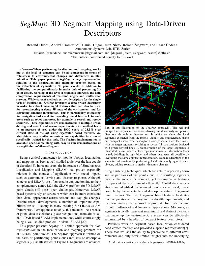
Fig. 1: An illustration of the SegMap approach1. The red andorange lines represent two robots driving simultaneously in oppositedirections through an intersection. In white we show the localsegments extracted from the robots’ vicinity and characterized usingour compact data-driven descriptor. Correspondences are then madewith the target segments, resulting in successful localizations depictedwith green vertical lines. A reconstruction of the target segments isillustrated below, where colors represent semantic information (carsin red, buildings in light blue, and others in green), all possible byleveraging the same compact representation. We take advantage of thesemantic information by performing localization only against staticobjects, adding robustness against dynamic changes.
using clustering techniques which are able to repeatedly formsimilar partitions of the point cloud. The resulting segmentsprovide the means for compact, yet discriminative featuresto represent the environment efficiently. Global data associ-ations are identified by segment descriptor retrieval, madepossible by the repeatable and descriptive nature of segmentbased features. The use of segment based features facilitateslow computational, memory and bandwidth requirements, andtherefore makes the approach appropriate for real-time usein both multi-robot and long-term applications. Moreover, assegments typically represent meaningful and distinct elementsthat make up the environment, a scene can be effectivelysummarized by a handful of compact feature descriptors.
Previous work on segment based localization consideredhand-crafted features and provided a sparse representation[7].These features lack the ability to generalize to different envi-ronments and only offer limited insights into the underlying
1A video demonstration is available at https://youtu.be/CMk4w4eRobg.
3D structure. In this work, we overcome these shortcomingsby introducing a novel data-driven segment descriptor whichcan offer high retrieval performances, even under variations inpoint of view. As depicted in Figure 1, these descriptors canbe decoded in order to generate 3D reconstructions. Thesecan be used by robots for navigating around obstacles anddisplayed to remote operators for improved situation aware-ness. Moreover, we show that semantic information can beextracted by performing classification in the descriptor space.This information can for example lead to increased robustnessto changes in the environment.
To the best of our knowledge, this is the first work onrobot localization proposing to reuse the extracted featuresfor reconstructing environments in three dimensions and forextracting semantic information. This reconstruction is, in ouropinion, a very interesting capability for real-world, large-scale applications with limited memory and communicationbandwidth. To summarize, this paper presents the followingcontributions:
• A novel data-driven 3D segment descriptor achievingincreased localization performance.
• A technique for reconstructing the environment based onthe same compact features used for localization.
• An extensive evaluation of the SegMap approach usingreal-world, multi-robot automotive and disaster scenariodatasets.
The remainder of the paper is structured as follows: Sec-tion II provides an overview of the related work in the fieldsof localization and machine learning based descriptors for 3Dpoint clouds. The SegMap approach and our novel descriptorenabling environment reconstruction are detailed in Section IIIand Section IV. The method is evaluated in Section V, andSection VI finally concludes with a short discussion.
II. RELATED WORKAn overview of the related work on localization in 3D
point clouds was presented in [4] and [7]. In this section,we review learning based techniques with applications to 3Dpoints clouds.
In recent years, Convolutional Neural Networks (CNNs)have become the state of the art method for generatinglearning based descriptors, due to their ability to find complexpatterns in data [18]. For 3D point clouds methods based onCNNs achieve impressive performances in applications suchas object detection [12, 19, 21, 25, 27, 34, 37], semanticsegmentation [19, 25, 27, 30], and 3D object generation [36].
Recently, a handful of works proposing the use of CNNs forlocalization in 3D point clouds have started to appear [10, 38].First, Zeng et al. [38] propose extracting data-driven 3Dkeypoint descriptors (3DMatch) which are robust to changes inpoint of view. Although impressive retrieval performances aredemonstrated using an RGB–D sensor in indoor environments,it is not clear whether this method is applicable in real-timein large-scale outdoor environments. Elbaz et al. [10] proposedescribing local subsets of points using a deep neural networkautoencoder. The authors state that the implementation has
not been optimized for real-time operation and no timingshave been provided. Contrastingly, our work presents a data-driven segment based localization method that can operatein real-time and that allows map reconstruction and semanticextraction capabilities.
To achieve this reconstruction capability, the architectureof our descriptor was inspired by autoencoders in which anencoder network compresses the input to a small dimensionalrepresentation, and a decoder network attempts to decompressthe representation back into the original input. The compressedrepresentation can be used as a descriptor for performing 3Dobject classification [2]. Brock et al. [2] also present success-ful results using variational autoencoders for reconstructingvoxelized 3D data. Different configurations of encoding anddecoding networks have also been proposed for achievinglocalization and for reconstructing and completing 3D shapesand environments [6, 10, 15, 26, 28, 31].
While autoencoders present the interesting opportunity ofsimultaneously accomplishing both compression and featureextraction tasks, optimal performance at both is not guaran-teed. As will be shown in Section V-E, these two tasks canhave conflicting goals when robustness to changes in pointof view is desired. In this work, we combine the advantagesof the encoding-decoding architecture of autoencoders with atechnique proposed by Parkhi et al. [24]. The authors addressthe face recognition problem by first training a CNN to classifypeople in a training set and afterwards use the second tolast layer as a descriptor for new faces. This classificationbased method proved to be the best in our previous workwhere we evaluated three training techniques for achievingbetter segment descriptor retrieval performances [5]. Otheralternative training techniques include for example the use ofcontrastive loss [3] or triplet loss [32]. We use the resultingsegment descriptors in the context of SLAM to achieve betterperformance, as well as significantly compressed maps thatcan easily be stored, shared, and reconstructed.
III. THE SegMap APPROACH
This section presents our SegMap approach to localizationand mapping in 3D point clouds. It is composed of five coremodules: segment extraction, description, localization, mapreconstruction, and semantics extraction. These modules aredetailed in this section and together allow single and multi-robot systems to create a powerful unified representation whichcan conveniently be communicated.
Segmentation The stream of point clouds generated by a3D sensor is first accumulated in a dynamic voxel grid2. Pointcloud segments are then extracted in a section of radius Raround the robot. An incremental region growing algorithm isused to efficiently grow segments by using only newly activevoxels as seeds [9]. This results in a handful of local segments,which are each associated to a set of past observations i.e.
2In our experiments, LiDAR-odometry is estimated by performing scanregistration using Iterative Closest Point (ICP) [8]. In future work, it wouldbe interesting to combine the SegMap approach with other LiDAR basedodometry techniques [1, 39]
Si = {s1, s2, . . . , sn}. Each observation sj ∈ Si is a 3D pointcloud representing a snapshot of the segment as points areadded to it. Note that sn represents the latest observationof a segment and is considered complete when no furthermeasurements are made, e.g. when the robot has moved away.
Description Compact features are then extracted from these3D segment point clouds using the data-driven descriptorpresented in Section IV. A global segment map is createdonline by accumulating the segment centroids and descriptors.In order for the global map to most accurately represent thelatest state of the world, we only keep the descriptor associatedwith the last and most complete observation.
Localization In the next step, candidate correspondencesare identified between global and local segments using k-Nearest Neighbors (k-NN) in feature space. Localization isfinally performed by verifying the candidate correspondencesfor geometric consistency on the basis of the segment cen-troids. In the experiments presented in Section V-H, this isachieved using an incremental recognition strategy based onpartitioning and caching of geometric consistencies [9]. Whena geometrically consistent set of correspondence is identified, a6 Degrees of Freedom (DoF) transformation between the localand global maps is estimated. This transformation is fed to anincremental pose-graph SLAM solver which in turn estimates,in real-time, the trajectories of all robots [8].
Reconstruction & Semantics The compressed represen-tation can at any time be used to reconstruct a map and toextract semantic information. Thanks to the compactness ofthe SegMap descriptor which can conveniently be transmittedover wireless networks with limited bandwidth, any agent inthe network can reconstruct and leverage this 3D information.On the other hand, the semantic information can for examplebe used to discern between static and dynamic objects whichcan improve the robustness of the localization.
IV. THE SegMap DESCRIPTOR
In this section we present our main contribution: a data-driven descriptor for 3D segment point clouds which allowsfor localization, map reconstruction and semantic extraction.The descriptor extractor’s architecture and the processing stepsfor inputting the point clouds to the network are introduced.We then describe our technique for training this descriptor toaccomplish both tasks of segment retrieval and map recon-struction. We finally show how the descriptor can further beused to extract semantic information from the point cloud.
A. Descriptor extractor architecture
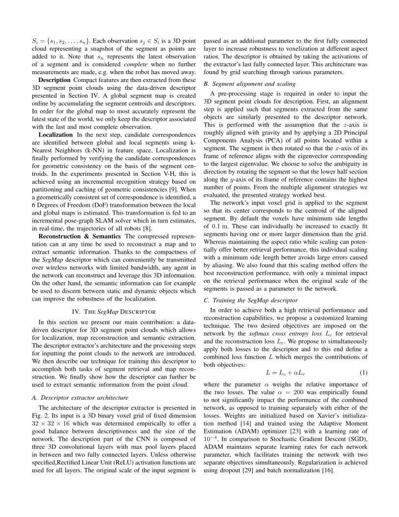
The architecture of the descriptor extractor is presented inFig. 2. Its input is a 3D binary voxel grid of fixed dimension32 × 32 × 16 which was determined empirically to offer agood balance between descriptiveness and the size of thenetwork. The description part of the CNN is composed ofthree 3D convolutional layers with max pool layers placedin between and two fully connected layers. Unless otherwisespecified,Rectified Linear Unit (ReLU) activation functions areused for all layers. The original scale of the input segment is
passed as an additional parameter to the first fully connectedlayer to increase robustness to voxelization at different aspectratios. The descriptor is obtained by taking the activations ofthe extractor’s last fully connected layer. This architecture wasfound by grid searching through various parameters.
B. Segment alignment and scaling
A pre-processing stage is required in order to input the3D segment point clouds for description. First, an alignmentstep is applied such that segments extracted from the sameobjects are similarly presented to the descriptor network.This is performed with the assumption that the z-axis isroughly aligned with gravity and by applying a 2D PrincipalComponents Analysis (PCA) of all points located within asegment. The segment is then rotated so that the x-axis of itsframe of reference aligns with the eigenvector correspondingto the largest eigenvalue. We choose to solve the ambiguity indirection by rotating the segment so that the lower half sectionalong the y-axis of its frame of reference contains the highestnumber of points. From the multiple alignment strategies weevaluated, the presented strategy worked best.
The network’s input voxel grid is applied to the segmentso that its center corresponds to the centroid of the alignedsegment. By default the voxels have minimum side lengthsof 0.1 m. These can individually be increased to exactly fitsegments having one or more larger dimension than the grid.Whereas maintaining the aspect ratio while scaling can poten-tially offer better retrieval performance, this individual scalingwith a minimum side length better avoids large errors causedby aliasing. We also found that this scaling method offers thebest reconstruction performance, with only a minimal impacton the retrieval performance when the original scale of thesegments is passed as a parameter to the network.
C. Training the SegMap descriptor
In order to achieve both a high retrieval performance andreconstruction capabilities, we propose a customized learningtechnique. The two desired objectives are imposed on thenetwork by the softmax cross entropy loss Lc for retrievaland the reconstruction loss Lr. We propose to simultaneouslyapply both losses to the descriptor and to this end define acombined loss function L which merges the contributions ofboth objectives:
L = Lc + αLr (1)
where the parameter α weighs the relative importance ofthe two losses. The value α = 200 was empirically foundto not significantly impact the performance of the combinednetwork, as opposed to training separately with either of thelosses. Weights are initialized based on Xavier’s initializa-tion method [14] and trained using the Adaptive MomentEstimation (ADAM) optimizer [23] with a learning rate of10−4. In comparison to Stochastic Gradient Descent (SGD),ADAM maintains separate learning rates for each networkparameter, which facilitates training the network with twoseparate objectives simultaneously. Regularization is achievedusing dropout [29] and batch normalization [16].
Con
v | 3
2 | 3
×3×
3
FC
| 51
2
Max
Poo
l | 2
×2×
2
Con
v | 6
4 | 3
×3×
3
Max
Poo
l | 2
×2×
2
Con
v | 6
4 | 3
×3×
3
FC
| 64
64x1
Scale 3x1
Dec
onv
| 32
| 3×
3×3
Dec
onv
| 32
| 3×
3×3
Dec
onv
| 1 |
3×3×
3
Reconstruction
Class
Descriptor extractor
32x32x16 32x32x16BN
| D
ropo
ut 0
.5
FC | N
Sig
moi
d
FC
| 81
92
BN | Dropout 0.5 Softmax
Classification
Fig. 2: The descriptor extractor is composed of three convolutional and two fully connected layers. The 3D segments are compressed in arepresentation of dimension 64× 1 which can be used for localization, map reconstruction and semantic extraction. Right of the descriptorwe illustrate the classification and reconstruction layers which are used for training. In the diagram the convolutional (Conv), deconvolutional(Deconv), fully connected (FC) and batch normalization (BN) layers are abbreviated respectively. As parameters the Conv and Deconv layershave the number of filters and their sizes, FC layers have the number of nodes, max pool layers have the size of the pooling operation, anddropout layers have the ratio of values to drop. Unless otherwise specified, ReLU activation functions are used for all layers.
Vehicle
Building
OtherFC
| 64
FC
| 3
Dro
pout
0.5
Semantics64x1
SegMapDecriptor
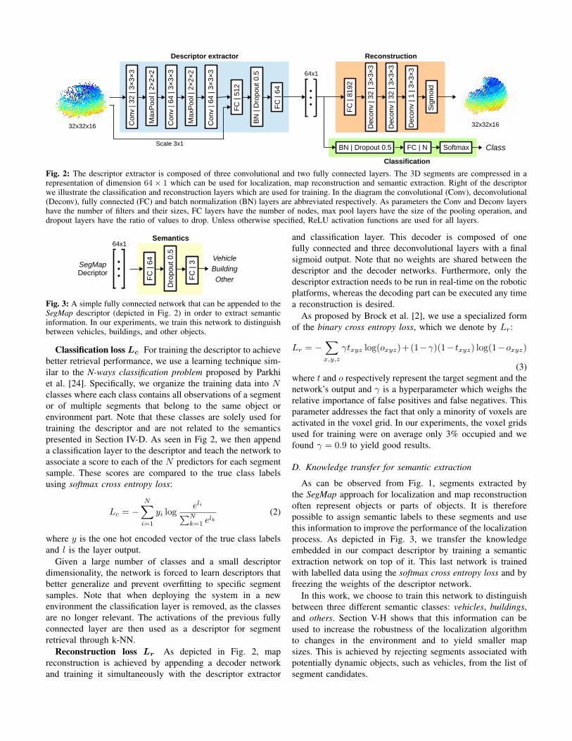
Fig. 3: A simple fully connected network that can be appended to theSegMap descriptor (depicted in Fig. 2) in order to extract semanticinformation. In our experiments, we train this network to distinguishbetween vehicles, buildings, and other objects.
Classification loss Lc For training the descriptor to achievebetter retrieval performance, we use a learning technique sim-ilar to the N-ways classification problem proposed by Parkhiet al. [24]. Specifically, we organize the training data into Nclasses where each class contains all observations of a segmentor of multiple segments that belong to the same object orenvironment part. Note that these classes are solely used fortraining the descriptor and are not related to the semanticspresented in Section IV-D. As seen in Fig 2, we then appenda classification layer to the descriptor and teach the network toassociate a score to each of the N predictors for each segmentsample. These scores are compared to the true class labelsusing softmax cross entropy loss:
Lc = −N∑i=1
yi logeli∑N
k=1 elk
(2)
where y is the one hot encoded vector of the true class labelsand l is the layer output.
Given a large number of classes and a small descriptordimensionality, the network is forced to learn descriptors thatbetter generalize and prevent overfitting to specific segmentsamples. Note that when deploying the system in a newenvironment the classification layer is removed, as the classesare no longer relevant. The activations of the previous fullyconnected layer are then used as a descriptor for segmentretrieval through k-NN.
Reconstruction loss Lr As depicted in Fig. 2, mapreconstruction is achieved by appending a decoder networkand training it simultaneously with the descriptor extractor
and classification layer. This decoder is composed of onefully connected and three deconvolutional layers with a finalsigmoid output. Note that no weights are shared between thedescriptor and the decoder networks. Furthermore, only thedescriptor extraction needs to be run in real-time on the roboticplatforms, whereas the decoding part can be executed any timea reconstruction is desired.
As proposed by Brock et al. [2], we use a specialized formof the binary cross entropy loss, which we denote by Lr:
Lr = −∑x,y,z
γtxyz log(oxyz)+(1−γ)(1− txyz) log(1−oxyz)
(3)where t and o respectively represent the target segment and thenetwork’s output and γ is a hyperparameter which weighs therelative importance of false positives and false negatives. Thisparameter addresses the fact that only a minority of voxels areactivated in the voxel grid. In our experiments, the voxel gridsused for training were on average only 3% occupied and wefound γ = 0.9 to yield good results.
D. Knowledge transfer for semantic extraction
As can be observed from Fig. 1, segments extracted bythe SegMap approach for localization and map reconstructionoften represent objects or parts of objects. It is thereforepossible to assign semantic labels to these segments and usethis information to improve the performance of the localizationprocess. As depicted in Fig. 3, we transfer the knowledgeembedded in our compact descriptor by training a semanticextraction network on top of it. This last network is trainedwith labelled data using the softmax cross entropy loss and byfreezing the weights of the descriptor network.
In this work, we choose to train this network to distinguishbetween three different semantic classes: vehicles, buildings,and others. Section V-H shows that this information can beused to increase the robustness of the localization algorithmto changes in the environment and to yield smaller mapsizes. This is achieved by rejecting segments associated withpotentially dynamic objects, such as vehicles, from the list ofsegment candidates.
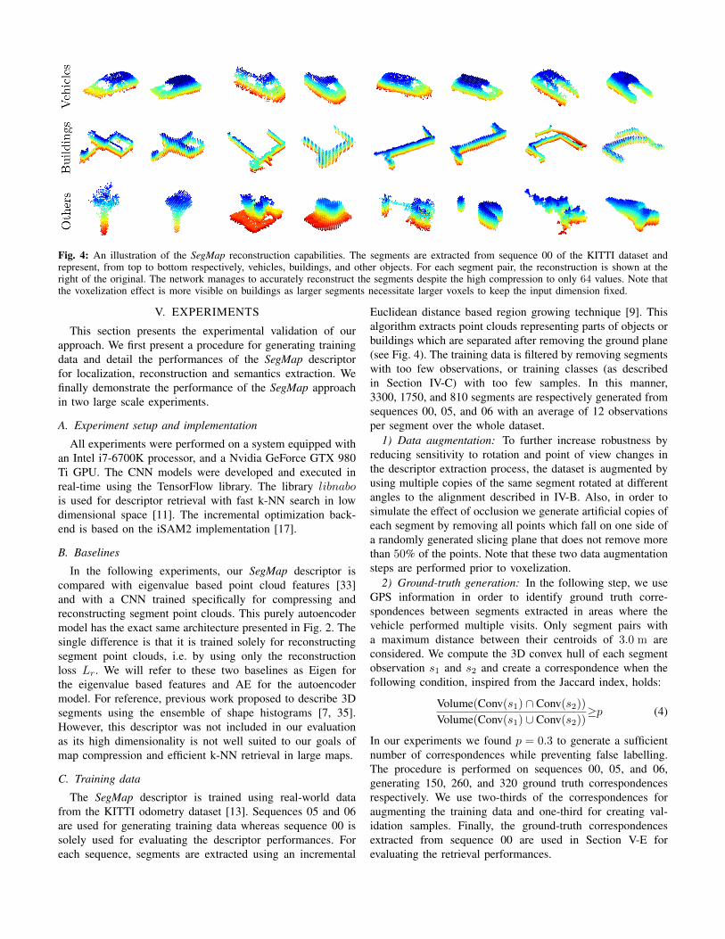
Fig. 4: An illustration of the SegMap reconstruction capabilities. The segments are extracted from sequence 00 of the KITTI dataset andrepresent, from top to bottom respectively, vehicles, buildings, and other objects. For each segment pair, the reconstruction is shown at theright of the original. The network manages to accurately reconstruct the segments despite the high compression to only 64 values. Note thatthe voxelization effect is more visible on buildings as larger segments necessitate larger voxels to keep the input dimension fixed.
V. EXPERIMENTS
This section presents the experimental validation of ourapproach. We first present a procedure for generating trainingdata and detail the performances of the SegMap descriptorfor localization, reconstruction and semantics extraction. Wefinally demonstrate the performance of the SegMap approachin two large scale experiments.
A. Experiment setup and implementation
All experiments were performed on a system equipped withan Intel i7-6700K processor, and a Nvidia GeForce GTX 980Ti GPU. The CNN models were developed and executed inreal-time using the TensorFlow library. The library libnabois used for descriptor retrieval with fast k-NN search in lowdimensional space [11]. The incremental optimization back-end is based on the iSAM2 implementation [17].
B. Baselines
In the following experiments, our SegMap descriptor iscompared with eigenvalue based point cloud features [33]and with a CNN trained specifically for compressing andreconstructing segment point clouds. This purely autoencodermodel has the exact same architecture presented in Fig. 2. Thesingle difference is that it is trained solely for reconstructingsegment point clouds, i.e. by using only the reconstructionloss Lr. We will refer to these two baselines as Eigen forthe eigenvalue based features and AE for the autoencodermodel. For reference, previous work proposed to describe 3Dsegments using the ensemble of shape histograms [7, 35].However, this descriptor was not included in our evaluationas its high dimensionality is not well suited to our goals ofmap compression and efficient k-NN retrieval in large maps.
C. Training data
The SegMap descriptor is trained using real-world datafrom the KITTI odometry dataset [13]. Sequences 05 and 06are used for generating training data whereas sequence 00 issolely used for evaluating the descriptor performances. Foreach sequence, segments are extracted using an incremental
Euclidean distance based region growing technique [9]. Thisalgorithm extracts point clouds representing parts of objects orbuildings which are separated after removing the ground plane(see Fig. 4). The training data is filtered by removing segmentswith too few observations, or training classes (as describedin Section IV-C) with too few samples. In this manner,3300, 1750, and 810 segments are respectively generated fromsequences 00, 05, and 06 with an average of 12 observationsper segment over the whole dataset.
1) Data augmentation: To further increase robustness byreducing sensitivity to rotation and point of view changes inthe descriptor extraction process, the dataset is augmented byusing multiple copies of the same segment rotated at differentangles to the alignment described in IV-B. Also, in order tosimulate the effect of occlusion we generate artificial copies ofeach segment by removing all points which fall on one side ofa randomly generated slicing plane that does not remove morethan 50% of the points. Note that these two data augmentationsteps are performed prior to voxelization.
2) Ground-truth generation: In the following step, we useGPS information in order to identify ground truth corre-spondences between segments extracted in areas where thevehicle performed multiple visits. Only segment pairs witha maximum distance between their centroids of 3.0 m areconsidered. We compute the 3D convex hull of each segmentobservation s1 and s2 and create a correspondence when thefollowing condition, inspired from the Jaccard index, holds:
Volume(Conv(s1) ∩ Conv(s2))Volume(Conv(s1) ∪ Conv(s2))
≥p (4)
In our experiments we found p = 0.3 to generate a sufficientnumber of correspondences while preventing false labelling.The procedure is performed on sequences 00, 05, and 06,generating 150, 260, and 320 ground truth correspondencesrespectively. We use two-thirds of the correspondences foraugmenting the training data and one-third for creating val-idation samples. Finally, the ground-truth correspondencesextracted from sequence 00 are used in Section V-E forevaluating the retrieval performances.
0 128 256
Epoch [#]
2
4
6
8Lc
[-]
Train
Test
0 128 256
Epoch [#]
3
4
5
Lr
[-]
Train
Test
Fig. 5: The classification loss Lc (left) and the reconstruction lossLr (right) when training the descriptor extractor along with the re-construction and classification networks. The depicted reconstructionloss has already been scaled by α.
D. Training the models
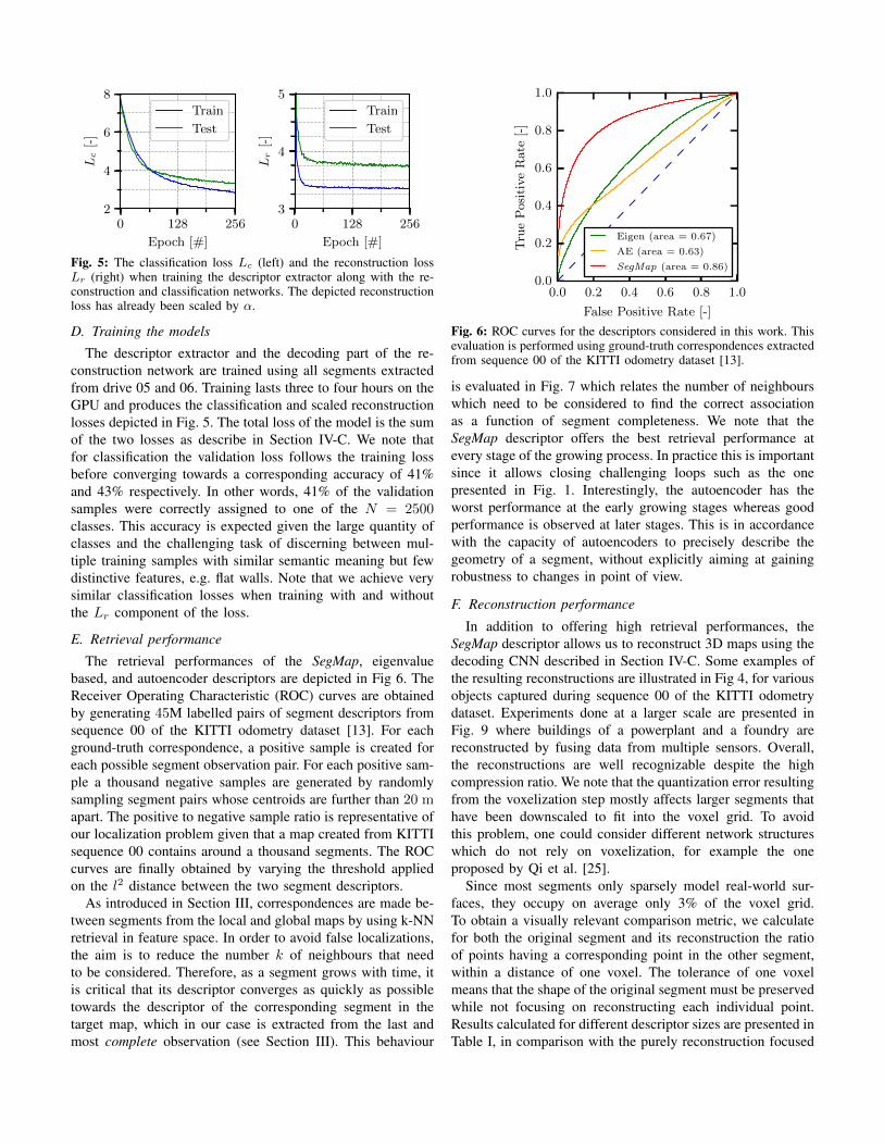
The descriptor extractor and the decoding part of the re-construction network are trained using all segments extractedfrom drive 05 and 06. Training lasts three to four hours on theGPU and produces the classification and scaled reconstructionlosses depicted in Fig. 5. The total loss of the model is the sumof the two losses as describe in Section IV-C. We note thatfor classification the validation loss follows the training lossbefore converging towards a corresponding accuracy of 41%and 43% respectively. In other words, 41% of the validationsamples were correctly assigned to one of the N = 2500classes. This accuracy is expected given the large quantity ofclasses and the challenging task of discerning between mul-tiple training samples with similar semantic meaning but fewdistinctive features, e.g. flat walls. Note that we achieve verysimilar classification losses when training with and withoutthe Lr component of the loss.
E. Retrieval performance
The retrieval performances of the SegMap, eigenvaluebased, and autoencoder descriptors are depicted in Fig 6. TheReceiver Operating Characteristic (ROC) curves are obtainedby generating 45M labelled pairs of segment descriptors fromsequence 00 of the KITTI odometry dataset [13]. For eachground-truth correspondence, a positive sample is created foreach possible segment observation pair. For each positive sam-ple a thousand negative samples are generated by randomlysampling segment pairs whose centroids are further than 20 mapart. The positive to negative sample ratio is representative ofour localization problem given that a map created from KITTIsequence 00 contains around a thousand segments. The ROCcurves are finally obtained by varying the threshold appliedon the l2 distance between the two segment descriptors.
As introduced in Section III, correspondences are made be-tween segments from the local and global maps by using k-NNretrieval in feature space. In order to avoid false localizations,the aim is to reduce the number k of neighbours that needto be considered. Therefore, as a segment grows with time, itis critical that its descriptor converges as quickly as possibletowards the descriptor of the corresponding segment in thetarget map, which in our case is extracted from the last andmost complete observation (see Section III). This behaviour
0.0 0.2 0.4 0.6 0.8 1.0
False Positive Rate [-]
0.0
0.2
0.4
0.6
0.8
1.0
Tru
eP
osi
tive
Rate
[-]
Eigen (area = 0.67)
AE (area = 0.63)
SegMap (area = 0.86)
Fig. 6: ROC curves for the descriptors considered in this work. Thisevaluation is performed using ground-truth correspondences extractedfrom sequence 00 of the KITTI odometry dataset [13].
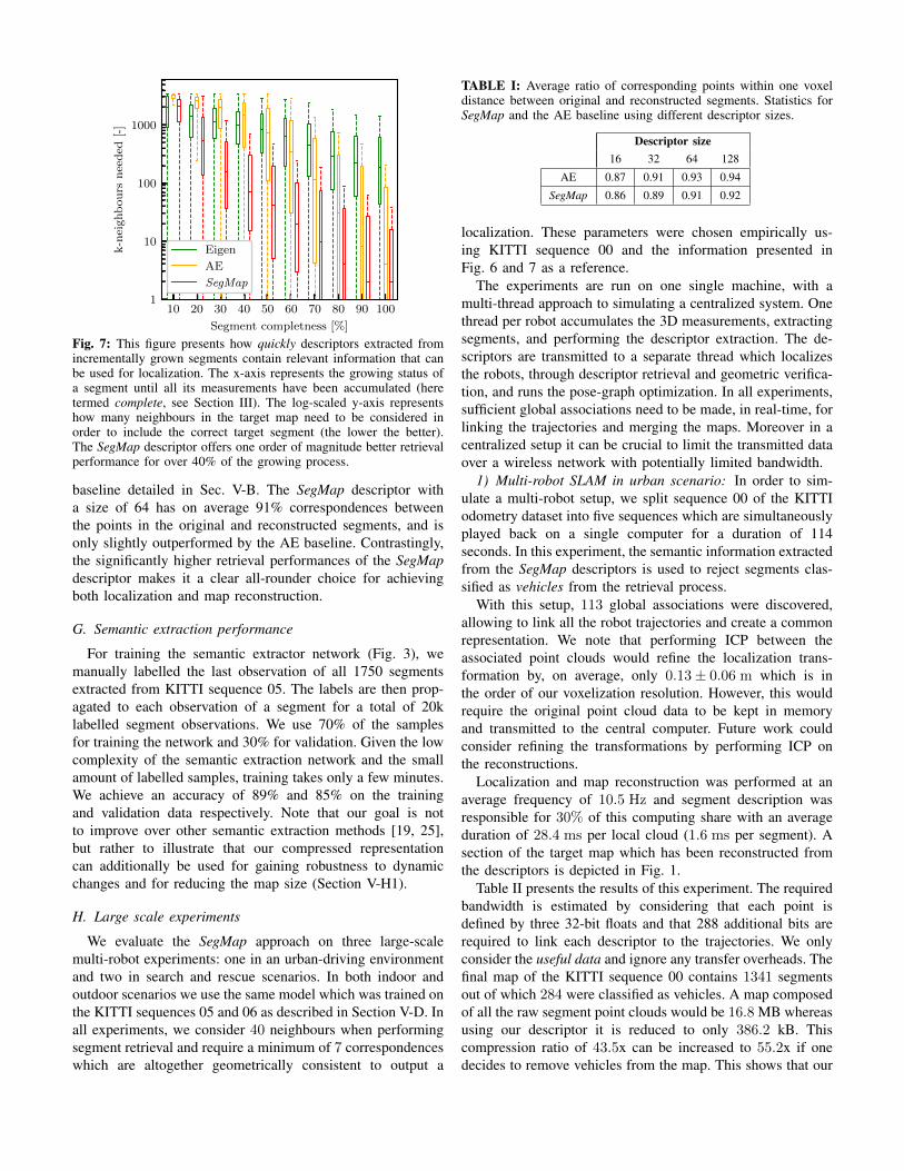
is evaluated in Fig. 7 which relates the number of neighbourswhich need to be considered to find the correct associationas a function of segment completeness. We note that theSegMap descriptor offers the best retrieval performance atevery stage of the growing process. In practice this is importantsince it allows closing challenging loops such as the onepresented in Fig. 1. Interestingly, the autoencoder has theworst performance at the early growing stages whereas goodperformance is observed at later stages. This is in accordancewith the capacity of autoencoders to precisely describe thegeometry of a segment, without explicitly aiming at gainingrobustness to changes in point of view.
F. Reconstruction performance
In addition to offering high retrieval performances, theSegMap descriptor allows us to reconstruct 3D maps using thedecoding CNN described in Section IV-C. Some examples ofthe resulting reconstructions are illustrated in Fig 4, for variousobjects captured during sequence 00 of the KITTI odometrydataset. Experiments done at a larger scale are presented inFig. 9 where buildings of a powerplant and a foundry arereconstructed by fusing data from multiple sensors. Overall,the reconstructions are well recognizable despite the highcompression ratio. We note that the quantization error resultingfrom the voxelization step mostly affects larger segments thathave been downscaled to fit into the voxel grid. To avoidthis problem, one could consider different network structureswhich do not rely on voxelization, for example the oneproposed by Qi et al. [25].
Since most segments only sparsely model real-world sur-faces, they occupy on average only 3% of the voxel grid.To obtain a visually relevant comparison metric, we calculatefor both the original segment and its reconstruction the ratioof points having a corresponding point in the other segment,within a distance of one voxel. The tolerance of one voxelmeans that the shape of the original segment must be preservedwhile not focusing on reconstructing each individual point.Results calculated for different descriptor sizes are presented inTable I, in comparison with the purely reconstruction focused
10 20 30 40 50 60 70 80 90 100
Segment completness [%]
1
10
100
1000k-n
eighb
ou
rsn
eed
ed[-
]
Eigen
AE
SegMap
Fig. 7: This figure presents how quickly descriptors extracted fromincrementally grown segments contain relevant information that canbe used for localization. The x-axis represents the growing status ofa segment until all its measurements have been accumulated (heretermed complete, see Section III). The log-scaled y-axis representshow many neighbours in the target map need to be considered inorder to include the correct target segment (the lower the better).The SegMap descriptor offers one order of magnitude better retrievalperformance for over 40% of the growing process.
baseline detailed in Sec. V-B. The SegMap descriptor witha size of 64 has on average 91% correspondences betweenthe points in the original and reconstructed segments, and isonly slightly outperformed by the AE baseline. Contrastingly,the significantly higher retrieval performances of the SegMapdescriptor makes it a clear all-rounder choice for achievingboth localization and map reconstruction.
G. Semantic extraction performance
For training the semantic extractor network (Fig. 3), wemanually labelled the last observation of all 1750 segmentsextracted from KITTI sequence 05. The labels are then prop-agated to each observation of a segment for a total of 20klabelled segment observations. We use 70% of the samplesfor training the network and 30% for validation. Given the lowcomplexity of the semantic extraction network and the smallamount of labelled samples, training takes only a few minutes.We achieve an accuracy of 89% and 85% on the trainingand validation data respectively. Note that our goal is notto improve over other semantic extraction methods [19, 25],but rather to illustrate that our compressed representationcan additionally be used for gaining robustness to dynamicchanges and for reducing the map size (Section V-H1).
H. Large scale experiments
We evaluate the SegMap approach on three large-scalemulti-robot experiments: one in an urban-driving environmentand two in search and rescue scenarios. In both indoor andoutdoor scenarios we use the same model which was trained onthe KITTI sequences 05 and 06 as described in Section V-D. Inall experiments, we consider 40 neighbours when performingsegment retrieval and require a minimum of 7 correspondenceswhich are altogether geometrically consistent to output a
TABLE I: Average ratio of corresponding points within one voxeldistance between original and reconstructed segments. Statistics forSegMap and the AE baseline using different descriptor sizes.
Descriptor size16 32 64 128
AE 0.87 0.91 0.93 0.94
SegMap 0.86 0.89 0.91 0.92
localization. These parameters were chosen empirically us-ing KITTI sequence 00 and the information presented inFig. 6 and 7 as a reference.
The experiments are run on one single machine, with amulti-thread approach to simulating a centralized system. Onethread per robot accumulates the 3D measurements, extractingsegments, and performing the descriptor extraction. The de-scriptors are transmitted to a separate thread which localizesthe robots, through descriptor retrieval and geometric verifica-tion, and runs the pose-graph optimization. In all experiments,sufficient global associations need to be made, in real-time, forlinking the trajectories and merging the maps. Moreover in acentralized setup it can be crucial to limit the transmitted dataover a wireless network with potentially limited bandwidth.
1) Multi-robot SLAM in urban scenario: In order to sim-ulate a multi-robot setup, we split sequence 00 of the KITTIodometry dataset into five sequences which are simultaneouslyplayed back on a single computer for a duration of 114seconds. In this experiment, the semantic information extractedfrom the SegMap descriptors is used to reject segments clas-sified as vehicles from the retrieval process.
With this setup, 113 global associations were discovered,allowing to link all the robot trajectories and create a commonrepresentation. We note that performing ICP between theassociated point clouds would refine the localization trans-formation by, on average, only 0.13± 0.06 m which is inthe order of our voxelization resolution. However, this wouldrequire the original point cloud data to be kept in memoryand transmitted to the central computer. Future work couldconsider refining the transformations by performing ICP onthe reconstructions.
Localization and map reconstruction was performed at anaverage frequency of 10.5 Hz and segment description wasresponsible for 30% of this computing share with an averageduration of 28.4 ms per local cloud (1.6 ms per segment). Asection of the target map which has been reconstructed fromthe descriptors is depicted in Fig. 1.
Table II presents the results of this experiment. The requiredbandwidth is estimated by considering that each point isdefined by three 32-bit floats and that 288 additional bits arerequired to link each descriptor to the trajectories. We onlyconsider the useful data and ignore any transfer overheads. Thefinal map of the KITTI sequence 00 contains 1341 segmentsout of which 284 were classified as vehicles. A map composedof all the raw segment point clouds would be 16.8 MB whereasusing our descriptor it is reduced to only 386.2 kB. Thiscompression ratio of 43.5x can be increased to 55.2x if onedecides to remove vehicles from the map. This shows that our
TABLE II: Statistics resulting from the three experiments.
Statistic KITTI Powerplant Foundry
Duration (s) 114 850 1086
Number of robots 5 3 2
Number of segmented local cloud 557 758 672
Average number of segments per cloud 42.9 37.0 45.4
Bandwidth for transmitting local clouds (kB/s) 4814.7 1269.2 738.1
Bandwidth for transmitting segments (kB/s) 2626.6 219.4 172.2
Bandwidth for transmitting descriptors (kB/s) 60.4 9.5 8.1
Final map size with the SegMap descriptor (kB) 386.2 181.3 121.2
Number of successful localizations 113 27 85
approach can be used for mapping much larger environments.2) Multi-robot SLAM in disaster environments: For the two
following experiments, we use data collected by UnmannedGround Vehicles (UGVs) equipped with multiple motor en-coders, an Xsens MTI-G Inertial Measurement Unit (IMU) anda rotating 2D SICK LMS-151 LiDAR. First, three UGVs weredeployed at the decommissioned Gustav Knepper powerplant:a large two-floors utility building measuring 100 m long by25 m wide. The second mission took place at the Phoenix-West foundry in a semi-open building made of steel. A sectionmeasuring 100 m by 40 m was mapped using two UGVs. Thebuildings are shown in Fig 8.
For these two experiments, we used an incremental smooth-ness based region growing algorithm which extracts plane-likesegments [9]. The resulting SegMap reconstructions are shownin Fig. 9 and detailed statistics are presented in Table II. Al-though these planar segments have a very different nature thanthe ones used for training the descriptor extractor, multiplelocalizations have been made in real-time so that consistentmaps could be reconstructed in both experiments.
VI. CONCLUSION
This paper presented SegMap: a segment based approachfor map representation in localization and mapping with 3Dsensors. In essence, the robot’s surroundings are decomposedinto a set of segments, and each segment is represented bya distinctive, low dimensional learning based descriptor. Dataassociations are identified by segment descriptor retrieval andmatching, made possible by the repeatable and descriptivenature of segment based features. The descriptive power ofSegMap outperforms hand-crafted features as well as theevaluated autoencoder baseline.
In addition to enabling global localization, the SegMapdescriptor allows us to reconstruct a map of the environmentand to extract semantic information. The ability to reconstructthe environment while achieving a high compression rate isone of the main features of SegMap. This feature allowsperforming SLAM with 3D LiDARs at a large scale requiringlow communication bandwidth between the robots and acentral computer. These capabilities have been demonstratedthrough experiments with real-world data in urban driving andsearch and rescue scenarios. The reconstructed maps couldallow performing navigation tasks such as, for instance, multi-robot global path planning or increasing situational awareness.
Fig. 8: Buildings of the Gustav Knepper powerplant (left) and thePhoenix-West foundry (right).
Fig. 9: This figure illustrates a reconstruction of the buildings ofthe Gustav Knepper powerplant (top) and the Phoenix-West foundry(bottom). The point clouds are colored by height and the estimatedrobot trajectories are depicted with colored lines.
In future work, we would like to extend the SegMap ap-proach to different sensor modalities and different point cloudsegmentation algorithms. Furthermore, whereas the presentwork performs segment description in a discrete manner, itwould be interesting to investigate incremental updates oflearning based descriptors that could make the descriptionprocess more efficient, such as the voting scheme proposedby Engelcke et al. [12]. Moreover, it could of interest to learnthe usefulness of segments as a precursory step to localization,based on their distinctiveness and semantic attributes.
ACKNOWLEDGMENTS
This work was supported by the European Union’s SeventhFramework Programme for research, technological develop-ment and demonstration under the TRADR project No. FP7-ICT-609763 and by the National Center of Competence in Re-search (NCCR) Robotics through the Swiss National ScienceFoundation. The authors would like to thank Hannes Sommer,Mark Pfeiffer, Mattia Gollub, Helen Oleynikova, Abel Gawel,Dr. Philipp Krusi, Dr. Elena Stumm, and Alexander Winklerfor their valuable collaboration and support.

REFERENCES
[1] Michael Bosse and Robert Zlot. Continuous 3D Scan-Matching with a Spinning 2D Laser. In IEEE Interna-tional Conference on Robotics and Automation, pages4312–4319, 2009.
[2] Andrew Brock, Theodore Lim, JM Ritchie, and NickWeston. Generative and Discriminative Voxel Modelingwith Convolutional Neural Networks. In Workshop on3D Deep Learning, NIPS, 2016.
[3] Jane Bromley, Isabelle Guyon, Yann LeCun, EduardSackinger, and Roopak Shah. Signature Verificationusing a ”Siamese” Time Delay Neural Network. InAdvances in Neural Information Processing Systems,pages 737–744, 1994.
[4] C. Cadena, L. Carlone, H. Carrillo, Y. Latif, D. Scara-muzza, J. Neira, I. Reid, and J.J. Leonard. Past, Present,and Future of Simultaneous Localization And Mapping:Towards the Robust-Perception Age. IEEE Transactionson Robotics, 32(6):1309–1332, 2016.
[5] Andrei Cramariuc, Renaud Dube, Hannes Sommer,Roland Siegwart, and Igor Gilitschenski. Learning 3DSegment Descriptors for Place Recognition. In Workshopon Learning for Localization and Mapping, IROS, 2017.
[6] Angela Dai, Charles Ruizhongtai Qi, and Matthias Niess-ner. Shape Completion Using 3D-Encoder-PredictorCNNs and Shape Synthesis. In IEEE Conference onComputer Vision and Pattern Recognition, July 2017.
[7] Renaud Dube, Daniel Dugas, Elena Stumm, Juan Nieto,Roland Siegwart, and Cesar Cadena. SegMatch: Segmentbased place recognition in 3D point clouds. In IEEEInternational Conference on Robotics and Automation,pages 5266–5272, 2017.
[8] Renaud Dube, Abel Gawel, Hannes Sommer, Juan Nieto,Roland Siegwart, and Cesar Cadena. An Online Multi-Robot SLAM System for 3D LIDARs. In IEEE Inter-national Conference on Robotics and Automation, pages1004–1011, 2017.
[9] Renaud Dube, Mattia Gollub, Hannes Sommer, IgorIgilitschenski, Roland Siegwart, Cesar Cadena, and JuanNieto. Incremental Segment-Based Localization in 3DPoint Clouds. IEEE Robotics and Automation Letters, 3(1):1–8, 2018.
[10] Gil Elbaz, Tamar Avraham, and Anath Fischer. 3DPoint Cloud Registration for Localization using a DeepNeural Network Auto-Encoder. In IEEE Conference onComputer Vision and Pattern Recognition, pages 2472–2481. IEEE, 2017.
[11] J. Elseberg, S. Magnenat, R. Siegwart, and A. Nuchter.Comparison of Nearest-Neighbor-Search Strategies andImplementations for Efficient Shape Registration. Jour-nal of Software Engineering for Robotics, 3(1):2–12,2012. ISSN 2035-3928.
[12] Martin Engelcke, Dushyant Rao, Dominic Zeng Wang,Chi Hay Tong, and Ingmar Posner. Vote3Deep: FastObject Detection in 3D Point Clouds Using Efficient
Convolutional Neural Networks. In IEEE InternationalConference on Robotics and Automation, pages 1355–1361. IEEE, 2017.
[13] Andreas Geiger, Philip Lenz, and Raquel Urtasun. Arewe ready for Autonomous Driving? The KITTI VisionBenchmark Suite. In IEEE Conference on ComputerVision and Pattern Recognition, 2012.
[14] Xavier Glorot and Yoshua Bengio. Understanding thedifficulty of training deep feedforward neural networks.In International Conference on Artificial Intelligence andStatistics, volume 9, pages 249–256, 2010.
[15] Vitor Guizilini and Fabio Ramos. Learning to Re-construct 3D Structures for Occupancy Mapping. InRobotics: Science and Systems, 2017.
[16] Sergey Ioffe and Christian Szegedy. Batch normalization:Accelerating deep network training by reducing internalcovariate shift. In International Conference on MachineLearning, pages 448–456, 2015.
[17] M. Kaess, H. Johannsson, R. Roberts, V. Ila, J. J.Leonard, and F. Dellaert. iSAM2: Incremental smoothingand mapping using the Bayes tree. The InternationalJournal of Robotics Research, 31(2):216–235, 2012.
[18] Alex Krizhevsky, Ilya Sutskever, and Geoffrey E Hinton.Imagenet classification with deep convolutional neuralnetworks. In Advances in Neural Information ProcessingSystems, pages 1097–1105, 2012.
[19] Bo Li, Tianlei Zhang, and Tian Xia. Vehicle Detectionfrom 3D Lidar Using Fully Convolutional Network. InRobotics: Science and Systems, 2016.
[20] Stephanie Lowry, Niko Sunderhauf, Paul Newman,John J Leonard, David Cox, Peter Corke, and Michael JMilford. Visual Place Recognition: A Survey. IEEETransactions on Robotics, 2016.
[21] Daniel Maturana and Sebastian Scherer. VoxNet: A 3DConvolutional Neural Network for real-time object recog-nition. In IEEE International Conference on Roboticsand Automation, 2015.
[22] Paul Newman, Gabe Sibley, Mike Smith, Mark Cum-mins, Alastair Harrison, Chris Mei, Ingmar Posner, Rob-bie Shade, Derik Schroeter, Liz Murphy, et al. Navi-gating, Recognizing and Describing Urban Spaces WithVision and Lasers. The International Journal of RoboticsResearch, 28(11-12):1406–1433, 2009.
[23] Kingma D. P. and Ba J. L. Adam: A Method forStochastic Optimization. In International Conference onLearning Representations, 113, 2015.
[24] Omkar M Parkhi, Andrea Vedaldi, Andrew Zisserman,et al. Deep Face Recognition. In British Machine VisionConference, volume 1, page 6, 2015.
[25] Charles R. Qi, Hao Su, Kaichun Mo, and Leonidas J.Guibas. PointNet: Deep Learning on Point Sets for 3DClassification and Segmentation. In IEEE Conference onComputer Vision and Pattern Recognition, July 2017.
[26] Daniel Ricao Canelhas, Erik Schaffernicht, Todor Stoy-anov, Achim J Lilienthal, and Andrew J Davison.Compressed Voxel-Based Mapping Using Unsupervised
Learning. Robotics, 6(3):15, 2017.[27] Gernot Riegler, Ali Osman Ulusoy, and Andreas Geiger.
OctNet: Learning Deep 3D Representations at HighResolutions. In IEEE Conference on Computer Visionand Pattern Recognition, 2017.
[28] Johannes L Schonberger, Marc Pollefeys, AndreasGeiger, and Torsten Sattler. Semantic Visual Localiza-tion. 2018.
[29] Nitish Srivastava, Geoffrey E Hinton, Alex Krizhevsky,Ilya Sutskever, and Ruslan Salakhutdinov. Dropout: ASimple Way to Prevent Neural Networks from Overfit-ting. Journal of machine learning research, 15(1):1929–1958, 2014.
[30] Lyne P. Tchapmi, Christopher B. Choy, Iro Armeni, Jun-Young Gwak, and Silvio Savarese. SEGCloud: SemanticSegmentation of 3D Point Clouds. In InternationalConference on 3D Vision, 2017.
[31] J. Varley, C. DeChant, A. Richardson, J. Ruales, andP. Allen. Shape Completion Enabled Robotic Grasping.In IEEE International Conference on Robotics and Au-tomation, pages 2442–2447, 2017.
[32] Kilian Q Weinberger, John Blitzer, and Lawrence KSaul. Distance Metric Learning for Large Margin NearestNeighbor Classification. In Advances in neural informa-tion processing systems, pages 1473–1480, 2006.
[33] Martin Weinmann, Boris Jutzi, and Clement Mallet.Semantic 3D scene interpretation: A framework com-bining optimal neighborhood size selection with rele-vant features. ISPRS Annals of the Photogrammetry,
Remote Sensing and Spatial Information Sciences, 2(3):181, 2014.
[34] Paul Wohlhart and Vincent Lepetit. Learning Descriptorsfor Object Recognition and 3D Pose Estimation. In IEEEConference on Computer Vision and Pattern Recognition,pages 3109–3118, 2015.
[35] Walter Wohlkinger and Markus Vincze. Ensemble ofshape functions for 3D object classification. In IEEEInternational Conference on Robotics and Biomimetics,2011.
[36] Jiajun Wu, Chengkai Zhang, Tianfan Xue, Bill Freeman,and Josh Tenenbaum. Learning a Probabilistic LatentSpace of Object Shapes via 3D Generative-AdversarialModeling. In Advances in Neural Information ProcessingSystems, pages 82–90, 2016.
[37] Zhirong Wu, Shuran Song, Aditya Khosla, Fisher Yu,Linguang Zhang, Xiaoou Tang, and Jianxiong Xiao.3D ShapeNets: A Deep Representation for VolumetricShapes. In IEEE Conference on Computer Vision andPattern Recognition, pages 1912–1920, 2015.
[38] Andy Zeng, Shuran Song, Matthias Nießner, MatthewFisher, Jianxiong Xiao, and Thomas Funkhouser.3DMatch: Learning Local Geometric Descriptors fromRGB-D Reconstructions. In IEEE Conference on Com-puter Vision and Pattern Recognition, 2017.
[39] Ji Zhang and Sanjiv Singh. LOAM: Lidar Odometry andMapping in Real-time. In Robotics: Science and Systems,2014.


![M. Iftekhar Tanveer arXiv:1707.04790v1 [cs.HC] 15 Jul 2017rujzhao.com/refs/automannerplus.pdf · annotations. Contrastingly, it puts a larger weight on prosody features while predicting](https://img.pdfslide.us/doc/110x75/5fa0c790e7e81e0dcd094b4c/m-iftekhar-tanveer-arxiv170704790v1-cshc-15-jul-annotations-contrastingly.jpg)
![M. Iftekhar Tanveer arXiv:1707.04790v1 [cs.HC] 15 …annotations. Contrastingly, it puts a larger weight on prosody features while predicting audience annotations. This analysis might](https://img.pdfslide.us/doc/110x75/5fa0c6ba9fded56e51518785/m-iftekhar-tanveer-arxiv170704790v1-cshc-15-annotations-contrastingly-it.jpg)