Embed Size (px)
Citation preview

AnnllaL GeoLogicaL Conference '96 ............. -;;:::a:a_ JUlle 8-9, 1996, Kota KillaOaiu, Sahah
Sedimentation and tectonics of Paleogene sediments in central Sarawak
FELIX TONGKUL
Earth Science Department Universiti Kebangsaan Malaysia
Abstract: The deposition of the Paleogene sediments in Central Sarawak occurred in four successive stages, its axis of depocentre generally advancing and younging to the northeast in response to progressive southwest subduction-accretion of a Mesozoic oceanic lithosphere and its sedimentary cover under West Sarawak. The younger sediments were deposited on top or in front of an older accreted sediments. The timing of deposition and accretion is uncertain due to lack of precise age indicators. However, based on regional considerations, the accretion is interpreted to have occurred sometimes during the Early Paleocene, Middle Eocene, Upper Eocene and Upper Oligocene, respectively, along major fault zones , producing four tectono-stratigraphic units. The older sediments were subjected to polyphase deformation as younger units were accreted.
INTRODUCTION
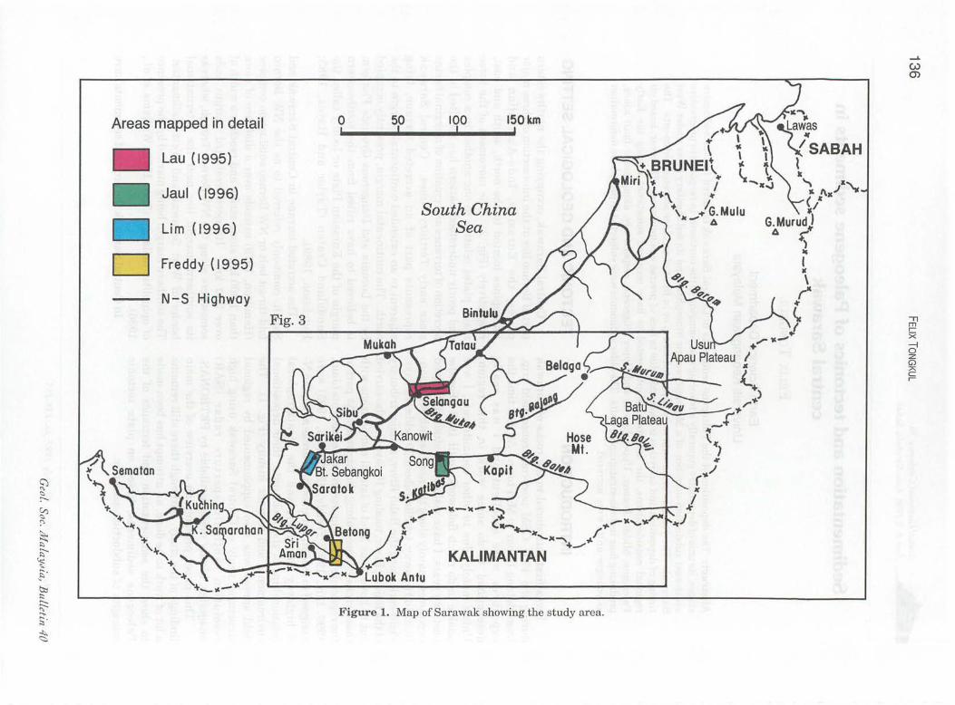
I was first introduced to the rocks of Sarawak during the 1991 GSM post-conference field trip, from Batang Lupar to Miri town. At that time the exposures were excellent and I was really determined to do some work in this region. Unfortunately, due to other commitments, I was unable to do much fieldwork, until 1993. For the past two years, I have visited and studied the good exposures, mainly along the north-south Sri AmanBintulu Highway, totalling about 20 fieldwork days. Fieldwork along the Balui River, a major tributary ofthe Rajang River, totaling 10 days was also carried out to have some kind of lateral comparisons with those rocks exposed along the highway. As part of the regional study, 4 undergraduate students (Jaul, 1996; Lim, 1996; Freddy, 1995; Lau, 1995) were assigned to map in detail critical areas along the NS highway to understand the stratigraphical relationships of the rock units, their depositional environments and tectonic history (Fig. 1). The field survey was also supplemented by regional structural study of Central Sarawak using high resolution synthetic aperture radar (SAR) imageries, kindly made available by PETRONAS.
This paper presents an overview of the main findings ofthe study. Although there still remains a lot of work to be done, an attempt has been made to show the sedimentation and tectonics of the Paleogene sediments, based on plate tectonic concepts of subduction-accretion.
Geol. Soc. Ma LaYJia, Bulletin 40, JuLy 1997; pp . 155-155
TECTONIC AND GEOLOGICAL SETIING
Central Sarawak, occupying the northwestern part of Borneo lies at the intersection ofthree major plates, the Eurasian, Indo-Australian and Philippines located to the north, south and east, respectively (Fig. 2). The movement of the three major plates relative to one another in a complex and poorly understood pattern has resulted in the accretion of terranes and creation of marginal basins since early Tertiary times. Central Sarawak represents part of an accreted terrane, lying adjacent to an extended continental margin to the north. The continental margin, presently occupied by the Luconia and Dangerous Grounds Platform is believed to have rifted from the southeastern margin of the Eurasian Plate or locally called the Sundaland Craton (Taylor and Hayes , 1983; Hutchison, 1989).
The accreted terrane in Central Sarawak and Sabah, commonly referred to as the NW Borneo fold-thrust belt or NW Borneo subduction complex (Hamilton, 1979) extends over a distance of more than 1,000 km along strike and reaches a width of over 300 km. Its northwestward margin ends somewhere along the NW Borneo Trough, whereas its southern margin lies near the international border of West Sarawak and West Kalimantan. The southern margin being marked by the presence of ophiolitic melange (Tan, 1979; Williams et al., 1986).
In Central Sarawak the accreted sediments have
Areas mapped in detail
Lau (1995)
Jaul (1996)
Lim (1996)
D Freddy (1995)
N-S Highway
Fig. 3
o 50 , 100 !
150km
South China Sea
Figure 1. Map of Sarawak showing the study area.
"Tl m r-X -i o z G) A C r-

o
SEDIMENTATION AND TECTONICS OF PALEOGENE SEDIMENTS IN CENTRAL SARAWAK 137
500km
D Pre-Tertiary Continental Crust
Extended Continental Margin
D Terrane accreted or formed since Late Cretaceous D Oceanic Crust
/ Subduction Zone
Z~ Transcurrent ~ Fault 11 Direction of Plate
/ /" Movement
Extensional Basin
Ophiolite
~ PHILIPPI NES
PLATE
Figure 2. Geological and t ectonic setting of Sarawak. Central Sarawak represents part of an accreted terrane, commonly referred to as the NW Borneo fold-thrust belt.
JuLy I!)!) 7

138 FELIX TONGKUL
been mapped as the Rajang Group flysch sediments in the Sibu Zone (Haile, 1969, 1974), dated to range in age from late Cretaceous to Oligocene. The Rajang Group sediments is in faulted contact with older rocks (mostly Mesozoic) of West Sarawak. along the Lupar Line (Haile, 1974) and are Qverlain by'. Neogene shallow marine deposits to the northwest in the Miri and Baram area (Haile, 1962;,Hamilton, 1979; James, 1984). The Rajang Group sediments includes the Lupar, Belaga, Kelalanand Mulu Formations.
TECTONO-STFiATIGRAP~IC UNITS
regional approach using age, lithology and degree of structural deformation as a criteria for differentiation might be helpful.
Based on the above criteria, the Paleogene sediments of Central Sarawak. have been grouped into four informal ~ectono-str~tigraphic units (Figs. 3 and, 4,). The oldest unit includes the Layar Member of the Belaga Formation which range in age from Upper Cretaceous to Middle Paleocene. The second unit includes the Kapit and Metah Members of the Belaga Formation, Lupar and Engkilili Formations (renamed as the LuJ:>okA.ntu Melange by Tan, 1979) which range in age from Late' Paleocene to Early Eo'c.ene. The third UIlit includes the Pelagus Member of the Belaga. Fprmation which range in age from Middle to Upper Eocene. The fourth unit includes the Tatau, Buan and Silantek Formations which range in age from Uppermost Eocene to Upper
Existing geological map ofSarawak(Yin, 1992), shows that the central part of Sarawak. is occupied by several rock units, the oldest being· the Lupar Formation, followed by the Belaga ]formations and subsequently the Melinau Limesio:tu~; Tatau; Buan and Nyalau Formations: The stratigraphical relationships between the formatiollS have not been fully resolved yet, due to lack precise age indicators.
The Belaga Formation vihi"ch' occupies an enormous .area (about 90%)' of Ceritral Silrawak-' was subdivided into foUr :.nembers, nainely the' Layar, Kapit, Pelagus ;and :M:etab Members based on differences in. theh- lithglogy 'by Leichti et al., (1960). The four members broadly corresponds to" Stag~8 I, Ii, III and IV proposed earlier by Kirk ' (1957) and later adopted by Wolfenden (1960':' Stages I, II, III and, IV, broadly represen~s the time . period of Upper' Cretaceous" Lower E"Ocene~ Paleocene, Middle·;Epcene t.o .L!>wer Eoc.ene·!IDd Upper Eocene, resp~ctively. ~other member, the~ Bawang'Meinber, whl.ch co~e~pono.s to Stage,lV: was added later by 'Wolfenden (.19.{}0) .. The striitigraphical relationship between, eaehmembers or. stages is also not fully resolved. La..cking concrete field ··evidences, up to now they . are" gen~r.ally assumed to be conformable with each other. Wolfenden (i960) however, pointed out that the sudden influxes of coarse-grained sediments in the lower' part of Stages II and III, may suggests instability and the:refo:r~ uncoriformable"
. Oligocene. The four units generally corresp6I1Q.s .' with Stages I-IV mentioned earlier. Except for
minor $anges in geological boundaries, the distribution of each unit generally follows the distribution of each roCk units'as mapped by Leichti etal., (1960) and Wolfenden (19'60). .
. relationshIp. Kirk (1957) suggested that. Stage III in the Upper Rajang area might be unconformable on Stage II., . .
DUring the present study, attemptwa.sriiade to diff~rentiate .. the rock formations in 'Central Saraw.ak."; . Whereas the Nyalau Formation was easily recogn~ "in thefi~ld, because of its distinctive lithology and simple structure, the older formations proved to be difficult to differentiate. It became even more difficult, if one were to separate each formation based on varied description of their lithologies and structures in different areas by previous researchers. It became apparent, that a
UNIT I (LATE CRETACEOUS-MIDDLE . ~ALEOCENE)
Distribution' 'and LithOlogy' This.unit, represented by the Layar Member of
'. the Belaga Formation occUr in the Batang Layar~ ,Buldt Sebangkoi bel~, with an approximate width , of abQut 80 ,km.~, Most of the unj.t has undergone met.amorphism to slate and sub-phyllite and' shows the de'\t.Qlopment of slaty cleavage.
The best outcrop for the unit occurs near Bukit Sebangkoi, where the lithologic8.l sequence can.still be measured. In'this area; the unit comprised of interbedded slate and thin metasandstone with occasional' occurr(m,ce of thick sandstone beds,
. reaehlng more 'than 10 metres (Fig. 8). Lim (1996) measured about 250 metres of section (Fig; 5). The sequence is typical of a deep water sediments, . shoWing; typical turbidite facies with numerous fining, and coarsening upward sequences, representing prograding and migrating outer fan lobes. The overall predominance of muddy sequence in the unit suggests an open basin plain depositional setting.
Towards the south near Batang Layar, the sequence commonly includes slump beds, channeled sand beds, pebbly to conglomeratic beds and vertical burrows suggesting deposition on slope settings (Freddy, 1995). The source of the sediments is
GeoL. Soc. MaLaYJia, BuLletin 40

~ <2-.......
~ '"
N -6
~ A .....r r, ./Al __ -::. _
~. '/./ ~ ~ "'::xi --- .... ,...- ---: ""/,:, A.. .,..-q \-1"'\".,.., .".. __ _ . .... ,:., 'A'"1x~ ~ ;'Y.YA' / I ...,,/ ~~v::. .-:::--;:::::-- -=_
..... "/ Tatau..:-"',4' " oJ-4.4' -v- / I )" 11~ _ _ _ 1# ~~-v--.r--r A<...<" / .At' /~/1' I ./ ~_ ::. Y A /Z-X .-A:::-<...r A' ~ ~~ //' /;/ __
..A-:, ::1:.Y-r-<-r~~""-Y"'~A// /0-~ .. "-,-.r--<r __ ........ y A_./' /" -... ~, ,-.-r" ~~ A _ _. / , '" ./' _ ~" '" ~ ,~ 4 At' --,.-:/: / '" '" /./' _
.:.(.11' .."...~--~-r~-.r...r ,:::?:// ~ '" / / "' .......... -:---:::. __ _ ~~"V""V" -v--v--v- -v-"9" t:Ci" AI" _ =- /"./ ~ / /' /"
.."... -- ~--~..psBt. MersirIO~-~""'-:::,...-::::::~ // ./'o'.:lJ:Al,.L" •• ~ ...... ""-- -- ---::::/ //" Jf.:.' / .) , ') -----... - - ,.-/~ --- /" /"..., ,J'...,Bl. Kajang;.- ~ . ... - - ~-- - - '" - -::::::-=: ." . .......... ./ ./;' ..... - ~-- >~~ ~ : : : : ;? ? ,,<;;;;'-C !.--;: -- - .....-..... -- tA A" --
- - _ ... ,.-'...>...; --"" --:::.- --- . .......... '""'~ - - -- " ., ..- "-",.,.,-"", .~ ... - ----- , ..... - ----...,..·; 11"" :; -- ---" ......... ' ,'" ., A' ~ .
-;.
- - - - - - -' - -, - ...... Af" - - .:" " .• ,....... _ _ __ .::-- - - '- ' ...... '- .... ,- ....... 4 - _ - ···.-·lA/ __ _ ::----' .......... ' __ 4 ...... - .,. __
,,- , -r.... _--•. 1--.5 ">-::. - -:;:;.. ~~~Il..--!- -........:- ____ _
- = --- .... . .-.. .. ~ ............ ",,"--..- - -- --..... :.:..:.~. . .. -<~.,,--::;:
..... , - - -- -V-" '"'"' ~ - ...... , - - - -r...r ' " - ,-', ,- - ------- / --::---.,< '" "" , ....... - - - - ...< --,,~ '"' - - ~ -, - ...... -- -- ___ _ --A' _-----,-- --, ,~:.,.. -",A- _ ,- ~ ~ --,-::.. =-" -.:::-....... < ~---, ........ - -,--- .......... -"-...... ....... '"' ........ ... =----...:- --" -..Af'_ __
" ....... .. ... ....." -- -- .... ......- A' --_ """""-- _ -.::- - " - .......... ...... ....... - -r - - _ - :;:;: _ - '"1>-- ...... '"1>-- - -......:- ........ ____ _ _'
.... ..:::.......... ......'"1>--_ _ ...-.. __ - -.r ~ __ _ _ _ -= "- - _/ KEY _ . _ _ __ .... .... . ./ -"-"-... -.f ) -.,- ....,.. _ ;:, .......... _ -... :::
- - ---- -..,.", , --- ;' SEDIMENTARY ROCKS \..::::"~~ p :,,; _:::.. ,
O Alluvium IGNEOUS ROCKS '\ _~-::::- - _ _ _ _ \
B . " ._\::::::. . . Dacite ~~. o Early Miocene and Younger A" MIOCene \:.
o Upper Eocene-Oligocene
o Mid -Upper Eocene
o Late Paleocene-E. Eocene
o Late Cret.-Paleocene
Miocene Basalt
Tatau Volcanics
• Eoc;ene Intrusives
• late eret.-Eocene Basalts
o 50km
Lineament
/,,< Scarp with dip
,,44 Thrust Fault
...,./ Horizontal Fault
--::;....'-+- -......>
Main Road
Geological Boundary (Approximate
Figure 3. Geological an d structural map of Central 8arawak. The regional lineaments based on 8AR imagery interpretations. Geological boundaries of units extrapolated based on regional structures an d on previous maps .
en m o ~ m Z
~ o z :» z o -I m ()
b z o (f)
o T1
\J :» .m o G) m z m (f) m o ~ m z -I (f)
Z () m z -I :JJ :» .-en :» :JJ :» ::z: :» ;:<;
....... W <0

140 FELIX TONGKUL
A PERIOD U FORM ATI ON DEPOSITIONAL T ECTON I C S G EPOCH N (Member) ENVIRON MENT Direction of Compression E I (Tectonic Setting) (Deformational Structures) (Ma) T
0
5 W Z
10 W (!)
15 0 Lambir W Z
Beloit ---- - - --- ------------- NW-SE
20
Nyalau • Open fold
25 Setap o Thrusting to the NW
--------.... ShalJow -to deep -woter - - NNW-SSE
30 '" Silantek ./ '" o Accret. fore-orc basin o Open to tight upright fold "'./ Buan o Slope apron o Thrusting to the N and NW 35 '" Tatau '" o Abyssal plain
W ----/ -------- -------------- NNW-SSE 40 Z Shallow to deep water o Tight upright fold
W GI Pelo gus o Accret. fore-arc basin o Thrusting to the N 45 (!) c: III
Member o Slope apron 0
GI o Low angle thrust u o Abyssal plain o Weak c1eavage ·
50 W 0 -------- -- -- -------- N-S -l LtJ '" Shallow to deep water o Refolded fold
55 ~ II o Accret. fore-arc basin o Folded cleavage o Abyssal plain o Quartz veins
60 o Slight metamorphism ------ - ----------- NNE-SSW Shallow to deep woter
65 o Accret. fore-orc basin o Refolded fold (upright and plunging)
70 Layar
o Slope apron o Folded cleavage -=- ~ . .:...
I --- - Member 75 -- - -o Abyssal plain o Folded Quartz veins ----- ----- -
80 CJ) --- o Thrusting to the NE ::::> -0 -- -- o Moderate metamorphism
85 W -- --- - -- Initiation of - - -0 -------- - ------ - ----
90 Lubok Antu subduction -accretion
~ Melange
95 W Pakong Mafic a: Complex P~~I Argillites/Shale ~ 100 0 (ophiolites) Limestone
~ Sondstone/Metasand. ~ Volcanic rocks ,.. ...
~ ffi Slumped beds 0 Conglomerate w
Figure 4. Informal tectono-chronostratigraphic units of Paleogene sediments in Central Sarawak with their various depositional settings and structural styles.
Geol. Soc. MaLaYdia, BuLLetin 40

IThicknes! Measured Sections Facies ~~~~~:~., Interpretation (m) ( Flysch) Analysis (Submarine Fan)
240 DIE \ FUS
\ Lobe 220
/ Migration
C/B 200
D
180 '- .- I C/B
160-CUS lobe
140111[ I Progradation Outer
E Fan
C E
120-?
100 :- C I DIG
80 . , C/B
I 6 DIE
40 CUS lobe 8asin '·1 C
I Progradation Plain
20-G
0
Figure 5. Measured sections of Unit I (Layar Member) at Bukit Sebangkoi by Lim (1996).
o 2km ... ! __ ..... __ ~I
Sandy:" : .'. p~d. :: :':, '
::: : :.:: .0::.' ,I:.: :": :".":.,: .'.:
Red Shale Beds
\
" UNIT 1I
(KapH Member)
r;:wI UNIT II (Kapit Member) ~ Interbedded Sandstones
and Shales overlyinQ a red Shale Bed I Sequence
(J) m o ~ m Z
E ~ :l> Z o -f m (')
b z o en o " -0 :l> r m o Gl m Z m en m o ~ m Z -f en z
UNIT 1 (Layar Member) (') Interbedded Metasandstones ~ and Slates :ri
Lineaments
Thrust Fault
){II Fold Axis with PlunQe
1-40 Strike and Dip
/:70 CleavaQe
:l> r (J) :l> :JJ :l>
~ A
Figure 6, Geological map of the Bukit Sebangkoi-Jakar area, showing the boundary of Units I and II and the occurrence of refolded fold in both units. Mainly from Lim (1996). .-..
~ .-..
142 FELIX TONGKUL
interpreted to be mostly from the southwest based on paleocurrent measurements.
The overall thickness of the unit is difficult to ascertain due to the repetition of beds by folding and thrusting. It is however, estimated that the thickness could be 1-2 km.
Age
Due to the intensely deformed nature of the unit, no diagnostic fossils have been obtained during the present study, thus the ages assigned have been based on the paleontological findings of previous workers. Wolfenden (1960), estimated the age of the rocks here to be Upper Cretaceous, based on the occurrence of Globotruncana spp. associated with Orbitolina sp.
Boundaries
In the northern part of the belt, this unit is in fault contact with Unit II, as seen in the Bukit Sebangkoi area. A drastic change in lithology and intensity of deformation occur on opposite sides of the Sebangkoi Fault Zone (Fig. 6). In the southern part, this unit is also in fault contact with Unit II. Here the distinction in lithology and degree of deformation is not as clear (Fig. 7).
Structure
This unit being the oldest, shows the most intense deformation, characterized by the presence of folded cleavage, refolded fold and numerous quartz veins .
The presence of folded cleavage and refolded fold can be seen near Bukit Sebangkoi area (see Fig. 6). Detailed structural mapping by Lim (1996), has recognized two sets of fold axis (F1 and F2) trending oblique to each other. Small scale structures in the field (Fig. 9) indicate that the earlier fold trends approximately NW-SE, followed
by the NE-SW trend. Near the Sebangkoi Fault Zone, where Unit I is in fault contact with Unit II, earlier quartz vein have been folded trending NWSE.
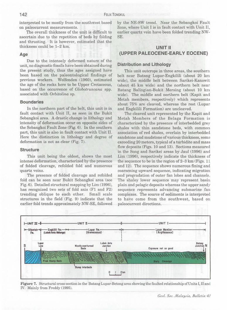
UNIT II (UPPER PALEOCENE-EARLY EOCENE)
Distribution and Lithology
This unit outcrops in three areas, the souther belt near Batang Lupar-Engkilili (about 20 km wide), the middle belt between Sarikei-Kanowit (about 45 km wide) and the northern belt near Batang Balingian-Bukit Mersing (about 10 k wide). The middle and northern belt (Kapit an Metah members, respectively) which represents about 75% are cleaved, whereas the rest (Lupar and Engkilili Formation) are uncleaved.
The cleaved unit represented by the Kapit and Metah Members of the Belaga Formation is characterized by the presence of interbedded grey shales with thin sandstone beds, with commo association of red shales, overlain by interbedded sandstone and mudstone of various thickness, some exceeding 20 meters, typical of a turbidite and mass flow deposits (Figs. 10 and 13). Sections measured in the Song and Sarikei areas by Jaul (1996) and Lim (1996), respectively indicate the thickness of the sequence to be in the region of 2-3 km (Figs. 11 and 12). The sequence shows numerous fining and coarsening upward sequence, indicating migration and progradation of outer fan lobes and channel . The shaley lower sequence may represent basin plain and pelagic deposits whereas the upper sandy sequence represents advancing submarine fan complexes . The source of sediments is interpreted to have come from the southwest, based on paleocurrent directions.
r-UN1T nr- lI&---- ----uNIT n---------fl---------UNIT 1- --------1
I4- Sllan"~En9kilili Fm.,---;~~E~----Lupor Fm .,----~.~IIII4-. ---- ---LOlar Member Fm. : (lubokAntu Metange) (Arenaceous): ( rgilloceous)
I : I I
I
Figure 7. Structural cross-section in the Batang Lupar-Betong area showing the faulted relationship ofU nits I, II and IV. Mainly from Freddy (1995).
Ceo L. S oc. Ma LaYJia, BuLLetin 40

SEDIMENTATION AND TECTONICS OF PALEOGENE SEDIMENTS IN CENTRAL SARAWAK 143
Figure 9. Small scale tight F1 fold axis trending NW-SE subjected to later folding, with its axis oriented approximately NE-SW in the Layar sediments (Unit I) in the Bukit Sebangkoi area.
JuLy 1997
Figure 8. Dark grey slates interbedded with thin metasandstones of the Layar Member (Unit I) in the Bukit Sebangkoi area showing intense shearing and thrusting to the northeast.
Figure 10. Grey shales interbedded with thin graded sandstones of the Kapit Member (Unit II) typical of a turbidite deposit in the Jakar area. The vertically dipping sequence is accompanied by the development of cleavage.

Composite Facies .'HIlt;;UI Interpretation ~hickness Facies Vertical Interpretation Sequence Measured Sections Sequence I ...... Measured Sections (Flyscb) Anolnls (Submarine Fan) (m) ( FlYSCh) (Submarine fon) ~
I Analysis
~
1300~ I I
! \ 1200-1· •. , •. ; ..... ·1 BIA
Lobe 240 cus DIE FuS
/ Progradation \ DIE I Lobe 220
I G Migration
C/B B
200 0 D G \ C 180 ! 0 FUS Mid
\ Fan C/B
C Channel 160 Lobe Migration CUS Progradation Outer
C/G \ E I Fan B 140
C II C '\ m
E r-
Lobe x FUS --l B Migration 120 0
\ z G>
G \ / '" C c 100
r-
Clo DIG B ! C 801::_::: :~:~,~::.:J C/B
CUS Lobe Outer 0 / Progradation Fan
G DIE ~
B I Lobe I Basin 300 DIG CUS <::> 40 Progradation Plain I"'- ..................... " .0 .. C
I ~ B I !'>
~ 200 DIE 20 G
S- CUS Lobe Basin ~ Progradotion Plain j:;' 100 G
I b::! !::
~ 0 ..,.
S· ~ Figure 11. Composite measured section ofthe Unit II (Kapit Member) Figure 12. Measured section of Unit II (Kapit Member) in the Jakar area by Lim
in the Song area by Jaul (1996). (1996).

SEDIMENTATION AND TECTONICS OF PALEOGENE SEDIMENTS IN CENTRAL SARAWAK 145
The uncleaved unit, represented by the Lupar and Engkilili Formations is characterized by the intercalation of un deformed and deformed sequence. The deformed sequence is associated with primary slump structures, whereas the undeformed sequence comprise mainly of thick shales interbedded with thin to medium sandstones (Freddy, 1995). The thickness of the deformed sequence can reach up to
20 metres. The overall thickness of this unit is uncertain due to the deformed nature of the sequence. However, it is estimated, based on the exposed sections to be more than 500 metres. The unit is interpreted to have been deposited in an unstable slope environment, possibly quite shallow, as indicated by the presence of numerous vertical burrows and channeled pebbly-conglomeratic
Figure 13. Red shales interbedded with thin siltstones of the Kapit Member (Unit II), interpreted as deep water basin plain deposits in the Song area. The cleaved beds represent part of a vertically plunging fold limb, with its axis trending approximately NW-SE.
July 1997
Figure 14. Steeply plunging FI fold axis trending approximately NW-SE in the thick sandstone beds of the Kapit Member (Unit II) in the Song area. The height of the hill cutting is approximately 10 metres.

146 FELIX TONGKUL
sandstone interbeds in the undeformed sequence. The source of sediments is not clear due to the absence of good paleocurrent indicators.
Age
The southern belt, mapped previously as the Engkilili Formation yielded abundant microfossils, indicating ages ranging from Paleocene to Lower Eocene. However, the Lupar Formation which is conformable with the Engkilili Formation did not yield good microfossil (Freddy, 1995). Upper Cretaceous microfossils which was mostly obtained from blocks in the deformed sequence, was assumed by Tan (1979) to come from the Lupar Formation. His description of the Lupar Formation, which also shows well developed slaty cleavage is difficult to differentiate with the Layar Member. It is possible that the Upper Cretaceous age may have been derived from the latter. Tan (1979) which includes the Engkilili Formation in the LubokAntu Melange suggested an Upper Lower Eocene age for the matrix in the deformed beds. Tan also suggested that the limestone blocks found inside the deformed beds is of Upper Paleocene to Middle Eocene in age. An early Middle Paleocene to early Middle Eocene age was suggested by Basir and Madira (1995) for the microfossils extracted from· the Lubok Antu mud matrix.
No microfossils were found on the middle (Kapit Member) and north (Metah Member) belts. Based on earlier studies, the middle belt have been dated as Paleocene to Lower Eocene, whereas the north belt as Upper Eocene (Wolfenden, 1960). Recent age determination for the Kapit sediments by Sulong (1987) shows Lower-Middle Eocene. The Upper Eocene age assigned to the Metah Formation appears to be inappropriate, considering its distinctive lithology and higher degree of deformation compared to the surrounding rocks. It is therefore assumed in the present study that the Metah member is the northern extension of the Kapit Member based on their similar lithology and structures.
Boundary
In the Batang Rajang area, the unit is in fault contact with Unit I and Silantek Formation (Unit IV) (see Fig. 6). In Sibu, Kanowit and Song areas, the Unit is interpreted to be in fault contact with Unit III. The fault is not seen in the field, but inferred from the drastic change in lithology and structure on both side of the Rajang River. For example, near Durin Ferry station, the southern side of the river is characterized by intensely sheared and tightly folded grey and reddish shale and slate, whereas on the northern side, steeply dipping, thin-medium, well-bedded carbonaceous mudstone and sandstones occur.
In the Balingian area, the Unit is in fault contact with Unit III and IV (Fig. 15). The boundary is not exposed in the field, but the sudden change in lithological and structural deformation along the road is apparent (Lau, 1995).
In the northern part of Sarawak, rocks of equivalent age, similar lithology and structure have been mapped as the Mulu Formation by Haile (1962).
Structure This unit shows two different structural styles
of deformation. The northern and central belt which are cleaved, is characterized by the presence of refolded fold and numerous quartz veins, whereas the southern belt is characterized by the presence of overturned and disrupted beds.
In the northern belt, near the Batang Balingian bridge (see Fig. 15), the unit is intensely sheared, shoWing tight asymmetric folding and thrusting towards the north. Kink bands are also seen in some of the foliation which are usually cut through by extensional quartz veins.
In the central belt, near Jakar (see Fig. 5), two sets of fold axis (F1 and F2) trending NW -SE and NE-SW, respectively have been mapped. In the field, the intersection of both fold axis is usually marked by a sudden change in direction of cleavage and the presence of disrupted beds, with its strike and dip in various directions (Lim, 1996). Similar structures have been mapped by Jaul (1996) near Sungai Musa in the Song area. Here the F1 fold axis shows steep plunge (Fig. 14). Along the Katibas River, the folded sequence shows approximately 1.5 km wavelength (Fig. 16).
In the southern belt, near Batang Lupar, the unit mostly shows tight asymmetric folding accompanied by steepened and overturned beds (see Fig. 6). Similar overturned rock units towards Lubok Antu have been mapped by Tan (1979). In the slumped part of the unit, rock fragments of different lithologies (mostly sedimentary rocks) and sizes (cobble to boulder) occur imbedded in a silty mud matrix. Tectonic shearing occur in places within the mud matrix. The presence of exotic blocks (igneous, sedimentary and metamorphic) in the mud matrix has led Tan (1979) to interpret them as a tectonic melange.
UNIT III (MIDDLE TO UPPER EOCENE)
Distribution and Lithology This unit, represented by the Pelagus Member
of the Belaga Formation occur in the Sibu-Selangau belt, with an approximate width of about 60 km. The best outcrop can be seen near Sibu Town and
Ceo!. Soc. MaLaYJia, BuLLetin 40

SEDIMENTATION AND TECTONICS OF PALEOGENE SEDIMENTS IN CENTRAL SARAWAK 147
Near Selangau-Mukah Junction. In the vicinity of Sibu Town, the unit is characterized by a thick sequence of dark grey carbonaceous shales interbedded with thin laminated sandstones, intercalated with thicker sandstone beds. Vertical burrows are commonly seen in some of the shale interbeds, probably suggesting shallow water deposition of some of the sequence (Fig. 17).
In the vicinity of Selangau town, Lau (1995) measured about 1650 metres of section, comprising mainly of shales interbedded with sandstones of various thickness, typical of a turbidite and mass
D D D
UNIT Ill: (Tatau Formation) In terbedded Sandstone and Shale
UNI T m/ Ill: (Pelagus Member) Interbedded Sandstone and Shale
UNIT II /1 (Metah Member) Interbedded Metasandsfone and Slate
N
o o 2M! Io'_lrrr..rrorI'
UNIT m/Ell (Pelogus "ember)
flow deposits (Fig. 20). The sequence shows several fining and coarsening upward sequence, representing the migration and progradation of a submarine fan lobes and channels over a basin plain setting. The presence of numerous primary slump structures in some of the sequence also suggests a depositional environment near a slope. In other areas, the vertical burrows in a carbonaceous mudstone with thin discontinuous sandstone beds suggests shallow water environment (Fig. 18). Paleocurrent measurements indicate a source of the sediments from the southwest.
4:1 Strike /Dip .4 Foliation
UNIT n ( MeIGh M8mber )
" Fold Alis
Figure 15. Geological map ofthe Selangau area showing the boundary of Units II, III and IV, interpreted to be faulted, as shown by the drastic change in the lithology and structural deformation. Based on Lau (1995).
Steeply plung iog fold axis
UNIT n (Kepit Member)
o 2 km I
Figure 16. Structural cross-section in the Song area by Jaul (1996), showing the deformational style of Unit II (Kapit Member).
JuLy 1997

148
Figure 18. Uncleaved dark carbonaceous mudstone interbedded with discontinuous thin sandstones and siltstones with vertical burrows within the area mapped as Pelagus Member (Unit III) in the Selangau area. This particular muddy sequence was probably deposited in a shallow water environment with tidal influence.
FELIX TONGKUL
Figure 17. Uncleaved grey shales and thin sandstone interbeds showing common vertical burrows in the shaley sequence of the Pelagus Member (Unit III) near Sibu Airport.
Figure 19. Disorientatedsandstone interbeds inside a grey mudstone matrix within the Tatau Formation (Unit IV), near Tatau Town. The chaotic deposit is possibly due t o gravity sliding and reactivation b_ later tectonics .
Ceo!. Soc. Ma LaY.1ia, BuLLetin 40

SEDIMENTATION AND TECTONICS OF PALEOGENE SEDIMENTS IN CENTRAl SARAWAK 149
Age
The shale samples in the Selangau area yielded Upper Eocene foraminifera (Lau, 1995). However, samples collected in the Sibu area was barren. The belt has been previously mapped as the Pelagus member of the Belaga Formation and has been dated to range in age from Middle to Upper Eocene by Wolfenden (1960).
Boundary The unit is interpreted to be in fault contact
with Unit II at its northern and southern margin
as discussed earlier. In the northern part of Sarawak., rock unit of
similar age, lithology and structure have been mapped as the Kelalan Formation by Haile (1962).
Structure This unit is characterized by upright, tight
folding and thrust faulting with associated horizontal faults. Minor development of cleavage occur in some area.
In the Selangau area, for example, numerous folds with wavelengths between 100-250 metre
(m) Composite
Measured Sections Facies
(Flysch)
Vertical Sequence Interpretation
(Submarine Fan)
July 1997
1650~----~ 1600. B
C/O
C
A
O/C
B G
o
A
C
B
B
DIG
G
o
C G C
c~ /
Channel Migration
Lobe Migration
Lobe Progradation
Lobe Migration
Mid Fan
Basin Plain
Outer Fan
Figure 20. Composite measured sections of Unit III (Pelagus Member) in the Selangau area by Lau (1995) showing typical submarine fan sediments.

150 FELIX TONGKUL
occur (see Fig. 15). These folds are possibly drag folds within a bigger fold limb, as indicated by the occurrence of fold limb with more than 1 km wavelength. The presence of numerous small scale slump folds within the fold limbs complicates the structures in this unit. The thrust faults shows transport direction both to the north and south. The steeply dipping limbs of the fold are also commonly cut through by low angle thrust faults.
Near Sibu town, at the airport roundabout, upright, tight folds can also be seen. Here the folds are so tight, that the fold limbs are nearly parallel to each other. The occurrence of slaty cleavage is restricted to the core of the fold.
UNIT IV (UPPER EOCENE-UPPER OLIGOCENE)
Distribution and Lithology
This unit outcrops in two areas, at the southern belt near Sri Arnan, represented by the Silantek Formation and at the northern belt near Batang Balingian-Tatau, represented by the Tatau and Buan Formations. In the northern belt, a large part of the unit is overlain by Neogene sediments (e.g. Nyalau Formation). The unit is composed mainly of sandstones and shales, with minor occurrence of conglomerates, limestones, marls and volcanic rocks.
In the northern belt, near Arip bridge, the sediments shows common cross-beddings and vertical burrows typical of shallow water deposits. Interbeds of conglomerates, limestones, marls and volcanic rocks have also been recorded by previous workers (e.g. Wolfenden, 1960; Gasah, 1984). The sequence here have been estimated by Wolfenden to be more than 3 kID.
Near Tatau Town, the sediments consists of interbedded sandstones and shales of various thickness, typical of turbidite and mass flow deposits. Some of the shale beds show vertical burrows. In the thinner sandstone and shale beds, soft sediment folding is common (Fig. 19). The occurrence of slump folds and vertical burrows suggests an unstable slope depositional environment.
In the southern belt, near Marup Ridge the unit consist of a thick sequence of grey to black carbonaceous shale and mudstone alternating with sandstones, occasionally rippled-top and crossbedded, typical of shallow water deposits. This unit, mapped as the Silantek Formation has been well documented by Tan (1979). Tan estimated its thickness to about 5 km. Paleocurrent directions indicate a source from the north-northeast.
Age
Since the sediments in this unit is well dated, no attempts were made to do further age determination. In the Tatau area, the Tatau and Buan Formations have been dated to range in age from uppermost Eocene to Oligocene by Wolfenden (1960). The limestone lenses yielded Upper Eocene age, whereas the marl yielded Oligocene age.
In the Sri Arnan area, the Silantek Formation have been dated by Tan (1979) to be possibly Upper Eocene.
Boundary
In the southern belt, the unit is in fault contact with Unit II along the Lupar Fault Zone (see Fig. 6). In the northern belt, the boundary of the unit with Unit II is interpreted to be faulted too, based on the drastic change in lithology and structure between them. The boundary ofthe unit with Unit III remains uncertain, due to the similarity of their lithology and structure. It is possible that some of the unit might be present within the Unit III belt.
Structure
This unit also shows two contrasting deformational style. The northern belt is characterized by the development of tight upright folds and thrust faults, whereas in the southern belt, the unit is only gently folded.
In the northern belt, near Arip bridge, numerous small to medium scale fold occur with their axis trending approxiniately E-W. Near Tatau Town, the beds are nearly vertical and overturned in places, indicating the presence of tight fold. The presence of numerous slump folds within larger fold limbs also complicates the structures here. Tjia et al., (1987) who did a detailed structural analysis of the sediments here showed at least two main tectonic transport directions, to the north and west.
In the southern belt, near Marup Ridge the unit dips moderately to the south, forming a large syncline trending NW-SE. The dips are however, steeper near its northern margin, possibly due to the presence of the Lupar Fault Zone.
REGIONAL RELATIONSHIP OF UNITS
The relationship of the units with each other shows a systematic arrangement in terms of their distribution, age and degree of deformation. There appears also a repetition of similar depositional environment in each unit.
Except for the minor occurrence of Unit II and IV towards the north and south, the distribution of the four units generally occupies a specific belt,
Geo!. Soc. MaLaytfia, BuLLetin 40

SEDIMENTATION AND TECTONICS OF PALEOGENE SEDIMENTS IN CENTRAL SARAWAK 151
mostly separated by major fault zones (see Fig. 2). From the south, Units IV and II is separated by the Lupar Fault, Units I and II by the Sebangkoi Fault, Units II and III by the Kanowit-Song Fault, and Units III, II and IV by the Balingian-Bukit Mersing Faults. The age of each unit progressively youngs towards the north.
Each unit shows a variety of depositional environments, ranging from shallow marine, unstable slope to abyssal plain. The occurrence of limestones is limited to Unit II towards the south and Unit IV towards the north. The source of sediments generally comes from the southwest.
Except for the occurrence of Unit II and IV near Batang Rajang and Batang Balingian, the episode and intensity of deformation decreases as the unit gets younger towards the north (Fig. 21). The moderate regional metamorphism to slate and subphyllite, and the occurrence of refolded fold and numerous quartz veins is mainly restricted to Unit I and a large part of Unit II. The higher degree of deformation and metamorphism is mainly
concentrated along the major fault zones. Units I and II also experienced two different compressional directions from the NE-SW and NW-SE, compared to only one in the younger units . The two contrasting deformational styles seen in Unit II and IV, are located in different areas, having different depositional settings.
DEPOSITIONAL AND TECTONIC MODEL
The difference in age, degree of deformation and lithology of each unit is difficult to reconcile with the concept that an Upper Eocene subduction was solely responsible for the deformation of the Upper Cretaceous , Paleocene and Eocene sediments in Central Sarawak. The facts are more easily explained on the assumption that deposition and deformation of the Paleogene sediments occurred progressively with time. Each culmination of tectonic events was marked by a different tectono-stratigraphic unit, irrespective of their site of deposition and style of deformation.
Figure 21. Summary of structural styles in the Paleogene sediments of Central Sarawak showing an overall decrease in intensity of deformation as the units get younger to the north.
JuLy 1997
152 FELIX TONGKUL
In fact this assumption has been mentioned earlier by Wolfenden (1960) and Haile (1962) and interpreted later in terms of subduction process by Hamilton (1979). The four stages of the Belaga Formation proposed by Wolfenden (1960) is typical of an accreted terrain according to Hutchison (1989). However, the earlier workers, in the absence of a more detailed sedimentological and structural informations was unable to elaborate on the development of the Eocene accretionary complex.
The subduction-accretion of the Palaeogene sediments is elaborated further below based on the additional informations gathered during the present study (Fig. 22). For completeness purpose, other rock units are also included in the discussion.
carbonates may have developed along the accretionary ridge. The continued movement due to the accretionary process might have resulted in the widespread occurrence of slump structures at the edge of the accretionary ridge, especially in the Engkilili sediments. Further southwest the shallow water sediments (Kayan Formation) continued to fill the older accretionary fore-arc basin.
Middle Eocene-Upper Eocene (SG-40 Ma) At the end of Lower Eocene, the subduction
front again migrated northward probably along the Bukit Mersing Fault Zone, resulting in the accretion of a large part of Unit II sediments against Unit I along the Sebangkoi Fault Zone (Fig. 22C). Due to the subduction process, a large part of the previously
Upper Cretaceous-Early Paleocene (90-&0 accreted Unit I sediments was probably uplifted Ma) and exposed to weathering and erosion at this time,
Southwest subduction of a Mesozoic oceanic supplying coarse-grained sediments to the newly lithosphere under West Sarawak continental formed accretionary fore-arc' basins and the basement during the Upper Cretaceous resulted in narrowing elongate basin to the northeast. Towards the accretion of ophiolitic basement rocks and its the southwest, the older fore-arc basins continued sedimentary cover south of the present Lupar Line to be filled by sediments both from the southwest (Fig. 22A). The subduction front was probably and northeast. The great thickness of the Pelagus marked by the development of the Lubok Antu sediments (Unit III) filling the accretionary basin tectonic melange in front of the present Lupar Line. suggests that the source area may have been Behind the subduction front, the shallow water continually rising during this period. Up to now sediments of the Pedawan Formation was prpbt~.bly the southwest subduction-accretion has resulted in being deposited in a fore-arc basin setting. In front the deformation-imbrication of the Units I and II of the subduction front, an elongate basin of sediments, producing upright folds and thrusts considerable width was created due to the presence faults with associated slaty cleavage, trending of the rifted southern margin of China to the approximately NW-SE. northwest. Shallow marine Layar sediments (Unit I) were deposited on top of the newly accreted Upper Eocene-Middle Oligocene (40-30Ma) sediments, .giving way to deep water sediments in During the Upper Eocene, the subduction front the elongate basin towards the northeast. The again migrated to the northeast, probably along uplifted continental base~ent towards the theBintulu-GunungMuluShearZone. Haile(1962), southwest provided the main source of sediments. . reported intense tectonic deformation of the Mulu The sedimentation possibly continued up to . Formation in the Tutoh·Gorge, near Gunung Mulu, Paleocene, resulting in the: great thickness of Unit characterized by· steep dips, tight folds and slaty I. cleavage. . Although no deformation of similar
intensity have' been reported in the Bintulu area, Middle Paleocene:-Early Eocene (60-50 Ma). possibly due to the thick Neogene sedimentary
The deposition . of sediments was possibly cover, the regional structural grains suggests the interrupted during the middle Paleocene, as the existence of such fault zone. The subduction subduction front migrated.northeastwards probably resulted in the- aCCretion of a large part of Unit III along the Bukit Sebangkoi Fault Zone, resultin,g in sediments agl,linst Unit II along the Kanowit-Song the accretion of the Layar sediments against the Fault-Zone and possibly along the Mersing Fault older rocks to the southwest (Fig. 22B). The newly' . Zone. (Fig. 22D). This time the subduction direction developed accretionary fore-arc ridge and basin at was oblique to th,eprevious one. and resulted in the the back of the subduction front subsequently development of anew fold axis trending became the site of deposition of the relatively approximatelyNE~SW on the earlier accreted Units shallow water Lupar and Engkilili sediments, I and II sediments.. The change in subduction whereas the Kapit, Metah and Mulu sediments direction may be related to regional plate (also Unit II) continued to fill the elongate basin, rearrangements during the opening of the South through the northeast progradation and migration China Sea basin at this time. The subduction of submarine fan lobes and channels. Shallow water process also resulted in the extrusion and intrusions
Geol. Soc. MalaYJia, Bulletin 40

W
E
F
Kayan
Koyon,
Silontek
Plateau
Lupor Engkilili
(UNITn)
Kapit Mulu
Pelogus
o I
Arip Volcanic (UNIT:nz:) Totou Cgl , Melinau Lmst.
(UNIT JZ:)
,0 I
Kelolon
"Oblique Subduction" Buan/Tubau
"Neogene Basin"
MID, PALAEOCENE (60 Ma)
MID, EOCENE (50Ma)
UPPER EOCENE (40Mo)
UPPER OLIGOCENE (30Ma)
LATE LOWER MIOCENE (20Ma)
Figure 22. Schematic sedimentation and tectonic model for the Paleogene sediments of Central Sarawak involving subduction-accretion processes. The model is based on the assumption that deposition and deformation of the sediments occurred progressively with time as the subduction front migrated northwards . See text for further discussion.

154 FELIX TONGKUL
of igneous rocks along the Bukit Mersing Fault Zone, producing the Arip Volcanics and Piring intrusives. A prominent accretionary ridge may have developed along the former subduction front for the development of shallow water carbonates and conglomerates (e.g. Melinau Limestone and Tatati conglomerates). In front of the accretionary ridge, shallow to deep marii:te sediments began to fill the newly formed accretionary fore-arc basin and the elongate basin.- Towards· ilie south.west, the old accretionary fore-arc basin continued to receive sediments from the northeast and southwest for the deposition of shallow marine sediments of the Silantek Formation.
Upper: Oligocene-Early Miocene (30-20 Ma)
By the end of Middle Oligocene, the elongate basin must have been nearly filled with. sediments.
ACKNOWLEDGEMENTS
This paper is part of a regional geological correlation between the Tertiary sediments C)fSabah and Saraw~ supported byUKM. I wish to thank Lau, Freddy, Lim and Jaulfor their companionship in the field. The results of their detailed mapping has enabled me to have a better grasps of the complexity of the geology in this region. I wish to thlinkthe Geological Survey of Kuching, for their' . support and access to secondary information and for Petronas for granting me access to their SAR imagery data. The. generous assistance by the Geological Society of Malaysia in the preparation of the figures is greatly appreciated.
REFERENCES·
Again the subduction front migrated northwards, BASIRJASINANDTAJMADIRA TAJAHMAD, 1995. Some Paleogene resulting in the accretion of Units IV and III planktonicforaminifera from the LubokAntu Complex, sediments against the older sediments along the Sarawak. ·'Warta Geologi,21(3), 147-151. Mersing Fault Zone andpossibly along the Bintulu- FREDDY H, CHImA; 1995. Gt:ologi am kawasan.MIlrup hingga Gunung Mulu Fault Zone (Fig. 22E). The Upper Si.mpang Betong, Lebuhraya Sri Aman-Sarikei, Sarawak. Cretaceous-Eocene accretionary wedge by now has Unpublished RSc. thesis, Universiti Kebangsaan reache4 more than 200 km wide, and.a large part Malaysia, Sabah Campus. . had already been uplifted, 'providing th.e. sourceo£ ~ GASAH L1NGI<AI~ 1~1M.· Summary of the geology of Nanga
. Lemai:area;CentralSarawak. Geol. Surv. MIllaysia Annual coarse-grained sediments (e.g. Ransi conglomerates) . rt 1984 repo , .
. f9r the fllling of stU! submerged narrow' accretionary HAILE; N.S.r 1962. ·The geology and mineral resources of the fore-arc basins (Nyalau and Setap sediments). A . Suai-Baramarea,NorthSarawak. Brit. Borneo Geol. Sum prominent accretionary ridge may have developed Mem. 13 .. along the Bintulu-Gunung Mulu fault zone; the HAILE,N.S., 1969. Geosynclinal theory and the organizational former subduction front, where it was conducive- pattern of the NW Borneo Geosyncline. J. Geol. Soc. for the development of the shallow water carbonates London, 124, 171-194. . . of. the Subis' and Melinau limestones. The HAn.B,N.S., 1974. Borneo: In: A.M. Spencer (Ed.),Mesozoicaccumulated effect of the accretionary process may Cen9zoieorogenicbelts: Data fur orogeriic studies. Geol.
Soc. London. Spec. Pub. 4,333-347. have resulted in the gradual steepening of beds on HAMILTON, W., 1979. Tectonics of the Indonesian region. US the older sediments. Geol. Surv.Prof. Paper 1078 .
. .. By late Early Miocene,the elongate basin finally HuttHisON, C:S:, 1989. Geological evoTUtion of Southeast Asia. closed due to the arrival of the rifted . southern Oxford Monographs on geology and geophysics No. 13. margin of China (Fig. 22F). The oblique' collision Clarendon· Press, Oxford, 386p. resulted in: the gentle folding of the Nyalau and-· IAMFS,D.M.D.{Eo.),1984.Thegeologyandhydrocarbonresources Setap sediments, whereas a tightening of the fold ofNegara Brunei Darussalam. Brunei Museum and Brunei structures on Unit IV . sediments. Some of the Shell P$oleum CO.
JAUL l<.AMPrr{ 19.96. Geologi am kawasan' hilir· Sungai Katibas, major faults in the older accreted sediments may . Song, SaraiDtlk; Unpublished' B.Sc. thesis, Universiti have ~so been reactivated. The accumulated effect Kebangsaan Mahiysia, Sal>ah Campus. of the 81lhduction and collision would have been the KmK, J.C., 1957. The geology and mineral resources of the shortening of the whole -accretionary complex, . llpp~~jaIlg;mdadja~entar.!'!a$. Brit. Borneo Geol. Sun •.
·causmg the gradual steepemng and overturning ()f Mem. 8. beds, especially on the older sediments. 'The LAu,L.C.,1995~'GeologiamlaiwtisanlebuhrayaSibu-Bintulu,km numerous igneous intrusions and extrusions in the 68.5-117.8, Sibu! Sarawak. Un~blished B.Sc. thesis, accrete4 sediments might have occurred during this . Universiti Kebangsaan Malaysia, Sabah Campus. time, utilizing existing weak 'z()nes, along thrusts Lmarn, P., ROB, F.W. AND HAn.li, N.S., 1960. The geology of or.wrench faults. ~wak,BruneiandwesternpartofBorneo. Brit. Borneo
Th ..' . . Geol. Surti. Bull;·3, 36Op.· . . e continued plate movements in.this region liM, S.T;,~996:· 'Geologi am kawasan lebUhraya sarlkei-Saratok,
during the Miocene may have gradually uplifted a Km 12.:,30,Sarikei, Sarawak. Unpublished B.Sc. thesis, large part of the Paleogene sediments and Universiti Kebangsaan Malaysia, Sabah Campus. reactivated some of the major fault zones. . SULON6 ENJop, 1987. Laporan Kemajuan pemetaan geologi
Geot. Soc. MataY<1ia, Bulletin 40

SEDIMENTATION AND TECTONICS OF PALEOGENE SEDIMENTS IN CENTRAL SARAWAK 155
kawasan Sarikei-Pakan, Sarawak. Geological Survey Malaysia Annual Report 1987.
TAN, DN.K., 1979. Lupar Valley, West Sarawak, Malaysia. Geol. Surv. Malaysia Rep. 13.
TAYLOR, B. AND HAYES, D.E., 1983. Origin and history of the South China Sea Basin. In: Tectonic and geologic evolution of Southeast Asian seas and islands, Part 2. American Geophysical Union Geophysical Monograph, 27, 23-56.
TJIA, H.D., BORHAN SIDI AND TEOH, c.L., 1987. Superimposed deformations and vergence of Lower Tertiary sediments
near Tatau, Sarawak. Bull. Geol. Soc. Malaysia., 21,251-271.
WILLIAMS,P.P.,SUPRIATNA,S.ANDHARAHAP,B., 1986. Cretaceous melange in West Kalimantan and its tectonic implications. GEOSEA V Proceedings Vol. 1, Bull. GeoI.Soc.MaIaysia,19, 69-78.
WOLFENDEN, E.B., 1960. The geology and mineral resources of the Lower Rajang Valley and adjoining areas, Sarawak. Brit. Borneo Geol. Surv. Mem. 11.
YIN, KH., 1992. Geological map of Sarawak. 2nd Edn. Geol. Surv. Malaysia.
----------.•• -~-+.+.---------Manuscript received 1 July 1996
July 1997