Embed Size (px)
Citation preview

S·edimentation and Tectonics in the Early Tertiary Continental Borderland Of Central California
\
GEOLOGICAL SURVEY PROFESSIONAL PAPER 925
mJJRl£A[21 Of r:.r~~l~~:
!UBRARV £?OKANE, WASN. ,
!;;'·"'-' iQ 'll '1 ,t.gAJ!,
:(~fA~£ R~~·. _ ·,,._\ [©1

Sedimentation· and Tectonics in the Early Tertiary Continental Borderland Of Central California By TOR H. NILSEN and SAMUEL H. CLARKE, Jr.
GEOLOGICAL SURVEY PROFESSIONAL PAPER 925
UNITED STATES GOVERNMENT PRINTING OFFICE, WASHINGTON : 1975
UNITED STATES DEPARTMENT OF THE INTERIOR
ROGERS C. B. MORTON, Secretary
GEOLOGICAL SURVEY
V. E. McKelvey, Director
Library of Congress catalog- card No.7 6-7 6 2 4
For sale by the Superintendent of Documents, U.S. Government Printing Office
Washington, D.C. 20402

CONTENTS
Abstract Introduction _______________________________________________ _
Acknowledgments _____________________________________ _
Summary of Mesozoic tectonic history-----------------------Lower Tertiary stratigraphic units --------------------------
~orthwestern area _____________________________________ _
Page
1 1 3 3 4 6
(}ualala area ---------------------------------------- 6 Point Reyes --.-------------------------------------- 7 Point San Pedro----------------------.-------------- 7 Santa Cruz Mountains------------------------------ 7 San Juan Bautista area ---------------------------- 11 PointLobos ---------------------------------------- 11 ~orthern Santa Lucia Range------------------------ 11 Adelaida area -------------------------------------- 12 La Panza, southern Santa Lucia, and Sierra Madre
Ranges ------------------------------------------ 12 Pattiway Ridge area ---------------------------.,----- 12 Mount Pinos area -----------------------------'----- 13
~ortheastern area _ _ __ _ _ _ _ __ _ ___ _ _ ___ _ __ __ _ _ _ _ _ _ _ __ _ _ _ __ 13 Sierra ~evada ___ _ _ _ __ _ _ _ _ _ _ ___ _ _ _ _ _ _ _ __ _ _ _ _ _ __ _ _ _ __ 13
Franciscan assemblage in the northern Coast Ranges__ 14 Round Valley area---------------------------------- 14 Rice Valley area------------------------------------ 14 Middle Mountain area ------------------------------ 15 Clear Lake area ------------------------------------ 15 Mount Diablo area and Sacramento Valley area ______ 15 San Leandro Hills ---------------------------------- 17 San Jose area-------------------------------------- 17 Tesla area__________________________________________ 18
Orestimba area -----------------------~------------ 19 Laguna Seca area ---------------------------------- 19 Bolado Park area ---------------------------------- 19 Vallecitos area ------------------------------------ 20 ~orthern Temblor Range, southern Diablo Range,
and adjacent San Joaquin Valley ------------------ 21 San Emigdio and western Tehachapi Mountains
and adjacent southern San Joaquin Valley ________ 22 Southern Tehachapi Mountains ______________________ 23 El Paso Mountains __________________________________ 24
Page
Lower Tertiary stratigraphic units-Continued Southeastern area -------------------------------------- 24
Cadon Pass area ---~-------------------------------- 24 Orocopia Mountains -------------------------------- 24
Southwestern'area ______________________________________ 24
Ortega Hill, Pine Mountain, Santa Ynez Mountains, and Topatopa Mountains areas -------------------- 25
Piru Creek area ------------------------------------ 29 Las Lladas Canyon, Simi Hills, and Santa Susanna
Mountains areas __________________________ --______ 29 Santa Monica Mountains ____________________________ 30
Elsmere Canyon and (}old Creek areas -------------- 30 Elizabeth Lake Canyon .and Valyermo areas __________ 30 Channel Islands------------------------------------ 30 Santa Ana Mountains and San Joaquin Hills -------- 31 San ~icolas Island __________________________________ 31
Western Peninsular Ranges ---"'"-------------------- 32 Lake Elsinore, Lake Henshaw, and Jaccumba
Valley areas-------------------------------------- 32 ~orthern Bada California ____________________________ 33
Early Tertiary history.of the San Andreas fault ---------.----- 33 Early Tertiary paleogeography ------------------------------ 36
Introduction ____________________________________________ 36
Source areas ------------------------------------------ 36 Eastern nonmarine deposits ---------------------------- 39 Shallow marine shelf deposits -------------------------- 40 Continental slope and ocean floor deposits---------------- 42
Introduction ________________________________________ 42
Hemipelagic deposits ------------------------------ 42 Deep-sea fans deposited east of the borderland and
derived from eastern source areas __________________ 43
Continental borderland deposits ------------------------ 45
Deep-sea trench deposits -------------------------------- 46 Sedimentology of the borderland deep-sea fans ________________ 47 Tectonic framework of borderland sedimentation ______________ 48
Summary and conclusions ---------------------------------- 52 References cited _ __ _ __ _ _ __ _ _ ___ _ ____ _ ___ _ _ ___ _ __ ___ _ ___ _ _ ___ 54
ILLUSTRATIONS
Page
FIGURE 1. Index map of California showing mador geomorphic and tectonic provinces, mador faults, and informal geographic divisions___ 2 2. Index map of California showing outcrops of lower Tertiary sedimentary rocks----------------------------------------_ 4 3. Index map of the western Transverse Ranges showing outcrops of lower Tertiary,sedimentary rocks--------------------_ 26 4. Diagram showing inferred history of offset along the San Andreas fault in central California -------------------------~ _ 34 5. Schematic maps showing Mesozoic and Cenozoic plate relations in the western Pacific Ocean -------------------------- _ 35 6. Diagrammatic sketch showing the early Tertiary tectonic development of central California ____________ ----------------_ 37 7. <1eneralized paleogeographic map of early Tertiary California--------------------------------------------------------_ 38 8. <1eneralized map showing tectonic activity within the early Tertiary continental borderland of western California -------- 50
III

IV CONTENTS
TABLES
Page
TABLE 1. Lower Tertiary megainvertebrate and foraminiferal stages in California------------------------------------------------ 5 2. Sedimentary structures and features reported from inferred deep-sea fan deposits of the early Tertiary continental bor
derland and adjacent areas of California__________________________________________________________________________ 8 3. Comparison of thicknesses and depositional intervals of inferred deep-sea fan deposits of the early Tertiary continental
borderland and adjacent areas of California ---------------------------------------------------------------------- 10

SEDIMENTATION AND TECTONICS IN THE EARLY TERTIARY CONTINENTAL BORDERLAND
OF CENTRAL CALIFORNIA
By ToR H. NILSEN and SAMUEL H. CLARKE, JR.
ABSTRACT
We infer that the most prominent early Tertiary paleogeographic features of central California were the Sierran landmass to the east and the Salinian island area or peninsula to the west, both underlain by granitic crust, and a trough-shaped deep marine basin which separated the two, underlain by oceanic crust. These elongate elements trended approximately north-south, parallel to the edge of the North American continent. Clastic sediment from erosion of the Sierran landmass was transported westward and deposited in adjacent fluvial, nearshore, shallow marine, and deep marine environments. The Salinian area was probably detached from the Sierran landmass by pre-Eocene right-lateral faulting along its eastern edge; it formed a continental borderland consisting either of irregular island uplands separated by deep marine basins or a very irregularly shaped peninsula.
Detritus eroded from the borderland was deposited primarily as submarine fans at bathyal to abyssal depths within the borderland basins and on the sea floor to the east and west. These early Tertiary submarine fan deposits are similar throughout the central Coast Ranges and contain assemblages of proximal and distal turbidites, deep-sea conglomerates, grain-flow deposits, and hemipelagic shales. They differ from most modern deep-sea fan deposits and typical flysch sequences in that they are very thick but limited in areal extent, and consist mostly of coarse terrigenous detritus. The conglomerates commonly contain clasts as large as boulders, are very thickly and irregularly bedded, and are generally not laterally persistent. Sandstones deposited in more proximal parts of the fans consist primarily of conglomeratic Bouma ae channel deposits that are very thickly ·bedded, amalgamated, poorly graded to ungraded, without prominent current-generated sedimentary structures, and containing large mudstone rip-up clasts, diffuse parallel laminae, and dish structures. Sandstones deposited in more distal parts of the fans generally contain more complete Bouma sequences, are more thinly bedded, have a greater variety of current-generated sedimentary structures, and are graded. Hemipelagic shales and thin Bouma cde sequences were deposited at and beyond the margins of the deep-sea fans and locally in the interchannel areas of the more proximal parts of the fans.
The borderland region was tectonically active during sedimentation, so that island or peninsula source areas and depositional basins formed and changed abruptly. Submarine fan sedimentation was rapid, but the supply of sediment was probably not continuous for long periods of time. Paleocurrent directions are varied, reflecting the irregular distribution of source areas and depositional basins.
INTRODUCTION The lower Tertiary marine sedimentary rocks that
crop out in geographically restricted areas of the Coast and Transverse Ranges of western California have at-
tracted the attention of many geologists during recent years (fig. 1). These rocks form sequences as much as 25,000 ft (7 ,600 m) thick in some areas. The rocks consist primariiy of thickly bedded to massive, medium- to coarse-grained sandstone with subordinate amounts of conglomerate, siltstone, and mudstone. Ungraded sandstone beds as much as 75 ft (23 m) thick or more have been noted; other thick beds may be reversegraded in the lowermost part or normally graded in the uppermost part, with sandstone grading sharply upward into thin siltstone or mudstone layers. These sandstones typically lack internal structures except for large irregularly shaped mudstone clasts, diffuse parallel laminations, and dish structures, which were first recognized in these rocks by Wentworth (1967).
The origin of these sandstone sequences has been the subject of considerable controversy, and in the past they have been interpreted as shallgw marine transgressive and regressive shelf deposits, deltaic deposits, a type of flysch, a type of turbidite, grain-flow deposits, and more recently, as deep-sea fan deposits. The few megafossils found in these rocks are generally individual abraded and broken mollusk shells that probably have been transported considerable distances. Microfossils are generally common in both interbedded mudstones and in thicker mudstone and shale sequences. These microfossils, particularly benthonic and planktonic foraminifers, permit reasonably reliable age assignments and provide some information about depths of water and access of the depositional site to the open ocean.
The sandstones are generally good reservoirs for oil and gas and detailed subsurface data are locally available to permit definition of the areal extent and lateral facies changes in the units. Although most of the lower Tertiary sequences have been mapped in some detail, sedimentological and paleontological studies have been completed for very few.
Detailed sedimentologic studies by other workers during the past 10 years have greatly clarified and facilitated our understanding of the depositional proc-
1

2 TERTIARY SEDIMENTATION AND TECTONICS, CONTINENTAL BORDERLAND OF .QALIFORNIA
OREGON 120°W ----Q - 142°N
~1' ~ I 0\ 0 c. "'P ~ ~~ ~ )7~
/ ~
~
SHELTER ....A'
COVE
u;, I
~ I -'f.) ~goN
POl NT ARENA )7
'
SAN FRANCISCO
"""'\)
}:::::> PILARCITOS FAULT
Cl SANTA CRUZ MTS
BIG PINE FAULT
CHANNEL ISLANDS¢> · £ttn> o
<\tb LOS
<n SAN NICOLAS
ISLAND
EXPLANATION
~ Northwestern area
(Salin ian block)
D North eastern
[[[]]]] Southwestern
EZJ Southeastern
0
I 50
I I
area
area
area
IOOMILES I
0 I
50 100 KILOMETRES
SAN DIEGO
FIGURE 1.-Index map of California showing major geomorphic and tectonic provinces, location of some major faults, and the four informal geographic divisions used in this paper (modified from Bailey, 1966).
esses and sedimentary history of these lower Tertiary rocks. In particular, we depend heavily on studies by Stauffer (1965, 1967) in the Santa Ynez Mountains, Wentworth (1966, 1968) in the Gualala area, Yeats (1968), Cole (1970), Merschat (1971) and Parsley (1972) in the central Transverse Ranges, Channel Islands, and San Nicolas Island, Chipping (1970a, b, 1972a) in the
southern Coast Ranges, and Link (1971, 1972) and Sage (1973, 197 4) in the southern Coast Ranges, Transverse Ranges, and Peninsular Ranges. By adding to their conclusions the results of our work in the Santa Cruz Mountains (Nilsen and Simoni, 1973), central Coast Ranges (Nilsen and others, 1974), and southern Coast Ranges (Clarke, 1973; Nilsen, 1973c; Nilsen and·

SUMMARY OF MESOZOIC TECTONIC IDSTORY 3
Clarke, 1973), we here synthesize the available data about the early Tertiary history of California. We emphasize the area extending from the Transverse Ranges on the south to the San Francisco Bay region on the north (fig. 1).
Studies of these lower Tertiary rocks, because they are located at the western margin of the North American lithospheric plate, can provide valuable information about the early Tertiary history of the San Andreas fault and the interactions between the continental North American plate and oceanic plates to the west. Of particular interest is the inferred change in tectonic style at the plate boundaries at the western edge of North America, from subduction of the ocean floor in Mesozoic time to right-lateral slip along transcurrent faults in Cenozoic time. The purposes of this paper are (1) to describe these unusual deposits in some detail, (2) to present our interpretations of their depositional processes and environments, (3) to outline our conclusions concerning the early Tertiary paleogeography of western California, and ( 4) to summarize the relations between early Tertiary tectonic activity and sedimentation in the region.
Before discussing the lower Tertiary sedimentary rocks in detail, we shall briefly summarize the Mesozoic tectonic history of California, because it influenced the framework of early Tertiary sedimentation and tectonics.
ACKNOWLEDGMENTS
Work by Nilsen has been partly funded by a U.S. Geological Survey Post-Doctoral Research Associateship. Clarke's contribution is based partly on his doctoral research, conducted under the direction of Drs. F. A. F. Berry and C. M. Gilbert, and funded in part by grants from the Penrose Bequest Fund of the Geological Society of America, the Amoco Production Company, and the Graduate Division of the University of California, Berkeley. We thank W. R. Dickinson, J. G. Vedder, T. W. Dibblee~ Jr., J. C. Crowell, D. G. Howell, and E. E. Brabb for helpful and thought-provoking reviews of the manuscript, and R. H. Campbell, D. L. Durham, R. F. Yerkes, G. W. Moore, and G. L. Peterson for helpful discussions. SUMMARY OF MESOZOIC TECTONIC HISTORY
The three main rock units of Mesozoic age in central California are the Franciscan assemblage, the Great Valley sequence, and granitic and related intrusive rocks. Interpretations by others of the structural, stratigraphic, and chronologie relations between these units indicate the presence of a deep-sea trench and subduction zone along the Mesozoic continental margin. Within this framework, the Franciscan rocks are thought to have been underthrust eastward beneath the
Great Valley sequence concurrently with the intrusion of granitic plutons in the Sierra Nevada (Bailey and others, 1964; Hamilton and Myers, 1966; Hsii, 1968; Bailey and Blake, 1969; Hamilton, 1969; Page, 1970b; Ernst, 1970; Bailey and others, 1970; Dickinson, 1971). Granitic intrusions of similar age are present in the Klamath Mountains, Salinian block, Mojave Desert, Transverse Ranges and Peninsular Ranges (Evernden and Kistler, 1970; Ross, 1972). The faulted contact of the Great Valley sequence and the Franciscan assemblage has been designated the Coast Range thrust (Bailey and others, 1970), and includes the South Fork Mountain, Stony Creek, Tesla-Ortigalita, and SurNacimiento faults. The Coast Range thrust may represent a Mesozoic Benioff zone (Ernst, 1970). Bailey and Blake (1969) inferred that the Fr_anciscan and Great Valley rocks were deposited concurrently in essentially parallel but separated linear belts, both underlain by oceanic crust. The Great Valley sequence, and possibly the Franciscan assemblage, were derived from source areas to the east in the Sierra Nevada area (Ojakangas, 1968). Deposition continued through the middle Cretaceous, followed by underthrusting and penecontemporaneous sedimentation until the latest Late Cretaceous. Dickinson (1971) interpreted the history as representing concurrent deposition of the Great Valley sequence in an arc-trench gap and deformation of the Franciscan rocks in an adjacent trench to the west.
Beginning probably late in Cretaceous time, this inferred tectonic framework, which had previously been dominated by underthrusting of oceanic crust, apparently changed to one dominated by right-lateral faulting subparallel to the coast. The postulated offsets of Cretaceous rocks along the San Andreas fault suggest that as much as 350 miles (560 km) or more of rightlateral slip has accumulated along the fault since Cretaceous time (Dibblee, 1966b; Wentworth, 1968; Hill and Hobson, 1968; Ross and others, 1973). If this conclusion is correct, the Salinian block was sheared off the southern end of the Sierra Nevada and displaced 350 miles (560 km) to the northwest, where it is presently bounded on both east and west by Franciscan rocks. The old Mesozoic subduction zone was thus split into two separate segments. At the beginning of Tertiary time the Salinian block was probably in motion and must have had a major effect on early Tertiary sedimentation. It was deformed so that basins formed locally within it and parts of it also became source areas for sediment. At about the same time, east-west tectonic trends began to develop in the area of the Transverse Ranges, and the Sierra Nevada, Mojave Desert, and other areas to the east were uplifted to form a mountainous terrain that served as a source area for sediment. Thus, earliest Tertiary sedimentation in central
4 TERTIARY SEDIMENTATION AND TECTONICS, CONTINENTAL BORDERLAND OF CALIFORNIA.
I CAPE
MENDOCINO
EXPLANATION
~ Outcropping lower Tertia-ry
sedimentary rocks
0
I 0
I 30
SANTA BARB.~ RAt IS
SAN NICOLAS~ ISLAND
I I 60 90
()
90 120 MILES
I II l_j 120 150 180 KILOMETRES
ASO . f
A
6 ~~'-~.-oc;l· M 0 J A V E
DESERT
NTA ~~~' • '····~:AKE ELSINORE
San Joaquin Hills' ~~1--,' SANTA '~-.r
CScATALINA .. ~ "LAKE HENSHAw ISLAND ':f"1' 'J
\._ SA,N CLEMENTE \0'SLAND
., /
• OROCOPIA '·'"' MTS
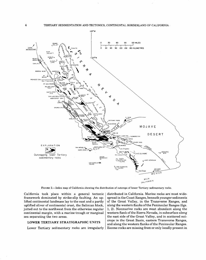
FIGURE 2.-Index map of California showing the distribution of outcrops of lower Tertiary sedimentary rocks.
California took place within· a general tectonic framework dominated by strike-slip faulting. An uplifted continental landmass lay to the east and a partly uplifted sliver of continental crust, the Salinian block, jutted out to the northwest from the otherwise regular continental margin, with a marine trough or marginal sea separating the two areas.
LOWER TERTIARY STRATIGRAPHIC UNITS
Lower Tertiary sedimentary rocks are irregularly
distributed in California. Marine rocks are most widespread in the Coast Ranges, beneath younger sediments of the Great Valley, in the Transverse Ranges, and along the western flanks of the Peninsular Ranges (figs. 1, 2). Nonmarine rocks are most abundant along the western flank of the Sierra Nevada, in subsurface along the east side of the Great Valley, and in scattered outcrops in the Great Basin, eastern Transverse Ranges, and along the western flanks of the Peninsular Ranges. Eocene rocks are missing from or only locally present in

LOWER TERTIARY STRATIGRAPHIC UNITS 5
TABLE 1.-Lower Tertiary megainvertebrate and foraminiferal stages in California
[Mega invertebrate stages from Weaver and others (1944); benthonic foraminiferal stages from Kleinpell (1938> and Mallory (1959); planktonic foraminiferal, nannoplankton and coccolith age modifications from Bukry and Kennedy (1969), Schmidt (1970, 1971), Brabb, Bukry, and Pierce (1971), Steineck and Gibson (1971), Steineck, Jervey and Gibson (1972), and Gibson and Steincck (l972a, bl. The standard megainvertebrate and benthonic foraminiferal stages are used in this report)
Pacific Coast provincial stages Tentative classifications Sub- Sub- based on planktonic System Series system· series Megainvertebnite Benthonic Foraminifera, coccoliths,
marine fossils Foraminifera and nannoplankton
Q) 1:: ~~ Q)
Refugian Refugian Upper '"C ..... CJ :9t! .~ Eocene ~~ 0
s..Q)
&~ o.CJ "Tejon" Narizian ::::>~ Middle
Eocene
Q) Q)Q) "Transition" 1:: -~:: Ulatisian Q) :g~ CJ 0 ~ :@~
~ j:;il "Domengine"
~ :e Lower Q) s..Q) ~ Eocene E-o Q)l:: "Capay" Penutian s.. ~Q)
.s~ Q) ~ .s
Q) s.. 1:: &~ 0.~
"Meganos" Bulitian Q) ::::>~ 1:: Q) ~ Upper CJ
~ Q) Paleocene s.. 1::
~ Q)Q) ~g "Martinez" Ynezian
.s~ ~
00 ::::>
gj 0 j:;il s..~ C) &CJ < 0.~ E-o ::::>+'> ~
~ C)
C)
the Klamath Mountains, Cascade Range, Modoc Plateau, Great Basin, Mojave Desert, and Salton Trough provinces (figs. 1, 2).
Volcanic rocks are generally not present in the Paleocene and Eocene deposits, although scattered occurrences of tuffaceous sediments and bentonites attest to some volcanic activity. The Lovejoy Formation of Durrell (1959), a basaltic unit in the northern Sierra Nevada, is considered by Durrell (1959, 1966) to be of late Eocene age; however, Dalrymple (1964) suggested a younger age on the basis of radiometric age determinations. No lower Tertiary volcanic rocks have been mapped in the central or southern Sierra Nevada (Slemmons, 1966). Minor amounts of greenstone that may be early Tertiary in age are reported to be present
in the !(coastal belt" sequence of the Franciscan assemblage (Bailey and others, 1964; O'Day and Kramer, 1972).
The lower Tertiary System of California has been divided into provincial stages on the basis of megainvertebrate and benthonic foraminiferal fossils (table 1). We shall refer in the text to the time-rock correlations of Kleinpell (1938), Weaver and others (1944), and Mallory (1959) in discussing the ages of various units, although recent studies of planktonic foraminifers, nannoplankton, and coccoliths have indicated that the older correlations are in need of revision; these tentative correlations are indicated in the right-hand column of table 1, but will not be referred to in the text.
We have divided California into four areas for a gen-
6 TERTIARY SEDIMENTATION AND TECTONICS, CONTINENTAL BORDERLAND OF CALIFORNIA
eral review of the nature and distribution of the lower Tertiary stratigraphic units (fig. 1). The four areas, bounded by major faults, are distinctive early Tertiary paleogeographic provinces characterized by somewhat different styles of sedimentation and tectonic activity. The San Andreas fault is used as the major boundary between the areas partly because of the inferred large amount of post-early Tertiary right-lateral offset along it. The stratigraphic sequences within each area are described in ascending order and from north .to south. The sedimentary structures and bedding features, and the thickness and age of most of the units inferred to be deep-sea fan deposits are summarized in tables 2 and 3, respectively.
NORTHWESTERN AREA
The northwestern area, the Salinian block, extends approximately from Point Arena on the north to near the southern end of the Coast Ranges (fig. 1). Its eastern boundary is the San Andreas fault except in the San Francisco Bay region, where the Pilarcitos fault is the boundary. Its western boundary is formed genetically by the Sur-Nacimiento and southern Rinconada faults and the southern boundary arbitrarily is the Big Pine fault. The northern boundary of the Salinian block is in the Point Arena area, the northernmost offshore extent of granitic rocks (Silver and others, 1971). Thus, the Salinian block lies wholly within the Coast Ranges province and is underlain by a granitic basement complex. 1
Within the Salinian block, the lower Tertiary rocks are distributed very unevenly as restricted outcrop areas with large intervening areas in which such rocks are missing. Thick sequences of lower Tertiary marine sedimentary rocks crop out in the Gualala area, the Santa Cruz Mountains, and in the southern Santa. Lucia, La Panza, and Sierra Madre Ranges (fig. 2). A sequence of moderate thickness crops out in the northeastern Santa Lucia Range. Isolated thinner sequences are present locally at Point Reyes, near San Juan Bautista, and at Point Lobos. The three thick sequences contain both Paleocene and Eocene units, while the thin sequences contain either Paleocene or Eocene units. Because the Salinian block and the Transverse Ranges to the south formed the early Tertiary continental borderland of central California, this area will receive primary emphasis in this paper.
Lower Tertiary marine strata in the central and southern parts of the northwestern area are overlain conformably or unconformably by nonmarine strata of late Eocene, Oligocene, and early Miocene age. These nonmarine strata consist generally of coarse-grained
1The lower Tertiary rocks of the Gualala area are a possible exception, as they rest on a spilite which may possibly be part of the Franciscan assemblage (Wentworth, 1966, 1968). Thus, this area may not be part of the Salinian block; however, for convenience this area is here considered part of the Salinian block.
clastic rocks that were deposited in a variety of fluvial environments. They include the Zayante Sandstone of Oligocene and early Miocene (?) age in the southern Santa Cruz Mountains (Clark, 1966); the red beds of Kerr and Schenck (1925) in the San Juan Bautista area (Clark and Reitman, 1973); the Berry Formation of Oligocene (?) age in the northern Santa Lucia Mountains (Durham, 1974); the Tierra Redonda Formation of early and middle Miocene age in the Adelaida area (Durham, 1968, 1974); a variety of Oligocene and Miocene strata in the La Panza, southern Santa Lucia and Sierra Madre Ranges (Chipping, 1972a); th~ Simmler Formation of Oligocene(?) age in the Patti way Ridge area (Dibblee, 1973c; Bartow, 1974); and the Plush Ranch Formation of Carman (1964) of Oligocene (?) age on the south flank of Mount Pinos.
GUALALA AREA
Paleocene and Eocene marine sedimentary rocks of the German Rancho Formation of Wentworth (1968) crop out near Gualala in the northern Coast Ranges, where they rest conformably on similar Upper Cretaceous marine sedimentary rocks and are overlain by a basalt thought to be of Miocene age (Weaver, 1944; Wentworth, 1966, 1968). The lower Tertiary sequence is at least 10,000 ft (3,000 m), and possibly as much as 20,000 ft (6,000 m) thick. Sparse ((Martinez" megafossils are present 2,400 ft (730 m) above the base, and ucapay" or ((Domengine" megafossils are present in the upper part of the formation, although the top of the sequence may be as young as late Eocene. The German Rancho Formation consists mostly of medium- and coarse-grained sandstone and conglomerate sequences that are irregularly distributed and difficult to correlate or subdivide into members; subordinate amounts of rhythmically interbedded fine- to medium-grained sandstone and mudstone are also present, as well as some unusual red mudstone. .
Conglomerate clasts in the German Rancho Formation are composed of granite, amphibolite, biotite schist, gneiss, quartzite, marble, and intermediate and felsic porphyritic volcanic rocks. The arkosic sandstone was described by Wentworth (1968) as being rich in potassium feldspar; however, Nilsen, Dibblee, and Simoni (197 4) found that 15 sandstone samples from the southern part of the outcrop area were 18-37 percent quartz, 12-38 percent potassium feldspar, 33-58 percent plagioclase feldspar, and 1-7 percent lithic fragments. Paleocurrent directions indicate sediment transport toward the northwest from source areas presumably located within the Salinian block. Wentworth (1966, 1968) inferred deposition by turbidity currents in a northwest-trending basin at water depths of one to several thousand feet (30~1,000 m), with an active fault scarp along the western margin of the basin.

NORTHWESTERN AREA 7
POINT REYES
The Laird Sandstone is exposed in three separate fault blocks at Point Reyes (Weaver, 1949, p. 65; Galloway, 1962, 1966), where it unconformably overlies quartz diorite and is overlain unconformably by Pliocene strata. Its maximum thickness is about 100ft (30 m). It consists of massive, coarse-grained sandstone and subordinate amounts of conglomerate, with some shale in the upper part. It is thought to be Ynezian in age on the basis of sparse Foraminifera (Galloway, 1961). Conglomerate clasts as much as 2 ft (60 em) in diameter are composed primarily of quartz diorite from the underlying basement complex. Scant data are available regarding paleocurrent directions, sedimentary structures, and inferred depositional environments of the Laird Sandstone; in addition, its original areal extent is difficult to estimate.
Eocene shales have been penetrated by wells drilled for oil about 17 miles (27 km) east-southeast of Point Reyes (John West, written commun., July 1973), but their thickness and relation to other lower Tertiary stratigraphic units are not known.
POINT SAN PEDRO
Paleocene marine conglomerate, sandstone, and shale about 1,300 ft (400 m) thick crop out on the San Francisco Peninsula southeast of Point San Pedro (Darrow, 1963). These strata rest unconformably on a flyschlike Upper Cretaceous sequence and are overlain by Quaternary alluvium. Dickerson (1914) concluded that the Tertiary rocks were Paleocene, and Clark (1968) indicated their age as Ynezian(?). The lower Tertiary strata consist of alternating thinly bedded sandstone and shale and locally abundant thickly bedded sandstone and conglomerate (Chipping, 1972b). The sandstones are arkosic and contain more potassium feldspar than plagioclase feldspar; lithic fragments are composed of volcanic, quartzitic, and argillaceous material. Chipping (1972b) inferred that the thinly interbedded sandstone and shale were deposited by turbidity currents and that the thickly bedded sands-tones and conglomerates were deposited by high-density turbidity currents, grain flows and slurries. He inferred that these sediments were derived from a source area to the southeast, probably in the area of the present northern Santa Cruz Mountains, and were deposited on the upper portion of a submarine fan.
SANTA CRUZ MOUNTAINS
Lower Tertiary marine sedimentary rocks of the Santa Cruz Mountains are a widely distributed sequence of strata as much as 10,000 ft (3,000 m) or more in thickness. The sequence is subdivided into three parts.
(1) The Ynezian Locatelli Formation ofBrabb (1960)~
which is 900 ft (270 m) thick. It rests unconformably on granitic basement rocks and is informally divided into two members, a lower sandstone and siltstone member 100ft (30m) thick that contains shallow marine mollusks, and an upper siltstone member 800 ft (240 m) thick that contains arenaceous foraminifers. It was deposited in progressively deeper marine conditions, the lower part at neritic depths and the upper part at bathyal to abyssal depths, in a basin with unrestricted access to the open ocean (Cummings and others, 1962; Clark, 1968). It contains granitic and metamorphic detritus derived from source areas similar to the underlying basement rocks and well-rounded volcanic clasts that were probably recycled from older conglomerates (Cummings and others, 1962).
(2) The Butano Sandstone, which is at least 5,000 and possibly as much as 10,000 ft (1,500-3,000 m) thick, of Penutian to N arizian age. It rests unconformably on the Locatelli Formation and is informally divided by Clark (1966, 1968) into three members, (a) a lower conglomerate and sandstone no less than 1,500 ft ( 460 m) thick of Penutian age, (b) a middle siltstone 250-750 ft (75--230 m) thick of Penutian age, and (c) and upper sandstone more than 3,200 ft (980 m) thick ofPenutian, Ulatisian, and N arizian age. The conglomerate contains clasts of granite, gneiss, schist, quartzite, and volcanic rocks; the sandstone is arkosic, with 35--60 percent quartz, 20-37 percent potassium feldspar, 5--17 percent plagioclase feldspar, and lesser amounts of biotite and lithic fragments (Brabb, 1960). Beveridge (1958) identified a large suite of heavy minerals including apatite, clinozoisite, epidote, garnet, ilmenite, leucoxene-anatase, magnetite, rutile, sphene, and tourmaline. The Butano Sandstone was deposited at bathyal and abyssal depths in a basin that had unrestricted access to the open ocean (Sullivan, 1962; Cummings and others, 1962; Clark, 1966; Fairchild and others, 1969; Smith, 1971). Paleocurrent and paleoslope patterns and the areal distribution of conglomerate clasts indicate northwarddirected sediment transport; deposition is inferred to have bee~ by turbidity currents, grain flows, fluidized sediment flows, slumping and the slow settling out of pelagic detritus (Nilsen, 1970, 1971; Nilsen and Simoni, 1973). Nilsen (1971) inferred that the Butano was deposited as a deep-sea fan and was derived from a source area to the south, within the Salinian block, underlain by granitic and metamorphic basement rocks and older conglomerates (Brabb, 1960; Cummings and others, 1962; Nilsen and Simoni, 1973; Nelson and Nilsen, 1974).
(3) The San Lorenzo Formation, which is 1,720-3,000 ft (525--900 m) thick, ofNarizian, Refugian, and Zemorrian age. It rests conformably on the Butano Sandstone and was divided by Brabb (1964) into two members: the
TABLE 2.-Sedimentary structures and features reported from inferred deep-sea fan deposits of the early Tertiary continental borderland and adjacent areas of California (x = reported in literature; R = rare; C = common]
<1>
"'C § {! <1> rJ1 or, ~ <1> bD !l tl "'til<l> ~ ~ ~ ' ~ s... ] .5 en ., bl:JJ:l .S t..... ·- -~ ~ c:: -r.. ; e 6b :s .... I!J "2~ ~ .s ~ ~ {! ~ ~ ~ "'til ~ ~ ~ ~ a ~ .£ § ~ .0 bD ~ s : §" ~ ~ ~ g ~ :E {! ~ <1> {! ~ ..., s .s ~ -;: ~ ~ gs ~ "' -~ .:-: ~
Area (~ee figs. 1 and 2), <1> ~ ~ 1l ~ .5 .5 "' ~ .§ § 6.. ] ·;;; l:l .S 1;1] ~ 1l ] 1l S § ~ ~ ~ 3 ,£ tl ·s 3 ;; ~ ~ : ..§ formatiOn; source of data "'til 8 ·;; <1> "C a! ""g ~ 3 CJ tl"i: (ij § ~ {! t>D ~ bD <1> ] ..., <1> !l ..., t: <1> "'til §: ;;:; CJ "C ~ !:! ~ "' :.0 :.0 0 ;:: ~
~ ] :g a ~ 6b ~ ~ .§ ] ~ ! :g &" 5 :B 'o :B § 8 .;g § !l ~ i ~ a.§ ~ t1 ·;::: ·;::: 2 a 13 3 E] ~ ~ ~ ~ ~ § ~ .2l s.~ <ii ~ 5l ~ tl -~ s .s Q) .s ~ » ~ ~ ~ {! ~"' .z" {! ~ Q) CJ ~ ~"'til 1 ~ i:l ~ : s ~ .g ~.8 .s ~ -e ~ c
~ ~~ ~ ~ § ~ !2 ~ ~ ~ ~.§ -~ ~ i] i ~ ~] ~ m ~ ~ ] 1 -~~ ] b ~ ~ .§ ~ ~ § § s ] ] -~ ~ ~ u ~ ~ z ~ ~ 0 ~ ~ 0 ~ ~ u u < 00 ~ ~ ~ ~ ~ 00 u ~ ~ ~ u 00 00 00 ~ ~ ~
Northwestern area (Salinian block)
Gualala area, German Rancho Formation of Wentworth (1966, 1968) X X X X X X X X X X X R X X X X X X X X X X X X X R X X __ __ X X R
Point San Pedro, unnamed Paleocene unit; Chipping (1972b) X X X X X X X X X X X __ X X X __ _ ___ X __ -- X ____ X R X __ -- X -- R R
Santa Cruz Mountains, Butano Sandstone; Nilsen and Simoni (1973) X X X X X __ X X X X X __ X X X X X X X __ X X X -- X R X X __ X X C R
Point Lobos, Carmelo Formation of Bowen (1965a); Nili-Esfahani (1965), and this X X X X __ X __ -- X X X X X X X __ X X X __ -- X X -- X X X X -- -- X R R paper
Northern Santa Lucia Range, The Rocks Sandstone of Thorup (1941); Dickinson X -- X -- X -- -- -- X X -- -- X __ X X X X X -- -- X X -- -- -- -- X -- -- -- -- --(1965), Link (1975), and this paper
La Panza; southern Santa Lucia and Sierra Madre Ranges, undifferentiated lower x x x x x x x __ x x x x x x x x __ R R __ R x x __ __ R x x ______ R R Tertiary units; Chipping (1970a)
Pattiway Ridge area, Pattiway Formation; Sage (1973) x x x x __ x __ __ __ x x __ x __ __ __ __ __ __ __ __ x __ __ __ __ __ __ _ _____ x R
Northeastern area
Mount Diablo area, Markley Sandstone Mem-ber of Kreyenhagen Formation; this paper __ __ __ x x __ __ __ x x x __ x x x x __ x x __ __ x x __ __ __ __ __ __ __ __ x __
San Jose area, Paleocene(?) sandstone; Esser (1958), Mack (1959), Burtner (1959), and X __ X X X -- -- -- X X X __ X X X X X X X -- __ X X __ __ __ X X -- -- -- X R this paper
San Jose area, Paleocene and Eocene sand-stone; Beaulieu (1970) X __ X X __ __ __ -- X X __ X X X X __ -- X X -- __ __ X __ __ __ X -- X -- -- X --
Bolado Park area, Tres Pinos Sandstone of Kerr and Schenck (1925); this paper X __ X X X __ X X X X X __ X X X ~ X X X __ X X X X X __ X X ____ X -- __
Vallecitos area, Cantua Sandstone Member ofLodoFormation;Nilsenandothers(1974) X __ X X X X X X X X X __ X X X X X X X X X X X X X X X X X __ X X R
Northern Temblor Range, Point of Rocks Sandstone; Clarke (1973) X X X X X __ X X X X X __ X X X X X X X X X X ____ X __ X X -- -- X X R
00
t;3 ~
~ r:n t%j tj
~ t%j
z g 0 z > z tj
t-3 t%j 0 t-3 0 z 0 sn 0 0
~ ~ ~ ~ to 0
~ t%j
~
~ 0 '"%j
0
~ -'"%j 0
~ >

TABLE 2.-Sedimentary structures and features reported from inferred deep-sea fan deposits of the early Tertiary continental borderland and adjacent areas of California-Con. (x = reported in literature; R = rare; C = common]
"' c (/) (/) T;
"' '"0 ~ ...,-o "' "' !::!> (/)
COl~ c !::!> c c e '"0 c (/) "0 0 c 0 "' c rn :::: COl
-~~ :.;; btl
E So :.c (/) -o<Z c "' 'o ·z -~s ·3 i3
COl 2 -g ~ c c-u ~ c "0
"' "' ~ ~ c c COlo. (/) '-0 c ~ COl E :::: 0 E (/)
"' ::::+-> ~~ COl "'"' E "' ~E oo.S "' -sD ::::~ ..0 btl btl :::: "'"' c "' c o"' Ul'"O COl ;: "' c ~~ "' ·c.. ~ Area (see figs. 1 and 2), I~ c "'"' "2 c . ::00 "' c • ]";; u
0 u"O "' COlO> E "' ~ ... £1n .E :;;:; "' ~ ;; "' 8 ~-E"
c "'c :;::..o "0 ..o..o "' 0: ~ "' COl .E formation; source of data 0 >..0 "0 -o-g ...
"' "' ,(Z "' "' ... a. - -och 0: +-'(/) ;; ;; c ~ "' d u ·w" ~ ~ E.§ :::: '"0 btl<ll btl"' +-'0) ;: ~§ ~~ Q.
~ - ~] 0 -~ 0: ~ COl ~§ "' "' ? a~ ~ "0 "'C 6'n -~
"00) 0:+-> CJ' :::: C<.... c:C (/)
"' :.. "' "' "' ·z :..
E~ :::: c "' :.=.S E 5 "' j~ "' E "' :::: Q.<Z "' E ·- 0 ..... "' u ~·z .a ~ E ~ :l c c _g ·;::: > -g .,o
~ E.B ~-= "'"' "'"' ~rn COl 0: "' ;: "''"' ~ ~ 0 ,ZUl c; COl COl ..c"' "' u "' :..... ~ o.E .E c -~en ·"0 ~~ ~
;;., c"' c-o ...,-o u "' "' ~ 3 -sD ;;., ... ~~ E :!5 c c --o oc > "' "0 COlO> e ::::- -~ '-CC ...>:c E coo "0 0 ~ c ~2 a. ~ ·-co: E c "0 "0 0: c:: ~2 ~ ~.§ o:O: o:<Z dO) 0 ~ :l c c ..o- ~~ i3 :::: ~-rn :::: ..0 E..o d 2 2 ~;:: 5 Q. "Ou c ::::8 c c 0 0 ~u Gi cs w 0 "' ..c..O ..c'fl E"' .3 ~
E u ~ ~ "''" 0 0: 0: iii 0 ~ u ..:: E-< z 0 0::: ....J ell c.. u u < r:n 0 c.. r:n u :E u Ui r:n r:n c..
Southwestern area z 0 ~
Santa Ynez Mountains, Juncal Formation; ~ Stauffer (1965) X X X X X X X X X R X X X X X X X X X X X X X X X
Santa Ynez Mountains, lower part ofMatilija tzj 00
Sandstone; Stauffer (1965), and Link (1972) X X X X X X X X X X X X X X X X X X X X X X X X X R ~ tzj
Santa Ynez Mountains, Sacate Formation; ~ O'Brien (1972) X X X X X X X X X X X X X X -- X X X -- -- -- X -- -- -- X X s; Santa Cruz Island; Merschat (1968) X X X -- X -- X X X X -- X -- X X X X X X -- tzj
Santa Rosa Island, South Point Formation of > Weaver and Doerner (1969) -- -- X X X X X -- -- -- X X -- -- -- R
San Miguel Island, Pozo and Caiiada Forma-tions; Parsley (1972) and Sage (1973) lx X X X X -- X X X X X X X X -- X X X X X X X X R
San Nicolas Island, unnamed unit; Cole (1970)· lx X X X X -- X X X X X X X X X X X X X X X X X X X X X R
Elizabeth Lake Canyon and Valyermo areas, San Francisquito Formation; Sage (1973) IX X X X X X -- X -- X -- X X -- X -- X X X
Number of occurrences ------------ 118 12 20 18 16 9 13 6 18 1916 6 19 15 18 13 14 18 18 6 8 19 15 7 9 10 15 15 4 3 11 18 15
c.o

~ ~ 0 r;;
·->
l
;:f ~-:;,
?~ '{ ~ -~
~ {
00 0 c::
g' ::::: iii· :;,
Provincial foraminiferal stages
.. ~:g __ o 8~.8 3~C!
-~ ~
d' :;,
~ §'
c: [ r;;· ;;;· :;,
1 ~
~i~ o~.o ocr .....:;-<
~ ~-;;;· :;,
. l J
Gualala area German Rancho Formation of Wentworth (1968,)
Point San Pedro Unnamed unit z
0 ~----------------------------------~ ~
Santa Cruz Mountains Butano Sandstone ~
Vl ~--------------------------------~~
Point Lobos Carmelo Formation of Bowen (l965a)
::c z >
~------------~------------------------------~~ I ;: ~ J Northern Santa Lucia Range ~ ·~ 0 -~ f ~ ·· The Rocks Sandstone of Thorup (1941) t
~~----------------------~--------~------------------------~~ 1. ,? ~. Southern Santa Lucia and La Panza Ranges ~ T ~ { Unnamed units S
I .::5 ~ ~ Sierra Madre Range fS
I T
.i ~
1 ·->
~
w 00
~g c:: .•
'"......:."'N 00 c::c::
~ -~
I 5
-f>W -..,.-..,. oo C?~
. .., 00 ·..,) .
I ~ ~ S Unnamed umts
Pattiway Ridge area Pattiway Formation
T-:-< . I ~ ( Mount Dtablo area -~ Markley Sandstone Member
San Jose area, Siindstone between Pilarcitos and San Andreas faults
z ~--------------------------------~0
~ .-f> ."" ~ San Jose area, sandstones of Beaulieu (1970), ~ ·-> 8 ;:;! ·-> Carter (1970), Bennett (1972), Mclaughlin ~ ~ c::~ ~ (1973) ~ i I Bolado Park area ~ . :, ;g ·-> Tres Pinos Sandstone of Kerr and Schenck Z
1 c:: J (1928) ~
.~_, Vallecitos area, Cantua San~stone Member of
1
~ I Lodo Formation
I b~ I T ~~ T
I
l ~ I ~ 0 ~
I ~ I
Northern Temblor Range Point of Rocks Sandstone
Santa Ynez Mountains Juncal Formation
Santa Ynez Mountains Matilija Sandstone
G Santa Ynez Mountains "f~"j Sacate Formation of Kelley (1943) LJ ~ l:l Sj
·-> ~ ·-> Santa Cruz Island ~
______Lj ~-------..,.--------------------------i § -~ Santa Rosa and San Miguel Islands ~ I ~ ~ I South Point Formation of Weaver and Doerner (1969) ~
r-------------------------------,L--------~ > N
~ ·->
~
0\.f> \Do 00 00 . ,·
;...,
~
.i I
San Miguel Island T Pozo and Canada Formations
.l I
w ':!:.
~ 1 I
Elizabeth Lake Canyon and Valyermo areas San Francisquito Formation
San Nicolas Island South Point Formation of Weaver and Doerner (1969)
~ ~~ ff~ [h 0' 0
i~ m a. 0 0 ... ;:s
~~ (!) ....
i'l ;::to
~§: ~ ~ "' en :::~ en 0. (I) o. en s- ~ ·~ :p ~-~ i'l 0 -· en !. :::;: g- s· a 5 5 ..... ~- s· 0'~
~ ~ s· ~ ;.; c jil"""i-,
i~ • ... CJ,i "'' rn ..,
'Sia. f!l. s R. c: ~ (I)
·!5;--9 0 s· en ... ~ (I)
§ == ~ ~0~ ~ ~ ;:s s· ~ !} !a"''ti ~ &. 0 (!) == ~ . § ~ ~ ~ ~ ~ [ 0 s. ::I tO (I) -CJl
tO (I) ':-" ~
~~ § ~ § ;:t 0' s· s ~ g. ~ iD§ 8 .... ::I .... .... ;:s "' (I) -~ ;:s
I~ 8 o:::1 0 0',~ 3 "'' g. ..... - ~ (!) ;:s 8 R. a ~ ~~ ~~ 5 ~ .... (I)
~ ~ e. ~ 8 ~ a ~ "' en ~ 0
~~ ::I ~
~.§; .. ~ ;:s s·
VINHO.ill'lV::l .i~O QNV'1H:3:QHOH '1V.LN3NI.LNO::l 'S8INO.L8:3:.L QNV NOI.LV.LN:3:WIQ:3:S Xmri.LH:3:.1 01
NORTHWESTERN AREA 11
Twobar Shale Member, 650--790 ft (200--240 m) thick, of Narizian age, and the overlying Rices Mudstone Member, 1,030--1,700 ft (310--520 m) thick, ofRefugian and Zemorrian age (Brabb, 1960, 1964; Cummings and others, 1962; Clark, 1966, 1968; Smith, 1971). The Twobar Shale Member is a hemipelagic shale deposited at lower bathyal or abyssal depths in a basin with unrestricted access to the open ocean. The Rices Mudstone Member was deposited at bathyal to neritic depths in a basin with restricted access to the ocean (Brabb, 1964).
SAN JUAN BAUTISTA AREA
Strata of Eocene to Miocene age crop out south and east of San Juan Bautista; they rest unconformably on mafic crystalline basement rocks to the north and are in fault contact with granitic basement rocks to the south (Allen, 1946; Ross, 1970, 1972; Clark and Reitman, 1973).The lower unit of this sequence, the San Juan Bautista Formation of Kerr and Schenck (1925), is of Penutian or Ulatisian to Zemorrian age. The lower part of this formation consists of foraminiferal siltstone 600 ft (180m) thick that was deposited at bathyal depths. It is overlain by fine-grained sandstone and siltstone 1,200 ft (370 m) thick that contains molluscan and foraminiferal fossils indicative of deposition in shallow marine conditions (Castro, 1967). The foraminiferal faunas near the base of the sequence indicate a Penutian or Ulatisian age and those 1,250 ft (390m) above the base indicate a Refugian age (Castro, 1967; Waters, 1968; Clark and Reitman, 1973).
POINT LOBOS
A sequence of marine conglomerate, sandstone, siltstone and shale of the Paleocene Carmelo Formation of Bowen (1965a) crops out in a small area broken by numerous faults near Point Lobos at the northwest end of the Santa Lucia Range. The sequence is probably as muc,h as 800 ft (240 m) thick, although the thickest continuous section measures only 725 ft (220 m) (Bowen, 1965a, b). The sequence rests unconformably on porphyritic biotite granodiorite; the upper contact is not exposed. Scattered mollusks, foraminifers and plant remains indicate a Paleocene age. The conglomerate clasts are composed primarily of andesite, rhyolite, granodiorite, chert, and quartz; the sandstones are feldspathic. Paleocurrents are variable but suggest a source area to the east (Nili-Esfahani, 1965). NiliEsfahani (1965) and Bowen (1965a) suggested that deposition was by turbidity currents, subaqueous sliding and slumping, and traction currents on a submarine fan. NORTHERN SANTA LUCIA RANGE
least 7 50 ft (230 m) thick resting unconformably on granitic and metamorphic basement rocks with the upper contact eroded; (2) the Junipero Sandstone of Thorup (1941), 0--150 ft (0--45 m) thick ofPenutian age, also resting unconformably on basementrocks; (3) the Ulatisian Lucia Mudstone ofDickinson (1965), 0--250 ft (0--75 m) thick, resting either conformably on the Junipero Sandstone or unconformably on basement rocks; (4) The Rocks Sandstone of Thorup (1941), 400--800 ft (120--240 m) thick of Ulatisian and N arizian age, resting either conformably on the Lucia Mudstone or unconformably on basement rocks; and (5) the Church Creek Formation, 1,250--1,500 ft (390--450 m) thick of Refugian age, consisting of conglomerate, sandstone, siltstone, and mudstone that rest conformably on The Rocks Sandstone (Herold, 1936; Wardle, 1957; Masters, 1962; Waters, 1963; Dickinson, 1965; Kleinpell and others, 1967; Brabb and others, 1971).
In the Reliz Canyon area farther to the southeast, the conformable lower Tertiary sequence has been divided by Durham (1963, 1964, 1965, 1974) into (1) the Reliz Canyon Formation (Eocene), which he subdivided into three unnamed members: (a) conglomerate and sandstone (the Junipero Sandstone of Thorup, 1941), 180ft (55 m) thick, probably Penutian and resting unconformably on basement rocks; (b) massive siltstone with thin sandstone beds near the top (the Lucia Shale of Thorup, 1941), 150--350 ft (45--110 m) thick and Ulatisian; and (c) thickly bedded sandstone (The Rocks Sandstone of Thorup, 1941), 1,450 ft (440 m) thick and probably N arizian; and (2) the Berry Formation, nonmarine conglomerate and sandstone 65~1,100 ft (200--340 m) thick, probably Refugian and Zemorrian and possibly disconformably overlying the upper sandstone member of the Reliz Canyon Formation (Thorup, 1941, 1943; Durham, 1963, 1974).
The Paleocene rocks in the Church Creek area grade upward from thickly bedded feldspathic sandstone and conglomerate containing primarily plutonic clasts to thinly interbedded sandstone and mudstone (Dickinson, 1965). The massive and cross-stratified Junipero Sandstone includes conglomerate lenses and some bioclastic limestone; its sandstones-arkosic arenites containing more potassi urn feldspar than plagioclase feldspar-are inferred to be shallow marine deposits (Dickinson, 1965). The Lucia Mudstone, which contains abundant pelagic foraminifers, was probably deposited in quiet waters having unrestricted access to the open ocean. Dickinson (1965) interpreted the Junipero-Lucia sequence as representing a marine transgression from east to west.
Lower Tertiary strata in the Church Creek area of the The Rocks Sandstone consists of massive sandstone northern Santa Lucia Range consist of (1) Paleocene beds from 2 to 15ft (0.6-4.6 m) thick that are separated conglomerate, sandstone, siltstone, and mudstone at by thin mudstone layers; it increases in grain size and

12 TERTIARY SEDIMENTATION AND TECTONICS, CONTINENTAL BORDERLAND OF CALIFORNIA
bedding thickness toward the southeast (Link, 1975). Compositionally it is arkosic arenite, with three to five times as much potassi urn feldspar as plagioclase feldspar and conglomerate clasts composed of granite, quartzite, volcanic rocks, amphibolite, schist, and gneiss (Dickinson, 1965). Although some sandstones near the base of The Rocks Sandstone have been interpreted by Dickinson (1965) as shallow marine deposits, the unit has many sedimentary features ip. common with inferred deep-sea fan deposits of the Salinian block (table 2). Link (1975) concluded that it had been deposited as a submarine-fan complex by turbidity currents, fluidized sediment flows, and grain flows that transported sediments northwestward into a moderately deep basin. Nannoplankton from the overlying Church Creek Formation suggest deposition at outer-shelf or slope depths (Brabb and others', 1971); sandstones in The Rocks are arkosic arenites with four to six times as much potassium feldspar as plagioclase feldspar (Dickinson, 1965). Eastward, The Rocks Sandstone may grade laterally into nonmarine conglomerate of the Berry Formation (Dickinson, 1965).
ADELAIDA AREA
Taliaferro (1944, p. 513) assigned Paleocene sedimentary rocks in two small areas north of Adelaida to the Dip Creek Formation; he concluded that the 1,320-ft-thick (400 m) sequence rests unconformably on similar Upper Cretaceous rocks and is overlain unconformably by Oligocene or Miocene nonmarine sedimentary rocks. Durham (1968, 1974) includes these strata in an unnamed formation of Late Cretaceous and Paleocene age, does not recognize any unconformities within the sequence, and concludes that they are overlain unconformably by Oligocene or Miocene nonmarine sedimentary rocks. The Paleocene part of the sequence consists primarily of sandstone with some conglomerate, siltstone, and mudstone. Molluscan faunas of ~~Martinez" age indicate that deposition occurred in a shallow, inner neritic marine environment; however, foraminiferal faunas indicate deposition in outer neritic or deeper environments (Durham, 1974). ·
LA PANZA, SOUTHERN SANTA LUCIA, AND SIERRA MADRE
RANGES
A continuous Upper Cretaceous to Ulatisian (?) sequence of strata about 20,000 ft (6,000 m) thick crops out in the southern Santa Lucia and La Panza Ranges. The sequence has been informally divided in ascending order into conglomerate, sandstone, shale, and sandstone units. It rests unconformably on granitic basement rocks and is overlain unconformably by Miocene(?) sedimentary rocks. Thick sequences of Penutian to Narizian strata crop out in the Sierra Madre Range to the south, a dominantly sandstone and
conglomerate sequence about 16,000 ft (4,900 m) thick in the northern part, and a dominantly shale and sandstone sequence more than 20,000 ft (6,000 ·m) thick in the southern part. The base of these sequences is not exposed; they are overlain unconformably by Oligocene and Miocene strata (Hill and others, 1958; Gower and others, 1966; Vedder and others, 1967; Vedder, 1968; Vedder and Brown, 1968). Stratigraphic units have not been formally named, ages are only approximately known, and correlations between the three ranges have not been well established to date. Sage (1973) classified Paleocene sandstone in the northern La Panza Range as arkose, with more potassium feldspar than plagioclase feldspar; he also identified conglomerate clasts composed of granite, rhyolite, andesite, gneiss, quartzite, and quartz.
Chipping (1969, 1970a, b, 1972a) inferred that these rocks were deposited in a single large basin which he called the Sierra Madre basin. He determined southward-directed paleocurrents in the lowest part of the sequence in the southern Santa Lucia and La Panza Ranges, northward-directed paleocurrents in the uppermost part of the sequence in the Sierra Madre Range, and westward- and northwestward-directed paleocurrents in the other parts of the sequence in each range. He inferred that source areas were located to the north, east, and south, and that the basin shoaled eastward. Deposition was inferred to have been by turbidity currents, grain flows, and gravity slumping and sliding on a submarine fan. The basin was deepest during the Penutian and Ulatisian Stages. Sage (1973) also determined southward-directed paleocurrents from Paleocene strata in the northernmost lower Tertiary outcrops in the La Panza Range. Both he and Chipping (1972a) concluded that these rocks were deposited in very nearshore or nonmarine environments, probably at the northern edge of the Sierra Madre basin. Chipping further concluded that during most of its depositional history the Sierra Madre basin was separated from the Santa Ynez basin to the south except during Ulatisian time, when they were connected by a seaway in the east.
PA TTIW A Y RIDGE AREA
Lower Tertiary rocks crop out in the southeastern Caliente Range and along Pattiway Ridge about five miles (8 km) to the southeast. Paleocene molluscan and Ynezian foraminiferal faunas have been reported from the Patti way Formation in the Caliente Range (Hill and others, 1958; Vedder and Repenning, 1965; Vedder, 1970a). Although the age of the rocks along Patti way Ridge is uncertain, they have been lithologically correlated with the Pattiway Formation by Sierveld (1957) and Van Amringe (1957). Basal contacts are not exposed in either area; both sequences are overlain unconformably by nonmarine sedimentary rocks of probable .

NORTHEASTERN AREA 13
Oligocene age. The Caliente Range deposits consist of interbedded conglomerate, sandstone, siltstone, and shale as much as 3,500 ft (1,100 m) thick; the Pattiway Ridge deposits consist of800 ft (240m) of fine-grained to pebbly sandstone with subordinate amounts of shale and siltstone (Sage, 1973). The sandstone in both areas is arkosic in composition, containing more potassium feldspar than plagioclase feldspar, with minor amounts of biotite and lithic fragments that include granitic, metamorphic, volcanic, and quartzitic rocks; the conglomerate clasts include granite, rhyolite, andesite, gneiss, quartzite, and quartz (Sage, 1973). On the basis of paleocurrent measure~ents and sedimentological analyses, Sage (1973) inferred that (1) the Caliente Range sequence was derived from a source area underlain by volcanic, granitic, and gneissic rock located to the north-northwest, and was deposited as a relatively shallow submarine fan built out to the south-southwest· (2) the Pattiway Ridge sequence was derived from ~ source area underlain by granitic and metamorphic rocks to the north, and was deposited as proximal turbidites in a south- or southeast-trending basin.
MOUNT PINOS AREA
Unnamed Eocene strata about 2,200 ft (670 m) thick crop out in a narrow fault wedge along the south flank of Mount Pinos and locally rest unconformably on granitic basement rocks (Carman, 1964). The strata consist primarily of shale but include limestone, siltstone, mudstone, thinly bedded arkosic sandstone, and pebble conglomerate containing granite, chert, mudstone, siltstone, and silty limestone clasts. The sandstone is about 70 percent quartz, 25 percent feldspar (mostly plagioclase and microcline, but with orthoclase and perthite common), and minor amounts of chlorite, mica, and lithic fragments. Rare molluscan fossils suggest a ((Capay" age. Carman (1964) inferred, in the absence of graded bedding and slump structures, that deposition occurred in shallow marine, nearshore environments, but did not indicate the location or orientation of the shoreline.
NORTHEASTERN AREA
A great variety of lower Tertiary sedimentary rocks crop out in this area (figs. 1 and 2). Nonmarine deposits are present in the western foothills of the Sierra Nevada, in subsurface beneath the eastern Great Valley, and in the Tehachapi and El Paso Mountains along the southern edge of the area. Marine deposits are present in the western foothills and southwestern edge:. of the Sierra Nevada, in subsurface beneath the Gr~at Valley, and in the northern and southern Coast Rang~s. Recent studies in the western part of the northern Coiast Ranges indicate that the !(coastal belt" Franciscan rocks, previously thought to be of Mesozoic age, contain
fossils diagnostic of an early Tertiary age (Berkland and others, 1972, p. 2295).
SIERRA NEVADA
Plant fossils from the prevolcanic auriferous gravels ofthe northwestern Sierra Nevada indicate Eocene and Oligocene ages; the gravels are inferred to have been deposited by large westward- and southwestwardflowing streams; (Lindgren, 1911; MacGinitie, 1941; Bateman and Wahrhaftig, 1966; Wolfe and others, 1961; Dalrymple, 1964; Durrell, 1966; Peterson and others, 1968; Clark, 1970; Yeend, 197 4). The gravels are generally less than 50ft (15m) thick except along the ancestral Yuba River, where they are 500-600 ft (150-180 m) thick. They typically consist of (1) ((blue gravels" in the bottoms of channels which contain clasts of adjacent bedrock types and small amounts of granitic clasts; and (2) overlying !(white gravels," which are mainly quartz, chert, and quartzite clasts. The gravel clasts are generally of pebble and cobble size. Sands associated with the !(blue gravels" are arkosic and con-· tain biotite, hornblende, and epidote; sands associated with the !(white gravels" contained quartz, anauxite, and biotite, a mineral assemblage commonly attributed to deep chemical weathering in a tropical climate. The uppermost sandstones contain fresh feldspar and biotite indicative of less intense chemical weathering.
Other lower Tertiary nonmarine and marine sedimentary rocks in the westernmost foothills of the Sierra Nevada include (1) the Dry Craek Formation of Allen (1929), which rests unconformably on Cretaceous sedimentary rocks in a small area near Oroville; it is as much as 80ft (24m) thick, contains a HMeganos" age megafauna, and consists of interbedded shale and sandstone with abundant feldspar, hornblende, and biotite; and (2) the lone Formation, which is more widespread and possibly as much as 1,000 ft (300m) thick locally; it rests unconformably on crystalline basement rocks with as much as 1,000 ft (300m) oflocal relief or without
. angular discordance on the Dry Creek Formation (Allen, 1929; Creely, 1965; Bateman and Wahrhaftig, 1966; Durrell, 1966). The lone Formation has been divided informally into (1) a lower member which typically rests on a deeply weathered lateritic surface and includes (a) sandstone as much as 415ft (125m) thick and composed of quartz, anauxite, biotite, hornblende, heavy minerals, and little or no feldspar, (b) clay beds composed mostly of kaolinite and halloysite, and (c) lignite beds as much as 24 ft (7.3 m) thick; and (2) an upper member consisting primarily offeldspathic sandstone containing biotite, chlorite, and kaolinite, characterized by cross-strata, gravel lenses, and abundant channels. The upper member rests unconformably on the lower. Locally abundant megafossils indicate a !(Capay" age and shallow marine and nonmarine depos-

14 TERTIARY SEDIMENTATION AND TECTONICS, CONTINENTAL BORDERLAND OF CALIFORNIA
ition, including deltaic, lagoonal, and fluviatile environments. The unusual composition of the lower member suggests deep chemical weathering in a tropical climate.
Allen (1929) proved that sediments of the lone Formation and the nonmarine prevolcanic gravels were transported and deposited by the same streams, and that the Eocene shoreline lay between the two units. According to Hackel (1966, p. 227), the late Eocene lone Formation grades laterally northward into the nonmarine Butte Gravel Member of the Sutter Formation, which overlies granitic rocks along the northeastern edge of the Great Valley. A possible nonmarine partial equivalent ofthe lone in the southeastern Great Valley is the Walker Formation, which is poorly dated but may contain strata as old as Paleocene or Eocene in its lower part and early Miocene in its upper part. It is thought to have been deposited by westward-flowing streams and may be partly equivalent to the prevolcanic gravels of the northern Sierra Nevada (Hackel, 1966).
FRANCISCAN ASSEMBLAGE IN THE
NORTHERN COAST RANGES
Although the Franciscan assemblage has traditionally been considered to be of Mesozoic age, probably Late Jurassic to Late Cretaceous (Irwin, 1957; Bailey and others, 1964), recently discovered fossils in the northern Coast Ranges indicate that much or most of the ((coastal belt," or westernmost sequence of Franciscan rocks (Bailey and Irwin, 1959), is early Tertiary (Berkland and others, 1972; O'Day and Kramer, 1972). These ((coastal belt" rocks consist mostly of interbedded flysch-like sandstone and shale; the sandstones are feldspathic graywackes with more -potassium feldspar (4.5 percent average) than other Franciscan rocks and very little chert, greenstone, serpentine, or highpressure metamorphic rocks (Bailey and others, 1964; Raymond and Christensen, 1971; O'Day, 1974).
The Hco.astal belt" sequence contains zones with disturbed and broken bedding (melanges) and also pebbly mudstone (Kleist, 197 4); it contains large exotic blocks of sandstone, limestone and volcanic rocks, but almost no blocks of the high pressure-low temperature metamorphic rocks characteristic of older Franciscan strata. · Sedimentary features of the ((coastal belt" rocks indi
cate deposition by turbidity currents, debris flows and grain flows; the chaotically bedded zones probably indicate submarine slumping and gravity sliding (Chipping, 1971; Kleist, 1974). The ((coastal belt" rocks probably are a complex comprising deep-sea fans deposited on the floor of an elongate offshore trench, and gravityslide and debris-flow materials deposited on the lower slopes of the trench.
In addition to the lower Tertiary ((coastal belt" sequence, lower Tertiary strata are also preserved on
some outliers of Great Valley sequence rocks that are thought to have been thrust westward over the Franciscan assemblage along an active subduction zone; these relations suggest that subduction along the offshore trench in which the ((coastal belt" rocks were probably deposited continued into the early Tertiary in the northern Coast Ranges (Berkland, 1969, 1971, 1972, 1973). There is little evidence in the early Tertiary stratigraphic record of central and southern California, however, for continued subduction; rocks of the Franciscan assemblage and the Catalina Schist in these areas seem to be restricted in age entirely to the Mesozoic (Page, 1970b).
ROUND VALLEY AREA
A sequence of lower Tertiary strata up to 2,000 ft (600 m) thick disconformably overlies Cretaceous rocks in a large klippe that rests on Franciscan rocks southwest of Covelo in Round Valley. The klippe, like others in the Middle Mountain, Rice Valley, and Clear Lake areas, is inferred to be part of a thrust sheet detached from the main outcrop belt of Mesozoic and lower Tertiary sedimentary rocks along the west side of the Sacramento Valley and thrust westward, without significant rotation, over the Franciscan assemblage (Swe and Dickinson, 1970). Clarke (1940) divided this sequence into (1) the Martinez Formation, fine-grained sandstone about 130ft (40 m) thick containing biotite, muscovite, chert, shale chips, and carbonaceous material, that locally has asymmetrical ripple marks; (2) the Meganos Formation, carbonaceous sandstone about 300 ft (90 m) thick that locally contains conglomerate composed of shale, quartz, and dacite or rhyolite clasts; and (3) the Capay Formation, dark shale and fine sandstone about 1,500 ft (450 m) thick with fragments of chert, slater shale, and volcanic rocks and a heavy mineral assemblage consisting principally of epidote, garnet, ilmenite-leucoxene, titanite, magnetite, tourmaline, and clinozoisite-zoisite. The contacts between these units are apparently conformable although poorly exposed. Clarke (1940) noted shallow marine molluscan faunas of Paleocene age in the Martinez and Meganos Formations and of ((Capay" age in the Capay For-mation.
RICE VALLEY AREA
Lower Tertiary marine sedimentary rocks more than 1,150 ft (350 m) thick unconformably overlie Cretaceous marine sedimentary strata in a small, synclinally folded klippe of Great Valley sequence rocks that rest on Franciscan rocks near Rice Valley (Berkland, 1971, 1973). The lower Tertiary sequence consists of(l) unfossiliferous, cross-stratified sandstone 200 ft (60 m) thick, (2) unfossiliferous pebble conglomerate 150 ft ( 45 m) thick that is more than 60 percent clasts of Franciscan rock types, (3) unfossiliferous quartz grit 150ft (45 m)

NORTHEASTERN AREA 15
thick with minor coal seams, (4) calcareous sandstone 150ft (45 m) thick containing a ((Meganos" molluscan fauna indicative of deposition in shallow marine conditions, and (5) glauconitic sandstone and greenish siltstone 500ft (150m) thick that contains a sparse molluscan fauna questionably assigned to the ((Capay" stage. The entire sequence is overlain unconformably by Quaternary sediments. The abundant Franciscan detritus in the second unit indicates rapid, local uplift of
. Franciscan blueschists in the early Tertiary (Berkland, 1973).
MIDDLE MOUNTAIN AREA
Lower Paleocene sandstones are reported to conformably overlie the Great Valley sequence in a klippe that rests on Franciscan rocks near Middle Mountain (Berkland, 1969, 1972). However, detailed stratigraphic data have not been published to date.
CLEAR LAKE AREA
A conformable sequence of lower Tertiary sedimentary rocks about 5,500 ft (1,700 m) thick is faulted against (but may locally be in depositional contact with) the Great Valley sequence in a large imbricated klippe near Clear Lake (Swe and Dickinson, 1970). The lower Tertiary sequence is overlain by Quaternary volcanic and sedimentary rocks. Brice (1953) divided the lower Tertiary sequence into (1) the Paleocene Martinez Formation, 2,200-4,200 ft (670-1,300 m) thick, subdivided into (a) a lower fine- to medium-grained, thickly bedded, massive arkosic wacke unit 1,400 ft (430 m) thick containing moderate amounts of chert and a heavy mineral assemblage of tourmaline, zircon, epidote, hypersthene, garnet, rutile, brookite, clinozoisite, and staurolite; (b) a middle feldspathic sandstone 700ft (210m) thick with thick lenses of pebble and cobble conglomerate composed of rounded clasts of dark chert, quartzite, and fine-grained porphyritic igneous rocks; (c) an upper fossiliferous well-bedded, silty shale 2,150 ft (660 m) thick containing some interbedded sandstone in the lower part and inferred to have been deposited in warm, quiet, shallow marine conditions; and (2) the Eocene Tejon Formation, about 1,000 ft (300m) thick, consisting of locally fossiliferous medium-grained arkosic to lithic wacke containing a heavy mineral assemblage similar to the underlying Martinez Formation, and beds and lenses of granule and cobble conglomerate of dark chert, quartz, and volcanic rock clasts. The Tejon is inferred to have been deposited in shallow marine to continental conditions. Clark and Vokes (1936) assigned the youngest strata, mistakenly referred to the Tejon Formation by Brice (1953), to the HMeganos" stage on the basis of molluscan fauna.
MOUNT DIABLO AREA AND SACRAMENTO VALLEY AREA
Lower Tertiary marine sedimentary rocks more than
9,000 ft (2,750 m) thick crop out in the Mount Diablo area where they have been mapped as the Martinez Formation, Meganos Formation, Capay Formation, Domengine Sandstone, Nortonville Shale Member of the Kreyenhagen Formation, and the Markley Formation. This sequence unconformably overlies Upper Cretaceous sedimentary rocks and is unconformably overlain by Oligocene and Miocene sedimentary rocks (Colburn, 1961; 1964). Major unconformities within thesequence are present at the base of the Domengine Sandstone on the north flank of Mount Diablo (Colburn, 1961) and at the base of the Capay Formation farther north in the Sacramento Valley (Pacific Section, American Association of Petroleum Geologists, 1960; Lachenbruch, 1962; Safonov, 1962). A related lower Tertiary sequence in the Pacheco syncline area to the west has been described by Weaver (1953) and Smith (1957).
The Ynezian Martinez Formation is 900-1,000 ft (270-300 m) thick on the north flank of Mount Diablo but absent on the south flank. The lower half is poorly bedded, medium- to coarse-grained, locally pebbly sandstone with a thin fossiliferous basal conglomerate of limestone pebbles and cobbles apparently derived from the underlying Cretaceous rocks. The upper half is massive mudstone and siltstone (Colburn, 1961; Berry, 1964).
The Bulitian Meganos Formation is more than 4,000 ft (1,200 m) thick on the north flank of Mount Diablo (Mallory, 1959; Colburn, 1961; Berry, 1964). The base is marked by a 20- to 50-ft-thick (6-15 m) conglomerate (member A) that contains angular boulders of sandstone and limestone up to 1 ft (30 em) long, and rounded pebbles and cobbles of chert, quartzite, and vein quartz (Colburn, 1961). The remainder of the Meganos consists of thick alternating sandstone and shale units, with sandstone predominating in the lower and upper parts (members B, C, and D of Clark and Woodford, 1927 and Colburn, 1961). A 20-ft-thick (6 m) bed in the upper part of the formation contains abundant thick-shelled mollusks, thin beds of orbitoidallimestone, and, toward the east, thin lignite seams (Colburn, 1961). The composition and heavy mineralogy of upper Meganos sandstones suggest a source area of felsic plutonic rocks (Clark and Woodford, 1927). Colburn (1961, 1964) inferred that the Martinez and Meganos Formations were deposited in shallow marine conditions during a southward transgression onto an area of low relief.
Both the Martinez and Meganos Formations extend northward in subsurface for about 60 miles (100 km) beneath the Sacramento Valley, where they conformably overlie Upper Cretaceous strata; farther north and east they are truncated by pre-middle Eocene unconformities (Pacific Section, American Association of Petroleum Geologists, 1951, 1960; Safonov, 1962; Lachenbruch, 1962; Hackel, 1966). Abrupt lateral facies

16 TERTIARY SEDIMENTATION AND TECTONICS, CONTINENTAL BORDERLAND OF CALIFORNIA
changes from sandstone to siltstone in the Meganos about 25 miles (40 km) northeast of Mount Diablo have been interpreted by Safonov (1962) as the result of deltaic sedimentation, by Silcox (1962) as siltstone-filled channels cut into sandstone, and by Fischer (1971) as submarine canyon and fan deposits. In any case, the distribution of sandstones in the · Meganos indicates that they were transported southwestward and apparently derived from the Sierran landmass. The combined thickness of the Martinez and Meganos Formations increases abruptly from about 2,000 ft (600 m) to nearly 3,500 ft (1,100 m) westward across the Midland fault zone (fig. 2), which is downthrown to the west, indicating early Tertiary movement of the fault (Pacific Section, American Association of Petroleum Geologists,· 1951).
Strata referred to the Capay Formation, the Meganos E shale, or the Marysville Claystone Member of the Meganos Formation, of Penutian to Ulatisian age, are about 700ft (210m) thick on the north flank of Mount Diablo (Berry, 1964; Johnson, 1964). They extend north of Mount Diablo as far as 130 miles (210 km) into the northern Sacramento Valley as a 200- to 300-ft-thick (60-90 m) blanket of glauconitic siltstone and claystone that unconformably overlies Paleocene and older rocks (Pacific Section, American Association of Petroleum Geologists, 1951, 1960). Sandstone and conglomerate to the north arid east suggest source areas in those directions (Safonov, 1962). To the northwest beneath the Sacramento Valley, shales of the Capay Formation are truncated by the ((Capay" or ((Princeton" gorge, a north-south-trending erosional feature that has been interpreted as a submarine canyon cut into Cretaceous strata and filled by 2,000 ft (600 m) or more of sediments of ((Capay" age (Pacific Section, American Association of Petroleum Geologists, 1960; Safonov, 1962; Redwine, 1972). The deposits filling this postulated submarine canyon are sparsely fossiliferous silty to sandy mudstones with some interbedded sandstone and conglomerate (Hackel, 1966). The original type section of the Capay Formation in Capay Valley may represent canyon-fill deposits; Stewart (1949) reported that molluscan fossils in this section are abraded and larger than those from the underlying ·mudstones, and suggested that they were transported from shallow marine environments.
The Capay Formation contains various fossils suggestive of moderate depths and stagnant bottom conditions (Stewart, 1949) and records the greatest extent of the marine transgression begun earlier in ttMeganos" time. The formation thickens abruptly west of the Midland fault zone, indicating that vertical displacement on this fault continued into the Eocene (Pacific Section, American Association of Petroleum Geologists, 1951).
The Domengine Sandstone, of Ulatisian age, is about 800 to 1,200 ft (240-360 m) thick on the north flank of Mount Diablo (Colburn, 1961; Johnson, 1964; Berry, 1964). ·It consists of a lower member of massive, medium- to coarse-grained, quartzose arenite with interbedded coal seams, a middle member of silty mudstone and fine sandstone, and an upper member of interbedded mudstone and very thickly bedded, mediumto coarse-grained sandstone (Colburn, 1961). Nearshore deposition in an area of possible low-lying beaches and swamps similar to the modern Florida coast is suggested by the presence of thick-shelled mollusks, coal, and silicified wood in the lower Domengine; an eastward increase in abundance of coals suggests that a landmass lay in that direction (Colburn, 1961). Shallow marine depositional environments are also indicated by molluscan faunas in the upper Domengine (Colburn, 1961).
The Domengine crops out along the southwestern edge of the Sacramento Valley and extends in subsurface northward from Mount Diablo for about 80 miles (130 km). It records the last major early Tertiary marine transgression of the Sacramento Valley area and deposition in a complex of marginal marine, littoral and sublittoral environments (Pacific Section, American Association of Petroleum Geologists, 1960; Todd and Monroe, 1968). It is about 500 ft (150 m) thick throughout this region and may be partly nonmarine to the north and east, where it partly correlates with the lone Formation of the Sierra Nevada (Safonov, 1962; Pacific Section, American Association of Petroleum Geologists, 1951, 1954, 1960).
The Nortonville Shale Member of the Kreyenhagen Formation, of late Ulatisian and early Narizian age, consists of mudstone with some interbedded sandstone. It is about 500 ft (150 m) thick on the north flank of Mount Diablo, where it is included in the upper part of the Domengine Sandstone by Colburn (1961), and as much as 2,500 ft (760 m) thick on the south flank (Pacific Section, American Association of Petroleum Geologists, 1960; Johnson, 1964; Berry, 1964). It extends in subsurface northward from the Mount Diablo area for about 45 miles (72 km) beneath the Sacramento Valley; along its northern and eastern margins it is truncated by a post-Eocene unconformity (Johnson, 1964; Pacific Section, American Association of Petroleum Geologists, 1951 and 1960). The Nortonville ((represents a deepening water phase of the Domengine transgression" (Johnson, 1964), and is similar in age, lithology and faunal content to the lower part of the Kreyenhagen Formation ofthe San Joaquin Valley (Fulmer, 1964). It contains some volcanic ash northeast of Mount Diablo (Safonov, 1962).
The Narizian Markley Sandstone Member of the

NORTHEASTERN AREA 17
Kreyenhagen Formation is as much as 4,500 ft (1,400 m) thick on the north flank of Mount Diablo, where it is a massive, medium- to coarse-grained sandstone with some interbedded thin shale (Stewart, 1949; Colburn, 1961; Berry, 1964; Mallory, 1959). Thick sections are also present farther north in the Vacaville area (Bailey, 1930; Day, 1951; Weaver, 1953). However, it is absent on the south flank of Mount Diablo. The sandstones are arkosic, with 50-65 percent quartz, 10-25 percent potassium feldspar, 5-25 percent plagioclase feldspar, and minor biotite, muscovite, and glauconite; heavy minerals include much green hornblende, tremoliteactinolite, and epidote, lesser amounts of garnet, sphene, zircon, and tourmaline, and small amounts of glaucophane and andalusite (Morris, 1962). Paleocurrent directions from outcrops in the Mount Diablo area indicate transport of sediment to the west. Foraminiferal faunas from the lower part of the Markley in the Vacaville area indicate deposition at bathyal or greater depths and in a basin connected to the open ocean; faunas from the 700-ft-thick (210m) late Narizian Sidney Shale Member of the Markley Formation of Clark and Campbell (1942) on the north flank of Mount Diablo indicate deposition at neritic to mid-bathyal depths (Mallory, 1959).
The Markley Sandstone Member extends in subsurface northward into the Sacramento Valley where it is truncated on the north and east by a post-Eocene unconformity (Pacific Section, American Association of Petroleum Geologists, 1951 and 1960). An eastern Sierran source for the Markley is indicated by paleocurrent directions, sandstone composition, and the eastward transition from deep marine to shallow marine and nonmarine depositional environments (Safonov, 1962). The HMarkley gorge," which extends in subsurface from north of Sacramento southwestward for 60 miles (100 km) to the vicinity of Rio Vista, may be an early Tertiary submarine canyon; it is cut as deeply as 1,200 ft (370 m) into Upper Cretaceous to lower Eocene shale and is filled with upper Eocene and Oligocene shale, sandstone, and conglomerate (Safonov, 1962; Almgren and Schlax, 1957).
SAN LEANDRO HILLS
Lower Tertiary marine sedimentary strata about 1,500 ft (450 m) thick crop out in a small area of the San Leandro and Berkeley Hills near Oakland. The sequence consists of (1) the Pinehurst Shale of Ynezian age, about 500 ft (150 m) of interbedded siliceous sh~le and thinly bedded sandstone that contain abundant radiolarians and sparse foraminifers; and (2) unnamed Eocene strata of Ynezian to HDomengine"(?) age, about 1,000 ft (300m) of glauconitic sandstone with subordinate shale, conglomerate, and fossiliferous limestone
(Case, 1963, 1968). The Pinehurst Shale rests conformably on Upper Cretaceous. marine shales. The unnamed Eocene strata are not found in contact with the Pinehurst Shale and are either in faulted contact with or unconformably overlain by Miocene marine sedimentary rocks.
SAN JOSE AREA
Lower Tertiary marine sedimentary rocks crop out in separate areas located east of the San Andreas and Pilarcitos faults in the general vicinity of San Jose. They have not been studied in great detail in this structurally complex area and their stratigraphic relations to one another are not known. Relatively thick sequences of sandstone that were probably deposited in deep marine environments and resemble the type Butano Sandstone of the Santa Cruz Mountains have been mapped and named the Butano or Butano(?) Sandstone by workers in this area. However, these sandstones overlie Franciscan rocks, and it is probable that they were originally deposited well over one hundred miles (300 km) southeast of the type Butano Sandstone and reached their present position by large amounts of right-lateral slip along the nearby San Andreas fault.
The lower Tertiary strata that crop out between the Pilarcitos and San Andreas faults about 30 miles (48 km) northwest of San Jose are 1,200-1,700 ft (360-520 m) thick and have been mapped as Butano Sandstone by Esser (1958), Mack (1959), Burtner (1959), and Brabb and Pampeyan (1972). These strata rest unconformably on the Franciscan assemblag~ and are overlain unconformably by Miocene marine sedimentary rocks. They are mostly thickly bedded, internally structureless, fine- to coarse-grained arkosic sandstone with some interbedded thin- to medium-bedded fine-grained sandstone, siltstone, shale, and locally abundant pebble conglomerate. A basal conglomerate contains angular fragments of Franciscan graywacke and diabase (Burtner, 1959). The sandstone is 40-50 percent quartz, 20-25 percent plagioclase feldspar, 5 percent potassium feldspar, and smaller amounts of biotite, muscovite, glaucophane, zircon, sphene, and other heavy minerals (Mack, 1959). Pebble clasts are primarily volcanic.rocks and chert, with very small amounts of quartzite (Mack, 1959). Foraminiferal faunas indicate an Ynezian or Bulitian age for at least part of the sequence and deposition at depths greater than 600ft (180m) in a basin with access to the open ocean (Esser, 1958). Deposition by turbidity currents and slumping was inferred by Esser (1958) and Mack (1959).
Lower Tertiary strata about 4,000 ft (1,200 m) thick that crop out east of the San Andreas fault about 20 miles (32 km) northwest of San Jose and west of Palo Alto have ~een mapped as the Butano(?) Sandstone by

•
18 TERTIARY SEDIMENTATION AND TECTONICS, CONTINENTAL BORDERLAND OF CALIFORNIA
Dibblee (1966c) and Brabb and Pampeyan (1972), as unnamed Eocene sandstones by Page and Tabor (1967), and as informally named sandstones by Beaulieu (1970). These strata rest unconformably on the Franciscan assemblage and are unconformably overlain by Miocene sedimentary rocks. Planktonic foraminiferal faunas indicate a late Paleocene to late Eocene age for these rocks and benthonic foraminiferal faunas indicate a Penutian to Narizian age (Graham and Classen, 1955; Graham, 1967; Page and Tabor, 1967; Clark, 1968; Beaulieu, 1970). The sequence consists mostly of interbedded arkosic sandstone, siltstone, and mudstone with locally abundant conglomerate lenses. A basal breccia and conglomerate that contains fragments of Franciscan graywacke up to 15ft (4.5 m) long is locally present. Chaotically bedded zones are abundant throughout the rocks; they consist of large blocks of sandstone set in a sheared mudstone matrix and are probably of both tectonic and synsedimentary origin (Page and Tabor, 1967; Beaulieu, 1970). The sandstone composition averages 55 percent quartz, 25 percent plagioclase feldspar, 17 percent potassium feldspar, and lesser amounts of mica, glauconite, and heavy minerals such as zircon, tourmaline, staurolite, anatase, sphene, and garnet. Chert accounts for about half of the conglomerate clasts, the remainder being quartzite and volcanic rocks. Beaulieu (1970) concluded that the basal breccia and conglomerate were deposited at neritic depths, after which the basin subsided rapidly and the overlying sandstone, siltstone, and mudstone were deposited at upper to lower bathyal depths by turbidity currents. He also determined southward-directed paleocurrents and suggested that the source area consisted primarily of the granitic and metamorphic rocks of the Sierra Nevada to the east. A Sierran rather than a Salinian block source was also inferred by Tieh (1965, 1973), on the basis of the abundance of staurolite in the heavy mineral suite.
Lower Tertiary rocks also crop out southwest of San Jose in the southern Santa Cruz Mountains and have been mapped and described by Bauer (1971), McLaughlin, Simoni, Osbun, and Bauer (1971), McLaughlin (1973), Dibblee (1973a), and Simoni (1974). This sequence comprises (1) a lower shale and mudstone unit that contains some interbedded sandstone and a conglomeratic sandstone near the base, of Late Cretaceous to middle Eocene age and 170--1,800 ft (50--550 m) thick, and (2) an upper sandstone unit, mapped as the Butano(?) Sandstone by Bauer (1971), probably of middle and late Eocene age and 1,300--1,800 ft ( 400--550 m) thick. The sandstones are fine- to coarse-grained and thin- to thick-bedded, but become more massive higher up in the sequence; they are arkosic, about 55--65 percent quartz, 18--25 percent
potassium feldspar, 15--20 percent plagioclase feldspar, 5 percent rock fragments, primarily chert, siltstone, schist, and quartzite, and minor amounts of apatite, magnetite, and biotite (Bauer, 1971; McLaughlin, 1973; Simoni, 1974; E. Osbun, written commun., September 1973). McLaughlin (1973) concluded that the lower unit had been deposited at bathyal depths in a basin with unrestricted access to the ocean, and that the upper unit had been deposited at outer neritic to bathyal depths in part by turbidity currents. Farther east in this area, Bailey and Everhart (1964) described a lower middle Eocene sequence in the Santa Teresa Hills that consists of shale and overlying sandstone containing scattered lenses of fossiliferous limestone.
Lower Tertiary marine sedimentary rock~ that crop out along the western edge of the Diablo Range about 15 miles (23 km) southeast of San Jose have been described by Gilbert (1943), Ortalda (1950), Frames (1955), Carter (1970), Bennett (1972), and Dibblee (1973b). They rest both conformably or unconformably on similar Upper Cretaceous marine sedimentary rocks and are overlain unconformably by Miocene marine sedimentary rocks. Carter (1970) determined a maximum thickness of about 6,600 ft (2,000 m) for these strata and divided the sequence into (1) a sandstone unit 600 ft (180 m) thick 'of Paleocene(?) age; (2) a mudstone unit 2,300 ft (700 m) thick of Paleocene age; and (3) a thinly interbedded sandstone, siltstone, and shale unit that contains some interbedded massive arkosic sandstone and a basal conglomeratic sandstone, 3,750 ft (1,150 m) thick and of Eocene age. The sandstones are 35--60 percent quartz, 15--25 percent potassium feldspar, 1-10 percent plagioclase feldspar, 5--15 percent chert; less than 5 percent volcanic, schistose, and shale rock fragments; minor amounts of mica, sphene, epidote, garnet, zircon, and chlorite; and locally large amounts of glauconite (Carter, 1970; Bennett, 1972). Conglomerate clasts are primarily chert, porphyritic volcanic rocks, granitic and metamorphic rocks, sandstone, siltstone, limestone, and shale (Carter, 1970). The sequence is apparently incomplete in adjacent areas and different ages, thicknesses, and informal names have been assigned to it by other workers. Carter (1970) determined northwestward-directed paleocurrents from flute casts and primary current lineations. Bennett (1972) inferred that most of the sequence was deposited in deep marine environments with access to the open ocean, although some of the basal conglomeratic sandstones may have been deposited in shallow marine environments.
TESLA AREA
The Tesla Formation, which is as much as 2,000 ft (600 m) thick, crops out along the northeastern flank of
NORTHEASTERN AREA 19
the Diablo Range near Tesla. In this area, it is of Paleocene to lower Eocene CCapay" age, unconform~ ably overlies Upper Cretaceous marine strata and is unconformably overlain by Miocene strata (Huey, 1948). The Tesla is a heterogeneous assemblage of arkosic, quartzose, and anauxitic sandstone, carbonaceous shale and claystone, and lignite seams. The anauxitic sandstones are characteristic of the formation and resemble beach sands in that they are fine . to medium grained, well sorted, and crossbedded. These sandstones are 7 5 percent or more angular quartz, 10--22 percent orthoclase (often kaolinized), up to 3 percent each of oligoclase-andesine and microcline, and traces of chert and biotite (H uey, 1948). Heavy minerals are sparse but include andalusite, zircon, tourmaline, and lesser amounts of staurolite, garnet and several other minerals (Huey, 1948; Morris, 1962).
A Sierran source for the anauxitic sandstones was suggested by Huey (1948) partly on the basis of mineralogical similarities to the lone Formation. Allen (1941) postulated a contemporaneous Franciscan source in the Coast Ranges for interbedded ·micaceous sandstones that contain fresh biotite, albite, and glaucophane. The lower part of the Tesla contains brackish-water megafossils, and the upper part shallow-marine megafossils (Huey, 1948). The character of the Tesla sediments and faunas and the absence of the Tesla in outcrops farther north and in subsurface to the east suggest that the early Tertiary basin in the San Joaquin Valley shoaled northward and that basins in the Sacramento and San Joaquin Valley areas were separated from Paleocene to early Eocene time by a structural or topographic high, presumably the Stockton arch.
ORESTlMBA AREA
A conformable sequence of lower Tertiary sedimentary rocks crops out for nearly 25 miles ( 40 km) along the western border of the San Joaquin Valley near Orestimba; it conformably or disconformably overlies Cretaceous marine strata and is unconformably overlain by Miocene marine strata (Collins, 1949; Booth, 1950; Hacker, 1950). The sequence comprises the Tesla and Kreyenhagen Formations.
The Tesla Formation is carbonaceous siltstone and shale with interbedded fine-grained anauxitic quartzose sandstone (Booth, 1950) containing ripple markings and cross-strata, about 2,300 ft (700 m) thick, of Paleocene to ~~Domengine" age. Brackish-water mega·faunas are present in the lower 1,000 ft (300 m) of the Tesla (Booth, 1950) and shallow-marine magafaunas are present at the top in a greensand of as much as 20 percent glauconite and 70 percent or more quartz (Stewart and others, 1944; Collins, 1949; Booth, 1950).
The Kreyenhagen Formation is a locally carbonaceous shale with some andesitic sandstone in the lower part, 750--1,100 ft (230--340 m) thick and ofN arizian age (Collins, 1949). These sandstones also contain zoned plagioclase, hypersth~ne, augite, and basaltic hornblende, and montmorillonoid-coated volcanic fragments that impart a distinctive blue color (Booth, 1950).
LAGUNA SECA AREA
Lower Tertiary sedimentary rocks about 2,000 ft (600 m) thick crop out for about 11 miles (18 km) along the west flank of the San Joaquin Valley south of Los Banos in the Laguna Sec a area. The sequep.ce comprises the Laguna Seca Formation of Payne (1951), the Tesla(?) Formation and the Kreyenhagen Formation, disconformably overlying Upper Cretaceous marine strata and unconformably over lain by Miocene nonmarine strata.
The Laguna Seca Formation of Payne (1951) is shale, siltstone and fine-grained massive micaceous sandstone, about 1,200 ft (370 m) thick, of uMartinez" to ~~capay(?)" age (Stewart and others, 1944; Payne, 1951; Briggs, 1953). Deposition in shallow marine environments is indicated by crossbedded and ripple-marked sandstones, abundant molluscan and coralline faunas, glauconite, numerous petrified logs and wood fragments, andPholas borings in sandstone (Briggs, 1953).
The Tesla(?) Formation is a glauconitic quartzose sandstone and soft anauxitic carbonaceous claystone, locally ripple-marked and crossbedded, 50--200 ft (15-60 m) thick and ~~capay(?)" to UDomengine(?)" in age (Briggs, 1953). Heavy minerals are sparse and include andalusite, zircon, garnet, epidote, sphene, and tourmaline. Deposition in shallow marine environments and a Sierran source are indicated by the sedimentary structures and sandstone composition. The only fossils are leaf imprints and wood fragments.
The N ariz ian Kreyenhagen Formation, diatomaceous and radiolarian shale with some thin limestone lentils and volcanic ash layers, is about 700ft (210m) thick in this area. Glauconitic sandstone and siltstone containing Tesla(?)-like pebbles and cobbles are present near the base of the Kreyenhagen, suggesting that the contact with the Tesla(?) Formation is an unconformity (Briggs, 1953). Deposition of the lower part of the Kreyenhagen in relatively shallow marine environments is suggested by the presence of mollusk burrows and cross bedding; deposition of the upper part in quiet, somewhat deeper marine environments is suggested by the presence of thin and regular bedding (Briggs, 1953).
BOLADO PARK AREA
The lower Tertiary strata that crop out along the west

20 TERTIARY SEDIMENTATION AND TECTONICS, CONTINENTAL BORDERLAND OF CALIFORNIA
flank of the Diablo Range near Bolado Park have been mapped by Kerr and Schenck (1925), Wilson (1943), Taliaferro (1945), Washburn (1946), Dempster (1951), and Dibblee (1972b, 1973d) as consisting in ascending order of (1) the Indart Sandstone of Taliaferro (1945), (2) The Los Muertos Creek Formation of Wilson (1943), and (3) the Tres Pinos Sandstone of Kerr and Schenck (1925). The sequence was generally thought to be internally conformable, to overlie Upper Cretaceous marine strata, and to be unconformably overlain by Quaternary nonmarine sediments.
The stratigraphic order of the sequence has been reinterpreted by Kaar (1962) on the basis of foraminiferal studies, by Sullivan (1965) on the basis of nannoplankton studies, and by Kleinpell, Weaver, and Doerner (1967) on the basis of general biostratigraphic relations, to consist in ascending order of (1) the Bolado Park Formation of Sullivan (1965), (2) the Tres Pinos Sandstone of Kerr and Schenck (1925), (3) the Los Muertos Creek Formation of Wilson (1943), and (4) the lndart Sandstone of Taliaferro (1945). These writers consider the top and bottom of the sequence to be truncated by faults and the sequence to be internally conformable, even though the contact between the Los Muertos Creek Formation and the Indart Sandstone is thought to be faulted and the contact between the Bolado Park Formation and the Tres Pinos Sandstone is covered.
Dibblee (oral commun., April1974) considers the Bolado Park and Los Muertos Creek Formations to be equivalent and exposed on the opposite limbs of a syncline. We have not resolved the differences in the stratigraphic interpretations of this area and are not certain which stratigraphic superposition of units is correct. Preliminary work has suggested that the area is more complex structurally than has been previously shown. The following description of the formations is based on all of the previous work, with the ages based primarily on the paleontologic studies.
The Bolado Park Formation consists of foraminiferal mudstone and shale about 400 ft (120 m) thick. It is thought to·be of Ynezian to Penutian age, deposited at bathyal depths in a basin having access to the open ocean, although the lower 40 feet (12m) may have been deposited in somewhat restricted conditions (Sullivan, 1965).
The unfossiliferous Tres Pinos Sandstone consists of thickly bedded sandstone with thin shale interbeds. It is as much as 900ft (270m) thick and is thought to be of Penutian age. It is composed of quartz, lesser amounts of feldspar, and small amounts of zircon, biotite, garnet, glaucophane, and sphene (Wilson, 1943). Our preliminary work indicates deposition on a submarine fan by turbidity currents, grain flows, and fluidized sediment flows; paleocurrent measurements indicate sediment
transport toward the north and northeast, with a source area consisting of granitic and metamorphic rocks located to the southwest within the Salinian block. It may be equivalent to the Cantua Sandstone Member of the Lodo Formation in the Vallecitos area (Nilsen, Dibblee, and Simoni, 1974).
The Los Muertos Creek Formation is 1,100--1,250 ft (340--380 m) thick and consists of (a) a basal fossiliferous conglomerate 10--15 ft (3-4.5 m) thick that contains pebbles of quartz, chert and limestone; (b) siltstone and fine-grained sandstone about 600 ft (180 m) thick that contains local beds of coarse-grained sandstone as much as 4ft (1.2 m) thick compositionally similar to the Tres Pinos Sandstone; and (c) interbedded siltstone, mudstone, and siliceous shale about 600ft (180m) thick. The Los Muertos Creek Formation thought to be of Ulatisian and N arizian age. Molluscan faunas indicate deposition of the basal conglomerate in shallow marine environments; foraminiferal faunas from shale in the middle part of the formation indicate deposition at bathyal to abyssal depths and foraminiferal faunas from siliceous shale in the upper part of the formation indicate deposition at intermediate depths.
The Indart Sandstone consists of unfossiliferous fine-grained sandstone about 900ft (270m) thick and is thought to be Narizian or younger.
VALLECITOS AREA
Lower Tertiary strata as much as 5,000 ft (1,500 m) thick crop out in the Vallecitos syncline and along the adjacent eastern flank of the central Diablo Range. The strata disconformably overlie Upper Cretaceous marine strata and are conformably overlain by Refugian marine strata. The sequence is internally conformable except for an unconformity at the base of the Yokut Sandstone of White (1940) and the Domengine Sandstone (Anderson and Pack, 1915; White, 1938, 1940; Payne, 1951; Schoellhamer and Kinney, 1953; Pacific Section, American Association of Petroleum Geologists, 1957b; Mallory, 1959; Enos, 1965; Dibblee and Nilsen, 197 4). The sequence comprises four units:
(1) the Lodo Formation, about 500 to 5,000 ft (150--1,500 m) thick, is here subdivided into three members: (a) the Cerros Shale Member, 100--700 ft (30--210 m) thick of Ynezian and Bulitian(?) age; (b) the Cantua Sandstone Member, 0--4,500 ft (0--1,400 m) thick of late Bulitian and Penutian age; and (c) the Arroyo Hondo Shale Member, 500--1,100 ft (150--340 m) thick ofPenutian and Ulatisian age (White, 1938, 1940; Mallory, 1959; Sullivan, 1965). The shale members are similar in age and lithology to the Lodo Formation of other parts of the southern Diablo and northern Temblor Ranges and are mostly glauconitic, ..foraminiferal mudstone and siltstone but contain minor amounts of interbedded

NORTHEASTERN AREA 21
fine-grained sandstone. Only where the Cantua Sandstone Member is present are the shale members separable.
The Cantua Sandstone Member in outcrop wedges out in shale 7-8 miles (11-13 km) north and south of the Vallecitos syncline and probably in subsurface about 15 miles (24 km) east of it (White, 1940; Regan, 1943; Pacific Section, American Association of Petroleum Geologists, 1958). The Cantua consists mostly of fine- to coarse-grained, massive, thickly bedded, arkosic sandstone beds as much as 25 ft (7 .6 m) thick, separated by thin shale interbeds. Regan (1943) determined a composition of about 40 percent quartz, 40 percent potassium feldspar, 15 percent andesine, and 5 percent heavy minerals and rock fragments. Nilsen, Dibblee and Simoni (1974) counted 21-51 percent quartz, 13-29 percent potassium feldspar, 12-33 percent plagioclase feldspar, 1-4 percent glauconite, and 0-6 percent lithic fragments, biotite, and heavy minerals, and calculated a mean quartz:feldspar ratio of 0.92:1 and a mean potassium: plagioclase feldspar ratio of 1.18:1. The heavy mineral assemblage is characterized by variable but often high percentages of green hornblende, epidote and titanite, small amounts of garnet, zircon, and tourmaline, and rare andalusite and pyroxene (Regan, 1943). The mineralogy suggests that it was derived principally from a source area underlain by felsic plutonic rocks. Moderate depths and open ocean conditions are indicated by foraminiferal faunas from both the Cantua and lower Arroyo Hondo Members (Woodside, 1957; Mallory, 1959). The thickness ofthe Cantua Sandstone Member together with the presence of fossils in shales of the Lodo Formation only a short distance to the north and south indicate deposition at shallow to medium depths and suggest that the sandstone was deposited in an east-west-trending, relatively narrow, subsiding trough. Regan (1943) concluded that Cantua sands were transported eastward through the Vallecitos ((channel" from granitic source rocks west of the San Andreas fault. Nilsen, Dibblee, and Simoni (1974) determined that sediments were transported northward and northwestward, suggesting that the source area was located to the south, in the granitic rocks of the Salinian block west of the San Andreas fault.
(2) The Ulatisian Yokut Sandstone ofWhite (1940) is 0-300 ft (0-90 m) of fine- to medium-grained massive sandstones that are silty, micaceous, and somewhat carbonaceous near the base, and clean and well sorted in the upper part (White, 1940; Mallory, 1959). It is characterized by high potassi urn to plagioclase feldspar ratios (as much as 30:1) and a sparse heavy min~ral assemblage dominated by zircon, tourmaline, garnet, and andalusite (Regan, ·1943). Both abundant mollusks and discocyclinid Foraminifera suggest deposition in
shallow marine environments (White, 1940). Regan (1943) suggested that the Yokut sands were derived from a western source.
(3) The Ulatisian Domengine Sandstone, 0-800 ft (0-240 m) thick, consists mostly of silty glauconitic shale with minor amounts of interbedded fine-grained sandstone and a basal fine- to medium-grained fossiliferous pebbly sandstone (White, 1940; Mallory, 1959). It overlaps the Yokut Sandstone north and south ofthe Vallecitos syncline area and is widespread in the northern San Joaquin Valley. Thin lignite seams and fossiliferous ccreefs" that contain abundant molluscan and foraminiferal faunas suggest deposition in shallow marine and locally brackish-water environments (White, 1940). Common heavy minerals include zircon, tourmaline, titanite, garnet, and glaucophane; variable amounts of epidote, andalusite, and hornblende are also present (Regan, 1943). The abundance of glaucophane and red and green radiolarian chert pebbles suggests a Franciscan provenance probably located in the area of the present central Coast Ranges (White, 1940; Regan, 1943). The Domengine and Yokut cannot be separated throughout the area, and Dibblee and Nilsen (197 4) mapped them as an undivided unit, both deposited in shallow marine conditions, locally with angular unconformity on older rocks.
( 4) The Kreyenhagen Shale, 1,000 to 2,000 ft (300-600 m) thick, of N arizian and Refugian age, consists of shale that. is semisiliceous in the upper part and contains foraminiferal faunas indicative of deposition at medium or greater depths and free access to the open ocean (Mallory, 1959).
NORTHERN TEMBLOR RANGE, SOUTHERN DIABLO RANGE,
AND ADJACENT SAN JOAQUIN VALLEY
The thick lower Tertiary sequence in the southwestern San Joaquin Valley and adjacent Coast Ranges has been subdivided by Dibblee (1973c, e) into four parts. (1) The Lodo(?) Formation, 0-300 ft (0-90 m) thick and of Ynezian to early Penutian age, consists mostly of shale. In the Temblor Range and Devils Den area, foraminiferal faunas from the lower part suggest deposition at bathyal depths in a basin having free access to the open ocean whereas those from the upper part suggest deposition at neritic depths (Mallory, 1970).
(2) The Avenal Sandstone (includes the Mabury Formation ofVan Couvering and Allen (1943), middle Lodo Sandstone of Mallory (1959), and Acebedo Sandstone of Dickinson (1963), as well as the typical Avenal Sandstone), 0-600 ft (0-180 m) thick and of late Penutian to Ulatisian age, is a fine- to coarse-grained sandstone that contains discocyclinid Foraminifera, corals, burrowing annelids, and algal debris indicative of deposition at shoal depths. In the northern Temblor Range the
22 TERTIARY SEDIMENTATION AND TECTONICS, CONTINENTAL BORDERLAND OF CALIFORNIA
Avenal also contains abundant shale chips, pebbles and cobbles of chert, quartzite, and metavolcanic rocks, and less common boulders of granitic rocks.
(3) The Kreyenhagen Shale, 0-1,250 ft (0-380 m) thick is ofUlatisian to Refugian age and consists mostly of deep-marine hemipelagic shale. The Kreyenhagen is separated into the Gredal Shale Member of Ulatisian age (includes the upper Lodo Shale of Mallory, 1959) and the Welcome Shale Member of N arizian and Refugian age by the intervening Point of Rocks Sandstone, which wedges out into the Kreyenhagen Shale. Foraminiferal faunas from the Gredal Shale Member in the Temblor Range and at Devils Den (V. S. Mallory, written commun., April1970 and December 1971) suggest a progressive deepening of the basin from neritic to bathyal depths.
( 4) The Point of Rocks Sandstone, ofUlatisian to early N arizian age, is 0-2,900 ft (0-880 m) thick in outcrops at Devils Den and in the northern Temblor Range, where it is truncated by an unconformity. It increases in thickness to more than 5,000 ft (1,500 m) in subsurface farther southeast, where it may contain Penutian or older strata in its lower part; it decreases in thickness northward and eastward, wedging out within the Kreyenhagen Shale along Reef Ridge and in subsurface 18-25 miles (29-40 km) east of the Devils Den and Temblor Range outcrops (Clarke, 1973). It is mostly a thickly bedded, medium- to coarse-grained, arkosic sandstone with subordinate shale. The sandstones are 35-50 percent quartz, 14-18 percent potassium feldspar, 10-18 percent plagioclase feldspar, 1-5 percent other minerals (principally biotite), and 8-10 percent lithic fragments that include chert, quartzite, shale, slate, argillite, phyllite, quartzofeldspathic metamorphic and plutonic rocks, and minor amounts of andesitic or basaltic volcanic rocks; Microcline and perthite feldspar are ubiquitous constituents; the plagioclase feldspar is unzoned oligoclase and sodic andesine. Zircon, sphene, apatite, epidote, pink garnet, and green hornblende are the most common heavy minerals. The sandstones are generally intermediate between arenites and wackes (Clarke, 1973).
Foraminiferal faunas indicate that the Point of Rocks Sandstone was deposited largely at bathyal or greater depths in a basin having free access to the open ocean (Mallory, 1959, 1970). Paleocurrents in the northern Temblor Range indicate northwestward sediment transport, and those in the southern Diablo Range northeastward sediment transport (Clarke, 1973). Clarke (1973) concluded that the Point of Rocks sands were probably derived from two source areas within the Salinian block to the west: one situated south of the northern Temblor Range and the other west of the Devils Den and Avenal Ridge outcrop areas. Both source
areas are inferred to have been underlain by felsic plutonic and associated metamorphic basement rocks as well as older sedimentary rocks. Clarke (1973) inferred that the Point of Rocks was deposited as a large deep-sea fan.
The shallow-marine Avenal Sandstone of the Reef Ridge and probably of the A venal Ridge area, is largely equivalent in age (Ulatisian) to the Gredal Shale Member and the lower part of the Point of Rocks Sandstone to the south (Stewart, 1946; Mallory, 1959; Dickinson, 1963; Sullivan, 1965). This relation indicates that shallow marine conditions prevailed in the south-
. ern Diablo Range concurrently with deep marine conditions to the south in the Devils Den area and northern Temblor Range.
SAN EMIGDIO AND WESTERN TEHACHAPI MOUNTAINS AND ADJACENT SOUTHERN SAN JOAQUIN VALLEY
The Eocene sedimentary rocks that crop out extensively in the east-west-trending San Emigdio and western Tehachapi Mountains provide an exposed cross section of similar Eocene rocks that underlie the southern San Joaquin Valley to the north. The Eocene strata in the mountains comprise the Tejon Formation and the lower parts of the San Emigdio and Tecuya Formations. The sequence rests unconformably on granitic basement rocks in the eastern and central parts of the area and on mafic and ultramafic basement rocks in the western part of the area.
The Tejon Formation, which is as much as 4,000 ft (1,200 m) thick, has been subdivided by Marks (1941, 1943) into four members.
(1) The Uvas Conglomerate Member, 0-400 ft (0-120 m) thick, ranges in age from ~~capay" in the west to ((T..ejon" in the east. It consists of a basal cobble and boulder conglomerate made up of clasts derived from the underlying basement rocks, overlain by interbedded arkosic sandstone and pebble and cobble conglomerate composed primarily of clasts of quartzite, porphyritic volcanic rocks, granite, and gneiss. A locally abundant megafauna indicates deposition in shallow marine environments.
(2) The Liveoak Shale Member is 0-2,000 ft (0-600 m) thick, ofUlatisian and Narizian age. It consists of shale with subordinate siltstone, fine-grained sandstone, and lenses of conglomerate. Locally abundant foraminiferal faunas indicate deposition at shallow depths in the east, bathyal depths in the central and western areas, and lower bathyal to abyssal depths in the westernmost areas.
(3) The Metralla Sandstone Member, 0-2,000 ft (0-600 m) thick, is of((Tejon" age. It consists ofmassive, silty, fine-grained arkosic sandstone with some interbedded conglomerate and siltstone. Its abundant mol-

NORTHEASTERN AREA 23
luscan fauna indicates deposition at shallow depths in the east and at bathyal depths in the west. It fingers out westward into deep-marine shales of the Liveoak Shale Member.
( 4) The N arizian Reed Canyon Siltstone Member is 0-200 ft (0-60 m) thick, consisting mostly of siltstone but with some interbedded sandstone and shale that is locally very carbonaceous. Molluscan and foraminiferal faunas indicate deposition in shallow marine environments (Harris, P. B., 1950; Hammond, 1958; Mallory, 1959; Dibblee, 1961; Nilsen, 1972, 1973a, b, c; Nilsen and others, 1973).
Sandstones of the Tejon Formation are arkosic, generally about 50 percent quartz and 50 percent feldspar, with minor amounts of lithic fragments (chert, volcanic rocks, quartzite, granitic rocks, and shale) and biotite, chlorite, and muscovite. Nilsen (1973c) inferred (1) that the Tejon Formation was deposited during an eastward transgression across the present outcrop area during ((Capay" to uTejon" time and a subsequent westward regression during ((Tejon" time; (2) that sediments were transported primarily toward the west; and (3) that a west-facing submarine slope in the western part of the area separated a shallow-marine shelf area in the east from a deep-marine basin in the west in which hemipelagic shales and turbidite sandstones were deposited.
In the east, the Tejon Formation grades upward into the Tecuya Formation, primarily nonmarine conglomerate apparently derived from source areas to the east and southeast and composed of clasts of quartzite, porphyritic volcanic rocks, granite, gneiss, and marble (Nilsen and others, 1973). Nilsen (1972, 1973c) concluded that the lowermost part of the Tecuya Formation is late Eocene and that it was deposited as coastal plain fanglomerates. These overlie and in part interfinger westward with shallow-marine sedimentary rocks of the Tejon Formation.
In the west, the Tejon Formation is overlain conformably by the San Emigdio Formation of N arizian and Refugian age (DeLise, 1967). The lower (Narizian) part consists of a massive shallow-marine sandstone that contains pebbly conglomerate and abundant mediumto large-scale cross-strata, overlain by a shale deposited in deeper marine waters. Subsurface and outcrop data suggest that the sandstone was derived from a southern source area (Tipton, 1971; Tipton and others, 1973; Nilsen and others, 1973).
Middle and late Eocene subsurface equivalents of these formations can be traced northward for at least 75 miles (120 km) beneath the southern San Joaquin Valley. In the east, the lower part of the nonmarine Walker Formation, which ranges in age from Eocene to early Miocene, interfingers westward with the late Eocene
shallow-marine Famosa sand 7-12 miles (11-19 km) west of exposed Sierran basement (Pacific Section, American Association Petroleum Geologists, 1957a; Clarke, 1973). This marine-nonmarine transition probably corresponds to the contact between the Tejon and Tecuya Formations in the Tehachapi Mountains; it delineates the eastern shoreline of the San Joaquin basin area during the late Eocene.
The Famosa sand, which is present in subsurface 7-15 miles (11-24 km) west ofthis shoreline, is 200-600 ft (60-180 m) thick and consist of fine- to coarse-grained, massive sandstone and interbedded siltstone and shale. It correlates with the upper part of the Tejon Formation to the south, as well as the Kreyenhagen Formation and Point of Rocks Sandstone to the west (Beck, 1952; Pacific Section, American Association Petroleum Geologists, 1957a; Hackel, 1966). The Famosa generally rests on an interbedded sandstone, siltstone, and shale unit 50-250ft (15-75 m) thick that rests in turn on crystalline basement rocks; this lower unit was probably deposited in a nonmarine environment.
The Famosa sand interfingers westward in subsurface with the Kreyenhagen Formation, which is 250-650 ft (7 5-200 m) thick here and consists mostly of dark organic shale with some thin interbedded fine-grained sandstone. The Kreyenhagen is lithologically similar and generally equivalent "in age to the Liveoak Shale Member of the Tejon Formation and the Kreyenhagen Formation of the Temblor Range. Foraminiferal faunas indicate a late Ulatisian and Narizian age, deposition at bathyal to abyssal depths, and possibly an eastward shallowing of the basin (Mallory, 1959; Clarke, 1973). This westward bathymetric and lithofacies transition from shelf to deep basin environments appears to define a west-facing paleoslope that extended northward from the western San Emigdio Mountains to a position 8--15 miles (13--24 km) southwest of Bakersfield and thence northeastward for about 60 miles (100 km) to a position 5-15 miles (8--24 km) east of the Kettleman Hills.
SOUTHERN TEHACHAPI MOUNTAINS
Lower Tertiary strata of the nonmarine Witnet Formation crop out in the southern Tehachapi Mountains and eastward along the Garlock fault (Buwalda, 1954; Dibblee, 1967; Dibblee and Louke, 1970). The formation is as much as 4,000 ft (1,200 m) thick, resting unconformably on granitic basement rocks and overlain un: conformably by Miocene volcanic and nonmarine sedimentary rocks. Although no fossils have been found in the Witnet Formation, Dibblee (1967) correlated it with the lower Tertiary Goler Formation in the El Paso Mountains to the west. The Witnet generally comprises a lower cobble conglomerate and pebbly arkosic sand-

24 TERTIARY SEDIMENTATION AND TECTONICS, CONTINENTAL BORDERLAND OF CALIFORNIA
stone that is overlain by arkosic sandstone with minor siltstone. The conglomerate clasts include granitic rocks, aplite, porphyritic volcanic rocks, metaporphyry, quartzite, and quartz. Dibblee (1967) concluded that the Witnet Formation was deposited by alluvial processes in a northeast-trending lowland area situated between highlands in the present Mojave Desert and Sierra Nevada regions.
EL PASO MOUNTAINS
Lower Tertiary strata of the nonmarine Goler Formation crop out along the north flank of the El Paso Mountains, which are located north of the Garlock fault and east of the Sierra Nevada (Dibblee, 1952, 1967). The formation is as much as 6,500 ft (2,000 m) thick, resting unconformably on igneous and metamorphic basement and overlain unconformably by Pliocene nonmarine sedimentary rocks. Fossil plant remains and leaves considered to be ofEocene age have been recovered from a thin coal seam at the base of the formation (F. W. Knowlton, in Fairbanks, 1896; Axelrod, 1949). However, vertebrate remains recovered from localities about 1,500 ft (460 m) stratigraphically above the Eocene plant locality are considered to be of Paleocene age (McKenna, 1955, 1960). Dibblee (1952) divided the Goler Formation informally into two members: a conglomerate and breccia unit 0--1,500 ft (0--460 m) thick apparently derived from source rocks underlying the El Paso Mountains, and an overlying arkosic sandstone and red mudstone unit as much as 6,000 ft (1,800 m) thick with local lenses of conglomerate, apparently derived (Christiansen, 1961) from source areas beyond the El Paso Mountains. Conglomerate clasts include granitic rocks, chert, quartzite, limestone, and porphyritic volcanic rocks. Dibblee (1952, 1967) inferred that the Goler Formation was deposited by alluvial processes in a northeast-trending lowland area situated between highlands in the present Mojave Desert and Sierra Nevada regions.
SOUTHEASTERN AREA
Lower Tertiary marine sedimentary rocks crop out only in two relatively small and widely separated parts of the southeastern area, which is located south of the Garlock fault and east of·the San Andreas fault and includes parts of the Mojave Desert, Transverse Ranges, and Salton Trough provinces (figs. 1 and 2). The lower Tertiary marine strata in both areas are unconformably overlain by Oligocene or Miocene nonmarine and volcanic strata.
CAJON PASS AREA
Lower Tertiary strata that crop out in and adjacent to Cajon Pass were originally designated the Martinez Formation by Noble (1954) and later redefined as the
San Francisquito Formation by Dibblee (1967). These strata rest unconformably on granitic and gneissic basement rocks and are unconformably overlain by Miocene strata. The San Francisquito Formation is considered Paleocene and Eocene(?) on the basis of rare marine megafauna recovered from the basal part of the sequence. It consists of a lower pebble to boulder conglomerate 550ft (170m) thick composed of clasts of the underlying basement rocks and interbedded with thin to thick-bedded lenticular sandstone, and an upper interbedded sandstone and shale 270ft (80 m) thick (Sage, ~973). The conglomerate near the top of the lower conglomeratic unit contains mostly clasts of quartz monzonite, biotite gneiss, and aplite, with lesser amounts of quartzite, quartz, and sandstone and very small amounts of volcanic r<;>cks; the overlying sandstone is arkosic and contains much larger amounts of potassium feldspar than plagioclase feldspar (Sage, 1973). Sage (1973) determined south-southwest-directed paleocurrents in the San Francisquito Formation and inferred that it was deposited as a submarine fan; he also suggested that it was derived from a source area underlain by felsic to intermediate plutonic and gneissic rocks.
OROCOPIA MOUNTAINS
The Maniobra Formation of Crowell and Susuki (1959), 4,800 ft (1,460 m) thick, crops out in a structural depression in the Orocopia Mountains. The Maniobra is considered to be oCtCapay" and uDomengine" age on the basis of marine magafauna; it rests unconformably on granitic and gneissic basement rocks; and is unconformably overlain by Miocene(?) nonmarine sedimentary rocks. Crowell and Susuki (1959) informally divided it into a lower breccia and conglomerate 2,000 ft (600 m) thick and an upper thinly bedded siltstone 3,000 ft (900 m) thick that contains some interbedded arkosic sandstone beds as much as 30ft (9 m) thick. Both units contain exotic clasts as large as 30ft (9 m) in diameter. The sandstones are 43-80 percent quartz, 15-48 percent potassium feldspar, 1-14 percent perthite, and 1-5 percent plagioclase feldspar and lithic fragments, including quartzite, granite, gneiss, and metasiltstone. Crowell and Susuki (1959) concluded that the Maniobra Formation was deposited in a shallow marine embayment that probably extended eastward from the present outcrops, may have deepened offshore toward the west or south, and was adjacent to a steep, rugged coastline.
SOUTHWESTERN AREA
A great variety oflower Tertiary strata crop out in the southwestern area, which is bounded on the north and east by the Sur-Nacimiento, Rinconada, Big Pine, and San Andreas faults (fig. 1, 2). Marine strata crop out in the Transverse Ranges, western Peninsular Ranges and offshore islands; nonmarine strata crop out in the
SOUTHWESTERN AREA 25
eastern Transverse Ranges and Peninsular Ranges. The marine and nonmarine facies distinguished in the Peninsular Ranges can be traced southward into Baja California.
Distinctive grayish-red porphyritic rhyolite tuff clasts, known as the uPoway Conglomerate clast assemblage" or ((Poway-type" clasts (Woodford and others, 1968) are present in Eocene conglomerates in the Lake Elsinore, Lake Henshaw, western Peninsular Ranges, Santa Ana Mountains, San Joaquin Hills, Santa Monica Mountains, Simi Hills, and Piru Creek areas, as well as on the Channel Islands and San Nicolas Island (Yeats, 1968; Cole, 1973; Yerkes and others, 1965; Minch, 1971). They are variously considered to have been derived from unroofing of the Peninsular Ranges batholith (Bellemin and Merriam, 1958), from Permian and Triassic rocks of the Mojave Desert (Delisle and others, 1965), from an unspecified distant eastern source (Peterson, 1970, 1971), and from volcanic rocks in northern Sonora, Mexico (Merriam, 1968, 1972). The clasts are very hard and extremely resistant to abrasion, and are inferred by Abbott and Peterson (1974) to indicate high energy, long distance fluvial transport.
Nonmarine strata of late Eocene, Oligocene, and early Miocene age conformably or unconformably overlie the lower Tertiary marine strata in most parts of the southwestern area (Bohannon, 1974). These nonmarine strata are generally coarse-grained clastic rocks that were deposited in a variety of fluvial environments. Lower Tertiary marine sequences are conformably overlain by the nonmarine Sespe Formation of late Eocene, Oligocene and, early Miocene age in the Ortega Hill, Santa Ynez Mountains, Topatopa Mountains, central Santa Monica Mountains, Santa Ana Mountains, and San Joaquin Hills areas, and are unconformably overlain by the Sespe Formation in the Piru Creek, Las Llajas Canyon, Simi Hills, and Santa Rosa Island areas (McCracken, 1969, 1972). However, the conformable or unconformable nature of the basal contact of the Sespe has not been agreed upon in each area by all workers, and its nature may vary locally within the different areas. In the EUzabeth Lake Canyon area, the nonmarine and volcanic Vasquez Formation of Oligocene and early Miocene(?) age overlies lower Tertiary strata (Dibblee, 1967). In the western Peninsular Ranges, the last phase oflower Tertiary sedimentation is marked by deposition of nonmarine conglomerates of the Poway Group.
ORTEGA HILL, PINE MOUNTAIN, SANTA YNEZ MOUNTAINS,
AND TOPATOPA MOUNTAINS AREAS
A thick, mostly Eocene sequence of lower Tertiary strata is present in these areas and fills an east-west
trending basin generally known as the Santa Ynez basin. The basin can be informally divided into four areas for discussion purposes: (1) the Ortega Hill area, located south of the Big Pine fault, southwest of the Pine Mountain fault, and north of the Hildreth-Munson Creek-Tule Creek faults; (2) the Pine Mountain area, located south of the Big Pine fault and northeast of the Pine Mountain fault; (3) the Topatopa Mountains area, located south of the Tule Creek and Pine Mountain faults and east of Ojai; and (4) the Santa Ynez Mountains area, located south of the Hildreth-Munson CreekTule Creek faults and west of Ojai, and subdivided into northern and southern areas by the Santa Ynez fault (fig. 3). The sequence rests disconformably on Upper Cretaceous marine strata in most areas but on granitic basement rocks in the Pine Mountain area and on Franciscan rocks in the westernmost outcrops north of the Santa Ynez fault.
The sequence can conveniently be divided into (1) Ynezian(?) to Ulatisian strata, comprising the Juncal Formation and lithologically similar units of correlative age, and (2) Ulatisian and N arizian strata, comprising the Matilija Sandstone, Cozy Dell Shale, Coldwater Sandstone, and lithologically similar units of generally correlative age (Dickinson, 1969).
The Juncal Formation in its type area in the northern Santa Ynez Mountains area consists of (1) a lower unit of shale 1,000 ft (300 m) thick, (2) a middle unit of sandstone 1,000 ft (300m) thick and (3) an upper unit of shale 1,500 ft (460 m) thick (Page and others, 1951; Dibblee, 1966a). The depositional basin in this area shoaled toward the no:r:th and east where shallow marine facies are present and deepened toward the south and west, where deeper marine facies are present. In its type area, the Juncal conformably overlies the Sierra Blanca Limestone, which is of Penutian age and 0-270 ft (0-80 m) thick, consisting of carbonates deposited in algal bank, shoreline, talus slope, and other shallow marine environments (Walker, 1950; Johnson, 1968; Schroeter, 1972a, b, 1973).
In the Pine Mountain area to the northeast, the Juncal consists of fossiliferous, lenticular units of conglomerate, arkosic sandstone, siltstone and mudstone that are about 12,000 ft (3, 700 m) thick (Schlee, 1952; Vedder and others, 1973; Givens, 1974). It rests unconformably on granitic rocks along the eastern margin of the area. These deposits are inferred to have been derived from source areas north, northeast, east, and southeast of the basin (Jestes, 1963). It was deposited in continental, transitional, and generally shallow marine environments (Givens, 1974). In the Ortega Hill area to the west, the Juncal consists mostly of mudstone and siltstone (Jestes, 1963; Badger, 1957).
South or' the Santa Ynez fault in the central Santa Ynez Mountains, the three lithologic divisions of the

34°30'
'o 1::.
~ -., (:)
C) <") n, 1::.
<
120°30'
EXPLANATION
\\2[? Outcrops of
lower Tertiary strata
Fault
~~~~ ~
Point Conception
120°00'
~ "'
Area of map
5 AN TA BARBARA C
'~-~AI!tl!tc-.c.
0 5 10 15 20 MILES
0 5 10 15 20 25 KILOMETRES
119°00'
mventuro
FIGURE 3.-Index map of the western Transverse Ranges showing the distribution of outcrops of lower Tertiary sedimentary rocks (modified from Jennings and Strand, 1969, and Jennings, 1959).
1.\:) a>
~ § ~ ~ t;
~
~ 0 z
~ ~ 0
6 z 0 sn 0 0
~ z tz:j
~ t:C 0 § tz:j
~ t;
0 "%j
0
~ ~ ~ ~

SOUTHWESTERN AREA 27
Juncal distinguished in the type area are present; however, the middle sandstone is much thicker and is called the Camino Cielo Sandstone Member (Page and others, 1951). Stauffer (1965, 1967) concluded that most of the Juncal Formation in this area was deposited by turbidity currents, and that the Camino Cielo was deposited by grain-flow processes. Paleocurrent measurements from the lower Juncal indicate sediment transport to the southwest; those from the upper Juncal indicate transport to the west, south, and southeast.
Farther east, in the western Topatopa Mountains, the Juncal Formation consists of the Camino Cielo Sandstone Member, 1,500 ft (460 m) thick, overlain by a mudstone unit 5,000 ft (1,500 m) thick that contains some interbedded sandstone (Bailey, in Redwine and others, 1952). The Juncal is not present in the eastern Topatopa Mountains (Eschner, 1969). The sandstones of the Juncal are arkoses, with the potassium feldspar to plagioclase feldspar ratios varying from 1:4 to 4:1; other constituents are lithic fragments (9--26 percent), which include granitic, volcanic, metamorphic, and chert fragments, and minor amounts of biotite and heavy minerals (Stauffer, 1965).
In the western Santa Ynez Mountains, the Anita Shale of Kelly (1943), 300--1,000 ft (90--300 m) thick and of Ynezian to Ulatisian age, underlies the Matilija Sandstone and is laterally equivalent to the Juncal Formation (Kelley, 1943; Dibblee, 1950; Kleinpell and Weaver, 1963; Hornaday and Phillips, 1972; Gibson, 1973c). The Anita has been divided by Gibson (1973c) into a lower silstone member, a middle mudstone member, and an upper siltstone member; in its lower strata, it contains thin sandstone beds with scattered lenses of algal limestone (Weaver and Molander, 1964; Gilson, 1972, 1973b, c). Weaver (1962) concluded that it was deposited in an offshore ba~.in that deepened southward progressively to bathyal depths. Paleocurrent measurements indicate that sediment transport was southward (Stauffer, 1965) and southwestward (Gibson, 1973c). According to Sage (1973), the Anita Shale was deposited on an offshore ocean floor characterized by very slow rates of sedimentation; the source area lay to the east (Gibson, 1973c).
The Ulatisian and younger parts of the Eocene sequence have type areas south of the Santa Ynez fault in the eastern Santa Ynez Mountains and Topatopa Mountains areas (Vedder, 1972). Although parts ofthe sequence have been traced northward and westward, correlation over the whole area is difficult, probably because depositional environments represented by tongues and lenses of lithologically similar strata migrated laterally through time, producing complex facies relationships (Dickinson, 1969).
The type Matilija Sandstone is 2,750 ft (840 m) thick,
of Ulatisian or N arizian age. The lower part of the formation consists of thinly bedded, fine-grained sandstone (Bailey, in Redwine and others, 1952) with foraminiferal faunas indicative of deposition at bathyal depths (Blaisdell, 1955). The lower part of the Matilija Sandstone was deposited by turbidity currents that flowed northwestward, northeastward, and northward (Jestes, 1963). The upper part of the Matilija Sandstone in the type area is thickly bedded, medium- to coarsegrained sandstone (Bailey, in Redwine and others, 1952) that contains molluscan and foraminiferal faunas indicating deposition in shallow marine environments (Blaisdell, 1955). Very shallow marine nearshore deposition· is indicated by sedimentary features in the upper Matilija, and paleocurrent patterns indicate sediment transport toward the southeast (Jestes, 1963). The Matilija is thought to thin eastward in the eastern Topatopa Mountains area, where it may finger out into shale (Eschner, 1969); however, a thick sequence of fossiliferous sandstone and shale is present there that may possibly be laterally equivalent to the Matilija. This sequence is thought to have been deposited in shallow marine environments and is inferred to have been derived from source areas to the north and east.
In the central Santa Ynez Mountains, the Matilija is massive sandstone with some intercalated mudstone about 2,000 ft (600 m) thick (Page and others, 1951; Dibblee, 1966a). Stauffer (1965, 1967) concluded that the lower part of the Matilija here was deposited principally by grain-flow processes, with sediment transport toward the south and east; for the upper part, he inferred shallow marine deposition, with sediment transport toward the south and west. The Matilija thins in the western Santa Y nez Mountains near San Marcos Pass, and has been correlated with different units by different workers in the westernmost areas (Kelley, 1943; Dibblee, 1950). For the correlative unit determined by Stauffer (1965, 1967) and Gibson (1973a, c) in the western Santa Ynez Mountains, Stauffer (1967) inferred that it had been deposited by grain-flow processes, and determined sediment transport toward the west and south. In the northern Santa Ynez Mountains area north of the Santa Ynez fault, the Matilija is about 1,300 ft (400 m) thick; here also the lower part is thought to be a deep marine grain-flow deposit and the upper part a shallow marine traction current deposit (Stauffer, 1965; Link, 1971, 1972, 1974).
In the Ortega Hill and Pine Mountain areas, the Matilija apparently consists of several sandstone and shale units; in general, coarse-grained, shallow-marine deposits are present toward the east and fine-grained, deeper marine deposits toward the west (Schlee, 1952; Badger, 1957; Kiessling, 1958; Carman, 1964; Dickinson, 1969; Vedder and others, 1973). The Matilija in the

28 TERTIARY SEDIMENTATION AND TECTONICS, CONTINENTAL BORDERLAND OF CALIFORNIA
Pine Mountain area is as much as 1,600 ft (490 m) thick and is inferred to ha··e been deposited in a nearshore, inner-sublittoral, marine environment (Givens, 1974); paleocurrents indicate sediment transport toward the north and west, with source areas probably to the east and possibly to the north, south and southeast (J estes, 1963). In the Ortega Hill area, the Matilija is inferred to have been deposited by turbidity currents and submarine sliding; paleocurrents indicate sediment transport toward the northwest (Jestes, 1963).
In the northern Santa Ynez Mountains, the composition of the Matilija Sandstone averages 40 percent quartz, 35 percent feldspar (about equal amounts of potassium and plagioclase feldspar), and smaller amounts of lithic fragments, which include granitic, metamorphic, volcanic, and sedimentary types, mica, . chlorite, and chert; heavy minerals include epidote, sphene, magnetite, apatite, zircon, tourmaline, garnet, and monazite (Link, 1972). Conglomerate clasts from local pebble beds consist of silicic volcanic rocks, chert, mafic igneous rocks, graywacke, limestone, granitic rocks, and quartz arenite (Link, 1972).
The Narizian Cozy Dell Shale is about 3,250 ft (1,000 m) thick in its type area, where it is silty shale and mudstone with some thin beds of fine-grained sandstone and limestone concretions (Kerr and Schenck, 1928; Bailey, in Redwine and others, 1952). It has been mapped throughout almost the entire region, although its thickness varies considerably: 465ft (140m) thick in the eastern Topatopa Mountains area, 1, 700 ft (520 m) thick in the central Santa Ynez Mountains (Page and others, 1951; Dibblee, 1966a), about 700ft (210m) thick in the western Santa Ynez Mountains (Dibblee, 1950), as much as 4,000 ft (1,200 m) thick in the northwestern Santa Ynez Mountains area (Dibblee, 1966a; Blaisdell, 1955), and more than 4,000 ft (1,200 m) thick in the Ortega Hill area, where it includes thick sequences of sandstone (Jestes, 1963; Badger, 1957; Dickinson, 1969). In the Pine Mountain area it has been mapped as a southeastward-lensing tongue of mudstone that includes much sandstone and some limestone; it ranges in thickness from 0 to 700 feet (0-210 m) and is thought to have been deposited at outer-sublittoral or bathyal depths (Vedder and others, 1973; Givens, 1974). Stauffer (1965, 1967) determined that sediment transport in the Cozy Dell was toward the south and west, and locally toward the north. Weaver (1962), Weaver and Weaver (1962), and Molander (1956) concluded that deposition took place at bathyal depths.
The Narizian Coldwater Sandstone is about 2,500 ft (760 m) thick in its type area in the Topatopa Mountains area, where it is a thick-bedded fossiliferous sandstone interbedded with mudstone, shale and pebble conglomerate (Kerr and Schenck, 1928; Bailey, in Redwine and
others, 1952). The Coldwater is lithologically similar at the eastern end of the Topatopa Mountains area, but is only 1,280 ft (390 m) thick (Eschner, 1969). In these areas, the lower part of the Coldwater is thought to be a turbidite, and the upper part a shallow-marine deposit (Natland and Kuenen, 1951). In the Pine Mountain and Ortega Hill areas, the Coldwater is about 500ft (150 m) thick and consists of sandstone that is locally conglomeratic and interbedded with siltstone and mudstone; in these areas, it rests with local unconformity on the Cozy Dell Shale and was deposited in very nearshore marine and marginal marine, locally deltaic, environments (Jestes, 1963; Vedder and others, 1973; Givens, 1974).
In the western Santa Ynez Mountains, the Coldwater Sandstone grades laterally westward into the Sacate Formation of Kelley (1943); which is about 1,000 ft (300 m) thick, mostly sandstone in the lower part and mudstone in the upper part (Kelley, .1943; Dibblee, 1950; Hornaday, 1965; Hornaday and Phillips, 1972). The Sacate is thought to have been deposited at bathyal depths (Wilson, 1954; Hornaday, 1961; Kleinpell and Weaver, 1963); deposition is thought to have been by grain-flow and turbidity current processes as well as by hemipelagic sedimentation on a submarine fan, with sediment transport dominantly toward the west (O'Brien, 1972).
The Gaviota Formation of Effinger (1936), 700-1,750 ft (210-530 m) thick and ofNarizian and Refugian age, overlies the Coldwater and Sacate Formations in the western Santa Ynez Mountains (Kelley, 1943; Dibblee, 1950). The lower member is a mudstone ofNarizian age which was deposited at bathyal depths (Wilson, 1954; Kleinpell and Weaver, 1963); this member thins eastward and grades laterally into shallow marine sand~tone (O'Brien, 1972).
Sandstones of the Coldwater, Sacate, and Gaviota Formations in the western Santa Ynez Mountains are arkoses or lithic arkoses, 40-50 percent quartz, 20-30 percent potassium feldspar, 10-20 percent plagioclase feldspar, and 5-30 percent lithic fragments, mostly igneous but including some metamorphic and sedimentary fragments (O'Brien, 1972).
The overall mineralogy and chemistry of the arkosic sandstones and shales of the Eocene and Oligocene strata in the Santa Ynez Mountains area are thought to indicate a source area of plutonic igneous and metamorphic rocks with minor amounts of volcanic rocks; these data, combined with general paleogeographic and paleocurrent data, suggest that the primary source area was located to the east in the Mojave Desert region (Van de Kamp and Leake, 1974).
Stauffer (1965, 1967) suggested that the east-westtrending Santa Ynez basin filled with sediment during

SOUTHWESTERN AREA 29
two successive cycles of sedimentation, the first concluding with the shallow marine sandstones of the upper Matilija and the second with the shallow marine sandstones of the Coldwater and nonmarine deposits of the Sespe. He considered the primary source area to be to the north except for the Cozy Dell Formation, which may have had a southerly source, and the Coldwater and Sespe Formations, which may have had sources more to the east.
Within the general area of the early Tertiary Santa Ynez basin, the limits of the basin and several subbasins have been recognized. The basin was apparently separated from the Sierra Madre basin to the north by an east-northeast-trending high generally known as the San Rafael high, which was underlain by Franciscan rocks. The high was not a major source of sediment for the deposits of the Santa Ynez basin prior to middle· Eocene time, because only the localized algal bank deposits in the northern Santa Ynez Mountains contain Franciscan detritus before this time. However, Franciscan detritus is more abundant locally in younger strata, suggesting that it may have become a more important source of sediments in middle and late Eocene and Oligocene time (Gibson, 1973c).
To the west, in the Point Conception area, the Anita Formation and younger strata thin against a sill underlain by Franciscan rocks that forms the western boundary of the basin (Gibson, 1973c). The shelf break that separated relatively deep marine deposits to the south from shallow marine deposits to the north trended generally parallel to the modern Santa Ynez fault (Stauffer, 1965; Gibson, 1973c). A high in the San Marcos Pass area may have separated the basin into two subbasins to the west and east; prominent facies and thickness changes take place in this area. Eastward, the basin merges into the southeastern end of the Sierra Madre basin (Chipping, 1972a); farther eastward and southeastward, other basins or subbasins were present in the Simi Hills and Elizabeth Lake Canyon areas. The southern edge of the Santa Y nez basin is not well defined; the basin may have continued offshore into an ocean floor setting.
PIRU CREEK AREA
Upper Paleocene to upper Eocene strata 17,000 ft (5,200 m) thick rest unconformably on granitic basement rocks east and west of lower Piru Creek. Kriz (1947) divided the sequence into (1) conglomerate 2,900 ft (880 m) thick with minor amounts of shale anq sandstone; (2) silty shale 5,000 ft (1,500 m) thick; (!3) finegrained conglomerate 2,000 ft (600 m) thick, with some sandstone near the base; (4) shale 4,500 ft (1,400 m) thick interbedded with sandstone; (5) thickly 'Dedded, locally pebbly feldspathic marine sandstone 650-2,400
ft (180-730 m) thick interbedded with some shale; and (6) massive, cross-stratified nonmarine sandstone 0-2,300 ft (0-700 m) thick interbedded with varicolored shale, siltstone, and some pebbly conglomerate. Kriz (1947) concluded that the entire sequence was deposited in shallow marine, possibly deltaic environments during a marine transg'!ession followed by a regression. For the lower 2,300 ft (700 m) of the sequence, however, Sage (1973) determined southwest-flowing paleocurrents; he inferred that this part of the sequence was deposited on a submarine fan and was derived from a nearby source area to the northeast underlain by felsic to intermediate volcanic and plutonic rocks and gneissic rocks.
LAS LLAJAS CANYON, SIMI HILLS AND
SANTA SUSANNA MOUNTAINS AREA
Lower Tertiary strata crop out in Las Llajas Canyon and in the southwestern Santa Susanna Mountains to the north and the Simi Hills to the south. The sequence rests unconformably on Upper Cretaceous marine strata and consists of four parts.
(1) Marine and nonmarine strata of ''Martinez" age 280-1,430 ft (85--440 m) thick, consist of (a) a lower unfossiliferous conglomerate containing sandstone lenses inferred to have been deposited in an alluvial fan-braided river complex, (b) a middle unit of red beds consisting of conglomerate, sandstone, shale, and pisolitic claystone, inferred to have been deposited in meandering river and lagoonal environments, and (c) an upper fossiliferous sandstone that is lenticularly bedded, contains peaty shale interbeds, and is inferred to have been deposited· in lagoonal, alluvial, and shallow-marine environments (Sage, 1973).
(2) Fossiliferous sandstone interbedded with shale, 415--2,360 ft (125--720 m) thick of Ynezian to Bulitian age, is inferred to have been deposited in transgressive shallow-marine environments (Sage, 1973).
For both of these Paleocene units, Sage (1973) concluded that sediments were transported southwestward and were derived from a source area of granitic, gneissic, quartzitic, and felsic to intermediate volcanic rocks that was located to the northeast.
(3) Shale and siltstone is 300-2,110 ft (90-646 m) thick, of ''Meganos(?)" to ''Capay(?)" age. These strata are mostly of shallow-marine origin, contain a basal conglomerate and sandstone and disconformably overlie the older part of the sequence.
(4) The top unit is composed mostly of sandstone, 1,400-2,500 ft (430-760 m) thick of !!Domengine(?)" age. This unit disconformably overlies the shale of unit 3 and consists of a lower conglomerate overlain by fossiliferous sandstone, siltstone, and shale inferred to have been deposited in shallow marine environments

30 TERTIARY SEDIMENTATION AND TECTONICS, CONTINENTAL BORDERLAND OF CALIFORNIA
(Cushman and McMasters, 1936; Levorsen, 1947; Conrad, 1949; Bishop, 1950; Fantozzi, 1955; Martin, 1958).
SANTA MONICA MOUNTAINS
Marine and nonmarine strata of early Tertiary age crop out in various parts of the Santa Monica Mountains, but are difficult to correlate because of abrupt facies changes and complex structure. Paleocene strata crop out discontinuously in fault blocks in four main areas.
(1) In the easternmost part of the range is un-fossiliferous, nonmarine feldspathic sandstone and conglomerate about 300 ft (90 m) thick (Yerkes and others, 1965). (2) In the Topanga Canyon area to the east, fossiliferous conglomerate, sandstone, and shale is as much as 2,000 ft (600 m) thick (Campbell and others, 1970; Yerkes and others, 1971). Sage (1973) concluded that this sequence consists of alluvial fan deposits that grade upward into shallow marine and then into deeper marine deposits. (3) In the central part of the range in the Carbon Canyon area, conglomerate, sandstone, and shale is possibly as much as 2,000 to 8,500 ft (600-2,600 m) thick (Pelline, 1952; Carter, 1958; Champeny, 1961). However, this sequence may include some strata younger or older than Paleocene (R. H. Campbell, oral commun., October 1973). Sage (1973) interpreted the sequence as shallow submarine fan deposits. (4) In the western part of the range in the Solstice Canyon area, conglomerate, sandstone, and shale are as much as 1,650 ft (500 m) thick. The sequence contains interbeds of peaty shale and pisolitic claystone near the base at some localities. Sage (1973) inferred meandering river and lagoonal deposition in the lower part and shoreline and shallow marine deposition in the upper part. Sage (1973) concluded that these strata were derived from an area of granitic, gneissic, and felsic to intermediate volcanic rocks to- the northeast and east, and transported southwestward into a subsiding and deepening marine basin.
The Eocene Llajas(?) Formation of Schenck (1931), about 1,200 ft (370m) thick and of ccDomengine" age, overlies the Paleocene strata with possible disconformity. It consists of interbedded locally fossiliferous fine-grained sandstone and siltstone of shallow-marine origin, and includes some thin discontinuous beds of very coarse-grained sandstone and cobble conglomerate (Campbell and others, 1970; Yerkes and others, 1971).
ELSMERE CANYON AND GOLD CREEK AREAS
In Elsmere Canyon south ofNewhall, strata of probable ccCapay" to ccTejon" age about 1,000 ft (300m) thick are faulted against granitic basement rocks (Oakeshott, 1958). Winterer (1954) divided the Elsmere Canyon sequence into a lower unit of massively bedded arkosic sandstone that contains pebbles of quartz and granitic
rock, a middle unit of silty shale interbedded with sandy limestone and conglomerate with clasts of slate and granitic rock, and an upper unit of very thickly bedded sandstone with interbeds of silty shale, large siltstone clasts, and pebbles of granitic rock. Because graded beddir.1g is common in these strata, Winterer and Durham (1962) concluded that they were probably turbidites, noting, however, that the abundant molluscan fauna present suggested that the depth of water was not great.
Strata about 1,500 ft ( 460 m) thick of probable ccMartinez" age crop out near Gold Creek. These deposits are mostly thickly bedded coarse-grained sandstone interbedded with some thin shales. Lenses of pebble conglomerate containing porphyritic volcanic, gneiss, quartzite, anorthosite(?), and limestone clasts are locally present. The sequence is thought to have been deposited at littoral depths along a rugged coastline (Oakeshott, 1958).
ELIZABETH LAKE CANYON AND VALYERMO AREAS
The Paleocene and Eocene(?) San Francisquito Formation is about 6,900 ft (2,100 m) thick in the Elizabeth Lake Canyon area and 4,000 ft (1,200 m) in the Valyermo area (Dibblee, 1967). In both areas it unconformably overlies and is in fault contact with gneissic and granitic basement rocks; it is conformably overlain by Oligocene nonmarine strata in the Elizabeth Lake Canyon area and unconformably overlain by Miocene strata near Valyermo. The San Francisquito Formation consists of interbedded marine breccia, conglomerate, sandstone, siltstone, and shale that in both areas contain a ccMartinez" molluscan megafauna in the lower part. Various subdivisions and interpretations of the origin of the formation have been made by Clements (1937), Pfaffman (1941), Herbert Harris (1950), Smith (1951), Johnson (1952), Miller (1952), Holwerda (1952), Szatai (1961), Setudehnia (1964), Sams (1964), Stanley (1966), Konigsberg (1967), and Sage (1973). The ·formation in both areas was interpreted by Sage (1973) to represent submarine fan and basin floor sediments deposited in an unrestricted, southwest-trending basin that progressively deepened during the course of sedimentation. He inferred a provenance composed of felsic to intermediate plutonic, gneissic, and porphyritic felsic volcanic rocks that lay nearby to the northeast.
CHANNEL ISLANDS
The marine lower Tertiary sequences on Santa Cruz and San Miguel Islands rest on Upper Cretaceous marine strata and are overlain by Oligocene marine strata. The sequence on Santa Cruz Island has been described by Rand (1931, 1933) and Doerner (1968, 1969), as consisting of three parts. (1) the Pozo Formation of Doerner (1969), is an Ynezian(?) to Bulitian

II
SOUTHWESTERN AREA 31
sandstone and siltstone 225 ft (70 m) thick containing fossiliferous calcareous lenses. The lower part of the formation is inferred to be inner shelf deposits that were transported southward (Merschat, 1968, 1971; Sage, 1973), and the upper part is inferred to be central shelf to upper bathyal deposits (Doerner, 1968). (2) The Canada Formation of Doerner (1969), 1,420 ft (430 m) thick, ofPenutian to Narizian age, consists of shale and siltstone with minor amounts of fine-grained sandstone. The Canada Formation unconformably overlies the Pozo Formation and was deposited at central shelf to upper bathyal depths (Doerner, 1968) by southwestward-flowing currents (Merschat, 1971). (3) The Jolla Vieja Formation of Doerner (1969), is a sandstone and conglomerate ofNarizian age as much as 880ft (270m) thick, containing minor amounts of fine-grained sandstone and inferred by Doerner (1968) to have been deposited at abyssal depths by southwestward-flowing currents.
The San Miguel Island sequence is composed of two members (Weaver, 1969). (1) Undifferentiated PozoCanada Formations, shale, sandstone and conglomerate are 2,250 ft (685 m) thick and of Ynezian to Ulatisian age. The lower part is thought to have been deposited on the lower part of a deep-sea fan by northnorthwest- and south-southeast-flowing turbidity currents and grain flows (Sage, 1973): (2) The South Point Formation of Weaver and Doerner (1969) is 2,920 ft (890 m) thick and of Ulatisian to N arizian age. It consists of sandstone and conglomerate inferred to have been deposited by northeastward-flowing turbidity currents and grain flows, and siltstone and mudstone inferred to have been deposited by both traction currents and the vertical settling of pelagic detritus. The South Point Formation is thought to have been deposited on the upper part of a deep-sea fan (Parsley, 1972). Outer shelf to upper bathyal conditions with free access to the open ocean are indicated by foraminiferal faunas in both formations (Weaver and Doerner, 1969); the source area was located to the northeast and east and consisted of granitic and metamorphic rocks (Parsley, 1972; Weaver and Doerner, 1969).
A conformable sequence of lower Tertiary strata on Santa Rosa Island according to Weaver and Doerner (1969) starts with (1) the Canada Formation, shale and conglomerate of probable Ynezian to Ulatisian age and present only in subsurface. (2) The South Point Formation, 700 ft (210m) thick in outcrop and 3,450 ft (1,050 m) thick in subsurface, is ofUlatisian and Narizian age and consists of fine- to coarse-grained sandstone rhythmically interbedded with siltstone and mudstone. It is inferred to have been deposited at bathyal depths as a deep-sea fan in an unrestricted basin by mass flows that moved northwestward; the source area is thought to have consisted of quartz-monzonitic to granodioritic .
plutonic rocks or their derivative sediments (Erickson, 1972). (3) The Cozy Dell Formation is mudstone and shale ofNarizian age and 410ft (130m) thick, deposited at bathyal depths in an unrestricted basin. On top is ( 4) the nonmarine Sespe Formation.
SANTA ANA MOUNTAINS AND SAN JOAQUIN HILLS
Lower Tertiary marine and nonmarine strata rest unconformably on both Upper Cretaceous sedimentary rocks and granitic basement rocks in the San Joaquin Hills and northern Santa Ana Mountains, and extend southeastward along the Elsinore fault toward Lake Elsinore (Woodring and Popenoe, 1945; Schoellhamer and others, 1954; Vedder and others, 1957; Engel, 1959; Gray, 1961; Durham and Yerkes, 1964; Yerkes and others, 1965; Vedder, 1970b).
The Paleocene Silverado Formation, 1,150-1,875 ft (350-570 m) thick, has a lower unit consisting of a basal nonmarine conglomerate overlain by a coarse-grained pebbly arkosic sandstone that contains interbedded siltstone, carbonaceous shale, clayey grit, red pisolitic sandy claystone, and lignite. Sage (1973) inferred deposition of the basal conglomerate in a braided, meandering river system, and deposition of the overlying sediments in fluvial and lagoonal environments and as residual deposits on a stable area of low relief that had been subjected to prolonged chemical weathering. The upper unit consists of fine- to medium-grained fossiliferous sandstone thought to have been deposited in brackish to shallow-marine environments during a transgression of the sea (Yerkes and others, 1965). Paleocurrents indicating sediment transport toward the south-southwest were determined by Sage (1973), who inferred that the source area was to the northeast and consisted of granitic and felsic to intermediate volcanic rocks.
The Santiago Formation, 300-2,700 ft (90-820 m) thick, overlies the Silverado Formation with apparent conformity, although a hiatus representing early Eocene time separates the two. It consists of: (1) a basal shallow-marine conglomerate and sandstone that contains clasts of porphyritic volcanic, sedimentary, and granitic rocks, quartzite, quartz, chert, aplite, a?-d conglomerate, with calcareous algae and other manne fossils in its upper part; (2) a shallow-marine sandstone; and (3) a nonmarine regressive pebbly sandstone. Molluscan and foraminiferal faunas indicate uDomengine" and Ulatisian ages, respectively, for the Santiago Formation (Woodring and Popenoe, 1945; Gray, 1961; Yerkes and others, 1965).
SAN NICOLAS ISLAND
Eocene marine conglomerate, pebbly mudstone, sandstone, siltstone, and mudstone 3,445 ft (1,050 m) thick crop out on San Nicolas Island (Vedder and Nor-

32 TERTIARY SEDIMENTATION AND TECTONICS, CONTINENTAL BORDERLAND OF CALIFORNIA
ris, 1963). These strata are of Ulatisian and Narizian age and are tentatively correlated with the South Point Formation of San Miguel and Santa Rosa Islands on the basis of bathyal foraminiferal faunas and rare mollusks (Weaver, 1969). The sandstones are arkosic, containing 40-60 percent quartz, 48 percent feldspar (primarily oligoclase), and 8--20 percent metavolcanic lithic fragments (Vedder and Norris, 1963). Paleocurrent measurements by Cole (1970; 1973) indicate sediment transport toward the south-southwest; he inferred that deposition took place on part of a large submarine delta-fan complex principally by grain-flow processes but also by subaqueous mudslides, turbidity currents, and highenergy traction currents.
WESTERN PENINSULAR RANGES
Nearly flat-lying shallow-marine and nonmarine Eocene strata as much as 1,600 ft (490 m) thick crop out along the western flank of the Peninsular Ranges in coastal areas north of San Diego. These strata unconformably overlie Upper Cretaceous marine strata and are unconformably overlain by upper Tertiary strata (Peterson, 1970, 1971; Moore and Kennedy, 1970; Peterson and Nordstrom, 1970; Kennedy and Moore, 1971; Gibson and Steineck, 1972a). Kennedy (1971) and Kennedy and Moore (1971) divided the sequence in the San Diego area into the La Jolla and Poway Groups, assigning ages to various formations on the basis of coccolith studies by Bukry and Kennedy (1969), molluscan studies by Hanna (1926) and Moore (1968), and vertebrate studies by Golz (1971) and Golz and Kennedy (1971).
The La Jolla Group consists of (1) the Mount Soledad Formation, marine conglomerate and sandstone of early(?) and middle Eocene age 230ft (70 m) thick; (2) the Delmar Formation, marine sandstone and shale of middle Eocene age, 100-200 ft (30-60 m) thick, a probable lagoonal deposit; (3) the Torrey Sandstone, mediumto coarse-grained sandstone oC(Domengine" age, 200 ft (60 m) thick, a probable shallow-marine deposit; (4) the Ardath Shale, richly fossiliferous silty shale of ((Domengine" age, 230 ft (70 m) thick and considered by Gibson and Steineck (1972a) to have been deposited at depths greater than 1,500 ft (460 m); (5) the Scripps Formation, sandstone with subordinate amounts of conglomerate and siltstone of middle and late Eocene age, 220 ft (65 m) thick; and (6) the Friars Formation, nonmarine sandstone of middle and late Eocene age, 115 ft (35 m) thick.
The Poway Group consists of (1) the Stadium Conglomerate, primarily nonmarine massive cobble and boulder conglomerate of middle(?) and late Eocene age, 165 ft (50 m) thick and containing abundant Powaytype clasts; (2) the Mission Valley Formation, fine-grained sandstone with conglomerate in the upper
part, oflate Eocene CTejon") age and 190ft (58 m) thick, thought to have been deposited in shallow marine and nonmarine environments (Kern, 1974); and (3) an unnamed nonmarine formation of late Eocene age, 33 ft ( 10 m) thick.
The Eocene sequence according to Kennedy and Moore (1971) records an early(?) to late Eocene transgression, with the Mount Soledad, Delmar, Torrey, and Ardath Formations representing successive basal conglomerate, lagoonal, barrier-beach, and offshore-shelf facies, respectively, followed by a late Eocene regression, with the Scripps, Friars, and Stadium Formations representing nearshore shelf and nonmarine facies. The cycle ended with renewed transgression represented by the Mission Valley Formation and finally regression represented by the uppermost unnamed nonmarine conglomerate formation.
LAKE ELSINORE, LAKE HENSHAW, AND
JACUMBA VALLEY AREAS
Lower Tertiary nonmarine gravels that are locally auriferous crop out in the interior parts of the Peninsular Ranges at several scattered localities. The northernmost gravels crop out near Santa Rosa Ranch in the northeastern Peninsular Ranges about 10 miles (16 km) south of Lake Elsinore, and have been informally called the Santa Rosa gravels (Minch, 1970); they unconformably overlie granitic and metamorphic basement rocks and are overlain by Quaternary volcanic rocks. A second group of gravels crop out adjacent to the Ballenas Valley in the central Peninsular Ranges south of Lake Henshaw, and have been informally called the Ballenas gravels (Minch, 1970, 1971); they unconformably overlie granitic basement rocks and are overlain by Quaternary alluvium~ A third group of gravels crop out near the Jacumba Valley in the southeastern Peninsular Ranges near the Baja California border, and have been informally called the Jacumba gravels by Minch (1970) and Minch and Abbott (1973); they unconformably overlie pre-Eocene conglomeratic sandstone and are overlain unconformably by Miocene volcanic and nonmarine sedimentary rocks. None of the gravels has been accurately dated, but they are considered to be of middle or possibly late Eocene age on the basis of regional stratigraphic relations.
Each of the gravels is thought to have been deposited by major Eocene rivers (Santa Rosa, Ballenas, and Jacumba rivers) that flowed southwestward and emptied into the shallow sea located to the west along the present western edge of the Peninsular Ranges (Minch, 1971, 1972). The Eocene Jacumba river is inferred to have been a southward-flowing tributary to the larger La Pumerosa-Las Paluma river of Eocene age that was located in northern Baja California.
Congomerate clasts in the gravels of the Lake Elsi-

EARLY TERTIARY HISTORY OF THE SAN ANDREAS FAULT 33
nore and Lake Henshaw areas consist of quartzite, Poway-type rhyolite and dacite porphyries, epidotized meta volcanic rocks, and epiclastic metasedimentary rocks; however, in the gravels of the Jacumba Valley area, the clasts consist of quartzite, epidotized metavolcanic and metasedimentary rocks, and granitic rocks, without Poway-type rhyolite and dacite porphyries (Minch, 1970, 1972). Because only a partial suite of the Poway-type clast assemblage is present in the Jacumba gravels, Minch (1970) inferred that these gravels were deposited close to the boundary between Poway-type clast assemblages in Eocene rocks to the north, and quartzite-chert-argillite clast assemblages to the south.
NORTHERN BAJA CALIFORNIA
The general stratigraphic distribution of lower Ter.tiary sedimentary rocks in the Peninsular Ranges continues southward into northern Baja California. Three additional nonmarine gravels thought to have been deposited by southwestward-flowing early Tertiary river systems have been recognized by Minch (1970, 1971) in the Peninsular Ranges of northern Baja. The southernmost ones, the Campo N acional and El Rodeo Rivers, contain clasts of gray to black quartzites, cherts, argillites, gneisses, and chlorite schists, but no Poway-type clasts. The northernmost river gravels are located about 10 miles (16 km) south of the California border and contain a partial suite of the Poway-type clast assemblage; these gravels were deposited by the La Pumorosa-Las Palmas River, of which the Jacumba River is thought to have been a tributary. .
Middle Eocene sedimentary strata of shallow-marine character extend discontinuously southward from San Diego along the northwestern coast of Baja California (Allison, 1966; Minch, 1967; Flynn, 1970a, b). The strata rest unconformably on metavolcanic basement rocks or Upper Cretaceous marine sedimentary rocks and consist of (1) the Delicias Formation of Flynn (1970a), mudstone and siltstone overlain by fine-to medium-grained sandstones about 300ft (90 m) thick, of ~~Domengine" age, thought to have been deposited in restricted marginal marine (brackish?) environments; and (2) the Buenos Aires Formation of Flynn (1970a), conglomerate overlain by sandstone, about 500ft (150 m) thick and considered of ~~Domengine" age. It rests with angular unconformity on the Delicias Formation and is thought to have been deposited in shallow marine environments. Conglomerate clasts within the Buenos Aires consist of quartzite, porphyry, volcanic breccia, dacite, and granitic rocks.
EARLY TERTIARY HISTORY OF THE SAN ANDREAS FAULT
Movements along the San Andreas fault have
strongly influenced the tectonic and paleogeographic evolution of early Tertiary California and the pattern, style, and loci of sedimentation. Previous paleogeographic reconstructions by Reed (1933) and Reed and Hollister (1936) have been largely invalidated by convincing evidence for far more offset along the San Andreas and related faults in the Coast Ranges than was formerly believed. We suggested earlier that the San Andreas fault began to move in a right-lateral sense during the Late Cretaceous. What is known of its subsequent history is briefly summarized below.
Hill and Dibblee (1953) observed numerous rightlateral offsets of Cretaceous to Quaternary geologic features along the San Andreas fault and noted that progressively older rocks were apparently offset by progressively greater distances. They concluded that the San Andreas fault had moved steadily during the past 100 million years. Other stratigraphic, sedimentologic, and paleontologic studies have provided additional evidence of continuous offset. However, Dickinson and Grantz (1968) concluded that while convincing evidence existed for relatively continuous movement from early Miocene to the present, the evidence for pre-Oligocene offset was only suggestive.
An additional problem is the apparent disparity between the total offsets in northern and southern California. Evidence from the north suggests offset of more than 325 miles (520 km), while evidence from the south suggests that a total of no more than about 200 miles (320 km) of offset has accumulated along the combined San Gabriel and San Andreas faults (Crowell, 1962, 1973a).
More recent studies in' central and northern California have demonstrated that lower Miocene rocks about 22 and 23.5 m.y. old are offset between 185 and 200 miles (300-320 km) (Bazeley, 1961; Turner, 1968, 1969; Turner and others, 1970; Huffman, 1972a, b; Huffman and others, 1973; Matthews, 1972, 1973a, b). A preliminary study of Oligocene faunal and paleogeographic elements suggests that Oligocene rocks have been offset about the same distance, 190-200 miles (305--320 km) (Addicott, 1968). Detailed studies of the Eocene Butano Sandstone of the Santa Cruz Mountains and the Point of Rocks Sandstone of the northern Temblor Range indicate that they are congeneric and have been offset by about 190 miles (305 km) since mid-Narizian time, about 44 m.y. ago (Clarke and Nilsen, 1972, 1973; Clarke, 1973). Nilsen, Dibblee and Simoni (1974) have suggested that the Paleocene and Eocene German Rancho Formation of the Gualala area is congeneric with and offset about 190-200 miles (305--320 km) along the San Andreas fault from the Lodo Formation and its Cantua Sandstone Member in the Vallecitos area. In addition, work in progress by T. H. Nilsen and M. H.

34 TERTIARY SEDIMENTATION AND TECTONICS, CONTINENTAL BORDERLAND OF CALIFORNIA
Link suggests that Eocene and Oligocene strata of the northern Gabilan Range and northern Santa Lucia Range are offset 190-200. miles (305--320 km) from equivalent strata in the San Emigdio Mountains. A variety of evidence suggests that Upper Cretaceous sedimentary rocks near Gualala have been separated from their source area by about 350 miles (560 km), and that mid-Mesozoic basement rocks are offset between 325 and 450 miles (520-720 km) (Wentworth, 1966, 1968; Ross, 1970; Ross and others, 1973).
These data thus suggest a history of intermittent rather than continuous movement on the San Andreas fault: (1) right-lateral strike-slip faulting with 135 to 260 miles (220-420 km) of offset in central and northern California during the Cretaceous and (or) early Paleocene; (2) inactivity from at least late Paleocene to early Miocene, and (3) renewed right-slip movement with about 190 miles (305 km) of offset along the present San Andreas fault since the early Miocene (fig. 4). Kistler, Peterman, Ross, and Gottfried (1973) have suggested a similar history on the basis of geochemical studies of basement rocks within the Salinian block.
In southern California, rocks of Precambrian to about middle Miocene age are displaced right-laterally an equal distance, about 200 miles (320 km), along the present San Andreas fault (Crowell, 1962, 1973a; Minch, 1971; Merriam, 1972). The Late Cretaceous and Paleocene episode of right-lateral slip evident in central and northern California is not yet recognized in southern California, where the displacements are apparently entirely post-middle Miocene in age. The presence of a ((proto-San Andreas" fault, which bypassed the present San Andreas fault in southern California, and along which about 200 miles (320 km) of offset accumulated by late Oligocene time, was suggested by Suppe (1970) to explain the apparent disparity in offsets between northern and southern California. He proposed that the Newport-Inglewood fault west of the present San Andreas fault might represent this ancestral fault trace. Others believe that it may be located still farther west, or perhaps even east of the present San Andreas fault. Gastil, Phillips, and Rodriquez-Torres (1972) consi.dered it to be near the present Gulf of California, Gastil and Jensky (1973) beneath the Trans-Mexican volcanic belt, and Minch and James (1974) proposed that a major fault along the east coast of central Baja California is the proto-San Andreas fault.
The interpretation of magnetic anomalies on the oce~n floor to the west and the reconstruction of the history of plate movements in the Pacific also suggests that the California continental margin may have undergone two major episodes of right-lateral strike-slip faulting. Studies of sea-floor spreading data in the eastern Pacific region suggest that the present San Andreas fault system is a transform fault along which the Pacific
700
Cl)
~ 600 J....: ~ ~ 500 ~
~ :::c 400 ~ ........
" 300
~ 200
100
PALEOCENE
3 4 5 6 I
8, ,.....PA ~"?-< )..·./ BH I I ? I
\ I, __ c::b__,o' --d-7 2 ,..--oo-
lJ 0,1
I
10 20 30 40 50 60 70 AGE IN MILLIONS OF YEARS
200" ~
100
50
~ ~
FIGURE 4.-Inferred history of offset along the San Andreas fault in central California. Data points include: (1) Dickinson and others (1972); (2) Huffman (1972 a, b); (3) Turner and others (1970); (4) Turner and others (1970) and Huffman (1970); (5) Addicott (1968); (6) Clarke and Nilsen (1972, 1973); (7) Nilsen and others, 1974; (8) Ross and others (1973). Locations of Bodega Head (BH), Point Arena (PA), and Shelter Cove (SC) (about 30 miles (48 km) south of Cape Mendocino) shown on figures 1 and 2. Age estimates of time boundaries from Berggren (1972).
and North American plates are moving past one another in a right-lateral sense (Wilson, 1965a, 1965b; Vine, 1966; Morgan, 1968; McKenzie and Morgan,
·1969). Atwater (1970) and Atwater and Molnar (1973) concluded that the present San Andreas system is no more than 30 m.y. old; however, Atwater's (1970) reconstruction of earlier plate motions suggests that rightlateral faulting took place along the California continental margin during the period from about 80 to 60 m.y. ago (fig. 5).
Her model suggests that the Kula pl~te, whi_ch has now been completely subducted beneath the Aleutian Islands and mainland Alaska (Grow and Atwater, 1970), was sliding past the North American plate at this time. The history of the California continental margin as deduced from her model consists of (1) Mesozoic subduction, during which Franciscan rocks were underthrust beneath the Great Valley sequence, (2) rightlateral offset along a transform. fault, perhaps the ((proto-San Andreas fault" of Suppe (1970), during Late Cretaceous and early Tertiary; (3) subduction, without right-lateral displacement, during the period from about Paleocene to early Miocene time, and (4) rightlateral offset along a transform fault, the present San Andreas; system, from early Miocene 1 to the present.
We believe that a proto-San Andreas fault along which 135 miles (220 km) or more of offset occurred prior to the Eocene is consistent with geologic evidence

EARLY TERTIARY HISTORY OF THE SAN ANDREAS FAULT 35
d.
~ KULA PLATE
E XPLANA T/ON
+ Line of spreading; arrows show relative directions of motion
++rr Line of subduction; arrows
on underthrusting plate
Transform fault; arrows show relative directions of motion
~
Mot ion of plates relative to North America
FIGURE 5.-Mesozoic and Cenozoic plate relations in the western Pacific Ocean (modified from Atwater, 1970, fig. 18). North American plate is held fixed, and large arrows show motion relative to it. Captions give time in millions of years before present. Pacific-North American motion assumed constant at 6 cm/yr in a horizontal direction for.last 20 m.y., 4 cm/yr taken up by near-coast faults and 2 cm/yr by inland faults. WH = Whitehorse; S = Seattle; SF = San Francisco; LA = Los Angeles; MZ = Mazatlan.
from central and northern California, and provides the most satisfactory means of reconciling the differing amounts of total offset in northern and southern California. Moreover, the Late Cretaceous and Paleocene period of right-lateral slip indicated by onshore geologic evidence in central and northern California corresponds well in type, location and timing of displacement to Atwater's model involving Kula plate motion, and supports the contention that the San Andreas is part of a complex transform fault system (Hill, 1971; Dickinson and others, 1972; Hill, 1974).
The location of a proto-San Andreas fault is problematical. If it was a transform fault forming the boundary between the Kula and North America plates, its orientation probably differed from that of the present San Andrea!' system, as the directions of movement of the Kula and Pacific plates with respect to the North American plate are unlikely to have been identical. Atwater (1970) shows the directions of movement to be slightly different (fig. 5). In addition, sedimentation a.nd deformation in Eocene and later time have been exten-
sive in this region, undoubtedly obscuring the presence of an older fault and older offsets.
It seems probable that an ancestral San Andreas fault zone was located somewhere to the west of the present trace of the fault in central California. Unusual and remarkably similar sequences of Jurassic gabbros (Ross, 1970) overlain by Eocene to early Miocene sedimentary rocks are present east of the fault near Eagle Rest Peak in the San Emigdio Range and west of the fault near San Juan Bautista. Should these sequences prove to be correlative, as suggested by Huffman (1972a), Clarke (1973, p. 231-232) and Clarke and Nilsen (1973, p. 362), it would indicate that the Gabilan and San Emigdio basement terranes originally constituted a single block which was not offset until after early Miocene· time. This would limit ~isplacement along the present trace of the fault in central California to post-early Miocene time and a maximum distance of about 200 miles (320 km),. thus indicating that the proposed proto-San Andreas fault in this region did not coincide with the present San Andreas fault.
Subsequent study may establish that proto-San Andreas fault displacement is represented in part by Late Cretaceous and early Tertiary offset along the RelizRinconada fault of Dibblee (1972a), as suggested by Kistler and others (1973); this fault parallels the east flank of the Santa Lucia Range, eventually coinciding with the Nacimiento fault southward to the Big Pine fault (figs. 1 and 2). However, no evidence for preMiocene right-lateral slip along this fault has been presented (Dibblee, 1972a), and the proto-San Andreas fault may be one of several other buried faults in the area between the Gabilan and Santa Lucia Ranges. In the San Francisco Bay region, it may be partly represented by the Pilarcitos fault, which separates Franciscan and granitic basement rocks and was probably an active trace of the San Andreas system before the Pliocene (Dibblee, 1966b, p. 383). To the s·outh, it probably bypasses present-day southern California. It may extend beneath the Transverse Ranges, where it cannot be recognized because of subsequent deformation and burial, and thence southward into the continental bor-· derland of southern and Baja California.
In summary, we think it probable that two episodes of right-lateral strike-slip faulting have occurred in the California continental margin since the emplacement of Mesozoic basement rocks. During latest Cretaceous and Paleocene time, right-lateral slip of 135 to 260 'miles (220-420 km) occurred along a proto-San Andreas fault which probably paralleled, but did not coincide with the present San Andreas fault in central and northern California; this ancestral fault extended southward into the southern California borderland. Displacement along the proto-San Andreas fault proba-

36 TERTIARY SEDIMENTATION AND TECTONICS, CONTINENTAL BORDERLAND OF CALIFORNIA
bly ceased during Paleocene or earliest Eocene time, possibly with a tectonic change from right-lateral faulting to subduction along the continental margin. During the remainder ofEocene time, the Salinian block west of the proto-San Andreas fault jutted out perhaps 150 miles (240 km) or more from the continental margin as a long peninsula or island chain, forming a continental border land with deep marine basins to the east and west (fig. 5). Subduction may have continued west of this borderland until right-lateral displacement recommenced along the present San Andreas fault some time after the early Miocene (Atwater, 1970).
EARLY TERTIARY PALEOGEOGRAPHY INTRODUCTION
Our paleogeographic synthesis of early Tertiary California differs from earlier syntheses by Reed (1933) and Reed and Hollister (1936) in that we have incorporated the following concepts: (1) right-lateral displacements that total about 190--200 miles (305--320 km) along the San Andreas fault during the past 20 million years, offsetting lower Tertiary strata that were originally contiguous; (2) significant displacements along other lateral faults, including the Reliz-Rinconanda fault (Dibblee, 1972a), the Garlock fault (Smith, 1962), the Big Pine and other faults in the Transverse Ranges (Hill and Dibblee, 1953), the San Gabriel fault (Crowell, 1962), and offshore faults in the southern California borderland area (Yeats, 1968; Yeats and others, 1974; Howell and others, 1974); (3) right-lateral displacements that totalled 135--260 miles (220--420 km) along a proto-San Andreas fault before or during Paleocene time, resulting in the emplacement of a long borderland underlain by continental crust to the west of the continental margin (fig. 6); and (4) many thick sequences of sandstone and conglomerate, previously considered to be of shallow marine origin, appear on the basis of modern sedimentologic and paleontologic criteria to be submarine fan deposits that accumulated at bathyal or greater depths.
Our reconstruction of the paleogeography is drawn largely from the previously cited published reports and unpublished theses, and we are indebted to these authors. Some units and areas have been thoroughly studied, whereas others have been examined only in reconnaissance. We encourage future studies to test and refine our synthesis, especially those aimed at a better understanding of the sedimentary processes and environments, sediment dispersal patterns, location of source areas, and those directed toward unraveling the complicated post-Eocene tectonic history of western California.
The paleogeography of California changed considerably during early Tertiary time. In the early Paleocene,
the inferred proto-San Andreas fault was probably active; during at least late Paleocene to late Eocene time, movement along it had ceased. Within the borderland region, basins developed at different times and underwent different histories of development. Some basins persisted throughout the early Tertiary, whereas others lasted for only relatively short periods of time. Sedimentation on deep-sea fans was probably rapid, and many fans were relatively short lived. Source areas also changed abruptly, indicating that major tectonic uplift occurred contemporaneously with sedimentation in adjoining ·basins. All of these features are characteristic of a transform plate boundary, and one of our purposes in this paper is to demonstrate the types and patterns of tectonism and sedimentation characteristic of plate boundaries marked by transform faults. These tectonic and sedimentary patterns can also be studied in the later history of the San Andreas fault region and in some of the modern basins and uplifted areas along the fault.
Despite the rapid rate of tectonic change during the early Tertiary along the transform boundary, we have compiled a generalized paleogeographic map of early Tertiary California that groups Paleocene and Eocene elements together (fig. 7). The map, which incorporates palinspastic restorations of lateral movements along the San Andreas and other post-Eocene faults, is thus a composite of all or most of the major paleogeographic elements present in early Tertiary California. It may
. not be fully correct in all the details, but we feel that it presents a reasonably ~ccurate assembly of the paleogeographic elements based on the many published and unpublished studies summarized earlier. From the descriptions of these paleogeographic elements that follow, the reader will be able to place each element in its proper time framework within the early Tertiary.
SOURCE AREAS
The major source areas for the lower Tertiary sediments were underlain by (1) granitic rocks, (2) various metamorphic rocks that included granitic gneisses, schists, quartzites, and metavolcanic rocks, and (3) felsic to intermediate volcanic rocks. In some areas, erosion of older sedimentary rocks, including sandstones, conglomerates, shales, mudstones, siltstones, and cherts provided sediment. Some of the volcanic and metamorphic detritus was derived from erosion of
. Upper Cretaceous sedimentary rocks; in fact, resistant and well-rounded pebbles and cobbles of chert, quartzite, and volcanic rocks may have been derived from several earlier cycles of erosion and sedimentation, and thus represent recycled clastic detritus.
The source areas were located both westward in the Salinian block and eastward in the Sierra Nevada,

EARLY TERTIARY PALEOGEOGRAPHY 37
a. Middle and late Mesozoic EX PLAN AT I 0 N FR.
Franciscan rocks
GVS Great Valley sequence
SN Sierra Nevada
GV Great Valley
SB Salinian block
P-SAF Proto-San Andreas fault
•• • • Subduction zone Teeth on upper pia te,· queried where not known to have been active or possibly
· incorrectly located
~ "' \ ""' " \ \ Western edge of conti nenta I crust locally. expressed as a continental slope
~ Upland source area Ocean floor
Direct ions of sediment transport
Areas of thick sedimentation
Direction of right-lateral slip along proto-San Andreas fault
FIGURE G.-Diagrammatic sketch showing the early Tertiary tectonic development of central California, formation of the continental borderland, and influence of the proto-San Andreas fault.
Great Basin, eastern Transverse Ranges, Mojave Desert, Peninsular Ranges, and Salton Trough provinces, as well as the So no ran Desert region of northern Mexico (fig. 1). The source rocks in the western and eastern source areas were generally similar; as a result, almost all of the lower Tertiary sandstones in California are arkosic in composition and variations are relatively minor. Where paleogeographic, paleocurrent, and stratigraphic data are ambiguous, it may be impossible to distinguish those sandstones derived from eastern source areas from those derived from western source areas. The distinction may be equally difficult for con-
glomeratic strata, because the almost ubiquitous appearance of granitic, v·olcanic, and quartzitic clasts in so many lower Tertiary conglomerates may prevent the distinction of eastern from western source areas. Similarly, the mineralogy of various shale, mudstone, and claystone units may not permit distinction of source areas based on our present knowledge of what the source areas were like.
In some lower Tertiary deposits of central California, source areas located to the east have been inferred on the basis of the mineralogy of quartz-rich, anauxitic sandstones and the presence of andalusite and stauro-

38 TERTIARY SEDIMENTATION AND TECTONICS, CONTINENTAL BORDERLAND OF CALIFORNIA
___.,.. ~ ........-
~ __....
-----~ ___.,..,
__.... -- ,....,....... _....... ___.,.. ~ ___.,..,
........-~
PACIFIC --OCEAN -· -. -
0
I 0
I 50
N
50
I
100 MILES I
100 KILOMETRES
PACIFIC
OCEAN
FAULT TRACE)
.//
FIGURE 7 .-Generalized paleogeographic map of early Tertiary California, based on reversal of 190 miles (305 km) of post-Eocene rightlateral offset along the present San Andreas fault. The prominent paleogeographic features of both Paleocene and Eocene age are shown on the map; paleogeographic changes between the early Paleocene, when the proto-San Andreas fault may have been active, and the end of the Eocene are not shown. The present locations of several cities and the Garlock fault are included for orientation purposes. Abbreviations: SAC-Sacramento; SF-San Francisco; BAK-Bakersfield; MON-Monterey; LA-Los Angeles; SD-San Diego.

EARLY TERTIARY PALEOGEOGRAPHY 39
lite in the heavy mineral assemblages. These inferences may prove to be valid, but not enough detailed work has been completed yet in central California to clearly demonstrate it. In southern California, the presence of Poway-type clasts has been used to demonstrate an eastern source area for many lower Tertiary deposits.
Franciscan rocks constituted an additional minor source that locally supplied detritus at various times in the northern Coast Ranges (Middle Mountain and Rice Valley areas and possibly within the ucoastal belt" part of the Franciscan assemblage), in the central Coast Ranges (Mount Diablo, Orestimba, Tesla, Vallecitos, and San Jose areas), and in the western Transverse Ranges (western Santa Ynez Mountains north of the Santa Ynez fault). In these areas, Franciscan sources have been clearly demonstrated; in other areas, Franciscan sources have been suggested on the basis of minor amounts of glaucophane in heavy mineral assemblages and cherts of Franciscan affinity in conglomerate clast assemblages.
In summary, a great deal of additional mineralogic and petrographic work will be required before we can easily distinguish sediments derived from the Salinian block, the Sierra Nevada and other eastern source areas, and the Franciscan. Detailed data are needed on the composition of conglomerate clasts, feldspars and lithic fragments in the arkosic sandstones, clay minerals, and heavy mineral suites.
EASTERN NONMARINE DEPOSITS
The easternmost lower Tertiary sedimentary rocks throughout California generally consist of nonmarine facies, indicating the presence of a continental upland area to the east. The coarseness, volume, and widespread distribution of conglomerate, sandstone, and local breccia derived from this terrane suggest that it had considerable relief and occupied a large area. Sediment transport was principally toward the west and southwest; eastern source areas have been determined or inferred for fluvial deposits in the northern Sacramento Valley (Butte Gravel Member of the Sutter Formation), northern Sierra Nevada (prevolcanic gravels and nonmarine parts of the lone Formation near and south of Oroville), southern Sierra Nevada and eastern San Joaquin Valley (Walker Formation), San Emigdio and western Tehachapi Mountains (Tecuya Formation), eastern Santa Monica Mountains, Santa Ana Mountains and San Joaquin Hills (Silverado and Santiago Formations), central Peninsular Ranges (Santa Rosa, Ballenas, and Jacumba River gravels of Minch, 1970), western flank of the Peninsular Ranges (regressive Stadium Conglomerate), and northern Baja California (La Pumorosa-Las Palmas, Campo Nacional, and El Rodeo River gravels of Minch, 1970).
The lower Tertiary fluvial deposits in most areas rest unconformably on Upper Cretaceous marine strata or
Mesozoic granitic and metamorphic basement rocks. The erosional surface has variable relief, ranging from high in 'some areas where it is topographically very irregular and the thickness of the overlying flu vial deposits changes abruptly, to low in othe_! areas where fluvial deposits of uniform thickness are ~i~esP.read. In the northern Sierra Nevada, Peninsular Ranges, and northern Baja California, fluvial gravels crop out in long sinuous patterns that represent the channels of major westward-flowing rivers cut into the underlying basement rocks.
The eastern continental upland to the east that was the principal source of sediments varied in relief, morphology, and composition both areally and through time. Tropical climates and deep lateritic weathering are suggested during early and middle Eocene time by ...1
the presence of quartzose, anauxitic sandstone lacking in feldspar and the scarcity of clasts of granitic rock in the lone Formation and prevolcanic gravels of the northern Sierra Nevada, Mount Diablo and adjacent Great Valley area, Santa Monica Mountains, Santa Ana Mountains, and western and central Peninsular Ranges. Pisolitic claystones associated with these deposits in these areas are probably residual accumulations on the deeply weathered surfaces. The conglomerate clasts in these strata are primarily types resistant to chemical weathering: in northern areas they are primarily quartz, chert, quartzite, and low-grade metamorphic rock; in the Peninsular Ranges, quartzite, metavolcanic and metasedimentary rock, and Powaytype rhyolite and dacite clasts; and in northern Baja California, quartzite, chert, argillite, and gneiss.
In contrast, the younger nonmarine deposits of late Eocene and Oligocene age that flank the continental upland consist of arkosic and lithic sandstones that do not contain anauxite, and conglomerates with abundant clasts of granitic rock as large as boulder size. These deposits probably represent broad alluvial fan complexes that fringed coastlines, rather than individual river channel deposits. They indicate that relief was probably higher, erosion more rapid, and physical weathering more dominant than chemical weathering, resulting in little, if any, development of laterites.
The Goler and Witnet Formations of the southern Tehachapi and El Paso Mountains are probably alluvial fans deposited in intramontane basins located within the eastern continental upland area. Dibblee (1967) suggested that these units were deposited in a long, continuous, linear lowland that separated upland areas to the north and south. The coarsenes8, thickness, and nature of the deposits suggests deposition in a faultbounded basin in which sedimentation occurred contemporaneously with tectonic uplift. Detritus was derived primarily from the south edge of the basin, located along the northern edge of the Mojave Desert region. The orientation of the linear lowland parallel to the
40 TERTIARY SEDIMENTATION AND TECTONICS, CONTINENTAL BORDERLAND OF CALIFORNIA
present trend of the Garlock fault suggests that a zone of structural weakness and possible precursor to the modern Garlock fault may have been present in the area in the early Tertiary. These data suggest that the Garlock fault zone may have been a possible transform fault boundary even earlier than suggested by Davis and Burchfiel (1973), and that movement along it may have been initiated during the early Tertiary. The deposits of other early Tertiary intramontane basins which may have been present within the eastern source areas have not been preserved.
Most of the lower Tertiary fluvial deposits are inferred or known to be primarily Eocene rather than Paleocene. Paleocene nonmarine strata have been reported only from the Las Llajas-Simi Hills-Santa Susanna Mountains, Santa Monica Mountains, Santa Ana Mountains-San Joaquin Hills, La Panza Range, and possibly the Tehachapi and El Paso Mountains areas. The lack of recognized Paleocene nonmarine strata may reflect the general paucity of fossil remains in the early Tertiary nonmarine strata or erosion of Paleocene deposits prior to deposition of the extensive Eocene strata of western California. However, it probably also reflects profound paleogeographic changes in the eastern source region and surrounding areas in Paleocene and. Eocene time. Paleocene marine strata to the west are generally fine grained, except for those conglomerate and sandstone units derived from western source areas. Thus, Paleocene time was probably characterized primarily by low relief and little deposition adjacent to or within the eastern source areas; active tectonism and sedimentation was taking place primarily to the west in the continental borderland area. Major uplift of the eastern source areas during Eocene and Oligocene time resulted in westward transport and deposition of large volumes of coarse-grained nonmarine sediment.
SHALLOW MARINE SHELF DEPOSITS
Nonmarine strata in the east grade laterally westward into shallow-marine sedimentary strata that appear to have been mostly deposited along a narrow northwest-southeast trending continental shelf west of the continental landmass. The shelf averaged 10-50 miles (16-80 km) in width, and shelf deposits range from about 500 to 4,000 ft (150-1,200 m) in thickness. The continental shelf east of the proto-San Andreas fault appears to have been relatively straight, continuous, and unbroken by faulting throughout most of its extent (north of the Tehachapi Mountains and south of the Santa Monica Mouptains), in sharp contrast to the disrupted borderland area west of the proto-San Andreas fault (fig. 7). These shallow marine shelf deposits are preserved along the western flank of the northern and central Sierra Nevada CDry Creek" and lone For-
mations), in klippen that rest on Franciscan rocks in the Clear Lake, Rice Valley, Middle Mountain, and Round Valley areas of the northern Coast Ranges, in subsurface beneath the Sacramento Valley and in the Mount Diablo area (Martinez, Meganos, Capay, and Domengine Formations), in subsurface beneath the western San Joaquin Valley and in adjacent outcrops of the Coast Ranges (Laguna Seca, Tesla, Y okut, A venal, and Domengine Formations), in subsurface beneath the eastern San Joaquin Valley (Famosa sand), in the western Tehachapi and San Emigdio Mountains (shallow marine facies of the Tejon Formation), in the Pine Mountain and Piru Creek areas, in some of the strata in the Gold Creek, Las Llajas Canyon, Simi Hills, Santa Susanna Mountains, and Santa Monica Mountains areas, in the Santa Ana Mount~ins and San Joaquin Hills areas (marine strata of the Silverado and Santiago Formations), in the coastal region west of the Peninsular Ranges and southward into Baja California (La Jolla and Poway Groups), and in the Orocopia Mountains (Maniobra Formation).
In the San Joaquin Valley area the shelf was probably 15 to 40 miles (24-64 km) wide, based on the present distribution of shallow and deep marine strata. In the northern San Joaquin Valley, the shelf had a westward extension formed by the Stockton arch, an east-west trending structural high bounded on the north by the Stockton fault (figs. 2, 7). During much of Paleocene and Eocene time, this high may have formed an emergent or shallow marine barrier which extended at least as far west as the Tesla area and divided the Great Valley into separate San Joaquin and Sacramento basins (Hackel, 1966). This arch may have resulted from buckling of the pre-Eocene continental margin due to compression associated with emplace~ent of the borderland by lateral movements along the proto-San Andreas fault.
North ofthe Stockton arch in the Sacramento Valley, the Martinez, Meganos, Capay, and Domengine Formations are largely shallow-marine deposits thought to represent shelf sedimentation. Remnants of similar deposits are also found in klippen to the west in the Clear Lake, Rice Valley, Middle Mountain and Round Valley areas. The width and geometry of the shelf in this region is not known because the boundary between shallow and deep-marine facies is not preserved in the northern Coast Ranges. However, the present distribution of shallow-marine strata from the Sierran foothills westward to the southwestern margin of the valley indicates that the shelf was at least 50 miles (80 km) wide in this region. Franciscan detritus is found in the shallow marine Eocene rocks in klippen at Rice Valley and Round Valley, indicating that the Franciscan rocks were exposed at least locally during the Paleogene in the northern Coast Ranges west of the Sacramento Valley.

EARLY TERTIARY PALEOGEOGRAPHY 41
In the coastal region south of Los Angeles, the Eocene continental shelf apparently extended southward for more than 100 miles (160 km) into western Baja California (fig. 7). The shelf in this area was probably 10-40 miles (16-64 km) wide, but could have been wider to the south. The shelf extended northward in middle Eocene time, including deposits of the Las Llajas Canyon, Simi Hills, Santa Susanna Mountains, and Santa Monica Mountains areas. No evidence exists from these deposits for derivation of sediments from western source areas underlain by Franciscan-type rocks.
In the Sacramento Valley area, the continental shelf was cut by the Capay and Markley gorges, which appear to have been submarine canyons through which shelf sediments were transported southward and westward into deeper environments. No such gorges or canyons have been recognized as cutting the shelves in the San Joaquin Valley area or the coastal area south of Los Angeles. However, one has been suggested to have been present in the southern area, through which sediments were transported westward to Poway fan (fig. 7; Yeats and others, 1974).
Marine transgressions across the eastern shelf are indicated in many areas by sedimentary sequences consisting of basal conglomerates overlain by fossiliferous sandstones, siltstones, and shales. Eastward transgressions are indicated in the San Emigdio and western Tehachapi Mountains area from early to late Eocene, in the Piru Creek area from late Paleocene to late Eocene, in the Santa Ana Mountains and SanJoaquin Hills area from middle to late Eocene and in the coastal area west of the Peninsular Ranges from early to late Eocene. Detailed studies in the subsurface of the eastern Great Valley area and in the Las Llajas Canyon, Simi Hills and Santa Monica Mountains areas may reveal that broadly transgressive conditions also existed in those areas from late Paleocene to .Late Eocene time.
The erosional surface over which marine transgressions occurred was one of great relief in many places. As much as 1,000 ft (300m) of relief is indicated at the base of the lone Formation. In the San Emigdio and Orocopia Mountains areas, the Tejon and Maniobra Formations contain very coarse, thick boulder beds which were apparently deposited along steep, irregular shorelines. In contrast, the shelf region extending from the Santa Ana Mountains and San Joaquin Hills areas south along the western edge of the Peninsular Ranges to San Diego was probably characterized by a stable shelf having relatively little relief (Yerkes and others, 1965; Peterson and Nordstrom, 1970).
A widespread late Eocene to Oligocene regression in which nonmarine deposition prograded westward across the shelf occurred in the western Tehachapi and San Emigdio Mountains and adjacent San Joaquin Valley, in the Transverse Ranges and in the Santa Ana
Mountains, and along the western edge of the Peninsular Ranges areas. Regressive conditions also characterized parts of the eastern San Joaquin and northern and eastern Sacramento basins (Hackel, 1966). Uplift of the eastern continental landmass at the close of Eocene time was evidently regional in extent, and in some areas was accompanied-by extensive deformation.
Shallow marine sedimentary strata are also present along the western margin of the San Joaquin Valley, principally in the Diablo Range (Laguna Seca and Tesla Formations, and Yokut, A venal, and Domengine Sandstones). These strata range in age from Paleocene to Eocene in the northern Diablo Range, but elsewhere they are mostly middle Eocene. These deposits were derived in part from source areas located wit}:lin the Diablo Range and also from the borderland area to the west. In the northern Diablo Range, the Tesla Formation contains mineralogic evidence for derivation from both eastern and western sources; albite and glaucophane indicate derivation from Franciscan rocks of. the northern Diablo Range (Allen, 1941; Morris, 1962). Significant amounts of glaucophane, commonly accompanied by granules and pebbles of radiolarian chert, are also present in the Domengine Sandstone.throughout the Diablo Range; glaucophane also is found in trace amounts in other units (White, 1940; Regan, 1943; Morris, 1962). Regan (1943) concluded on the basis of both
· mineralogic and lithofacies evidence that the Yokut Sandstone of the Vallecitos area had a granitic source to the west. Serpentine is locally abundar1t in the A venal Sandstone of the southern Diablo Range (Acebedo Sandstone of Herrera, 1951); this mineral is abundant in nearby bedrock outcrops, and its presence in sediments thought to have been deposited in near-shore environments suggests a local derivation from within the southern Diablo Range.
The long history of brackish water and shallow marine deposition, and evidence of mixed eastern and western source areas in the northern Diablo Range, suggest that shelf sedimentation during the early Tertiary extended completely across the Great Valley in the vicinity of the Stockton arch and northern Diablo Range. Shallow-marine strata farther south in the Diablo Range were probably deposited flanking emergent areas located both within the present Diablo Range area and in the border land area west of the proto-San Andreas fault. The-sources of these deposits were probably mostly the older sedimentary rocks and granitic basement rocks of the Salinian block; however, Franciscan rocks; which underlay the ocean basin area east of the proto-San Andreas fault, were a distinctive secondary source. Tecton~c ·instability during the Eocene is indicated locally in this region by unconformities at the base of the A venal and Domengine Sandstones. The Stockton arch, central and western San Joaquin Valley,

42 TERTIARY SEDIMENTATION AND TECTONICS, CONTINENTAL BORDERLAND OF CALIFORNIA
and much of the Sacramento Valley region finally subsided in late Eocene time, as indicated by widespread deposition of shales of the Kreyenhagen Formation in a deeper marine environment.
CONTINENTAL SLOPE AND OCEAN FLOOR DEPOSITS
INTRODUCTION
A prominent west-facing submarine slope (the continental slope) formed the western edge of the shelf, and the floor of the Pacific Ocean extended westward from the base of this slope (fig. 7). In northern California, a deep-sea trench and subduction zone may have been located west of the continental shelf and slope. In central California north of the San Emigdio Mountains, a continental borderland was located west of the continental shelf and slope and a strip of ocean floor. In southern California between the San Emigdio Mountains and Los Angeles, the proto-San. Andreas fault probably transected the continental margin, producing an area characterized by irregular borderland geography. Locally within this area, a west-facing continental slope and ocean floor was located west of a narrow shelf area; in other parts of this area, upland parts of the borderland were contiguous with the Mojave Desert upland area, without an intervening continental shelf and slope and ocean floor .. South of Los Angeles, the continental slope and ocean floor were located west of the shelf with no evidence for the presence of a borderland. A deep-sea trench or subduction zone may have been located west of the borderland area of central and southern California, although conclusive evidence has not been produced; it may possibly have extended further south, offshore from the area in which the Poway fan was deposited (fig. 7).
The continental slope and ocean floor strata comprise (1) a widespread thin blanket of fine-grained hemipelagic sediments (a mixture of terrigenous detritus and pelagic plankton tests), and (2) thick, areally restricted coarse-grained deep-sea fan deposits, derived from both the borderland to the west and the continental shelf to the east. The deep-sea fan and hemipelagic deposits are commonly coeval and interfinger laterally with one another.
HEMIPELAGIC DEPOSITS
The hemipelagic deposits consist of mudstones, shales, and siltstones with some thinly interbedded turbidite sandstones, deposited at middle bathyal to abyssal depths. The deposits are widespread but generally thin because of the slow rate of sedimentation. They are commonly indistinguishable from the fine-grained interchannel and distal deposits of deep-sea fans with which they interfinger. No contourites (deposits of bot-
tom currents2 ) have been recognized in these rocks, but some may be present. Deposition by turbid-layer transport (slowly moving low-density turbidity currents that transport fine-grained sediments to deep water) may have been important, as this process has been observed in the modern continental borderland of southern California and is responsible for the deposition of similar deposits (Moore, 1969, p. 83). The planktonic foraminiferal faunas in these hemipelagic deposits, including those of the region of central California that was bounded on the west by the borderland, indicate free access to the open ocean.
The hemipelagic continental slope and ocean floor deposits are present in subsurface throughout much of the western Great Valley and in outcrops in the Coast Ranges, San Emigdio Mountains, western Santa Y nez Mountains, Channel Islands, San Nicolas Island, and possibly along the western flank of the Peninsular Ranges. The transitions from shelf to slope to ocean floor deposition are apparent in the Tejon Formation of the western San Emigdio Mountains (fig. 2), where shallow-marine sandstones of the late Eocene Metralla Sandstone Member grade laterally westward into bathyal and abyssal hemipelagic shales and mudstones of the Liveoak Shale Member (Nilsen, 1973c). The westernmost hemipelagic shales overlie mafic and ultramafic basement rocks which may represent Mesozoic oceanic crust. The continental slope and ocean floor facies represented by the Liveoa,k Shale Member in the San Emigdio Mountains can be traced northwestward as the Kreyenhagen Formation for almost 200 miles (320 km) in well sections and outcrops along the west side of the San Joaquin Valley. Toward the north the Kreyenhagen becomes siliceous, suggesting deposition in very deep silica-rich waters. Older, Ynezian to Penutian slope and ocean basin deposits may be represented in cental California by hemipelagic shales and mudstones in the Lodo Formation which crops out in the northern Temblor and eastern Diablo Ranges.
In the Sacramento Valley area, the Nortonville Shale Member of the Kreyenhagen Formation consists mostly of hemipelagic deposits, although these were deposited at neritic depths and probably represent shelf muds. Fine-grained continental slope and deep ocean basin
·deposits have not been recognized in the Sacramento Valley area except for probably the Sidney Shale Member of the Kreyenhagen Formation. In the northern Coast Ranges, parts of the ncoastal belt" Franciscan rocks, which probably represent trench-fill deposits, may represent slope and deep ocean hemipelagic deposits. West of the Stockton arch-northern Diablo Range area, hemipelagic sediments deposited at conti-
2Bottom currents are traction currents that flow because of the potential energy in a water mass, and not because of sediment load (Piper, 1970).

EARLY TERTIARY PALEOGEOGRAPHY 43
nental slope depths are represented by unnamed siliceous shale of Ynezian age in the San Leandro Hills area; mudstone of Paleocene and early(?) Eocene age southwest and southeast of San Jose; the upper Ulatisian and Narizian Nortonville Shale Member of the Kreyenhagen Formation; the late N arizian Sidney Shale Member of the Kreyenhagen Formation; and mudstone of the Bolado Park Formation and siliceous shales and mudstones of the Los Muertos Creek Formation of the Bolado Park area (fig. 2). These shales are locally phosphatic (Dickert, 1966).
Lower Tertiary hemipelagic shales and mudstones are not abundant in southern· California south of the Santa Ynez basin; however, our paleogeographic model suggests that they should have been deposited in the area of the present southern California borderland west of the Peninsular Ranges and west of Baja California (figs. 2, 7). Examples of such deposits may include the Pozo, Canada, and Cozy Dell Formations in the Channel Islands, and the Ardath Shale, which is evidently an offshore shale facies of the shallow marine deposits in the San Diego area.
DEEP-SEA FANS DEPOSITED EAST OF THE BORDERLAND
AND DERIVED FROM EASTERN SOURCE AREAS
Deep-sea fans were deposited on the ocean floor west of the continental slope. In central California, these deposits were derived from both western sources in the borderland and Sierran sources to the east. Only those fans derived from eastern source areas and deposited east of the borderland are described in this section. Four fan deposits of this type have been identified, two to the north and two to the south of the borderland (fig. 7): (1) thick sandstones in the lower Tertiary ((coastal belt" Franciscan rocks, which were probably deposited as deep-sea fans in a trench; (2) the Markley Sandstone Member and other strata of the northern Diablo Range, southwestern Sacramento Valley, and San Jose areas; (3) the San Francisquito, Juncal, Matilija, and Sacate Formations of the Santa Ynez Mountains and adjacent areas; and (4) the Poway fan ofYeats (1968) and Yeats, Cole, Merschat, and Parsley (1974), inferred to have been deposited west of the Peninsular Ranges and to comprise deposits now located in the Channel Islands, Santa Monica Mountains, San Nicolas Island, and adjacent areas. The ((coastal belt" Franciscan rocks will be discussed in a later section under ((trench(?)" deposits.
These fans were probably deposited at the base of the continental slope to form continental-rise prisms and may have been fed by large submarine canyons that funneled sediments westward and southward from the shelf areas into deeper water. Because they were deposited on the open ocean rather than in an enclosed borderland basin, these fans were probably larger and
more nearly symmetrical than those in the borderland. Several deep-sea fans that were derived from Sierran
sources may have been deposited on the ocean floor in central California in the· general vicinity of the northern Diablo Range. Sediments were probably transported westward and southwestward through the Capay (Princeton) and Markley gorges, which probably represent early Tertiary submarine canyons (fig. 7). Thick sequences of sandstones that probably represent submarine canyon and fan deposition are present in the Capay gorge area, Markley gorge and adjacent Mount Diablo and southwestern Sacramento Valley areas, and in the San Jose area.
Redwine (1972; oral commun., February 1974) has shown the presence of submarine canyon..:fill deposits of ttCapay" age within Capay gorge and has inferred the presence of a deep-sea fan deposit at the mouth of the gorge. Sands of the Markley Sandstone Member of the Kreyenhagen Formation were probably transported westward through the Markley gorge and deposited as a deep-sea fan in the Mount Diablo and southwestern Sacramento Valley area; the Markley is present north of the Stockton arch and thickens abruptly west of the Midland fault, suggesting that fan growth was controlled by these features. The full extent of this fan to the west is not presently known, although it may possibly include parts of the thick sandstone sequences of the San Jose area described by Esser (1958), Mack (1959), Beaulieu (1970), McLaughlin (1973), and Carter (1970); however, these deposits most likely represent separate fans deposited at different times.
The paleogeography and pattern of sedimentation represented by the thick lower Tertiary sections in the San Jose area cannot be easily reconstructed on the basis of available mineralogic, sedimentologic, and paleontologic data. These sequences may have been deposited as small, separate fans derived from either the Salinian block to the west or from the northern Diablo Range-Stockton arch area to the east. On the other hand, they may have been deposited as a single elongate fan in a relatively narrow northwest-trending basin with a northwestward axial slope located between the borderland area to the southwest and a possible emergent area to the northeast in the northern Diablo Range. This type of reconstruction would be reasonably consistent with the paleogeographic framework proposed by Wentworth (1966, 1968) for deposition of the German Rancho Formation of the Gualala area to the northwest across the San Andreas fault. However, the deposits of the San Jose area have variable ages, mineralogies, and paleocurrent directions, including some oriented toward the south; simple correlations of this sequence with those of the Gualala area are not convincing, and require a great deal of additional study

44 TERTIARY SEDIMENTATION AND TECTONICS, CONTINENTAL BORDERLAND OF CALIFORNIA
of the lower Tertiary sequences in the San Jose area. At least some of these deposits, particularly those described by Beaulieu (1970) and Tieh (1973), suggest deep-sea fan deposition derived from eastern source areas.
The Santa Ynez basin and adjacent areas could reasonably be part of the western borderland area, inasmuch as tectonic movements in the southern part of the borderland influenced deposition in the basin (fig. 7). However, because the sediments were derived primarily from eastern source areas, were deposited as fans that extended westward and southwestward onto the open ocean floor, and were effectively deposited south of the true borderland area, we shall discuss the paleogeography of the deep-sea fans deposited in the Santa Ynez basin and adjacent areas in this section.
Reconstr~ction of the early Tertiary paleogeography of the Santa Ynez basin and adjacent areas to the east and southeast is complicated by abundant post-Eocene lateral faulting and compressive folding that must be palinspastically restored to determine the original paleogeography. In order to delineate the middle Eocene paleogeography of southern California, Howell (1974) restored about 30 miles (48 km) of right-lateral displacement along the San Gabriel fault, 50 miles (80 km) ofleft-lateral displacement along the Garlock fault, 9 miles (14.5 km) ofleft-lateral displacement along the Big Pine and Santa Y nez faults, 56 miles (90 km) of left-lateral displacement along the Malibu Coast fault (an east-west-trending fault located along the southern edge of the Santa Monica Mountains and extending westward toward the Channel Islands), 88 miles (140 km) of right-lateral displacement" along the east Santa Cruz Basin fault of Howell, Stuart, Platt, and Hill (197 4) (a northwest-trending fault located in the central part of the southern California borderland), and 10 miles (16 km) of north-south crustal extension to unfold the Transverse Range.
Restorations along these and other faults yield a late Paleocene paleogeography consisting of a relatively straight northwest-trending shoreline and narrow shelf, southwest of which submarine fans represented by thick Paleocene strata in the Piru Creek area and the San Francisquito Formation of the Elizabeth Lake Canyon, Valyermo, and Cajon Pass areas were deposited (Sage, 1973). Because these fan deposits rest mostly on granitic crust, they may have been deposited on the outer part of the continental shelf and continental slope, or on strongly down warped parts of the outer shelf. Sage (1973, fig. 100) indicates that the late Paleocene shoreline extended northwestward into the La Panza Range area, and that the deep marine hemipelagic deposits of the Anita Shale of the Santa Ynez basin were deposited far offshore and southwest of the limits of the deep-sea fan deposits.
The restorations along the faults indicate that the Eocene Santa Ynez basin was irregularly shaped, extending northward into the Sierra Madre basin and eastward into the Piru Creek area. Within the basin, the Juncal, Matilija, and Sacate Formations have been interpreted as submarine fan deposits derived from source areas located primarily to the north and east (Stauffer, 1965; Weaver, 1969; Link, 1971, 1972; O'Brien, 1972; Van De Camp and others, 1974; Howell, 197 4). The Eocene basin was bounded on the southeast, east, northeast, and northwest by upland areas; the deep-sea fans were derived from these upland areas and coalesced within the basin to form thick, irregularlyshaped fan deposits that extended far out onto the ocean floor to the southwest. During the middle Eocene, the Santa Ynez basin was bounded on the southeast by the northward extension of the continental shelf and slope that was present in the coastal area west of the Peninsular Ranges, Santa Ana Mountains, and San Joaquin Hills areas; the middle Eocene sequences of the Las Llajas Canyon, Simi Hills, Santa Susanna Mountains, and Santa Monica Mountains areas were deposited on this part of the continental shelf (D. G. Howell, written commun., May 1974).
Thus, the paleogeography of the Santa Ynez basin area changed considerably during the early Tertiary. Tectonic activity in the borderland area northwest of the basin was probably the chief cause of these paleogeographic changes. The history of these paleogeographic changes in this complex area is not completely understood yet, particularly for the early Paleocene and early Eocene intervals.
The Poway deep-sea fan and submarine cone of the southern California borderland is the fourth deposit to be considered in the category of deep-sea fans derived from eastern source areas and deposited east of or beyond the limits of the borderland. The Poway fan was reconstructed by Yeats, Cole, Merschat, and Parsley (1974) from scattered Eocene deposits that contain the distinctive Poway-type clast assemblage; the fan is thought to have radiated westward from a point source located near Lake Elsinore and to have been derived in part from an eastern source area underlain by Powaytype rocks and probably located in northern Sonora, Mexico (Minch, 1971; Merriam, 1972). However, Howell, Stuart, Platt and Hill (1974) consider the point source to be located further south in the San Diego area. Conglomerate and sandstone in the Santa Monica and Santa Ana Mountains areas are thought to represent the upper part of the Poway fan, whereas grain-flow and turbidite deposits of San Nicolas, Santa Rosa, Santa Cruz, and San Miguel Islands are thought to represent the middle and lower parts of the fan (Yeats, 1968, 1973; Yeats and others, 1970; Yeats and others, 1974; Merschat, 1968, 1971; Parsley, 1972; Cole, 1973). The
EARLY TERTIARY PALEOGEOGRAPHY 45
Poway fan was probably deposited on the ocean floor as a large, unrestricted open-ocean fan, and it was probably completely separated from the fans deposited in the Santa Ynez basin to the north.
Yeats, Cole, Merschat, and Parsley (197 4) concluded that the Eocene Poway fan had been fragmented and distributed by later Miocene rifting within the modern southern California borderland area. Howell, Stuart, Platt, and Hill (1974), on the other hand, concluded that the Poway fan had been fragmented and distributed by right-lateral strike-slip faulting along the East Santa Cruz Basin fault system within the modern southern California borderland area. Both, however, accept the presence of the Poway fan in the area during middle and late Eocene time.
CONTINENTAL BORDERLAND DEPOSITS
We infer that the thick, coarse-grained, and areally restricted sequences of sandstone and conglomerate in the borderland represent deep-sea fan deposits. Thinner sequences of shale and mudstone associated with these deposits are inferred to represent deep-sea hemipelagic sediments laid down when and where fan growth was not active. Shallow marine and nonmarine deposits of lower Tertiary age are rare in the borderland. Paleocurrent analyses, stratigraphic studies, and mineralogic data indicate that the deep-sea fans were derived from· sources within the borderland rather than from eastern sources in the Sierra or Mojave areas.
Large deep-marine borderland basins are suggested by extensive fan deposits in the Gualala area (Gualala basin of Wentworth, 1968), the Santa Cruz Mountains (La Honda basin of Cummings and others, 1962), the southern Santa Lucia, La Panza and Sierra Madre Ranges (Sierra Madre basin of Chipping, 1970a; 1972a), and the western Transverse Ranges (Santa Ynez basin of Stauffer, 1965, 1967). Because the Santa Ynez basin may have been located at the south end of the early Tertiary borderland area and the sediments deposited within it derived primarily from source areas located east of the borderland area, we have discussed it in an earlier section.
Smaller borderland basins are suggested by localized outcrops of sandstone and conglomerate that resemble deep-sea fan deposits in the Point Reyes area, Point San Pedro area, Point Lobos area, and in the northern Santa Lucia Range. Some of these may not have been separate, individual basins but connected to or at the fringe of the larger basins. Thus, the Point Reyes deposits may possibly have been laid down along the southern edge of the Gualala basin, although relations between these sequences would be very difficult to prove; the Point San Pedro deposits may be related to those of the larger La Honda basin (as suggested by Chipping, 1972b) and the lower Tertiary sequences in the Patti way Ridge, Mount
Pinos, and Pine Mountain areas were probably deposited in the eastern Sierra Madre and Santa Ynez basins, where they merge eastward and their sediments grade laterally into shallow-marine deposits. The relation of the Carmelo Formation at Point Lobos to the La Honda or northern Santa Lucia Range basins is uncertain. The lower Tertiary deposits of the Adelaida area, probably of shallow marine origin, may have been deposited .in the Sierra Madre basin and subsequently offset right-laterally from it along the Rinconada fault, as suggested by Schwade, Carlson, and O'Flynn (1958) and Dibblee (1972a).
The borderland paleogeography was characterized primarily by deep restricted basins separated by upland source areas. Outcrops are not sufficient, particularly in the northern end of the borderland area which is now largely under the sea, to establish conclusively whether the upland areas were separate, detached islands or partly or wholly interconnected to form a long, irregularly shaped peninsula. It is doubtful that upland areas underlain by granitic rock existed north of the Gualala basin, inasmuch as seismic data reveal the absence of granitic crust north of Point Arena (Silver and others, 1971). Planktonic foraminiferal faunas from the borderland deposits indicate access to the open ocean, suggesting that the basins were not enclosed by land areas. Paleocurrent and lithofacies data indicate that source areas were located southwest of the Gualala basin (Wentworth, 1966); southeast of the Point San Pedro deposits (Chipping, 1972b); south and possibly northwest of the La Honda basin (Nilsen and Simoni, 1973); east of the Point Lobos deposits (Nili-Esfahani, 1965); possibly southeast of the northern Santa Lucia Mountains deposits (Link, 1975); north, east, and south of the Sierra Madre basin sequence (Chipping, 1972a); north and northeast of the Pattiway Ridge deposits (Sage, 1973); and north and east of the Santa Ynez basin sequence (Stauffer, 1967).
A palinspastic reconstruction of central California made by unslipping the San Andreas fault 190 miles (305 km) to allow for post-early Miocene right-lateral displacement juxtaposes the following lower Tertiary sequences; (1) the German Rancho Formation of the Gualala area with the Cantua Sandstone Member of the Lodo Formation of the Vallecitos area and possibly the Tres Pinos Sandstone of the Bolado Park area; (2) the Locatelli Formation, Butano Sandstone, and Twobar Shale Member of the San Lorenzo Formation of the Santa Cruz Mountains area with the Lodo Formation, Point of Rocks Sandstone, and Wagonwheel Shale Member of the Kreyenhagen Formation of the northern Temblor Range; and (3) shales and siltstones of the San Juan Bautista area with the Liveoak Shale Member of the Tejon Formation and the San Emigdio Formation of the western San Emigdio Mountains. In addition, it is

46 TERTIARY SEDIMENTATION AND TECTONICS, CONTINENTAL BORDERLAND OF CALIFORNIA
probable that the shoreline represented by the ~astward interfingering of the marine Tejon and San Emigdio Formations with the nonmarine Tecuya Formation in the western Tehachapi and San Emigdio Mountains extended southwestward across the San Andreas fault and is represented in the northern Santa Lucia Range by eastward interfingering of the Reliz Canyon and Church Creek Formations with the partly nonmarine Berry Formation. We believe that these sequences were contiguous at the time of deposition and were subsequently offset about 190 miles (305 km) by right-lateral slip along the San Andreas fault.
Kirkpatrick (1958), Crowell (1962), and Dickinson, Cowan, and Schweickert (1972) have concluded that in southern California the Maniobra Formation of the Orocopia Mountains has been offset along the San Andreas and San Gabriel fault as much as 190 miles (310 km) from lower and middle Eocene sandstones in the Mount Pinos-Pine Mountain areas. Paleocene strata in the Patti way Ridge area also appear to have been offset from similar strata in the Cajon Pass area; however, the amount of displacement is less (about 140 miles, 225 km), suggesting that either the fault had another active strand in this region during its history or that the Cajon Pass sequence may itself lie within a sliver of the San Andreas fault.
In the Gualala basin, the deep-sea fan of the German Rancho Formation apparently extended beyond the borderland onto the ocean floor to the east across the present trace of the San Andreas fault. Similarly, the fan of the Butano Sandstone in the La Honda basin extended eastward across the fault as the Point of Rocks Sandstone. The ocean floor east of the borderland thus received deep-sea fan sediments from both the borderland to the west and the continental landmass to the east. Submarine fan deposits may have also spilled out of the borderland onto the ocean floor to the west and, if present, into an offshore trench.
Deep marine hemipelagic shales accumulated in areas that did not receive deep-sea fan sediments and on the fans when coarse-grained clastic sediments were not being deposited. These sediments make up the Locatelli and San Lorenzo Formations in the La Honda basin, Eocene shale in the San Juan Bautista area, Eocene shale in subsurface southeast of Point Reyes, some of the thick shale sequences in the Sierra Madre basin, and shales of the Juncal, Anita, Cozy Dell, and Gaviota Formations in the Santa Ynez basin. These shale units are locally siliceous and phosphatic (Dickert, 1966).
The basins in the ·central part of the borderland area are unusual in that both submarine fan deposits, shallow marine, and nonmarine strata of approximately the same age are preserved. In the northern Santa Lucia Range basin, the lower part of the Eocene and Oligocene
sequence consists of a shallow marine, transgressive , basal sandstone (Junipero Sandstone) overlain by a shale (Lucia Shale) deposited in quiet, offshore waters (Dickinson, 1965). The upper part of the sequence (The Rocks Sandstone and Church Creek Formation) contains sandstones indicative of offshore deposition. The Rocks Sandstone appears to represent submarine fan deposition (Link, 1975), and the Church Creek Formation was dep(;aited at outer shelf or slope depths (Brabb and others, 1971). The upper part of the sequence, which is probably regressive, may grade laterally eastward into the nonmarine Berry Formation, considered of Oligocene(?) age (Durham, 1974), but the lower part may possibly be late Eocene.
Paleocene strata near the northern edge of the Sierra Madre basin have been interpreted by Chipping (1972a) and Sage (1973) as shallow marine and nonmarine deposits. The strata near Adelaida may represent similar facies, although nonmarine deposits have not been described.
Thus, the central part of the borderland area, which adjoined the upland continental landmass area to the east, apparently did not subside to form very deep basins in which thick deep-sea fan sequences were deposited. To the north, in the La Honda basin, and to the south, in the main part of the Sierra Madre and in the Santa Ynez basins, thick deep-sea fan deposits accumulated.
DEEP-SEA TRENCH DEPOSITS
A number of writers have recently inferred the presence of a deep-sea trench west of California in the early Tertiary, and several have identified the trench deposits. Atwater's (1970) model for late Mesozoic and Cenozoic plate interactions along the west coast of North America suggests the presence along the boundary between the North American and Farallon plates of
. a deep-sea trench and subduction zone during the early Tertiary (fig. 5). On the basis of lower Te:rtiary strata found in what was interpreted as the upper plate of a ufossil" underthrust or subduction zone, Berkland (1972) suggested that an early Tertiary deep-sea trench and subduction zone was present in northern California. On the basis of chaotically structured beds in lower Tertiary strata northwest of San Jose, and other data, Travers (1972) inferred the presence of an early Tertiary deep-sea trench west of central California. Raymond and Christensen (1971), Chipping (1971), O'Day and Kramer (1972), Berkland (1972), O'Day (1974), and Kleist (1974) have suggested or inferred that the ucoastal belt" Franciscan rocks were deposited largely as fill in a deep-sea trench in which active subduction was no longer occurring.
Unfortunately, with the single exception of the ((coastal belt" Franciscan rocks, little concrete evidence exists for the presence of the early Tertiary trench and

SEDIMENTOLOGY OF THE BORDERLAND DEEP-SEA FANS 47
subduction zone. If deposited, trench fill would have accumulated west of the early Terti"ary borderland area of central California and west of the continental shelf, slope and ocean floor of the Poway fan area of southern California (fig. 7). Because these areas presently lie offshore and relatively little information is available about possible lower Tertiary deposits in these areas, we can only speculate that possibly a trench and subduction zone existed west of central and southern California to fit the cons.traints of Atwater's (1970) model; however, its existence remains unproven. The slump features and chaotic bedding in lower Tertiary strata of the San Jose area may represent slumping within one of the basins formed adjacent to the protoSan Andreas fault rather than penecontemporaneous deformation within a trench, as suggested by Travers (1972).
The Hcoastal belt" Franciscan rocks and ~~fossil" subduction zone of Berkland (1972) provide good evidence for the existence of a trench in northern California. Berkland (1972) suggests that active subduction in the trench continued until at least the middle Paleocene; after subduction had ceased, the trench was filled with sediments. ~~coastal belt" sandstones and conglomerates are relatively unmetamorphosed and generally lack the presence of volcanic rocks, serpentine, chert, melange structure, and exotic blocks of high pressurelow temperature metamorphic rocks. The thick sandstone, shale, and conglomerate sequences were deposited by turbidity currents, grain flows, debris flows, slumping, and sliding; deep-sea fans may have grown outward down the axis of the trench. The source areas for these sediments are not known, but presumably they lay to the east or north.
SEDIMENTOLOGY OF THE BORDERLAND DEEP-SEA FANS
The borderland deep-sea fan deposits consist mostly of thick irregularly bedded conglomerate, thickly bedded ungraded or poorly graded sandstone, more thinly bedded graded sandstone, and thin-bedded to massive hemipelagic mudstone, shale, and siltstone. These different strata grade laterally and vertically into one another and form the various facies of deep-sea fan deposits. The most common facies is the thickly bedded, ungraded to poorly graded sandstone, identified by various workers as proximal turbidites, fluxoturbidites, grain flow deposits, and submarine slide or slump deposits.
Recent studies of the physiography, morphology, growth patterns, and sedimentology of modern deep-sea fans along the continental margin of western North America and particularly in the modern southern California borderland area have provided useful models for comparison with the early Tertiary borderland fans.
The modern fans and their surrounding areas generally comprise: (1) a submarine canyon which acts as a conduit for the transport of sediment from shallow to deep marine areas; (2) an upper fan area cut by a large incised valley that extends from the submarine canyon out onto the fan surface, where it is flanked by levees; (3) a middle fan area characterized by a depositional bulge or suprafan that results from major sedimentation where the leveed upper fan valley divides downfan into meandering major channels; (4) a lower fan area where the middle fan channels divide further into many smaller, shallower braided distributary channels; and (5) a fan fringe area, where fine-grained sands and silts grade laterally outward into hemipelagic sediments of the ocean floor (Normark and Piper, 1969, 1972; Normark, 1970; Nelson and others, 1970; Haner, 1971; Nelson and Kulm, 1973; Nelson and Nilsen, 1974).
The resulting modern fan deposits comprise two distinct facies, coarser grained and more thickly bedded channel deposits and finer grained and more thinly bedded interchannel deposits. Because the major sedimentation in the middle fan area is accompanied by the lateral migration of channels, the two facies overlap one another and the resulting deposits are laterally discontinuous. Furthermore, because turbidity currents, grain flows, and other transporting mechanisms rapidly lose velocity in the lower submarine canyon and upper fan area, the coarsest detritus is deposited in the submarine canyon and upper fan channel. Progressively finer grained sediments are transported to more distal parts of the fan, where fine sand and silt is deposited as laterally continuous thin turbidite beds. Thus, the proximal (upper and middle fan) deposits are generally coarser grained that the distal (lower fan) and fan fringe deposits.
These studies of modern submarine fans also show that, in general, irregularly bedded conglomerates form in submarine canyons and upper fan channels; thickly bedded, poorly graded sandstones form in submarine canyons, upper fan, and upper suprafan channels; thinly bedded graded sandstones form in interchannel areas, the lower suprafan, lower fan channels, and fan fringe areas; and hemipelagic shales form on and beyond the fan fringe and on any part of the fan or canyon where coarse-grained terrigenous detritus is not being deposited. We believe that these general relationships also apply to the lower Tertiary deposits of this study.
Of the coarse-grained sediments, the upper fan and middle fan channel deposits are most commonly preserved in the rock record, largely because more proximal submarine canyon deposits were of limited extent and are commonly removed by subsequent uplift and erosion of the basin margin. The early Tertiary borderland fans apparently had large, thick suprafans, where

48 TERTIARY SEDIMENTATION AND TECTONICS, CONTINENTAL BORDERLAND OF CALIFORNIA
subaqueous sediment gravity flows, including grain flows, fluidized sediment flows, and turbidity currents deposited proximal turbidites in numerous large channels (Middleton and Hampton, 1973; Nelson and Kulm, 1973; Nelson and Nilsen, 1974). Thinly bedded, finer grained interchannel and levee deposits resulted from overbank spilling of large sediment gravity flows. The basin slopes were probably relatively steep and submarine canyons poorly developed. The fans are small in size compared to many modern fans, and source areas in some cases were located on more than one side of the basin; as a result, the more distal, thin-bedded flyschlike deposits are generally poorly developed. As reconstructed, the Butano-Point of Rocks and German Rancho-Cantua fans overflowed the borderland basins onto the ocean floor to the east, where both the Point of Rocks and Cantua interfingered eastward with fine-grained hemipelagic sediments of the San Joaquin basin area.
Many characteristic features of modern deep-sea fan deposits are present in the reconstructed early Tertiary Butano-Point of Rocks fan, including (1) a fan-shaped wedge of sediment that thins distally; (2) a radiating system of fan channels, indicated by the distribution of coarse-grained conglomerate and by paleoccurent patterns; (3) coarse-grained conglomerates in proximal depositional sites, thought to be upper fan channels; (4) common channeling of sandstones in the upper and middle fan areas; (5) abrupt vertical and lateral facies changes representing the shifting of channel, levee and interchannel deposits; (6) downfan fining and thinning of channel deposits; (7) Bouma ae sequences in strata thought to be proximal channel deposits, Bouma ae to abcde sequences in strata thought to be suprafan channel deposits, and Bouma abcde to cde sequences in strata thought to be distal channel deposits; (8) Bouma cde and de sequences in strata thought to be levee and interchannel deposits; and (9) bioturbation of finegrained sediments (Nilsen, 1970, 1971; Nilsen and
·Simoni, 1973; Clarke, 1973; Nelson and Nilsen, 1974). The sedimentary structures and other features which
characterize the lower Tertiary deep-sea fan deposits of the California continental margin are summarized in table 2. Similar deposits from other regions have been described by Walker (1970), Mutti and Ricci-Lucci (1972), Stanley and Unrug (1972), and Walker and Mutti (1973).
The sandstones of the early Tertiary fan deposits are typically ungraded or have very poorly defined grading, delayed grading, or cccoarse-tail" grading; some beds show a reverse grading at the base. The coarse-grained sandstones and conglomerates have beds as much as 75 ft (23 in) or more in thickness. The soles of many beds have load casts and large flute and groove casts; however, smooth, fiat soles may be even more common.
Diffuse parallel lamination, dish structures, swirled lamination, and elutriation columns indicative of the upward escape of fluid are common. Large mudstone and siltstone rip-up clasts that may be deformed are found evenly distributed through beds or concentrated along particular horizons, as are calcareous concretions. The uppermost parts of the beds, if graded, characteristically contain convolute laminae and contorted stratification. Thin mudstone and shale interbeds commonly separate the thick sandstones; however, these interbeds or partings are commonly laterally discontinuous. Amalgamation of sandstones due to the nondeposition of or removal of fine-grained interbeds is common and results in composite sequences of sandstone beds as much as 150ft (45 m) thick.
Conglomerate clasts may be oriented or irregularly dispersed in a sandstone matrix. Pebbly mudstone is very rare. Channeling and downcutting into underlying strata is common, both at the base of sandstone beds and within beds. Sequences of thick sandstones grade laterally into more thinly bedded sandstones and downcurrent into more thinly bedded turbidite sandstones with more completely developed Bouma sequences. Rotational slumps and contorted strata are present in both thickly bedded and thinly bedded sandstones inferred to be channel and interchannel deposits. Sand injection structures, such as dikes, sills, and diapirs are locally abundant. Invertebrate megafossils are rare, but Foraminifera are common in interbedded shales.
These deposits are mostly very proximal turbidites as defined by Walker (1967, 1970); however, they are interbedded seemingly at random with ·more thinly bedded, finer grained fl.yschlike sandstones which are very distal turbidites by the same definition. The thinly bedded sandstones apparently represent interchannel deposits, and are characterized by graded bedding, flute, groove and load casts, primary current lineation, convolute lamination, flame structures, current ripple markings, small-scale cross-strata, and generally incomplete Bouma sequences.
TECTONIC FRAMEWORK.OF BORDERLAND SEDIMENTATION
We believe that the deep, restricted early Tertiary basins of central California probably resulted from right-lateral slip along a proto-San Andreas fault. The formation of these basins is closely linked spatially and temporally to the postulated emplacement of the continental borderland by right-slip transform faulting along the proto-San Andreas fault. The basins appear to be similar to those suggested by Crowell (1972, 1973b, 1974) to result from slicing and fragmentation of continental crust along transform boundaries between major crustal plates. Such tectonism results in local crustal extension, the pulling apart or rifting of the continental

TECTONIC FRAMEWORK OF BORDERLAND SEDIMENTATION 49
crust to form basins at the same time that compression, folding, and uplift forms adjacent highland source areas.
The basins formed by crustal stretching or extension are small rhombochasms or pull-apart basins; they may be grabens or half-grabens bounded by normal faults which trend at high angles to the major transform fault zone, or may be elongate depressed blocks within the complex, bifurcating transform zone (fig. 8). The basins are typically bounded by upland areas on two sides, often three or four sides. Sediments may be transported into the basins from adjacent uplifted blocks or longitudinally from source areas farther away, on either side of the major transform fault. The Ridge basin, parts of the Ventura basin and the Santa Barbara Channel have been suggested as possible examples of late Cenozoic basins formed as rhombochasms or pull-aparts related to movement on the present San Andreas fault. Other modern features such as San Francisco Bay, Monterey Bay, and at least some of the borderland basins of southern California have probably also been formed as a result of right-lateral slip.
We conclude that similar processes disrupted the early Tertiary continental borderland formed by the Salinian block, and that thick, areally restricted borderland deep-sea fan deposits filled deep rhombic holes or pull-apart basins formed by right-lateral slip along the proto-San Andreas fault. As the Salinian block was transported northwestward during Late Cretaceous and early Tertiary time, it broke into separate fragments that formed island sources areas separated by deep marine basins. Most of the basins were probably fault-bounded, although some may have originated partly as simple down warps of the crust due to extension. Because the island source areas were rapidly uplifted, the detritus supplied to the depositional basins was coarse-grained, fresh, and unweathered. In many areas, gravels and coarse-grained sands were apparently transported directly from source areas to deep marine depositional sites. Most of the pull-apart basins of the borderland were probably deep and bounded by relatively steep slopes. As a result of the volume, coarseness, and high rate of sediment supply, thick, coarse-grained upper and middle fan facies dominated the submarine fans deposited in these basins.
The major basins in the early Tertiary continental borderland area, the Gualala, La Honda, Sierra Madre, and Santa Ynez basins, contain thick, deep marine sedimentary sections. In contrast, many of the late Tertiary rhombochasmic basins along the present San Andreas fault system are largely filled with shallow marine and nonmarine sediments. An exception to this general pattern in the early Tertiary continental borderland may have been the northern Santa Lucia Range basin, which appears to have been filled substantially
by shallow marine and even nonmarine deposits; however, the original extent of this basin and its deposits cannot be ascertained from the existing outcrops. Two of the deepest basins with very thick sediment fills were the Gualala and La Honda basins, located in the part of the borderland that jutted out more than 150 miles (240 km) northwestward from the continental margin (figs. 7, 8). ·
The geometry and boundaries of the Gualala basin cannot be fully determined because it is truncated on the east by the San Andreas fault, covered on the west by the Pacific Ocean, and its strata are beveled by a post-middle Eocene unconformity. The oldest strata in the basin, which are Late Cretaceous in age, rest on a pillowed spilite that resembles volcanic rocks in the Franciscan Formation and has oceanic affinities (Wentworth, 1966). It is possible that rifting and extension of the continental crust near the margin of the continent during the Late Cretaceous may have resulted in oceanic crust being exposed in the central part of the basin; by this process, the Gualala basin or possibly some of the other borderland basins may be floored by oceanic crust, even though it is part of the Salinian block. Alternatively, the presumably Franciscan spilite may have been offset right-laterally from Franciscan basement rocks near the inferred Sierran-Franciscan contact located northwest of the western San Andreas fault, as suggested by Wentworth (1968).
The original boundaries of the La lfonda basin are also poorly known. The southern margin may have been formed by the Monterey fault, an old fault that trends approximately east-west within Monterey Canyon, is probably upthrown on the south side, and may have been active in the early Tertiary (Martin and Emery, 1967; Greene, 1970). A second potential boundary is the Santa Cruz fault of Ross and Brabb (1973), which trends northeast-southwest near the south end of the Santa Cruz Mountains; it is a dip-slip fault of moderate displacement along which granitic basement rocks are upthrown on the south. A bounding landmass northwest of the reconstructed La Honda basin is suggested by the presence of some southeastward-directed paleocurrents and fine conglomerates in the northwesternmost outcrops of the Butano Sandstone, and by northeastward-directed paleocurrents and thick, coarse-grained upper and middle fan facies in the northwesternmost outcrops of the Point of Rocks Sandstone. The relation between the La Honda basin and the Paleocene basin represented by deposits in the Point San Pedro area is not known. The La Honda basin was probably bounded by uplands on the northwest and south, and possibly on the southwest. The lower Tertiary sedimentary strata within it indicate that initial shallow marine deposition was followed by rapid deepening of the basin and deposition of deeper marine

50 TERTIARY SEDIMENTATION AND TECTONICS, CONTINENTAL BORDERLAND OF CALIFORNIA
--- ---------------- ---------------
--------
---EXPLANATION
CS - Cantua Sandstone Member of Lodo Formation, Vallecitos area
GR - German Rancho Formation of Wentworth, 1968, Gualala area
PR - Conglomerate, sandstone and shale of Point Reyes area
PSP - Conglomerate, sandstone and shale of Point San Pedro area
POR - Point of Rocks Sandstone of the northern Temblor Range and southwestern San Joaquin Valley area
BU - Butano Sandstone of the Santa Cruz Mountains area
C - Carmelo Formation of Bowen, 1965a, of the Point Lobos area
TR - The Rocks Sandstone of Thorup, 1941, of the northern Santa Lucia Range area
SM Sierra Madre basin SR H - San Rafael high
APPROXIMATE SCALE
0 50
0 50 100 KILOMETRES
+
SIERRA NEVADA
+
MOJAVE DESERT
+
N
+
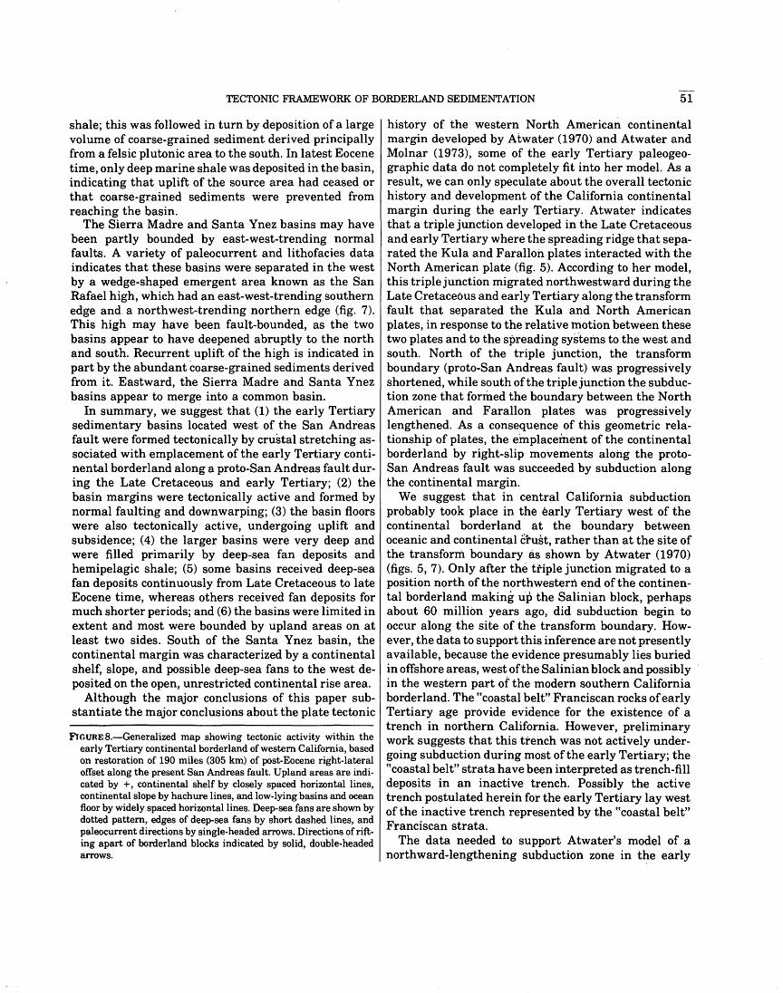
TECTONIC FRAMEWORK OF BORDERLAND SEDIMENTATION 51
shale; this was followed in turn by deposition of a large volume of coarse-grained sediment derived principally from a felsic plutonic area to the south. In latest Eocene time, only deep marine shale was deposited in the basin, indicating that uplift of the source area had ceased or that coarse-grained sediments were prevented from reaching the basin.
The Sierra Madre and Santa Ynez basins may have been partly bounded by east-west-trending normal faults. A variety of paleocurrent and lithofacies data indicates that these basins were separated in the west by a wedge-shaped emergent area known as the San Rafael high, which had an east-west-trending southern edge and. a northwest-trending northern edge (fig. 7). This high may have been fault-bounded, as the two basins appear to have deepened abruptly to the north and south. Recurrent uplift of the high is indicated in part by the abundant coarse-grained sediments derived from it. Eastward, the Sierra Madre and Santa Ynez basins appear to merge into a common basin.
In summary, we suggest that (1) the early Tertiary sedimentary basins located west of the San Andreas fault were formed tectonically by crustal stretching associated with emplacement of the early Tertiary continental borderland along a proto-San Andreas fault during the Late Cretaceous and early Tertiary; (2) the basin margins were tectonically active and formed by normal faulting and downwarping; (3) the basin floors were also tectonically active, undergoing uplift and subsidence; ( 4) the larger basins were very deep and were filled primarily by deep-sea fan deposits and hemipelagic shale; (5) some basins received deep-sea fan deposits continuously from Late Cretaceous to late Eocene time, whereas others received fan deposits for much shorter periods; and (6) the basins were limited in extent and most were bounded by upland areas on at least two sides. South of the Santa Ynez basin, the continental margin was characterized by a continental shelf, slope, and possible deep-sea fans to the west deposited on the open, unrestricted continental rise area.
Although the major conclusions of this paper substantiate the major conclusions about the plate tectonic
FlGURE8.-Generalized map showing tectonic activity within the early Tertiary continental borderland of western California, based on restoration of 190 miles (305 km) of post-Eocene right-lateral offset along the present San Andreas fault. Upland areas are indicated by +, continental shelf by closely spaced horizontal lines, continental slope by hachure lines, and low-lying basins and ocean floor by widely spaced horizontal lines. Deep-sea fans are shown by dotted pattern, edges of deep-sea fans by short dashed lines, and paleocurrent directions by single-headed arrows. Directions of rifting apart of borderland blocks indicated by solid, double-headed arrows.
history of the western North American continental margin developed by Atwater (1970) and Atwater and Molnar (1973), some of the early Tertiary paleogeographic data do not completely fit into her model. As a result, we· can only speculate about the overall tectonic history and development of the California continental margin during the early Tertiary. Atwater indicates that a triple junction developed in the Late Cretaceous and early Tertiary where the spreading ridge that separated the Kula and Faralloil plates interacted with the North American plate (fig. 5). According to her model, this triple junction migrated northwestward during the Late Cretaceous and early Tertiary along the transform fault that separated the Kula and North American plates, in response to the relative motion between these two plates and to the spreading systems to the west and south. North of the triple junction, the transform boundary (proto-San Andreas fault) was progressively shortened, while south of the triple junction the subduction zone that formed the boundary between the North American and Farallon plates was progressively lengthened. As a consequence of this geometric relationship of plates, the emplacement of the continental borderland by right-slip movements along the protoSan Andreas fault was succeeded by subduction along the continental margin.
We suggest that in central California subduction probably took place in the early Tertiary west of the continental borderland at the boundary between oceanic and continental ci"ust, rather than at the site of the transform boundary as shown by Atwater (1970) (figs. 5, 7). Only after the triple junction migrated to a position north of the northwestern end of the continental borderland making u·p the Salinian block, perhaps about 60 million years ago, did subduction begin to occur along the site of the transform boundary. However, the data to support this inference are not presently available, because the evidence presumably lies buried in offshore areas, west of the Salinian block and possibly in the western part of the modern southern California borderland. The ucoastal belt" Franciscan rocks of early Tertiary age provide evidence for the existence of a trench in northern California. However, preliminary work suggests that this trench was not actively undergoing subduction during most of the early Tertiary; the ((coastal belt" strata have been interpreted as trench-fill deposits in an inactive trench. Possibly the active trench postulated herein for the early Tertiary lay west of the inactive trench represented by the ucoastal belt" Franciscan strata.
The data needed to support Atwater's model of a northward-lengthening subduction zone in t~e early

52 TERTIARY SEDIMENTATION AND TECTONICS, CONTINENTAL BORDERLAND OF CALIFORNIA
Tertiary along the contact between the Farallon and North American plates are not available from the onshore record of the lower Tertiary strata. The only concrete evidence for a trench exists in the record of the ucoastal belt" Franciscan rocks, where preliminary data indicate evidence for subduction continuing only up to the middle Paleocene (Berkland, 1972). If Atwater's model is correct, the subduction zone should have been initiated at successively later times toward the north.
It may be possible that the subduction of the Farallon plate in the early Tertiary was very slow or that it proceeded in such a manner that evidence for active subduction in the ~~coastal belt" Franciscan strata of northern California is not clearly recognizable. The extensive volcanic activity throughout California that began in Oligocene time is probably related to subduction of the Farallon plate; the rate of subduction may have increased along the postulated offshore trench and subduction zone to the west during the Oligocene. Much additional study of early Tertiary sedimentary rocks in the ~~coastal belt" Franciscan, San Francisco Bay region, and offshore areas will be required to satisfactorily resolve some of the large-scale problems of the early Tertiary tectonic history of California.
SUMMARY AND CONCLUSIONS
Recent geologic studies suggest that 135-260 miles (220-420 km) of right-lateral offset occurred along a proto-San Andreas· fault in central and northern California during Late.Cretaceous and early Paleocene time (fig. 4). Mid-Mesozoic granitic basement rocks in the Salinian block have been offset northwestward between 325 and 450 miles (520-720 km) from the southern end of the Sierra Nevada (Hill and Dibblee, 1953; Curtis and others, 1958). Displacements along the present San Andreas fault appear to be limited to about 190 miles (305 km), an offset which has been demonstrated for rocks of late Paleocene, Eocene, Oligocene, and Miocene (about 22 and 23.5 m.y. old) age. These displacements indicate that right-lateral slip did not occur between early Paleocene and early Miocene time and that the offset observed on the present San Andreas fault results entirely from post-early Miocene movements (Turner, 1968, 1969; Turner and others, 1970; Huffman, 1972a, b; Huffman and others, 1973; Clarke and Nilsen, 1972, 1973; Nilsen and Clarke, 1972; Clarke, 1973; Dickinson and others, 1972; Matthews, 1973a, b; Nilsen, Dibblee, and Simoni, 197 4). The remaining offset of 135-260 miles (220-420 km) was taken up by the proto-San Andreas fault (Suppe, 1970). This conclusion is supported by a tentative reconstruction of plate motions in the eastern Pacific which suggest that interaction of the North American and Kula plates resulted in rightlateral transform faulting of the California continental margin from about 80 to 60 m.y. ago (Atwater, 1970).
The trace of this old .fault in central and northern California is probably almost parallel to but west of the present San Andreas fault; it probably bypassed the present onshore southern California area and is located in the present continental borderland west of southern California and northern Baja California. Part of it may be preserved onshore in southern Baja California (Minch and James, 1974).
Displacement of the Salinian block from the southern Sierra Nevada along the proto-San Andreas fault formed an elongate continental borderland which extended perhaps 200 miles (320 km) northwestward from the Mesozoic continental margin (fig. 7). This borderland probably consisted of granitic island uplands separated by deep marine basins, although the uplands may have been interconnected to form a long irregular peninsula. Preservation of the early Tertiary basins in the borderland areas, determination of fault offsets, and recognition that the Salinian block formed a borderland in the early Tertiary argue against emplacement of the Salinian block wholly during the Neogene (Johnson and Normark, 1974). The borderland may have been bounded on the west by an active subduction zone and trench (Atwater, 1970), which possibly extended northwestward through the present northern Coast Ranges of California where it could be represented by the ucoastal belt" Franciscan rocks (Berkland, 1972).
The sedimentary record indicates that the borderland was tectonically active; sedimentation was rapid and both basins and source areas were mobile. Uplift and vigorous erosion of granitic and metamorphic terranes is also suggested by the arkosic composition, freshness, angularity, and coarseness of sands derived from this region, and by the presence of pebble to boulder-size clasts of plutonic and gneissic rock. Very well rounded pebbles and cobbles of quartz, quartzite, chert, and porphyritic volcanic rock are common, indicating that older sedimentary rocks, including conglomerates, were also present in many borderland source areas.
Some basins subsided to bathyal-abyssal depths. Paleocurrent directions in basin deposits are varied, and in some cases, suggest that basins received sediments from two or more sides. Most of these deposits were clearly derived from source areas within the borderland. Shallow-marine deposits are rare, possibly due to subsequent deformation and erosion of basin margins. However, their absence also suggests that shallow-marine shelves were not well developed, so that sediments were transported from source areas directly to deep-marine environments.
Clastic sediments from borderland sources were deposited mostly as submarine fans, some of which apparently spilled eastward out of the borderland onto the floor of the San Joaquin basin. Some deposits represent several fans which coalesced to form a single, large

SUMMARY AND CONCLUSIONS 53
composite fan. The major early Tertiary deep-sea fans c;>f the borderland were: (1) an early Paleocene to middle Eocene fan comprising the present German Rancho Formation ofWentworth (1968) in the Gualala area, the Cantua Sandstone Member of the Lodo Formation in the Vallecitos area and possibly the Tres Pinos Sandstone of Kerr and Schenck (1925) in the Bolado Park area; (2) an early to late Eocene fan comprising the Butano Sandstone in the Santa Cruz Mountains and the Point of Rocks Sandstone in the southern· Diablo and northern Temblor Ranges; (3) a middle and late Eocene fan represented by The Rocks Sandstone of Thorup (1941) in the northern Santa Lucia Range; and (4) Late Cretaceous, Paleocene, and Eocene fans represented by deep-marine sandstone and conglomerate in the La Panza, southern Santa Lucia, and Sierra Madre Ranges. Other large deep-sea fans are represented by similar deposits located to the south in the Santa Ynez Mountains and adjacent areas (Stauffer, 1965, 1967; Link, 1971, 1972; O'Brien, 1972; Sage, 1973; Howell, 1974; Van de Camp and others, 1974). Smaller submarine fans may have developed within the borderland in the Point Reyes, Point San Pedro, and Point Lobos areas.
The deep-sea fan deposits are mostly thickly bedded, medium- to coarse-grained sandstone, but pebble to boulder conglomerates are prominent in several areas. They were probably funneled into the basin through submarine canyons; however, the sedimentary record of such basin margin deposition has been largely obliterated by post-Eocene uplift and erosion. Upper and middle fan facies dominate the fan deposits which are preserved, undoubtedly reflecting the coarseness and great volume of sediments, high rate of influx, and perhaps factors such as multiple sources of supply and physical restrictions on lateral growth of the fans. Upper fan facies comprise thickly bedded coarse-grained sandstones and conglomerates (interpreted as channel deposits) which are vertically and laterally juxtaposed with thinly interbedded sandstone, siltstone, and shale (interpreted as levee and interchannel deposits). Middle fan facies consist mostly of thickly bedded, medium- to coarse-grained sandstone which forms laterally discontinuous beds, reflecting the migration of major channels through time. These coarse-grained deposits bear evidence of deposition by various subaqueous gravity flow processes, including turbidity currents, fluidized sediment flows, and grain flows (Middleton and Hampton, 1973). Pebbly mudstones are generally rare in the borderland deposits.
Distal fan facies comprise thinly interbedded sandstones, siltstones, and shales, and more rarely, channel sandstones. This facies appears to have been poorly developed in borderland fans. Most very fine terrigenous sediments probably were transported in suspension
beyond the borderland where they were deposited on the adjacent ocean floors. with clay and pelagic detritus to form hemipelagic shale, siltstone, and mudstone. The Kreyenhagen Formation in the San Joaquin Valley and Brabb's (1964) Twobar Shale Member of the San Lorenzo Formation in the Santa Cruz Mountains represent such deposits. These fine-grained sediments also accumulated on deep-sea fans when and where coarsegrained clastic sedimentation was not occurring. Siliceous and phosphatic shales characterize the Kreyenhagen Formation and several other deep marine shale deposits (Dickert, 1966).
Large, deep-sea fans constructed westward from sources in the Sierra Nevada and Peninsular Ranges include (1) the Markley fan, of late Eocene age, represented by deep-marine sandstones in the Markley Sandstone Member of the Kreyenhagen Formation north of Mount Diablo, and (2) the Poway fan (Yeats and others, 197 4), of Eocene to Oligoecene age, which has been reconstructed from shallow to deep marine conglomerate and sandstone presently exposed in the Santa Monica and Santa Ana Mountains, and on San Nicolas, Santa Rosa, Santa Cruz, and San Miguel Islands. The Poway fan deposits are thought to represent a delta which graded offshore westward into a large, unrestricted deep-sea fan of the open ocean, perhaps the only fan of this type preserved in the early Tertiary rock record of the California continental margin. Smaller fans from several different source areas are probably represented by various lower Tertiary deposits in the San Jose area. Other fans may have been constructed at the bases of ccgorges" thought to represent submarine canyons, such as the Paleocene and early Eocene Meganos and Capay (Princeton) gorges of the Sacramento Valley.
East of the borderland, lower and middle Eocene shallow-marine sedimentary rocks derived from the Sierra Nevada and Peninsular Ranges contain quartzose_, anauxitic, feldspar-deficient sandstone, residual pisolitic claystone, and conglomerate composed principally of resistant clast types (e.g., quartz, quartzite, chert, metavolcanic, and metasedimentary rocks). These deposits suggest a history of prolonged chemical weathering and a relatively quiet tectonic history. Upper Eocene and Oligocene deposits, in contrast, are composed largely arkosic and lithic sandstone, and conglomerates containing cobble to boulder-size clasts of granitic rock, suggesting increasing tectonic activity attended by uplift and rapid erosion. Along the east flank of the Diablo Range and in the northern Coast Ranges, middle Eocene and older shallow-~arine and brackish-water sandstones contain glaucophane, serpentine, radiolarian chert pebbles, and other indicators of derivation from within the Franciscan assemblage, indicating that portions of the Diablo Range and north-

54 TERTIARY SEDIMENTATION AND TECTONICS, CONTINENTAL BORDERLAND OF CALIFORNIA
ern Coast Ranges were emergent during Paleocene and Eocene time.
The complete record of early Tertiary sedimentation and tectonics in California is characteristic of the complexities developed along transform fault boundaries that involve continental margins. The history of events and variety of processes that acted in the shelf, slope, ocean floor, trench, and borderland areas yielded aremarkably varied and rapidly changing paleogeography; related events and processes have continued to the present, yielding the complex geography of modern California along the modern San Andreas transform fault.
REFERENCES CITED
Abbott, P. L., and Peterson, G. L., 1974, Durability of selected rock types in simulated fluvial transport, with application to the Eocene Poway conglomerates of the San Diego area, California [abs.]: Geol. Soc. America Abs. with Programs, v. 6, no. 3, p. 137.
Addicott, W. 0., 1968, Mid-Tertiary zoogeographic and paleogeographic discontinuities across the San Andreas fault, California, in Dickinson, W. R., and Grantz, Arthur, eds., Proc. Conf. Geol. Problems of San Andreas fault system: Stanford Univ. Pubs. Geol. Sci., v. 11, p. 144-165.
Allen, J. E., 1946, Geology of the San Juan Bautista quadrangle, California: California Div. Mines Bull. 133, p. 9-75.
Allen, V. T., 1929, The lone Formation of California: California Univ. Pubs. Dept. Geol. Sci. Bull., v. 18, no. 14, p. 347-448.
--1941, Eocene anauxitic clays and sands in the Coast Ranges of California: Geol. Soc. America Bull., v. 52, no. 2, p. 271-294.
Allison, E. C., 1966, One hundred million years at the rim of the Pacific-Northern Baja and Southern Alta California [abs.]: Geol. Soc. America, Ann. Mtg., San Francisco, Calif., p. 2-3.
Almgren, A. A., and Schlax, W. N., 1957, Post-Eocene age of"Markley Gorge" fill, Sacramento Valley, California: Am. Assoc. Petroleum Geologists Bull., v. 41, no. 2, p. 32~330.
Anderson, Robert, and Pack, R. W., 1915, Geology and oil resources of the west border of the San Joaquin Valley north of Coalinga, California: U.S. Geol. Survey Bull. 603, 220 p.
Atwater, Tanya, 1970, Implications of plate tectonics for the Cenozoic tectonic evolution of western North America: Geol. Soc. America Bull., v. 81, no. 11, p. 3513-3536.
Atwater, Tanya, and Molnar, Peter, 1973, Relative motion of the Pacific and North American plates deduced from sea-floor spreading in the Atlantic, Indian, and South Pacific Oceans, in Kovach, R. L., and Nur, Amos, eds., Proc. Conf. Tectonic Problems of the San Andreas fault system: Stanford Univ. Pubs. Geol. Sci., v. 13, p. 13~148.
Axelrod, D. 1., 1949, Eocene and Oligocene formations in the western Great Basin [abs.]: Geol. Soc. America Bull., v. 60, no. 12, p. 1935--1936.
Badger, R. L., 1957, Geology of the western Lion Canyon quadrangle, Ventura County, California: California Univ., Los Angeles, M.A. thesis, 84 p.
Bailey, E. H., ed., 1966, Geology of northern California: Calif. Div. Mines and Geology Bull. 190, 508 p.
Bailey, E. H., and Blake, M. C., Jr., 1969, Late Mesozoic tectonic development of western California: Geotectonics, no. 3, p. 148-154, 225--230.
Bailey, E. H., Blake, M. C., Jr., and Jones, D. L., 1970, On-land Mesozoic oceanic crust in California Coast Ranges: U.S. Geol. Survey Prof. Paper 700-C, p. C70-C81.
Bailey, E. H., and Everhart, D. L., 1964, Geology and quicksilver
deposits of the New Almaden district, Santa Clara County, California: U.S, Geol. Survey Prof. Paper 360, 206 p.
Bailey, E. H., and Irwin, W. P., 1959, K-feldspar content of Jurassic and Cretaceous graywackes of northern Coast Ranges and Sacramento Valley, California: Am. Assoc. Petroleum Geologists Bull., v. 43, no. 12, p. 2797-2809.
Bailey, E. H., Irwin, W. P., and Jones, D. L., 1964, Franciscan and related rocks and their significance in the geology of western California: Calif. Div. Mines and Geology Bull. 183, 177 p.
Bailey, T. L., 1930, The geology of the Potrero Hills and Vacaville region, Solano County, California: California Univ. Dept. Geol. Sci. Bull., v. 19, p. 321-333. ·
Bartow, J. A., 1974, Oligocene alluvial sedimentation in the Caliente Range, California [abs.]: Geol. Soc. America Abs. with Programs, v. 6,no. 3, p. 142-143.
Bateman, P. C., and Wahrhaftig, C., 1966, Geology of the Sierra Nevada, in Bailey, E. H., ed., Geology of northern California: Calif. Div. Mines and Geology Bull. 190, p. 107-172.
Bauer, P. G., 1971, Geology of the Redwood Retreat-Croy Ridge area of Santa Clara County, California: California State Univ ., San Jose, M.S. thesis, 7 4 p.
Bazely, William, 1961, 175 miles of lateral movement along the San Andreas fault since lower Miocene?: Pacific Petroleum Geologist, v. 15,no. 5,p. 2-3.
Beaulieu, J. D., 1970, Cenozoic stratigraphy of the Santa Cruz Mountains, California and inferred displacement along the San Andreas fault: Stanford Univ., Stanford, Calif., Ph.D. thesis, 202 p.
Beck, R. S., 1952, Correlation chart of Paleocene and Eocene on the Pacific Coast, in Field Trip routes, oil fields, geology: Am. Assoc. Petroleum Geologists-Soc. Econ. Paleontologists and Mineralogists-Soc. Explor. Geophysicists Guidebook, Joint Ann. Mtg., Los Angeles, Calif., 1952, p. 105.
Bellemin, G. J., and Merriam, R. H., 1958, Petrology and origin of the Poway Conglomerate, San Diego County, California: Geol. Soc. America Bull., v. 69, no. 2, p. 199-220.
Bennett, R. E., 1972, Geology of the Dexter Canyon area, Santa Clara County, California: California State Univ., San Jose, M.S. thesis, 64 p.
Berggren, W. A., 1972, A Cenozoic time-scale: Some implications for re~onal geology and paleobiogeography: Lethaia, v. 5, no. 2, p. 195--215.
Berkland, J. 0., 1969, Late Mesozoic and Tertiary sequence near the proposed Garrett Tunnel, Mendocino and Lake counties, California [abs.]: Geol. Soc. America Abs. with Programs, pt. 3, p. 4-5.
--1971, New occurrence of Cretaceous and Paleocene strata within Franciscan terrane of the northern Coast Ranges, California [abs.]: Geol. Soc. America Abs. with Programs, v. 3, no. 2, p. 81-82.
--1972, Paleogene "frozen" subduction zone in the Coast Ranges of northern California: Proc. 24th lnternat. Geol. Congress, Sec. 3, p. 99-105.
--1973, Rice Valley outlier-New sequence of CretaceousPaleocene strata in northern Coast Ranges, California: Geol. Soc. America Bull., v. 84, no. 7, p. 2389-2406.
Berkland, J. 0., Raymond, L.A., Kramer, J. C., Moores, E. M., and O'Day, Michael, 1972, What is Franciscan?: Am. Assoc. Petroleum Geologists Bull., v. 56, no. 12, p. 2295--2302.
Berry, K. D., 1964, Tertiary micropaleontology, north side of Mt. Diablo: Geol. Soc. Sacramento Guidebook and Field Trip to the Mt. Diablo area, p. 48-53.
Beveridge, A. J., 1958, Heavy minerals in lower Tertiary formations in the Santa Cruz Mountains, California: Stanford Univ., Stanford, Calif., Ph.D. thesis, 109 p.
Bishop, W. C., 1950, Geology of south flank of Santa Susanna

REFERENCES CITED 55
Mountains, ~ounty line to Limekiln Canyon, Los Angeles County, ·California: California Univ., Los Angeles, M.A. thesis, 115 p.
Blaisdell, R. C., 1955, The stratigraphy and Foraminifera of the Matilija, Cozy Dell, and "Coldwater" formations near Ojai, California: California Univ., Berkeley, M.A. thesis, 93 p.
Bohannon, R. G., 1974, Mid-Tertiary nonmarine phase of southern California geologic history [abs.]: Geol. Soc. America Abs. with Programs, v. 6,no. 3,p. 146.
Booth, C. V., 1950, Geology of the west-central portion of the Orestimba quadrangle: California Univ., Berkeley, M.A. thesis, 58 p.
Bowen, 0. E., 1965a, Stratigraphy, structure and oil possibilities in Monterey and Salinas quadrangles, California, in Symposium of Papers: Pacififi Sec., Am. Assoc. Petroleum Geologists Ann. Mtg., Bakersfield, Calif., 1965, p. 48--67.
--1965b, Point Lobos, a geologic guide: California Div. Mines and Geology Mineral lnf. Service, v. 18, no. 4, p. 60--67.
Brabb, E. E., 1960, Geology of the Big Basin area, Santa Cruz Mountains, California: Stanford Univ., Stanford, Calif., Ph.D. thesis, 192 p.
---1964, Subdivision of San Lorenzo Formation (EoceneOligocene), west-central California: Am. Assoc. Petroleum Geologists Bull., v. 48, no. 5, p. 670--679.
Brabb, E. E., Bukry, David, and Pierce, R. L., 1971, Eocene (Refugian) nannoplankton in the Church Creek Formation near Monterey, central California: U.S. Geol. Survey Prof. Paper 750--C, p. C44-C47.
Brabb, E. E., and Pampeyan, E. H., 1972, Preliminary geologic map of San Mateo County, California: U.S. Geol. Survey Misc. Field Studies Map MF-328, scale 1:62,500.
Brice, J. C., 1953, Geology of Lower Lake quadrangle, California: Calif. Div. Mines and Geology Bull. 166, 72 p.
Briggs, L. I., 1953, Geology of the Ortigalita Peak quadrangle, California: Calif. Div. Mines and Geology Bull. 167, 61 p.
Bukry, David, and Kennedy, M. P., 1969, Cretaceous and Eocene coccoliths at San Diego, California: Calif. Div. Mines and Geology Spec. Rept. 100, p. 33--43.
Burtner, R. L., 1959, Geology of the upper Crystal Springs Reservoir-Cahill Ridge area, San Mateo County, California: Stanford Univ., Stanford, Calif., unpub. School of Mineral Sci. Rept.
Buwalda, J. P., 1954, Geology of the Tehachapi Mountains, California, in Jahns, R. H., ed., Geology of southern California: California Div. Mines Bull. 170, p. 131-142.
Campbell, R. H., Blackerby, B. A., Yerkes, R. F., Schoellhamer, J. E., Birkeland, P. W., and Wentworth, C. M., 1970, Preliminary geologic map of the Point Dume quadrangle, Los Angeles County, California: U.S. Geol. Survey open-file map, scale 1:24,000.
Carman, M. F., 1964, Geology of the Lockwood Valley area, Kern and Ventura Counties, California: Calif. Div. Mines and Geology Spec. Rept. 81, 62 p.
Carter, C. H., 1970, Geology of the Palassou Ridge area, California: California State Univ., San Jose, M.S. thesis, 70 p.
Carter, N. L., 1958, Geology of the Fernwood-Topanga Park area, Santa Monica Mountains, California: California Univ., Los Angeles, M.A. thesis, 99 p.
Case, J. E., 1963, Geology of a portion of the Berkeley and San Leandro Hills, California: California Univ., Berkeley, Ph.D. thesis, 319 p.
---1968, Upper Cretaceous and lower Tertiary rocks, Berkeley and San Leandro Hills, California: U.S. Geol. Sur\rey Bull. 1251-J, p. J1-J29.
Castro, M. J., 1967, Geology and oil potential of the area westerly of San Juan Bautista, California, in Gabilan Range and adjacent San Andreas fault: Pacific Sees., Am. Assoc. Petroleum Geologists
and Soc. Econ. Paleontologists and Mineralogists, Field Trip Guidebook, p. 81-86.
Champeny, J.D., 1961, Paleocene and Upper Cretaceous stratigraphy of Santa Ynez Canyon and adjacent areas, Santa Monica Mountains, California: California Univ., Los Angeles, M.A. thesis, 52 p.
Chipping, D. H., 1969, Lower Tertiary rocks of the La Panza, southern Santa Lucia, and Sierra Madre Ranges, California, in Dickinson, W. R., chm., Geologic setting of upper Miocene gypsum and phosphorite deposits, upper Sespe Creek and Pine Mountain, Ventura County, California: Soc. Econ. Paleontologists and Mineralogists, Pacific Sec., Field Trip Guidebook, p. 27-40.
--1970a, The petrology and paleogeography of Cretaceous and lower Tertiary strata in the vicinity of Cuyama Valley, California: Stanford Univ., Stanford, Calif., Ph.D. thesis, 179 p.
--1970b, Late Cretaceous and Eocene paleogeography of the La Panza, southern Santa Lucia, and Sierra Madre Ranges, Califo.rnia [abs.]: Geol. Soc. America Abs. with Programs, v. 2, no. 2, p. 80.
--1971, Franciscan Formation near Bodega Bay and Jenner, California, in Lipps, J. H., and Moores, E. M., eds., Geologic Guide to the northern Coast Ranges, Point Reyes region, California: Geol. Soc. Sacramento Ann. Field Trip Guidebook, p. 47-57.
--1972a, Early Tertiary paleogeography of central California: Am. Assoc. Petroleum Geologists Bull., v. 56, no. 3, p. 480--493.
--1972b, Sedimentary structures and environment of some thick sandstone beds of turbidite type: Jour. Sed. Petrology, v. 42, no. 3, p. 587-595.
Christiansen, R. L., 1961, Structure, metamorphism, and plutonism in the El Paso Mountains, Mojave Desert, California: Stanford Univ., Stanford, Calif., Ph.D. thesis, 180 p.
Clark, B. L., and Campbell, A. S., 1942, Eocene radiolarian faunas from the Mt. Diablo area, California: Geol. Soc. America Spec. Paper 39, 112 p.
Clark, B. L., and Vokes, H. E., 1936, Summary of marine Eocene sequence of western North America: Geol. Soc. America Bull., v. 47, no. 6, p. 851-878.
Clark, B. L., and Woodford, A. 0., 1927, The geology and paleontology of the type section of the Meganos formation of California: California Univ. Pubs. Geol. Sci., v. 17, no. 2, p. 63--142.
Clark, J. C., 1966, Tertiary stratigraphy of the Felton-Santa Cruz area, Santa Cruz Mountains, California: Stanford Univ., Stanford, Calif., Ph.D. thesis, 179 p.
--1968, Correlation of the Santa Cruz Mountains TertiaryImplications for San Andreas history, in Dickinson, W. D., and Grantz, Arthur, eds., Proc. Conf. Geol. Problems of San Andreas fault system: Stanford Univ: Pubs. Geol. Sci., v. 11, p. 166--180.
Clark, J. C., and Reitman, J. D., 1973, Oligocene stratigraphy, tectonics, and paleogeography southwest of the San Andreas fault, Santa Cruz Mountains and Gabilan Range, California Coast Ranges: U.S. Geol. Survey Prof. Paper 783, 18 p.
Clark, L. D., 1970, Geology of the San Andreas 15-minute quadrangle, Calaveras County, California: California Div. Mines and Geology Bull. 195, 23 p.
Clark, S. G., 1940, Geology of the Covelo district, Mendocine County, California: California Univ. Dept. Geol. Sci. Bull., v. 25, no. 2, p. 119--142.
Clark, S. H., Jr., 1973, The Eocene Point of Rocks SandstoneProvenance, mode of deposition, and implications for the history of offset along the San Andreas fault in central California: California Univ., Berkeley, Ph.D. thesis, 302 p.
Clarke, S. H., Jr., and Nilsen, T. H., 1972, Postulated offsets of Eocene strata along the San Andreas fault zone, central California [abs.]: Geol. Soc. America Abs. with Programs, v. 4, no. 3, p. l37-138.
56 TERTIARY SEDIMENTATION AND TECTONICS, CONTINENTAL BORDERLAND OF CALIFORNIA
--1973. Di8placement of Eocene strata and implications for the hi8tory of ofrset along the San Andreas fault, central and northern California, in Kovach, R. L., and Nur, Amos, eds., Proc. Conf. Tectonic Problems of the San Andreas fault system: Stanford Univ. Pubs. Geol. Sci., v. 13, p. 358-367.
Clements. Thomas, 1937, Structure of the southeastern part of the Tejon quadrangle, California: Am. Assoc. Petroleum Geologists Bull.. v. 21. p. 212-232.
Colburn, Ivan, 1961, The tectonic history of Mt. Diablo, California: Stanford Univ., Stanford, Calif., Ph.D. thesis, 276 p.
--1964, The Mesozoic stratigraphy in the vicinity of Mount Diablo, California: Geol. Soc. Sacramento Guidebook and Field Trip to the Mt. Diablo area, p. 9-22.
Cole, M. R., 1970, Paleocurrent and basin analysis on San Nicolas Island, California: Ohio Univ., Athens, Ohio, M.S. thesis, 110 o.
--1973, Paleocurrent and basin analysis on San Nicolas Island, California [abs.]: Geol. Soc. America Abs. with Programs, v. 5, no. 1, p. 24.
Collins, D. F., 1949, The geology of the southern third of the Orestimba quadrangle, Stanislaus and Merced Counties, California: ·California Univ., Berkeley, M.A. thesis, 54 p.
Conrad, S.D., 1949, Geology of the eastern portion of the Simi Hills, Los Angeles and Ventura Counties, California: California Univ., Los Angeles, M.A. thesis, 41 p.
Creely, R. S., 1965, Geology of the Oroville (15') quadrangle, Butte County, California: California Div. Mines and Geology Bull. 184, 86 p.
Crowell, J. C., 1962, Displacement along the San Andreas fault, California: Geol. Soc. America Spec. Paper 71, 61 p.
--1972, Sedimentation along continental transform faults [abs.]: Geol. Soc. America Abs. with Programs, v. 4, no. 3, p. 141.
---1973a, Problems concerning the San Andreas fault system in southern California, in Kovach, R. L., and Nur, Amos, eds., Proc. Conf. Tectonic Problems of the San Andreas fault system: Stanford Univ. Pubs. Geol. Sci., v. 13, p. 125-135.
---1973b, Origin of late Cenozoic basins in southern California [abs.]: Am. Assoc. Petroleum Geologists Bull., v. 57, no. 4, p. 774.
--1974, Sedimentation along the San Andreas fault, California, in Dott, R. H., Jr., and Shaver, R. H., eds., Modem and ancient geosynclinal sedimentation: Soc. Econ. Paleontologists and Mineralogists Spec. Pub. 19, p. 292-303.
Crowell, J. C., and Susuki, Takeo, 1959, Eocene stratigraphy and paleontology, Orocopia Mountains, southeastern California: Geol. Soc. America Bull., v. 70, no. 5, p. 581-592.
Cummings, J. C., Touring, R. M., and Brabb, E. E., 1962, Geology of the northern Santa Cruz Mo1,111tains, California: California Div. Mines and Geology Bull. 181, p. 179-220.
Curtis, G. H., Evernden, J. F., and Lipson, Joseph, 1958, Age determination of some granitic rocks in California by the potassium-argon method: California Div. Mines Spec. Rept. 54, 16 p.
Cushman, J. A., and McMasters, J. H., 1936, Middle Eocene Foraminifera from the Llajas Formation, Ventura County, California: Jour. Paleontology, v. 10, no. 6, p. 497-517.
Dalrymple, G. B., 1964, Cenozoic chronology ofthe Sierra Nevada, California: California Univ. Pubs. Geol. Sci., v. 47, 41 p.
Darrow, R. L., 1963, Franciscan Formation in the Montara Mountain quadrangle: California Div. Mines and Geology Spec. Rept. 78, 23 p.
Davis, G. A., and Burchfiel, B. C., 1973, Garlock fault: An intracontinental transform structure, southern California: Geol. Soc. America Bull., v. 84, no. 4, p. 1407-1422.
Day, D. W., Jr., 1951, The geology of a part of the Mt. Vaca quadrangle: Calif~rn.ia Univ., Berkeley, M.A. thesis, 58 p.
DeLise, K. C., 1967, Biostratigraphy of the San Emigdio Formation, Kern County, California: California Univ. Pubs. Geol. Sci., v. 68, p. 1-66.
Delisle, M., Morgan, J. R., Heldenbrand, J., and Gastil, R. G., 1965, Lead-alpha ages and possible sources of metavolcanic rock clasts in the Poway Conglomerate, southwest California: Geol. Soc. America Bull., v. 76, no. 9, p. 1069-1074.
Dempster, R. E., 1951, Geology of the northeastern part of the Gonzales quadrangle, California: California Univ., Berkeley, M.A. thesis, 62 p.
Dibblee, T. W., Jr., 1950, Geology of southwestern Santa Barbara County, California-Point Arguello, Lompoc, Point Conception, Los Olivos, and Gaviota quadrangles: Calif. Div. Mines and Geology Bull. 150, 95 p.
--1952, Geology of the Saltdale quadrangle, California: Calif. Div. Mines and Geology Bull. 160, p. 7-43.
---1961, Geologic structure of the San Emigdio Mountains, Kern County, California: Pacific Sees., Soc. Econ. Paleontologist and Mineralogists-Soc. Exploration Geophysicists-Am. Assoc. Petroleum Geologists, and San Joaquin Geol. Soc. Spring Field Trip Guidebook, 1961, p. 2-6.
---1966a, Geology of the central Santa Ynez Mountains, Santa Barbara County, California: Calif. Div. Mines and Geology Bull. 186, 99 p.
---1966b, Evidence for cumulative offset on the San Andreas fault in central and northern California, in Bailey, E. H., ed., Geology of northern California: Calif. Div. Mines and Geology Bull. 190, p. 375-384.
--1966c, Geologic map of the Palo Alto 15-minute quadrangle, California: Calif. Div. Mines and Geology Map Sheet 8, scale 1:62,500.
--1967, Areal geology of the western Mojave Desert: U.S. Geol. Survey Prof. Paper 522, 153 p.
---1972a, Rinconada fault in southern Coast Ranges, California and its significance [abs.]: Am. Assoc. Petroleum Geologists Bull., v. 57, no. 2, p. 432.
---1972b, Geologic map of the San Benito quadrangle, California: U.S. Geol. Survey open-file map, scale 1:62,500.
---1973a, Preliminary geologic map of the Mt. Madonna quadrangle, Santa Clara and Santa Cruz Counties, California: U.S. Geol. Survey open-file map, scale 1:24,000.
---1973b, Preliminary geologic maps of the Gilroy, Gilroy Hot Springs, Mt. Sizer, and Morgan Hill quadrangles, Santa Clara County, California: U.S. Geol. Survey open-file maps, scale 1:24,000.
--1973c, Stratigraphy ofthe southern Coast Ranges near the San Andreas fault from Cholame to Maricopa, California: U.S. Geol. Survey Prof. Paper 764, 45 p.
--1973d, Geologic maps of the Gonzales and Hollister quadrangles, California: U.S. Geol. Survey open-file maps, scale 1:62,500.
--1973e, Regional geologic map of San Adreas and related faults in Carrizo Plain, Temblor, Caliente, and La Panza Ranges and vicinity: U.S. Geol. Survey Misc. Geol. Inv. Map I-757, scale 1:125,000.
Dibblee, T. W., Jr., and Louke, G. P., 1970, Geologic map of the. Tehachapi quadrangle, Kern County, California: U.S. Geol. Survey Misc. Geol. Inv. Map I-607, scale 1:62,500.
Dibblee, T. W., Jr., and Nilsen, T. H., 1974, Lower Tertiary stratigraphy from the Panache Creek area to Domengine Creek area and Vallecitos area, California, in Payne, M. B., chm., The Paleogene ofthe Panoche Creek-Cantua Creek area, central California: Soc. Econ. Paleontologists and Mineralogists, Pacific Sec., Fall Field Trip Guidebook, p. 28-37.
Dickerson, R. E., 1914, Fauna of the Martinez Eocene of California: California Univ. Dept. Geol. Sci. Bull., v. 8, p. 61-180.
REFERENCES CITED 57
Dickert, P. F., 1966, Tertiary phosphatic facies of the Coast Ranges, in Bailey, E. H., ed., Geology of northern California: California Div. Mines and Geology Bull. 190, p. 289-304.
Dickinson, W. R., 1963, Tertiary stratigraphic sequence ofMt. Hancock Ranch area, Monterey and Kings Counties, California, in Guidebook to the geology of Salinas Valley: Pacific Sees., Am. Assoc. Petroleum Geologists and Soc. Econ. Paleontologists and Mineralogists Field Trip Guidebook, p. 41-53.
---1965, Tertiary stratigraphy of the Church Creek area, Monterey County, California: Calif. Div. Mines and Geology Spec. Rept. 86, p. 25-44.
--1969, Geologic problems in the mountains between Ventura and Cuyama, in Dickinson, W. R., chm., Geologic setting of upper Miocene gypsum and phosphorite deposits, upper Sespe Creek and Pine Mountain, Ventura County, California: Pacific Sec., Soc. Econ. Paleontologists and Mineralogists, Field Trip Guidebook, p. 1-23.
--1971, Clastic sedimentary sequences deposited in shelf, slope, and trough settings between magmatic arcs and associated trenches: Pacific Geologist, v. 3, p. 15-30.
Dickinson, W. R., Cowan, D. S., and Schweickert, W. A., 1972, Test of new global tectonics: Discussion: Am. Assoc. Petroleum Geologists Bull., v. 56, no. 2, p. 375-384.
Dickinson, W. R., and Grantz, Arthur, 1968, Indicated cumulative offsets along the San Andreas fault in the California Coast Ranges, in Dickinson, W. R., and Grantz, Arthur, eds., Proc. Conf. Geol. Problems of the San Andreas fault system: Stanford Univ. Pubs. Geol. Sci., v. 11, p. 117-119.
Doerner, D. P., 1968, Lower Tertiary biostratigraphy of Santa Cruz Island: California Univ., Santa Barbara, M.A. thesis, 112 p.
--1969, Lower Tertiary biostratigraphy of southwestern Santa Cruz Island, in Weaver, D. W., Geology of the northern Channel Islands: Pacific Sees., Am. Assoc. Petroleum Geologists and Soc. Econ. Paleontologists and Mineralogists Spec. Publ., p. 17-29.
Durham, D. L., 1963, Geology of the Reliz Canyon, Thompson Canyon, and San Lucas quadrangles, Monterey County, California: U.S. Geol. Survey Bull. 1141-Q, p. Q1-Q41.
--1964, Geology of the Cosio Knob and Espinosa Canyon quadrangles, Monterey County, California: U.S. Geol. Survey Bull. 1161-H, p. H1-H29.
--1965, Geology of the Jolon and Williams Hill quadrangles, Monterey County, California: U.S. Geol. Survey Bull. 1181-Q, p. Q1-Q27.
---1968, Geologic map of the Adelaida quadrangle, San Luis Obispo County, California: U.S. Geol. Survey Map GQ-768, scale 1:24,000.
--1974, Geology of the southern Salinas Valley area, California: U.S. Geol. Survey Prof. Paper 819, 111 p.
Durham, D. L., and Yerkes, R. F., 1964, Geology of oil resources of the eastern Puente Hills area, southern California: U.S. Geol. Survey Prof. Paper 420-B, p. B1-B62.
Durrell, Cordell, 1959, The Lovejoy Formation of northern California: California Univ. Pubs. Geol. Sci., v. 34, no. 4, p. 193-220.
---1966, Tertiary and Quaternary geology of the northern Sierra Nevada, in Bailey, E. H., ed., Geology of northern California: California Div. Mines and Geology Bull. 190, p. 185-197.
Effinger, W. L., 1936, Gaviota Formation of Santa Barbara County, California [abs.]: Geol. Soc. America Proc. for 1935, p. 351-352.
Engel, Rene, 1959, Geology of the Lake Elsinore quadrangle, California: California Div. Mines Bull. 146, p. 9-58.
Enos, Paul, 1965, Geology of the western Vallecitos syncline, San Benito County, California: California Div. Mines and Geology Map Sheet 5, scale 1:24,000.
Erickson, J. W., 1972, Paleoslope and petrographic analysis of the South Point Formation, Santa Rosa Island, California: California Univ., Santa Barbara, M.A. thesis, 60 p.
Ernst, W. G., 1970, Tectonic contact between the Franciscan melange and the Great Valley sequence-Crustal expression of a late Mesozoic Benioff zone: Jour. Geophys. Research, v. 75, no. 5, p. 886-901.
Eschner, Stan, 1969, Geology of the central part of the Fillmore quadrangle, Ventura County, California: Pacific Sec., Am. Assoc. Petroleum Geologists, Field Trip Guidebook, 1969, 4 7 p.
Esser, R. W., 1958, The reconnaissance geology of a part of the Woodside quadrangle, northeast of Skyline Boulevard, San Mateo County, California: Stanford Univ., Stanford, Calif., M.S. thesis, 78 p.
Evernden, J. F., and Kistler, R. W., 1970, Chronology of emplacement of Mesozoic batholithic complexes in California and western Nevada: U.S. Geol. Survey Prof. Paper 623, 42 p.
Fairbanks, H. W., 1896, Notes on the geology of eastern California: Am. Geologist, v. 17, p. 63-74.
Fairchild, W. W., Wesendunk, P.R., and Weaver, D. W., 1969, Eocene and Oligocene Foraminifera from the Santa Cruz Mountains, California: California Univ. Pubs. Geol. Sci., v. 81, 145 p.
Fantozzi, J. H., 1955, Stratigraphy and biostratigraphy of a portion of the Simi Hills on the south side of the Simi Valley: California Univ., Los Angeles, M.A. thesis, 68 p.
Fischer, P. J., 1971, An ancient (upper Paleocene) submarine canyon and fan-The Meganos Channel, Sacramento Valley, California [abs.]: Geol. Soc. America Abs. with Programs, v. 3, no. 2, p. 120.
Flynn, C. J., 1970a, Post-batholithic geology of the La Gloria-Presa Rodriguez area, Baja California, Mexico: Geol. Soc. America Bull., v. 81, p. 1789-1806.
--1970b, Eocene stratigraphy of northwestern Baja California, in Pacific slope of northern Baja California and adjacent Alta California: Pacific Secs.-Am. Assoc. Petroleum Geologists-Soc. Econ. Paleontologists and .Mineralogists, and Soc. Econ. Geophysicists, Field Trip Guidebook, p. 88-89.
Frames, D. W., 1955, Stratigraphy and structure of the lower Coyote Creek area, Santa Clara County, California: California Univ., Berkeley; M.A. thesis, 65 p.
Fulmer, C. V., 1964, The type Markley and Nortonville formations: Geol. Soc. Sacramento Guidebook·and Field Trip to the Mt. Diablo area, p. 54-59.
Galloway, A. J., 1961, The geology of the Point Reyes Peninsula: U.S. N atl. Park Service, Land Use Survey, proposed Point Reyes N atl. Seashore, Region Four Office, San Francisco, Calif., p. 30-34.
---1962, Field Trip 3-Point Reyes Peninsula and San Andreas fault zone: Calif. Div. Mines and Geol. Bull. 181, p. 391-398.
--1966, Field Trip-Point Reyes Peninsula and San Andreas fault zone, in Bailey, E.H., ed., Geology of northern California: Calif. Div. Mines and Geology Bull. 190, p. 429-440.
Gastil, R. G., and Jensky, Wallace, 1973, Evidence for strike-slip displacement beneath the Trans-Mexican volcanic belt, in Kovach, R. L., and Nur, Amos, eds., Proc. Conf. Tectonic Problems of the San Andreas fault system: Stanford Univ. Pubs. Geol. Sci., V. 13, p. 171-180.
Gastil, R. G., Phillips, R. P., and Rodriguez-Torres, Rafael, 1972, The reconstruction of Mesozoic California: Proc. 24th Internat. Geol. Congress, Sec. 3, p. 217-229.
Gibson, J. M., 1972, The Anita Formation and "Sierra Blanca Limestone" (Paleocene-early Eocene), western Santa Ynez Mountains, Santa Barbara County, California, in Weaver, D. W. (field trip leader), Central Santa Ynez Mountains, Santa Barbara County, California: Guidebook, Pacific Sees., Am. Assoc. Petroleum Geologists-Soc. Econ. Paleontologists and Mineralogists, Spring Field Trip, p. 16-19.
--1973a, Late Cretaceous age of strata mapped as "?Matilija Formation" (late Eocene), Lompoc quadrangle, Santa Barbara County, California: Geol. Soc. America Bull., v. 84, no. 5, p. 1705-1707.

58 TERT~J\RY SEDIM~NTATION AND TECTONICS, CONTINENTAL BORDERLAND OF CALIFORNIA
---1973b, Foraminifer.al and nannoplankton piostratigraphy, · paleoecology, and basinal reconstruction, Anita Formation, western Santa Ynez Mounta,ips, California [abs.]: Am. Assoc. Petroleum Geologists Bull., v. 57, no. 4, p. 781.
---1973c, Foraminiferal biostratigraphy of the Anita Formation, western Santa Ynez Mountains, Santa Barbara County, California: Southern Calif. Univ., Los Apgeles, M.S. thesis, 319 p.
Gibson, J. M., and Steineck, P. L., 1972a, Stratigraphic relations of Upper Cretaceous anp Eocene formations, San Diego coastal area, California: Discussion: Am. Assoc. Petroleum Geologists Bull., v. 56, no. 5, p. 971-972.
---1972b, Age and correlation of the Ulatisian and Narizian stages, California: Reply: Geol. Soc. America Bull., v. 83, no. 7, p. 2225-2232.
Gilbert, C. M., 1943, Tertiary sediments northeast of Morgan Hill, California: Am. Assoc. Petroleum Geologists Bull., v. 27, no. 5, p. 640-646.
Givens, C. R., 1974, Eocene molluscan biostratigraphy of the Pine Mountain area, Ventura County, California: California Univ. Pubs. Geol. Sci., v. 109, 107 p.
Golz, D. J., 1971, Selenodont artidactyls from the Eocene of southern California [abs.]: Geol. Soc. America Abs. with Programs, v. 3, no. 2, p. 125-126.
Golz, D. J., and Kennedy, M.P., 1971, Comparison of mammalian and invertebrate chronologies in the Eocene of southern California [abs.]: Geol. Soc. America Abs. with Programs, v. 3, no. 2, p. 125.
Gower, H. D., Vedder, J. G., Clifton, H. E., and Post, E. V., 1966, Mineral resources of the San Rafael primitive area, California: U.S. Geol. Survey Bull. 1230-A, p. A1-A28.
Graham, J. J., 1967, Early Tertiary Foraminifera from Jasper Ridge, San Mateo County, California [abs.]: Am. Assoc. Petroleum Geologists-Soc. Econ. Paleontologists and Mineralogists, Ann. Mtg., Los Angeles, Calif., 1967, Program, p. 68-69.
Graham, J. J., and Classen, W. J., 1955, A lower Eocene foraminiferal faunule from the Woodside area, San Mateo County, California: Cushman Found. Foram. Research Contr., v. 6, pt. 2, p. 1-38.
Gray, C. H., Jr., 1961, Geology of tlJI Corona South quadrangle and the Santa Ana Narrows area, Riverside, Orange, and San Bernardino Counties, California: California Div. Mines Bull. 178, p. 7-58.
Greene, H. G., 1970, Geology of southern Monterey Bay and its relationship to the ground-water basiP and salt-water intrusion: U.S. Geol. Survey open-file report, 50 p.
Grow, J. A., and Atwater, Tanya, 1970, Mid-Tertiary tectonic transition in the Aleutian arc: Geol. Soc. America Bull., v. 81, no. 12, p. 3715-3722.
Hackel, Otto, 1966, Summary of the geology of the Great Valley, in Bailey, E. H., ed., Geology of northern California: Calif. Div. Mines and Geology Bull. 190, p. ~17-238.
Hacker, R. N., 1950, The geology of the northwest corner of the Orestimba quadrangle and the northeast corner of the Mount Boardman quadrangle, California: California Univ., Berkeley, M.A. thesis, 42 p.
Hamilton, Warren, 1969, Mesozoic C~ifornia and the underflow of Pacific mantle: GeQl.. Soc. America Bull., v. 80, no. 12, p. 2409-2430. ·.
Hamilton, Warren, and Myers, W. :ij., ~966, Cenozoic tectonics of the western United States: Reviews of Geophysics, v. 4, no. 4, p. 509-549.
Hammond, P. E., 1958, Geology of the lower Santiago Creek area, San Emigdio Mountains, Kern Co~ty, California: California Univ., Los Angeles, M.A. thesis, 108 p.
Haner, B. E., 1971, Morp}lology and sediments of Redondo submarine fan, southern California: Geol. Soc. America Bull., v. 82, no. 9, p. 2413-2432.
Hanna, M.A., 1926, Geolo~ of the La Jolla quadrangle, California:
California Univ. Dept. Geol. Sci. Bull., v. 16, p. 187-246. Harris, Herbert, 1950, Geology of the Palomas Canyon-Castaic Creek
area, Los Angeles County, California: California Univ., Los Angeles, M.A. thesis, 72 p.
Harris, P. B., 1950, Geology of the Tunis-Pastoria Creek area, Kern County, California: California Inst. of Technology, Pasadena, M.S. thesis, 80 p.
Herold, C. L., 1936, Distribution of Eocene rocks in Santa Lucia Mountains, California: Am. Assoc. Petroleum Geologists Bull., v. 20, p. 481-494.
Herrera, L. J., Jr., 1951, Geology of the Tent Hills quadrangle, California: California Univ., Berkeley, M.A. thesis, 72 p.
Hill, M. L., 1971, A test of new global tectonics: Comparisons of northeast Pacific and California structures: Am. Assoc. Petroleum Geologists Bull., v. 55, no. 1, p. 3-9.
--1974, Is the San Andreas a transform fault?: Geology, v. 2, no. 11, p. 535-536.
Hill, M. L., Carlson, S. A., and Dibblee, T. W., Jr., 1958, Stratigraphy of Cuyama Valley-Caliente Range area, California: Am. Assoc. Petroleum Geologists Bull., v. 42, p. 2973-3000.
Hill, M. L., and Dibblee, T. W., Jr., 1953, San Andreas, Garlock, and Big Pine faults-A study of the character, history, and tectonic significanceoftheirdisplacement: Geol. Soc. America Bull., v. 64, no. 4, p. 443-458.
Hill, M. L., and Hobson, H. D., 1968, Possible post-Cretaceous slip on the San Andreas fault zone, in Dickinson, W. R., and Grantz, Arthur, eds., Proc. Conf. Geol. Problems of the San Andreas fault system, p. 123-129: Stanford Univ. Pubs. Geol. Sci., v. 11,374 p.
Holwerda, J. G., 1952, Geology ofthe Valyermo area: Southern Calif. Univ., Los Angeles, M.S. thesis, 53 p.
Hornaday, G. R., 1961, Foraminifera from the Sacate Formation south of Refugio Pass, Santa Barbara County, California: California Univ. Pubs. Geol. Sci., v. 37, p. 165-232. ·
---· 1965, An Eocene foraminiferal faunule from the northwestern Santa Ynez Mountains, California: Cushman Found. Foram. Research Contr., v. 16, no. 1, p. 29-39.
Hornaday, G. R., and Phillips, F. J., 1972, Paleogene correlations, Santa Barbara area, California-An alternative view, in Weaver, D. W. (field trip leader), Central Santa Ynez Mountains, Santa Barbara County, California: Guidebook, Pacific Sees., Am. Assoc. Petroleum Geologists and Soc. Econ. Paleontologists and Mineralogists Spring Field Trip, p. 59-71.
Howell, D. G., 1974, Eocene paleogeography of southern California and the San Andreas fault system: Pacific Sees., Am. Assoc. Petroleum Geologists, Soc. Econ. Paleontologists and Mineralogists, and Soc. Exploration Geophysics, Ann. Mtg., Prog., San Diego, Calif., p. 23-24.
Howell, D. G., Stuart, C. J., Platt, J.P., and Hill, D. J., 1974, Possible strike-slip faulting in the southern California borderland: Geology, v. 2,no. 2, p. 93-98.
Hsii, K. J., 1968, Principles of melangesand their bearing on the Franciscan-Knoxville paradox: Geol. Soc. America Bull., v. 79, no. 8,p. 1063-1074.
Huey, A. S., 1948, Geology of the Tesla quadrangle, California: Calif. Div. Mines and Geology Bull. 140, 75 p.
Huffman, 0. F., 1970 Miocene and post-Miocene offset on the San Andreas fault in central California [abs.]: Geol. Soc. America Abs. with Programs, v. 2, no. 2, p. 104-10~.
---1972a, Upper Miocene geology, lateral displacement of upper Miocene rocks and the history offault slip along the.San Andreas fault in central California: California Univ., Berkeley, Ph.D. thesis, 137 p.
---1972b, Lateral displacement of upper Miocene rocks and the Neogene history of offset along the San Andreas fault in central California: Geol. Soc. America Bull., v. 83, no. 10, p. 2913-2946.
Huffman, 0. F., Turner, 0. L., and Jack, R.N., 1973, Offset of late

REFERENCES CITED 59
Oligocene-early Miocene volcanic rocks along the San Andreas fault in central California, in Kovach, R.L., and Nur, Amos, eds., Proc. Conf. Tectonic Problems of the San Andreas fault system: Stanford Univ. Pubs. Geol. Sci., v. 13, p. 36~373.
Irwin, W. P., 1957, Franciscan Group in Coast Ranges and its equivalents in Sacramento Valley, California: Am. Assoc. Petroleum Geologists Bull., v. 41, no. 10, p. 2284-2297.
Jennings, C. W., compiler, 1959, Geologic map of California-Santa Maria Sheet: California Div. Mines and Geology, scale 1:250,000.
Jennings, C. W., and Strand, R. G., compilers, 1969, Geologic map of California-Los Angeles Sheet: California Div. Mines and Geology, scale 1:250,000.
Jestes, E. L., 1963, A stratigraphic study of some Eocene sandstones, northeastern Ventura Basin, California: California Univ., Los Angeles, Ph.D. thesis, 250 p.
Johnsons, B. K., 1952, Geology of the Castaic Creek-Elizabeth Lake Canyon area: California Univ., Los Angeles, M.A. thesis, 44 p.
Johnson, C. J., 1968, Petrography and paleoecology of the Sierra Blanca Limestone: California Univ., Riverside, M.S. thesis, 52 p.
Johnson, J.D., and Normark, W. R., 1974, Neogene tectonic evolution ofthe Salinian block, west-central California: Geology, v. 2, no.1, p. 11-14.
Johnson, W. S., 1964, Paleocene and Eocene geology of the north flank ofMt. Diablo: Geol. Soc. Sacramento Guidebook and Field Trip to the Mt. Diablo area, p. 23-32.
Kaar, R. F., 1962, Lower Tertiary Foraminifera from northcentral San Benito County, California: California Univ., Berkeley, M.A. thesis, 144 p.
Kelley, F. R., 1943, Eocene stratigraphy in the western Santa Ynez Mountains, Santa Barbara County, California: Am. Assoc. Petroleum Geologists Bull., v. 27, no. 1, p. 1-19.
Kennedy, M. P., 1971, Eocene shoreline facies in the San Diego coastal area, California [abs.]: Geol. Soc. America Abs. with Programs, v. 3, no. 2, p. 142.
Kennedy, M. P., and Moore, G. W., 1971, Stratigraphic relations of Upper Cretaceous and Eocene formations, San Diego coastal area, California: Am. Assoc. Petroleum Geologists Bull., v. 55, no. 5, p. 709-722.
Kern, P. J., 1974, Trace fossils, body fossils, and the environment of deposition of a marine lens in the middle Eocene Mission Valley Formation, San Diego, California [abs.]: Geol. Soc. America Abs. with Programs, v. 6, no. 3, p. 201.
Kerr, P. ·F., and Schenck, H. G., 1925, Active thrust-faults in San Benito County, California: Geol. Soc. America Bull., v. 36, no. 3, p. 465-494.
--1928, Significance of the Matilija overturn: Geol. Soc. America Bull., v. 39, p. 1087-1102.
Kiessling, E. W., 1958, Geology of the southwest portion of the Lockwood Valley quadrangle, Ventura County, California: California Univ., Los Angeles, M.A. thesis, 117 p.
Kirkpatrick, J. C., 1958, A study of some marine middle Eocene formations in southern California: California Univ., Los Angeles, M.A. thesis, 7 5 p.
Kistler, R. W., Peterman, z. E., Ross, D. C., and Gottfried, D., 1973, Strontium istopes and the San Andreas fault, in Kovach, R. L., and Nur, Amos, eds., Proc. Conf. Tectonic Problems of the San Andreas fault system, Stanford Univ. Pubs. Geol. Sci., v. 13, p. 339-347.
Kleinpell, R. M., 1938, Miocene stratigraphy of California: Tulsa, Okla., Am. Assoc. Petroleum Geologists, 450 p.
Kleinpell, R. M., and Weaver, D. W., 1963, Oligocene biostratigraphy of the Santa Barbara Embayment, California: California Univ. Pubs. Geol. Sci., v. 43, 250 p.
Kleinpell,R. M., Weaver, D. W., and Doerner, D.P., 1967, Glimpses of the Paleogene deposition record west, north, northeast, and east of the Gabilan Mesa, in Gabilan Range and adjacent San Andreas
fault, p. 3~44: Pacific Sees., Am. Assoc. Petroleum Geologists and Soc. Econ. Paleontoiogists and Mineralogists, Field Trip Guidebook, 110 p.
Kleist, J. R., 1974, lmpliCJltions of style otdeformation in coastal belt, Franciscan complex [al;>s.]: ~1. Soc. America Abs. with Pro-grams, v. 6, no. 3, p. 202. . .
Konigsberg, R. L., 1967, Oeol~ aiorig th~ San Francisquito fault, Los Angeles County, Caiifdf'riia: Caiifornia Univ., Los Angeles, M.S. thesis, 84 p. , . ·. . .
Kriz, S. J., 194~, Stratigraphy ~d: stlucture of the Whitaker PeakReasoner Canyon area, V~ura afld Los Angeles Counties, California: Princeton Urti\r., ~ceton, New Jersey, Ph.D. thesis, 68 p. .
Lachenbruch, M. C., 1962, Geology of the west side of the Sacramento Valley, California, itt BOwen, 0. ~ .• Jr., ed., Geologic guide to the oil and gas fields of nolthern California: Calif. Div. Mines and Geology Bull. 181, p. 53-66.
Levorsen, R. 1., 1947·, Geology of the Las ~lajas Canyon area, California: California Univ., LoS Angeles, M.A. thesis, 59 p.
Lindgren, W., 1911, The Tertiary gravels of the Sierra Nevada of California: U.S. Geol. Survey Prof. Paper 73, 226 p.
Link, M. H., 1971, Sedimentology, petrography, and environmental analysis of the Matilija Sandstone north of the Santa Ynez fault,
· Santa Barbara County, California: California Univ., Santa Barbara, M.A. thesis, 106 p.
--1972, Matilija Sandstone: a transition from deep-water flysch to shallow-marine deposition, in Weaver, D. W. (field trip leader), Central Santa Ynez Mountains, Santa Barbara County, California: Guidebook, Pacific Sees., Am. Assoc. Petroleum Geologists and Soc. Econ. Paleontologists and Mineralogists, Spring Field Trip, p. 30-36.
--1974, Matilija Sandstone-Transition from deep-water flysch to shallow-marine deposition in the :Bocene of California [abs.]: Geol. Soc. America Abs. with Programs, v. 6, no. 3, p. 206.
--1975, Stratigraphy and sedimentology of The Rocks Sandstone, Santa Lucia Mountains, California [abs.]: Geol. Soc. America Abs. with Programs, (in press).
McCracken, W. A., 1969, Sedimentary structures and paleocurrent analysis of Sespe Formation, Ventura Basin, California [abs.]: Am. Assoc. Petroleum Geol<i~sts Bull., v .. 5~, p. 463.
--1972, Paleocurrents and pett:alogy of Sespe sandstones and conglomerates, Ventura Basin, California: Stanford Univ., Stanford, Calif., Ph.D. thesis, 192 p.
MacGinitie, H. D., 1941, A middle Eocene flora from the central Sierra Nevada: Carnegie Inst. Washington Bull. 534, 178 p.
Mack, J. E., 1959, Reconnaissance geology of the Woodside quadrangle, San Mateo County, California: Stanford Univ., Stanford, Calif., M.S. thesis, 79 p. . , ..
McKenna, M. C., 1955, Paleocene mailm\a.I, Goler Formation, Mojave Desert, California: Ain. Assoc. Petroleum Geologists Bull., v. 39, p. 5112-5115. ~ .
--1960, A continental Paleoc~iie vertebrate fauha from California: Am. Mus. Novitate!, no. 2024, 20 p.
Mc~enzi~, D. P., and Mor~an, W. J., 1009, The evolution of triple Junctions: Nat,ure, v. 224, p.·t~5o-133.
McLaughlin, R. J., 1973, Geofog& of the Sargent fault zone in the vicinity or M6unt Madonna, San~ Ciata and Santa Cruz Counties, California: CalifoPtttA State tiniv., San Jose, M.S. thesis, 137 p. ··' . . . .
McLaughlin, R. J., Simoni, T.l\,, Jr., OsbU.n, E. D., and Bauer, P. G., 1971, Prelirilinaty ~eolOgic imip 6t .the Lotha Prieta-Mount Madonna area, Santa Cl!fa !fid San~ Cruz Counties, California: u.s. Geol. Survey open-At~ Mt5, seale i:24,000.
Mallory, V. S., 1959,.Lower f~~t)r biostratigraphy of the California Coast Ranges: Tulsa, OkM..., Aril. Assoc. Petroleum Geologists, 416 p.
.).~ ..... ·:~· ..
. ·•· · . .,.

60 TERTIARY SEDIMENTATION AND TECTONICS, CONTINENTAL BORDERLAND OF CALIFORNIA
--1970. Lower Tertiary Foraminifera from the Media Agua Creek drainage area, Kern County, California: Thomas Burke Mem. Washington State Mus. Research Rept. no. 2, 211 p.
Marks, J. G., 1941, Stratigraphy of the Tejon formation and its type area, Kern County, California: Stanford Univ., Stanford, Calif., M.A. thesis, 65 p.
---1943, Type locality of the Tejon Formation: Calif. Div. Mines and Geology Bull. 118, p. 534-538.
Martin, B. D., and Emery, K. 0., 1967, Geology of Monterey Canyon, California: Am. Assoc. Petroleum Geologists Bull., v. 51, no. 11, p. 2281-2304.
Martin, D. R., 1958, Geology of the western part of the Santa Susanna Mountains, Ventura County, California: California Univ., Los Angeles, M.A. thesis, 75 p.
Masters, B. A., 1962, Eocene Foraminifera from the Church Creek area, Santa Lucia Mountains, Monterey County, California: California Univ., Berkeley, M.A. thesis, 91 p.
Matthews, V., 1972, Geology of the Pinnacles Volcanic Formation and the Neenach Volcanic Formation and their bearing on the San Andreas (ault problem [abs.]: Geol. Soc. America Abs. with Programs, v. 4, no. 6, p. 392-393.
---1973a, Pinnacles-Neenach correlation: A restriction for models of the Transverse Ranges and the big bend in the San Andreas fault: Geol. Soc. America Bull., v. 84, no. 2, p. 683--688.
--1973b, Geology of the Pinnacles Volcanic Formation and the Neenach Volcanic Formation and their bearing on the San Andreas fault problem: University of California, Santa Cruz, Ph.D. thesis, 214 p.
Merriam, R. H., 1968, Geologic reconnaissance of northwest Sonora [abs.], in Dickinson, W. R., and Grantz, Arthur, eds., Proc. Conf. Geologic Problems of San Andreas fault system: Stanford Univ. Pubs. Geol. Sci., v. 11, p. 287.
---1972, Evidence for 200 miles of right-lateral displacement on faults of the San Andreas wne in southwest Sonora, Mexico [abs.]: Geol. Soc. America Abs. with Programs, v. 4, no. 3, p. 198.
Merschat, W. R., 1968, Lower Tertiary paleocurrent trends, Santa Cruz Island, California [abs.]: Am. Assoc. Petroleum Geologists Bull., v. 53, no. 2, p. 461.
---1971, Lower Tertiary paleocurrent trends, Santa Cruz Island, California: Ohio Univ., Athens, M.S. thesis, 77 p.
Middleton, G. V., and Hampton, M. A., 1973, Sediment gravity flows-Mechanics of flow and deposition, in Middleton, G. V. and Bouma, A. H., co-chm., Turbidites and deep-water sedimentation: Soc. Econ. Paleontologists and Mineralogists, Pacific Sec., Lecture Notes for Short Course, May 1973, p. 1-38.
Miller, C. J., 1952, Geology of portions of the Red Mountain and San Francisquito quadrangles, California: California Univ., Los Angeles, M.A. thesis, 58 p.
Minch, J. A., 1967, Stratigraphy and structure of the TijuanaRosarito Beach area, northwestern Baja California, Mexico: Geol. Soc. America Bull., v. 78, no. 9, p. 1155--1178.
--1970, Early Tertiary paleogeography of a portion of the northern Peninsular Range, in Pacific slope geology of northern Baja California and adjacent Alta California: Pacific Sees., Am. Assoc. Petroleum Geologists and Soc. Econ. Paleontologists and Mineralogists, Field Trip Guidebook, p. 83--87.
---1971, Early Tertiary paleogeography of the northern Peninsular Ranges, Baja California, Mexico [abs.]: Geol. Soc. America Abs. with Programs, v. 3, no. 2, p. 164.
---1972, The late Mesozoic-early Tertiary framework of continental sedimentation, northern Peninsular Ranges, Baja California, Mexico: California Univ., Riverside, Ph.D. thesis, 192 p.
Minch, J. A., and Abbott, P. L., 1973, Tertiary stratigraphy of Jacumba Valley, southeastern San Diego County, California [abs.]: Geol. Soc. America Abs. with Programs, v. 5, no. 1, p. 81-82.
Minch, J: A., and James, A. H., 1974, Evidence for a major fault parallel to the Gulf of California [abs.]: Geol. Soc. America Abs. with Programs, v. 6, no. 3, p. 221-222.
Molander, G. E., 1956, Lower Tertiary stratigraphy and Foraminifera of the eastern Santa Rosa Hills, Santa Barbara County, California Univ., Berkeley, M.A. thesis, 113 p.
Moore, D. G., 1969, Reflection profiling studies of the California continental borderland-Structure and Quaternary turbidite basins: Geol. Soc. America Spec. Paper, 142 p.
Moore, E. J., 1968, Fossil mollusks of San Diego County: San Diego Soc. Nat. History Occasional Paper 15, 76 p.
Moore, G. W., and Kennedy, M. P., 1970, Coastal geology of the California-Baja California border area, in Pacific slope geology of northern Baja California and adjacent Alta California: Pacific Sees., Am. Assoc. Petroleum Geologist&-Soc. Econ. Paleontologists and Mineralogist&-Soc. Econ. Geophysicists, Field Trip Guidebook, p. 4-9.
Morgan, W. J., 1968, Rises, trenches, great faults and cru!;)tal blocks: Jour. Geophys. Research, v. 73, p. 1959-1982.
Morris, E. C., 1962, Mineral correlations of some Eocene sandstones of central California: Stanford Univ., Stanford, Calif., Ph.D. thesis, 85 p.
Mutti, E., and Ricci Lucci, F. R., 1972, Le torbiditi dell'Appenino settentrionale-introduzione all'analisi di facies: Soc. Geol. ltaliana Mem., v. 11, p. 161-199.
Natland, M. L., and Kuenen, Ph. H., 1951, Sedimentary history ofthe Ventura basin, California, and the action of turbidity currents, in Hough, J. L., Turbidity currents and the transportation of coarse sediments to deep water-A symposium: Soc. Econ. Paleontologists and Mineralogists Spec. Publ. 2, p. 76--107.
Nelson, C. H., Carlson, P. R., Byrne, J. V., and Alpha, T. R., 1970, Physiography of the Astoria Canyon fan system: Marine Geology, v. 8, p. 259-291.
Nelson, C. H., and Kulm, L. D., 1973, Submarine fans and deep-sea channels, in Middleton, G. V., and Bouma, A. H., co-chm., Turbidites and deep-water sedimentation: Pacific Sec., Soc. Econ. Paleontologists and Mineralogists, Lecture Notes for Short Course, May 1973, p. 39-78.
Nelson, C. H., and Nilsen, T. H., 1974, Depositional trends of ancient and modern deep-sea fans, in Dott, R. H., Jr., and Shaver, R. H., eds., Modern and ancient geosynclinal sedimentation: Soc. Econ. Paleotologists and Mineralogists Spec. Publ. 19, p. 69-91.
Nili-Esfahani, Alireza, 1965, Investigation of Paleocene strata, Point Lobos, Monterey County, California: California Univ., Los Angeles, M.A. thesis, 228 p.
Nilsen, T. H., 1970, Paleocurrent analysis of the flysch-like Butano Sandstone (Eocene), Santa Cruz Mountains, California [abs.]: Geol. Soc. America Abs. with Programs, v. 2, no. 7, p. 636.
---1971, Sedimentology of the Eocene Butano Sandstone, a continental borderland submarine fan deposit, Santa Cruz Mountains, California [abs.]: Geol. Soc. America Abs. with Programs, v. 3, no. 7, p. 659-660.
---1972, Stratigraphy and sedimentation ofthe Tejon Formation, San Emigdio Mountains, California [abs.]: Newsletter, Pacific Sec., Am. Assoc. Petroleum Geologists, v. 26, no. 1, p. 5.
---. 1973a, Sedimentology of the type Tejon Formation of the San Emigdio Mountains, California [abs.]: Am. Assoc. Petroleum Geologists Bull., v. 57, no. 2, p. 436.
---1973b, Continental-margin sedimentation ofthe Eocene Tejon Formation, western Tehachapi and San Emigdio Mountains, California [abs.]: Am. Assoc. Petroleum Geologists Bull., v. 57, no. 4, p. 797.
---1973c, Facies relations in the Eocene Tejon Formation of the San Emigdio and western Tehachapi Mountains, California, in Vedder, J. G., chm., Sedimentary facies changes in Tertiary rocks--California Transverse and southern Coast Ranges:

REFERENCES CITED 61
Guidebook, Soc. Econ. Paleontologists and Mineralogists Field Trip No. 2, Anaheim, Calif. p. 7-23.
Nilsen, T. H., and Clarke, S. H., 1972, Early Tertiary history of the San Andreas fault in central California [abs.]: Geol. Soc. America Abs. with Programs, v. 4, no. 7, p. 612--613.
---1973, Sedimentation and tectonics in the early Tertiary continental borderland of central California [abs.]: Am. Assoc. Petroleum Geologists Bull., v. 57, no. 4, p. 797.
Nilsen, T. H., Dibblee, T. W., Jr. and Addicott, W. 0., 1973, wwer and middle Tertiary stratigraphic units of the San Emigdio and western Tehachapi Mountains, California: U.S. Geol. Survey Bull. 1372--H, p. H1-H23.
Nilsen, T. H., Dibblee, T. W., Jr., and Simoni, T. R., Jr., 1974, Stratigraphy and sedimentation of the Cantua Sandstone Member of the wdo Formation, Vallecitos area, California, in Payne, M. B., chm., The Paleogene of the Panoche Creek-Cantua Creek area, central California: Soc. Econ. Paleontologists and Mineralogists, Pacific Sec., Fall Field Trip Guidebook, p. 38--68.
Nilsen, T. H., and Simoni, T. R., Jr., 1973, Deep-sea fan paleocurrent patterns of the Eocene Butano Sandstone, Santa Cruz Mountains, California: U.S. Geol. Survey Jour. Research, v. 1, no. 4, p. 439-452.
Noble, L. F., 1954, The San Andreas fault zone from Soledad Pass to Cajon Pass, California, in Jahns, R. H., ed., Geology of southern California: California Div. Mines Bull. 170, ch. 4, pt. 5, p. 37-48.
Normark, W. R., 1970, Growth patterns of deep sea fans: Am. Assoc. Petroleum Geologists Bull., v. 54, no. 11, p. 2170-2195.
Normark, W. R., and Piper, D. J., 1969, Deep-sea fan valleys, past and present: Geol. Soc. America Bull., v. 90, no. 9, p. 1859-1866.
--1972, Sediments and growth pattern of Navy deep-sea fan, San Clemente Basin, California borderland: Jour. Geology, v. 80, p. 198-223.
Oakeshott, G. B., 1958, Geology and mineral deposits of San Fernando quadrangle, Los Angeles County, California: Calif. Div. Mines and Geology Bull. 172, 147 p.
O'Brien, J. M., 1972, Narizian-Refugian (Eocene-Oligocene) marine and marginal-marine sedimentation, western Santa Ynez Mountains, Santa Barbara County, California, in Weaver, D. W. (field trip leader), Central Santa Ynez Mountains, Santa Barbara County, California: Guidebook, Pacific Sees., Am Assoc. Petroleum Geologists and Soc. Econ. Paleontologists and Mineralogists, Spring Field Trip, p. 37-43.
O'Day, Michael, 1974, Correlation of the sandstones of the central and coastal belts of the Franciscan complex, northern California [abs.]: Geol. Soc. America· Abs. with Programs, v. 6, no. 3, p. 230-231.
O'Day, Michael, and Kramer, J. C., 1972, The "coastal belt" of the northern California Coast Ranges, in Moores, E. M., and Matthews, R.A., eds., Geologic guide to the northern Coast Ranges-Lake, Mendocino and Sonoma Counties, California: Guidebook, Geol. Soc. Sacramento Ann. Field Trip, 1972, p. 51-56.
Ojakangas, R. W., 1968, Cretaceous sedimentation, Sacramento Valley, California: Geol. Soc. America Bull., v. 79, no. 8, p. 97~1008.
Ortalda, R. A., 1950, Geology of the northern part of the Morgan Hill quadrangle, California: California Univ., Berkeley, M.A. thesis, 55 p.
Pacific Section, American Association of Petroleum Geologists, 1951, Cenozoic Correlation Section 1 from northside Mt. Diablo to eastside Sacramento Valley: ws Angeles, Pacific Sec., Am. Assoc. Petroleum Geologists.
---1954, Correlation section, northern Sacramento Valley, California: ws Angeles, Pacific Sec., Am. Assoc. Petroleum Geologists.
---1957a, Cenozoic correlation section 8 across south San Joaquin
Valley from San Andreas fault to Sierra Nevada foothills, California: ws Angeles, Pacific Sec., Am. Assoc. Petroleum Geologists.
--1957b, Correlation section 9 across central San Joaquin Valley from San Andreas fault to Sierra Nevada foothills: ws Angeles, Pacific Sec., Am. Assoc. Petroleum Geologists.
---1958, Correlation section (lON), central San Joaquin Valley from Rio Vista through Riverdale: ws Angeles, Pacific Sec., Am. Assoc. Petroleum Geologists.
--1960, Correlation section (13), longitudinally north-south through Sacramento Valley from Red Bluffto Rio Vista, California: ws Angeles, Pacific Sec., Am. Assoc. Petroleum Geologists.
Page, B. M., 1970a, Sur-Nacimiento fault zone of California: Continental margin tectonics: Geol. Soc. America Bull., v. 81, no. 3, p. 667-690.
---1970b, Time of completion of underthrusting of Franciscan beneath Great Valley rocks west of Salinian block, California: Geol. Soc. America Bull., v. 81, no. 9, p. 2825--2834.
Page, B. M., Marks, J. G., and Walker, G. W., 1951, Stratigraphy and structure of the mountains northeast of Santa Barbara, California: Am. Assoc. Petroleum Geologists Bull., v. 35, no. 8, p. 1727-1780.
Page, B. M., and Tabor, L. T., 1967, Chaotic structure and decollements in Cenozoic rocks near Stanford University, California: Geol. Soc. America Bull., v. 78, no. 1, p. 1-12.
Parsley, R. M., 1972, Late Cretaceous through Eocene paleocurrent directions, paleoenvironment and paleogeography of San Miguel Island, California: Ohio Univ., Athens, M.S. thesis, 135 p.
Payne, M. B., 1951, Type Moreno Formation and overlying Eocene strata on the west side of the San Joaquin Valley, Fresno and Merced Counties, California: Calif. Div. Mines and Geology Spec. Rept. 9, 29 p.
Pelline, J. E., 1952, The geology of adjacent parts of the Los Flores and Topanga quadrangles, Santa Monica Mountains, California: California Univ., Los Angeles, M.A. thesis, 50 p.
Peterson, D. W., Yeend, W. E., Oliver, H. W., and Mattick, R. E., 1968, Tertiary gold-bearing gravel in northern Nevada County, California: U.S. Geol. Survey Circ. 566, 22 p.
Peterson, G. L., 1970, Distinctions between Cretaceous and Eocene conglomerates in the San Diego area, southwestern California, in Pacific slope geology of northern Baja California and adjacent Alta California: Pacific Sees., Am. Assoc. Petroleum Geologists-Soc. Econ. Paleontologists and Mineralogists-Soc. Econ. Geophysicists, Field Trip Guidebook, p. 90-98.
---1971, Stratigraphy of the Poway Valley area, southwestern California: San Diego Soc. Nat. History Trans., v. 16, no. 9, p. 225--236.
Peterson, G. L., and Nordstrom, C. E., 1970, Sub-La Jolla unconformity in the vicinity of San Diego, California: Am. Assoc. Petroleum Geologists Bull., v. 54, p. 265--274.
Pfaffman, G. A., 1941, The geology of the Martinez Formation of the Tejon and Elizabeth Lake quadrangles, California: Univ. Southern California, M.A. thesis, 51 p.
Piper, D. J. W., 1970, Transport and deposition of Holocene sediment on La Jolla deep-sea fan, California: Marine Geology, v. 8, p. 211-227.
Rand, W. W., 1931, Preliminary report of the geology of Santa Cruz Island, Santa Barbara County, California: California Div. Mines Rept. of the State Mineralogist, v. 27, no. 2, p. 214-219.
---1933, The geology of Santa Cruz Island, California: California Univ., Berkeley, Ph.D. thesis, 274 p.
Raymond, L. E., and Christensen, W. P., 1971, Petrographic reconnaissance of Franciscan rocks, Occidental-Guerneville area, Sonoma County, California, in Lipps, J. E., and Moores, E. M., eds., Geologic guide to the northern Coast Ranges, Point Reyes

62 TERTIARY SEDIMENTATION AND TECTONICS, CONTINENTAL BORDERLAND OF CALIFORNIA
Region, California: Geol. Soc. Sacramento Ann. Field Trip Guidebook, p. 38-46.
Reed, R. D., 1933, Geology of California: Tulsa, Okla., Am. Assoc. Petroleum Geologists, 355 p.
Reed, R. D., and Hollister, J. S., 1936, Structural evolution of southern California: Tulsa, Okla., Am. Assoc. Petroleum Geologists, 157 p.
Redwine, L. E., 1972, The Tertiary Princeton submarine valley sequence, California, Parts I and II: California Univ., Los Angeles, Ph.D. thesis, 480 p.
Redwine, L. E., and others, 1952, Cenozoic correlation section, western Ventura Basin: Pacific Sec., Am. Assoc. Petroleum Geologists.
Regan, L. J., 1943, Origin of the Eocene sands of the Coalinga district, California: California Inst. Technology, Pasadena, Ph.D. thesis,
. 73 p. Ross, D. C., 1970, Quartz gabbro and anorthositic gabbro: Markers of
offset along the San Andreas fault in the California Coast Ranges: Geol. Soc. America Bull., v. 81, no. 12, p. 3647-3662.
---1972, Petrographic and chemical reconnaissance study of some · granitic and gneissic rocks near the San Andreas fault from Bodega Head to Cajon Pass, California: U.S. Geol. Survey Prof. Paper 698, 92 p.
Ross, D. C., and Brabb, E. E., 1973, Petrography and structural relations of granitic basement rocks in the Monterey Bay area, California: U.S. Geol. Survey Jour. Research, v. 1, no. 3, p. 273-282.
Ross, D. C., Wentworth, C. M., and McKee, E. H., 1973, Cretaceous m.afic conglomerate near Gualala offset 350 miles by San Andreas fault from oceanic crustal source near Eagle Rest Peak, California: U.S. Geol. Survey Jour. Research, v. 1, no. 1, p. 45-52.
Safonov, A., 1962, The challenge of the Sacramento Valley, California, in Bowen, 0. E., Jr., ed., Geologic guide to the gas and oil fields of northern California: Calif. Div. Mines and Geology Bull. 181, p. 77-97.
Sage, 0. G., Jr., 1973, Paleocene geography of southern California: California Univ., Santa Barbara, Ph.D. thesis, 250 p.
--1974, Paleocene geography of southern California [abs.]: Geol. Soc. America Abs. with Programs, v. 6, no. 3, p. 246.
Sams, R. H., 1964, Geology of the Charlie Canyon area, northwest Los Angeles County: California Univ., Los Angeles, M.A. thesis, 101 p.
Schenck, H. G., 1931, Cephalopods of the GenusAturia from western North America: California Univ. Dept. Geol. Sci. Bull., v. 19, no. 19, p. 436-491.
Schlee, J. S., 1952, Geology of the Mutau Flat area, Ventura County, California: California Univ., Los Angeles, 108 p.
Schmidt, R. R., 1970, Planktonic Foraminifera from the lower Tertiary of California: California Univ., Los Angeles, Ph.D. thesis, 339 p.
---1971, Planktonic foraminiferal zonation from the lower Tertiary of California-Paleogeographic and paleoclimatic implications [abs.]: Geol. Soc. America Abs. with Programs; v. 3, no. 2, p.190.
Schoellhamer, J. E., and Kinney, D. M., 1953, Geology of portions of Tumey and Panoche Hills, Fresno County, California: U.S. Geol. Survey Oil and Gas Inv. Map OM-128, scale 1:24,000.
Schoellhamer, J. E., Kinney, D. M., Yerkes, R. F., and Vedder, J. G., 1954, Geologic map of the northern Santa Ana Mountains, Orange and Riverside Counties, California: U.S. Geol. Survey Oil and Gas Inv. Map OM-154, scale 1:24,000.
Schroeter, C. E., 1972a, Stratigraphy and structure of the Juncal Camp-Santa Ynez fault slice: California Univ., Santa Barbara, M.A. thesis, 89 p.
--1972b, Local paleogeography of the Sierra Blanca Limestone (Eocene), in Weaver, D. W. (field trip leader), Central Santa Ynez
Mountains, Santa Barbara County, California: Guidebook, Pacific Sees., Am. Assoc. Petroleum Geologists and Soc. Econ. Paleontologists and Mineralogists, Spring Field Trip, p. 20-29.
---1973, Eocene coralline-algal sedimentation related to faulting, southeastern Santa Barbara County, California [abs.]: Geol. Soc. America Abs. with Programs, v. 5, no. 1, p. 101-102.
Schwade, I. T., Carlson, S. A., and O'Flynn, J. B., 1958, Geologic environment of Cuyama Valley oil fields, California, in Weeks, L.G., ed., Habitat of oil: Tulsa, Okla., Am. Assoc. Petroleum Geologists, p. 78-98.
Setudehnia, A. 0., 1964, Structure and stratigraphy of the Martinez Formation, Big Rock Creek area, Valyermo: California Univ., Riverside, M.A. thesis, 52 p.
Sierveld, F. G., 1957, Geology of a part ofPattiway Ridge, Kern and Ventura Counties, California: California Univ., Los Angeles, M.A. thesis, 73 p.
Silcox, J. H., 1962, West Thornton and Walnut Grove gas fields, California, in Bowen, O.E., Jr., ed., Geologic guide to the oil and gas fields of northern California: Calif. Div. Mines and Geology Bull. 181, p. 140-148.
Silver, E. A., Curray, J. R., and Cooper, A. K., 1971, Tectonic development of the continental margin off central California, in Lipps, J. and Moores, E. M., eds., Geologic guide to the northern Coast Ranges-- Point Reyes region, California: Guidebook, Geol. Soc. Sacramento Ann. Field Trip, 1971, p. 1-10.
Simoni, T. R., Jr., 1974, Geology of the Lorna Prieta area, Santa Clara and Santa Cruz Counties, California: California State Univ., San Jose, M.S. thesis, 75 p.
Slemmons, D. B., 1966, Cenozoic volcanism of the central Sierra Nevada, California, in Bailey, E. H., ed., Geology of northern California: California Div. Mines and Geology Bull. 190, p. 199--208.
Smith, B. Y., 1957, Lower Tertiary Foraminifera from Contra Costa County, California: California Univ. Pubs. Geol. Sci., ,v. 32, no. 3, p. 127...,.242.
Smith, G. 1., 1962, Large lateral displacement on Garlock fault, California, as measured from offset dike swarm: Am. Assoc. Petroleum Geologists Bull., v. 46, no. 1, p. 85-104.
Smith, R. K., 1971, Foraminiferal studies in the lower and middle Tertiary of Soquel Creek, Santa Cruz County, California: . California Univ. Pubs. Geol. Sci., v. 91, 86 p.
Smith, V. M., 1951, Geology of the upper Castaic Creek region, Los Angeles County, California: California Univ., Los Angeles, M.A. thesis, 31 p.
Stanley, D. J., and Unrug, R., 1972, Submarine channel deposits, fluxoturbidites, and other indicators of slope and base-of-slope environments in modem and ancient marine basins: Soc. Econ. Paleontologists and Mineralogists Spec. Publ. 16, p. 287-340.
Stanley, K. 0., 1966, Structural history of the Clearwater fault, northwest Los Angeles County: California Univ., Los Angeles, M.A. thesis, 69 p.
Stauffer, P. H., 1965, Sedimentation of lower Tertiary marine deposits, Santa Ynez Mountains, California: Stanford Univ., Stanford, Calif., Ph.D. thesis, 200 p.
---1967, Grain-flow deposits and their implications, Santa Ynez Mountains, California: Jour. Sed. Petrology, v. 37, no. 2, p. 487-508.
Steineck, P. L., and Gibson, J. M., 1971, Age and correlation of the Eocene Ulatisian and Narizian stages, California: Geol. Soc. America Bull., v. 82, no. 2, p. 477-480.
Steineck, P. L., Jervey, M. T., and Gibson, J. M., 1972, Paleoecologic and biostratigraphic implications of Eocene planktonic foraminiferal assemblages, California [abs.]: Am. Assoc. Petroleum Geologists Bull., v. 55, no. 2, p. 365-366.
Stewart, Ralph, 1946, Geology of Reef Ridge, Coalinga District,

REFERENCES CITED 63
California: U.S. Geol. Survey Prof. Paper 20~C, p. 81-115. ---1949, Lower Tertiary stratigraphy ofMount Diablo, Marysville
Buttes, and west border of lower Central Valley of California: U.S. Geol. Survey Oil and Gas Inv. Prelim. Chart 34.
Stewart, Ralph, Popenoe, W. P., and Snavely, P. D., Jr., 1944, Correlations and subdivisions of Tertiary and late Upper Cretaceous rocks in Panoche Hills, Laguna Seca area and Orestimba area, Merced and Stanislaus Counties, Caiifornia: U.S. Geol. Survey Oil and Gas Inv. Prelim. Chart 6.
Sullivan, F. R., 1962, Foraminifera from the type section of the San Lorenzo Formation, Santa Cruz County, California: California Univ. Pubs. Geol. Sci., v. 37, no. 4, p. 233-353.
---1965, Lower Tertiary nannoplankton from the California Coast Ranges: II Eocene: California Univ. Pubs. Geol. Sci., v. 53, p. 1-75.
Suppe, John, 1970, Offset of late Mesozoic terranes by the San Andreas fault system: Geol. Soc. America Bull., v. 81, no. 12, p. 3253-3258.
Swe, Win, and Dickinson, W. R., 1970, Sedimentation and thrusting of late Mesozoic rocks in the Coast Ranges near Clear Lake, California: Geol. Soc. America Bull., v. 81, no. 1, p. 16~188.
Szatai, J. E., 1961, The geology of parts of the Redrock Mountain, Warm Springs, Violin Canyon, and Red Mountain quadrangles, Los Angeles County, California: Univ. Southern California, Los Angeles, Ph.D. thesis, 164 p.
Taliaferro, N. L., 1944, Cretaceous and Paleocene of Santa Lucia Range, California: Am. Assoc. Petroleum Geologists Bull., v. 28, no. 4, p. 449-521.
---1945, Geologic map of the Hollister quadrangle: Calif. Div. Mines and Geology Bull. 143, scale 1:62,500.
Thorup, R. R., 1941, Vaqueros formation (Tertiary) at its type locality, Junipero Serra quadrangle, Monterey County, California [abs.]: Geol. Soc. America Bull., v. 52, no. 12, p. 1957-1958.
--1943, Type locality of the Vaqueros Formation: Calif. Div. Mines and Geology Bull. 118, p. 463-466.
Tieh, T. T., 1965, Heavy mineral assemblages in some Tertiary sediments near Stanford University, California: Stanford Univ., Stanford, Calif., Ph.D. thesis, 148 p.
--1973, Heavy mineral assemblages in some Tertiary sediments in Sa.'1 Mateo County, California: Jour. Sed. Petrology, v. 43, no. 2, p. 408-417.
Tipton, Ann, 1971, Oligocene faunas and biochronology in the subsurface, southwest San Joaquin Valley, California: California Univ., Berkeley, M.A. thesis, 120 p.
Tipton, Ann, Kleinpell, R. M., and Weaver, D. W., 1973, Oligocene biostratigraphy, San Joaquin Valley, California: California Univ. Pubs. Geol. Sci., v. 105, 81 p.
Todd, T. W., and Monroe, W. A., 1968, Petrology of Domengine Formation (Eocene) at Potrero Hills and Rio Vista, California: Jour. Sed. Petrology, v. 38, no. 4, p. 1024-1039.
Travers, W. B., 1972, A trench ofT central California in late Eoceneearly Oligocene time, in Studies in Earth and Space Sciences: Geol. Soc. America Mem. 132, p. 173-182.
Turner, D. L., 1968, Potassium-argon dates concerning the Tertiary foraminiferal time scale and San Andreas fault displacement: California Univ., Berkeley, Ph.D. thesis, 99 p.
---1969, K-Ar ages of California Coast Range volcanics-Implications for San Andreas fault displacement [abs.]: Geol. Soc. America Abs. with Programs for 1969, pt. 3, p. 70.
Turner, D. L., Curtis, G. H., Berry, F. A. F., and Jack, R., 1970, Age relationship between the Pinnacles and Parkfield felsites and felsite clasts in the southern Temblor Range, California-Implications for San Andreas fault displacement [abs.]: Geol. Soc. America Abs. with Programs, v. 2, no. 2, p. 154.
Van Amringe, J. H., 1957, Geology of a part of the western San Emigdio Mountains, California: California Univ., Los Angeles, M.A. thesis, 120 p.
Van Couvering, Martin, and Allen, H. B., 1943, Devils Den oil field: Calif. Div. Mines and Geology Bull. 118, p. 494-501.
Van de Kamp, P. C., Harper, J. D., and Conniff, J. C., 1973, Facies relations and paleontology in Eocene-Oligocene, Santa Ynez Mountains, California [abs.]: Am. Assoc. Petroleum Geologists Bull., v. 57, no. 4, p. 809-810.
Van de Kamp, P. C., Harper, J. D., ConifT, J. J., and Morris, D. A., 1974, Facies relations in the Eocene-Oligocene in the Santa Ynez Mountains, California: Geol. Soc. London Jour., v. 130, pt. 6., p. 54~565.
Van de Kamp, P. C., and Leake, B. E., 1974, Mineralogy and geochemistry of lower Tertiary sediments, Santa Ynez Mountains, California [abs.]: Geol. Soc. America Abs. with Programs, v. 6, no. 3, p. 270.
Vedder, J. G., 1968, Geologic map of Fox Mountain quadrangle, Santa Barbara County, California: U.S. Geol. Survey Misc. Geol. Inv. Map I-547, scale 1:24,000.
. --1970a, Geologic map of the Wells Ranch and Elkhorn Hills quadrangles, San Luis Obispo and Kern Counties, California, showing juxtaposed Cenozoic rocks along the San Andreas fault: U.S. Geol. Survey Misc. Geol. Inv. Map I-585, scale 1:24,000.
--1970b, Summary of geology of the San Joaquin Hills, in Vernon, J. W., chm., Geologic guidebook, southeastern rim of the Los Angeles Basin, Orange County, California-Newport LagoonSan Joaquin Hills-Santa Ana Mountains: Pacific Sees., Am. Assoc. Petroleum Geologists-Soc. Econ. Paleontologists and Mineralogists-Soc. Explor. Geophysicists, Field Trip Guidebook, p. 1~19.
--1972, Revision of stratigraphic names for some Eocene formations in Santa Barbara and Ventura Counties, California: U.S. Geol. Survey Bull. 1354-D, p. D1-D12.
Vedder, J. G., and Brown, R. D., Jr., 1968, Structural and stratigraphic relations along the Nacimiento fault in the southern Santa Lucia Range and San Rafael Mountains, California, in Dickinson, W. R., and Grantz, Arthur, eds., Proc. Conf. Geol. Problems of the San Andreas fault system: Stanford Univ. Pubs. Geol. Sci., v. 11, p. 242-259.
Vedder, J. G., Dibblee, T. W., Jr., and Brown, R. D., Jr., 1973, Geologic map of the upper Mono Creek-Pine Mountain area, California: U.S. Geol. Survey Misc. Geol. Inv. Map I-752, scale 1:48,000.
Vedder, J. G., Gower, H. D., Clifton, H. E., and Durham, D. L., 1967, Reconnaissance geologic map of the central San Rafael Mountains and vicinity, Santa Barbara County, California: U.S. Geol. Survey Misc. Geol. Inv. Map I-487, scale 1:48,000.
Vedder, J. G., and Norris, R. M., 1963, Geology of San Nicolas Island, California: U.S. Geol. Survey Prof. Paper 369, 65 p.
Vedder, J. G., and Repenning, C. A., 1965, Geologic map of the southeastern Caliente Range, San Luis Obispo County, California: U.S. Geol. Survey Oil and Gas Inv. Map OM-217, scale 1:24,000.
Vedder, J. G., Yerkes, R. F., and Schoellhamer, J. E., 1957, Oil possibilities of San Joaquin Hills-San Juan Capistrano area, California: U.S. Geol. Survey Oil and Gas Inv. Map OM-193, scale 1:24,000.
Vine, F. J., 1966, Spreading of the ocean floor: new evidence: Science, v. 154, no. 3755, p. 140~1415.
Walker, G. W., 1950, Sierra Blanca Limestone in Santa Barbara County, California: Calif. Div. Mines and Geology Spec. Rept. 1-A, 5 p.
Walker, R. G., 1967, Turbidite sedimentary structures and their relationships to proximal and distal depositional environments: Jour. Sed. Petrology, v. 37, no. 1, p. 2~43.
--1970, Review of the geometry and facies organization ofturbi-
/

64 TERTIARY SEDIMENTATION AND TECTONICS, CONTINENTAL BORDERLAND OF CALIFORNIA
dites and turbidite-bearing basins, in Lajoie, J., ed., Flysch sedimentology in North America: Geol. Assoc. Canada Spec. Paper no. 7, 219-251.
Walker, R. G., and Mutti, E., 1973, Turbidite facies and facies associations, in Middleton, G. V., and Bouma, A. H., co-chmn., Turbidites and deep-water sedimentation: Pacific Sec., Soc. Econ. Paleontologists and Mineralogists, short course, May 1973, p. 119-157.
Wardle, W. C., 1957, Eocene Foraminifera from the Lucia Shale: California Univ., Berkeley, M.A. thesis, 88 p.
Washburn, E. D., III, 1946, The geology of part of the Hollister quadrangle, San Benito and Santa Clara Counties, California: California Univ., Berkeley, M.A. thesis, 42 p.
Waters, J. N., 1963, Oligocene Foraminifera from Church Creek, Santa Lucia Mountains: California Univ., Berkeley, M.A. thesis, 102 p.
---1968, Eocene faunule from the basal San Juan Bautista formation of California: Cushman Found. Foram. Research Contr., v. 19, pt. 1, p. 18-20.
Weaver, C. E., 1944, Geology of the Cretaceous (Gualala Group) and Tertiary formations along the Pacific coast between Point Arena and Fort Ross, California: Washington Univ. Pubs. Geology, v. 6, no. 1, 29 p.
--1949, Geology of the Coast Ranges immediately north of the San Francisco Bay region, California: Geol. Soc. America Mem. 35, 242 p.
---1953, Eocene and Paleocene deposits at Martinez, California: Washington Univ. Pubs. Geology, v. 7, p. 1-102.
Weaver, C. E., and others, 1944, Correlation of the marine Cenozoic formations of western North America: Geol. Soc. America Bull., v. 55, no. 5, p. 569-598.
Weaver, D. W., 1962, Eocene Foraminifera from west of Refugio Pass, California: California Univ. Pubs. Geol. Sci., v. 37, p. 353-420.
---1969, Paleogeographic implications and geologic history, in Weaver, D. W., ed., Geology of the northern Channel Islands: Pacific Sees., Am. Assoc. Petroleum Geologists and Soc. Econ. Paleontologists and Mineralogists, Spec. Pub., p. 115-124.
Weaver, D. W., and Doerner, D. P., 1969, Lower Tertiary stratigraphy, San Miguel and Santa Rosa Islands, in Weaver, D. W., ed., Geology of the northern Channel Islands: Pacific Sees., Am. Assoc. Petroleum Geologists and Soc. Econ. Paleontologists and Mineralogists Spec. Pub., p. 30-4 7.
Weaver, D. W., and Molander, G. E., 1964, The Eocene faunule se. quence in the eastern Santa Rosa Hills, Santa Barbara County,
California: California Univ. Pubs. Geol. Sci., v. 41, no. 3, p. 161-248.
Weaver, W. R., and Weaver, D. W., 1962, Upper Eocene Foraminifera from the southwestern Santa Ynez Mountains, California: California Univ. Pubs. Geol. Sci., v. 41, p. 1-96.
Wentworth, C. M., 1966, The Upper Cretaceous and lower Tertiary rocks of the Gualala area, northern Coast Ranges, California: Stanford Univ., Stanford, Calif., Ph.D. thesis, 197 p.
---1967, Dish structure, a primary sedimentary structure in coarse turbidites [abs.]: Am. Assoc. Petroleum Geologists Bull., v. 51, p. 485.
---1968, Upper Cretaceous and lower Tertiary strata near Gualala, California, and inferred large right slip on the San Andreas fault, in Dickinson, W. R., and Grantz, Arthur, eds., Proc. Conf. Geol. Problems of the San Andreas fault system: Stanford Univ. Pubs. Geol. Sci., v. 11, p. 130-143.
U.S. GOVERNMENT PRINTING OFFICE: 1975-0-689-907/34
White, R. T., 1938, Eocene Lodo formation and Cerros member of California: Geol. Soc. America Proc., p. 256-257.
---1940, Eocene Yokut sandstone north of Coalinga, California: Am. Assoc. Petroleum Geologists Bull., v. 24, no. 10, p. 1722-1751.
Wilson, E. J., 1954, Foraminifera from the Gaviota Formation east of Gaviota Creek, California: California Univ. Pubs. Geol. Sci., v. 30, p. 103-170.
Wilson, I. F., 1943, Geology of the San Benito quadrangle, California: California Jour. Mines and Geology, v. 39, no. 2, p. 183-270.
Wilson, J. T., 1965a, A new class of faults and their bearing on continental drift: Nature, v. 207, no. 4995, p. 343-347.
---1965b, Transform faults, oceanic ridges, and magnetic anomalies southwest of Vancouver Island: Science, v. 150, no. 3695, p. 482-485.
Winterer, E. L., 1954, Geology of the southeastern Ventura basin, Los Angeles County, California: California Univ., Los Angeles, Ph.D. thesis, 144 p.
Winterer, E. L., and Durham, D. L., 1962, Geology of southeastern Ventura Basin, Los Angeles County, California: U.S. Geol. Survey Prof. Paper 334-H, p. 275-366.
Wolfe,J. A., Gower, H. D., and Vine,J. D., 196l,Ageandcorrelationof the Puget Group, King County, Washington: U.S. Geol. Survey Prof. Paper 424-C, p. C230-C232.
Woodford, A. 0., Welday, E. E., and Merriam, R., 1968, Siliceous tuff clasts in the upper Paleogene of southern California: Geol. Soc. America Bull., v. 79, no. 11, p. 1461-1486.
Woodring, W. P., and Popenoe, W. P., 1945, Paleocene and Eocene stratigraphy of northwestern Santa Ana Mountains, Orange County, California: U.S. Geol. Survey Oil and Gas Inv. Prelim. Chart no. 12.
Woodside, E. R., 1957, Eocene Foraminifera from New ldria, Califor. nia: California Univ., Berkeley, M.A. thesis, 82 p.
Yeats, R. S., 1968, Rifting and rafting in the southern California borderland, in Dickinson, W. R., and Grantz, Arthur, eds., Proc. Conf. Geol. Problems of San Andreas fault system: Stanford Univ. Pubs. Geol. Sci., v. 11, p. 307-322.
---1973, Poway fan and submarine cone and rifting of the southern California borderland [abs.]: Geol. Soc. America Abs. with Programs, v. 5, no. 1, p. 125-126.
Yeats, R. S., Cole, M. R., and Merschat, W. R., 1970, Eocene paleogeography ofthe southern California borderland [abs.]: Geol. Soc . America Abs. with Programs, v. 2, no. 2, p. 159-160.
Yeats, R. S., Cole, M. R., Merschat, W. R., and Parsley, R. M., 1974, Poway fan and submarine core and rifting of the inner southern California borderland: Geol. Soc. America Bull., v. 85, no. 2, p. 293-302.
Yeend, W. E., 1974, Gold-bearing gravelsofthe ancestral Yuba River, Sierra Nevada, California: U.S. Geol. Survey Prof. Paper 772, 44p.
Yerkes, R. F., Campbell, R. H., Blackerby, B. A., Wentworth, C. M., Birkeland, P. W., and Schoellhamer, J. E., 1971, Preliminary geologic map of the Malibu Beach quadrangle, Los Angeles County, California: U.S. Geol. Survey open-file map, scale 1:24,000.
Yerkes, R. F., McCulloh, T. H., Schoellhamer, J. E., and Vedder, J. G., 1965, Geology of the Los Angeles basin-An introduction: U.S. Geol. Survey Prof. Paper 420-A, p. Al-A57.