Embed Size (px)
Citation preview
Sedimentary Geology 228 (2010) 271–283
Contents lists available at ScienceDirect
Sedimentary Geology
j ourna l homepage: www.e lsev ie r.com/ locate /sedgeo
Sedimentary facies and progradational style of a Pleistocene talus-slope succession,Northern Calcareous Alps, Austria
Diethard SandersInstitute of Geology and Palaeontology, Faculty of Geo- and Atmospheric Sciences, University of Innsbruck, Innrain 52, A-6020 Innsbruck, Austria
E-mail address: [email protected].
0037-0738/$ – see front matter © 2010 Elsevier B.V. Aldoi:10.1016/j.sedgeo.2010.05.002
a b s t r a c t
a r t i c l e i n f oArticle history:Received 20 January 2010Received in revised form 16 April 2010Accepted 10 May 2010Available online 21 May 2010
Editor: M.R. Bennett
Keywords:QuaternaryAlpsTalus slopeScreeProgradation
In mountain ranges, talus slopes are ubiquitous and typically represent the highest deposystem. The style oftalus buildup from a low-dipping, immature slope to a high and steep, geomorphically mature slope,however, to date was not documented. Near Innsbruck city (Austria) a lithified talus-slope successionrecords progradation and downlap via talus-associated alluvial fans along its toe-of-slope; the fans linkedprogradation of the steep-dipping talus-slope segment over a lower-dipping substrate.The considered succession (‘Hötting Breccia’ Auct.) probably accumulated during the terminal Riss–Würminterglacial to earlyWürmian, and became lithifiedbefore the LastGlacialMaximum. TheHöttingBreccia consistsof alluvial-fan deposits which, in turn, are locally downlapped by a succession of aggrading to prograding talusslopes. Up-hill, the fossil talus slopes pinch out in onlap onto former rock cliffs. In the eastern part of outcrop, talusbuildup iswell-exposedalong theflanks of a canyon; there, facies and depositional geometries record: (a) a basal,low-dipping alluvial-fan interval that accumulated near the toe-of-cliff, overlain and downlapped by (b) asteeper-dipping talus-slope succession. In the steep-dipping (25–35°), proximal talus-slope segment hundredsofmeters in length, the talus successions consist mainly of: (i) clast-supported breccias of cohesive debris flows,intercalated with (ii) openwork breccias from grain flows and particle creep. Progradation of the steep-dippingsegment of talus slopes took place via shingling of alluvial-fan depounits along the toe-of-slope. The fans linkedthe progradation of the steep-dipping, proximal talus-slope segment with the lower-dipping substrate ahead ofthe talus slope.The change from alluvial-fan deposition along the toe of initially high cliffs towards climbing onlap andprogradationof talus slopes occurredwhena slope segmentdippingwith themeanangle of residual shear of talusmaterial had formed at the apex of the fan. Because the free cliff face supplying talus deposition diminishes withtime, the progradation potential of talus slopes is inherently limited.
l rights reserved.
© 2010 Elsevier B.V. All rights reserved.
1. Introduction
In mountain ranges, talus slopes commonly represent the highestdeposystem with respect to altitude and onlap onto older rocks. Talusis strictly associated with rock cliffs providing the clastic material forslope development. In their early stage, talus accumulations are oflow, concave to rectilinear slope (Fig. 1). Upon progressive aggrada-tion, the slope lengthens, and its proximal segment becomesgeomorphically graded to the angle of residual shear of talus material(cf. Clowes and Comfort, 1987; Summerfield, 1991; cf. Allen, 1970);this angle, typically between 30° and 35° in gravelly to cobblymaterial, cannot be exceeded during further slope buildup (Allen,1972; Statham, 1976; Carson, 1977). Under continued input of talusmaterial, thus, the graded slope must prograde (Fig. 1). Previousinvestigations into numerous talus slopes, both active and fossil, oncarbonate-rocky terrains of the Eastern Alps showed that geomor-
phically mature talus develops according to a ‘canon’ with respect tofacies associations and depositional geometries. A key element in thiscanon is downlap of steep-dipping talus-slope deposits over theirsubstrate, typically a lower-dipping package of an alluvial fan suppliedby rockfalls and stone-laden water chuting off the cliff (Sanders et al.,2009).
To date, the facies architecture of a talus downlap interval has notbeen described in detail, perhaps because such intervals are only veryrarely exposed. In the Eastern Alps, actively-forming downlapintervals today are rare because most talus-slope–alluvial-fanensembles had been abandoned long ago by post-glacial climaticwarming, forestation, and shift of the ‘talus window’ with highfrequency of freeze–thaw cycles (Hales and Roering, 2005; Sanderset al., 2009). In the present paper, a well-exposed downlap interval oftalus slopes over talus–fan deposits is described. The exposures aresituated in a fossil, lithified talus-slope to alluvial-fan successiontraditionally called Hötting Breccia directly north of the city ofInnsbruck (Fig. 2). This is the first example of a downlap of a talussuccession onto underlying deposits to be described in detail.

Fig. 1. Generalized scheme of talus-slope development. A. In an early stage, talusaccumulations are of gentle slope, and are dominated by deposits of rockfalls andephemeral alluvial runoff. B. Upon continued aggradation, a proximal talus-slopesegment develops that is graded to the mean angle of residual shear of gravelly tocobbly material (30–35°); this angle cannot be exceeded upon further slopeaggradation. Under continued material input, thus, the talus slope progrades. Slopeprogradation is recorded by downlap onto underlying deposits.
272 D. Sanders / Sedimentary Geology 228 (2010) 271–283
2. Geological frame
The Hötting Breccia is situated along the southern flank of Nordkette,the southernmost range of this sector of the Northern Calcareous Alps(NCA) (Fig. 2). The substrate of the Hötting Breccia is a Triassic successionmainly of neritic carbonate rocks (Table 1). Among the Quaternarydeposits along the southern slope of Nordkette (Table 2), the HöttingBreccia is the best-exposed. The Hötting Breccia accumulated across theboundary of twoAlpine cover-thrust nappes (Figs. 2 and3). The subjacentnappe (Lechtal nappe) consists of shear slices up to theHauptdolomit unit(Fig. 3, Table 1). In the overlying Inntal nappe, the succession ranges fromthe red beds of the Werfen Formation to the carbonate succession of theWetterstein Limestone (Fig. 3). The red beds (Werfen Formation) arewidely exposed in thewestern outcrop sector, in a belt between 1040 and1120 m a.s.l.; towards the eastern outcrop sector, in the area of downlapdescribed herein, this outcrop belt narrows (Figs. 2 and 4). Based oncolour, the Hötting Breccia is subdivided into (Penck, 1921): (1) The ‘RedBreccia’with red to pink-coloured clasts from theWerfen Formation. TheRed Breccia accumulated from alluvial fans characterized by: (a) cohesivedebris flows with a matrix of pink to reddish lime mudstone to lithicwackestone, and (b) water-laid breccias to conglomerates of torrentialfloods (Fig. 5A and B; Tables 3 and 4) (Sanders, 2008). The Red Brecciacomprises the major portion of the lower part of the Hötting Breccia
(Figs. 2 and3). In itswesternoutcrop sector, theRedBreccia is intercalatedby a few veneers up to about 10 cm in thickness of polymictic, lithic siltto fine sand of probable aeolian origin (Fig. 3) (Ladurner, 1956; Obojes,2003). (2) The ‘White Breccia’ consists of carbonate-rock clasts and, insome facies types, of a light grey to whitish matrix of lime mudstone(Table 4). The lower part of theWhite Breccia accumulated from stream-dominated alluvial fans (Fig. 5C and D); its upper part consists of fossiltalus slopes (Figs. 2–4; Tables 3 and 4).
In the western outcrop sector, the distinction Red/White Brecciacorresponds to a physical separation produced mainly by later glacialerosion (Figs. 2 and 3) (Paschinger, 1950; Sanders andOstermann, 2006).In theeastern sector, by contrast, theHöttingBreccia is continuous fromitsdistal preserved part (stream-dominated alluvial-fan deposits) to itsproximal part (talus slopes) (Figs. 2 and 6). Along Mühlau gorge, asidefromanerosional remnantofRedBreccia in thebasally exposedpart of theHötting Breccia (Fig. 6B), intercalations of Red Breccia appear only in thehigher part of the succession (Figs. 4 and5E and F). Red andWhite Brecciathus accumulated at least in part penecontemporaneously (Figs. 2 and 4)(Sanders and Ostermann, 2006). The difference between both types ofbreccias is related to different input of clays and haematite from theWerfen Formation: in thewestern outcrop sector, with its wide exposureof red beds, development of cohesive debris flows was favoured bycomparatively high clay input; in the eastern outcrop sector, by contrast,narrow outcrop of red beds allowed for development of a stream-dominated fan (cf. Figs. 2, 4 and 6) (Sanders, 2008).
In outcrops between 660 and 740 m a.s.l., the Red Breccia isunderlain by a lodgement till assigned to the Riss glacial (Figs. 2 and 3,Table 2) (Ampferer, 1914). At 1100 m a.s.l., the White Breccia, in turn,is underlain by an erosional remnant (‘Rossfall–Lahner interval’ inTable 2) that hosts a diversified fossil flora (Figs. 2 and 3) (cf. Murr,1926; Wettstein, 1892). Both, the flora of ‘Riss–Würm interglacial’character (Murr, 1926) and the lithologies of this remnant – stronglydifferent from the unconformably overlying Hötting Breccia – suggestthat the Rossfall–Lahner interval is an erosional vestige of Riss–Würminterglacial deposits (Sanders and Ostermann, 2006) (cf. Table 2). Inthe Hötting Breccia, intraclasts up to a few meters in size wereidentified (Fig. 7). Two intraclast types were distinguished (Sanders,2008): (1) Single-cycle intraclasts of (a) talus-slope facies, (b) alluvial-fan facies (White Breccia, Red Breccia), and (c) conglobreccias toconglomerates rich in metamorphic rock fragments, and supported bya matrix of yellow lime mudstone. In well-exposed intraclasts,subvertically-tilted geopetals of laminated lime mudstone, as wellas truncation of and dissolution pits into rock fragments along theouter intraclast surface, suggest that these were transported inlithified state. (2) Multi-cycle intraclasts comprise matrix-supportedconglobreccias to conglomerates as mentioned, plus single-cycleintraclasts (White/Red Breccia). To date, however, aside from theRossfall–Lahner interval and, perhaps, the basal interval of Red Brecciain Mühlau gorge, no clear-cut indication of older deposits comparableto Hötting Breccia could be found in the field (Figs. 3 and 6B).
During the Last GlacialMaximum(LGM), theHöttingBreccia hadbeenalready lithified, and was subject to glacial erosion (cf. Table 2). Inopenwork clast fabrics of fossil talus slopes of the White Breccia, iceloading probably during the LGM, is recorded by clasts cracked andcrunched along vertical point contacts, and by subvertical fractures(Sanders, 2008). In buildup of and during the LGM, the Hötting Brecciabecame onlapped and overlain by glacio-fluvial and glacial deposits(Figs. 4 and 6, Table 2) (Katschthaler, 1930; Patzelt and Resch, 1986). Thisindicates that the Hötting Breccia accumulated, lithified, and becamesubject to erosion all before the LGM (Penck, 1921; Katschthaler, 1930).
3. Age
Because the Hötting Breccia is overlain by deposits of the LGM, andunderlain by a till assigned to the Riss glacial (Figs. 2 and 3),deposition of the Hötting Breccia was hitherto placed into the Riss–

Fig. 2. Position of investigated succession in Austria (inset above), and geological map of lithified talus-slope and alluvial-fan deposits subsumed as Hötting Breccia. The lower part ofthe Hötting Breccia consists of a gently south-dipping succession characterized by cohesive debris-flow breccias with a red to pink matrix (Red Breccia); the colour of the matrixstems from erosion of Lower Triassic red beds higher upslope. Towards the northeast, the Red Breccia interfingers with grey to whitish breccias and conglomerates deposited from astream-dominated alluvial fan (White Breccia, lower part). Upslope of the outcrop belt of Triassic red beds, the Hötting Breccia consists of deposits of alluvial fans and talus slopes(White Breccia, upper part). Green maple leaf shows the position of an erosional remnant of older Pleistocene deposits with a diversified fossil flora (see text). Red rectangle showsthe area of talus downlap described in present paper. Line A–A′ shows trace of section of Fig. 6A.
273D. Sanders / Sedimentary Geology 228 (2010) 271–283
Würm interglacial (Ampferer, 1914; Paschinger, 1950). In a fracturecoated by calcitic flowstone in the Red Breccia of quarry Mayr (‘1’ inFig. 3; cf. Fig. 2), U/Th ages of flowstone layers range from 100.5±1.5 ka to 70.3±1.8 ka; this records repeated phases of speleothemdeposition, and provides a minimum-age constraint at least forlithification of the Red Breccia (Spötl and Mangini, 2006). U/Thdisequilibrium dating of diagenetic calcite cement of a fossil talusslope (White Breccia) adjacent to Hötting Alm (Fig. 2; ‘2’ in Fig. 3)yielded an age of cement precipitation of 109±6.6 ka, correspondingto the transition from the Riss–Würm interglacial into the Würmglacial (Ostermann, 2006; Sanders and Ostermann, 2006). Optically-stimulated luminescence dating of three loessic layers in the RedBreccia of quarry Mayr (‘3’ in Fig. 3) yielded a total of eight agesscattered between 105.9±14.8 and 29.7±12.8 ka (Gemmell andSpötl, 2009). Discussing the quality of individual age data, Gemmelland Spötl (2009, p. 59) conclude that at least the majority of RedBreccia accumulated during the late Riss–Würm interglacial or earlyWürm. As outlined, however, the observed intraclasts and erosionalremnants may imply: (a) hitherto unlocated vestiges of older slopedeposits, perhaps hidden within or underneath present outcrops of‘Hötting Breccia’ s.l., and/or (b) phases of intermittent lithification,followed by limited erosional incision during the depositional cycle ofthe Hötting Breccia (Figs. 6B and 7) (Sanders, 2008).
4. Methods
The entire Hötting Breccia was mapped by the author in the fieldon a scale of 1:10,000. In total, 105 rock samples supporteddocumentation of facies and diagenesis in polished slabs and thinsections. In the western outcrop sector, downlap and progradation oftalus slopes over underlying deposits of Hötting Breccia can bededuced frommapping (Sanders and Ostermann, 2006; Sanders et al.,2009). In the eastern outcrop sector described herein, by contrast, thedownlap interval of fossil talus slopes is well-preserved. The outcropscontaining the downlap interval were documented by means ofisohypsed satellite orthophotographs (scale 1:2000) and of laserscantopographic images (1:2000) provided by the federal government ofthe Tyrol (http://tiris.tyrol.at).
5. Facies and facies associations of downlap interval
5.1. Alluvial fan
The alluvial-fan succession consists of breccias of cohesive debrisflows intercalatedwith intervals ofwater-laid breccias to conglobreccias(cf. Tables 3 and 4). Cohesive debris-flow deposits typically are clast-supported, and range from extremely-poorly-sorted, small-bouldery to

Table 1Triassic stratigraphic units between Innsbruck city and the crest of Nordkette range (see Fig. 2). For interpretation of Triassic units see summaries in Brandner (1984), Bechstädt andSchweizer (1991), and Mandl (1999).
Stratigraphic unit abbreviation in Fig. 3 Range Characteristic lithologies Interpretation
Werfen Formation = LowerTriassic red beds in Fig. 2 (WeF)
Induan to ?uppermostOlenekian
Dark red claystones to siltstones, fine- tomedium-grained quartzites with diagenetichaematite
Distal alluvial to marginal-marine depositsof semi-arid environment. Red colour resultsfrom disperse haematite and haematiticcement
Reichenhall Formation (RhF) ?uppermost Olenekian tolower Anisian
Cellular dolostones, organic-richdolostones–limestones, marly limestones–dolostones, marls
Marine, restricted shallow subtidal tosupratidal deposition in arid to semi-aridclimate
Virgloria Formation (VF) Lower to upper Anisian Stylo-nodular burrow-mottled lime mudst towkst, bioclastic wkst to pkst; locally dolomitized
Subtidal deposition on the inner to middlepart of a wide, ramp-like carbonate shelf
Steinalm Formation (StF) Upper Anisian Rudstones to floatst of bioclasts of dasycladaleansand crinoids; locally dolomitized
Subtidal sand bodies of fragments fromcalcareous algae and crinoids
Reifling Formation (RF) Base Ladinian to upperLadinian
Nodular to evenly-bedded, locally cherty limemudsts to bioclastic pksts; locally dolomitized
Deep neritic deposition on a carbonate shelfundergoing tectonically-induceddifferentiation into platforms and basins
Partnach Formation (PaF) Lower Ladinian to lowerCarnian
Shales with intercalated beds/bedsets of marly topure lime mudst to shallow-water bioclastic pksts
Basinal terrigenous clastics with intercalatedcalciturbidites derived fromcontemporaneous carbonate platformBasinal equivalent to Reifling Fm andWetterstein limestone
Wetterstein limestone (WL) Lower Ladinian to top lowerCarnian (=top Tuvalian)
(1) Limestones of reefal, peri-reefal and lagoonalenvironments (2) fenestral lime mudst, tepees,laminated dolostones, etc. of inter- to supratidalenvironments
(1)+(2): Deposition from fore-reef tolagoonal and tidal-flat environments ofshallow-water carbonate platform
Northern Alpine Raibl beds (NAR) Base middle Carnian totop Carnian
Variegated, mixed siliciclastic-carbonate successionof shales, bioclastic and fenestral limestones anddolostones
Mixed siliciclastic-carbonate depositionin neritic to peritidal environments
Hauptdolomit unit (HD) Norian Coarsely crystalline, thick- to very thick-bedded,brown-weathering dolost and fenestral dolost
Deposition in lagoonal to peritidal sectorof a large attached carbonate platform
274 D. Sanders / Sedimentary Geology 228 (2010) 271–283
fine-gravelly, tomoderately sorted, medium-gravelly breccias (Fig. 5G).Unbedded intervals of amalgamated, extremely-poorly-sorted cohesivedebris flows are up to about 10–12m in exposed thickness. Theinterstitials of a fewextremely-poorly-sorted, clast-supported, cobbly to
Table 2Quaternary units north of Innsbruck city. The units are arranged from oldest to youngest. N
Unit Age Features
Till 1 Riss glacial Diamicton with facerock clasts (from CeNCA.
‘Rossfall–Lahner interval’ Riss–Würm interglacial? Clast- to matrix-supconglobreccias, croscalciwackes, paralle
Hötting Breccia Terminal Riss–Würm interglacial toearlyWürm (U/Th: Ostermann; 2006;OSL: Gemmell and Spötl, 2009)
Mainly clast-suppor(see Tables 3 and 4)
Till 2 Würm Gravelly to boulderyHötting Breccia; diaglacio-fluvial and gl
Proglacial succession(mainly fluvial deposits)
Late Würm Cross-laminated sancobbly fluvial deposrocks including Inn-Triassic carbonate roHötting Breccia.
Till 3, and ‘local’ till Till 3: Last Glacial Maximum ‘Local’till: late-Glacial
Till 3: Diamicton ofrich in clasts of metLGM: garnet amphib‘Local’ till: Typicallyfaceted and striatedrocks (NCA), embed
Topmost deposits,undifferentiated
Late-Glacial to Holocene Talus slopes, bouldedeposits, gravelly hi
small-bouldery debris flows may locally be filled by fine to medium-gravelly breccia supported by the carbonate-muddy matrix (Fig. 5H).
Water-laid breccias to conglobreccias are clast-supported, andtypically are representedbymoderately sortedcobbly togravellydeposits.
CA=Northern Calcareous Alps. LGM=Last Glacial Maximum.
Interpretation, references, and remarks
ted and striated metamorphicntral Alps) and clasts from the
Basal till, assigned to Riss glaciation (Ampferer,1914; Penck, 1921; Patzelt and Resch, 1986).
ported conglomerates ands-laminated calcilithic arenites,l-laminated calcilutites.
Proximal fluvial succession influenced by episodicmudflows, and with ephemeral ponds in whichplant fragments were embedded. Interval may bean erosional remnant of Riss–Würm interglacialdeposits (Sanders and Ostermann, 2006) intervalcontains diversified fossil flora. Fossil flora is of‘warm-interglacial’ character: Riss–Würminterglacial? (Murr, 1926) Denk (2006): taxonomicaspects of Rhododendron.
ted breccias and conglobreccias.
Deposits of alluvial fans and talus slopes(Paschinger, 1950; Sanders, 2008; Sanders et al.2009).
diamicton with clasts ofmicton associated withacio-lacustrine deposits.
Glacial till of uncertain position relative to LastGlacial Maximum(Penck, 1921; Katschthaler, 1930).
ds and stratified gravelly toits of clasts of (a) metamorphicvalley index clasts of LGM, (b)cks of the NCA, and (c) clasts of
Deposits of braided rivers ahead and laterally ofadvancing Inn-valley glacier in buildup of LGM(Katschthaler, 1930; Patzelt and Resch, 1986).
clayey calcisiltite to calcilutiteamorphic rocks (index clasts ofolite, granite of Julier massif)clast-supported diamicton ofclasts of Triassic carbonateded in calcisiltite to calcilutite.
Till 3: Basal till of Inn-valley glacier of LGM(Ampferer, 1914; Penck, 1921; Katschthaler, 1930,Patzelt and Resch, 1986).
ry to gravelly proximal fluvialllslope colluvium, soils.
Obvious from depositional system.

Fig. 3. Generalized N–S section through Hötting Breccia, roughly to scale. Over most of its extent, the Hötting overlies a truncation surface cut across the boundary of two Alpinethrust nappes (see Table 1 for stratigraphic units in rock substrate). At 750 m a.s.l., the Red Breccia overlies a lodgement till assigned to the Riss glacial (see text). Higher upslope, theRed Breccia onlaps and pinches out onto a former topographic ‘swell’. Upslope, at 1100 m a.s.l., an erosional remnant of a fluvial to ephemeral–lacustrine succession hosts adiversified fossil flora (see maple leaf in Fig. 2); this remnant is overlain by talus–fan deposits and, higher up, by lithified talus slopes of the Hötting Breccia. In the Hötting Breccia,clasts ofWhite- and Red-Breccia lithotypes suggest presence of erosional remnants of slope deposits (labeled A, B in figure) that to date could not be located in the field. Numbers 1 to3 indicate schematic locations where numerical ages are available so far. See text for further description.
275D. Sanders / Sedimentary Geology 228 (2010) 271–283
The interstitial pore space of these deposits is filled by geopetally-laminated carbonate-lithic mud to fine-grained sand (Fig. 8A and B). Thewater-laid breccias typically are intercalated as downward-convex lensesto veneers between thicker intervals of cohesive debris-flowbreccias thatcomprise the majority of the alluvial-fan interval (Fig. 8C).
5.2. Talus slopes
In the head of Mühlau gorge, upslope from its lowest outcrops, achange of facies associations and dip of bedding is exposed: (a) in thetopographically/stratigraphically lower part, corresponding to thedescribed alluvial-fan interval, stratification surfaces dip with 5–10°,locally up to about 20°. The alluvial fan is overlain and downlapped by(b) fossilized talus slopes dipping with 30–35°; these consist of clast-supported cohesive debris-flow breccias, vertically intercalated withopenwork breccias of gravelly grain flows (Fig. 8D, Tables 3 and 4).Both, the cohesive debris-flow breccias and the grain-flow brecciascomprise distinct layers typically between some 20 cm to about 1 m inthickness (Fig. 8E and F); in all outcrops of fossilized talus slopes,stratification is obvious in the field.
5.3. Diagenesis
Aside from lithification of fine-grained matrices, diagenesis isrecorded by: (a) common presence of dissolution pores in matrices ofcarbonate-lithic silt to carbonate mud, either, in cohesive debris-flowbreccias or in the geopetally-laminated secondary matrix of water-laidrudites (Fig. 8F); (b) lithomouldic pores, as suggestedmainly by, both, awidth of up to a few centimeters and an ‘angular’ shape of these pores(see also farther below); and (c) thin isopachous fringes of micriticcement or of calcite cement, either on lithoclasts of openwork fabrics or,more rarely, in dissolution pores (Fig. 5H). Furthermore, in megapores,microstalactites are locally present (Fig. 8F).
6. Depositional geometries
6.1. Right flank of Mühlau gorge
Along the right flank of the gorge low-dipping, extremely-poorly-sorted rudites (mainly breccias of cohesive debris flows) are overlainalong a surface of moderate erosion by well-stratified, steep-dippingtalus-slope deposits. (Fig. 8G and H). Approximately 100–120m

Fig. 4. Geological map of the area wherein downlap and progradation of talus slopes is exposed. Upslope from about 1000 m a.s.l., a gently southward-dipping succession depositedfrom an alluvial fan is exposed. The fan succession, in turn, is downlapped and overlain (red rectangle in figure) by a steeper-dipping (25–35°) succession deposited from talusslopes. The alluvial-fan and talus-slope deposits are unconformably overlain by basal till of the Last Glacial Maximum.
276 D. Sanders / Sedimentary Geology 228 (2010) 271–283
down stream the gorge, both along its left and right flanks, thevertical succession of stratification surfaces and (as far as thesesubvertical outcrops are accessible) of facies shows an overall similarrecord as described for the better outcrops upstream: the lowerexposed part consists of low-dipping, extremely-poorly-sorteddebris-flow breccias and water-laid breccias–conglobreccias, theupper part consists of steep-dipping (20–30°) deposits, presumablytalus-slope deposits as described. Still farther down the gorge,outcrops do not provide evidence for downlap of talus slopes ontoalluvial-fan deposits.
6.2. Left flank of gorge
There, the lower part of outcrop (Fig. 9A) consists of a bedset ofcohesive debris-flowbrecciaswith divergent strata dippingwith 15–25°;this bedset is capped by a lower-dipping (5–10°) interval of water-laid
Fig. 5. A. Red Breccia. Matrix-bearing breccia of a cohesive debris flow (cdf) is overlain alongfrom sheet flows (sf). In the sheet-flow deposits, levels with geopetally-laminated sieve depoconglobreccia deposited from surface runoff. Note the dark-red lithoclasts from erosion of Lconglomerate of clasts of Triassic carbonate rocks. Right flank of Mühlau gorge. D. Thin-sectiThe clasts are mainly derived from the Wetterstein Limestone (see Table 1). Crossed nicols.weathering ‘Red’ Breccia, above a faintly defined surface of erosion (red dotted line labeleddepositional lobes on alluvial fans (see text). Above the Red Breccia, a subhorizontally-bedaccumulated mainly from torrential channels and sheet-flow deposits. G. Extremely-poorlyflank of head ofMühlau gorge, 1110 m a.s.l. H. Thin section of breccia supported by amatrix oof equant calcite spar (inset in upper left).
conglobreccias as illustrated (Fig. 8A, B and C). These conglobreccias areoverlainbyanotherpackage showing the samearrangement, i. e. a bedsetof outweathering, cohesive debris-flow breccias capped by a lower-dipping interval of water-laid conglobreccias (Fig. 9B and C).
This latter package, in turn, is overlain and downlapped by a steep-dipping succession of cohesive debris-flow breccias that comprise theupper part of outcrop (Fig. 9D). In the upper part of outcrop, consistent25–30°/S–SSE dip–dip azimuth values of bedding surfaces indicate thatit represents a fossil talus slope; furthermore, this bedset is continuouswith the talus-slope successions higher upslope (see Fig. 4).
7. Interpretation and discussion
The described facies and depositional geometries record an alluvialfan that was downlapped and overlain by talus slopes (Fig. 10A). Therock substrate below the alluvial-fan–talus-slope succession comprised
a surface of erosion (dashed white line) by stratified breccias to coarse sands depositedsits of lithic silt are present (inset in upper left). B. Red Breccia. Poorly-sorted, stratifiedower Triassic red beds (cf. Figs. 2 and 3). C. White Breccia. Faintly subparallel-stratifiedon image of package shown in C. Note prevalence of subrounded to rounded lithoclasts.E, F. Depositional geometry, left flank of Mühlau gorge, 860 m a.s.l. Here, in light pink-by question tags), a divergent bedding pattern is present, as typical for progradation ofded package of grey conglobreccias to conglomerates is exposed (White Breccia) that-sorted, unbedded, clast-supported breccia of clasts of Triassic carbonate rocks. Rightf lithic wackestone. Note dissolution pores (labeled d) thatmay be coated by thin fringes

277D. Sanders / Sedimentary Geology 228 (2010) 271–283
a gentlemorphological depressionbounded towards thenorth by a highrock cliff (cf. Fig. 6A). In such a geomorphic setting, meteoricprecipitation (snow, water) is focussed along cliff dihedra and chutes,
and an alluvial fan will first accumulate at the toe of the cliff. Thisinterpretation is supported by field observations on numerous activetalus slopes of the Alps; only below vertical cliffs of exceptionally plane

Table 3Prevalent facies types of Hötting Breccia. Aside from the strongly prevalent clastic fraction from the local Triassic rock substrate, rare clasts of metamorphic rocks are present; theseclasts were entrained by glacial drift from the Central Alps during glaciation(s) preceeding deposition of the Hötting Breccia.
Facies Description Interpretation, references, and figures
Rockfall breccias Extremely-poorly-sorted breccia of angular boulders to fine gravelsfrom local rock substrate; disordered clast fabric; present in unbedded/unstratified interval at least a few tens of meters in thickness; primarymatrix is scarce, and includes (a) carbonate-lithic sand to silt, and/or(b) poorly lithified to unlithified carbonate silt to lime mud.
Breccia accumulated from rockfalls. Rare facies (Sanders et al., 2009).
Breccias of grain flows Very poorly to moderately well-sorted openwork breccias of gravels tocobbles derived from the local rock substrate; individual layerstypically poorly to moderately well-sorted, no vertical segregation ofclast sizes across beds; locally imbricated a-axes of clasts; large clastsmay project from bed top; interstitial pore space locally with geopetalsof laminated calcisiltite to lime mudstone; these breccias build stratatypically a few decimeters in thickness; strata dip with 25–35°.
Breccias deposited from cohesionless debris flows (grain flows) andparticle creep (Sanders et al., 2009) Fig. 8E.
Breccias of matrix-bearingdebris flows = cohesivedebris flows
Extremely poorly to moderately sorted, clast-supported breccias ofsmall boulders to fine gravels from the local rock substrate; brecciastrata range from a few centimeters to a about 1 m in thickness; novertical segregation of clast sizes across beds; large clasts may projectfrom top; amalgamated breccia layers may build intervals a few metersin thickness; dip of stratification: from about 5° (lower part of HöttingBreccia) to 35° (upper part of Hötting Breccia); matrix is a light red topink, or light grey, lime mudstone to lithoclastic wkst.
Breccias deposited from debris flows with a primary matrix of limemud (cohesive debris flows) (Penck, 1921; Paschinger, 1950; Sanderset al., 2009) Fig. 5A, G and H, and Figs. 8E and F and 9C.
Breccias to conglomerates ofephemeral fluid flows =water-laid rudites
(a) Very poorly sorted, cobbly conglobreccias to conglomerates of clastsfrom local rock substrate; this facies is present in downward-convexlenses up to a few meters thick and a few meters in lateral extent;matrix is a winnowed carbonate-lithic grainstone to packstone (b)Poorly to well-sorted, gravelly breccias to conglomerates; clast (a,b)-planes subparallel to bedding, or (b(i)/a(t,p) clast imbrication; thisfacies is typically arranged in vertical rhythms of coarser-grained/finer-grained layers; matrix of carbonate-lithic grst to pkst is scarce (c)Veneers up to a few clasts in thickness of coarse-gravelly to cobbly(conglo)breccias; interstitial pore space with geopetally-laminatedlithic grainstone to calcisiltite to lime mudstone; the lower boundary ofthese veneers is undulated.
(a) Ruditic deposits of torrential channels(b) Deposits of sheet flows accumulated during waning flood stage (c)(Conglo)breccias accumulated from slope wash or sheet flows onalluvial-fan surface, and/or in shallow lateral portions of torrentialchannels (Sanders et al., 2009) Figs. 5A–D and 8A–C.
278 D. Sanders / Sedimentary Geology 228 (2010) 271–283
and rectilinear shape, and subject to ‘line input’ from above, – such as afew cliffs bounding castellate summits of theDolomites (Italy) – thefirststage of talus development is a low-dipping, immature, rockfall-dominated apron (Sanders et al., 2009). Occasional larger rockfallsmay alsohit analluvial fanat the toe-of-cliff, yet thefinal deposit inmostcases will be that of an alluvial fan, not a rockfall talus.
Table 4Facies associations of Hötting Breccia.
Facies association Description Location
Talus slopes(‘White Breccia’, upper part)
Bedsets up to at least a few tens of meters inthickness and hundreds of meters in lateralextent of strata dipping between 20° and35°; bedsets consist of (a) grain-flowbreccias, intercalated with (b) cohesivedebris-flow breccias; western outcropsector: bedsets underlain by (c) rockfallbreccias; eastern outcrop sector: bedsetsunderlain by and downlap onto talus–fanassociation.
CompriseHötting Beastern o
Stream-dominated alluvial fan(‘White Breccia’, lower part)
Stratal packages dipping with 5–20°; up toabout 100m in thickness; composed mainlyof (a) water-laid rudites, intercalated with(b) cohesive debris-flow breccias.
CompriseHötting BalongMüdownlapp(this pape
Debris-flow dominated alluvialfan (‘Red Breccia’)
Stratal packages dipping with 5–15°; up tomore than 100 m in thickness; composedmainly of (a) cohesive debris-flow brecciaswith a red to pink matrix of lime mudstone;intercalated with (b) water-laid rudites.Both debris-flow breccias and water-laidrudites contain clasts of Lower Triassic redbeds.
CompriseHötting Bthe East, twith streaof the Wh
Upon progressive aggradation, climbing onlap, and consequentsteepening of the proximal slope segment of the alluvial fan, achangeover to development of talus slopes takes place: rockshowersdetached from a low to middle position in the (partly already buried)cliff will be of lower kinetic energy, and their outreach is limited; thus,many rockshowers will produce rolling and bouncing clasts, not
Interpretation and references
s the topographically upper part ofreccia in, both, the western andutcrop sectors.
Fossilized talus slopes (Penck, 1921; Paschinger,1950; Sanders et al., 2009) Figs. 8D–H, and 9D.
s the topogaphically lower part ofreccia in eastern outcrop sectorhlau gorge. This facies association ised and overstepped by talus slopesr).
Deposition on an overall low-dipping (5–10°)stream-dominated alluvial fan (medial to distalpart); in proximal part overall steeper-dipping(10–20°) talus–fan (Sanders et al., 2009)Figs. 5C–H, 8A–C and G and H, and 9A–D.
s the topographically lower part ofreccia in western outcrop sector. Tohis facies association interfingersm-dominated alluvial-fan depositsite Breccia.
Deposition on an alluvial fan characterized bysubequal proportions of cohesive debris flowsversus water-laid breccias (Paschinger, 1950;Sanders, 2008) Fig. 5A, B, E and F.

Fig. 6. A. Transect along line A–A′ in Fig. 2. The lithified talus slopes onlap and pinch out against a cliff of Triassic carbonate rocks. Downslope, the talus slopes downlap and overliealluvial-fan deposits (see also Fig. 4). In the middle reach of Mühlau gorge, a ‘swell’ in the Triassic rock substrate is onlapped and overstepped by alluvial-fan deposits. At the debouchof the gorge, the Hötting Breccia abuts along a steep truncation surface to proglacial deposits of the Last Glacial Maximum. B. Outcrop of lower part of Hötting Breccia along left flankof Mühlau gorge. A basal interval of poorly lithified Red Breccia (labeled 1 in figure) is overlain and onlapped along a scoured surface by stratified alluvial breccias to conglobreccias(labeled 2). Higher up, a package composed of bouldery to cobbly torrential channel-fills (labeled 3) intercalatedwith lenses of well-stratified gravels of sheet-flowdeposits (labeled 4) ispresent.
279D. Sanders / Sedimentary Geology 228 (2010) 271–283
vertically high-falling clasts. In consequence, the depositional dy-namics changes from that of an alluvial fan to the dynamics of a heapof gravel subject to steady sediment input, such as can be observed in
man-made gravel pits: From this turnover point onwards, the slopedip is adjusted to and controlled by themean angle of residual shear oftalus material. Both, gravelly grain flows and significant talus shift by

Fig. 7. Schematic N–S section of Hötting Breccia as shown in Fig. 3, with types and mainlocations of intraclasts indicated. ‘Single-cycle’ intraclasts include lithologies ofWhite- andRed Breccia type, respectively. ‘Multi-cycle’ intraclasts contain, both, rounded metamor-phic rock fragments and single-cycle intraclasts. Aside from the erosional remnant hostingthe plant fossils (green leaf label, see also Fig. 3), the intraclasts suggest the presence oferosional remnants of ?penecontemporaneous to older deposits that to date could not belocated in the field.
280 D. Sanders / Sedimentary Geology 228 (2010) 271–283
particle creep, are limited to slope angles of about 30–35° (except forfrost-coated clast flows; see Hétu and Gray, 2000); this is by far theprevalent dip of the proximal segment of both active and fossil talus-slope successions in the NCA (Sanders et al., 2009). Furthermore,input of carbonate mud from rock cliffs (Sanders et al., 2010) givesrise to matrix-bearing gravelly creep sheets, and of cohesive debrisflows that freeze near the toe of the talus slope. The facies anddepositional geometries in the described downlap interval indicatethat the mature talus slopes prograded via alluvial-fan depositionalong their toe-of-slope (Fig. 10). Comparatively small alluvial-fandepositional units, arranged in a shingled pattern (Fig. 9A), andcharacterized by cohesive debris-flow breccias and water-laid rudites,provided the direct morphological foundation for progradation. Thesteep segment of the talus slope thus prograded by shingling ofalluvial-fan depounits along the toe-of-slope (Fig. 10B).
In the present NCA, talus slopes continuous into active alluvialfans, and in presumed state of progradation, are rare; the few still-active talus-alluvial-fan ensembles typically accumulate in detach-
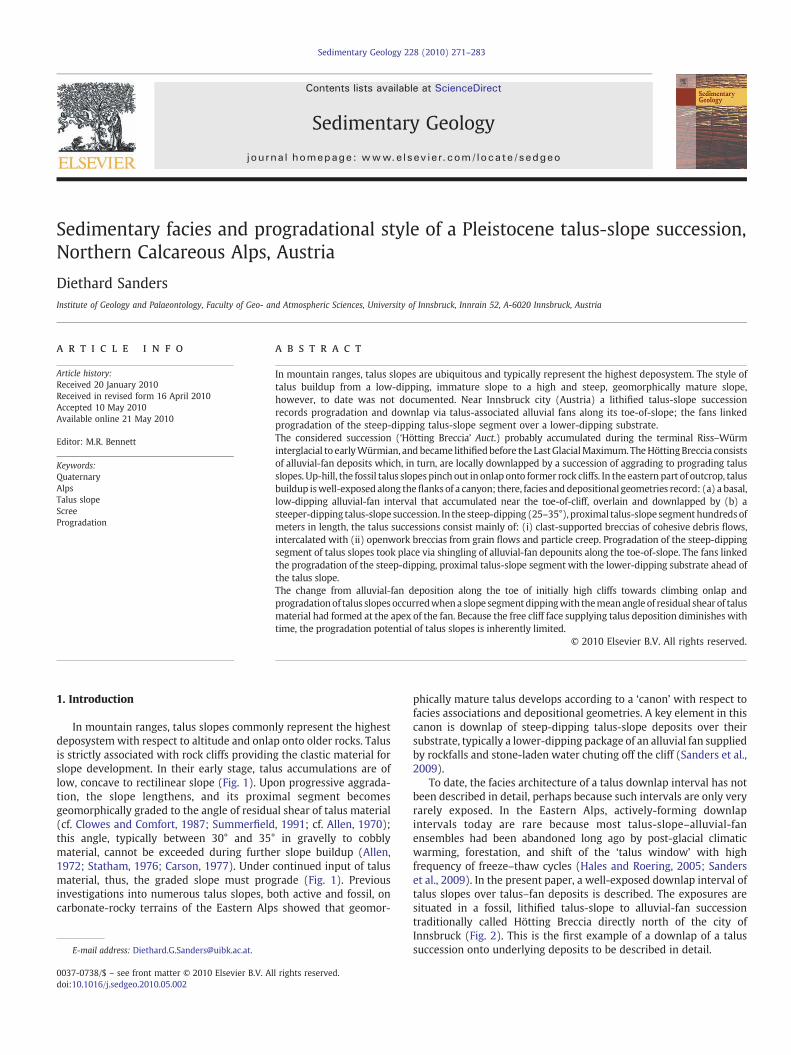
Fig. 8. A. Interval of water-laid rudite of subangular lithoclasts in an interstitial matrix of geopA. The geopetally-laminated, secondary matrix consists of carbonate-lithic silt to lime mudwater-laid conglobreccias (wcb). Beds of cohesive debris-flow breccias dipping with abouOutcrop on 1095 m a.s.l., right flank of Mühlau gorge. Width of view is approximately 7 m. Dflank of an erosional ravine. Note distinct subparallel stratification of talus succession due to ifrom grain flows 1480 m a.s.l. Width of view is about 18m. E. Detail of talus-slope successionfrom cohesive debris flows (cdf) are intercalated by a level of openwork breccia depositedcohesive debris-flow breccia from the proximal, steep-dipping (30–35°) sector of talus slopeembedded in a matrix of lithic wackestone. Dissolution pores (light patches) locally providehead of Mühlau gorge. Low-dipping, extremely-poorly-sorted alluvial-fan deposits (afd; seeslope succession. Some bedding surfaces are highlighted by white lines. Width of view is 60mleast a few stratification surfaces in alluvial-fan deposits (afd) are truncated along the contaTowards proximal, truncation of alluvial-fan deposits is not obvious. Width of view is appr
ment scars of rockslides that descended only a few thousands of yearsago (see Sanders et al., 2009). In the absence of copious input ofmeteoric water, the described style of alluvial-fan and talus-slopedeposition perhaps might not have developed, hence ultimatelyresults from Quaternary climatic conditions in the Alps. Similarclimatic conditions, however, are widespread in mountain ranges onEarth. In addition, investigation of numerous talus slopes showed thattalus successions are poor recorders of climate; this is because talusaccumulation is strongly influenced by many other factors unrelatedor only indirectly related to climate (Sanders et al., 2009).
For the marine realm, progradation of high, steep submarineslopes dominated by cohesive debris flows and/or by grain flows iswell-documented from the flanks of shallow-water carbonate plat-forms (Bosellini, 1984; Kenter, 1990; Adams and Schlager, 2000). Aslong as favourable ecological conditions allow for effective productionof shallow-water carbonate, platform slopes may prograde at highrates (Bosellini, 1984;Wilber et al., 1990; Schlager, 1991); even entireseaways may be leveled out by shedding of platform-derivedcarbonate sediment (Eberli and Ginsburg, 1987). Aside from sea-level changes that may steer progradation of carbonate-platformslopes (Masetti et al., 1991), however, the progradation of subaerialtalus slopes also is fundamentally different with respect to long-termsediment input. Because, on subaerial talus slopes, the free cliff areasupplying slope deposition progressively diminishes with time, talusaccumulation and progradation is inherently limited by a negativefeedback with respect to sediment input.
Acknowledgements
Financial support from project 16114-N06 (Austrian ResearchFoundation) is acknowledged. Two anonymous referees are thankedfor constructive reviews.
References
Adams, E.W., Schlager, W., 2000. Basic types of submarine slope curvature. J. Sed. Res.70, 814–828.
Allen, J.R.L., 1970. The avalanching of granular solids on dune and similar slopes. J. Geol.78, 326–351.
Allen, J.R.L., 1972. Intensity of deposition from avalanches and the loose packing ofavalanche deposits. Sedimentology 18, 105–111.
Ampferer, O., 1914. Über die Aufschliessung der Liegendmoräne unter der HöttingerBrekzie im östl. Weiherburggraben Innsbruck. Z. Gletscherkunde 8, 145–159.
Bechstädt, T., Schweizer, T., 1991. The carbonate-clastic cycles of the East-Alpine Raiblgroup: result of third-order sea-level fluctuations in the Carnian. Sed. Geol. 70,241–270.
Bosellini, A., 1984. Progradation geometries of carbonate platforms: examples from theTriassic of the Dolomites, northern Italy. Sedimentology 31, 1–24.
Brandner, R., 1984. Meeresspiegelschwankungen und Tektonik in der Trias der NW-Tethys.Jb Geologischen Bundesanst. 126 (4), 435–475.
Carson, M.A., 1977. Angles of repose, angles of shearing resistance and angles of talusslopes. Earth Surf. Process. 2, 363–380.
Clowes, A., Comfort, P., 1987. Process and Landform: An Outline of ContemporaryGeomorphology. Oliver and Boyd, Edinburgh. 335 pp.
Denk, T., 2006. Rhododendron ponticum L. var. sebinense (Sordelli) Sordelli in the LatePleistocene flora of Hötting, Northern Calcareous Alps: witness of a climate warmerthan today? Veröff. Tiroler Landesmuseums Ferdinandeum 86, 43–66.
etally-laminated silt to limemud. B. Thin section of matrix of water-laid rudite shown in. C. Facies association of cohesive debris-flow breccias (cdf) and intercalated levels oft 20° (hightlighted by white lines) are capped by a level of water-laid conglobreccia.. Outcrop of steep-dipping (35°), proximal sector of fossil talus slope, exposed along thenterbedding of: (a) cohesive debris-flow breccias with (b) openwork breccias depositedis shown in D. Two intervals of very poorly-sorted, clast-supported breccias depositedfrom a grain flow, or from several grain flows (gf). F. Thin section of clast-supported,s. The breccia consists of clasts of reefal/peri-reefal Wetterstein Limestone (cf. Table 1),d space for growth of microstalactites (inset in upper right). G. Outcrop on right flank ofFig. 5G and H) are overlain and, by implication, downlapped by a steeper-dipping talus-. Red rectangle outlines detail shown in Fig. 8H. H. Detail of preceeding photo. Here, at
ct to overlying talus-slope deposits (see also Sanders et al., 2009, their Figs. 15E and F).oximately 20 m.
281D. Sanders / Sedimentary Geology 228 (2010) 271–283
Eberli, G.P., Ginsburg, R.N., 1987. Segmentation and coalescence of Cenozoic carbonateplatforms, northwestern Great Bahama Bank. Geology 15, 75–79.
Gemmell, A.M.D., Spötl, C., 2009. Attempts to date the Hötting Breccia near Innsbruck(Austria), a classical Quaternary site in the Alps, by optically-stimulatedluminescence. Austrian J. Earth Sci. 102, 50–61.
Hales, T.C., Roering, J.J., 2005. Climate-controlled variations in scree production,Southern Alps, New Zealand. Geology 33, 701–704.
Hétu, B., Gray, J.T., 2000. Effects of environmental change on scree slope developmentthroughout the postglacial period in the Chic-Choc Mountains in the northernGaspé Peninsula, Québec. Geomorphology 32, 335–355.

Fig. 9. A. Panorama of left flank of uppermost reach of Mühlau gorge. Low-dipping, extremely-poorly-sorted alluvial-fan breccias (afb; cf. Fig. 5G and H) are overlain by a packagemainly of cohesive debris-flow breccias with a divergent bedding pattern. At the top of this package, steeply (20–25°) sub-packages of cohesive debris-flow breccias are capped bylevels, arranged in shingles of low-dipping water-laid rudites, intercalated with cohesive debris-flow breccias (see Fig. 8A–C). Rectangle 1 shows area of Fig. 8C; rectangle 2 showsarea shown in subsequent figure B. Width of view is 70 m. B. Detail 2 of preceeding photo. In the lower part of photo, the succession shows a shingle composed of: (a) a bedsetdipping with 15–20° of cohesive debris-flow breccias, capped by (b) a lower-dipping level of backweathering water-laid rudites as described. This shingle is overlain, in turn, bylenticular units composed either of water-laid rudites, or of cohesive debris-flow breccias. Above, a package of steep-dipping cohesive debris-flow breccias is exposed. C. Cut andpolished rock slab, representative for several samples of steeper-dipping, outweathering beds in A and B. The slab shows a cohesive debris-flow breccia with a matrix of lithicwackestone to lime mudstone. D. Panorama of left flank of uppermost reach of Mühlau gorge, seen from up slope the right valley flank. The steep-dipping (30–35°) successionlabeled ‘talus slope’ consists largely of beds of cohesive debris-flow breccias, identical in polished slab and thin section to C. The talus-slope package shown here is in physical andmappable continuity with the talus succession higher up the present mountain flank (compare Figs. 4 and 8D). Width of view is 110 m.
282 D. Sanders / Sedimentary Geology 228 (2010) 271–283
Katschthaler, H., 1930. Neue Beobachtungen im Gelände der Höttinger Brekzie. JbGeologischen Bundesanst. 80, 17–44.
Kenter, J.A.M., 1990. Carbonate platform flanks: slope angle and sediment fabric.Sedimentology 37, 777–794.
Ladurner, J., 1956. Mineralführung und Korngrössen von Sanden (Höttinger Breccieund Umgebung). Tschermaks Mineralog. Petrogr. Mitt. 5, 102–109.
Mandl, G.W., 1999. The Alpine sector of the Tethyan shelf — example of Triassic toJurassic sedimentation and deformation from the Northern Calcareous Alps. Mitt.Österr. Geologischen Ges. 92, 61–77.
Masetti, D., Neri, C., Bosellini, A., 1991. Deep-water asymmetric cycles and progradationof carbonate platforms governed by high-frequency eustatic oscillations (Triassic ofthe Dolomites, Italy). Geology 19, 336–339.

Fig. 10. A. Summary of depositional geometries. The lowermost-exposed alluvial-fan interval is overlain by packages with divergent-sigmoidal to divergent-oblique bedding; each ofthese packages is topped by a level of water-laid rudites. Down-dip, each of these packages should pinch out and downlap older deposits, but this is not exposed. The divergentpackages, in turn, are downlapped and overstepped by the steep-dipping talus-slope segment. Between about 1500 and 1600 m a.s.l., the preserved steep-dipping proximal segmentof talus slopes onlaps rock cliffs. B. Style of talus-slope progradation. The talus slope prograded via stacking of alluvial-fan units (labeled 1 to 4) along its toe-of-slope. These alluvialfans comprised the morphological foundation for progradation of the steep-dipping talus-slope segment above. The alluvial fans along the toe-of-slope are dominated by:(a) cohesive debris-flow breccias, comprising depositional lobes, and (b) by water-laid rudites from channels and slope-wash veneers on top of the depositional lobes. The long,steep-dipping slope segment above consists of: (i) clast-supported, matrix-bearing breccias of cohesive debris flows and/or from gravelly creep sheets, intercalated with (ii)openwork breccias from grain flows and particle creep.
283D. Sanders / Sedimentary Geology 228 (2010) 271–283
Murr, J., 1926. Neue Übersicht über die fossile Flora der Höttinger Breccie. Jb GeologischenBundesanst. 76, 153–170.
Obojes, U., 2003. Quartärgeologische Untersuchungen an den Hängen der InnsbruckerNordkette (Höttinger Breccie). Unpubl. Diploma thesis. Univ. Innsbruck 89, 1 map.
Ostermann, M., 2006. Thorium–uranium age-dating of “impure” carbonate cements ofselected Quaternary depositional systems of western Austria: results, implications,problems. Unpubl. Ph. D. thesis, Univ. of Innsbruck, 173 pp. (including appendices)
Paschinger, H., 1950. Morphologische Ergebnisse einer Analyse der Höttinger Brekziebei Innsbruck. Schlern Schriften 75, 7–86.
Patzelt, G., Resch, W., 1986. Quartärgeologie des mittleren Tiroler Inntales zwischenInnsbruck und Baumkirchen. Jahresberichte Mitteilungen Oberrheinischen Geolo-gischen Vereines Neue Folge 68, 43–66.
Penck, A., 1921. Die Höttinger Breccie und die Inntalterrasse nördlich Innsbruck. Abh.Der preussischen Akad. Wiss. Phys. Math. Klasse 1920, 1–136.
Sanders, D., 2008. Eislast-Erscheinungen und Intraklasten in der Höttinger Brekzie(Riß-Würm Interglazial) bei Innsbruck (Österreich). Geo. Alp. 5, 149–164.
Sanders, D., Ostermann, M., 2006. Depositional setting of the sedimentary rockscontaining the “warm-interglacial” fossil flora of the Höttinger Brekzie (Pleisto-cene, Northern Calcareous Alps, Austria): a reconstruction. Veröff. Tiroler Land-esmuseums Ferdinandeum 86, 91–118.
Sanders, D., Ostermann, M., Kramers, J., 2009. Quaternary carbonate-rocky talus slopesuccessions (Eastern Alps, Austria): sedimentary facies and facies architecture.Facies 55, 345–373. doi:10.1007/s10347-008-0175-z.
Sanders, D., Ostermann, M., Kramers, J., 2010. Meteoric diagenesis of Quaternarycarbonate-rocky talus slope successions (Northern Calcareous Alps, Austria). Facies56, 27–46. doi:10.1007/s10347-009-0194-4.
Schlager, W., 1991. Depositional bias and environmental change— important factors insequence stratigraphy. Sed. Geol. 70, 109–130.
Spötl, C., Mangini, A., 2006. U/Th constraints on the absence of ice in the central InnValley (eastern Alps, Austria) during Marine Isotope Stages 5c to 5a. Quatern. Res.66, 167–175.
Statham, I., 1976. A scree slope rockfall model. Earth Surf. Process. 1, 43–62.Summerfield, M.A., 1991. Global Geomorphology. Longman Scientific and Technical,
Essex. 537 pp.Wettstein, R.v., 1892. Die fossile Flora der Höttinger Breccie. Denkschriften der
kaiserlichen Akademie der Wissenschaften in Wien. Math. Naturwiss. Cl. 59,479–524.
Wilber, R.J., Milliman, J.D., Halley, R.B., 1990. Accumulation of bank-top sediment on thewestern slope of Great Bahama Bank: rapid progradation of a carbonate megabank.Geology 18, 970–974.


![[PPT]Facies and Facies Models - UCSC Directory of individual …mclapham/eart120/slides/Facies... · Web viewWhat is a facies? A sedimentary unit with consistent characteristics (lithology,](https://img.pdfslide.us/doc/110x75/5aef4a8a7f8b9a8c308bc665/pptfacies-and-facies-models-ucsc-directory-of-individual-mclaphameart120slidesfaciesweb.jpg)