Embed Size (px)
Citation preview

This paper describes an ongoing multidisciplinary study onthe development of the barrier islands in the Danish WaddenSea (Vadehavet), carried out by the Department of Geographyand Geology at the University of Copenhagen and the Geolo -gical Survey of Denmark and Greenland (GEUS). Nine sed-iment cores each c. 25 m long and a total of c. 45 km groundpenetrating radar (GPR) profiles have been acquired on theislands of Rømø and Fanø. Geochemical and palaeontologi-cal analyses and dating of 150 core samples using opticallystimulated luminescence (OSL) are in progress. This multi-disciplinary approach has given new insights into the sedi-mentary architecture and development of the island, and thestudy is expected to result in a new detailed facies model. Suchmodels are essential for an assessment of the effects of risingsea level associated with global warming. The new faciesmodel can also be used as an analogue for subsurface oil orwater reservoirs in similar sedimentary settings. This articlepresents selected core and GPR data from the Rømø barrierisland.
Setting
The Rømø barrier island is situated in the northern part ofthe European Wadden Sea (Fig. 1). The maximum tidalamplitude is c 1.8 m (Andersen & Pejrup 2001). During thelast c. 8000 years, the area has experienced an overall relativesea-level rise of ~15 m (Behre 2007).
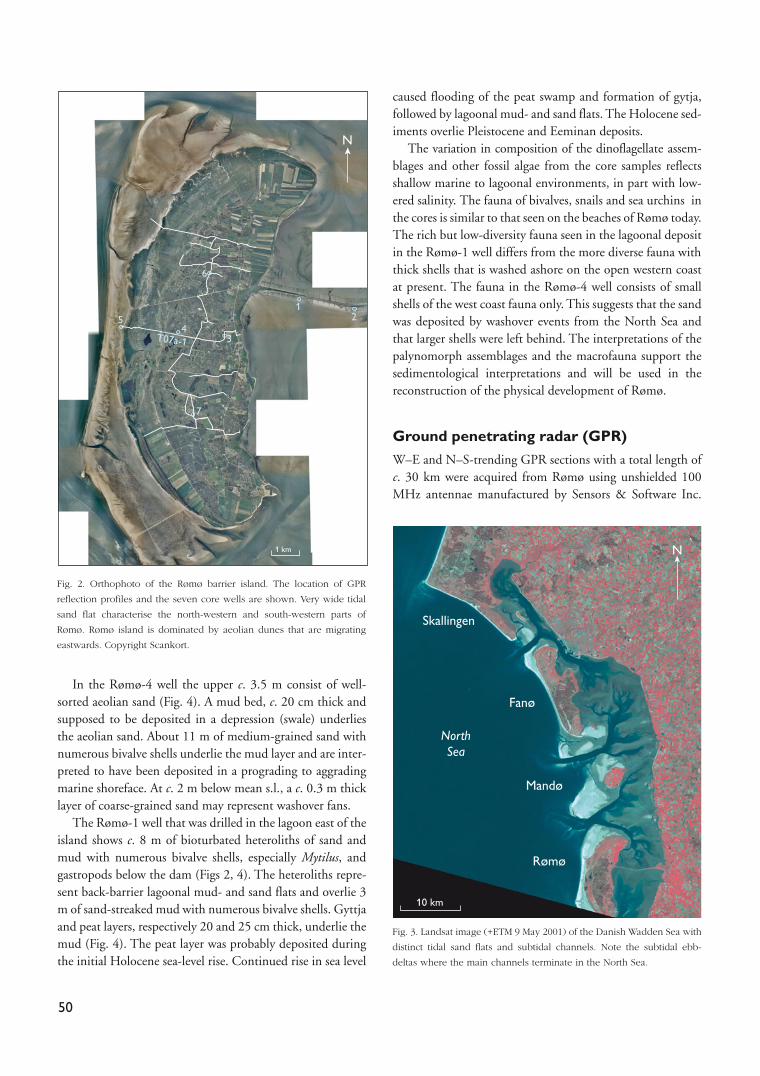
The island of Rømø is c. 14 km long and c. 4 km wide andseparated from the mainland by a c. 8 km wide lagoon (Figs1, 2). The island is connected to the mainland by a dam.Tidal inlets, c. 1 km across, occur at the northern and south-ern tips of the island. The inlets continue as tidal channelsinto the lagoon and cut sand flats and mixed flats. Subtidalebb-deltas are located where the tidal inlets terminate in theNorth Sea (Fig. 3). The inlets reach depths of up to 30 m, asin the Listerdyb south of Rømø, or 4–10 m in the Juvre Dybnorth of the island. The salt marsh area fringing the lagoonalcoast of the island is up to 2 km broad. Sand flats, up to 2.7km wide, with three, 0.8–1.6 km broad bars that migratetowards the island, characterise the north-western and south-western parts of the island (Fig. 2). Tidal creeks, up to c. 50m wide, separate the bars. Active eastward migrating aeoliandunes are found on large parts of the island.
Sedimentary facies of the Rømø barrierisland
Core wellsSeven core wells were drilled on the island, and depositionalunits were defined on the basis of sedimentary structures, grainsizes, sorting, organic material, fossils, trace fossils and rootlets.Data from the Rømø-4 and -1 wells are presented here.
© GEUS, 2008. Geological Survey of Denmark and Greenland Bulletin 15, 49–52. Available at: www.geus.dk/publications/bull
Sedimentary facies and architecture of the Holocene toRecent Rømø barrier island in the Danish Wadden Sea
Peter N. Johannessen, Lars Henrik Nielsen, Lars Nielsen, Ingelise Møller, Morten Pejrup,Thorbjørn J. Andersen, Joakim Korshøj, Birger Larsen and Stefan Piasecki
49
Salt marsh
Mud flat
Land, supratidal
River
Mixed mud flat
Sand flat
Tidal channelsmore than6 m deep
Subtidal
5 km
55°N
9°E
9°E
Denmark
Germany
NorthSea
250 km
Fanø
Rømø
Sylt
Mandø
Juvre Dyb
Listerdyb
North Sea
WaddenSea
Fig. 1. The Danish Wadden Sea. The distribution of sediment types and
subtidal channels are shown. The mainland of Jylland east of the lagoon
consists of glacial deposits. Inset map shows the whole tidal Wadden Sea
area. Modified from Pejrup (2006) and Sørensen et al. (2006).
In the Rømø-4 well the upper c. 3.5 m consist of well-sorted aeolian sand (Fig. 4). A mud bed, c. 20 cm thick andsupposed to be deposited in a depression (swale) underliesthe aeolian sand. About 11 m of medium-grained sand withnumerous bivalve shells underlie the mud layer and are inter-preted to have been deposited in a prograding to aggradingmarine shoreface. At c. 2 m below mean s.l., a c. 0.3 m thicklayer of coarse-grained sand may represent washover fans.
The Rømø-1 well that was drilled in the lagoon east of theisland shows c. 8 m of bioturbated heteroliths of sand andmud with numerous bivalve shells, especially Mytilus, andgastropods below the dam (Figs 2, 4). The heteroliths repre-sent back-barrier lagoonal mud- and sand flats and overlie 3m of sand-streaked mud with numerous bivalve shells. Gyttjaand peat layers, respectively 20 and 25 cm thick, underlie themud (Fig. 4). The peat layer was probably deposited duringthe initial Holocene sea-level rise. Continued rise in sea level
caused flooding of the peat swamp and formation of gytja,followed by lagoonal mud- and sand flats. The Holocene sed-iments overlie Pleistocene and Eeminan deposits.
The variation in composition of the dinoflagellate assem-blages and other fossil algae from the core samples reflectsshallow marine to lagoonal environments, in part with low-ered salinity. The fauna of bivalves, snails and sea urchins inthe cores is similar to that seen on the beaches of Rømø today.The rich but low-diversity fauna seen in the lagoonal depositin the Rømø-1 well differs from the more diverse fauna withthick shells that is washed ashore on the open western coastat present. The fauna in the Rømø-4 well consists of smallshells of the west coast fauna only. This suggests that the sandwas deposited by washover events from the North Sea andthat larger shells were left behind. The interpretations of thepalynomorph assemblages and the macrofauna support thesedimentological interpretations and will be used in thereconstruction of the physical development of Rømø.
Ground penetrating radar (GPR)
W–E and N–S-trending GPR sections with a total length ofc. 30 km were acquired from Rømø using unshielded 100MHz antennae manufactured by Sensors & Software Inc.
50
N
6
T07a-1
1 km
4
7
5
3
21
Fig. 2. Orthophoto of the Rømø barrier island. The location of GPR
reflection profiles and the seven core wells are shown. Very wide tidal
sand flat characterise the north-western and south-western parts of
Rømø. Rømø island is dominated by aeolian dunes that are migrating
eastwards. Copyright Scankort.
Skallingen
Fanø
Mandø
NorthSea
Rømø
10 km
N
Fig. 3. Landsat image (+ETM 9 May 2001) of the Danish Wadden Sea with
distinct tidal sand flats and subtidal channels. Note the subtidal ebb-
deltas where the main channels terminate in the North Sea.

(Fig. 2; Nielsen et al. in press). Maximum signal penetrationis c. 15 m in the central parts of the island where freshgroundwater is thickest, and the vertical resolution is 0.2–0.3m. The reflected signal only reaches about 1 m depth at themargins of Rømø because of strong damping of the electro-magnetic waves due to saltwater intrusion. Salt marsh, peatand mud layers also significantly reduce the signal penetra-tion.
A GPR section from the central part of the island shows abeach ridge, c. 1.25 m high and c. 70 m wide, with a steeperosional side towards the west and a less steep side towardsthe east (Fig. 5). The top of the beach ridge is c. 0.5 m abovemean s.l. Two superimposed cross-bedded units with east-dipping foresets occur upon the beach ridge. The lower unitis 0.8 m thick and c. 30 m long and the upper unit is c. 1 mthick and c. 50 m long (Fig. 5). East of the washover fanslarge, gently eastward-dipping clinoforms occur with muchhigher amplitude signal, which indicates that the sediments
are organic or mud rich. Data from the Rømø-4 core well sit-uated c. 75 m north of the section indicate that the highamplitude layer correlates with a 20 cm thick mud layerdeposited in a swale (Fig. 4), consistent with previous find-ings elsewhere on the island (Nielsen et al. in press).
A more than 125 m wide set with clinoforms, c. 1.5 mthick, dipping in an eastward direction is found in the west-ernmost part of the section (Fig. 5). The set terminates east-wards in a channel-like structure. The clinoform set isinterpreted as an eastward-migrating tidal bar filling in thewestern side of a 1.5 m deep tidal channel, forcing the chan-nel eastwards, which is comparable to the modern situationillustrated in Fig. 3. The amplitude of the reflections in thechannel sediments differs from those of the bar, suggestingthat the channel fill is slightly muddier due to channel aban-donment. The top of the channel and the bar are situated atthe modern mean s.l.
51
Rømø-4
Clay Si Vf F MSand
C Vc Peb.
Clay Si Vf F MSand
C Vc Peb.
Prograding/agradingshoreface
sand
Progradingupper shoreface
sand
Aeolian sand
Washover fans?
Swale
Hol
ocen
eW
eich
selia
n
Wei
chse
lian
Hol
ocen
e
–1
–2
–3
–4
–5
–6
–7
–8
–9
–10
–11
–12
Marinetransgressive
surface
metre
4
3
2
1
0
metre
Rømø-1
Dam
Back-barrierlagoon with
mud and sand flats
Fluvial channels
Lagoon
Lagoonaltransgressivesurface
Peat
Mytilus
Mytilus
Mytilus
Mytilus
Gyttja
–11
–10
–12
–13
1.9
1
0.0
–1
–2
–3
–4
–5
–6
–7
–8
–9
Legend
Lithology
Structures
Fossils
Biogenic structure
Peat
Clay
Heterolith 80%clay, 20% sand
Sand
Silty sand
Pebbles
Clay clast
Cross-bedding
Parallel lamination
Current ripple
Cross-lamination
Rootlets
Shells
Sea urchin
Organic rich clast
Bioturbation
Gastropods
Fig. 4. Sedimentological core logs from the Rømø-1 and -4 wells, situated in the lagoon and the centre of Rømø, respectively. For locations see Fig. 2.

52
Between the bar-channel complex and the beach ridgeoccur two sediment wedges, altogether c. 150 m across (Fig.5). The eastern wedge onlaps the relatively steep western sideof the beach ridge, whereas the western wedge onlaps theeastern wedge and is truncated by the channel to the west.The wedges were probably deposited by landward migratingbars that welded to the coast, causing a stepwise shorefaceprogradation. Aeolian sand lies on top of these foreshore sed-iments (Fig. 5). The gently westward dipping, high ampli-tude reflections in the deeper part of the section areinterpreted as representing westward shoreface progradation,in agreement with the core data (Figs 4, 5).
Discussion and conclusions
The cores and GPR sections provide high quality data for theidentification of the depositional units that compose theRømø barrier island, and a few examples of the units are pre-sented here. The interpretations of the cores and the GPRsections show that the Rømø barrier island was never locatedas far east as the Rømø-1 well. Furthermore, lagoonal sedi-ments are not present at the position of the Rømø-4 well sug-gesting that lagoonal conditions were never established at thislocation. However, data from the cores of the Rømø-6 and -3wells (to be described in forthcoming papers) suggest that thewestern fringe of the lagoon reached the positions of thesewells, because lagoonal deposits are identified below aeoliansand (Nielsen et al. in press).
Samples of sand from the cores have been submitted forOSL dating, and shells and organic matter are being dated bythe 14C method. When the ages of the depositional units
become available the development of the depositional unitsthrough time will be described in detail. Plots of sampledepths against ages will be constructed to portray the relativesea level history and will, together with analyses of the mol-lusc fauna and palynomorph assemblages, provide additionalconstraints on the reconstructions of the development of thebarrier island. The study will be concluded with a detailedreconstruction of the Holocene development of the Rømøbarrier island.
AcknowledgementsThe Danish Natural Science Research Council and Geocenter Copenhagen
are thanked for financial support.
References Andersen, T.J. & Pejrup, M. 2001. Suspended sediment transport on a tem-
perate, microtidal mudflat, the Danish Wadden Sea. Marine Geology
173, 69–85.
Behre, K.-E. 2007: A new Holocene sea-level curve for the southern North
Sea. Boreas 36, 82–102.
Nielsen, L., Møller, I., Nielsen, L.H., Johannessen, P.N., Pejrup, M., Korshøj,
J.S. & Andersen, T.J. in press: Integrated ground-penetrating radar and
sedimentological studies of Wadden Sea barrier islands. Journal of
Applied Geophysics.
Pejrup, M. 2006: Det danske vadehav og store landvindingsprojekter. In:
Sand-Jensen, K. & Fenchel, T. (eds): Naturen i Danmark: Havet, 433–415.
København: Gyldendal.
Sørensen, T.H., Bartholdy, J. Christiansen, C. & Pedersen, J.B.T. 2006:
Intertidal surface type mapping in the Danish Wadden Sea. Marine
Geology 235, 87–99.
Authors’ addresses
P.N.J., L.H.N., I.M., B.L. & S.P.: Geological Survey of Denmark and Greenland, Øster Voldgade 10, DK-1350 Copenhagen K, Denmark. E-mail: [email protected]
L.N., M.P., T.J.A. & J.K.: Department of Geography and Geology, Øster Voldgade 10, DK-1350 Copenhagen K, Denmark.
WoFWoF
AeoAeo
AeoAeo
SfClSfCl
SwSwChCh ChCh
BRBR
WoFWoFWoF
B
BB
5
0
Aeo
Aeo
SfCl
SwCh Ch
BR
WoF
Elev
atio
n (m
)
–5
W E
100 m
B
BB
Rømø-4 well c. 75 mnorth of GPR profile
Aeo: aeolian, BR: beach ridge, Sw: swale, WoF: washover fan, B: bar, Ch: channel, SfCl: shoreface clinoforms : Present mean sea level
Fig. 5. West–east-trending ground penetrating radar profile T07a-1 from Rømø. The upper part of the section consists of aeolian sand. For location see Fig. 2.