Embed Size (px)
Citation preview
lable at ScienceDirect
ARTICLE IN PRESS
Quaternary International xxx (2010) 1e23
Contents lists avai
Quaternary International
journal homepage: www.elsevier .com/locate/quaint
Sedimentary characteristics and origin of the Late Pleistocene Ice Complexon north-east Siberian Arctic coastal lowlands and islands e A review
L. Schirrmeister a,*, V. Kunitsky b, G. Grosse c, S. Wetterich a, H. Meyer a, G. Schwamborn a, O. Babiy b,A. Derevyagin d, C. Siegert a
aAlfred Wegener Institute for Polar and Marine Research, Periglacial Research, Telegrafenberg A 43, 14471 Potsdam, GermanybMelnikov Permafrost Institute RAS SB, Merslotnaya Street, Yakutsk, Republic of Sakha, (Yakutia), 677010 RussiacGeophysical Institute, University of Alaska Fairbanks (UAF), 903 Koyukuk Drive, Fairbanks, AK 99775, USAdMoscow State University (MSU), Faculty of Geology Russia, Moscow 119899, Vorobievy Gory
a r t i c l e i n f o
Article history:Available online xxx
* Corresponding author.E-mail address: [email protected] (L. Schi
1040-6182/$ e see front matter � 2010 Elsevier Ltd adoi:10.1016/j.quaint.2010.04.004
Please cite this article in press as: Schirrmeieast..., Quaternary International (2010), doi:
a b s t r a c t
The origin of Late Pleistocene ice-rich, fine-grained permafrost sequences (Ice Complex deposits) in arcticand subarctic Siberia has been in dispute for a long time. Corresponding permafrost sequences arefrequently exposed along seacoasts and river banks in Yedoma hills, which are considered to be erosionalremnants of Late Pleistocene accumulation plains. Detailed cryolithological, sedimentological, geochro-nological, and stratigraphical results from 14 study sites along the Laptev and East Siberian seacoastswere summarized for the first time in order to compare and correlate the local datasets on a largeregional scale. The sediments of the Ice Complex are characterized by poorly-sorted silt to fine-sand,buried cryosols, TOC contents of 1.2e4.8 wt%, and very high ground ice content (40e60 wt% absolute). Asecond large constituent of the Ice Complex are large syngenetic ice wedges, resulting in a total icecontent of the Ice Complex of up to 80 vol%. Ice Complex deposits were mostly formed during the MiddleWeichselian interstadial and/or during the Late Weichselian stadial periods. A conceptual model of nivallithogenesis of Ice Complex deposits was developed that integrates various other formation hypotheses.A combination of various local and regional paleogeographical, geological, and paleoclimate conditionscontrolled the formation of Ice Complex sequences during the Late Pleistocene in northern East Siberia.They are chronologically and stratigraphically, but not genetically equivalent to Eurasian and Alaskanloess deposits.
� 2010 Elsevier Ltd and INQUA. All rights reserved.
1. Introduction
In Siberia, perennially frozenfine-grained deposits are consideredto be part of the Northern Hemisphere Late Pleistocene loess region(Péwé et al., 1977; Péwé and Journaux, 1983; Kaplina and Lozhkin,1984; Pye, 1984; Frenzel et al., 1992; Colinvaux, 1996; Morozova andVelichko, 1996). The sedimentological and cryolithological genesisof these widely distributed ice-rich sediments is still under discus-sion, and several hypotheses have been put forward in the lastdecades. Concepts included ice-sheet-dammed basin sediments(Grosswald, 1998), deltaic formations (Nagaoka et al., 1995), alluvialgenesis (Rozenbaum, 1981), proluvial and slope deposits (Gravis,1969; Slagoda, 2004), cryogeniceaeolian deposits (Tomirdiaro,1982, 1984; Tomirdiaro and Chernen’k’ii, 1987), nival deposits
rrmeister).
nd INQUA. All rights reserved.
ster, L., et al., Sedimentary ch10.1016/j.quaint.2010.04.004
(Kunitsky,1989;Galabala,1997), andpolygeneticorigins (Konishchev,1981; Sher et al.,1987). Subsequently, someof these hypotheseswereeasily discarded as the increasing availability of paleoenvironmentaldata falsified the core ideas of such hypotheses, e.g. the ice-sheet-dammed hypothesis of Grosswald (1998) or the deltaic origin ofNagaoka et al. (1995). Currently, the hypothesis of a pure aeolian(loessic) origin of these deposits appears to be the one favoured bymost of the current scientific literature (e.g. Brigham-Grette, 2001;Walter et al., 2006; Zimov et al., 2006; Schuur et al., 2008). Theconcept of a uniform arctic loess cover during the Late Pleistocene isalso used in some climate models to simulate a dust cover on snowand ice, which reduces albedo (Krinner et al., 2006). Often, studies onthesefine-grained permafrost deposits drawgeneralized conclusionsfrom few study sites and tend to neglect some of the special paleo-environmental conditions in heterogeneous periglacial landscapesduring the time of deposition.
Permafrost is a widely distributed, climatically-inducedphenomenon in terrestrial arctic and subarctic regions. In northern
aracteristics and origin of the Late Pleistocene Ice Complex on north-
L. Schirrmeister et al. / Quaternary International xxx (2010) 1e232
ARTICLE IN PRESS
East Siberia, permafrost is closelyconnected to long-termstable coldand dry climate conditions and the absence of large ice sheets in theQuaternary past (Hubberten et al., 2004). Extremecooling under theinfluence of long-termvery cold winter air temperatures resulted inthe formation and preservation of a thick continuous permafrostzone. Areas where such conditions prevailed for several 10,000 yearperiods during the Late Pleistocene include the arctic lowlandregions east of the Eurasian ice shield. The idea of largely barren andwindswept North Siberian lowlands prone to wind-erosion andacting as both source and sink of loessic material during the LatePleistocene has been largely discarded by newer paleoenvir-onmental studies indicating a nearly complete vegetation cover anddense populations of grazing animals (e.g. Sher et al., 2003, 2005).
The fine-grained Late Pleistocene ice-rich deposits in question,called Ice Complex formations (in Russian: ledovyi complex,according to Soloviev, 1959), are well exposed along coasts andriver banks in the northern East Siberian lowlands. For describingthis permafrost formation, the term “Yedoma” is very often usedsynonymously (e.g. Zimov et al., 2006). In its original sense, theterm Yedoma defines relief features in East Siberian lowlands, i.e.elevated areas separating thermokarst depressions (Kolosov, 1947;Baranova and Biské, 1964; Tomirdiaro, 1980; Mursaev, 1984). Suchhills are usually composed of the Ice Complex deposits. Because ofthe high content of fossil plant and animal remains ranging fromgrass leaves to mammoth bones, and the unknown depositionalorigin, these deposits had already attracted scientific interest earlyin the 19th century (Adams, 1807; Bunge, 1895).
Ice Complex deposits are an essential component of periglaciallandscapes in the northern East Siberian lowlands, and play an
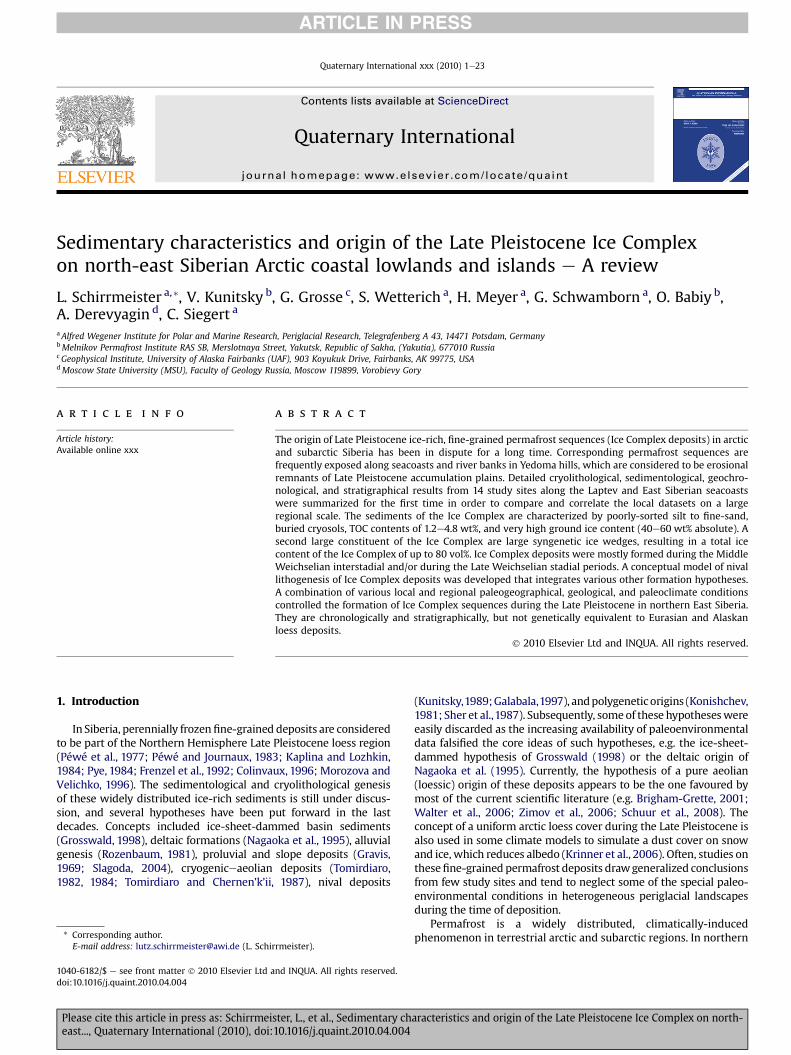
Fig. 1. Study region in northern East Siberia and positions o
Please cite this article in press as: Schirrmeister, L., et al., Sedimentary cheast..., Quaternary International (2010), doi:10.1016/j.quaint.2010.04.004
important role for understanding the Late Pleistocene sedimento-logical, stratigraphical, and paleoenvironmental dynamics in EastSiberia. In connection with ongoing climate change and globalwarming, it is assumed that the Ice Complex formations will betransformed from a long-term carbon sink to a major carbon sourceas these organic-rich sediments thaw and greenhouse gases aresubsequently released (Walter et al., 2006; Zimov et al., 2006;Schuur et al., 2008).
This study presents similarities and differences among variousIce Complex sequences by summarizing cryolithological dataacquired and analyzed within the Russian-German science colla-boration “Laptev Sea System” from 1998 to 2008. Shortdescriptions of geomorphological, stratigraphical, and cryolitho-logical features are presented for 14 major sites (Fig. 1) and thensummarized into five different Ice Complex provinces. Selectedrecords of similar sedimentological parameters are used for thesynthesis. The objective of this paper is to provide a compre-hensive characterisation of Ice Complex deposits in northern EastSiberia, i.e., for the Laptev Sea region and the New SiberianArchipelago. Ice Complex genesis is discussed and the conceptualmodel of deposition and genesis for these deposits is advancedby going a step beyond the prevailing loess formationhypothesis.
Although site-specific data has been published before innumerous papers (Table 1), a generalizing review of Ice Complexcharacteristics from NE Siberian Arctic coastal lowland and islandsites was not conducted yet. This paper represents the firstsystematic review of ten years of intense cryolithological fieldstudies on North Siberian Ice Complex deposits.
f study sites and other locations mentioned in the text.
aracteristics and origin of the Late Pleistocene Ice Complex on north-
Table 1Location of studied Ice Complex sites indicated in Fig. 1 and corresponding site-specific publications.
Region Location Coordinates
�N �E
W Laptev Sea Cape Mamontov Klyk (Schirrmeister et al., 2008; Bobrov et al., 2009; Müller et al., 2009;Winterfeld et al., under review)
73.61 117.18
Lena Delta Ebe Basyn Sise Island (Nagym) 72.88 123.32Khardang Sise Island, 2005 (Schirrmeister, 2007) 72.95 124.21Kurungnakh Sise Island (Buor Khaya), 1998, 2000, 2002 (Kuzmina et al., 2003; Schirrmeisteret al. 2001, 2003b; Schwamborn et al., 1999, 2002; Wetterich et al., 2008)
72.33 126.30
E Laptev Sea Bykovsky Peninsula (Mamontovy Khayata), 1998, 2002 (Siegertet al., 1999, 2002; Sher et al., 2000, 2005; Andreev et al., 2002; Meyeret al, 2002a; Schirrmeister 2002a,b; Grosse et al., 2003, 2005, 2007;Bobrov et al., 2004; Kienast et al., 2005; Wetterich et al., 2005)
71.78 128.42
Muostakh Island, 2002 (Schirrmeister et al., 2003a) 71.61 129.94New SiberianArchipelago
Stolbovoy Island, 2002 (Schirrmeister et al., 2003a) 74.06 136.08Bel’kovsky Island, 2002 (Schirrmeister et al., 2003a) 75.37 135.59N Kotelny Island (Cape Anisii), 2002 (Schirrmeister et al., 2003a) 76.17 139.01SW Kotelny Island (Komurganakh River mouth), 2002 (Schirrmeister et al., 2003a) 74.73 138.45Maly Lyakhovsky Island, 2002 (Schirrmeister et al., 2003a) 74.25 140.35Bol’shoy Lyakhovsky Island (Zimov’e River), 1999, 2007 (Schirrmeisteret al., 2000, 2003a, 2008b; Meyer et al., 2002b; Andreev et al., 2004, 2009;Ilyashuk et al., 2006; Schirrmeister et al., 2008b; Kienastet al., 2008; Wetterich et al., 2009)
73.30 141.5
Dmitry LaptevStrait
Cape Syatoy Nos, 1999 72.84 140.85Oyogos Yar coast, 2002, 2007 (Schirrmeister et al., 2003a, 2008b; Wetterichet al., 2009)
72.68 143.53
L. Schirrmeister et al. / Quaternary International xxx (2010) 1e23 3
ARTICLE IN PRESS
2. Geographical setting
Ice Complex deposits are widely distributed in the coastallowlands of the Laptev, East Siberian, and Chukchi seas, on the NewSiberian Archipelago, and in other continental lowlands and largeriver valleys of East Siberia, especially in Yakutia (Fig. 1;Romanovsky, 1993; Walter et al., 2007). The Ice Complex is a cha-racteristic feature in the stratigraphy and landscapes of the westernpart of the Beringian landmass which is described as the extendednon-glaciated region between the Eurasian and the Laurentian iceshields during the Late Pleistocene.
The sites are well exposed large bluffs on the coast of the LaptevSea, the Dmitry Laptev Strait, the New Siberian Islands, and alongriver cutbanks in the Lena Delta (Figs. 1 and 2; Table 1). The studysites are part of the arctic and subarctic tundra zones, and areunderlain by continuous permafrost several hundreds of metersdeep (Yershov, 1989). A continental arctic climate with long severewinters and short cold summers is typical for the region today.
The study region belongs to the Arctic Rift Zone, characterizedby vertical block tectonics with narrow long horsts, grabens andsynclines and a high modern seismic activity (Grigoriev et al., 1996;Drachev et al., 1998; Imaev et al., 2000; Franke et al., 2000). Coastallowlands in the western part of the study region are framed bysmall mountain ridges of 200e500 m asl (above sea level) like thePronchishchev Ridge, the Chekanovky Ridge and the KharaulakhRange. They belong to the Olenek Zone and the Late Mesozoicfolded sediment complex between the Siberian Craton and theLaptev Paraplatformal Block. These low ridges are considered thenorth-western continuation of the Verkhoyan Mountain Range(Drachev et al., 1998). In the eastern part of the study region iso-lated bedrock elevations of Cretaceous granite domes exist as wellas the fold ranges on Kotel’ny Island.
3. Methods
Although the steep permafrost outcrops are generally wellexposed, it is often necessary to study accessible subsections andthen to combine these subsections into complete vertical profiles.
Please cite this article in press as: Schirrmeister, L., et al., Sedimentary cheast..., Quaternary International (2010), doi:10.1016/j.quaint.2010.04.004
Limiting factors for accessibility are steepness of bluffs, over-hanging frozen sediments and peat, and extensive mudflows frommelting ground ice. Subsections consist of sediment sequencesdeposited in ice wedge polygon centres exposed between icewedges on the bluffs or in still-frozen, undisturbed thermokarstmounds in front of a bluff (Fig. 2). Vertical position and thickness ofstratigraphic horizons in such exposures were surveyed using lasertheodolite and measuring tapes. The initial stratigraphic assess-ment of the frozen sediments included descriptions of colour,organic remains, sediment type, and cryostructures. Each subsec-tion was sampled in 0.5e1.0 m intervals. About 500 g of frozensediment was collected per sample and sealed in plastic bags. Thegravimetric ice content was determined in the field laboratory asthe ratio of the weight of ice in a sample to the weight of the drysample and expressed as weight percentage (wt %) (vanEverdingen, 1998). Ice contents were not measured for allsamples but representatively for ca. every third sample in eachsubprofile.
In the laboratory, sediment samples were freeze-dried,homogenized, and split into subsamples. For grain size analysis,subsamples were first treated with hydrogen peroxide to removeorganic matter and then measured in a laser particle analyser(Coulter LS 200). The software SEDIVISION was used to obtain thegrain size mean and sorting parameters. The mass-specificmineral magnetic susceptibility (MS) was measured with a Bar-tington MS2 and an MS2B-type sensor. The values of MS areexpressed in SI units (10�8 m3 kg�1). The contents of total organiccarbon (TOC), total carbon (TC), and total nitrogen (TN) weremeasured with a CNS analyser (Elementar Vario EL III). The C/Nratio is calculated as the quotient of TOC and TN values. This ratiowas only calculated when the TN values are >0.05%. Thecarbonate (inorganic carbon) content was calculated by subtract-ing TOC from TC. Stable carbon isotope composition (d13C) of TOC(contents >0.3%) was measured with a Finnigan DELTA S massspectrometer. The values are expressed in delta per mil notation(d, &) relative to the Vienna Pee Dee Belemnite (VPDB) Standard.The 63e125 mm subfraction of selected samples was used forheavy mineral analyses. The grains were gravitationally separated
aracteristics and origin of the Late Pleistocene Ice Complex on north-
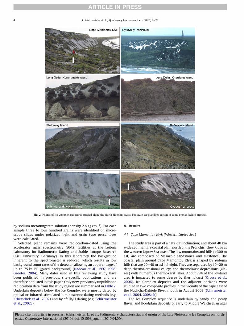
Fig. 2. Photos of Ice Complex exposures studied along the North Siberian coasts. For scale see standing person in some photos (white arrows).
L. Schirrmeister et al. / Quaternary International xxx (2010) 1e234
ARTICLE IN PRESS
by sodium metatungstate solution (density 2.89 g cm�3). For eachsample three to four hundred grains were identified on micro-scope slides under polarized light and grain type percentageswere calculated.
Selected plant remains were radiocarbon-dated using theaccelerator mass spectrometry (AMS) facilities at the LeibnizLaboratory for Radiometric Dating and Stable Isotope Research(Kiel University, Germany). In this laboratory the backgroundinherent to the spectrometer is reduced, which results in lowbackground count rates of the detector, allowing an apparent age ofup to 75 ka BP (gated background) (Nadeau et al., 1997, 1998;Grootes, 2004). Many dates used in this reviewing study havebeen published in previous, site-specific publications and aretherefore not listed in this paper. Only new, previously unpublishedradiocarbon data from the study region are summarized in Table 2.Underlain deposits below the Ice Complex were mostly dated byoptical or infrared stimulated luminescence dating methods (e.g.Krbetschek et al., 2002) and by 230Th/U dating (e.g. Schirrmeisteret al., 2002c).
Please cite this article in press as: Schirrmeister, L., et al., Sedimentary cheast..., Quaternary International (2010), doi:10.1016/j.quaint.2010.04.004
4. Results
4.1. Cape Mamontov Klyk (Western Laptev Sea)
The study area is part of a flat (<1� inclination) and about 40 kmwide sedimentary coastal plain north of the Pronchishchev Ridge atthewestern Laptev Sea coast. The lowmountains and hills (<300 masl) are composed of Mesozoic sandstones and siltstones. Thecoastal plain around Cape Mamontov Klyk is shaped by Yedomahills that are 20e40 m asl in height. They are separated by 10e20 mdeep thermo-erosional valleys and thermokarst depressions (ala-ses) with numerous thermokarst lakes. About 78% of the lowlandarea is impacted to some degree by thermokarst (Grosse et al.,2006). Ice Complex deposits and the adjacent horizons werestudied in two composite profiles in the vicinity of the cape east ofthe Nuchcha-Dzhiele River mouth in August 2003 (Schirrmeisteret al., 2004, 2008a,b).
The Ice Complex sequence is underlain by sandy and peatyfluvial and floodplain deposits of Early to Middle Weichselian ages
aracteristics and origin of the Late Pleistocene Ice Complex on north-
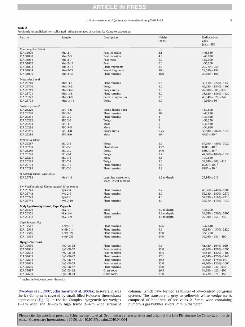
Table 2Previously unpublished non-calibrated radiocarbon ages of various Ice Complex exposures.
Lab. no. Sample Description Height[m asl]
Radiocarbonages[years BP]
Khardang Sise IslandKIA 31029 Kha-2-1 Peat inclusion 3.1 >43,550KIA 31030 Kha-2-3 Peat inclusion 4.3 >49,030KIA 31031 Kha-2-7 Peat moss 5.0 >52,090KIA 31032 Kha-2-13 Peat 6.6 >50,200KIA 31033 Kha-2-18 Plant fragments 8.6 29,770� 250KIA 31034 Kha-2-24 Wood fragments 10.1 28,050� 190KIA 31035 Kha-2-32 Plant remains 16.9 20,100� 100
Muostakh IslandKIA 25718 Muo-3-1 Plant remains 0.5 39,110þ 2220/�1740KIA 25720 Muo-3-5 Twigs 1.0 46,780þ 1270/�1100KIA 25719 Muo-3-4 Twigs, moss 2.0 42,800þ 980/�870KIA 25721 Muo-3-8 Plant remains 5.0 38,620þ 1310/�1120KIA 25722 Muo-3-9 Carex, eriophorum 7.5 40,340þ 820/�740KIA 25723 Muo-3-11 Twigs 9.7 19,560� 80
Stolbovoy IslandKIA 26279 STO-1-6 Twigs, betula nana 27 >50,890KIA 26280 STO-2-1 Plant remains 10 >40,830KIA 26281 STO 2-2 Plant remains 1 >36,440KIA 26282 STO 2-3 Twigs 3 >52,250KIA 26283 STO-3-1 Moss 5 >42,430KIA 26284 STO-3-5 Moss 6 >54,940KIA 26285 STO-3-8 Twigs, moss 6.75 36,580þ 2070/�1640KIA 26286 STO-4-0 Moss 10 4480� 40 a
Bel’kovsky IslandKIA 26287 BEL-2-1 Twigs 2.7 54,390þ 4890/�3020KIA 26288 BEL-2-6 Plant stems 13.7 8880� 40 a
KIA 26289 BEL-2-7 Twigs 14.6 8890� 35 a
KIA 26290 BEL-3-1 Twigs 3.7 47,660þ 1890/�1530KIA 26291 BEL-3-3 Moss 4.6 >39,840KIA 26293 BEL-7-1 Twigs 1.0 39,980þ 900/�810KIA 26194 BEL-7-3 Plant remains 2.5 8020� 100 a
KIA 26295 BEL-7-6 Plant remains 3.8 8990� 90 a
N Kotel’ny Island, Cape AnisiiKIA 25738 Mya-1-1 Lemming excrement,
seeds, insect remains1.5 m depth 27,860� 210
SW Kotel’ny Island, Khomurganakh River mouthKIA 25741 Kys-2-4 Plant remains 2.7 45,960þ 2480/�1880KIA 25742 Kys-2-5 Plant remains 3.0 52,280þ 3800/�2570KIA 25743 Kys-2-6 Moss 4.0 52,790þ 4110/�2710KIA 25744 Kys-2-10 Plant remains 8.4 35,370þ 1190/�1030
Maly Lyakhovsky Island, Cape VaygachKIA 26300 KLY-1-1 Moss 5.0 m depth >38,290KIA 26301 KLY-1-4 Plant remains 3.3 m depth 34,680þ 5380/�3200KIA 26302 KLY-1-9 Twigs 1.5 m depth 27,980þ 250/�240
Cape Svyatoy NosKIA 12517 X-99-019 Plant remains 14.6 >47,640KIA 12518 X-99-014 Plant remains 9.6 45,350þ 4370/�2820KIA 12516 X-99-024 Plant remains 17.0 >50,290KIA 12515 X-99-025 Plant remains 24.0 36,080þ 530/�490
Oyogos Yar coastKIA 37630 Oy7-08-32 Plant remains 9.5 41,420þ 1040/�920KIA 37631 Oy7-08-37 Peat inclusion 12.0 43,860þ 1270/�1090KIA 37632 Oy7-08-38 Peat inclusion 15.5 44,840þ 1270/�1100KIA 37633 Oy7-08-42 Plant remains 17.1 48,540þ 1750/�1440KIA 37634 Oy7-08-47 Plant remains 19.2 40,850þ 1750/1440KIA 37635 Oy7-08-53 Peat inclusion 22.0 44,900þ 1230/�1060KIA 37636 Oy7-08-57 Plant remains 24.0 38,600þ 930/�830KIA 37637 Oy7-08-62 Grass roots 26.5 34,630þ 420/�400KIA 37638 Oy7-08-63 Grass roots 27.0 32,220þ 370/�350
a Inclusive Holocene cover deposits.
L. Schirrmeister et al. / Quaternary International xxx (2010) 1e23 5
ARTICLE IN PRESS
(Overduin et al., 2007; Schirrmeister et al., 2008a). In several placesthe Ice Complex is covered by small, filled Holocene thermokarstdepressions (Fig. 3). In the Ice Complex, syngenetic ice wedges1e3 m wide and 10e25 m high frame 2e4 m wide sediment
Please cite this article in press as: Schirrmeister, L., et al., Sedimentary cheast..., Quaternary International (2010), doi:10.1016/j.quaint.2010.04.004
columns, which have formed as fillings of low-centred polygonalsystems. The transparent, grey to yellowish-white wedge ice iscomposed of hundreds of ice veins 2e5 mm wide containingnumerous gas bubbles several mm in diameter.
aracteristics and origin of the Late Pleistocene Ice Complex on north-
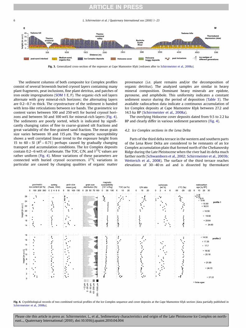
Fig. 3. Generalized cross-section of the exposure at Cape Mamontov Klyk (redrawn after to Schirrmeister et al., 2008a).
L. Schirrmeister et al. / Quaternary International xxx (2010) 1e236
ARTICLE IN PRESS
The sediment columns of both composite Ice Complex profilesconsist of several brownish buried cryosol layers containing manyplant fragments, peat inclusions, fine plant detritus, and patches ofiron oxide impregnations (SOM 1 E, F). The organic-rich soil layersalternate with grey mineral-rich horizons; the alternating layersare 0.2e0.7 m thick. The cryostructure of the sediment is bandedwith lens-like reticulations between ice bands. The gravimetric icecontent varies between 100 and 250 wt% for buried cryosol hori-zons and between 50 and 100 wt% for mineral-rich layers (Fig. 4).The sediments are poorly sorted, which is indicated by signifi-cantly changing ratios of fine to coarse-grained silt fractions andgreat variability of the fine-grained sand fraction. The mean grainsize varies between 10 and 115 mm. The magnetic susceptibilityshows a well correlated linear trend to the exposure height from15 to 60� SI (R2¼ 0.71) perhaps caused by gradually changingtransport and accumulation conditions. The Ice Complex depositscontain 0.2e6 wt% of carbonate. The TOC, C/N, and d13C values arerather uniform (Fig. 4). Minor variations of these parameters areconnected with buried cryosol occurrences. d13C variations inparticular are caused by changing qualities of organic matter
Fig. 4. Cryolithological records of two combined vertical profiles of the Ice Complex sequenSchirrmeister et al., 2008a).
Please cite this article in press as: Schirrmeister, L., et al., Sedimentary cheast..., Quaternary International (2010), doi:10.1016/j.quaint.2010.04.004
provenance (i.e. plant remains and/or the decomposition oforganic detritus). The analyzed samples are similar in heavymineral composition. Dominant heavy minerals are epidote,pyroxene, and amphibole. This uniformity indicates a constantsediment source during the period of deposition (Table 3). Theavailable radiocarbon data indicate a continuous accumulation ofIce Complex deposits at Cape Mamontov Klyk between 27.2 and14.5 ka BP (Schirrmeister et al., 2008a).
The overlying Holocene cover deposits dated from 9.5 to 2.2 kaBP and clearly differ in various sediment parameters (Fig. 4).
4.2. Ice Complex sections in the Lena Delta
Parts of the third delta terrace in the western and southern partsof the Lena River Delta are considered to be remnants of an IceComplex accumulation plain that formed north of the ChekanovskyRidge during the Late Pleistocenewhen the river had its delta muchfarther north (Schwamborn et al., 2002; Schirrmeister et al., 2003b;Wetterich et al., 2008). The surface of the third terrace reacheselevations of 30e40 m asl and is dissected by thermokarst
ce and cover deposits at the Cape Mamontov Klyk section (data partially published in
aracteristics and origin of the Late Pleistocene Ice Complex on north-
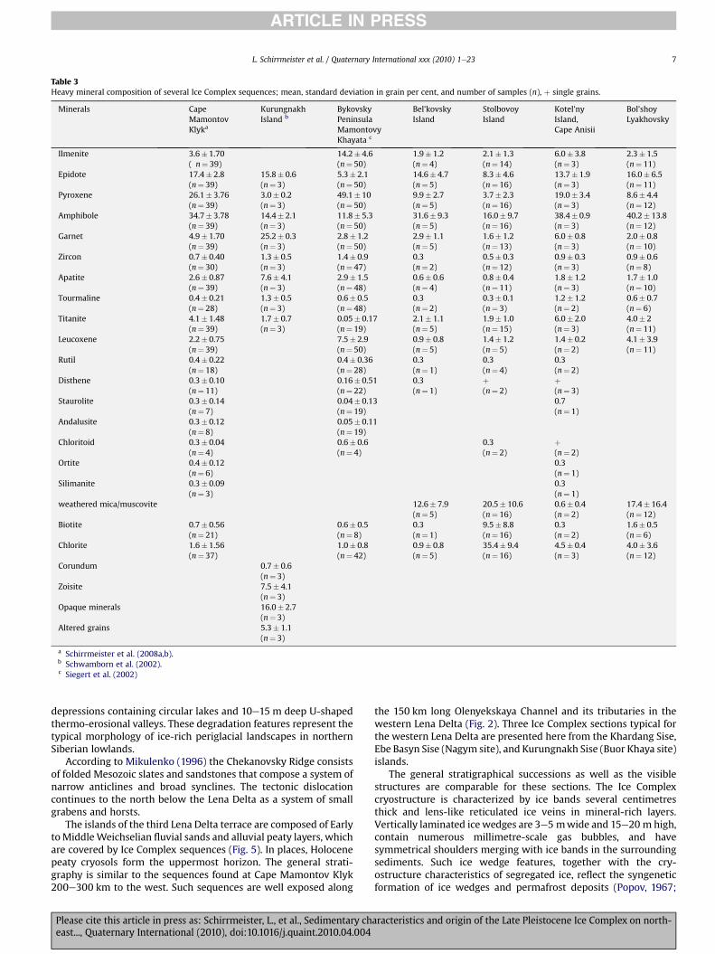
Table 3Heavy mineral composition of several Ice Complex sequences; mean, standard deviation in grain per cent, and number of samples (n), þ single grains.
Minerals CapeMamontovKlyka
KurungnakhIsland b
BykovskyPeninsulaMamontovyKhayata c
Bel’kovskyIsland
StolbovoyIsland
Kotel’nyIsland,Cape Anisii
Bol’shoyLyakhovsky
Ilmenite 3.6� 1.70 14.2� 4.6 1.9� 1.2 2.1� 1.3 6.0� 3.8 2.3� 1.5( n¼ 39) (n¼ 50) (n¼ 4) (n¼ 14) (n¼ 3) (n¼ 11)
Epidote 17.4� 2.8 15.8� 0.6 5.3� 2.1 14.6� 4.7 8.3� 4.6 13.7� 1.9 16.0� 6.5(n¼ 39) (n¼ 3) (n¼ 50) (n¼ 5) (n¼ 16) (n¼ 3) (n¼ 11)
Pyroxene 26.1� 3.76 3.0� 0.2 49.1� 10 9.9� 2.7 3.7� 2.3 19.0� 3.4 8.6� 4.4(n¼ 39) (n¼ 3) (n¼ 50) (n¼ 5) (n¼ 16) (n¼ 3) (n¼ 12)
Amphibole 34.7� 3.78 14.4� 2.1 11.8� 5.3 31.6� 9.3 16.0� 9.7 38.4� 0.9 40.2� 13.8(n¼ 39) (n¼ 3) (n¼ 50) (n¼ 5) (n¼ 16) (n¼ 3) (n¼ 12)
Garnet 4.9� 1.70 25.2� 0.3 2.8� 1.2 2.9� 1.1 1.6� 1.2 6.0� 0.8 2.0� 0.8(n¼ 39) (n¼ 3) (n¼ 50) (n¼ 5) (n¼ 13) (n¼ 3) (n¼ 10)
Zircon 0.7� 0.40 1.3� 0.5 1.4� 0.9 0.3 0.5� 0.3 0.9� 0.3 0.9� 0.6(n¼ 30) (n¼ 3) (n¼ 47) (n¼ 2) (n¼ 12) (n¼ 3) (n¼ 8)
Apatite 2.6� 0.87 7.6� 4.1 2.9� 1.5 0.6� 0.6 0.8� 0.4 1.8� 1.2 1.7� 1.0(n¼ 39) (n¼ 3) (n¼ 48) (n¼ 4) (n¼ 11) (n¼ 3) (n¼ 10)
Tourmaline 0.4� 0.21 1.3� 0.5 0.6� 0.5 0.3 0.3� 0.1 1.2� 1.2 0.6� 0.7(n¼ 28) (n¼ 3) (n¼ 48) (n¼ 2) (n¼ 3) (n¼ 2) (n¼ 6)
Titanite 4.1� 1.48 1.7� 0.7 0.05� 0.17 2.1� 1.1 1.9� 1.0 6.0� 2.0 4.0� 2(n¼ 39) (n¼ 3) (n¼ 19) (n¼ 5) (n¼ 15) (n¼ 3) (n¼ 11)
Leucoxene 2.2� 0.75 7.5� 2.9 0.9� 0.8 1.4� 1.2 1.4� 0.2 4.1� 3.9(n¼ 39) (n¼ 50) (n¼ 5) (n¼ 5) (n¼ 2) (n¼ 11)
Rutil 0.4� 0.22 0.4� 0.36 0.3 0.3 0.3(n¼ 18) (n¼ 28) (n¼ 1) (n¼ 4) (n¼ 2)
Disthene 0.3� 0.10 0.16� 0.51 0.3 þ þ(n¼ 11) (n¼ 22) (n¼ 1) (n¼ 2) (n¼ 3)
Staurolite 0.3� 0.14 0.04� 0.13 0.7(n¼ 7) (n¼ 19) (n¼ 1)
Andalusite 0.3� 0.12 0.05� 0.11(n¼ 8) (n¼ 19)
Chloritoid 0.3� 0.04 0.6� 0.6 0.3 þ(n¼ 4) (n¼ 4) (n¼ 2) (n¼ 2)
Ortite 0.4� 0.12 0.3(n¼ 6) (n¼ 1)
Silimanite 0.3� 0.09 0.3(n¼ 3) (n¼ 1)
weathered mica/muscovite 12.6� 7.9 20.5� 10.6 0.6� 0.4 17.4� 16.4(n¼ 5) (n¼ 16) (n¼ 2) (n¼ 12)
Biotite 0.7� 0.56 0.6� 0.5 0.3 9.5� 8.8 0.3 1.6� 0.5(n¼ 21) (n¼ 8) (n¼ 1) (n¼ 16) (n¼ 2) (n¼ 6)
Chlorite 1.6� 1.56 1.0� 0.8 0.9� 0.8 35.4� 9.4 4.5� 0.4 4.0� 3.6(n¼ 37) (n¼ 42) (n¼ 5) (n¼ 16) (n¼ 3) (n¼ 12)
Corundum 0.7� 0.6(n¼ 3)
Zoisite 7.5� 4.1(n¼ 3)
Opaque minerals 16.0� 2.7(n¼ 3)
Altered grains 5.3� 1.1(n¼ 3)
a Schirrmeister et al. (2008a,b).b Schwamborn et al. (2002).c Siegert et al. (2002)
L. Schirrmeister et al. / Quaternary International xxx (2010) 1e23 7
ARTICLE IN PRESS
depressions containing circular lakes and 10e15 m deep U-shapedthermo-erosional valleys. These degradation features represent thetypical morphology of ice-rich periglacial landscapes in northernSiberian lowlands.
According to Mikulenko (1996) the Chekanovsky Ridge consistsof folded Mesozoic slates and sandstones that compose a system ofnarrow anticlines and broad synclines. The tectonic dislocationcontinues to the north below the Lena Delta as a system of smallgrabens and horsts.
The islands of the third Lena Delta terrace are composed of EarlytoMiddleWeichselian fluvial sands and alluvial peaty layers, whichare covered by Ice Complex sequences (Fig. 5). In places, Holocenepeaty cryosols form the uppermost horizon. The general strati-graphy is similar to the sequences found at Cape Mamontov Klyk200e300 km to the west. Such sequences are well exposed along
Please cite this article in press as: Schirrmeister, L., et al., Sedimentary cheast..., Quaternary International (2010), doi:10.1016/j.quaint.2010.04.004
the 150 km long Olenyekskaya Channel and its tributaries in thewestern Lena Delta (Fig. 2). Three Ice Complex sections typical forthe western Lena Delta are presented here from the Khardang Sise,Ebe Basyn Sise (Nagym site), and Kurungnakh Sise (Buor Khaya site)islands.
The general stratigraphical successions as well as the visiblestructures are comparable for these sections. The Ice Complexcryostructure is characterized by ice bands several centimetresthick and lens-like reticulated ice veins in mineral-rich layers.Vertically laminated icewedges are 3e5 mwide and 15e20 m high,contain numerous millimetre-scale gas bubbles, and havesymmetrical shoulders merging with ice bands in the surroundingsediments. Such ice wedge features, together with the cry-ostructure characteristics of segregated ice, reflect the syngeneticformation of ice wedges and permafrost deposits (Popov, 1967;
aracteristics and origin of the Late Pleistocene Ice Complex on north-
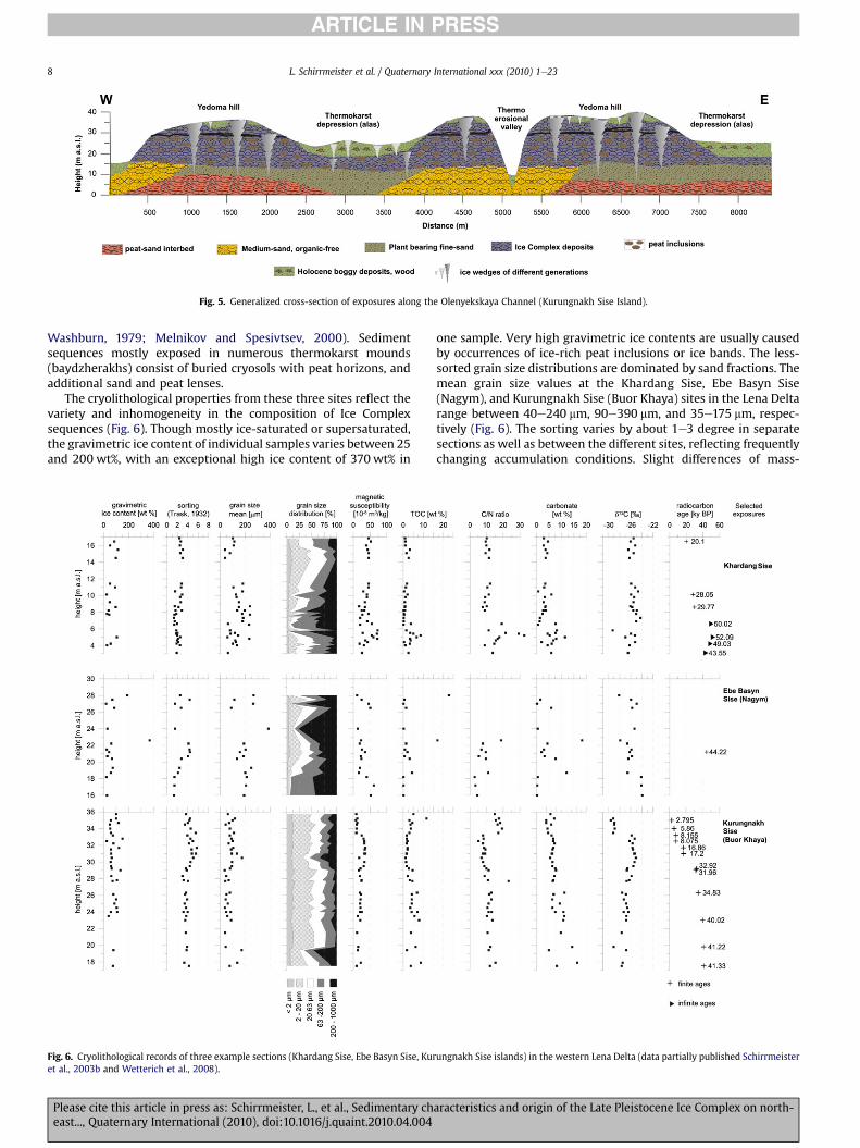
Fig. 5. Generalized cross-section of exposures along the Olenyekskaya Channel (Kurungnakh Sise Island).
L. Schirrmeister et al. / Quaternary International xxx (2010) 1e238
ARTICLE IN PRESS
Washburn, 1979; Melnikov and Spesivtsev, 2000). Sedimentsequences mostly exposed in numerous thermokarst mounds(baydzherakhs) consist of buried cryosols with peat horizons, andadditional sand and peat lenses.
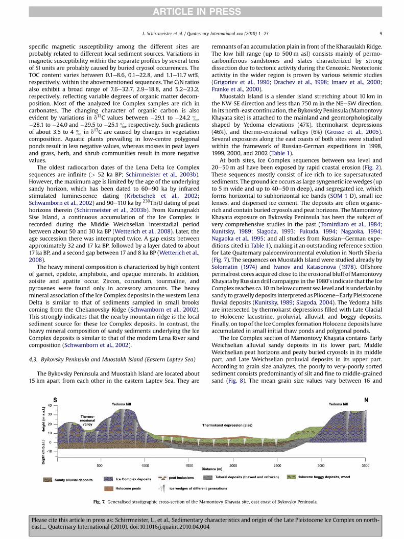
The cryolithological properties from these three sites reflect thevariety and inhomogeneity in the composition of Ice Complexsequences (Fig. 6). Though mostly ice-saturated or supersaturated,the gravimetric ice content of individual samples varies between 25and 200 wt%, with an exceptional high ice content of 370 wt% in
Fig. 6. Cryolithological records of three example sections (Khardang Sise, Ebe Basyn Sise, Kuret al., 2003b and Wetterich et al., 2008).
Please cite this article in press as: Schirrmeister, L., et al., Sedimentary cheast..., Quaternary International (2010), doi:10.1016/j.quaint.2010.04.004
one sample. Very high gravimetric ice contents are usually causedby occurrences of ice-rich peat inclusions or ice bands. The less-sorted grain size distributions are dominated by sand fractions. Themean grain size values at the Khardang Sise, Ebe Basyn Sise(Nagym), and Kurungnakh Sise (Buor Khaya) sites in the Lena Deltarange between 40e240 mm, 90e390 mm, and 35e175 mm, respec-tively (Fig. 6). The sorting varies by about 1e3 degree in separatesections as well as between the different sites, reflecting frequentlychanging accumulation conditions. Slight differences of mass-
ungnakh Sise islands) in the western Lena Delta (data partially published Schirrmeister
aracteristics and origin of the Late Pleistocene Ice Complex on north-
L. Schirrmeister et al. / Quaternary International xxx (2010) 1e23 9
ARTICLE IN PRESS
specific magnetic susceptibility among the different sites areprobably related to different local sediment sources. Variations inmagnetic susceptibility within the separate profiles by several tensof SI units are probably caused by buried cryosol occurrences. TheTOC content varies between 0.1e8.6, 0.1e22.8, and 1.1e11.7 wt%,respectively, within the abovementioned sequences. The C/N ratiosalso exhibit a broad range of 7.6e32.7, 2.9e18.8, and 5.2e23.2,respectively, reflecting variable degrees of organic matter decom-position. Most of the analyzed Ice Complex samples are rich incarbonates. The changing character of organic carbon is alsoevident by variations in d13C values between �29.1 to �24.2 &,�28.1 to �24.0 and �29.5 to �25.1 &, respectively. Such gradientsof about 3.5 to 4 & in d13C are caused by changes in vegetationcomposition. Aquatic plants prevailing in low-centre polygonalponds result in less negative values, whereas mosses in peat layersand grass, herb, and shrub communities result in more negativevalues.
The oldest radiocarbon dates of the Lena Delta Ice Complexsequences are infinite (> 52 ka BP; Schirrmeister et al., 2003b).However, the maximum age is limited by the age of the underlyingsandy horizon, which has been dated to 60e90 ka by infraredstimulated luminescence dating (Krbetschek et al., 2002;Schwamborn et al., 2002) and 90e110 ka by 230Th/U dating of peathorizons therein (Schirrmeister et al., 2003b). From KurungnakhSise Island, a continuous accumulation of the Ice Complex isrecorded during the Middle Weichselian interstadial periodbetween about 50 and 30 ka BP (Wetterich et al., 2008). Later, theage succession there was interrupted twice. A gap exists betweenapproximately 32 and 17 ka BP, followed by a layer dated to about17 ka BP, and a second gap between 17 and 8 ka BP (Wetterich et al.,2008).
The heavy mineral composition is characterized by high contentof garnet, epidote, amphibole, and opaque minerals. In addition,zoisite and apatite occur. Zircon, corundum, tourmaline, andpyroxenes were found only in accessory amounts. The heavymineral association of the Ice Complex deposits in thewestern LenaDelta is similar to that of sediments sampled in small brookscoming from the Chekanovsky Ridge (Schwamborn et al., 2002).This strongly indicates that the nearby mountain ridge is the localsediment source for these Ice Complex deposits. In contrast, theheavy mineral composition of sandy sediments underlying the IceComplex deposits is similar to that of the modern Lena River sandcomposition (Schwamborn et al., 2002).
4.3. Bykovsky Peninsula and Muostakh Island (Eastern Laptev Sea)
The Bykovsky Peninsula and Muostakh Island are located about15 km apart from each other in the eastern Laptev Sea. They are
Fig. 7. Generalised stratigraphic cross-section of the Mamo
Please cite this article in press as: Schirrmeister, L., et al., Sedimentary cheast..., Quaternary International (2010), doi:10.1016/j.quaint.2010.04.004
remnants of an accumulation plain in front of the Kharaulakh Ridge.The low hill range (up to 500 m asl) consists mainly of permo-carboniferous sandstones and slates characterized by strongdissection due to tectonic activity during the Cenozoic. Neotectonicactivity in the wider region is proven by various seismic studies(Grigoriev et al., 1996; Drachev et al., 1998; Imaev et al., 2000;Franke et al., 2000).
Muostakh Island is a slender island stretching about 10 km inthe NW-SE direction and less than 750 m in the NEeSW direction.In its north-east continuation, the Bykovsky Peninsula (MamontovyKhayata site) is attached to the mainland and geomorphologicallyshaped by Yedoma elevations (47%), thermokarst depressions(46%), and thermo-erosional valleys (6%) (Grosse et al., 2005).Several exposures along the east coasts of both sites were studiedwithin the framework of Russian-German expeditions in 1998,1999, 2000, and 2002 (Table 1).
At both sites, Ice Complex sequences between sea level and20e50 m asl have been exposed by rapid coastal erosion (Fig. 2).These sequences mostly consist of ice-rich to ice-supersaturatedsediments. The ground ice occurs as large syngenetic icewedges (upto 5 m wide and up to 40e50 m deep), and segregated ice, whichforms horizontal to subhorizontal ice bands (SOM 1 D), small icelenses, and dispersed ice cement. The deposits are often organic-rich and contain buried cryosols and peat horizons. TheMamontovyKhayata exposure on Bykovsky Peninsula has been the subject ofvery comprehensive studies in the past (Tomirdiaro et al., 1984;Kunitsky, 1989; Slagoda, 1993; Fukuda, 1994; Nagaoka, 1994;Nagaoka et al., 1995; and all studies from RussianeGerman expe-ditions cited in Table 1), making it an outstanding reference sectionfor Late Quaternary paleoenvironmental evolution in North Siberia(Fig. 7). The sequences on Muostakh Island were studied already bySolomatin (1974) and Ivanov and Katasonova (1978). Offshorepermafrost cores acquired close to the erosional bluff ofMamontovyKhayata byRussiandrill campaigns in the 1980’s indicate that the IceComplex reaches ca.10 mbelowcurrent sea level and is underlain bysandy to gravelly deposits interpreted as PlioceneeEarly Pleistocenefluvial deposits (Kunitsky, 1989; Slagoda, 2004). The Yedoma hillsare intersected by thermokarst depressions filled with Late Glacialto Holocene lacustrine, proluvial, alluvial, and boggy deposits.Finally, on top of the Ice Complex formation Holocene deposits haveaccumulated in small initial thaw ponds and polygonal ponds.
The Ice Complex section of Mamontovy Khayata contains EarlyWeichselian alluvial sandy deposits in its lower part, MiddleWeichselian peat horizons and peaty buried cryosols in its middlepart, and Late Weichselian proluvial deposits in its upper part.According to grain size analyzes, the poorly to very-poorly sortedsediment consists predominantly of silt and fine to middle-grainedsand (Fig. 8). The mean grain size values vary between 16 and
ntovy Khayata site, east coast of Bykovsky Peninsula.
aracteristics and origin of the Late Pleistocene Ice Complex on north-
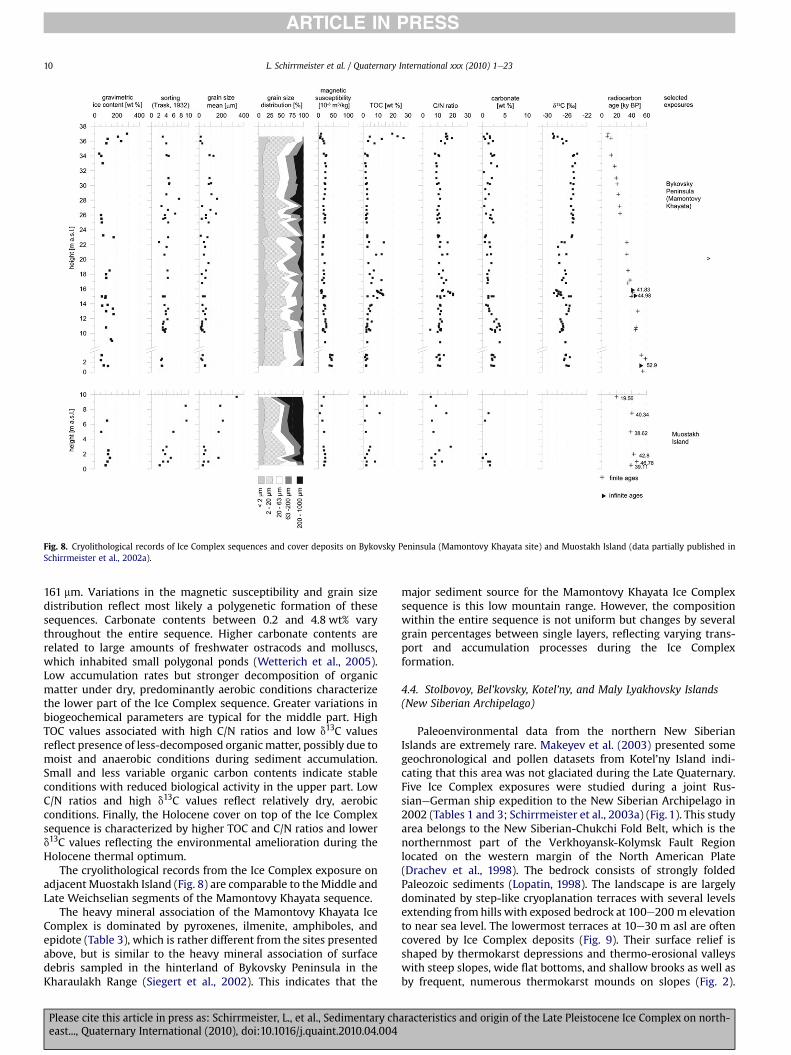
Fig. 8. Cryolithological records of Ice Complex sequences and cover deposits on Bykovsky Peninsula (Mamontovy Khayata site) and Muostakh Island (data partially published inSchirrmeister et al., 2002a).
L. Schirrmeister et al. / Quaternary International xxx (2010) 1e2310
ARTICLE IN PRESS
161 mm. Variations in the magnetic susceptibility and grain sizedistribution reflect most likely a polygenetic formation of thesesequences. Carbonate contents between 0.2 and 4.8 wt% varythroughout the entire sequence. Higher carbonate contents arerelated to large amounts of freshwater ostracods and molluscs,which inhabited small polygonal ponds (Wetterich et al., 2005).Low accumulation rates but stronger decomposition of organicmatter under dry, predominantly aerobic conditions characterizethe lower part of the Ice Complex sequence. Greater variations inbiogeochemical parameters are typical for the middle part. HighTOC values associated with high C/N ratios and low d13C valuesreflect presence of less-decomposed organicmatter, possibly due tomoist and anaerobic conditions during sediment accumulation.Small and less variable organic carbon contents indicate stableconditions with reduced biological activity in the upper part. LowC/N ratios and high d13C values reflect relatively dry, aerobicconditions. Finally, the Holocene cover on top of the Ice Complexsequence is characterized by higher TOC and C/N ratios and lowerd13C values reflecting the environmental amelioration during theHolocene thermal optimum.
The cryolithological records from the Ice Complex exposure onadjacent Muostakh Island (Fig. 8) are comparable to the Middle andLate Weichselian segments of the Mamontovy Khayata sequence.
The heavy mineral association of the Mamontovy Khayata IceComplex is dominated by pyroxenes, ilmenite, amphiboles, andepidote (Table 3), which is rather different from the sites presentedabove, but is similar to the heavy mineral association of surfacedebris sampled in the hinterland of Bykovsky Peninsula in theKharaulakh Range (Siegert et al., 2002). This indicates that the
Please cite this article in press as: Schirrmeister, L., et al., Sedimentary cheast..., Quaternary International (2010), doi:10.1016/j.quaint.2010.04.004
major sediment source for the Mamontovy Khayata Ice Complexsequence is this low mountain range. However, the compositionwithin the entire sequence is not uniform but changes by severalgrain percentages between single layers, reflecting varying trans-port and accumulation processes during the Ice Complexformation.
4.4. Stolbovoy, Bel’kovsky, Kotel’ny, and Maly Lyakhovsky Islands(New Siberian Archipelago)
Paleoenvironmental data from the northern New SiberianIslands are extremely rare. Makeyev et al. (2003) presented somegeochronological and pollen datasets from Kotel’ny Island indi-cating that this area was not glaciated during the Late Quaternary.Five Ice Complex exposures were studied during a joint Rus-sianeGerman ship expedition to the New Siberian Archipelago in2002 (Tables 1 and 3; Schirrmeister et al., 2003a) (Fig. 1). This studyarea belongs to the New Siberian-Chukchi Fold Belt, which is thenorthernmost part of the Verkhoyansk-Kolymsk Fault Regionlocated on the western margin of the North American Plate(Drachev et al., 1998). The bedrock consists of strongly foldedPaleozoic sediments (Lopatin, 1998). The landscape is are largelydominated by step-like cryoplanation terraces with several levelsextending from hills with exposed bedrock at 100e200 m elevationto near sea level. The lowermost terraces at 10e30 m asl are oftencovered by Ice Complex deposits (Fig. 9). Their surface relief isshaped by thermokarst depressions and thermo-erosional valleyswith steep slopes, wide flat bottoms, and shallow brooks as well asby frequent, numerous thermokarst mounds on slopes (Fig. 2).
aracteristics and origin of the Late Pleistocene Ice Complex on north-
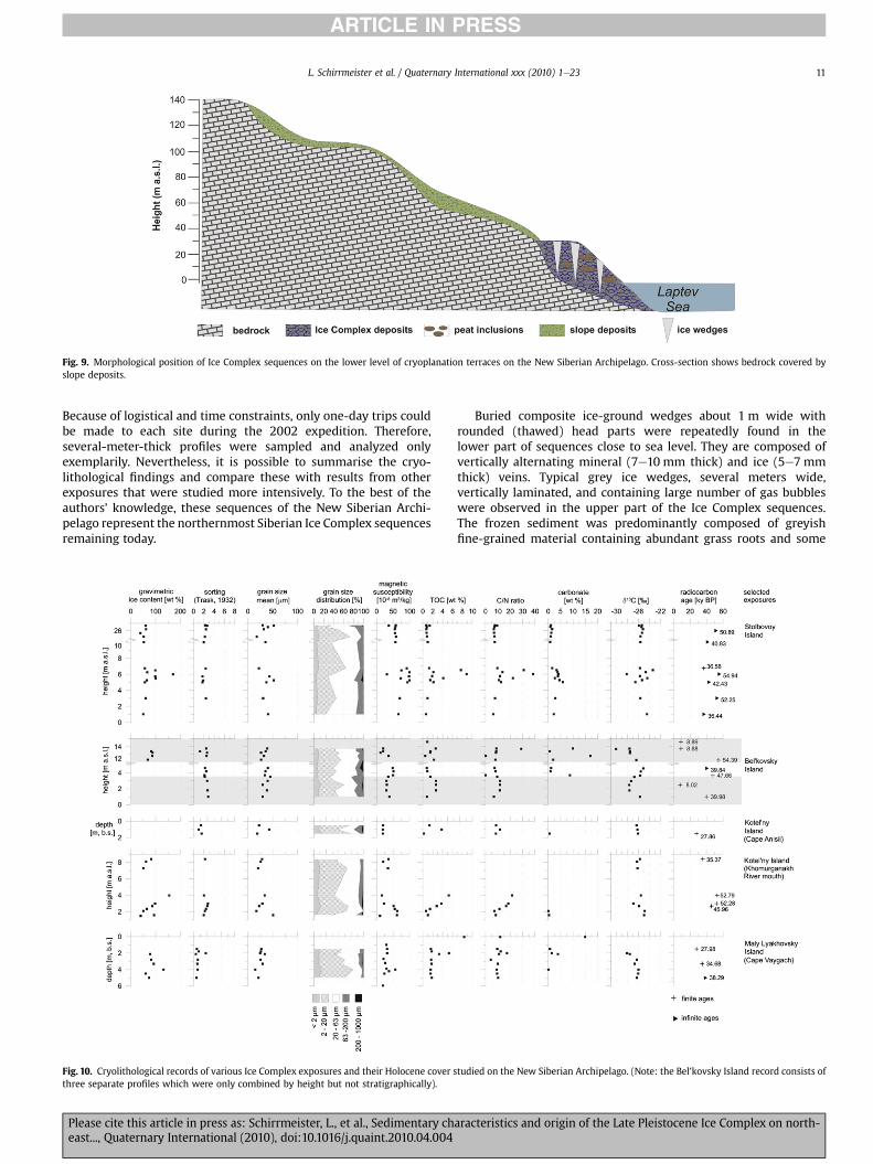
Fig. 9. Morphological position of Ice Complex sequences on the lower level of cryoplanation terraces on the New Siberian Archipelago. Cross-section shows bedrock covered byslope deposits.
L. Schirrmeister et al. / Quaternary International xxx (2010) 1e23 11
ARTICLE IN PRESS
Because of logistical and time constraints, only one-day trips couldbe made to each site during the 2002 expedition. Therefore,several-meter-thick profiles were sampled and analyzed onlyexemplarily. Nevertheless, it is possible to summarise the cryo-lithological findings and compare these with results from otherexposures that were studied more intensively. To the best of theauthors’ knowledge, these sequences of the New Siberian Archi-pelago represent the northernmost Siberian Ice Complex sequencesremaining today.
Fig. 10. Cryolithological records of various Ice Complex exposures and their Holocene cover sthree separate profiles which were only combined by height but not stratigraphically).
Please cite this article in press as: Schirrmeister, L., et al., Sedimentary cheast..., Quaternary International (2010), doi:10.1016/j.quaint.2010.04.004
Buried composite ice-ground wedges about 1 m wide withrounded (thawed) head parts were repeatedly found in thelower part of sequences close to sea level. They are composed ofvertically alternating mineral (7e10 mm thick) and ice (5e7 mmthick) veins. Typical grey ice wedges, several meters wide,vertically laminated, and containing large number of gas bubbleswere observed in the upper part of the Ice Complex sequences.The frozen sediment was predominantly composed of greyishfine-grained material containing abundant grass roots and some
tudied on the New Siberian Archipelago. (Note: the Bel’kovsky Island record consists of
aracteristics and origin of the Late Pleistocene Ice Complex on north-
L. Schirrmeister et al. / Quaternary International xxx (2010) 1e2312
ARTICLE IN PRESS
peat inclusions. In the lower part of the section at the Kho-murganakh River mouth (SW Kotel’ny Island) gravels androunded pebbles occurred. At two sites (Stolbovoy and Bel’kov-sky Island) typical 1e2 m thick peaty horizons were studied. Ingeneral, the observed banded cryostructures point to syncryo-genic accumulation, which is evident by ice bands continuing asshoulders of ice wedges. The deposits are mostly ice-rich or ice-supersaturated with a gravimetric ice content ranging from 30to 170 wt%.
All analyzed Ice Complex samples from these sites (Fig. 10) arecharacterized by a relatively uniform low grain size with meanvalues between 20e40 mm and a low sorting degree. The grainsize composition is dominated by silt. Only a small part (<15%)was classified as fine to middle-grained sand. The mass-specificmagnetic susceptibility differs between various sites as well aswithin longer profiles. The highest values were measured in IceComplex samples from Stolbovoy Island (about 100 SI), indicatinga different sediment source for these deposits. The TOC contentvaries between 0.5 and 8.8 wt% depending on the occurrence ofpeat inclusions and buried peaty cryosols. Horizons with higherorganic carbon content are also characterized by higher C/Nratios, reflecting less decomposition of organic matter. The IceComplex deposits from five exposures studied on the northernNew Siberian Archipelago were radiocarbon-dated to betweenolder than 55 ka BP to 28 ka BP (Table 2). The youngest depositswere found either on top of coastal exposures (e.g. StolbovoyIsland) or in the top parts of thermokarst mounds (e.g. Kotel’nyIsland, Cape Ansii, or Maly Lyakhovsky Island, Cape Vaygach).There are no Ice Complex formations younger than 28 ka BP onthe New Siberian Islands. In places, Ice Complex deposits in thestudied sections were covered by Holocene deposits (e.g. Bel’-kovsky Island).
The heavy mineral fraction from Stolbovoy Island Ice Complexsamples is dominated by micas and chlorite followed by amphi-bole and epidote. At Bel’kovsky Island the heavy mineral spectraare dominated by amphibole, epidote, muscovite, and pyroxene.Ice Complex samples from Kotel’ny Island (Cape Anisii) exhibityet another heavy mineral composition. The mineralogicalsignatures of the abovementioned sequences clearly differ fromthose of the western and eastern Laptev Sea coasts and the LenaDelta (Table 3). Though bedrock debris for mineralogicalcomparison was not found, a close genetic relationship of the IceComplex deposits to the nearby Jurassic and Cretaceous (Stolbo-voy), Devonian (Bel’kovsky), or Ordovician (Kotel’ny) bedrockhills, and thus to local sediment sources, can be assumed(Table 4).
Table 4Hinterland geology and geomorphology of the New Siberian Archipelago Ice Complex st
Study area/site Basement lithology(Lopatin, 1998)
Stolbovoy Island Jurassic andCretaceoussediment rocks
Bel’kovsky Island/Cape Skalisty
Devoniansediment rocks,NW-SE faults
Kotel’ny Island, N/Cape Anisii
Ordovicianlimestone
Kotel’ny Island, SW/Khomurganakh Rivermouth
Maly Lyakhovsky Island/Cape Vaygach
Upper Jurassic andLower Cretaceoussediment rocks
Please cite this article in press as: Schirrmeister, L., et al., Sedimentary cheast..., Quaternary International (2010), doi:10.1016/j.quaint.2010.04.004
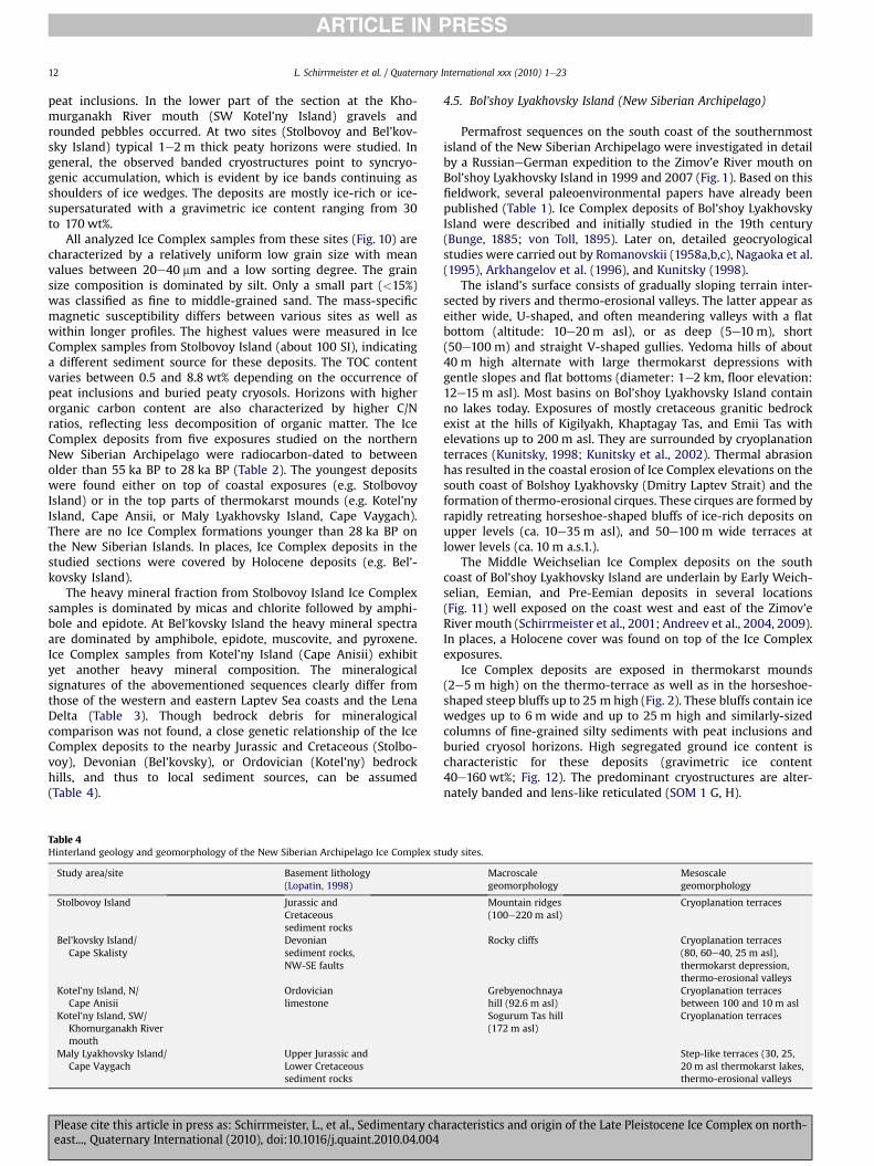
4.5. Bol’shoy Lyakhovsky Island (New Siberian Archipelago)
Permafrost sequences on the south coast of the southernmostisland of the New Siberian Archipelago were investigated in detailby a RussianeGerman expedition to the Zimov’e River mouth onBol’shoy Lyakhovsky Island in 1999 and 2007 (Fig. 1). Based on thisfieldwork, several paleoenvironmental papers have already beenpublished (Table 1). Ice Complex deposits of Bol’shoy LyakhovskyIsland were described and initially studied in the 19th century(Bunge, 1885; von Toll, 1895). Later on, detailed geocryologicalstudies were carried out by Romanovskii (1958a,b,c), Nagaoka et al.(1995), Arkhangelov et al. (1996), and Kunitsky (1998).
The island’s surface consists of gradually sloping terrain inter-sected by rivers and thermo-erosional valleys. The latter appear aseither wide, U-shaped, and often meandering valleys with a flatbottom (altitude: 10e20 m asl), or as deep (5e10 m), short(50e100 m) and straight V-shaped gullies. Yedoma hills of about40 m high alternate with large thermokarst depressions withgentle slopes and flat bottoms (diameter: 1e2 km, floor elevation:12e15 m asl). Most basins on Bol’shoy Lyakhovsky Island containno lakes today. Exposures of mostly cretaceous granitic bedrockexist at the hills of Kigilyakh, Khaptagay Tas, and Emii Tas withelevations up to 200 m asl. They are surrounded by cryoplanationterraces (Kunitsky, 1998; Kunitsky et al., 2002). Thermal abrasionhas resulted in the coastal erosion of Ice Complex elevations on thesouth coast of Bolshoy Lyakhovsky (Dmitry Laptev Strait) and theformation of thermo-erosional cirques. These cirques are formed byrapidly retreating horseshoe-shaped bluffs of ice-rich deposits onupper levels (ca. 10e35 m asl), and 50e100 m wide terraces atlower levels (ca. 10 m a.s.1.).
The Middle Weichselian Ice Complex deposits on the southcoast of Bol’shoy Lyakhovsky Island are underlain by Early Weich-selian, Eemian, and Pre-Eemian deposits in several locations(Fig. 11) well exposed on the coast west and east of the Zimov’eRiver mouth (Schirrmeister et al., 2001; Andreev et al., 2004, 2009).In places, a Holocene cover was found on top of the Ice Complexexposures.
Ice Complex deposits are exposed in thermokarst mounds(2e5 m high) on the thermo-terrace as well as in the horseshoe-shaped steep bluffs up to 25 m high (Fig. 2). These bluffs contain icewedges up to 6 m wide and up to 25 m high and similarly-sizedcolumns of fine-grained silty sediments with peat inclusions andburied cryosol horizons. High segregated ground ice content ischaracteristic for these deposits (gravimetric ice content40e160 wt%; Fig. 12). The predominant cryostructures are alter-nately banded and lens-like reticulated (SOM 1 G, H).
udy sites.
Macroscalegeomorphology
Mesoscalegeomorphology
Mountain ridges(100e220 m asl)
Cryoplanation terraces
Rocky cliffs Cryoplanation terraces(80, 60e40, 25 m asl),thermokarst depression,thermo-erosional valleys
Grebyenochnayahill (92.6 m asl)
Cryoplanation terracesbetween 100 and 10 m asl
Sogurum Tas hill(172 m asl)
Cryoplanation terraces
Step-like terraces (30, 25,20 m asl thermokarst lakes,thermo-erosional valleys
aracteristics and origin of the Late Pleistocene Ice Complex on north-
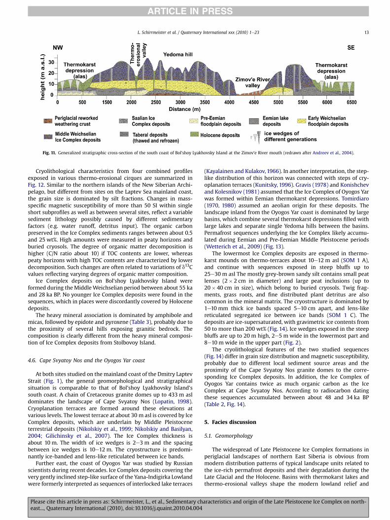
Fig. 11. Generalized stratigraphic cross-section of the south coast of Bol’shoy Lyakhovsky Island at the Zimov’e River mouth (redrawn after Andreev et al., 2004).
L. Schirrmeister et al. / Quaternary International xxx (2010) 1e23 13
ARTICLE IN PRESS
Cryolithological characteristics from four combined profilesexposed in various thermo-erosional cirques are summarized inFig. 12. Similar to the northern islands of the New Siberian Archi-pelago, but different from sites on the Laptev Sea mainland coast,the grain size is dominated by silt fractions. Changes in mass-specific magnetic susceptibility of more than 50 SI within singleshort subprofiles as well as between several sites, reflect a variablesediment lithology possibly caused by different sedimentaryfactors (e.g. water runoff, detritus input). The organic carbonpreserved in the Ice Complex sediments ranges between about 0.5and 25 wt%. High amounts were measured in peaty horizons andburied cryosols. The degree of organic matter decomposition ishigher (C/N ratio about 10) if TOC contents are lower, whereaspeaty horizons with high TOC contents are characterized by lowerdecomposition. Such changes are often related to variations of d13Cvalues reflecting varying degrees of organic matter composition.
Ice Complex deposits on Bol’shoy Lyakhovsky Island wereformed during the MiddleWeichselian period between about 55 kaand 28 ka BP. No younger Ice Complex deposits were found in thesequences, which in places were discordantly covered by Holocenedeposits.
The heavy mineral association is dominated by amphibole andmicas, followed by epidote and pyroxene (Table 3), probably due tothe proximity of several hills exposing granitic bedrock. Thecomposition is clearly different from the heavy mineral composi-tion of Ice Complex deposits from Stolbovoy Island.
4.6. Cape Svyatoy Nos and the Oyogos Yar coast
At both sites studied on themainland coast of the Dmitry LaptevStrait (Fig. 1), the general geomorphological and stratigraphicalsituation is comparable to that of Bol’shoy Lyakhovsky Island’ssouth coast. A chain of Cretaceous granite domes up to 433 m asldominates the landscape of Cape Svyatoy Nos (Lopatin, 1998).Cryoplanation terraces are formed around these elevations atvarious levels. The lowest terrace at about 30 m asl is covered by IceComplex deposits, which are underlain by Middle Pleistoceneterrestrial deposits (Nikolskiy et al., 1999; Nikolskiy and Basilyan,2004; Gilichinsky et al., 2007). The Ice Complex thickness isabout 10 m. The width of ice wedges is 2e3 m and the spacingbetween ice wedges is 10e12 m. The cryostructure is predomi-nantly ice-banded and lens-like reticulated between ice bands.
Further east, the coast of Oyogos Yar was studied by Russianscientists during recent decades. Ice Complex deposits covering thevery gently inclined step-like surface of the Yana-Indigirka Lowlandwere formerly interpreted as sequences of interlocked lake terraces
Please cite this article in press as: Schirrmeister, L., et al., Sedimentary cheast..., Quaternary International (2010), doi:10.1016/j.quaint.2010.04.004
(Kayalainen and Kulakov, 1966). In another interpretation, the step-like distribution of this horizon was connected with steps of cry-oplanation terraces (Kunitsky, 1996). Gravis (1978) and Konishchevand Kolesnikov (1981) assumed that the Ice Complex of Oyogos Yarwas formed within Eemian thermokarst depressions. Tomirdiaro(1970, 1980) assumed an aeolian origin for these deposits. Thelandscape inland from the Oyogos Yar coast is dominated by largebasins, which combine several thermokarst depressions filled withlarge lakes and separate single Yedoma hills between the basins.Permafrost sequences underlying the Ice Complex likely accumu-lated during Eemian and Pre-Eemian Middle Pleistocene periods(Wetterich et al., 2009) (Fig. 13).
The lowermost Ice Complex deposits are exposed in thermo-karst mounds on thermo-terraces about 10e12 m asl (SOM 1 A),and continue with sequences exposed in steep bluffs up to25e30 m asl The mostly grey-brown sandy silt contains small peatlenses (2� 2 cm in diameter) and large peat inclusions (up to20� 40 cm in size), which belong to buried cryosols. Twig frag-ments, grass roots, and fine distributed plant detritus are alsocommon in the mineral matrix. The cryostructure is dominated by1e10 mm thick ice bands spaced 5e10 cm apart, and lens-likereticulated segregated ice between ice bands (SOM 1 C). Thedeposits are ice-supersaturated, with gravimetric ice contents from50 to more than 200 wt% (Fig. 14). Ice wedges exposed in the steepbluffs are up to 20 m high, 2e5 m wide in the lowermost part and8e10 m wide in the upper part (Fig. 2).
The cryolithological features of the two studied sequences(Fig. 14) differ in grain size distribution and magnetic susceptibility,probably due to different local sediment source areas and theproximity of the Cape Svyatoy Nos granite domes to the corre-sponding Ice Complex deposits. In addition, the Ice Complex ofOyogos Yar contains twice as much organic carbon as the IceComplex at Cape Svyatoy Nos. According to radiocarbon datingthese sequences accumulated between about 48 and 34 ka BP(Table 2, Fig. 14).
5. Facies discussion
5.1. Geomorphology
The widespread of Late Pleistocene Ice Complex formations inperiglacial landscapes of northern East Siberia is obvious frommodern distribution patterns of typical landscape units related tothe ice-rich permafrost deposits and their degradation during theLate Glacial and the Holocene. Basins with thermokarst lakes andthermo-erosional valleys shape the modern lowland relief and
aracteristics and origin of the Late Pleistocene Ice Complex on north-
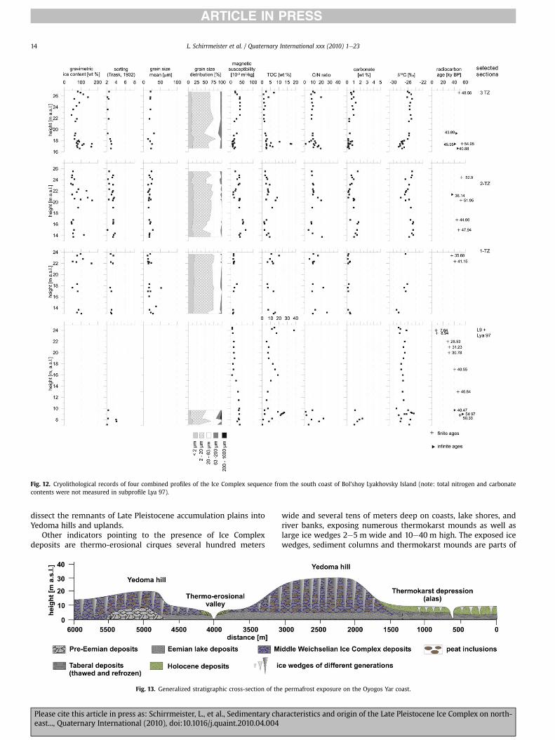
Fig. 12. Cryolithological records of four combined profiles of the Ice Complex sequence from the south coast of Bol’shoy Lyakhovsky Island (note: total nitrogen and carbonatecontents were not measured in subprofile Lya 97).
L. Schirrmeister et al. / Quaternary International xxx (2010) 1e2314
ARTICLE IN PRESS
dissect the remnants of Late Pleistocene accumulation plains intoYedoma hills and uplands.
Other indicators pointing to the presence of Ice Complexdeposits are thermo-erosional cirques several hundred meters
Fig. 13. Generalized stratigraphic cross-section of th
Please cite this article in press as: Schirrmeister, L., et al., Sedimentary cheast..., Quaternary International (2010), doi:10.1016/j.quaint.2010.04.004
wide and several tens of meters deep on coasts, lake shores, andriver banks, exposing numerous thermokarst mounds as well aslarge ice wedges 2e5 m wide and 10e40 m high. The exposed icewedges, sediment columns and thermokarst mounds are parts of
e permafrost exposure on the Oyogos Yar coast.
aracteristics and origin of the Late Pleistocene Ice Complex on north-
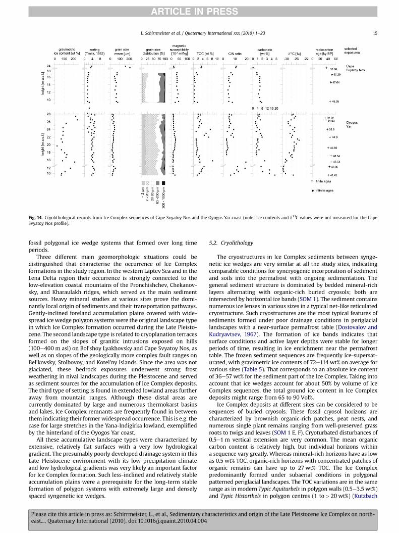
Fig. 14. Cryolithological records from Ice Complex sequences of Cape Svyatoy Nos and the Oyogos Yar coast (note: Ice contents and d13C values were not measured for the CapeSvyatoy Nos profile).
L. Schirrmeister et al. / Quaternary International xxx (2010) 1e23 15
ARTICLE IN PRESS
fossil polygonal ice wedge systems that formed over long timeperiods.
Three different main geomorphologic situations could bedistinguished that characterise the occurrence of Ice Complexformations in the study region. In thewestern Laptev Sea and in theLena Delta region their occurrence is strongly connected to thelow-elevation coastal mountains of the Pronchishchev, Chekanov-sky, and Kharaulakh ridges, which served as the main sedimentsources. Heavy mineral studies at various sites prove the domi-nantly local origin of sediments and their transportation pathways.Gently-inclined foreland accumulation plains covered with wide-spread icewedge polygon systemswere the original landscape typein which Ice Complex formation occurred during the Late Pleisto-cene. The second landscape type is related to cryoplanation terracesformed on the slopes of granitic intrusions exposed on hills(100e400 m asl) on Bol’shoy Lyakhovsky and Cape Svyatoy Nos, aswell as on slopes of the geologically more complex fault ranges onBel’kovsky, Stolbovoy, and Kotel’ny Islands. Since the area was notglaciated, these bedrock exposures underwent strong frostweathering in nival landscapes during the Pleistocene and servedas sediment sources for the accumulation of Ice Complex deposits.The third type of setting is found in extended lowland areas furtheraway from mountain ranges. Although these distal areas arecurrently dominated by large and numerous thermokarst basinsand lakes, Ice Complex remnants are frequently found in betweenthem indicating their former widespread occurrence. This is e.g. thecase for large stretches in the Yana-Indigirka lowland, exemplifiedby the hinterland of the Oyogos Yar coast.
All these accumulative landscape types were characterized byextensive, relatively flat surfaces with a very low hydrologicalgradient. The presumably poorly developed drainage system in thisLate Pleistocene environment with its low precipitation climateand low hydrological gradients was very likely an important factorfor Ice Complex formation. Such less-inclined and relatively stableaccumulation plains were a prerequisite for the long-term stableformation of polygon systems with extremely large and denselyspaced syngenetic ice wedges.
Please cite this article in press as: Schirrmeister, L., et al., Sedimentary cheast..., Quaternary International (2010), doi:10.1016/j.quaint.2010.04.004
5.2. Cryolithology
The cryostructures in Ice Complex sediments between synge-netic ice wedges are very similar at all the study sites, indicatingcomparable conditions for syncryogenic incorporation of sedimentand soils into the permafrost with ongoing sedimentation. Thegeneral sediment structure is dominated by bedded mineral-richlayers alternating with organic-rich buried cryosols; both areintersected by horizontal ice bands (SOM 1). The sediment containsnumerous ice lenses in various sizes in a typical net-like reticulatedcryostructure. Such cryostructures are the most typical features ofsediments formed under poor drainage conditions in periglaciallandscapes with a near-surface permafrost table (Dostovalov andKudryavtsev, 1967). The formation of ice bands indicates thatsurface conditions and active layer depths were stable for longerperiods of time, resulting in ice enrichment near the permafrosttable. The frozen sediment sequences are frequently ice-supersat-urated, with gravimetric ice contents of 72e114 wt% on average forvarious sites (Table 5). That corresponds to an absolute ice contentof 36e57 wt% for the sediment part of the Ice Complex. Taking intoaccount that ice wedges account for about 50% by volume of IceComplex sequences, the total ground ice content in Ice Complexdeposits might range from 65 to 90 Vol%.
Ice Complex deposits at different sites can be considered to besequences of buried cryosols. These fossil cryosol horizons arecharacterized by brownish organic-rich patches, peat nests, andnumerous single plant remains ranging from well-preserved grassroots to twigs and leaves (SOM 1 E, F). Cryoturbated disturbances of0.5e1 m vertical extension are very common. The mean organiccarbon content is relatively high, but individual horizons withina sequence vary greatly. Whereas mineral-rich horizons have as lowas 0.5 wt% TOC, organic-rich horizons with concentrated patches oforganic remains can have up to 27 wt% TOC. The Ice Complexpredominantly formed under subaerial conditions in polygonalpatterned periglacial landscapes. The TOC variations are in the samerange as in modern Typic Aquiturbels in polygon walls (0.5e3.5 wt%)and Typic Historthels in polygon centres (1 to> 20 wt%) (Kutzbach
aracteristics and origin of the Late Pleistocene Ice Complex on north-
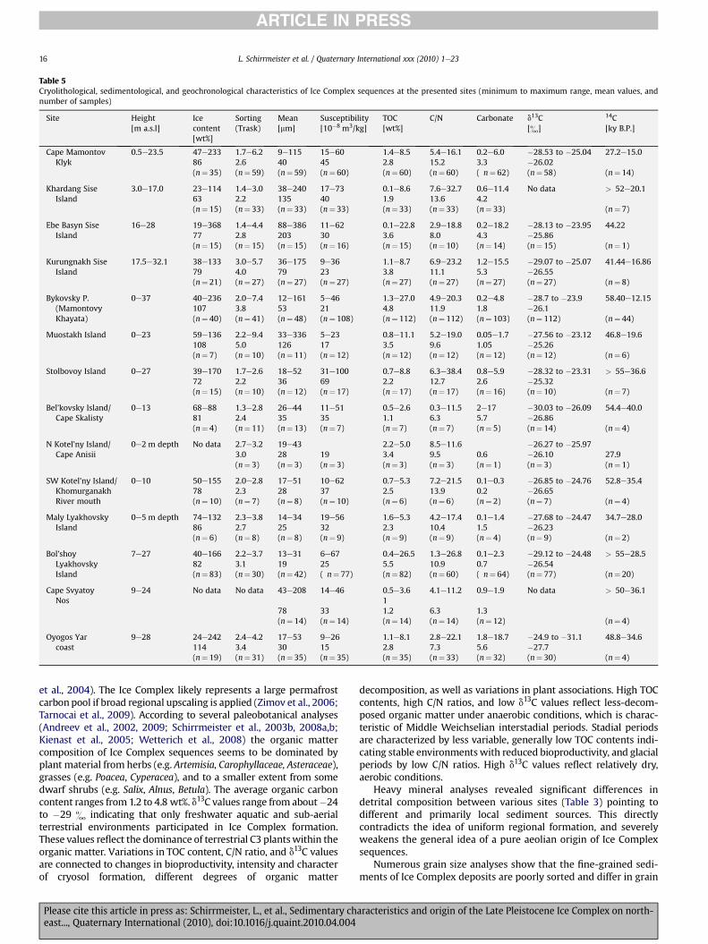
Table 5Cryolithological, sedimentological, and geochronological characteristics of Ice Complex sequences at the presented sites (minimum to maximum range, mean values, andnumber of samples)
Site Height[m a.s.l]
Icecontent[wt%]
Sorting(Trask)
Mean[mm]
Susceptibility[10�8 m3/kg]
TOC[wt%]
C/N Carbonate d13C[&]
14C[ky B.P.]
Cape MamontovKlyk
0.5e23.5 47e233 1.7e6.2 9e115 15e60 1.4e8.5 5.4e16.1 0.2e6.0 �28.53 to �25.04 27.2e15.086 2.6 40 45 2.8 15.2 3.3 �26.02(n¼ 35) (n¼ 59) (n¼ 59) (n¼ 60) (n¼ 60) (n¼ 60) ( n¼ 62) (n¼ 58) (n¼ 14)
Khardang SiseIsland
3.0e17.0 23e114 1.4e3.0 38e240 17e73 0.1e8.6 7.6e32.7 0.6e11.4 No data > 52e20.163 2.2 135 40 1.9 13.6 4.2(n¼ 15) (n¼ 33) (n¼ 33) (n¼ 33) (n¼ 33) (n¼ 33) (n¼ 33) (n¼ 7)
Ebe Basyn SiseIsland
16e28 19e368 1.4e4.4 88e386 11e62 0.1e22.8 2.9e18.8 0.2e18.2 �28.13 to �23.95 44.2277 2.8 203 30 3.6 8.0 4.3 �25.86(n¼ 15) (n¼ 15) (n¼ 15) (n¼ 16) (n¼ 15) (n¼ 10) (n¼ 14) (n¼ 15) (n¼ 1)
Kurungnakh SiseIsland
17.5e32.1 38e133 3.0e5.7 36e175 9e36 1.1e8.7 6.9e23.2 1.2e15.5 �29.07 to �25.07 41.44e16.8679 4.0 79 23 3.8 11.1 5.3 �26.55(n¼ 21) (n¼ 27) (n¼ 27) (n¼ 27) (n¼ 27) (n¼ 27) (n¼ 27) (n¼ 27) (n¼ 8)
Bykovsky P.(MamontovyKhayata)
0e37 40e236 2.0e7.4 12e161 5e46 1.3e27.0 4.9e20.3 0.2e4.8 �28.7 to �23.9 58.40e12.15107 3.8 53 21 4.8 11.9 1.8 �26.1(n¼ 40) (n¼ 41) (n¼ 48) (n¼ 108) (n¼ 112) (n¼ 112) (n¼ 103) (n¼ 112) (n¼ 44)
Muostakh Island 0e23 59e136 2.2e9.4 33e336 5e23 0.8e11.1 5.2e19.0 0.05e1.7 �27.56 to �23.12 46.8e19.6108 5.0 126 17 3.5 9.6 1.05 �25.26(n¼ 7) (n¼ 10) (n¼ 11) (n¼ 12) (n¼ 12) (n¼ 12) (n¼ 12) (n¼ 12) (n¼ 6)
Stolbovoy Island 0e27 39e170 1.7e2.6 18e52 31e100 0.7e8.8 6.3e38.4 0.8e5.9 �28.32 to �23.31 > 55e36.672 2.2 36 69 2.2 12.7 2.6 �25.32(n¼ 15) (n¼ 10) (n¼ 12) (n¼ 17) (n¼ 17) (n¼ 17) (n¼ 16) (n¼ 10) (n¼ 7)
Bel’kovsky Island/Cape Skalisty
0e13 68e88 1.3e2.8 26e44 11e51 0.5e2.6 0.3e11.5 2e17 �30.03 to �26.09 54.4e40.081 2.4 35 35 1.1 6.3 5.7 �26.86(n¼ 4) (n¼ 11) (n¼ 13) (n¼ 7) (n¼ 7) (n¼ 7) (n¼ 5) (n¼ 14) (n¼ 4)
N Kotel’ny Island/Cape Anisii
0e2 m depth No data 2.7e3.2 19e43 2.2e5.0 8.5e11.6 �26.27 to �25.973.0 28 19 3.4 9.5 0.6 �26.10 27.9(n¼ 3) (n¼ 3) (n¼ 3) (n¼ 3) (n¼ 3) (n¼ 1) (n¼ 3) (n¼ 1)
SW Kotel’ny Island/KhomurganakhRiver mouth
0e10 50e155 2.0e2.8 17e51 10e62 0.7e5.3 7.2e21.5 0.1e0.3 �26.85 to �24.76 52.8e35.478 2.3 28 37 2.5 13.9 0.2 �26.65(n¼ 10) (n¼ 7) (n¼ 8) (n¼ 10) (n¼ 6) (n¼ 6) (n¼ 2) (n¼ 7) (n¼ 4)
Maly LyakhovskyIsland
0e5 m depth 74e132 2.3e3.8 14e34 19e56 1.6e5.3 4.2e17.4 0.1e1.4 �27.68 to �24.47 34.7e28.086 2.7 25 32 2.3 10.4 1.5 �26.23(n¼ 6) (n¼ 8) (n¼ 8) (n¼ 9) (n¼ 9) (n¼ 9) (n¼ 4) (n¼ 9) (n¼ 2)
Bol’shoyLyakhovskyIsland
7e27 40e166 2.2e3.7 13e31 6e67 0.4e26.5 1.3e26.8 0.1e2.3 �29.12 to �24.48 > 55e28.582 3.1 19 25 5.5 10.9 0.7 �26.54(n¼ 83) (n¼ 30) (n¼ 42) ( n¼ 77) (n¼ 82) (n¼ 60) ( n¼ 64) (n¼ 77) (n¼ 20)
Cape SvyatoyNos
9e24 No data No data 43e208 14e46 0.5e3.61
4.1e11.2 0.9e1.9 No data > 50e36.1
78 33 1.2 6.3 1.3(n¼ 14) (n¼ 14) (n¼ 14) (n¼ 14) (n¼ 12) (n¼ 4)
Oyogos Yarcoast
9e28 24e242 2.4e4.2 17e53 9e26 1.1e8.1 2.8e22.1 1.8e18.7 �24.9 to �31.1 48.8e34.6114 3.4 30 15 2.8 7.3 5.6 �27.7(n¼ 19) (n¼ 31) (n¼ 35) (n¼ 35) (n¼ 35) (n¼ 33) (n¼ 32) (n¼ 30) (n¼ 4)
L. Schirrmeister et al. / Quaternary International xxx (2010) 1e2316
ARTICLE IN PRESS
et al., 2004). The Ice Complex likely represents a large permafrostcarbonpool if broad regional upscaling is applied (Zimov et al., 2006;Tarnocai et al., 2009). According to several paleobotanical analyses(Andreev et al., 2002, 2009; Schirrmeister et al., 2003b, 2008a,b;Kienast et al., 2005; Wetterich et al., 2008) the organic mattercomposition of Ice Complex sequences seems to be dominated byplant material from herbs (e.g. Artemisia, Carophyllaceae, Asteraceae),grasses (e.g. Poacea, Cyperacea), and to a smaller extent from somedwarf shrubs (e.g. Salix, Alnus, Betula). The average organic carboncontent ranges from 1.2 to 4.8 wt%. d13C values range from about�24to �29 & indicating that only freshwater aquatic and sub-aerialterrestrial environments participated in Ice Complex formation.These values reflect the dominance of terrestrial C3 plantswithin theorganic matter. Variations in TOC content, C/N ratio, and d13C valuesare connected to changes in bioproductivity, intensity and characterof cryosol formation, different degrees of organic matter
Please cite this article in press as: Schirrmeister, L., et al., Sedimentary cheast..., Quaternary International (2010), doi:10.1016/j.quaint.2010.04.004
decomposition, as well as variations in plant associations. High TOCcontents, high C/N ratios, and low d13C values reflect less-decom-posed organic matter under anaerobic conditions, which is charac-teristic of Middle Weichselian interstadial periods. Stadial periodsare characterized by less variable, generally low TOC contents indi-cating stable environmentswith reduced bioproductivity, and glacialperiods by low C/N ratios. High d13C values reflect relatively dry,aerobic conditions.
Heavy mineral analyses revealed significant differences indetrital composition between various sites (Table 3) pointing todifferent and primarily local sediment sources. This directlycontradicts the idea of uniform regional formation, and severelyweakens the general idea of a pure aeolian origin of Ice Complexsequences.
Numerous grain size analyses show that the fine-grained sedi-ments of Ice Complex deposits are poorly sorted and differ in grain
aracteristics and origin of the Late Pleistocene Ice Complex on north-
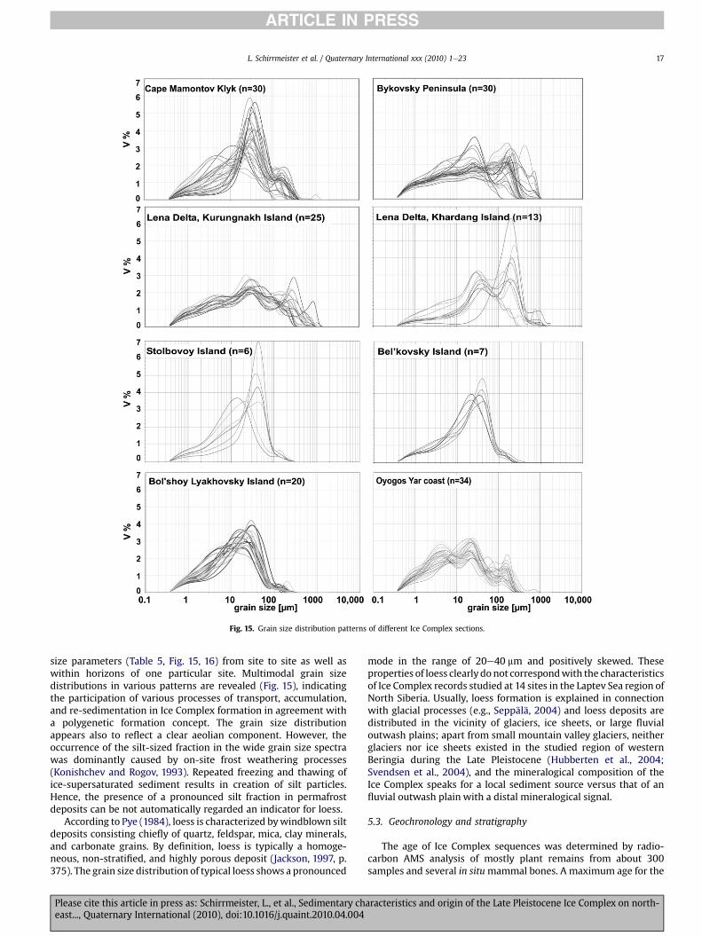
Fig. 15. Grain size distribution patterns of different Ice Complex sections.
L. Schirrmeister et al. / Quaternary International xxx (2010) 1e23 17
ARTICLE IN PRESS
size parameters (Table 5, Fig. 15, 16) from site to site as well aswithin horizons of one particular site. Multimodal grain sizedistributions in various patterns are revealed (Fig. 15), indicatingthe participation of various processes of transport, accumulation,and re-sedimentation in Ice Complex formation in agreement witha polygenetic formation concept. The grain size distributionappears also to reflect a clear aeolian component. However, theoccurrence of the silt-sized fraction in the wide grain size spectrawas dominantly caused by on-site frost weathering processes(Konishchev and Rogov, 1993). Repeated freezing and thawing ofice-supersaturated sediment results in creation of silt particles.Hence, the presence of a pronounced silt fraction in permafrostdeposits can be not automatically regarded an indicator for loess.
According to Pye (1984), loess is characterized bywindblown siltdeposits consisting chiefly of quartz, feldspar, mica, clay minerals,and carbonate grains. By definition, loess is typically a homoge-neous, non-stratified, and highly porous deposit (Jackson, 1997, p.375). The grain size distribution of typical loess shows a pronounced
Please cite this article in press as: Schirrmeister, L., et al., Sedimentary cheast..., Quaternary International (2010), doi:10.1016/j.quaint.2010.04.004
mode in the range of 20e40 mm and positively skewed. Theseproperties of loess clearly donot correspondwith the characteristicsof Ice Complex records studied at 14 sites in the Laptev Sea region ofNorth Siberia. Usually, loess formation is explained in connectionwith glacial processes (e.g., Seppälä, 2004) and loess deposits aredistributed in the vicinity of glaciers, ice sheets, or large fluvialoutwash plains; apart from small mountain valley glaciers, neitherglaciers nor ice sheets existed in the studied region of westernBeringia during the Late Pleistocene (Hubberten et al., 2004;Svendsen et al., 2004), and the mineralogical composition of theIce Complex speaks for a local sediment source versus that of anfluvial outwash plain with a distal mineralogical signal.
5.3. Geochronology and stratigraphy
The age of Ice Complex sequences was determined by radio-carbon AMS analysis of mostly plant remains from about 300samples and several in situmammal bones. A maximum age for the
aracteristics and origin of the Late Pleistocene Ice Complex on north-
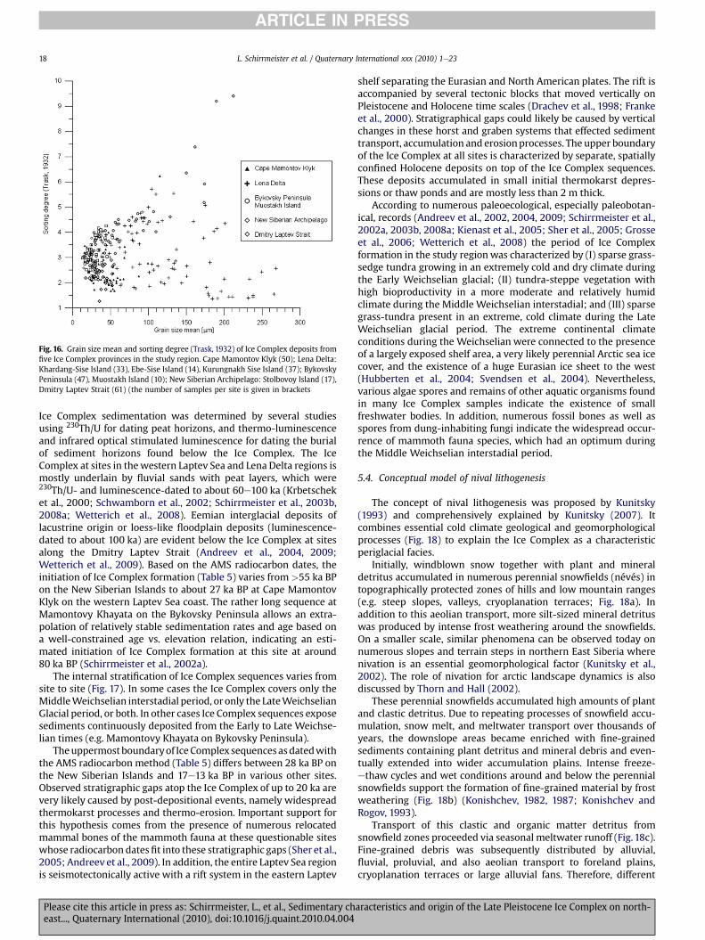
Fig. 16. Grain size mean and sorting degree (Trask, 1932) of Ice Complex deposits fromfive Ice Complex provinces in the study region. Cape Mamontov Klyk (50); Lena Delta:Khardang-Sise Island (33), Ebe-Sise Island (14), Kurungnakh Sise Island (37); BykovskyPeninsula (47), Muostakh Island (10); New Siberian Archipelago: Stolbovoy Island (17),Dmitry Laptev Strait (61) (the number of samples per site is given in brackets
L. Schirrmeister et al. / Quaternary International xxx (2010) 1e2318
ARTICLE IN PRESS
Ice Complex sedimentation was determined by several studiesusing 230Th/U for dating peat horizons, and thermo-luminescenceand infrared optical stimulated luminescence for dating the burialof sediment horizons found below the Ice Complex. The IceComplex at sites in thewestern Laptev Sea and Lena Delta regions ismostly underlain by fluvial sands with peat layers, which were230Th/U- and luminescence-dated to about 60e100 ka (Krbetscheket al., 2000; Schwamborn et al., 2002; Schirrmeister et al., 2003b,2008a; Wetterich et al., 2008). Eemian interglacial deposits oflacustrine origin or loess-like floodplain deposits (luminescence-dated to about 100 ka) are evident below the Ice Complex at sitesalong the Dmitry Laptev Strait (Andreev et al., 2004, 2009;Wetterich et al., 2009). Based on the AMS radiocarbon dates, theinitiation of Ice Complex formation (Table 5) varies from >55 ka BPon the New Siberian Islands to about 27 ka BP at Cape MamontovKlyk on the western Laptev Sea coast. The rather long sequence atMamontovy Khayata on the Bykovsky Peninsula allows an extra-polation of relatively stable sedimentation rates and age based ona well-constrained age vs. elevation relation, indicating an esti-mated initiation of Ice Complex formation at this site at around80 ka BP (Schirrmeister et al., 2002a).
The internal stratification of Ice Complex sequences varies fromsite to site (Fig. 17). In some cases the Ice Complex covers only theMiddleWeichselian interstadial period, or only the LateWeichselianGlacial period, or both. In other cases Ice Complex sequences exposesediments continuously deposited from the Early to Late Weichse-lian times (e.g. Mamontovy Khayata on Bykovsky Peninsula).
Theuppermostboundaryof IceComplex sequencesasdatedwiththe AMS radiocarbon method (Table 5) differs between 28 ka BP onthe New Siberian Islands and 17e13 ka BP in various other sites.Observed stratigraphic gaps atop the Ice Complex of up to 20 ka arevery likely caused by post-depositional events, namely widespreadthermokarst processes and thermo-erosion. Important support forthis hypothesis comes from the presence of numerous relocatedmammal bones of the mammoth fauna at these questionable siteswhose radiocarbon datesfit into these stratigraphic gaps (Sher et al.,2005; Andreev et al., 2009). In addition, the entire Laptev Sea regionis seismotectonically active with a rift system in the eastern Laptev
Please cite this article in press as: Schirrmeister, L., et al., Sedimentary cheast..., Quaternary International (2010), doi:10.1016/j.quaint.2010.04.004
shelf separating the Eurasian and North American plates. The rift isaccompanied by several tectonic blocks that moved vertically onPleistocene and Holocene time scales (Drachev et al., 1998; Frankeet al., 2000). Stratigraphical gaps could likely be caused by verticalchanges in these horst and graben systems that effected sedimenttransport, accumulation and erosionprocesses. The upper boundaryof the Ice Complex at all sites is characterized by separate, spatiallyconfined Holocene deposits on top of the Ice Complex sequences.These deposits accumulated in small initial thermokarst depres-sions or thaw ponds and are mostly less than 2 m thick.
According to numerous paleoecological, especially paleobotan-ical, records (Andreev et al., 2002, 2004, 2009; Schirrmeister et al.,2002a, 2003b, 2008a; Kienast et al., 2005; Sher et al., 2005; Grosseet al., 2006; Wetterich et al., 2008) the period of Ice Complexformation in the study regionwas characterized by (I) sparse grass-sedge tundra growing in an extremely cold and dry climate duringthe Early Weichselian glacial; (II) tundra-steppe vegetation withhigh bioproductivity in a more moderate and relatively humidclimate during the Middle Weichselian interstadial; and (III) sparsegrass-tundra present in an extreme, cold climate during the LateWeichselian glacial period. The extreme continental climateconditions during the Weichselian were connected to the presenceof a largely exposed shelf area, a very likely perennial Arctic sea icecover, and the existence of a huge Eurasian ice sheet to the west(Hubberten et al., 2004; Svendsen et al., 2004). Nevertheless,various algae spores and remains of other aquatic organisms foundin many Ice Complex samples indicate the existence of smallfreshwater bodies. In addition, numerous fossil bones as well asspores from dung-inhabiting fungi indicate the widespread occur-rence of mammoth fauna species, which had an optimum duringthe Middle Weichselian interstadial period.
5.4. Conceptual model of nival lithogenesis
The concept of nival lithogenesis was proposed by Kunitsky(1993) and comprehensively explained by Kunitsky (2007). Itcombines essential cold climate geological and geomorphologicalprocesses (Fig. 18) to explain the Ice Complex as a characteristicperiglacial facies.
Initially, windblown snow together with plant and mineraldetritus accumulated in numerous perennial snowfields (névés) intopographically protected zones of hills and low mountain ranges(e.g. steep slopes, valleys, cryoplanation terraces; Fig. 18a). Inaddition to this aeolian transport, more silt-sized mineral detrituswas produced by intense frost weathering around the snowfields.On a smaller scale, similar phenomena can be observed today onnumerous slopes and terrain steps in northern East Siberia wherenivation is an essential geomorphological factor (Kunitsky et al.,2002). The role of nivation for arctic landscape dynamics is alsodiscussed by Thorn and Hall (2002).
These perennial snowfields accumulated high amounts of plantand clastic detritus. Due to repeating processes of snowfield accu-mulation, snow melt, and meltwater transport over thousands ofyears, the downslope areas became enriched with fine-grainedsediments containing plant detritus and mineral debris and even-tually extended into wider accumulation plains. Intense freeze-ethaw cycles and wet conditions around and below the perennialsnowfields support the formation of fine-grained material by frostweathering (Fig. 18b) (Konishchev, 1982, 1987; Konishchev andRogov, 1993).
Transport of this clastic and organic matter detritus fromsnowfield zones proceeded via seasonal meltwater runoff (Fig. 18c).Fine-grained debris was subsequently distributed by alluvial,fluvial, proluvial, and also aeolian transport to foreland plains,cryoplanation terraces or large alluvial fans. Therefore, different
aracteristics and origin of the Late Pleistocene Ice Complex on north-
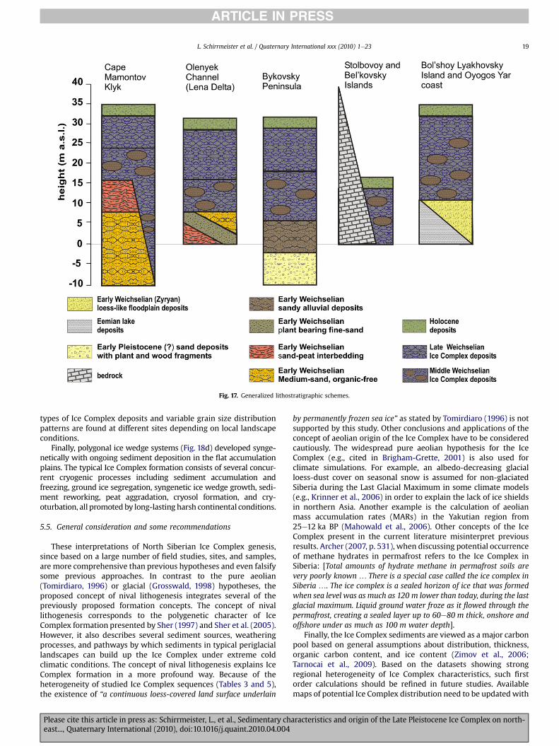
Fig. 17. Generalized lithostratigraphic schemes.
L. Schirrmeister et al. / Quaternary International xxx (2010) 1e23 19
ARTICLE IN PRESS
types of Ice Complex deposits and variable grain size distributionpatterns are found at different sites depending on local landscapeconditions.
Finally, polygonal ice wedge systems (Fig. 18d) developed synge-netically with ongoing sediment deposition in the flat accumulationplains. The typical Ice Complex formation consists of several concur-rent cryogenic processes including sediment accumulation andfreezing, ground ice segregation, syngenetic ice wedge growth, sedi-ment reworking, peat aggradation, cryosol formation, and cry-oturbation, all promoted by long-lasting harsh continental conditions.
5.5. General consideration and some recommendations
These interpretations of North Siberian Ice Complex genesis,since based on a large number of field studies, sites, and samples,are more comprehensive than previous hypotheses and even falsifysome previous approaches. In contrast to the pure aeolian(Tomirdiaro, 1996) or glacial (Grosswald, 1998) hypotheses, theproposed concept of nival lithogenesis integrates several of thepreviously proposed formation concepts. The concept of nivallithogenesis corresponds to the polygenetic character of IceComplex formation presented by Sher (1997) and Sher et al. (2005).However, it also describes several sediment sources, weatheringprocesses, and pathways by which sediments in typical periglaciallandscapes can build up the Ice Complex under extreme coldclimatic conditions. The concept of nival lithogenesis explains IceComplex formation in a more profound way. Because of theheterogeneity of studied Ice Complex sequences (Tables 3 and 5),the existence of “a continuous loess-covered land surface underlain
Please cite this article in press as: Schirrmeister, L., et al., Sedimentary cheast..., Quaternary International (2010), doi:10.1016/j.quaint.2010.04.004
by permanently frozen sea ice” as stated by Tomirdiaro (1996) is notsupported by this study. Other conclusions and applications of theconcept of aeolian origin of the Ice Complex have to be consideredcautiously. The widespread pure aeolian hypothesis for the IceComplex (e.g., cited in Brigham-Grette, 2001) is also used forclimate simulations. For example, an albedo-decreasing glacialloess-dust cover on seasonal snow is assumed for non-glaciatedSiberia during the Last Glacial Maximum in some climate models(e.g., Krinner et al., 2006) in order to explain the lack of ice shieldsin northern Asia. Another example is the calculation of aeolianmass accumulation rates (MARs) in the Yakutian region from25e12 ka BP (Mahowald et al., 2006). Other concepts of the IceComplex present in the current literature misinterpret previousresults. Archer (2007, p. 531), when discussing potential occurrenceof methane hydrates in permafrost refers to the Ice Complex inSiberia: [Total amounts of hydrate methane in permafrost soils arevery poorly known . There is a special case called the ice complex inSiberia .. The ice complex is a sealed horizon of ice that was formedwhen sea level was as much as 120 m lower than today, during the lastglacial maximum. Liquid ground water froze as it flowed through thepermafrost, creating a sealed layer up to 60e80 m thick, onshore andoffshore under as much as 100 m water depth].
Finally, the Ice Complex sediments are viewed as a major carbonpool based on general assumptions about distribution, thickness,organic carbon content, and ice content (Zimov et al., 2006;Tarnocai et al., 2009). Based on the datasets showing strongregional heterogeneity of Ice Complex characteristics, such firstorder calculations should be refined in future studies. Availablemaps of potential Ice Complex distribution need to be updatedwith
aracteristics and origin of the Late Pleistocene Ice Complex on north-
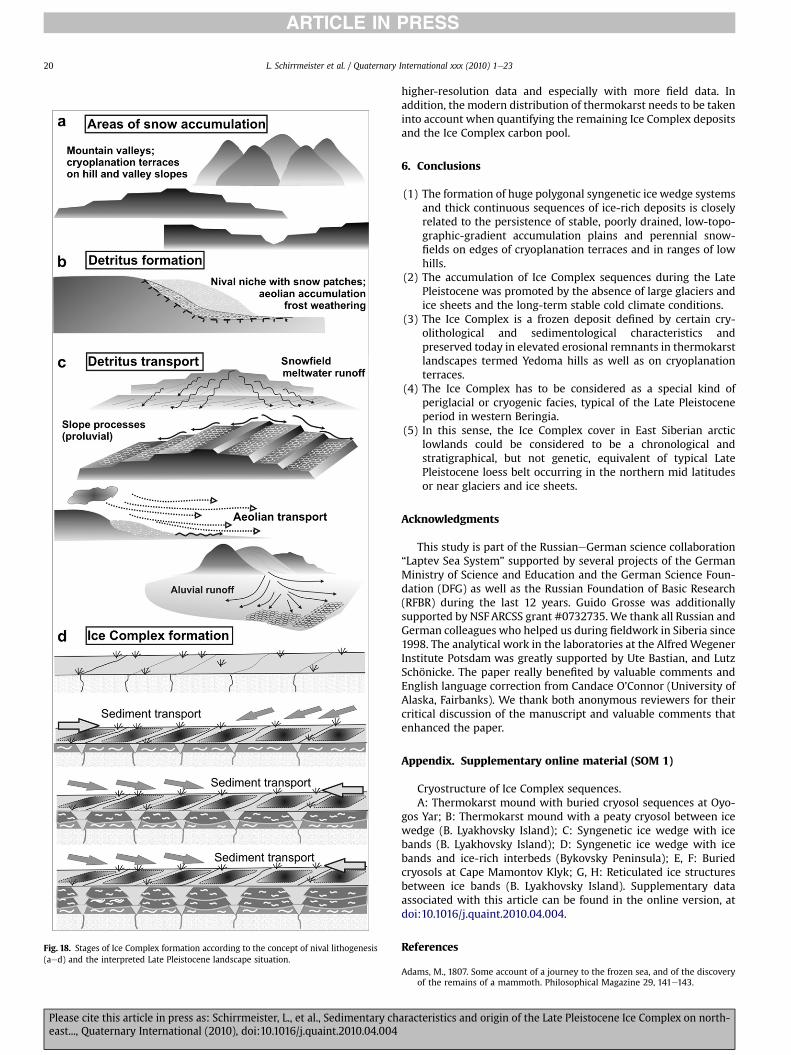
Fig. 18. Stages of Ice Complex formation according to the concept of nival lithogenesis(aed) and the interpreted Late Pleistocene landscape situation.
L. Schirrmeister et al. / Quaternary International xxx (2010) 1e2320
ARTICLE IN PRESS
Please cite this article in press as: Schirrmeister, L., et al., Sedimentary cheast..., Quaternary International (2010), doi:10.1016/j.quaint.2010.04.004
higher-resolution data and especially with more field data. Inaddition, the modern distribution of thermokarst needs to be takeninto account when quantifying the remaining Ice Complex depositsand the Ice Complex carbon pool.
6. Conclusions
(1) The formation of huge polygonal syngenetic ice wedge systemsand thick continuous sequences of ice-rich deposits is closelyrelated to the persistence of stable, poorly drained, low-topo-graphic-gradient accumulation plains and perennial snow-fields on edges of cryoplanation terraces and in ranges of lowhills.
(2) The accumulation of Ice Complex sequences during the LatePleistocene was promoted by the absence of large glaciers andice sheets and the long-term stable cold climate conditions.
(3) The Ice Complex is a frozen deposit defined by certain cry-olithological and sedimentological characteristics andpreserved today in elevated erosional remnants in thermokarstlandscapes termed Yedoma hills as well as on cryoplanationterraces.
(4) The Ice Complex has to be considered as a special kind ofperiglacial or cryogenic facies, typical of the Late Pleistoceneperiod in western Beringia.
(5) In this sense, the Ice Complex cover in East Siberian arcticlowlands could be considered to be a chronological andstratigraphical, but not genetic, equivalent of typical LatePleistocene loess belt occurring in the northern mid latitudesor near glaciers and ice sheets.
Acknowledgments
This study is part of the RussianeGerman science collaboration“Laptev Sea System” supported by several projects of the GermanMinistry of Science and Education and the German Science Foun-dation (DFG) as well as the Russian Foundation of Basic Research(RFBR) during the last 12 years. Guido Grosse was additionallysupported by NSF ARCSS grant #0732735.We thank all Russian andGerman colleagues who helped us during fieldwork in Siberia since1998. The analytical work in the laboratories at the Alfred WegenerInstitute Potsdam was greatly supported by Ute Bastian, and LutzSchönicke. The paper really benefited by valuable comments andEnglish language correction from Candace O’Connor (University ofAlaska, Fairbanks). We thank both anonymous reviewers for theircritical discussion of the manuscript and valuable comments thatenhanced the paper.
Appendix. Supplementary online material (SOM 1)
Cryostructure of Ice Complex sequences.A: Thermokarst mound with buried cryosol sequences at Oyo-
gos Yar; B: Thermokarst mound with a peaty cryosol between icewedge (B. Lyakhovsky Island); C: Syngenetic ice wedge with icebands (B. Lyakhovsky Island); D: Syngenetic ice wedge with icebands and ice-rich interbeds (Bykovsky Peninsula); E, F: Buriedcryosols at Cape Mamontov Klyk; G, H: Reticulated ice structuresbetween ice bands (B. Lyakhovsky Island). Supplementary dataassociated with this article can be found in the online version, atdoi:10.1016/j.quaint.2010.04.004.
References
Adams, M., 1807. Some account of a journey to the frozen sea, and of the discoveryof the remains of a mammoth. Philosophical Magazine 29, 141e143.
aracteristics and origin of the Late Pleistocene Ice Complex on north-
L. Schirrmeister et al. / Quaternary International xxx (2010) 1e23 21
ARTICLE IN PRESS
Andreev, A.A., Schirrmeister, L., Siegert, C., Bobrov, A.A., Demske, D., Seiffert, M.,Hubberten, H.-W., 2002. Paleoenvironmental changes in north-eastern Siberiaduring the Late Quaternarydevidence from pollen records of the BykovskyPeninsula. Polarforschung 70, 13e25.
Andreev, A.A., Grosse, G., Schirrmeister, L., Kuzmina, S.A., Novenko, E.Yu., Bobrov, A.A., Tarasov, P.E., Kuznetsova, T.V., Krbetschek, M., Meyer, H., Kunitsky, V.V., 2004.Late Saalian and Eemian palaeoenvironmental history of the Bol’shoy Lya-khovsky Island (Laptev Sea region, Arctic Siberia). Boreas 33, 319e348.
Andreev, A., Grosse, G., Schirrmeister, L., Kuznetsova, T.V., Kuzmina, S.A., Bobrov, A.A., Tarasov, P.E., Novenko, E.Yu., Meyer, H., Derevyagin, A.Yu., Kienast, F.,Bryantseva, A., Kunitsky, V.V., 2009. Weichselian and Holocene palae-oenvironmental history of the Bol’shoy Lyakhovsky Island, New SiberianArchipelago. Arctic Siberia. Boreas 38, 72e110.
Archer, D., 2007. Methane hydrate stability and anthropogenic climate change.Biogeosciences 4, 521e544.
Arkhangelov, A.A., Mikhalev, D.V., Nikolaev, V.I., 1996. About early epochs ofpermafrost formation in northern Yakutia and age of ancient relicts of under-ground glaciation. In: Velichko, A.A., Arkhangelov, A.A., Borisova, O.K.,Gribchenko, Y.N., Drenova, A.N., Zelikson, E.M., Kurenkova, E.N., Mikhalev, D.V.,Nikolaev, V.I., Novenko, E.Y., Timireva, S.A. (Eds.), Razvitie oblasti mnnogoletneimerzloty i periglyatsial’noi zony Severnoi Evrazii i usloviya rasseleniya drev-nego cheloveka. Institute of Geography, Moscow, pp. 102e109 (in Russian).
Baranova, Yu.P., Biské, S.F., 1964. North East USSR (History of Relief Formation inSiberia and Far East). Nauka Press, Moscow (in Russian), p. 290.
Bobrov, A.A., Andreev, A.A., Schirrmeister, L., Siegert, C., 2004. Testate amoebae(Protozoa: Testacealobosea and Testaceafilosea) as bioindicators in the LateQuaternary deposits of the Bykovsky Peninsula, Laptev Sea, Russia. Palae-ogeography, Palaeoclimatology, Palaeoecology 209, 165e181.
Bobrov, A.A., Müller, S., Chizhikova, N.A., Schirrmeister, L., Andreev, A.A., 2009.Testate Amoebae in Late Quaternary sediments of the Cape Mamontov Klyk(Yakutia). Biology Bulletin 36 (4), 363e372.
Brigham-Grette, J., 2001. New perspectives on Beringian Quaternary paleogeog-raphy, stratigraphy, and glacial history. Quaternary Science Reviews 20, 15e24.
Bunge, A.A., 1887. Bericht ueber den ferneren Gang der Expedition. Reise nach denNeusibirischen Inseln. Aufenthalt auf der Grossen Ljachof-Insel. In: Schrenk, L.V., Maximovicz, C.J. (Eds.), Expedition zu den Neusibirischen Inseln und demJana-Lande (1885). Beitraege zur Kenntnis des russischen Reiches und derangrenzenden Laender, vol. III, pp. 231e284.
Bunge, A.A., 1895. The Lena expedition 1881e1884. In: Tillo, A. (Ed.), Observations ofthe Russian polar station at the Lena mouth, Beobachtungen der russischenPolarstation an der Lenamündung. Expedition der Kaiserlichen RussischenGeographischen Gesellschaft, St. Petersburg, pp. 1e96.
Colinvaux, P.A., 1996. Reconstructing the environment. In: West, C.F. (Ed.), AmericanBeginnings: The Prehistory and Palaeoecology of Beringia. University of ChicagoPress, Chicago, pp. 13e19.
Dostovalov, B.N., Kudryavtsev, V.A., 1967. General geocryology (Obshchee merso-tovedenie). Moscow University Publishing House, Izdatel’stvo MoskovkogoUniversiteta, p. 403.
Drachev, S.S., Savostin, L.A., Groshev, V.G., Bruni, I.E., 1998. Structure and geology ofthe continental shelf of the Laptev Sea, Eastern Russian Arctic. Tectonophysics298, 357e393.
van Everdingen, R.O. (Ed.), 1998. Multi-language Glossary of Permafrost and RelatedGround-ice Terms. Arctic Institute of North America, University of Calgary,Calgary.
Franke, D., Hinz, K., Block, M., Drachev, S.S., Neben, S., Kos’ko, M.K., Reichert, C.,Roeser, H.A., 2000. Tectonics of the Laptev Sea region in Northeastern Siberia.Polarforschung 68, 51e58.
Frenzel, B., Pecsi, M., Velichko, A.A., 1992. Atlas of Paleoclimates and Paleoenvir-onments of the Northern Hemisphere: Late PleistoceneeHolocene. Geograph-ical Research Institute, Hungarian Academy of Sciences/Gustav Fischer Verlag,Budapest/Stuttgart, 156 p.
Fukuda, M., 1994. Occurrence of Ice-Complex (edoma) in Lena River Delta Regionand Big Lyakhovsky Island. High Arctic eastern Siberia. In: Inoue, G. (Ed.),Proceedings of the 2nd Symposium on the Joint Siberian Permafrost StudiesBetween Japan and Russia, pp. 5e13.
Galabala, R.O., 1997. Pereletki and the initiation of glaciation in Siberia. QuaternaryInternational 41/42, 27e32.
Gilichinsky, D.A., Nolte, E., Basilyan, A.E., Beer, J., Blinov, A.V., Lazarev, V.E.,Kholodov, A.L., Meyer, H., Nikolskiy, P.A., Schirrmeister, L., Tumskoy, V.E., 2007.Dating of syngenetic ice wedges in permafrost with 36Cl. Quaternary ScienceReviews 26, 1547e1556.
Gravis, G.F., 1969. Slope Deposits in Yakutia. Nauka Press, Moscow, pp. 128 (inRussian).
Gravis, G.F., 1978. Cyclicity of thermokarst at the coastal lowlands during the latePleistocene and Holocene. In: Publications of the 3rd International PermafrostConference, July 10e13 1978, Edmonton, Alberta, Canada, vol. 1, pp. 283e287.
Grigoriev, M.N., Imaev, V.S., Kozmin, B.M., Kunitsky, V.V., Larionov, A.G.,Mikulenko, K.I., Skrjabin, R.M., Timirsin, K.V., 1996. Geology, Seismicity andCryogenic Processes in the Arctic Areas of Western Yakutia. Yakutian ScientificCentre SB RAS, Yakutsk (in Russian).
Grootes, P.M., Nadeau, M.J., Rieck, A., 2004. 14C-AMS at the Leibniz-Labor: radio-metric dating and isotope research. Nuclear Instruments and Methods inPhysics Research 223, 55e61.
Grosse, G., Schirrmeister, L., Kunitsky, V.V., Dereviagyn, A., 2003. Periglacial featuresaround Tiksi. Reports on Polar Research 466, 134e191.
Please cite this article in press as: Schirrmeister, L., et al., Sedimentary cheast..., Quaternary International (2010), doi:10.1016/j.quaint.2010.04.004
Grosse, G., Schirrmeister, L., Kunitsky, V.V., Hubberten, H.-W., 2005. The use ofCORONA images in remote sensing of periglacial geomorphology: an illustrationfrom the NE Siberian coast. Permafrost and Periglacial Processes 16, 163e172.
Grosse, G., Schirrmeister, L., Malthus, T.J., 2006. Application of Landsat-7 satellitedata and a DEM for the quantification of thermokarst-affected terrain types inthe periglacial LenaeAnabar coastal lowland. Polar Research 25, 51e67.
Grosse, G., Schirrmeister, L., Siegert, C., Kunitsky, V., Slagoda, E.A., Andreev, A.A.,Dereviagyn, A.Y., 2007. Geological and geomorphological evolution of a sedi-mentary periglacial landscape in northeast Siberia during the Late Quaternary.Geomorphology 86, 25e51.
Grosswald, M.G., 1998. Late-Weichselian ice sheets in Arctic and Pacific Siberia.Quaternary International 45/46, 3e18.
Hubberten, H.-W., Andreev, A., Astakhov, V.I., Demidov, I., Dowdeswell, J.A.,Henriksen, M., Hjort, C., Houmark-Nielsen, M., Jakobsson, M., Kuzmina, S.,Larsen, E., Lunkka, J.P., Lysa, A., Mangerud, J., Moeller, P., Saarnisto, M.,Schirrmeister, L., Sher, A.V., Siegert, C., Siegert, M.J., Svendsen, J.I., 2004. Theperiglacial climate and environment in northern Eurasia during the last glaci-ation. Quaternary Science Reviews 23, 1333e1357.
Ilyashuk, B.P., Andreev, A.A., Bobrov, A.A., Tumskoy, V.E., Ilyashuk, E.A., 2006.Interglacial history of a palaeo-lake deposit and regional environment: a multi-proxy study of a permafrost deposit from Bol’shoy Lyakhovsky Island, ArcticSiberia. Journal of Paleolimnology 35, 855e872.
Imaev, V.S., Imaeva, L.P., Kozmin, B.M., 2000. Seismo-tectonics of Yakutia. GEOS,Moscow (in Russian).
Ivanov, M.S., Katasonova, E.G., 1978. Percularities of cryolithogenic deposits ofMuoastakh Island. Geocryological and Hydrogeological Studies in Yakutia.Permafrost Institute Yakutsk Press, Yakutsk, pp. 12e25 (in Russian).
Jackson, J., 1997. Glossary of Geology, fourth ed. American Geological InstituteAlexandria, Virginia, 769 pp.
Kaplina, T.N., Lozhkin, A.V., 1984. Age and history of accumulation of the “IceComplex” of the maritime lowlands of Yakutiya. In: Velichko, A.A., Wright Jr., H.E., Barnosky, C.W. (Eds.), Late Quaternary Environments of the Soviet Union.University of Minnesota Press, Minneapolis, MN, pp. 147e151.
Kayalainen, V.I., Kulakov, Yu.N., 1966. To the questions of Paleogeography of theYana-Indigirka coastal lowland during the NeogeneeQuaternary period.Quaternary Period in Siberia. Nauka, Moscow, pp. 274e283 (in Russian).
Kienast, F., Schirrmeister, L., Siegert, C., Tarasov, P., 2005. Palaeobotanical evidencefor warm summers in the East Siberian Arctic during the last cold stage.Quaternary Research 63, 283e300.
Kienast, F., Tarasov, P., Schirrmeister, L., Grosse, G., Andreev, A.A., 2008. Continentalclimate in the East Siberian Arctic during the last interglacial: Implications frompalaeobotanical records. Global and Planetary Change 60 (3/4), 535e562.
Kolosov, D.M., 1947. Problems of former glaciation of Northeast USSR. In: Reports ofthe Geological Department of the Major Administration of the Northern SeaRoute (GUSMP), vol. 30. Glavsevmorput Publishing House, Moscow, Leningrad,p. 175 (in Russian).
Konishchev, V.N., 1981. Formation of Disperse Composed Deposits of the Cry-olithophere. Nauka, Novosibirsk, 198 pp. (in Russian).
Konishchev, V.N., Kolesnikov, S.F., 1981. Specialities of structure and composition oflate Cenozoic deposits in the section of Oyogossky Yae. In: Problems of Cry-olithology, vol. IX. MGU Publishing, Moscow, pp. 107e117 (in Russian).
Konishchev, V.N., 1982. Characteristics of cryogenic weathering in the permafrostzone of the European USSR. Arctic and Alpine Research 14 (3), 261e265.
Konishchev, V.N., 1987. Origin of loess-like silt in Northern Jakutia, USSR. Geo-Journal 15 (2), 135e139 (in Russian).
Konishchev, V.N., Rogov, V.V., 1993. Investigations of cryogenic weathering inEurope and Northern Asia. Permafrost and Periglacial Processes 4, 49e64.
Krbetschek, M.R., Gonser, G., Schwamborn, G., 2002. Luminescence dating resultson sediment sequences of the Lena Delta. Polarforschung 70, 83e88.
Krinner, G., Boucher, O., Balkanski, Y., 2006. Ice-free glacial northern Asia due todust deposition on snow. Climate Dynamics 27, 613e625. doi:10.1007/s00382-006-0159-z.
Kunitsky, V.V., 1989. Kriolitologiya nizo’ev Leny (Cryolithology of the Lower Lena).Permafrost Institute Press, Yakutsk, 162 pp (in Russian).
Kunitsky, V.V., 1993. On the study of nival deposits in Yakutia. Permafrost. In:Proceedings of the Sixth International Conference on Permafrost. Bejing, vol. 1,pp. 903e910.
Kunitsky, V.V., 1996. Chemical content of ice wedges of the Ice complex. Develop-ment of the Cryolithozone of Eurasia During the Upper Cenozoic. RAS,Permafrost Institute, Yakutsk, pp. 93e117 (in Russian).
Kunitsky, V.V., 1998. Ice Complex and cryoplanation terraces of Bol’shoy LyakhovskyIsland. In: Kamensky, R.M., Kunitsky, V.V., Olovin, B.A., Shepelev, V.V. (Eds.),Problems of Geocryology. Collected papers. RAS, Permafrost Institute, Yakutsk,210 pp. (in Russian).
Kunitsky, V.V., Schirrmeister, L., Grosse, G., Kienast, F., 2002. Snow patches in nivallandscapes and their role for the Ice Complex formation in the Laptev Seacoastal lowlands. Polarforschung 70, 53e67.
Kunitsky,V.V.,2007.Nival lithogenesisand IceComplexontheterritoryofYakutia.Abstractof the Doctoral Dissertation. Permafrost Institute, Yakutsk, 46 pp. (in Russian).
Kutzbach, L., Wagner, D., Pfeiffer, E.-M., 2004. Effect of microrelief and vegetation onmethane emission from wet polygonal tundra, Lena Delta, Northern Siberia.Biogeochemistry 69, 341e362.
Kuzmina, S., Wetterich, S., Meyer, H., 2003. Paleoecological and sedimentologicalstudies of Permafrost deposits in the Central Lena Delta (Kurungnakh andSamoylov Islands). Reports on Polar and Marine Research 466, 71e81.
aracteristics and origin of the Late Pleistocene Ice Complex on north-
L. Schirrmeister et al. / Quaternary International xxx (2010) 1e2322
ARTICLE IN PRESS
Lopatin, V.G. (Ed.), 1998. State Geological Map of Russian Federation, New SiberianIslands, 1:1,000,000 Map of Pre-Quaternary Formations. Ministry of NaturalResources of Russian Federation.
Mahowald, N.N., Muhs, D.R., Levis, S., Rasch, P.J., Yoshikitha, M., Zender, C.S., Luo, C.,2006. Change in atmospheric mineral aerosols in response to climate: Lastglacial period, pre-industrial, modern and doubled carbon dioxide climates.Journal of Geophysical Research 111, D10202. doi:10.1029/2005JD006653.
Makeyev, V.M., Ponomareva, D.P., Pitulko, V.V., Chernova, G.M., Solovyeva, D.V.,2003. Vegetation and climate of the New Siberian Islands for the past 15,000Years. Arctic. Antarctic and Alpine Research 35, 56e66.
Melnikov, V.P., Spesivtsev, V.I., 2000. Cryogenic Formations in the Earth’s Litho-sphere. Nauka, Novosibirsk, Russia, 343 p.
Meyer, H., Dereviagin, A.Y., Siegert, C., Hubberten, H.-W., 2002a. Paleoclimatestudies on Bykovsky Peninsula, North Siberiadhydrogen and oxygen isotopesin ground ice. Polarforschung 70, 37e51.
Meyer, H., Dereviagin, A., Siegert, C., Schirrmeister, L., Hubberten, H.-W., 2002b.Palaeoclimate reconstruction on Big Lyakhovsky Island, North Siberia d
hydrogen and oxygen isotopes in ice wedges. Permafrost and PeriglacialProcesses 13, 91e105.
Mikulenko, K.I.,1996. Questions of the geologyof the arctic regionofWest Yakutia. In:Grigoriev,M.N., Imaev,V.S., Imaeva, L.P. (Eds.), Geology, SeismicityandPermafrostProcesses of the Arctic Region of West Yakutia Yakutsk, Russia, (in Russian).
Morozova, T.D., Velichko, A.A., 1996. Loess-ice formation in Northeastern Asia. In:West, C.F. (Ed.), American Beginnings: The Prehistory and Palaeoecology ofBeringia. University of Chicago Press, Chicago and London, pp. 52e57.
Müller, S., Bobrov, A.A., Schirrmeister, L., Andreev, A.A., Tarasov, P.E., 2009. Testateamoebae record from the Laptev Sea coast and its implication for the recon-struction of Late Pleistocene and Holocene environments in the Arctic Siberia.Palaeogeography, Palaeoclimatology, Palaeoecology 271 (3e4), 301e315.
Mursaev, E.M., 1984. Glossary of Local Geographical Terms. Mysl Publishing House,Moscow, 653 pp. (in Russian).
Nadeau, M.J., Schleicher, M., Grootes, P.M., Erlenkeuser, H., Gottdang, A., Mous, D.J.W., Sarntheim, J.M., Willkomm, H., 1997. The Leibniz-Labor facility at theChristian-Albrecht-University, Kiel, Germany. Nuclear Instruments andMethods in Physics Research 123, 22e30.
Nadeau, M.J., Grootes, P.M., Schleicher, M., Hasselberg, P., Rieck, A., Bitterling, M.,1998. Sample throughput and data quality at the Leibniz-Labor AMS facility.Radiocarbon 40, 239e245.
Nagaoka, D., 1994. Properties of Ice Complex deposits in Eastern Siberia. In:Proceedings of the 2nd Symposium on the Joint Siberian Permafrost Studiesbetween Japan and Russia in 1993, pp. 14e18. Tsukuba, Japan.
Nagaoka, D., Saijo, K., Fukuda, M., 1995. Sedimental environment of the Edoma inhigh Arctic eastern Siberia. In: Takahashi, K., Osawa, A., Kanazawa, Y. (Eds.),Proceedings of the 3rd Symposium on the Joint Siberian Permafrost Studiesbetween Japan and Russia. Hokkaido University, Tsukuba, Japan, pp. 8e13.
Nikolskiy, P.A., Basilyan, A.E., Simakova, A.N., 1999. New data on stratigraphy ofUpper Cenozoic deposits of Sviatoj Nos (Laptev Sea). In: Gribchenko, Yu.N.,Nikolaev, V.I. (Eds.), Landscape-Climatic Changes, Animals and Man during theLast Pleistocene and Holocene, Moscow, pp. 51e60 (in Russian).
Nikolskiy, P.A., Basilyan, A.E., 2004. Svyatoy Nos e The main Quaternary crosssection of the Yana-Indigirka lowland. In: Nikolskiy, P.-A., Pitulko, V.V. (Eds.),Natural History of the Russian Arctic during the Late Pleistocene and Holocene:Paleogeography, Geology and Archeology. GEOS Press, Moscow, pp. 5e13 (inRussian).
Overduin, P.P., Grigoriev, M.N., Junker, R., Rachold, V., Kunitsky, V.V., Bolshiyanov, D.Yu., Schirrmeister, L., 2007. RussianeGerman Cooperation System Laptev Sea:The Expedition COAST I: COAST Drilling Campaign 2005: Subsea permafroststudies in the near-shore zone of the Laptev Sea. In: Schirrmeister, L. (Ed.),Expeditions in Siberia 2005. Reports on Polar and Marine Research 550, 1e39.
Pye, K., 1984. Loess. Progress in Physical Geography 8, 176.Péwé, T.L., Journaux, A., Stuckenrath, R., 1977. Radiocarbon dates and late Quater-
nary stratigraphy from Mamontova Gora, unglaciated Yakutia, Siberia, USSR.Quaternary Research 8, 51e63.
Péwé, T.L., Journaux, A., 1983. Origin and character of loess-like silt in unglaciatedsouth-central Yakutia, Siberia, USSR. USGS Professional Paper 1262, 1e45.
Popov, A.I., 1967. Permafrost Phenomena in the Earth Crust (Cryolithology). MSUPublishing House, Moscow, 304 pp (in Russian).
Romanovskii, N.N., 1958a. New data about Quaternary deposits structure on theBol’shoy Lyakhovsky Island (Novosibirskie Islands). Nauchnye Doklady VyssheiShkoly. Seriya geologo-geograficheskaya 2, 243e248 (in Russian).
Romanovskii, N.N., 1958b. Paleogeographic conditions of formation of the Quater-nary deposits on Bol’shoy Lyakhovsky Island (Novosibirskie Islands). In:Bogorov, V.G. (Ed.), Voprosy fizicheskoi geografii polyarnykh stran. Vypysk I.Moscow State University, Moscow, pp. 80e88 (in Russian).
Romanovskii, N.N., 1958c. Permafrost structures in Quaternary deposits. NauchnyeDoklady Vysshei Shkoly. Seriya geologo-geograficheskaya 3,185e189 (in Russian).
Romanovsky, N.N., 1993. Fundamentals of the Cryogenesis of the Lithosphere.University Press, Moscow, pp. 1e336 (in Russian).
Rozenbaum, G.E., 1981. Special features of lithogenesis of the alluvial planes in theEastern Subarctic as related to the problem of the Ice (Yedoma) Complex. In:Problems of Cryolithology, vol. 9. MSU Press, Moscow. 87e100 (In Russian).
Schirrmeister, L., Kunitsky, V., Grosse, V., Meyer, H., Kuznetsova, T., Kuzmina, S.,Tumskoy, V., Derevyagin, A., Akhmadeeva, I., Syromyatnikov, I., 2000. Quaternarydeposits of Bol’shoy Lyakhovsky Island. Reports on Polar Research 354, 113e168.Alfred Wegener Institute for Polar and Marine Research, Bremerhaven.
Please cite this article in press as: Schirrmeister, L., et al., Sedimentary cheast..., Quaternary International (2010), doi:10.1016/j.quaint.2010.04.004
Schirrmeister, L., Kunitsky, V.V., Grosse, G., Kuznetsova, T., Kuzmina, S.,Bolshiyanov, D., 2001. Late Quaternary and recent environmental situationaround the Olenyok Channel (western Lena Delta) and on Bykovsky Peninsula.Reports on Polar Research 388, 85e135.
Schirrmeister, L., Siegert, C., Kuznetsova, T., Kuzmina, S., Andreev, A.A., Kienast, F.,Meyer, H., Bobrov, A., 2002a. Paleoenvironmental and paleoclimatic recordsfrom permafrost deposits in the Arctic region of Northern Siberia. QuaternaryInternational 89, 97e118.
Schirrmeister, L., Siegert, C., Kunitsky, V.V., Grootes, P.M., Erlenkeuser, H., 2002b.Late Quaternary ice-rich permafrost sequences as a paleoenvironmental archivefor the Laptev Sea region in northern Siberia. International Journal of EarthSciences 91, 154e167.
Schirrmeister, L., Oezen, D., Geyh, M.A., 2002c. 230Th/U dating of frozen peat, Bol’-shoy Lyakhovsky Island (North Siberia). Quaternary Research 57, 253e258.
Schirrmeister, L., Grosse, G., Kunitsky, V., Meyer, H., Derevyagin, A., Kuznetsova, T.,2003a. Permafrost, periglacial and paleo-environmental studies on New Sibe-rian Islands. Reports on Polar Research 466, 195e314.
Schirrmeister, L., Grosse, G., Schwamborn, G., Andreev, A.A., Meyer, H., Kunitsky, V.V., Kuznetsova, T.V., Dorozhkina, M.V., Pavlova, E.Y., Bobrov, A.A., Oezen, D.,2003b. Late Quaternary history of the accumulation plain north of the Cheka-novsky Ridge (Lena Delta, Russia): a multidisciplinary approach. Polar Geog-raphy 27, 277e319.
Schirrmeister, L. (Ed.), 2004. Periglacial studies around Cape Mamontov Klyk. In:Schirrmeister, L, Grigoriev, M.N., Kutzbach, L., Wagner, D., Bolshiyanov, D.Yu.(Eds.) 2004. Russian-German Cooperation SYSTEM LAPTEV SEA: The ExpeditionLena-Anabar 2003. Reports on polar and marine research, 489, 61e209.
Schirrmeister, L. (Ed.), 2007. Studies of periglacial landscape dynamics and surfacecharacteristics studies in the western Lena Delta. In: Schirrmeister, L., Wagner,D., Grigoriev, M.N., Bolshiyanov, D.Y. (Eds.), The Expedition LENA 2005, Expe-ditions in Siberia in 2005. Reports on Polar and Marine Research 550, 83e196.
Schirrmeister, L., Grosse, G., Kunitsky, V., Magens, D., Meyer, H., Dereviagin, A.,Kuznetsova, T., Andreev, A., Babiy, O., Kienast, F., Grigoriev, M., Overduin, P.P.,Preusser, F., 2008a. Periglacial landscape evolution and environmental changesof Arctic lowland areas for the last 60,000 years (Western Laptev Sea coast,Cape Mamontov Klyk). Polar Research 27 (2), 249e272. doi:10.1111/j.1751-8369.2008.00067.x.
Schirrmeister, L., Wetterich, L., Tumskoy, V., Dobrynin, D., 2008b. Palae-oenviromental studies on Bol’shoy Lyakhovsky Island. In: Boike, J.,Bolshiyanov, D., Schirrmeister, L., Wetterich, S. (Eds.), RussianeGerman Coop-eration System Laptev Sea: The Expedition Lena - New Siberian Islands 2007(during the International Polar Year 2007/2008). Reports on Polar and MarineResearch 584, 51e84.
Schuur, E.A.G., Bockheim, J., Canadell, J.G., Euskirchen, E., Field, C.B., Goryachkin, S.V., Hagemann, S., Kuhry, P., Lafleur, P.M., Lee, H., Mazhitova, G., Nelson, F.E.,Rinke, A., Romanovsky, V.E., Shiklomanov, N., Tarnocai, C., Venevsky, S., Vogel, J.G., Zimov, S.A., 2008. Vulnerability of permafrost carbon to climate change:Implications for the global carbon cycle. BioScience 58 (8), 701e714.
Schwamborn, G., Schneider, W., Grigoriev, M.N., Rachold, V., Antonow, M., 1999.Sedimentation and environmental history of the Lena Delta. In: Rachold, V.,Grigoriev, M.N. (Eds.), RussianeGerman Cooperation System Laptev Sea 2000:The Lena Delta 1998 Expedition. Reports on Polar Research 315, 94e111.
Schwamborn, G., Rachold, V., Grigoriev, M.N., 2002. Late Quaternary sedimentationhistory of the Lena Delta. Quaternary International 89, 119e134.
Seppälä, M., 2004. Wind as a geomorphic agent in cold climates. Studies in PolarResearch. Cambridge University Press, 358 pp.
Sher, A.V., Kaplina, T.N., Ovander, M.G., 1987. Unified regional stratigraphic chart forthe Quaternary deposits in the Yana-Kolyma Lowland and its mountainoussurroundings. Explanatory note. In: Decisions of Interdepartmental Strati-graphic Conference on the Quaternary of the Eastern USSR. Magadan, 1982.USSR Academy of Sciences, Far-Eastern Branch, North-Eastern ComplexResearch Institute, Magadan, USSR, pp. 29e69 (in Russian).
Sher, A.V., 1997. A brief overview of the Late-Cenozoic history of the WesternBeringian Lowlands. In: Edwards, M.E., Sher, A.V., Guthrie, R.D. (Eds.), Terrestrialpaleoenvironmental studies in Beringia, Proceedings of a joint Rus-sianeAmerican workshop, Fairbanks, Alaska, June 1991, pp. 3e6.
Sher, A., Parmuzin, I., Bartsov, A., 2000. Ice Complex on Bykovsky Peninsula. AWIReports on Polar and Marine Research 354, 169e182.
Sher, A., Kuzmina, S., Kiselyov, S., Lister, A., 2003. . Tundra-steppe environment in arcticSiberia and the evolution of the woolly mammoth. In: The Third InternationalMammoth Conference, Yukon, Canada, May 24e29, 2003, pp.136e142. Abstracts.
Sher, A.V., Kuzmina, S.A., Kuznetsova, T.V., Sulerzhitsky, L.D., 2005. New insightsinto the Weichselian environment and climate of the East Siberian Arctic,derived from fossil insects, plants, and mammals. Quaternary Science Reviews24, 533e569.
Siegert, C., Schirrmeister, L., Kunitsky, V.V., Meyer, H., Kuznetsova, T., Dereviagyn, A.,Kuzmina, S., Tumskoy, V., Sher, A., 1999. Paleoclimate signals of ice-richpermafrost. AWI Reports on Polar and Marine Research 315, 145e259.
Siegert, C., Schirrmeister, L., Babiy, O., 2002. The sedimentological, mineralogicaland geochemical composition of late Pleistocene deposits from the ice complexon the Bykovsky Peninsula, northern Siberia. Polarforschung 70, 3e11.
Slagoda, E.A., 1993. Genesis i mikrostroenie kriolitogennykh otlozhenii Bykovskogopolyostrova i ostrova Muoastakh [Genesis and microstructure of cryolithogenicdeposits at the Bykovsky Peninsula and the Muostakh Island]. Ph.D. Thesis.Russian Academy of Science, Siberian Branch, Permafrost Institute Yakutsk(in Russian).
aracteristics and origin of the Late Pleistocene Ice Complex on north-
L. Schirrmeister et al. / Quaternary International xxx (2010) 1e23 23
ARTICLE IN PRESS
Slagoda, E.A., 2004. Cryolithogenic Deposits of the Laptev Sea Coastal Plain:Lithology and Micromorphology. Publishing and Printing Centre Express, Tyu-men, 119 pp. (in Russian).
Solomatin, V.N., 1974. Composition and origin of polygonal ice wedges in Pleisto-cene deposits of Northern Yakutia (according to study results of the YanaOmoloy interfluve and Muostakh Island). In: Problems of Cryolithology, vol. 4.MSU Publishing House, Moscow (in Russian).
Soloviev, P.A., 1959. The cryolithozone in the north part of the Lena-Amga-Inter-fluve. Academy of Science of the USSR, 144 pp. (in Russian).
Svendsen, J.I., Alexanderson, H., Astakhov, V.I., Demidov, I., Dowdeswell, J.A.,Funder, S., Gataullin, V., Henriksen, M., Hjort, C., Houmark-Nielsen, M.,Hubberten, H.-W., Ingolfsson, O., Jacobsson, M., Kjær, K., Larsen, E., Lokrantz, H.,Lunkka, J.P., Lysa, A., Mangerud, J., Matioushkov, A., Murray, A., Moeller, P.,Niessen, F., Nikolskaya, O., Polyak, L., Saarnisto, M., Siegert, C., Siegert, M.J.,Spielhagen, R.F., Stein, R., 2004. Late Quaternary ice sheet history of northernEurasia. Quaternary Science Reviews 23, 1229e1272.
Tarnocai, C., Canadell, J.G., Schuur, E.A.G., Kuhry, P., Mazhitova, G., Zimov, S., 2009.Soil organic carbon pools in the northern circumpolar permafrost region. GlobalBiogeochemical Cycles 23, GB2023.
Thorn, C.E., Hall, K., 2002. Nivation and cryoplanation: the case for scrutiny andintegration. Progress in Physical Geography 26 (4), 533e550.
von Toll, E.V., 1895. Wissenschaftliche Resultate der von der Kaiserlichen Akademieder Wissenschaften zur Erforschung des Janalandes und der NeusibirischenInseln in den Jahren 1885 und 1886 ausgesandten Expedition. Abtheilung 3. Diefossilen Eislager und ihre Beziehungen zu den Mammuthleichen. In: Mémoiresde L’Académie impérials des Sciences de St. Pétersbourg VII Série, Tome XLII,No. 13. Commissionnaires de I’Académie Impériale des Sciences, St. Péters-bourg. 1e86.
Tomirdiaro, S.V., 1970. Eolian-cryogene origin of Yedoma-Complex deposits ofNortheast USSR. Abstracts of the Allunion Permafrost Conference. Moscow StateUniversity, Moscow, pp. 106e107 (in Russian).
Tomirdiaro, S.V., 1980. Loess-ice Formations of East Siberia During Late Pleistoceneand Holocene. Nauka Press, Moscow, 184 pp. (in Russian).
Tomirdiaro, S.V., 1982. Evolution of lowland landscapes in northern Asia duringLate Quaternary time. In: Hopkins, D.V., Matthews Jr., J.V., Schweger, Ch.E.,Young, S.B. (Eds.), Paleoecology of Beringia. Academic Press, New York, NY, pp.29e37.
Tomirdiaro, S.V., 1984. Periglacial landscape and loess accumulation in the latePleistocene Arctic and Subarctic. In: Velichko, A.A., Wright Jr., H.E., Barnosky, C.W. (Eds.), Late Quaternary Environments of the Soviet Union. University ofMinnesota Press, Minneapolis, MN, pp. 141e146.
Please cite this article in press as: Schirrmeister, L., et al., Sedimentary cheast..., Quaternary International (2010), doi:10.1016/j.quaint.2010.04.004
Tomirdiaro, S.V., Arslanov, K.A., Chernen’kii, B.I., Tertychnaya, T.V.,Prokhorova, T.N., 1984. New data on formation of loess-ice sequences inNorthern Yakutia and ecological conditions of mammoth fauna in theArctic during the late Pleistocene. Reports Academy of Sciences USSR 278,1446e1449 (in Russian).
Tomirdiaro, S.V., Chernen’k’ii, B.I., 1987. Cryogenic deposits of East Arctic andSub Arctic. AN SSSR Far-East-Science Center, Magadan, pp. 1e196(in Russian).
Tomirdiaro, S.V., 1996. Palaeogeography of Beringia and Arctida. In: West, C.F. (Ed.),American Beginnings: The Prehistory and Palaeoecology of Beringia. Universityof Chicago Press, Chicago and London, pp. 58e69.
Trask, P.D., 1932. Origin and environment of source sediments of petroleum. GulfPubl. Co., Houston, Texas, 323 pp.
Walter, K.M., Zimov, S.A., Chanton, J.P., Verbyla, D., Chapin III, F.S., 2006. Methanebubbling from Siberian thaw lakes as a positive feedback to climate warming.Nature 443, 71e75.
Walter, K.M., Edwards, M.E., Grosse, G., Zimov, S.A., Chapin III, F.S., 2007. Thermo-karst lakes as a source of atmospheric CH4 during the last deglaciation. Science318, 633e636.
Washburn, A.L., 1979. Geocryology d A Survey of Periglacial Processes and Envi-ronments. Edward Arnold Ltd., London, UK, 406 p.
Wetterich, S., Schirrmeister, L., Pietrzeniuk, E., 2005. Freshwater Ostracodes inQuaternary permafrost deposits in the Siberian Arctic. Journal of Paleolimnol-ogy 34, 363e374. doi:10.1007/s10933-005-5801-y.
Wetterich, S., Kuzmina, S., Andreev, A.A., Kienast, F., Meyer, H., Schirrmeister, L.,Kuznetsova, T., 2008. Palaeoenvironmental dynamics inferred from lateQuaternary permafrost deposits on Kurungnakh Island, Lena Delta, NortheastSiberia, Russia. Quaternary Science Reviews 27 (15e16), 1523e1540.doi:10.1016/j.quascirev.2008.04.007.
Wetterich, S., Schirrmeister, L., Andreev, A.A., Pudenz, M., Plessen, B., Meyer, H.,Kunitsky, V.V., 2009. Eemian and Late Glacial/Holocene palaeoenvironmentalrecords from permafrost sequences at the Dmitry Laptev Strait (NE Siberia,Russia). Paleogeography, Paleoclimatology, Paleoecology 279 (1e2), 73e95.doi:10.1016/j.palaeo.2009.05.002.
Winterfeld, M., Schirrmeister, L., Grigoriev, M.N., Kunitsky, V.V., Andreev, A.A.,Overduin, P.P. Permafrost and landscape dynamics during the Late Pleistocene,Western Laptev Sea Shelf, Siberia, Boreas, under review.
Yershov, E.D. (Ed.), 1989. Geocryology of the USSR, East Siberia and Far East. “Nedra”Publishing House, Moscow, 515 pp.
Zimov, S.A., Schuur, E.A.G., Chapin III, F.S., 2006. Permafrost and the global carbonbudget. Science 312, 1612e1613. doi:10.1126/science.1128908.
aracteristics and origin of the Late Pleistocene Ice Complex on north-