Embed Size (px)
Citation preview


The Study on the Integrated Regional Development Plan for the Northeastern Border Region in the Kingdom of Thailand
Sector Plan: Chapter16 Transportation
16-1
CHAPTER 16
TRANSPORTATION
16.1 International and Inter-Urban Transport System of Thailand
16.1.1 National Highway System in Thailand
The DOH1 network of national highways has a total route length of approximately
55,000 km, of which there are about 20,000 km of 1-, 2- and 3-digit roads and 30,000
km of 4-digit roads. All provinces (changwats) are connected to this network and most
long-distance (inter-province) traffic uses these roads.
Table 16.1 Highway Classification by Numbering System
1-digit route Highway Route No.1: Bangkok - Chiangrai (Phaholyothin Road)
Highway Route No.2: Saraburi - Nongkai (Friendship Road)
Highway Route No.3: Bangkok - Trad (Sukhumvit Road)
Highway Route No.4: Bangkok - Amphoe Sadao, Songkla (Petchkasem Road)
2- digit route Primary highway in the regions
3-digit route Secondary highway in the regions
4-digit route Highway linking Changwat and Amphoe or important places in that province.
Source: Department of Highways, Ministry of Transport and Communications
1 Department of Highway, Ministry of Transport and Communication, Thailand

PP LLAANNEE TT NESDB - JICA
16-2
Table 16.2 Highway Classification by Jurisdiction
(1) Special Highway and National Highway
Highways registered at the Department of Highways (DOH) by the order of the Director-General with the approval of the Minister.
(2) Concession Highways Highways registered at the Department of Highways (DOH) by the order of the Director-General with the approval of the Minister.
(3) Rural Roads Roads registered at Provincial City Hall by the order of the Governor with the consent of the Director-General of the Public Works, Department of the Secretary-General of the Office of the Accelerated Rural Development.
(4) Municipal Roads Roads registered at Municipality by the order of Lord Major with the approval of the Governor.
(5) Sanitary Roads Roads registered at Sanitary Office by the order of the Chairman of the Sanitary Board with the approval of the Director-General of Public Works Department..
Source: Department of Highways, Ministry of Transport and Communications
Table 16.3 Highway Development by DOH
Under Maintenance (km) Year Concrete Asphalt Unpaved Total
Under construction (km)
1985 635 30,621 4,979 36,235 9,102 1990 1,326 38,606 5,513 45,445 6,900 1994 3,313 42,656 4,186 50,155 8,043 1999 4,497 49,481 1,240 55,218
Source: Department of Highways, Ministry of Transport and Communications
There are three concession highways under DOH as follows:
• Neon Lang Tao – Ban Thoong Highway (Distance: 14.7 km, Highway Route
No.3246),
• Bu Kae Samee – Du Song Yoa (Distance: 15 km, Highway Route No. 4055), and
• Vidpawadi – Rangsit Elevated Tollway.
Concession contracts of the first two projects were expired. Currently the Vidpawadi –
Rangsit Elevated Tollway has been operated under a concession agreement between
DOH and the operator.
Asian Highway Network in Thailand
The Asian Highway (AH) project was initiated in 1959 by the United Nations Economic
and Social Commission for Asia and the Pacific (UN ESCAP), aiming at promoting the
development of international road transport in the region. In 1992, UN ESCAP

The Study on the Integrated Regional Development Plan for the Northeastern Border Region in the Kingdom of Thailand
Sector Plan: Chapter16 Transportation
16-3
endorsed the “Integrated Asian Land Transport Infrastructure Development (ALTID)”
project, comprising the Asian Highway, the Trans-Asian Railway and the facilitation of
land transport projects. In 1995, the “Study on Road Network in Central Asia” was
implemented. As a result of the study, a new Asian Highway network of approximately
90,000 km in 28 member countries was revised / formulated; road classification and
design standards were also revised; and international border crossing facilitation
measures were introduced.
As part of the Asian Highway System, DOH has improved about 3,439 kilometers of the
national highway system as shown in the table below. It can be said that the condition
of the Asian Highway system in Thailand is rather good in comparison with those of
neighboring countries.
Table 16.4 Asian Highway in Thailand
Route Name Distance Route
Asian Highway Route A-1 698 km (paved)
Mae Sod (Myanmar) – (Highway No. 105) – Changwat Tak – (Highway No.1) – Amphoe Payuhakiri – (Highway No.32) – Amphoe Bang Pa In – (Highway No. 1) – Hin Kong – Nakhon Nayok, Prachinburi, Aranyaprathet (Cambodia)
Route A-2 1,945 km (paved)
Mae Sai – (Highway No. 110) – Chiengrai – (Highway No.1) –Payuhakiri – (Highway No.32) – Bang Pa In – (Highway No.1) – Bangkok – (Highway No.4) – Nakhon Pathom, Petchaburi, Prachaubkirikhan, Chumphon - (Highway No.41) – Phattalung – (Highway No.4) – Hat Yai – Amphoe Sadao (Malaysian border)
Route A-3 115 km Chienngrai – (Highway No. 1020 and 1152) – Amphoe Chiengkhong
Route A-12 524 km (paved)
Hin Kong – (Highway No.1 and No.2) – Nakhon Ratchasima, Khon Kaen, Udon Thani – Nong Khai
Route A-15 241 km (paved)
Udon Thani – (Highway No.22) – Sak on Nakhon – Nakhon Phanom
Route A-16 275 km (paved)
Hat Yai – (Highway No.43) – Pattani, Narathiwat – (Highway No.4056) – Amphoe Sungai Kolok (Malaysian border)
Source: Department of Highways, MOTC, Thailand
The East-West Transport Corridor Project by Asian Development Bank
As part of the East-West Transport Corridor Project funded by Asian Development
Bank, a road transport corridor linking northeast Thailand through Lao PDR to Da Nang
Port in Viet Nam has been improved.
Currently about 78 km of Road No. 9 in Lao PDR between Maung Phin and the border
with Vietnam has been improved. The scope of this project includes reconstructing the
existing largely-failed road pavement to a two-lane bituminous surface treatment
standard construction of new bridges and other drainage structures, and repair of
existing structures, and ancillary works

PP LLAANNEE TT NESDB - JICA
16-4
Source: Department of Highway
Figure 16.1 National Highway System

The Study on the Integrated Regional Development Plan for the Northeastern Border Region in the Kingdom of Thailand
Sector Plan: Chapter16 Transportation
16-5
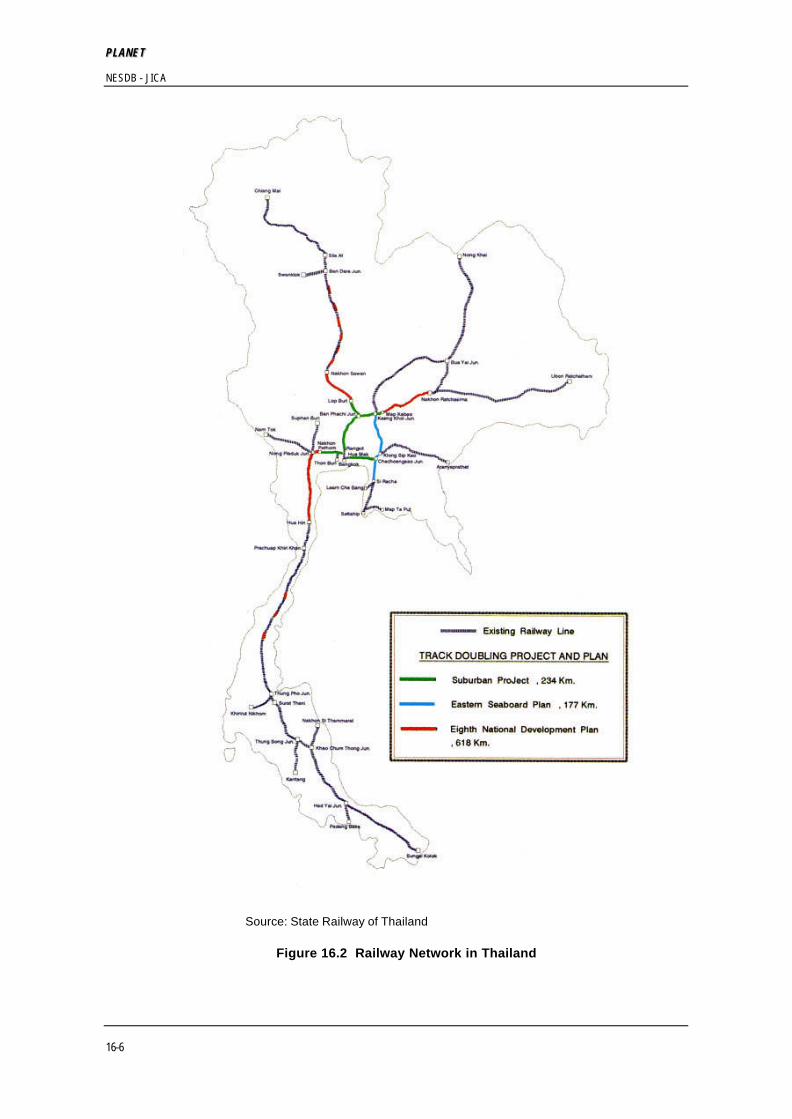
16.1.2 National Railway System in Thailand
SRT currently operates a network of about 4,404.5 km, all of which is single track with
the exception of the 90-km double-track section between Bangkok and Ban Phachi.
Ridership in 1997 was over 65 million passengers; however, the railway’s transport
share has been declining, reflecting the rapid growth of highway length and road traffic.
Table 16.5 Current Railway System in Thailand
Line Section Year of Opening Southern Bangkok - Hat Yai - Padang Besar 1918
Bangkok - Hat Yai - Sungai Kolok 1921
Eastern Bangkok - Aranyaprathet 1926
Northern Bangkok - Chiang Mai 1926
Northeastern Bangkok Ubon Ratchathani 1939
Bangkok Nong Khai 1958
Eastern Sea board Chachoengsao - Sattahip 1985
Si Racha - Leam Chabang 1993
Kao Cheechan - Map Ta Phut 1995
Khong Sip Kao - Kaeng Khoi 1995
PP LLAANNEE TT NESDB - JICA
16-6
Source: State Railway of Thailand
Figure 16.2 Railway Network in Thailand

The Study on the Integrated Regional Development Plan for the Northeastern Border Region in the Kingdom of Thailand
Sector Plan: Chapter16 Transportation
16-7
16.1.3 Air Aviation in Thailand
The air route network centers on Bangkok and a dominant portion of all domestic air
trips have one trip end in Bangkok (Don Muang International Airport). Four airports,
namely, Bangkok, Phuket, Hat Yai and Chiang Mai, provide scheduled international
services in Thailand.
Passenger activity at all airports has shown significant growth over the last decade.
Total passengers increased from 8.3 million in 1985 to 32.3 million in 1997. Over the
same period, international passengers increased by an annual average growth of 9.6%.
Cargo has also achieved significant growth since 1985, reaching 900,000 tons a year.
Most of the cargo is international, and more than 90% of international cargo flows
through Bangkok International Airport. Meanwhile, domestic cargo movement has
been very limited, and all of it is carried by passenger flights (there is no domestic
freighter service). Therefore, it is unlikely that freighter services are required in the
foreseeable future.

PP LLAANNEE TT NESDB - JICA
16-8
16.2 Regional Transport System of North-East Thailand
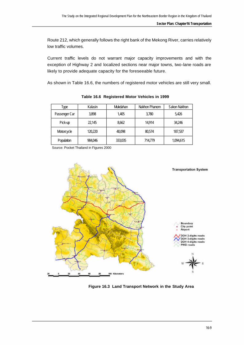
Figure 16.1 shows the national highway system (DOH roads) in the Northeastern
Region of Thailand. And the major highway system in the Study area is shown in Figure
16.3.
The region has the largest route mileage of DOH roads. The network comprises a
central spine (The Friendship Highway – Route 2) from Bangkok to Nakhon
Ratchasima, and continues northwards to Khon Kaen, Udon Thani and Nong Khai, plus
additional east-west highways (Routes 12, 22, 23 and 24) linking major population
centers.
Nakhon Ratchasima is the major city of and gateway to the region. Highway 2 provides
the main connection to Bangkok and the Central Region, while Route 304 provides a
secondary link southwards through Khao Yai National Park to the Eastern Seaboard.
Most of the northern and eastern borders of the region are formed by the Mekong River,
which is also the border with Lao PDR. The Friendship Bridge has been completed at
Nong Khai to provide the first fixed crossing to Vientiane, and another crossing (The
Second Mekong Bridge) will be constructed at Mukdahan.
Traffic volumes are relatively low throughout the region and traffic growth in recent
years has been below the national average. With the exception of Route 2 and
immediate environs of the main towns, traffic volumes on almost all routes are less than
4,000 vehicles per day.
The second major corridor in the region runs eastwards from Korat to Ubon Ratchathani.
This corridor was developed originally along the rail line and contains four
chanwats–Buriram, Surin, Si Saket and Ubon– with a combined population in excess of
1 million. There are two parallel roads in the corridor–Route 226 which links the towns
and closely follows the railway and Route 24, approximately 40 km to the south, which
follows a new alignment away from the urban settlements.
Khon Kaen, together with the nearby changwats of Kalasin, Mahasarakham and Roi Et,
comprises a significant concentration of population in the center of the region. Routes
12 and 23 provide east-west connections from this area to Ubon Ratchathani and the
Northern Region (Phitsanulok).
An extensive network of 2- and 3-digit roads link the main towns throughout the region
and minor improvements have been made to selected 4-digit roads to supplement this
network. Most economic activity is focused inwards onto the center of the region and
The Study on the Integrated Regional Development Plan for the Northeastern Border Region in the Kingdom of Thailand
Sector Plan: Chapter16 Transportation
16-9
Route 212, which generally follows the right bank of the Mekong River, carries relatively
low traffic volumes.
Current traffic levels do not warrant major capacity improvements and with the
exception of Highway 2 and localized sections near major towns, two-lane roads are
likely to provide adequate capacity for the foreseeable future.
As shown in Table 16.6, the numbers of registered motor vehicles are still very small.
Table 16.6 Registered Motor Vehicles in 1999
Type Kalasin Mukdahan Nakhon Phanom Sakon Nakhon
Passenger Car 3,898 1,405 3,780 5,426
Pick-up 22,145 8,662 14,914 34,246
Motorcycle 120,220 40,098 80,574 187,537
Population 984,046 333,035 714,779 1,094,615
Source: Pocket Thailand in Figures 2000
Figure 16.3 Land Transport Network in the Study Area

PP LLAANNEE TT NESDB - JICA
16-10
Table 16.7 Highway Traffic Volume in the NBR
Source: Department of Highways, Ministry of Transport and Communication
Route Control Link_ID Name Type KM. Car Light Bus Heavy Bus Light Truck Medium Truck Heavy Truck Total HV. Bicycle Motorcycle
22 202 220202 KM.43+073 - BY PASS KHO TAI C 54+328 1686 37 282 3483 633 508 6629 21.47% 45 2393
22 204 220204 BYPASS KHO TAI C 57+100 46 34 5 67 4 10 166 11.45% 105 893
22 205 220205 BYPASS KHO TAI -BYPASS BAN NGON C 60+350 1414 327 276 2996 454 435 5902 19.74% 3 1486
22 207 220207 BYPASS BAN NGON C 74+500 70 15 24 347 35 47 538 19.70% 247 3466
22 301 220301 JCT.TALAT SAWANGDAENDIN -BYPASS MUANG KHAI C 80+000 651 70 198 2807 270 247 4243 16.85% 27 3660
22 303 220303 BYPASS MUANG KHAI C 100+200 55 10 0 207 21 7 300 9.33% 198 1765
22 304 220304 BYPASS MUANG KHAI -KM.106+895 (PHANG KHON) P 103+800 750 2 212 3133 330 327 4754 18.28% 16 2067
22 401 220401 JCT.PHANG KHON -BYPASS PHANNANIKHOM C 114+400 1798 62 214 3284 431 257 6046 14.92% 24 2860
22 403 220403 BYPASS PHANNANIKHOM C 121+440 456 24 122 1412 123 30 2167 12.69% 202 3667
22 404 220404 BYPASS PHANNANIKHOM -JCT.THAT NAWAENG C 135+000 1919 239 223 2407 422 194 5404 15.53% 190 3020
22 405 220405 JCT.THAT NAWAENG -JCT.SAKONNAKHON 1 DIST. C 156+900 4441 991 680 7719 568 187 14586 9.84% 41 7339
22 406 220406 JCT.R.NO.223 -THANON RATPHATTHANA C 161+140 5994 652 578 318 375 134 8051 13.50% 51 1808
22 407 220407 THANON RATPHATTHANA- THANON MAKKHALAI C 161+378 5370 1319 1043 5987 647 179 14545 12.85% 113 5331
22 501 220501 JCT.THAT NAWENG - KM.171+000(NAKHONPHANOM DIST.) C 156+700 2844 781 767 3474 1084 742 9692 26.75% 498 6619
22 502 220502 KM.171+000 (SAKONNAKHON DIST)'- KM.189+190 C 189+500 748 116 185 3310 753 1190 6302 33.77% 266 5704
22 600 220600 JCT.TO THA UTHEN -HUAI HU MENT BRIDGE (WEST) C 195+500 846 127 178 1728 321 211 3411 20.82% 10 1834
22 700 220700 HUAI HU MENT BRIDGE (WEST) -NAKHON PHANOM C 234+100 1594 653 438 3061 632 628 7006 24.24% 201 6302
209 202 2090202 KM.38+552 - JCT.YANG TALAT C 45+500 2368 367 261 2897 589 467 6949 18.95% 275 1570
212 901 2120901 HUAI DAN CHUM BRIDGE -THA U-THEN C 269+850 978 65 43 481 177 38 1782 14.48% 73 1380
212 1001 2121001 BYPASS THA UTHEN (D) -NAKHON PHANOM P 18+000 1016 176 109 1391 161 130 2983 13.41% 21 1253
212 1100 2121100 MUNI. OF NAKHON PHANOM -JCT.TO RENU KAKHON C 261+300 941 424 237 2164 263 138 4167 15.31% 32 4138
212 1201 2121201 JCT.TO RENU KAKHON - BAN TONG(MUKDAHAN DIST.) C 213+900 936 230 128 3008 390 181 4873 14.34% 126 6781
212 1302 2121302 NAKHON PHANOM - DON SAWAN C 201+600 1377 183 323 1175 490 228 3776 27.57% 184 1478
212 1400 2121400 MUKDAHAN - JCT.LOENG NOK THA(NEW) C 163+350 5717 222 158 742 500 413 7752 13.82% 34 7687
213 101 2130101 JCT.R.NO.208 - KALASIN DIST. C 1+700 4552 309 299 1771 263 141 7335 9.58% 26 8301
213 102 2130102 KM.14+020 - KALASIN P 33+500 3820 491 437 6736 968 1249 13701 19.37% 23 2715
213 103 2130103 BYPASS KALASIN C 2+300 1773 198 37 4423 595 508 7534 15.13% 56 6058
213 200 2130200 KALASIN - JCT.TALAT SOMDET C 47+618 3342 92 294 2762 448 185 7123 13.01% 100 7485
213 302 2130302 KM.84+620 (KALASIN DIST.) -KM.109+470 C 86+000 1323 259 148 251 244 229 2454 25.31% 13 344
213 303 2130303 KM.109+470 - JCT.NAM PHUNG DAM C 127+100 1874 121 199 264 243 207 2908 22.32% 9 908
213 400 2130400 JCT.NAM PHUNG DAM - MUNI. OF SAKON NAKHON C 28+950 748 341 315 3034 418 269 5125 19.55% 31 3796
214 100 2140100 JCT. TO TALAT KALASIN -KM.28+000 C 8+764 3746 306 211 1306 565 278 6412 16.44% 84 4171
222 100 2220100 JCT.PHANG KHON - KM.31+153)BRIDGE (WANONIWAT) C 16+225 291 93 110 1577 141 69 2281 14.03% 68 1451
222 201 2220201 KM.31+153 BRIDGE (WANONIWAT)- KM.57+500 C 42+700 399 85 122 1659 261 235 2761 22.38% 325 1861
223 102 2230102 MUNI. OF SAKON NAKHON -JCT. TO NONG BO C 23+950 743 465 123 2060 354 169 3914 16.50% 178 3997
The Study on the Integrated Regional Development Plan for the Northeastern Border Region in the Kingdom of Thailand
Sector Plan: Chapter16 Transportation
16-11
16.3 Commodity Transportation
16.3.1 Major Commodity Movement at Transport Centers in the Northeastern
Thailand
Nakhon Ratchasima and Khon Kaen are the two major transport centers in the
Northeastern region. Statistics of commodity movement at such major centers are
available at the Department of Land Transport, MOTC. Tables 16.8 and 16.9 show total
commodity volume transported to/from major transport centers: Nakhon Ratchasima,
Khon Kaen, and Bangkok by road transport.
Nakhon Ratchasima is a gateway city to the Northeastern region from the Central and
other southern areas including Bangkok, the Eastern region and the Southern region.
The Central region is the dominant region that generates commodity movement to
Nakhon Ratchasima, followed by the Northeastern region. The total volume of
commodity attracted to Khon Kaen is slightly larger than that of Nakhon Ratchasima.
Similar to the case of Nakhon Ratchasima, the Central region is the dominant
commodity-producing region to Khon Kaen.
Bangkok is the biggest commodity generation and attraction center for the Northeastern
region, of which situation is common to other regions. While within the region, it can be
said that Khon Kaen is a more important transport center than Nakhon Ratchasima.
Table 16.8 Total Commodity Volume Attracted to Transport Centers
Unit: ton per year
From Nakhon Ratchasima Khon Kaen BangkokCentral Region 2,089,894 2,387,988 14,829,381Eastern Region 230,494 238,241 24,715,757Northeastern Region 408,066 1,516,151 3,418,830Northern Region 8,212 53,917 2,480,295Western Region 51,918 32,474 18,672,826Southern Region 12,865 12,863 1,295,725Bangkok 855,560 854,187Total 3,657,009 5,095,821 65,412,814
From Nakhon Ratchasima Khon Kaen BangkokCentral Region 57.1% 46.9% 22.7%Eastern Region 6.3% 4.7% 37.8%Northeastern Region 11.2% 29.8% 5.2%Northern Region 0.2% 1.1% 3.8%Western Region 1.4% 0.6% 28.5%Southern Region 0.4% 0.3% 2.0%Bangkok 23.4% 16.8% 0.0%Total 100.0% 100.0% 100.0%
To
Source: Department of Land Transport, MOTC
To
Note: Data of Nakhon Ratchasima and Khon Kaen are of 1997, while those of Bangkok are of 1996

PP LLAANNEE TT NESDB - JICA
16-12
Table 16.9 Total Commodity Volume Generated from Transport Centers
Figures 16.4 and 16.5 show volumes of commodities by type at the two transport centers.
Rice, tapioca, and processed foods are the major commodities generated from Nakhon
Ratchasima, while cement/cement products and petroleum products are the major
commodities that come from other provinces to Nakhon Ratchasima.
Figure 16.4 Volumes of Commodity Generation and Attraction at Nakhon Ratchasima
Volume (ton per year)
- 200,000
400,000
600,000
800,000
1,000,000
1,200,000
1,400,000
1,600,000
1. Rice2. Sand & Gravel
3. Cement & Products4. Steel
5. Other Construction 6. Timber
7. Firewood8. Petroleum Product
9. Minerals10. Vegetable & Fruit
11. Tapioca12. Maize13. Sugar14. Beans
15.Jute & Products16. Beverages
17. Processed foods 18. Animals
19. Fish20. Ferti&Animal
21. Personal Effects22. Other
23. All, Others
Type of Commodity
In
Out
Unit: ton per year
To Nakhon Ratchasima Khon Kaen BangkokCentral Region 785,659 377,117 2,549,406Eastern Region 669,316 168,990 4,806,016Northeastern Region 786,021 1,550,638 2,412,619Northern Region 9,670 27,822 3,376,120Western Region 178,939 112,323 4,307,880Southern Region 23,358 7,938 2,816,851Bangkok 865,050 675,883Total 3,318,013 2,920,711 20,268,892
To Nakhon Ratchasima Khon Kaen BangkokCentral Region 23.7% 12.9% 12.6%Eastern Region 20.2% 5.8% 23.7%Northeastern Region 23.7% 53.1% 11.9%Northern Region 0.3% 1.0% 16.7%Western Region 5.4% 3.8% 21.3%Southern Region 0.7% 0.3% 13.9%Bangkok 26.1% 23.1% 0.0%Total 100.0% 100.0% 100.0%
From
Source: Department of Land Transport, MOTC
From
Note: Data of Nakhon Ratchasima and Khon Kaen are of 1997, while those of Bangkok are of 1996

The Study on the Integrated Regional Development Plan for the Northeastern Border Region in the Kingdom of Thailand
Sector Plan: Chapter16 Transportation
16-13
Sugar and sand & gravel are the major commodities generated from Khon Kaen, while
Cement/cement products and petroleum products are the major commodities that come from
other provinces to Khon Kaen.
Source: Department of Land Transport, MOTC
Figure 16.5 Volumes of Commodity Generation and Attraction at Khon Kaen
16.3.2 Major Commodity Movement at Provincial Level of the Northeastern
Thailand
Figure 16.6 shows total amount of annual commodity flow generated from and attracted
to Nakhon Ratchasima, Khon Kaen, and Bangkok.
As can be seen, three provinces along the National Highway 2, namely, Udon Thani,
Khon Kaen and Nakhon Ratchasima have relatively strong relationship with Bangkok.
Khon Kaen is the major commodity attraction and distribution center for Kalasin;15% of
the inflow commodity at Khon Kaen comes from Kalasin, while 48% of the outflow
commodity goes to Kalasin.
Other three provinces in the Study area have relatively small shares in terms of
commodity volume between the transport centers, ranging around 1% to 2 % of the
total.
Volume (ton per year)
- 200,000
400,000
600,000
800,000
1,000,000
1,200,000
1,400,000
1,600,000
1. Rice2. Sand & Gravel
3. Cement & Products4. Steel
5. Other Construction 6. Timber
7. Firewood8. Petroleum Product
9. Minerals10. Vegetable & Fruit
11. Tapioca12. Maize13. Sugar14. Beans
15.Jute & Products16. Beverages
17. Processed foods 18. Animals
19. Fish20. Ferti&Animal
21. Personal Effects22. Other
23. All, Others
Type of Commodity
In
Out

PP LLAANNEE TT NESDB - JICA
16-14
In general, provinces along the Mekong River have relatively weak relationship with the
two transport centers on the National Highway 2. While there are relatively larger
commodity movements between these provinces and Bangkok in comparison to the
two transport centers. Kalasin is the only exception.
Source: Department of Land Transport, MOTC
Figure 16.6 Volume of Commodity To/From Nakhon Ratchasima, Khon Kaen, and
Bangkok
Le gend
Tota l To/From C om modity Nak hon Ra tcha sima
Tota l To/From C om modity Khon K aen
Tota l To/From C om modity Bangk ok
L oei
Surin
N akhon R atc hasima
R oiet
Buri ram
Ubon Ratchathan i
Chaiya Ph um
Udont hani
Srisak et
Khon Kae n
Kalasin
No ngkhai
Sakon N akhonN akhon Phan om
Maha sa rakh Yosothon Amna t Ch aroen
N ongb ua Lamph u
Mu kdah an
2 ,000 ,000 0 ton per year

The Study on the Integrated Regional Development Plan for the Northeastern Border Region in the Kingdom of Thailand
Sector Plan: Chapter16 Transportation
16-15
Table 16.10 Commodity Movement in the Northeastern Region at Major Centers
Source: Department of Land Transport, MOTC
16.3.3 Freight Forwarding Services
The Express Transportation Organization (ETO) of MOTC used to monopolize the
freight forwarding services by truck in Thailand. At present, there emerged a number of
private forwarding companies.
Region/ ProvinceTotal In Out Total In Out Total In Out
Chaiyaphum 69,349 24,637 44,712 103,923 61,132 42,791 149,647 110,410 39,237 Yasothon 42,157 16,060 26,097 25,638 23,084 2,554 159,320 94,169 65,151 Ubon Ratchathani 78,018 58,856 19,162 19,432 11,952 7,480 242,262 139,882 102,380 Sri Saket 40,423 25,915 14,508 7,845 3,557 4,288 182,040 131,398 50,642 Buriram 143,262 43,070 100,192 56,934 35,584 21,350 290,171 192,537 97,634 Nakhon Ratchasima - - - 799,244 599,504 199,740 2,141,627 1,131,951 1,009,676 Surin 65,791 13,596 52,195 17,153 11,953 5,200 284,516 200,749 83,767 Amnat Charoen 26,280 13,140 13,140 4,013 1,915 2,098 72,086 58,399 13,687 Nong Bualumpoo 2,920 - 2,920 4,742 2,007 2,735 32,849 5,931 26,918 Nong Khai 27,831 9,855 17,976 119,802 74,639 45,163 127,383 69,988 57,395 Loei 8,759 2,007 6,752 84,304 19,887 64,417 38,870 28,743 10,127 Udon Thani 90,246 25,641 64,605 243,079 66,790 176,289 453,600 213,523 240,077 Nakhon Phanom 12,136 3,011 9,125 19,982 7,665 12,317 56,209 45,624 10,585 Sakhon Nakhon 14,143 2,737 11,406 59,669 14,232 45,437 87,963 60,589 27,374 Khon Kaen 395,477 133,681 261,796 - - - 892,508 517,475 375,033 Kalasin 47,631 9,398 38,233 961,945 220,271 741,674 178,117 113,604 64,513 Maha Sarakham 50,917 8,760 42,157 440,267 299,932 140,335 140,066 90,154 49,912 Roi Et 67,342 15,695 51,647 71,352 54,200 17,152 234,326 156,765 77,561 Mukdahan 11,405 2,007 9,398 27,465 7,847 19,618 67,889 56,939 10,950
Total 1,194,087 408,066 786,021 3,066,789 1,516,151 1,550,638 5,831,449 3,418,830 2,412,619
Region/ ProvinceTotal In Out Total In Out Total In Out
Chaiyaphum 5.8% 6.0% 5.7% 3.4% 4.0% 2.8% 2.6% 3.2% 1.6%Yasothon 3.5% 3.9% 3.3% 0.8% 1.5% 0.2% 2.7% 2.8% 2.7%Ubon Ratchathani 6.5% 14.4% 2.4% 0.6% 0.8% 0.5% 4.2% 4.1% 4.2%Sri Saket 3.4% 6.4% 1.8% 0.3% 0.2% 0.3% 3.1% 3.8% 2.1%Buriram 12.0% 10.6% 12.7% 1.9% 2.3% 1.4% 5.0% 5.6% 4.0%Nakhon Ratchasima 0.0% 0.0% 0.0% 26.1% 39.5% 12.9% 36.7% 33.1% 41.8%Surin 5.5% 3.3% 6.6% 0.6% 0.8% 0.3% 4.9% 5.9% 3.5%Amnat Charoen 2.2% 3.2% 1.7% 0.1% 0.1% 0.1% 1.2% 1.7% 0.6%Nong Bualumpoo 0.2% 0.0% 0.4% 0.2% 0.1% 0.2% 0.6% 0.2% 1.1%Nong Khai 2.3% 2.4% 2.3% 3.9% 4.9% 2.9% 2.2% 2.0% 2.4%Loei 0.7% 0.5% 0.9% 2.7% 1.3% 4.2% 0.7% 0.8% 0.4%Udon Thani 7.6% 6.3% 8.2% 7.9% 4.4% 11.4% 7.8% 6.2% 10.0%Nakhon Phanom 1.0% 0.7% 1.2% 0.7% 0.5% 0.8% 1.0% 1.3% 0.4%Sakhon Nakhon 1.2% 0.7% 1.5% 1.9% 0.9% 2.9% 1.5% 1.8% 1.1%Khon Kaen 33.1% 32.8% 33.3% 0.0% 0.0% 0.0% 15.3% 15.1% 15.5%Kalasin 4.0% 2.3% 4.9% 31.4% 14.5% 47.8% 3.1% 3.3% 2.7%Maha Sarakham 4.3% 2.1% 5.4% 14.4% 19.8% 9.1% 2.4% 2.6% 2.1%Roi Et 5.6% 3.8% 6.6% 2.3% 3.6% 1.1% 4.0% 4.6% 3.2%Mukdahan 1.0% 0.5% 1.2% 0.9% 0.5% 1.3% 1.2% 1.7% 0.5%
Total 100.0% 100.0% 100.0% 100.0% 100.0% 100.0% 100.0% 100.0% 100.0%
Nakhon Ratchasima in 1997 Khon Kaen in 1997 Bangkok in 1996
Nakhon Ratchasima in 1997 Khon Kaen in 1997 Bangkok in 1996
PP LLAANNEE TT NESDB - JICA
16-16
ETO provides three types of services as follows:
1. Express domestic cargo (EDC)
2. Express International cargo (EIC)
3. Transit cargo
A number of private companies are now providing express-type domestic forwarding
services at prices lower than ETO’s. Since changes of prices for services by ETO need
approval by the Government, therefore, ETO has been losing its competitiveness in this
business
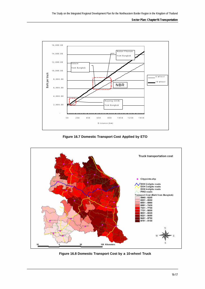
Figure 16.7 shows ETO’s prices for freight forwarding by distance. An incremental
increase of the price by 6-wheel trucks is 7 baht per kilometer, and 9 baht per kilometer
by 10-wheel trucks.
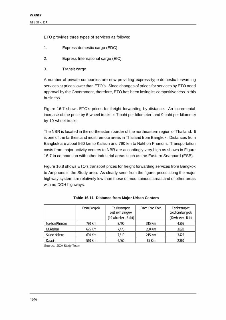
The NBR is located in the northeastern border of the northeastern region of Thailand. It
is one of the farthest and most remote areas in Thailand from Bangkok. Distances from
Bangkok are about 560 km to Kalasin and 790 km to Nakhon Phanom. Transportation
costs from major activity centers to NBR are accordingly very high as shown in Figure
16.7 in comparison with other industrial areas such as the Eastern Seaboard (ESB).
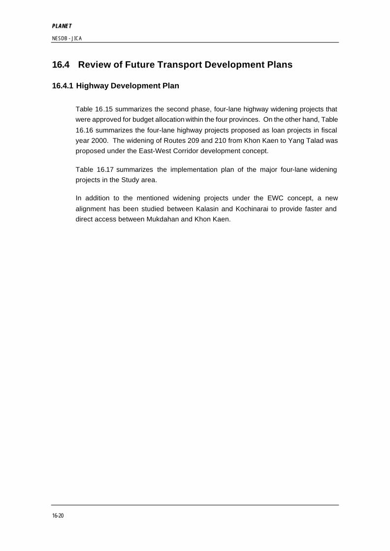
Figure 16.8 shows ETO’s transport prices for freight forwarding services from Bangkok
to Amphoes in the Study area. As clearly seen from the figure, prices along the major
highway system are relatively low than those of mountainous areas and of other areas
with no DOH highways.
Table 16.11 Distance from Major Urban Centers
From Bangkok Truck transport cost from Bangkok
(10 wheel er , Baht)
From Khon Kaen Truck transport cost from Bangkok (10 wheeler , Baht
Nakhon Phanom 790 Km 8,490 315 Km 4,305 Mukdahan 675 Km 7,475 260 Km 3,820 Sakon Nakhon 690 Km 7,610 215 Km 3,425 Kalasin 560 Km 6,460 85 Km 2,360
Source: JICA Study Team
The Study on the Integrated Regional Development Plan for the Northeastern Border Region in the Kingdom of Thailand
Sector Plan: Chapter16 Transportation
16-17
Figure 16.7 Domestic Transport Cost Applied by ETO
Figure 16.8 Domestic Transport Cost by a 10-wheel Truck
-
2 , 0 0 0 . 0 0
4 , 0 0 0 . 0 0
6 , 0 0 0 . 0 0
8 , 0 0 0 . 0 0
1 0 , 0 0 0 . 0 0
1 2 , 0 0 0 . 0 0
1 4 , 0 0 0 . 0 0
1 6 , 0 0 0 . 0 0
5 0 2 5 0 4 5 0 6 5 0 8 5 0 1 0 5 0 1 2 5 0 1 4 5 0
D i s t a n c e ( k m )
Baht
per
truc
k
6 w h e e l
1 0 w h e e l
N a k o n P h a n o m
f r o m B a n g k o k
K a l a s i n
f r o m B a n g k o k
R a y o n g ( E S B )
f r o m B a n g k o k
NBR

PP LLAANNEE TT NESDB - JICA
16-18
International transit cargoes have been handled by three private companies and by
ETO. These three private companies are:
1. TL Enterprise (in Lao)
2. Ubon Sahatham Co.,
3. RCL Co.,
In this market, ETO still has about 30% share according to an official of ETO.
According to the ETO’s statistics (refer to Tables 16.12 and 16.13), Tha Na Lang
(opposite to Nongkhai in Thailand) is the dominant crossing point in terms of total transit
commodity movement, followed by Sawannakhet. Traffic crossing Sawannakhet has
been increasing recently due to improvement of road condition in Lao PDR.
Table 16.12 Transit Cargoes transported by ETO from Lao through Thai to 3rd Countries
From - To 1999 2000
10 wheels truck Volume of
commodity 10-wheel truck Volume of
commodity (unit) (ton) (unit) (ton)
Tha Na Lang- Thai- 3rd countries 252 2,520.00 240 2,620.00
Sawannakhet- Thai- 3rd countries 57 567.93 135 1,350.00
Chong Mek- Thai- 3rd countries 83 2,263.90 356 5,520.63
Chieng Khong- Thai- 3rd countries 0 - 1 20.00
Total 392 5,351.83 732 9,510.63
Source: ETO
Note: The information does not include petroleum products.
Table 16.14 shows volume of commodities exported from Thai to Lao that were
transported by ETO. A significant increase is observed at the Sawannakhet crossing.
According to an official of ETO, the number of empty trucks passing the checkpoint is
close to 50%, which is not economical in comparison to the so-called developed
countries. One of the facts to explain this situation is that a lot of small and individual
transport companies provide freight forwarding services, therefore there is neither
effective cooperation nor coordination between them. It is suggested that there be a
kind of integration of this business by providing facilities such as a truck terminal and
communication system between individual truck companies (owners).

The Study on the Integrated Regional Development Plan for the Northeastern Border Region in the Kingdom of Thailand
Sector Plan: Chapter16 Transportation
16-19
Table 16.13 Transit Cargoes transported by ETO from a 3rd Country through Thai to Lao
1999 2000
From - To 10-wheel truck Volume of 10-wheel truck Volume of
commodity (unit) commodity (ton) (unit) (ton)
3rd countries- Thai- Tha Na Lang 233 3,995.24 343 6,014.72
3rd countries - Thai- Sawannakhet 340 5,047.65 463 6,179.26
3rd countries- Thai-Chong Mek 39 437.71 31 382.00
3rd countries - Thai-Chieng Khong 2 74.10 13 240.58
3rd countries - Thai- Tha Khek 13 175.82 21 567.75
3rd countries - Thai- Tha Lee 0 - 2 26.00
3rd countries - Thai- Pak Sun 4 50.70 0 -
Total 631 9,781.21 873 13,410.31 Source: ETO Note: The information does not include petroleum products
Table 16.14 Exported Commodity Volume by ETO from Thai to Lao
From - To 1999 2000 10-wheel truck Volume of commodity 10-wheel truck Volume of commodity (unit) (ton) (unit) (ton)
Export between Lao and Thai Thai- Tha Na Lang 359 4,850.00 286 3,771.00
Thai- Sawannakhet 166 2,157.00 255 3,224.00
Thai- Tha Khek 18 234.00 8 104.00
Thai-Chong Mek 63 819.00 88 1,138.00
Thai-Pak Sun 2 26.00
Thai-Chieng Khong 3 39.00
Export between Lao and each province in the Northeastern region
Nongkhai- Tha Na Lang 1,956 24,802.20 1,875 25,433.22
Ubon Ratchathani (Chong Mek) - - 10 100.00
Northeastern- Sawannakhet - - 57 230.00
Northeastern- Tha Khek 86 1,008.00 74 876.00
PP LLAANNEE TT NESDB - JICA
16-20
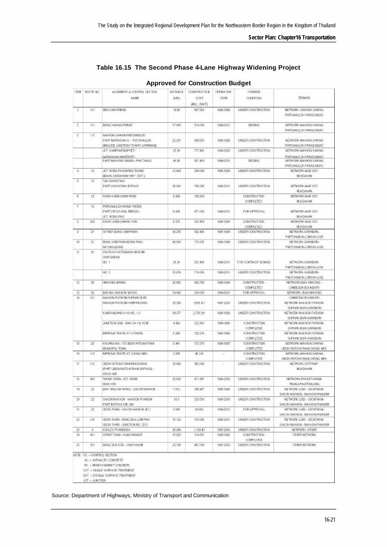
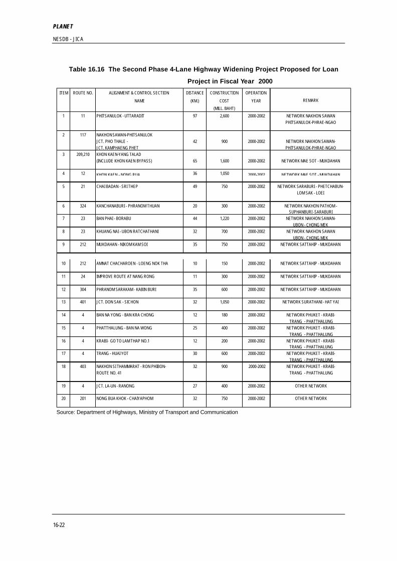
16.4 Review of Future Transport Development Plans
16.4.1 Highway Development Plan
Table 16.15 summarizes the second phase, four-lane highway widening projects that
were approved for budget allocation within the four provinces. On the other hand, Table
16.16 summarizes the four-lane highway projects proposed as loan projects in fiscal
year 2000. The widening of Routes 209 and 210 from Khon Kaen to Yang Talad was
proposed under the East-West Corridor development concept.
Table 16.17 summarizes the implementation plan of the major four-lane widening
projects in the Study area.
In addition to the mentioned widening projects under the EWC concept, a new
alignment has been studied between Kalasin and Kochinarai to provide faster and
direct access between Mukdahan and Khon Kaen.
The Study on the Integrated Regional Development Plan for the Northeastern Border Region in the Kingdom of Thailand
Sector Plan: Chapter16 Transportation
16-21
Table 16.15 The Second Phase 4-Lane Highway Widening Project
Approved for Construction Budget
Source: Department of Highways, Ministry of Transport and Communication
PP LLAANNEE TT NESDB - JICA
16-22
Table 16.16 The Second Phase 4-Lane Highway Widening Project Proposed for Loan
Project in Fiscal Year 2000
Source: Department of Highways, Ministry of Transport and Communication
ITEM ROUTE NO. ALIGNMENT & CONTROL SECTION DISTANCE CONSTRUCTION OPERATION
NAME (KM.) COST YEAR(MILL. BAHT)
1 11 PHITSANULOK - UTTARADIT 97 2,600 2000-2002 NETWORK NAKHON SAWANPHITSANULOK-PHRAE-NGAO
2 117 NAKHON SAWAN-PHITSANULOKJCT. PHO THALE - 42 900 2000-2002 NETWORK NAKHON SAWAN-JCT. KAMPHAENG PHET PHITSANULOK-PHRAE-NGAO
3 209,210 KHON KAEN-YANG TALAD (INCLUDE KHON KAEN BYPASS) 65 1,600 2000-2002 NETWORK MAE SOT - MUKDAHAN
4 12 KHON KAEN - NONG RUA 36 1,050 2000-2002 NETWORK MAE SOT - MUKDAHAN
5 21 CHAI BADAN - SRI THEP 49 750 2000-2002 NETWORK SARABURI - PHETCHABUN-LOM SAK - LOEI
6 324 KANCHANABURI - PHRANOM THUAN 20 300 2000-2002 NETWORK NAKHON PATHOM -SUPHANBURI -SARABURI
7 23 BAN PHAI - BORABU 44 1,220 2000-2002 NETWORK NAKHON SAWAN-UBON - CHONG MEK
8 23 KHUANG NAI - UBON RATCHATHANI 32 700 2000-2002 NETWORK NAKHON SAWANUBON - CHONG MEK
9 212 MUKDAHAN - NIKOM KAM SOI 35 750 2000-2002 NETWORK SATTAHIP - MUKDAHAN
10 212 AMNAT CHACHAROEN - LOENG NOK THA 10 150 2000-2002 NETWORK SATTAHIP - MUKDAHAN
11 24 IMPROVE ROUTE AT NANG RONG 11 300 2000-2002 NETWORK SATTAHIP - MUKDAHAN
12 304 PHRANOM SARAKAM - KABIN BURI 35 600 2000-2002 NETWORK SATTAHIP - MUKDAHAN
13 401 JCT. DON SAK - SICHON 32 1,050 2000-2002 NETWORK SURATHANI - HAT YAI
14 4 BAN NA YONG - BAN KRA CHONG 12 180 2000-2002 NETWORK PHUKET - KRABI- TRANG - PHATTHALUNG
15 4 PHATTHALUNG - BAN NA WONG 25 400 2000-2002 NETWORK PHUKET - KRABI- TRANG - PHATTHALUNG
16 4 KRABI- GO TO LAM THAP NO.1 12 200 2000-2002 NETWORK PHUKET - KRABI- TRANG - PHATTHALUNG
17 4 TRANG - HUAI YOT 30 600 2000-2002 NETWORK PHUKET - KRABI- TRANG - PHATTHALUNG
18 403 NAKHON SI THAMMARAT - RON PHIBON- 32 900 2000-2002 NETWORK PHUKET - KRABI-ROUTE NO. 41 TRANG - PHATTHALUNG
19 4 JCT. LA-UN - RANONG 27 400 2000-2002 OTHER NETWORK
20 201 NONG BUA KHOK - CHAIYAPHOM 32 750 2000-2002 OTHER NETWORK
REMARK

The Study on the Integrated Regional Development Plan for the Northeastern Border Region in the Kingdom of Thailand
Sector Plan: Chapter16 Transportation
16-23
Table 16.17 The Second Phase 4–Lane Highway Widening Project
Construction Planning in 1999 – 2008
Source: Department of Highways, Ministry of Transport and Communication
ROUTE NETWORK(2): MAE SOT - TAK - SOKHOTHAI - PHISANULOK - LOM SAK - CHUM PHAE - KHON KAEN - KALASIN - MUKDAHAN
HIGHWAYS LENGTH CONSTRUCTIONROUTE NO. (KM) COST 2000 2001 2002 2003 2004 2005 2006 2007 2008
(MILLION BAHT)209, 213 KHON KAEN -KALASIN
209 KHON KAEN - CHIENG YUN - YANG TALAT 65 1,585 317 634 634213, 2042 KALASIN - SOMDET - MUKDAHAN
2042 KAMCHA-I - MUKDAHAN 35 813 163 325 325213, 2042 KALASIN - SOMDET - MUKDAHAN
KALASIN (NEW ALIGNMENT) - KAMCHA-I 102 2,818 564 1127 1127
202 5,216 480 959 959 564 1127 1127
ROUTE NETWORK(7): SATTAHIP - PHANOM SARAKHAM - PAK THONG CHAI - CHOK CHAI - UBON RATCHATHANI - MUKDAHAN
HIGHWAYS LENGTH CONSTRUCTION
ROUTE NO. (KM) COST 2000 2001 2002 2003 2004 2005 2006 2007 2008(MILLION BAHT)
212 UBON RATCHATHANI - MUKDAHANKM.20 - LU AMNAT 38 912 182 365 365AMNAT CHAROEN - LOENG NOK THA 35 803 161 321 321
212 UBON RATCHATHANI - MUKDAHANLU AMNAT - AMNAT CHAROEN 42 1,085 217 434 434
212 UBON RATCHATHANI - MUKDAHANNIKHOM KHAM SOI - MUKDAHAN 35 750 150 300 300
212 UBON RATCHATHANI - MUKDAHANLOENG NOK THA - NIKHOM KHAM SOI 21 453 91 181 181
171 4,003 150 391 824 867 686 217 434 434
HIGHWAYS LENGTH CONSTRUCTION
ROUTE NO. (KM) COST 2000 2001 2002 2003 2004 2005 2006 2007 2008(MILLION BAHT)
22 UDON THANI - SAKON NAKHON - NAKHON PHANOMUDON THANI - JCT. R. NO. 2312 31 764 152 306 306
210 WANG SA PUNG - NONG BUA LAM PHU - UDON THANINONG BUA LAM PHU - UDON THANI 49 1,654 330 662 662
22 UDON THANI - SAKON NAKHON - NAKHON PHANOM 324 649 649 JCT.R. NO. 2312 - SAWANG DAEN DIN 55 1,622 158 315 315SAWANG DAEN DIN - PHANG KHON 26 788 232 462 462PHANG KHON - SAKON NAKHON 45 1,156 90 179 179SAKON NAKHON - JCT.R. NO. 2132 16 448
222 6,432 152 636 968 986 1129 1605 956
YEARS
NETWORK / CONTROL SECTION REMARK
NETWORK / CONTROL SECTION REMARK
TOTAL
TOTAL
YEARS
ROUTE NETWORK(10): LOEI - UDON THANI - SAKON NAKHON - NAKHON PHANOM
NETWORK / CONTROL SECTION REMARK
TOTAL
YEARS

PP LLAANNEE TT NESDB - JICA
16-24
16.4.2 Railway Development Plan
Progress of those SRT’s projects are summarized as follows:
(1) Track Rehabilitation Projects
Life of the current tracks has gradually expired, resulting in frequent cracks and
breakage that has seriously disturbed train operations. In 1994, SRT started the
three-phase track rehabilitation project in order to secure traffic capacity as well as to
efficiently maintain the rail tracks by reinforcing the 791 km northern and southern lines
with 100 lb/yd rails and concrete pre-cast sleepers with three phases (Table 16.18).
Table 16.18 Track Rehabilitation Projects
Project Area Length (Km) Progress
Northern line Lop Buri – Chumsaeng 148 Completed Phase 1
Southern line Hua Hin – Ban Krut 141 Completed
Northern line Chumsaeng – Phitsanulok 108 Progressing Phase 2
Southern line Chiya – Thung Song 150 Progressing Phase 3 Southern line Ban Krut - Chiya 244 Progressing
As the second phase, approximately 840 km of the track rehabilitation project has been
justified in the 8th Plan by the NESDB; however, the project has been delay due to the
economic crisis.
(2) Track Doubling Projects
SRT started the track-doubling project in order to improve transportation capability by
increasing train frequency as well as train speed. In 1993, 234 km lines of track
doubling project around Bangkok was started as the first phase of the track-doubling
program approved by the Cabinet in principle.
Table 16.19 Track Doubling Projects
Project Area Length (Km)
Progress
Southern line Bang Sue – Taling Chan 14 Completed
Northern line Rangsit – Ban Phachi 61 Completed
Northern line Bang Phachi – Lop Buri 43 Under construction
Northeastern line
Bang Phachi – Map Kabao 44 Under construction
Southern line Taling Chan – Nakhon Pathom 42 Under construction
Eastern line Hua Mak - Chachoengsao 30 Under construction

The Study on the Integrated Regional Development Plan for the Northeastern Border Region in the Kingdom of Thailand
Sector Plan: Chapter16 Transportation
16-25
As the second phase, the following 618 km of the track doubling project has been
justified in the 8th Plan by the NESDB, and 177 km of track doubling project related to
the ESB development is also planned. However, these projects have not yet
commenced due to the economic crisis.
Table 16.20 Track Doubling Projects under 8th Plan
Project Area Length (Km) Note
Northern line Nakhon Sawan – Sila At 104 Long loops
Southern line Prachuab Kirikhan – Surat Thani 70 Long loops
Northern line Lop Buri – Nakhon Sawan 113 Extension of phase 1
Northern line Map Kabao – Nakhon Ratchasima 130 Extension of phase 1
Southern line Nakhon Pathom – Hua Hin 165 Extension of phase 1
Eastern line Chachoengsao – Klong Sip Kao 177 ESB related project
(3) Expansion of Rail Network (new railway line) Projects
Recently the Thai government has adopted a policy of extending the railway system to
densely populated areas, such as Chiang Rai province in the north, Phuket island in the
south, Rayong province in the Eastern Seaboard Area, and Nakhon Phanom or
Mukdahan in the northeast. In July 1997, the Cabinet approved in principle the
extension of the 4 new railway lines.
Following the policy, SRT has planned to construct 4 new railway lines to cover highly
populated remote areas.
Table 16.21 New Railway Project
Project Area Length (Km) Note Northern line Den Chai – Chiang Rai 246 D/D completed
Northeastern line Bua Yai – Roi Et – Mukdahan – Nakhon Phanom
368 F/S completed
Eastern line Map Ta Phut – Rayong 24 D/D completed Southern line Maluan/ Thung Pho - Phuket 165 D/D completed
An extension railway network to the northeastern region: Bua Yai – Roi Et – Mukdahan
– Nakhon Phanom route has been planned since 1969. According to the preliminary
study by Engineering Consulting Firms Association (ECFA), Japan in 1989, this line has
potential. Following this recommendation, a feasibility study had been made in 1994 by
a Canadian consultant. Economic appraisal of this study suggests that all of the three
alternative routes, namely, Corridor 1 Udon Thani-Sakon Nakhon-Nakhon Phanom,
Corridor 2 Bua Yai-Roi Et-Mukdahan-Nakhon Phanom, and Corridor 3
Chatturat-Chaiyaphum-Ban Phai-Roi Yet-Mukdahan-Nakhon Phanom, have a negative
net present value (NPV) at a 10% discount rate. However, the consultant
recommended that SRT proceed with a preliminary design and feasibility analysis for
the line from Bua Yai to Nakhon Phanom.

PP LLAANNEE TT NESDB - JICA
16-26
Due to severe financial situation, SRT principally seeks private sector participation on a
Build-Operate-Transfer (BOT) basis for implementing above new line projects. No
progress has been seen on these projects yet.
(4) Signaling and Telecommunication Improvement Projects
SRT has commenced two projects for signaling and telecommunication improvement
projects, namely, upgrading of the level crossing protection for the eastern lines project,
and installation of signaling and telecommunication system for a track project.
(5) Service Improvement Projects
For improving client service, SRT has encouraged computerization through on-line
computerized ticketing and reservation system and client server system.
16.4.3 Airport Development Plan
According to the Study on Airport Development Master Plan in the Kingdom of Thailand,
Department of Aviation (DOA), Ministry of Transport and Communication (MOTC),
which has been recently finalized through the technical assistance of Japan
International Cooperation Agency (JICA), a new airport is proposed at Mukdahan. The
site is located approximately 16 km through the well-paved Route 212 from the CBD of
Mukdahan. The short-term development plan of the new airport includes the following:
• earthworks of approximately 236,650 cu.m. cut and 633,650 cu.m. fill,
• construction of a 1,840 m x 45 m runway with a 300-meter-wide runway strip,
• construction of a new passenger terminal, apron, cargo building, control tower,
fire station, fuel farm, car park, etc. on the south site of the runway, and
• installation of air navigation systems including VOR/DME, ILS LLZ, ILS GP, and
ALS.
Among the investigated 29 regional airports, the new Mukdahan airport ranked 7th in
terms of EIRR. However, the estimated EIRR of the new Mukdahan airport was lower
than the general standard used by the World Bank, which is 12%. Therefore, the study
recommended that the economic viability of the airport needed further investigation due
to its marginal feasibility and risk sensitivity.

The Study on the Integrated Regional Development Plan for the Northeastern Border Region in the Kingdom of Thailand
Sector Plan: Chapter16 Transportation
16-27
Table 16.22 Annual Domestic Air Passenger Demand
1997 2002 2007 2012 2017
Nakhon Phanom 43,472 57,792 78,179 168,667 281,081
Sakon Nakhon 47,938 60,899 84,259 179,488 298,051
Mukdahan 112,800 202,535 318,600
Source: The Study on Airport Development Master Plan in the Kingdom of Thailand, Ministry of Transport and
Communications
Since the new Mukdahan airport development is still ranked relatively high, it is
worthwhile to seek a way to improve its economic and financial viability. One such idea
is sharing airport functions with the Savannakhet airport in Lao PRD. If this airport were
used jointly by Mukdahan (Thai) and Savannakhet (Lao PDR), the Thai side could save
huge investment costs for construction of the new airport and related facilities. For this
joint operation, there is an idea for the city of Mukdahan to have a City Airport Terminal
(M-CAT) with effective shuttle services between the Savannakhet airport and the
M-CAT by fully utilizing the planned Second Mekong Bridge. Institutional arrangement
between both countries is required to make this idea operational.
Table 16.23 Cost Estimates of Mukdahan Airport in 2002
Cost (Baht) Earthworks 51,2000,000 Runway 66,380,340 Taxiway 43,455,238 Apron 8,621,925 Drainage System 27,600,000 Passenger Air Terminal 63,270,000 Fire Station 4,750,000 Maintenance Building 3,800,000 Car Park and Road 21,331,250 Firefighting Vehicle 14,800,000 Airfield Lighting 12,704,600 Airport Utilities 30,258,650 Preliminary and General 34,817,200 Miscellaneous 153,195,681 Consultants’ Fee 53,618,488 Grand Total 589,803,373 Source: The Study on Airport Development Master Plan in the Kingdom of Thailand,
Ministry of Transport and Communications

PP LLAANNEE TT NESDB - JICA
16-28
Table 16.24 Priority of Airport Development by EIRR
Rank Airport EIRR 1 Mae Hong Son 22.0% 2 Phrae 20.3% 3 Lampang 17.5% 4 Nan 16.5% 5 Betong 16.3% 6 Udon Thani 14.9% 7 Mukdahan 8.4%
8 Pattani 4.7% 9 Loei 4.2% 10 Roi Et 0.9% All other airports Zero or negative
Source: The Study on Airport Development Master Plan in the Kingdom of Thailand
16.5 Issues in Developing Land Transportation System
In this section, several issues found from the current situation as well as the future
development plans in the Study area. It is not necessary that all of the planning issues
are derived from a quantitative analysis.
16.5.1 Land Transport
(1) Arterial Road System
1) Identification of Heavily-Loaded Road System and Truck Terminal
Development
In general, the highway system in the Northeastern Region has been well developed.
Besides, many four-lane widening projects and new highway development are
scheduled. Most sections of the highways are AC paved; however, due to some
vehicles carrying heavy load some road segments of 3-digit roads are easily
deteriorated. In order to prevent the further deterioration of lower-class roads, the
routes should be designated along 2-, 3 and some 4-digit DOH roads and development
truck terminals will be necessary.
2) New 2-digits Class Roads Connecting Major Urban Centers
In the northern area of the Phu Pham, the highway No.2 connects major urban centers
such as Udon Thani, Sakon Nakhon and Nakhon Pathom. However, highway system
in the southern area is relatively weak. In order to develop another effective east-west
The Study on the Integrated Regional Development Plan for the Northeastern Border Region in the Kingdom of Thailand
Sector Plan: Chapter16 Transportation
16-29
axis in the region, it is recommended to develop a 2-digit class road connecting
Mukdahan, Kalasin and Khon Kaen. Actually, DOH has been conducting widening
projects under the 8th National Plan, and carried out a feasibility study for the new
alignment connecting Kalasin and Khochinarai.
(2) Public Transport
1) Introduction of ordinary shuttle bus services between Mukdahan and
Savannakhet using the Second Mekong Bridge
Based on the Trilateral Agreement signed by Thailand, Lao PDR, and Vietnam on 26
November 1999, shuttle bus services between the cities of Mukdahan and
Savannakhet should be discussed in the National Transport Facilitation Committees, as
stated in Article 28.
2) Establishment of Thai-Lao Joint Bus Operation Company
For the provision of the above-mentioned shuttle bus services, establishment of a joint
operation company (by both countries or cities) is recommended to mutually enjoy the
benefit generated from the business. The shuttle bus services will provide comfortable
passenger transport services between the city centers of the two cities: Mukdahan and
Savannakhet. Immigration function should be included with the bus terminal function to
be a “City Air Terminal”. Articles 5 and 6 of the agreement are relevant to materialize
this idea.
(3) International Freight Transport
1) Inland Container Depot (ICD) Development at Mukdahan
In order to provide one-window inspection and one-stop inspection services, it is
worthwhile to consider the development of ICD at Mukdahan. If Savannakhet in Lao
PDR has an industrial estate aimed at exporting goods to Thailand, this idea becomes
more realistic, since the forwarding system in Thailand is well developed in comparison
with those in Lao PDR.
(4) Intra-Regional Freight Transport
1) Establishment of Forwarding Cooperation for Agricultural Products
Following the structural change of agricultural products, from monoculture to mixed
farming, traffic demand between urban centers and farmland will increase in order to
transport daily consumables such as vegetables, eggs, and flowers. In order to
transport these products effectively and economically, it is recommended that the
farmers in the region share vehicles to transport their product.

PP LLAANNEE TT NESDB - JICA
16-30
(5) New Gateway Development: The Third Mekong Bridge at Nakhon Phanom
The Second Mekong Bridge will provide better access to Da Nang in Vietnam as well as
to Savannakhet for the Thai side. Likewise, Nakhon Phanom has good potential for
development of a third Mekong Bridge. As discussed in the earlier section of this report,
traffic demand for crossing this point has been increasing. And it is also mentioned that
this crossing will provide another opportunity to the region by connecting the central
area of Lao PDR and the northern part of Vietnam.
Figure 16.9 Trucks of Lao PDR A truck from the ESB to Lao PDR
at the Nakhon Phanom Pier at Nakhon Phanom
16.5.2 Aviation
As mentioned earlier, it is worthwhile to consider the opportunity of sharing airport
functions with Savannakhet Airport. In order to proceed with this idea, the following
actions will be necessary:
• Establishment of Thai-Lao Friendship Committee for joint use of the Savannakhet
Airport; and
• Establishment of Bilateral Service Agreement for sharing the Savannakhet
Airport.
Consequently, the following projects should be discussed:
• Development of Mukdahan City Airport Terminal;
• Airport Shuttle Bus (or LRT) Services using the Second Mekong Bridge; and
• Express-bus services to/from the Mukdahan City Airport Terminal.

The Study on the Integrated Regional Development Plan for the Northeastern Border Region in the Kingdom of Thailand
Sector Plan: Chapter16 Transportation
16-31
16.6 Proposed Transportation System Development
16.6.1 Concept of Urban Center Development
Under Strategy 5: Urban Center and Infrastructure Development, it is proposed to
develop urban centers by infrastructure-led urban development with the following
targets and link urban centers together to form one economic zone.
Table 16.25 Planned Urban Population
(thousand person)
1998 2020
Nakhon Phanom 32 150
Sakon Nakhon 52 200
Mukdahan 28 150
Kalasin 38 150
Other municipalities 344 457
Urban Population of NBR 494 1,107
Three provinces located north of Mt. Phu Phan will have about 500 thousand urban
population, forming an “NBR Urban Alliance.” Mukdahan and Savannakhet will form a
“Pair City.” Nakhon Phanom and Ta Khek will form another Pair City. Mukdahan and
Kalasin are on the East West corridor. By these urban center networks, urban function
in the NBR as a whole should be intentionally strengthened adequately to support
industry and the agricultural sector in the NBR. Overall urban structure of the NBR is
shown in Figure 16.10.

PP LLAANNEE TT NESDB - JICA
16-32
Figure 16.10 Urban Development Concept
1) Nakhon Phanom
Nakhon Phanom will be an industrial development center in the NBR by fully utilizing its
advantage of agricultural products and proximity to the Indochina market including
Vietnam and Lao PDR. Under the Pair City Program, Nakhon Phanom will jointly
promote tourism and border trade with Tha Khek, Laos.
2) Sakon Nakhon
Sakon Nakhon will be a research and human resource development center in the NBR.
Based on the research and higher educational functions, Sakon Nakhon will be the
center of cultural and human interchange between Thailand and Laos in short/medium
term, and among GMS countries in the long term.
3) Mukdahan
Mukdahan is the gateway city to Laos and Vietnam along the Indochina East-West
Corridor. Based on the development potential provided by the 2nd Mekong International
Bridge, Mukdahan will be a goods distribution and related business center of the NBR.

The Study on the Integrated Regional Development Plan for the Northeastern Border Region in the Kingdom of Thailand
Sector Plan: Chapter16 Transportation
16-33
4) Kalasin
Kalasin will be a base of supporting industries and agro-processing of the NBR by
utilizing its advantage of proximity to Khon Kaen. Kalasin is also to be developed as a
tourism destination by utilizing villages and its fossil dinosaur attraction.
5) NBR Urban Alliance and Pair City Development
In summary, each city has specific characteristics and supports each other in the NBR
to form an effective intra urban linkage (NBR Urban Alliance Program) as follows:
Nakhon Phanom: Industrial Activity Center
Sakon Nakhon: Research & Human Resources Development Center
Mukdahan: Goods Distribution business Center
Kalasin: Agro-processing Center
Under the “NBR Urban Alliance System,” Sakon Nakhon, Mukdahan and Nakhon
Phanom should be closely linked with each other by an effective transportation system.
The Second Mekong International Bridge will provide direct access between Mukdahan
and Savannakhet. Nakhon Phanom and Tha Khek have been a historically important
pair city in terms of commodity flow. To encourage further cooperation and
development, a “Pair City Development” concept is proposed to maximize mutual
benefits through joint use of their infrastructure. In the transportation sector, such idea
includes:
l Joint Savannakhet Airport Utilization; and
l Secondary (minor) river crossing points development.
16.6.2 Supporting Transport Infrastructure Development
NBR has relatively well-developed transportation infrastructure, however, it is still
necessary to further develop its transportation system in order to physically support the
“NBR Urban Alliance” concept as well as “Pair City” concept. Following are the
proposed projects under the PLANET Master Plan.
Transportation Development Code TR01 and TR03:
To form the Indochina East West Corridor in Thai portion, the currently planned
highway network should be developed on schedule, the components of which are
already listed in the second phase widening plan of DOH:
l Khon Kaen – Kalasin (2000-2002);
l Ubon Ratchathani – Mukdahan (2000-2007); and

PP LLAANNEE TT NESDB - JICA
16-34
l Udon Thani – Sakon Nakhon – Nakhon Phanom (2000-2004).
TR02: New Widening Project under NBR Urban Alliance Program
To support urban center development under the “NBR Urban Alliance” concept, the
following road-widening projects will be necessary under the widening plan by DOH to
form a triangle four-lane highway network:
l Sakon Nakhon – Mukdahan (Route 223 and 212); and
l Nakhon Phanom – Mukdahan (Route 212).
Total length of this new widening project is roughly calculated at 175km.
TR04: Rural Products Home Delivery Service Center Project
This project aims at establishing a small parcel collection and delivery system in the
NBR. Such small parcels will be agricultural products bound for large markets such as
Bangkok. E-commerce function will also be included in this facility to collect market
information from the central activity centers. Two strategic places have been selected
for this project at Sakon Nakhon and Mukdahan.
TR05: Goods Distribution Center and Inland Container
Under the Local Industrialization Promotion Program, a goods distribution and
processing center project is recommended.
The objective of this project is to develop an industrial area with a truck terminal and
light industry base. It is planned for environment-friendly industries with zero-emission
concept. The cluster development method, which is a stepwise development according
to the demand situation, is applied to the industrial area to reduce cost. It is expected to
induce standard factories, warehouses, information center, and related common
service facilities.
Physically, the project is composed of three major functions as follows:
l Truck terminal for local distribution and collection;
l Inland container depot for international cargo; and
l Goods processing center of local products and materials.
TR06: Mukdahan City Air Terminal
Under the Pair City Development Program, the Joint Usage Project of Savannakhet
Airport has been proposed. To fully materialize this idea, a city air terminal
development project is recommended in the city of Mukdahan. The capacity of this
terminal should meet the air passenger of about 380,000 in the year of 2017.
The Study on the Integrated Regional Development Plan for the Northeastern Border Region in the Kingdom of Thailand
Sector Plan: Chapter16 Transportation
16-35
TR07: The Third Mekong Bridge
The border trading locations between Thailand and Lao PDR are limited to 13 points
along the Mekong River. Within the NBR there are four locations, namely, Tha Uten,
Nakhon Phanom, That Phanom and Mukdahan. The volume of border trade at Nakhon
Phanom is lower than that of Mukdahan; however, its volume is the third largest one
among all border-trading locations in Thailand. The volumes of Tha Uten and That
Phanom are negligible. Growth of the trading at Nakhon Phanom has been remarkable,
achieving a 35% annual increase in the last5 years in terms of Baht. Within ten years,
the amount of trading at Nakhon Phanom will reach at the current trading volume at
Mukdahan. Therefore it is recommended that the Third Mekong International Bridge at
Nakhon Phanom be developed in Phase 3 of the NBR-PLANET Master Plan.
TR08: Ferryboat Pier Improvement Project at Nakhon Phanom
In phase 3 of PLANET, construction of the Third Mekong Bridge has been proposed,
however, in order to meet the current demand, a minimum improvement of the ferryboat
and pier is recommended.
TR09: Savannakhet Airport Dedicated Shuttle Bus Service Development
In order to provide passenger transfer services from the Mukdahan City Air Terminal
and the Savannakhet Airport, a quality shuttle bus service is necessary. The demand
for such service is estimated at 137,000 in the year 2007 (380 passengers per day) and
382,000 in 2017 (1,050 passengers per day). Assuming two daily flights from Bangkok
in 2007, two large bus coaches will be necessary.
TR10: Minor Boat Pier Improvement
There are four potential small- and medium-scale towns in the NBR along the Mekong
River, namely Ban Phaeng, Tha Uten, That Phanom and Wan Yai. Two of them are
included in the border trading locations, but the scale of trading is very small. In order to
support local small scale-trading activities, boat pier improvement is recommended.
TR11 and TR12: Joint Master Plan Development
Under the Pair City Development Program, Joint Master Plan Development Studies are
recommended for both of the two pair cities. Because the gap in the level of urban
facilities including transportation system between the cities in Thai and those in Lao
PDR which is quite huge at present, a balanced urban development is required to avoid
unbalanced urban problems, e.g. traffic congestion in Lao side but no traffic congestion
in Thai side.

PP LLAANNEE TT NESDB - JICA
16-36
Table 16.26 Proposed Transport Project under NBR-PLANET Master Plan
Code Sector Relevant Project/Program Objectives Scope (components)No. Transport Strategy
TR01 Transport 5The Second Phase Widening Project/NBRUrban Alliance Development Program(PLANET)
To widen highways between Kalasin andMukdahan (2000-2005) and between SakonNakhon and Nakhon Phanom (2002-2008)
As described in the DOH plan
TR02 Transport 5 New Widening Project/NBR Urban AllianceProgram (PLANET)
To widen highways between Sakon Nakhon andMukdahan (-2010) and between Nakhon Phanomand Mukdahan(--2010)
Widening of Route 212 and 223 (Total length 175km)
TR03 Transport 5The Second Phase WideningProject/International and Regional InterfaceDevelopment Program (PLANET)
To widen highways between Khon Kaen andKalasin (2000-2002) , Ubon Ratchathani -Mukdahan (2000-2007) and Udon Thani - SakonNakhon - Nakhon Phanom (2000-2004)
As described in the DOH plan
TR04 Transport 5 Rural Products Home Delivery Service CenterProject
To create a small parcel transport system toprovide direct marketing channel to remote areas
Small parcel transport system (collect rural products anddeliver to major consumption centers such as Bangkok) atSakon Nakhon and Mukdahan.
TR05 Transport 35
Goods Distribution Center and InlandContainer Depot
To enhance the international gateway function ofMukdahanTo consolidate and distribution of LCL (Less thancontainer load )
Full facility to handle containersContainer Freight StationCustom Office, etc
TR06 Transport 5 Mukdahan City Air Terminal ProjectTo develop domestic and international city airterminal at Mukdahan for the Savannakhet airportpassengers.
Savannakhet Airport Improvement (runway extension andinternationalization) is necessary.
TR07 Transport 5 The Third Mekong BridgeTo provide effective access to the NakhonPhanom airport for Lao people.To provide better access to Hanoi from NE.
Tha Khek City Air Terminal Project can be recommended toLao PDR.
TR08 Transport 5 Ferryboat Pier Improvement ProjectTo improve the ferry peir at Nakhon Phanom tomeet the demand
Until construction of the Third Mekong Bridge, the life offerryboat pier will be extended by minimum improvement.
TR09 Transport 5 Savannakhet Airport Dedicated Shuttle BusService Development
To provide quality passenger services to/from theSavannakhet Airport.
Establishment of a joint operation company by Thai and Laoconcessionaire.
TR10 Transport 5 Minor Boat Pier Improvement ProjectTo improve local boat piers in small towns alongthe Maekong River
Four minor towns along the Mekong River (Ban Phaeng, ThaUthen, That Phanom, and Wan Yai) and small- and medium-scale market development.
TR11 Transport 5 Mukdahan and Savannakhet UrbanTransportation Master Plan Study
To develop urban transportation master plan witha target year of 2021. Master Plan Study
TR12 Transport 5Nakhon Phanom and Tha Khek UrbanTransportation Master Plan Study
To develop urban transportation master plan witha target year of 2021. Master Plan Study

The Study on the Integrated Regional Development Plan for the Northeastern Border Region in the Kingdom of Thailand
Sector Plan: Chapter16 Transportation
16-37
16.6.3 Project Costing and Schedule
Based on the proposed projects above and the development scenario of the Master
Plan, the following development schedule was developed.
The total implementation cost of the proposed projects (excluding DOH’s project: TR01
and TR03) is estimated at 7,116 million Baht for the next twenty years.
Table 16.27 Project Costing and Schedule
Code Sector Project/Program Place Implementing Schedule CostNo. Transport Organization 2000-2004 2005-2009 2010-2014 2015-2020 (Million Baht)
TR01 TransportThe Second Phase Widening Project/NBRUrban Alliance Development Program (DOHprojects)
NBR DOH, MOTC 4080.0
TR02 Transport New Widening Project/NBR Urban AllianceProgram (PLANET)
MukdahanSakon Nakhon
Nakhon PhanomDOH, MOTC 4600.0
TR03 TransportThe Second Phase WideningProject/International and Regional InterfaceDevelopment Program (DOH projects)
NBR DOH, MOTC 9154.0
TR04 TransportRural Products Home Delivery Service CenterProject
MukdahanSakon Nakhon
MukdahanSakon NakhonPrivate sector
37.5
TR05 Transport Inland Container Depot MukdahanChangwat
Office,Concession to
188.0
TR06 Transport Mukdahan City Air Terminal Project Mukdahan DOA, MOTC 62.5
TR07 Transport The Third Mekong Bridge Nakhon Phanom DOH, MOTC 2000.0
TR08 Transport Ferryboat Pier Improvement Project Nakhon PhanomDOH, PAT,
Municipalities 38.0
TR09 Transport Savannakhet Airport Dedicated Shuttle BusService Development Mukdahan DOA, MOTC
Concessionaire 4.5
TR10 Transport Minor Boat Pier Improvement Project Nakhon PhanomMukdahan
DOH, PAT,Municipalities 45.0
TR11 Transport Mukdahan and Savannakhet UrbanTransportation Master Plan Study
MukdahanSavannakhet
MukdahanSavannakhet 70.0
TR12 TransportNakhon Phanom and Tha Khek UrbanTransportation Master Plan Study
Nakhon PhanomTha Khek
NakhonPhanom
Tha Khek70.0
including planned DOH project 20349.5excluding planned DOH project (PLANET New Project) 7115.5