Embed Size (px)
Citation preview


Cultural Resource Services for Work Projects in the Plum Creek Timber
Company’s Windsor Tract, East Alachua County, Florida
SEARCH PROJECT # 3084_13168P
PREPARED FOR
PLUM CREEK TIMBER COMPANY, INC.
PREPARED BY
SOUTHEASTERN ARCHAEOLOGICAL RESEARCH, INC.
___________________________________ LISABETH CARLSON, PHD, RPA
PRINCIPAL INVESTIGATOR
NICHOLAS LINVILLE, M.A. HISTORIAN
RYAN VAN DYKE, M.A.
ARCHITECTURAL HISTORIAN
WWW.SEARCHINC.COM
NOVEMBER 2013
FINAL


Southeastern Archaeological Research, Inc. November 2013 Reconnaissance Survey of Windsor Tract, Plum Creek Timber Company Final Report
iii
REPORT PREPARERS AND PROJECT PARTICIPANTS
Report Preparation GISLisabeth Carlson Christopher F. AltesNicholas Linville Ryan Van Dyke HistorianBruce Nodine Nicholas Linville
Technical Editing and Peer Review Architectural HistorianEd Salo Ryan Van DykeBruce Nodine Joshua Torres
Administration and Logistics Bruce Nodine Lisa McNeely

November 2013 Southeastern Archaeological Research, Inc. Final Report Reconnaissance Survey of Windsor Tract, Plum Creek Timber Company
iv
This page intentionally left blank.

Southeastern Archaeological Research, Inc. November 2013 Reconnaissance Survey of Windsor Tract, Plum Creek Timber Company Final Report
v
TABLE OF CONTENTS Report Preparers and Project Participants ..................................................................................... iii Table of Contents ............................................................................................................................. v List of Figures ................................................................................................................................. vii List of Tables ................................................................................................................................... ix Chapter 1: Introduction .................................................................................................................. 1 Document Organization ............................................................................................................ 5 Chapter 2: Project Location and Environment ............................................................................... 7 Area Descriptions (1 through 5) ................................................................................................ 7 Modern Environment of East Alachua County ....................................................................... 11 Paleoenvironment .................................................................................................................. 17 Chapter 3: Historic Overview ........................................................................................................ 19 Native American Culture History ............................................................................................ 19 Paleoindian Period (10,000–8000 B.C.) ............................................................................ 19 Archaic Period (8000–500 B.C.) ........................................................................................ 20 Woodland (500 B.C.–A.D. 600) ......................................................................................... 22 Mississippian Period (A.D. 600–1539) .............................................................................. 24 Post‐Contact History in Alachua County ................................................................................. 25 First Spanish Period, 1513‐1763 ....................................................................................... 25 British Period, 1763‐1784 ................................................................................................. 27 Second Spanish Period, 1784‐1821 .................................................................................. 27 Early American Period, 1821‐1845 ................................................................................... 28 Statehood to the Civil War, 1845‐1865 ............................................................................ 29 Post‐Civil War to the Early Twentieth Century, 1865‐1929 .............................................. 31 Great Depression to the Present, 1929‐2012 ................................................................... 32 Historic Communities in Vicinity of the Plum Creek Project Area .......................................... 33 Hawthorne ........................................................................................................................ 33 Campville ........................................................................................................................... 37 Rex ..................................................................................................................................... 39 Orange Heights ................................................................................................................. 39 Windsor ............................................................................................................................. 40 Rochelle ............................................................................................................................. 42 Grove Park ......................................................................................................................... 43 Phifer ................................................................................................................................. 44 Chapter 4: Research Design and Preliminary Background Work ................................................. 45 Previous Surveys Recorded with Florida Master Site Files ..................................................... 45 Historic Map and Aerial Photograph Review .......................................................................... 48 Historic Maps .................................................................................................................... 49

November 2013 Southeastern Archaeological Research, Inc. Final Report Reconnaissance Survey of Windsor Tract, Plum Creek Timber Company
vi
Historic Aerials .................................................................................................................. 52 Archaeological Model (Probability Areas) .............................................................................. 59 Soil Drainage ..................................................................................................................... 59 Proximity to Water ............................................................................................................ 60 Relative Elevation ............................................................................................................. 60 Final Model ....................................................................................................................... 62 Chapter 5: Recorded Cultural Resources ...................................................................................... 67 Previously Recorded Archaeological Resources ..................................................................... 67 Archaeological Materials Within or on the Boundary of the Windsor Tract .................... 67 Significant Archaeological Sites Within the One‐mile Buffer of the Windsor Tract ......... 70 Previously Recorded Structures .............................................................................................. 72 NRHP Listed Structures within One‐Mile Buffer Zone of the Project Area ...................... 74 Eligible or Likely Eligible Structures within 200 m of the Project Area ............................. 74 Previously Recorded Bridges, Roads, and Railway Corridors ................................................. 75 Previously Recorded Cemeteries ............................................................................................ 78 Chapter 6: Unrecorded Potential Cultural Resources .................................................................. 81 Potential Archaeological Resources: Site Probability Model .................................................. 81 Area 1 ................................................................................................................................ 82 Area 2 ................................................................................................................................ 84 Area 3 ................................................................................................................................ 86 Area 4 ................................................................................................................................ 88 Area 5 ................................................................................................................................ 90 Potential Historic Properties ................................................................................................... 92 Early Landowners: Nineteenth‐Century Land Patents ..................................................... 92 Unrecorded Cemeteries .................................................................................................... 98 Potential Unrecorded Historic Structures, Roads, Railways, and Bridges ...................... 102 Chapter 7: Conclusions ............................................................................................................... 117 References Cited ......................................................................................................................... 119 Appendix A. Unanticipated Discoveries Statement Appendix B. Township/Section/Range for the Windsor Tract Appendix C. Recorded Historic Structures within One Mile of the Windsor Tract

Southeastern Archaeological Research, Inc. November 2013 Reconnaissance Survey of Windsor Tract, Plum Creek Timber Company Final Report
vii
LIST OF FIGURES Figure 1.1. Location of the Windsor Tract, Plum Creek Timber Company .................................. 2 Figure 1.2. Five subdivisions of the Windsor Tract and adjacent communities shown on
topographic quadrangle maps ................................................................................... 3 Figure 1.3. Five subdivisions of the Windsor Tract shown on a 2010 aerial photograph ........... 4 Figure 2.1. Area 1 of Windsor Tract shown on USGS quadrangle map ....................................... 8 Figure 2.2. Area 2 of Windsor Tract shown on USGS quadrangle map ....................................... 9 Figure 2.3. Area 3 of Windsor Tract shown on USGS quadrangle map ..................................... 10 Figure 2.4. Area 4 of Windsor Tract shown on USGS quadrangle map ..................................... 12 Figure 2.5. Area 5 of Windsor Tract shown on USGS quadrangle map ..................................... 13 Figure 2.6. Soil drainage properties for the Windsor Tract, Plum Creek Timber Company ...... 15 Figure 3.1. Post‐500 B.C. culture areas in Florida ...................................................................... 23 Figure 3.2. An artist’s rendition of the August 1864 Battle of Gainesville ................................ 30 Figure 3.3. Early postcard depicting an orange packing operation in Florida ........................... 31 Figure 3.4. Early twentieth‐century postcard illustrating the Seaboard Air Line passenger
train and depot at Hawthorne ................................................................................. 35 Figure 3.5. Early Hawthorne, c. 1890 ......................................................................................... 36 Figure 3.6. The brick manufactory at Campville, ca. 1914 ........................................................ 38 Figure 3.7. Late nineteenth‐ or early twentieth‐century postcard illustrating a “Turpentine
Farm” near Gainesville ............................................................................................. 39 Figure 3.8. Windsor home of George B. Griffin, the town founder ........................................... 41 Figure 3.9. Madison Starke Perry, ca. 1860 ............................................................................... 42 Figure 4.1. Cultural resource surveys within one mile of the Windsor Tract boundary ........... 47 Figure 4.2. Portion of the Arredondo Grant map ...................................................................... 50 Figure 4.3. Alachua County, 1890 .............................................................................................. 51 Figure 4.4. 1936 General Highway Map with projected Windsor Tract boundary ................... 53 Figure 4.5. 1944 Hawthorne quadrangle with projected Windsor Tract boundary .................. 54 Figure 4.6. 1953 [1955] General Highway Map with projected Windsor Tract boundary ........ 55 Figure 4.7. 1964 [1965] General Highway Map with projected Windsor Tract boundary ........ 56 Figure 4.8. 1937 aerial photograph composite of area surrounding the Windsor Tract .......... 57 Figure 4.9. Hydrological resources for the Windsor Tract buffered by 100 m to create zones of higher archaeological potential ........................................................................... 61 Figure 4.10. Relative elevation data for the Windsor Tract ........................................................ 63 Figure 4.11. Relative elevation data for Area 1 and a portion of Area 2 showing previously
recorded archaeology sites ...................................................................................... 64 Figure 4.12. Archaeological probability zones (high, medium and targeted low) for entire
Windsor Tract ........................................................................................................... 65

November 2013 Southeastern Archaeological Research, Inc. Final Report Reconnaissance Survey of Windsor Tract, Plum Creek Timber Company
viii
Figure 5.1. Previously recorded archaeological resources within the project area and within a one‐mile radius of the Windsor Tract boundary ....................................... 69
Figure 5.2. Previously recorded structures within a one‐mile radius of the Windsor Tract boundary .................................................................................................................. 73
Figure 5.3. Previously recorded rail lines within a one‐mile radius of the Windsor Tract boundary .................................................................................................................. 76
Figure 5.4. Late nineteenth‐ or early twentieth‐century postcard depicting “The Log Landing” on Lake Newnan ....................................................................................... 77
Figure 5.5. Previously recorded cemeteries within a one‐mile radius of the Windsor Tract boundary .................................................................................................................. 79
Figure 6.1. Archaeological probability zones for Area 1 and previously recorded sites ........... 83 Figure 6.2. Archaeological probability zones for Area 2 and previously recorded sites ........... 85 Figure 6.3. Archaeological probability zones for Area 3 and single artifact finds (AO 1) .......... 87 Figure 6.4. Archaeological probability zones for Area 4 and previously recorded sites and
single artifact finds (AO 3 and AO 4) ........................................................................ 89 Figure 6.5. Archaeological probability zones for Area 5 ............................................................ 91 Figure 6.6. Projected locations of nineteenth‐century land patents within the Windsor
Tract, keyed to Table 6.1.......................................................................................... 95 Figure 6.7. Arredondo Grant map showing partial Windsor Tract boundary and three
plantation houses along north‐south running road (present‐day CR 234) ............. 97 Figure 6.8. Unrecorded cemeteries within the project area and within a one‐mile radius
of the Windsor Tract boundary ............................................................................. 100 Figure 6.9. Location of potential and recorded historic‐period resources within Area 1 ....... 105 Figure 6.10. Location of potential historic‐period resources within Area 2 .............................. 107 Figure 6.11. Location of potential historic resources within Area 3 .......................................... 111 Figure 6.12. Location of potential and recorded historic‐period resources within Area 4 ....... 113 Figure 6.13. Location of potential historic resources within Area 5 .......................................... 115

Southeastern Archaeological Research, Inc. November 2013 Reconnaissance Survey of Windsor Tract, Plum Creek Timber Company Final Report
ix
LIST OF TABLES Table 2.1. Soil Units and their Drainage Characteristics across the Project Area .................... 16 Table 3.1. General Prehistoric Chronology of North‐Central Florida ....................................... 19 Table 3.2. Historic Post Offices Near the Project Area ............................................................. 34 Table 4.1. Previous Cultural Resource Assessment Surveys within a One‐Mile Radius of the
Windsor Tract ........................................................................................................... 46 Table 5.1. Previously Recorded Archaeological Sites within a One‐Mile Radius of the Project Area ............................................................................................................. 68 Table 5.2. Previously Recorded Cemeteries within a One‐Mile Radius of the Windsor Tract ......................................................................................................................... 78 Table 6.1. Nineteenth‐Century Landowners and Settlers within the Windsor Tract Project
Area as Identified in Land Patent Records ............................................................... 94 Table 6.2. Unrecorded Cemeteries in the General Vicinity of the Windsor Tract ................... 99 Appendix Table C‐1. Previously Recorded Historic Structures within One Mile of Windsor Tract,
Plum Creek Timber Company Project Area.

November 2013 Southeastern Archaeological Research, Inc. Final Report Reconnaissance Survey of Windsor Tract, Plum Creek Timber Company
x
This page intentionally left blank.

Southeastern Archaeological Research, Inc. November 2013 Reconnaissance Survey of Windsor Tract, Plum Creek Timber Company Final Report
1 Introduction
CHAPTER 1 INTRODUCTION
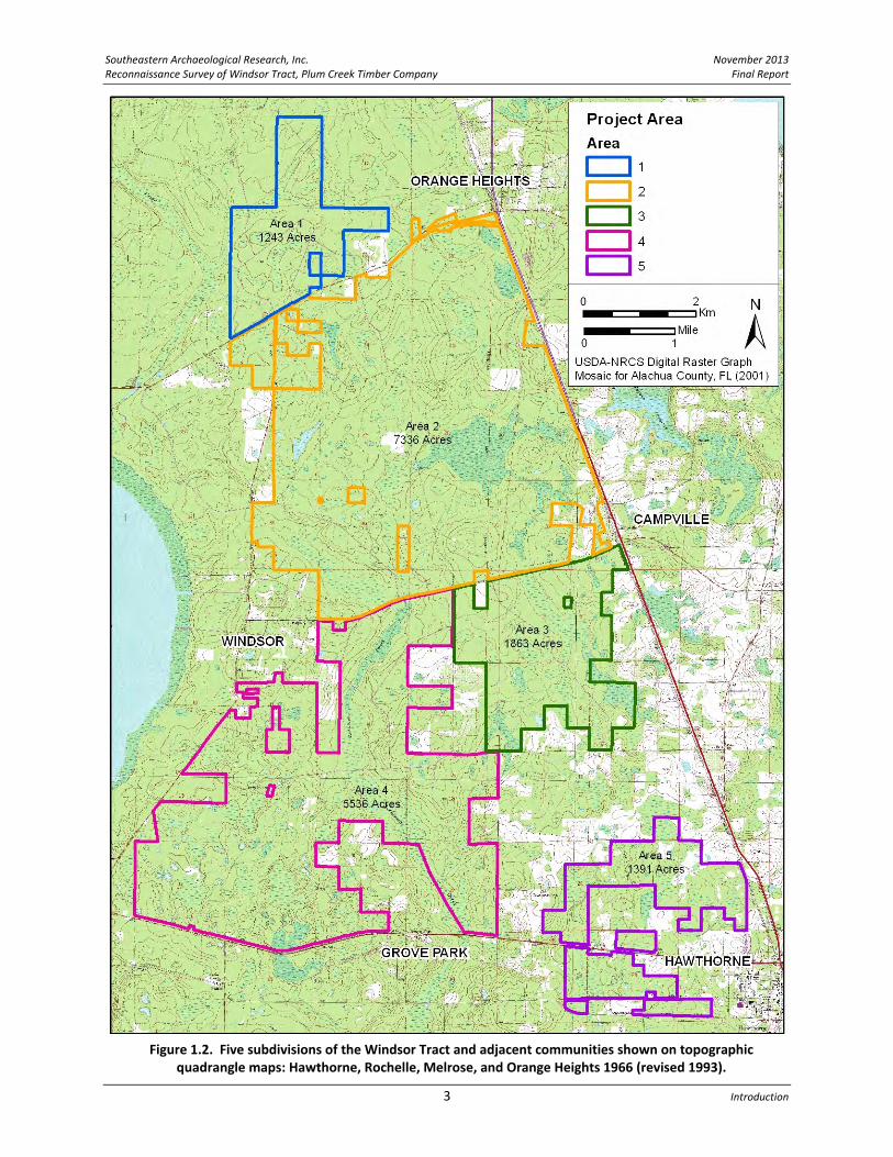
Early in 2012, Southeastern Archaeological Research, Inc., (SEARCH) was contracted by the Plum Creek Timber Company, Inc., to initiate a Cultural Resource Reconnaissance Assessment of the Windsor Tract in east Alachua County, Florida. This approximately 17,300‐acre property contains vast silvicultural areas within open uplands and extensive lowlands. The property is generally bounded on the north by State Road (SR) 26, on the south by SR 20, and, on the west and east by the Windsor Highway (County Road [CR] 234) and US 301, respectively (Figure 1.1). The tract extends east from the town of Windsor near the east side of Newnans Lake, and the parcel boundaries abut the towns of Orange Heights, Campville, Grove Park, and Hawthorne. For the purposes of this document, the large tract has been subdivided into five areas (Areas 1 through 5, numbered north to south) (Figures 1.2 and 1.3). The research on this tract was conducted as due diligence to provide information on the location and type of known or anticipated cultural resources. This information will be utilized for planning and preservation, and in anticipation of compliance and permitting requirements. The reconnaissance consists of a desktop survey incorporating background research on the property, a literature review, a study of previous cultural resource surveys that have been conducted in the vicinity of the project area, and a search for previously recorded archaeological sites and historic properties within and adjacent to the Windsor Tract. In addition, this assessment was designed to identify areas of likely archaeological or historical significance that have not yet been recorded. Historic aerial photographs, historic maps (e.g., state highway maps, US Geological Survey [USGS] topographic quadrangle maps, and US Department of Agriculture [USDA] soil maps), and the Alachua County Property Appraiser database were reviewed in order to pinpoint the locations of potentially unrecorded structures of more than 50 years old and other potentially historic properties within the parcel boundaries. The ultimate goal of this research was to identify areas of high cultural resource probability and provide recommendations for work that would most effectively identify and assess archaeological sites, historic structures, historic roads, railroads, bridges, and historic cemeteries that may be present within the property boundary. This objective required researching beyond the project boundary in order to understand the extent and content of historic activities in this region. Generally, a one‐mile radius surrounding the Windsor Tract was utilized as this included the major historic towns in the region and the primary transportation routes. This regional understanding will inform future surveys of the parcel, which will focus entirely within the confines of the Windsor Tract boundary. All previously recorded resources, surveys, and potential resource areas have been projected in GIS format on project area maps.

November 2013 Southeastern Archaeological Research, Inc. Final Report Reconnaissance Survey of Windsor Tract, Plum Creek Timber Company
Chapter 1 2
Figure 1.1. Location of the Windsor Tract, Plum Creek Timber Company.
Southeastern Archaeological Research, Inc. November 2013 Reconnaissance Survey of Windsor Tract, Plum Creek Timber Company Final Report
3 Introduction
Figure 1.2. Five subdivisions of the Windsor Tract and adjacent communities shown on topographic quadrangle maps: Hawthorne, Rochelle, Melrose, and Orange Heights 1966 (revised 1993).

November 2013 Southeastern Archaeological Research, Inc. Final Report Reconnaissance Survey of Windsor Tract, Plum Creek Timber Company
Chapter 1 4
Figure 1.3. Five subdivisions of the Windsor Tract shown on a 2010 aerial photograph.

Southeastern Archaeological Research, Inc. November 2013 Reconnaissance Survey of Windsor Tract, Plum Creek Timber Company Final Report
5 Introduction
The project team for this Assessment includes Nick Linville, M.A., as Historian, and Ryan Van Dyke, M.A., as Architectural Historian. They conducted background research and wrote significant portions of this report. The Principal Investigator for this project, Lisabeth Carlson, Ph.D., meets the Secretary of the Interior’s Standards and Guidelines for Archaeology and Historic Preservation (48 FR 44716‐42) and is listed on the Register of Professional Archaeologists. All work was performed in accordance with the Florida Division of Historic Resources (FDHR) recommendations for such projects as stipulated in the Cultural Resource Management Standards and Operations Manual and Rule Chapter 1A‐46, Florida Administrative Code. Any unanticipated discoveries found on the project area subsequent to this report should be handled in accordance with the Unanticipated Discoveries Statement in Appendix A.
DOCUMENT ORGANIZATION Following this Introduction, Chapter 2 provides project location information, a description of the general environment, and the soil drainage characteristics of the project area. Chapter 2 also includes a description of the five segments (Areas 1 through 5) that make up the Windsor Tract. These five areas were designated to help organize this report and to make the information readily available from a land‐management perspective. Chapter 3 presents the prehistoric and historic cultural context of the overall Windsor Tract. The historic research emphasizes Alachua County and, more specifically, communities near the project area mentioned above and shown in Figures 1.2 and 1.3: Windsor, Orange Heights, Campville, Grove Park, and Hawthorne; other, smaller communities such as Phifer, Rex, and Rochelle are also addressed. This research focuses on activities having to do with the Seminole Wars, Civil War, and early twentieth century, to identify military activity, early homesteads, historic towns, and naval stores and early timber industry activity. Chapter 4 outlines the research design and project goals and presents the preliminary background research for the Reconnaissance Assessment. Background research topics include a review of previous cultural resource surveys on file with the FDHR, the historic map and aerial photograph source review, and an overview of the environmental data used to create the archaeological site probability model for the Windsor Tract. Chapters 5 and 6 present the results of the research, with Chapter 5 focusing on previously recorded archaeology sites and historic properties (structures, bridges, roads, railways, and cemeteries), and Chapter 6 identifying known but unrecorded cultural resources within the tract, as well as areas of potential prehistoric and historic activities. The discussion of potential resources includes the results of the archaeology site probability model, a presentation of nineteenth‐century landowners, and the detailed results of the historic map and aerial photograph research, which identifies locations of unrecorded and potentially extant historic properties. A brief conclusion is provided in Chapter 7.

November 2013 Southeastern Archaeological Research, Inc. Final Report Reconnaissance Survey of Windsor Tract, Plum Creek Timber Company
Chapter 1 6
This page intentionally left blank.

Southeastern Archaeological Research, Inc. November 2013 Reconnaissance Survey of Windsor Tract, Plum Creek Timber Company Final Report
7 Project Location and Environment
CHAPTER 2 PROJECT LOCATION AND ENVIRONMENT
The Windsor Tract is located in east Alachua County as shown on the Hawthorne, Melrose, Rochelle, and Orange Heights USGS quadrangle maps (see Figure 1.2). The approximately 17,300‐acre project area contains numerous Sections in differing Townships and Ranges. For reference purposes, all the Sections contained within the project parcel are listed and illustrated in Appendix B. The major environmental features that bound the research area are Newnans Lake to the west, Lochloosa Lake to the south, and Santa Fe Lake to the north. Lochloosa Creek and its many slow‐moving tributaries is the primary hydrological feature of the Windsor Tract, running generally north–south across the center of the parcel.
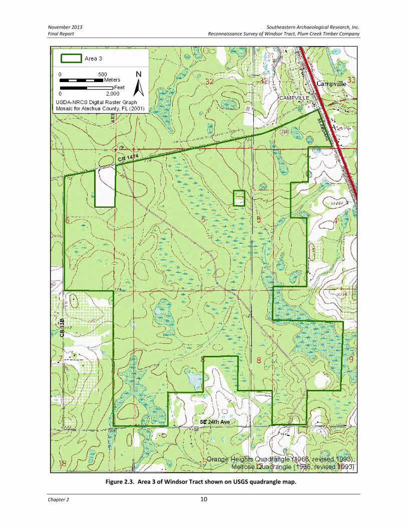
AREA DESCRIPTIONS (1 THROUGH 5) The Windsor Tract has been divided for discussion purposes into five sub‐areas (see Figure 1.2). Area 1 (1,243 acres) extends north of SR 26 and includes a tributary of Hatchet Creek on the west side of the parcel. An upper branch of this creek (called Beetree on early maps) crosses to the east side (Figure 2.1). Area 1 contains one outparcel that is not part of the project area and one improved logging road and several unimproved tracks. Otherwise, the parcel is undeveloped except for silviculture. The central parcel, Area 2 (7,336 acres), is the largest portion of the Windsor Tract and extends from US 301 on the east to CR 234 on the west, and from SR 26 on the north to CR 1474 on the south (Figure 2.2). The Seaboard Air Line (S.A.L.) Railroad marks the eastern boundary of Area 2 and the parcel’s eastern corners abut the railroad towns of Campville and Orange Heights. The town of Windsor is adjacent to the parcel’s southwest corner. Area 2 encompasses the upper headwaters of the Lochloosa Creek drainage and a large water feature marks the center of the parcel. There are six outparcels within the boundary of Area 2 that are not part of the project area. Several improved logging roads cross the tract (NE 70th Place; NE 48th Place) and numerous backcountry tracks criss‐cross the parcel. Area 3 (1,863 acres) extends south from CR 1474 to SE 24th Avenue, and west from US 301 to CR 13B (also called SE 163rd Street) (Figure 2.3). The project boundary excludes the private properties that are dispersed along CR 13B and SE 24th Avenue, which formerly contained orchard operations (likely pecans). At its northeast corner, Area 3 abuts the S.A.L. Railroad and an area that was formerly developed as part of Campville; however, there appear to be no extant Campville structures within the project area. Area 3 contains one outparcel and one primary improved logging road that provides access to the parcel and crosses northwest to southeast. Several dirt tracks are visible in between the numerous sloughs and ponds that are associated with the eastern upper drainage of Lochloosa Creek.

November 2013 Southeastern Archaeological Research, Inc. Final Report Reconnaissance Survey of Windsor Tract, Plum Creek Timber Company
Chapter 2 8
Figure 2.1. Area 1 of Windsor Tract shown on USGS quadrangle map.

Southeastern Archaeological Research, Inc. November 2013 Reconnaissance Survey of Windsor Tract, Plum Creek Timber Company Final Report
9 Project Location and Environment
Figure 2.2. Area 2 of Windsor Tract shown on USGS quadrangle map.
November 2013 Southeastern Archaeological Research, Inc. Final Report Reconnaissance Survey of Windsor Tract, Plum Creek Timber Company
Chapter 2 10
Figure 2.3. Area 3 of Windsor Tract shown on USGS quadrangle map.

Southeastern Archaeological Research, Inc. November 2013 Reconnaissance Survey of Windsor Tract, Plum Creek Timber Company Final Report
11 Project Location and Environment
Area 4 (5,536 acres) extends south from CR 1474 to SR 20 (Hawthorne Road), and east from CR 234 to three rural roads (CR 13B; SE 171st Street; SE 24th Avenue; Figure 2.4). At its northwest corner, Area 4 abuts the town of Windsor, while its southern boundary is approximately one‐half mile from the Atlantic Coast Line (A.C.L.) railroad towns of Grove Park and Phifer. There are three outparcels within Area 4 that are not part of the project area, including St. Pauls Cemetery. The parcel encompasses the lower, better‐defined portion of Lochloosa Creek and extends to within one‐half mile of the southeast shore of Newnans Lake. The north–south running Lochloosa Creek bisects Area 4 with the western half being a poorly drained expanse of lowlands, while the eastern half contains areas of somewhat drier uplands. Primary and secondary logging roads cross the parcel. Area 5 (1391 acres) is a separate, irregularly shaped parcel that extends north and south of SR 20 and west of US 301 (and the S.A.L. Railroad) (Figure 2.5). The irregular boundary excludes several private properties that are scattered on the outskirts of the towns of Hawthorne and Rex. Improved roads cross the parcel (211th Street; SE 193rd Street, SE 177th Street) in between the lowlands that are associated with the eastern upper drainage of Lochloosa Creek. Townsend Cemetery is approximately 300 m outside the western boundary of Area 5.
MODERN ENVIRONMENT OF EAST ALACHUA COUNTY In general, surface water over much of the Windsor Tract parcel drains into Lochloosa Creek, which then flows south into Lake Lochloosa (located approximately three miles south of SR 20); a small percentage flows west into Newnans Lake via an upper tributary of Hatchet Creek in the far northern portion of the parcel (Area 1). The Newnans Lake Conservation Area is a 6,504‐acre parcel divided into three parts: the North Tract covers the northeast lakeshore; the South Tract extends along the southeast shore east to CR 234; the Hatchet Creek Tract encompasses the drainages of Hatchet Creek and Little Hatchet Creek. The Hatchet Creek Tract abuts Area 1 of the Windsor Tract, while the South Tract abuts Area 4. The portion of Lochloosa Creek south of SR 20 is included within the 10,333‐acre Lochloosa Wildlife Conservation Area. One last Alachua County‐owned parcel abuts the Windsor Tract at its northern end (near Areas 1 and 2) and is called the Balu Forest Tract (1,585 acres). This parcel is administered by the Alachua County Public Works Department and is currently managed for silviculture. Geologically, the entire county is underlain by the Eocene age, Ocala Limestone Formation, which is present at or very close to the surface in the western third of the County. The Miocene Age Hawthorn Formation overlies the Ocala Limestone in much of the rest of the County. The Hawthorn Formation consists of a thick sequence of clays, clayey sands, limestones, and dolomites. Physiographically, Alachua County has been divided into five provinces (Williams et al. 1977; White 1970). From east to west these are: the Northern Highlands, the Northern Highlands Transitional Zone, the Alachua Lake Cross Valley, the Western Valley, and the Brooksville Ridge.

November 2013 Southeastern Archaeological Research, Inc. Final Report Reconnaissance Survey of Windsor Tract, Plum Creek Timber Company
Chapter 2 12
Figure 2.4. Area 4 of Windsor Tract shown on USGS quadrangle map.

Southeastern Archaeological Research, Inc. November 2013 Reconnaissance Survey of Windsor Tract, Plum Creek Timber Company Final Report
13 Project Location and Environment
Figure 2.5. Area 5 of Windsor Tract shown on USGS quadrangle map.

November 2013 Southeastern Archaeological Research, Inc. Final Report Reconnaissance Survey of Windsor Tract, Plum Creek Timber Company
Chapter 2 14
The Windsor Tract is located within the Northern Highlands, which is an upland plateau that encompasses most of the area north and east of Gainesville. Elevations in this region range from 135 to 180 feet above mean sea level (amsl) and the terrain is characterized by gentle slopes and relatively flat to gently rolling topography. Here, the Ocala Limestone dips to the east and northeast and is buried at depths in excess of 100 feet below the ground surface. Ground water within the Ocala Limestone is confined under artesian pressure by the overlying Hawthorn Formation. The relatively impermeable Hawthorn clays also serve to prevent the secondary aquifer (water table) from vertical movement downward into the Ocala Limestone, resulting in a large number of poorly drained swamps and cypress hammocks. South of the project area is the Alachua Lake Cross Valley province; this low area with many large, flat‐bottomed lakes characterizes southern Alachua County. Lakes of prominence in this province include Orange, Lochloosa, and Levy; Paynes Prairie also is located in this region. Here, the surface of the Ocala Limestone coincides with ground‐water level creating these large lakes, which are connected to the Florida aquifer through drainage sinks located in their basins. There are numerous wetland and pond features resulting from the small elevation gradients and poor soil drainage (Gottgens and Montaque 1987). Generally, eastern Alachua County is characterized by poor drainage and wetland environments. Soils in the county are influenced by the underlying geology and the surficial or near‐surficial exposures of geological formations. The soils and hydrology of a region, in turn, affect the nature of the vegetation. In the Northern Highlands, the soils tend to be poorly drained to somewhat poorly drained and support a predominantly pine flatwoods vegetation (Figure 2.6). Moving further west across the county, the soils tend to become better drained and have loamy subsoil that supports hardwood forest vegetation. For archaeology and cultural resources, the pertinent aspect of soils on the project parcel pertains to their drainage characteristics; better drained soils tend to host more human activity. A wide variety of soils occur within the Windsor Tract, but most tend to be wet, acidic, and low in major plant nutrients (Table 2.1). The soils are all sand with some areas of muck. Twenty‐nine individual soil types occur within the Windsor Tract project area, ranging from excessively drained (only 1 acre) to very poorly drained (3,064 acres; 17.6% of the parcel). Pockets of moderately well drained soils are spread across the project area but they make up only 4.9% of the parcel (851 acres). The best drained soils are in the immediate area of the town of Windsor. Somewhat poorly drained soils make up the majority of the Windsor Tract with 39.6%, followed closely by poorly drained soils with 37.8%. Pomona sand (poorly drained) makes up over 27% of the total acreage, with Sparr fine sand, Lochloosa fine sand, and Newnan sand (all somewhat poorly drained) each contributing approximately 13% of the parcel. No other mapped soil type contributes more than 5% of the total acreage. In general the western section of the project area (closer to Newnans Lake) contains the highest frequency of poorly drained soils and very poorly drained soils. Even with Lochloosa Creek and its drainages flowing through the central portion of the Windsor Tract, there are significant areas of better drained soils on both sides of the creek.

Southeastern Archaeological Research, Inc. November 2013 Reconnaissance Survey of Windsor Tract, Plum Creek Timber Company Final Report
15 Project Location and Environment
Figure 2.6. Soil drainage properties for the Windsor Tract, Plum Creek Timber Company.

November 2013 Southeastern Archaeological Research, Inc. Final Report Reconnaissance Survey of Windsor Tract, Plum Creek Timber Company
Chapter 2 16
Table 2.1. Soil Units and their Drainage Characteristics across the Project Area.
Map Unit Drainage Acres
Percent of
Project Area
Totals/ %
Lake Sand, 0 To 5 Percent Slopes Excessively Drained 1 0.01 1 (0.01%)
Bonneau Fine Sand, 2 To 5 percent slopes Moderately Well Drained 329 1.89
851 (4.90%)
Millhopper Sand, 0 To 5 percent slopes Moderately Well Drained 448 2.58
Millhopper Sand, 5 To 8 percent slopes Moderately Well Drained 2 0.01
Tavares Sand, 0 To 5 Percent slopes Moderately Well Drained 72 0.41
Chipley Sand Somewhat Poorly Drained 68 0.39
6,880 (39.60%)
Lochloosa Fine Sand, 0 To 2 percent slopes Somewhat Poorly Drained 2216 12.76
Lochloosa Fine Sand, 2 To 5 percent slopes Somewhat Poorly Drained 5 0.03
Newnan Sand Somewhat Poorly Drained 2198 12.65
Sparr Fine Sand Somewhat Poorly Drained 2393 13.78
Blichton Sand, 0 To 2 percent slopes Poorly Drained 3 0.02
6,570 (37.82%)
Mascotte, Wesconnett, and Surrency soils flooded Poorly Drained 727 4.18
Myakka Sand Poorly Drained 7 0.04
Pelham Sand Poorly Drained 444 2.56 Pelham, Plummer, and Mascotte Soils, occasionally flooded Poorly Drained 59 0.34
Plummer Fine Sand Poorly Drained 414 2.38
Pomona Sand Poorly Drained 4742 27.30
Pompano Sand Poorly Drained 2 0.01
Pottsburg Sand Poorly Drained 77 0.44
Riviera Sand Poorly Drained 4 0.02
Wauchula Sand Poorly Drained 91 0.52
Monteocha Loamy Sand Very Poorly Drained 784 4.51
3,064 (17.63%)
Pickney Sand, frequently flooded Very Poorly Drained 1 0.01
Placid Sand, depressional Very Poorly Drained 43 0.25
Pomona Sand, depressional Very Poorly Drained 663 3.82
Samsula Muck Very Poorly Drained 407 2.34
Starke Sand, frequently flooded Very Poorly Drained 311 1.79
Surrency Sand Very Poorly Drained 823 4.74
Terra Ceia Muck Very Poorly Drained 32 0.18
Water
6 0.03 6
(0.04%)
Total 17,372 100.00% 17,372
(100.00%)

Southeastern Archaeological Research, Inc. November 2013 Reconnaissance Survey of Windsor Tract, Plum Creek Timber Company Final Report
17 Project Location and Environment
The diversity of habitats in Alachua County would have supported a wide range of terrestrial faunal resources. Early historical accounts document the area as providing good hunting (Pierce 1970 [1825]; Van Doren 1928) with specific mention of plentiful deer, bear, raccoon, opossum, rabbit, squirrel, turkey, geese, ducks, cranes, panther and wildcat. In addition to terrestrial resources, the Santa Fe River, the large lakes and wet prairies in the southern half of the county, and the many small ponds, wetlands, and streams in the eastern half of the county, would have provided important aquatic food resources. Although the archaeological evidence for plant foods is extremely limited, various nuts, fruits, roots, and other plants were no doubt gathered for food. During late prehistory and the early contact period, agriculture was practiced by some native groups.
PALEOENVIRONMENT Florida was much cooler and drier than today from 18,000 to 12,000 years before present (yr B.P.), and then became warmer and wetter rather rapidly during the next three millennia. By no later than 9000 yr B.P., the warmer climates of the Holocene began to prevail. These changes were more drastic in northern Florida and southern Georgia than in southern Florida, where the “peninsular effect” and a more tropically influenced climate tempered the effects of the continental glaciers that were melting far to the north (Watts 1969, 1971, 1975, 1980). Melting of the continental ice sheets led to a major global rise in sea level (summarized for long time scales by Rohling et al. 1998) that started from a low stand of –120 meters at 18,000 yr B.P. The rise was slow while glacial conditions prevailed at high latitudes but became very rapid in the latest Pleistocene and earliest Holocene. By 6000 to 5000 yr B.P., sea level had risen to only 3‐5 meters lower than at present. As a generalization, the climate, water levels, and plant communities of Florida attained essentially modern conditions by 4000 yr B.P. during the Late Archaic period and have been fairly stable through all phases of habitation by ceramic‐using cultures.

November 2013 Southeastern Archaeological Research, Inc. Final Report Reconnaissance Survey of Windsor Tract, Plum Creek Timber Company
Chapter 2 18
This page intentionally left blank.

Southeastern Archaeological Research, Inc. November 2013 Reconnaissance Survey of Windsor Tract, Plum Creek Timber Company Final Report
19 Historic Overview
CHAPTER 3 HISTORIC OVERVIEW
This historic overview focuses on the cultural events relevant to the region that is currently East Alachua County, beginning with the prehistory of Native American cultures of west‐central Florida, then providing a general Alachua County history from European contact to the present. This chapter concludes with concise histories of the eight small communities that surround the Windsor Tract.
NATIVE AMERICAN CULTURE HISTORY Alachua County is located within the north‐central Florida archaeological region (Milanich and Fairbanks 1980). This area is known for its karst topography, abundant water sources, and hardwood forests. Its boundaries are generally from the south edge of Marion County north to the Santa Fe River and from the pine flats of the northern peninsular Gulf Coast on the west to the eastern edge of Alachua County. The following prehistoric overview of north‐central Florida serves as a framework for understanding prehistoric land use in this region. Table 3.1 offers a general overview of the local chronology and the ensuing discussion begins with the earliest Native American settlements in the region and concludes with the more recent time periods. The four temporal prehistoric periods are Paleoindian, Archaic, Woodland, and Mississippian.
Paleoindian Period (10,000–8000 B.C.) The most widely accepted model for the peopling of the New World argues that Asian populations migrated to North America over the Beringia land bridge that formerly linked Siberia and Alaska, some 12,000 years ago. However, data are mounting in support of migrations that date to before 12,000 years ago (e.g., Dunbar 2006; Faught 2008; Goodyear 2000), some of which may have come through the Pacific Northwest or skirted the Pacific coast to the Isthmus of Panama (Anderson and Gillam 2000), and others that may have even involved
Table 3.1. General Prehistoric Chronology of North‐Central Florida. Sources: Dunbar 2002; Milanich 1994, 1995; Mitchem 1989; Waters and Stafford 2007.
Cultural Periods & Phases Temporal Placement
Paleoindian 10,000–8000 B.C.
Early (Clovis) 10,000–9000 B.C.
Middle (Suwannee) 9000–8500 B.C.
Late (Dalton) 8500–8000 B.C.
Archaic 8000–500 B.C.
Early 8000–5000 B.C.
Middle 5000–3000 B.C.
Late 3000–500 B.C.
Preceramic 3000–2000 B.C.
Orange 2,000–500 B.C.
Woodland 500 B.C.–A.D. 600
Deptford 500 B.C.–A.D. 100
Cades Pond A.D. 100–600
Mississippian A.D. 600–1565
Hickory Pond A.D. 600–1250
Alachua A.D. 1250–1539

November 2013 Southeastern Archaeological Research, Inc. Final Report Reconnaissance Survey of Windsor Tract, Plum Creek Timber Company
Chapter 3 20
an Atlantic Ocean origin (Bradley and Stanford 2004; Faught 2008). The Paleoindian tradition has been traced through the distribution of lanceolate‐shaped projectile points. The Late Paleoindian period coincides with the climate changes that mark the transition from the Late Pleistocene to the Holocene eras. The conventional view of Paleoindian existence in Florida is that they were nomadic hunters and gatherers (Goggin 1949). Excavations at the Harney Flats site in Hillsborough County (Daniel and Wisenbaker 1987) have altered this view, and many archaeologists believe that Paleoindian people lived part of the year in habitation sites that were located near critical resources such as fresh water. As discussed above, the climate during the Paleoindian period was cooler than at present and the land drier, with coastal sea levels and the inland water table much lower than at present (Carbone 1983; Watts and Hansen 1988). The paucity of potable water sources appears to have played a crucial role in the distribution of Paleoindian bands across the landscape. Researchers hypothesize that human groups frequented sinkholes and springs to collect water and exploit the flora and fauna that were also attracted to these locations (Dunbar 1991; Milanich 1994; Webb et al. 1984). Many of these freshwater sources were located in areas of exposed Tertiary‐age limestone that had become silicified, providing the Paleoindians with a raw material source (chert) for tool manufacture. Thus, it is thought that permanent freshwater sources (sinkholes, springs) along with locations of high‐quality chert were primary factors influencing Paleoindian settlement patterns in Florida. Dunbar and Waller (1983:22) identify two areas within Alachua County as having an abundance of Paleoindian projectile point finds. The Paynes Prairie/Orange Lake Cluster consists of seven locations around the margins of flat‐bottomed lakes or drained lakes such as Paynes Prairie, Levy Lake, Lochloosa Lake, Orange Lake, and Johnson Lake. A second group of sites is the Lower Santa Fe/Ichetucknee Cluster that extends from Alachua County into Columbia, Gilchrist, and Suwannee counties. According to the online Paleoindian Database of the Americas (PIDBA; http://pidba.tennessee.edu/), which was last updated on June 13, 2011, there are 45 Paleoindian projectile points reported for Alachua County, with 91% (n=41) being Suwannee points (Middle Paleoindian), and four being Clovis points (Early Paleoindian). The majority of this material has been recovered from river bed and spring contexts.
Archaic Period (8000–500 B.C.)
Around 8000 B.C. the environment and physiology of Florida underwent pronounced changes due to climatic amelioration. These changes were interconnected and include a gradual warming trend, a rise in sea levels, a reduction in the width of peninsular Florida, and the spread of oak‐dominated forests and hammocks throughout much of Florida (Milanich 1994; Smith 1986). Concomitant with these environmental changes were alterations in native subsistence strategies, which became more diverse due to the emergence of new plant, animal, and aquatic species. Also occurring at this time was a significant increase in population numbers and density, with native groups developing regional habitat‐specific adaptations and material assemblages (Milanich 1994; Smith 1986:10). As conditions became wetter, coastal,

Southeastern Archaeological Research, Inc. November 2013 Reconnaissance Survey of Windsor Tract, Plum Creek Timber Company Final Report
21 Historic Overview
riparian, and lacustrine adaptations became increasingly more common. The Archaic period is typically divided into the Early, Middle, and Late subperiods. Early Archaic (8000–5000 B.C.) Within the north‐central Florida region, evidence of the earliest occupations usually consists of lithic scatters containing chert debitage and occasional projectile points. Early Archaic components are generally distinguished through the presence of distinct hafted biface types such as Kirk and Bolen (Bullen 1975; Milanich 1994:63). Early Archaic Bolen projectile points have been recovered at sites in Alachua County, although Middle Archaic points are much more common (Smith and Bond 1984:53‐55). Habitations from this period occurred next to water sources, and in Alachua County they are most frequent near Paynes Prairie and Orange Lake. Middle Archaic (5000–3000 B.C.) Middle Archaic hafted bifaces include: Hardee, Hillsborough, Putnam, Sumter, Alachua, and Marion types, with Newnan points cited by Bullen (1975) as being the most prominent type found in Florida. In fact, this period (5000‐3000 B.C.) has been referred to as the Newnan Horizon by Randall and Sassaman (2005). As life became more settled during the Archaic period, an array of site types evolved that included residential bases, short‐term settlements, specialized procurement camps, and cemeteries (Milanich 1994:75–85). Collectively, these comprised the regional settlement‐subsistence system. Middle Archaic groups were traditionally viewed as aggregating within the interior of Florida; however, more recent research has illustrated much more intensive occupation along the Atlantic coast than previously believed (Bond 1992; Russo 1988, 1992), with groups focusing on the exploitation of aquatic estuarine resources. Middle Archaic occupations are most common in the inland river valleys of Florida. One of the largest Middle Archaic sites in this region is situated on the high ground between Newnans Lake and Paynes Prairie (8AL356, the Newnans Site) in Alachua County (Clausen 1964). This site was a central village, but many Middle Archaic sites are small, seasonally occupied, hunting and fishing camps (Hemmings and Kohler 1974). The distinctive, stemmed Middle Archaic projectile points are common in Alachua County (Bullen 1975; Smith and Bond 1984:53‐55). Large chopping tools and thermally altered lithics also appeared at this time (Bullen 1958; Ste. Claire 1987). Archaic‐period quarry sites have been identified and excavated in Alachua County, including the Cunnils Workshop site (8AL287) and the Keeler site (8AL2331) (SEARCH 1996, 1998). There are numerous limestone outcrops suitable for flaking in Alachua County, especially in the limestone plain region west of Gainesville. Late Archaic (3000–500 B.C.) The trend toward increased sedentism and more circumscribed territories continued into the Late Archaic period, as environmental and climatic conditions approached those of today. The Late Archaic was a time of cultural adaptation that incorporated a mixed hunting, gathering,

November 2013 Southeastern Archaeological Research, Inc. Final Report Reconnaissance Survey of Windsor Tract, Plum Creek Timber Company
Chapter 3 22
fishing, and shellfishing economy and incipient horticulture. Late Archaic sites are not common in the interior highland forests, although Middle Archaic sites have been identified there. Coastal and riverine locales were sought out by Late Archaic groups, perhaps because they provided a greater quantity of dependable aquatic foods (Milanich 1994:87). Late Archaic sites are most common on the northeast coast and the inland waterway, the coast of southwest Florida, and along the St. Johns River (Milanich 1994:85). Canoes were an important part of the Archaic peoples adaptation to marine/aquatic environments. A major technological innovation of the Late Archaic was the development of fired‐clay pottery around 2000 B.C. Late Archaic groups are assigned either to a preceramic phase (ca. 3000‐2000 B.C.) or to the Orange phase (2000‐500 B.C.) (Randall and Sassaman 2005). Referred to as Orange pottery, this early ceramic ware was tempered with vegetal fibers, either thin strands of palmetto or Spanish moss (Bullen 1972; Griffin 1945). During a span of approximately 1,500 years, plain, incised, and punctated types were produced. Early pots were hand molded and tended to be thick walled, whereas some of the later vessels were thinner and formed by coiling. People belonging to the Orange culture lived along the Atlantic Coast between southern South Carolina and northern Florida. Fiber‐tempered pottery is found sparingly throughout Florida. It is primarily recovered in the eastern and central portions of the state. Fiber‐tempered pottery was probably introduced into north‐central Florida from the people of the St. Johns region (Clausen 1964). Several Orange‐phase Late Archaic sites have been recorded around Paynes Prairie. The second recognized early fiber‐tempered ceramic culture, Norwood, extended across the central and gulf coast regions of the state. Norwood pottery is usually undecorated or stick impressed with both fiber and sand temper. A third fiber‐tempered ceramic variant known as Tick Island Incised was produced at the same time as Orange pottery and is localized to the Upper St. Johns River drainage area. Over time, more and more sand was added as a tempering agent to the clay used to make pottery, and eventually, this technique replaced the practice of adding plant fibers.
Woodland (500 B.C.–A.D. 600) Early sand‐ and grit‐tempered pottery in north Florida followed the fiber‐tempered tradition. These ceramics were produced by the Deptford culture; during the same time period ceramics referred to as St. Johns ware were also produced. These relied on microscopic sponge spicules, or exoskeletons, as temper, and although some sand was added to this pottery, St. Johns ware maintains a chalky texture because of the high percentage of spicule content. Deptford and St. Johns were produced at the same time and are often recovered in association with each other. Deptford (500 B.C.–A.D. 100) Deptford is the Woodland‐period culture of the north‐central Florida region (Figure 3.1). Cultural sites dating to the Deptford time period (ca. 500 B.C. to A.D. 100) are frequently marked by the presence of sand‐tempered pottery; however, limestone‐tempered or fuller’s

Southeastern Archaeological Research, Inc. November 2013 Reconnaissance Survey of Windsor Tract, Plum Creek Timber Company Final Report
23 Historic Overview
Figure 3.1. Post‐500 B.C. culture areas in Florida: a) general culture areas; Alachua County is in the north‐central archaeological region; b) geographic extent of Deptford culture; c) geographic extent of
Cades Pond culture; d) geographic extent of Alachua Tradition (after Milanich 1995).
earth‐tempered pottery, known as Pasco Plain, is also a common element to such sites. Surface treatments can be plain, check stamped, cord wrapped, brushed, punctated, or malleated (Milanich and Fairbanks 1980). Although the majority of Deptford sites are located on the coast, sites have been recorded in the interior forests and inland riverways. These coastal people were apparently coming inland to procure seasonal resources and a supply of chert. The inland sites are primarily short‐term occupations by small groups probably traveling the waterways in search of nuts, berries, and other terrestrial resources (e.g., wood, game, chert). These sites are often found along lakes and streams where hickory and oak are present. Lithic tools are extremely rare in Deptford

November 2013 Southeastern Archaeological Research, Inc. Final Report Reconnaissance Survey of Windsor Tract, Plum Creek Timber Company
Chapter 3 24
sites, with only small triangular points occurring in small numbers. By A.D. 100, the Deptford sites had been replace by Cades Pond sites in Alachua County. Cades Pond (A.D. 100–600) Cades Pond (A.D. 100‐600) is a Weeden Island‐related culture exclusive to north‐central Florida. It is marked by the introduction of burial mound ceremonialism. Sites associated with this culture are restricted to the region between the Santa Fe River and Orange Lake and occur primarily on the wetter, east side of Alachua County. They are especially common around Paynes Prairie and Orange Lake. Goggin (1949) initially defined Cades Pond and noted a resemblance in the ceramics found in Cades Pond burial mounds to the St. Johns culture on the northeast coast (earlier) and to Weeden Island cultures on the Gulf coast (later). In Cades Pond sites, burial mounds and village sites are found in combination, but each contain distinctive ceramic assemblages. At villages, sand‐tempered plain ceramics comprise up to 95% of the ceramic assemblage, while burial mounds are dominated by Deptford, Dunn’s Creek Red, and St. Johns Plain ceramics (Milanich 1994:228). Later period mounds contain early Weeden Island decorated ceramics (Smith 1971). Excavations have been carried out at five of these sand burial mounds in Alachua County (Bell 1883; Hemmings 1978; Milanich 1978; Sears 1956; Smith 1972). Goggin excavated the Melton village site (8AL169) in 1951, which was reinvestigated by Fairbanks in 1971 (Cumbaa 1972). The Melton cluster, located on the north side of Paynes Prairie, included at least five ceremonial mounds and ten villages and special‐use camps (Milanich 1994:239). Some cremated remains were deposited in Cades Pond and Alachua mounds (Bullen et al. 1972). Point types associated with Cades Pond sites include Columbia, Jackson, and Bradford types (Bullen 1975) along with small triangular points.
Mississippian Period (A.D. 600–1539) Alachua Tradition Cades Pond was replaced by the Alachua Tradition about A.D. 600, and sites associated with this culture dominate the archaeological landscape of Alachua County. The Alachua Tradition is marked by the introduction of an agricultural way of life, and based on ceramic seriation, the pre‐contact groups can be subdivided into two main temporal periods: Hickory Pond (A.D. 600 to A.D. 1250), and Alachua (A.D. 1250 to European contact in 1539). The Alachua Tradition was initially defined by Goggin (1947, 1949) as a sedentary, agricultural way of life with people living in extensive villages. Goggin noted (1949:39) that this complex did not resemble the surrounding Florida cultures, that their pottery was mostly cord marked or cob marked, and that burial mounds were rare. Current evidence suggests that the Alachua Tradition did not evolve from the preceding Cades Pond culture. Instead, it is postulated that Cades Pond people were displaced by the migration

Southeastern Archaeological Research, Inc. November 2013 Reconnaissance Survey of Windsor Tract, Plum Creek Timber Company Final Report
25 Historic Overview
of new people into the area, who carried with them a distinct material culture. The two cultures appear to have had mutually exclusive settlement patterns with Alachua sites located on good agricultural soils especially at higher elevations with good drainage along the Hammock Belt (Milanich 1994:334), and Cades Pond sites located adjacent to wetlands. The earlier Hickory Pond ceramic assemblage is dominated by cord‐marked vessels that were decorated with paddles or dowels wrapped in cordage. During the Alachua period, cord marking was replaced by a transition to cob marking, which is achieved by applying a dried corncob to the wet clay to leave a distinctive cob‐marked appearance (Milanich 1994:338). The emergence of cob‐marked pottery is assumed to have coincided with the development of maize agriculture. Kohler and Johnson (1986) further defined Alachua‐series ceramics as including Alachua Cob Marked, Prairie Cord Marked, fabric and net marked (both very rare), punctated over cord marked (rare), and Lochloosa Punctated. The small, triangular Pinellas Point is the typical flaked arrow point throughout the Alachua Tradition (Bullen 1975). Within Alachua County, the sites of the Alachua Tradition are often clustered, possibly as the result of shifting agricultural fields. Milanich (1994:337) lists Alachua Tradition cultures at the following locations: west Orange Lake, northwest Paynes Prairie, north‐central Paynes Prairie, Rochelle, Moon Lake, north Levy Lake, Devil’s Millhopper, Robinson Sink and near the town of Alachua. Sand burial mounds are sometimes in association with the clusters. The people of the Alachua culture inhabited north Florida when European explorers arrived. The Potano are the historic descendents of the Alachua culture mixed with Spanish influence.
POST‐CONTACT HISTORY IN ALACHUA COUNTY First Spanish Period, 1513‐1763 Spain was the first European nation to devote attention to the exploration of the interior of what is now Florida. These early sixteenth‐century explorations rarely entered present‐day Alachua County although they left an impact on the native populations of the area. Juan Ponce de Leon, who ventured to Florida in 1513 and again in 1521, kept to the coast of the peninsula. Nearly a decade after de Leon’s second voyage, the Pánfilo de Narváez expedition (1528) arrived near Tampa and trekked northward into the peninsula, but did not venture into today’s Alachua County. In 1539, the Hernando de Soto expedition landed near Tampa Bay. Proceeding inland, the de Soto expedition reached the native village of Ocale (approximately 25 miles southwest of present‐day Ocala). Proceeding northward, de Soto entered Alachua County in the San Felasco Hammock area which was, at the time, inhabited by the Potano and Utina groups of Timucua Indians. Though de Soto and his men continued northward into Georgia and ultimately reached the Mississippi River, they blazed a path of violence and new disease through Alachua County that disrupted native life (Milanich 1994; Milanich and Hudson 1993).

November 2013 Southeastern Archaeological Research, Inc. Final Report Reconnaissance Survey of Windsor Tract, Plum Creek Timber Company
Chapter 3 26
Several decades passed until Europeans again came into contact with the natives of Alachua County. The founding of St. Augustine influenced this new period of contact. After driving French colonists from northeastern Florida at Fort Caroline near present‐day Jacksonville, Pedro Menédez de Avilés founded the colony of Florida for Spain in 1565 at what is now the oldest permanently settled city in the United States. Tasked by the King of Spain to spread the Catholic faith among the natives of Florida, Avilés instituted a mission system that spread across the interior of northern Florida as well as coastal Georgia and South Carolina in the decades that followed. These missions, where Franciscan priests administered the Catholic faith to the natives, became a lifeline to St. Augustine not only because they promoted Spanish influence, but because they were important agricultural centers where corn and other crops were grown (Milanich and Hudson 1993). Alachua County was the site of several early Spanish missions. The Mission San Francisco de Potano (8AL272; known as the Fox Pond site) was established in 1603 to the northwest of present‐day Gainesville (Milanich and Hudson 1993). Three native villages were located within a day’s walk from the mission. According to Kenneth W. Johnson (1993:141), the Mission Santa Fe de Toloca (8AL190) was founded between 1606 and 1616 in the Robinson Sinks area of northwestern Alachua County. Father Martin Prieto, who had founded the Mission San Francisco de Potano, probably founded the Mission Santa Fe de Toloca. The site appears to have been abandoned in the mid‐seventeenth century, but it may have been reestablished in a different locale (Boyd et al. 1951:37; Johnson 1993:142). The Spanish mission system induced hardship upon the natives of Alachua County and elsewhere. Spanish accounts mention skirmishes between native groups and the Spanish, disease epidemics, and attest to a decline in population (Buchholz 1929; Gannon 1983; Johnson 1991; Milanich and Hudson 1993). Moreover, the mission system was a target of English invaders in the early eighteenth century who were venturing to destroy Spanish influence in the southeast. Colonel James Moore, from the British colony of Carolina, invaded Spanish Florida in 1702 and destroyed many of the missions in northern Florida as part of his overall attack against the Spanish mission system. Moore’s assault sped the decline of the mission system (Boyd et al. 1951:37). Other than the missions, which usually had at least one priest in residence, Spanish settlement was largely restricted to St. Augustine. However, Spanish cattlemen had discovered the advantages of Alachua County’s prairies by the mid‐seventeenth century. Cattle raising supported the missions as well as the colonists in St. Augustine. Spanish cattle roamed what is now Paynes Prairie as early as the 1620s. Indeed, the name Alachua is derived from the name of an early Spanish ranch in this period that was located “at the sink” or “a la Chua” (Baker 1993; Bushnell 1978; Worth 1998). Over the years as a cow or two escaped the herd, the wilderness of Florida became populated with these hardy, if small, Spanish cattle, which came to be known in later periods as Cracker cows. Warfare and disease had depleted the native population of Florida, leaving the wilderness of northern Florida open to new settlement. The Spanish lacked the means to promote

Southeastern Archaeological Research, Inc. November 2013 Reconnaissance Survey of Windsor Tract, Plum Creek Timber Company Final Report
27 Historic Overview
settlement as far away as Alachua County. However, native groups from other parts of the southeast looked at this quiet wilderness as a refuge and began settling the area in the mid‐eighteenth century. Many of the newcomers were Hitchiti and Muskogee speakers who came from the Creeks of Alabama and Georgia. Cowkeeper, an Oconee Creek, established the villages of Alachua, near today’s Payne’s Prairie, and Cuscowilla, between the prairie and Micanopy. As these newcomers came in larger numbers and grew further from their Creek brethren, they came to be known as the Seminole (Covington 1993).
British Period, 1763‐1784 The 1763 treaty ending the French and Indian War resulted in Spanish Florida’s transfer to Great Britain. Many historians have considered Britain’s 20 year tenure in Florida a failure. A recent evaluation, however, has concluded that the colony developed into a valuable province during this period (Schafer 2000). However, many of the plantations and other activities that helped garner this distinction were far from Alachua County, which remained a wilderness. British traders based on the St. Johns River often traversed the territory to conduct trade with the Seminole, but no permanent settlements were made (Bartram 1955). This wilderness was what William Bartram was interested in exploring. Accompanying British traders who knew the area well, this noted English botanist passed through northern Florida, including Alachua County, in 1774. He recorded his observations in a later publication. Since then, his trek across the county has been mapped. Beginning east of Hawthorne, he traveled southwestward to the well‐known sites of the county including Orange Lake, the Micanopy area, Paynes Prairie, Alachua Sink, and Bivens Arm (Gasche 1986). He spent time with Cowkeeper, earning permission from the chief to collect flowers and plants for his collection. Bartram was impressed with the beauty of the area, but the knowledge he shared did not inspire settlement in Alachua County (Bartram 1955).
Second Spanish Period, 1784‐1821 As a consequence of the negotiations that concluded the American Revolutionary War, Great Britain relinquished control of Florida to Spain. One of the most important legacies of the British Period in Florida was the government’s policy of promoting settlement through land grants. When the Spanish regained control of Florida in 1784, they perpetuated this system with an appreciable degree of success. The land grants that the Spanish awarded often were located at former British grants. However, there were a large number of new land grants, some of which were in the tens of thousands of acres. Many new settlers were drawn to Florida, and some to Alachua County, via the land grant system. Fernando de la Maza Arredondo received a land grant that covered much of present‐day Alachua County. This tract covered a 20‐mile square area and all land titles in the Gainesville vicinity originate within this grant. The grant required Arredondo to settle 200 families within three years on this land. To aid in this endeavor, Arredondo’s friend Moses Levy bought part of

November 2013 Southeastern Archaeological Research, Inc. Final Report Reconnaissance Survey of Windsor Tract, Plum Creek Timber Company
Chapter 3 28
the tract and enlisted Edward Wanton and Horatio Dexter to help found a colony (Mahon 1985). Despite these plans, the Arredondo Grant was settled only to a minimal degree. Title to much of Arredondo’s thousands of acres was bound up in legal wrangling and controversy for much of the nineteenth century although portions of it were parceled off and sold as the years passed. While East Florida, the Spanish province that included later Alachua County, was under Spanish control, pressure from the United States to the north was nearly incessant. President James Madison (1809‐1817) considered the Spanish territory to be “at all times a source of irritation and ill blood with the United States” (Cusick 2003). As a means of solidifying Spain’s presence in Florida, the Spanish government in St. Augustine had made a practice of offering freedom to runaway slaves from bordering states and territories. This practice was a major point of tension between the Spanish and the Americans as was the former’s loose coalition with the Seminole. The Seminole far outnumbered the Spanish and held a considerable influence over affairs in the peninsula. They, too, welcomed runaway slaves into their midst, much to the ire of planters in Georgia and elsewhere who lost slaves (Frank 2005). Between 1812 and 1813, American forces attempted to invade and occupy northeastern Florida in an effort to assert dominance in the region. St. Augustine endured a siege in the course of the conflict and numerous violent actions took place elsewhere in the region. The Patriot War, as it is now known, resulted in no new land acquisitions for the United States, but it did leave numerous plantations in ruin and amplified existing tensions over Florida between Spain and the United States (Cusick 2003). As Secretary of State John Quincy Adams entered into negotiations with Spain to purchase its Florida territory in 1818, General Andrew Jackson led an incursion into Florida to attempt to bring the Seminoles and their black allies under control. His bold action (the First Seminole War 1817‐1818) also laid bare Spain’s weakness in the Americas. The war further strained relations with Spain and especially the Seminole who fled farther south into the state. In 1819, the Adams‐Onis Treaty was written between the United States and Spain. When finally ratified in 1821, it transferred Florida to the United States (Tebeau 1971). For many years to come, the status of the former Spanish land grants, including that of Arredondo, would be in dispute.
Early American Period, 1821‐1845 After Florida became an American territory in 1821, the territorial government ventured to avoid conflicts between white settlers and the Seminole by establishing a reservation for the Seminole that included much of central Florida (Brown 1991; Mahon 1985). With more settlers pushing into the frontier of the Florida territory each year, conflicts between the Seminoles, whites, and blacks in Florida increased and the Indian agency, with support from the government and the white population, pushed hard for the wholesale removal of the Seminole (Mahon 1985).

Southeastern Archaeological Research, Inc. November 2013 Reconnaissance Survey of Windsor Tract, Plum Creek Timber Company Final Report
29 Historic Overview
Many of the new settlers to Florida came to Alachua County. The territorial Florida government established the county on December 29, 1824 (Morris 1995:2). Micanopy was the county seat until four years later when the seat was transferred to Newnansville, near the present‐day city of Alachua (Opdyke 1974). At the time, the county covered an expansive area that, in later years, would be divided into new counties including Columbia, Suwannee, Baker, Bradford, Union, Clay, Hillsborough, Pinellas, Polk, Desoto, Hardee, Manatee, Sarasota, Charlotte, Hernando, Citrus, Marion, Levy, and Gilchrist. Though Alachua County covered such a broad area, the population of the county was approximated at 2,204 in 1830 (Dietrich 1978:13). A costly and long war with the Seminole erupted late in 1835. The military built over two dozen forts in Alachua County during the Second Seminole War (1835‐1842). Settlers sometimes constructed their own forts, such as Fort Hogtown, built by the Spring Grove Guards in present‐day Gainesville (Opdyke 1974). Fort Russell (also known as Fort No. 6) was located on Orange Lake near present‐day Island Grove. Fort No.12 was located approximately nine miles east of Alachua on the old Bellamy Road. Fort No. 13 was approximately five miles west of present‐day High Springs along a military supply road connecting Fort White on the Santa Fe River to Fort Gilleland at Newnansville. Fort Call was situated on the Santa Fe River north of Newnansville. Fort Clarke was located approximately one mile south of what is now the intersection of Interstate 75 and Newberry Road, on the old Micanopy‐Newnansville Road. Fort Crane was south of Rochelle on the north rim of Paynes Prairie. Nearby was Fort Traver, located at a plantation on the north bank of Paynes Prairie (Opdyke 1974). The US Army and its bands of volunteers from Florida came into conflict with the Seminole at many places in Alachua County, but by the late 1830s, the conflict had moved further south. The principal stimulus to settlement of this region was the Armed Occupation Act of 1842, which extended land title to any white male settler who could prove cultivation and defense of 160 acres. The new settlement that came from this act influenced the passage of Florida to statehood in 1845. The 1850 Homestead Act, the first of several such inducements, similarly promoted settlement in the county. In the meantime, a road system had developed that was largely based on earlier military trails. Some, including the Bellamy Road, which traversed the northern reaches of the county, followed much older Indian trails (Mahon 1985; Pickard 1994).
Statehood to the Civil War, 1845‐1865 In the early 1850s, State Senator John Boston Dell had secured a law enabling Alachua County citizens to vote on the location of their county seat. They chose a site several miles east of Hogtown, a trading post on a creek of the same name. The county seat was founded in 1854 on land purchased from Major James Bailey. The new town was named Gainesville in honor of Edmund P. Gaines, a General in the US Army who had fought against the Seminole (Opdyke 1974). In the half decade before the outbreak of the Civil War, the population of Gainesville was 223. The county was undergoing a new phase of settlement in this period with many newcomers arriving from South Carolina and other southern states to establish Sea Island cotton plantations. Indeed, many of the white residents in the county at the time were committed to the institution of slavery (Johns 1963).
November 2013 Southeastern Archaeological Research, Inc. Final Report Reconnaissance Survey of Windsor Tract, Plum Creek Timber Company
Chapter 3 30
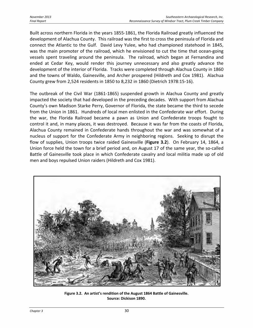
Figure 3.2. An artist’s rendition of the August 1864 Battle of Gainesville. Source: Dickison 1890.
Built across northern Florida in the years 1855‐1861, the Florida Railroad greatly influenced the development of Alachua County. This railroad was the first to cross the peninsula of Florida and connect the Atlantic to the Gulf. David Levy Yulee, who had championed statehood in 1845, was the main promoter of the railroad, which he envisioned to cut the time that ocean‐going vessels spent traveling around the peninsula. The railroad, which began at Fernandina and ended at Cedar Key, would render this journey unnecessary and also greatly advance the development of the interior of Florida. Tracks were completed through Alachua County in 1860 and the towns of Waldo, Gainesville, and Archer prospered (Hildreth and Cox 1981). Alachua County grew from 2,524 residents in 1850 to 8,232 in 1860 (Dietrich 1978:15‐16). The outbreak of the Civil War (1861‐1865) suspended growth in Alachua County and greatly impacted the society that had developed in the preceding decades. With support from Alachua County’s own Madison Starke Perry, Governor of Florida, the state became the third to secede from the Union in 1861. Hundreds of local men enlisted in the Confederate war effort. During the war, the Florida Railroad became a pawn as Union and Confederate troops fought to control it and, in many places, it was destroyed. Because it was far from the coasts of Florida, Alachua County remained in Confederate hands throughout the war and was somewhat of a nucleus of support for the Confederate Army in neighboring regions. Seeking to disrupt the flow of supplies, Union troops twice raided Gainesville (Figure 3.2). On February 14, 1864, a Union force held the town for a brief period and, on August 17 of the same year, the so‐called Battle of Gainesville took place in which Confederate cavalry and local militia made up of old men and boys repulsed Union raiders (Hildreth and Cox 1981).

Southeastern Archaeological Research, Inc. November 2013 Reconnaissance Survey of Windsor Tract, Plum Creek Timber Company Final Report
31 Historic Overview
Figure 3.3. Early postcard depicting an orange packing operation in Florida. Source: Alachua County Historic Trust.
Post‐Civil War to the Early Twentieth Century, 1865‐1929 The end of the Civil War did not signal a sudden resumption of growth in the county. On the contrary, the consequences of the difficult war stifled growth. The system of slavery, once a major source of labor, was now destroyed and the political setting was upturned. The old Florida Railroad gained a reputation for inefficiency in the 1860s and 1870s. The Reconstruction period (1865‐1877), while it attempted to create order in the South, accomplished little towards establishing equal rights for freed slaves in Florida and many found themselves indebted to former masters as tenant farmers (Hildreth and Cox 1981). With the end of Reconstruction in 1877, a new period of interest in settling Florida began and was influenced largely by the expansion of railroads, the abundance of unsettled land, and dreams of the prosperity that citrus cultivation could bring. Maps from this period illustrate the expansion of railroads and settlements, with new towns and new tracks appearing almost every year in Alachua County. Many of the new settlers were white people from the North who had seen advertisements glorifying Florida. A significant number also were African Americans from neighboring southern states who labored in the construction of the railroads and the harvesting of oranges, among many other industries. The citrus industry in Alachua County was very visible in the 1880s (Figure 3.3). In fact, Alachua County had some of the most well‐known citrus groves in the nation (Webber 1883). A freeze in 1885 was the first event that threatened the prosperity of the industry in the county, but

November 2013 Southeastern Archaeological Research, Inc. Final Report Reconnaissance Survey of Windsor Tract, Plum Creek Timber Company
Chapter 3 32
most appear to have ignored the damage it caused to their crops and instead reestablished their groves. The Great Freeze of the winter of 1894‐1895, however, changed the minds of many. On December 27, 1894, Tallahassee’s temperature plunged to two degrees below zero, Tampa’s temperature plummeted to 14 degrees and communities around Florida recorded similar lows. Oranges were frozen on the tree in many north and central Florida citrus groves. Much of Florida’s fruit was destroyed, but the trees survived. Beginning on February 7th and continuing through the 9th, the temperatures again dropped below freezing, destroying not just the fruit but the trees themselves. These freezes wiped out much of north Florida’s citrus industry and set back central Florida’s citrus prospects for several years. Many who had staked their future on citrus simply abandoned their lands and groves, never to return. Others turned their focus to crops that were more suited to the region (Chapin 1914:206‐210; Dovell 1952:630‐631). The naval stores and timber industries became rooted in Alachua County in the latter decades of the nineteenth century. Both found the abundant pine of the county to be a vital resource. Nearly all of the communities of the period had a saw mill or distillery (R.L. Polk & Company, 1908, 1912, 1925). Much as they relied on the pines, the timber and naval stores industry depended on railroad connections and inexpensive African American labor. As such, these industries flourished in Alachua County (Hildreth and Cox 1981; Pickard 1994). The state of Florida selected Gainesville to be the home of the new University of the State of Florida in 1905. This institution combined several geographically dispersed state schools of higher learning into one location. Since this time, the university has been indelibly linked to the economy and culture of Alachua County (Hildreth and Cox 1981). With the United States’ entry into World War I in 1917, the University of Florida became somewhat of a military base and the army converted the dormitories into barracks. At this time, a flu epidemic killed many residents and the boll weevil destroyed the Sea Island cotton crops and economically ruined many local farmers. Depleted resources and the German blockade of foreign markets weakened the once dominant phosphate industry (Hildreth and Cox 1981). Because of the agricultural, mining, and health crises in the region, Alachua County’s population dropped from 34,305 in 1910 to 31,689 in 1920 (Dietrich 1978:21‐22).
Great Depression to the Present, 1929‐2012 While Gainesville became increasingly urban in the twentieth century as a result of the expanding university, other parts of the county remained rural, relying on naval stores, timber, and agriculture. The most populated communities in Alachua County in the 1930s were Gainesville, Waldo, Alachua, Newberry, Hawthorne, Island Grove, Micanopy, Archer, Melrose, Arredondo, LaCrosse, Fairbanks, Rochelle, Evinston, Hague, Orange Heights, High Springs, Campville, Windsor, Bland, and Monteocha. Approximately 240,000 of the county’s 571,000 acres was farmland in the 1930s. The population of the county in 1930 was 34,365 and the number grew by over 2,000 by 1935

Southeastern Archaeological Research, Inc. November 2013 Reconnaissance Survey of Windsor Tract, Plum Creek Timber Company Final Report
33 Historic Overview
(Florida Chamber of Commerce and Florida Emergency Relief Administration 1935). Railroads still crisscrossed the county playing a major role in transportation. By World War II, the proliferation of the automobile and modern roadways led to a decrease in the use of railroads, and increased access of rural communities to Gainesville, the economic center of the county (Florida Chamber of Commerce and Florida Emergency Relief Administration 1935). During the Great Depression, the University of Florida researched alternative crops to replace Sea Island cotton, including watermelon, cucumber, potato, bean, squash, corn, and peanut. During this time, tung oil was harvested for paint production and flue‐cured tobacco was introduced from North Carolina (Opdyke 1974). Generally, the university kept Alachua County economically healthier than other parts of the state, but the county also benefitted from numerous works projects spawned by federal agencies (e.g., Civil Works Administration, Public Works Administration, Civilian Conservation Corps, Works Progress Administration). These projects built schools, municipal buildings, and made state park improvements (Pickard 1994). World War II sparked a period of growth for Gainesville. The University became a training center, and the Alachua Army Airbase operated a flight school for the Army Air Corps. Hospitals and electrical power plants were modified to meet the increasing service demands (Hildreth and Cox 1981). With the end of the war in 1945, Gainesville, having never relied on large war‐time factories or the military’s presence, continued to thrive. The growth of the University of Florida during the 1940s and 1950s reinvigorated development around the university (ERLA Associates and The History Group, Inc. 1980:130‐132). Today, with a population of 124,354 residents (US Bureau of the Census 2012), Gainesville and the University of Florida is the economic focal point for numerous outlying Alachua County communities.
HISTORIC COMMUNITIES IN VICINITY OF THE PLUM CREEK PROJECT AREA Several historical communities are located within a one‐mile radius of the project area and evidence of activities associated with outlying areas of these communities is potentially present within the Windsor Tract boundaries. A brief history is provided for each of the surrounding communities— Windsor, Orange Heights, Campville, Grove Park, Hawthorne, Phifer, Rex, and Rochelle. Post office information provides insight into when a community was established and, likewise, when it officially diminished to the point of having its postal service discontinued. Table 3.2 provides this information for the communities relevant to our discussion. Phifer is not listed in this table as the community never received postal service. Each of these communities established postal service initially in the 1880s, with the exception of Hawthorne (originally Morrison Mills), which had its first post office in the 1850s.
Hawthorne The present‐day city of Hawthorne traces its roots to the post‐Second Seminole War period when Daniel Morrison acquired land to the east of the city. Morrison received title to his lands

November 2013 Southeastern Archaeological Research, Inc. Final Report Reconnaissance Survey of Windsor Tract, Plum Creek Timber Company
Chapter 3 34
in the late 1840s. By 1854, Morrison had constructed a water mill and established the Morrison Mills post office approximately one mile east of present‐day Hawthorne (Bradbury and Hallock 1962:37,55; Buchholz 1929:186; Gallagher 1997). Benjamin Powell served as the first postmaster. Morrison Mills was not much more than a crossroads settlement during much of its existence (Florida Division of Historical Resources 2012a; Pickard 1994:36). The 1860 census reveals that a blacksmith, two store owners, a physician, carpenters, farmers, and farm laborers all resided in the area (University of Florida 1996). C.F. Stokes acquired land in 1861 and eventually sold his holdings to Calvin Waits. James Madison Hawthorn was another early landholder. A settlement formed around Calvin Waits’ landholdings that eventually became known as Wait’s Crossing (Morris 1995:114). During the late 1870s and early 1880s, the area experienced a boom with the arrival of the railroad and the discovery of phosphate. In 1879 the Peninsular Railroad built tracks into the region (later the Seaboard Air Line [S.A.L.], Figure 3.4). During the same period, the Florida Southern Railroad connected Palatka to Gainesville (later the Atlantic Coast Line [A.C.L.]). In 1879, Wait’s Crossing and another emerging settlement known as Hawthorn together came to be known as Jamestown (Buchholz 1929:186). The post office at Morrison Mills was discontinued and was reestablished at Jamestown in the same year (Bradbury and Hallock 1962:55). A year later, Jamestown was renamed Hawthorn in honor of James Hawthorn who had helped attract the railroad to the area (Bradbury and Hallock 1962:37). From 1881 to 1950, Hawthorn has variously been spelled with and without an “e” at the end. In 1950, the post office officially formalized the name to Hawthorne (Morris 1995:114). In the 1880s, Dr. C.A. Simmons discovered evidence of phosphate at Hawthorne (Drylie 1974: 26). He began mining this mineral in 1883, but soon discontinued his operation due to a lack of capital. However, this discovery spurred a phosphate rush in Florida that propelled the state to the forefront of the phosphate mining industry (Blakey 1973; Millar 1892). In addition to phosphate mines in the Hawthorne region, lumber, cotton, and grist‐mill operations were established (Robinson 1882:86). Kaolin, a white clay used in making porcelain, also was mined
Table 3.2. Historic Post Offices Near the Project Area. Source: Gallagher 1997.
Post Office Established Discontinued First Postmaster
Campville 12 September 1881 30 December 1966 Warren Bacon
Grove Park 6 August 1883 31 August 1958 Alva S. Greenman
Hawthorne 1 January 1950 Presently in operation Nina K. Berkstresser
formerly Hawthorn 19 March 1880 31 December 1949 Lawrence J. Stokes
formerly Jamestown 18 March 1879 18 March 1880 Lawrence J. Stokes
formerly Morrison Mills 7 March 1854 17 March 1879 Benjamin W. Powell
Orange Heights 28 February 1884 28 February 1954 David B. St. Clair
Rex 15 December 1899 31 October 1907 James L. Townsend
Rochelle 11 Aug 1884 30 April 1945 John W. McAllister
formerly Gruelle 22 November 1881 10 August 1884 John W. McAlister
Windsor 20 March 1884 1 March 1942 H.A. Webster

Southeastern Archaeological Research, Inc. November 2013 Reconnaissance Survey of Windsor Tract, Plum Creek Timber Company Final Report
35 Historic Overview
Figure 3.4. Early twentieth‐century postcard illustrating the Seaboard Air Line passenger train and depot at Hawthorne. Source: Alachua County Historic Trust.
in the area (Pickard 1994:36). With all this activity, Hawthorne blossomed. Hotels, houses, churches, and farms were built across the landscape with farmland ranging from $2 to $20 an acre (Pickard 1994:36). In 1883, Carl Webber (1883:60) described the bustling town:
“Hawthorne is one of the many new towns that have sprung into existence by means of the railroads. It occupies high rolling piney‐land, about 155 feet above the level of the St. Johns River. It is 19 miles east of Gainesville, 14 miles south of Waldo, and is the junction of the Florida Southern and Peninsular railroads. The soil here, though of sandy appearance, contains a vast amount of phosphate‐rock and accumulations of vegetable mold or muck. Cattle subsist upon the wild grass the year round. Hawthorne has a fine Baptist Church, with a Methodist Episcopal in contemplation. There are five or six stores, two small hotels, two cotton‐gins, two wagon, blacksmith and general jobbing shops, a livery and feed stable, and saw‐mills within easy distance. A good Academic school has been recently established. It also boasts of a newspaper, the Hawthorne Graphic.”
With rich farmland and important rail links to northern markets, Hawthorne was an important agricultural center. Citrus became an important cash crop in the 1880s, furthering the town’s prosperity (Ashby 1888:36), and by the 1890s, its population was over 300 (State of Florida 1945:87) (Figure 3.5). However, the prosperity did not last. Waldo, Melrose, and Hawthorne were hard hit by the Great Freeze of 1894‐1895 and the citrus industry was never revived

November 2013 Southeastern Archaeological Research, Inc. Final Report Reconnaissance Survey of Windsor Tract, Plum Creek Timber Company
Chapter 3 36
(Spencer 1974:31). Hawthorne slowly pulled itself out of the slump as farmers focused on other crops, including pecans, cabbage, corn, cotton, beans, potatoes, melons, cucumbers, and peanuts (Alachua County Chamber of Commerce c1925). Turpentine and timber became an important economic engine for the community when R.A. Smith and T.C Holden started a turpentine distillery in 1906 that produced approximately 450 barrels a year (Buchholz 1929:186). Twenty years later this one distillery employed 85 people and produced 11,000 barrels of spirits and 3,500 barrels of rosin a year. With this success farmers began leasing their land to timber and naval stores companies (Pickard 1994:76). Hawthorne remained rural and agricultural through the twentieth century, reaching a population of 618 by 1935 (State of Florida 1945:88). Town amenities included paved sidewalks, a paved highway (present‐day SR 20), a $60,000 school building, and an ice plant (Buchholz 1929:188). The town’s employers included F.W. Capell who operated a grist mill, H.G.W. Dansby who manufactured corn meal, grits, and syrup; J.A. Fleming who operated a moss plant; and the Florida Power & Light Company (Florida State Chamber of Commerce and Florida Emergency Relief Administration 1935:43). Still, agriculture dominated the local economy as revealed in this 1930s town description:
“Hawthorn...is a quiet oak‐shaded village in the midst of extensive bean fields...Between its few low brick business buildings stand several two‐story frame houses with ornate jig‐saw galleries. Throughout this area trucks cruise day and night during spring months, picking up loads of vegetables, which are bought direct from growers and sold to wholesale markets in the large cities. Farmers post signs along the highway instructing drivers at what fields to call for cabbages, beans, and squash” (The Federal Writers Project 1939:534).
Figure 3.5. Early Hawthorne, c. 1890. Source: Florida Photographic Collection.

Southeastern Archaeological Research, Inc. November 2013 Reconnaissance Survey of Windsor Tract, Plum Creek Timber Company Final Report
37 Historic Overview
Trends set in the 1930s continued throughout the 1940s and 1950s. While farming remained an important industry, more and more farmers abandoned their land or leased it to pulpwood industries (University of Florida 1996). Turpentine’s importance decreased as cheaper synthetic products were developed, but timbering remains a prominent industry in the region. Hawthorne’s population surpassed the 1,000 mark in 1950, as the town became a bedroom community to Gainesville (Cox 1974:45).
Campville Campville was the next railway stop heading north out of Hawthorne. The Camp brothers, John Stafford Camp, Robert Camp, and Dr. Benjamin Franklin (“Frank)” Camp, established the town of Campville in the early 1880s. Hailing from Virginia, the Camp family was prominent in the timber industry of North Carolina as well as that of their home state (Rouse 1988). The Camps began exploring Florida for timber and other business opportunities in the early 1880s and found eastern Alachua County to be suitable to their needs. A major incentive in their choice of this area was the recent completion (1879) of the Peninsular Railroad, a branch of the larger Transit Railroad Company, which provided market connections to Cedar Key, Fernandina, and Ocala. Later, as railroads expanded in Florida, the connections multiplied (Florida Division of Historical Resources 2012a). The Camps began their timber operation in March of 1881. In September of that year, a US post office was established at “Campville” (Gallagher 1997). For several years to come, however, the railroad station at Campville was known as “Dixie” (The Florida Railway and Navigation Company 1884:33). By 1883, when a Fernandina newspaper provided a description of the “lumbering village” of Campville, the Camp family had already established a grove of 4,000 orange trees, in addition to a nursery of 125,000 young orange trees, 4,000 young peach trees, and 100 young pear trees. They also grew vegetables among the rows of oranges. W.H. Kayton initially served as the manager of the grove and nursery, but later Frank Camp took over management responsibilities. The Camps had purchased 1,000 acres in the area and were planning to sell five‐to‐ten‐acre town lots (The Florida Mirror 1883). In a 1927 reminiscence, Dr. Frank Camp recalled he and his brothers’ arrival to the area where they found “a pretty piece of timber and good land to start a grove [of citrus trees] at what is now Campville” (Rouse 1988:54). There the brothers built a small sawmill and opened a store. John ran logging operations, Robert ran the store and sawmill, and Frank started the citrus grove. Many of the employees of the Camp operations were African Americans who had worked with the family back in Virginia (Rouse 1988). By 1884, Frank Camp established the Campville Brick Company (Figure 3.6). Using local clay, the manufactory produced an average of four million bricks a year between the 1880s and the 1920s (Alachua County News ca. 1924; The Florida Railway and Navigation Company 1884:33). In 1885, a winter freeze destroyed most of the Camp’s citrus crop. Robert returned north, leaving his store and sawmill responsibilities with his brother Frank. “I had no experience with

November 2013 Southeastern Archaeological Research, Inc. Final Report Reconnaissance Survey of Windsor Tract, Plum Creek Timber Company
Chapter 3 38
Figure 3.6. The brick manufactory at Campville, ca. 1914. Source: Florida Photographic Collection.
business,” Frank recalled in 1927, “so it was very hard for me, and with a lick on the head, caused me to have a nervous breakdown” (Rouse 1988:54). Over the next decade, Frank Camp focused on his brick manufactory and also timber. He also sold real estate in the area. In 1885, a plat of Campville was entered with the county (Alachua County Clerk of Court 1885a). At that date, the population of the town was estimated at 250 (Webb 1885). An avid Baptist who is remembered for shunning tobacco, whiskey, and cursing, Frank Camp also established the Campville Baptist Church sometime in the 1880s (Rouse 1988). Frank continued to cultivate citrus at Campville until the freeze of 1894‐1895 descended upon the state (Rouse 1988). In 1896, Frank relocated his family to White Springs near the Suwannee River where he had developed timber and other business interests (Rouse 1988). Campville remained a small but economically healthy community into the twentieth century. By 1910, J.A. Maultsby had bought the Campville Brick Company. Maultsby lived in a spacious, two‐story house in town. Campville still had a sawmill in operation. Many of the farmers in the area were beginning to grow pecan trees (Raley‐Hamby Company 1910) and another new economic activity in Campville was the naval stores industry. In the 1920s, the pecan groves were thriving with some operations covering up to 160 acres. To meet the demand for pecan trees, there were two nurseries in Campville. In addition to these agricultural pursuits, many local farmers grew vegetables and some began cultivating a new crop—tobacco (Alachua County News ca. 1924). Campville Brick Company and the naval stores industry remained present in Campville into the 1930s. By 1935, the brick company, now owned by J.W. Craber and C.E. Long, produced 25,000 bricks per day (Florida Chamber of Commerce and Florida Emergency Relief Administration 1935). In 1939, the Work Progress Administration published a guide to the communities of the state of Florida that described Campville as “a turpentine community” (Figure 3.7). The population was estimated at 250 and consisted of a “smoky still and rough unpainted shacks.” The smoky still referred to a turpentine distillery. To the south of Campville, on the way to Hawthorne, was “open country planted to corn, green beans, tobacco, and pecans” (Federal Writers Project 1939:534). The brick manufactory remained in operation into the late 1960s (Rouse 1988).

Southeastern Archaeological Research, Inc. November 2013 Reconnaissance Survey of Windsor Tract, Plum Creek Timber Company Final Report
39 Historic Overview
Figure 3.7. Late nineteenth‐ or early twentieth‐century postcard illustrating a “Turpentine Farm” near Gainesville. Source: Alachua County Historic Trust.
Rex Rex was a small community east of the railroad line and between Campville and Hawthorne. By 1899, Rex had received its own post office (Gallagher 1997), but the community likely emerged decades earlier with the completion of the Peninsular Railroad. Rex is the name of a late nineteenth‐century lumbering operation in Quincy, Florida (in the panhandle) and perhaps this Alachua County community of Rex is associated with Rex Lumber, which was founded by the McRae family (http://rex‐lumber.com/aboutus.html). In any case, it is very likely that Rex was a timbering and later turpentining camp. In 1902, the Eden Baptist Church was established in Rex, which is still in use today. Although the population of Rex was estimated at 100 in 1906 (J.B. Lippincott Company 1906), the postal service was discontinued in the following year. Today, this small community is considered part of outlying Hawthorne.
Orange Heights Situated near the intersection of US 301 and SR 26, the area of Orange Heights saw its first settlers in the 1850s, but the community did not emerge until after the completion of the Peninsular Railroad. Charles B. Palmer, a professor from Antioch College in Ohio, purchased land for a colony for his fellow Ohioans and other northerners. He called his colony Orange Heights and opened it to settlement in 1884. The same year saw the opening of a post office and the naming of the rail station at “Palmer’s colony”. The name Orange Heights referred to the dominant agricultural interest of the period, but there were other business interests in the

November 2013 Southeastern Archaeological Research, Inc. Final Report Reconnaissance Survey of Windsor Tract, Plum Creek Timber Company
Chapter 3 40
town including a saw mill that was built by C.E. Daugherty who hailed from Philadelphia (Florida Division of Historical Resources 2012a; Gallagher 1997; Webb 1885). The freeze of 1885 greatly injured the orange trees in Orange Heights and the surrounding area. Though hoping to stake their future on orange cultivation, Orange Heights residents would gain fame from pecans. In 1886, Dr. J.B. Curtis ordered 100 pecan trees from Louisiana and Georgia to attempt to grow the nuts in the Orange Heights area. He ultimately propagated a pecan nut known as the Curtis Pecan which became famous. His home in Orange Heights was surrounded by 500 Curtis Pecan trees (Alachua County News ca. 1924). With rail access to northern markets, Orange Heights grew into a prosperous farming community at the turn of the century. The town had sawmills, four churches, two general stores and a hotel, plus two carpenters, a teacher, a real estate agent, a wire fencemaker, a watchmaker, a painter, a nursery, and a butcher. Most area inhabitants were truck farmers or citrus or pecan growers (Tolles 1982:167,175,176). The Federal Writers’ Project (1939:233‐234) described the greater Orange Heights area between Waldo and Campville in the 1930s:
“Between Waldo and Campville, State Road 31 [US 301] runs through pine woods for several miles. The trees stand bronze‐green in the sun, their shadows long and black against the slopes. In the timber portable sawmills are noisily at work. Piles of freshly hewn cross‐ties appear along sandy trails, awaiting transportation to railroad sidings. Negro women and children, with crude poles, fish for perch and bream in small ponds and in trickling roadside streams so narrow that they can be stepped across. In clearings are pine‐slab cabins surrounded by beds of collards, cabbages, and corn, all tightly fenced to keep out wandering hogs and the family mule. Many of these primitive houses are covered with the delicate pink coral vine. Farther south, farmhouses and tilled fields appear; large oaks, magnolias, and chinaberry trees dot the landscape; acres of pecan trees, herds of cattle, and many corrals appear along the road.”
By 1940, 320 people resided in Orange Heights, but over the course of World War II, families began to leave for more urbanized areas of the region (State of Florida 1945:14,131). Due to the population decline and the consolidation of rural post offices, the Orange Heights post office was discontinued on February 28, 1954, 70 years to the day that it opened (Bradbury and Hallock 1962:62).
Windsor George B. Griffin founded the town of Windsor around 1884, at a time when railroad development and citrus cultivation were fueling growth in Alachua County (Figure 3.8). Previously, Griffin had been a real estate developer in Chicago. Having lost a fortune there as a result of the Panic of 1873, he resettled in Jacksonville where he became a prominent figure in the development of the Springfield, Campbell, and Burbridge neighborhoods and also served on the board of the Jacksonville and Atlantic Railroad (Webb 1885).
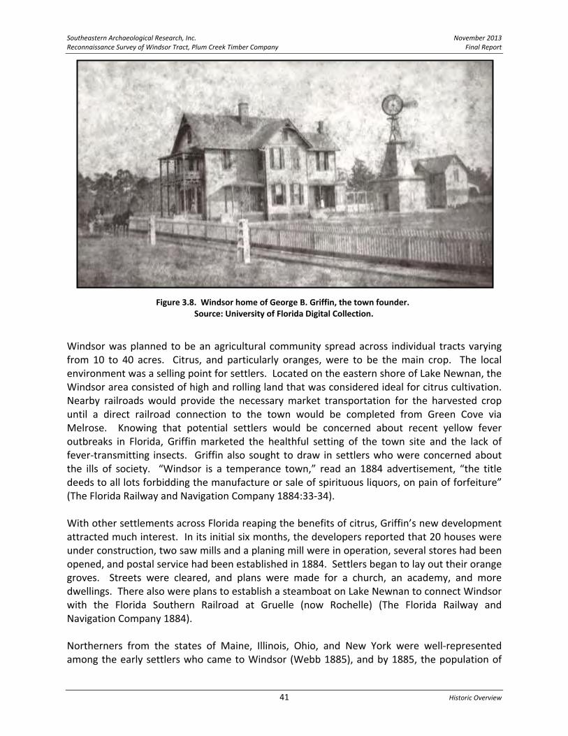
Southeastern Archaeological Research, Inc. November 2013 Reconnaissance Survey of Windsor Tract, Plum Creek Timber Company Final Report
41 Historic Overview
Figure 3.8. Windsor home of George B. Griffin, the town founder. Source: University of Florida Digital Collection.
Windsor was planned to be an agricultural community spread across individual tracts varying from 10 to 40 acres. Citrus, and particularly oranges, were to be the main crop. The local environment was a selling point for settlers. Located on the eastern shore of Lake Newnan, the Windsor area consisted of high and rolling land that was considered ideal for citrus cultivation. Nearby railroads would provide the necessary market transportation for the harvested crop until a direct railroad connection to the town would be completed from Green Cove via Melrose. Knowing that potential settlers would be concerned about recent yellow fever outbreaks in Florida, Griffin marketed the healthful setting of the town site and the lack of fever‐transmitting insects. Griffin also sought to draw in settlers who were concerned about the ills of society. “Windsor is a temperance town,” read an 1884 advertisement, “the title deeds to all lots forbidding the manufacture or sale of spirituous liquors, on pain of forfeiture” (The Florida Railway and Navigation Company 1884:33‐34). With other settlements across Florida reaping the benefits of citrus, Griffin’s new development attracted much interest. In its initial six months, the developers reported that 20 houses were under construction, two saw mills and a planing mill were in operation, several stores had been opened, and postal service had been established in 1884. Settlers began to lay out their orange groves. Streets were cleared, and plans were made for a church, an academy, and more dwellings. There also were plans to establish a steamboat on Lake Newnan to connect Windsor with the Florida Southern Railroad at Gruelle (now Rochelle) (The Florida Railway and Navigation Company 1884). Northerners from the states of Maine, Illinois, Ohio, and New York were well‐represented among the early settlers who came to Windsor (Webb 1885), and by 1885, the population of

November 2013 Southeastern Archaeological Research, Inc. Final Report Reconnaissance Survey of Windsor Tract, Plum Creek Timber Company
Chapter 3 42
Figure 3.9. Madison Starke Perry, ca. 1860. Source: Florida Photographic Collection.
Windsor was about 75. In the decade after its founding, Windsor quadrupled in population and came to rival the county seat of Gainesville in size. The town had a Methodist Episcopal Church and a Baptist Church. The school had 50 students. A hotel, called the Windsor Central Hotel, had been completed. Griffin had developed a tub and pail manufactory with a business partner named Adler. Two physicians were in residence (Belding 1895). Sam White, an African‐American resident of Windsor who was interviewed by a Tampa Tribune reporter in 1954 about early Windsor, recalled the town at its height in the 1890s. “It was the prettiest place you ever did see back then, before the freeze killed down all [the] orange trees” (Roberts 1954:1). The Great Freeze of 1894‐1895, the second devastating freeze to hit the area in a decade, wiped out the citrus crop at Windsor. With nearly every tree lost, the citrus growers in Windsor abandoned their groves and homes (Roberts 1954). The town failed to become the premiere citrus growing center that Griffin and others envisioned and the long‐awaited railroad connection never arrived. Nevertheless, Windsor survived. Most of its residents became involved in truck farming and timber. Based in Windsor around the turn of the twentieth century, physician J.L. Kelley manufactured satin finished veneer, pine wood for citrus boxes, cypress shingle, and other lumber products from his mill on the north side of town (Roberts 1954). By 1912, business activity had dwindled in Windsor. The population was estimated at 100 and two general stores were in operation (R.L. Polk & Company 1912). Windsor has since remained a rural community that features architecture that harkens back to an earlier time.
Rochelle The community of Rochelle is one of Alachua County’s oldest. During the Second Seminole War period (1835‐1842), the US Army built a fort in the area called Fort Crane, which was located just south of the present‐day town of Rochelle. With the end of the war, settlers from Georgia and South Carolina, including the Perry, Rochelle, Tillman, and Zetrouer families, settled in the vicinity of the former fort (Florida Division of Historical Resources 2012b). Madison Starke Perry (Figure 3.9) purchased land in the area in 1854 and started a plantation. He also donated land for the local Oak Ridge Cemetery. Due to Perry’s prominence, the community was originally called “Perry Junction”. But Perry’s influence ranged beyond his Alachua County plantation, and he soon became prominent in Florida politics. In 1857, Perry was elected Governor of Florida, an office he held until the Civil War broke out, at which time he became a Colonel

Southeastern Archaeological Research, Inc. November 2013 Reconnaissance Survey of Windsor Tract, Plum Creek Timber Company Final Report
43 Historic Overview
of the 7th Florida Infantry Regiment of the Confederate Army. Perry became ill in 1863 and retired to his plantation where he died in 1865 (Florida Division of Historical Resources 2012b). Railroad development in the latter half of the nineteenth century spurred growth in the Perry Junction area. In 1881, N.R. Gruelle helped bring the Florida Southern Railway to Alachua County. The line was completed from Palatka to Gainesville in that year. Perry Junction was renamed Gruelle for a brief period, but the name did not stick (Webber 1883). In 1884, the name Rochelle was chosen for this emerging railroad community. The name honored the Rochelles, Governor Perry’s in‐laws and one of the earliest families to settle the area (Gallagher 1997; Florida Division of Historical Resources 2012b). By 1888, 24 trains a day passed through the Rochelle, which lay on a route that ran from Jacksonville to St. Petersburg. The population of the community in this period was 100. Like many Alachua County communities at the time, citrus was an important crop at Rochelle; however, the citrus industry at Rochelle failed due to the Great Freeze of 1894‐1895. Since that time, Rochelle has remained a rural community. Beautiful remnants of Rochelle’s history are still visible, including the 1885 NRHP Listed Rochelle School (also known as the Martha Perry Institute, named for Governor Perry’s wife).
Grove Park Daniel Scott and David Finley, South Carolina natives, acquired 3,000 acres in present‐day Grove Park in 1853, transforming 400 acres of the tract into a cotton plantation (Alachua County Clerk of Court 1853:414). Scott bought out Finley in 1858 and continued to operate the plantation until the end of the Civil War (Alachua County Clerk of Court 1858:370‐371). During the war, Scott’s slaves erected a two‐story Greek Revival‐style plantation house on his property (Gainesville Sun 28 January 1979) that was located on the northwest corner of SR 20 and SE 155th Street in Grove Park. Many of Alachua’s cotton growers were forced to sell their plantations after the Civil War due to crop loss from heavy rains and a plague of caterpillars (Hildreth and Cox 1981:54‐55). In 1866, Scott sold his property to Reverend E.L. King, another prosperous landowner in the area (Alachua County Clerk of Court 1866:360; Smith 1973:214). Like the rest of central Florida, further settlement in the Grove Park area did not occur until railroads began to open up the region. Grove Park prospered with the arrival of the Florida Southern Railway in 1879. Local stations included McMeekin, Wait’s Crossing (later Hawthorne), Magnesia Springs, and Grove Park. Grove Park’s post office opened in 1883 (Bradbury and Hallock 1962:35; Davis 1960:137) and the town included several schools and churches, a butcher, four sawmill owners, a dairy operator, a real estate agent, a general merchandise retailer, an undertaker, and two stock dealers. The region supported several sawmills and phosphate mines (Smith 1884:216). Samuel Waits sold livestock and owned extensive acreage around Grove Park. Other large landowners in the area were John Dent and W.H.H. Holdridge. Dent and Holdridge had Grove Park surveyed in 1884 and the plat recorded (Alachua County Recordings and Official Records Department, March 23, 1885c). Dent and Holdridge are considered the founding fathers of Grove Park (Gainesville Sun 23 July 1989);

November 2013 Southeastern Archaeological Research, Inc. Final Report Reconnaissance Survey of Windsor Tract, Plum Creek Timber Company
Chapter 3 44
they operated the Park House hotel, and Holdridge also sold real estate and managed 40 acres of cotton and grain and 200 acres of citrus. Samuel Waits’ farm was smaller with 10 acres in cotton and grain and 10 acres in vegetables. Lochloosa Creek furnished water power and area farmers typically grew oranges and vegetables. Land ranged from $25 to $250 an acre. Samuel Waits and E.E. Lynch operated a turpentine distillery and a general store, and Lynch also operated a saw mill (Gainesville Sun 7 June 1981). The still produced 650 barrels of spirits and 1,000 barrels of rosin annually. By 1895, 75 people lived in the community (Belding 1895:119). At the height of the Florida land boom of the 1920s, 215 people lived in the Grove Park area (R.L. Polk & Company 1927:309), the majority making their livelihoods as farmers, but the town also supported a railroad express agent, a teacher, a laundress, a pastor, grocers, general merchandise retailers, and laborers. During the 1920s, Magnesia Springs, located southeast of Grove Park, was developed with swimming pools, a pumping station, bathhouses, and a restaurant. The springs had long been a popular leisure time spot for area residents (Webber 1883:64). Despite this development, the growth of Grove Park leveled and began to wane in the 1930s (Miller 1930:357‐358). While farming remained an important industry, more and more farmers abandoned their land or leased it to timber interests (University of Florida 1996).
Phifer Phifer lies within a one‐mile radius of the Windsor Tract Plum Creek Timber Company property between the contemporaneous communities of Grove Park and Rochelle. Phifer emerged in the late nineteenth century as a railway town along the Florida Southern Railway track, and was named for a pioneer family in the area. The Phifers had a merchandise store and blacksmith shop in Rochelle in the 1890s (Belding 1895). Phifer & Waits (of Grove Park) operated a naval stores operation and general store in the early 1900s (R.L. Polk & Company 1908). Phifer never had a post office (Gallagher 1997) and never developed into a significant town. In the 1930s and 1940s, the community consisted of the railroad station and several surrounding homes and other structures (Florida State Road Department 1936; USDA 1940).

Southeastern Archaeological Research, Inc. November 2013 Reconnaissance Survey of Windsor Tract, Plum Creek Timber Company Final Report
45 Research Design and Preliminary Background Work
CHAPTER 4 RESEARCH DESIGN AND PRELIMINARY BACKGROUND WORK
The goal of this Cultural Resource Reconnaissance Assessment is to provide a basis for the formulation of estimates of the necessity, type, and intensity of further cultural resource identification work within the Windsor Tract, and to set priorities for the individual tasks involved. Thus, the primary purpose of this document is to help guide the organization of potential future Phase I survey of all or portions of this large parcel. To these ends, the research design was composed of background investigation, a historical document search, and archaeological probability modeling. The background investigation involved a perusal of relevant previous cultural resource investigations, producing a summary of survey work undertaken near the project area. Current soil surveys, vegetation maps, and relevant literature were consulted to provide a description of the physiographic region of which the project area is a part. The general history of the area was researched. The Florida Master Site File (FMSF) was checked for any previously recorded sites and properties within the project area, which provided an indication of prehistoric and historic settlement and land‐use patterns for the region. In addition, original township plat maps, early aerial photographs, and other relevant map sources were examined for information pertaining to the existence of unrecorded historic structures or the locations of historic events within the project limits. All these data sources were used in combination to document historic or prehistoric properties within the project area, which may include archaeological sites (prehistoric or historic), structures and features (roads, railways, bridges) that are more than 50 years old, and potential historical landscapes. Ultimately, the research design was created to develop expectations regarding the types of archaeological sites (prehistoric and historic) that may be present within the Windsor Tract and to forecast their likely locations by defining site probability areas. The remainder of this document presents the results of this work. This chapter provides the review of previous survey work in the area, examines relevant historic map and aerial photograph sources, and presents the theoretical foundation of the archaeological probability model utilized for this project.
PREVIOUS SURVEYS RECORDED WITH FLORIDA MASTER SITE FILES FMSF data from July 2013 were reviewed to identify previous cultural resource surveys within one mile of the project area. Seventeen surveys have been completed (Table 4.1, Figure 4.1); these include 8 road surveys, 1 bridge replacement, 3 cell tower surveys, 2 development parcel surveys, 1 historic structure survey (of Hawthorne) and 2 county‐wide surveys (one historic structure and one archaeology) focused on the unincorporated areas of Alachua County. There is minimal overlap between the previously surveyed areas and the Windsor Tract. All the linear road surveys and the one bridge replacement are along roads that mark the boundaries of the

November 2013 Southeastern Archaeological Research, Inc. Final Report Reconnaissance Survey of Windsor Tract, Plum Creek Timber Company
Chapter 4 46
Table 4.1. Previous Cultural Resource Assessment Surveys within a One‐Mile Radius of the Windsor Tract.
Survey No.
Title Year Reference RecordedResources
1604 Cultural Resource Assessment Survey for State Project #26080‐1516, Alachua County, Florida. Improvements along SR 20 from CR 329B to US 301
1988 William D. Browning, FDOT
3 prehistoric sites (8AL320, 8AL321,
8AL2493)
2604 Cultural Resource Assessment Survey of the CR 1474 Bridge Replacement, Alachua County, Florida
1990 Environmental Services, Inc. (ESI)
0
4083 Historic Hawthorne Florida Survey and Plan 1995 William Weismantel, University of Florida
17 historic structures
4122
Archaeological and Historical Survey of SE 171st
Street, SE 24th Avenue, and SE 163rd Street, Alachua County, Florida. Road improvements between SR 20 (near Grove Park) to CR 1474
1995 SouthArc, Inc. 5 isolated artifacts
including 1 Levy PPK; farmstead (8AL3083)
4867 Solid Waste Management Facility Cultural Resources Survey, Alachua County, Florida. On SR 26 near intersection with US 301
1997 SouthArc, Inc.
4 archaeology sites: 8AL3055 (historic), 8AL3056, 8AL3279, 8AL3280 (prehistoric)
5512 Cultural Resources Survey White Construction SR 20 Borrow Pit Alachua County, Florida
1999 SouthArc, Inc. 1 historic site (AL3524)
5873 Cultural Resource Assessment Survey of Improvements to SR 20, Alachua County, Florida
1999 SEARCH 0
5889 Cultural Resource Assessment Survey of the Proposed SR 26/US 301 Overpass, Orange Heights, Alachua County, Florida
1999 SEARCH 0
5986 Historic Structures Survey of Unincorporated Alachua County
2000 Anderson Consulting 111 historic structures
6873 An Archaeological Survey of Unincorporated Alachua County, Florida (Phase I and Phase II)
2001 SEARCH 0
6963 Cultural Resource Survey of Two Retention Ponds in Hawthorne (SR 20), Alachua County, Florida
2002 SEARCH 0
6999 Cultural Resources Survey and Assessment Orange Creek Basin, Newnans Lake Boardwalk and Observation Tower, Alachua County, Florida
2002 SouthArc, Inc. 4 historic properties within observation tower 1‐mile radius
9659 Cultural Resource Assessment of Proposed SR 26 Cell Tower #J‐445, East Gainesville, Alachua County, Florida
2004 SEARCH
8 historic structures within cell tower 1‐mile radius (8AL4320; others no FMSF#s)
11310 Cultural Resource Reconnaissance Survey and Section 106 Review: Proposed Rochelle Cellular Tower, Alachua County, Florida
2005 Archaeological Consultants, Inc. (ACI)
24 historic structures within cell tower 1‐
mile radius
12009 Cultural Resource Assessment of Proposed Rochelle Cell Tower Project
2005 SouthArc, Inc. 5 historic structures within cell tower 1‐
mile radius
12066 A Phase I Cultural Resource Survey of SR 20 from Hawthorne to Interlachen, Alachua and Putnam Counties, Florida
2001 SEARCH 0
18318 Phase I Cultural Resource Assessment Survey of SR 20 from Hawthorne to Interlachen, Alachua and Putnam Counties, Florida
2009 SEARCH 0

Southeastern Archaeological Research, Inc. November 2013 Reconnaissance Survey of Windsor Tract, Plum Creek Timber Company Final Report
47 Research Design and Preliminary Background Work
Figure 4.1. Cultural resource surveys within one mile of the Windsor Tract boundary.

November 2013 Southeastern Archaeological Research, Inc. Final Report Reconnaissance Survey of Windsor Tract, Plum Creek Timber Company
Chapter 4 48
current project area; in particular, SR 20 at the south edge of the project area (with six different surveys), SR 26 at the northeast corner of Area 2 (Survey #5889), a small segment of CR 1474 between Areas 2 and 4 (Survey #2604), and three smaller roads between Grove Park and CR 1474 (SE 171st Street, SE 24th Avenue, and CR 13B), which mark the boundary between Areas 3 and 4 (Survey #4122). One of the cell tower surveys (Survey #9659) recorded historic structures along roads that bind the northwest edge of the project area (between Areas 1 and 2); none appear to fall within the Windsor Tract. Neither of the Rochelle cell tower surveys intersect the Windsor Tract. Portions of the 1,585‐acre Balu Forest Tract (Survey #4867) abut the Windsor Tract at the northern end of Areas 1 and 2. This county‐owned parcel was surveyed in 1996 in advance of its potential development as a solid waste management facility and four archaeological sites were identified (SouthArc 1996). This same parcel was used as part of the testing phase for the archaeological model developed for the unincorporated portions of Alachua County in 2001 (Survey #6873; SEARCH 2001). Although this 2001 archaeology survey investigated many parcels across unincorporated Alachua County, only the Balu Forest Tract is in the vicinity of the current project area. Two historic structure surveys have been undertaken in the vicinity of the Windsor Tract. The town of Hawthorne was surveyed in 1995 by the University of Florida to identify and assess its historic properties (Survey #4083; Weismantel 1995). In 2000, a historical and architectural survey of unincorporated Alachua County was conducted by Anderson Consulting (Survey #5986). This survey recorded 111 historic structures within communities that are adjacent to the Windsor Tract including Orange Heights, Campville, Windsor, Rex, Grove Park, and Rochelle. Table 4.1 notes the number of cultural resources recorded as a result of each of these surveys, whether they be historic structures, archaeology sites, or isolated artifact finds. In total, these surveys identified eight archaeology sites, 130 structures, five Archaeological Occurrences (AOs—single artifact finds), and 40 unrecorded historic structures noted during cell tower surveys. A full discussion of the previously recorded cultural resources within the Windsor Tract, including archaeology sites and structures, is presented in Chapter 5.
HISTORIC MAP AND AERIAL PHOTOGRAPH REVIEW Historic maps and aerial photographs were examined in order to identify past land use in the vicinity of the current project area. The earliest available maps of detail are General Land Office (GLO) survey maps created by US government land surveyors in the first half of the nineteenth century. These maps characteristically show landscape features such as vegetation, bodies of water, roads, and Spanish land grants; however, the level of detail in GLO maps varies and sometimes cultural features such as structures, Indian villages, railroads, and agricultural fields are depicted. Later nineteenth‐century maps include early railroad maps and general county maps, but these were not typically produced at the detailed scale seen in the GLO maps. Twentieth‐century map resources include General Highway Maps starting in 1936, USDA soils

Southeastern Archaeological Research, Inc. November 2013 Reconnaissance Survey of Windsor Tract, Plum Creek Timber Company Final Report
49 Research Design and Preliminary Background Work
survey maps, and early USGS quadrangle maps. After 1937, aerial photographs of the project area became available.
Historic Maps 1835 General Land Office Survey Map and 1846 Arredondo Grant Map GLO survey maps of Township 9 South, Range 22 East and Township 10 South, Range 22 East were created in 1835 (GLO 1835a, 1835b); this covers the eastern half of the Windsor Tract. The 1835 GLO maps show no cultural features within the project area. David H. Burr surveyed the Arredondo Grant in 1846, which includes Township 9 South, Range 21 and Township 10 South, Range 21 East (Burr 1846); this covers the western half of the Windsor Tract. In general, the area is characterized on these maps by numerous unnamed ponds, streams, and swamplands. Present‐day Newnans Lake is identified on the Arredondo Grant map as “Lake Pithlachocco” (Figure 4.2). “Hatchet Creek” is named, along with an eastern tributary of Hatchet Creek called “Beetree Branch” (which crosses Area 1 of the Windsor Tract). Although Lochloosa Creek is clearly shown, it is unnamed on the Arredondo map, although “Lake Lulhloosa” to the south is identified. The only land grant on the Arredondo map that pertains to the Windsor Tract property belongs to the “Heirs of Nehemiah Brush”. There is no evidence that Brush or his heirs ever developed any of the land currently held within the Windsor Tract and the Brush heirs started to divide and sell the land after 1855. The only cultural feature shown in the vicinity of the project on the Arredondo map is a north‐to‐south‐running road that follows generally the present‐day location of CR 234. Shown along this road are three plantation houses. These named plantations and other early landowners are discussed in further detail in Chapter 6. Late Nineteenth‐ and Early Twentieth‐Century Maps Late nineteenth‐ and early twentieth‐century maps provide an overview of development in the area surrounding the Windsor Tract. This property is characterized as predominantly rural and agricultural with scattered farmsteads and a smattering of structures along major roads. An 1865 topographic map of Alachua County shows the same features as the Arredondo Map, namely Lake Pithlachocco, Hatchet Creek, the north‐south road on the east side of the lake, and several structures along the north–south road (Julius Bien and Co. 1865). A new feature seen on this map is the Florida Railroad that extends through Waldo and Gainesville (completed in 1860), approximately three miles north of the Windsor Tract. By 1890, the communities of Hawthorne, Campville (“Camp V.”), and Orange Heights appear as stops along the Peninsular Railroad and the communities of Grove Park, Rochelle, and Constine’s Mill appear as stops along the Florida Southern Railroad (Norton 1890) (Figure 4.3). The community of Windsor is shown on the east side of present‐day Newnans Lake (unnamed).

November 2013 Southeastern Archaeological Research, Inc. Final Report Reconnaissance Survey of Windsor Tract, Plum Creek Timber Company
Chapter 4 50
Figure 4.2. Portion of the Arredondo Grant map (Burr 1846).

Southeastern Archaeological Research, Inc. November 2013 Reconnaissance Survey of Windsor Tract, Plum Creek Timber Company Final Report
51 Research Design and Preliminary Background Work
Figure 4.3. Alachua County, 1890. Source: A Handbook of Florida 1890, by Charles Ledyard Norton. On the web at http://etc.usf.edu/maps [map#f2156].
A 1909 sectional map of Florida shows the former Peninsular Railroad stretching from Waldo to Silver Springs as part of the Seaboard Air Line (S.A.L.) Railroad and the former Florida Southern Railroad stretching from Gainesville to Palatka as part of the Atlantic Coast Line (A.C.L.) Railroad (USDA 1909). The town of Rex is shown as a stop along the S.A.L. railroad, located between Hawthorne and Campville. The lake is identified as “L. Pithlachocco or Newnans L”. The railstop of Constine’s Mill is no longer present. The 1926 Atlas of Florida shows the first roadways in the county. SR 14 (present‐day SR 20) runs parallel to the A.C.L. Railroad and connects Gainesville to Hawthorne, and SR 31 (present‐day US 301) runs parallel to the S.A.L. Railroad from Orange Heights to Hawthorne (Associated Map Co. 1926). Lake Pithlachocco is labeled as ‘Newmans Lake’ [sic]. Orange Heights, Rochelle, and Campville are shown as towns and Hawthorne is depicted as a larger town, while Windsor and Grove Park are designated as named places rather than true towns (Associated Map Co. 1926). Mid‐Twentieth‐Century Maps More detailed maps of the area are available beginning in 1936 when the Florida Department of Transportation (FDOT) began publishing General Highway Maps with updated road numbers and community resources located along the roads. The 1936 General Highway Map of Alachua County shows several types of roads crossing through the Windsor Tract project area, including

November 2013 Southeastern Archaeological Research, Inc. Final Report Reconnaissance Survey of Windsor Tract, Plum Creek Timber Company
Chapter 4 52
roads described as “bituminous road” (paved), “primitive road”, and “graded and drained road” (FDOT 1936). All the major roads that currently cross the interior portion of the Windsor Tract (CR 1474, CR 13B, SE 24th Avenue, SE 171st Street) are present by 1936 (Figure 4.4). A small number of structures are shown within the Windsor Tract boundary; however, due to georeferencing inconsistencies they may not actually fall within the project area. The 1944 USGS topographic map of the Hawthorne quadrangle shows an increase in the number of structures and secondary roads within and around the Windsor Tract (USGS 1944) (Figure 4.5). In general, rural roads lead to residences or farm buildings and some roads support multiple residences. Multiple structures in Campville appear to be located within the Windsor Tract, including large blocks that may represent a high density of buildings within close spacing to one another or may represent larger railroad‐associated structures. The small community of Rex is shown along SR 31/US 301. Small orchards, likely pecan trees, are present near the center of the Windsor tract within a large outparcel. Also within an outparcel is “St. Pauls Cemetery”, which is named on this map along with the “Providence Cemetery”, which is located in Windsor, just outside the project boundary. The 1953 [1955] General Highway Map shows a decrease in the amount of scattered farm‐related structures, with an increase in the number of structures near towns and major roads (FDOT 1953) (Figure 4.6). Two bridges are visible along SR 31/US 301 as it crosses different branches of upper Lochloosa Creek. On the road between Windsor and Campville (CR 234 /present‐day CR 1474), two bridges cross over Lochloosa Creek and its northwestern branch. These bridges were replaced in 1990 (Survey #2604, ESI 1990). Occasionally, the remnants of older bridges are in proximity to the new bridges; thus, bridge locations are typically investigated during Phase I surveys. Campville appears smaller than on previous maps and the majority of buildings are now located outside the boundaries of the Windsor Tract. A cemetery is shown at the southeast corner of the intersection of SE 24th Avenue and SE 171st Street, just outside the boundary of the Windsor Tract (see the northwest corner of Section 17). This resource was not identified in any other research documents. The 1964 [1965] General Highway Map shows a similar picture of the Windsor Tract as the 1953 [1955] General Highway Map (FDOT 1964) (Figure 4.7). The main difference is the addition of bridges in 1964 along the private roads in the upper Lochloosa drainage area (Area 2) and a bridge along SR 20 at Lochloosa Creek just east of Grove Park (adjacent to Area 4).
Historic Aerials Beginning in the 1930s, the US Department of Agriculture (USDA) took aerial photographs of the State of Florida. Photographs of this area of Alachua County were first taken in 1937 and continued to be taken in subsequent decades. The 1937 aerial photograph composite of the entire Windsor Tract is provided here (Figure 4.8), showing that in 1937 the tract was primarily undeveloped with scattered cleared agricultural plots and very few rural roads. The towns of Windsor, Grove Park, and Campville show a fair amount of development and land clearing. The greatest activity follows US 301 especially between Campville and Hawthorne. In addition to

Southeastern Archaeological Research, Inc. November 2013 Reconnaissance Survey of Windsor Tract, Plum Creek Timber Company Final Report
53 Research Design and Preliminary Background Work
Figure 4.4. 1936 General Highway Map with projected Windsor Tract boundary (FDOT 1936).Note: planimetric and cartographic inaccuracy in the original.

November 2013 Southeastern Archaeological Research, Inc. Final Report Reconnaissance Survey of Windsor Tract, Plum Creek Timber Company
Chapter 4 54
Figure 4.5. 1944 Hawthorne quadrangle with projected Windsor Tract boundary (USGS 1944).

Southeastern Archaeological Research, Inc. November 2013 Reconnaissance Survey of Windsor Tract, Plum Creek Timber Company Final Report
55 Research Design and Preliminary Background Work
Figure 4.6. 1953 [1955] General Highway Map with projected Windsor Tract boundary (FDOT 1953).
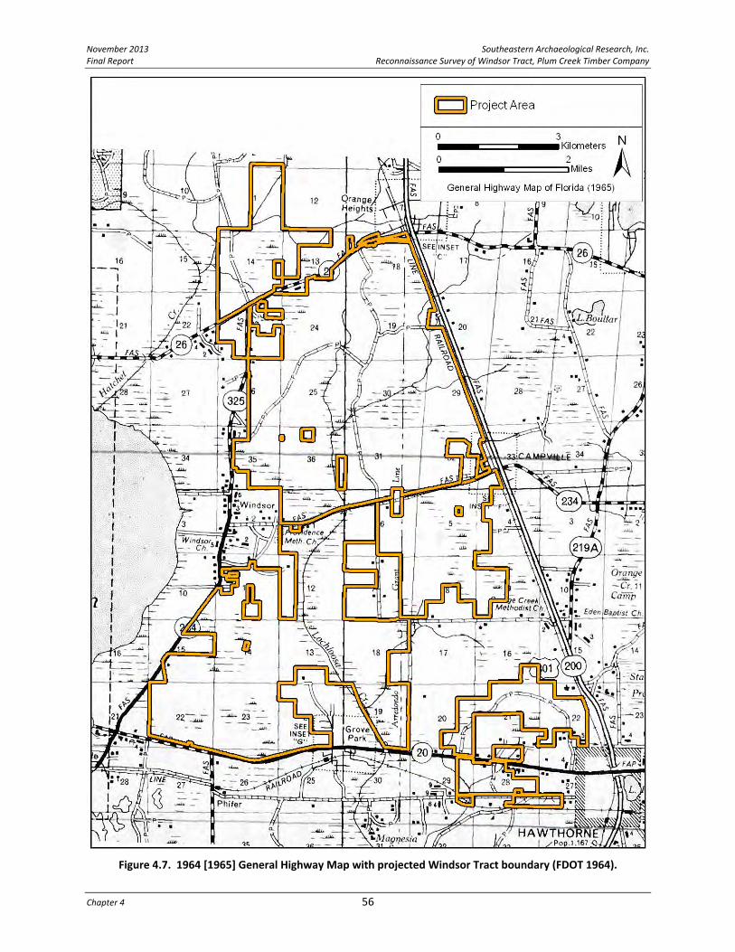
November 2013 Southeastern Archaeological Research, Inc. Final Report Reconnaissance Survey of Windsor Tract, Plum Creek Timber Company
Chapter 4 56
Figure 4.7. 1964 [1965] General Highway Map with projected Windsor Tract boundary (FDOT 1964).

Southeastern Archaeological Research, Inc. November 2013 Reconnaissance Survey of Windsor Tract, Plum Creek Timber Company Final Report
57 Research Design and Preliminary Background Work
This page intentionally left blank.
Figure 4.8. 1937 aerial photograph composite of area surrounding the Windsor Tract (USDA 1937).

November 2013 Southeastern Archaeological Research, Inc. Final Report Reconnaissance Survey of Windsor Tract, Plum Creek Timber Company
Chapter 4 58
This page intentionally left blank.

Southeastern Archaeological Research, Inc. November 2013 Reconnaissance Survey of Windsor Tract, Plum Creek Timber Company Final Report
59 Research Design and Preliminary Background Work
the 1937 aerial photograph, images were reviewed from 1949, 1956, 1961, 1968, and 1974 to identify historic activities within the Windsor Tract and follow changes in those activities through time. The detailed discussion of cultural features visible on aerial photographs and maps within each of the five areas will be presented in the results section of this report (Chapter 6).
ARCHAEOLOGICAL MODEL (PROBABILITY AREAS) When considering the archaeological potential of this project parcel, one can explore what resources and areas may have been attractive to prehistoric people. Sites within the project parcel are expected to be on better drained soils, at relatively higher elevations, and close to water or wetland resources. The higher elevation/better drained areas in proximity to lower, wetter areas were considered to contain the highest probability for archaeological sites. Based on an examination of environmental variables (soil drainage, relative elevation, proximity to water or wetland resources), as well as the results of previously conducted surveys, the potential for prehistoric archaeological sites to be present within the project area was calculated. The types of sites expected within the Windsor Tract are primarily lithic scatters, although ceramic scatters and midden deposits are also considered possible. In addition to the drainage qualities of the parcel, a relative elevation map was generated to identify areas that are relatively higher and drier. Development of the Phase I testing model involved defining the criteria to be used and evaluating appropriate thresholds for differentiating High Probability (HP), Medium Probability (MP), and targeted Low Probability (LP) archaeological zones.
Soil Drainage Soil drainage is a key factor for influencing settlement. Essentially, soil that drains better is more amenable to prolonged habitation, while soil that drains slowly retains water and is not conducive to prolonged habitation. The USDA‐prepared soil data differentiates between soil type and drainage class. Distinct soil drainage classes, ranked from worst to best, include: very poorly drained (VPD), poorly drained (PD), somewhat poorly drained (SPD), moderately well drained (MWD), well drained (WD), and excessively drained (ED). The project area soil drainage classes include VPD, PD, SPD, MWD, and ED (see Figure 2.6). For this analysis, areas mapped as MWD and ED are considered to exhibit higher archaeological potential (HP zones), areas mapped as SPD are classified as containing medium archaeological potential (MP zones), and those classified as VPD and PD are considered to exhibit low archaeological potential (LP zones). Based only on soil drainage, there are 852 acres (4.9%) that correspond with HP zones, 6,880 acres (39.6%) that correspond with MP zones, and 9,634 acres (55.5%) that correspond with LP zones within the Windsor Tract (see Table 2.1). Previously recorded sites in the vicinity of the Windsor Tract occur in areas mapped as having SPD soils, which a predictive model based solely on mapped soil units would classify as a MP zone. If all SPD, MWD, and ED drainage classes are

November 2013 Southeastern Archaeological Research, Inc. Final Report Reconnaissance Survey of Windsor Tract, Plum Creek Timber Company
Chapter 4 60
combined, 7,732 acres (44.5%) of the Windsor Tract would be considered to have a medium to high probability of containing archaeological sites; however, soil drainage by itself is insufficient to accurately and most effectively characterize archaeological potential. The drainage probability measurement can be further refined by considering additional environmental factors.
Proximity to Water Access to water is a key factor for predicting site locations. Native American sites are often very close to potable water, while historic settlements were somewhat less dependent on direct water access. Hydrography maps prepared by the Natural Resources Conservation Service (NRCS) and US Fish & Wildlife provide the location of hydrological resources (Figure 4.9). Numerous data layers exist on such maps, and for this study, the streams and ponds layer and the swamps and marshes layer were utilized. Applying a 100‐m buffer around the limits of these hydrological resources defines zones of higher potential for containing cultural resources, while areas that are greater than 100 m from water are considered to have lower archaeological potential. Within the Windsor Tract, there are 7,315 acres (42%) that correspond with areas of higher archaeological potential based on their proximity to water (100 m or less), and 10,057 acres (58%) that correspond with areas of lower archaeological potential based on their distance from water (greater than 100 m) or fall within wetlands.
Relative Elevation Relative elevation captures the elevation of any point in relation to the area around it. This measure provides a means of assessing local landscape variability at a detailed scale. Overall, the broad spaces between primary water resources are designated low priority for archaeological resources. These areas have few resources that would encourage people to live, harvest, or collect there (and create archaeological sites). Within these broad spaces, however, areas with high relative elevation that neighbor areas of low relative elevation may have been more attractive, as these areas of low relative elevation could have been seasonal wetlands or water sources in the past. For the purpose of this predictive model, data was processed to identify small rises in otherwise flat or gently sloping areas. Processed data highlights and quantitatively assesses the landscape and identifies rises and neighboring ponds, sinks, wetlands, and waterways. Using relative elevation, either slightly above or slightly below the average, areas with positive relative elevations were designated as having higher archaeological potential. The best‐available digital elevation model (DEM) for this region was acquired from the USDA‐NRCS, and consists of a 30‐m cell grid with elevation in decimal meters above mean sea level (amsl). This particular digital elevation model included over 2,700,000 acres and encompassed the Windsor Tract. Elevation data within the project area were processed to generate a “neighborhood mean” for each cell grid by sampling within a 180 m diameter. The resulting file

Southeastern Archaeological Research, Inc. November 2013 Reconnaissance Survey of Windsor Tract, Plum Creek Timber Company Final Report
61 Research Design and Preliminary Background Work
Figure 4.9. Hydrological resources for the Windsor Tract buffered by 100 m to create zones of higher
archaeological potential.

November 2013 Southeastern Archaeological Research, Inc. Final Report Reconnaissance Survey of Windsor Tract, Plum Creek Timber Company
Chapter 4 62
characterized the mean elevation of the surrounding area from any point on the map. Raw elevation was then subtracted from the mean elevation to create a new data set of relative elevation (Figure 4.10). This new data set was compared to previously recorded archaeological sites both in the immediate vicinity of the project and within the larger area sampled (Figure 4.11). Almost all archaeological sites correspond with areas of high relative elevation, and most also correlate with neighboring negative relative elevation. In order to characterize this elevation variability, the highest positive relative elevation zones were deemed zones of moderate archaeological probability. With these relative high elevation zones, the areas that occurred within 100 m of mapped depressions or water were deemed zones of high archaeological probability. Finally, these were compared with the probability zones generated by soil drainage classes and strong correlations were observed between the two models.
Final Model A combination of these three environmental variables was used to delineate HP, MP, and LP archaeological resource zones for the Windsor Tract (Figure 4.12). Areas with (1) SPD soil drainage or better, (2) more than 1/2 m of positive relative elevation, and (3) a location less than 100 m from a mapped water source or depression were designed HP archaeology zones. After limiting the project area to locations where these three factors overlap, the data was visually assessed and modified to account for the mechanistic base of the model as to include entire landforms rather than single cells. In total, 1,666.2 acres (9.6%) of the Windsor Tract are classified as HP for prehistoric archaeological sites. Due to the better drainage characteristics of these locations, this model will help identify the location of historic sites as well. For the purposes of a Phase I cultural resource survey, HP zones are generally subsurface tested at 25‐m intervals. Areas with high relative elevations OR better soil drainage (SPD/MWD/ED) that are located less than 100 m from mapped water sources or depressions (in other words, locations with two out of the three characteristics) were designed MP archaeology zones. A total of 3,092 acres (17.8%) of the project area is classified as MP for prehistoric archaeological sites. For the purposes of a Phase I cultural resource survey, MP zones are generally subsurface tested at 50‐m intervals. As these two classifications were created using a series of automated processes, some of the zones are very small and unlikely to contain a significant archaeological site and would therefore be discounted during the course of a Phase I survey. The remaining high relative elevation areas that neighbor low‐lying areas but have poorly drained soils (PD or VPD) have been designated “targeted” LP zones. These areas, which comprise 913 acres (5.3%), allow a sample of the poorly drained LP area to be archaeologically tested. Targeted LP zones should be pedestrian surveyed and subsurface tested at 100‐m intervals during a Phase I cultural resource survey.

Southeastern Archaeological Research, Inc. November 2013 Reconnaissance Survey of Windsor Tract, Plum Creek Timber Company Final Report
63 Research Design and Preliminary Background Work
Figure 4.10. Relative elevation data for the Windsor Tract.
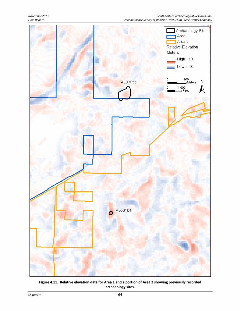
November 2013 Southeastern Archaeological Research, Inc. Final Report Reconnaissance Survey of Windsor Tract, Plum Creek Timber Company
Chapter 4 64
Figure 4.11. Relative elevation data for Area 1 and a portion of Area 2 showing previously recorded
archaeology sites.

Southeastern Archaeological Research, Inc. November 2013 Reconnaissance Survey of Windsor Tract, Plum Creek Timber Company Final Report
65 Research Design and Preliminary Background Work
Figure 4.12. Archaeological probability zones (high, medium and targeted low) for entire Windsor Tract.

November 2013 Southeastern Archaeological Research, Inc. Final Report Reconnaissance Survey of Windsor Tract, Plum Creek Timber Company
Chapter 4 66
The remainder of the parcel is considered to have a very low probability of containing archaeological sites and these areas will be assessed judgmentally based on the discretion of the Principal Investigator. The images and discussion provided here are intended to present the overall theory and method behind the archaeological model. The application of the model to the Phase I survey plan is presented in Chapter 6.

Southeastern Archaeological Research, Inc. November 2013 Reconnaissance Survey of Windsor Tract, Plum Creek Timber Company Final Report
67 Recorded Cultural Resources
CHAPTER 5 RECORDED CULTURAL RESOURCES
The Windsor Tract project parcel contains numerous areas of archaeological and historical interest. The process of identifying cultural resource locations begins by describing archaeological sites and historic properties (structures, roads, railroads, bridges, cemeteries) that have been previously recorded by the Florida Master Site File (FMSF) within the Windsor Tract property and within a one‐mile buffer zone surrounding the project area.
PREVIOUSLY RECORDED ARCHAEOLOGICAL RESOURCES FMSF data were reviewed to identify any previously recorded archaeological resources within one mile of the project area. Seventeen sites have been recorded within this area and only three are within or touching the boundary of the Windsor Tract (Figure 5.1; Table 5.1). In addition, archaeological occurrences (AOs) are noted here from a road survey that abuts Areas 3 and 4, since the isolated positive shovel tests could not be tested outside the road right‐of‐way and these artifacts are indications of prehistoric activity. Of these 17 sites, one is currently listed on the National Register of Historic Places (NHRP) (8AL4792, Lake Pithlachocco [Newnans Lake]); one burial mound site has been recommended NRHP eligible (8AL3279); and the 1812 Fort Newnan battleground (8AL3524) is a potentially significant site near the southwest boundary of the Windsor Tract. These last two sites also have the potential to contain human remains. There are no sites that have been found eligible for listing in the NRHP currently recorded within the boundaries of the Windsor Tract property.
Archaeological Materials Within or on the Boundary of the Windsor Tract The Sand Pit Site (8AL104) is located in the northwest quadrant of Area 2, approximately 1/2‐mile southeast of the intersection of SR 26 and CR 234. Recorded in 1949, the site was described as a light surface scatter of lithic flakes and pottery sherds located on a slight upland overlooking a small pond. No additional testing has occurred at the site and it has not been evaluated for NRHP eligibility. The present condition of 8AL104 is unknown. It is recommended that Phase I survey investigate the area of 8AL104 in order to relocate, if possible, and evaluate this cultural resource. The Lang Site (8AL2493) was identified during a 1988 corridor survey associated with road improvements to SR 20 (Browning 1988). This prehistoric site consists of a low‐density lithic scatter (24 flakes) recovered on both the north and south sides of SR 20. The site is considered not eligible for the NRHP, and does not need to be considered in future development phases of this parcel. This does, however, suggest that areas of relatively higher ground in the expanse of lowlands in the southwest portion of the project area has the potential to contain lithic sites possibly associated with the known Archaic‐period use of the Newnans Lake resource.

November 2013 Southeastern Archaeological Research, Inc. Final Report Reconnaissance Survey of Windsor Tract, Plum Creek Timber Company
Chapter 5 68
Table 5.1. Previously Recorded Archaeological Sites within a One‐Mile Radius of the Project Area (data from FMSF).
FMSF No. Site Name Time Period Description NRHP Recommendation
Within Project Area
8AL104 Sand Pit Prehistoric Low‐density lithic and pottery scatter on ridge between two water features
Insufficient Information
8AL2493 Lang Prehistoric Lithic scatter (24 flakes) on north and south sides of SR 20
Ineligible
8AL3055 Beetree Branch
Historic: late 19th
c. to at least 1937); also prehistoric
Farmstead with midden refuse and brick‐lined well; also low‐density lithic and pottery scatter
Ineligible
AOs: isolated artifacts
PPK Isolate and two thermally altered lithic flakes
Middle Archaic—Levy PPK
PPK found on south side of SE 24
th Avenue; flakes found on CR 13B
Not sites, cannot be evaluated for NRHP
Outside Project Area (within approximately one mile buffer zone)
8AL105 East Newnans Lake Prehistoric Lithic scatter Not evaluated
8AL320 NN Prehistoric 1 sand‐tempered pot sherd; 2 lithic flakes (N & S sides of SR 20)
Ineligible
8AL321 NN Prehistoric Lithic scatter on north side of SR 20
Ineligible
8AL357 Hatchet Creek Ceramic age and Archaic
Village site Insufficient Information
8AL367 South Newnan Ridge
Not recorded Not recorded Not evaluated
8AL2562 Hawthorne R&T Prehistoric Campsite with lithics (n=25) and pottery (n=3)
Ineligible
8AL3056 Railway Historic (early 20th century)
Farmstead Ineligible
8AL3279 Surprise Prehistoric (late Ceramic age)
Probable burial mound (human remains)
Eligible
8AL3280 Post Prehistoric Low‐density lithic scatter Ineligible
8AL3524 CR 325 Homestead Historic: late 19th/early 20th c.
Farmstead Ineligible
8AL3525 Fort Newnan Historic: 1812 (Seminole battleground)
Fort and battleground site; log & earth breastwork; possible human remains; location is General Vicinity (G.V.), mapped on west side of road to Windsor in 1931
Not evaluated as site has not been re‐located. If found, this is likely an NRHP eligible site.
8AL4768 Town Lake Canoe Native American Historic
Dugout; fire‐hollowed w/ metal tool marks
Not evaluated
8AL4792 Lake Pithlachocco Canoe Site
Prehistoric: Middle and Late Archaic; Alachua
55 dugout canoes, most dating to the Late Archaic; primarily on NE shore of Newnans Lake
Listed (2001)
8AL5230 Little Orange Creek Mill Sites
19th century Multiple mills from timbering, turpentining, and cotton ginning
Insufficient information
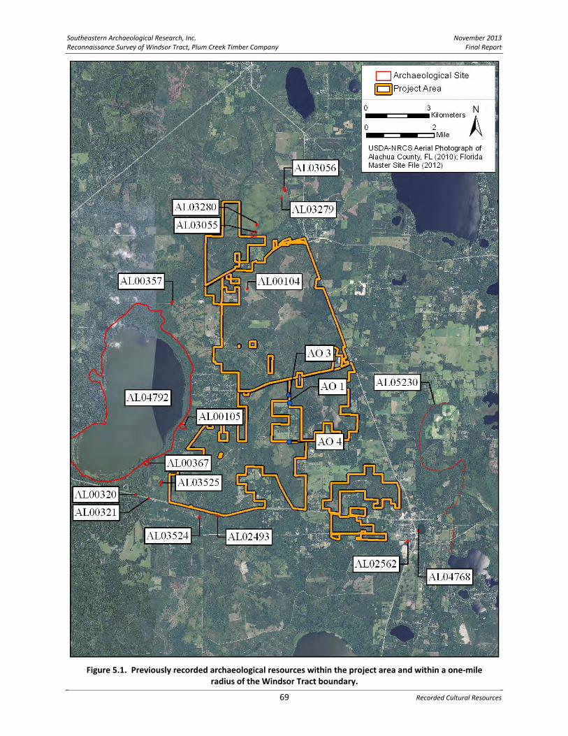
Southeastern Archaeological Research, Inc. November 2013 Reconnaissance Survey of Windsor Tract, Plum Creek Timber Company Final Report
69 Recorded Cultural Resources
Figure 5.1. Previously recorded archaeological resources within the project area and within a one‐mile
radius of the Windsor Tract boundary.

November 2013 Southeastern Archaeological Research, Inc. Final Report Reconnaissance Survey of Windsor Tract, Plum Creek Timber Company
Chapter 5 70
The Beetree Branch Site (8AL3055) abuts the boundary between the county‐owned Balu Forest Tract and Area 1 of the Windsor Tract; near the northern end of the project area. This site is a late nineteenth‐ to early twentieth‐century homestead. Two structures are visible on the 1937 aerial photograph within the site boundaries, but consists today only of a brick‐lined well, a refuse midden, and scattered bricks that are possibly the remnants of house piers. Extending southwest of the historic site is a low‐density scatter of prehistoric lithic debitage and ceramics (St. Johns and sand‐tempered plain wares) that covers an area 150 x 150 m. The site is located on a slight upland within 50 m of an intermittent creek that runs south of the site. This creek is named on the 1846 Arredondo Grant map as the “Beetree Branch” tributary of Hatchet Creek (see Figure 4.2). This site is not eligible for inclusion in the NRHP (State Historic Preservation Officer [SHPO] determination 1996) and does not need to be considered in future development phases of this parcel, although it is possible that unrecorded sites are associated with the Beetree Branch drainage where it crosses Area 1 of the Windsor Tract. Archaeological Occurrences. The 1995 corridor survey (SouthArc 1995) of three small roads (SE 171st Street, SE 24th Avenue, and CR 13B) that generally connect Grove Park to CR 1474 did not identify any archaeological sites; however, five isolated single artifacts were recovered in shovel tests within the road corridor. Three of these AOs are within or on the boundary of the Windsor Tract—two in Area 4 (AO #3 and AO #4) and one in Area 3 (AO #1). Although two of these artifacts are single thermally altered flakes, one isolated artifact is a complete Levy projectile point (AO #4), which is a diagnostic artifact type that dates to the Middle Archaic period (5000‐3000 B.C.). None of these isolated‐artifact shovel tests were further investigated with additional shovel testing outside the road right‐of‐way, and have the potential to be associated with larger sites. The Levy point was recovered on the south side of SE 24th Avenue close to what is considered a high probability location—on better drained soils adjacent to a small water feature and near a tributary of Lochloosa Creek. The two flakes were recovered on either side of CR 13B, in designated HP and MP archaeological zones. It is recommended that Phase I survey investigate these three isolated artifact find locations to determine if they are associated with larger sites.
Significant Archaeological Sites Within the One‐mile Buffer of the Windsor Tract Because very little of the Windsor Tract has been previously surveyed, it is important to understand the types of resources that have been recorded in close proximity to this property in order to anticipate what types of sites may be located within the Tract. This information is presented to provide a cultural context to any unrecorded resources that may be present inside the Windsor Tract. Prehistoric The most important and abundant prehistoric resources in this region are associated with Newnans Lake, called Lake Pithlachocco by the Seminole/Miccosukee tribes (Gallagher and Flowers 2000). In addition to being a significant water resource for the region, Newnans Lake is a significant historic resource due to the presence of the largest single find of prehistoric canoes

Southeastern Archaeological Research, Inc. November 2013 Reconnaissance Survey of Windsor Tract, Plum Creek Timber Company Final Report
71 Recorded Cultural Resources
in North America, with 93 canoes mapped as of 2001 (Wheeler et al. 2003). The Lake Pithlachocco Canoe Site (8AL4792) is listed on the NRHP. Site occupation dates from the Middle Archaic (5000 B.C.) period to the contact period. The canoes are clustered at the northeast end of the lake, but evidence of prehistoric and historic‐period use of the area surrounds the lake. The site boundaries of 8AL4792 encompass the entire lake and shoreline along with the southern portion of Hatchet Creek and Little Hatchet Creek, which drain into the northern end of the lake. Numerous prehistoric archaeological sites have been recorded in proximity to the lake; however, only five are within one mile of the Windsor Tract boundary. With the exception of the two lithic scatter sites along SR 20 (8AL320 and 8AL321), these lake sites have not been evaluated as to their significance. Site 8AL357 on Hatchet Creek appears to have been a large village, but most of the sites in the area are small lithic scatters. Hatchet Creek flows adjacent to the western boundary of Area 1 of the Windsor Tract and the proximity to this important creek increases the probability of unrecorded sites in this location. The same can be said for the western portion of Area 2, which has a boundary in some places less than 1/2‐mile from the lake shore. One additional canoe has been discovered in this area (8AL4768), recovered from Town Lake within the city limits of Hawthorne; this is a fire‐hollowed vessel likely produced by historic‐period Native Americans. One NRHP eligible site, the Surprise Site (8AL3279) is located north of the project boundary, just beyond the one‐mile buffer zone. It is mentioned here because the site has been determined to be a prehistoric burial mound and it is a noteworthy occurrence in the vicinity of the project area. Above‐ground burial mounds are a possibility within the Windsor Tract. Historic Fort Newnan (8AL3525) is both an expediently constructed fort, consisting of a breastwork of logs and earth, and a battleground site, which extends beyond the footprint of the “fort”. This fortification featured briefly in a historic conflict known as the Patriot War (1812‐1813). A week‐long attack took place here between Seminole Indians, led by King Payne, and Colonel Daniel Newnan and his force of 112 men. Colonel Newnan proceeded toward Lake Newnan on September 24 with the intent of engaging the Seminole in a battle. Meeting his enemy near the lake that later took his name (Newnans Lake), Newnan was forced to withdraw. During the following week, the breastwork and Newnan’s force were periodically attacked. On October 4 Newnan and his force abandoned the fort. Three soldiers were killed in this spot before Newnan’s retreat. In 1931, a local historian reported that he found this breastwork at a spot estimated to be in the eastern half of Section 21 of Township 10 South, Range 21 East; however, no evidence of the breastwork or any diagnostic artifacts were observed during a site relocation visit in 2001 (SEARCH 2001). Because the area is relatively undisturbed and vegetated with primary growth pine, subsurface deposits may be preserved. Colonel Newnan had a map produced showing the battleground location and the fort is clearly shown on the west side of the “paved road to

November 2013 Southeastern Archaeological Research, Inc. Final Report Reconnaissance Survey of Windsor Tract, Plum Creek Timber Company
Chapter 5 72
Windsor” (present‐day CR 234). This location is sufficiently outside the boundary of the Windsor Tract (at least 1/4 mile) that future development phases of this parcel will likely not have an impact to the Fort Newnan site. Even so, the general vicinity of this suspected site of Fort Newnan beyond the location of the breastwork is of historical interest. It is possible that activities associated with the larger battleground have the potential to cross into the Windsor Tract boundary.
PREVIOUSLY RECORDED STRUCTURES FMSF data were reviewed to identify any previously recorded historic structures within the project area or within the one‐mile buffer zone. Although no previously recorded structures are present within the Windsor Tract boundary, this examination of historic properties adjacent to the boundary will allow a better understanding of the potential for unrecorded resources to be encountered during future Phase I survey (discussed in Chapter 6). In total, 143 historic structures have been recorded within the buffer zone. All 143 structures are listed in a Table C‐1 in Appendix C. Their locations are provided in Figure 5.2; the 13 labeled structures on this figure are those that are NRHP listed (bolded), eligible for listing in the NRHP, or have been recommended by the original surveyor for additional examination and evaluation. Only NRHP‐eligible structures within 200 m of the Windsor Tract boundary and any NRHP‐listed structures within the one‐mile radius are discussed in further detail here. This information is presented to provide a historical context for this region; no future work will be undertaken on resources that fall outside the Windsor Tract boundary. However, it is important to be aware of the location of NRHP listed or eligible historic properties or historic districts that are in close proximity to a project area because viewsheds surrounding such resources must be considered in the evaluation of potential adverse impacts from proposed developments. Three previous surveys account for all the recorded structures in this area. The town of Hawthorne was surveyed in 1995 (Survey #4083, Weismantel 1995). Of the 116 recorded structures, 30 are located within one mile of the Windsor Tract boundary. Twenty‐nine of the structures were found individually ineligible for listing on the NRHP; however, two of these structures were listed as likely contributing resources to a potential NRHP‐eligible district (Weismantel 1995), and one nineteenth‐century structure needs additional evaluation. The architectural survey of unincorporated Alachua County (Survey #5986, Anderson Consulting 2000) recorded 111 resources that are within one‐mile of the Windsor Tract boundary. Historic communities surveyed in proximity to this project area include Grove Park (n=13 historic properties), Rochelle (n=18), Windsor (n=11), Campville (n=17), Rex (n=8), and Orange Heights (n=13), with the remainder of the historic structures scattered in outlying areas. Potential historic districts were identified in Rochelle, Grove Park, Campville, and Windsor; however, none of the districts, with the exception of Grove Park (8AL5591), have been evaluated and recorded in the FMSF. The 2000 survey mentioned two NRHP‐listed properties: the Rochelle

Southeastern Archaeological Research, Inc. November 2013 Reconnaissance Survey of Windsor Tract, Plum Creek Timber Company Final Report
73 Recorded Cultural Resources
Figure 5.2. Previously recorded structures within a one‐mile radius of the Windsor Tract boundary. The labeled structures are those that are NRHP listed (bolded), eligible for listing in the NRHP, or were
recommended by the original surveyor as needing additional work for evaluation.

November 2013 Southeastern Archaeological Research, Inc. Final Report Reconnaissance Survey of Windsor Tract, Plum Creek Timber Company
Chapter 5 74
School (8AL466) in Rochelle and the Kelly‐Neilson House (8AL468) in Windsor. There are more significant structures in Windsor than in any of the other surrounding communities. The 1995 survey (#4122, Southarc) of three roadways connecting CR 1474 to SR 20 near Grove Park (SE 171st Street, SE 24th Avenue, and CR 13B) investigated roadways that act as boundaries to Areas 3 and 4 of the Windsor Tract. One historic structure was recorded during this survey—8AL3083. This 1930s barn was determined ineligible for inclusion in the NRHP. No other cultural resource surveys or road surveys identified additional historic properties near the Windsor Tract. In summary, of the total 143 recorded properties, 13 structures are recommended eligible, likely eligible, or were considered to have insufficient information for evaluation; five are in Windsor (two of which are churches). All the other recorded structures (n=130) have been determined ineligible for the NRHP, although some properties were considered contributing resources to potential historic districts. The most significant structures in proximity to the Windsor Tract are detailed below.
NRHP Listed Structures within One‐Mile Buffer Zone of the Project Area The Rochelle School (8AL466) is approximately one mile southwest of the Area 4 Windsor Tract boundary in the community of Rochelle. This is a Frame Vernacular school building located along SE 64th Avenue in Section 29 of Township 10 South, Range 21 East on the Rochelle, FL USGS quadrangle. Constructed in ca. 1885, it was historically known as the Martha Perry Institute and stood on land donated by Sallie Perry, daughter of Governor Madison Starke Perry. The two‐story school continued operation until ca. 1935 and features a hip roof with a balcony and bell tower, horizontal siding, boxed brackets, and Classic‐style porch pediment. The Rochelle School was listed in the NRHP on April 2, 1973. The Neilson House (8AL468) is approximately 800 m west of the Area 2 boundary in the community of Windsor. This is a two‐story Stick style private residence located at 607 SE CR 234 in Section 2 of Township 10 South, Range 21 East 2 on the Orange Heights, FL USGS quadrangle. Constructed in ca. 1890, the Neilson House features Victorian details including multi‐textured wall surfaces (wood shingles, diagonal, and horizontal wood siding), gable dormers, diagonal braces to mimic exposed structural elements, intricate spindlework, and decorative roof cresting. The Neilson House was originally constructed by R.H. Kelley, who bought the land out of the Arredondo Grant in 1885 and is considered the founder of the community of Windsor. The house was listed in the NRHP on June 4, 1973 under Criteria C as an excellent example of a local interpretation of the Stick style.
Eligible or Likely Eligible Structures within 200 m of the Project Area The Nelson Farm (8AL4201) is approximately 200 m from the southern boundary of Area 5, which is northeast of the town of Hawthorne. This is a two‐story Frame Vernacular private

Southeastern Archaeological Research, Inc. November 2013 Reconnaissance Survey of Windsor Tract, Plum Creek Timber Company Final Report
75 Recorded Cultural Resources
residence located at 5704 SE 199th Street in Section 21 of Township 10 South, Range 22 East on the Hawthorne, FL USGS quadrangle. Constructed in ca. 1895, the Nelson Farm has not been evaluated by the Florida SHPO; however, the previous surveyor evaluated it as eligible for individual listing and as a contributing resource to a potential historic district. The Waits House (8AL4120) is approximately 100 m southeast of the Area 4 boundary within the community of Grove Park. This is a two‐story Folk Victorian private residence located at 15226 SE Hawthorne Road (SR 20) in Section 24 of Township 10 South, Range 21 East on the Rochelle, FL USGS quadrangle. Constructed in ca. 1895, the Waits House features Victorian details including sawn brackets and intricate spindlework on the entry porch. Although the structure has not been evaluated by the Florida SHPO, the previous surveyor evaluated it as eligible for individual listing and as a contributing resource to a potential historic district under Criteria C as an excellent example of a local interpretation of the Folk Victorian style. The Camp‐Tillman House (8AL4262) is approximately 115 m east of the Area 2 boundary within the community of Campville. It is recorded in the FMSF as west of the railroad line. This is a two‐story Folk Victorian private residence located along NE 191st Trail in Section 33 of Township 9 South, Range 22 East on the Melrose, FL USGS quadrangle. Constructed in ca. 1880 by the Camp brothers who founded of the community of Campville, the Camp‐Tillman House features Victorian details including intricate spindlework on the entry porch. Although the structure has not been evaluated by the Florida SHPO, the previous surveyor evaluated it as eligible for individual listing and as a contributing resource to a potential Campville historic district. The Providence United Methodist Church (8AL4299) is approximately 100 m east of the Area 2 Windsor Tract boundary, within the community of Windsor. This is a ca. 1885 Gothic Revival‐style church located at 13705 E. CR 1474 in Section 2 of Township 10 South, Range 21 East on the Orange Heights, FL USGS quadrangle. This church has an associated historic cemetery to the southeast (discussed below). Although the structure has not been evaluated by the Florida SHPO, the previous surveyor evaluated it as eligible for individual listing and as a contributing resource to a potential Windsor historic district.
PREVIOUSLY RECORDED BRIDGES, ROADS, AND RAILWAY CORRIDORS FMSF data were reviewed to identify any previously recorded bridges, roads, or railway corridors within the Windsor Tract or within the one‐mile buffer zone (Figure 5.3). There are no previously recorded historic bridges located within the research area. The Florida Department of Transportation (FDOT) bridge database does show several bridges within the one‐mile buffer zone; however, none of the bridges were built before 1967 which means that they are not currently considered historic resources. The FDOT database records no bridges within the Windsor Tract.

November 2013 Southeastern Archaeological Research, Inc. Final Report Reconnaissance Survey of Windsor Tract, Plum Creek Timber Company
Chapter 5 76
Figure 5.3. Previously recorded rail lines within a one‐mile radius of the Windsor Tract boundary.

Southeastern Archaeological Research, Inc. November 2013 Reconnaissance Survey of Windsor Tract, Plum Creek Timber Company Final Report
77 Recorded Cultural Resources
SR 26 borders the Windsor Tract. During a survey in western Alachua County, SR 26 was recorded (8AL5107) and evaluated as a linear resource along the portion that runs west from Newberry to Fanning Springs (west of Gainesville). The roadway was found ineligible for listing in the NRHP by the Florida SHPO in December 2009. The portion of SR 26 along the Windsor Tract has not been recorded or evaluated; that it has been recorded in another segment of the county indicates that should any portions of the original SR 26 roadway fall within the boundaries of the Windsor Tract, they should be recorded and evaluated. No historic railway corridors have been previously recorded within the project area; however, four recorded railway corridors are located within a three‐mile radius of the parcel boundary. Two are logging trams: the North Newnans Lake Logging Tram (8AL4781) and the Gum Root Logging Tram (8AL4782), which are associated with turpentine production and sawmill activities near the banks of Newnans Lake (Memory 2001) (Figure 5.4). Both trams are approximately two miles outside the Windsor Tract boundary and neither logging tram sites have been evaluated by SHPO. A segment of the Florida Southern Railway (8AL5203) parallels the southern boundary of the project area, generally following SR 20. A segment abuts the southern boundary of Area 5. Similar to other railroad projects in the state, the Florida Southern Railway construction (1879) spurred industry and growth in Alachua County. Hawthorne, Rochelle, Phifer, and Grove Park all benefited from the transportation capabilities and settlement inducement that this railroad provided (Webb 1885). This railroad came under
Figure 5.4. Late nineteenth‐ or early twentieth‐century postcard depicting “The Log Landing” on Lake Newnan. Source: Alachua County Historic Trust.

November 2013 Southeastern Archaeological Research, Inc. Final Report Reconnaissance Survey of Windsor Tract, Plum Creek Timber Company
Chapter 5 78
many different owners in the preceding years that led to name changes, with the Seaboard Coast Line (S.C.L.) being among the last owner of this rail corridor. In 1992, the corridor was transformed into the Gainesville‐Hawthorne State Rail‐Trail (Gainesville Sun 1992). The portion of the railroad to the west of Hawthorne and to the south of the Windsor Tract has been evaluated and determined ineligible by the Florida SHPO. A FMSF‐recorded segment of the Florida Railroad (8AL5192) crosses to the northwest of the Windsor Tract, approximately three miles outside the project boundary. The Florida Railroad (1855‐1861 construction) was the first transportation corridor to cross the Florida peninsula; stretching from Fernandina on the Atlantic Ocean to Cedar Key on the Gulf of Mexico. This Alachua County segment of the railroad was considered by the original surveyor to be eligible for listing in the NRHP under Criteria A and B for the importance of railroads to the development of Florida and its association with David Levy Yulee, a significant figure in Florida history; however, the segment has not been formally evaluated by the SHPO. Although not recorded with the FMSF in Alachua County, a third major rail line in this area is the Peninsular Railroad (S.A.L. Railroad), which generally follows US 301 adjacent to the eastern edge of Area 2 (discussed in further detail in Chapter 6). Should any portions of the original Peninsular Railroad fall within the boundaries of the Windsor Tract, they should be recorded and evaluated.
PREVIOUSLY RECORDED CEMETERIES
FMSF data was reviewed to identify any previously recorded cemeteries within or adjacent to the project area. There are no previously recorded historic cemeteries inside the Windsor Tract boundaries, but there are seven within the one‐mile radius (Table 5.2; Figure 5.5). Table 5.2. Previously Recorded Cemeteries within a One‐Mile Radius of the Windsor Tract.
Site No. Site Name T R S Year Cemetery Type
Surveyor NRHP Evaluation
8AL4181 Hawthorne Cemetery 10S 22E 26 ca. 1886 Community Eligible
8AL4258 Nelson Cemetery 9S 22E 27 ca. 1905 Community Ineligible
8AL4280 Orange Heights Saluda Cemetery
9S 22E 7 ca. 1878 Community Ineligible
8AL4300 Providence Methodist Church Cemetery
10S 21E 2 ca. 1855 Religious Insufficient Information
8AL5204 Unmarked African American Cemetery
10S 22E 25 ca. 1880 Unknown Insufficient Information
8AL5205 Morrison Cemetery 10S 22E 25 ca. 1800 Family Insufficient Information
8AL5228 Unknown 10S 22E 33 ca. 1906 Community,
family Ineligible

Southeastern Archaeological Research, Inc. November 2013 Reconnaissance Survey of Windsor Tract, Plum Creek Timber Company Final Report
79 Recorded Cultural Resources
Figure 5.5. Previously recorded cemeteries within a one‐mile radius of the Windsor Tract boundary.

November 2013 Southeastern Archaeological Research, Inc. Final Report Reconnaissance Survey of Windsor Tract, Plum Creek Timber Company
Chapter 5 80
The Providence Methodist Church Cemetery (8AL4300) is the only previously recorded cemetery that lies less than 100 m from the boundary of the Windsor Tract. This is a religious cemetery located immediately southeast of the Providence Methodist Church (8AL4299, discussed above), which was constructed in ca. 1885; however, the earliest known burial dates before this to 1873, while the latest burial dates to 2008 (according to Find‐a‐Grave http://www.findagrave.com and the Alachua County Virtual Cemetery Project http://www.wizardofar.org/). The cemetery contains family groupings with approximately 550 total interments within a fenced‐in area. 8AL4300 was recorded as part of the historical and architectural survey of unincorporated Alachua County (Anderson Consulting 2000), and the surveyor evaluation concluded that the cemetery was not individually eligible for listing in the NRHP, but because 8AL4300 was recognized as one of the oldest cemeteries in Alachua County, it was recommended as a contributor to a potential Windsor NRHP district. The only other cemetery that has been evaluated by the SHPO is the Hawthorne Cemetery (8AL4181). This resource was determined potentially eligible for listing in the NRHP by the SHPO under Criteria A, B, and C. This information is presented to provide a general understanding of the number and type of cemeteries found in this region; no future investigations will be undertaken on resources that fall outside the Windsor Tract boundary. With this understanding of the known resources inside and adjacent to the Windsor Tract that have already been recorded with the FMSF, the discussion turns to research into potential cultural resources that have yet to be identified or recorded with the state database.

Southeastern Archaeological Research, Inc. November 2013 Reconnaissance Survey of Windsor Tract, Plum Creek Timber Company Final Report
81 Unrecorded Potential Cultural Resources
CHAPTER 6 UNRECORDED POTENTIAL CULTURAL RESOURCES
The goal of this research is to highlight areas with cultural resource potential, which will assist in land development and management decisions for the Windsor Tract. The background information concerning the environment, history and the database at the FMSF has provided a context of documented resources that can be used to create a potential Phase I cultural resource survey testing program. The bulk of the Windsor Tract has not been surveyed for cultural resources. Phase I work would test for the presence of undocumented resources such as archaeological sites, structures, and other man‐made features across the Windsor Tract landscape and evaluate discovered cultural resources for their potential for listing in the NRHP. Beginning with archaeology, targets have been identified through environmental modeling that specifies areas recommended for future Phase I survey. Such archaeological modeling helps to pinpoint potential site locations for both prehistoric‐ and historic‐period occupations. This archaeology discussion is organized by Area to accommodate the probability results on appropriately scaled maps. Second, to further identify potential areas for historic‐period settlements, historic map and land title patent research focuses attention on specific areas within the Windsor Tract with known historic occupations. Historic‐period targets were identified through researching a variety of sources such as historic aerials (1937 through the 1960s), historic topographic maps, and historic railroad and highway maps. The discussion then turns to unrecorded cemeteries in the vicinity of the Windsor Tract. Early landowners, recognized plantation sites, and unrecorded cemeteries are described and identified on project maps of the Windsor Tract as a whole. Finally, the five Areas of the Windsor Tract were assessed for possible undocumented historic bridges, railways, roads, and structures. Appropriately scaled maps, which display the location of the potential resources assembled from various historic maps, are presented by individual Area.
POTENTIAL ARCHAEOLOGICAL RESOURCES: SITE PROBABILITY MODEL
When considering the size of the property, there are surprisingly few previously recorded archaeological sites in this region. This may be because the bulk of the parcel has been under private ownership and there has been little necessity for archaeological surveys. As discussed previously in Chapter 4, using a model based on a combination of environmental variables (drainage, proximity to water, and relative elevation), the Windsor Tract property has been subdivided into areas of targeted Low Probability (LP), Medium Probability (MP), and High

November 2013 Southeastern Archaeological Research, Inc. Final Report Reconnaissance Survey of Windsor Tract, Plum Creek Timber Company
Chapter 6 82
Probability (HP) archaeological zones. When present, previously recorded sites are displayed on these archaeological probability maps. Applying the environmental archaeological model, a shovel testing program will target locations within each of the five Areas of the Windsor Tract. Shovel tests will be strategically placed in accordance with the attributes for each area. Relatively higher elevations adjacent to primary water courses will be given particular scrutiny. This is appropriate since these areas were not only often utilized by prehistoric peoples, but have been utilized through historic times as well. Based on the map review and previous survey data, the highest probability areas for prehistoric archaeological sites often correspond with locations that were utilized as farmsteads during the nineteenth and early twentieth centuries. Figures 6.1 through 6.5 provide site probability maps overlain on a 2010 aerial photograph for each of the five areas.
Area 1 Area 1 is the most poorly drained area of the entire Windsor Tract parcel with 80.5% of the parcel being poorly drained or very poorly drained (see Figure 2.6). A tributary of Hatchet Creek crosses the northernmost extension of the parcel and Beetree Branch crosses to the easternmost extension of Area 1. The better drained soils are near the center of the parcel and on the western border overlooking Hatchet Creek. This 1,243‐acre parcel has been divided into HP (3.6%), MP (11.7%), and targeted LP (5.7%) zones (Figure 6.1). Hatchet Creek, which is the primary creek leading into Newnans Lake flows just outside the western boundary of Area 1. The potential for archaeological sites in proximity to Hatchet Creek is high; therefore, the western edge of Area 1 is designated an HP archaeological zone. In particular, areas of better drained soils overlooking the creek should be targeted during Phase I testing for this segment of the Windsor Tract. Beetree Branch flows immediately south of a previously recorded archaeological site (8AL3055). The site is a late nineteenth‐ to early twentieth‐century farmstead that also contains a prehistoric component. Any high ground in close proximity to Beetree Branch is considered a high probability locale for archaeological sites. Although 8AL3055 has been determined ineligible for the NRHP, it is possible that other prehistoric deposits possibly associated with the prehistoric component of the site are located in this area. The area south of this archaeological site should be revisited and subsurface tested.

Southeastern Archaeological Research, Inc. November 2013 Reconnaissance Survey of Windsor Tract, Plum Creek Timber Company Final Report
83 Unrecorded Potential Cultural Resources
Figure 6.1. Archaeological probability zones for Area 1 and previously recorded sites.

November 2013 Southeastern Archaeological Research, Inc. Final Report Reconnaissance Survey of Windsor Tract, Plum Creek Timber Company
Chapter 6 84
Area 2 Area 2 is the largest of the five areas assessed for this reconnaissance study, covering 7,336 acres. Lochloosa Creek’s diffuse upper drainage runs generally northeast–southwest through this parcel, originating from a large pond or slough near the center of Area 2. The northern half of Area 2 is generally better drained than the southern half, although pockets of moderately well drained soils occur across the entire parcel (see Figure 2.6). Relative to the other areas of the Windsor Tract, Area 2 is fairly well drained with 54.9% of the parcel having somewhat poorly drained or better soils. Applying the archaeological model, the parcel has been divided into HP (10%), MP (18.8%), and targeted LP (4.5%) zones (Figure 6.2). The areas with better drained soils in proximity to the upper Lochloosa Creek tributaries that also sit at relatively higher elevations in Area 2 are considered a high probability testing zone for archaeology sites. HP areas are most prevalent near US 301 and in the northwest quadrant of Area 2. One previously recorded site (8AL104) is located on a slight ridge between two
hydrological features in the northwest quadrant of Area 2. The site sits within a HP archaeological zone, as designated for the Windsor Tract through the application of the environmental probability model. Recorded in 1949 as a low‐density lithic and ceramic scatter, the present condition of 8AL104 is unknown. The site should be revisited, tested, and evaluated during the Phase I survey.
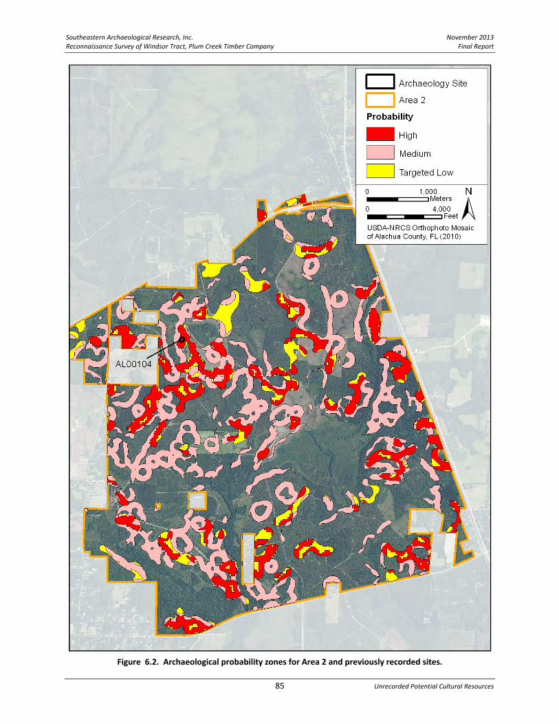
Southeastern Archaeological Research, Inc. November 2013 Reconnaissance Survey of Windsor Tract, Plum Creek Timber Company Final Report
85 Unrecorded Potential Cultural Resources
Figure 6.2. Archaeological probability zones for Area 2 and previously recorded sites.

November 2013 Southeastern Archaeological Research, Inc. Final Report Reconnaissance Survey of Windsor Tract, Plum Creek Timber Company
Chapter 6 86
Area 3 Area 3 is characterized by a north–south running drainage that bisects the landscape. The 1835 GLO map of this area shows two upper forks of the Lochloosa Creek crossing the southern half of the parcel, with the note “inundated by heavy rains” next to the main tributary. Even with these two main drainages crossing Area 3, 49.9% of the parcel has fairly well drained soils (somewhat poorly drained or better) (see Figure 2.6). The west half of Area 3 is better drained than the east half, and there is one large west‐central pocket of moderately well drained soils that abuts a water feature. This 1,863‐acre parcel has been divided into HP (8.3%), MP (20.6%), and targeted LP (2.9%) zones (Figure 6.3). HP zones are concentrated in the west‐central and southeast areas of the parcel. One archaeological occurrence was recorded on the far western edge of Area 3 (AO 1), in a location classified as having medium archaeological probability.
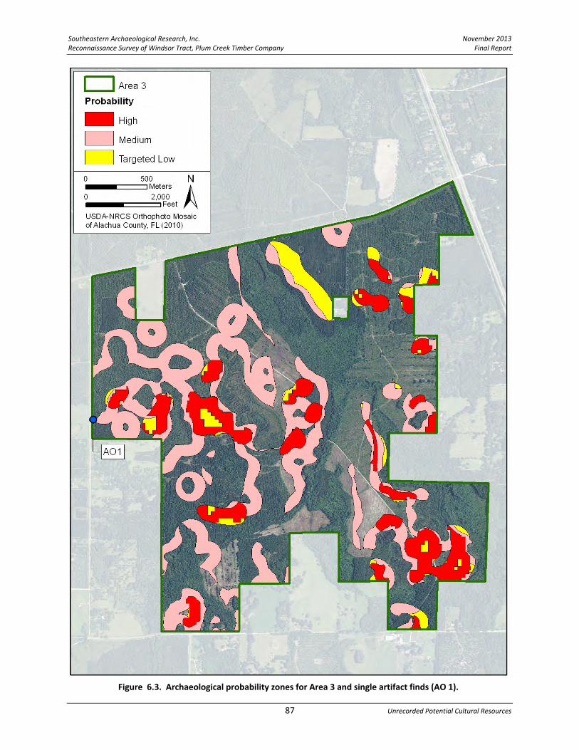
Southeastern Archaeological Research, Inc. November 2013 Reconnaissance Survey of Windsor Tract, Plum Creek Timber Company Final Report
87 Unrecorded Potential Cultural Resources
Figure 6.3. Archaeological probability zones for Area 3 and single artifact finds (AO 1).

November 2013 Southeastern Archaeological Research, Inc. Final Report Reconnaissance Survey of Windsor Tract, Plum Creek Timber Company
Chapter 6 88
Area 4 Area 4 is the parcel closest to Newnans Lake and has a high proportion (63.1%) of poorly drained and very poorly drained soils (see Figure 2.6). Lochloosa Creek bisects the center of Area 4 running north–south, and the two halves of Area 4 are physiographically quite different. West of the creek is an expanse of lowlands extending to Newnans Lake. The east side of the creek is an upland of better drained land. The best drained soils are closest to the town of Windsor and there are isolated areas of moderately well drained soils spread across the parcel. Generally, surface water in this area moves south into Lochloosa Creek, which flows into Lake Lochloosa and from there into Orange Creek and the Ocklawaha River. This 5,536‐acre parcel has been divided into HP (11%), MP (18.3%), and targeted LP (7.3%) zones (Figure 6.4). The central north–south axis of Area 4 is considered an HP and MP testing zone for archaeology because of the proximity to Lochloosa Creek. At its closest, Newnans Lake is only 1/2‐mile from the western boundary of Area 4. Although much of the western half of Area 4 is low and poorly drained, the areas of relatively higher elevation have pinpointed many small MP archaeological zones. The presence of site 8AL2493 near SR 20 illustrates the potential for lithic sites in this area. The site straddles SR 20 and is located in a MP archaeological zone. In addition, two archaeological occurrences occur on the eastern edge of Area 4 (AO 3 and AO 4) within areas identified as having HP or MP classifications. These isolated single artifacts are indicators of prehistoric activity and help in identifying targets for additional Phase I investigation.

Southeastern Archaeological Research, Inc. November 2013 Reconnaissance Survey of Windsor Tract, Plum Creek Timber Company Final Report
89 Unrecorded Potential Cultural Resources
Figure 6.4. Archaeological probability zones for Area 4 and previously recorded sites and single artifact finds (AO 3 and AO 4).

November 2013 Southeastern Archaeological Research, Inc. Final Report Reconnaissance Survey of Windsor Tract, Plum Creek Timber Company
Chapter 6 90
Area 5 Area 5 is the southeastern portion of the Windsor Tract and is not contiguous with the remainder of the property. A tributary of Lochloosa Creek crosses the western extension of Area 5 (shown on the 1835 GLO) and 64.4% of the parcel is poorly drained or very poorly drained soil (see Figure 2.6). A large pocket of moderately well drained soil occurs in the center of the parcel, which corresponds with the area of highest relative elevation. This 1,391‐acre parcel has been divided into HP (8.8%), MP (12.2%), and targeted LP (2.9%) zones, with the HP areas located along the higher elevation ridges on either side of the creek bed (close to SR 20) and along the outer edges of the better‐drained central pocket (Figure 6.5).

Southeastern Archaeological Research, Inc. November 2013 Reconnaissance Survey of Windsor Tract, Plum Creek Timber Company Final Report
91 Unrecorded Potential Cultural Resources
Figure 6.5. Archaeological probability zones for Area 5.

November 2013 Southeastern Archaeological Research, Inc. Final Report Reconnaissance Survey of Windsor Tract, Plum Creek Timber Company
Chapter 6 92
POTENTIAL HISTORIC PROPERTIES Turning from prehistoric archaeological potential to identifying targets of historic occupation, activities on the parcel associated with the earliest landowners within the Windsor Tract can be identified through land records and archival research. The following potential historic property discussion begins with the earliest recorded nineteenth‐century records for this region provided by historic maps and aerials and moves into the twentieth century to pinpoint specific areas of interest within the Windsor Tract. Early Landowners: Nineteenth‐Century Land Patents Many of the early landowners in the project area acquired title to their land from the federal government in the mid‐to‐late nineteenth century. They received their titles through several means, including cash payments, bounty land warrants (i.e., land available in return for military service), or proof of occupancy and improvements to the land. The General Land Office in Washington, D.C. determined if the applicant met the necessary criteria. If so, the individual was granted title to the subject land. The title was known as a land patent (Hawkins 2009). Land patents are helpful in understanding who the early landowners and settlers were in the project area. Land patent certificates contain the name of the individual, the location of the tract of land, the date the patent was awarded, and the size of the tract. In essence, they are similar to a deed record. Historic land patents in the project area can be identified through research in the Bureau of Land Management’s General Land Office Records Automation website, which contains a database of land patents (http://www.glorecords.blm.gov/). Each of the Sections/Township/Ranges of the project area was researched and the results, including land patent locations, are presented in Table 6.1 and Figure 6.6. Research identified 35 nineteenth‐century land grants within the eastern half of the Windsor Tract, awarded to 23 different landowners. Dates of the land patents range from 1849 to 1903. Most of the plots were small 40‐acre parcels, although several landowners purchased multiple small, adjacent plots. Within Area 2, many of the patents are close to present‐day US 301. However, Henry Joiner held title to a full section of land that surrounded the headwaters of Lochloosa Creek near the center of Area 2. Within Area 3, the Gillet brothers, David and George held half of the land patents, while the brothers Samuel and Jasper Gutterey held one patent each and Crompton W. Stokes controlled a 160‐acre plot southwest of Campville. Several land grants were awarded within the Windsor Tract’s Area 5, which is likely a reflection of increased activity closer to the town of Hawthorne, which along with Rochelle were the earliest communities in this region (founded in the late 1840s). Much of the western half of the project area (Township 9 South, Range 21 East and Township 10 South, Range 21 East) was never patented through the federal government because it had been under private ownership (the Arredondo Grant) since Florida became an American Territory in 1821. There were no land patents awarded for Area 1, and within Area 4 only two

Southeastern Archaeological Research, Inc. November 2013 Reconnaissance Survey of Windsor Tract, Plum Creek Timber Company Final Report
93 Unrecorded Potential Cultural Resources
early landowners are noted. One grant belonged to Moses Levy. Moses was a successful merchant and landowner, who between 1818 and 1829, purchased over 90,000 acres in Alachua and Marion Counties. His son was the future Senator David Levy Yulee. Moses Levy’s tract is on the western edge of Areas 2 and 4, immediately east of present‐day Windsor. One full section (640 acres) of land was deeded to the heirs of Moses E. Levy in 1916, which shows that Moses or his heirs must have actively improved this parcel in the nineteenth century. The second grant within Area 4 is a 45‐acre parcel awarded to George Gillet in 1885. It is located on the eastern edge of Area 4. Although the western half of Area 2 was not patented (excepting Levy 1916), additional historical research has identified a large plantation in the area northeast of Windsor. The unrecorded Link Cemetery (discussed below) was initially identified through historic map research and additional archival research into the cemetery revealed that the cemetery and the entire Section 36 was once a plantation owned by Jacob and Christina Link (see Figure 6.6). This tract was adjacent to Moses Levy’s parcel to the north. Research uncovered additional details about early plantations and landowners in this area east and north of Windsor. Link Plantation Historical county records available through Alachua County Ancient Records (http://www.clerk‐alachua‐fl.org/archive/) provide information on past ownership of the land where the Link Plantation is located. Records created after 1885 have not been reviewed to date but should assist in tracing historical ownership of the cemetery. The evidence gathered tells that the Link family acquired the property in 1855 and retained possession as late as 1885. The earliest landowner of the Link Cemetery property is Nehemiah Brush. Brush was one of the early investors in land that is now Alachua County. No evidence has been found that Brush settled or otherwise used the cemetery land or its immediate vicinity. By 1855, Brush was dead and the executors of his will, Eugene Van Ness and Charles Brush (both of New York), sold the Section 36 property to Christina Link in that same year (Alachua County Clerk of Court 1855). Christina Link was the wife of Jacob Link Sr. (Alachua County Clerk of Court 1854). Records suggest that Jacob Sr. died sometime between 1854 and 1855 at the same time Christina purchased the 640 acres from Brush. While Brush did not develop the parcel, Christina certainly did. Her will, submitted to the county clerk in 1867, references that this 640 acres was a “Plantation.” The will does not indicate what crops were being grown although hogs and cattle are mentioned. Household and kitchen furniture also are mentioned as well as a stock of horses that Christina ranged “on Pains Pararie [sic]” (Alachua County Clerk of Court 1867). Christina’s will bequeathed her plantation, hogs, and cattle to her son, Jacob Link Jr. and the horses were to be divided among her children. The will also tells that Christina’s sister, Polly Smith, lived at the plantation and was permitted to remain there should Christina precede her in death (Alachua County Clerk of Court 1867). In agreement with the 1867 will, the 1870 census for Alachua County shows that Christina Link and Polly Smith lived together in Christina’s household (United States Bureau of the Census 1870b).

November 2013 Southeastern Archaeological Research, Inc. Final Report Reconnaissance Survey of Windsor Tract, Plum Creek Timber Company
Chapter 6 94
Table 6.1. Nineteenth‐Century Landowners and Settlers within the Windsor Tract Project Area as Identified in Land Patent Records. Source: Bureau of Land Management’s GLO Record Automation website.
Patentee Date Patented
Township (South)
Range (east)
Section Specifics Acres Area #
Map Key
Francis W. Bellmer 11/30/1885 9 22 18 Lot 3 35 2 A
Charles Smith 6/30/1884 9 22 18 Lot 1 40 2 B
Thomas Williams 6/30/1883 9 22 18 Lot 2 40 2 C
William P. Boulware
5/9/1885 9 22 20 N 1/2 of NW 1/4 40 2 D
Benjamin J. Simmons
3/20/1885 9 22 20 SW 1/4 of SW 1/4 40 2 E
Stephen Sparkman 5/1/1855 9 22 20 E 1/2 of SW 1/4 80 2 F
Stephen Sparkman 11/10/1851 9 22 29 NE 1/4 160 2 G
Nathaniel Jones 8/10/1852 9 22 29 SE 1/4 160 2 H
Benjamin J. Simmons
3/20/1885 9 22 29 SW 1/4 of SW 1/4 40 2 I
Henry Joiner 5/25/1885 9 22 30 Lot 1 640 2 J
Jasper Guthrie 2/1/1861 9 22 32 SE 1/4 of NE 1/4 40 2 K
John C. Harris 2/13/1891 9 22 32 W 1/2 of NW 1/4 80 2 L
James Martin 3/3/1897 9 22 32 W 1/2 of SW 1/4 80 2 M
Stephen Sparkman 5/1/1855 9 22 32 NE 1/4 of N/E 1/4 40 2 N
Stephen Sparkman 5/1/1855 9 22 33 NW 1/4 of NW 1/4 40 2
Toney Wells 7/21/1879 9 22 32 NW 1/4 of NE 1/4 40 2 O
Moses E. Levy 5/9/1916 10 21 1 Entire section 640 2&4 P
Crompton W. Stokes
6/12/1903 10 22 4 S 1/2 of NW 1/4 80 3
Q Crompton W. Stokes
4/1/1859 10 22 4 W 1/2 of SW 1/4 80 3
David Gillet 5/1/1855 10 22 5 NW 1/4 of SW 1/4 40 3
R David Gillet 3/1/1860 10 22 5 SW 1/4 of NW 1/4 40 3
David Gillet 3/1/1860 10 22 6 Lot 1 40 3
David Gillet 5/1/1855 10 22 6 Lot 2 40 3
George Gillet 5/1/1855 10 22 8 NW 1/4 of NW 1/4 40 3 S
George Gillet 5/1/1855 10 22 7 Lot 1 40 3
Jasper Gutterey 5/1/1855 10 22 5 SW 1/4 of SW 1/4 40 3 T
Samuel Gutterey 5/1/1855 10 22 8 SW 1/4 of SW 1/4 40 3 U
Peter B. Perry 4/1/1859 10 22 9 N 1/2 of SW 1/4 80 3 V
George Gillet 5/1/1855 10 22 18 Lot 2 45 4 W
Frank Williams 7/21/1879 10 22 20 SW 1/4 of SE 1/4 40 5 X
William E. Collier 4/1/1859 10 22 21 E 1/2 of NW 1/4 80 5 Y
William E. Collier 4/1/1859 10 22 21 SW 1/4 of NE 1/4 40 5
Samuel Hudson 5/1/1855 10 22 21 NW 1/4 of NE 1/4 40 5 Z
Rease R. Ormand 2/25/1885 10 22 22 SE 1/4 of NW 1/4 40 5 AA
Joseph Mizell 1/1/1849 10 22 22 NE 1/4 160 5 AB

Southeastern Archaeological Research, Inc. November 2013 Reconnaissance Survey of Windsor Tract, Plum Creek Timber Company Final Report
95 Unrecorded Potential Cultural Resources
Figure 6.6. Projected locations of nineteenth‐century land patents within the Windsor Tract, keyed to Table 6.1. Source: Bureau of Land Management’s General Land Office Record Automation website.
November 2013 Southeastern Archaeological Research, Inc. Final Report Reconnaissance Survey of Windsor Tract, Plum Creek Timber Company
Chapter 6 96
Christina Link passed away between the years 1871 and 1874. An 1871 court document has Christina granting horses to her granddaughters, Rebecca P. Beck, Nancy E. Guthrey, and Cary Isabella Guthrey (Alachua County Clerk of Court 1871). This document proves that she was living in 1871. Three years later, in 1874, a deed transaction directly refers to Christina Link as deceased (Alachua County Clerk of Court 1874). By the terms of her 1867 will, ownership of her plantation should have passed to her son, Jacob Jr. Yet it appears that the will had changed since that time because the 1874 deed shows other family members as heirs (and not Jacob Jr.). These heirs included Mary Jane Perry and Joseph Beck, both of whom were later buried in Link Cemetery (discussed below). The reason for this discrepancy may not matter as much as the fact that the 1874 deed transferred the 640‐acre plantation to Jacob Jr. (Alachua County Clerk of Court 1874). Beginning in 1876 and continuing to at least 1885, Jacob Jr. and his wife Priscilla sold off portions of the 640‐acre plantation. The buyers included M.H. Ormand (Alachua County Clerk of Court 1876), Daniel F. Perry (Alachua County Clerk of Court 1883a) who likely was a relative, Julius A. Carlisle (Alachua County Clerk of Court 1883b), and John C. Thigpin, who ran a plantation to the northwest (Alachua County Clerk of Court 1885b). None of these transactions included the cemetery portion of the 640‐acre property. Plantations within the Arredondo Grant Even though no land patents were awarded by the federal government for the Arredondo Grant area, other sources of information point to early landowners and plantations in the generally vicinity of Windsor. Early historical information on the Windsor area (Webb 1885) notes that the area had several cotton plantations by 1846. This 1885 source may also have been making reference to the Madison Starke Perry plantation near Rochelle or the Scott/King “Grove Park Plantation”. The structures depicted on the 1846 Arredondo map (Burr 1846) and identified as “Thigpen”, “Pierce”, and “Adams” appear to note plantations, but at the very least, denote homesteads (Figure 6.7). All three of these properties are in the vicinity of present‐day CR 234, north of Windsor. The Thigpen property and possibly the Adams property appear to be inside the boundaries of Windsor Tract Area 2, although due to the imprecise nature of early maps, this may not be the case. Depending on the size of Pierce’s operation, it is possible that a portion of this plantation extended on to the Windsor Tract as well. As mentioned above, the Thigpen family purchased land from the Link estate, and it is possible that these families may have been related.

Southeastern Archaeological Research, Inc. November 2013 Reconnaissance Survey of Windsor Tract, Plum Creek Timber Company Final Report
97 Unrecorded Potential Cultural Resources
Figure 6.7. Arredondo Grant map showing partial Windsor Tract boundary and three plantation houses along north‐south running road (present‐day CR 234).

November 2013 Southeastern Archaeological Research, Inc. Final Report Reconnaissance Survey of Windsor Tract, Plum Creek Timber Company
Chapter 6 98
Unrecorded Cemeteries The FDOT cemetery database (2006) provides the locations of 12 unrecorded cemeteries (including the Link Cemetery) within the general vicinity of the Windsor Tract (Table 6.2, Figure 6.8). A single additional cemetery was noted on a 1953 General Highway map (FDOT 1953) and is included here, making the total number 13. Only the Link Cemetery is on the Windsor Tract property; one cemetery is within an outparcel of Area 4 (St. Pauls). The St. Pauls Cemetery contains burials from the nineteenth century (earliest ca. 1884). The remainder of the unrecorded cemeteries are within one mile of the Windsor Tract boundaries but are outside the tract:
Hatchet Creek Cemetery is approximately one mile west of Area 1.
An unknown cemetery (#1) is recorded approximately 500 east of Area 2.
The Waters Cemetery is located to the west of SE 210th Terrace, between US 301 and CR 219A, and is approximately one mile east of Area 3.
An unknown cemetery (#2) is shown on the 1953 General Highway map at the southeast corner of SE 24th Avenue and SE 171th Street on the boundary of Area 3.
The Grove Park Cemetery is located on the north side of SR 20 between SE 155th Street and SE 159th Street and is approximately 400 m outside of Area 4, within the community of Grove Park.
The African‐American Grove Park Cemetery (also known as Odum Grave) is approximately 500 m south of Area 4.
The Kelly Cemetery is located south of the previously recorded Providence Cemetery in Windsor (discussed above). It is less than 200 m west of the Area 4 boundary in the community of Windsor.
The Hawthorne Baptist Cemetery is located approximately 1 km southeast of Area 5.
The Townsend Cemetery is located on the south side of SE 49th Place and is halfway between Areas 4 and 5.
The Jones Green Cemetery is approximately 1.5 km south of Area 5.
The Smith Family Cemetery is located between US 301 and the S.A.L. Railroad, approximately 95 m east of the northeast corner of Area 5.
This information is presented to provide further information of the number and type of cemeteries found in this region; no future investigations will be undertaken on resources that fall outside the Windsor Tract boundary. However, several of these cemeteries are quite close to the parcel boundaries. The Smith Family Cemetery in north Hawthorne and the unnamed cemetery south of Area 3 are both less than 100 m from the Windsor Tract, while the St. Pauls Cemetery is itself an outparcel of the Windsor Tract. If the edges of these cemeteries are not clearly defined they could be of possible concern during future work. During Phase I work, the boundaries of any cemetery within 100 m of the Windsor Tract boundaries should be confirmed.

Southeastern Archaeological Research, Inc. November 2013 Reconnaissance Survey of Windsor Tract, Plum Creek Timber Company Final Report
99 Unrecorded Potential Cultural Resources
Table 6.2. Unrecorded Cemeteries in the General Vicinity of the Windsor Tract.
Cemetery Name Other Name Address T R S Year Cemetery Type
Area #
Unrecorded Cemeteries within Windsor Tract
Link Cemetery
Near CR 234 9 21 36 ca. 1901
Family Area 2
Unrecorded Cemeteries within One‐Mile Buffer of the Windsor Tract
Hatchet Creek Cemetery
Pons Cemetery NE 73rd Place 9S 21E 15 ca. 1861
Unknown West of Area 1
Unknown Name
Cemetery #1
Near 301 and SR
26 9 22 20 ?? Unknown Area 2
Waters Cemetery
SE 210th Terrace 10S 22E 3 ca. 1901
Unknown East of Area 3
Unknown Name Cemetery #2
SE 24th Avenue and SE 171st Street‐SE corner
10S 22E 17 ?? Unknown South of Area 3
Grove Park Cemetery
Old Grove Park Cemetery
SE 159th Street 10S 22E 19 ca. 1886
Community South of Area 4
Grove Park Cemetery (African American)
Odum Grave SE CR 2082 10S 21E 25 ca. 1912
Unknown South of Area 4
St. Pauls Cemetery SE 122nd Terrace 10S 21E 14 ca. 1884
Religious Area 4
outparcel
Kelly Cemetery Christa Delphian Cemetery
SE 135th Terrace 10S 21E 2 ca. 1890
Unknown West of Area 4
Hawthorne Baptist Cemetery
Old Hawthorne Cemetery or Pleasant Grove
SE 65th Avenue/ Johnson Street
10S 22E 26 ca. 1861
Religious SE of Area 5
Townsend Cemetery
SE 49th Place 10S 22E 20 ca. 1872
Family Between
Areas 4 & 5
Jones Green Cemetery
Moore Cemetery SE 200th Drive 10S 22E 33 ca. 1900
Unknown South of Area 5
Smith Family Cemetery
US 301 10S 22E 22 ca. 1951
Family East of Area 5

November 2013 Southeastern Archaeological Research, Inc. Final Report Reconnaissance Survey of Windsor Tract, Plum Creek Timber Company
Chapter 6 100
Figure 6.8. Unrecorded cemeteries within the project area and within a one‐mile radius of the Windsor Tract boundary.

Southeastern Archaeological Research, Inc. November 2013 Reconnaissance Survey of Windsor Tract, Plum Creek Timber Company Final Report
101 Unrecorded Potential Cultural Resources
Link Cemetery Link Cemetery is located in a wooded area east of the community of Windsor within Area 2 of the Windsor Tract. This cemetery has not been previously recorded with the FMSF. Specifically, the cemetery is located in the eastern half of Section 36 of Township 9 South, Range 21 East. Two inscribed grave markers at the Link Cemetery identify burials: Mary Jane Perry (1828‐1901) and Joseph Beck (dates unknown). A dilapidated metal fence generally demarcates the cemetery boundaries; however, as there is the potential for unmarked graves in the Link Cemetery, this observed boundary may not be accurate. The cemetery does not appear to be in use at the present. The earliest burial, Mary Jane Perry, occurred in 1901. Her headstone notes that she was the wife of W.S. Perry. As noted above, both Mary Jane Perry and Joseph Beck were heirs of Christina Link and likely part of her extended family. Historical evidence suggests that the Link Cemetery was a private family cemetery. Information about burials at Link Cemetery was obtained from Plum Creek Timber Company, the Alachua County Virtual Cemetery Project (http://www.wizardofar.org/), and Find‐a‐Grave (http://www.findagrave.com/). Further information was sought on the Perrys in historical census records. These records support that Mary Jane Perry was the wife of William S. Perry, an Alachua County planter. William and Mary appear in the 1860 census for Alachua County as free whites. William was born about 1826. Their household included five children. The Perrys likely had a number of slaves although they are not noted in the 1860 census. The 1860 census also states that the Perrys, like many early settlers in Alachua County, hailed from South Carolina (Johns 1963; United States Bureau of the Census 1860). William and Mary Jane Perry possibly were related to Madison Starke Perry, another early Alachua County (Rochelle) plantation owner (See Chapter 3). William and Mary Jane Perry remained in Alachua County after the Civil War (United States Bureau of the Census 1870a). In the ten years since 1860, two new children had been born, bringing the number of individuals in the household to nine. William S. Perry likely is the same W.S. Perry who is buried at the Hawthorne Baptist Cemetery in Hawthorne. The marker tells that he died in 1880 and provides a birth date of 1826, which is in agreement with the census records (http://www.wizardofar.org/). Mary Jane outlived her husband by 20 years and never remarried. It is curious that she was not buried next to her husband. Joseph Beck is the second of the two identified burials at Link Cemetery. The marker does not provide dates but notes that he was a veteran who served in the Confederate Army in Company I of the 7th Florida Infantry. These details provide further information on Beck. The 7th Florida Infantry was mustered into service at Gainesville in April of 1862. Madison Starke Perry served as Colonel. The first assignment of the 7th Infantry was to Tennessee where its men, including Joseph Beck, would fight in numerous campaigns until the close of the war in 1865. Muster rolls for Company I list “J.J. Beck,” adding that he “mustered out” of this company at the end of the war in April of 1865, meaning he survived the war. However, he returned home without his right eye, which he had lost during a bout with smallpox while serving in Tennessee (Florida Board of State Institutions 1903).

November 2013 Southeastern Archaeological Research, Inc. Final Report Reconnaissance Survey of Windsor Tract, Plum Creek Timber Company
Chapter 6 102
Further information on Joseph Beck was sought in census records (United States Bureau of the Census 1900). The 1900 Alachua County census tells that Beck was a white male, born in 1845, who was occupied as a farmer. This birth date indicates that he entered war service at the young age of 17. Beck’s wife, Amelia, was 67 (12 years his senior) in 1900. Both were born in South Carolina but, as Beck’s war enlistment proves, the family was living in Alachua County by 1862. Ameila had given birth to 11 children in her lifetime; seven were still living in 1900. Joseph Beck and his wife Amelia are listed in the 1910 census for Alachua County as residents of the Campville area. At the time, Beck was about 65. This evidence indicates that the undated Beck burial site post‐dates 1910. The Becks were not found in the 1920 census, suggesting that Joseph Beck died sometime between 1910 and 1920. The grave of Joseph Beck was noted in a 1941 register of deceased veterans in Alachua County (Veterans Graves Registration Project 1941). The information in this publication is identical to that of Beck’s grave marker, which says “Joseph Beck Florida PVT CO 17 REGT FLA INF Confederate States Army”. The grave marker for Beck appears to be fairly modern, suggesting that it was placed at his unmarked (or poorly marked) gravesite many years after his death and perhaps by an organization concerned with marking veteran burials such as the Daughters of the American Revolution or the Sons of Confederate Veterans. The placing of this new marker may have been a consequence of the 1941 study (Veterans Graves Registration Project 1941).
Potential Unrecorded Historic Structures, Roads, Railways, and Bridges A review of Alachua County Property Appraiser data revealed no historic structures within the boundaries of the Windsor Tract. This along with the lack of previously recorded FMSF structures suggests that the potential for extant structures within the Windsor Tract is low. However, a review of historic maps and aerials indicates that the potential for at least the remnants of structures (historic archaeological sites) and associated roads and bridges within the bounds of the Windsor Tract is relatively high. The 1936 General Highway Map, the 1937 aerial photograph, and the 1944 USGS Hawthorne quadrangle (among others) indicate that structures were once scattered across the project area (FDOT 1936, 1953; USDA 1937; USGS 1944). Several bridges are noted and one unrecorded railway abuts the eastern boundary of the project area. In some cases, resources that abut the Windsor Tract boundary (such as the S.A.L. Railroad and the A.C.L. Railroad) may have had associated historic activities that occurred within the project area and such evidence may still be present. This can be determined through the Phase I survey process. Each of the five Areas of the Windsor Tract will be examined individually for the presence of historic features as recorded on historic maps and aerials. The following graphic representations consist of the 1944 Hawthorne quadrangle map overlain on the 1937 USDA aerial photograph with historic features such as roads, bridges, structures, and cleared agricultural parcels (potential farmsteads) highlighted for each of the five Areas. Older roads and other known historic features have been superimposed on these area maps from relevant

Southeastern Archaeological Research, Inc. November 2013 Reconnaissance Survey of Windsor Tract, Plum Creek Timber Company Final Report
103 Unrecorded Potential Cultural Resources
sources extending back to 1846 (Arredondo map). The resulting images provide a general overview of historic activities within each area. Although it is likely that most of these historic features are no longer extant, they act as targets to guide and focus future Phase I archaeological and historic structure surveys.

November 2013 Southeastern Archaeological Research, Inc. Final Report Reconnaissance Survey of Windsor Tract, Plum Creek Timber Company
Chapter 6 104
Area 1 Area 1 appears as planted pines in aerial photographs going back to 1968 and it is not until this time that the primary logging road first becomes visible. Prior to this, as seen on aerials extending back to 1937, the area was undeveloped except for a handful of farmsteads and unpaved trails. Roads and Bridges. The earliest historic feature within Area 1 is the 1846 north–south trail that follows the west side of the Windsor Tract (Figure 6.9). The 1846 Arredondo Grant map shows a road running along on the east side of Lake Pithlachocco (Newnans Lake) that extends onto the western portion of Area 1 (see Figure 4.6 for Arredondo map). The road crosses the eastern branch of Hatchet Creek, indicating some type of crossing, either a ford or a bridge, was once located here. On the 1944 quadrangle map and the 1937 aerial, a road is visible in a similar location extending north from the intersection of SR 26 and CR 234 that also crosses this branch of Hatchet Creek. Each of the reviewed maps and aerial photographs that post‐date 1937 shows this similar road location, suggesting an extended period of use for this path. Where it extends south of SR 26, it appears that the historic alignment has been incorporated into what is now CR 234. The unpaved segment that extends north of SR 26 is still visible on the 2010 aerial with the northern portion graded near the Hatchet Creek crossing and the southern portion unimproved (see Figure 1.3). It is possible that some evidence of this original nineteenth‐century road and bridge may still be present on the parcel and it may retain some historic integrity. A second potential bridge is noted in the northeast corner of the parcel where a road shown on the 1944 quadrangle map crosses an upper tributary of Hatchet Creek. Structures. Four twentieth‐century farmsteads are visible on the 1944 quadrangle that may contain residences or perhaps outbuildings such as barns (Figure 6.9). Two structures are located within the area of better drained soils near the center of the parcel (see Figure 2.6) at the end of a private road leading north from present‐day SR 26. Two additional structures occur in the far northwest corner of Area 1 adjacent to an unimproved east–west road. On the 1937 aerial, three cleared plots are visible: two are associated with the structures near the center of Area 1, and the other area is near the intersection of present‐day SR 26 and CR 234. A structure can be seen on the 1937 aerial associated within this cleared area at the road intersection. The previously recorded farmstead of 8AL3055 is off the property to the north and two structures are visible within the site boundary on the 1944 map. The following are recommendations for future work. The footprint of the potentially historic road, particularly the segment in the far northwest corner of Area 1 where the road crosses upper Hatchet Creek, should be investigated during Phase I survey to ascertain if any evidence of the historic road and water crossing (bridge or ford) is still present in this location. The second bridge in the northeast corner of the Area should be visited and assessed. In total, five potential historic farmsteads have been identified within Area 1, three of which occur on the parcel boundaries. These five areas should be targeted during Phase I survey to ascertain if any historic cultural features are still present in these locations.
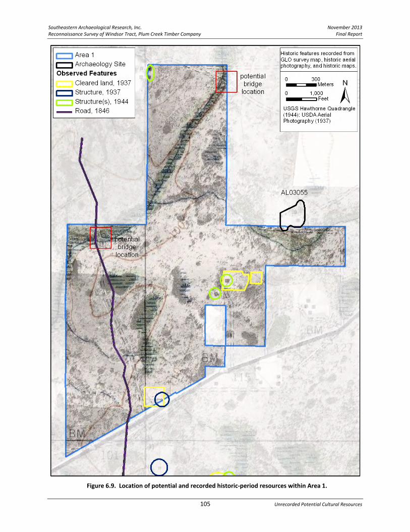
Southeastern Archaeological Research, Inc. November 2013 Reconnaissance Survey of Windsor Tract, Plum Creek Timber Company Final Report
105 Unrecorded Potential Cultural Resources
Figure 6.9. Location of potential and recorded historic‐period resources within Area 1.

November 2013 Southeastern Archaeological Research, Inc. Final Report Reconnaissance Survey of Windsor Tract, Plum Creek Timber Company
Chapter 6 106
Area 2 Area 2 extends between the towns of Orange Heights to the northeast, Campville to the southeast, and Windsor to the southwest. The northwest corner encounters the outskirts of Gainesville. Historically, residences associated with these small towns extended onto what is now the Windsor Tract, especially in the area of Campville. Although there are no previously recorded structures within Area 2, there was activity in this region dating back at least to the mid‐nineteenth century, when the area supported several plantations and later smaller farmsteads. It was not until the 1960s that Area 2 became primarily a planted pine forest crossed by timber roads. Railways, Roads, and Bridges. The boundaries of Area 2 abut several major roadways: US 301 to the east, CR 234 to the west, SR 26 to the north, and CR 1474 to the south. As discussed for Area 1, the mid‐nineteenth‐century road visible on the 1846 GLO map extends north–south on the western boundary of Area 2; it appears to be in the same place as present‐day CR 234 (Figure 6.10). Due to the construction of CR 234, evidence of this original road is likely obliterated; however, in the far northwest corner of Area 2 it is possible that evidence of the old road could be encountered on the west side of CR 234 (near the Thigpen Plantation) Between US 301 and Area 2’s eastern boundary is the Seaboard Air Line (S.A.L.) Railroad, which is historically the Peninsular Railroad that connected the towns of Orange Heights, Campville, Rex, and Hawthorne starting in 1879. The S.A.L./Peninsular Railroad corridor is recorded in Marion County (8MR3346), where it has been determined potentially eligible for listing in the NRHP by the Florida SHPO. The portion of this historic railway that crosses Alachua County is presently unrecorded with FMSF, but it has the potential to be a significant resource. If any portions of the original S.A.L./Peninsular Railroad or remnants of historic activities associated with the railroad fall within the boundaries of the Windsor Tract, they should be recorded and evaluated. Two unrecorded railroad bridges are noted on the eastern border of Area 2 located at crossings over Lochloosa Creek. If any portion of these bridges fall within the Windsor Tract boundary they should be recorded and evaluated. Two additional bridges are associated with private roads on the interior of Area 2 as they cross the upper drainages of Lochloosa Creek (FDOT 1964, see Figure 4.7). The two private road bridges are potentially extant and should be targeted during Phase I survey to ascertain if these cultural features are still present in these locations and further research should be undertaken to determine their age and historic potential. It should be noted that the two bridges on CR 1474 have been previously recorded and date to 1990 and are not of concern here. All these bridge locations have been highlighted on Figure 6.10. No roads are shown within the interior portion of Area 2 on the 1936 General Highway Map (see Figure 4.4); however, the 1944 quadrangle and early aerial photographs show several roads that are mostly restricted to the southern half of Area 2. Each of these roads at one time led to historic farmsteads.

Southeastern Archaeological Research, Inc. November 2013 Reconnaissance Survey of Windsor Tract, Plum Creek Timber Company Final Report
107 Unrecorded Potential Cultural Resources
Figure 6.10. Location of potential historic‐period resources within Area 2.
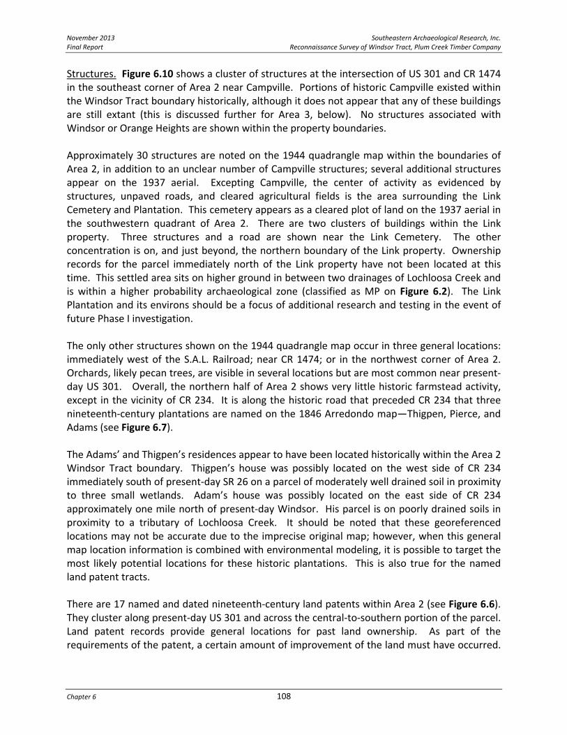
November 2013 Southeastern Archaeological Research, Inc. Final Report Reconnaissance Survey of Windsor Tract, Plum Creek Timber Company
Chapter 6 108
Structures. Figure 6.10 shows a cluster of structures at the intersection of US 301 and CR 1474 in the southeast corner of Area 2 near Campville. Portions of historic Campville existed within the Windsor Tract boundary historically, although it does not appear that any of these buildings are still extant (this is discussed further for Area 3, below). No structures associated with Windsor or Orange Heights are shown within the property boundaries. Approximately 30 structures are noted on the 1944 quadrangle map within the boundaries of Area 2, in addition to an unclear number of Campville structures; several additional structures appear on the 1937 aerial. Excepting Campville, the center of activity as evidenced by structures, unpaved roads, and cleared agricultural fields is the area surrounding the Link Cemetery and Plantation. This cemetery appears as a cleared plot of land on the 1937 aerial in the southwestern quadrant of Area 2. There are two clusters of buildings within the Link property. Three structures and a road are shown near the Link Cemetery. The other concentration is on, and just beyond, the northern boundary of the Link property. Ownership records for the parcel immediately north of the Link property have not been located at this time. This settled area sits on higher ground in between two drainages of Lochloosa Creek and is within a higher probability archaeological zone (classified as MP on Figure 6.2). The Link Plantation and its environs should be a focus of additional research and testing in the event of future Phase I investigation. The only other structures shown on the 1944 quadrangle map occur in three general locations: immediately west of the S.A.L. Railroad; near CR 1474; or in the northwest corner of Area 2. Orchards, likely pecan trees, are visible in several locations but are most common near present‐day US 301. Overall, the northern half of Area 2 shows very little historic farmstead activity, except in the vicinity of CR 234. It is along the historic road that preceded CR 234 that three nineteenth‐century plantations are named on the 1846 Arredondo map—Thigpen, Pierce, and Adams (see Figure 6.7). The Adams’ and Thigpen’s residences appear to have been located historically within the Area 2 Windsor Tract boundary. Thigpen’s house was possibly located on the west side of CR 234 immediately south of present‐day SR 26 on a parcel of moderately well drained soil in proximity to three small wetlands. Adam’s house was possibly located on the east side of CR 234 approximately one mile north of present‐day Windsor. His parcel is on poorly drained soils in proximity to a tributary of Lochloosa Creek. It should be noted that these georeferenced locations may not be accurate due to the imprecise original map; however, when this general map location information is combined with environmental modeling, it is possible to target the most likely potential locations for these historic plantations. This is also true for the named land patent tracts. There are 17 named and dated nineteenth‐century land patents within Area 2 (see Figure 6.6). They cluster along present‐day US 301 and across the central‐to‐southern portion of the parcel. Land patent records provide general locations for past land ownership. As part of the requirements of the patent, a certain amount of improvement of the land must have occurred.

Southeastern Archaeological Research, Inc. November 2013 Reconnaissance Survey of Windsor Tract, Plum Creek Timber Company Final Report
109 Unrecorded Potential Cultural Resources
It is likely that structures were associated with these parcels. Site probability modeling can be used to pinpoint potential locations for historic homesteads within these patented tracts. Phase I survey priorities should include investigation and evaluation of (1) the southwest quadrant of Area 2 within and surrounding the Link Plantation, (2) the area formerly within the town of Campville, (3) the two bridges within Area 2, (4) the vicinity of the S.A.L. Railroad and bridges (noting only features that fall within the Windsor Tract boundary), (5) the northwest corner of Area 2 where evidence of the original north–south 1846 road may be present, and (6) the potential locations of the Thigpen and Adams’ plantations adjacent to present‐day CR 234. These six areas should be targeted during Phase I survey to ascertain if any historic cultural features are still present in these locations. Any identified resources should be evaluated for their age and historic significance.

November 2013 Southeastern Archaeological Research, Inc. Final Report Reconnaissance Survey of Windsor Tract, Plum Creek Timber Company
Chapter 6 110
Area 3 Like Area 2, Area 3 abuts the historic town of Campville. In the northeast corner of Area 3, the 1937 aerial photograph shows a small housing community of Campville with approximately 20 buildings set in rows parallel to the S.A.L. Railroad. The 1944 quadrangle map does not show these structures but illustrates several large blocks that possibly represent a high density of buildings within close spacing to one another (Figure 6.11). By 1956, the majority of the area appears cleared in the aerial photograph, leaving approximately five extant buildings. The 2010 aerial shows planted pine in this area with no visible structures (see Figure 1.3). It is recommended that during future Phase I work the northeast corner of Area 3 be investigated to ascertain the presence of historical structures, features, or archaeology sites associated with either the town of Campville or the activities of the S.A.L./Peninsular Railroad.
Structures. A dominant feature on the early aerial photographs are orchards, likely pecan groves. The east‐central edge of Area 3 shows extensive groves in the same location as the nineteenth‐century Crompton Stokes land grants (see Figure 6.6). These groves are no longer present on the 1956 aerial photograph. The large outparcel between Areas 3 and 4 also contained orchards in 1937, scattered along present‐day CR 13B. A small community of rural residences has been present along the roads separating Area 3 and Area 4 from at least the early part of the twentieth century, and several of these operations focused on pecan production. This unnamed pecan‐farming community even had a local cemetery (see Figure 4.6, FDOT 1953). All the structures and the unnamed cemetery (#2) appear to be outside the Windsor Tract boundaries, although this should be confirmed during future Phase I survey. The 1949 aerial indicates that many of the orchards in this area had been left wild for a period of time and were no longer functioning farms. A second cluster of cleared agricultural plots with scattered buildings and two access roads is visible in the southwest quadrant of Area 3 on either side of the east–west Lochloosa Creek drainage. The largest of these cleared plots overlaps the location of George Gillet’s nineteenth‐century land patent. There are five named and dated nineteenth‐century land patents within Area 3 (including Gillet and Stokes, see Figure 6.6). All are located on the higher, drier ground on either side of the main Lochloosa drainage and each of these land grant locations corresponds to recommended HP and MP archaeological zones, which should be tested during future Phase I investigations. Outside of Campville, six structures are visible on the 1944 quadrangle (see Figure 6.11); each adjacent to an unimproved road. On the 1937 aerial, seven cleared agricultural plots and an additional six structures are visible. The Area 3 farmsteads fall well within the parcel boundaries and provide targets for additional historical investigation and Phase I survey. In summary, the Phase I survey priorities should include investigation and evaluation of (1) the area formerly within the town of Campville that falls within the Windsor Tract, (2) the former pecan‐growing community in the southwest quadrant of the Area, including Unnamed Cemetery #2, whose location should be verified as outside the Windsor Tract; and (3) potential additional farmstead locations as shown on the historic maps and aerial photographs.

Southeastern Archaeological Research, Inc. November 2013 Reconnaissance Survey of Windsor Tract, Plum Creek Timber Company Final Report
111 Unrecorded Potential Cultural Resources
Figure 6.11. Location of potential historic resources within Area 3.

November 2013 Southeastern Archaeological Research, Inc. Final Report Reconnaissance Survey of Windsor Tract, Plum Creek Timber Company
Chapter 6 112
Area 4 Because Area 4 extends to the boundaries of the small towns of Windsor and Grove Park, it is likely that historic activities identified within the Windsor Tract relate to these historic communities. However, historic activity in the vicinity of this parcel dates back well into the nineteenth century, as evidenced by the 1846 road that parallels the western edge of the Windsor Tract (Figure 6.12). Somewhat earlier, the 1812 battle at Newnans Fort (8AL3525) took place just outside the southwest edge of Area 4. Although there is evidence of historic activity, much of Area 4 consists of slow‐moving drainages associated with Lochloosa Creek and, in particular, the western half of the parcel is poorly drained and not well suited to permanent settlement. The modern configuration of roads and logging roads is visible on aerial photographs beginning in 1968. The boundaries of Area 4 abut the major roadways of CR 234 to the west and SR 20 to the south, but generally excludes the potentially historic structures and features in the area; the FMSF records no historic properties within the parcel. Railways, Roads, and Bridges. Although the 1846 road crosses the Windsor Tract in Area 1 and a portion of Area 2, it does not appear to fall within Area 4 at all. The georeferenced location places the road west of CR 234 and closer to Newnans Lake; however, due to the imprecision of historic mapping this may not be accurate. It is also possible the road shifted east over time farther away from the edge of Newnans Lake. Running parallel to SR 20 is the A.C.L. (Florida Southern) Railroad corridor, which generally falls one‐half mile south of the Area 4 boundary, coming closest to the Windsor Tract at the railstop of Grove Park. One FDOT recorded non‐historic bridge is located on SR 20. As this portion of SR 20 was reconstructed as a divided highway in 2004, it is possible the earlier bridge may still be extant. A second unrecorded bridge appears to be present within Area 4, located on the road extending east from Windsor at the point of the Lochloosa Creek crossing (see Figure 6.12). If any portion of these bridges fall within the Windsor Tract boundary they should be recorded and evaluated. No roads on the interior of the parcel are shown on the General Highway Maps (FDOT 1936, 1953, 1964); however, the 1944 quadrangle shows an unpaved road leading from Grove Park directly to Windsor and a second road heading north and then west to meet CR 234. Farmsteads and agricultural plots are associated with these roads and their offshoots. One road spur leads to St. Pauls Cemetery near the center of Area 4. Structures. Approximately 13 structures are noted on the 1944 quadrangle map within the boundaries of Area 4, in addition to one orchard and associated structure visible on the 1937 aerial photograph (see Figure 6.12). Eight cleared agricultural plots can be seen on the 1937 aerial. The center of activity within Area 4, evidenced by structures, unpaved roads, and cleared fields, is the area directly east and south of Windsor. The largest farmstead is located

Southeastern Archaeological Research, Inc. November 2013 Reconnaissance Survey of Windsor Tract, Plum Creek Timber Company Final Report
113 Unrecorded Potential Cultural Resources
Figure 6.12. Location of potential and recorded historic resources within Area 4.

November 2013 Southeastern Archaeological Research, Inc. Final Report Reconnaissance Survey of Windsor Tract, Plum Creek Timber Company
Chapter 6 114
immediately east of Windsor in an area of moderately well drained soils and adjacent to a small pond. At least two structures are mapped in this area along with several possible outbuildings. The large farm is adjacent to two Windsor cemeteries (Providence Methodist Church Cemetery and Kelly Cemetery) that appear to be approximately 200 m outside the boundary of Area 4. This large farm falls within the Section that was deeded to the heirs of Moses E. Levy in 1916, who was one of the original homesteaders in Alachua County. This parcel likely would have been originally developed in the mid‐to‐late nineteenth century. Only one additional nineteenth‐century land patent occurs within Area 4—a small 45‐acre plot belonging to George Gillet (1855) located on the higher ground near the eastern tributary of Lochloosa Creek at the very eastern edge of Area 4 (see Figure 6.6). Moving south from Windsor, there is a pocket of moderately well drained soils near the center of Area 4 in the location of two agricultural plots, at least three structures, and the St. Pauls Cemetery. A small farming community was once located here. At the southern end of Area 4, a few structures occur along the north side of SR 20 on the outskirts of Grove Park that may still be extant. While the eastern side of Area 4 has generally less surface water and better drained soils than the west, structures and unpaved roads are limited and most settlement east of Lochloosa Creek falls outside the Windsor Tract boundary. Phase I survey priorities for Area 4 should include investigation and evaluation of (1) the southwest edge of Area 4 where the 1812 Patriot War battle at Newnans Fort occurred, (2) within the Moses Levy Heirs land patent, in particular the southwest corner closest to Windsor, (3) the private road bridge over Lochloosa Creek, (4) the community in the vicinity of St. Pauls Cemetery near the center of Area 4, and (5) potential structures and historic bridges located outside of Grove Park near SR 20. These five areas should be targeted during Phase I survey to ascertain if any historic cultural features are still present in these locations. Any identified resources should be evaluated for their age and historic significance. Although the three cemeteries (St. Pauls, Kelly, and Providence Methodist Church) are outside the Windsor Tract, it is recommended they be visited during the Phase I survey to ascertain boundaries and be sure that no unmarked graves occur within the Windsor Tract. Area 5 Area 5 first appears as planted pines traversed by an improved logging road on the 1968 aerial photograph. Earlier on the 1949 and 1937 aerials the parcel appears to be undeveloped, forested land with scattered ponds and sloughs. Because Area 5 is close to the outskirts of Hawthorne (and Rex) there are residences just beyond the boundaries of the Windsor Tract on its southern and eastern sides. Hawthorne is one of the few communities in this area that continued to grow in population and size in the mid‐twentieth century. There are numerous cemeteries in the vicinity of Hawthorne, but only one is near the border of Area 5: the Townsend Cemetery located 300 m outside its western edge (east of the mapped area on Figure 6.13). Townsend Cemetery is too far outside the Windsor Tract boundary to be of concern for the present project.

Southeastern Archaeological Research, Inc. November 2013 Reconnaissance Survey of Windsor Tract, Plum Creek Timber Company Final Report
115 Unrecorded Potential Cultural Resources
Figure 6.13. Location of potential historic resources within Area 5.

November 2013 Southeastern Archaeological Research, Inc. Final Report Reconnaissance Survey of Windsor Tract, Plum Creek Timber Company
Chapter 6 116
Structures, Roads, and Railroads. Only the southern edge of Area 5 abuts the S.A.L./Peninsular Railroad (1879) and the corridor falls on the edge the tract boundary. The 1944 quadrangle map and 1937 aerial photograph shows that the northeast quadrant of Area 5 had at least five and potentially more structures associated with cleared agricultural lands (Figure 6.13). An additional three structures are seen in the southern portion of the project. All these structures are located fairly close to the railroad line. The only indications of cultural activity in the remainder of the parcel are several undeveloped roads. Although evidence for settlements in the twentieth century is minimal within Area 5, there are five landowners who were granted patents on these lands in the nineteenth century. Frank Williams’ parcel (1879) is located near the tributary of Lochloosa Creek at the far western corner of Area 5, this area has been designated an HP archaeological zone (see Figure 6.5). The better drained soils within Area 5 are located in the central zone where three of the historic land patents occur. The final grant covers the eastern section where the later development is concentrated near the railroad. It is recommended that the HP archaeological zones within each of the five nineteenth‐century land grants should be targeted during Phase I survey to ascertain if any historic cultural features are still present in these locations. In sum, Chapters 5 and 6 combined have presented the results of research into documented cultural resources within the Windsor Tract, as well as presented ways to predict the locations of undocumented, potential cultural resources. The primary methods employed in this pursuit were (1) environmental modeling to predict archaeological site locations, and (2) historic research using land patent records, historic maps, and historic aerials to target locations with indications of historic activity. The results of this preliminary work provide the basis for the research design that will guide future Phase I cultural resource studies within the Windsor Tract.

Southeastern Archaeological Research, Inc. November 2013 Reconnaissance Survey of Windsor Tract, Plum Creek Timber Company Final Report
117 Conclusions
CHAPTER 7 CONCLUSIONS
Southeastern Archaeological Research, Inc., (SEARCH) was contracted by the Plum Creek Timber Company, Inc., to perform this Cultural Resource Reconnaissance Assessment of the Windsor Tract in east Alachua County, Florida. The research on this tract was conducted as due diligence to provide information on the location and type of known or anticipated cultural resources. The goal of this research was to identify areas of high cultural resource probability. This information will be utilized for planning and preservation, and in anticipation of compliance and permitting requirements. The Windsor Tract encompasses approximately 17,300 acres in eastern Alachua County. To date, no systematic cultural resource surveys have been conducted on this property. Background research indicates prehistoric activity at least back to the Early Archaic period (8000 years B.C.) in the vicinity of the Windsor Tract and based on background information gathered for this project, there is the potential for unknown prehistoric archaeological sites to be present on the property particularly in areas identified in this study as high probability areas. Research into the historic uses of the Windsor Tract indicates the potential for remains of historic structures, historic roads, railroads, bridges, and historic cemeteries that may be present within the property boundary as identified in historic maps and aerial photographs.

November 2013 Southeastern Archaeological Research, Inc. Final Report Reconnaissance Survey of Windsor Tract, Plum Creek Timber Company
References Cited 118
This page intentionally left blank.

Southeastern Archaeological Research, Inc. November 2013 Reconnaissance Survey of Windsor Tract, Plum Creek Timber Company Final Report
119 References Cited
REFERENCES CITED Alachua County Chamber of Commerce ca. 1925 The Great Bowl of Alachua. Alachua County Chamber of Commerce, Gainesville. Alachua County Clerk of Court 1853 Deed Records Book B. Microfilm Roll 1003. On file, Alachua County Official Records
Department, Gainesville. 1854 Deed Record B, pp. 336. Alachua County Ancient Records. Electronic document,
http://www.alachuaclerk.org/archive/, accessed February 24, 2012. 1855 Deed Record D, pp. 21‐22. Alachua County Ancient Records. Electronic document,
http://www.alachuaclerk.org/archive/, accessed February 24, 2012. 1858 Deed Records Book 28. Microfilm Roll 212. On file, Alachua County Official Records
Department, Gainesville. 1866 Deed Records Book H. Microfilm Roll 1069. On file, Alachua County Official Records
Department, Gainesville. 1867 Will Book B, pp. 129‐131. Alachua County Ancient Records. Electronic document,
http://www.alachuaclerk.org/archive/, accessed February 24, 2012. 1871 Deed Record H, pp. 643. Alachua County Ancient Records, Electronic document,
http://www.alachuaclerk.org/archive/, accessed February 24, 2012. 1874 Deed Book I, pp. 356. Alachua County Ancient Records. Electronic document,
http://www.alachuaclerk.org/archive/, accessed February 24, 2012. 1876 Deed Record I, pp. 830‐832. Alachua County Ancient Records. Electronic document,
http://www.alachuaclerk.org/archive/, accessed February 24, 2012. 1883a Deed Record O, pp. 988‐989. Alachua County Ancient Records. Electronic document,
http://www.alachuaclerk.org/archive/, accessed February 24, 2012. 1883b Deed Record Q, pp. 409‐410. Alachua County Ancient Records. Electronic document,
http://www.alachuaclerk.org/archive/, accessed February 24, 2012. 1885a Campville [plat]. Book A, Page 8. Alachua County Ancient Records. Electronic
document, http://www.clerk‐alachua‐fl.org/archive/, accessed February 21, 2012. 1885b Deed Record U, pp. 539‐540. Alachua County Ancient Records. Electronic document,
http://www.alachuaclerk.org/archive/, accessed February 24, 2012. 1885c Plat Book A. On file, Alachua County Official Records Department, Gainesville. Alachua County News ca. 1924 Alachua County, Florida: The Hub of the Greatest State of the Greatest Nation:
Agricultural, Educational and Industrial Center. McCreary Publishing Company, Gainesville. University of Florida Digital Collections. Electronic document, http://ufdc.ufl.edu/, accessed February 21, 2012.
Anderson Consulting 2000 Historic Structures Survey of Unincorporated Alachua County. Florida Master Site File
Survey No. 5986. On file, Florida Division of Historical Resources, Tallahassee.

November 2013 Southeastern Archaeological Research, Inc. Final Report Reconnaissance Survey of Windsor Tract, Plum Creek Timber Company
References Cited 120
Anderson, David G., and Christopher Gillam 2000 Paleoindian Colonization of the Americas: Implications from an Examination of
Physiography, Demography, and Artifact Distribution. American Antiquity 65(1):43‐66. Archaeological Consultants, Inc. (ACI) 2005 Cultural Resource Reconnaissance Survey and Section 106 Review: Proposed Rochelle
Cellular Tower, Alachua County, Florida. Florida Master Site File Survey No. 11310. On file, Florida Division of Historical Resources, Tallahassee.
Ashby, John W. 1888 Alachua: The Garden County of Florida. Issued by the Alachua County Immigration
Association. The South Publishing Company, New York. Associated Map Company 1926 Map of Alachua County, Florida. In Atlas of Florida containing Sectional Maps of Each
County. Living Pictures Inc., Melbourne, Florida. Baker, Henry A. 1993 Spanish Ranching and the Alachua Sink Site: A Preliminary Report. The Florida
Anthropologist 46(2):82‐100. Bartram, William 1955 Travels of William Bartram. Edited by Mark Van Doren. Dover Publications, Mineola. Belding, George T. 1895 Florida Railroad Gazetteer and State Business Directory, 1895. Cotton States Publishing
and Advertising Company, Atlanta. Bell, James 1883 Mounds in Alachua County, Florida. Smithsonian Institution Annual Report 1881:635‐
637. Blakey, Arch Fredric 1973 The Florida Phosphate Industry: A History of the Development and Use of a Vital Mineral.
Harvard University Press, Cambridge. Bond, Stanley C., Jr. 1992 Archaeological Excavations at 8SJ43, the Crescent Beach Site, St. Johns County, Florida.
The Florida Anthropologist 45:148‐161. Boyd, Mark F., Hale G. Smith, and John W. Griffin 1951 Here They Once Stood: The Tragic End of the Apalachee Missions. Southern Classics in
Archaeology, Anthropology, and History. 1999 reprint. University of Florida Press, Gainesville.

Southeastern Archaeological Research, Inc. November 2013 Reconnaissance Survey of Windsor Tract, Plum Creek Timber Company Final Report
121 References Cited
Bradbury, Alford G., and E. Story Hallock 1962 A Chronology of Florida Post Offices. 1993 reprint. The Florida Federation of Stamp
Clubs, Sewards Point. Bradley, Bruce, and Dennis Stanford 2004 The North Atlantic Ice‐Edge Corridor: A Possible Paleolithic Route to the New World.
World Archaeology 36(4):459‐478. Brown, Canter, Jr. 1991 Florida’s Peace River Frontier. University of Central Florida Press, Orlando. Browning, William D. 1988 Cultural Resource Assessment Survey for State Project #26080‐1516, Alachua County,
Florida. Florida Master Site File Survey No. 1604. On file, Florida Division of Historical Resources, Tallahassee.
Buchholz, F. W. 1929 History of Alachua County, Florida: Narrative and Biographical. The Record Company,
St. Augustine. Bullen, Ripley P. 1958 The Bolen Bluff Site in Paynes Prairie, Florida. Contributions of the Florida State
Museum, Social Sciences, Number 4. Gainesville. 1972 The Orange Period of Peninsular Florida. In Fiber‐tempered Pottery in Southeastern
United States and Northern Columbia: Its Origins, Context, and Significance, edited by R. P. Bullen and J. B. Stoltman, pp. 9‐33. Florida Anthropological Society Publication 6. Gainesville.
1975 A Guide to the Identification of Florida Projectile Points. 2nd edition. Kendall Press, Gainesville.
Bullen, Ripley P., Adelaide K. Bullen, and E. Thomas Hemmings 1972 The River Styx Site: A Depository for Deptford Cremations. Paper presented at the 37th
annual meeting of the Society for American Archaeology, Bal Harbor. Burr, David H. 1846 Arredondo Grant [map]. University of Florida Digital Collection. Electronic document,
www.ufdc.ufl.edu, accessed February 14, 2012. Bushnell, Amy 1978 The Menendez Marquez Cattle Barony at La Chua and the Determinants of Economic
Expansion in Seventeenth‐Century Florida. Florida Historical Quarterly 56(4):407‐431.

November 2013 Southeastern Archaeological Research, Inc. Final Report Reconnaissance Survey of Windsor Tract, Plum Creek Timber Company
References Cited 122
Carbone, V. A. 1983 Late Quaternary Environments in Florida and the Southeast. The Florida Anthropologist
36(1‐2):3‐17. Chapin, George M. 1914 Florida, 1513‐1913, Past, Present, and Future. Chicago. Clausen, Carl J. 1964 The A‐356 Site and the Florida Archaic. Master’s thesis, Department of Anthropology,
University of Florida, Gainesville. Covington, James 1993 The Seminoles of Florida. University Press of Florida, Gainesville. Cox, Merlin G. 1974 Economic, Political and Social Developments Since World War II. In Alachua County: A
Sesquicentennial Tribute, edited by John B. Opdyke, pp. 45‐60. The Alachua County Historical Commission, Gainesville.
Cumbaa, S. L. 1972 An Intensive Harvest Economy in North‐Central Florida. Unpublished master’s thesis,
Department of Anthropology, University of Florida. Cusick, James G. 2003 The Other War of 1812: The Patriot War and the American Invasion of Spanish East
Florida. University Press of Florida, Gainesville. Daniel, I. Randolph, and Michael Wisenbaker 1987 Harney Flats: A Florida Paleo‐Indian Site. Baywood Publishing Co., Farmingdale, New
York. Davis, Jess 1960 History of Alachua County. N.p., Gainesville. Dickison, Mary Elizabeth 1890 Dickison and His Men: Reminiscences of the War in Florida. Courier‐Journal Job Print
Company, Louisville. Dietrich, T. Stanton 1978 The Urbanization of Florida’s Population: An Historical Perspective of County Growth,
1830‐1970. Bureau of Economic and Business Research, Gainesville.

Southeastern Archaeological Research, Inc. November 2013 Reconnaissance Survey of Windsor Tract, Plum Creek Timber Company Final Report
123 References Cited
Dovell, J. E. 1952 Florida: Historic, Dramatic, Contemporary, Volume I. Lewis Historical Publishing
Company, Inc., New York. Drylie, Sara 1974 Alachua County 1880‐1900. In Alachua County: A Sesquicentennial Tribute, edited by
John B. Opdyke, pp. 25‐29. The Alachua County Historical Commission, Gainesville. Dunbar, James S. 1991 Resource Orientation of Clovis and Suwannee Age PaleoIndian Sites in Florida. In Clovis:
Origins and Adaptations, edited by R. Bonnichsen and K. Turnmire, pp. 185‐213. Center for the First Americans, Oregon State University, Corvallis.
2002 Chronostratigraphy and Paleoclimate of Late Pleistocene Florida and the Implications of Changing Paleoindian Land Use. Master’s thesis, Department of Anthropology, Florida State University, Tallahassee.
2006 Paleoindian Archaeology. In First Floridians and Last Mastodons: the Page‐Ladson Site in the Aucilla River, edited by S. David Webb, pp. 403‐435. Springer, Dordrecht.
Dunbar, James S., and B. I. Waller 1983 A Distribution Analysis of the Clovis/Suwannee Paleo‐Indian Sites of Florida: A
Geographic Approach. The Florida Anthropologist 36:18‐30. ERLA Associates and The History Group, Inc. 1980 City of Gainesville Comprehensive Preservation and Conservation Plan, Phase 1: Survey
Report. Florida Master Site File Survey No. 347. On file, Florida Division of Historical Resources, Tallahassee.
Environmental Services, Inc. (ESI) 1990 Cultural Resource Assessment Survey of the CR 1474 Bridge Replacement, Alachua
County, Florida. Florida Master Site File Survey No. 2604. On file, Florida Division of Historical Resources, Tallahassee.
Faught, Michael K. 2008 Archaeological Roots of Human Diversity in the New World: A Compilation of Accurate
and Precise Radiocarbon Ages from the Earliest Sites. American Antiquity 65(1):43‐66. Federal Writers’ Project 1939 Florida: A Guide to the Southern Most State. Oxford University Press, New York. Florida Board of State Institutions 1903 Soldiers of Florida in the Seminole Indian‐Civil and Spanish‐American Wars. Board of
State Institutions, Tallahassee. Reprinted as Special Archives Publication Number 91: Florida Soldiers: CSA: 6th, 7th Florida Infantry, Florida Cavalry, by the Florida Department of Military Affairs, State Arsenal, St. Francis Barracks, St. Augustine.

November 2013 Southeastern Archaeological Research, Inc. Final Report Reconnaissance Survey of Windsor Tract, Plum Creek Timber Company
References Cited 124
Florida Chamber of Commerce and Florida Emergency Relief Administration 1935 Industrial Directory of Florida. The Record Company, St. Augustine. Florida Department of Transportation (FDOT) 1936 Alachua County General Highway Map. Florida Department of Transportation,
Tallahassee. Electronic document, http://ufdc.ufl.edu/mapfl, accessed February 27, 2012.
1953 [1955] Alachua County General Highway Map. Florida Department of Transportation, Tallahassee. Electronic document, http://ufdc.ufl.edu/mapfl, accessed February 27, 2012.
1964 [1965] Alachua County General Highway Map. Florida Department of Transportation, Tallahassee. Electronic document, http://ufdc.ufl.edu/mapfl, accessed February 27, 2012.
Florida Division of Historical Resources 2012a Hawthorne, Florida. Florida Historical Markers Program. Electronic document,
http://www.flheritage.com/preservation/markers/markers.cfm?ID=alachua, accessed February 22, 2012.
2012b Rochelle Vicinity. Florida Historical Markers Program. Electronic document, http://www.flheritage.com/preservation/markers/markers.cfm?ID=alachua, accessed February 22, 2012.
The Florida Mirror 1883 The Peninsular Division. 18 August:3. Fernandina. The Florida Railway and Navigation Company 1884 The Key Line. South Publishing Company, Jacksonville. Florida State Road Department 1936 General Highway Map of East Alachua. Florida State Road Department, Tallahassee. Frank, Andrew K. 2005 Taking the State Out: Seminoles and Creeks in Late‐Eighteenth Century Florida. Florida
Historical Quarterly, 84(1):10‐37. Gainesville Sun 1979 The Mansion. By Bryan Grisby. 28 January:11E. 1981 Quiet Little Grove Park was Once a Lively Shipping Village. By Barbara Foster. 7 June. 1989 Grove Park Continues, but Not As a Town. By Barbara Foster. 23 July. 1992 Hitting the Trail. 25 August. Gallagher, John S. 1997 Florida Post Offices. The Depot, Lake Grove, Oregon.

Southeastern Archaeological Research, Inc. November 2013 Reconnaissance Survey of Windsor Tract, Plum Creek Timber Company Final Report
125 References Cited
Gallagher, P. B., and C. Flowers 2000 Tragedy at Pith‐la‐choc‐co. Seminole Tribune. 17 August. Gannon, Michael V. 1983 The Cross in the Sand: The Early Catholic Church in Florida 1513‐1870. University Press of
Florida, Gainesville. Gasche, Bob 1986 William Bartram Trail in Alachua County: A Car‐Bicycle Self Guided Tour. University of
Florida Digital Collections. Electronic document, http://ufdc.ufl.edu/, accessed February 23, 2012.
General Land Office (GLO) 1835a Township 9 South, Range 22 East. Electronic document,
http://www.glorecords.blm.gov/, accessed February 19, 2012. 1835b Township 10 South, Range 22 East. Electronic document,
http://www.glorecords.blm.gov/, accessed February 19, 2012. Goggin, John M. 1947 A Preliminary Definition of Archaeological Areas and Periods in Florida. American
Antiquity 13:114‐127. 1949 Cultural Occupation at Goodland Point, Florida. The Florida Anthropologist 2:65‐91. Goodyear, Albert C. 2000 Topper 2000: Results of the 2000 Allendale Paleoindian Expedition. Legacy 5:18‐25. Gottgens, Johan F., and Clay L. Montaque 1987 Orange, Lochloosa, and Newnans Lakes: A Survey and Preliminary Interpretation of
Environmental Data. Department of Environmental Engineering Sciences, University of Florida, Gainesville.
Griffin, James B. 1945 The Significance of the Fiber‐Tempered Pottery of the St. Johns Area in Florida. Journal
of the Washington Academy of Sciences 35(7):218‐233. Hawkins, Kenneth (compiler) 2009 Research in the Land Entry Files of the General Land Office: Record Group 49, Reference
Information Paper 114. National Archives and Records Administration, Washington, DC. Hemmings, E. T. 1978 Cades Pond Subsistence, Settlement and Ceremonialism. The Florida Anthropologist
31:141‐150.

November 2013 Southeastern Archaeological Research, Inc. Final Report Reconnaissance Survey of Windsor Tract, Plum Creek Timber Company
References Cited 126
Hemmings, E. T., and T. A. Kohler 1974 The Lake Kanapaha Site in North Central Florida. Bureau of Historic Sites and Properties
Bulletin 4:45‐64. Hildreth, Charles H., and Merlin G. Cox 1981 History of Gainesville, Florida: 1854‐1979. Alachua County Historical Society,
Gainesville. J. B. Lippincott Company 1906 A Complete Pronouncing Gazetteer or Geographical Dictionary of the World, Volume II.
Edited by Angelo Heilprin and Louis Helprin. J. B. Lippincott Company, Philadelphia. Johns, John E. 1963 Florida During the Civil War. University of Florida Press, Gainesville. Johnson, Kenneth W. 1991 The Utina and Potano Peoples of Northern Florida: Changing Settlement Systems in the
Spanish Colonial Period. PhD dissertation, Department of Anthropology, University of Florida, Gainesville. University Microfilms, Ann Arbor.
1993 Mission Santa Fe de Toloca. In The Spanish Missions of La Florida, edited by Bonnie G. McEwan, pp. 141‐164. University Press of Florida, Gainesville.
Julius Bien and Company 1865 Map of Alachua County Florida, General Topographical Map Sheet XI. In Atlas to
Accompany the Official Records of the Union and Confederate Armies. US Government Printing Office, New York. Electronic document, http://ufdc.ufl.edu/mapfl, accessed February 19, 2012.
Kohler, Timothy A., and G. M. Johnson 1986 Dixie County Archaeological Reconnaissance, Winter 1985‐1986. Submitted to HR. Mahon, John K. 1985 History of the Second Seminole War, 1835‐1842. Revised edition. University Presses of
Florida, Gainesville. Memory, Melissa 2001 Two Logging Trams (8AL4781 and 8AL4782) on Newnans Lake, Alachua County, Florida.
Report submitted to St. Johns Water Management District. Florida Master Site File Survey No. 6620. On file, Florida Division of Historical Resources, Tallahassee.
Milanich, Jerald T. 1978 Two Cades Pond Sites in North‐Central Florida: The Occupational Nexus as a Model of
Settlement. The Florida Anthropologist 31:151‐173.

Southeastern Archaeological Research, Inc. November 2013 Reconnaissance Survey of Windsor Tract, Plum Creek Timber Company Final Report
127 References Cited
1994 The Archaeology of Precolumbian Florida. University Press of Florida, Gainesville. 1995 Florida Indians and the Invasion from Europe. University Press of Florida, Gainesville. Milanich, Jerald T., and Charles H. Fairbanks 1980 Florida Archaeology. Academic Press, New York. Milanich, Jerald T., and Charles Hudson 1993 Hernando de Soto and the Indians of Florida. University of Florida Press, Gainesville. Millar, C. C. Hoyer 1892 Florida, South Carolina, and Canadian Phosphates. Eden Fisher and Co., London. Miller, E. H. 1930 Gainesville, Florida, City Directory, 1930‐1931. The Miller Press, Asheville. Mitchem, Jeffrey M. 1989 Redefining Safety Harbor: Late Prehistoric/Protohistoric Archaeology in West Peninsular
Florida. PhD dissertation, University of Florida, Gainesville. Morris, Allen 1995 Florida Place Names. Pineapple Press, Sarasota. Norton, Charles Ledyard 1890 Map of Alachua County, Florida. In A Handbook of Florida. Longmans, Green and Co.,
New York. Electronic document, http://ufdc.ufl.edu/mapfl, accessed February 19, 2012. Opdyke, John B. (editor) 1974 Alachua County: A Sesquicentennial Tribute. The Alachua County Historical Commission,
Gainesville. Pickard, John B. 1994 Florida’s Eden: An Illustrated History of Alachua County. Maupin House, Gainesville. Pierce, Charles W. 1970 [1825] Pioneer Life in Southeast Florida. University of Miami Press, Coral Gables. R. L. Polk & Company 1908 R. L. Polk & Company’s Florida Gazetteer and Business Directory, 1908. R. L. Polk &
Company, Jacksonville. 1912 R. L. Polk & Company’s Florida Gazetteer and Business Directory, 1911‐1912. R. L. Polk &
Company, Jacksonville. 1925 R. L. Polk & Company’s Florida Gazetteer and Business Directory, 1925. R. L. Polk &
Company, Jacksonville. 1927 Gainesville Directory, 1927‐1928. R. L. Polk & Company, Jacksonville.

November 2013 Southeastern Archaeological Research, Inc. Final Report Reconnaissance Survey of Windsor Tract, Plum Creek Timber Company
References Cited 128
Raley‐Hamby Company 1910 Florida Farms at Lawtey, Florida, 35 Miles South of Jacksonville and Campville, Florida,
60 Miles South of Jacksonville, the Home of the Early Strawberry and Pecan. Raley‐Hamby Company, Jacksonville. University of Florida Digital Collections. Electronic document, http://ufdc.ufl.edu/, accessed February 21, 2012.
Randall, Asa R., and Kenneth E. Sassaman 2005 St. Johns Archaeological Field School 2003‐2004: Hontoon Island State Park. Technical
Report 6. Laboratory of Southeastern Archaeology, Department of Anthropology, University of Florida, Gainesville.
Roberts, Bruce 1954 Florida’s Quick‐Frozen Ghost Town. Tampa Tribune 7 March. Tampa. Robinson, A. A. 1882 The Resources and Natural Advantages of Florida; Containing Special Papers Descriptive
of the Several Counties. Floridian Book and Job Office, Tallahassee. Rohling, E. J., M. Fenton, F. J. Jorissen, P. Bertrant, G. Ganssen, and J. P. Caulet 1998 Magnitudes of Sea‐Level Lowstands of the Past 500,000 Years. Nature 394:162‐165. Rouse, Parke, Jr. 1988 The Timber Tycoons: The Camp Family of Virginia and Florida, and Their Empire, 1887‐
1987. Southampton County Historical Society, Franklin, Virginia. Russo, Michael 1988 Coastal Adaptations in Eastern Florida: Models and Methods. Archaeology of Eastern
North America 16:159‐176. 1992 Chronologies and Cultures of the St. Marys Region of Northeast Florida and Southeast
Georgia. The Florida Anthropologist 45(2):107‐126. Schafer, Daniel L. 2000 “A Swamp of An Investment?” Richard Oswald’s British East Florida Plantation
Experiment. In Colonial Plantations and Economy in Florida, edited by Jane G. Landers, pp. 11‐38. University Press of Florida, Gainesville.
Sears, William H. 1956 Melton Mound Number 3. The Florida Anthropologist 9:87‐100. Smith, Samuel D. 1972 A Reinterpretation of the Cades Pond Archaeological Period. Master’s thesis,
Department of Anthropology, University of Florida, Gainesville.

Southeastern Archaeological Research, Inc. November 2013 Reconnaissance Survey of Windsor Tract, Plum Creek Timber Company Final Report
129 References Cited
Smith, Bruce D. 1986 The Archaeology of the Eastern United States: From Dalton to de Soto, 10,500‐500 B.P.
Advances in World Archaeology 5:1‐93. Smith, James M., and Stanley C. Bond Jr. 1984 Stomping the Flatwoods: An Archaeological Survey of St. Johns County, Florida, Phase I.
Historic St. Augustine Preservation Board, St. Augustine. Smith, Julia Floyd 1973 Slavery and Plantation Growth in Antebellum Florida. University of Florida Press,
Gainesville. Smith, Ross A. (compiler) 1884 The Florida State Gazetteer and Business Directory for 1884‐1885. Southern Directory
and Publishing Company, Charleston, South Carolina. Smith, Samuel D. 1971 A Reinterpretation of the Cades Pond Archeological Period. Unpublished master’s thesis,
Department of Anthropology, University of Florida, Gainesville. SouthArc, Inc. 1995 Archaeological and Historical Survey of SE 171st Street, SE 24th Avenue, and SE 163rd
Street, Alachua County, Florida. Florida Master Site File Survey No. 4122. On file, Florida Division of Historical Resources, Tallahassee.
1997 Solid Waste Management Facility Cultural Resources Survey, Alachua County, Florida. Florida Master Site File Survey No. 4867. On file, Florida Division of Historical Resources, Tallahassee.
1999 Cultural Resources Survey White Construction SR 20 Borrow Pit Alachua County, Florida. Florida Master Site File Survey No. 5512. On file, Florida Division of Historical Resources, Tallahassee.
2002 Cultural Resources Survey and Assessment Orange Creek Basin, Newnans Lake Boardwalk and Observation Tower, Alachua County, Florida. Florida Master Site File Survey No. 6999. On file, Florida Division of Historical Resources, Tallahassee.
2005 Cultural Resource Assessment of Proposed Rochelle Cell Tower Project. Florida Master Site File Survey No. 12009. On file, Florida Division of Historical Resources, Tallahassee.
Southeastern Archaeological Research, Inc. (SEARCH) 1999 Cultural Resource Assessment Survey of Improvements to SR 20, Alachua County, Florida.
Florida Master Site File Survey No. 5873. On file, Florida Division of Historical Resources, Tallahassee.
1999 Cultural Resource Assessment Survey of the Proposed SR 26/US 301 Overpass, Orange Heights, Alachua County, Florida. Florida Master Site File Survey No. 5889. On file, Florida Division of Historical Resources, Tallahassee.

November 2013 Southeastern Archaeological Research, Inc. Final Report Reconnaissance Survey of Windsor Tract, Plum Creek Timber Company
References Cited 130
2001 An Archaeological Survey of Unincorporated Alachua County, Florida (Phase I and Phase II). Florida Master Site File Survey No. 6873. On file, Florida Division of Historical Resources, Tallahassee.
2001 A Phase I Cultural Resource Survey of SR 20 from Hawthorne to Interlachen, Alachua and Putnam Counties, Florida. Florida Master Site File Survey No. 12066. On file, Florida Division of Historical Resources, Tallahassee.
2002 Cultural Resource Survey of Two Retention Ponds in Hawthorne (SR 20), Alachua County, Florida. Florida Master Site File Survey No. 6963. On file, Florida Division of Historical Resources, Tallahassee.
2004 Cultural Resource Assessment of Proposed SR 26 Cell Tower #J‐445, East Gainesville, Alachua County, Florida. Florida Master Site File Survey No. 9659. On file, Florida Division of Historical Resources, Tallahassee.
2009 Phase I Cultural Resource Assessment Survey of SR 20 from Hawthorne to Interlachen, Alachua and Putnam Counties, Florida. Florida Master Site File Survey No. 18318. On file, Florida Division of Historical Resources, Tallahassee.
Spencer, Arthur P. 1974 The World Wars. In Alachua County: A Sesquicentennial Tribute, edited by John B.
Opdyke, pp. 30‐44. The Alachua County Historical Commission, Gainesville. State of Florida 1945 The Seventh Census of the State of Florida, 1945. State of Florida, Tallahassee. Ste. Claire, Dana 1987 The Development of Thermal Alteration Technologies in Florida: Implications for the
Study of Prehistoric Adaptation. The Florida Anthropologist 40:203‐208. Tebeau, Charlton W. 1971 A History of Florida. Revised edition. University of Miami Press, Coral Gables. Tolles, Zonira Hunter 1982 Bonnie Melrose: The Early History of Melrose, Florida. Storter Printing Company,
Gainesville. University of Florida 1996 Historic Hawthorne Florida Survey and Plan. Prepared for the Florida Division of
Historic Resources and the City of Hawthorne. Electronic document, http://www.sbac.edu/~shell/hawthorne/more/history.html, accessed March 23, 1999.
US Bureau of the Census 1860 William S. Perry household. US Federal Census for 1860, Alachua County, Florida.
Electronic document, http://familysearch.org, accessed February 24, 2012. 1870a William S. Perry household. US Federal Census for 1870, Alachua County, Florida.
Electronic document, http://familysearch.org, accessed February 24, 2012.

Southeastern Archaeological Research, Inc. November 2013 Reconnaissance Survey of Windsor Tract, Plum Creek Timber Company Final Report
131 References Cited
1870b Christina Link household. US Federal Census for 1870, Alachua County, Florida. Electronic document, http://familysearch.org, accessed February 24, 2012.
1900 Joseph J. Beck household. US Federal Census for 1900, Alachua County, Florida. Electronic document, http://familysearch.org, accessed February 24, 2012.
1910 Joseph J. Beck household. US Federal Census for 1910, Alachua County, Florida. Electronic document, http://familysearch.org, accessed February 24, 2012.
2012 Quick Facts: Gainesville, Florida Population. Electronic document, http://quickfacts.census.gov/qfd/states/12/1225175.html, accessed March 1, 2012.
US Department of Agriculture (USDA) 1909 A New Sectional Map of Florida. J. N. Matthews Co., Buffalo. Electronic document,
http://ufdc.ufl.edu/mapfl, accessed February 19, 2012. 1937 Aerial Photographs: Alachua County. On file, University of Florida Map and Imagery
Library, Gainesville. Electronic document, http://ufdc.ufl.edu/aerials, accessed February 19, 2012.
1930 Soil Survey: Alachua County, Florida, Eastern Sheet. US Department of Agriculture, Bureau of Soils, Washington, DC. Electronic document, http://alabamamaps.ua.edu/historicalmaps/soilsurvey, accessed February 19, 2011.
1940 Soil Map: Alachua County, Florida, Eastern Sheet. US Department of Agriculture, Washington, DC.
1949 Aerial Photographs: Alachua County. On file, University of Florida Map and Imagery Library, Gainesville. Electronic document, http://ufdc.ufl.edu/aerials, accessed February 19, 2012.
1956 Aerial Photographs: Alachua County. On file, University of Florida Map and Imagery Library, Gainesville. Electronic document, http://ufdc.ufl.edu/aerials, accessed February 19, 2012.
1961 Aerial Photographs: Alachua County. On file, University of Florida Map and Imagery Library, Gainesville. Electronic document, http://ufdc.ufl.edu/aerials, accessed February 19, 2012.
1968 Aerial Photographs: Alachua County. On file, University of Florida Map and Imagery Library, Gainesville. Electronic document, http://ufdc.ufl.edu/aerials, accessed February 19, 2012.
1974 Aerial Photographs: Alachua County. On file, University of Florida Map and Imagery Library, Gainesville. Electronic document, http://ufdc.ufl.edu/aerials, accessed February 19, 2012.
US Department of Agriculture (USDA) Natural Resources Conservation Service (NRCS) 2010 Orthophoto Mosaic of Alachua County, FL. US Department of Agriculture, Natural
Resources Conservation Service, Washington, DC. US Fish and Wildlife Agency 2010 National Wetlands Inventory – Polygons in Florida – 2010. Electronic document,
http://www.fws.gov/wetlands/data/DataDownload.html.
November 2013 Southeastern Archaeological Research, Inc. Final Report Reconnaissance Survey of Windsor Tract, Plum Creek Timber Company
References Cited 132
US Geological Survey (USGS) 1944 Hawthorne, Fla. quadrangle. 15'‐minute series topographic, 1:62500 scale. US
Department of the Interior, Geological Survey. On file, University of Florida Map and Imagery Library, Gainesville. Electronic document, http://ufdc.ufl.edu/mapfl, accessed February 27, 2012.
1981 Melrose, Fla. quadrangle. US Geological Survey, Washington, DC. 1984 Hawthorne, Fla. quadrangle. US Geological Survey, Washington, DC. 1966 Rochelle, Fla. quadrangle. Revised 1993. US Geological Survey, Washington, DC. 1993 Orange Heights, Fla. quadrangle. US Geological Survey, Washington, DC. Van Doren, Mark 1928 Travels of William Bartram. Dover Publications, New York. Veterans Graves Registration Project 1941 WPA Veterans Graves Registration, 1940‐1941: Alachua, Baker, Bradford, Clay, Nassau,
Union. Veterans Graves Registration Project, St. Augustine. University of Florida Digital Collection. Electronic document, http://ufdc.ufl.edu/, accessed February 21, 2012.
Waters, Michael R., and Thomas W. Stafford Jr. 2007 Redefining the Age of Clovis: Implications for the Peopling of the Americas. Science
315:1122‐1126. Watts, W. A. 1969 A Pollen Diagram from Mud Lake, Marion County, North‐Central Florida. Geological
Society of America Bulletin 80:631‐642. 1971 Postglacial and Interglacial Vegetation History of Southern Georgia and Central Florida.
Ecology 52:676‐690. 1975 A Late Quaternary Record of Vegetation from Lake Annie, South Central Florida. Geology
3:344‐346. 1980 The Late Quaternary Vegetation History of the Southeastern United States. Annual
Reviews of Ecology and Systematics 11:387‐409. Watts, W. A., and B. C. S. Hansen 1988 Environments of Florida in the Late Wisconsin and Holocene. In Wet Site Archaeology,
edited by Barbara Purdy, pp. 307‐323. Telford Press, Caldwell, New Jersey. Webb, S. D., J. T. Milanich, R. Alexon, and J. S. Dunbar 1984 A Bison Antiquus Kill Site, Wacissa River, Jefferson County, Florida. American Antiquity
49:384‐392. Webb, Wanton S. 1885 Historical, Industrial and Biographical Florida, Part I. W. S. Webb and Company, New
York.

Southeastern Archaeological Research, Inc. November 2013 Reconnaissance Survey of Windsor Tract, Plum Creek Timber Company Final Report
133 References Cited
Webber, Carl H. 1883 The Eden of the South: Alachua County, Florida. Leve and Alden’s Publication
Department, New York. Weismantel, William 1995 Historic Hawthorne Florida Survey and Plan. Florida Master Site File Survey No. 4083.
On file, Florida Division of Historical Resources, Tallahassee. Wheeler, Ryan J., James J. Miller, Ray M. McGee, Donna Ruhl, Brenda Swan, and Melissa Memory 2003 Archaic Period Canoes from Newnans Lake, Florida. American Antiquity 68(3):533‐551. White, William A. 1970 The Geomorphology of the Florida Peninsula. Florida Geological Survey, Bulletin No. 51.
Tallahassee. Williams, Kenneth E., David Nicol, and Anthony F. Randazzo 1977 The Geology of the Western Part of Alachua County, Florida. Report of Investigations
No. 85. Bureau of Geology, Division of Resource Management, Florida Department of Natural Resources, Tallahassee.
Worth, John E. 1998 Timucuan Chiefdoms of Spanish Florida, Volume I. University Press of Florida,
Gainesville.

November 2013 Southeastern Archaeological Research, Inc. Final Report Reconnaissance Survey of Windsor Tract, Plum Creek Timber Company
References Cited 134
This page intentionally left blank.

APPENDIX A.
UNANTICIPATED DISCOVERIES STATEMENT


UNANTICIPATED DISCOVERIES OF ARCHAEOLOGICAL AND HISTORIC SITES
INCLUDING HUMAN REMAINS
Although a project area may receive a complete cultural resource assessment survey, it is impossible to ensure that all cultural resources will be discovered. Even at sites that have been previously identified and assessed, there is a potential for the discovery of previously unidentified archaeological components, features, or human remains that may require investigation and assessment. Therefore, a procedure has been developed for the treatment of any unexpected discoveries that may occur during site development. If unexpected cultural resources are discovered the following steps should be taken: (1) Initially, all work in the immediate area of the discovery should cease and
reasonable efforts should be made to avoid or minimize impacts to the cultural resources.
(2) A qualified Professional Archaeologist should be contacted immediately and should evaluate the nature of the discovery.
(3) The Archaeologist should then contact the State Historic Preservation Officer (SHPO) and, if necessary, the State Archaeologist.
(4) As much information as possible concerning the cultural resource, such as resource type, location, and size, as well as any information on its significance, should be provided to the SHPO.
(5) Consultation with the SHPO should occur in order to obtain technical advice and guidance for the evaluation of the discovered cultural resource.
(6) If necessary, a mitigation plan should be prepared for the discovered cultural resource. This plan should be sent to the SHPO for review and comment. The SHPO should be expected to respond with preliminary comments within two working days, with final comments to follow as quickly as possible.
(7) If a formal data recovery mitigation plan is required, development activities in the near vicinity of the cultural resource should be avoided to ensure that no adverse impact to the resource occurs until the mitigation plan can be executed.
If human remains are encountered during site development, the stipulations of Chapter 872.05 (Offenses Concerning Dead Bodies and Graves) should be followed. All work in the near vicinity of the human remains should cease and reasonable efforts should be made to avoid and protect the remains from additional impact. In cases of inclement weather, the human remains should be protected with tarpaulins. A qualified Professional Archaeologist should be retained to investigate the reported discovery, inventory the remains and any associated artifacts, and assist in coordinating with state and local officials.

(1) The County Medical Examiner should be immediately notified as to the findings. If the
remains are found to be other than human, any construction will be cleared to proceed. If the remains are human, and are less than 75 years old, the Medical Examiner and local law enforcement officials will assume jurisdiction. If the remains are found to be human and older than 75 years, the State Archaeologist should be notified and may assume jurisdiction of the remains.
(2) If jurisdiction is assumed by the State Archaeologist, he will (a) determine whether the human remains represent a significant archaeological resource, and (b) make a reasonable effort to identify and locate persons who can establish direct kinship, tribal community, or ethnic relationship with the remains. If such a relationship cannot be established, then the State Archaeologist may consult with a committee of four to determine the proper disposition of the remains. This committee shall consist of a human skeletal analyst, two Native American members of current state tribes recommended by the Governor’s Council on Indian Affairs, and “an individual who has special knowledge or expertise regarding the particular type of the unmarked human burial.”
(3) A plan for the avoidance of any further impact to the human remains and/or mitigative excavation, reinterment, or a combination of these treatments will be developed in consultation with the State Archaeologist, the SHPO, and, if applicable, appropriate Indian tribes or closest lineal descendents. All parties will be expected to respond with advice and guidance in an efficient time frame. Once the plan is agreed to by all parties, the plan will be implemented.
The points of contact for Florida are: Robert Bendus, Director and State Historic Preservation Officer Florida Division of Historical Resources R.A. Gray Building 500 S. Bronough St. Tallahassee, FL 32399‐0250 PH: 850‐245‐6333 Mary Glowacki, Ph.D., Chief and State Archaeologist Bureau of Archaeological Research B. Calvin Jones Center for Archaeology at the Governor Martin House 1001 de Soto Park Drive Tallahassee, FL 32301 PH: 850‐245‐6301

APPENDIX B.
TOWNSHIP/SECTION/RANGE FOR THE WINDSOR TRACT


Section Township D Range D County
2 9 S 21 E Alachua 10 9 S 21 E Alachua 11 9 S 21 E Alachua 12 9 S 21 E Alachua 13 9 S 21 E Alachua 14 9 S 21 E Alachua 15 9 S 21 E Alachua 22 9 S 21 E Alachua 23 9 S 21 E Alachua 24 9 S 21 E Alachua 25 9 S 21 E Alachua 26 9 S 21 E Alachua 35 9 S 21 E Alachua 36 9 S 21 E Alachua 17 9 S 22 E Alachua 18 9 S 22 E Alachua 19 9 S 22 E Alachua 29 9 S 22 E Alachua 30 9 S 22 E Alachua 31 9 S 22 E Alachua 32 9 S 22 E Alachua 01 10 S 21 E Alachua 02 10 S 21 E Alachua 10 10 S 21 E Alachua 11 10 S 21 E Alachua 12 10 S 21 E Alachua 13 10 S 21 E Alachua 14 10 S 21 E Alachua 15 10 S 21 E Alachua 22 10 S 21 E Alachua 23 10 S 21 E Alachua 24 10 S 21 E Alachua 25 10 S 21 E Alachua 26 10 S 21 E Alachua 27 10 S 21 E Alachua 4 10 S 22 E Alachua 5 10 S 22 E Alachua 6 10 S 22 E Alachua 7 10 S 22 E Alachua 8 10 S 22 E Alachua 9 10 S 22 E Alachua 15 10 S 22 E Alachua 16 10 S 22 E Alachua 17 10 S 22 E Alachua 18 10 S 22 E Alachua 19 10 S 22 E Alachua 20 10 S 22 E Alachua 21 10 S 22 E Alachua 22 10 S 22 E Alachua 27 10 S 22 E Alachua 28 10 S 22 E Alachua 29 10 S 22 E Alachua 30 10 S 22 E Alachua 20 9 S 22 E Alachua 33 9 S 22 E Alachua


APPENDIX C.
RECORDED HISTORIC STRUCTURES WITHIN ONE MILE OF THE WINDSOR TRACT


Appendix Table C‐1. Previously Recorded Historic Structures within One Mile of Windsor Tract, Plum Creek Timber Company Project Area.
Community Site No. Site Name Address T R S Survey Year Built
Style NRHP
Evaluation
Rochelle AL0466 Rochelle School SE of SR 234/SCL Railroad
10 21 29 none 1885 Frame Vernacular NR 1973
Windsor AL0468 Neilson House SR 325 10 21 2 none 1890 Stick ca. 1860‐1890 NR 1973
Rural (b/n Areas 3&4)
AL3083 Barn SE 163RD ST 10 22 7 4122 c1930 Frame Vernacular Ineligible
Hawthorne AL399 N/A 2 Myrtle Ave 10 22 26 none 1884 Italianate ca. 1840‐1885
Not Evaluated
Hawthorne AL3155 Old Scout House 201 S Johnson ST 10 22 26 4083 c1920 Frame Vernacular Ineligible
Hawthorne AL3156 Waits‐Baker House 604 S US 301 10 22 35 4083 c1905 Frame Vernacular Ineligible
Hawthorne AL3157 Mattie Bates House 408 SE 1ST AVE 10 22 26 4083 1941 Frame Vernacular Ineligible
Hawthorne AL3158 N/A 404 SE 1ST ST 10 22 35 4083 c1930 Frame Vernacular Ineligible
Hawthorne AL3159 N/A 304 SE 1ST ST 10 22 26 4083 1920 Frame Vernacular Ineligible
Hawthorne AL3160
Joel Smith House 204 SE 1ST ST 10 22 26 4083 c1930 Bungalow ca. 1905‐1930
Ineligible
Hawthorne AL3161
G.D. Moore Ford Company
2 SE 2ND AVE 10 22 26 4083 1922 Masonry Vernacular Ineligible
Hawthorne AL3167 N/A 403 NW 3RD AVE 10 22 27 4083 1940 Frame Vernacular Ineligible
Hawthorne AL3169 Herring House 406 NW 5TH ST 10 22 27 4083 c1930 Frame Vernacular Ineligible
Hawthorne AL3171 Herring House 507 NW 3RD AVE 10 22 27 4083 c1900 Frame Vernacular Ineligible
Hawthorne AL3173 Gordon House 601 NW 3RD AVE 10 22 27 4083 c1930 Frame Vernacular Ineligible
Hawthorne AL3174 N/A 603 NW 3RD AVE 10 22 27 4083 c1930 Frame Vernacular Ineligible
Hawthorne AL3177 N/A 705 NW 3RD AVE 10 22 27 4083 c1930 Frame Vernacular Ineligible
Hawthorne AL3178 N/A 309 NW 7TH ST 10 22 27 4083 c1930 Frame Vernacular Ineligible
Hawthorne AL3179 N/A 307 NW 7TH ST 10 22 27 4083 c1940 Other Ineligible
Hawthorne AL3180 N/A 703 NW 5TH AVE 10 22 27 4083 c1930 Frame Vernacular Ineligible
Hawthorne AL3181 N/A 704 NW 5TH AVE 10 22 27 4083 c1940 Frame Vernacular Ineligible
Hawthorne AL3182 N/A 707 NW 5TH AVE 10 22 27 4083 1920 Frame Vernacular Ineligible
Hawthorne AL3183 N/A 709 NW 5TH AVE 10 22 27 4083 c1920 Frame Vernacular Ineligible
Hawthorne AL3184 N/A 712 NW 5TH AVE 10 22 27 4083 c1920 Frame Vernacular Ineligible
Hawthorne AL3186 Old Presbyterian Church
9 NW 1ST ST 10 22 35 4083 1911 Frame Vernacular Ineligible
Hawthorne AL3235 Lima Bch Packing House 702 N US 301 10 22 26 4083 c1929 Commercial Ineligible
Hawthorne AL3237 103 NE 8TH AVE 10 22 26 4083 1938 Frame Vernacular Ineligible
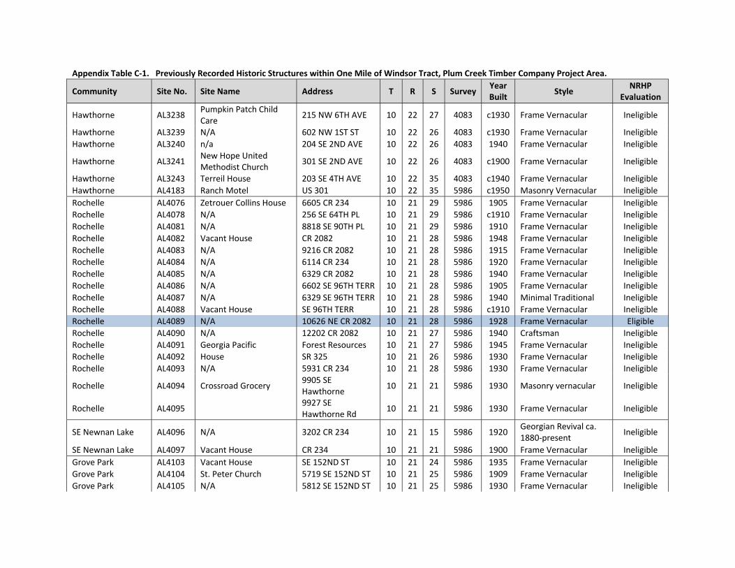
Appendix Table C‐1. Previously Recorded Historic Structures within One Mile of Windsor Tract, Plum Creek Timber Company Project Area.
Community Site No. Site Name Address T R S Survey Year Built
Style NRHP
Evaluation
Hawthorne AL3238 Pumpkin Patch Child Care
215 NW 6TH AVE 10 22 27 4083 c1930 Frame Vernacular Ineligible
Hawthorne AL3239 N/A 602 NW 1ST ST 10 22 26 4083 c1930 Frame Vernacular Ineligible
Hawthorne AL3240 n/a 204 SE 2ND AVE 10 22 26 4083 1940 Frame Vernacular Ineligible
Hawthorne AL3241 New Hope United Methodist Church
301 SE 2ND AVE 10 22 26 4083 c1900 Frame Vernacular Ineligible
Hawthorne AL3243 Terreil House 203 SE 4TH AVE 10 22 35 4083 c1940 Frame Vernacular Ineligible
Hawthorne AL4183 Ranch Motel US 301 10 22 35 5986 c1950 Masonry Vernacular Ineligible
Rochelle AL4076 Zetrouer Collins House 6605 CR 234 10 21 29 5986 1905 Frame Vernacular Ineligible
Rochelle AL4078 N/A 256 SE 64TH PL 10 21 29 5986 c1910 Frame Vernacular Ineligible
Rochelle AL4081 N/A 8818 SE 90TH PL 10 21 29 5986 1910 Frame Vernacular Ineligible
Rochelle AL4082 Vacant House CR 2082 10 21 28 5986 1948 Frame Vernacular Ineligible
Rochelle AL4083 N/A 9216 CR 2082 10 21 28 5986 1915 Frame Vernacular Ineligible
Rochelle AL4084 N/A 6114 CR 234 10 21 28 5986 1920 Frame Vernacular Ineligible
Rochelle AL4085 N/A 6329 CR 2082 10 21 28 5986 1940 Frame Vernacular Ineligible
Rochelle AL4086 N/A 6602 SE 96TH TERR 10 21 28 5986 1905 Frame Vernacular Ineligible
Rochelle AL4087 N/A 6329 SE 96TH TERR 10 21 28 5986 1940 Minimal Traditional Ineligible
Rochelle AL4088 Vacant House SE 96TH TERR 10 21 28 5986 c1910 Frame Vernacular Ineligible
Rochelle AL4089 N/A 10626 NE CR 2082 10 21 28 5986 1928 Frame Vernacular Eligible
Rochelle AL4090 N/A 12202 CR 2082 10 21 27 5986 1940 Craftsman Ineligible
Rochelle AL4091 Georgia Pacific Forest Resources 10 21 27 5986 1945 Frame Vernacular Ineligible
Rochelle AL4092 House SR 325 10 21 26 5986 1930 Frame Vernacular Ineligible
Rochelle AL4093 N/A 5931 CR 234 10 21 28 5986 1930 Frame Vernacular Ineligible
Rochelle AL4094 Crossroad Grocery 9905 SE Hawthorne
10 21 21 5986 1930 Masonry vernacular Ineligible
Rochelle AL4095
9927 SE Hawthorne Rd
10 21 21 5986 1930 Frame Vernacular Ineligible
SE Newnan Lake AL4096 N/A 3202 CR 234 10 21 15 5986 1920 Georgian Revival ca. 1880‐present
Ineligible
SE Newnan Lake AL4097 Vacant House CR 234 10 21 21 5986 1900 Frame Vernacular Ineligible
Grove Park AL4103 Vacant House SE 152ND ST 10 21 24 5986 1935 Frame Vernacular Ineligible
Grove Park AL4104 St. Peter Church 5719 SE 152ND ST 10 21 25 5986 1909 Frame Vernacular Ineligible
Grove Park AL4105 N/A 5812 SE 152ND ST 10 21 25 5986 1930 Frame Vernacular Ineligible

Appendix Table C‐1. Previously Recorded Historic Structures within One Mile of Windsor Tract, Plum Creek Timber Company Project Area.
Community Site No. Site Name Address T R S Survey Year Built
Style NRHP
Evaluation
Grove Park AL4106 N/A 6019 SE 152ND ST 10 21 25 5986 1930 Frame Vernacular Ineligible
Grove Park AL4107 N/A 6115 SE 152ND ST 10 21 25 5986 1900 Frame Vernacular Ineligible
Grove Park AL4108 N/A 15213 SE 59TH PL 10 21 25 5986 1915 Frame Vernacular Ineligible
Grove Park AL4109 N/A 253 SE 59TH PL 10 21 25 5986 1945 Frame Vernacular Ineligible
Grove Park AL4110 N/A 6009 SE 153RD TERR
10 21 25 5986 1920 Frame Vernacular Ineligible
Grove Park AL4111 N/A 15402 SE 59TH PL 10 21 25 5986 1930 Frame Vernacular Ineligible
Grove Park AL4120 Waits House SR 20 10 21 24 5986 c1895 Frame Vernacular Eligible
Grove Park AL4121 Scott‐Phifer House SE 155TH ST 10 21 24 5986 c1862 Greek Revival ca. 1825‐1860
Insufficient Information
Grove Park AL4122 N/A 5320 SE 155TH ST 10 21 24 5986 c1865 Frame Vernacular Insufficient Information
W. of Hawthorne AL4123 N/A 15601 SE Hawthorne Rd
10 22 30 5986 c1915 Frame Vernacular Ineligible
W. of Hawthorne AL4124 N/A 5715 SE 156TH TERR
10 22 30 5986 c1948 Frame Vernacular Ineligible
W. of Hawthorne AL4125 N/A 5735 SE 156TH TERR
10 22 30 5986 c1945 Frame Vernacular Ineligible
W. of Hawthorne AL4126 RT 3 BOX 46 SE Hawthorne 10 22 30 5986 c1940 Frame Vernacular Ineligible
near Rex AL4184 N/A 21514 SE 41ST LN 10 22 15 5986 c1910 Frame Vernacular Ineligible
near Rex AL4188 N/A 3620 US 301 10 22 15 5986 c1900 Frame Vernacular Ineligible
near Rex AL4189 N/A 4220 US 301 10 22 22 5986 c1910 Frame Vernacular Ineligible
near Rex AL4190 N/A 4701 US 301 10 22 22 5986 c1925 Craftsman Ineligible
near Rex AL4191 N/A 5604 US 301 10 22 23 5986 c1930 Frame Vernacular Ineligible
near Rex AL4192 N/A 5602 US 301 10 22 23 5986 c1930 Frame Vernacular Ineligible
near Rex AL4193 N/A 5600 US 301 10 22 23 5986 c1930 Frame Vernacular Ineligible
W. of Hawthorne AL4198 Rt 3 Box 20A SR 20 10 22 28 5986 c1930 Frame Vernacular Ineligible
W. of Hawthorne AL4199 House #1 SE 199TH ST 10 22 28 5986 c1930 Frame Vernacular Ineligible
W. of Hawthorne AL4200 House #2 SE 199TH TERR 10 22 28 5986 c1910 Frame Vernacular Ineligible
W. of Hawthorne AL4201 Nelson Farm 5704 SE 199TH ST 10 22 21 5986 1918 Frame Vernacular Eligible
W. of Hawthorne AL4202 Ernest Nelson House N/A 10 22 21 5986 c1925 Frame Vernacular Insufficient Information
W. of Hawthorne AL4203 Clyde Nelson House N/A 10 22 21 5986 c1935 Frame Vernacular Ineligible

Appendix Table C‐1. Previously Recorded Historic Structures within One Mile of Windsor Tract, Plum Creek Timber Company Project Area.
Community Site No. Site Name Address T R S Survey Year Built
Style NRHP
Evaluation
W. of Hawthorne AL4204 House #1 SE Hawthorne Rd 10 22 27 5986 c1915 Frame Vernacular Ineligible
W. of Hawthorne AL4205 House #2 SE Hawthorne Rd 10 22 27 5986 c1915 Frame Vernacular Ineligible
Rural (near Area 3) AL4214 N/A 18304 SE 24TH AVE
10 22 8 5986 c1920 Frame Vernacular Ineligible
Rural (near Area 3) AL4215 N/A 18128 SE 24TH AVE
10 22 8 5986 c1925 Frame Vernacular Ineligible
Rural (near Area 3) AL4216 N/A 18835 SE 24TH AVE
10 22 16 5986 c1900 Frame Vernacular Ineligible
Rex AL4217 Bungalow US 301 10 22 15 5986 c1925 Frame Vernacular Ineligible
Rex AL4218 N/A 3707 US 301 10 22 15 5986 c1910 Frame Vernacular Ineligible
Rex AL4219 Rex House #1 CR 219A 10 22 15 5986 c1935 Frame Vernacular Ineligible
Rex AL4220 N/A 225 CR 219A 10 22 10 5986 c1920 Frame Vernacular Ineligible
Rex AL4221 N/A 1915 CR 219A 10 22 10 5986 c1915 Frame Vernacular Ineligible
Rex AL4222 House SE 16TH AVE 10 22 10 5986 c1890 Frame Vernacular Ineligible
Rex AL4223 N/A 1027 CR 219A 10 22 10 5986 c1930 Frame Vernacular Ineligible
Rex AL4224 N/A 1126 SE 12TH AVE 10 22 10 5986 c1925 Frame Vernacular Ineligible
Campville AL4256 N/A 19312 NE 22ND LN 09 22 33 5986 c1925 Frame Vernacular Ineligible
Campville AL4259 Stokes House 1226 NE 191ST TERR
09 22 33 5986 1902 Frame Vernacular Ineligible
Campville AL4260 Dyess House 1232 NE 191ST TERR
09 22 33 5986 1923 Craftsman Ineligible
Campville AL4261 Mathews‐Sherouse House
1414 NE 191ST TERR
09 22 33 5986 c1885 Frame Vernacular Ineligible
Campville AL4262 Camp‐Tillman House 1512 NE 191ST TERR
09 22 33 5986 c1880 Frame Vernacular Eligible
Campville AL4263 Canova‐Long House 1604 NE 191ST TERR
09 22 33 5986 c1918 Craftsman Ineligible
Campville AL4264 Kayton House 1616 NE 191ST LN 09 22 33 5986 c1880 Frame Vernacular Ineligible
Campville AL4265 Parker House 1626 NE 191ST LN 09 22 33 5986 c1910 Frame Vernacular Ineligible
Campville AL4266 Campville Hope Fellowship Church
N/A 09 22 33 5986 c1895 Frame Vernacular Ineligible
Campville AL4267 Van Landingham House NE 90TH TERR 09 22 33 5986 c1890 Frame Vernacular Ineligible
Campville AL4268 Damascus Church NE 12TH AVE 09 22 33 5986 1902 Frame Vernacular Ineligible
Campville AL4269 19508 CR 1474 09 22 33 5986 c1900 Frame Vernacular Ineligible

Appendix Table C‐1. Previously Recorded Historic Structures within One Mile of Windsor Tract, Plum Creek Timber Company Project Area.
Community Site No. Site Name Address T R S Survey Year Built
Style NRHP
Evaluation
Campville AL4270 St. Johns Missionary Baptist Church
US 301 09 22 33 5986 c1940 Frame Vernacular Ineligible
Campville AL4271 Grimes‐Cooper House 163K US 301 09 22 33 5986 1907 Frame Vernacular Ineligible
Campville AL4272 Vacant House US 301 09 22 33 5986 c1900 Frame Vernacular Ineligible
Campville AL4273 N/A 163 US 301 09 22 33 5986 c1920 Frame Vernacular Ineligible
Campville AL4274 N/A 903 US 301 09 22 33 5986 c1920 Frame Vernacular Ineligible
Orange Heights AL4281 N/A 16707 NE 76TH PL 09 22 7 5986 c1930 Frame Vernacular Ineligible
Orange Heights AL4285 House NE 72ND PL 09 22 7 5986 c1920 Frame Vernacular Ineligible
Orange Heights AL4287 N/A 7007 NE 172ND TERR
09 22 7 5986 c1930 Frame Vernacular Ineligible
Orange Heights AL4288 N/A NE 70TH AVE 09 22 7 5986 c1890 Frame Vernacular Ineligible
Orange Heights AL4289 N/A 17116 NE 71ST PL 09 22 7 5986 c1945 Frame Vernacular Ineligible
Orange Heights AL4290 N/A 17221 NE 71ST PL 09 22 7 5986 c1930 Frame Vernacular Ineligible
Orange Heights AL4291 N/A 17220 NE 71ST PL 09 22 7 5986 c1940 Frame Vernacular Ineligible
Orange Heights AL4292 N/A 7207 NE 72ND PL 09 22 7 5986 c1930 Frame Vernacular Ineligible
Orange Heights AL4293 N/A 82‐B NE 168TH TERR
09 22 7 5986 c1885 Frame Vernacular Ineligible
Orange Heights AL4294 House NE 71ST PL 09 22 7 5986 c1925 Craftsman Ineligible
Orange Heights AL4295 House NE 70TH PL 09 22 7 5986 c1900 Frame Vernacular Ineligible
Orange Heights AL4296 N/A 16515 NE 70TH PL 09 22 18 5986 c1930 Frame Vernacular Ineligible
Orange Heights AL4297 Orange Heights Baptist Church
SR 26 09 22 18 5986 c1885 Neo‐Classical Revival ca. 1880‐1940
Ineligible
Rural (CR 1474) AL4298 N/A 16622 CR 1474 10 22 6 5986 c1945 Frame Vernacular Ineligible
Windsor AL4299 Providence‐United Methodist Church
CR 1774 10 21 2 5986 c1885 Gothic Revival ca. 1840‐present
Likely Eligible
Windsor AL4302 Lewis‐Phifer House SE 9TH PL 10 21 11 5986 c1840 Frame Vernacular Insufficient Information
Windsor AL4304 N/A 808 CR 234 10 21 11 5986 c1900 Frame Vernacular Ineligible
Windsor AL4305 N/A 710 CR 234 10 21 11 5986 c1880 Frame Vernacular Ineligible
Windsor AL4306 Roseborough‐King House
N/A 10 21 11 5986 c1902 Queen Anne (Revival) ca. 1880‐1910
Ineligible
Windsor AL4307 Windsor Baptist Church N/A 10 21 2 5986 c1880 Other Eligible

Appendix Table C‐1. Previously Recorded Historic Structures within One Mile of Windsor Tract, Plum Creek Timber Company Project Area.
Community Site No. Site Name Address T R S Survey Year Built
Style NRHP
Evaluation
Windsor AL4308 Watson House CR 234 10 21 2 5986 c1885 Queen Anne (Revival) ca. 1880‐1910
Eligible
Windsor AL4309 N/A 423 CR 234 10 21 2 5986 c1940 Masonry vernacular Ineligible
Windsor AL4311 Nichols‐Smith House 218 CR 234 10 21 2 5986 c1890 Frame Vernacular Ineligible
Windsor AL4313 N/A 529 CR 234 10 21 2 5986 c1930 Frame Vernacular Ineligible
Windsor AL4314 House #1 NE 7TH AVE 10 21 2 5986 c1940 Frame Vernacular Ineligible
Rural (NW Area 2) AL4317 N/A 1008 CR 234 09 21 35 5986 c1920 Frame Vernacular Ineligible
Rural (NW Area 2) AL4318 N/A 12918 CR 234 09 21 26 5986 c1930 Frame Vernacular Ineligible
Rural (NW Area 2) AL4319 N/A 3912 CR 234 09 21 23 5986 c1940 Frame Vernacular Ineligible
Rural (NW Area 2) AL4320 House #1 NE 48TH PL 09 21 23 5986 c1900 Frame Vernacular Ineligible
Rural (NW Area 2) AL4321 House #2 NE 48TH PL 09 21 24 5986 c1900 Frame Vernacular Ineligible
Grove Park AL4660 N/A 5915 SE 156TH TERR
10 22 30 5986 c1930 Frame Vernacular Ineligible
Grove Park AL4661 Vacant Building Hawthorne & 155th 10 22 19 5986 c1940 Masonry vernacular Ineligible
**Blue shading indicates a resource that is either NRHP listed, eligible, or needs further examination