Embed Size (px)
Citation preview
Final Recreational Off-Road Vehicle Management PlanSupplemental Environmental Impact Statement
BIG CYPRESSNational Preserve Florida

Final
Off-Road Vehicle Management PlanSupplemental Environmental Impact Statement
Big CypressNational Preserve
Collier, Miami-Dade, and Monroe Counties, Florida
The National Park Service developed this plan to provide guidance on the management of off-road vehicle (ORV) use within Big Cypress National Preserve. This plan is called for and directed by the General Management Plan and Final Environmental Impact Statement: Big Cypress National Preserve, Florida (NPS 1991), and is required as part of a litigation settlement.
The plan presents and analyzes two alternatives for managing ORV use within the 582,000 acres in the original boundary of the preserve. The no action alternative analyzes the effects of continuing to apply the current management program. The proposed action would adopt a new program that focuses on the resource protection mandates of the National Park Service while providing reasonable recreational access.
The analysis evaluated the effects of the alternatives on natural resource and visitor experience impact topics. Compared to the no action alternative (continue current management), the analysis found that implementing the proposed action would result in substantial beneficial effects to surface water flow, soils, and vegetation. These beneficial effects would result from limiting ORVs to designated roads and trails, which would produce a major reduction in the spatial extent of the preserve affected by ORVs. The visitor experience for ORV users would be affected by the limitations on their ability to access certain places by vehicle, and by the need to conform with new rules and permit requirements. Many visitors who do not use ORVs would perceive a benefit from reduced impacts to the scenic quality of the preserve.
For more information concerning this plan contact:
John J. Donahue, Superintendent
Big Cypress National Preserve
HCR 61 Box 110
Ochopee Florida 34141
(941) 695-2000, ext. 310
United States Department of the Interior • National Park Service
Executive Summary
Introduction
The Final Recreational Off-Road Vehicle Management Plan and Supplemental Environmental Impact Statement addresses the management of recreational off-road vehicle use within the original 582,000 acres of Big Cypress National Preserve. The preserve’s general management plan (NPS, 1991) provided overall guidance for ORV management, but recommended the preparation of a more detailed ORV management plan. This off-road vehicle management plan was prepared in response to that recommendation. This planning effort is tiered off of the general management plan and incorporates new information gathered and new issues raised by the public since 1991. The purpose of the Supplemental Environmental Impact Statement (SEIS) is to analyze the alternatives presented in accordance with the National Environmental Policy Act of 1969.
In addition, the off-road vehicle management plan is being prepared in accordance with the 1995 settlement agreement negotiated between the Florida Biodiversity Project (FBP) and several agencies and bureaus. These include the U.S. Department of the Interior, National Park Service, U.S. Fish and Wildlife Service, U.S. Environmental Protection Agency, U.S. Department of the Army, and U.S. Army Corps of Engineers. The settlement agreement was a result of a lawsuit filed by FBP, concerning the management of ORVs within the preserve.
Big Cypress National Preserve was established on October 11, 1974 (16 USC 698) "in order to assure the preservation, conservation, and protection of the natural, scenic, hydrologic, floral and faunal, and recreational values of the Big Cypress Watershed in the State of Florida and to provide for the enhancement and public enjoyment thereof." The boundary of the preserve was expanded by 147,000 acres in 1988, with administration of
this addition by the National Park Service beginning in 1996. Management guidance for the Addition Lands was not included in the general management plan (NPS 1991) and will be addressed in a separate general management plan. ORV management guidance in the Addition Lands will be prepared as part of this future planning effort.
The enabling legislation states that the preserve, as a unit of the national park system, is to be managed in a manner that will ensure its "natural and ecological integrity in perpetuity." The legislation further states the management of the area should be in accordance "with the provisions of the Act of August 25, 1916" (NPS Organic Act). The enabling act allows for the use of off-road vehicles, but stipulates that this use will be controlled in a manner that does not impair the resources of the preserve. The legislative history of the preserve states that "While the use of all-terrain vehicles must be carefully regulated by the secretary (of the interior) to protect the natural wildlife and wilderness values of the preserve, the bill does not prohibit their use along designated roads and trails" (U.S. House of Representatives, 1973; U.S. Senate, 1974).
The management plan and supplemental environmental impact statement consists of five chapters. The first chapter details the purpose and need for the plan, legislative mandates and special commitments, management objectives, and planning issues. The second chapter describes the two alternatives considered, and the alternatives considered but dismissed from further analysis, and summarizes the key differences between the alternatives and associated impacts. Chapter three discusses the aspects of the environment that would be affected by implementing the management plan. The environmental consequences of implementing the alternatives are presented in the fourth chapter. Finally, chapter five summarizes the public involvement in this planning process and consultation and coordination with federal, state, local and tribal governments.
The 1991 general management plan and environmental impact statement evaluated four alternatives, all of which included management of ORV use within the preserve. Three of these alternatives were considered but dismissed from further analysis in this plan. Only the general management plan proposed action was further considered. In compliance with the National Environmental Policy Act regulations that require a no-action alternative be evaluated in order to provide a baseline for comparison among the alternatives, the general management plan proposed action alternative represents this no action alternative.
The no action alternative, which reflects the current management strategy, and the proposed action are the two alternatives developed and evaluated in this document. These alternatives were based on the National Park Service legal mandates, the general management plan/environmental impact statement, and issues identified during the scoping process for the plan.
Proposed Action
The proposed action applies the precautionary principle in managing recreational ORV use within the preserve. Although the National Park Service has used the best available
scientific information available to prepare this plan, this database is not complete. The research section of the proposed action outlines where more information is needed. Where the effects of an action are unknown, the proposed management actions would favor the protection of the preserve’s natural and cultural resources. The proposed action would be a model for sustainable management of a high-impact recreational activity in a sensitive area.
The key features of the proposed action include the following.
ORVs would be allowed only on designated trails and would depart only from designated access points.
Sensitive areas would be closed immediately to all ORV traffic, including all marl prairies, specific Bear Island Unit trails, zone 1 of the Stairsteps Unit, and Cape Sable seaside sparrow habitat in the Stairsteps unit.
Temporal closures would be instituted including restriction of ORV traffic between the hours of 10:00 p.m. and 5:00 a.m., a 60-day seasonal closure, as well as closures triggered by high or low water levels.
Three permits would be required to operate an ORV in the preserve including a vehicle permit ($50.00), an ORV operator’s permit (free), and a daily use backcountry permit (free).
Up to 2,000 annual permits would be issued by random draw.
A mandatory education course would be required to obtain an ORV operator’s permit.
Vehicles must meet specifications.
Impacts of ORV use would be monitored and management actions would be taken as necessary, based on monitoring results.
Areas impacted by ORV use would be restored.
Research would be conducted to support ORV management within the preserve.
Fifteen access points would be designated. ORVs would travel only on designated trails throughout the preserve. The Deep Lake Unit and Loop Unit would both remain closed to all ORV traffic, as they are in the no action alternative (continue current management).
Guidance for the types of ORVs allowed in each management unit is given in the proposed action. These designations are based on the type of terrain found in the various areas of the preserve and to provide for resource protection. The Corn Dance Unit and
Turner River Unit would be opened to swamp buggies and all-terrain cycles (ATCs). Bear Island Unit would be opened to swamp buggies, ATCs, and street-legal four-wheel drive vehicles. In the Stairsteps Unit, Zone 2 would be opened to swamp buggies and ATCs; Zone 3 would be opened to swamp buggies, ATCs and airboats; and Zone 4 would be opened only to airboats.
The number of annual vehicle permits that would be issued would be reduced from 2500 to 2000, in accordance with the 1990 biological opinion issued by the U.S. Fish and Wildlife Service on the general management plan.
The proposed action is based on the concept of adaptive management, which is a dynamic process. As the proposed action is implemented, additional information would be obtained through monitoring, research and experience. As the knowledge base expands, the National Park Service would respond by adapting management actions that assure the highest protection of the preserve’s resources.
All aspects of the proposed action would be implemented within ten years. Closure of sensitive resource areas would be implemented immediately. Some dispersed use of ORVs would initially be allowed outside of marked sensitive areas until the designated trail system is in place, and only if monitoring results indicate that no further resource impacts are occurring.
Limiting ORV use to designated trails would substantially reduce the spatial extent of the preserve impacted by ORVs. Implementing the proposed action would result in long-term benefits to water resources, soils and vegetation. The plan may also benefit endangered and threatened species, including the Cape Sable seaside sparrow and the Florida panther. Some ORV users may experience adverse impacts due to a slight increase in permit costs, and the time required to complete the education course. Restricting travel to designated routes may alter the use patterns of some ORV users. Other visitors (non-ORV users) would experience beneficial impacts by reducing the visual impacts of ORV use and lessening the potential for user conflicts in the backcountry of the preserve. The development of the trail system may eventually create greater access to the backcountry of the preserve for all visitors.
No Action Alternative (Continue Current Management)
The no action alternative continues the current management strategy. Under this alternative the National Park Service would adopt a strategy combining opened areas and designated trails for ORV use. ORV users would continue to have unlimited access from approximately 70 informal locations. ORVs would be required to travel on designated trails within the Bear Island Unit and a small portion of the Stairsteps Unit. ORVs would be allowed to disperse within the Turner River Unit, Corn Dance Unit and portions of the Stairsteps Unit. Deep Lake Unit and Loop Unit would remain closed to all ORVs. Prairies and other sensitive areas would continue to be open to dispersed ORV use.
This alternative does include limitations on the types of vehicles allowed within management units or portions of these units. Zone 1 of the Stairsteps Unit has been closed to airboats and Zone 4 in this unit has been designated for airboats only, except for some limited trails within the Lostmans Pine area. The Corn Dance Unit and Turner River Unit are opened to all permitted vehicle types. Bear Island Unit is closed to airboats.
The National Park Service would continue to permit 2,500 vehicles annually for use within the preserve. However, further consultation with the USFWS would be required, since the biological opinion prepared for the 1991 general management plan was based on 2,000 annual permits. To obtain an annual permit ($35.00), all vehicles would be required to meet certain specifications.
The current management under this strategy has been primarily reactive to unacceptable conditions. ORV impacts monitoring would be ad-hoc and would rely primarily on staff observations. In recent years, the National Park Service has made several closures of all or portions of the preserve in response to water levels. These closures were intended to reduce stress to wildlife during high water conditions, and to reduce impacts to soils and vegetation under low-water conditions.
During this planning effort, it has been revealed that this alternative would not meet the NPS legal mandates or comply with policy for managing the preserve.
The implementation of this alternative would result in long-term adverse impacts to water resources, soils, and vegetation. The spatial extent of impacts is expected to increase under this alternative, with major impacts to soils, prairies and marshes. The Cape Sable seaside sparrow may experience long-term adverse impacts by the alteration of the vegetation structure it needs for nesting, foraging and roosting. The alternative may impact the Florida panther by increasing the potential for human disturbance and the degradation of habitat. This alternative restricts backcountry access in the preserve to a limited number of individuals who possess specialized motorized equipment.
contents
Executive Summary v
Purpose of and Need for the Plan
Introduction 3
Legislative Mandates and Special Commitments 9
National Park System Mandates 9
Big Cypress Legislative Background and the Purpose of the Preserve 11
Federal regulations, Executive Orders, and NPS Policies Related to ORV Use 12
Federal Statutes, Executive Orders, and NPS Policies Related to Water Resources 13
Federal Statues and NPS Policies Related to Biological Resources 14
1995 Settlement Agreement 16
Ability to Meet Legislative Mandates and Special Commitments 17
Management Objectives 18
Natural Resources 18
Water Resources 18
Soils 18
Vegetation 18
Wildlife 18
Cultural Resources 18
Visitor Experience 19
Planning Issues 20
Natural Resource Impact Topics 20
Cultural Resource Impact Topics 21
Visitor Experience Impact Topics 21
Topics Dismissed from Detailed Analysis 23
Other Wildlife Species 23
Preserve Use by Miccosukee and Seminole Tribes 23
Air Quality 23
Mineral Interests 24
Cultural Resources 24
Environmental Justice 24
Prime and Unique Agricultural Lands 24
Alternatives, Including the Proposed Action
Introduction 28
Proposed Action 29
Introduction 29
Trails and Access Points 30
Criteria for Developing the Trail System and Access Points 32
Resource Protection. 32
Visitor Experience. 33
Methodology 33
Proposed System of Trails and Access Points 34
Designated Trails. 35
Access Points. 37
Carrying Capacities 39
Monitoring 40
Trail Use Indicators and Standards 40
Methods of Monitoring 41
Management Actions 43
Closure of Areas 44
Nightly Closures 44
Seasonal Closures 44

Spatial Closures 45
Criteria for Closures 46
Permit Program 47
Fees 48
Off-Road Vehicle Permit 48
Number of Vehicle Permits. 48
Vehicle Inspection Program. 49
Allocation of Vehicle Permits. 50
ORV Operator Permit 50
Special Use Permit for Private Property Owners 51
Education and Communication 52
Vehicle Specifications 52
Rules and Enforcement 54
Restoration 55
Implementation 58
Resource Recovery Monitoring 58
Indicators 59
Methods 59
Frequency and Timing 60
Information Needs 60
Research 60
Implementation Strategy and Schedule 60
Cost 66
No Action Alternative (Continue Current Management) 68
Introduction 68
Trails, Areas, and Access Points 70
Trails and Areas 70
Access Points 71
Monitoring 71
Management Actions 72
Closure of Areas 72
Permit Program 72
Education and Communication 72
Vehicle Specifications 73
Rules and enforcement 73
Restoration 74
Research 74
Implementation Strategy 75
Cost 75
Alternatives Considered but Dismissed from Further Analysis 76
Summary of Alternatives 77
Affected Environment
Natural Resource Issues 86
Surface Water Flows 86
Water Quality 89
Soils 90
Vegetation 91
Prairies 91
Marshes 98
Cypress Strands and Domes, Mixed Hardwood Swamps, and Sloughs 99
Mangroves 100
Hardwood Hammocks 100
Pinelands 100
Wildlife 101
American Alligator 101
Cape Sable Seaside Sparrow 103
Bald Eagle 103
Wood Stork 104
Red-cockaded Woodpecker 104
Everglade Snail Kite 104
Florida Panther 105
West Indian Manatee 108
Other Wildlife Species 108
Visitor Experience Issues 109
General Preserve Visitation 109
Visits 109
ORV Use 110
ORV Trail Mapping 111
Characteristics of ORVs 113
Characteristics of ORV Users and Visitation 115
Hunting 120
Other Visitation 121
Nonfederal Property Owners 122
Environmental Consequences
Introduction 126
Methodology 126
Intensity 126
Duration 127
Direct versus Indirect Impacts 127
Cumulative Impacts 127
Impacts on Natural Resources 129
Water Resources 129
Surface Water Flows 129
Analysis of the Proposed Action. 129
Analysis of No Action (Continue Current Management). 129
Cumulative Impacts. 129
Conclusion. 130
Water Quality 130
Analysis of the Proposed Action. 130
Analysis of No Action (Continue Current Management). 131
Cumulative Impacts. 131
Conclusion. 131
Soils 131
Analysis of the Proposed Action. 131
Analysis of No Action (Continue Current Management). 132
Cumulative Impacts. 132
Conclusion. 132
Vegetation 132
Prairies and Marshes 132
Analysis of the Proposed Action. 132
Analysis of No Action (Continue Current Management). 132
Cumulative Impacts. 133
Conclusion. 133
Cypress Strands and Domes, Mixed Hardwood Swamps, and Sloughs 133
Analysis of the Proposed Action. 133
Analysis of No Action (Continue Current Management). 134
Cumulative Impacts. 134
Conclusion. 134
Mangroves 134
Analysis of the Proposed Action. 134
Analysis of No Action (Continue Current Management). 134
Cumulative Impacts. 134
Conclusion. 134
Hardwood Hammocks 134
Analysis of the Proposed Action. 134
Analysis of No Action (Continue Current Management). 135
Cumulative Impacts. 135
Conclusion. 135
Pinelands 135
Analysis of the Proposed Action. 135
Analysis of No Action (Continue Current Management). 135
Cumulative Impacts. 135
Conclusion. 135
Protected Species 136
Cape Sable Seaside Sparrow 136
Analysis of the Proposed Action. 136
Analysis of No Action (Continue Current Management). 136
Cumulative Impacts. 136
Conclusion. 137
Bald Eagle 137
Analysis of the Proposed Action. 137
Analysis of No Action (Continue Current Management). 137
Cumulative Impacts. 137
Conclusion. 137
Wood Stork 137
Analysis of the Proposed Action. 137
Analysis of No Action (Continue Current Management). 138
Cumulative Impacts. 138
Conclusion. 138
Red-Cockaded Woodpecker 138
Analysis of the Proposed Action. 138
Analysis of No Action (Continue Current Management). 139
Cumulative Impacts. 139
Conclusion. 139
Everglade Snail Kite 139
Analysis of the Proposed Action. 139
Analysis of No Action (Continue Current Management). 139
Cumulative Impacts. 139
Conclusion. 139
Florida Panther 140
Analysis of the Proposed Action. 140
Analysis of No Action (Continue Current Management). 140
Cumulative Impacts. 140
Conclusion. 141
West Indian Manatee 141
Analysis of the Proposed Action. 141
Analysis of No Action (Continue Current Management). 141
Cumulative Impacts. 141
Conclusion. 141
White-Tailed Deer and Feral Hogs 141
Analysis of the Proposed Action. 141
Analysis of No Action (Continue Current Management). 141
Cumulative Impacts. 141
Conclusion. 142
Impacts on Visitation 143
ORV Use 143
Analysis of the Proposed Action. 143
Analysis of No Action (Continue Current Management) 143
Cumulative Impacts. 143
Conclusion. 144
Hunting 144
Analysis of the Proposed Action. 144
Analysis of No Action (Continue Current Management). 144
Cumulative Impacts. 144
Conclusion. 144
Other Visitation 144
Analysis of the Proposed Action. 144
Analysis of No Action (Continue Current Management). 145
Cumulative Impacts. 145
Conclusion. 145
Nonfederal Property Owners 145
Analysis of the Proposed Action. 145
Analysis of No Action (Continue Current Management). 145
Cumulative Impacts. 146
Conclusion. 146
Sustainability and Long-term Management 147
Any Adverse Impacts that Cannot Be Avoided Should the Action Be Implemented 147
Analysis of the Proposed Action 147
Analysis of No Action (Continue Current Management) *
The Relationship between Local Short-Term Uses of the Environment and the Maintenance and Enhancement of Long-Term Productivity 147
Analysis of the Proposed Action 147
Analysis of No Action (Continue Current Management) 148
Any Irreversible or Irretrievable Commitments of Resources that Would Be Involved Should the Alternative Be Implemented 148
Consultation and Coordination
History of Public Involvement 152
Public Information 152
Consultation with the U.S. Fish and Wildlife Service 153
Consultation with Federally Recognized Tribes 153
Consultation with the State Historic Preservation Officer 154
List of Agencies, Organizations, and Individuals Who Received the Draft ORV Management Plan and Supplemental Environmental Impact Statement 154
Federal Agencies 154
Native American Tribes 154
State of Florida 154
Organizations 155
Companies 155
Media 155
Libraries 155
Individuals 155
Preparers and Contributors 156
Department of the Interior 156
Office of the Secretary 156
Office of the Solicitor 156
National Park Service 156
Big Cypress National Preserve 156
Denver Service Center 156
Everglades National Park 156
Southeast Regional Support Office 156
Washington Office, Park Planning and Special Studies Division 156
U.S. Fish and Wildlife Service 156
Parsons Engineering Science, Inc. 157
Virginia Tech University, Department of Forestry, Cooperative Park Studies Unit (CPSU) 157
Utah State University 157
Columbia University 157
University of Georgia 157
Response to Comments 158
Introduction 158
Response to Comments 162
Analysis and Utilization of Scientific Data and Supporting Information 162
Opening and Closing of Management Units 164
Compliance with Legal Mandates and the Settlement Agreement 165
Visitor Experience 167
Cumulative Impacts 168
Education and Communications 169
Protected Species 169
Enforcement 170
Management Objectives and Funding 170
Hunting 171
Surface Water Flow and Water Quality 171
Monitoring, Restoration, and Research 171
ORV Types and Specifications 172
ORV Permits, Fees, Regulations, and Operating Standards 174
Soils 175
Trails and Access Points 176
University of Georgia Database and Miles of Trails 178
Vegetation 178
Wildlife and Habitat 179
Scope of the Plan and Supplemental Environmental Impact Statement 180
Comment Letters 181
Appendices, Glossary, Bibliography, and Index
Appendix A: Draft – Proposed Application of Temporal Restrictions to Airboat Operations in the Southeast Corner of Big Cypress National Preserve 529
Appendix B: Preliminary Report – Off-road Vehicle Trail Accuracy Assessment 538
Appendix C: Biological Opinion for the Final Recreational Off-Road Vehicle Management Plan and Supplemental Environmental Impact Statement: Big Cypress National Preserve, Florida 545
Glossary 591
Bibliography 595
Index 598
Tables
1: Substrate Suitability and Resource Sensitivity 34
2: Candidate Indicators and Standards for Assessing Trail Conditions 40
3: Research Needs for Implementation of the Proposed Action 60
4: Implementation Schedule for the Proposed Action 65
5: Implementation Cost Estimate for the Proposed Action 67
6: Summary of Key Differences between the Alternatives 77
7: Summary of Impacts of the Alternatives 80
8: Listed Wildlife Species in Big Cypress National Preserve 101
9: Visitation at Big Cypress National Preserve, 1995 to 1999 109
10: Numbers of ORVs Registered for Use in Big Cypress National Preserve, 1980 to 1999 109
11: Activities Participated in by ORV Permit Holders during a 1-Year Period 116
12: Role and Importance of the ORV in Recreational Experiences 118
13: Agreement with Statements Describing the Importance of Specific Places, Vehicle Types, and Routes Used within the Preserve
14: Numbers of Hunters in the Field per Day per Season at Big Cypress National Preserve, 1996 to 1999 104
15: Identification of Commentors 159
Figures
L-28 Canal Map 88
Figure - South Florida Region
Figure - Management Planning Units
Figure – Conceptual Framework of Access Points and Primary Trails
Figure – ORV Management - Proposed Action
Figure – ORV Management - No Action Alternative (Continue Current Management)
Figure - Vegetation Classes
Figure - ORV Use Areas
Figure - Panther Locations, 1981-1999
Figure - GMP ORV Trails
Figure - University of Georgia Trails Interpretation
Figure - Off-Road Vehicle Photographs
Purpose of and Need for the Plan
Introduction
The purpose of this Recreational Off-Road Vehicle Management Plan (plan) is to guide the National Park Service (NPS) in its management of recreational off-road vehicle (ORV) use in Big Cypress National Preserve, the location of which is shown on the South Florida Region map. This plan implements the direction established in the General Management Plan and Final Environmental Impact Statement: Big Cypress National Preserve, Florida (NPS 1991). The general management plan and environmental impact statement was finalized with a record of decision, and recognized the need for an ORV management plan.
The general management plan provided broad direction for management of the preserve and stated that more detailed actions concerning ORV management would be included in an ORV management plan, which would be developed after approval of the general management plan. This plan tiers off the general management plan and the environmental
impact statement, in conformance with the Council on Environmental Quality (1978) guidelines for implementing the National Environmental Policy Act. It also reflects federal laws, regulations, and executive orders, and Florida laws, regulations, and policies that have been enacted or modified since the release of the general management plan.
This plan and supplemental environmental impact statement were also prepared in response to a settlement agreement negotiated in 1995 between the Florida Biodiversity Project and several federal agencies and bureaus. The agencies and bureaus named in the lawsuit included the U.S. Department of the Interior, National Park Service, U.S. Fish and Wildlife Service, U.S. Environmental Protection Agency (EPA), U.S. Department of the Army, and U.S. Army Corps of Engineers. This agreement and its relevance to ORV management in the preserve are described later in this section.
The purpose of this plan and the associated supplemental environmental impact statement is to analyze the specific actions for ORV management, incorporate new information gathered and policies developed since the 1991 general management plan and environmental impact statement, and address new issues raised by the public. The plan and supplemental environmental impact statement jointly address ORV use in Big Cypress National Preserve.
ORV activities in Big Cypress must be managed and regulated to conserve preserve resources and values in accordance with the NPS Organic Act of 1916, as amended; the preserve’s enabling legislation; and other legal mandates. To comply with these mandates, the plan addresses
an ORV permit program, including vehicle specifications
a system of designated access points and trails
rules governing the operation of vehicles and enforcement of those rules
methods for monitoring
strategies for restoring areas impacted by ORVs
education needs
research needs
other management strategies, such as number limits for access points
the adaptive management approach to ensure that the plan remains current and effective
Soil disturbance is the most direct, visible, and lasting impact of ORV use in the preserve. When the soils of Big Cypress are saturated or inundated with water, they become

especially susceptible to disturbance (including compaction, rutting, deformation, and ridging) from vehicle traffic. The factors that influence the degree of impact have changed over the years, including wetter hydrologic conditions, improved vehicle capabilities, and the long-term accumulation of effects, as summarized below.
Wetter hydrologic conditions of the 1990s. The dryer conditions that prevailed during the establishment of the preserve meant that operation of ORVs resulted in less damage to the landscape than has been observed in the 1990s. The wetter conditions of the 1990s increased the level of soil impacts because soils are saturated for a longer time each year. This means that ORVs are more likely to be in operation when soils are most sensitive. Potential sources of wetter conditions in the 1990s included greater rainfall, modification to upstream water management practices, and landscape alterations within the preserve. The dry conditions of the 1960s and 1970s may also have been influenced by upstream water management practices. Major modification to the landscape and water management practices over the next 40 years as a result of region-wide ecosystem restoration efforts are anticipated to alter the hydrologic regime in the future.
Improved Vehicle Capabilities. Vehicle capabilities, including increased vehicle reliability, power, and maneuverability, have increasingly opened up areas of the preserve that were not accessible in the past. Increased accessibility is also related to improved maps and greater availability of remote communication and navigation devices.
Accumulation of effects over time. The persistence of disturbed soils suggests that ORV impacts are occurring at a faster rate than soils are naturally recovering, and that impacts are accumulating over time. There are no known processes that restore the soils once disturbed. Farm field furrows that existed prior to the preserve’s establishment are still clearly visible from the air and on the ground decades later. Soil impacts from ORVs appear to be having similar persistence over time, with associated hydrological and biological impacts.
Ground-level observations, either at roadside entry locations or along trails, provide a limited view of ORV impacts. An aerial inspection of the ORV trails and travel corridors provides a greater appreciation of the levels of impacts that have occurred. The networks of tire ruts and airboat paths from dispersed used of ORVs influence the hydrological, vegetative, and wildlife conditions of the preserve.
Unlike many plans prepared by the National Park Service, the need for this plan was not prompted by increased demand for a particular type of recreation in the preserve. The 1991 general management plan limited the number of recreational ORV permits to 2000. The record of decision changed this number to 2,500 (NPS 1992). In 1999, 2,271
recreational ORV permits were issued. Therefore, the number of recreational ORVs in use in Big Cypress National Preserve
Figure - South Florida Region
could increase by only 10 percent. Instead, the plan is needed to enable the National Park Service to comply with its legislative mandates and special commitments. Those mandates and commitments as they relate to recreational ORV use in the preserve are described below.
The scope and complexity of the plan would require a phased implementation over a 10-year period. However, many of the plan’s key components would be initiated in the first year. A schedule for implementation is provided in the "Alternatives, Including the Proposed Action" section of this plan. Implementation would begin promptly after the record of decision for this ORV management plan was signed.
The National Park Service would use an adaptive management approach that would include continual review and modification of the plan as needed to ensure its effectiveness and to confirm that management of ORVs was in compliance with NPS mandates and policies. If modifications to the plan were needed, the National Park Service would comply with all appropriate laws and regulations, including but not limited to, the National Environmental Policy Act and Endangered Species Act, including appropriate public involvement.
The scope of this plan is limited to recreational ORV use within the original preserve boundary. It does not address oil and gas development in the preserve, commercial operations of ORVs, or tribal rights.
This plan also does not address any management issues in the Addition Lands (see Management Planning Units map). The management of the Addition Lands will be addressed in a future general management plan and environmental impact statement. The Big Cypress Addition Act (Public Law 100-301) requires these lands be evaluated for wilderness suitability pursuant to the Wilderness Act (78 Stat. 891: 16 U.S. Code (USC) 1132 (c) and (d)). Until the wilderness suitability study and the general management plan addendum are completed, the Addition Lands will remain closed to recreational ORV use.
Figure - Management Planning Units
Legislative Mandates and Special Commitments
This ORV management plan has been developed consistent with NPS legal mandates, NPS management policies, the Big Cypress National Preserve general management plan, other approved preserve planning documents, and the 1995 settlement agreement. A review of these mandates and commitments as they relate to the use of recreational ORVs in Big Cypress National Preserve is provided in this section.
Legislative mandates and special commitments include those measures that apply to the entire National Park Service, plus preserve-specific requirements. In addition, ORV use in Big Cypress National Preserve must comply with all federal statutes, executive orders, and NPS policies.
The intent of all of the mandates and commitments is to establish sustainable conservation and to avoid impairment of NPS lands. As a result, ORV use can occur only to the extent that it does not significantly adversely affect the preserve and its natural and cultural resources. Appropriate use of ORVs within this context, and the means for achieving that use, are provided in this plan.
National Park System Mandates
The National Park Service and its mandates are authorized under the NPS Organic Act (16 USC 1, 2-4) and the General Authorities Act (16 USC 1a-8). These acts direct the agency to conserve the scenery, the natural and historic objects, and the wildlife, and to provide for the enjoyment of those resources in such a manner as to leave them unimpaired for future generations.
Amending the NPS Organic Act of 1916, the Redwood Act (March 27, 1978, 16 USC 1a-1) was passed shortly after Big Cypress National Preserve was established, with complete knowledge of how the act would affect such units as Big Cypress. In this act, Congress reaffirmed the mandates of the Organic Act and provided additional guidance on national park system management:
The authorization of activities shall be construed and the protection, management, and administration of these areas shall be conducted in light of the high public value and integrity of the National Park System and shall not be exercised in derogation of the values and purposes for which these various areas have been established.
According to Senate Report No. 95-528, page 7, the restatement of these principles of park management in the Redwoods Act intended to serve as the basis for any judicial resolution of competing private and public values and interests in the national park system (U.S. Senate 1976). If a conflict occurs between visitor use and protection of resources, this act confirms the intent of Congress to favor resource protection.
The National Park Omnibus Management Act of 1998 (P.L. 105-391), Title II, National Park System Resource Inventory and Management, supports the integration of scientific study results into management. This act directs the secretary of the interior to take necessary steps to ensure the full and proper utilization of the results of scientific studies in the management decisions. In conformance with the 1998 act and the National Environmental Policy Act, this plan has used the best available scientific information to develop the ORV management measures of the proposed action. As additional information becomes available from such sources as the studies outlined in the
"Research" section, the National Park Service will use adaptive management principles to integrate the results into the ORV management plan to continuously improve its effectiveness.
Big Cypress Legislative Background and the Purpose of the Preserve
Big Cypress National Preserve was established in 1974 (16 USC 698), with the purpose being "to assure the preservation, conservation, and protection of the natural, scenic, hydrologic, floral and faunal, and recreational values of the Big Cypress Watershed in the State of Florida and to provide for the enhancement and public enjoyment thereof."
The enabling legislation states that the preserve, as a unit of the national park system, is to be managed in a manner that will ensure its "natural and ecological integrity in perpetuity." The legislation further states the management of the area should be in accordance "with the provisions of the Act of August 25, 1916" (NPS Organic Act). Thus, the natural and ecological integrity of the preserve is the fundamental value that Congress directed the National Park Service to protect.
In the enabling legislation for Big Cypress Natural Preserve, Congress directs the National Park Service to limit and control the use of federal lands and waters with respect to motorized vehicles and certain other activities. The enabling legislation directs the secretary of the interior to develop appropriate rules and regulations to carry out the purpose of the act, protecting the natural and ecological integrity of the watershed. This provision allows, but does not mandate, ORV use in the preserve, and directs the National Park Service to manage ORV use so that it does not impair the natural or cultural resources of the preserve.
The Senate and House reports that comprise part of the preserve’s legislative history both contained identical language discussing the management of the preserve (U.S. House of Representatives 1973; U.S. Senate 1974).
The area included in the preserve is largely undeveloped at the present time and . . . it will be managed in a manner which will assure its return to the true wilderness character which once prevailed
These reports indicate an intent to limit and control uses authorized at the time the preserve was created to allow the wilderness character of the area to be restored.
The congressional reports also discuss the management of ORVs, stating that "While the use of all-terrain vehicles must be carefully regulated by the secretary [of the interior] to protect the natural wildlife and wilderness values of the preserve, the bill does not prohibit their use along designated roads and trails."
The reports recognize that preserves "differ in some respects, from national parks and monuments insofar as administrative policies are concerned. Hunting for example, subject to reasonable regulation by the Secretary, could be permitted to the extent compatible with the purposes for which the area is established." However the reports state that "All management activities within these areas should be directed toward maintaining the natural and scientific values of the area, including preservation of the flora and fauna and establishment of the indigenous plant and animal life, if possible." The report further states "National preserves may accommodate significant recreational uses without impairing the natural values, but such public use and enjoyment would be limited to activities where, or periods when, such human visitation would not interfere with or disrupt the values which the area is created to preserve."
The act provides management guidance on "usual and customary use and occupancy" of the preserve by members of the Miccosukee Tribe of Indians of Florida and the Seminole Tribe of Florida. Nothing in the alternatives considered would interfere with the right to usual and customary use and occupancy by members of the tribes. The act provides the following:
Members of the Miccosukee Tribe of Indians of Florida and the Seminole Tribe of Florida shall be permitted, subject to reasonable regulations established by the Secretary, to continue their usual and customary use and occupancy of Federal or federally acquired lands and waters within the preserve.
In addition, the act provides the following guidance regarding improved properties and oil and gas rights.
No improved property, as defined by this Act, nor oil and gas rights, shall be acquired without consent of the owner unless the Secretary, in his judgement, determines that such property is subject to, or threatened with, uses which are, or would be detrimental to the purpose of the preserve.
The National Park Service has worked with improved property owners to allow reasonable passage across federal lands to access their properties. Both alternatives considered would allow for reasonable access to improved properties within the preserve boundaries.
Federal regulations, Executive Orders, and NPS Policies Related to ORV Use
Under existing regulations published in 36 CFR 1.5, the superintendent has the authority to limit public use based on the determination that such action is necessary to maintain
public safety and health, protect the environmental or scenic values, protect natural or cultural resources, aid scientific research, implement management responsibilities, provide equitable allocation and use of facilities, or avoid conflict among visitor use activities. The superintendent may limit public use through closures, by restricting times and areas of use, or by imposing conditions on the use.
ORV management regulations for Big Cypress National Preserve are published in the Code of Federal Regulations (36 CFR 7.86). These are modified as necessary to address management issues and concerns as they arise. These regulations prohibit the operation of ORVs in a manner that could cause significant damage to or disturbance of the preserve’s resources, including soils, wildlife habitat, vegetation, and cultural resources. As provided by 36 CFR 7.86, the superintendent has discretionary authority to temporarily or permanently close portions of the preserve to ORV use if the use represents a threat to resources.
Executive Order (E.O.) 11644 (as amended by E.O. 11989 and E.O. 12608), "Use of Off-Road Vehicles on the Public Lands," directs agencies to designate trails and areas where ORVs would be permitted. In designating these trails and areas, the agency must base these decisions on "the protection of the resources of the public lands." The executive order states that in permitting ORV use, the agency must manage this activity to
minimize damage to soil, watershed, vegetation, or other resources
minimize harassment of wildlife or significant disruption of wildlife habitats
minimize conflicts between ORV use and other recreational uses
ensure compatibility of uses in populated areas, taking into account noise and other factors
avoid adverse effects to natural, aesthetic, or scenic values
E.O. 11644 further requires federal agencies to immediately close areas or trails under their jurisdiction, or to discontinue certain vehicle types, whenever it is determined that ORV use will cause considerable adverse effects on the soil, vegetation, wildlife, wildlife habitat, or cultural or historic resources of particular areas or trails. Closed areas and trails may be reopened after such adverse effects have been eliminated and future recurrence prevented with mitigation.
The order also calls for federal agencies to monitor the effects of ORV use on lands under their jurisdiction. On the basis of the information gathered, they shall from time to time amend or rescind designations of areas or other actions as required. The order also calls for federal agencies to develop operating conditions, establish enforcement procedures, and publish and distribute ORV use information to the public.
The National Park Service management policies on ORV use (NPS 1988) are based on E.O. 11644 and amendments described above. The policies emphasize that ORV routes and areas may only be designated in locations where there will be no significant adverse impacts on the area’s natural, cultural, and scenic resources and values and in consideration of other visitors.
Federal Statutes, Executive Orders, and NPS Policies Related to Water Resources
The NPS (1988) Management Policies require protection of water quality consistent with the Clean Water Act (33 USC Section 1251 et seq.) and other applicable federal, state, and local laws and regulations, and an examination of impacts during planning. The Water Resources Management Plan: Big Cypress National Preserve (NPS 1996) provides guidance for protecting water resources in the preserve. Special consideration of impacts on wetlands and floodplains is required by E.O. 11990, "Protection of Wetlands," and E.O. 11988, "Floodplain Management."
The primary goal of the Clean Water Act (33 USC Section 1251(a)) is to "restore and maintain the chemical, physical, and biological integrity of the Nation’s water." The act directs the individual states to set and enforce water quality standards that meet U.S. Environmental Protection Agency (EPA) minimum guidelines. Section 404 of the act and Section 10 of the Rivers and Harbors Act authorize the Army Corps of Engineers to prohibit or regulate, through a permit process, discharges of dredged or fill material into the nation’s waters, including wetlands.
Some of the ORV-related facilities that would affect wetlands would require a Section 404 permit. Most of these would consist of canal crossings at access points. To help protect wetlands, the National Park Service would obtain permits before affecting wetlands with construction. A Section 404 permit would not be required for other proposed management activities such as routing unimproved trails through wet areas, because they would not result in the dredging or filling of wetlands. However, the great majority of this plan revolves around restoration of the environment.
Section 303 (d) of the Clean Water Act requires states to identify water segments that are impaired by pollution, even after application of pollution controls. For those waters, states must establish a total maximum daily load (TMDL) of pollutants to ensure that water quality standards can be attained. If a state does not do this, the EPA is required under Section 303 (d) to develop a priority list and make its own TMDL determination. Section 319 requires states to voluntarily develop and implement programs to control non-point pollution sources.
Under the Clean Water Act, the EPA has delegated to the state of Florida the authority to identify high-quality waters. It is then the responsibility of the state to protect the quality of such waters to ensure that they are not degraded. Under this authority, the Florida Department of Environmental Protection (DEP) established rules for protecting certain special waters to prevent any degradation from existing conditions. Designated waters are to be preserved in perpetuity for the benefit of the public. The waters of Big Cypress
National Preserve are classified as Outstanding Florida Waters under these rules (Florida Administrative Code (FAC) 62-302.700 (2)(g)). Before construction of ORV-related facilities, the National Park Service would obtain all of the required permits to ensure protection of the preserve’s waters.
The National Park Service will continue to work with the state and EPA to meet Clean Water Act provisions, including those under Sections 303 (d) and 319, and the Outstanding Florida Waters designation. The proposed action includes measures specifically designed to assist the National Park Service in meeting these requirements. The National Park Service would have considerably less ability to meet Clean Water Act requirements in association with ORV activities under the no action alternative (continue current management).
E.O. 11990 for protecting wetlands directs federal agencies to minimize the destruction, loss, or degradation of wetlands. NPS Director’s Order #77-1 (NPS 1998a) and Procedural Manual #77-1 (NPS 1998b) provide the guidelines for implementing this order. If a proposed action would result in new adverse impacts on wetlands, a statement of findings documenting compliance with this director’s order and procedure manual would be required.
E.O. 11988 on floodplain management directs federal agencies to reduce the risk of flood loss; minimize the impacts on human safety, health, and welfare; and restore and preserve the natural and beneficial values served by floodplains. The National Park Service Floodplain Management Guideline (NPS 1993) provides the procedures for implementing this order. A floodplain statement of findings is required for certain actions that occur in regulatory floodplains.
A wetland and floodplain statement of findings was prepared for Big Cypress National Preserve in the general management plan and environmental impact statement (NPS 1991). The National Park Service concluded that there were no practicable alternatives to the general management plan for avoiding impacts on wetlands and floodplains. However, the proposed action would include development of a sustainable system that would incorporate wetland restoration.
Federal Statues and NPS Policies Related to Biological Resources
The Endangered Species Act and Management Policies (NPS 1988) provide guidance for protecting biological resources and require the examination of impacts during planning. Additionally, one of the primary goals in the overall mission statement of the Department of the Interior is to protect plant and animal diversity (biodiversity) on public lands.
The Endangered Species Act requires federal agencies, in consultation with the secretary of the interior, to utilize their authorities in the furtherance of the purposes of the act and to carry out programs for the conservation of listed endangered and threatened species (16 USC 1535 Section 7(a)(1)). The National Park Service interprets Section 7(a)(1) as
an affirmative restoration mandate and will comply through positive habitat protection and restoration programs that are integral to the proposed action.
The act also directs federal agencies, in consultation with the secretary of the interior, to ensure that any action authorized, funded, or carried out by the agency is not likely to jeopardize the continued existence of any endangered or threatened species or result in the destruction or adverse modification of designated critical habitat (16 USC 1535 Section 7(a)(2)). Consultation with the U.S. Fish and Wildlife Service (USFWS) is required if the action may affect such a species to ensure that it does not jeopardize the species’ continued existence.
NPS policies involve managing biological resources through the use of management areas. The management areas for Big Cypress Natural Preserve are described in detail in the general management plan and environmental impact statement (NPS 1991). Within the preserve, development and special use zones are managed and maintained for intensive visitor use. Within those zones, the natural aspects might be altered. The primary objective in natural zones, which constitute the majority of the preserve, is the protection of natural resources and values for appropriate types of enjoyment but only if that enjoyment occurs in a manner that leaves the resources unimpaired for future generations. In natural zones, the goal of the National Park Service is to maintain the natural components and processes of naturally evolving ecosystems, including the natural abundance, diversity, and ecological integrity of the plants and animals. However, ORV use under the no action alternative (continue current management) challenges and limits the ability of the National Park Service to maintain natural components and processes.
NPS (1988) policies for implementing the Endangered Species Act call for the National Park Service to "identify and promote the conservation of all federally listed threatened, endangered, and candidate species . . . and their critical habitat" within the preserve. The National Park Service also must control access to critical habitats and conduct management programs that perpetuate the natural distribution and abundance of these species and the ecosystems on which they depend. The no action alternative (continue current management) violates these policies, since it limits the ability of the preserve’s staff to control access to critical habitats. A key feature of the proposed action alternative is the protection and affirmative restoration of threatened and endangered species habitats.
The National Park Service consulted with the USFWS during the development of the 1991 general management plan and environmental impact statement. The USFWS issued a biological opinion that the general management plan would adversely affect the Florida panther, but was not likely to jeopardize the continued existence of the species (USFWS 1991). The USFWS concurred with the determination of the National Park Service that the general management plan would not adversely affect eight other federally listed species that occur in the vicinity of the preserve. To reduce the potential adverse impacts, the USFWS recommended that the National Park Service
develop a recreational ORV management plan
provide details in the plan on how ORV use would be managed to protect Florida panthers
provide the draft plan to the Florida Panther Interagency Committee for review and comment
prohibit ORV use in areas regularly used by panthers, except where ORV use was determined essential for the preserve to comply with its mandates
apply adaptive management principles, such as changing ORV access points, designated trails and areas, or number of permits issued, based on continued monitoring of the Florida panther and any difficulties in controlling ORV activities.
Conditions have changed since the preparation of the biological opinion in association with the Big Cypress National Preserve general management plan. Therefore, the National Park Service will consult with the USFWS in association with preparing the ORV management plan, and a new biological opinion will be issued. The new biological opinion will update the recommendations presented in the earlier opinion and will supercede that document.
1995 Settlement Agreement
The Florida Biodiversity Project filed suit alleging failures by several federal agencies and bureaus in connection with the use and/or management of ORVs in Big Cypress National Preserve. The agencies and bureaus named in the suit included the U.S. Department of the Interior, National Park Service, U.S. Fish and Wildlife Service, U.S. Environmental Protection Agency, U.S. Department of the Army, and U.S. Army Corps of Engineers. The suit alleged failure to comply with federal statutes, including Section 404 of the Clean Water Act, the Endangered Species Act, and the National Environmental Policy Act (NEPA).
On October 25, 1995, the National Park Service settled the suit. As part of the settlement, the National Park Service agreed to prepare an ORV management plan and supplemental environmental impact statement in consultation with the EPA and other appropriate state and federal agencies. The plan builds on the analyses of issues and impacts previously set forth in the Big Cypress National Preserve general management plan and final environmental impact statement (NPS 1991).
The agreement specified that the overall objective of the ORV management plan would be to establish a comprehensive system for management of ORV use in the preserve. The goal would be assuring the natural and ecological integrity of resources in accordance with the enabling legislation establishing Big Cypress National Preserve. The settlement agreement specified that, at a minimum, the plan would address the following items:
Current ORV policies and practices within the preserve and each management unit
Methods for limiting and controlling ORV use to minimize impacts to resources in the preserve
Methods of avoiding adverse impacts to wetlands and sensitive resources from ORVs, and alternative methods of minimizing unavoidable adverse impacts
Best management practices (BMPs) designed to avoid and/or minimize impacts from ORV use on preserve resources
Criteria for the development of a comprehensive designated trail system and/or use areas
Management practices for particular vehicle types to avoid and/or minimize impacts to preserve resources
Methods for monitoring impacts of ORV use and mechanisms for taking remedial action based on the results of monitoring
Procedures and considerations (including but not limited to ecology and recreational factors) for closing, opening, and reopening areas and closing, relocating, opening, and reopening trails to ORV use
It was also stipulated that the National Park Service would involve the public and various state and federal agencies, and would use public and agency input to help prepare the plan and supplemental environmental impact statement.
Ability to Meet Legislative Mandates and Special Commitments
The National Park Service would not be able to meet some of its legislative mandates and special commitments for Big Cypress National Preserve under the no action alternative (continue current management). This situation is unacceptable to the National Park Service. Therefore, an ORV management plan is needed that will enable the National Park Service to conform with the
statutes and executive orders that apply to federal facilities throughout the nation
measures that apply to the entire National Park Service
preserve-specific requirements
Management Objectives
Objectives for management of recreational ORVs in Big Cypress National Preserve are presented below. These management objectives are based on the intent of the enabling legislation. They were further defined based on the preserve’s general management plan (NPS 1991). This plan discusses how recreational ORVs would be managed under the proposed action and no action alternative (continue current management) to fulfill these objectives.
Natural Resources
Water Resources
Maintain natural water flows within Big Cypress National Preserve and outflows to Everglades National Park.
Maintain the water quality within the preserve.
Restore areas where natural water flows have been disrupted.
Soils
Maintain natural elevation, composition, and integrity of soils.
Restore areas where soils have been disturbed.
Vegetation
Protect vegetation from disturbance outside of access points and designated trails.
Maintain and affirmatively restore habitat for rare and federally and state-listed species.
Control and reduce the spread of invasive plants.
Wildlife
Maintain the natural abundance of wildlife populations.
Protect and affirmatively restore federally listed threatened and endangered species and state special-concern species and their habitat.
Cultural Resources
Protect all known cultural resources on or eligible for listing on the National Register of Historic Places. Prior to their evaluation, protect all known cultural resources to the same level that listed resources are protected.
Protect Indian sacred sites within the preserve.
Cooperate with the Miccosukee Tribe of Indians of Florida and Seminole Tribe of Florida to continue usual and customary use and occupancy of preserve lands.
Ensure that the plan does not conflict with the provisions of the Native American Graves Protection and Repatriation Act.
Visitor Experience
Provide all visitors with the opportunity to explore Big Cypress National Preserve.
Provide opportunities for diverse groups to use the preserve.
Maintain the scenic quality of Big Cypress National Preserve.
Provide appropriate resource–related recreational opportunities.
Manage and reduce adverse impacts of ORV use to natural and cultural resources.
Provide for public safety.
Planning Issues
Impact topics are potential environmental concerns that may result from federal action, if it is taken. Impact topics were identified by specialists in the National Park Service and in other state and federal agencies, and by the public during scoping for this project.
Two notices related to this planning effort were published in the Federal Register.
A notice of the intent to prepare the ORV management plan was published in the January 22, 1996 issue (61 FR (14):1599-1600)
A notice of intent to prepare the ORV management plan and supplemental environmental impact statement was published in the March 17, 1999 issue (64 FR (85):13233)
The general public and stakeholders have been kept informed of the progress of this planning effort through a series of newsletters, visitor surveys, and meetings with individuals, organizations, and agencies. Meetings were held between September 1995 and March 1996. Two newsletters were mailed to about 1,600 people during August 1996 and June 1997. The newsletters and other information about ORV use and management in the preserve were also made available on the Internet. Additional information on the public information program is provided in the "History of Public Involvement" section.
Once impact topics were identified, they were used to help formulate the alternatives. Impact topics in the general management plan and environmental impact statement (NPS 1991) were also reviewed for applicability to the ORV management plan. Impact topics
were then selected for detailed analysis based on substance, the settlement agreement, environmental statutes, regulations, executive orders, and NPS management policies. A summary of specific impact topics and the rationale for their selection is given below.
Natural Resource Impact Topics
Water Resources. ORV use may displace soils in such a way so that natural mechanisms are unable to restore the natural topography over periods of years or even decades (Duever et al. 1986b). This could change water flow patterns and directions. Preliminary studies also suggest that airboat trails may alter both direction and velocity of local surface water flow (Pernas et al. 1995). ORV use may increase turbidity or result in some discharges, leaks, or spills of petroleum products in localized areas. Construction of ORV access points could affect water flow and quality. For these reasons, surface water flows and water quality are two of the impact topics analyzed in this document.
Soils. ORV use causes soil rutting, displacement, and compaction. This causes soil loss or reduced productivity. Therefore, soils are included as an impact topic addressed in this document.
Vegetation. ORVs can directly impact vegetation by crushing plants, scarring trees, and exposing roots. Sites disturbed by ORVs may be susceptible to invasive plants. ORV ruts may act as firebreaks, which could alter fire behavior affecting vegetation. All of these could result in changes in plant composition. In addition, the construction of ORV access points would cause the loss of vegetation. The vegetation types that were identified in the general management plan and environ
mental impact statement as "important resources" included cypress strands and domes, mixed hardwood swamps, sloughs, marshes, mangrove forests, pinelands, and hardwood hammocks. All of these types are analyzed in this document. Prairies have been added as an impact topic because of their high susceptibility to ORV impacts.
Protected Species. A total of 30 animal species that receive special protection or are recognized by the state of Florida, the federal government, or the Convention on International Trade in Endangered Species may occur within the preserve (Florida Fish and Wildlife Conservation Commission 1997; USFWS 1999a). The endangered Florida panther, Cape Sable seaside sparrow, and red-cockaded woodpecker, and the threatened bald eagle, were analyzed in the general management plan and final environmental impact statement (NPS 1991). These four species, plus the endangered Everglade snail kite, West Indian manatee, and wood stork are analyzed in this supplemental environmental impact statement because ORV use and management activities could reduce the quality of habitat preferred by these species, directly disturb individual animals, or reduce foraging opportunities.
White-Tailed Deer and Feral Hogs. White-tailed deer and European feral hogs are preyed on by panthers and sought by hunters. Public comment indicated concern that ORV use
facilitates hunting activities in remote areas and could reduce prey numbers, thus potentially affecting the panther’s foraging opportunities in the preserve.
Other wildlife were dismissed from detailed analysis for the reasons given below under "Topics Dismissed from Detailed Analysis."
Cultural Resource Impact Topics
The preserve has approximately 400 known archeological sites. These sites contain valuable information on past occupations of the area. All of these sites are protected under the National Historic Preservation Act of 1966, as amended, and the Archeological Resource Protection Act of 1979.
The preserve has three known sacred sites for the Miccosukee and Seminole people. Executive Order 13007, Indian Sacred Sites (1996), directs federal agencies, to the extent practicable, to accommodate access and ceremonial use of Indian sacred sites and avoid adversely affecting the physical integrity of such sacred sites. The executive order also states that where appropriate, locations of sacred sites should be confidential. Therefore, these locations are not included in any of the maps in this document.
Visitor Experience Impact Topics
ORV Use. ORV restrictions would affect the recreational opportunities for some ORV users. The ORV permitting process and limited access in some areas may also inconvenience some recreational ORV users. For these reasons, ORV use was included as an impact topic analyzed in this document.
Hunting. Many hunters use ORVs to access hunting areas and to transport camping and hunting gear and game. Restricting ORV use in some areas would challenge some hunters’ mobility. Conversely, limiting ORV use may enhance the hunting experience for those who prefer to walk. For these reasons, hunting was included as an impact topic analyzed in this document.
Other Visitation. Approximately 450,000 people who visit the preserve each year engage in activities other than those associated with ORV use. There is concern that noise and visual intrusions resulting from ORV use may adversely affect these non-ORV preserve visitors. ORV use and its impact on vegetation and soils could impact the scenic quality of the preserve, especially in areas frequently used by other visitors such as near roads, hiking trails, and campgrounds. ORV use could also affect natural sounds, and viewing opportunities for wildlife.
Nonfederal Property Owners. The recreational activities of property owners may be affected by recreational ORV use restrictions. Reasonable access to their properties would continue to be permitted by the National Park Service.
Topics Dismissed from Detailed Analysis
Several topics were eliminated from further analysis because they were considered to be outside the scope of this supplemental environmental impact statement, the best available information indicated that impacts would be negligible, or scoping did not indicate public or regulatory concerns in association with ORV use. The topics considered but not evaluated further in the "Environmental Consequences" section of this document include the following.
Other Wildlife Species
Other federally protected species, such as the eastern indigo snake, were considered but dismissed from detailed analysis. These species typically are not found in the affected areas and/or their preferred habitat would not be physically disturbed by ORV use and management under either alternative. Therefore, specific ORV management measures to protect these species are not needed, other than general protection afforded by the national preserve (NPS 1991).
The American alligator is federally listed because of the similarity of its appearance to the endangered American crocodile. Because the crocodile does not occur in the preserve, effects to the alligator were not considered.
The seven federally listed species analyzed, plus the white-tailed deer and feral hog, are suitable indicators for the status of other wildlife species that occur in the preserve. Together, these species reflect ecosystem health for wildlife in general. As such, the beneficial or adverse effects that would accrue to these species from the ORV management alternatives would probably indicate similar effects to state special-concern wildlife, other game species, and other non-game species. Therefore, effects to other wildlife were not included as an impact topic.
Preserve Use by Miccosukee and Seminole Tribes
The preserve’s enabling legislation provides for the usual and customary use and occupancy of the preserve by the Miccosukee Tribe of Indians of Florida and the Seminole Tribe of Florida. This plan only addresses recreational ORV use. Customary use and occupancy must be addressed in a different venue.
The National Park Service has consulted with the tribes during preparation of this plan and environmental impact statement. Nothing in the alternatives considered would interfere with these tribes’ abilities to exercise their rights. Therefore, this topic was not considered in detail in this evaluation.
Air Quality
Big Cypress National Preserve has been designated a Class II area under the Clean Air Act. The preserve is currently within a designated attainment area (i.e., concentrations below standards) for criteria pollutants. Fugitive dust and exhaust emissions would be
produced by ORV use but would not cause national ambient air quality standards to be exceeded.
Mineral Interests
The proposed action would not affect mineral exploration or extraction operations in the preserve. Mineral operations are beyond the scope of this plan. The Big Cypress National Preserve mineral management plan, which is an appendix to the general management plan (NPS 1991), provides details on management of mineral-related activities. Thus, mineral interests were dismissed from detailed analysis.
Cultural Resources
Cultural resources were dismissed from further detailed analysis. Nonstructural and other significant cultural resources will continue to be protected through management zoning and monitoring. Measures to protect sites on or eligible for the National Register of Historic Places as described in the general management plan and final environmental impact statement (NPS 1991) would be carried out to ensure that these sites were protected from ORV use.
Environmental Justice
E.O. 12898 requires all federal agencies to incorporate environmental justice into their missions by identifying and addressing disproportionately high and adverse human health or environmental effects on minorities and low-income populations and communities. The proposed action is not expected to result in significant changes in the socioeconomic environment of the affected area, and therefore would not impact minorities or low-income populations or communities. Therefore, environmental justice was eliminated from detailed analysis.
Prime and Unique Agricultural Lands
The Farmland Protection Policy Act (7 USC 4201 et seq.) and the U.S. Department of the Interior (Environmental Statement Memorandum No. ESM94-7 – Prime and Unique Agricultural Lands) require an evaluation of impacts on prime or unique agricultural lands. No prime or unique agricultural lands exist in the preserve. Therefore, this topic was dismissed from further consideration.
Alternatives, Including the Proposed Action
introduction
Two alternatives were considered for the management of ORVs in Big Cypress National Preserve.
The proposed action would focus on meeting the legislative mandates and special commitments of the preserve through a sustainable management system of this high-impact recreational activity. It would include
provisions to restrict ORVs to designated trails and access points
an integral research component to determine such items as the best areas through which to route ORVs and the most effective trail construction and maintenance techniques
a restoration program to address conditions that have resulted in the preserve from past ORV use
an education and communication program to convey the importance and results of management plan implementation to ORV users and other stakeholders
application of the precautionary principle, which would favor resource protection over resource use
use of adaptive management techniques, which would apply lessons learned from research and field experience to improving ORV management and to improving the visitor experience of both ORV users and other preserve visitors
The no action alternative (continue current management) would continue current NPS programs for ORV use and natural resource management in the preserve. As described in the "Purpose of and Need for the Plan" section, the National Park Service would not meet several of its legal obligations for resource protection with implementation of the no action alternative.
Proposed Action
Introduction
This alternative emphasizes protection of natural and cultural resources in a manner that would leave the resources unimpaired for future users, while allowing ORV access for resource-related recreational opportunities. Key features of the proposed action include the following.
All ORVs would be required to depart from designated access points and travel only on designated trails within the preserve.
Sensitive areas, such as marl prairies and Cape Sable seaside sparrow habitat, would be closed.
The Loop Unit and Deep Lake Unit would remain closed to ORV use.
ORV users wanting to enter the preserve would be required to meet vehicle specifications and to obtain a vehicle permit.
Vehicle permits would be issued through a random drawing.
All vehicle operators would be required to attend an education course and obtain an operator’s permit.
All recreationists in the preserve would be required to have backcountry permits for each trip into the preserve.
Temporal and spatial closures, such as nighttime and seasonal closures, would be implemented for all backcountry use.
Monitoring, restoration, and research activities would be implemented.
Adaptive management based on increased knowledge gained through implementation of the plan would be used to optimize all of the plan components.
This alternative focuses on the mandate of the NPS Organic Act, which is resource preservation. This and other legal mandates direct the National Park Service to manage the preserve’s resources such that they are not impaired.
In developing this alternative, the National Park Service has used the best available information. However, to help ensure the effectiveness of the plan, the National Park Service would adaptively manage ORVs. This means that the plan would not be a static document but instead would evolve as additional information became available. Sources of information would include existing data, new information from scientific research and monitoring, and input from NPS staff and other individuals who are familiar with the preserve. These data would be entered into a geographic information system. As additional information was gathered and analyzed, it would be incorporated into the plan. For example, as the National Park Service learned through experience the most and
least effective techniques to solve a particular problem, both the plan and on-ground conditions (such as a trail alignment) may be modified to improve the protection of preserve resources.
The proposed action would also apply the precautionary principle to resources management. In all situations involving conflicts between resource protection and resource use, the National Park Service would decide in favor of resources protection.
Under the proposed action, the National Park Service would establish an advisory committee of concerned citizens to examine issues and make recommendations regarding the management of ORVs in the preserve. The establishment of the committee would meet the legal requirements of the 1972 Federal Advisory Committee Act (FACA) (P.L. 92-463, 1972, as amended). The committee is envisioned to be a subcommittee of the National Park Advisory Board and would be chaired by a member of that board. The advisory committee would provide access to the extensive knowledge available in the public arena and would offer advice to the National Park Service in the decision-making process in a manner consistent with FACA. This committee would be an element of the adaptive management approach that would be used to develop best management practices for ORV use.
Trails and Access Points
Under the proposed action, ORVs could enter the preserve only from specified access points. Within the preserve, ORVs would be restricted to designated trails. No off-trail or cross-county use of ORVs would be permitted.
The Conceptual Framework of Access Points and Primary Trails map shows the current configuration of the ORV network within Big Cypress National Preserve. The ORV network would include 15 access points, described later in this section, and no more than 400 miles of designated primary trails.
It should be recognized that the Conceptual Framework of Access Points and Primary Trails map represents only preliminary alignments for trails. As described below, a detailed analysis using such tools as geographic information system, staff knowledge, and ground-truthing would be used to refine the most appropriate route for each trail. Even after the ORV management plan went into effect, trail alignments could be modified by the National Park Service as part of the adaptive management approach, based on experience, environmental and resource conditions, and improved information.
A system of access points and designated trails is consistent with the intent of the enabling legislation for the preserve, as documented in its legislative history. Specifically, U.S. Senate Report 1128 (1974) and U.S. House of Representatives Report 502 (1973) state that " . . . the use of all-terrain vehicles must be carefully regulated by the Secretary [of the Interior] to protect the natural, wildlife and wilderness values of the preserve," but recognize that " . . . the bill does not prohibit their use along designated roads and trails" (emphasis added). This statement is interpreted by the National Park Service to authorize, but not mandate, the use of ORVs in the preserve, and to indicate the intent of Congress to restrict ORVs to designated roads and trails.
Private landowners within the preserve boundaries would be issued a special use permit to allow reasonable access to and from their private property. Their access routes would be determined by
Figure – Conceptual Framework of Access Points and Primary Trails
the National Park Service, based on resource protection criteria and discussions with the property owner. This permit would not allow for recreational ORV use of the preserve. Recreational ORV use by landowners would require participation in the recreational ORV permit program.
Criteria for Developing the Trail System and Access Points
The designated trail system and access points would continue to be developed based on resource protection and visitor experience criteria. These criteria were derived using recommendations from preserve staff, ORV users, and other individuals and groups interested in the protection of Big Cypress resources.
Resource Protection.
Resource criteria were developed to protect important environmental and cultural areas, restore heavily impacted and environmentally sensitive areas, and direct use to areas of suitable substrate. The first three criteria were designed to avoid or minimize placement of trails and access points in vulnerable plant communities and wildlife habitats, and to entirely avoid archeological sites, Native American sacred sites, and areas that are currently heavily impacted and cannot sustain ORV use. The last two criteria target locations that are more suitable for placement of trails and access points.
Avoid or minimize trails through vegetation communities most susceptible to impacts. Some plant communities are highly sensitive to impacts from ORV use because of their soil and vegetative composition, hydroperiod, and/or the manner in which ORVs are operated in them. For instance, marl prairies have been identified as the vegetation community most sensitive to disturbance by ORVs. The soils in marl prairies are extremely soft when wet. Woody vegetation typically is absent in these areas, which promotes dispersal of ORVs to avoid heavily rutted areas. As a result, there has been extensive soil and vegetative disturbance throughout entire prairie systems. Adverse effects include widespread soil and vegetation disturbance and modification of water flow. These areas may require complete exclusion of ORV use to accommodate restoration.
Avoid or minimize trails in areas where ORVs may have a detrimental effect on threatened and endangered species. These areas include Cape Sable seaside sparrow habitat, red-cockaded woodpecker clusters, areas frequented by the Florida panther, bald eagle nest sites, Everglade snail kite nests, West Indian manatee critical habitat, and wood stork rookeries.
Avoid archeological and sacred sites. There are three known Indian sacred sites, and approximately 400 known archeological sites within the preserve.
Designate trails and access points in areas that offer the most suitable substrate. These areas primarily include semi-upland terrain, such as areas within and adjacent to pinelands, that are flooded less frequently and for shorter periods. Previously disturbed areas would be considered for use.
Locate access points and designate trails to maximize use of existing disturbed areas. These corridors include existing filled roadways, trams (raised or filled railroad beds constructed in the 1930s and 1940s for lumbering operations), and existing trails. Use of these corridors takes advantage of already affected areas and minimizes impacts to more sensitive soils. This criterion would not apply to areas that are thought to be too heavily impacted and require complete exclusion to accommodate restoration.
Visitor Experience.
Visitor experience criteria were developed to provide recreational ORV users with access to a variety of locations, and to avoid or minimize visual impacts, safety hazards, and conflicts with other types of preserve visitors. The first criterion would help identify trails to specific destinations. The other two criteria are designed to avoid or minimize placing ORV trails and access points where they would adversely affect other visitors, safety, or aesthetics.
Designate trails to provide access. Trails would be selected to provide access to a variety of recreation destinations, and would be used to provide access for property owners. However, they would not provide unlimited access to all open areas of the preserve as would occur with the no action alternative (continue current management).
Avoid or minimize user conflicts. Preferred locations for ORV trails and access points would avoid hiking trails, canoe trails, and viewing areas where possible. Access points would be located to minimize mixing ORV use with campgrounds, roadside day use areas, and proposed locations for improvements, such as pullouts and scenic viewing parking areas that will be developed as part of the U.S. Highway 41 enhancements project.
Avoid or minimize safety hazards. Much of the existing access requires parking ORV transport vehicles and trailers along a highway or county road. In other areas, the ORV user must leave a developed parking site and drive along the road shoulder to the access point. Sometimes, ORVs must cross a major highway to enter the preserve. Preferred locations for ORV trails and access points would attempt to avoid safety conflicts with roadway traffic and unlawful practices.
Methodology
Using the criteria described above, a computerized geographic information system (GIS) suitability analysis would be refined to develop the trail alignments and access points shown on the Conceptual Framework of Access Points and Primary Trails map. The GIS analysis to date has used data layers for vegetation communities, threatened and endangered wildlife species, archeological sites, and sacred sites. Other data included roadways, trams, and trails; existing park service personnel and ORV users’ knowledge of the preserve; and preliminary field surveys.
Data layer categories were given a value by preserve staff for substrate suitability and resource sensitivity.
Substrate suitability is the capacity of an area to sustain ORV traffic, and was inferred from vegetation type and the availability of existing roads and trails.
Resource sensitivity is an area’s susceptibility to ORV impacts and the importance of preventing these impacts or restoring past effects.
The values for each of the major categories are shown in Table 1. These data, along with locations of heavily impacted areas, were then used in the GIS analysis to reflect the resource protection criteria and produce a suitability map. Visitor experience criteria, including trail destinations and best locations for access points, were applied using input from NPS staff and the public. The GIS was then used to plot the best trail routes and access sites.
Table 1: Substrate Suitability and Resource Sensitivity
Category Substrate Suitability Resource Sensitivity
Pines High High
Hardwood hammocks High High
Cypress strands Moderate Moderate
Mixed swamp forest Moderate Moderate
Prairies Low High
Marshes Low High
Cape sable seaside sparrow habitat NA a/ High
Red-cockaded woodpecker clusters NA Moderate
Bald eagle nest sites NA High
West Indian manatee critical habitat NA High
Archeological sites NA High
Indian sacred sites NA High
Canoe trails NA High
Existing ORV trails NA High
Florida Trail NA High
Existing roads and trams High Low
a/ NA = not applicable.
Proposed System of Trails and Access Points
The conceptual system of designated trails and access points is shown on the Conceptual Framework of Access Points and Primary Trails map. It consists of 15 access points and up to 400 miles of designated primary trails. This map depicts the general placement and overall distribution of designated primary trails and access points. The approach for implementing this ORV network is described in the "Implementation Strategy and Schedule" section.
Under the proposed action, more detailed GIS analyses would be performed to select optimal alignments for each component of the access points and trails network. Field inspections would be undertaken to ground-truth precise locations for ORV travel routes and boundaries of areas that are environmentally sensitive or heavily impacted by ORV activity. Designated trail routes would then be verified and more accurately located. An appropriate buffer guideline would be developed in consultation with the U.S. Fish and Wildlife Service (USFWS) for trail placement and maintenance in the vicinity of habitat of endangered or threatened species. As part of the adaptive management approach, individual trails and access sites would be periodically reevaluated as to how well they were meeting management goals and achieving acceptable conditions. If necessary, trail segments or access points would be relocated. Areas where the National Park Service was unable to maintain trails or trail marking due to vandalism would be closed.
Designated Trails.
The Conceptual Framework of Access Points and Primary Trails map includes only the designated primary trails within the preserve. Primary trails would be those trails emanating from the designated access points and providing recreational access within the preserve. These trails would be the principal ORV routes.
Secondary trails would be identified to provide access to private property or specific destinations such as campsites. Like the primary network, secondary trail alignments would be based on field surveys and GIS analyses. Secondary trails would branch off of the primary trails and would receive less use. Trails accessing a private property would be limited to use by that landowner if no other destination existed along that route. Secondary trails for public recreational use accessing features such as designated campsites would extend for a short distance from the primary trail.
The management units for the proposed action are shown in the ORV Management – Proposed Action map. The types of vehicles that would be allowed within each management unit of the preserve are described below. The description also includes the total miles of designated primary trails available in each management unit, based on the alignments in the Conceptual Framework of Access Points and Primary Trails map. These lengths could change as better data become available.
Bear Island Unit. Permitted ORV use would include swamp buggies, all-terrain cycles, and street-legal, four-wheel-drive vehicles. This unit would have approximately 30 miles of designated primary trails.
Turner River Unit. Permitted ORV use would include swamp buggies and all-terrain cycles. This unit would have approximately 140 miles of designated primary trails.
Corn Dance Unit. Permitted ORV use would include swamp buggies and all-terrain cycles. This unit would have approximately 60 miles of designated primary trails.
Stairsteps Unit. Permitted ORV use would vary by zone, as follows. The U.S. Fish and Wildlife Service currently is reviewing a petition for the designation of critical habitat for the Cape Sable seaside sparrow. Changes to ORV management could occur if the USFWS designates critical habitat within the preserve. The proposed management for each zone is as follows.
Zone 1 – closed to all ORV use.
Zone 2 – only swamp buggies and all-terrain cycles would be allowed on the approximately 10 miles of designated primary trails, after they were designated.
Zone 3 – swamp buggies, all-terrain cycles, and airboats would be allowed on approximately 25 miles of designated primary trails, after they were designated.
Zone 4 – only airboats would be allowed, and then only on designated primary trails. The lengths of these trails have not yet been determined.
Loop Unit. No change – this unit would remain closed to ORV use.
Deep Lake Unit. No change – this unit would remain closed to ORV use.
Figure – ORV Management - Proposed Action
ORV use would be limited within a strip 1 mile wide on either side of U.S. Highway 41 following issuance of the record of decision for the ORV management plan. In this area,
which would serve as a visual buffer, access points and designated ORV trails would be established. Creation of this visual buffer is consistent with the general management plan.
Access Points.
There would be 15 designated access points within the preserve. Their locations are shown on the Conceptual Framework of Access Points and Primary Trails map. In addition, Monument Lake Campground would continue to be an access point until January 31, 2001, after which it would be closed. The locations, parking, types of vehicles allowed, and facilities that would be available at each access point are described below.
1. Bear Island. This access point would be located near the existing Bear Island Campground. ORV users would park in the existing portion of Turner River Road north of the campground entrance. Campers could park their vehicles at their campsite. Swamp buggies, all-terrain cycles, and street-legal vehicles would be allowed to access the preserve from this point.
During peak-use periods, the National Park Service would have portable toilet and trash collection facilities near the trailhead. A bulletin board would be maintained to provide information and a backcountry permit dispenser would be established. Closures and restrictions to protect the Florida panther and its habitat would be implemented as required.
2. Turner River Road North. This access point would be located approximately 15 miles north of U.S. Highway 41 on the east side of Turner River Road. Parking would be along Turner River Road. Swamp buggies and all-terrain cycles would be allowed to enter the backcountry from this point. A bulletin board would be maintained to provide information, and a backcountry permit station would be established.
3. Concho Billie. This access point would use the existing road located on the east side of Turner River Road approximately 7 miles north of U.S. Highway 41. Parking at this site would be along Turner River Road. Swamp buggies and all-terrain cycles would be allowed to enter the backcountry from this point.
This road formerly was used for oil and gas exploration and has an elevated road bed. The road bed would be repaired and water conveyance structures would be added. A bulletin board would be maintained to provide information and a backcountry permit station would be established.
4. Windmill Tram. This access point would use the existing tram located on the east side of Turner River Road approximately 4 miles north
of U.S. Highway 41. Parking at this site would be along Turner River Road. Swamp buggies and all-terrain cycles would be allowed to access the preserve from this point.
The tram would be repaired and water conveyance structures would be added, if necessary. A bulletin board would be maintained to provide information and a backcountry permit station would be established.
5. Burns Lake. ORV parking would be provided at Burns Lake Campground. The access point would be located at the end of Burns Lake Road, about 1.5 miles away. Swamp buggies and all-terrain cycles would be allowed to enter the preserve from this area. A bulletin board would be maintained to provide information and a backcountry permit station would be established.
6. Skillet Strand North. This access point would be developed on the north side of U.S. Highway 41. Swamp buggies and all-terrain cycles would be allowed to enter the preserve from this point. A bulletin board would be maintained to provide information and a backcountry permit station would be established.
7. Skillet Strand South. This access point would be developed on the south side of U.S. Highway 41. Swamp buggies and all-terrain cycles would be allowed to enter the preserve from this point. A bulletin board would be maintained to provide information and a backcountry permit station would be established.
8. Oasis. Oasis is located approximately in the middle of the preserve on the north side of U.S. Highway 41. The Big Cypress National Preserve Visitor Center parking lot at Oasis is being redesigned to make the area safer and more efficient. The redesign would include ORV parking spaces. Swamp buggies and all-terrain cycles would be allowed to access the backcountry from this point.
The designated trail would be constructed on the east side of the facility and would provide access to the north. A bulletin board would be maintained to provide information and a backcountry permit station would be established.
9. Jetport. The Dade-Collier Jetport is located on the eastern side of the preserve north of U.S. Highway 41. Although the jetport is within the preserve boundary, the National Park Service does not have management authority over the jetport. Users wanting to access the preserve from jetport lands must continue to obtain permission from the Miami-Dade County Port Authority.

The National Park Service would designate an access point for users of the jetport to enter preserve lands. Swamp buggies and all-terrain cycles would be allowed into the backcountry from this point. The National Park Service would work with the Miami-Dade County Port Authority in determining the best location for this access point. A bulletin board and backcountry permit station for this access point may be established at a convenient location.
10. Monroe Station North. Monroe Station is located about halfway through the preserve on the south side of U.S. Highway 41. Swamp buggies and all-terrain cycles would be allowed access north into the Turner River Unit.
Portable toilets and trash facilities would be provided at Monroe Station at peak times of use. A bulletin board would be maintained to provide information and a backcountry permit station would be established.
11. Monroe Station South. Swamp buggies and all-terrain cycles would be allowed access west into Zone 2 of the Stairsteps Unit. Portable toilets and trash facilities would be provided at Monroe Station at peak times of use. A bulletin board would be maintained to provide information and a backcountry permit station would be established. Private storage of ORVs would be eliminated at Monroe Station, in order to provide for adequate public parking for backcountry use at this access point.
12. Sig Walker Strand. This access point would be located on Loop Road approximately 4 miles south of the western intersection of Loop Road and U.S. Highway 41. Parking at this site would be along Loop Road. This access point would be for airboats only. A bulletin board would be maintained to provide information and a backcountry permit station would be established.
13. Pace’s Dike. Parking at this site, which would be located on the east end of Pace’s Dike and the intersection of Loop Road, would be along Loop Road. This access point would be for swamp buggies and all-terrain cycles. A bulletin board would be maintained to provide information and a backcountry permit station would be established.
14. Red Bird Lane (Mitchell’s Landing). This access point would be located on the south side of Loop Road at Mitchell’s Campground where the existing fill road extends approximately a half-mile south of Loop Road. Parking would be on the existing filled area at the campground. The existing boat ramp would provide access for airboats only. A bulletin board would be maintained to provide information and a backcountry permit station would be established.
15. Boundary Line. This access point would be located on the south side of Loop Road, with parking along Loop Road. The existing boat ramp would provide access for airboats only. A bulletin board would be maintained to provide information and a backcountry permit station would be established.
The designated trail leaving from this area would be routed to avoid Cape Sable seaside sparrow habitat. If data indicated that additional protection for this species was required, this area could be closed in the future.
Current plans include installing bulletin boards and backcountry permit stations at each access point along Loop Road. However, this may be modified to provide bulletin boards and permit stations just at the east and west entrances to Loop Road.
Carrying Capacities
As described below in the "Monitoring" section, the National Park Service would continually monitor effects to the preserve’s resources along designated trails and at access points. One of the goals of this monitoring would be to provide data to support the establishment of carrying capacities, as part of the adaptive management approach. The development of carrying capacities would be performed within a framework such as the visitor experience and resource protection (VERP) approach (NPS 1997b). ORV use could then be managed to stay within carrying capacities through such measures as adjusting the number of available parking slots at access points.
Monitoring
Trail Use Indicators and Standards
The National Park Service would develop a system of indicators and standards to assess trail conditions and to support the need for management action. The indicators and standards would be developed in conformance with such guidance as the visitor experience and resource protection handbook (NPS 1997b). Indicators would measure specific physical and ecological parameters that reflect the overall condition of an area. Standards would define the minimum acceptable condition of each indicator.
A preliminary list of indicators is provided in Table 2. Indicators were selected based on their ease of measurement, ability to provide useful data, cost effectiveness, and ability to provide useful results any time of day or any time of the year. Additions and improvements to these indicators would be made based on experience gained in implementing this plan.
Table 2: Candidate Indicators and Standards for Assessing Trail Conditions
Indicator MeasurementWhat Does It Indicate?
What Exceeds Standard?
Trail width Width in feet. Sufficient traction, suitable substrate.
Expressed as a percent increase. The threshold would vary, based on the setting.
Trail depth Depth in inches of the deepest sets of ruts.
Suitable substrate. The threshold would vary, based on the setting.
Water flow Flow in cubic feet per second or minute.
Hydrologic change. Flows greater than background.
Turbidity Turbidity greater than standard when measured outside of the acceptable zone of influence.
Water quality change. Turbidity measurements greater than background.
Oily sheen Visual observation. Presence of petroleum product.
Oily sheen observed at the sampling location.
Soils Difference from ambient conditions.
Change in soil chemistry or structure.
The threshold would vary, based on the setting.
Invasive plants Spread of invasive plants or identification of newly established growth along a trail.
Potential distribution of seed by ORVs.
Any new invasive plants adjacent to designated trails.
The assessment of conditions would recognize that conditions such as removal of vegetation and localized, short-duration turbidity are inherent to ORV use and would occur within trail alignments. Therefore, some of the indicators such as turbidity would define an acceptable zone of influence within which exceedences of standards are expected. For these indicators, the standards would only be applied outside of the acceptable zone of influence.
The National Park Service would continue to consult with the Florida Department of Environmental Protection and conduct research regarding water quality impacts from ORVs.
Trail Width. Trail width is often an indicator of the degree of suitable substrate within a trail. As trails become rutted, ORV operators travel parallel to the rutted area in order for the vehicle to have traction to cross the area. This practice often increases the width of the trail.
Trail Depth. The trail depth is related to the rutting caused by vehicles traveling through moist soils. The displacement of soils by vehicles deepens trails over time.
Water Flow. Repeated passes of ORVs will result in the loss of the vegetation in the trail and rutting. The loss of vegetation and change in the topography have been shown to increase the rate of water movement (Pernas et al. 1995).
Water Quality. The use of ORVs could result in the changes in water quality by increasing turbidity, re-suspending nutrients and metals from soils, or discharging petroleum products.
Soils. Repeated disturbance by ORV use can displace soils. This produces topographic changes in and adjacent to ORV trails. Soil displacement and associated mixing can change soil hydrology and chemistry, which could alter the soil’s ability to sustain plants or the type of plant community the soil can support.
Invasive Plants. There are indications that ORVs have resulted in the spread of invasive plants, such as Schinus terebinthefolius (Brazilian pepper), Melaleuca quinquenervia, Typha (cattail), and Lygodium microphyllum (old world climbing fern) within Big Cypress National Preserve. ORVs can collect seed in their tire tread and beds and distribute it in currently unaffected areas of the preserve as they travel (Pernas 1999).
Examples of candidate standards for some of the indicators are provided in Table 2. After the adoption of the proposed action, standards for each indicator would be developed in conformance with such guidance as the visitor experience and resource protection handbook (NPS 1997b). Like the indicators, the standards would be periodically reevaluated as the National Park Service collected additional data.
Methods of Monitoring
This section describes the strategy for monitoring the effects that would result from the recreational use of ORVs in Big Cypress National Preserve under the proposed action. Much of the monitoring would be performed along the trails and access points designated for use by ORVs and would be designed to determine whether management actions were needed. However, monitoring also would be conducted to define the acceptable zones of
influence of ORV use, to determine the effectiveness of restoration, and to support enforcement.
The monitoring program would periodically survey the designated trails and access areas for impacts. The optimal frequency of monitoring would be determined as part of the adaptive management approach.
A goal of monitoring would be to provide information that would help NPS staff understand problems and select the most appropriate actions with a sound, scientific basis. After management actions were implemented, monitoring would reveal their effectiveness over time. This information would support development of a management action guideline or table, as discussed in the "Management Actions" section.
Another goal of monitoring would be to ensure that trails remained passable without causing adverse resource effects beyond the acceptable zone of influence. Monitoring would focus on direct impacts of ORV use and would employ the indicators and standards presented in Table 2. Indirect effects of ORV use on wildlife, vegetation, or hydrology would be considered based on a combination of scientific research and professional judgment.
Monitoring techniques primarily would include on-the-ground observations and measurements. Trail condition and compliance monitoring would occur during routine field activities by NPS staff, which would allow for early identification of problems. The staff assigned to this activity would be familiar with the indicators and standards, which they would apply on a daily basis.
In addition, regularly scheduled monitoring at permanent sampling locations would be conducted. Regularly scheduled monitoring could occur both to detect the development of problems and to determine the effectiveness of restoration efforts. The most appropriate approach for monitoring to meet each of these objectives would be developed as part of the adaptive management aspect of the proposed action.
NPS staff would select sites in response to concerns about a particular area of the trail system. Sites would be selected through the use of aerial photography, field observations, and comments from preserve visitors. Because the goal of regularly scheduled monitoring would be to provide long-term records from which trends could be established, strong justification would be required before a regularly scheduled monitoring site could be deleted or moved.
Typically, a transect perpendicular to the trail would be established at a monitoring site. The transect would establish benchmarks on both sides of the trail and would serve as the point of measuring trail widths. The established benchmarks would serve as the reference points for elevation. Using a basic survey transit, trail depth would be measured at 1-foot intervals across the trail to create a trail cross-sectional profile. This type of information would indicate the degree of rutting and could be used for trend analysis of trail
conditions and to determine the need for management action. Photo points would be established to visually document conditions over time.
Water flow measurement would be taken in the trails and compared to background reference points in similar habitat in the vicinity of and upgradient from the trail. Trail and background measurements would be compared to determine if the standards were being exceeded.
Monitoring also would include the use of aerial photography. In conformance with adaptive management principles, the National Park Service periodically would determine the best source of photographs. Sources could include contracted fly-over, commercially available photography, or satellite imagery. The most appropriate photographic scale and schedule for obtaining new images would be identified as part of proposed action implementation. Aerial photographs would be examined for:
trail widths
the locations and extent of invasive vegetation
areas that should be targeted for on-the-ground evaluation
violations of the use of designated trails, potentially indicating the need for enforcement or other management actions
As described in the "Research" section, monitoring research needs already have been identified. Additional research needs would be identified with plan implementation. One need is to determine the areal extent of soil displacement and compaction along the trail system. This information could potentially be used as a threshold indicator for management decisions. The effectiveness of other trail condition monitoring techniques also would be explored.
Management Actions
If monitoring indicated that standards had been exceeded in a trail, based on the indicators and standards described in Table 2, the National Park Service would implement management actions. The management actions could include, but would not be limited to, trail closures, trail relocation, trail maintenance, and altering the level or type of use on the trail. The course of action would be based on such factors as the degree of the problem, the location of the trail, experience at other similar sites, consultation with experts, and the professional judgment of NPS staff. The ultimate decision would be the protection of preserve resources.
Trail Closures. Could be implemented immediately if a trail exceeded the standards for any of the trail condition indicators in Table 2. The National Park Service would use a process such as that outlined in the visitor experience and resource protection handbook (NPS 1997b) to evaluate the
situation and to determine if problems could be corrected to allow recreational use to continue. If the trail problem could not be corrected, the closure would be made permanent and the area would be restored.
Trail Relocation. Would be utilized when trail degradation was occurring and more suitable routes were available that would resolve unsuitable conditions. When trails were relocated, the original trail would be restored. The new trail locations would be based on the geographic information system suitability model and professional judgment of NPS staff.
Trail Maintenance. Would be used to stabilize or improve trails that were degrading. Maintenance would be conducted in such a way that any improvements did not cause further impact to resources (for example, impede sheet flow). Maintenance activities would use methods and materials that were compatible with the surroundings.
Alter Levels or Types of Trail Use. Would be used if the National Park Service determined that trail degradation was being caused by a particular type of ORV or by excessive use. As part of this action, the National Park Service may implement a program to limit use at access points for resource protection and/or visitor safety.
It would not be necessary or desirable to bring rough routes up to a filled-roadway standard. Stabilization and improvement methods would be chosen based on their ability to reverse existing impacts and prevent additional deterioration.
Existing filled roads or trams would be maintained as roads, were appropriate. Where existing filled trams or roads were used for designated trails, water conveyance structures would be maintained to allow water flow.
Trails would be improved at the natural grade so that water flow was not compromised. Trails would not be improved to such a standard as to make a trail "easy" or to encourage a higher level of ORV use than would occur in the absence of such improvements.
A variety of techniques would be used to stabilize trails in the early stages of proposed action implementation. To date, the National Park Service has conducted limited testing of techniques using geotextiles and wood boards, both of which produced mixed results. It is anticipated that the effectiveness of trail stabilization techniques will vary based on site conditions. Therefore, the goal would be to determine the most appropriate methods of stabilization at each type of site, and to produce a management action guideline or table that NPS staff could use to select the most appropriate treatment, based on defining site characteristics. Consistent with the adaptive management approach for the plan, the
recommendations for management actions would be continually updated as better information became available.
Whenever management actions involved dredging or filling of wetlands, the National Park Service would consult with the agencies involved in regulating activities in wetlands. Appropriate permits, such as Section 404 permits under the Clean Water Act, would be obtained as necessary.
Closure of Areas
This section describes temporal and spatial closures of all or parts of the preserve to recreational ORV use, including criteria for closures. The closures discussed in this section are for broad areas, not management of specific trails. Management of specific trails was discussed previously under "Management Actions." All of these closures would be subject to modification based on research and feedback from implementation.
Nightly Closures
Recreational ORV use would be prohibited throughout the preserve between 10:00 p.m. and 5:00 a.m.
Seasonal Closures
A hydrologic trigger, described below under "Criteria for Closures" and in Appendix A, has been developed for Zone 4 of the Stairsteps Unit. This trigger to temporarily close this zone was developed and applied on an emergency basis during low-water conditions in 1999. Based on its success, it would be refined and incorporated as a standard operating practice.
High-water conditions place greater than normal demands on the preserve’s terrestrial wildlife (Jansen 1996). Therefore, the National Park Service would develop high-water triggers for wildlife protection and would temporarily close areas when those triggers were met.
A seasonal 60-day period would be established to allow resources a time free from any pressures related to ORV use. This moratorium on ORV use would not apply to landowners who held special use permits to access their private properties via a designated route through the preserve. The optimal time for the seasonal rest period would be determined by research.
Safety closures would be implemented in all or portions of the preserve to ensure the protection of visitors. Safety closures primarily would be related to environmental conditions such as high fire danger or threats from hurricanes.
Spatial Closures
The following areas, shown on the ORV Management – Proposed Action map, would be closed under the authority of 36 CFR. Because of their environmental and wildlife sensitivity to ORV use, no ORV trails or access points would be located in these areas. Under adaptive management, additional closures may be implemented where monitoring showed adverse environmental impacts.
Area south of Upper and Lower Wagonwheel Road and west of Turner River Road
Stairsteps Unit Zone 1
Stairsteps Unit Zone 2 and Zone 3 (initially closed until trails are designated)
Airplane Prairie
Windmill Prairie
Grimy Gulch Prairie
Lost Dog and Buckskin Prairie
Selected Bear Island trails
Mullet Slough complex
Cape Sable seaside sparrow nesting area in Stairsteps Unit Zone 4
Under the Endangered Species Act, the National Park Service has an obligation to protect federally listed threatened and endangered species. If the National Park Service, in consultation with the U.S. Fish and Wildlife Service, determines that ORV use may result in adverse effects to listed species, area closures may be implemented. Such closures could be seasonal or permanent, depending on the nature of the adverse effects.
The identified Cape Sable seaside sparrow nesting areas in Zone 4 of the Stairsteps Unit would be among the areas closed to ORV use. There is no evidence that airboat use in Zone 4 has caused a decline in this endangered species. However, because the population is so low, the precautionary principle dictates that any action and/or disturbance that could potentially cause harm to the species or its habitat should be avoided. If future research results demonstrate that the sparrow is not adversely affected by ORV use, all or portions of this area could be re-opened to ORV use on designated trails.
Other areas would be closed as needed to protect threatened or endangered species. In addition to the Cape Sable seaside sparrow, closures initially would be imposed for at least the bald eagle, wood stork, red-cockaded woodpecker, snail kite, and Florida panther. Criteria for closures are provided in the next section. Many of these closures
would be imposed to protect parents and young during the vulnerable nesting or denning period. The closure could then be lifted after the young left the area.
High fire danger is another condition that may result in a closure to ORV uses. Public use in the backcountry during periods of drought present both a safety issue for ORV users and a fire threat to natural resources. Fire reports maintained by the preserve demonstrate that multiple wildfires have been started by ORVs. Therefore, when drought conditions exist, the superintendent may implement restrictions on ORV use in individual units or throughout the preserve.
During hurricane season, the superintendent may close the preserve to public use, including ORV use. The National Park Service continually monitors the tropical storm situation. When hurricanes are threatening, the preserve moves into a state of readiness at 100 hours from landfall. Decisions involving public use, including closure of the backcountry to ORV use, typically would be imposed between 48 to 72 hours from estimated landfall.
Criteria for Closures
Since 1999, the National Park Service has been evaluating airboat use in relation to water levels, particularly in Zone 4 of the Stairsteps Unit. Based on this evaluation, the National Park Service has developed a "hydrologic trigger" that would allow zone-wide decisions on airboat use. A draft description of the hydrologic trigger, including the development of closure criteria, is provided in Appendix A. Field work on this process is continuing, and in accordance with adaptive management principles, the results would be used to refine this tool.
Decisions regarding closure to airboats would be based on surface water depths. The hydrologic trigger would rely on water-level data collected at water gauging stations and a series of additional data gathering points. This monitoring system would establish both high- and low-water levels when airboat use would be prohibited.
Gauging stations can have different responses to rising or falling water levels. Thus, different low-water levels have been established for the summer-fall (June through December) and winter-spring (January through May) seasons. Initially, airboat use in Zone 4 would be allowed
during the summer-fall season only when water levels at the P34 gauging station were above 2.2 feet above sea level (asl) and below 4.0 feet asl
during the winter-spring season only when water levels at the P34 gauging station were above 3.0 asl and below 4.0 feet asl
In accordance with the principles of adaptive management, these trigger levels for resource protection might be changed as additional data were collected. This could
include changing the trigger levels at the P34 gauging station, and/or establishing additional trigger sites within Zone 4.
The National Park Service currently has established water levels for airboat use only in Zone 4. Under the proposed action, additional data would be gathered to establish similar hydrologic triggers for airboat use in Zone 3 of the Stairsteps Unit.
The use of wheeled ORVs during periods of high waters could adversely affect wildlife. High-water conditions impede movement by wildlife such as deer, raccoon, and bobcat. Disturbance associated with ORV use during these periods may result in additional stress (Jansen 1996). Under the proposed action, the National Park Service would establish sufficient data-gathering stations to develop a high-water-level trigger for each unit, above which ORV use within that unit would be restricted to protect wildlife. The procedures for establishing the water-level triggers would be similar to those describe in Appendix A.
Criteria for closing areas to protect threatened and endangered wildlife would include the following.
Cape Sable seaside sparrow. Determination that a designated trail was within 0.5 miles of a territory, as determined by annual surveys.
Bald eagle. Determination that a designated trail was within 1,500 feet of an active bald eagle territory, as determined by annual surveys (USFWS 1987).
Wood stork. Determination that a designated trail was within the distance stated in the revised guidelines currently being prepared by Rodgers (citation not yet available).
Red-cockaded woodpecker. Determination that a designated trail was within 200 feet of an active cavity tree (Hendry 1989).
Everglade snail kite. Determination that a designated trail was within the distance stated in the revised guidelines currently being prepared by Rodgers (citation not yet available). The current guidelines are an 88-meter buffer.
Florida panther. Determination that a designated trail was within 0.5 miles of a den.
Permit Program
A revised permit program would be implemented to educate users, ensure that equipment and safety standards were met, monitor ORV use, and reduce resource impacts. All three of the following permits would be required to operate an ORV in the backcountry:
an off-road vehicle permit
an ORV operator’s permit
a backcountry use permit
An off-road vehicle permit would be issued for vehicles meeting the specifications and permitting process requirements described in this plan. The vehicle permit would be issued through a random drawing, as described below.
An ORV operator’s permit would be required for all individuals who operated any ORV in the preserve. The permit would be issued only after the operator met the requirements described in the "ORV Operator Permit" section. The ORV operator’s permit would be required both for recreational ORV users and for private property owners who hold special use permits to access their property using an ORV.
All backcountry users, including ORV users, hikers, and boaters, would be required to obtain a free backcountry use permit for each trip. These permits would be available from rangers and from dispensers at major access points, trailheads, check stations, and visitor facilities. A comprehensive assessment of backcountry use would be made based on data collected from this permit. The results would be incorporated, on an ongoing basis as part of the adaptive management approach, into the recreational management of the preserve to ensure the quality of the visitor experience.
Private landowners would be issued a free special use permit to allow reasonable access to and from their private property. A description of this permit is provided below in the section entitled "Special Use Permit for Private Property Owners."
Fees
The recreational off-road vehicle permit would cost $50.00 per year. ORV inspections, ORV operator’s permits, and backcountry use permits would be free.
Funds generated from the vehicle permits would be applied toward such costs as permit printing, administration of the drawing, education program materials, and operating the ORV permit system. While the cost of the permit is supposed to offset the cost of the ORV management program, the fee would actually pay only a small portion of the program costs.
Off-Road Vehicle Permit
Number of Vehicle Permits.
The National Park Service would issue no more then 2,000 recreational off-road vehicle permits per year. This number was established in the Big Cypress National Preserve general management plan and environmental impact statement preferred alternative (NPS
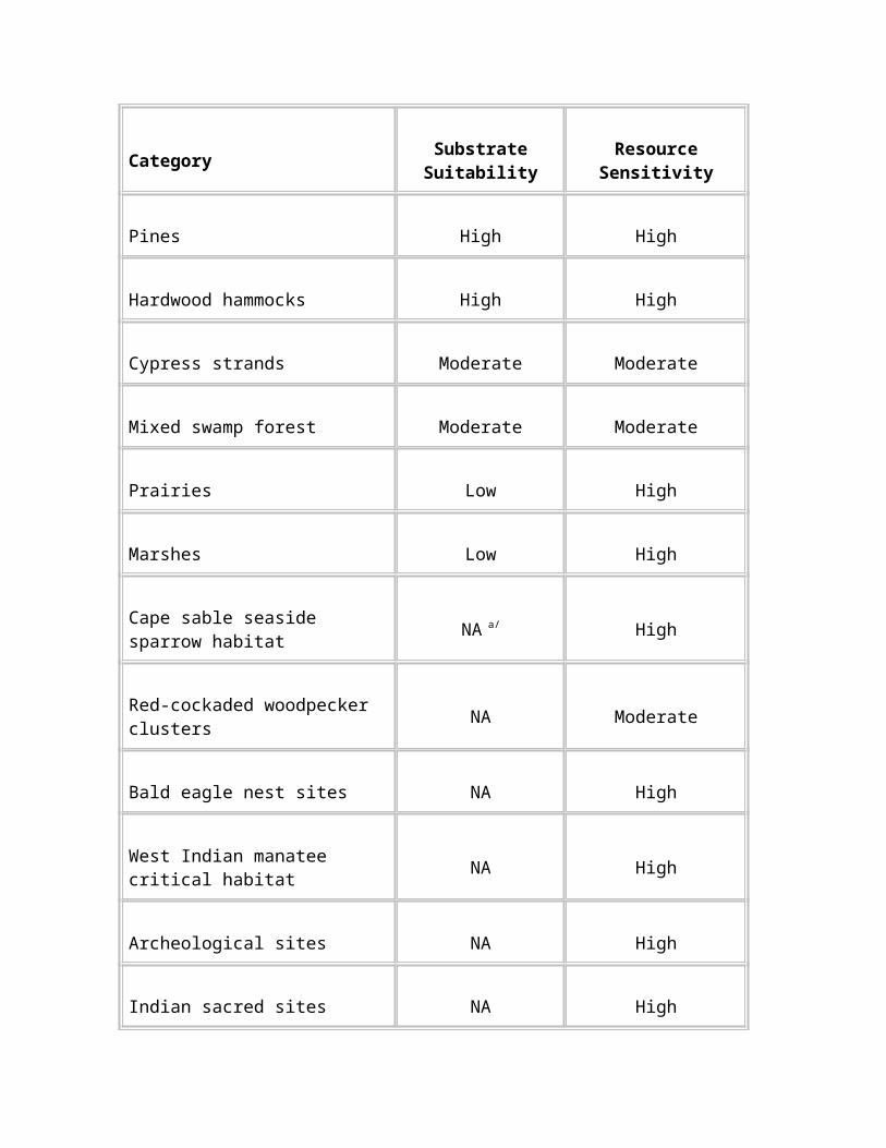
1991), and was the basis for formal consultation and the biological opinion prepared by the U.S. Fish and Wildlife Service (USFWS) under Section 7 of the Endangered Species Act. The record of decision for the general management plan and environmental impact statement modified the permit ceiling to 2,500 permits annually, but consultation with the USFWS was never reinitiated on this issue. This oversight was pointed out by public comment on the draft ORV management plan and environmental impact statement. Therefore, the proposed action would return the permit ceiling to 2,000, which would comply with the USFWS biological opinion.
As the proposed action was implemented, the vehicle permit program could be revised. The bases for changes could include research results, practical knowledge gained from the implementation of the plan, and safety concerns. Changes could include, but would not be limited to
reducing the number of permits issued annually, if monitoring demonstrated that recreational ORV use was causing unacceptable adverse effects on the preserve’s resources
limiting the number of permits issued for specific management units
limiting the number of ORVs that were allowed to enter the backcountry from each access point
When reevaluating the permit ceiling, the National Park Service would comply with appropriate laws and regulations, including the Endangered Species Act, and would provide public involvement when appropriate.
Vehicle permits would not be transferable to other vehicles owned by the same person or family, or to other vehicle owners. Off-road vehicles would be registered to only one person with a valid state driver’s license and only that person would be able to renew the permit.
Vehicle Inspection Program.
Vehicles would be required to meet specifications for that particular type of vehicle (all-terrain cycle, airboat, swamp buggy, or street-legal four-wheel-drive vehicle) before being eligible for a permit. Each vehicle would have to pass an inspection conducted by the National Park Service.
Vehicle inspections would result in a sticker that designated the vehicle as having met vehicle specification and safety requirements. This sticker would identify the vehicle over time. The inspection number would be included in a computer database and would stay with the vehicle for the entire time it was under the same ownership. Possession of an inspection sticker would mean only that the vehicle was eligible for the vehicle permit drawing and would not, by itself, allow for use of the vehicle in the preserve.
ORV owners would be encouraged to have their vehicles inspected prior to the drawing, during the period between October 1 and November 30. This would allow the ORV owner to be ready to participate in the drawing.
National Park Service staff would affix inspection stickers as follows:
airboat – steering bar (joystick)
swamp buggy – steering column
street legal – inside the driver’s door
all-terrain cycle – center of steering mechanism
The free inspection sticker would be valid for a 3-year period, at the end of which the vehicle would need to be re-inspected and a re-validated sticker would be obtained. All vehicles would be inspected in the first year of this new permit program, regardless of their inspection dates under the previous system.
Allocation of Vehicle Permits.
The vehicle permit system under the proposed action would begin with vehicle inspections and entry into a random drawing, which would be held for the opportunity to obtain a permit. The permit drawing would be held each December.
Permits would be valid from January 1 of each year through January 31 of the following year. This 13-month permit would allow for a month grace period to obtain a new permit, should the owner be successful in the drawing.
Announcement of the drawing would be sent out each October by letter to all previous permit holders and by press release. Cards for the drawing would be sent with announcement letters and would also be available at the preserve. Cards would also be given to those who had their vehicles inspected during the October 1 to November 30 period. During the first year of implementation, drawing cards would be filled out at the time of inspection. Drawing cards would be due into the permit station or postmarked by November 30.
The system would be designed to provide an opportunity for each vehicle owner, regardless of how many vehicles they may own, to receive at least one ORV permit unless the total number of individual owners exceeded 2,000. More than one permit per person would be available if the initial drawing resulted in fewer than 2,000 permit requests. A maximum of five permits would be allowed per individual. A waiting list would be developed to reassign permits not claimed by January 31.
Successful drawing participants would be notified immediately after the drawing and would be required to purchase their permit by mail or in person before January 31. If the
individual failed to purchase the permit by that date, the permit would go to the next person on the waiting list.
The owner would have the option of placing the purchased permit on any of the vehicles that were entered in the drawing. However, because the vehicle inspection number would be on the permit, the owner would have to specify the vehicle at the time of permit purchase.
Permits would be permanently fixed to the vehicle and would be non-transferable. The vehicle permit would be valid for 13 months. In each subsequent year, the vehicle owner would be required to reapply for the drawing, but could do so by mail unless an inspection was due.
ORV Operator Permit
Each person operating an ORV within the boundaries of the preserve would be required to obtain an ORV operator’s permit. This requirement would apply both to recreational ORV users and to landowners who were issued special use permits to access their private properties. The permit would be a picture identification and would be carried by the operator while using an ORV in the preserve.
All ORV operators would have to possess a valid state driver’s license, or possess a valid learner’s permit and be accompanied by a licensed adult 18 years or older who also possessed a Big Cypress National Preserve ORV operator’s permit.
Completion of a vehicle operator course would be required for each person who applied for an ORV operator permit. Information on this course is provided in the "Education and Communication" section. The National Park Service would offer this course in conjunction with the vehicle inspections at convenient times to reasonably accommodate those who wished to obtain a permit.
During implementation of the ORV management plan, research results are expected to produce greater knowledge of the best ways to operate and manage ORV use within the preserve. Therefore, operators would be required to attend the education course every year to stay current with rules and recommended techniques. As the program evolved and the need for updates diminished, the education program may be required less often.
The application for the operator’s permit would include a section stating the responsibilities of the operator while using the preserve. In signing the application, the permit holder would acknowledge that they understood and would conform with the rules and regulations.
Special Use Permit for Private Property Owners
Unless an exempt property owner has legal right of way or pre-existing access rights, legislation, laws, and regulations do not provide right of access via ORV.
Owners of improved private property within the preserve boundaries would be issued a free special use permit that would allow them reasonable access to and from their private property. The special use permit would authorize them to cross federal lands to access their property via a reasonably direct route. In most cases, the property access trail would be limited to use by the landowner only. The property access route would be
resource-protection based
described in detail on the permit
determined by the National Park Service in consultation with the landowner
The special use permit would not be included in the 2,000 recreational ORV permits allocated annually. However, it also would not allow for recreational ORV use in the preserve. If landowners wanted to recreate with an ORV within the preserve, they would have to participate in the annual drawing for vehicle permits. If they did not draw vehicle permits, landowners would be restricted to using their ORVs on their private property and on the access route specified on their special use permit. This special use permit would not allow use of ORVs for any recreational activity in the preserve.
Owners of private frontcountry properties would not be allowed to enter the preserve on ORVs from any point along their property boundary. They would have to use a designated access point. Backcountry property owners also would be required to enter the preserve via designated access points.
The designated access points shown on the Conceptual Framework of Access Points and Primary Trails map currently do not include entry into the Corn Dance Unit from the east side. The National Park Service may consider allowing access into this unit for property owners who have permission from adjacent landowners.
Special use permit holders would have to meet all of the other requirements for ORV use in Big Cypress National Preserve. This would include, but not be limited to, holding a valid ORV operator permit for the preserve, meeting all vehicle specifications, completing the education course annually, and complying with all rules and regulations relating to recreational ORV use in the preserve.
Education and Communication
It is critical that all ORV operators understand the intent, purpose, and requirements of the ORV management program. Only with knowledge of the rules and regulations can the ORV user appreciate and understand the potential impacts of ORV use and the consequences of misuse. Therefore, the following types of information would be given to ORV users:
an orientation to the preserve, the mission of the National Park Service, and the geography of the preserve
a review of the rules and regulations governing ORV use in the preserve
safety procedures for operating an ORV in the preserve
introduction to the designated access points and trails
resource sensitivity, including staying on designated trails, low-impact camping techniques, and wildlife awareness
details of the permit process, including how to apply, and the privileges and responsibilities of the permit holder
awareness of previous adverse effects, how they occurred, ways the new ORV management system mitigates past effects, and what is being done to restore areas
This information would be provided through any or all of the following:
an ORV user’s guide, with map
an operator’s orientation that would be required as a prerequisite to obtaining an ORV operator’s permit
an Internet page specifically for ORV users
posting on the bulletin boards at each access point
All materials would be designed to be easily understood. They would be easily adapted to changing management strategies and flexible enough to incorporate new materials as research revealed additional information on operating techniques. NPS staff, subject matter experts, and local recreational ORV users would be sources of information for the materials.
Vehicle Specifications
It is the intent of the National Park Service to establish vehicle specifications that protect the preserve’s resources while providing for reasonable recreational access. The criteria established below are based on the best available information and the Code of Federal Regulations (CFR). Vehicle types are defined in 36 CFR 7.
Preserve staff would continuously evaluate ORV equipment and its effects on resources and the visitor experience. If it was determined that certain ORV equipment was causing unacceptable impacts, ORV equipment specifications would be modified.
Under the proposed action, Big Cypress National Preserve would initiate additional research to refine the vehicle specifications. Based on research results, limits could be established in the future for a number of vehicle characteristics, such as overall weight, tire size, tire type, noise, and ground-bearing pressure (measured in weight per unit area, such as pounds per square inch).
Initially, the proposed action would not include any requirements for ground-bearing pressure. However, under the adaptive management provisions of the plan, ground-bearing pressure requirements may be added if research indicates that they would help to reduce soil displacement and rutting by ORVs in the preserve. Using wider, high-flotation tires and reducing vehicle weight may help reduce soil displacement, rut depths, and root damage. This could allow for greater use of trails that might otherwise become impassible, and reduce the tendency of users to expand ORV trails (Smidt and Blinn 1995).
Under the proposed action, vehicles would be required to meet the following specifications.
Vehicle width and length:
Wheeled vehicles could not exceed 8.0 feet in total width, including tires.
Airboat total width could not exceed 8.0 feet.
Airboat length could not exceed 14.0 feet (total length, including the grass rake).
Noise control:
All wheeled vehicles would be required to have a muffler in good working condition and in constant operation.
All airboats would be required to have one or more exhaust headers or manifolds attached to a flex pipe and routed to the rear of the boat.
Airboat requirements:
Airboats would have to meet all Florida and U.S. Coast Guard rules and regulations for vessels, including lighting and registration.
A solid, orange-colored safety flag, 10 inches by 12 inches or larger, flown at a minimum of 10 feet above the bottom of the airboat, would be required (36 CFR 7).
Vessel registration numbers, with a minimum size of 3 inches, would have to be displayed on each side of the bow, or on both sides of the rudder, or outside of the dual rudders. The numbers would have to be a contrasting color from the underlying hull or rudder.
Other ORV equipment:
All ORV mechanical systems important for safe operation must be in good operating condition.
Tires on all buggies and street legal ORVs must have a minimum of 9 inches of tread face.
On all-terrain cycles, the minimum tire tread face requirement would be 7 inches in the front and 9 inches in the rear.
Any device used to push aside, shear off, or otherwise damage vegetation would be prohibited.
Any tire chain, bar grip, or other device affixed to a tire in any way would be prohibited.
All tracked vehicles would continue to be prohibited.
Rules and Enforcement
The secretary of the interior is authorized to designate, pursuant to standards prescribed in regulations by the secretary, "certain officers or employees of the Department of the Interior whom shall maintain law and order and protect persons and property within areas of the national park system. The secretary of the interior shall make and publish such rules and regulations, as he may deem necessary or proper for the use and management of the parks, monuments, and reservations under the jurisdiction of the national park system" (16 USC).
ORV rules would include the provisions contained throughout this description of the proposed action. These rules would include, but not be limited to,
using only designated access points and trails
staying out of closed areas
having all three required permits
meeting all applicable vehicle specifications and training requirements
To facilitate compliance with regulations, the National Park Service would publish and distribute an ORV user’s handbook, which would be updated as needed.
Some of the other rules that would apply to the use of ORVs in the preserve are listed below. With the adoption of the proposed action, rules for ORV management would be codified in the Code of Federal Regulations (36 CFR 7.86).
To enforce ORV rules, NPS rangers would regularly conduct ground and aerial patrols of the preserve. This would include visiting the access points and traveling the designated trails to determine compliance.
As provided by law, a person convicted of violating a provision of the regulations within Big Cypress National Preserve could be punished by a fine, by imprisonment, or both, and could be adjudged to pay all costs of the proceedings (36 CFR 1.3). ORV operators who did not comply with preserve rules or permit requirements could also have their permits suspended or revoked, could be required to pay restitution for damages caused to the resources, could be subject to seizure of their vehicle and other property used during the offense, and could be banned from applying for an ORV permit for a specified period.
Some of the rules that currently apply to the operation of ORVs in Big Cypress National Preserve are listed in the "Rules and Enforcement" section of the no action alternative (continue current management). All of those rules would continue to be enforced under the proposed action. In addition, new rules would be established for ORV use under the proposed action. Some of the new requirements, which are based on Title 36 of the Code of Federal Regulations, are identified below. Adaptive management would be used to evaluate the effectiveness of ORV use rules under the proposed action, and changes would be made as appropriate.
All ORV operators would have to have in their possession a valid state driver’s license or possess a learner’s permit and be accompanied by a licensed adult 18 years or older. The operator with the learner’s permit would have to stay within 100 feet of the licensed adult during operation of the vehicle. Operators would be required to have in their possession a Big Cypress National Preserve ORV operator’s permit.
Operating ORVs off of designated trails or roads would be prohibited.
Vehicles would have to enter the preserve at designated access points.
ORVs would not be allowed to travel or operate between 10:00 p.m. and 5:00 a.m.
Speed limits would be 30 miles per hour for airboats and 15 miles per hour for wheeled vehicles.
"Power loading," or running the engine to move the airboat onto the trailer, would be prohibited.
It would continue to be the responsibility of the user to know and follow all rules and regulations that apply to Big Cypress National Preserve.
Restoration
This section outlines the process the preserve would use to return areas impacted by ORV traffic to a more desirable condition and monitor the success of those recovery activities.
To focus restoration efforts most effectively, it is important to first understand the extent and severity of the adverse effects to the preserve ecosystem caused by the use of ORVs. The extent of degradation would, on a gross spatial scale, be answered by ground-truthing aerial photographs taken of the preserve. The National Park Service is currently working with the University of Georgia to ground-truth ORV trail maps (Welch and Madden 1998; Welch et al. 1999).
It is vital to also determine what ecosystem processes or functions are not working. For example, has the diversity of the ecosystem been altered? Are the soils providing needed substrate for vegetation? Unless the problems are well understood, restoration can not be achieved. Secondly, restoration techniques for the degraded ecosystems must be determined. What are the most effective techniques and methods to return the ecosystem to a desired state? Lastly, after restoration techniques are determined and implemented, what are the environmental indicators that mark success?
To begin to set goals for restoration, a definition of "restoration" needs to be established. The National Research Council (1992) defines restoration as the "return of an ecosystem to a close approximation of its condition prior to disturbance." This report also suggests that restoration is by nature holistic and that recreating the form of an ecosystem but not restoring the functions of that system is not restoration. Applying this to the preserve, restoration is not necessarily achieved when ORV use has been removed from an area for a period of time and the area "turns green" again. Questions that need to be asked include: Is this area re-vegetated with those species that would naturally occur here and in the same proportions? Is the habitat that was once (before disturbance) supported by this area available again? Restoration can include one or more of the following: reconstruction of physical conditions such as topography or grade; chemical changes to the soils and water; and biological components such as the re-introduction of native plant species.
Long-range goals for restoring ORV disturbed sites in the preserve are to:
remove the scars caused by vehicles and recover a sustainable, self-regulating, self-organizing ecosystem, by restoring to the extent possible the biological, physical, and chemical characteristic of the system
meet biological, physical, and chemical targets defined by performance measures
To provide a gauge against which to measure restoration success there must be a baseline or reference condition. Specific restoration project goals should state which impacted condition(s) (for example, vegetation) is chosen for improvement. As restoration efforts proceed, the existing resource condition should begin to more closely resemble the reference condition. Restoration objectives defined in measurable ecosystem conditions (for example, vegetative community composition and richness) would define the basis for tracking restoration success.
A key factor in successful resource restoration is to, if possible, remove the source of the adverse effects to the resources. Implementing the proposed action would allow ORV use only on designated trails. Removal of dispersed ORV use would help sustain restoration efforts. Areas to be restored must be ranked. These priorities would be determined based on the relative importance of the area to the preserve’s overall management goals. Attributes that would be considered for prioritization include visual or scenic values, and the status of the biological, physical, and chemical ecosystem components or habitat health.
After the source of the resource impacts was removed, the best approach to restoring those areas would then be determined. Two approaches are to allow the area to recover on its own (passive restoration), or to in some way manipulate the area (active restoration). To let natural, or passive, restoration take place, the ecosystem’s self-organizational qualities must be sufficient to correct the pathology and restore the original optimal operating point.
The self-organizing quality of an ecosystem relates to the overall integrity of the ecosystem. The following flow chart will assist in deciding which of these pathways to choose. This process is based on current understanding of the preserve’s resources and would be modified as more was learned about the ecosystem functions and recovery.
The restoration plans for identified areas would provide specific guidance for the earthwork, revegetation methods, invasive plant control, monitoring, and restoration at each site. As part of each reclamation plan, the National Park Service would develop a planting plan based on the desired plant community to be established, site elevations, water table elevations, and soil conditions. The planting plan would recognize which native plant species from nearby reference sites could live and reproduce within the range of environmental conditions that exist at each restoration site and could be used for revegetation.
IF: THEN:
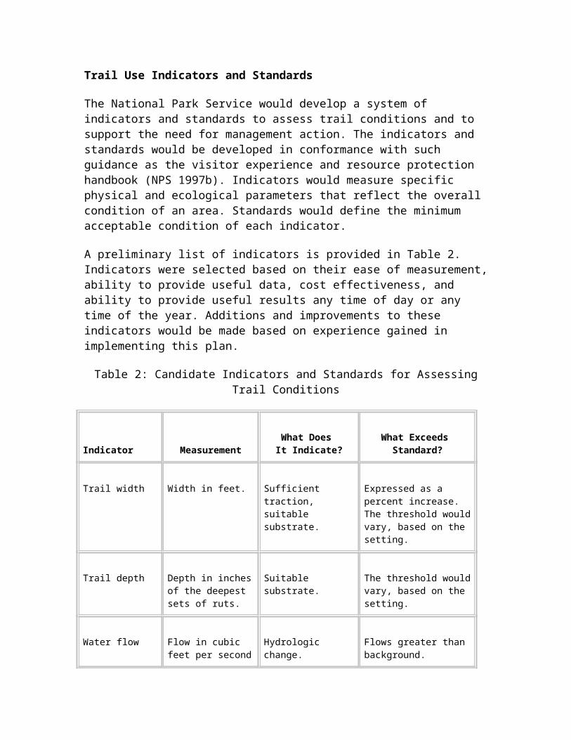
1. Surface near natural grade
Absence of invasive plants
Natural revegetation would occur over a short period Allow natural
revegetation
Surface water flow patterns are near natural conditions
1. Unnatural contours2. Natural revegetation
would occur over a long period
3. Presence of invasive plants
Upland areas: grading, planting, seeding, invasives controlActively implement
restoration measures
Wetland areas: grading during dry season, natural revegetation, control invasive plants
For upland areas with unnatural contours, invasive plant species, and/or where natural revegetation was a slow process, the National Park Service would actively implement restoration measures. Grading, planting, and/or seeding would begin after closure. Native species found in nearby reference sites that were suited for upland conditions and that could compete with invasive plants would be selected for revegetation whenever possible. Plants would be propagated from seeds and cuttings gathered in the preserve at nearby reference sites. If available, indigenous material from commercial sources might be used.
For disturbed wet areas, the primary restoration method would be grading during dry periods to restore natural surface elevations and contours, and to create more natural surface water flow patterns. In some cases, disturbed areas would be reshaped or water conveyance structures installed to restore water flow directions and velocities. After grading was completed, natural regeneration of wetland vegetation would be allowed to occur without planting or seeding.
In some cases, natural regeneration of vegetation without grading, planting, or seeding would be allowed to occur. This passive restoration
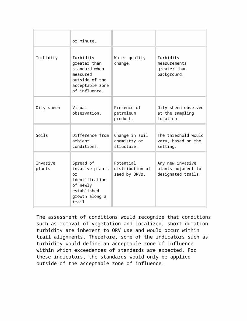
would be the preferred method in areas where the surface was near natural grades, invasive plants were not a problem, natural revegetation would occur over a short period, and surface water flow patterns were near natural conditions.
Although the above discussion outlines certain actions that would be taken – grading, planting, seeding – the specific techniques to use have yet to be determined. Because information on restoring areas disturbed by ORV use in south Florida is limited, research would be conducted that would apply various techniques to test areas. The results from these studies would be applied to determine the most effective means to restore habitat in impacted areas. Factors that would be considered when selecting the most feasible restoration techniques for a given area include the spatial scale, cost, and environmental impacts or risk associated with the technique.
Implementation
Under the proposed action, restoration would be a long-term activity. Execution of on-the-ground techniques to meet restoration goals would require detailed planning. The key components of restoration implementation, which would be applied to those areas that were identified for active restoration would include the following:
determining site-specific restoration goals
securing adequate funding
organizing and sequencing implementation activities
determining roles and responsibilities
developing a schedule
obtaining necessary permits
applying adaptive management to the process
Resource Recovery Monitoring
The goal of resource recovery monitoring would to determine the effectiveness of both active and passive restoration efforts, and to use this information to make adjustments to the restoration program as needed. Resource recovery monitoring would be conducted on areas that were closed to ORV use.
Indicators
The impacts of ORVs are most apparent on soils and plant communities. Therefore, these would be the most obvious choices for monitoring recovery of areas where ORV use had been restricted. More information is needed to determine which, if any, water quality monitoring parameters would yield useful recovery information. The response of wildlife to ORV traffic would be examined through research projects. Specific indicators would be chosen to reflect the restoration goals. For example, where the goal was to re-establish the natural grade of a prairie that had been extensively rutted by ORV traffic, topographic measurements may be taken. Measurements of the vegetation would be the appropriate indicators where re-establishment of the native plant community was the restoration goal.
Plants are convenient biological elements available for measure. They are valuable as measures of communities, as they reflect much of the physical nature of the community, particularly hydrologic and edaphic characters. Disturbances in the plant community may originate as a physical change, such as mechanical movement of soils in the substrate, or chemical change, such as a difference in local hydrology. Physical disturbances to substrates often result in soils that support greater numbers of ruderal plants (weeds), and lower species diversities. Measures of plant communities in affected areas may be conducted as comparisons with areas with little or no human-caused alteration.
Methods
Both aerial photography and on-the-ground measurements would be used for monitoring resource recovery. Aerial photographs would provide information on the overall recovery of preserve resources once the ORV management program was implemented. More intensive, on-the-ground measurements would yield information about the recovery of biological and physical attributes of specific areas.
Reference sites would be selected to compare targeted recovery areas with areas undisturbed by ORV traffic. Areas for comparison would be selected based on such features as community type, soil type, and hydrology. Replicate reference sites would be used to measure natural variation in similar communities and would be located in separate community systems. Considerations for field quantification of these sites should be the same as those for affected sites. Areas that are recovering from disturbances would be more similar to undisturbed areas as recovery progressed, and this would be reflected in diversity and similarity measures. Similarly, differences in areas that may have occurred with ORV use, may be demonstrated with these comparisons.
Requirements to monitor changes in biological communities may be partly addressed with diversity measures. At least two types of comparison can be used :
Identifying and comparing areas that differ can help to demonstrate changes in amounts of area affected over time.
Comparing amounts of difference between altered areas with areas identified as undisturbed, over time, can help identify whether recovery by the natural system is occurring.
If remediation or restoration is taking place, the effectiveness of these activities may be considered as change in altered areas becoming more similar to unaffected areas.
Acceptable alterations to natural areas (and habitat recovery programs) should be derived from standards applied to other national area, and refined to reflect the resources at Big Cypress. If these standards are not available, or clearly are not applicable to this area, standards derived from opinions of experts, public input, or preserve management and staff would be required. These standards should be flexible, to allow change as more information became available, but restrictive enough to adequately protect the biological community’s resources.
Differences between sites of investigation always will exist, so that measures will be needed to determine the naturally occurring variation in the communities studied. When this variation is known, measures of communities can be compared to determine differences of sample areas. Variables may include biotic and abiotic community elements. Considerable differences may occur with these communities, so that many measures may be necessary to obtain reliable comparisons. Following this, an acceptable level of difference between altered sites and naturally occurring habitat sites would be established for management decisions.
Frequency and Timing
The frequency and timing of resource recovery monitoring would be determined by the specific restoration project goals and the restoration techniques that were implemented.
Information Needs
How to best apply aerial data gathering techniques for monitoring ORV impacts and resource recovery trends would need to be established. Although vegetation and soils information is generally thought to be the
most direct indicators of resource recovery, the specific attributes of these parameters which yield the best information would need to be refined.
Research
Research needs have been identified throughout this description of the proposed action. As an integral part of the proposed action, research that focused on the outstanding questions related to managing ORV use in the preserve would be implemented. The results from this research would be used to make continuous improvements to the ORV management program.
Table 3 summarizes studies that would be useful in supporting management of ORVs in Big Cypress National Preserve. Although all of these research topics are important, budgets and staffing constraints would require that priorities be set. Therefore, the table includes an indication of the priority of each study and its justification.
Implementation Strategy and Schedule
Because of the comprehensive nature of the proposed action, implementing all aspects of the plan could take up to 10 years. The proposed action is conceptual in that not all of the information that is needed is currently available. More information would be gathered as a part of implementation, especially for restoration. This characteristic of the plan would provide for an iterative process that relied on feedback from the implementation of other parts of the plan. For example, the proposed action would result in the adoption of a designated trail system. However, it currently is not possible to identify exactly where all of these trails would be or how they would be maintained.
Table 3: Research Needs
Project Name Description
Priority and Justification
EstimatedCost
Research goal: support the siting, construction, maintenance, and monitoring of the designated trail system.
Ground-truth University of Georgia mapping data
Verify the trail and ORV use area database developed from aerial photographs.
HIGH. Continue to improve the accuracy of information on trails.
$115,000
Evaluate trail stabilization techniques
Identify best techniques, methods, and materials to harden and maintain trails and access points.
HIGH. Need to construct trails and access points with materials appropriate for environmental conditions and use, and to continually maintain these features.
$200,000
Improve topographic mapping
Current topographic mapping is at 5-foot intervals. Because the topographic relief in the preserve has less than 20 feet of variance, this level of detail is minimally useful in defining surface water flows across the preserve.
HIGH. Applications of more precise topographic information include mapping soil rutting, identifying vegetation changes, and determining trail locations to reduce surface water flow impacts.
$210,000
Determine how to apply aerial mapping for monitoring ORV impacts
Establish a technique to evaluate ORV use impacts, trends, and resource recovery.
HIGH. Aerial techniques will be necessary to effectively monitor the entire preserve trail system and resource recovery efforts.
$30,000
Research goal: determine existing levels of recreational use and the types of vehicles best suited for use in the Big Cypress environment.
Determine impacts of a range of vehicle specifications on natural resources
Refine current understanding of the types of ORVs that reduce impacts to the preserve’s soils, vegetation, and wildlife.
HIGH. Need to establish the effects of such factors as vehicle weight, ground pressure (psi), tire type, and vehicle noise to help profile the optimal "environmentally friendly" ORV. This would support future management decisions on vehicle specifications.
$220,000
Determine ORV carrying capacity of management units
Establish the numbers and types of ORVs that can be sustained in the management units without causing resource degradation.
MEDIUM. This information needs to be sequenced after the new designated trail system is in place.
$50,000
Table 3: Research Needs (Continued)
Project Name Description
Priority and Justification
EstimatedCost
Research goal: initially conduct or update inventories of the preserve’s flora, fauna, and soils. The results would be used to establish a baseline to determine future trends in resource condition, identify ecosystem stresses and associated environmental indicators, and determine if sensitive resources were or had the potential to be adversely affected by the designated trail system.
Update natural resources inventory and analysis
Establish baseline, identify stresses and indicators, and determine levels of concern for sensitive resources.
MEDIUM. Inventories previously have been done for many natural resource categories, but updates are needed to account for changes from ORV use and other factors within the dynamic ecosystem.
$300,000
Inventory and map soils
Same as above. HIGH. Soils provide the base for the preserve’s ecosystem.
$150,000
Inventory reptiles and amphibians
Same as above. MEDIUM. Need to understand dynamics of fauna and habitat needs.
$180,000
Inventory small mammals
Same as above. MEDIUM. Same as above. $150,000
Inventory birds Same as above. MEDIUM. Same as above. $90,000
Inventory invertebrates
Same as above. MEDIUM. Same as above. $180,000
Inventory fish Same as above. MEDIUM. Same as above. $120,000
Update plant inventory, abundance, and distribution
Same as above. LOW. Need to document changes in dynamic plant communities.
$120,000
Determine sensitive noise
Establish baseline on the "natural quiet" of the preserve
LOW. Need a baseline against which to compare the noise
$100,000
receptors and the natural sound-scape of the preserve
and determine levels of concern for sensitive noise receptors.
generated by ORVs and sensitivity values for receptors to established acceptable levels of noise.
Table 3: Research Needs (Continued)
Project Name Description
Priority and Justification
EstimatedCost
Research goal: determine the effects of ORV use under the proposed action on the preserve’s flora, fauna, and soils.
Identify and analyze cumulative effects of ORV use
Evaluate the impacts of ORV use over time.
HIGH. Need to comply with NPS mandate to protect resources in perpetuity.
$400,000
Determine the response of the Cape Sable seaside sparrow to airboat use
The Stairsteps Unit has known Cape Sable seaside sparrow habitat and additional potential habitat. Direct and indirect effects of the use of airboats on this species would be analyzed.
HIGH. The Cape Sable seaside sparrow is a federally listed species under the Endangered Species Act. The USFWS has been petitioned to revise the critical habitat designated for this species.
$300,000
Analyze Florida panther response to ORV use
Early studies have suggested that ORVs affect the behavior of panthers. Further studies would help determine the accuracy of these findings.
HIGH. The Florida panther is a federally listed species under the Endangered Species Act.
$150,000
Determine the effects of ORV use on soils
Analyze soil compaction, soil moisture effects, oxidation, and other properties in reference to ORV effects.
HIGH. Soils are an integral environmental component of the preserve’s ecosystem.
$50,000
Determine effects of ORV use on
Analyze the effects of spread of invasive plant species via ORVs
HIGH. Vegetative community response to ORV use is needed to
$210,000
vegetative communities
and changes in vegetative community composition along ORV trail areas.
most effectively site trails and to determine the most effective restoration techniques.
Determine the effects of ORV use on surface flow
Analysis of sheet flow patterns across the preserve in reference to ORV use.
HIGH. Study is needed to refine understanding of the effects of rutting on hydrologic regime of the preserve.
$50,000
Evaluate impacts of ORV traffic on water quality
Evaluate parameters such as spatially cumulative aspects of turbidity, and re-suspension of nutrients and metals from soil disturbance.
LOW. Other habitat components such as soils and vegetation are believed to be more direct indicators of environmental integrity in relation to ORV use.
$50,000
Determine disturbance to wildlife from ORV use
This would include impacts of noise from ORVs on wildlife.
LOW. Basic inventories of other wildlife species are needed before this study.
$210,000
Table 3: Research Needs (Continued)
Project Name Description
Priority and Justification
EstimatedCost
Research goal: examine recreational interactions to ensure that all visitors to the preserve have an enjoyable and educational experience.
Determine recreational interactions and effects on visitor experiences
Evaluate the experiences all visitors have and determine any incompatibilities between different user groups.
HIGH. Need to respond to numerous public comments regarding user conflicts between ORV and other preserve visitors.
$300,000
Research goal: determine the most efficient and effective means of mitigating effects caused by ORVs and establish best management practices for use in the preserve.
Develop Determine the efficacy of HIGH. Need to know the most $260,000
mitigation and restoration techniques
restoration techniques applied to areas that have been impacted by ORV use.
appropriate means to restore natural resources impacted by ORVs.
Three scenarios have been suggested for implementing the designated trail system:
complete closure of the preserve to ORVs until the trail system was established
complete access to areas of the preserve that currently are open to ORV use until the trail system was established
phasing of actions to provide a transition to a designated trail system
The National Park Service currently is planning a three-phased implementation throughout a 10-year period. Actions would include:
immediately eliminating ORV access from areas that are heavily impacted and that are highly sensitive to impacts, such as prairies
requiring use of the designated trails where they have been established, and allowing dispersed use (outside of designated closed areas) until trails are in place throughout the preserve.
immediately establishing management rules and actions that do not depend on sequencing
determining carrying capacity of ORV use for each management unit
incorporating new information in the trail designation process as it becomes available
Table 4 outlines the proposed implementation schedule. Adaptive management, relying on feedback from all aspects of the plan, would be applied throughout implementation.
Table 4: Implementation Schedule for the Proposed Action
Activity Phase I Phase II Phase III
Trail system
Design plan for trail designation and construction
X
Ground-truth and mark trails X X
Establish temporary trails around designated sensitive areas
X
Stabilize existing trails selected for designation
X X X
Maintain trail system X X X
Access points
Designate X
Develop X X
Maintain X X X
Eliminate vehicle storage at Monroe Station
X X
Implement spatial closures. Refine the boundaries of sensitive areas and endangered species nesting areas closed under the authority of 36 CFR.
X X X
Implement temporal closures X X X
Hydrologic triggers for resource protection
Seasonal closure to provide rest period for resources (optimal season to be determined as part of the program’s adaptive management)
Prohibit recreational ORV operation between 10:00 p.m. and 5:00 a.m.
ORV user map
Develop X
Revise as needed X X
Permit program
Renew existing permits until January 2001
X
Define vehicle specifications X X X
Initiate vehicle inspection program X
Issue up to 2,000 annual recreational ORV permits beginning January 2001
X
Initiate ORV operator permit program and education requirement
X
Initiate permit system for all backcountry use
X
On-going implementation X X
Research
Initiate highest priority research projects X
On-going X X
Table 4: Implementation Schedule for the Proposed Action (Continued)
Activity Phase I Phase II Phase III
Initiate environmental permitting, compliance, and mitigation required for various ORV program components
X
Establish advisory committee X
Restoration
Establish interdisciplinary team X
Initiate implementation X
Continue implementation X X
Education program
Initiate ORV operators course X
Refine course and other materials X X
Trail condition monitoring
Develop trail standards X
Establish techniques for determining baseline conditions
X
Monitor trail conditions X X
Resource recovery monitoring
Establish and refine monitoring techniques
X X
On-going monitoring X X
Enforce all NPS legal mandates related to ORV program management
X X X
Apply adaptive management to ORV program based on research and feedback from implementation
X X X
Phase I would start in the first year of implementation. It would include actions that could be completed or initiated immediately, or would be necessary for completion of subsequent actions.
Phase II generally would be started in years 2 through 5 of the program. It would include a continuation of some of the actions started in Phase I and the initiation of actions dependent on Phase I completion.
Phase III would include long-term and on-going efforts, including monitoring, research, restoration, maintenance,
and enforcement. All of these activities would be started before the end of year 10.
Cost
The preliminary cost estimate for implementing the proposed action is outlined in Table 5. This estimate includes
initial and recurring costs for staffing, equipment, and materials needed for operating the permit and education programs
designating, marking, constructing, and maintaining the trail system and access points
trail condition and resource recovery monitoring
restoring impacted areas
conducting research to support management decisions
Table 5: Implementation Cost Estimate for the Proposed Action
Activity Estimated Cost
Permit program administration $100,000 annually
Enforcement $250,000 annually
Education program $35,000 in year 1;$20,000 annually thereafter
Trail and access point design,marking, and maintenance
$1,000,000 annually(estimated for the first 5 years)
Trail condition monitoring $50,000 annually
Restoration To be determined
Research $5,000,000 total, based on research needs identified in Table 3
Environmental permitting/compliance $200,000 (total)
Because of the adaptive nature of this plan, cost estimates for each of these activities would be refined as more information was gathered through the implementation process. Cost for restoration would be determined through research results on the most effective restoration techniques. It is anticipated that significant funding for restoration would be needed in the future.
Funding sources for additional staffing and equipment would include requests for increases in the preserve’s operating budget, which is determined annually through Congressional funding processes and by priorities set by the Department of the Interior and the National Park Service. Funding for research projects would be sought through several sources, including the National Park Service Natural Resources Protection Program (NRPP), the Cultural Resources Protection Program (CRPP), the Operating Financial System (OFS), and the Critical Ecosystems Study Initiative (CESI). Cooperative research programs with universities would be considered. Congressional line-item funding also would be sought for construction, maintenance, and restoration. To date, approximately $12,000,000 in funding has been requested for implementation.
No Action Alternative (Continue Current Management)
Introduction
The no action alternative (continue current management) would continue the current NPS programs for ORV management and natural resources management within the preserve. The ORV Management – No Action Alternative map provides a graphic representation of this alternative. Under this alternative:
the Bear Island Unit would be open to ORV use on designated trails
the Corn Dance Unit and Turner River Unit would allow for dispersed ORV use
the Stairsteps Unit would be managed under the four-zone strategy
the Deep Lake Unit and Loop Unit would remain closed to ORV use
The National Park Service would require an annual permit for each off-road vehicle. The permit would be obtained if the vehicle met the specification and safety equipment requirements.
Access to the preserve would continue to occur from approximately 70 informal access points. Many of these do not have parking or involve the unsafe and illegal practice of driving on the road shoulder from an area where parking is available.
The National Park Service would respond to needs and problems, but no major change in management direction would be initiated under the no action alternative. Methods to avoid or reduce adverse ORV impacts would include regulation of ORV use and mitigation of impacts.
This alternative would not meet the legislative mandates and NPS policies for resource protection, or comply with the 1995 settlement agreement. This concern is described in the sections entitled "Purpose of and Need for the Plan" and "Environmental Consequences."
Continuing current management under this alternative would not be consistent with the goals and concepts of ORV management established in the preserve’s general management plan. The primary focus of the general management plan, as directed by federal law and executive orders, is that preserve lands would be "closed to ORV use except for those areas or trails that are suitable and specifically designated as open to such use" (NPS 1991).
Only a few of the general management plan’s proposed actions have been implemented. These include restricting ORV use to designated trails in the Bear Island Unit, closure of the Deep Lake Unit, and prohibiting the use of tracked vehicles in the preserve. However, no trails, areas, or access points have been designated in the Turner River Unit and Corn Dance Unit, and there have been only limited area closures and trail designations in the Stairsteps Unit. Continuing current management under this alternative would allow continued, virtually unrestricted ORV access and use in the Turner River Unit and Corn Dance Unit, and much of the Stairsteps Unit, in variance with the general management plan.
Figure – ORV Management - No Action Alternative (Continue Current Management)
The Big Cypress National Preserve general management plan and environmental impact statement included a limit of 2,000 vehicle permits per year (NPS 1991). This limit was not only the basis of the environmental analysis, but also was cited in the formal consultation between the National Park Service and the U.S. Fish and Wildlife Service under the Endangered Species Act. However, the record of decision for the plan and environmental impact statement issued the following January (NPS 1992) increased the total number of vehicle permits to 2,500 per year without reinitiating formal consultation as required by the Endangered Species Act. As a result, approval of this no action alternative would require formal consultation with the U.S. Fish and Wildlife Service to reinstate the 2,500 vehicle permits per year limit.
Trails, Areas, and Access Points
Trails and Areas
Under this alternative, the National Park Service would continue to manage ORV use in the general framework established in the general management plan and environmental impact statement. This framework used a management unit approach, shown in the ORV Management - No Action Alternative map. The six units would be managed as follows.
Bear Island Unit . Within the Bear Island Unit, wheeled ORVs would be restricted to approximately 55 miles of designated trails, 16 miles of which are above-grade roads constructed prior to the establishment of the preserve for agriculture, logging, and mineral exploration. This unit contains a relatively high density of Florida panthers. Therefore, ORV use restrictions were initiated in 1989 to reduce potential disturbance to panthers, control hunting pressure on panther prey, and protect important resource areas. In 1991, designated trails were established in this unit and travel off designated trails was prohibited. Most of the area is within 1 mile of an ORV trail, with no area farther than 2 miles from a trail.
Turner River Unit. This management unit currently is designated as open to dispersed traffic for all types of ORVs. ORVs are prohibited on the Florida National Scenic Trail, except for required crossings. ORV use would not be permitted on any new mineral access roads (NPS 1991).
Corn Dance Unit. The Corn Dance Unit currently is open to dispersed traffic for all types of ORVs. ORVs are prohibited on the Florida National Scenic Trail, except for required crossings. ORVs also are prohibited on the existing mineral access roads, including Eleven-Mile Road. Under the no action alternative, ORV use would not be permitted on any new mineral access roads (NPS 1991).
Stairsteps Unit . Special management zones and restrictions were defined for the Stairsteps Unit in 1990 to allow area-specific ORV management. This unit is the wettest area of the preserve, and is often referred to as "airboat country." There are designated trails in Lostmans Pines.
The Stairsteps Unit contains four special management zones (see ORV Management – No Action Alternative map).
Zone 1: This zone includes the Ochopee Prairie. Airboats have been prohibited in this zone since 1994 because concentrated commercial airboat traffic caused considerable adverse effects to its natural resources. Dispersed use by wheeled ORVs is allowed in this zone.
Zones 2 and 3: These zones are open to dispersed used by all permitted ORVs.
Zone 4: This zone is restricted to airboats, except in the Lostmans Pines area, part of which is open to all ORVs and part of which is open only to all-terrain cycles and airboats.
Deep Lake Unit . With implementation of the no action alternative (continue current management), ORVs would be prohibited within the Deep Lake Unit. This unit was closed to ORVs in 1989 because of the unit’s important resource areas and concern about illegal and unchecked hunting, which was difficult to control because of the unit’s accessibility from surrounding roads (NPS 1991). This closure was also expected to reduce hunting pressure on panther prey and potential disturbance from ORV use of panther habitat.
Loop Unit. ORVs would continue to be prohibited within the Loop Unit. The Loop Unit was closed to maintain the primitive character of the area. The unit would be used as a control zone for comparing the extent of ORV impacts in other areas of the preserve.
Access Points
Currently, ORV access to the preserve is largely uncontrolled. Approximately 70 undesignated access points are used on a regular basis, and would continue to be used under the no action alternative. ORV users would be allowed to continue accessing the backcountry at any location.
Monitoring
As funding allows, Big Cypress National Preserve would continue to provide mitigation measures for the historical, current, and future environmental impacts that accrue as a result of the continued use of ORVs. Measures would be limited, but could include monitoring, research on trail improvement, and reclaiming or restoring impacted areas.
Limited resource monitoring to evaluate ORV effects has been conducted at the preserve. As funds were made available, resource monitoring would systematically collect and compare standardized resource measurements from different times to predict or detect natural and human-induced changes. Monitoring would provide managers with information necessary for establishing and evaluating resource protection policies, strategies, and actions. A monitoring program would help detect and evaluate trends. It may detect deteriorating conditions before severe or irreversible changes occur, allowing time to implement corrective actions. Analysis of monitoring data may assist in the selection of appropriate management actions and reveal their effectiveness over time.
Management Actions
The preserve superintendent has the authority to close units or areas of the preserve. The superintendent could also place limitations on the types of vehicles accessing areas. Designated trails and areas could be altered if such action were deemed necessary.
Closure of Areas
The preserve superintendent has the authority to close units or areas of the preserve if field observations indicate that adverse impacts due to ORV use are occurring. The criteria for closure would rely on the professional judgement of the NPS staff.
Low-water-level closures in Zone 4 of the Stairsteps Unit were instituted on an emergency basis in 1999. This type of action would continue under the no action alternative.
Closures for the protection of threatened and endangered species, and closures for threats associated with adverse environmental conditions such as high fire danger and hurricanes would be identical to those described for the proposed action.
Permit Program
ORV users would continue to be required to obtain a permit for each ORV operated within the preserve. Obtaining a permit would involve providing weight information and complying with tire size rules. Under this alternative, the cost of the annual permit would be $35.00. The permit would be a sticker that would be attached to the vehicle.
This alternative would allow for the issuance of no more than 2,500 permits annually, which conforms to the number of permits identified in the record of decision (NPS 1992). However, as pointed out by public comment on the draft ORV management plan, the biological opinion from the U.S. Fish and Wildlife Service (USFWS) on the general management plan was for no more than 2,000 permits annually. Therefore, with implementation of the no action alternative (continue current management), the National Park Service would conduct further consultation with the USFWS to change the permit limit to 2,500 per year.
To obtain a permit, the owner would have to bring the vehicle to the Oasis Visitor Center for inspection at least once every 5 years. During inspections, preserve staff would check the vehicle to ensure compliance with ORV specifications such as safety features and tire width.
Education and Communication
The preserve would continue to prepare and distribute an annual ORV brochure. The brochure would provide detailed information on the rules and regulations governing ORVs and maps showing areas accessible and closed to ORVs.
Vehicle Specifications
Consistent with current practices, the National Park Service would only issue permits for ORVs that met the following vehicle specifications. The purpose of these specifications would be to help protect resources and ensure visitor safety.
Tire Sizes
Swamp buggy and 4 x 4 street-legal tires must have a minimum of 9 inches of tread face on both the front and rear tires. This would be measured as the flat or rounded surface of the tire contacting the ground during normal use.
All-terrain cycle tires must provide a minimum of 7 inches of tread face for front tires and a minimum of 9 inches of tread face for rear tires.
Noise Control
All ORVs must have a muffler in good working condition and in constant operation.
Wheeled ORVs must not cause noise levels that exceed 60 decibels measured on the A-weighted scale at 50 feet, except pursuant to the terms and conditions of the ORV permit (36 CFR 2.12).
Other ORV Equipment
All ORV mechanical systems important for safe operation, such as the braking or throttle systems, must be in good operating condition.
Tracked vehicles would continue to be prohibited to help protect soil and vegetation. Tracked vehicles were banned in 1988 after they were found to be causing substantially greater impacts to the vegetation than the other ORV types (Duever et al. 1981).
Rules and enforcement
General ORV management rules are derived from the resource protection, and public use and recreation sections of the Code of Federal Regulations (36 CFR 1.5, 2, 10, and 7.86). They are modified as necessary to address management issues and concerns as they arise. Some of the rules currently in effect that would continue to be enforced under the no action alternative (continue current management) include the following:
All accidents must be reported as soon as possible to a preserve ranger in person or by phone (36 CFR 4.4).
The permit holder is prohibited from giving false information. To do so is considered a breach of condition and could be grounds for permit revocation and/or fines (36 CFR 2.32 (4)).
No motor vehicle shall operate/travel on any part of the preserve that is designated as closed because of inclement weather, poor driving conditions, potential for environmental damage or disturbance to wildlife, construction, management activities, or wildlife surveys (36 CFR 7.86).
It is prohibited to operate an ORV without due care or at a speed greater than that which is reasonable or prudent, considering wildlife, traffic, weather, trail, road, area, and light conditions (36 CFR 4.22).
Operating an airboat in or upon inland waters so as to exceed a noise level of 82 decibels measured at a distance of 82 feet is prohibited (36 CFR 3.7).
Airboats must be equipped with one type I, II, III, IV, or V U.S. Coast Guard-approved personal flotation device (PFD) for each person aboard. Children 6 years old and under must wear a PFD while riding in an airboat at all times.
Operating an ORV under the influence of alcohol or drugs is prohibited (36 CFR 4.23).
Open containers of alcoholic beverages are prohibited on all ORVs (36 CFR 4.14).
Preserve rules prohibit the operation of ORVs in a manner that could adversely affect the preserve’s resources. Damaging or irresponsible practices, such as "mudding," racing, and tug-of-war contests with ORVs would continue to be prohibited. Cutting vegetation, ditching, filling, or other activities to build new trails or improve existing trails also would continue to be prohibited.
As provided by 36 CFR 7.86, the superintendent has authority to close portions of the preserve to ORV use if the use represents a threat to resources. Executive Order 11989 requires immediate closure of areas or trails, or the discontinuation of certain vehicle types, whenever it is determined that ORV use "will cause or is causing considerable adverse effects on the soil, vegetation, wildlife, wildlife habitat or cultural or historic resources of particular areas or trails" of the preserve. The public
would be notified before any area or trail was closed, or a vehicle type was discontinued, under such conditions (NPS 1991).
Restoration
The National Park Service has permanently closed the Loop Unit and Deep Lake Unit to allow these areas to recover from previous ORV activity. These closures would continue under the no action alternative (continue current management). However, there would be no active program to restore the hydrology in areas that are heavily rutted or to encourage the recovery of the native vegetation. There also would be no provisions to monitor the success of recovery at disturbed sites.
Research
The National Park Service would continue to pursue funding for research relating to ORV use. The priority would focus on trail maintenance.
Implementation Strategy
The National Park Service would continue to implement the program as it currently does. Permit fees would cover portions of the cost of managing the program.
Cost
The cost estimate for administration, processing permit applications, educating visitors, enforcing ORV rules and regulations, monitoring, and reclamation would be $200,000 per year. ORV permit fees would only partially offset ORV management costs.
It should be recognized that the costs presented for the no action alternative (continue current management) represent only the expenditure of monies. This alternative also is accruing environmental costs associated with adverse effects to the preserve’s resources and the inability to meet the mandates and commitments of the National Park Service. An accounting for these environmental costs will occur at some future date, either in higher expenditures for restoration or in the acceptance of a lower quality in the preserve’s resources.
Alternatives Considered but Dismissed from Further Analysis
The range of alternatives evaluated in this plan is based on the general management plan and final environmental impact statement (NPS 1991). The general management plan described four potential alternatives, including the proposed action, an alternative that emphasized recreational
use, an alternative that emphasized resource protection, and a no action alternative (continue current management). This reasonable range of ORV management actions was analyzed in the general management plan. The record of decision (NPS 1992) documents the decision of the National Park Service and the rationale for implementing the proposed action.
This recreational ORV management plan refines the ORV management actions that were established in the general management plan proposed action. All other alternatives, except for the required no action alternative, were dismissed from further consideration because they would not fulfill the direction set by the general management plan and record of decision.
Summary of Alternatives
Table 6 provides an overview of the key differences between the alternatives for ORV management in Big Cypress National Preserve. More detailed descriptions of the alternatives can be found throughout this "Alternatives, Including the Proposed Action" section.
Table 7 summarizes the impacts of the alternatives. Detailed information on the impacts evaluation is provided in the "Environmental Consequences" section.
Table 6: Summary of Key Differences between the Alternatives
Feature Proposed ActionNo Action Alternative
(Continue Current Management)
Management strategy Restrict ORVs within the preserve to no more than 400 miles of designated primary trails. No dispersed use would be permitted.
Dispersed ORV use in the Corn Dance Unit and Turner River Unit, and portions of the Stairsteps Unit. Approximately 55 miles of designated trails in Bear Island Unit.
Management units closed to all ORVs
Deep Lake Unit. Loop Unit.
Zone 1 of Stairsteps Units.
Deep Lake Unit. Loop Unit.
Access points 15 designated access points, potentially with limits on numbers of users.
Unlimited access from approximately 70 informal locations.
Dispersed use areas None. Turner River, Corn Dance, and portions of the Stairsteps Unit would be open to dispersed use by ORVs.
Bear Island Unit Swamp buggies, ATCs, and street-legal 4 x 4s would be allowed on approximately 30 miles of designated primary trails.
Wheeled ORVs would be allowed on approximately 55 miles of designated trails.
Turner River Unit Swamp buggies and ATCs would be allowed on approximately 140 miles of designated primary trails.
Open to all ORVs for dispersed use.
Corn Dance Unit Swamp buggies and ATCs would be allowed on approximately 60 miles of designated primary trails.
Open to all ORVs for dispersed use.
Stairsteps Unit Managed in four zones: Managed in four zones:
Zone 1: Closed to all ORVs. Zone 2: Swamp buggies and ATCs allowed
on approximately 10 miles of designated primary trails.
Zone 3: Swamp buggies, ATCs, and airboats allowed on approximately 25 miles of designated primary trails.
Zone 4: Airboats allowed on designated primary trails.
Zone 1: Closed to airboats; wheeled vehicles allowed. Zone 2: Dispersed use of all ORVs. Zone 3: Dispersed use of all ORVs. Zone 4: Closed to wheeled vehicles except for designated trails in Lostmans Pines and dispersed use of airboats in remainder of the zone.
Loop Unit Closed to all ORV use. Closed to all ORV use.
Table 6: Summary of Key Differences between the Alternatives (Continued)
Feature Proposed ActionNo Action Alternative
(Continue Current Management)
Deep Lake Unit Closed to all ORV use. Closed to all ORV use.
Monitoring Monitoring program based on indicators and standards. No monitoring program.
Temporal closures
A 60-day seasonal closure.
Closure of preserve to ORV use from 10 p.m. to 5 a.m. daily.
When National Park Service determines closures are needed.
Closures of areas
Use of hydrologic triggers to close areas when water levels are not appropriate.
Closures for environmental and wildlife sensitivity to ORV use.
Closures during high fire danger.
Closures due to threat of hurricanes.
When National Park Service determines water levels are too high or to low. Closures during high fire danger. Closures due to threat of hurricanes.
Permit program A three-permit program requiring: An annual vehicle permit program.
An annual vehicle permit, An annual operator’s permit, and
A trip-specific backcountry permit.
Permit fee $50 annual vehicle permit. $35 annual vehicle permit.
Number of vehicle permits annually
2,000 issued annually by a random draw. 2,500 issued annually on a first-come, first-serve basis.
Vehicle specifications Same as currently required, plus the following. Same as currently required.
Wheeled vehicles could not exceed 8.0 feet
in width, including tires. Airboats could not exceed 8.0 feet in width
or 14.0 feet in length. Any device used to push aside, shear off, or
otherwise damage vegetation would be prohibited.
Any tire chain, bar grip, or other device affixed to a tire in any way would be prohibited.
All airboats would have one or more exhaust headers or manifolds attached to a flex pipe and routed to rear of the boat.
ORVs would have to meet all current requirements for obtaining a vehicle permit.
Rules and Same as currently required, plus the following. Same as currently required.
Table 6: Summary of Key Differences between the Alternatives (Continued)
Feature Proposed ActionNo Action Alternative
(Continue Current Management)
enforcement
ORV operators would have to possess a valid state driver’s license.
Vehicles would have to enter the preserve at a designated access point and stay on designated trails.
Speed limits would be 30 mph for airboats and 15 mph for wheeled vehicles.
"Powerloading" or running the engine to load an airboat onto a trailer would be prohibited.
Education and communication
Mandatory annual educational course for all ORV operators.
Bulletin boards at all access points.
Annual ORV brochure.
An annual ORV brochure.
Restoration
An active restoration program.
No active restoration program.
Research
Integral research component.
Research needs have been identified.No formal research effort on ORV management.
Total implementation cost $1.3 million annually, plus $5.3 million over 10 years for education startup, research, and environmental permitting and compliance. Restoration costs are yet to be determined.
$200,000 annually.
Implementation strategy and schedule
A three-phased approach implemented over approximately 10 years.
Continue current management.
Table 7: Summary of Impacts of the Alternatives
Impact Topic Proposed ActionNo Action Alternative
(Continue Current Management)
Water Resources
Surface water flows
Minor to moderate, long-term, beneficial effects would result from restricting ORVs to trails and restoring previously affected areas.
Minor, short-term, adverse effects would occur in the vicinity of designated trails until the monitoring and maintenance components were completely implemented.
Continuation of dispersed use throughout much of the preserve would produce long-term, moderate, adverse impacts by allowing increases in the area altered by ORVs.
Water quality
Moderate, beneficial improvements in water quality would result from limiting the spatial extent of the area subject to localized impacts from ORV use.
Minor, adverse, localized water quality impacts would occur within designated trails.
Minor, adverse effects would occur because the area impacted by turbidity and sedimentation caused by ORVs would increase.
Soils
Long-term, major, beneficial effects would result from limiting ORVs to designated trails and restoring other areas.
Soils within trails would be adversely affected.
Long-term, major, adverse impacts to soils would result from increases in the area of affected soils and worsening conditions in problem sites.
Vegetation
Prairies and marshes Long-term, major, beneficial impacts would result from the reduced area of impact and from the restoration of previously affected areas.
Long-term, major, adverse impacts would result from the increased area of impact and the inability of sites to recover, compounding the situation over time.
Cypress strands and domes, mixed hardwood swamps, and sloughs
Negligible to minor beneficial impact. Because of deep water or unstable substrate, these areas are little used by ORVs and have experienced relatively few adverse effects from past use.
Negligible to minor adverse impact. Continued dispersed use of ORVs would pose a continued threat to the soils and vegetation of shallower areas.
Mangrove forest Negligible impacts would occur. Negligible impacts would occur.
Hardwood hammocks Long-term, minor, beneficial impacts would result from routing trails outside of these areas to protect the archaeological resources they often contain, and from restoring closed trails.
Minor, long-term, adverse effects would occur from increases in widths of trails in hammocks.
Pinelands
Long-term, moderate benefits to pinelands would result from the reduced trail mileage and from restoration.
Minor, localized adverse effects would occur from the widening of some trails over time.
The widening of existing trails and establishment of new trails through pinelands would produce long-term, minor, adverse impacts.
Table 7: Summary of Impacts of the Alternatives (Continued)
Impact Topic Proposed ActionNo Action Alternative
(Continue Current Management)
Protected species
Cape Sable seaside sparrow
Sparrows may experience long-term benefits from closures, which may eliminate impacts to vegetation structure used for nesting, foraging, and roosting.
Sparrows may experience long-term adverse impacts by alteration of vegetation structure needed for nesting, foraging, and roosting.
Bald eagle Potential for beneficial effect, because designated trails would be located a least 1,500 feet from eagle nests in accordance with USFWS guidelines.
Potential for adverse effect, because protective buffer areas have not been established around all known nest sites.
Wood stork Stork foraging would benefit from the confinement of ORVs to designated trails, which would reduce
Negligible impacts, because no change to stork habitat or disturbance levels would occur with a
disturbances, and from the restoration of prairie and marsh habitats.
continuation of current management.
Red-cockaded woodpecker Negligible impacts. Benefits associated with habitat restoration and routing of trails around cluster areas could be offset by the preferential routing of ORV trails through pinelands.
Negligible impacts, because no change to red-cockaded woodpecker habitat or disturbance levels would occur with a continuation of current management.
Everglade snail kite Negligible impacts, because there is no evidence that snail kites in the preserve are sensitive to or threatened by ORV use.
Negligible impacts, because no change to snail kite habitat or disturbance levels would occur with a continuation of current management.
Florida panther Long-term, beneficial effects may occur because the potential for human disturbance to panthers and adverse impacts to panther habitat would be reduced.
Long-term, adverse effects may occur because degradation of panther habitat and potential for human disturbance to panther would continue.
West Indian manatee Negligible effect. Critical habitat would be protected by closing Zone 1 of the Stairsteps Unit to all ORVs.
Negligible effect. Critical habitat would be protected by closing Zone 1 of the Stairsteps Unit to airboats.
White-tailed deer and feral hogs
Negligible to minor beneficial impacts to deer and hogs. Negligible impacts to deer and hogs.
Visitor experience
ORV use Long-term, moderate, adverse impacts due to increased cost, increased time requirements, and additional restrictions on use.
Negligible impacts.
Table 7: Summary of Impacts of the Alternatives (Continued)
Impact Topic Proposed ActionNo Action Alternative
(Continue Current Management)
Hunting
No direct impacts to hunting.
No reduction in the number of permits available to hunt in the preserve, availability of areas open to hunting, or number of game animals.
Many hunters who use ORVs would have to walk further. Hunting on foot may be improved. These would be indirect impacts.
Negligible impacts.
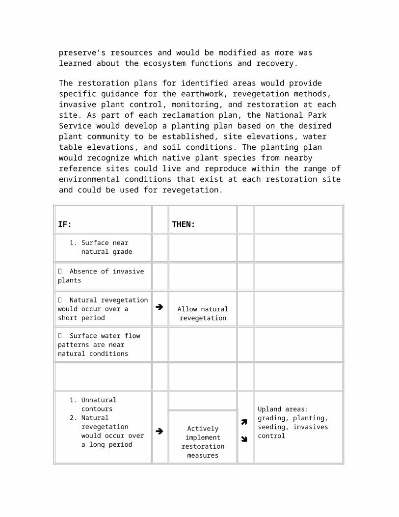
Other visitation
Some visitors would perceive improved scenic and aesthetic quality in the preserve associated with reducing the spatial extent of the area impacted by ORVs.
Decreases in noise from ORVs would be perceived as beneficial by some visitors.
Some visitors would perceive reduced scenic and aesthetic quality in the preserve because of increases in noise, rutting, and vegetation disturbances caused by ORVs.
Non-federal property owners
No impact to property owners’ ability to reasonably access their property.
Property owners would be required to obtain a free special use permit to access their property.
Unless they drew and purchased a recreational ORV permit, private property owners could not recreate with an ORV within the preserve.
Negligible impacts.
Affected Environment
Natural Resource Issues
This section describes the characteristics of the existing natural environment that could be affected by the proposed action and the no action alternative (continue current management). In compliance with the guidelines contained in the National Environmental Policy Act (NEPA) and Section 1502.15 of the regulations for implementing NEPA developed by the Council on Environmental Quality (1978), the description of the affected environment focuses on only those environmental aspects potentially subject to effects from the use of ORVs.
As discussed in "Purpose of and Need for the Plan," the National Park Service has identified impact topics that may be affected by the proposed action or the no action alternative (continue current management). This section establishes the basis for the "Environmental Consequences" section, which assesses the effects the alternatives may have on the impact topics within the affected environment.
Surface Water Flows
The preserve is exceptionally flat, with a typical gradient of only 5 to 10 inches per mile. Surface water hydrology of Big Cypress National Preserve is typically characterized as a "sheetflow" flooding regime. During the wet season, the landscape becomes covered with a shallow, continuous expanse of water that flows slowly toward the coast. Water movement is almost imperceptible in the interior of the preserve, where the terrain slopes an average of less than a foot per mile. However, flows are easily observable where the expanse of sheetflow is constricted to pass under a roadway or is channelized into a canal.
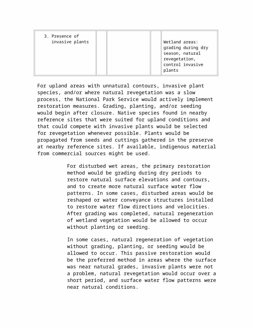
Surface water flows across the entire area during high-water conditions. It is most pronounced and is retained the longest in the forested cypress strands and marshy sloughs.
Wet-season conditions typically prevail from early summer to early winter. The quantity of water varies depending on the amount of summer rains, frequency of tropical depressions, occurrence of winter rain, and upstream water management practices. Typically, marsh, prairie, and cypress areas will have water depths of 1 to 3 feet, while areas of pines and hammock habitats will experience little or no inundation.
After surface flows have ceased, water losses continue through evapotranspiration and groundwater seepage. The preserve typically experiences an almost full drydown condition during the late spring, prior to the onset of summer rainfall. During drydown condition, standing water is retained only in the deepest depressions and canals.
The original boundary of the preserve was largely a self-contained, rain-driven watershed. However, surface flows in the original boundary are influenced by upstream management practices and internal barriers to flow. Major physical alterations of the landscape and associated water management practices have greatly modified the volume, timing, distribution, and quality of surface water in south Florida. These actions have included canal and levee building, road construction, agriculture, residential and commercial development, and operation of pumps and flood gates. Such disturbances have been especially pronounced in the greater Everglades east of the preserve and in the failed attempt to develop Southern Golden Gates Estates west of the preserve.
Investigators have documented that surface water in the Big Cypress vicinity preferentially flows in channels rather than in adjacent wetlands (Duever et al. 1981; Pernas et al. 1995). However, Duever et al. (1986a) also observed that topographic irregularities interrupted excessive drainage. Channelization is of particular concern at the southern boundary of the preserve where mixing of fresh water and salt water occurs, and where changes in salinity can change the vegetation composition.
A recent review of historical water-level information by preserve staff showed an increase in the duration of surface water inundation in the 1990s relative to the two previous decades (Sobczak and Pernas 2000). It is thought that the wetter condition in the 1990s was caused by increased rainfall amounts, but upstream water releases, gate operations in adjacent areas, and features within the preserve that block and channelize flow also contributed to the condition. Because the relatively dry conditions that prevailed in the 1970s and 1980s also were influenced by water management practices, there is uncertainty regarding future hydrologic conditions, both in terms of the weather patterns and the Central and South Florida Comprehensive Everglades Restoration Plan (CERP or Restudy) review study (U.S. Army Corps of Engineers 1999).
Major physical and operational alterations that will directly impact the preserve over the next 50 years include removal of part or all of the L-28 canal and levee, partial modification of the L-28 tieback, alteration of flows at the northern boundary of the
preserve, and changes in the operational rules for regulating flows in adjacent and upstream areas. As shown in the L-28 Canal map, the L-28 canal system is directly east of the preserve boundary and interrupts the generally northeast to southwest flow of water across the area. Water management practices from upstream citrus expansion may influence high-water conditions along the northeast portion of the preserve, but the extent of this impact (if any) is unclear.
Flattened vegetation and tire tracks at roadside entry points are generally the extent of ORV effects seen by most observers. However, aerial views of the preserve show a vast network of ORV trails and travel corridors. This network of tire ruts and ridges could be influencing the volume, timing, and distribution of surface water flows.
The extent, occurrence, and severity of effects that ORVs have had on surface water flows of the preserve are largely unknown. However, ORV ruts, which can be 2 or more feet deep, can channel water and potentially alter natural water flow patterns and timing. Two studies have documented greater water flow rates within ORV ruts than in adjacent undisturbed areas. Duever et al. (1981) found that over wet and dry seasons, water flows accelerated from two to four times in trails oriented parallel to the direction of water flows. Flows in some trails continued after water had ceased flowing in surrounding areas, possibly leading to a shortened natural hydroperiod in a localized area. Pernas et al. (1995) found that surface water flow always followed airboat trails, regardless of the trail orientation. Within the study area, these flow rates were accelerated approximately five times faster within the airboat trails than in adjacent undisturbed areas.
Duever et al. (1986a) hypothesized that trails that were extensively rutted and oriented parallel to flow could drain surface water from an adjacent wetland, particularly in low-lying areas. Such channel formation would be of particular concern at the southern boundary of the preserve because it could increase saltwater intrusion into freshwater wetland habitat. However, they also observed that topographic irregularities interrupted excessive drainage effects, so that impacts tended to be localized.
L-28 Canal Map
Water Quality
The original boundary of the preserve was established at the perimeter of a predominantly self-contained, rain-driven watershed that lies upgradient of Everglades National Park. Major cypress strands were logged in the early 1900s and areas of the watershed were used as farmland in the decades prior to the preserve’s establishment. However, the area’s remoteness limited it to only sparse development, much of which has
been reclaimed since the preserve’s establishment in 1974. As a result, the quality of the water within the preserve is high.
An extensive, shallow, surficial aquifer underlies the preserve. The formation is several tens of feet thick under the preserve, but diminishes completely near the preserve’s eastern boundary. This limestone aquifer is the main source of fresh water supplies in Collier County.
The waters of Big Cypress National Preserve are currently designated as Outstanding Florida Waters. This is a state designation, delegated by the U.S. Environmental Protection Agency (EPA) under the Clean Water Act, and is intended to protect existing, high-quality waters.
The low-nutrient, high-quality water in the preserve is vulnerable to degradation from contaminants. Because the water is of such high quality, even small amounts of contaminants can result in relatively large adverse effects. External sources of pollution primarily include nutrient-enriched runoff from upstream agricultural activities, especially along the northern boundary of the preserve. Internal contaminant sources include leakage and ancillary activities associated with oil and gas exploration and development, operation of vehicles along roads in the preserve, and oil and gas leakage and soil disturbance caused by the operation of ORVs in the preserve.
Big Cypress National Preserve established a long-term water monitoring program for measuring surface water stage and quality in 1988. Water quality samples currently are collected every other month at 10 stations located throughout the preserve.
The intent of this water monitoring program is to provide a long-term record for assessing ambient water quality conditions and contamination threats. Turbidity is among the parameters tested. The National Park Service currently is analyzing water quality data, and will use the results in making management decisions.
Water quality standards for evaluating ORV impacts have not been developed for the preserve. There is an on-going debate regarding the degree of water quality impacts, whether they are localized or regional in nature, and how other components of the ecosystem may be affected.
The use of ORVs in the preserve generates visible, localized turbidity in the overlying water column. This effect is most pronounced in areas where ruts are deepest and vegetation has thinned. However, a study by Duever et al. (1986b) determined that the effects of ORV use on water quality were negligible, localized, and produced no threat to regional water quality. Localized impacts included hydroperiod alteration, temperature variation, introduction of sediment into the water column, chemical pollution, and salinity changes. The turbidity that resulted from ORV operation was found to decrease sunlight penetration, thereby decreasing primary productivity of plants.
According to Beardsley (1995), extensive vegetation impacts from ORV use may inhibit nutrient uptake, causing greater levels of nutrients to remain in the water. Beardsley also stated that loss of vegetation cover reduces water filtration and removes frictional forces that reduce retention of water in the wetland. In some cases, subtle modification to water quality can impact other biological, vegetative, and wildlife components of the environment, and the existence of many localized impacts can translate into regional-scale and long-term impacts if the processes that cause them occur regularly and are permanent. Regional water quality effects would be most likely during times of heavy ORV use, and when ORV trails are heavily rutted and oriented in the direction of sheetflow.
Soils
According to Duever et al. (1986a), most of the soils at Big Cypress National Preserve are simple geological and biological products that have not had sufficient time or environmental conditions for evolution into true soils. Marl, sand, organic matter, and rock are the four substrate types in the preserve.
Carbonate marls are the most widespread unconsolidated soil type of the preserve. Marls are mixtures of calcareous clays with calcite particles, sand, and/or shell fragments, and may have periphyton precipitates at the surface. Marl soils support few trees and provide poor traction when wet. Therefore, ORV use tends to spread out in these areas, causing numerous parallel routes.
A hard limestone substrate, commonly called cap rock, is typically located 10 inches to 40 inches below the soil surface. The limestone also outcrops at the land surface, particularly within hardwood hammocks. The shallow limestone rock is typically pitted with solution holes of all sizes. In some areas, ORV use has displaced overlying soils and the limestone cap rock is exposed.
Cypress domes indicate areas of thicker soil deposition. Typically, these sites were caused by advanced dissolution and subsequent collapse of the limestone rock.
Sand deposits within the preserve are thin, infrequent, and likely derived from old shoreline deposits. Peats derived from partially decayed plant material are also present in the preserve and are identified by their major plant components that include mangroves and sawgrass.
The extent to which ORV operation affects soils within the preserve varies based on soil depth, soil composition, plant cover, and frequency of use. The controlling factor often is the moisture content of the soil. The calcium carbonate-rich organic soils that occur throughout most of the preserve (less so in the north) are extremely pliable when saturated and are susceptible to deformation by vehicle tires. Localized impacts include complete loss of the soil (bedrock exposure), rutting and ridging of soil, and water channelization. In addition, lateral expansion of the trail network (development of new
trails and widening of existing trails) occurs as operators avoid areas that are excessively muddy or rutted.
Duever et al. (1981) found that water elevation was the most important environmental factor influencing the severity of ORV impacts on soils. In areas where the water table was at the surface at the time ORV impacts occurred, the degree of impact and time required for recovery increased.
As described in the "Surface Water Flows" section, the annual surface water inundation periods during the 1990s were longer than they had been during the preceding two decades (Sobczak and Pernas 2000). As a result, surface organic sediments were saturated longer and dry less. This condition increased soil deformation from ORV activity, both from repeated passes and widening existing trails to avoid heavily rutted areas. This is believed to have increased the degree and spatial coverage of ORV impacts in the preserve.
ORV-induced deformation of soil structure and level causes an overall depletion of the soil resource through such processes as oxidation and erosion (Yamataki 1994). ORVs also affect processes that are influenced by soils, such as surface flows, evaporation, and the abundance and distribution of plants and wildlife.
Duever et al. (1986b), in a study of old trails in Big Cypress National Preserve, stated that once soils have been displaced, there are few natural mechanisms of restoring ground contour, and the ruts remain indefinitely. Therefore, it is likely that soil impacts are cumulative and worsen over time.
Vegetation
The Big Cypress National Preserve general management plan and environmental impact statement (NPS 1991) included a comprehensive description of the vegetation resources. Since then, vegetation has been re-classified by Welch et al. (1999) to provide consistency with the mapping of other public lands in the south Florida region. The largest changes were that some areas formerly classified as marsh, such as those in the Stairsteps Unit, are now defined as prairie. The current classifications of vegetation within the preserve are shown in the Vegetation Classes map. Areas used by ORVs are shown in the ORV Use Areas figure.
This ORV management plan and supplemental environmental impact statement tiers to the 1991 document. The ecological importance of the vegetation communities in the preserve has changed little since the publication of the general management plan. Therefore, except for ORV effects, the "Affected Environment" section of the general management plan is incorporated by reference to define the affected environment for vegetation in this ORV management plan.
There are indications that ORVs have resulted in the spread of invasive plants, such as Schinus terebinthefolius (Brazilian pepper), Melaleuca quinquenervia, and Lygodium
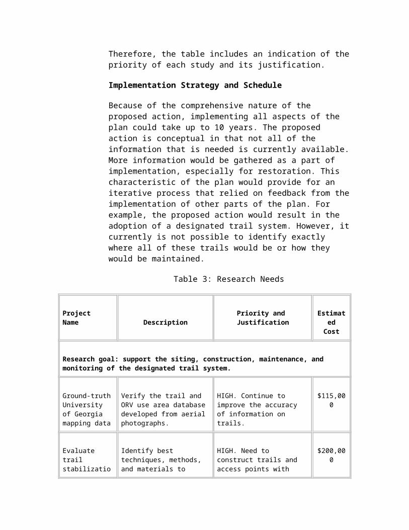
microphyllum (old world climbing fern), within Big Cypress National Preserve. ORVs transport seed in their tire treads and vehicle beds, and distribute it in currently unaffected areas of the preserve as they travel. Evidence of the spread of invasive plants along ORV trails has particularly been documented around the Monroe Station trailhead (Pernas 1999).
Prairies
Prairies appear to be the vegetation community in the preserve most impacted by ORV use. ORV trails within this community are easily distinguished on aerial photography. The tracks made by ORVs persist and are even visible on large-scale aerial images.
Impacts of ORV traffic in prairies include vegetation loss and exposed soils. During the ORV trail analysis performed by the University of Georgia (Welch and Madden 1998), many of the prairie areas were so heavily trafficked that mapping of individual trails was impossible. These areas are represented by shaded polygons in the University of Georgia Trails Interpretation map that is presented later in this "Affected Environment" section under "Visitor Experience Issues."
Figure - Vegetation Classes
Figure - ORV Use Areas
Duever et al. (1981) and Duever et al. (1986b) described effects of ORV traffic in marl marshes and sand marshes. Based on the species composition of these areas, these now appear to be classified as prairies. Duever et al. (1986b) observed that sand marshes that
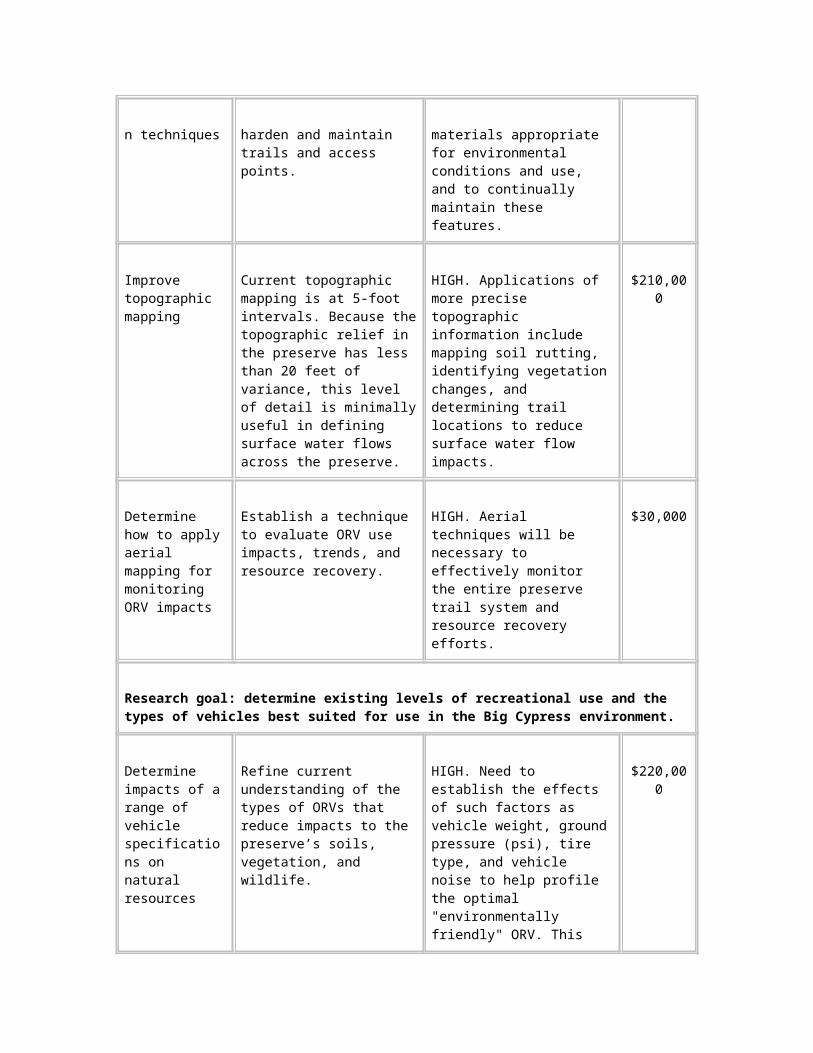
were not inundated were less likely to sustain heavy impacts from ORV use. This suggests that seasonal variation in hydrology may be an important factor in determining ORV effects, and that ORV use in prairies during the wet season should be minimized.
ORV uses have been shown to alter plant community structure. After 1 year of recovery, Duever et al. (1981) found that Cladium jamaicense (sawgrass) and Muhlenbergia capillaris (muhly grass) were reduced in the tire lanes. Bacopa sp.(hyssop) and Utricularia sp. (bladderwort) were common in the rutted areas; this was attributed to an increased hydroperiod in the tire ruts and increased sunlight from tree or shrub canopy removal within ORV use areas. After 7 years, Duever et al. (1986b) found that four graminoids (grasses, sedges, and rushes) were more common in ORV trails than in comparison areas. Cladium jamaicense (sawgrass) was less common in the trails used by ORVs than in the undisturbed comparison areas.
Duever et al. (1981) and Duever et al. (1986b) also evaluated effects in "small cypress" communities. Descriptions of these areas in Duever et al. (1981) suggest that they may be ecotones between cypress domes and prairies or dwarf cypress prairies, where scattered small cypress occur in a prairie community. These areas are closely aligned ecologically with marl prairies.
Duever et al. (1981) indicated that, of all five types of sites tested with wheeled vehicles, the small cypress communities required the lowest amount of use by wheeled ORVs to create "a significant impact." Duever et al. (1986b) indicated recovery of small cypress communities was lower than other communities 7 years after intermediate and heavy impacts from wheeled ORVs.
Duever et al. (1981) found that small (less than 3 feet tall) cypress trees suffered minor damage in areas used by ORVs, but that cypress trees between 3 feet and 10 feet tall had severe damage. Damage to these trees and associated mortality increased with ORV use. This indicates that cypress trees between 3 and 10 feet tall can be adversely affected in areas used by ORVs, but that after limited ORV use, recovery of very small trees can occur quickly.
Marshes
Since the preparation of the general management plan in 1991, the classification of marshes in the preserve has been changed to be consistent with vegetation classification throughout the south Florida region. Under the new classification of Welch et al. (1999), marshes now include many of the areas identified as prairies in 1991.
Marshes in Big Cypress National Preserve include fresh water and salt water wetlands. Aerial photography indicates that, along with prairies, the marsh community has incurred the greatest impact from ORV use (Welch and Madden 1998; Welch et al. 1999). Marshes in the preserve have extensive, braided networks of trails. Rutting from ORVs in marshes is easily visible on aerial photography, and in many areas is quite extensive.
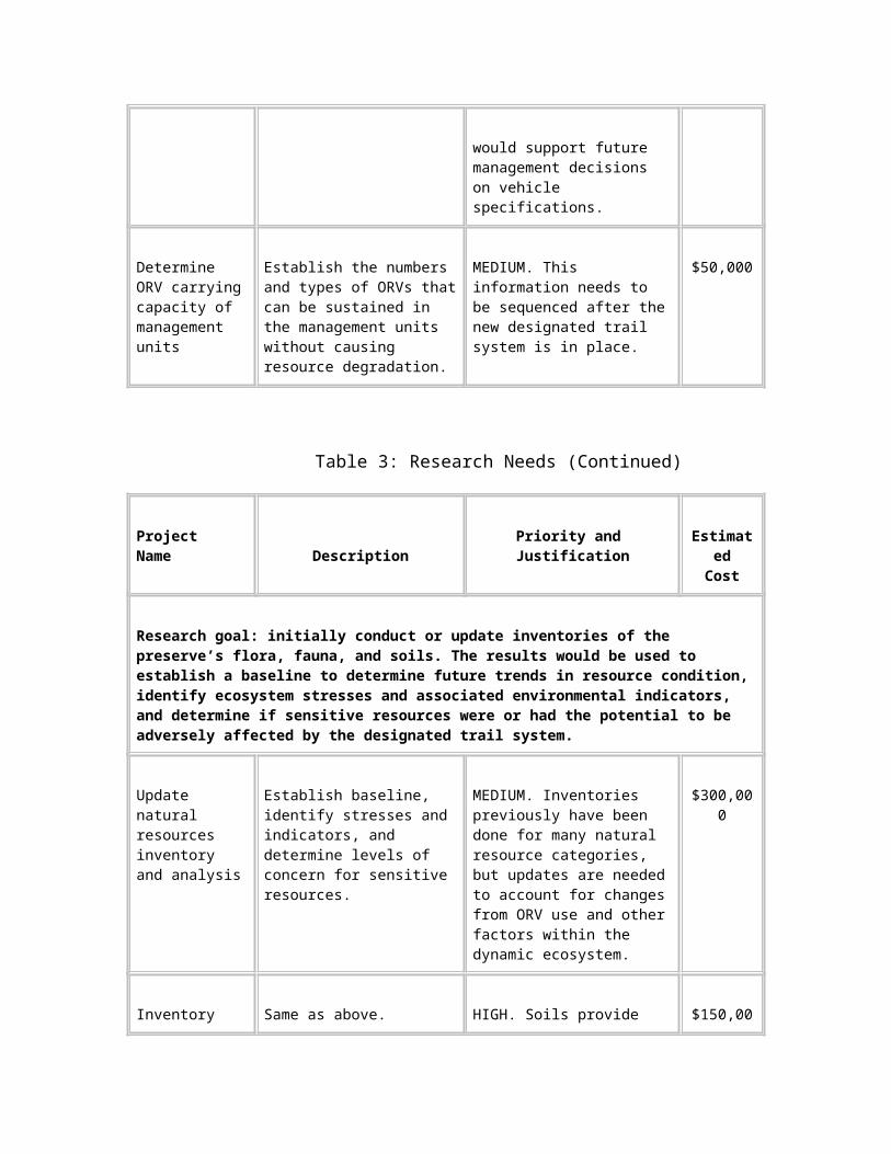
Duever et al. (1981) and Duever et al. (1986b) described effects of ORV traffic in inundated sand marshes and peat marshes, although wheeled vehicles were not tested in peat marshes. These communities appear to include much of the "marshes" category used in this plan. They consist of open communities with few trees or shrubs and a ground cover that is dominated by emergent herbs. Inundation is year-round or nearly year-round.
Duever et al. (1981) indicated that, with the same amount of ORV use, ORVs produced heavy impacts in inundated areas of marshes, but less impact in non-inundated areas. Continuously inundated marl marshes were not tested with wheeled vehicles, but appeared to be more affected when they were inundated than when the water table was below the ground surface. This suggests that marl marshes with extended hydroperiods may be quickly impacted by ORV use.
ORV use has been shown to alter marsh plant composition and structure. In marl marsh communities, Duever et al. (1981) found that Panicum sp. (panic grass), Cladium jamaicense (sawgrass) and Muhlenbergia capillaris (muhly grass) decreased with increased ORV use. Utricularia sp. (bladderwort), often a floating aquatic plant, was common in the rutted areas; this was attributed to an increased hydroperiod in the tire ruts. Sand marsh communities showed little difference in plant diversities with comparison areas after 1 year. After 7 years, Centella asiatica (coinwort) was more common in marl marsh areas used by ORVs.
Cypress Strands and Domes, Mixed Hardwood Swamps, and Sloughs
Cypress strands, mixed hardwood swamps, and sloughs form irregular bands trending northeast to southwest along the major drainages of the preserve. These communities, along with the scattered cypress domes, are the wettest of all vegetation types in the preserve. The interiors of these types are important refuges and concentration points for water-dependent wildlife during the annual dry season. The general management plan contains more detailed descriptions of each of these vegetation types (NPS 1991).
Generally, strands, swamps, sloughs, and domes are natural barriers to ORVs. Because these wetlands depend on topographic depressions, water depth increases substantially from their edges to the center. Most of the areas covered by these wetlands have water too deep to support ORV use, and ORVs must either skirt the shallowest margins or cross at the narrowest and shallowest places.
The forested wetlands, including cypress strands, cypress domes, and mixed hardwood swamps, typically have sandy, mineral soils that are less sensitive to ORVs than adjoining marl prairies. However, deep water and large, closely spaced trees confine ORVs to established, previously cut trails threading along the margins where mineral soil or bedrock provides sufficient traction and water depth is relatively shallow. ORV tracks usually encircle or skirt cypress domes along their outermost perimeter for the same reasons.

There are relatively few ORV trails perpendicular to the forested drainages. ORV trails crossing strands and swamps are normally on well-established, deeply entrenched routes where the forest narrows and water levels are shallower. Duever et al. (1981) found that established ORV trails through strands and swamps had the deepest ruts of all vegetation types, and that typically trails were worn down to bedrock and filled with standing water.
Sloughs, which are located primarily in the marshes of the Stairsteps Unit, typically contain deep water and deposits of muck or peat, all of which discourage the use of wheeled ORVs. Dense thickets of willows along sloughs deter airboats. As a result, ORV trails usually cross sloughs at established, narrow passages where wheeled vehicle drivers are reasonably confident of not being mired and airboats can avoid willows.
Mangroves
The mangrove communities in Big Cypress National Preserve are found primarily in Zone 1 of the Stairsteps Unit. Zone 1 is currently open only to wheeled vehicles, which primarily use the northern portion of the area, which does not contain mangrove forest.
Zone 2 of the Stairsteps Unit contains mangrove forest along its southern edge. Currently, airboats are allowed to travel in this area when water levels are adequate.
Hardwood Hammocks
Hammocks are scattered throughout the preserve. These areas are located on higher sand islands, and because of their raised position, they often appear as islands of trees. These areas function as refuges for wildlife during periods of high water. A large proportion of the known archeological sites within the preserve have been found in hardwood hammocks.
Hammocks are a successional stage that occurs after pinelands, when hardwoods dominate the community and exclude pines. In south Florida, this typically occurs when a pineland is insulated from fire for a long period, so that hardwoods are able to survive and replace pines. Trees that dominate these communities are often large, such as Quercus spp. (oaks), Sabal palmetto (sabal palms), or Lysiloma latisiliquum (wild tamarind). As a result, the hardwood hammocks usually are avoided by vehicle trails, and experience little ORV use. Occasionally, smaller trees and shrubs in the understory may be subject to damage, as they can be bent or broken by vehicles.
Duever et al. (1986b) stated that abandoned trails in the Loop Unit were vegetated by Baccharis spp. (saltbush) after 7 years. Saltbush species are opportunistic in disturbed areas. Duever et al. (1986b) speculated that the abandoned trails would eventually succeed to the native understory species, but no further assessment has been conducted to determine if this is occurring.
Pinelands
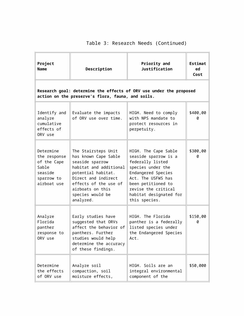
Pinelands occur extensively within the preserve, primarily throughout the northeastern portions. An estimated 23,500 acres of pinelands in the preserve have never been cut. Old-growth pinelands within the preserve are one of the largest examples of this vegetation type remaining in south Florida.
Of all the plant communities tested for ORV impacts by Duever et al. (1981), pinelands were the most resistant to adverse effects. Wetter pine communities were more heavily affected. Duever et al. (1986b) found that two of three pineland areas affected by ORVs had recovered after 7 years, but that the third, and wettest, pineland had not fully recovered. Amounts of ground cover did not appear to be substantially altered by ORV use. Heights of plants in areas of ORV use were decreased, but recovered in one growing season.
Within the pineland understory, Duever et al. (1981) found few differences in plant communities compared with undisturbed areas after 1 year. However, they did note slight increases in Cladium jamaicense (sawgrass), Centella asiatica (coinwort), and Hyptis sp. compared with undisturbed comparison sites, while Panicum sp. (panic grass) and Aristida sp. (three-awn grass) decreased with increased ORV use. After 7 years, Duever et al. (1986b) indicated that Hypericum sp., Ludwigia sp., and Xyris sp. (yellow-eyed grass) were more common in ORV trails than in comparison areas, while Pluchea sp. (fleabane) was less common. Cladium jamaicense (sawgrass) was less common in the trails used by ORVs than in the undisturbed comparison areas.
Pinelands are fire-dependent, and prescribed fires by NPS staff maintain the habitat viability by preventing hardwood succession. The trails through these communities could act as firebreaks, isolating portions of the pinelands from the benefits of fire. However, the firebreak effect of trails is usually taken into account in management fires, and multiple ignition points are used. While the effect of trails on the behavior of natural fires has not been studied, it is likely that low-intensity fires are more affected than high-intensity fire patterns.
Pinelands provide habitat for the federally listed red-cockaded woodpecker. Red-cockaded woodpeckers form clusters of cavity trees within pinelands. NPS annual surveys of red-cockaded woodpecker clusters have not documented the loss of pines because of ORV traffic.
Wildlife
The general management plan and environmental impact statement (NPS 1991) included a comprehensive description of the wildlife resources of the preserve. This ORV management plan and supplemental environmental impact statement tiers to that document, in conformance with the Council on Environmental Quality (1978) guidelines for implementing the National Environmental Policy Act. Therefore, the "Affected Environment" section of the general management plan is incorporated by reference to define most of the affected environment for wildlife in this ORV management plan.
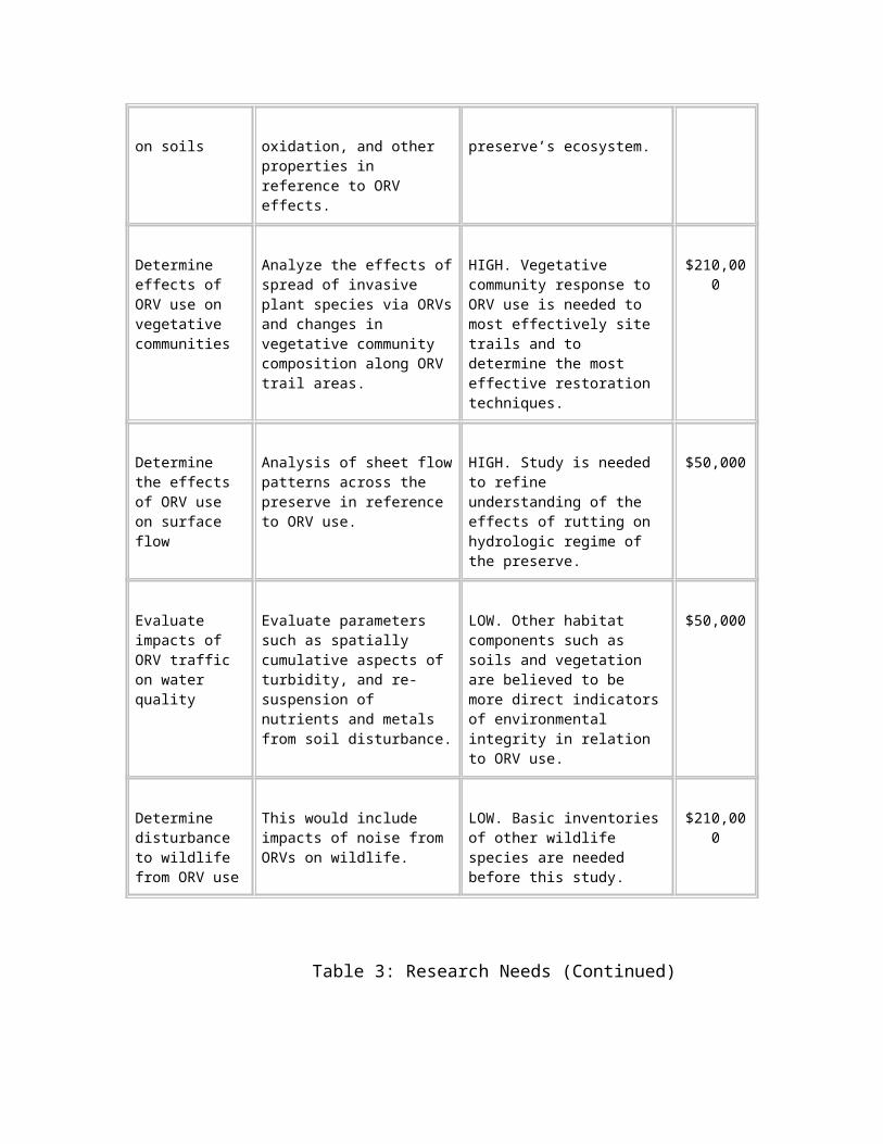
As shown in Table 8, ten species of wildlife that are federally listed as either endangered or threatened reside in Big Cypress National Preserve. All of these species occupy portions of the preserve where ORV activity occurs. The state of Florida lists an additional seven species that occur in the preserve as threatened or endangered. Of these 17 species, two are reptiles, nine are birds, and six are mammals.
The state lists an additional 13 species of special concern (SSC). These species warrant attention because they have experienced long-term population declines and are vulnerable to exploitation or environmental changes.
Table 8 displays the status of all 30 special status wildlife species that occur in Big Cypress National Preserve. Brief descriptions of the federally listed species as they relate to ORV use are provided below.
American Alligator
The American alligator is listed as threatened because of its similarity of appearance to the American crocodile, which is endangered. The alligator is common in the vast wetland communities of the preserve. Encounters with ORVs occur most often during the dry season when alligators travel overland seeking permanent bodies of water.
Table 8: Listed Wildlife Species in Big Cypress National Preserve a/
Common Name Type Scientific NameDesignated Status b/
Federal State
Florida tree snail Mollusk Liguus fasciatus SSC
Common snook Fish Centropomus undecimalis SSC
American alligator Reptile Alligator mississippiensis T (S/A) SSC
Eastern indigo snake Reptile Drymarchon corais couperi T T
Roseate spoonbill Bird Ajaia ajaja SSC
Cape Sable seaside Bird Ammodramus maritimus E E
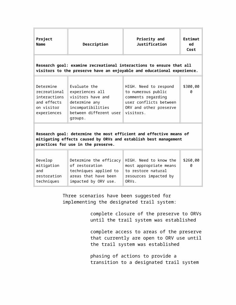
sparrow mirabilis
Limpkin Bird Aramus guarauna SSC
White-crowned pigeon Bird Columba leucocephala T
Little blue heron Bird Egretta caerulea SSC
Reddish egret Bird Egretta rufescens SSC
Snowy egret Bird Egretta thula SSC
Tri-colored heron Bird Egretta tricolor SSC
White ibis Bird Eudocimus albus SSC
Arctic peregrine falcon Bird Falco peregrinus tundrius E
Florida sandhill crane Bird Grus canadensis pratensis T
American oystercatcher Bird Haematopus palliatus SSC
Bald eagle Bird Haliaeetus leucocephalus T T
Wood stork Bird Mycteria americana E E
Osprey Bird Pandion haliaetus SSC
Brown pelican Bird Pelecanus occidentalis SSC
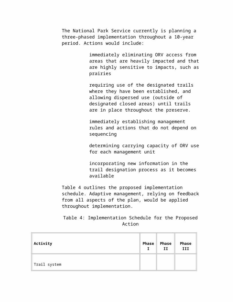
Red-cockaded woodpecker
Bird Picoides borealis E T
Everglade snail kite Bird Rostrhamus sociabilis E E
Black skimmer Bird Rynchops niger SSC
Least tern Bird Sterna antillarum T
Everglades mink Mammal Mustela vison evergladensis T
Mountain lion Mammal Puma concolor T (S/A)
Florida panther Mammal Puma concolor coryi E E
Big Cypress fox squirrel Mammal Sciurus niger avicennia T
West Indian manatee Mammal Trichechus manatus E E
Florida black bear Mammal Ursus americanus floridanus T
a/ Sources: USFWS 1999a and Florida Fish and Wildlife Conservation Commission 1997.
b/ E = endangered. S/A = similarity of appearance to a threatened or endangered species.
SSC = species of special concern. T = threatened.
The American crocodile does not occur within Big Cypress National Preserve. Therefore, effects of ORV management on the American alligator were not considered in the "Environmental Consequences" section.
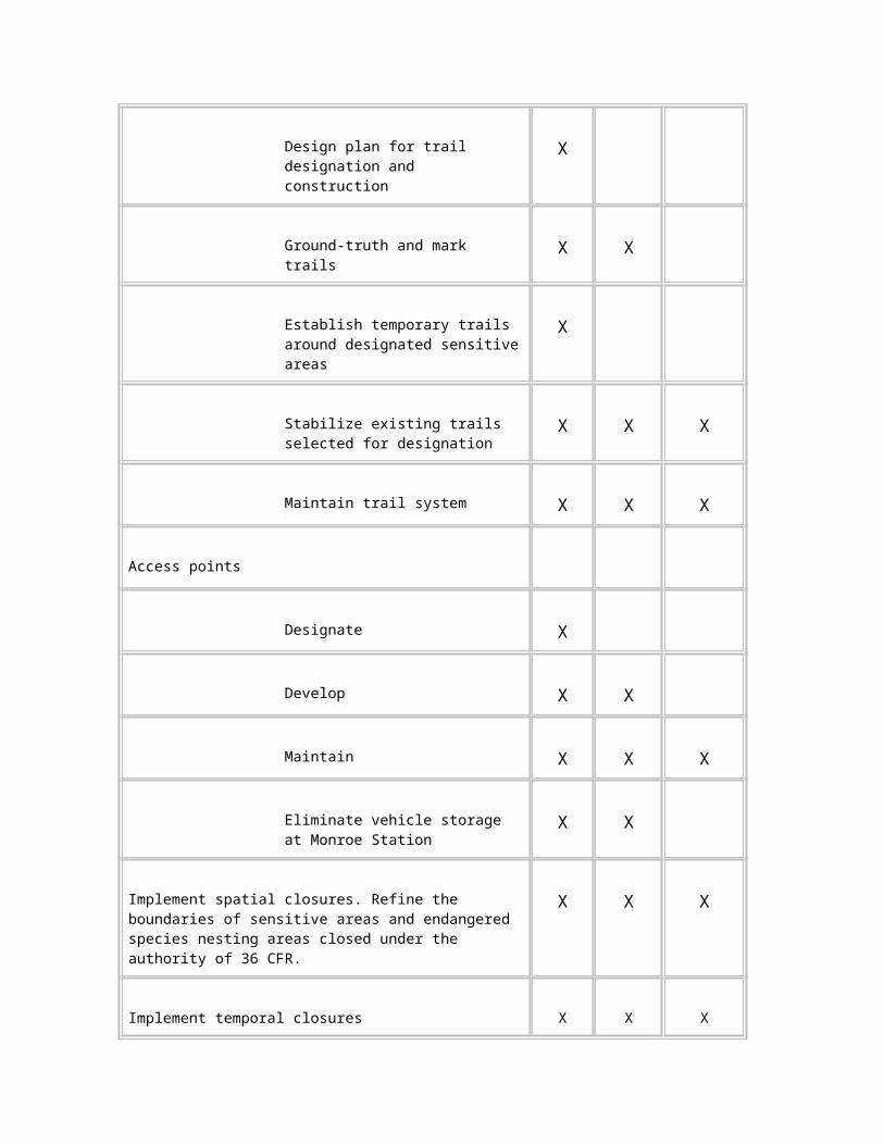
Cape Sable Seaside Sparrow
The Cape Sable seaside sparrow is endemic to south Florida. The U.S. Fish and Wildlife Service (USFWS) has been petitioned to revise the critical habitat designated for this species, which could include the Stairsteps Unit in Big Cypress National Preserve.
Two of the six subpopulations described by Curnutt and Pimm (1993) occurred in the preserve. The Ochopee Prairie subpopulation (Zone 1 of the Stairsteps Unit) was extirpated by 1979, with its demise attributed to fires and salinity changes associated with altered hydrology (USFWS 1983). The subpopulation of the sparrow west of Shark River Slough, half of which is within the preserve’s boundaries, experienced a 90 percent decline in the 1990s (USFWS 1999c). This was attributed to water management practices that had extended the hydroperiod into the breeding season, which has resulted in sparrows shifting from mixed marl prairie vegetation suitable for breeding to sawgrass-dominated vegetation that sparrows do not use for nesting (Curnett et al. 1998).
Wheeled vehicles currently are not allowed within known sparrow habitat and administrative actions in recent years have prohibited airboats when and where water levels are at a stage in which their use may cause soil displacement. These management actions have limited airboat use during the nesting season. The long-term effects of airboats on sparrow habitat and their behavior outside the nesting season have not been examined. ORVs may affect the vegetative structure required by sparrows for foraging, nesting, and roosting.
The Cape Sable seaside sparrow is critically endangered. The remaining birds that inhabit the preserve are vulnerable to further losses by either natural or man-caused impacts. Precautions must be taken to minimize disturbance to this species.
Bald Eagle
Three bald eagle territories have been documented in the preserve along the southern boundary, one each in Zones 1, 3, and 4 of the Stairsteps Unit. Based on annual eagle surveys by the Florida Fish and Wildlife Conservation Commission (1980-1999), their productivity has varied.
When commercial airboat activity was allowed in Zone 1, a buffer was established to prevent ORVs from disrupting nesting activity. This 1,500-foot buffer conforms with USFWS (1987) guidelines for protection of eagle nests.
The eagle nest in Zone 3 is located in the center of a cypress strand, which serves as a natural buffer to ORV traffic. Therefore, the National Park Service determined that posting a 1,500-foot buffer was not necessary.
In 1995 and 1996, adults eagles were observed in the area of the nest in Zone 4, but no young were observed in the nest. Since 1997, no eagle
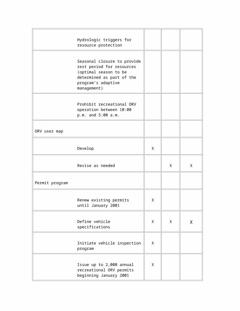
activity has been observed in the territory. A buffer is not posted at this location.
Wood Stork
The wood stork forages annually in the preserve when water levels provide concentrations of fish. Documented nesting in the preserve was rare until 1996 when 45 colonies were reported (Jansen and Brooks 1996). The previous two consecutive years of high water and subsequent buildup of the prey base apparently provided ideal conditions in which to raise young. Wood stork nests have been found only sporadically in the preserve after 1996.
Red-cockaded Woodpecker
The red-cockaded woodpecker is federally listed as an endangered species. Habitat fragmentation and/or loss is the primary threat to this species, which nests in cavities in mature, living pines. Other range-wide threats to the red-cockaded woodpecker include cluster abandonment due to mid-story encroachment and invasive plants.
Management actions for this species within the preserve include mechanical removal of fuel loads under cavity trees and midstory control through prescribed fire. Annual work includes determining cluster status, observing nesting activity, and banding nestlings.
Fifty-three red-cockaded woodpecker clusters, of which 42 are active, have been documented in the pinelands of the preserve. This represents the fifth largest red-cockaded woodpecker population in Florida.
The red-cockaded woodpecker population within the preserve is stable overall. However, the southernmost group of clusters located in Zone 4 of the Stairsteps Unit was impacted by Hurricane Andrew in 1992. The hurricane destroyed approximately 80 percent of the cavity trees and probably killed individual birds.
The habitat surrounding the clusters in Zone 4 continues to show impacts from environmental events such as wildfires and inundation by water for extended periods. The high-water years of 1994 and 1995 resulted in tree mortality at the periphery of the Zone 4 pinelands, demonstrating that extended inundation may adversely affect red-cockaded woodpecker habitat. Reproduction in this area is low and may be the result of a sparse understory in some areas. This area warrants special attention to ensure protection and survival of this species.
There has been no documentation of the loss of trees used by the red-cockaded woodpecker due to compaction or injury along ORV trails. Abandonment of clusters due to disturbance by ORVs also has not been observed.
Everglade Snail Kite
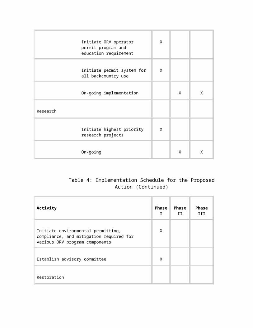
Everglade snail kite habitat consists of freshwater marshes that support apple snails and provide perching and nesting substrate in the form of scattered shrubs or small trees. Snail kites have been documented in the preserve in Lostmans Slough in Zone 4 of the Stairsteps Unit, in the Ochopee Prairie in Zone 1 of the Stairsteps Unit, in the eastern Loop Unit, in the eastern Corn Dance Unit, and in East Hinson Marsh and Okaloacoochee Slough in the Bear Island Unit. On rare occasions, snail kites have been observed along the Birdon Road and Turner River Road canals.
Since nest survey work began in 1995, Everglade snail kite nesting has been documented annually in Zone 4 of the Stairsteps Unit. Annual nest success in 1998 and 1999 was 60 percent, which is relatively high compared to other wetlands surveyed and is above the average range of 32 percent to 50 percent reported by previous studies (Dreitz et al. 1999).
Two studies addressed the impacts of human disturbance on snail kites in the water conservation areas of south Florida. Over a 10-year study period, Sykes (1987) reported two nest failures resulting from airboats. Bennetts et al. (1988) stated that snail kite nests usually were in denser vegetation than is normally traveled by airboats, but often were in proximity to travel routes. They did not find any evidence of nest damage by airboats.
Florida Panther
The Florida panther was listed as endangered in 1967. In 1995, eight female mountain lions were released into the Florida panther population, including four introduced into the preserve, to offset the negative effects of inbreeding documented in panthers. The mountain lion, therefore, is federally listed, based on its "similarity of appearance" to the panther.
The Florida Panther Habitat Preservation Plan (Logan et al. 1993) identified about 926,000 acres of habitat considered essential to maintaining a minimum viable population of panthers in south Florida. About 582,000 of these acres are within Big Cypress National Preserve, representing approximately 63 percent of the essential habitat.
The most recent verifiable population estimate is 60 panthers, including adults and subadults (McBride 2000). Of the 35 panthers currently monitored via radio-telemetry, 19 inhabit the preserve. The Florida Fish and Wildlife Conservation Commission (FFWCC) monitors six panthers that reside north of I-75 and the National Park Service monitors 13 panthers south of I-75 and north of U.S. Highway 41.
The Panther Locations, 1981-1999 map shows panther locations obtained by radio telemetry three times per week. No panthers currently are known to inhabit the Loop Unit or Stairsteps Unit, although past use has confirmed that these areas can support them. The greater numbers of locations north of I-75 are the result of a longer monitoring period and a denser population in the 1980s.
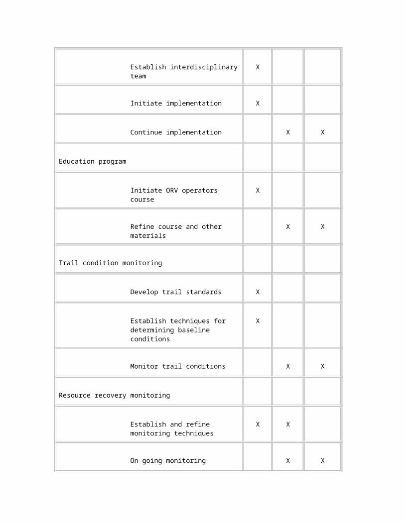
A study entitled The Effects of Recreational Deer and Hog Hunting on the Behavior of Florida Panthers was conducted between 1994 and 1998 (Janis and Clark 1999). It centered on the panther population north of I-75, including the Bear Island Unit. The study results indicated that panthers avoided the system of trails designated for ORV use. Panthers also reduced their use of the unit during the hunting season. It is not known whether this was in response to an impacted prey base or to an increase in disturbance by ORV users or other preserve visitors.
Figure - Panther Locations, 1981-1999
West Indian Manatee
The West Indian manatee uses the open-water creeks and canals of the southwest portion of the preserve. This area has been designated by the USFWS as critical habitat for the manatee. Recreational airboats currently are prohibited in Zone 1.
Other Wildlife Species
The diverse habitats of the preserve support numerous species that are not federally listed as endangered or threatened, yet are important components of a healthy and balanced ecosystem. Duever et al. (1986a) provided a partial list of birds, reptiles, amphibians, and mammals that use the habitats of the preserve. A list of the fish and invertebrates has not been compiled.
The marl prairie habitat in the preserve has been the most impacted by ORVs, which have altered both soil and vegetative structure in some areas. Prairies support a biotic community that includes invertebrates, amphibians, reptiles, fish, birds, and small mammals. It is expected that soil disturbance, vegetative loss, and altered water quality and quantity associated with ORV use have locally affected populations, but the extent of the effect has not been quantified.
Since the 1991 general management plan was written, the deer population in many areas of the preserve has increased. Factors influencing this increase include area closures, favorable environmental conditions, and changes in hunting regulations. The feral hog population in Big Cypress National Preserve appears to be stable.
Visitor Experience Issues
General Preserve Visitation
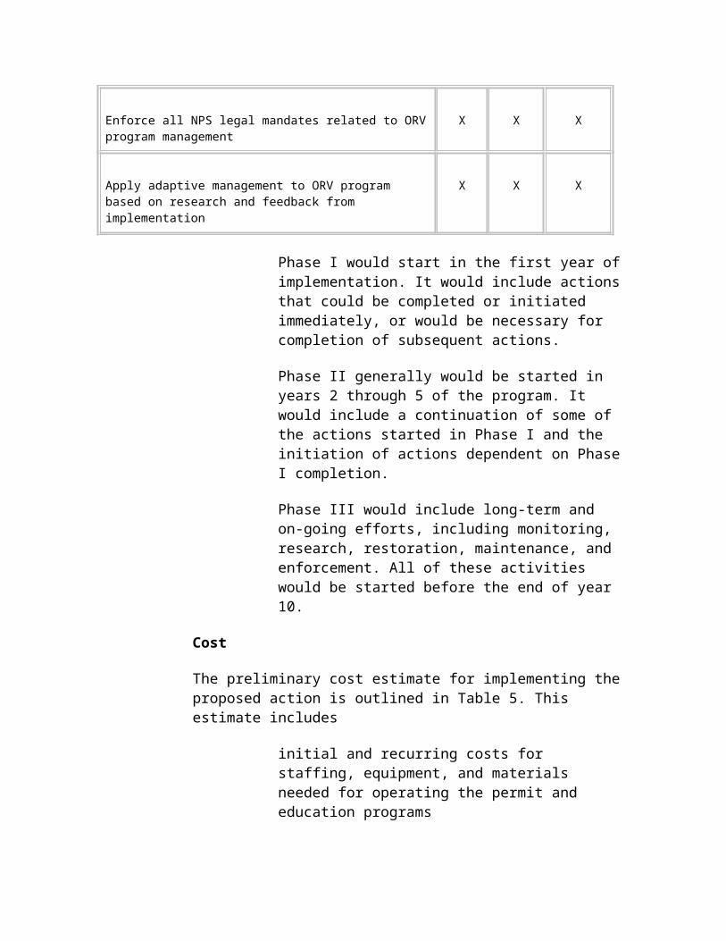
Visitation statistics maintained at the visitor center report a trend of increasing visitation to the preserve. Table 9 shows the last 5 years of visitation.
Table 9: Visitation at Big Cypress National Preserve, 1995 to 1999
Year Visits
1995 365,463
1996 424,920
1997 462,553
1998 474,895
1999 503,110
The Big Cypress National Preserve visitor study conducted in the winter of 1999 by the Cooperative Park Studies Unit, University of Idaho (Meehan 1999) identified general visitor demographics as follows. These findings are based on 857 questionnaires that were distributed January 2 through 10, 1999 at nine locations; 582 surveys were returned for a 68 percent response rate. Surveys were distributed at many locations, including ORV access sites and hunter check stations.
Twenty-five percent of total visitors surveyed were Florida residents. New York, Indiana, and California followed with 4 percent each. International visitors from 21 countries comprised 21 percent of the visitors surveyed. Germany, Canada, and England were the most frequently cited countries of origin.
Twenty-two percent of those surveyed had used an ORV during their visit to the preserve. Of those, 70 percent had been on a commercial airboat tour, 15 percent used a street-legal 4 x 4, 11 percent used an all-terrain cycle, 10 percent used a swamp buggy, and 2 percent used a privately owned airboat. This totals more than 100 percent because a few individuals had used more than one type of ORV.
Birdwatching, viewing wildlife, sightseeing, experiencing wilderness, and experiencing solitude were rated as the most important activities by those surveyed.
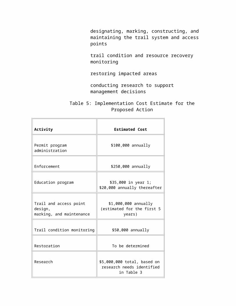
To the question, "What did you like least about your visit to Big Cypress National Preserve?" the most frequent answers included lack of information, poor quality of roads, too much litter, hunting and fishing, people driving too fast, ORVs and ATC’s, lack of animals, lack of time, and too many bugs.
Another question was "If you were a park manager planning for the future of Big Cypress National Preserve, what would you propose?" Frequent responses included better signage; more guided foot and bike tours; need to promote the area; boardwalks into wet areas; increased number of trails; more overlooks and roadside parking areas; improved quality of roads; discontinue ORV, airboat, and ATC usage; prohibit hunting and fishing;
discontinue mining and drilling; no further development; expand preserve boundary; provide careful preservation of area; and restore water quality.
ORV Use
The use of ORVs is a popular recreational activity within Big Cypress National Preserve. Several types of ORVs are used to access the preserve’s swampy backcountry. These include street-legal four-wheel-drive vehicles (4 x 4s); light-weight, all-terrain cycles (ATCs); swamp buggies; and airboats. Recreational activities that can involve the use of ORVs in the preserve include hunting, fishing, trapping, birdwatching, and exploring.
No data on ORV numbers could be located for years prior to 1980, when the National Park Service implemented a mandatory registration for all ORVs operated in the preserve. NPS ORV permit data since 1980 are presented in Table 10 and are presented graphically in the figure entitled ORV Permits by Type by Year. Tracked vehicles were banned in 1988 based on research that showed they produced more adverse impacts than other ORV types (Duever et al. 1981).
Table 10: Numbers of ORVs Registered for Use in Big Cypress National Preserve, 1980 to 1999
Year ATCSwampBuggy
Street Legal Airboat
Half Track
Full Track Totals
1980 361 180 176 130 10 14 871
1981 1,154 508 347 195 22 26 2,252
1982 1,042 162 464 166 5 14 1,853
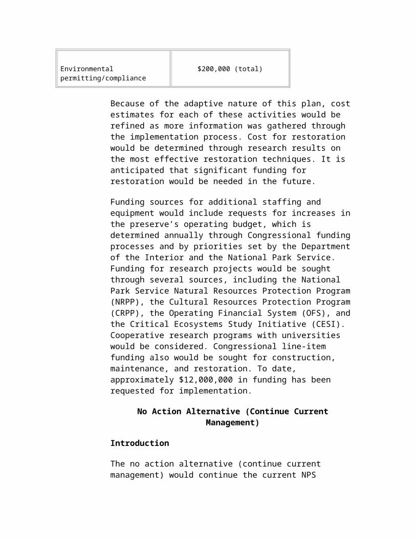
1983 1,012 174 404 133 10 4 1,737
1984 1,020 155 410 115 4 2 1,706
1985 300 143 345 96 2 5 891
1986 300 586 165 238 14 21 1,324
1987 456 794 348 328 17 37 1,980
1988 507 810 393 371 0 1 2,082
1989 512 756 398 323 0 0 1,989
1990 580 733 334 261 0 0 1,908
1991 812 773 315 274 0 0 2,174
1992 872 773 314 296 0 0 2,255
1993 842 735 270 331 0 0 2,178
1994 584 559 193 250 0 0 1,586
1995 303 135 108 87 0 0 633
1996 682 586 205 234 0 0 1,707
1997 967 625 202 277 0 0 2,071
1998 1,053 667 219 255 0 0 2,194
1999 1,131 670 220 250 0 0 2,271
Notes: a/ Tracked vehicles were banned in 1988.
b/ Year 2000 data not available at printing.
ORV permit numbers have ranged from 633 in 1995 to 2,271 in 1999. Fluctuations in the number of ORV permits issued each year primarily reflect water levels within the preserve, with fewer registered vehicles in the wetter years (e.g., 1995) when portions of the preserve were closed to hunting. Overall, ORV numbers have been slightly increasing.
ORV use is heaviest during the fall, winter, and spring hunting seasons. Opening weekends of hunting seasons and holidays receive the greatest usage.
Accurate data on ORV-related visitation are unavailable, although several efforts have been made to gather such information. Duever et al. (1986a) attributed the substantial increase in ORV trails visible in aerial photographs from 1953 to 1973 to increased recreational ORV use, primarily associated with hunting. They further estimated that approximately 2,540 to 4,000 ORV-related hunters may be present in the preserve at peak use times (weekends) during the hunting season. A 1970 study estimated 40,000 person-days of use per year in the entire Big Cypress region (Everglades Jetport Advisory Board 1970).
ORV Trail Mapping
In 1985, during preparation of the general management plan and environmental impact statement, the National Park Service mapped ORV trails, defined at the time as corridors and routes consistently used by ORVs. Trails were mapped from 1:63,000 color infrared photography flown in March 1984. The results are shown in the GMP ORV Trails map. Only those routes that were
Figure - GMP ORV Trails
clearly visible in the aerial photography were mapped, and major trails through forests were estimated. Based on this method, the total mileage for ORV trails in the preserve was conservatively estimated at 1,240 miles (NPS 1991). This effort did not attempt to map all existing trails.
The Center for Remote Sensing and Mapping Science, University of Georgia, mapped linear features for the National Park Service. The results are shown in the University of Georgia Trails Interpretation map. This map was prepared from 1:40,000 infrared aerial photographs flown in 1994 and 1995 that were enlarged to 1:10,000 scale (Welch et al. 1999). Rather than mapping only consistently used routes as in the earlier estimate, ORV trails for this effort were defined as any discernible linear feature.
This map shows a fine network of linear features totaling approximately 29,000 miles. Many of the prairie areas were so heavily trafficked that mapping of individual trails was impossible. These areas are represented on the map by shaded polygons. The mapping technique was quite sensitive, even indicating residual linear features in the Loop Unit, which has been closed to vehicles for more than 20 years. Because of the absence of ground-truthing, the researchers cautioned that linear features other than ORV trails may have been included in the map and that active and abandoned ORV trails were indistinguishable (Welch et al. 1999).
Ground-truthing in selected areas was performed in the year 2000. The preliminary findings of this activity are presented in Appendix B.
A comparison of the maps appears to show an exponential increase in ORV use since 1984. The difference in the map estimates, however, primarily reflects the difference between mapping known, primary ORV trails and mapping all linear features. To more accurately assess ORV impacts since 1984, the recently mapped linear features are currently being ground-truthed to separate ORV tracks from other linear features such as wildlife trails.
Characteristics of ORVs
The following paragraphs describe the typical types of ORVs that currently are being used in the preserve. Photographs of example vehicles are provided in the Off-Road Vehicles figure.
Street Legal 4 x 4s. Street-legal four-wheel drive ORVs and trucks that are commercially manufactured and sold are very restricted in the extent of their access within the preserve. These vehicles require the driest driving conditions and rarely venture very far into the preserve’s backcountry. As a group, this ORV type is the heaviest, with a mean weight of 4,431 pounds (based on 1996/97 permit data from the preserve). On average, they comprise approximately 18 percent of the ORV permits registered with the National Park Service, although this varies from year to year.
All-Terrain Cycles (ATCs). Small, commercially manufactured ATCs tend to be restricted to drier terrain, as they lack the clearance required for deeper water and mud. They are also limited in their ability to carry camping gear and supplies on extended overnight backcountry trips. However, they are less expensive to purchase and maintain, easier to transport, and can penetrate wooded areas more easily than other ORV types. These vehicles are the smallest and lightest ORVs used in the preserve; current four-wheel drive models range in weight from 400 to 600 pounds. On average, ATCs comprise approximately 39 percent of the Big Cypress National Preserve ORV permits.
Figure - University of Georgia Trails Interpretation
Swamp Buggies. Swamp buggies include a wide variety of custom-designed and -built vehicles. These vehicles have a wide range of configurations based on the frames, engines, number of axles, and wheel sizes used. Their weights range up to 7,160 pounds with an average of 3,629 pounds. These vehicles are less restricted in their access than street-legal vehicles and ATCs, and can carry several individuals and supplies deep into the backcountry on extended trips. However, they are more expensive to build and maintain, less reliable, and require substantially larger trailers to transport to and from the area. Swamp buggies annually comprise approximately 30 percent of ORV permits.
Airboats. Airboats can be commercially manufactured or custom-designed and -built. Airboats consist of a shallow, rectangular, aluminum hull powered by an aircraft or automobile engine that drives a large aircraft propeller. This ORV type is generally restricted to areas covered by deeper water, as their hulls are easily damaged by rock outcrops or obstructed by trees. An advantage is their speed of transport; while wheeled ORVs travel very slowly, airboats are operated at 20 to 60 mph. On average, airboats comprise about 13 percent of ORV permits.
Use patterns within the management zones are directly influenced by terrain characteristics. Airboats can most easily negotiate the marshes and wet prairies south of U.S. Highway 41 and Loop Road. Wheeled vehicles are used more frequently in shallow marl soils, sandy soils, and the drier upland areas north of U.S. Highway 41. Swamp buggies are less restricted, although in forested areas they are constrained by the width of the corridor through the trees, size of the vehicle, and tire size. ATCs are less confined to trails and can move faster but cannot traverse the marl or mucky soils as well as the swamp buggies. Street legal four-wheel-drive vehicles require mostly dry conditions and infrequently travel very far into the preserve backcountry (NPS 1991).
Characteristics of ORV Users and Visitation
Information about ORV users was obtained from a survey conducted as part of this planning effort (Farrell et al. 1998). Eight hundred of the 1,660 ORV permit holders registered by spring of 1997 were sent a mail-back questionnaire in April 1997. A stratified random sampling approach was used to obtain representative subsamples for permit holders for the four vehicle types. The survey had a response rate of 69 percent (552 respondents). Of these, 10 were unusable and were not included in the analysis.
Nearly all of the respondents were male (98 percent) and white (78 percent); other significant ethnicities were Native American (11 percent) and Hispanic (11 percent). Eighteen percent of the respondents reported that they owned land within the preserve, and 7 percent lived within the preserve. The respondent’s ORV types were swamp buggy (48 percent), all-terrain cycle (25 percent), airboat (14 percent), and street-legal 4 x 4 (13 percent).
ORVs were used predominantly for hunting-related activities, although as shown in Table 11, the survey revealed participation in a wide variety of non-hunting activities. Most respondents visit the preserve frequently, and 67 percent estimated they have made more than 100 trips to the area. Over the previous 12 months, 61 percent of the respondents reported they had visited the preserve 10 or more times, while 16 percent visited 30 or more times. Most respondents spent 2 or 3 days per trip.
Figure - Off-Road Vehicles
1 page long
Table 11: Activities Participated in by ORV Permit Holders during a 1-Year Period
ActivityPercent(N=542) Activity
Percent(N=542)
Camping 81 Visiting with members of my group 52
General gun hunting (deer or hog) 81 Photography 51
Pleasure of driving an ORV 77 Visiting others (residents/campers) 50
Prehunting season scouting 69 Picnicking 48
Fishing 68 Small game hunting 38
Sightseeing 64 Frogging 34
Animal/bird watching 54 Swimming 20
Archery hunting 52 Migratory game bird hunting 14
Spring turkey hunting 52 Other 10
ORV riding is a social activity. Most (61 percent) of the respondents said they visit the preserve with family and friends, 21 percent visit most often with just friends, 11 percent with just family, and only 5 percent visit the area alone.
Respondents were asked about the role and importance of the ORV to their enjoyment of the preserve. As shown in Table 12, seeing wildlife, the ability to reach a favorite destination, sharing activities with friends and family, and reaching a favorite hunting spot were the most highly rated items.
Table 12: Role and Importance of the ORV in Recreational Experiences
Role of ORV Mean Scale Rating a/
See wildlife 3.8
Reach a favorite destination 3.7
Share an activity with friends or family 3.6
Reach my favorite hunting spot 3.4
Explore places where few others go 3.4
Scout new hunting places 3.2
Experience the simple joy of riding 3.2
Travel off the beaten path 3.2
Bring in equipment and supplies 3.0
Visit friends in other camps 2.6
a/ Scale: 1 = strongly disagree to 5 = strongly agree.
Respondents also were asked to indicate their extent of agreement with statements describing the importance of specific places, vehicle types, and routes used within the preserve. The results, shown in Table 13, reveal a remarkably clear delineation and substantial agreement among ORV users. Strong agreement was voiced for the statements "I like to explore new places in Big Cypress" and "I am very attached to a special place in Big Cypress." Such statements indicate that while ORV visitors are deeply attached to certain places such as hunting camps or favored hunting spots, they also assign considerable importance to the opportunity provided by their ORVs to roam and explore the preserve’s backcountry. The most strongly rated statement was "I am very attached to the ORV I use in Big Cypress," likely reflecting the substantial work involved with constructing and maintaining ORVs such as swamp buggies and airboats.
Table 13: Agreement with Statements Describing the Importance of Specific Places, Vehicle Types, and Routes Used within the Preserve
StatementsMean Scale
Rating a/Percent Agree
PercentDisagree
I am very attached to the ORV I use in Big Cypress 4.5 89 4
I like to explore new places in Big Cypress 4.3 87 2
I am very attached to a special place in Big Cypress 4.1 73 5
I couldn’t do what I do in Big Cypress with any other type of ORV 3.9 67 18
I keep going back again and again to the same place 3.7 63 20
I generally take the same travel route through Big Cypress 3.1 44 37
If amount of time needed to reach my destination in Big Cypress stays about the same, one travel route is as good as another
2.4 25 58
One management unit is as good as another for what I like to do 2.1 15 65
One type of ORV is as good as another for what I do in Big Cypress 2.0 15 75
a/ Scale: 1 = strongly disagree to 5 = strongly agree.
Many recreation outings are reported to produce long-lasting benefits and valued experiences. As part of the planning effort, selected preserve ORV visitors were asked to describe and explain the experiences and benefits they received from their recreation. These people provided detailed, passionate descriptions of numerous ways in which recreational use of the preserve improved their lives (Hull 1998). An analysis of information from these focus group discussions suggests that preserve ORV users are similar to ORV users in other parts of the country. Specifically, they:
travel in groups
prefer little managerial intervention
see themselves as skilled risk takers and identify with others like themselves
say the ORV experience is a way to release stress, revitalize spirits, and gain a sense of purpose
want to protect the natural environment
enjoy opportunities for social bonding
value the ORV as a means to achieve solitude and immersion in nature
Preserve ORV users experience a high intensity of benefits and attachment to ORV riding in the preserve. Based on information from the larger survey of ORV permit holders, many of the most significant benefits depend on their specific activities and/or on specific places. The type and intensity of place- and activity-dependent benefits create connections between users, activities, and places that must be taken into consideration when selecting ORV management actions.
Hunting
Hunting is a popular recreational activity in the preserve. Hunting seasons run from September through April. Table 14 summarizes the average number of hunters in the field per day per season at Big Cypress National Preserve.
Table 14: Numbers of Hunters in the Field per Day per Season at Big Cypress National Preserve, 1996 to 1999
Season Season Length in Days Average Number of Hunters per Day
Archery 30 67
Muzzle-loading 16 131
General gun 51 220
Small game 35 9
Turkey 37 33
Deer, turkey, and feral hogs are the principal species hunted. The primary weapons include rifles, shotguns, bows, and muzzle-loading guns. Bird dogs and waterfowl retrievers are the only dogs permitted for hunting. While many hunters use ORVs to get to hunting areas, many other hunters access the preserve on foot.
The general management plan and final environmental impact statement (NPS 1991) describes the types of hunting, different hunting opportunities, general regulations, and permit program. Hunting and fishing are permitted in the preserve in accordance with state laws and regulations, and the preserve is designated as a wildlife management area by the state of Florida. The National Park Service has authority to manage wildlife within the preserve and has delegated the management of the hunt to the Florida Fish and Wildlife Conservation Commission (FFWCC).
In a 1984 FFWCC hunter survey reported in Jansen (1986), approximately 82 percent of Big Cypress National Preserve hunters owned and used ORVs for hunting, 9 percent used someone else’s ORV, and 9 percent did not own or use an ORV. The vehicle with the highest ownership was the all-terrain cycle, but the vehicle of highest use was the swamp buggy, which was also the preferred vehicle for 39 percent of the respondents. In this survey, the typical hunter had been going to the preserve for 14 years and used the area 29 days per year, of which 19 were spent hunting. The typical hunter hunted with a group of five family members and friends and stayed at an established camp for 3 days. Hunters used a vehicle for hunting more in 1984 than in the past and supported vehicle use during muzzle-loading, general gun, and small game seasons, but were undecided about their use during archery or spring gobbler seasons.
Jansen (1986) also reported results of a vehicle survey within the preserve. The mean number of hunting-related vehicles counted on Saturday surveys was 178, while weekday surveys recorded an average of 27 vehicles. No visitor estimates were derived from these vehicle counts.
FFWCC records show 19,122 hunter-days of use for the preserve in the 1998-1999 season. The average for the past 5 years in which hunting was not limited by closures was 16,945 hunter-days of use.
Hunters stay at frontcountry campgrounds and at backcountry camps in structures that range from primitive to elaborate. Approximately 100 private, backcountry camps currently exist on private lands within the preserve. While most hunters access hunting camps by ORV, some walk in, and a few fly in to one of the preserve’s three active, private, backcountry airstrips.
Other Visitation
Big Cypress National Preserve visitors participate in a variety of non-motorized recreational activities, including camping, hunting, hiking, canoeing, wildlife observation, photography, fishing, sightseeing, bicycling, and picnicking. Hiking opportunities include Fire Prairie Trail and a section of the Florida National Scenic Trail. The National Park Service collects limited information on visitor statistics for various categories of recreational use.
Camping occurs in both frontcountry and backcountry sites. In 1999, there were 16,301 tent and recreational vehicle (RV, not ORV) camping
overnight stays. Backcountry camping statistics were collected only for hikers using Florida Trail campsites and totaled 10,158 overnight stays.
Walk-in hunting particularly occurs in the Loop Unit and Deep Lake Unit.
Visitors drive Turner River Road and Loop Road to view birds, alligators, and other wildlife in the roadside canals.
People commonly fish in roadside canals.
Biking is gaining in popularity, particularly in the Bear Island area and along the Loop Road and Turner River Road/Birdon Road corridor.
Canoeing occurs primarily on the Turner River and Halfway Creek, with commercial tours taking frequent trips from U.S. Highway 41 to the Everglades City area.
Hiking the Florida National Scenic Trail is increasing. Many hikers use the first 5 to 10 miles north of Oasis and return there rather than hiking all the way through to I-75 or points further north.
Interpretive activities offered to visitors in the Oasis, Concho Billie, Bear Island, and Turner River areas sometimes use ORV trails as access into the preserve. Guided bicycle trips, canoe tours, and environmental education activities, as well as swamp walks and hikes up the Florida Trail, are offered each winter season from mid-December through early April.
The Florida Trail received national designation in 1983. The trail is currently incomplete but is planned to extend approximately 1,300 miles from Big Cypress National Preserve to the Gulf Islands National Seashore in Florida’s western panhandle. The trail, which is the only designated hiking trail longer than 2.5 miles in the preserve, provides backcountry hiking experiences to preserve visitors. Section 1 of this trail (Oasis to I-75) was established by the Florida Trail Association in the early 1970s. Section 1 begins at the visitor center trailhead and extends about 35 miles to a rest area along I-75. Several informal campsites are located along the trail.
To improve non-motorized recreational opportunities, improvements are gradually being made to campgrounds, access points, and picnic areas. Safety and visitor amenity improvements associated with the U.S. Highway 41 project will provide further opportunities by providing easy walking on boardwalks, interpretive and educational panels, and safe parking off of the main highway.
Facilities presently available include one visitor center, two picnic areas, a developed campground, five primitive campgrounds, and an interpretive trail on Loop Road. Future projects will add interpretive trails, a canoe landing, a welcome center, and improved parking in many areas.
Frontcountry visitors primarily witness ORV use or its environmental effects at ORV access points along preserve roads. Trails across prairies adjacent to the main highway are particularly noticeable to these visitors, as the trails interrupt the viewshed of wild lands. Walk-in hunters, Florida Trail hikers, mountain bikers, canoeists, and campground visitors are more likely to notice ORV impacts in the preserve than are frontcountry visitors.
Nonfederal Property Owners
The legislation establishing the preserve permitted continuation of private ownership of "improved properties." There are numerous types of non-federal landowners within the boundaries of Big Cypress National Preserve. These include approximately 100 owners of frontcountry properties that can be accessed from improved roads, and another 100 owners of backcountry properties that are customarily accessed by ORVs. In addition, the Miami-Dade County Port Authority owns the 23,481-acre Jetport, and the Internal Improvement Trust Fund of the State of Florida owns 12,561 acres.
Both residential and commercial frontcountry private property owners have access to their properties from improved roads. Many of these owners use ORVs to enter the preserve from any point along their property boundary.
Environmental Consequences
introduction
The National Environmental Policy Act (NEPA) requires that environmental documents disclose the environmental impacts of the proposed federal action, reasonable alternatives to that action, and any adverse environmental effects that cannot be avoided should the proposed action be implemented. This section analyzes the environmental impacts of the two alternatives for managing ORV use in Big Cypress National Preserve on water resources, soils, vegetation, wildlife, and visitors. This analysis provides the basis for comparing the effects of the alternatives. The consideration of impacts included the intensity and duration of effects, mitigation measures, and cumulative impacts.
This supplemental environmental impact statement tiers from the Big Cypress National Preserve general management plan and environmental impact statement (NPS 1991), in conformance with the Council on Environmental Quality guidelines for implementing NEPA. As such, this supplemental environmental impact statement includes by reference the impacts determined in the 1991 study, and only evaluates the additional effects of implementing this ORV management plan.
The geographical area included in this supplemental environmental impact statement includes the original boundaries of Big Cypress National Preserve. It does not include the Addition Lands.
Activities included in this analysis include only recreational ORV use and the use of ORVs to access private property. It does not include commercial ORV use or any other type of recreation within Big Cypress National Preserve.
This evaluation used the best available information. It is anticipated that additional information would be available in the future, especially if the proposed action, which includes an integral research component, were implemented. In accordance with the principles of adaptive management, the National Park Service would modify the ORV management program based on the experience gained from implementing the proposed action. To comply with NEPA, the National Park Service would prepare environmental assessments (EAs) as appropriate to determine the potential for significance of major changes to this plan.
Methodology
The National Park Service based these impact analyses and conclusions on the review of existing literature and park studies, information provided by experts within the National Park Service and other agencies, professional judgments and preserve staff insights, and public input.
Intensity
For this analysis, intensity or severity of the impact is defined as follows:
Negligible – impact to the resource or discipline is barely perceptible and not measurable and confined to a small area.
Minor – impact to the resource or discipline is perceptible and measurable and is localized.
Moderate – impact is clearly detectable and could have an appreciable effect on the resource or discipline.
Major – impact would have a substantial, highly noticeable influence on the resource or discipline on a regional scale.
Duration
The duration of the impacts in this analysis is defined as follows:
Short term – impacts that last less than 1 year.
Long term – impacts that last longer than 1 year.
Direct versus Indirect Impacts
The following definitions of direct and indirect impacts were used in this evaluation:
Direct – an effect that is caused by an action and occurs at the same time and place.
Indirect – an effect that is caused by an action but is later in time or farther removed in distance, but still reasonably foreseeable.
Cumulative Impacts
A cumulative impact is described in regulations developed by the Council on Environmental Quality (CEQ), 40 CFR 1508.7, as follows:
Cumulative impact is the impact on the environment which results from the incremental impact of the action when added to other past, present, and reasonably foreseeable future actions regardless of what agency (federal or non-federal) or person undertakes such other actions. Cumulative impacts can result from indi
vidually minor but collectively significant actions taking place over a period of time.
Cumulative impacts were determined by combining the impact of implementing this plan with potential impacts of other past, present, and reasonably foreseeable future actions. Therefore, it was necessary to identify other ongoing or foreseeable future projects within Big Cypress National Preserve and the surrounding region. The projects identified include:
The U.S. Highway 41 Scenic Corridor Visitor Safety Highway Improvement Project. This project involves work at several locations along U.S. Highway 41, Turner River Road, and Loop Road. These projects include improving entrance roads to three existing campgrounds and constructing new parking facilities and boardwalks.
Collier Resources Company Oil and Gas Plans of Operations. The Collier Resources Company has submitted 24 plans of operation for the exploration for oil and gas. The plans include conducting geophysical surveys and drilling exploratory wells. Implementation of the plans would use specialized off-road equipment that would travel cross-country. In addition, the plans call for constructing a series of roads and pads to provide access for exploratory well drilling. None of the plans has received approval from the National Park Service. An environmental analysis of these proposals and their potential cumulative impact has not been finalized.
South Florida Ecosystem Restoration. The south Florida ecosystem stretches south from Orlando through the Chain of Lakes, the Kissimmee Valley, Lake Okeechobee, and the remaining Everglades to the waters of Florida Bay and coral reefs. The ecosystem encompasses approximately 18,000 square miles within 16 counties. This region supports
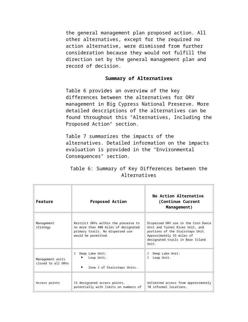
68 federally listed plant and animal threatened and endangered species. There is an intense, cooperative effort among federal, state, and local government agencies, tribes, environmental organizations, universities, businesses, and local citizens to preserve and restore the greater Everglades ecosystem. More than 200 restoration projects within this region have been identified. Listed below are projects that would have the most influence on the preserve.
Comprehensive Everglades Restoration Plan (CERP), commonly known as the Restudy. This is a multi-billion-dollar water system improvement plan led by the U.S. Army Corps of Engineers. It will reconfigure the artificially created drainage patterns of south Florida back to more natural conditions. Several projects under the umbrella of CERP that will have direct effects on the Big Cypress ecosystem include the removal of all or part of the L-28 levee, the modified waters project, and the U.S. Highway 41 Tamiami Trail culvert project. These projects will alter the regional hydrology, including the timing, distribution, and quantity of water. Implementation of this complex plan will continue for at least the next 20 years.
Southwest Florida (Feasibility) Study. This Corps of Engineers-initiated project will focus on ecosystem restoration needs specific to the southwest Florida region. This 4-year effort (through 2004) will result in a plan of action similar to the CERP, which emphasizes the eastern portion of south Florida.
Regional Growth and Development. Based on the most recent data from the Southwest Florida Regional Planning Council, southwest Florida is one of the most rapidly growing areas of the nation. For example, yearly gross and taxable sales nearly doubled from 1990 to 1999. In 1999, more than 12,000 new single-family-unit building permits and more than 8,000 multi-family-unit building permits were issued. This rapid growth is expected to continue, and the population of the southwest Florida region is projected to expand from 1,161,000 in 2000 to 1,652,300 in 2020. This represents a 42 percent increase. As this growth occurs, increasing demand will occur on all of the region’s resources.
Impacts on Natural Resources
Water Resources
Surface Water Flows
Analysis of the Proposed Action.
The proposed action would result in minor, short-term, adverse impacts to surface water flows in the areas of the designated trails. In the long term, there would be minor to moderate, beneficial effects to surface water flows throughout areas of the preserve that currently are subject to dispersed ORV use. Closing prairies to ORV use and restoring the
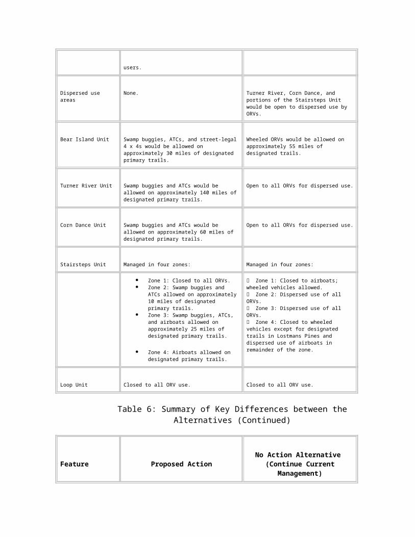
natural grades that have been heavily rutted by ORV activity, thereby re-establishing natural surface water flows to the prairies, would have localized, moderate to major, beneficial effects to surface water flow.
In the short term, the concentration of wheeled ORVs along designated trails would result in rutting within those trails. However, following complete implementation of the proposed action, the designated trails would not alter water flows because they would be continuously monitored and maintained whenever adverse alterations occurred. The restriction of ORV use to designated trails would substantially reduce the total affected area.
The hydrologic trigger would limit airboat use to times when surface water depths provided sufficient separation between the boat hulls and land surface. This would reduce the trail entrenching (channelization) that currently occurs with the operation of boats during low-water conditions.
Designating trails in areas that are more resilient to ORV traffic would reduce the amount of rutting, and should help control the increases in water flow that were observed by researchers (see the "Affected Environment" section). Maintenance of trails would further reduce the impacts on water flow. Monitoring water flow would be critical. When monitoring indicated that trails were deteriorating, appropriate management actions would be taken, based on the individual situation.
Analysis of No Action (Continue Current Management).
The no action alternative would result in long-term, moderate, adverse impacts to surface water flow in areas used by ORVs. With no restriction on where ORV use could occur in the Turner River Unit, Corn Dance Unit, and portions of the Stairsteps Unit, impacts would increase. Increases in impacts would be anticipated in terms of the total area affected (number and width of trails), magnitude of impact on high-use trails, and magnitude of impact in areas susceptible to rutting. Duever et al. (1986a) state that once soils are displaced, there are few natural mechanisms of restoring ground contour, and the ruts remain indefinitely. They also found that trails and ruts created by ORVs could act as drainage channels and alter natural hydrologic patterns on a localized basis. Therefore, since the no action alternative does not include a restoration component, the hydrologic changes resulting from ORV use would be expected to compound over time.
Cumulative Impacts.
The South Florida ecosystem restoration project includes several proposals for restoration of water flow within the region. Projects involving the preserve include the removal of the L-28 canal
levee, modification of the L-28 Tieback canal, and operational changes to various water control structures. These efforts are expected to result in major, long-term benefits to the hydrology of the preserve.
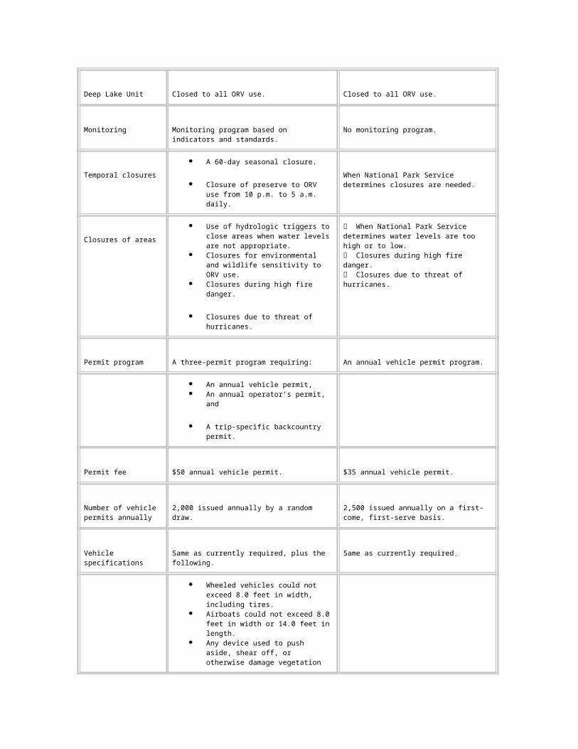
The Collier Resources Company plans to explore for oil and gas could adversely impact water flow. Collier proposes to construct roads and pads, which would have the potential to alter local hydrology. However, because approval of the operation plans would require mitigative measures to eliminate or reduce the impact of activities on water flow, the long-term effect of exploration could be minor to negligible. In addition, oil companies are required to restore any resources adversely impacted by their operation.
The construction of visitors amenities along U.S. Highway 41 could adversely affect water flow. These impacts are anticipated to be negligible to minor because of their close proximity to U.S. Highway 41, which has already altered flows in the area.
Cumulatively, beneficial effects to surface water flows would accrue from the proposed action and from the South Florida Ecosystem Restoration project, while negligible to minor adverse effect would result from oil and gas exploration and from construction along U.S. Highway 41. The overall effect is expected to involve long-term benefits to water flows within the preserve.
Conclusion.
Implementing the proposed action would have minor to moderate, long-term, beneficial effects on surface water flows, by limiting ORV travel to no more than 400 miles of designated primary trails and restoring areas previously affected by ORV use. There would be minor, short-term, adverse effects to surface water flows until the monitoring, maintenance, and restoration components of the proposed action were completely implemented. The no action alternative would result in long-term, moderate, adverse impacts to surface water flow by allowing increases in the area altered by ORVs.
Water Quality
Analysis of the Proposed Action.
Limiting ORV use to designated trails would produce moderate, beneficial improvements in water quality by limiting the spatial extent of the area subject to the localized impacts from ORV use. This would reduce areas subject to localized effects of turbidity and the potential for spills or leaks of fuels and oils associated with ORV use. Locating designated trails in areas that can sustain ORV use also would reduce impacts to water quality.
Monitoring of water quality associated with ORV trails would provide needed information to correct unacceptable conditions. The National Park Service would respond with appropriate management actions, based on the results of monitoring. These actions could range from maintenance to closures.
Analysis of No Action (Continue Current Management).
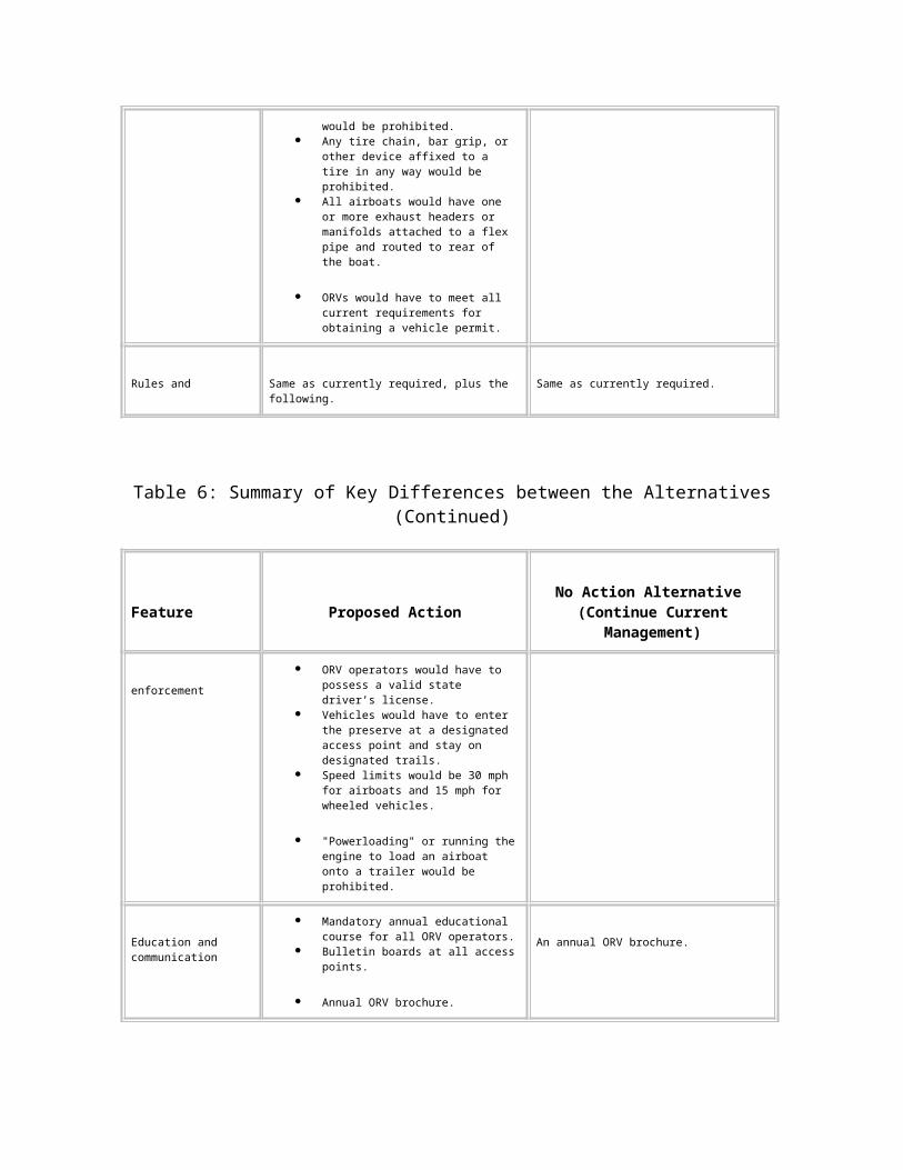
While the turbidity caused by ORVs has been described as localized (Duever et al. 1986a), the existing network of trails occurs in much of the preserve. The expected increase in the spatial extent of ORV use throughout the preserve would increase turbidity and sedimentation, producing minor, adverse impacts to water quality. The potential for spills of petroleum products would be similar to current conditions.
Cumulative Impacts.
The south Florida ecosystem restoration effort is working on improving water quality throughout the area. Implementation of these efforts is expected to produce long-term, major benefits to the water quality of the region.
Collier’s oil and gas proposals have the potential to degrade water quality through the release of contaminants and turbidity. However, their implementation of best management practices, the stipulations in the mineral management plan, and the obligation of operators to restore any detrimental effects should prevent any long-term adverse water quality effects.
The U.S. Highway 41 safety improvement project would result in a small loss of wetlands and the water quality benefits associated with wetlands. These activities would also result in short-term, adverse impacts to water quality due to elevated turbidity levels during construction.
Cumulatively, these projects and the preserve’s ORV management strategy would result in negligible to minor, short-term, adverse impacts to water quality during construction. However, in the long term, the water quality of the preserve is expected to benefit, particularly from the south Florida ecosystem restoration effort.
Conclusion.
Water quality would improve with the implementation of the proposed action by limiting the spatial extent of the area experiencing adverse water quality impacts. The no action alternative would result in minor, adverse effects associated with more widespread and repeated turbidity and sedimentation due to the anticipated increase in the area impacted by ORVs.
Soils
Analysis of the Proposed Action.
The proposed action would limit ORV travel to no more than 400 miles of designated primary trails. This would result in long-term, major, beneficial effects to soils by
restoring areas where extensive rutting has displaced soils
preventing new areas of soil impacts
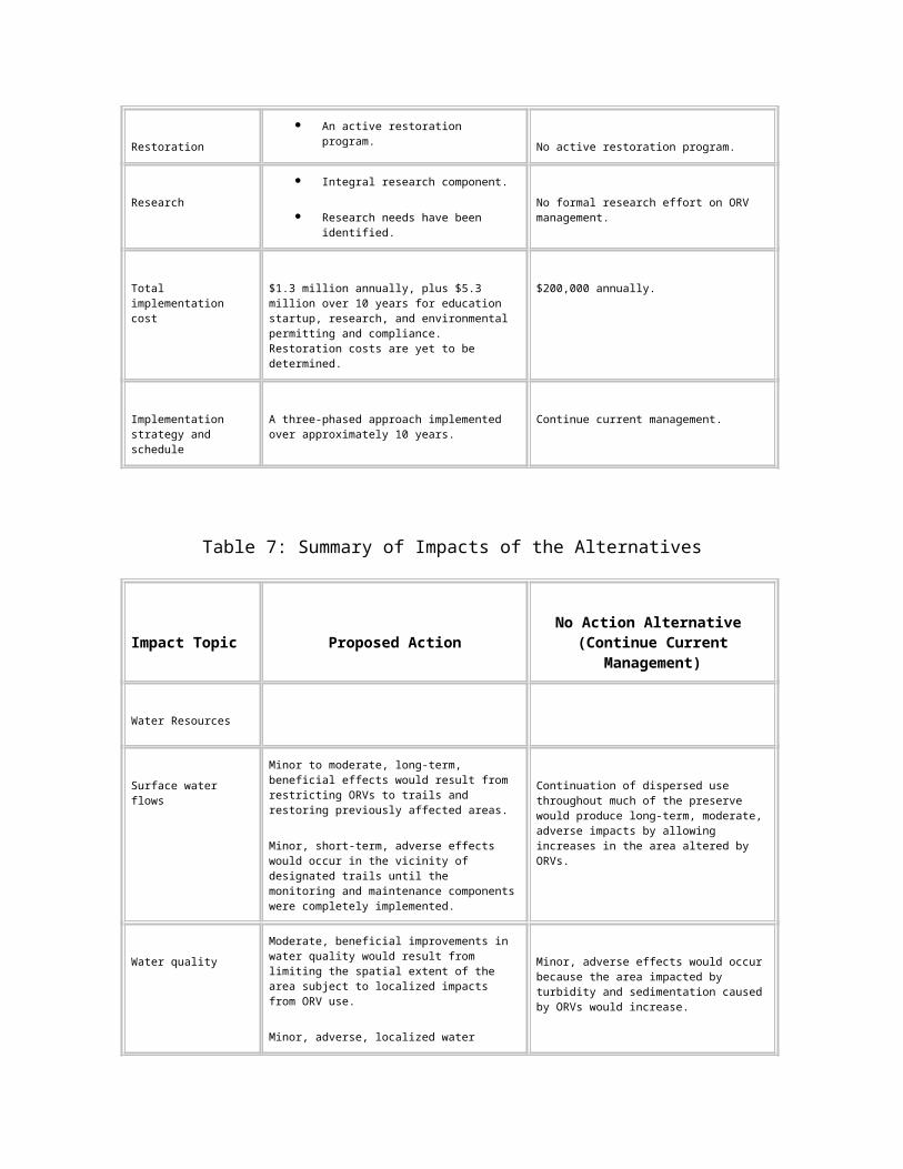
locating designated trails in areas that can sustain use, which would limit the severity of the impacts to the soils within the trails
Analysis of No Action (Continue Current Management).
This alternative is expected to result in long-term, major, adverse impacts to soils. Under this alternative, dispersed use by ORVs would be allowed in portions of the preserve. The area of adversely impacted soils would increase under this alternative, and problem sites would continue to get worse.
Duever et al. (1986b) state that once soils are displaced, there are few natural mechanisms of restoring ground contour, and the ruts remain indefinitely. Therefore, since the no action alternative does not include a restoration component, the soils effects resulting from ORV use would compound over time.
Cumulative Impacts.
The proposed oil and gas exploration and construction activities along U.S. Highway 41 are expected to result in minor, long-term, adverse impacts to soils. They would result in the placement of fill over native soils. The implementation of the proposed action would result in long-term benefits to soils that could exceed the adverse effects from the other two projects mentioned above, providing a net beneficial effect. Adverse effects from the no action alternative would be additive with the adverse effects from oil and gas development and from construction, producing a cumulative adverse effect.
Conclusion.
The proposed action would produce long-term, major, beneficial effects by promoting the recovery and restoration of heavily impacted soils in the preserve, and decreasing the area affected by ORVs. The no action alternative would have long-term, major, adverse impacts to soils.
Vegetation
Prairies and Marshes
Analysis of the Proposed Action.
The proposed action would have a long-term, major, beneficial effect on marshes and prairies. Contributing factors include the following.
The spatial extent of prairies and marshes subjected to ORV use would be substantially reduced.
Crossings of these areas, which have a low suitability for and high sensitivity to ORV use, would be limited to small segments of trails and
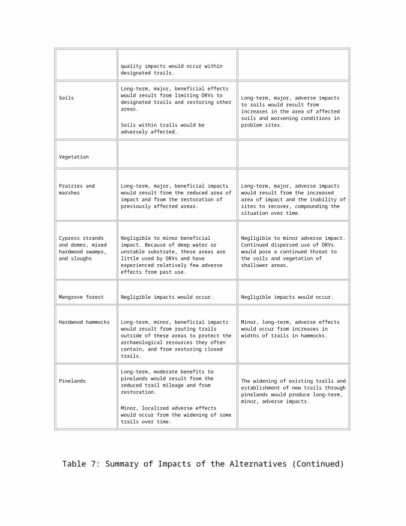
would involve the use of trail maintenance strategies such as corduroy or geotextiles.
Restoration and recovery of prairies and marshes using both active and passive techniques would be implemented.
Analysis of No Action (Continue Current Management).
Implementing the no action alternative would result in long-term, major, adverse impacts to prairies and marshes. Contributing factors include the following.
Dispersed use allows ORV operators to drive through areas of prairies and marshes that currently do not have trails, increasing the affected area.
The poor traction in prairies and marshes causes ORV operators to run parallel to existing tracks, which widens ORV trails.
Repeated passes through areas with poor suitability would continue to enlarge and deepen ruts.
The no action alternative does not include a restoration component, the so effects in these areas would compound over time.
Cumulative Impacts.
The general management plan and final environmental impact statement (NPS 1991) states that several hundred thousand acres of prairies and marshes south of Lake Okeechobee and north of I-75 have been lost to agriculture and, to a lesser extent, urban development. The anticipated increase in human population in south Florida would result in more development, causing additional losses of prairie and marsh communities on private lands outside of the preserve. However, efforts to restore the south Florida ecosystem would have major, long-term, beneficial effects on the remaining prairies and marshes throughout the region.
Locally, construction activities associated with the U.S. Highway 41 project that placed fill material within prairies and marshes would produce long-term, adverse impacts. However, these impacts would be minor because of their small areal extent.
Oil and gas exploration activities also would produce adverse effects associated with the placement of fill. If mitigation measures were not implemented, the large number of plans (24) could result in moderate effects. However, environmental protection and restoration provisions that would be included in the permit requirements would limit the adverse effects to prairies.
Cumulatively, the preceding two projects plus the no action alternative would have long-term, major, adverse impacts to prairies and marshes within the preserve. The long-term,
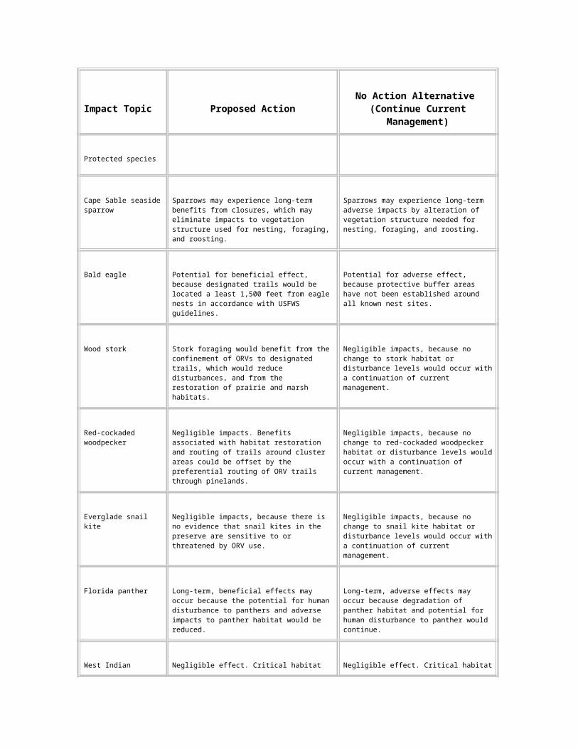
major, beneficial impacts to prairies and marshes associated with the proposed action would offset the adverse effects of the other developments.
Conclusion.
Implementation of the proposed action would result in long-term, major benefits to prairies and marshes. Long-term, major, adverse effects would be produced by the no action alternative.
Cypress Strands and Domes, Mixed Hardwood Swamps, and Sloughs
Analysis of the Proposed Action.
As described in the "Affected Environment" section, deep water, closely spaced trees, and/or deposits of muck or peat have discouraged ORV use in all but the shallow margins of these areas. Because these areas have been only slightly affected by ORV use, they would have only minor to negligible effects from a change in ORV management. This change would be beneficial, as the proposed action would prevent the establishment of new trails through these areas and could result in the restoration of some routes previously used by ORVs.
ORV trails crossing strands and swamps are normally on well-established, deeply entrenched routes where the forest narrows and water levels are shallower. Some of these crossings probably would be incorporated into the designated trail system. Monitoring and management actions would ensure that only minor adverse effects would occur at these crossings.
Analysis of No Action (Continue Current Management).
The no action alternative would produce negligible to minor adverse impacts to cypress strands and domes, and mixed hardwood swamps, and sloughs. The hydrologic, soils, and vegetative conditions that have discouraged ORV use in these areas in the past would continue to limit ORV use. However, the dispersed use of ORVs would pose an ongoing threat to the soils and vegetation of shallower areas.
Cumulative Impacts.
Throughout south Florida, state and federal regulations are targeted at preventing the loss of cypress strands, domes, and hardwood swamps. The southwest Florida feasibility study will help identify opportunities to reduce effects to these communities. However, the continued trend of increased urbanization and more intensive agriculture may locally alter the hydrologic conditions that support these communities. Over time, a net loss in this vegetation type is expected.
Conclusion.
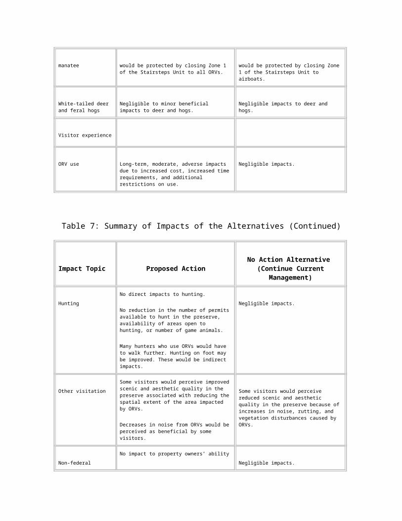
Either management approach would have only minor to negligible effects on cypress strands and domes, mixed hardwood swamps, and sloughs. For the proposed action, that small effect would be beneficial. The no action alternative would produce a small adverse effect.
Mangroves
Analysis of the Proposed Action.
Mangrove forests are found only in Zone 1 of the Stairsteps Unit. Under this alternative, Zone 1 would be closed to all ORV use. Therefore, implementing this alternative would result in negligible effects on mangrove forests.
Analysis of No Action (Continue Current Management).
The current management has closed Zone 1 to airboats, due to resource impacts associated with previous commercial activities. Although Zone 1 is open to wheeled vehicles, these vehicles operate primarily within the northern portion of the area which does not contain mangrove forest. Therefore, implementing this alternative would result in negligible effects on mangrove forests.
Cumulative Impacts.
Throughout the region, mangrove forests have been adversely affected by past waterfront development, agriculture, boating, and pollution of coastal waters. As a result, mangroves in south Florida are protected by state law. The remaining populations of mangroves are expected to proliferate. Neither alternative is expected to contribute to the cumulative impacts on mangroves.
Conclusion.
Neither the proposed action nor the no action alternative would affect the mangrove forest.
Hardwood Hammocks
Analysis of the Proposed Action.
Large numbers of the known archeological sites within the preserve are located in hardwood hammocks. It is anticipated that there also are many undiscovered archaeological sites on the hammocks. To avoid these resources, most designated trails would be routed outside of hardwood hammocks, despite their high substrate suitability. This would reduce the miles of trails with this vegetation community and would allow for the restoration of closed trails. The result would be a long-term, minor, beneficial effect to this vegetation community.
Analysis of No Action (Continue Current Management).
Long-term, minor, adverse impacts to hammocks are expected under this alternative. Few new trails in hammocks are anticipated under this alternative, but existing trails would probably increase in width over time. Hammocks would be subject to the introduction of invasive vegetation along trails.
Cumulative Impacts.
Hardwood hammocks on private lands throughout the region are being reduced in number by increasing urbanization and more intensive agriculture associated with a growing human population. ORV management practices within the preserve would have little effect on regional, development-related decreases of hammocks. Locally, the U.S. Highway 41 project could involve the placement of fill material within hammocks, which would produce long-term, minor, adverse impacts.
Conclusion.
Either management approach would have only minor effects on hardwood hammocks. For the proposed action, that small effect would be beneficial. The no action alternative would produce a small adverse effect.
Pinelands
Analysis of the Proposed Action.
Because of their suitable substrate, pinelands are preferentially used by ORVs under the dispersed-use approach. This ability to tolerate ORV use would also result in the routing of designated trails through pinelands under the proposed action. This use would produce widening of some trails through pinelands. However, the total mileage of trails through pinelands would decrease, compared to the no action alternative, and closed trails would be restored. This would result in a long-term, moderate benefit to pinelands.
Analysis of No Action (Continue Current Management).
Under the no action alternative, dispersed ORV use would produce the widening of some trails through pinelands. Some new trails through pinelands also may be established. These actions would result in long-term, minor, adverse impacts to pinelands.
Cumulative Impacts.
An analysis of vegetation types most impacted by human land conversion indicates that statewide, only 36 percent of pinelands remain (64 percent loss). According to the USFWS (1999c) south Florida pinelands are among the habitats least protected by current public lands. Residential and commercial development will continue to eliminate pinelands in private lands surrounding the preserve. ORV management practices within
the preserve would have little effect on regional, development-related decreases of pinelands.
Conclusion.
With the proposed action, long-term, moderate benefits to pinelands would result from the reduced trail mileage and from restoration. The no action alternative would produce long-term, minor, adverse impacts as a result of widening existing trails and establishing new trails through pinelands.
Protected Species
Cape Sable Seaside Sparrow
Analysis of the Proposed Action.
Implementing this alternative may result in long-term, beneficial effects to the Cape Sable seaside sparrow. Within the preserve, sparrows are currently found only within Zone 4 of the Stairsteps Unit. Since 1992, this population has experienced drastic declines caused by water management practices (USFWS 1999c). Therefore, precautionary measures are warranted.
Most of the area where sparrows were observed during the 1992 survey would be closed under the proposed action. This includes the eastern portion of Zone 4 of the Stairsteps Unit. The proposed action would also close Zone 1, another area historically occupied by sparrows, to all ORV use. This action may benefit the sparrow by allowing vegetative recovery in an area where natural re-population or translocation is possible.
Analysis of No Action (Continue Current Management).
The implementation of this alternative may result in both short- and long-term adverse impacts to the sparrow and its habitat through the continued dispersed use of airboats within the Stairsteps Unit. Airboat use in areas having low water levels during the nesting period (late February through early August) may have a detrimental impact on nesting occurrence, success, and productivity. Airboat activity that includes "mashing" of vegetation to enhance the harvest of frogs may negatively impact the vegetative structure required for sparrow nesting, foraging, and roosting.
Cumulative Impacts.
The changes in habitat that have occurred as a result of changes in the distribution, timing, and quantity of water flows into the western side of Shark River Slough have reduced the population of sparrows by 90 percent between 1992 and 1997. Although it is not known if ORV use has contributed to that decline, a precautionary approach is warranted. It is biologically more sound to promote the expansion of an existing population than resort to translocations after the loss of all of the birds in the area.
The south Florida ecosystem restoration efforts are addressing issues concerning the Cape Sable seaside sparrow. These efforts include water deliveries that will enhance sparrow productivity.
The U.S. Highway 41 project and oil exploration proposals do not include activities within sparrow habitat.
Both the proposed action and the south Florida ecosystem restoration efforts would have beneficial effects on the Cape Sable seaside sparrow, while the U.S. Highway 41 project and oil exploration would have no effect. Therefore, the cumulative effect of the projects in the vicinity of the preserve would be beneficial.
Conclusion.
The proposed action may benefit the Cape Sable seaside sparrow. The no action alternative may result in adverse impacts on habitat and nesting activity.
Bald Eagle
Analysis of the Proposed Action.
There are three known active bald eagle nests in the preserve, in Zones 1, 3, and 4 of the Stairsteps Unit near the southern boundary of the unit. The proposed action would close Zone 1 to ORV use. Zones 3 and 4 would allow ORVs on designated trails, but in conformance with U.S. Fish and Wildlife Service (USFWS) guidelines for protection of eagle nests (USFWS 1987), trails would be routed at least 1,500 feet away from nest trees. The establishment of buffers around known nest sites could have a beneficial effect on bald eagle nesting.
Analysis of No Action (Continue Current Management).
Under this alternative, ORV use would continue within 1,500 feet of some of the known bald eagle nest sites in the preserve. As a result, implementation of this alternative could have an adverse effect on bald eagles.
Cumulative Impacts.
The bald eagle currently is listed as threatened under the Endangered Species Act. It also is protected under the Bald and Golden Eagle Protection Act (16 USC 668 et seq., as amended) and the Migratory Bird Act of 1918 (16 USC 715 et seq.). This wide-ranging bird will continue to be adversely affected by habitat loss, human disturbance near nests, and poisoning by pollutants such as mercury, pesticides, and lead.
Locally, the South Florida restoration project and U.S. Highway 41 culvert projects may have minor beneficial effects on the bald eagle through hydrologic restoration, which could improve habitat and increase the prey base. Because proposed oil and gas
development activities would be prohibited within 1.25 miles of active bald eagle nests during nesting season, they would have negligible effects on this species. Collectively, these projects and ORV management in the preserve would have a negligible to minor beneficial impact on bald eagles.
An active nest occurs within 1.3 miles of the U.S. Highway 41 visitor safety project. Impacts from this project will be addressed in the project’s environmental assessment.
Conclusion.
The proposed action could have a beneficial effect on bald eagles. The no action alternative could result in adverse effects to this species.
Wood Stork
Analysis of the Proposed Action.
Wood storks nest in the fringe of cypress trees surrounding open water within the larger domes of the preserve. These domes typically are not traversed by ORVs because of the density of trees and deep water levels. Therefore, wood stork nests are little affected by ORVs and a change in ORV management would have negligible effects on wood stork nesting.
Foraging habitat consists of drying prairies and marshes. Designated trails may have a minor, beneficial, long-term benefit to storks by confining ORV use to limited areas and reducing disturbance within foraging habitat. Storks also may benefit from the restoration of prairies and marshes that would be a component of the proposed action.
Analysis of No Action (Continue Current Management).
Wood stork use of the preserve is dictated primarily by water levels and drying conditions. These conditions would not change from the current situation with a continuation of current ORV management procedures. Therefore, the no action alternative would have negligible effects on wood storks.
Cumulative Impacts.
Range-wide threats to the wood stork include loss or degradation of wetlands, improper regulation of water stages, and toxic effects from environmental contaminants such as mercury and pesticides. In addition, the decline of the wood stork is caused by poor reproduction associated with an inadequate food supply, which is attributed to water management practices that have disrupted the natural hydrology of Florida. Ongoing efforts to restore the south Florida ecosystem are expected to improve water quality and hydrological conditions, thus improving wood stork habitat conditions (USFWS 1999c). Despite these efforts, continuing development pressures throughout the region will have a

long-term adverse effect on the wood stork, regardless of ORV management efforts within the preserve.
Conclusion.
The proposed action may provide a long-term, minor benefit to wood storks. The no action alternative would result in negligible effects.
Red-Cockaded Woodpecker
Analysis of the Proposed Action.
Under the proposed action, ORV activities within the preserve would be limited to designated trails. These trails would not traverse active clusters, and a 200-foot buffer would be established around the aggregate of cavity trees in accordance with USFWS guidelines (Hendry 1989). The proposed action also includes a restoration element that could improve woodpecker habitat. These actions may have a minor, long-term, beneficial effect on the red-cockaded woodpecker.
Many trails currently traversing pineland habitat would be eliminated. However, ORV trails would be preferentially routed through pinelands, which generally provide a suitable substrate for ORV use. Routing trails through pinelands may produce a minor, long-term, adverse impact on the red-cockaded woodpecker.
While the buffer zone and restoration components of the proposed action may produce minor beneficial effects to the red-cockaded woodpecker, routing of ORV trails through pinelands could be slightly detrimental. The net effect to this species is expected to be negligible. However, consistent with the adaptive management component of the proposed action, monitoring would be conducted, and modifications would be made if a net adverse effect was detected.
Analysis of No Action (Continue Current Management).
There is no documentation that ORVs have a negative impact on red-cockaded woodpeckers in the preserve. However, continued ORV use in Zone 4 of the Stairsteps Unit may further stress a population that already is stressed by environmental factors. If this occurs, the superintendent has the authority under current management practices to close this area to ORV use. Therefore, implementation of the no action alternative would have a negligible effect on this species.
Cumulative Impacts.
Range-wide threats to the red-cockaded woodpecker include habitat fragmentation and/or loss, cluster abandonment due to mid-story encroachment, and exotic plant invasion. Locally, the U.S. Highway 41 project would not affect the red-cockaded woodpecker because it does not include construction near known woodpecker clusters. Oil and gas
development proposals would not affect this species because of the 500-foot buffer imposed by the preserve’s mineral management plan (1991), which is more stringent than the 200-foot buffer discussed earlier. Despite these efforts, continuing development pressures throughout the region will have a long-term adverse effect on the red-cockaded woodpecker, regardless of ORV management efforts within the preserve.
Conclusion.
Either ORV management alternative would have a negligible effect on the red-cockaded woodpecker.
Everglade Snail Kite
Analysis of the Proposed Action.
The implementation of this alternative is expected to result in negligible impacts to snail kites. Snail kites use the preserve for both foraging and nesting, especially in Zone 4 of the Stairsteps Unit. There are no reports or studies that document snail kites as being sensitive to or threatened by ORV use. Studies in several wetland environments in Florida have shown that the snail kite is fairly tolerant of airboat activity (Sykes 1987, Bennetts et al. 1988).
Analysis of No Action (Continue Current Management).
There is no documentation that snail kites are negatively affected by the current level of ORV use in the preserve. Therefore, the no action alternative is expected to result in negligible impacts to snail kites.
Cumulative Impacts.
The decline of snail kites has been attributed to the loss of habitat to agriculture and to reductions in their primary food source, the apple snail, that have resulted from water pollution. However, recent water quality and habitat restoration projects in the region have increased their numbers. Most of the current impacts to the population are caused by climate-related stresses, manipulation of water levels, and the spread of nuisance aquatic plants, such as water hyacinth, water lettuce, torpedo grass and hydrilla (Rodgers et al. 1996). Ongoing efforts to restore the south Florida ecosystem are expected to improve water quality and hydrological conditions, thus improving snail kite habitat.
Conclusion.
Either alternative would result in negligible impacts to snail kites.
Florida Panther
Analysis of the Proposed Action.
Under the proposed action, ORV activities within the preserve would be eliminated in some areas occupied by panthers and limited to designated trails in others. No studies thus far have shown that ORV use alone causes changes in panther behavior. However, Janis and Clark (1999) studied the effects of human activity on panthers in the preserve and found home range shifts and avoidance of designated trails by panthers during periods of higher levels of human activity associated with hunting. The study focused on the Bear Island Unit, which has one of the higher levels of hunting activity in the preserve during the deer and feral hog hunting seasons between October and January. The study used radio-telemetry data on 21 panthers over a 4-year period, as well as data collected since 1982 by the Florida Fish and Wildlife Conservation Commission (FFWCC). The study examined eight variables in panther behavior, including morning activity rates, movement rates, predator success, home range size, home range shifts, distance from panther location to trails, frequency of use of the Bear Island management unit, and habitat selection.
The proposed action would limit the extent of the ORV trail system in Bear Island. It would also establish a system of designated trails throughout the preserve, thus reducing disturbances by humans and minimizing the area of panther habitat impacted by ORV traffic. Implementing the proposed action may result in long-term beneficial impacts on the panther.
Analysis of No Action (Continue Current Management).
Janis and Clark (1999) reported that the level of human disturbance in the Bear Island Unit between 1995 and 1998 resulted in a significant response by Florida panthers. They reported that panthers avoided trails and departed the Bear Island Unit during periods of highest human activity. The no action alternative would result in the continuation of these types of effects on the panther.
Cumulative Impacts.
The decline of this large, secretive predator is largely attributed to habitat loss and human disturbance. In addition, panthers range over large areas both inside and outside of the preserve, and experience mortality from such sources as being struck by automobiles on highways. Continuing development pressures throughout the region will continue to adversely affect the panther.
The U.S. Highway 41 project and the oil exploration proposals would result in construction activities within panther habitat. Alteration of habitat and highway improvements are expected to result in adverse impacts to panthers. Panthers and their habitat will be factors considered in the review and decision on approval of Collier’s oil exploration plans.
The U.S. Highway 41 Scenic Corridor Visitor Safety Highway Improvement Project also would be constructed in panther habitat and may impact panther use of the preserve. These impacts will be addressed in the project’s environmental assessment.
Cumulatively, development in the region is expected to have a substantial, long-term, adverse impact on the panther. This trend makes it increasingly important to implement incremental beneficial actions within the preserve.
Conclusion.
The proposed action would result in long-term benefits to the Florida panther and its habitat. The no action alternative would adversely affect the panther through its continued habitat degradation and potential for human disturbance.
West Indian Manatee
Analysis of the Proposed Action.
Manatees only occur in the estuarine portions of Zone 1 of the Stairsteps Unit. The tidal creeks and bays of this area have been designated critical habitat by the U.S. Fish and Wildlife Service. Because the National Park Service already manages this area to protect manatees, the proposed action would have negligible effects on this species.
Analysis of No Action (Continue Current Management).
Under the no action alternative, the National Park Service would continue to protect manatee critical habitat. Therefore the effects of this alternative to the manatee would be negligible.
Cumulative Impacts.
The largest known human-related causes of manatee mortality are collisions with hulls and/or propellers of boats and ships (USFWS 1996). Mortality from collisions with watercraft has been increasing, including deaths of dependent calves (USFWS 1999b). Other factors in the decline of the manatee population have been entrapment in floodgates and navigation locks (USFWS 1996), and the loss of suitable habitat through incompatible coastal development, particularly destruction of seagrass beds by boating facilities (USFWS 1999b). The combination of high mortality and low reproduction has led to serious doubts about the species’ ability to survive in the United States (USFWS 1999b). The south Florida restoration project and U.S. Highway 41 culvert project will likely benefit the manatee through improved freshwater quality and quantity into the estuarine system.
Conclusion.
Both alternatives prohibit airboat use in Zone 1. Therefore, implementing either alternative would result in negligible impacts on manatees.
White-tailed Deer and Feral Hogs
Analysis of the Proposed Action.
The general management plan and final environmental impact statement (NPS 1991) states that the reduction in noise and other disturbances associated with ORV use would likely result in an increase in the populations of the white-tailed deer and feral hogs. However, studies conducted in two areas of the preserve reported that white-tailed deer did not leave their home ranges in response to hunting (Land 1991; Sargent and Labisky 1995). This indicates that disturbances associated with hunting, including ORV use, have little adverse effect on individual deer or the overall deer population. Therefore, the proposed action would result in negligible to minor beneficial effects on populations of deer and feral hogs.
Analysis of No Action (Continue Current Management).
The no action alternative would result in negligible change to deer and feral hog populations.
Cumulative Impacts.
The white-tailed deer and feral hog are widespread, resilient species that are adaptable to human disturbances. Therefore, individual projects such as the U.S. Highway 41 project and oil exploration would have negligible effects on their populations. However, like all wildlife in south Florida, increasing urbanization and more intensive agricultural practices are decreasing the available habitat and will continue to do so in the foreseeable future. Therefore, long-term declines in the numbers of both of these species in areas subject to development are anticipated, regardless of the ORV management alternative implemented at the preserve.
Conclusion.
The proposed action would result in negligible to minor beneficial effects. The no action alternative would result in negligible impacts to deer and hog populations.
Impacts on Visitation
ORV Use
Analysis of the Proposed Action.
The proposed action would result in long-term, moderate, adverse impacts to ORV users. Effects to ORV use would include the following.
ORV users would have to commit time to obtaining permits. This would include spending time getting their vehicles inspected, taking the ORV educational course, and filling out the vehicle permit application.
The cap of 2,000 permits would involve a lottery that would require ORV owners to plan ahead in order to obtain a permit for the upcoming season.
An ORV owner might not be successful in the drawing and might not be able to purchase a permit.
An increase in purchase price of the permit, from $35.00 to $50.00 per year, would increase the cost of recreating in the preserve for ORV users.
The restriction of ORVs to designated trails would reduce the freedom of driving to nearly any location within open areas, a privilege that ORV users previously experienced.
Access to many locations would require users to walk from the nearest designated trail.
The designated trail system may require longer travel times and distances to reach locations once directly accessible.
Potential restrictions at access points may limit the ability of some ORV users to enter their preferred areas during periods of heavy use.
Closures of some areas formerly open to ORVs would move ORV users into areas that are unfamiliar and perhaps less desirable to them.
Analysis of No Action (Continue Current Management). This alternative could result in negligible effects to ORV users. Eventually, some would be denied permits as demand exceeded the 2,500-permit limit.
Most ORV users are satisfied with the current level of regulations, permit fee, and restrictions. Those who have commented on impacts of increasing usage in some areas would be disappointed to see no action to mitigate adverse effects.
Cumulative Impacts.
As the population increases, and privately owned land is developed, competition for use of public land in south Florida will increase. As a result, the demand for areas to recreate using an ORV is expected to increase. Another result of increased development of open space is more restriction on the types of uses considered acceptable on public lands. Fewer places with open access for ORV use will bring more pressure on those areas that do allow such use.
Conclusion.
The proposed action would increase costs and time and add new restrictions that would result in long-term, moderate, adverse impacts to ORV users. The no action alternative would have negligible impacts on ORV users.
Hunting
Analysis of the Proposed Action.
The proposed action would not have any direct effects on hunting in the preserve. There would be no changes in the number of permits available to hunt within the preserve, the availability of open areas, or the number of animals available to be hunted.
Depending on personal perspective, the designated trail system could be considered either an adverse or a beneficial impact. Hunters who prefer hunting away from ORV traffic would benefit from ORVs being restricted to designated trails. The proposed action may improve the hunter success for walk-in hunters because of reductions in disturbances from ORVs. However, individuals who use ORVs to access hunting areas could be required to walk longer distances to reach many locations. As a result, there would be moderate indirect impact to hunting.
Analysis of No Action (Continue Current Management).
No change would occur as a result of the no action alternative. Hunting activities would remain the same as current conditions.
Cumulative Impacts.
Continued urbanization and the application of more intensive agricultural practices around the preserve will increase demands on the habitats of game species. As development increases, lands outside of the preserve that are available for hunting will be reduced. With either alternative, the preserve would continue to provide habitat for game species and would continue to provide hunting opportunities for the public.
Conclusion.
Hunting in Big Cypress National Preserve would not be directly impacted by the implementation of the proposed action or by the no action alternative. The proposed action could increase the distances that some hunters walk, which would be an indirect effect.
Other Visitation
Analysis of the Proposed Action.
Some visitors would perceive an improved recreational and/or aesthetic experience in the preserve with the implementation of the proposed action. According to Meehan (1999),
some visitors indicated that the rutted tracks and impacted vegetation caused by ORV uses detract from the natural beauty of the preserve, and that the visual experience would improve if ORV uses were restricted and former trails were revegetated. The access points may have negligible to minor adverse visual effects, but these would be offset by visual improvements associated with restoration.
Bird calls and other wildlife sounds would be more noticeable if the noise of ORVs was restricted to certain areas and buffered from non-motorized users. Designated trails routed away from primary visitor corridors like boardwalks, trails, and campgrounds would reduce the potential for conflict between user groups. Areas closed to ORV travel would increase the opportunity for backcountry experiences, including solitude and adventure, for non-motorized recreationists.
Analysis of No Action (Continue Current Management).
Implementation of the no action alternative would result in little change in the expectations of the non-motorized visitors. Potential for conflicts between ORV users and other visitors to the preserve would continue. Visually obvious rutting and vegetation disturbance would continue to increase, and noise would increase as ORV numbers increased to the permit limit of 2,500.
Cumulative Impacts.
As the population of south Florida grows, increasing pressure will be placed on public lands to serve all types of recreationists. The conflicts or potential conflicts identified now will increase. South Florida will also continue to be a very popular vacation destination for visitors from all over the world. These visitors have expectations of NPS sites to provide a wilderness or near-wilderness experience and to be preserved in their natural state. These expectations will grow as more awareness is drawn to our natural lands and their increasing rarity.
Conclusion.
The proposed action would reduce impacts to other visitors’ enjoyment of the preserve. The no action alternative would allow the potential for conflicts between user groups to continue and increase.
Nonfederal Property Owners
Analysis of the Proposed Action.
The implementation of this alternative would produce minor adverse impacts to non-federal property owners. Unless an exempt property owner has legal right of way or pre-existing access rights, legislation, laws, and regulations do not provide right of access via ORV. The National Park Service would continue to provide landowners with reasonable
access to their properties. However, landowners would experience the following new restrictions.
Property owners could not recreate with an ORV in the preserve unless they successfully drew and purchased an annual vehicle permit. If they did not draw vehicle permits, landowners would be restricted to using their ORVs on their private property and on the access route specified on their special use permit.
Like all other ORV users, property owners would be restricted to using designated access points and trails on federal lands. This would limit the free-ranging opportunities that private property owners now experience, just as it would for all other ORV users.
The route identified in the special use permit, or the designated access point, might not be the most convenient route or the route that the landowner has routinely used.
Analysis of No Action (Continue Current Management).
There would be negligible impacts on non-federal property owners in the preserve under the no action alternative. Private property owners would continue to access their property at their discretion and use the preserve for recreation.
Cumulative Impacts.
Like all other ORV users, private property owners would be restricted from using construction zones within the preserve, such as those associated with the U.S. Highway 41 scenic corridor project, or areas that were actively being explored for oil and gas, such as those proposed by the Collier Resources Company. These would produce short-term, minor, adverse effects to private property owners who use ORVs in the preserve.
Conclusion.
The proposed action would have minor adverse impacts on the free-ranging opportunities private property owners now experience in the preserve. The no action alternative would not impact non-federal property owners.
Sustainability and Long-term Management
Any Adverse Impacts that Cannot Be Avoided Should the Action Be Implemented
Analysis of the Proposed Action
The proposed action is a model for sustainable management of high-impact recreation in a natural area of national significance. However, implementing the proposed action
would result in unavoidable adverse effects to vegetation and soils within the designated trails. Plan implementation would result in the removal of vegetation within the trails. Soils would be increasingly displaced in some trails, although siting trails on suitable substrate or within previously disturbed areas would limit additional soil displacement and compaction.
Analysis of No Action (Continue Current Management)
Implementing the no action alternative (continue current management) would result in unavoidable adverse effects to surface water flows, water quality, soils, vegetation, and wildlife, including threatened and endangered species.
Localized disruption of surface water flows would occur because of rutting caused by wheeled ORVs and airboat trails.
Adverse water quality effects would include an increase in the area impacted by turbidity caused by ORVs.
Soils would become increasingly rutted and compacted, and would be subject to erosion. In some heavily used areas, soils could be completely displaced and the limestone cap rock would be exposed. Soils disturbances would become more widespread over time.
Crushing and removal of vegetation, particularly in prairies and marshes, would continue and would compound over time.
Degradation of protected species habitat would continue, and the potential for human disturbance of protected species would increase.
The Relationship between Local Short-Term Uses of the Environment and the Maintenance and Enhancement of Long-Term Productivity
Analysis of the Proposed Action
Activities associated with the proposed action would be consistent with a long-term management strategy for ensuring the protection and restoration of natural and cultural resources.
Restricting ORVs to designated roads and trails would enhance long-term ecological health. This alternative would reduce the spatial extent of soils and vegetation that would be affected by ORV
use in the preserve. Endangered species, including the Florida panther and Cape Sable seaside sparrow, may benefit by reductions in the area of their habitat impacted by ORVs and reductions in the potential for human disturbance.
The proposed action includes a component to restore areas that previously had been adversely impacted by ORV use. This restoration would result in long-term benefits to the ecological health of the preserve.
Analysis of No Action (Continue Current Management)
This alternative would not meet legislative mandates, nor would it be consistent with NPS policies for resource protection. In addition, it would violate the 1995 settlement agreement and would not meet the intent of the preserve’s general management plan.
Implementing the no action alternative would result in adverse impacts to the long-term ecological health of the preserve. This would occur from the increased spatial extent of the impacts related to ORV use. Vegetation and soils are expected to experience the greatest spatial increase in impacts from the continuation of current ORV management practices.
The ability of the preserve to provide suitable habitat to support the endangered Florida panther and Cape Sable seaside sparrow may also be adversely affected. Because of the endangered status of both of these species, any adverse effects could put their continued existence in the preserve at risk.
Any Irreversible or Irretrievable Commitments of Resources that Would Be Involved Should the Alternative Be Implemented
None of the natural resource or visitor experience changes associated with the proposed action would be considered irreversible or irretrievable commitments. However, the effort required to reverse some resource commitments and decisions, once implemented, may require substantial planning and implementation efforts.
The energy and materials expended during any access point or trail establishment or maintenance project would be an irretrievable resource commitment. Access point and trail construction would employ methods encouraging energy conservation and recycling when possible.
The no action alternative may include irreversible or irretrievable commitments of the preserve’s soil and vegetation resources.
Consultation and Coordination
History of Public Involvement
Public Information
Two notices related to this planning effort were published in the Federal Register.
A notice of the intent to prepare the ORV management plan was published in the January 22, 1996 issue (61 FR (14):1599-1600).
A notice of intent to prepare the ORV management plan and supplemental environmental impact statement was published in the March 17, 1999 issue (64 FR (85):13233).
The general public and stakeholders have been kept informed of the progress of this planning effort through a series of newsletters, visitor surveys, and meetings with individuals, organizations, and agencies. Meetings were held between September 1995 and March 1996. Two newsletters were mailed to about 1,600 people during August 1996 and June 1997. The newsletters and other information about ORV use and management in the preserve were also made available on the Internet.
The National Park Service published in the Federal Register on August 16, 1999 (64 FR (157):44532) a notice of availability for the draft off-road vehicle management plan and supplemental environmental impact statement. This notice announced that the public review period for the draft document would be from August 13, 1999 until November 15, 1999, and that public meetings would be held in the preserve vicinity at times to be published in local newspapers.
Announcements for two public meetings were placed in the Naples Daily News and the Miami Herald prior to the meetings that initially were scheduled in Miami on September 14, 1999 and in Naples on September 15, 1999. Due to hurricane threats, the public meetings were re-advertised and re-scheduled for November 1, 1999 in Miami and November 3, 1999 in Naples. Because of this delay, the public comment period was extended to December 13, 1999, which was announced in the Federal Register on November 16, 1999 (64 FR (220):62218).
At the public meetings, a brief overview of the draft plan was presented and oral comments were received from 83 speakers. More than 1,400 written comments were received during the public comment period. These comments were reviewed, responded to, and incorporated into the final document where appropriate (see "Response to Comments" section).
Representatives from the National Park Service and the Department of the Interior met with ORV user group and environmental organization representatives and individuals during 2 days in February 2000 to discuss ORV issues and concerns in the preserve. In addition, NPS staff participated in two meetings hosted by the Florida Wildlife Federation to discuss ORV management options with representatives from a wide range of user and environmental groups.
The National Park Service consulted with the following agencies by direct personal communications, by providing ORV management planning information for review and comments, and/or by requesting assistance or information:
U.S. Environmental Protection Agency
U.S. Fish and Wildlife Service
U.S. Army Corps of Engineers
Miccosukee Tribe of Indians of Florida
Seminole Tribe of Florida
Florida Fish and Wildlife Conservation Commission
Florida Department of Environmental Protection
State Historic Preservation Officer
South Florida Water Management District
Consultation with the U.S. Fish and Wildlife Service
Informal consultation with the USFWS began in January 2000. Representatives of the USFWS were an integral part of the planning team for preparation of this document. The USFWS received a copy of the draft plan and submitted comments, which are included as B1 in the "Response to Comments" section.
Formal consultation was initiated on July 8, 2000. The USFWS has prepared a biological opinion on this ORV management plan. The biological opinion is included as Appendix C of this document.
Consultation with Federally Recognized Tribes
The National Park Service provided copies of the draft document to federally recognized tribes, including the Miccosukee Tribe of Indians of Florida and the Seminole Tribe of Florida. The Miccosukee Tribe submitted written comments on the plan. A copy of their comments is included as G1 in the "Response to Comments" section. The superintendent addressed the Tribe’s written comments on June 14, 2000 and invited further consultation at the Tribe’s discretion and convenience.
Although the Seminole Tribe did not provide written comments on the draft plan, the superintendent offered to consult with the Seminole Tribe in a memorandum dated June 28, 2000.
Consultation with the State Historic Preservation Officer
As stipulated by the October 1995 programmatic agreement among the National Conference of State Historic Preservation Officers, the Advisory Council on Historic Preservation, and the National Park Service, consultation with the Florida State Historic Preservation Officer and the Advisory Council on Historic Preservation was initiated in August 1999. On November 30, 1999 the preserve received a response from the State Historic Preservation Officer. The response stated that in accordance with the procedures contained in 36 CFR, part 800 ("Protection of Historic Properties"), the proposed project will have no effect on historic properties listed, or eligible for listing, in the National Register, or otherwise of historical or architectural value.
List of Agencies, Organizations, and Individuals Who Received the Draft ORV Management Plan and Supplemental Environmental Impact Statement
Copies of the draft plan were distributed to the following agencies and organizations. In addition, approximately 400 copies were sent to individual citizens upon request. The draft document was also available on the preserve’s Internet site at www.nps.gov/bicy/draftorvplan.
Federal Agencies
Department of Agriculture
Forest Service
Natural Resources Conservation Service
Department of Commerce
National Marine Fisheries Service
National Oceanic and Atmospheric Administration
Department of Defense
Army Corps of Engineers
Department of Interior
Bureau of Indian Affairs
Fish and Wildlife Service
Geological Survey
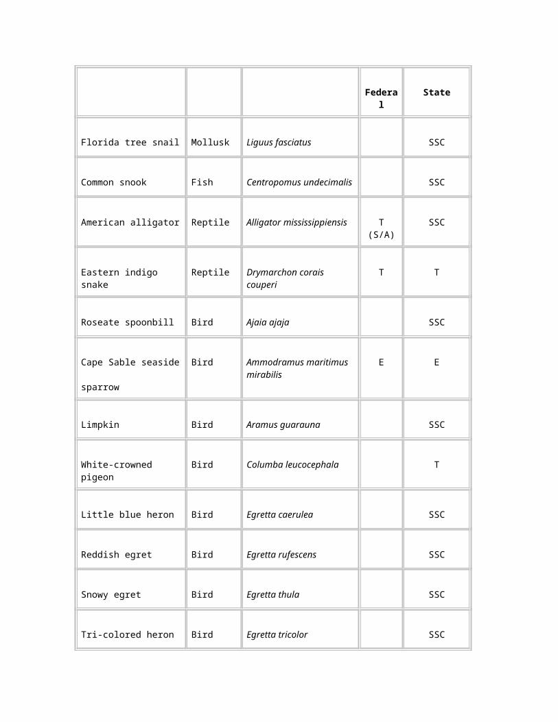
National Park Service
Biscayne National Park
Everglades National Park
Dry Tortugas National Park
Southeastern Archeological Center
Department of Justice
Environmental Protection Agency
Native American Tribes
Miccosukee Tribe of Indians of Florida
Seminole Tribe of Florida
State of Florida
Office of the Governor
Florida Department of Environmental Protection
Florida Fish and Wildlife Conservation Commission
Florida State Clearinghouse
South Florida Water Management District
State Historic Preservation Office
Florida Congressional Delegation
U.S. House of Representatives
Peter Deutsch
Mark Foley
Porter Goss
U.S. Senate
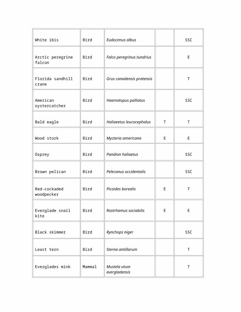
Bob Graham
Connie Mack
Florida State Legislature
Florida House of Representatives
J. Dudley Goodlette
Carole Green
Luis Rojas
J.R. Spratt
Florida Senate
Steven A. Geller
Burt Saunders
County/Local Government
Collier County
Manager
Commission
Sheriff
Miami-Dade County
Manager
Commission
Hendry County
Manager
Commission
Monroe County
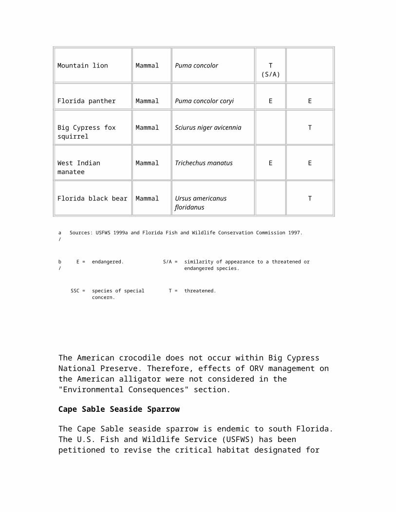
Manager
Commission
Southwest Florida Regional Planning Council
Organizations
Airboat Association of Florida
Biodiversity Legal Foundation
Collier County Historical Society
Collier County Sportsman Association
Conservancy of Southwest Florida
Corkscrew Swamp Sanctuary
Everglades Area Chamber of Commerce
Everglades Conservation and Sportsman Club, Inc.
Everglades Coordinating Council
Florida Audubon Society
Florida Biodiversity Project
Florida Panther Technical Advisory Committee
Florida Trail Association, Inc.
Florida Wildlife Federation
Governor’s Commission for a Sustainable South Florida
Greater Homestead/Florida City Chamber of Commerce
Independent Traditional Seminole Nation of Florida
Izaak Walton League
Marco Island Chamber of Commerce
Naples Chamber of Commerce
National Audubon Society
National Parks and Conservation Association
National Wildlife Federation
Sierra Club–Florida Chapter
South Florida Ecosystem Restoration Task Force
Tropical Audubon Society
World Wildlife Fund
Companies
Calumet Florida, Inc.
Collier Resources Company
Everglades National Park Boat Tours
Media
Everglades Echo
Fort Lauderdale Sun Sentinel
Fort Myers News Press
Miami Herald
Naples Daily News
Libraries
Barron (Hendry County) Public Library
Broward County Public Library
Collier County Public Library
Glades County Public Library
Hendry County Public Library
Miami-Dade County Public Library
Monroe County Public Library
Palm Beach County Public Library
Individuals
Approximately 400
Preparers AND CONTRIBUTORS
Department of the Interior
Office of the Secretary
Donald J. Barry, former Assistant Secretary for Fish, Wildlife, and Parks
T. Destry Jarvis, Senior Advisor to the Assistant Secretary for Fish, Wildlife, and Parks
Office of the Solicitor
Patricia Hooks, Attorney
National Park Service
Big Cypress National Preserve
John Donahue, Superintendent
Wallace Hibbard, former Superintendent, Big Cypress National Preserve, currently Associate Regional Director for Operations
Carolyn Kriz, Deputy Superintendent (retired)
Larry Belles, Chief of Fire Management Division
Ron Clark, Chief of Resource Management Division
Ellen Hand, former Chief of Administration Division
Terry Saunders, Chief of Maintenance Division
Dan Sholly, Chief of Ranger Activities Division
Christine Bates, Hydrologic Technician
James Burch, Botanist
Tina Collins, Program Assistant
Beth Ann Donahue, Office Automation Assistant
Randy Effert, Contract Specialist
Marlena Horvorka, Fire Effects Specialist
Deborah Jansen, Wildlife Biologist
Kevin Kacer, Management Assistant
Kim Kacer, Budget Analyst
Susan Kaynor, Environmental Protection Specialist
Peg Kohl, Program Assistant
J.D. Lee, Ranger
Wes Leishman, Interpretive Planner
Dusty Olson, Ranger
Frank Partridge, Computer Specialist
Greg Podany, Ranger
Sandra Snell-Dobert, Chief Interpretive Ranger
Bill Snyder, Forestry Technician
Robert Sobczak, Hydrologist
Tom Thatcher, Telecommunications Specialist
G.B. Wangerin, Ranger
Denver Service Center
John Hoesterey, Project Manager
Patrick Kenney, Job Captain
Steven Culver, Job Captain (draft)
Mary Magee, Natural Resource Specialist
Elaine Rideout, Natural Resource Specialist
Carol Whipple, Supervisory Leader, Planning
Everglades National Park
Sonny Bass, Wildlife Biologist
Troy Mullins, GIS Specialist
Antonio Pernas, Botanist
Southeast Regional Support Office
Tim Bemisderfer, Landscape Architect
Stuart Johnson, Chief of Planning and Compliance Division
John Yancy, Associate Regional Director for Natural and Cultural Resources Stewardship and Science
Washington Office, Park Planning and Special Studies Division
Nat Kuykendall, Program Analyst
U.S. Fish and Wildlife Service
Jay Slack, Project Leader
Jane Tutton, Wildlife Biologist
Parsons Engineering Science, Inc.
Michele Goddard, Geologist
Kathryn Kuhlman, Environmental Scientist
Tauna Murphy, Geologist
Brian Lane, Environmental Scientist
Julia Schulten, Environmental Scientist
Jan Snyder, Editor
Virginia Tech University, Department of Forestry, Cooperative Park Studies Unit (CPSU)
Dr. Jeffrey L. Marion, CPSU unit leader
Tracy Farrell
Dr. Troy Hall
Dr. Bruce Hull
Angelina Kendra
Dr. Joseph Roggenbuck
Utah State University
Dr. Dale Blahna
Peter Williams
Columbia University
Stuart Pimm
University of Georgia
Center for Remote Sensing and Mapping Science
Response to Comments
Introduction
The National Park Service received approximately 1,400 letters and oral remarks regarding the Big Cypress National Preserve draft recreational ORV management plan and supplemental environmental impact statement. A comment included any of the following:
An oral statement at a public meeting.
A letter or other written document from an private citizen. This included both individually prepared comments and form letters.
A letter or memorandum from a Native American Tribe or from a federal, state, regional, or local agency.
A letter or memorandum from a non-government organization.
Photocopies of all of the written comments from agencies, organizations, and Native American Tribes, and substantive written comments from individuals are provided at the end of this section. For each of the two form letters received by the National Park Service, a photocopy of a single letter is provided to be representative of the entire group of identical letters. The National Park Service received 775 copies of the letter represented by F250, and 223 copies of the letter represented by F251.
Written transcripts from the two public meetings and copies of all of the written comments are available for public review at Big Cypress National Preserve.
Each comment was assigned an alpha-numeric code. The letter within the code describes the affiliation of the commentor (agency, organization, or private citizen) and is followed by a number, assigned sequentially, that uniquely identifies the comment. Identification of each substantive commentor is provided in Table 15.
Written comments varied in length from less than a page to more than 100 pages and ranged in coverage from a single item to many subjects. Many commentors identified similar concerns. Individually addressing each concern from each commentor would have resulted in considerable repetition. Therefore, 20 broad topics that encompassed all of the comments were identified. Similar comments within each topic were summarized, with an identification of their sources. A response to each comment was then provided.
The Council on Environmental Quality (1978) guidelines for implementing the National Environmental Policy Act require that responses be provided to "substantive" comments. A comment that met any of the following criteria from Draft Directors Order 12: Conservation Planning and Environmental Impact Analysis (NPS 1999) was judged to be substantive.
It questioned, with reasonable basis, the accuracy of information.
It questioned, with reasonable basis, the adequacy of environmental analyses.
It presented reasonable alternatives other than those proposed in the plan and supplemental environmental impact statement.
It would cause changes or revisions in the proposal.
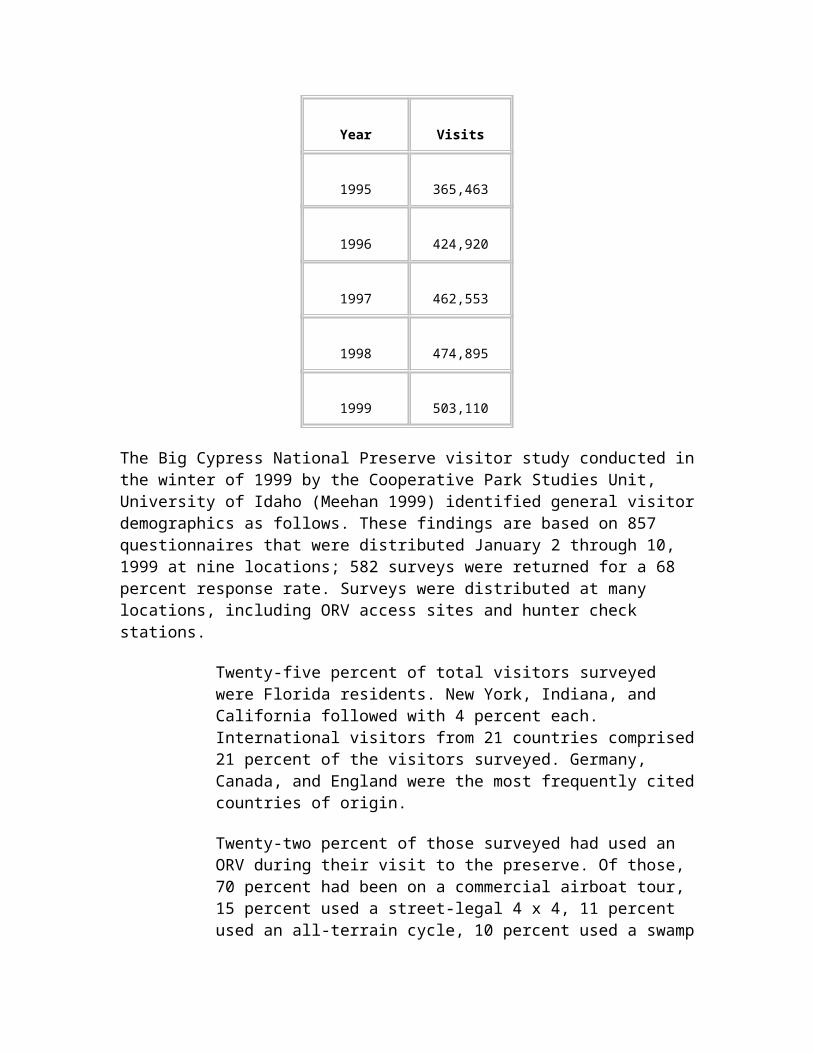
Many of the comments that were determined not to meet any of these criteria expressed an opinion. Many others were outside of the scope of the Big Cypress National Preserve recreational ORV management plan and supplemental environmental impact statement. While the National Park Service values this input, no response is provided to such comments. Comments that identified errors such as misspelled words were not included as substantive, but the National Park Service appreciates the information and has corrected the errors.
TABLE 15: Identification of Commentors
CommentorCommentor
Identification Code
A – Oral comments from public meetings
Adams, Franklin A2.13
Barry, Patrick A1.31
Beardsley, Gary Lee A2.15
Billie, Danny A2.32
Bishop, Patrick A1.40
Brewer, Bill A2.39
Buckley, Robert A1.10
Cain, Shannon A2.23
Campo, Paul A2.34
Carpenter, Ken A1.17
Cartwright, Karen A2.19
Clark, Todd D. A2.1
Coffey, Kenneth A1.28
Cook, Michele A1.29
Cruz, Luis A1.37
Cruz, Mark A1.32
Cunbelo, Robert A1.11
Del Toro, Ray A1.38
Denninger, Frank A2.3
Denninser, Frank A1.6
DiNunzio, John A2.25
Easom, James A1.30
Ednor, Benjamin A1.3
Fisikelli, Freddy A1.41
Ford, Michael A2.21
Furland, Wayne A1.39
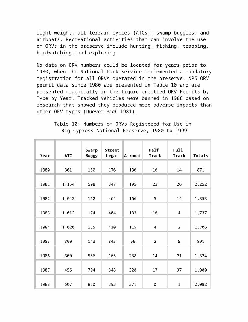
Garrott, John A2.6
Grant, David W. A2.31
Green, Mark A1.2
Greer, Karl A1.5
Guggenheim, David A2.10
Hampton, Charles W. A2.2
Hauser, Sean A2.4
Howard, Nat A2.27
Hull, Jerron A2.22
Jenkins, Wayne A2.33
Jensen, Hank A2.26
Jensen, Holly A1.14
Kimmel, Eric A1.23
Kimmel, Travis A1.24
Klein, Helene A1.4
Larkins, Mary A2.36
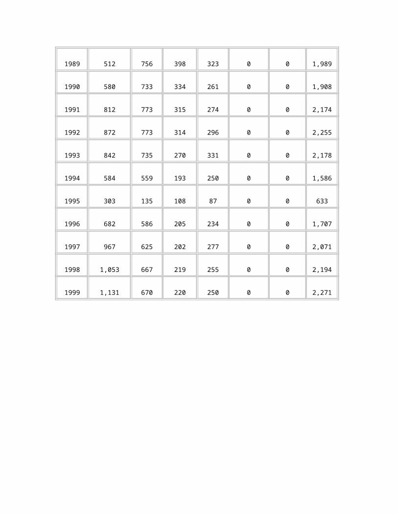
Lee, Mike A2.38
Leon, Leopoedo A1.26
Leon, Maritza A1.27
Marco, Joel A1.8
Marlin, Dennis T. A2.17
McCandless, Lyle A2.40
McDowell, Donnie A2.12
Mogelvang, Christian, M.D. A2.30
Moller, Jack A1.12
Myers, William A1.21
Newell, Norm A1.18
Peacock, William A1.22
Pershing, Keith A2.24
Peterson, Ellen W. A2.18
Powell, Barbara Jean A1.20
Powell, Barbara Jean A2.20
Rodriguez, Clemente A1.1
Rosewik, Richard A1.9
Sanders, Eddie A2.5
Sawyer, Carson and Kit A2.28
Scherf, Brian A1.16
Scherf, Brian A2.9
Scherf, Rosalyn A1.15
Scherf, Rosalyn A2.8
Shirley, Tom A1.25
Smith, Gregory H. A2.11
Snell, Shane A2.14
Sorrell, Mike A2.35
Swingle, John A2.16
Taylor, Mark A1.33
Thoemke, Kris A2.29
Townsend, Robert A2.37
Van Schaick, Gene A1.42
Varela, Rick A1.7
Vatter, Dave A1.34
Wilsey, Glen A1.19
Wilson, Chuck A2.7
Wilson, Dennis A1.13
Wimmer, Kent A1.36
Youse, Christopher A1.35
B – Federal agency comments
U.S. Environmental Protection Agency
B2
U.S. Fish and Wildlife Service B1
C – State of Florida agency comments
Florida Department of Health C5
Florida Department of Community Affairs, Areas of Critical State Concern
C9
Florida Department of Community Affairs, Coastal
C8
Management Program
Florida Department of Environmental Protection
C7
Florida Department of State, Division of Historical Resources
C2
Florida Department of Transportation
C6
Florida Division of Forestry C3
Florida Division of Forestry C4
Florida Fish and Wildlife Conservation Commission
C1
D – Regional and local agency comments
Southwest Florida Regional Planning Council
D1
Southwest Florida Regional Planning Council
D2
E – Non-government organization comments
Blue Ribbon Coalition Inc. E7
Collier Sportsmen and Conservation Club
E11
Everglades Conservation and Sportsman Club, Inc.
E8
Everglades Coordinating Council
E20
Florida Biodiversity Project E1
Florida Biodiversity Project E23
Florida Trails Association E19
Florida Wildlife Federation E2
Florida Wildlife Federation E6
Florida Wildlife Federation E21
Georgia Cruisers 4WD Club E9
Meyer & Glitzenstein, on behalf of the Florida Biodiversity Project and Biodiversity Legal Foundation
EL1
National Audubon Society E12
National Parks and Conservation Association, South Florida Field Office
E17
National Rifle Association of America
E4
Panther Action Coalition and Friends of Whales
E15
Predator 4-WD E5
Responsible Growth Management Coalition, The Environmental Confederation of Southwest Florida, and Save the Manatee Club
E24
Ridberg, Press & Sherbill, LLP, on behalf of National Park Trust
E13
Sierra Club, The Florida Chapter E14
Sierra Club, The Florida Chapter E22
Southern Appalachian Biodiversity Project
E16
SVIA – Specialty Vehicle Institute of America
E10
Wildlands Center for Preventing Roads
E18
Wildlife Legislative Fund of America, The
E3
F – Comments from the general public
Abraham, Eve F65
Abraham, Eve F68
Adams, Franklin F252
Bang, Harold W. F113
Barnes, William D. F162
Baxter, Michael F4
Beardsley, Gary F231
Beaver, Kris F135
Botticher, Pamela D. F92
Brooks, Leigh F189
Buisson, Justine F171
Bussing, Thomas D., Ph.D. F218
Camaraa, Tom F227
Cardona, Armando F210
Cherry, Robert F161
Christ, Doug F241
Clark, Todd F149
Clark, Todd F150
Counterman, Jesse F138
Crawford, William J. F156
Curle, Chris F188
Dayhoff, Fred E. F242
DeGraff, Rob F191
DeGraff, Rob F192
DeLine, Steven B. F155
De Mateo, Eduardo F257
De Mots, Dennis F186
Denison, Mr. and Mrs. J.L. F253
Denninger, Frank F. F107
Dernburg, Ernest A., M.D. F119
Dettmers, Dr. Almut E. F46
Drivas, Helen F159
Easom, James A. F148
Eichholz, Neal F. F35
Elton, Wallace F230
Fagergren, Fred J. F83
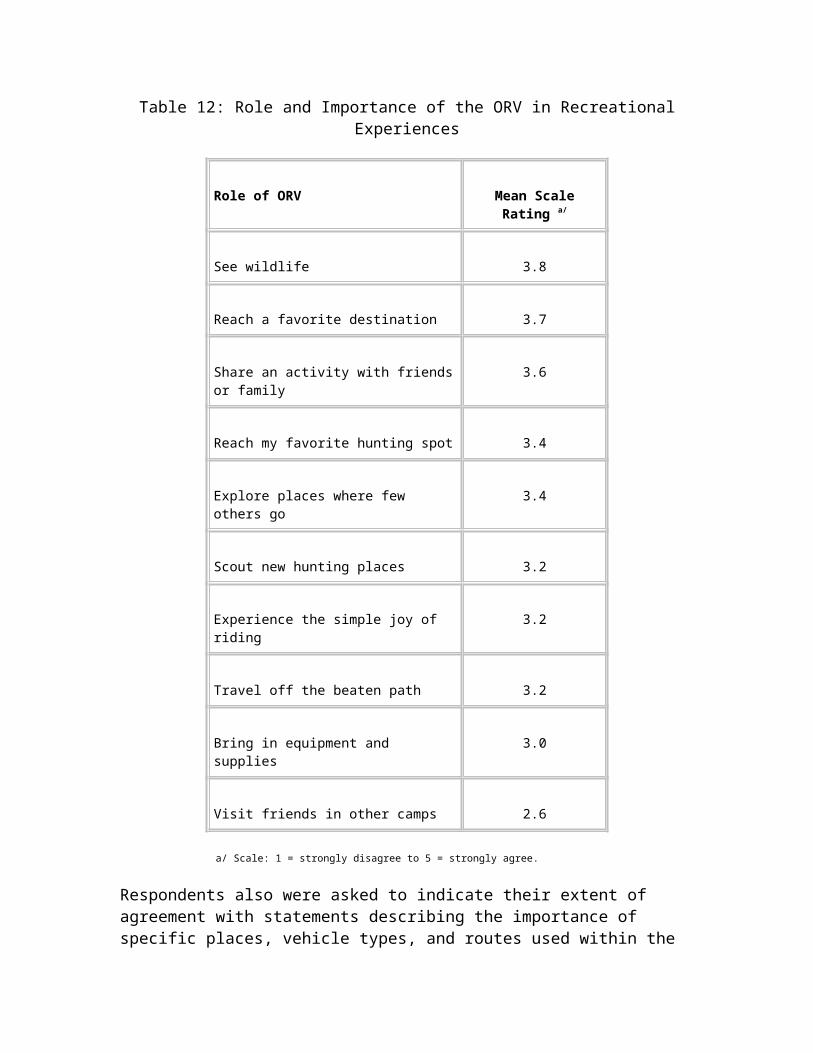
Featherly, Roxanne F77
Fleming, Donald H. F198
Fontenot, Donald F82
Fowler, Beverly, O.P. F52
Gabel, Bunny F185
Garrott, Joe F. F145
Garvey, Lydia F194
Grayson, Lee F32
Greenfield, Leonard J., Ph.D. F124
Griffin, Tim F142
Hall, Michele, Ms. F217
Hampton, Charles W. F240
Hampton, Charles Wade, Jr. F243
Hampton, Harold F245
Hampton, Steven K. F244
Hansen, Mary Lou F42
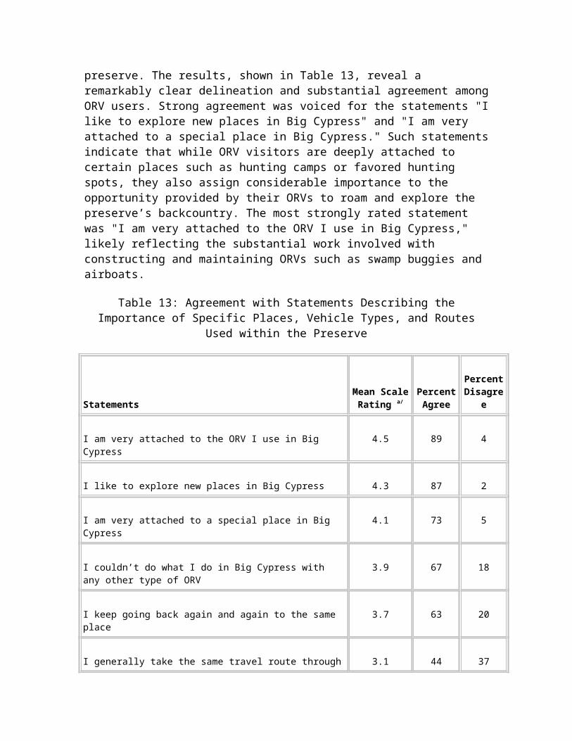
Henry, Barbara R. F246
Henry, Charles R. F246
Hodges, Dorothy F48
Horgan, Christopher F146
Houghton, Richard L. F152
Hull, Jerron K. F34
Joyce, Lawrence F147
Keim, Susan, O.P. F220
Kent, David A. F254
Kile, Gary E. F2
Kimmel, Cody F140
Kimmel, Eric F140
Kimmel, Michele F140
Kimmel, Travis F140
King, Jean F126
Knowles, Gary F201
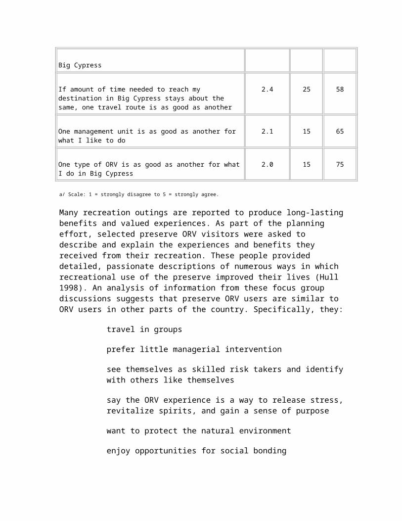
Lauredo, Rod F39
Lenz, Dennis J. F129
Leon, Maritza F153
Libkind, Marcus F184
Lohman, Donna F256
Mathews, Mary F133
Mayer, William Patrick F5
McClory, Valerie J. F50
McDonald, David M. F143
Mento, Sam A. F204
Merkel, Robert S. F187
Metzger, Sherry J. F180
Michaels, Bob F193
Millard, Andrew J., Dr. F132
Moller, Donna F28
Moller, Jack F29
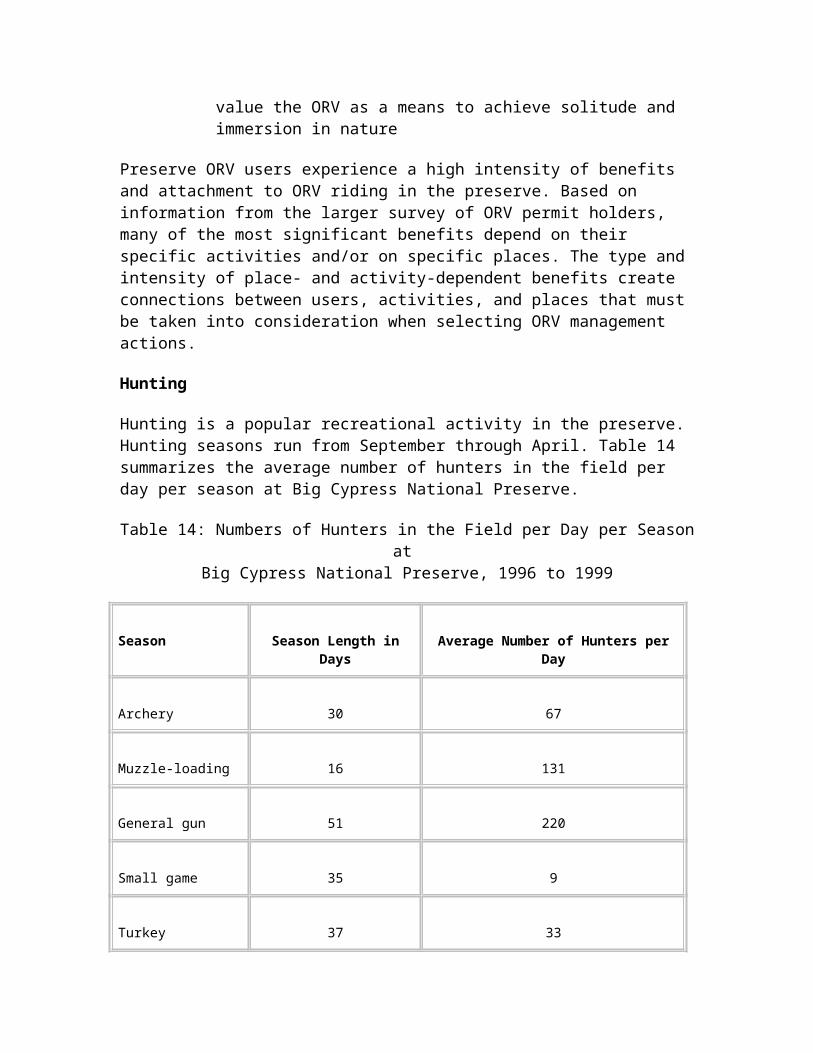
Moller, Jack F30
Moller, L. Jack F25
Moller, L. Jack F37
Moller, L. Jack F249
Morris, Heather F147
Neufeld, Steven F81
Nichols, Nick F125
Nye, Mrs. Dagmar F14
O’Connell, Dorothy E. F62
O’Neal, Denny F159
Patterson, Jeff & Dawn F199
Rauch, Peter F167
Rentschler, Dennis S. F215
Roby, Kinley E. F229
Rodriguez, Armando, Jr. F164
Ruscoe, Dean F131
Rust, Terry F3
Rutkowski, Robert E., Esq. F51
Rutkowski, Robert E., Esq. F128
Rutkowski, Robert E., Esq. F134
Salmon, Jean L. F63
Sandberg, Harlan K. F170
Savett, Adam T. F49
Scott, Lynwood V. F151
Sherk, Jerome F116
Smith, Sean F130
Snell, Shane F36
Spotts, Richard F139
Torres, Lorenzo F1
Trabulsy, Norman M., Jr. F219
Travis, Lisa A. F137
Trumbly, Gary L. F258
Turner, Kathleen Kaeding F136
Tyner, Robin D. F61
Van Winkle, Charlotte B. F64
Volk, Jeff F169
Voorhies, Bill & Marilyn F47
Wack, David R. F106
WDB, Martha F175
Whidden, David E. F141
Wilsey, Susan N. F259
Wilson, Cody F205
Youse, C. Robin F255
Zinn, Robert K. F223
G – Native American Tribe comments
Miccosukee Tribe of Indians of Florida
G1
Response to Comments
Analysis and Utilization of Scientific Data and Supporting Information
Comment: The description of the affected environment does not analyze global, national, and regional processes that impact the south Florida ecosystem and Big Cypress National Preserve. (Source: E1)
Response: The National Park Service is participating in the south Florida ecosystem restoration planning effort, which is providing a regional analysis of the environment. Consideration of this program is described in the "Environmental Consequences" section under "Methodology, Cumulative Impacts." The regional effects of each impact topic are included in the "Environmental Consequences" section. In addition, information on regional processes was included in the 1991 Big Cypress National Preserve general management plan from which this document is tiered, in conformance with 40 CFR 1502.20. Global and national processes are beyond the scope of this management plan and supplemental environmental impact statement.
Comment: Devise a plan that is based on science, utilizing the best available data. The methodologies cited do not reflect all of the relevant environmental documents. (Sources: A1.1, A2.9, A2.15, A2.22, E1, E12, E13, E14, E15, E17, E18, F47, F48, F49, F50, F51, F52, F125, F126, F130, F131, F132, F133, F134, F135, F136, F137, F138, F139, F159, F161, F199, F215, F218, F220, F223, F231, F242, G1)
Response: Additional information has been provided throughout the ORV management plan and supplemental environmental impact statement. Readers also should recognize that this plan is tiered to and incorporates all of the information included in the 1991 general management plan and environmental impact statement.
Comment: The plan does not contain comprehensive and scientifically justifiable conservation goals and objectives. (Sources: A1.14, A1.16, E1, F1, F2, F49, F148, F149, F250)
Response: See the revisions to management objectives in "Purpose of and Need for the Plan," and "Alternatives, Including the Proposed Action."
Comment: The plan does not provide any supporting data or analysis for dispersed ORV use. (Sources: E1, F143)
Response: The proposed action would eliminate all dispersed use of ORVs. See the "Alternatives, Including the Proposed Action" section.
Comment: A 5- to 10-year research program is needed. (Source: A1.14)
Response: See the modified "Research" section in "Alternatives, Including the Proposed Action."
Comment: The plan needs more input from ORV users and locals. (Sources: A1.35, A1.37, A1.38)
Response: The "Consultation and Coordination" section describes the public participation program that was conducted as part of preparing the plan.
Comment: The information in the supplemental environmental impact statement does not support the "no unavoidable adverse impacts" stated in the conclusion. (Source: B1)
Response: The "Unavoidable Adverse Impacts" section has been revised.
Comment: Geographic information system suitability analysis principles should be used in rewriting the ORV management plan and supplemental environmental impact statement. (Source: E15)
Response: Geographic information system suitability analyses have been included in the proposed action. See the revised text in "Alternatives, Including the Proposed Action."
Comment: Provide analysis of the impacts of current levels of ORV use. (Sources: E20, F229)
Response: Additional information on the effects of current ORV use has been provided in the "Affected Environment" section.
Comment Provide a projection of the expected increase in ORV use over the next decade and the effects of the increase. (Source: F229)
Response: Projected ORV use in the preserve is described in the "Purpose of and Need for the Plan" and "Alternatives, Including the Proposed Action" sections.
Comment: Evaluate reductions in impacts that have resulted from implementing measures included in the general management plan since its enactment in 1991 to the present. (Source: E.20)
Response: See the description of the no action alternative (continue current management in the "Alternatives, Including the Proposed Action" section for a description of the measures from the general management plan that have been implemented, and their effectiveness.
Opening and Closing of Management Units
Comment: The plan fails to analyze procedures and considerations for closing and opening trails and areas. Explain the criteria used to determine whether or not a trail or area should be closed for resource or visitor protection. (Sources: A1.14, A1.16, A2.10, A2.23, B1, B2, C1, E1, E2, E6, E8, E14, E15, E17, E18, E21, E24, F46, F65, F81, F82, F150, F151, F152, F184, F246, F252)
Response: Criteria for opening and closing trails and areas have been added to "Alternatives, Including the Proposed Action."
Comment: The plan should describe the hydrological criteria that would be used for management of each unit, particularly including the Stairsteps Unit. (Sources: B1, B2, F242)
Response: Hydrologic criteria are provided in the "Alternatives, Including the Proposed Action" section and Appendix A.
Comment: Reopen the gate on Cypress Lane at Alligator Alley to reduce traffic in Airplane Prairie. (Source: F145)
Response: This action was considered and analyzed in the general management plan and environmental impact statement and the I-75 recreational access plan and environmental assessment (NPS 1990). The National Park Service does not plan to reconsider opening Cypress Lane. Under the proposed action, ORVs in the vicinity of Airplane Prairie would be restricted to designated trails.
Comment: Prohibit ORV use on all lands identified as potential nesting sites for the Cape Sable seaside sparrow and all waters that are critical to the endangered West Indian manatee. (Source: E15)
Response: Unit management practices described in the "Alternatives, Including the Proposed Action" section have been developed in consultation with the U.S. Fish and Wildlife Service to ensure the protection of these and other threatened and endangered species.
Comment: How will no-drive areas be maintained and regulated? (Source: E14)
Response: See the revised proposed action description in the "Alternatives, Including the Proposed Action" section.
Compliance with Legal Mandates and the Settlement Agreement
Comment: The plan does not clearly explain the relationship of the no action alternative (continue current management) in the ORV plan relative to the 1991 general management plan proposed action. (Source: E1)
Response: See the revised description of the no action alternative.
Comment: The plan does not contain a reasonable range of alternatives as required by the National Environmental Policy Act. (Sources: A1.30, A2.15, B1, B2, E1, E14, E16, E20, F230, G1)
Response: The 1991 general management plan examined a wide range of reasonable alternatives for ORV management. Because this ORV management plan is tiered to the general management plan in conformance with 40 CFR 1502.20, the requirements and intent of the National Environmental Policy Act have been satisfied.
Comment: The plan does not set forth the traditional and customary use rights of the Miccosukee people or how this plan may or may not affect those rights. (Source: G1)
Response: The National Park Service has further consulted with the Miccosukee Tribe. Additional information concerning protection of these rights is included in the "Purpose of and Need for the Plan" section.
Comment: The plan impacts and discriminates against Native Americans. (Source: A2.32)
Response: The plan has no effect on Native American Tribes. The National Park Service has consulted with the Tribes and will continue to do so to ensure that their rights are protected.
Comment: At least one alternative must consider complete elimination of ORVs from the preserve. (Sources: E15, E16)
Response: As described in "Big Cypress Legislative Background and the Purpose of the Preserve," the Senate and House reports on the bill establishing Big Cypress National Preserve specifically stated that the bill did not prohibit the use of ORVs along designated roads and trails. Therefore, there is no basis for requiring such an alternative.
Comment: Provide an interpretation of the phrase in the preserve’s mandate "subject to regulation" that allows vehicles in the preserve. (Source: F229)
Response: See the revised "Purpose of and Need for the Plan" section and the description of the proposed action in the "Alternatives, Including the Proposed Action" section.
Comment: The plan does not assure that ORV usage will not supercede the preserve’s mission of resource protection. (Source: E17)
Response: See the revised "Purpose of and Need for the Plan" section and the revised description of the proposed action.
Comment: Congressional authorization does not appear to include basic ORV pleasure use of the preserve. Described how the alternatives meet the Congressional authorization. If this was discussed in the 1991 general management plan, it should be referenced. (Sources: B2, F229)
Response: This was addressed on page 44 of the Big Cypress National Preserve general management plan and final environmental impact statement.
Comment: The term "no action" for one of the management alternatives may be misinterpreted. The National Park Service should use "current action" instead. (Sources: C1, E2, E6, E20, E21, F252)
Response: This alternative is now referred to throughout the plan as "no action alternative (continue current management)."
Comment: The plan should mention that current management, embodied in the "no action alternative," has resulted in major impacts to the preserve. (Source: B2)
Response: The "Purpose of and Need for the Plan" and "Affected Environment" sections have been revised to include this information.
Comment: The proposed alternative does not adequately account for past negative impacts when deciding how to manage the resource in the future. (Source: E17)
Response: The "Alternatives, Including the Proposed Action" section has been revised to provide additional detail on this subject.
Comment: Both the 1990 biological assessment for the general management plan and the 1991 biological opinion were based on 2,000 vehicle permits per year. However, the NPS record of decision for the general management plan changed the number of permits to 2,500 and never reinitiated consultation with the U.S. Fish and Wildlife Service. Therefore, the National Park Service and U.S. Fish and Wildlife Service have violated the consultation requirements of the Endangered Species Act. (Source: EL1)
Response: The proposed action has been revised to include no more than 2,000 permits per year, which is consistent with the 1990 biological assessment and the 1991 biological opinion. Selection of the no action alternative (continue current management), including its provision to permit 2,500 ORVs per year, would require further consultation with the U.S. Fish and Wildlife Service under Section 7 of the Endangered Species Act.
Comment: The plan does not adequately analyze the criteria for the development of a comprehensive designated trail system and/or use areas for ensuring the natural and ecological integrity of the preserve’s resources in accordance with the provisions of the Big Cypress National Preserve enabling act and the 1995 settlement agreement. (Sources: A2.9, B2, E1, EL1, E14, E15, F81, F82, F150)
Response: As described in the revised text in "Alternatives, Including the Proposed Action," geographic information system suitability analyses would be used to select the optimal trail alignments.
Comment: Under the Endangered Species Act, a Section 7 consultation is required. (Sources: E14, E16)
Response: The National Park Service has consulted with the U.S. Fish and Wildlife Service in conformance with Section 7 requirements. See the "History of Public Involvement" section.
Comment: The statement on page 73, "The non-federal property owners are not regulated with respect to access to or dispersal from their property" is not true. (Sources: F37, F83)
Response: The text has been corrected.
Comment: Regarding the text on page 27, the National Park Service is not required to consult with the Florida Fish and Wildlife Conservation Commission on ORV use. (Source: F83)
Response: The text has been corrected.
Comment: The plan is not an action-oriented document, but instead is only a planning tool with an inadequate level of detail on implementation. (Sources: B1, B2, E15, G1)
Response: The description in the "Alternatives, Including the Proposed Action" section has been revised to address implementation.
Comment: The plan has no timetable, target dates for management, or specifics for implementing actions. (Sources: B2, E14, G1).
Response: An implementation schedule for the ORV management plan is provided in the "Alternatives, Including the Proposed Action" section.
Comment: ORV use is allowed by the enabling act; thus, a large fee increase is neither required nor legal. (Sources: F2, F4, F5, F28, F250, F251)
Response: The proposed fee for an off-road vehicle permit has been revised in the "Alternatives, Including the Proposed Action" section.
Comment: The plan must include an environmental justice component because the proposed fee increase and ORV specifications will deliberately reduce visitation by low-income individuals. Costs of changes to ORVs under the plan should fall under Executive Order 12898, Environmental Justice. (Sources: E20, F25)
Response: Environmental justice was not considered in detail for the reasons provided in the "Topics Dismissed from Detailed Analysis" section.
Comment: The provisions in the plan could result in landowners not being able to access their property, which is a taking of their land. Any reference to non-federal property rights and uses should not be part of the plan. (Sources: E20, F25)
Response: See the revised description of the proposed action. Exempt property owners would continue to be provided reasonable access to and from their property.
Comment: Private property owners have the right to access their property, but does this mean staying on the designated roads/trails or creating short cuts for convenience? What about if in environmentally sensitive area? (Source: E17)
Response: See the revised description of the proposed action.
Comment: The plan gives the misleading impression that ORV use is mandated under Congressional law. (Source: E17)
Response: The text in the section "Legislative Mandates and Special Commitments" has been revised to clarify the authorization of ORV use in the preserve.
Visitor Experience
Comment: Provide documentation on conflicts between ORV users and other visitors. Analyze the effects of these conflicts. (Sources: C1, E1, E2, E6, E8, E14, E,17, E20, F107, F148, F256)
Response: See the revised "Affected Environment" and "Environmental Consequences" sections.
Comment: The proposed action alternative fails to recognize social issues or issues related to the enjoyment of the area by ORV operators, including the ability to explore new places and reach favorite destinations. (Sources: C1, E2, E6)
Response: Recognition of the importance of these activities is included in the revised "Affected Environment" section. In the "Environmental Consequences" section, the text describing impacts to ORV users has been revised.
Comment: There are no alternative places to hunt and ride for recreation. (Source: F32)
Response: This ORV management plan would not limit places to hunt. Additional information on effects to ORV users has been provided in the "Environmental Consequences" section. This issue also was addressed on page 249 of the 1991 general management plan.
Comment: Do not link scenic highway management and the ORV plan. (Source: F107)
Response: The revised text does not include scenic highway management. However, as discussed under legislation mandates, Big Cypress National Preserve was established in part to protect the scenic values of the watershed.
Comment: The plan misrepresents the number of walk-ins and hikers using the preserve. (Source: A1.34)
Response: The "Affected Environment" section has been revised to provide additional information on visitors who do not use ORVs.
Comment: The survey of visitors included no African Americans. (Source: E17)
Response: The survey was sent to a randomly selected group of current ORV permit holders and reflects those who responded. The survey was developed in compliance with Office of Management and Budget regulations to ensure that it was an objective surveying instrument.
Comment: A buffer on the Florida Trail is impractical to comply with due to the difficulty in navigating within the preserve. (Source: F258)
Response: The proposed action has been revised to restrict ORVs to designated trails throughout the preserve. The designated trails would be located to minimize crossings of the Florida Trail.
Cumulative Impacts
Comment: The plan fails to fully consider cumulative impacts. (Sources: A2.15, E1, E14, E24, F61, F63, F64, F68, F81, F82, F119, F169, F171, F175, F184, F185)
Response: Cumulative impacts sections have been revised throughout the "Environmental Consequences" section.
Comment: The cumulative impact statement for the future loss of habitat section should be changed to "no cumulative impact," as the preserve is surrounded almost entirely by state and federally owned property where the loss of habitat through development is not a threat. (Sources: C1, E2, E6)
Response: Although state and federal lands are protected, privately owned lands in the region also provide important habitat and are subject to development. The northern boundary of the preserve has substantial private ownership, and there also are large, privately owned tracts throughout the region. The U.S. Fish and Wildlife Service has expressed concern about habitat fragmentation for several species.
Comment: The National Park Service must ensure that the environmental impact statement and final plan include a comprehensive analysis of all potential adverse impacts of ORV use, including all commercial activities and other activities which may produce cumulative or connected impacts. (Source: E18)
Response: The general management plan and final environmental impact statement were prepared to fulfill this intent. Commercial activities are beyond the scope of this recreational ORV management plan.
Education and Communications
Comment: The plan does not contain an adequate education and communication plan to avoid and minimize ORV impacts. Elements of such a plan could include an ORV users manual, videos, and establishing an educational component to the permitting process. (Sources: A1.6, A1.32, A2.3, B1, B2, E1, E2, E6, E8, E14, E17, E20, E21, F37, F81, F82, F107, F140, F148, F164, F180, F252)
Response: The descriptions of the education and communication programs in the "Alternatives, Including the Proposed Action" section have been revised.
Comment: NPS personnel must be trained to manage ORV use. (Source: E20)
Response: NPS personnel are trained about the regulatory history and legal authorities relating to the management of ORVs.
Protected Species
Comment: The plan does not adequately support the analyses of impacts on protected species. (Sources: B2, C1, E1, E2, E6, E14, E18)
Response: The "Environmental Consequences" section has been revised based on the best available information and consultations with the U.S. Fish and Wildlife Service.
Comment: The plan does not adequately analyze the direct, indirect, and cumulative impacts on the Florida panther, its habitat, and its restoration. (Sources: A2.14, B1, E1, E2, E6, E7, E13, E14, E16, E17, F81, F82, F210)
Response: The protected species discussions in the "Affected Environment" and "Environmental Consequences" sections have been modified based on recent studies and consultations with the U.S. Fish and Wildlife Service.
Comment: The Janis and Clark (1999) study represents the personal position of the researchers and is not scientifically valid. (Sources: F29, F37)
Response: Janis and Clark (1999) is a scientific study that was successfully defended as part of a major university’s masters degree program and has been accepted by the National Park Service.

Comment: The plan does not adequately analyze the direct, indirect, and cumulative impacts on the eastern indigo snake, wood stork, or West Indian manatee. (Sources: E1, E2, E6)
Response: The U.S. Fish and Wildlife Service has concurred with the National Park Service conclusion. See the letter from the U.S. Fish and Wildlife Service that is reproduced in this plan as Source B1.
Comment: Recreational airboating poses no threat to the manatee. In particular, the Ochopee Prairie and Stairsteps Airboat Trail are too shallow for the manatee. When water levels are adequate to support recreational airboating, these areas should not be closed to protect this species. (Sources: E2, E6)
Response: The U.S. Fish and Wildlife Service concurs with the proposed management action of the National Park Service for protection of this species and with the impacts of each alternative that are presented in the "Environmental Consequences" section.
Comment: The plan does not adequately analyze the direct, indirect, and cumulative impacts to the Cape Sable Seaside Sparrow. It also does not provide adequate protection to sparrow habitat and fails to use the best available information. (Sources: B1, B2, E1, E14, E17)
Response: The proposed action has been modified to protect this species. The "Environmental Consequences" section has been revised to reflect this change in the proposed action. Concurrence would be obtained from the U.S. Fish and Wildlife Service in a biological opinion before the proposed action would be implemented.
Enforcement
Comment: Provide additional information on enforcement, such as how the National Park Service would establish the level of enforcement that would be needed, how the appropriate number of rangers would be determined, and how checkpoints and access points would be monitored. (Sources: B1, E1, E14, F36, F229, G1)
Response: The description of the enforcement program in "Alternatives, Including the Proposed Action" section has been revised to provide additional information.
Comment: How can NPS enforcement be maintained after regular business hours? (Source: B2)
Response: NPS enforcement patrols, dispatch, and emergency response occur around the clock and are not restricted to regular business hours.
Management Objectives and Funding
Comment: The plan does not establish a comprehensive system for management of ORV use. It should be revised to contain clear conservation goals and objectives, specific management procedures, criteria that would avoid or minimize ORV impacts, criteria for implementing the program’s provisions, and descriptions of monitoring and education programs. Goals and objectives should be connected to specific indicators, threshold levels, and performance measures. Management provisions must be nondiscretionary and expressed as enforceable management standards. (Sources: B2, E1, E14, E15, E17, E18, E24, F81, F82, F184, F186, F246, G1)
Response: Management objectives, which are in "Purpose of and Need for the Plan," have been revised. The description of the proposed action alternative has been revised to include a more detailed description of the comprehensive plan for ORV management.
Comment: How would implementation of the ORV plan be funded? Without guaranteed funding, what assurances are there that the plan would be implemented? Implementation costs should (or should not) be borne by ORV users or ORV manufacturers. (Sources: E1, E12, E14, E15, E21, F3, F4, F28, F30, F83, F107, F126, F231, F251, F252, G1)
Response: The "Alternatives, Including the Proposed Action" section includes revised cost estimates for both alternatives and information on funding sources.
Hunting
Comment: The hunting factor should not be considered in the decision-making process as hunting is a separate and independently controlled activity. (Sources: F36)
Response: The scope of this plan is the management of recreational ORVs, not hunting. The effects of ORV management to hunting, as well as to all other users of Big Cypress National Preserve, are considered in the "Environmental Consequences" section.
Comment: Traditional hunting activities would be impacted by the proposed action. Without ORVs, hunting access would be diminished. (Sources: E20, F210)
Response: The evaluation of effects to hunting has been revised in the "Environmental Consequences" section.
Comment: Provide reasons for proposed restrictions of hunting. (Source: F162)
Response: The proposed action for recreational ORV management does not contain any proposed restrictions on hunting.
Surface Water Flow and Water Quality
Comment: The plan does not adequately analyze the direct, indirect, and cumulative impacts to surface water flows. This includes consideration of the effects of designated trails and new parking areas at access points. (Sources: B1, C1, C9, E1, E14, F113, F189, F210, F256)
Response: See the revised "Environmental Consequences" section.
Comment: The plan does not adequately analyze the direct, indirect, and cumulative impacts to water quality. (Sources: B1, B2, C1, E1, E2, E6, E14)
Response: See the revised "Environmental Consequences" section.
Comment: Many other features besides ORV use affect surface water flows and water quality. Some of these include roads, levees, Corps of Engineers’ ditch digging, and sugar farmers’ pollution. (Sources: A1.8, A1.9, A1.11, A2.1, A2.4, C1, F188, F201, F210)
Response: As stated in the "Affected Environment" section, the National Park Service recognizes that the hydrology and water quality of the area have been altered by these and other features. However, their presence does not affect the analysis of the effects of ORVs on surface water flows and water quality.
Monitoring, Restoration, and Research
Comment: Explain how the preserve would manage the problem corridors. (Source: E14)
Response: Management of problem corridors is addressed in the monitoring, management actions, and restoration sections of "Alternatives, Including the Proposed Action."
Comment: Develop specific procedures and measures for evaluating ecological integrity. (Source: E17)
Response: See the revised description of the monitoring program in the "Alternatives, Including the Proposed Action" section.
Comment: The proposed action fails to adequately analyze methods of monitoring impacts and taking remedial actions based on results of such monitoring. The research program is vague, speculative, and does not comply with legal mandates. (Sources: C9, E1, E17, F81, F82, F161, F167)
Response: See the revised description of the monitoring and research programs in the "Alternatives, Including the Proposed Action" section.
Comment: Identify mitigation, on-going or proposed, for ORV impacts. (Sources: B1, E17)
Response: Many of the individual components of the proposed action were developed to serve as mitigation for impacts from ORV use in the preserve.
Comment: Explain how future impacts to restored or reclaimed areas would be prevented through mitigation. (Sources: B1, E14)
Response: The revised proposed action would restrict ORVs to designated trails only. Therefore, they would not cause adverse effects to restored off-trail areas in the future.
Comment: Incorporate evaluating ecological integrity into a comprehensive monitoring program. (Source: E17)
Response: See the revised description of the monitoring program in the "Alternatives, Including the Proposed Action" section.
Comment: Provide timetables for reclamation of damaged areas. (Sources: B2, E14)
Response: The implementation schedule is included in the "Alternatives, Including the Proposed Action" section. However, actions would be implemented based on the availability of funding.
Comment: Cite on-going or previous mitigation areas that offset ORV impacts. (Source: E14)
Response: See the revised description of the alternatives.
ORV Types and Specifications
Comment: Commentors support or oppose the proposed 2 pounds per square inch tire pressure standard, its justification, and/or its cost and have provided reasons to buttress this position. (Sources: A1.5, A1.7, A1.18, A1.21, A1.22, A1.23, A1.34, A1.42, A2.1, A2.2, A2.3, A2.4, A2.10, A2.11, A2.22, A2.23, A2.25, A2.27, A2.30, A2.33, A2.40, B1, B2, C1, E1, E2, E6, E7, E8, E12, E14, E17, E20, E21, F2, F3, F4, F5, F28, F34, F35, F36, F37, F81, F82, F141, F143, F145, F147, F148, F150, F156, F184, F198, F210, F224, F240, F241, F242, F243, F244, F245, F250, F251, F252)
Response: The proposed action has been modified to eliminate any tire pressure standard.
Comment: Buggies do not need braking systems because they so low-geared. (Sources: E2, E6, E8, E20, F37, F142)
Response: Agreed. This requirement has been eliminated in the revised description of the proposed action.
Comment: Street-legal 4 x 4 vehicles must be restricted to above-grade roads. Clarify proposed specifications for street-legal 4 x 4s. Allow a higher psi limit for 4 x 4 street-legal vehicles, but restrict them to designated trails. (Sources: B1, E1, E14, F39, G1)
Response: See the revised vehicle specifications in the "Alternatives, Including the Proposed Action" section.
Comment: The 265-horsepower limit on airboat engines to reduce noise is an unjustified requirement. (Sources: B2, E20, F2, F3, F5, F28, F36, F140, F143, F148, F150, F242, F250, F251)
Response: This requirement has been eliminated in the revised description of the proposed action.
Comment: Vehicle specifications should include tire construction (such as lugs) and tire pressure. (Sources: A1.18, B2, E1, F140, F142, F145, F148, F156, F198)
Response: No specifications are currently included, but they could be added in the future under the adaptive management provisions of the proposed action.
Comment: New ORV specifications are cost prohibitive. This concern includes, but is not limited to, changing tire diameter, which requires changing gears and other equipment. (Sources: A1.23, A1.34, E20, F140, F140, F142)
Response: Many specifications were eliminated from the revised description of the proposed action.
Comment: Specifications should include limits on size, tires, equipment, weight, speed, noise, engine revolutions per minute, and engine size. Also, a timeline to comply with new standards should be prepared. (Sources: B2, E2, E6, E8, E17, E18, E20, F42, F47, F48, F48, F49, F50, F50, F51, F52, F77, F92, F116, F125, F128, F129, F130, F131, F132, F133, F134, F136, F137, F138, F139, F170, F188, F192, F215, F217, F220, F223, F230, F242)
Response: The proposed action includes research to determine if additional ORV specifications are required to protect the preserve’s resources. All of the factors identified in this comment were considered in the preparation of the revised specifications that are included in the "Alternatives, Including the Proposed Action" section. An implementation schedule for the ORV management plan also is provided in this section. Vehicles would have to pass an inspection that included the specifications before the owner could be eligible for the vehicle permit drawing in the first (and all subsequent) year of program implementation.
Comment: Document how vehicle standards are justified to help protect sensitive resources. (Sources: E20, E24, F35)
Response: The rational for vehicle specifications is provided in the revised "Alternatives, Including the Proposed Action" section.
Comment: Clarify vehicle width restrictions – does this include tire width? (Source: B2)
Response: Yes, tire width is included in the total vehicle width. See the revised vehicle specifications in the "Alternatives, Including the Proposed Action" section.
Comment: What types of motorized vehicles are under the umbrella of "motorized vehicles"? (Source: E17)
Response: See "Characteristics of ORVs" in the "Affected Environment" section.
Comment: Provide a definition of an ATC and distinguish it from other ORVs. (Source: E10)
Response: See the "Characteristics of ORVs" in the "Affected Environment" section.
Comment: The proposed maximum ORV sound level of 60 decibels must not apply to airboats and should be measured with ORV engines at idle speed. (Sources: F2, F5, F150, F250, F251)
Response: See the revised vehicle specifications in "Alternatives, Including the Proposed Action."
Comment: Provide analysis of the effects that ORV headlights have on endangered species. (Source: B2)
Response: The ORV management plan was prepared in conjunction with the U.S. Fish and Wildlife Service. Impacts from headlights were not identified by the U.S. Fish and Wildlife Service or other experts as being of concern to threatened and endangered species.
ORV Permits, Fees, Regulations, and Operating Standards
Comment: Commentors support or oppose the proposed fees and have provided reasons to buttress their position. They suggest that ORV user fees should be specifically earmarked for ORV management, should be better explained, should be consistent with
those charged on other federal lands, should cover program administrative costs only, or should be levied only after a fee analysis study. (Sources: A1.9, A1.13, A1.22, A1.23, A1.29, A1.24, A2.35, B2, E2, E5, E6, E7, E8, E14, E10, E17, E20, E21, F2, F3, F36, F37, F106, F140, F142, F145, F146, F147, F148, F150, F155, F199, F201, F204, F205, F240, F241, F243, F244, F245, F250, F252, G1)
Response: See the revised description of fees, described as part of the permit program for each alternative, in the "Alternatives, Including the Proposed Action" section.
Comment: NPS Director’s Order #53 is not applicable for fee increase. (Sources: F3, F4, F5, F28, F251)
Response: Agreed. The text has been revised.
Comment: Fees discriminate against low incomes and minorities. (Sources: A1.1, A1.24, A1.25, A1.27, A2.14, A2.21, A2.33, A2.35, A2.37, E7, F2, F36, F116, F145, F150, F242, F249, F250, F255)
Response: While ORV permit fees might affect how some people use the preserve to recreate, they would not affect any group’s ability to use the preserve.
Comment: Some statements regarding fees conflict. These include page 1, line 15; page 17, line 1; and page 111, Tactic 12.1. (Source: F107)
Response: The tactics presented in Appendix B of the draft plan were generic options. That appendix has been eliminated from the revised plan.
Comment: Tactic 10.3-"restrict use of particular ORV types in sensitive or problem areas" – The National Park Service needs to develop sound criteria to decide what is acceptable and what is not. (Sources: E2, E6)
Response: The project description in the "Alternatives, Including the Proposed Action" section has been revised to provide criteria for defining sensitive or problem areas.
Comment: Commentors support or oppose a ceiling on the number of ORV permits issued annually and have provided reasons to buttress their position. (Sources: B1, E1, E14, E17, F83)
Response: The permit ceiling of 2,000 was established on page 46 of the final general management plan and environmental impact statement. The effects of existing ORV use to resources are described in the "Affected Environment" section.
Comment: Commentors support, oppose, or request clarification on restrictions on age limits and the requirement that only licensed drivers be allowed to operate ORVs in the preserve. (Sources: A1.23, A1.24, A1.29, B2, F83, F140)
Response: Only persons having a valid drivers license would be allowed to operate an ORV in Big Cypress National Preserve. See "Rules and Enforcement" in the "Alternatives, Including the Proposed Action" section.
Comment: To control impacts, limit the number of ORVs using the preserve or any access point at the same time. (Sources: B2, F62, F210)
Response: The adaptive management approach of the proposed action potentially could include limiting use at access points. Research would be conducted to determine the carrying capacity of each area. See the revised text in the "Alternatives, Including the Proposed Action" section.
Comment: References in the "Environmental Consequences" section erroneously relate reductions in impacts to a management plan that would reduce ORV numbers when no such proposal was defined in the proposed action. (Source: C1)
Response: The revised proposed action would limit the number of vehicle permits issued annually to 2,000 in compliance with the 1991 Big Cypress National Preserve general management plan and environmental impact statement, and the U.S. Fish and Wildlife Service 1991 biological opinion. The "Environmental Consequences" section in this ORV management plan has been revised to reflect this and other changes in the regulation of ORVs.
Comment: Regarding text on owners of property within the backcountry on page 20: Legislation, laws, and regulations do not provide right of access via an ORV unless an exempt property owner has legal right-of-way or pre-existing access rights. (Source: F83)
Response: Exempt property owners would be provided reasonable access to their private property through a special use permit issued by the National Park Service. See the revised description of the proposed action.
Comment: The Specialty Vehicle Institute of America, a trade association representing manufacturers and distributors of ATCs, supports the use of helmets and eye protection for all ATC operators, not just children. The institute strongly opposes the carrying of passengers on ATCs, which are not designed for carrying passengers and carry warning labels to this effect. (Source: E10)
Response: In the education course described in the proposed action, the National Park Service would recommend the use of appropriate safety equipment.
Soils
Comment: The analysis of impacts on soils is insufficient. (Sources: C1, E1, E2, E6, F124, F187)
Response: The "Affected Environment" and "Environmental Consequences" sections have been revised. Identification of additional soils research has been included in research section.
Comment: The conclusion for impacts to soils should state under the no action alternative that some areas would be reclaimed to more natural conditions over time through the current use of temporary trail closures. (Sources: C1, E2, E6, F147)
Response: The assessment of impacts under the no action alternative (continue current management) has been revised.
Comment: The statutory and regulatory framework for soil impacts is misleading. (Source: E1)
Response: See the 1991 general management plan and environmental impact statement for more complete information on the statutory and regulatory framework for soils management.
Trails and Access Points
Comment: Indicate locations of access points, criteria for their selection, and where users would park. Data on points of entry and exit, and the destinations of ORV users should be obtained and evaluated before making decisions on adding, deleting, or improving access points. (Sources: A2.30, E1, E14, F3, F4, F28, F36, F150, F251, F254)
Response: Access point locations for the proposed action are shown in the Conceptual Framework of Access Points and Primary Trails map. Selection criteria for access points are provided in the revised "Alternatives, Including the Proposed Action" section.
Comment: The plan does not sufficiently assess the aesthetic effects of designated parking areas. (Source: F189)
Response: See the evaluation of effects to other visitation in the "Environmental Consequences" section.
Comment: There currently is insufficient information to determine the amount of parking that would be needed for ORV users at access points. Access and parking should be provided at least at the level identified in the general management plan. (Sources: B1, B2, E14, E20, F2, F36, F150, F250)
Response: Under adaptive management, the National Park Service would determine parking needs and provide appropriate parking.
Comment: Commentors support or oppose limiting ORVs to designated trails and access points, and have provided reasons to buttress their position. (Sources: A1.10, A1.34, A1.39, B2, C1, E2, E6, E17, E18, E20, F34, F140, F141, F143, F149)
Response: The legislative history for the establishment of the preserve recognizes that the use of ORVs must be carefully regulated, while stating that the establishing legislation "does not prohibit their use along designated roads and trails." In conformance with this legislative history, the proposed action has been revised to restrict ORVs to designated trails.
Comment: The positive benefits created by trails and ruts should be examined. (Sources: E2, E6)
Response: The mandate of the National Park Service under the establishing legislation is to manage for natural and ecological integrity. Artificial ponding, trails, and ruts are not consistent with this mandate.
Comment: Selection of access points would require review, permitting, and coordination with other agencies. These could include the Florida Department of Transportation, Florida Fish and Wildlife Conservation Commission, Florida Department of Community Affairs, and South Florida Water Management District. (Sources: C6, C7, C8, C9)
Response: The National Park Service would coordinate with other agencies as appropriate.
Comment: Information should be provided on trail stabilization locations, schedules, and techniques. (Sources: B1, B2, E1, E2, E6, E21, F252)
Response: See the revised "Alternatives, Including the Proposed Action" section. As described there, geographic information system-based suitability analyses would be used to select the optimal routes for the designated trails. This would reduce the need for trail
stabilization. As funding was available, the National Park Service would continue to evaluate methods for trail stabilization as described in the revised "Research" section.
Comment: Visible trails are a cultural and historical resource. (Source: F107)
Response: Trails have not been identified or designated as a cultural or historical resource by the National Park Service or the Florida State Historic Preservation Office.
Comment: Provide recreational and interpretive information at the parking areas. (Source: F189)
Response: This has been incorporated into the revised description of the proposed action in the "Alternatives, Including the Proposed Action" section.
Comment: Why is the access point to the Loop Road Unit being developed when that unit is closed to ORVs? (Source: B2)
Response: This access point has been eliminated from the revised description of the proposed action.
Comment: Commentors support or oppose access into the preserve from the eastern boundary, including the L-28 levee system, and have provided reasons to buttress their position. (Sources: E7, E20, F2, F3, F4, F5, F28, F37, F140, F150, F242, F250, F251, G1)
Response: Recreational access along the eastern boundary would be excluded because of enforcement and resource protection concerns. The closure would be implemented in cooperation with landowners along the preserve’s eastern boundary, including the Miccosukee Tribe. The National Park Service may consider allowing access to private properties from the eastern boundary via special use permits.
Comment: Commentors support or oppose access into the preserve from the jetport and have provided reasons to buttress their position. Commentors suggest that such entry points be selected in consultation with Florida Fish and Wildlife Conservation Commission and ORV users. (Sources: E20, F2, F3, F4, F28, F150, F250, F251)
Response: The National Park Service would work in cooperation with the Miami-Dade County Port Authority (the jetport manager) to designate an access point from the jetport.
Comment: Provide an accurate map of the preserve with acceptable ORV trails marked. (Source: F229)
Response: The Conceptual Framework of Access Points and Primary Trails map shows the conceptual map of the trails network. A detailed map would be prepared during implementation of the first phase of the proposed action.
Comment: Tactic 7.1-"add fill material in problem areas" - A test area should be done and monitored to see how effective this expensive idea is. (Sources: E2, E6, E8)
Response: The research and monitoring components of the proposed action would determine the best approaches for maintaining trails.
University of Georgia Database and Miles of Trails
Comment: The plan does not discuss why the University of Georgia ORV trail database was not ground truthed or when it will be completed. (Sources: A1.16, A1.20, A2.10, B1, B2, C1, E1, E2, E6, E14, E17, E20, F257, G1)
Response: Insufficient funding at the time the draft was released for public review prevented field verification of the potential trails shown in the University of Georgia ORV map. Since then, the National Park Service has engaged the university to provide this service, and preliminary results are provided in Appendix B.
Comment: The plan fails to note that much of the "permanent destruction" is not related to ORVs but is historical in origin, such as logging roads, access from trailer parks and houses, and activities of the U.S. Army Corps of Engineers and Florida Division of Forestry. (Sources: A1.8, A2.23, A2.26, E2, E6, F2, F150, F250)
Response: The intent of the National Park Service is to manage for the natural and ecological integrity of the preserve, regardless of the origin of the adverse effect. The mechanisms cited in this comment were the sources of trails in only a small portion of the total affected area. In addition, the continued use of these trails by ORVs exacerbates the condition and prevents recovery.
Comment: Even at 29,000 miles, no more than 1.4 percent of pre-addition Big Cypress has ever had a tire on it. (Sources: A2.3, F107)
Response: This calculation was based on the width of a vehicle’s tires and mistakenly assumed that all of the vehicles that have ever traveled along a particular trail have always traveled in the same pair of ruts. It did not consider multiple passes and numerous sets of ruts within a single trail.
Comment: Buggy ruts are beneficial as firebreaks. (Source: A2.31)
Response: Many vegetation types on the preserve are fire dependent. Therefore, the action of ruts as firebreaks is not necessarily beneficial.
Vegetation
Comment: The plan does not adequately analyze effects to vegetation. (Sources: B1, E1, E2, E6, E14, F253)
Response: The "Affected Environment" and "Environmental Consequences" sections have been revised.
Comment: Because of considerable mangrove damage from commercial operations in the southwest Addition Lands, the National Park Service is in violation of Executive Orders 11644 and 11989. (Source: E1)
Response: The Addition Lands are not within the scope of this plan.
Comment: The plan should discuss the effects of ORVs on invasive vegetation spread and succession. (Sources: A1.16, F37)
Response: See the revised vegetation description in the "Affected Environment" section.
Comment: The analysis of no action impacts for all plant communities should include "severely impacted areas would be closed and reclaimed to more natural conditions over time." (Sources: C1, E2, E6)
Response: See the revised description of impacts to vegetation from the no action alternative (continue current management) in the "Environmental Consequences" section.
Comment: The existing trails in the old-growth pinelands plant community represent 0.1 percent of this community’s area in the preserve. The impact of trails on ecological function and the ability of the area to support wildlife is negligible. This type of information would be useful to better assess the impacts of ORV use on ecological function. (Source: C1)
Response: See the revised "Affected Environment" and "Environmental Consequences" sections.
Comment: Provide a listing of habitats where ORVs should not be allowed and where ORV use can be sustained while preserving the integrity of the environment. (Source: F229)
Response: As described in the "Alternatives, Including the Proposed Action" section, a geographic information system suitability analysis would be used to define trail alignments that could best handle ORV use on a sustained basis.
Wildlife and Habitat
Comment: The plan does not adequately analyze effects to wildlife species that are not designated as protected species. (Sources: E1, E15, E17, E18, F46, F242)
Response: The "Affected Environment" and "Environmental Consequences" sections have been revised. The rationale for the selection of wildlife impact topics is included in "Planning Opportunities and Issues" within "Purpose of and Need for the Plan." In addition, a section entitled "Other Wildlife Species" has been added to the discussion of "Topics Dismissed from Detailed Analysis."
Comment: Include reducing or prohibiting traffic in sensitive areas to the strategies and tactics for managing ORV use. To address this strategy, sensitive areas should be identified and mapped, and criteria should be developed to determine the degree of sensitivity. (Sources: E2, E6)
Response: The geographic information system-based suitability analysis for selecting optimal trail alignments would incorporate maps of sensitive areas for wildlife, including both protected species and common regional species. Criteria would be developed within the suitability analysis to evaluate the effectiveness of each proposed alignment in protecting both of these wildlife groups.
Comment: Regarding deer movement, more recent studies using telemetry have been conducted and should be considered in the discussion of deer movements in response to hunting. In addition, the draft states that the reductions in noise and other disturbances that would result from more restrictive ORV management would likely result in population increases of white-tailed deer and feral hogs. This statement needs further clarification and documentation. (Sources: A1.6, C1, E2, E6, F107, F148)
Response: The "Environmental Consequences" section has been revised.
Comment: ORV use and hunting as currently regulated within the preserve have no known significant impacts to the area’s wildlife. (Sources: E2, E6, F141, F153)
Response: The 1999 study by Janis and Clark demonstrated that human activities associated with ORVs and hunting affect the Florida panther. This finding has raised concerns about the potential impacts of these activities to other wildlife species.
Comment: The sections describing wildlife impacts contain a number of contradictions and need careful review. (Sources: A2.29, C1, E2, E6)
Response: The "Environmental Consequences" section has been revised.
Comment: There are no empirical data to support the possible effects on breeding birds from airboat noise. (Source: F143)
Response: The proposed action has been modified to include research on the effects of airboat noise on breeding birds. Consistent with the precautionary principle, the proposed action would protect breeding birds from airboat noise until research demonstrated that protection was not needed.
Comment: Specify threshold criteria for unacceptable impacts. (Sources: E24, F81, F82, F169, F184, F218, F229, F46)
Response: Criteria for unacceptable impacts are included in the "Alternatives, Including the Proposed Action" section.
Scope of the Plan and Supplemental Environmental Impact Statement
Comment: The plan should include commercial vehicle use. Include a comprehensive analysis of past and present commercial ORV use. (Sources: E14, E15, E17, E18, E24, F14, F184, F227, F229, F242, F426, G1)
Response: Commercial activities are beyond the scope of this recreational ORV management plan.
Comment: Include the Addition Lands in the plan and prohibit/allow ORV use in the Addition Lands. (Sources: E13, E15, E24, F14, F47, F48, F49, F50, F51, F52, F65, F81,
F82, F125, F129, F130, F131, F132, F133, F134, F135, F137, F138, F139, F165, F184, F198, F215, F217, F220, F223, F F227, F229, 230, F246, F240, F242, F246, F259)
Response: Management of the Addition Lands is beyond the scope of this plan. Refer to the section entitled "Purpose of and Need for the Plan."
Comment: Address use by hikers, cyclists, canoeists, etc. (Sources: F186, F189, F191, F193, F194)
Response: Non-ORV recreational activities are beyond the scope of this ORV management plan, except to the extent that interactions may occur between user types. Such interactions are addressed under "Other Visitation" in the "Affected Environment" and "Environmental Consequences" sections.
Comment: The plan must include all vehicles in the preserve, not just recreational ORVs. (Source: E20)
Response: Other types of vehicles in the preserve are beyond the scope of this recreational ORV management plan.
Appendices, glossary, bibliography, and Index
Appendix A: Draft – Proposed Application of Temporal Restrictions to Airboat Operations in the Southeast Corner of Big Cypress National Preserve
Bob Sobczak and Bill Snyder
Big Cypress National Preserve
3/29/00
Abstract:
Water level thresholds are proposed for applying temporal restrictions to airboat activity in the southeast corner of Big Cypress National Preserve (Zone 4 of the Stairsteps Unit). Our preliminary proposal calls allowance of airboat operation in designated trails when water depths are suitable throughout the entire zone, as opposed to recommendation of trail-specific or landing-specific criteria. Restrictions would be applied when P34 stage is
greater than 4.0 feet above sea level (asl), when P34 stage in the summer-fall season (June through December) is below 2.2 ft asl, and when P34 stage in the winter-spring season (January through May) is below 3.0 ft asl. Application of the proposed thresholds under 1990 conditions would have resulted in the affected area being closed 47 percent of the time, in comparison to the estimated 32 percent closure frequency that actually occurred (both NPS-imposed and self-regulated closure). The proposed restrictions are believed to offer improved protection of the natural resource, allow reasonable visitor access during suitable environmental conditions, and provide a basis for consistent, predictable, and timely decision-making by resource managers. The criteria may be subject to modification based on continued field observation and development of new information.
Study Site:
Big Cypress National Preserve (est. 1974) comprises the approximate easternmost third of the Big Cypress Swamp in South Florida (Figure 1). The enabling legislation of the Preserve specifies that off-road vehicles (ORVs) may be operated in a manner that does not negatively impact the natural environment. Under current conditions (May 2000), a portion of the Preserve is closed to ORV activity, but the majority is open to permitted wheeled ORVs and airboat use unless special restrictions are in effect. Airboat activity almost exclusively occurs in the area south of the Tamiami Trail and Loop Road known as the Stairsteps Unit (Figure 1). Zone 4 of the Stairsteps Unit is generally regarded as the premiere airboat country in the Preserve because of its well-established network of trails and suitable hydrologic environment.
Airboat Operations:
Traditional motorboats are useless in the affected environment because they draft too much water and rely on submerged propellers. Airboats are a type of boat customized for the shallowly flooded environment of the sawgrass prairies in south Florida. Instead of a submerged propeller, they rely on a much larger propeller (2-5 meter width) that is fixed and caged on the back of the boat. Typically, the propeller and engine that drives it are taken from airplanes, thus giving the boats their name. In order to glide across the prairie, the boats have a flat hull that drafts only a few inches of water. Airboats run best on 6-18 inches of water in open prairie, but are capable of
Figure 1. Overview of south Florida and Big Cypress National Preserve
running directly across the ground in patchy surface water, moist soil, or even dry conditions and in deeper water (such as canals). Airboat operators tend to favor a network of well-established trails that accommodate the fastest travel time from a landing to the desired destination and also offer minimal exposure to limestone outcrops. Operators will generally depart from the major trail once they reach their destination, whether this be for hunting or recreation purposes.
Airboats are generally regarded as the least damaging of the ORVs allowed in the Preserve. Swamp buggies are thought to cause the greatest degree and spatial extent of environmental impact because soils are easily deformed by direct tire contact and operators tend to detour around or at the edge of existing trails to avoid areas that are heavily mudded or rutted out. These impacts occur primarily, if not exclusively, during times when surficial soils are saturated or inundated with water. Recent management initiatives by the Preserve to lessen impacts caused by swamp buggies has focused on spatial restrictions, including establishment of designated trails and closure of areas subject to longer soil saturation. In comparison, airboats generally do not make direct contact with the land surface and tend to stay on the main trail out of preference. Application of a temporal restriction is desirable for airboat activity because it causes minimal disturbance to the natural environment so long as environmental conditions are adequate. It should be pointed out that airboat activity is self-regulating to an extent under low water conditions because operators tend to avoid dry trails as they become dry and discontinue use in the area altogether when the primary trails go dry. However, it is desirable to impose restrictions prior to the onset of this "self-regulating" mode. Potential impacts of airboat activity in thin and patchy flooding conditions include formation of shallow channels in the trails, exposure of bedrock where soil is thin, reduction of
vegetation, alteration of surface water drainage and duration; and also threat of similar disturbance in the adjacent areas of the prairie that have not been disturbed.
Current Management Practices:
Unusual meteorological circumstances in 1999 resulted in closure of the affected area due to both periods of extended high and low water conditions. The low water closure extended from 4/13/99 to 6/18/99. This closure was prompted by observations of patchy water coverage in primary airboat trails and the absence of standing water in the adjacent prairie. The channelization of existing trails gives a perception that the entire area is still flooded, when in fact the trails may be the only areas with standing water. The high water closure extended from 10/5/99 to 12/31/99. This closure was prompted by observations that water depth in the prairies was at or above deer chest heights and that islands of upland habitat (tropical hardwood hammocks and pinelands) were inundated with water. This condition is thought to cause excessive stress on wildlife; including limited mobility and food availability, elimination of dry refugia, increased exposure to water, and increased vulnerability to hunting pressure.
Airboat restrictions were lifted in both cases when the area was thought to be suitable for airboat activity, but the lack of pre-defined objective thresholds made the restriction periods controversial, difficult, and time-consuming to defend. Table 1 reports P34 stage on the day relative to restriction periods that occurred in 1999. The absence of clearly defined criteria makes application of restriction periods subject to the ethos, availability, and experience level of resident resource managers and therefore open to unsubstantiated change in the future. For example, there is no record of airboat closures in the early 1990s despite an extended dry condition during this period.
Table 1. Water levels at P34 during and a week prior to imposing and lifting airboat restrictions in the affected area during 1999.
Date Management DecisionWater level at P34
during day of decision
Water level at P34 1 week
prior
4/13/99 Low water restriction imposed
1.98 2.11
6/18/99 Low water restriction lifted 2.79 2.13
10/5/99 High water restriction imposed
3.98 4.10
12/30/99 High water restriction lifted 3.95 4.10
3/21/00 Low water restriction imposed
2.52 2.60
The previous week is reported because field observations were generally made on a weekly basis, therefore the environmental condition that prompted management action generally fell between these two dates.
Methods:
Depth of standing water is a major, if not primary, determinant of airboat suitability in the affected area. Other variables include wildlife sensitivity, presence of threatened or endangered species, and visitor use patterns. The size of the affected area makes it impractical to characterize surface water depth in all areas, but the flat relief of the landscape means that a limited number of water level observation point(s) can be used to characterize the hydrologic regime of the entire area. Water stage is measured continuously at several hydrological monitoring stations within and adjacent to the affected area (Figure 1). Preference of this work is given to P34 because it is within the affected area and can be accessed remotely through telemetry.
A network of 12 surface water gages were installed in the field to determine P34s suitability as an index well and to provide a hydrologic basis for designating low and high water thresholds (Figure 1). Individual gages were located approximately 1 mile apart in a 3 by 4 matrix, and sampled over the course of a half year in order to capture a range of surface water conditions. Comparisons between water depths at the 12 stations and water stage at P34 is shown in Figure 2. The correlation coefficients are generally high, suggesting that P34 serves as a reasonable indicator for flooding depths in the affected area.
Proposed Management Practices:
Our preliminary proposal calls "zone-wide" allowance/restriction of airboat operation in designated trails based on suitability of surface water depths. Restriction would be applied when water levels at P34 are greater then 4.0 feet asl, when summer-fall season water levels (June through December) are below 2.2 ft asl, and when winter-spring water levels (January through May) are below 3.0 ft asl. Separate summer-fall and winter-spring threshold levels are recommended because the relationship between P34 stage and water depths in the affected environment were observed to be different during wetting (summer-fall) and drying (winter-spring) periods. This is likely due to P34’s placement at the downgradient end of the affected area. The area was determined to be hydrologically suitable for airboat activity flooding when P34s wet-season stage rises above 2.2 ft asl and when P34s dry-season stage remains above 3.0 ft asl. When surface water levels at P34 rise above 4.0 feet asl, prairie depth is generally greater than 18 inches and islands of upland habitat are approaching inundation.
Adoption of the proposed thresholds will result in the affected area being closed to airboat activity an average of 47 percent of the year, based on water level conditions that have prevailed over the past 10 years (1990s). A monthly summary of anticipated closure frequency is shown in Table 2. The majority of proposed closure time (69 percent) would occur in the 6-month period from January to June.
Figure 2. Regression graphs between water depth measured at 12 manually-measured gages and water elevation recorded at P34 (plots are in identical layout to layout of gauges shown in Figure 1).
Table 2. Anticipated Airboat Restriction Frequency in Zone 4 of Stairsteps Based on 1990 hydrologic conditions (in percent)
P34 < 3.0
Low-water threshold for winter-spring
restriction
P34 < 2.2
Low-water threshold for summer-fall
restriction
P34 > 4.0
High-water threshold for entire
year
Total restriction frequency
January 57 NA 10 67
February 63 NA 6 69
March 80 NA 0 80
April 87 NA 0 87
May 90 NA 0 90
June NA 37 3 40
July NA 5 1 6
August NA 0 4 4
September NA 0 14 14
October NA 9 22 31
November NA 10 25 35
December NA 16 21 37
A visual comparison between the actual closure conditions that occurred in the 1990s and the closure condition that would have resulted if the proposed management rules had been in effect are shown in Figure 3. It is estimated that airboat activity was restricted from the affected area for 32 percent time in the 1990s as a result of self-regulating environmental conditions (severe drydowns) and NPS-imposed restrictions (Figure 3, top diagram). NPS-imposed restrictions were fairly infrequent in the 1990s (hatched bars) but the area was subject to "self-regulating" closures during severe drydown conditions (gray bars). The estimate provided in this analysis assumes that the majority of airboat operators avoided the area when P34 dropped below 2.2 ft asl, although it is likely that some airboat use continued under these conditions and lower. The effect of the proposed high-water (black bars) and low-water (white bars) closure criteria is shown in the lower diagram of Figure 3.
Future temporal restrictions are anticipated to fall in line with seasonal trends observed in the 1990s, with low water closures mostly occurring in the winter-spring season and high water closures occurring less frequently in summer-fall season. High water closures are most likely to conflict with hunting season (general gun runs from November to early January). Had the proposed thresholds been in place during the 1990s, restrictions would have been in effect 30 percent of the general gun season (mostly as a result of high water conditions).
Implementation:
Establishment of the lower and upper water level thresholds is believed to offer improved protection of the natural resource, allow reasonable visitor access during suitable environmental condi
Figure 3. Diagrams displaying airboat restriction periods to Zone 4 of the Stairsteps Unit in the 1990s, as they actually occurred (top diagram) and how they would have occurred with the proposed management criteria (bottom diagram).
tions, and provide a basis for consistent, predictable, and timely decision-making by resource managers. Water levels at the P34 hydrologic monitoring station can be
accessed both daily and remotely, increasing the response time to resource protection, decision-making, and disseminating the decision-making to the affected public. Water levels are straight-forward to interpret, making them relatively easy to defend in real time and over time via reference to the historic record. Other information should be used to complement decision-making, including other natural resource information, anticipation of future meteorological conditions, and conditions in adjacent lands, but the proposed water level rules are thought to provide the best base-line for imposing and lifting temporal restrictions in the affected area.
Additional Work:
The proposed management rules were developed with a year’s worth of monitoring information and observations, therefore they will be subject to review, modification, and improvement through continued field observations and development of new information. The spatial variability of flooding regimes within the affected area needs to be more closely considered, including mapping and selected surveying of representative prairie and upland hammock habitats. The threshold criteria proposed in this work are designed for the entire affected area (Zone 4), and do not attempt to define landing-specific or trail-specific criteria. It has been observed that Mitchell’s Landing and the trails that directly connect to it hold water longer into the dry season than the Border Line landing and trails. Landing and/or trail specific thresholds may be considered in the future as a designated trail system is formally adopted in the affected area and additional hydrologic information is considered. Separate criteria should also be considered for Zone 3 of the Stairsteps Unit. Differences in water stage response during drying and wetting periods needs to be more closely considered. Thresholds need to be established for other nearby continuous recorder(s) in the event that P34 is malfunctioning or does not adequately represent the entire affected area. It may be desirable to establish another station more centrally located in the affected area as an index well, either in replacement of or to complement P34. Existing trails may need to be surveyed and monitored to quantify environmental effects and visitor use patterns. Biological, soil, and hunting-specific information also need to be considered.
The effect of upstream water management practices and structures need to be considered relative hydrologic conditions in the affected area. These upstream effects are thought to have altered the natural hydrologic regime of the affected area since the establishment of the Preserve. Major modification of landscape disturbances and water management practices to occur over the next twenty years as a result of the South Florida Comprehensive Review Study (Restudy) are anticipated to alter the hydrologic regime in the future.
Conclusion:
Temporal restrictions are proposed for limiting airboat activity in the southeast corner of Big Cypress National Preserve (Stairsteps Unit: Zone 4). A continuous hydrological monitoring station was selected for imposing and lifting airboat restrictions. Our preliminary proposal calls allowance of airboat operation in designated trails when water
depths are suitable throughout the entire zone, as opposed to recommendation of trail- or landing-specific criteria. Restrictions would be applied when water levels at P34 are greater then 4.0 feet above sea level (asl), when summer-fall season water levels (June through December) are below 2.2 ft asl, and when winter-spring water levels (January through May) are below 3.0 ft asl. Application of the proposed thresholds under 1990 conditions would have resulted in the affected area being closed 47 percent of the time, with the majority of the closures (69 percent) occurring from January to June. The proposed restrictions are believed to offer improved protection of the natural resource, allow reasonable visitor access during suitable environmental conditions, and provide a basis for consistent, predictable, and timely decision-making by resource managers. The criteria may be subject to modification based on continued field observation and development of new information.
Appendix B: Preliminary Report – Off-road Vehicle Trail Accuracy Assessment
Appendix c: biological opinion for the final recreational off-road vehicle management plan and supplemental environmental impact statement: big cypress
national preserve, florida
glossary
Access points: Designated areas that may be hardened or improved where ORVs have access to designated ORV trails from established roads.
Adaptive management: A management strategy that relies on feedback from implementation of activities and new information to make continuous improvements.
Addition Lands: Approximately 147,000 acres of adjacent lands added to the preserve in 1988 by PL 100-301.
Backcountry: Primitive, undeveloped portions of the preserve.
Community (also biotic community): Includes all of the biological populations of an area; a level of organization in the study of ecology.
Decibel (dB): A unit for measuring the amplitude of sound, equal to 20 times the logarithm to the base 10 of the ratio of the pressure of the sound measured to the reference pressure, which is 20.
Federally-listed species: Species listed by federal agencies as endangered, threatened, or otherwise categorized as of concern.
Frogging: Hunting and collecting of frogs.
Frontcountry: Areas of the preserve within and adjacent to established roads.
Habitat: The place where an organism lives.
Management unit: Land divisions within the preserve to facilitate management of land use and preservation.
Mashing: The matting of vegetation by airboats during frogging activities.
Precautionary principle: A principle of conservation biology that states if the effects of an action are unknown, management actions should be protective of the biological system.
Protected species: Species protected by any local, state, or federal statutes or regulations.
Rutting: The creation of sunken tracts or grooves by the passage of ORVs.
Sustainability: Managing natural systems in a manner that leaves them unimpaired.
bibliography
Beardsley, G.
1995 Affidavit of Gary Beardsley to the U.S. District Court for the Middle District of Florida, Fort Myers Division. The Florida Biodiversity Project, et al., Plaintiffs, v. Kennedy, et al., Defendants, Case No. 95-50-CIV-FTM-24D.
Bennetts, R.E., M.W. Collopy, and S.R. Beissinger
1988 Nesting Ecology of Snail Kites in Water Conservation Area 3A. Gainesville FL: Department of Wildlife and Range Science, University of Florida, Gainesville Florida Cooperative Fish and Wildlife Research Unit. Technical Report No. 31.
Council on Environmental Quality, Executive Office of the President
1978 "Regulations for Implementing the Procedural Provisions of the National Environmental Policy Act." Code of Federal Regulations Title 40, Parts 1500-1508. Washington, D.C.
Curnett, J.L. and S.L. Pimm
1993 Status and Ecology of the Cape Sable Seaside Sparrow. Vero Beach, FL: Unpublished report prepared for the U.S. Fish and Wildlife Service and National Park Service.
Curnutt, J.L., A.L. Mayer, T.M. Brooks, L. Manne, O.L. Bass, D.M. Fleming, and S.L. Pimm

1998 "Population dynamics of the endangered Cape Sable seaside-sparrow." Animal Conservation 1:11-21.
Dreitz, V.J., J.A. Duberstein, D.L. DeAngelis, and W.M. Kitchens
1999 Breeding Activity of Snail Kites in the "Stairsteps Unit" of Everglades National Park and Big Cypress National Preserve. USGS Annual Report to Big Cypress.
Duever, M.J., J.E. Carlson, and L.A. Riopelle
1981 Off Road Vehicles and Their Impacts in the Big Cypress National Preserve. U.S. Department of the Interior, National Park Service, Big Cypress National Preserve. T-614. National Audubon Society, Ecosystem Research Unit.
Duever, M.J., J.E. Carlson, J.F. Meeder, L.C. Duever, L.H. Gunderson, L. Riopelle, T.R. Alexander, R.L. Myers, and D.P. Spangler
1986a The Big Cypress National Preserve. U.S. Department of the Interior, National Park Service, Big Cypress National Preserve. No. 8. National Audubon Society.
Duever, M.J., L.A. Riopelle, and J.M. McCollom
1986b Long Term Recovery of Experimental Off-Road Vehicle Impacts and Abandoned Old Trails in the Big Cypress National Preserve. U.S. Department of the Interior, National Park Service, Big Cypress National Preserve. SFRC-86/09. National Audubon Society, Ecosystem Research Unit.
Everglades Jetport Advisory Board
1970 Alternative Uses of Big Cypress Swamp. Unpublished report quoted in The Big Cypress National Preserve. M.J. Duever, J.E. Carlson, J.F. Meeder, L.C. Duever, L.H. Gunderson, L. Riopelle, T.R. Alexander, R.L. Myers, and D.P. Spangler (Duever et al. 1986a).
Farrell, T., A. Kendra, J. Roggenbuck, T. Hall, and J. Marion
1998 Off-road Vehicle Riders in Big Cypress National Preserve: Results from a Survey of Permit Holders. Draft Research Report. Blacksburg, VA: Virginia Polytechnic Institute and State University, Department of Forestry.
Florida Fish and Wildlife Conservation Commission
1980- Annual Eagle Survey Report. Tallahassee FL.
1999
1997 Florida’s Endangered Species, Threatened Species and Species of Special Concern. Tallahassee FL.
Hendry, V.G.
1989 Guidelines for Preparation of Biological Assessments and Evaluations for Red-cockaded Woodpecker. Atlanta, GA: U.S. Fish and Wildlife Service.
Hull, R.B.
1998 Big Cypress National Preserve Off-Road Vehicle Recreation and its Benefits: Final Research Report. Blacksburg, VA: Virginia Polytechnic Institute and State University, Department of Forestry.
Janis, M.W. and J.D. Clark.
1999 Final Report to the Big Cypress National Preserve, National Park Service: The Effects of Recreational Deer and Hog Hunting on the Behavior of Florida Panthers. A thesis presented for the Master of Science Degree. Knoxville, TN: The University of Tennessee.
Jansen, D.K.
1986 Final Report: Study E-1-10m, Part of the Florida Endangered Wildlife Panther Research and Recovery Plan. Tallahassee, FL: Florida Game and Fresh Water Fish Commission.
1996 "The Effects of High Water on White-tailed Deer Survival and Reproduction in Southeastern Big Cypress National Preserve." In Ecological Assessment of the 1994-1995 High Water Conditions in the Southern Everglades: Proceedings of the Conference, edited by T. V. Armentano, 67-69. Miami, FL.
Jansen, D.K. and J.J. Brooks
1996. Big Cypress National Preserve in 1996: Late Season Wading Bird Nesting Report for South Florida. West Palm Beach, FL: South Florida Water Management District.
Land, E.D.
1991 Big Cypress Deer/Panther Relationships: Deer Mortality. Tallahassee FL: Florida Game and Fresh Water Fish Commission. Final Report. Study No. 7509/Federal No. E-1-11 II-E-5b.
Logan, T.J., A.C. Eller, Jr., R. Morrell, D. Ruffner, and J. Sewell
1993 Florida Panther Habitat Preservation Plan – South Florida Population. Prepared for the Florida Panther Interagency Committee
McBride, R.
2000 Current Panther Distribution and Habitat Use: A Review of Field Notes, Fall 1999 -Winter 2000. Report to the Florida Panther Subteam of MERIT. U.S. Fish and Wildlife Service.
Meehan, M.
1999 Big Cypress National Preserve Visitor Study. Moscow, ID: University of Idaho, Cooperative Park Studies Unit, Report 109, Visitor Services Project.
National Park Service, U.S. Department of the Interior
1988 Management Policies. Washington, D.C.
1990 I-75 Recreational Access Plan: Environmental Assessment. Ochopee FL: Big Cypress National Preserve.
1991 General Management Plan and Final Environmental Impact Statement: Big Cypress National Preserve, Florida. Volume 1. Ochopee, FL: Big Cypress National Preserve.
1992 Record of Decision: General Management Plan and Final Environmental Impact Statement, Big Cypress National Preserve, Florida. Ochopee, FL: Big Cypress National Preserve.
1993 National Park Service Floodplain Management Guideline. Special Directive 93-4. Fort Collins CO: Water Resources Division.
1996 Water Resources Management Plan: Big Cypress National Preserve, by W. J. Schneider, D.P. Weeks, and D.L. Sharrow. Ochopee, FL: Big Cypress National Preserve.
1997a Strategic Plan: 1997 – 2002 and Annual Performance Plan Fiscal 1998, Big Cypress National Preserve. Ochopee, FL: Big Cypress National Preserve.
1997b VERP: The Visitor Experience and Resource Protection (VERP) Framework. A Handbook for Planners and Managers. Denver, CO: Denver Service Center.
1998a Director’s Order #77-1: Wetland Protection. Denver CO: Water Resources Division.
1998b Procedural Manual #77-1: Wetland Protection. Denver CO: Water Resources Division.
1999 Draft Directors Order 12: Conservation Planning and Environmental Impact Analysis. Washington, D.C.
National Research Council
1992 Restoration of Aquatic Ecosystems. Washington, D.C.: National Academy of Sciences.
Pernas, A.J.
1999 Personal communication from A.J. Pernas, resource management specialist. Ochopee, FL: Big Cypress National Preserve.
Pernas, A.J., D. Weeks, and C. Bates
1995 "Dye trace field study – Ochopee Prairie." Unpublished data from the Ochopee Prairie Monitoring Program on file at Big Cypress National Preserve, Ochopee, FL.
Rodgers, J.A. Jr., H.W. Kale II, and H.T. Smith
1996 Rare and Endangered Biota of Florida, Volume V: Birds. Gainesville, FL: University Press of Florida.
Sargent, R.A. and R.F. Labisky
1995 "Home range of male white-tailed deer in hunted and non-hunted populations." Proceedings of the Annual Conference of the Southeast Association of Fish and Wildlife Agencies 49:389-398.
Smidt, M. and C.R. Blinn
1995 Logging for the 21st Century: Protecting the Forest Environment. Minnesota Extension Service, University of Minnesota. FO-6518-GO. Available on Internet from www.mes.umn.edu/Documents/D/D/DD6518.html.
Sobczak, R.V. and A.J. Pernas
2000 "Increased Off-Road Vehicle Impacts as a Result of Longer Flooding Duration in Big Cypress National Preserve." Draft NPS short paper. Ochopee, FL: Big Cypress National Preserve.
Sykes, P.W., Jr.
1987 "Some Aspects of the Breeding Biology of the Snail Kite in Florida." Florida Field Naturalist 15:57-70.
U.S. Army Corps of Engineers
1999 Central and Southern Florida Project Comprehensive Review Study: Final Integrated Feasibility Report and Programmatic Environmental Impact Statement. Jacksonville, FL: Jacksonville District and South Florida Water Management District.
U.S. Fish and Wildlife Service, U.S. Department of the Interior
1983 Cape Sable Seaside Sparrow Recovery Plan. Atlanta GA: Southeast Region.
1987 Habitat Management Guideline For the Bald Eagle in the Southeast Region. Atlanta, GA: Southeast Region.
1991 "Biological opinion of the U.S. Fish and Wildlife Service regarding the Big Cypress General Management Plan." In Appendix I of General Management Plan and Final Environmental Impact Statement: Big Cypress National Preserve, Florida. Volume 1.
1996 Florida Manatee Recovery Plan. Atlanta, GA: Florida Manatee Recovery Team.
1999a Endangered and Threatened Wildlife and Plants: 50 CFR 17.11 and 17.2. Washington, D.C.
1999b Endangered Species Program. Species Accounts from Endangered and Threatened Species of the Southeastern United States (The Red Book) Region 4. Available on Internet from http://www.fws.gov/r9endspp.
1999c South Florida Multi-Species Recovery Plan. Atlanta, GA: Southeast Region.
U.S. House of Representatives.
1973 House Report 502. 93rd Congress, Washington, D.C., Library of Congress.
U.S. Senate
1974 Senate Report 1128. 93rd Congress, Washington, D.C., Library of Congress.
1976 Senate Report 528. 95th Congress, Washington, D.C., Library of Congress.
Welch, R. and M. Madden
1998 Off-Road Vehicle Trail Database for Big Cypress National Preserve. Final Research Report. Athens, GA: The University of Georgia, Center for Remote Sensing and Mapping Science.
Welch. R., M. Madden, and R.F. Doren
1999 "Mapping the Everglades." Photogrammetric Engineering and Remote Sensing 65(2):166-170
Yamataki, H.
1994 "Agency Position Statement: Condition of Soils in ORV Use Areas at Big Cypress National Preserve." Letter to P. Kenney, Big Cypress National Preserve. Fort Myers, FL: USDA Soil Conservation Service, 2 pp.
Index
access point(s), vi, vii, 15, 19, 31, 32, 32, 33, 36, 36, 37, 38, 38, 43, 44, 47, 48, 50, 50, 51, 53, 54, 64, 66, 67, 70, 76, 78, 121, 143, 144, 144, 147, 175, 176, 177, 591
adaptive management, vii, 4, 7, 10, 15, 27, 28, 29, 33, 38, 41, 43, 44, 45, 46, 47, 52, 54, 57, 63, 64, 65, 124, 137, 172, 174, 176, 591
Addition Lands, v, 7, 124, 178, 180, 591
air quality, 22
airboat(s), v, vii, viii, 4, 19, 34, 38, 44, 45, 46, 48, 52, 54, 62, 69, 70, 73, 76, 77, 78, 80, 86, 98, 99, 102, 104, 107, 108, 109, 114, 118, 128, 133, 135, 138, 140, 146, 154, 169, 172, 173, 179, 529, 530, 530, 531, 532, 534, 535, 536, 591
alligator, American, 22, 100, 101, 120
all-terrain cycle(s) (ATCs), v, vii, 10, 29, 34, 36, 37, 38, 48, 53, 70, 72, 76, 108, 109, 112, 114, 119, 173, 175
archeology/archeological resources, 20, 31, 32, 33, 99, 133, 153
backcountry, 28, 36, 37, 38, 45, 46, 47, 48, 50, 64, 70, 77, 109, 112, 114, 118, 119, 120, 121, 144, 175, 591
Bear Island Unit, 34, 67, 69, 76, 103, 104, 139
campground(s), 21, 32, 36, 38, 119, 120, 121, 126, 143
camping, 20, 51, 112, 117, 120
Clean Water Act, 12, 13, 15, 43, 88
closure, vi, vii, vi, viii, 11, 28, 36, 42, 43, 44, 45, 56, 63, 64, 67, 70, 71, 73, 77, 80, 107, 119, 129, 142, 175, 177, 529, 530, 531, 532, 534, 537
Corn Dance Unit, 34, 50, 69, 76, 103
cost estimate, 65, 74
costs, vii, 47, 54, 66, 74, 78, 143, , 170, 174
criteria, 16, 22, 31, 32, 43, 45, 46, 52, 71, 157, 158, 163, 164, 166, 170, 174, 175, 176, 179, 529, 531, 534, 535, 536
cultural resource(s), 9, 10, 11, 17, 17, 18, 20, 23, 23, 28, 66, 155
cypress dome(s), 89, 97, 98
cypress strand(s), 20, 85, 88, 98, 102, 133
Deep Lake Unit, 34, 67, 70, 76, 77
deer, white-tailed, 20, 22, 140, 179, 594, 595
eagle, bald, 20, 31, 33, 45, 46, 80, 101, 102, 136
enabling legislation, v, 3, 10, 15, 17, 22, 29, 529
endangered species, vii, 7, 13, 14, 14, 15, 17, 20, 20, 22, 31, 32, 33, 44, 44, 45, 46, 47, 48, 62, 64, 69, 71, 100, 101, 102, 103, 104, 107, 126, 136, 146, 147, 147, 164, 165, 166, 173, 531, 591, 592, 593, 595, 596
Endangered Species Act, 7, 13, 14, 15, 44, 47, 48, 62, 69, 165, 166
enforcement, 3, 12, 40, 42, 53, 54, 65, 66, 78, 169, 169, 174, 177
environmental impact statement, i, iii, v, xv, xvi, 3, 153, 180, 594, 596
environmental justice, 23, 166
Environmental Protection Agency (EPA), v, 3, 12, 13, 15, 88, 152, 153, 159
Everglades National Park, 17, 88, 153, 154, 155, 592
executive order(s) (E.O.), 3, 9, 11, 11, 12, 13, 16, 19, 20, 23, 67, 73, 166
fees, 47, 74, 173, 174
hog, feral, 20, 22, 80, 107, 119, 139, 140, 140, 179