Embed Size (px)
Citation preview
201
Section IV.Water Quality Programs and Activities in the
Upper Mississippi River Basin
State Agency InitiativesBoard and Water and SoilResources
The Minnesota Board of Water and SoilResources (BWSR) is responsible for theoversight of the Comprehensive Local (County)Water Planning Process, Watershed DistrictOperations, and other soil and waterconservation measures including cost sharefunding of agricultural best managementpractices through the local Soil and WaterConservation Districts.
In addition, BWSR provides funding to the localwater planning task forces for various waterquality monitoring activities. Up to 65 countieshave preformed water monitoring activitiesacross the state through the local water planningprograms. Local Water Planning by theCounties in the Upper Mississippi River Basinis a high priority and each of the countiesactivities are discussed later in this section.
Overall the water monitoring programs havemonitored ground water for pesticides, nitrates,sulfates and coliform bacteria. Lakes andstreams monitoring have included nutrients,pesticides, sediment and chlorophyll a.
Best management practices in the UpperMississippi River Basin that BWSR hasprovided cost-shared assistance to include theconstruction of manure management and ag-waste systems, the construction of buffer stripsalong rivers and lakes, livestock fencing, clean
water diversions, temporary sediment controls,stream crossings, controlled watering accesspoints and windbreaks.
Department of Natural Resources
The Minnesota Department of NaturalResources has responsibility for themanagement of Minnesota public lands, forests,fish and wildlife, and water quantity resources.
Additionally, the Department of NaturalResources has some special projects in theUpper Mississippi River Basin that includeinvolvement in the Big Sandy Lake Clean WaterPartnership, the Lake Margaret Clean WaterPartnership, various Leech Lake projects, MilleLacs Lake Clean Water Partnership and variousother efforts.
Tri-County Leech Lake Watershed Project
The Tri-County Leech Lake Watershed Projectis a special project of the Minnesota Departmentof Natural Resources intended to coordinateresource management activities in the LeechLake Watershed. The project is designed to beheaded by a local citizen groups and resourcemanagers working together on local priorityprojects.
The project has been involved in creating aprivate foundation for resource management inthe Leech Lake area, funding of cluster septicsystems upgrades in highly sensitive areas of thewatershed, involvement in land swaps to protectsensitive lake shore areas and finally, the
202
coordination of a public education campaign inthe watershed.
Federal Agency InitiativesUS Army Corps of Engineers –Upper Mississippi RiverReconnaissance Study
The Corps of Engineers is now conducting aReconnaissance Study for the Upper MississippiRiver, with the study area from Lake Itasca toLock and Dam 2 at Hastings, Minnesota. Thefocus of this study is to form multi-agencypartnerships and prepare scopes of work forcost-shared feasibility studies that would lead topreparation of water quality, water quantity andwater use studies related to the UpperMississippi Watershed. Local-State-Federalpartnerships are needed to collect key baselineland use and water data, identify and evaluatebasin-wide problems and opportunities, and towork together to define meaningful protectionand restoration actions that will insure futureeconomic and natural viability of the river. Aplan to optimally operate the existingHeadwaters Lake/Reservoirs as a system needsto be cooperatively defined and tribal trustresponsibilities adequately integrated into afuture systemwide Headwater Reservoirsoperations plan. Also, the public and all levelsof government recognize that better waterquality monitoring and modeling is needed toprotect and restore important water resources inthe Upper Mississippi River Basin.
There is a growing recognition that economicvalue to the people of the region is dependant ona healthy Upper Mississippi River environmentand that future coordinated and comprehensiveland use and water management is critical tocontinued clean and productive use of the river.The Corps Reconnaissance Study is the first steptowards cost-shared detailed water resources
studies and remedial actions. However, in orderto proceed into detailed feasibility studies, non-federal cost sharing partners must come forwardwith local and/or state funding for federalfunding of such studies to begin.
US Geological Survey
The United States Geological Survey (USGS) isa section of the U. S. Department of Interior.The USGS’s primary mission is to assess thequantity and quality of the earth and waterresources of the nation to assist resourcemanagers and policy makers in makingdecisions impacting water resources.
Currently in the Upper Mississippi River Basin,the USGS has a number of activities underway.Two examples of efforts include the following.
National Water Quality AssessmentProgram - Upper Mississippi River Basin
Since 1994, the U.S. Geological SurveyNational Water Quality Assessment Program(NAWQA) began studies in the UpperMississippi River Basin, primarily fromRoyalton through the Twin Cities Metropolitanarea and down to Lake Pepin. The goals of theprogram are to quantify the quality of surfaceand ground water throughout the basin. Theproject recently completed the intensive studyand is preparing a final report. Many of thestudies released as part of this study effort areidentified in whole or summary in thisdocument. Additional reports are identified inthe Appendix – References Section. The overallstudies covered topics in water quality, nutrientsampling, pesticides in the streams and groundwater, trace elements, fish tissue, and quality ofthe surface and ground water related to land usepractices.
It is the part of the NAWQA program to returnapproximately every 5 to 10 years to evaluate
203
the trends and changes in a system since the lastevaluation.
Interdisciplinary Research Initiative -Shingobee River Headwaters Area
The Interdisciplinary Research Initiative (IRI)was initiated in 1989 to apply a scientificallypanoramic perspective to the need forfundamental research on the physical, chemical,and biological processes that interact to generatethe characteristics of a lake, wetland or stream(and its watershed). Research at the site isfocused on the interfaces of scientificdisciplines, the idea being that scientists whomight not normally work together will learnfrom each other's approaches and develop freshideas for conducting research on a watershedscale. From these new ideas and newapproaches comes a better understanding ofphysical, chemical and biological interactionsthat occur in and adjacent to lakes, wetlands andstreams. Resource managers can use this newinformation to better manage our nation's waterresources.
The USGS established the InterdisciplinaryResearch Initiative (IRI) at the Shingobee RiverHeadwaters-Williams Lake area in 1989 toencourage scientists from many differentdisciplines to work together to conduct researchfor the sound management of water resourcesand watersheds. The primary focus of the IRIeffort has been the processes associated withwatershed, lakes and ground water interactions.
Lakes were selected as an initial focus of the IRIeffort because lakes integrate many hydrologicalprocesses that are present in their watersheds,and they preserve a record of past environmentalchange in their sediments. The direction ofresearch at the IRI has evolved to includeresearch on streams and wetlands and theirwatersheds. Participation at the IRI has evolvedto include scientists from the Geologic Division
of the USGS, as well as from 8 universities in 5states.
Research efforts at the USGS IRI also havefocussed on newer methods to determine groundwater inputs to lakes, new methods ofdetermining water, chemical and nutrientbudgets for lakes, ground water, lake andwetland interactions. Additional information onthe IRI Research Effort can be found in Winteret.al. noted in the References Section ofAppendix A.
Metropolitan CouncilThe Metropolitan Council coordinates regionalplanning and guides development in the seven-county metropolitan area. The Council operatesregional services including wastewatercollection and treatment, transit and Metro HRA– an affordable housing service that providesassistance to low income families in the region.Created by the Minnesota Legislature in 1967,the Council establishes policies and providesplanning and technical assistance tocommunities in the Twin Cities region forairports, regional parks, highways and transit,sewers, water resources management, land useand affordable housing.
The mission of the Metropolitan Council is toimprove regional competitiveness in the globaleconomy, so this is one of the best places tolive, work, raise a family and do business.
The Metropolitan Council, as the designatedarea-wide water quality management planningagency under section 208 of the federal WaterPollution Control Act, has a responsibility toensure that water quality management policiesand programs are implemented.
Through the Council’s Environmental ServicesDivision, the Council attempts to fulfill this roleby the following activities:
204
1. The Council reviews and comments on all ofthe metropolitan area watershedmanagement organization and watersheddistrict plans to make sure the plans areconsistent with metropolitan system plansand adopted chapters of the Council’sRegional Blueprint.
2. The Council reviews and comments on all ofthe local water plans required by local citiesand townships as part of the comprehensiveplanning process.
3. The Council reviews and comments on all ofthe water supply plans for communities withmunicipal water systems as part of thecomprehensive planning process.
4. The Council is leading a collaborative effortto develop an environmental framework forthe metropolitan area.
5. The Council has a grant program for localgovernments to help them to set upmanagement programs to monitor the statusof and track the condition of their individualsewage treatment systems.
6. The Council has a local water resources plangrant program to help local governmentsimplement items in their local waterresources management plans.
7. The Council has a lake monitoring programand a citizen assisted lake monitoringprogram that has helped monitor and trackthe condition of over 200 lakes in theMetropolitan Area.
8. The Council has a watershed outlet-monitoring program that assists localgovernments in setting up monitoring sitesto collect event-based monitoringinformation on the major outlets to the arearivers.
9. The Council reviews and comments onenvironmental assessment worksheets,environmental impact statements, wetlandpermits, NPDES/SDS permits forconsistency with the Regional Blueprint.
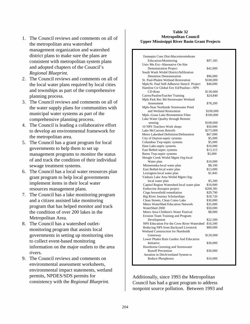
Table 32Metropolitan Council
Upper Mississippi River Basin Grant Projects
Hennepin Cons Dist-MacroinvertebrateEducation/Monitoring $97,185
Univ Mn Ext--Alternative On-SiteDemonstration Project $42,000
South Wash Wtshd District/InfiltrationDetention Demonstration $96,000
St. Paul-Phalen Wetland Restoration $100,000 Mpls/St. Paul Self-Adhesive Stencil Project $40,000 Hamline Ctr Global Env Ed/Pauline—NPS
CD-Rom $130,000 Cairns/PaulineTeacher Training $24,840 Mpls Park Rec Bd-Stormwater Wetland
Assessment $78,200 Mpls-Near Northside Stormwater Pond
and Wetland Restoration $100,000 Mpls.-Grass Lake Bioretention Filter $100,000 Lake Water Quality through Remote
sensing $100,000 10 NPS Teachers Work shops $50,000 Lake McCarrons Retrofit $275,000 Metro Lakeshed Definition/Delineation $67,000 City of Dayton-septic systems $5,000 Columbus Twp-septic systems $5,000 Ham Lake-septic systems $10,000 East Bethel-septic systems $13,315 Burns Twp-septic systems $5,000 Shingle Creek Wtshd Mgmt Org-local
Water plan $10,000 Minnetonka-local water plan $8,100 East Bethel-local water plan $13,000 Lexington-local water plan $1,845 Vadnais Lake Area Wtshd Mgmt Org-
local water plan $5,200 Capitol Region Watershed-local water plan $10,000 Endocrine disruptor project $200,381 Citgo brownfield remediation $29,790 Big River Journey Scholarships $18,720 Clean Streets, Clean Como Lake $30,000 Metro WaterShed Education Network $35,000 WaterShed 2000 $50,000 Metro Area Children's Water Festival $8,000 Erosion Team Training and Program
Development $22,500 NPS Education For the Crow River Watershed $16,500 Reducing NPS from Backyard Livestock $89,000 Wetland Construction for Humboldt
Greenway $120,000 Lower Phalen Rain Garden And Education
Initiative $30,000 Hawthorne Greening and Stormwater
Runoff Prevention $30,000 Aeration in Ditch/wetland System to
Reduce Phosphorus $16,000
Additionally, since 1993 the MetropolitanCouncil has had a grant program to addressnonpoint source pollution. Between 1993 and
Hennepin Cons Dist-MacroinvertebrateEducation/Monitoring $97,185
Univ Mn Ext--Alternative On-SiteDemonstration Project $42,000
South Wash Wtshd District/InfiltrationDetention Demonstration $96,000
St. Paul-Phalen Wetland Restoration $100,000 Mpls/St. Paul Self-Adhesive Stencil Project $40,000 Hamline Ctr Global Env Ed/Pauline—NPS
CD-Rom $130,000 Cairns/PaulineTeacher Training $24,840 Mpls Park Rec Bd-Stormwater Wetland
Assessment $78,200 Mpls-Near Northside Stormwater Pond
and Wetland Restoration $100,000 Mpls.-Grass Lake Bioretention Filter $100,000 Lake Water Quality through Remote
sensing $100,000 10 NPS Teachers Work shops $50,000 Lake McCarrons Retrofit $275,000 Metro Lakeshed Definition/Delineation $67,000 City of Dayton-septic systems $5,000 Columbus Twp-septic systems $5,000 Ham Lake-septic systems $10,000 East Bethel-septic systems $13,315 Burns Twp-septic systems $5,000 Shingle Creek Wtshd Mgmt Org-local
Water plan $10,000 Minnetonka-local water plan $8,100 East Bethel-local water plan $13,000 Lexington-local water plan $1,845 Vadnais Lake Area Wtshd Mgmt Org-
local water plan $5,200 Capitol Region Watershed-local water plan $10,000 Endocrine disruptor project $200,381 Citgo brownfield remediation $29,790 Big River Journey Scholarships $18,720 Clean Streets, Clean Como Lake $30,000 Metro WaterShed Education Network $35,000 WaterShed 2000 $50,000 Metro Area Children's Water Festival $8,000 Erosion Team Training and Program
Development $22,500 NPS Education For the Crow River Watershed $16,500 Reducing NPS from Backyard Livestock $89,000 Wetland Construction for Humboldt
Greenway $120,000 Lower Phalen Rain Garden And Education
Initiative $30,000 Hawthorne Greening and Stormwater
Runoff Prevention $30,000 Aeration in Ditch/wetland System to
Reduce Phosphorus $16,000
205
1998, the Council awarded over $8.2 million ingrants. The current grant program is a five-yearprogram with $7.5 million. Of the $10.8 milliondollars awarded since 1993, over $2 milliondollars went to projects in the Upper MississippiRiver Basin. The purpose of the MetroEnvironment Partnership grant program is toimprove the water quality of Metro Area lakesand rivers by reducing nonpoint source pollutionthrough education and implementation grants.
In the past this grant program has fundedwetland restoration projects, macroinvertebratemonitoring, wetland construction projects,demonstration projects for various bestmanagement practices and many educationprojects in the Upper Mississippi River Basin.
For more information on the projects funded inthe Upper Mississippi River Basin since 1993,see Table 32.
Mississippi HeadwatersBoard Programs
Mississippi Headwaters BoardRiver Watch Project
Mississippi River Watch Project - AnAnalysis of Low Dissolved Oxygen Levelsin the Upper Mississippi River in LateSummer to Early Fall
As part of the Mississippi Headwaters BoardRiver Watch Project a student from BemidjiHigh School studied a 110 kilometer (70 mile)reach of the Mississippi River from theMississippi Headwater at Itasca State Park toapproximately 5 kilometers (3 miles)downstream of Lake Bemidji. In the past,monitoring efforts in the study area haveidentified low dissolved oxygen levels. TheMinnesota Pollution Control Agency hasidentified the upper area of the study area on its
Section 303(b) Total Maximum Daily Load(TMDL) list as an impaired reach for dissolvedoxygen.
The River Watch study noted period in the studyarea where the dissolved oxygen dropped belowthe 5 mg/L standard set by the MinnesotaPollution Control Agency. The primaryconclusion of the study was that the dissolvedoxygen decline was caused by aerobic decaywithin the wetlands adjacent to the MississippiRiver. The effect was intensified by the lowersolubility of oxygen because of hightemperature and lack of replenishment becauseof flooded rapids.
Mississippi Headwater Board/Crow Wing County Soil and WaterConservation District/ErosionInventory of the MississippiHeadwaters
The Counties of Hubbard, Clearwater, Beltrami,Cass, Itasca, Aitkin, Crow Wing and Morrison,through the Mississippi Headwaters Board,undertook an inventory of the first 400 miles ofthe Upper Mississippi River Corridor to identifythe extent of erosion problems on theMississippi River.
Using methodology from the NorthwestMichigan Streambank Inventory developed bythe U.S. Department of Agriculture and theNatural Resources Conservation Service, theproject staff and volunteers documented 105erosion sites in the corridor. Of the 105 sites, 34percent were rated as minor erosion, 47 percentwere moderately eroding and 19 percent wereclassified as severely eroding. Informationgathered in the project will be used to developfurther implementation plans.
206
Minnesota Rivers CouncilThe Rivers Council of Minnesota (RCM) is anonprofit corporation dedicated to helpingMinnesotans protect, restore and enjoy our92,000 miles of streams and rivers. Theprincipal means the RCM achieves this missionis by assisting individuals and communities inprotecting rivers locally. This is done by thefollowing.
1. Supporting participation in decision-making and managementorganizations.
2. Providing information, education,training and networking services.
3. Enhancing performance of local rivergroups.
4. Implementing water qualitymonitoring and interpretation.
Organization of the Rivers Council began inJanuary 1991, when representatives of waterresources groups met at the Blandin Foundationto guide development and implementation of acomprehensive water quality monitoringprogram for the Mississippi Headwaters region.Participants recognized first, the need to link allthe state, regional and local activities thatinfluence rivers, and second, the need for acomprehensive network of water qualitymonitoring statewide. Two major grants fromthe Blandin Foundation supported theestablishment of the River Watch water qualitymonitoring network (1990-1995) and then thedevelopment of a statewide nonprofit to supportlocal monitoring programs (1995-1998). TheRivers Council is currently funded bycontributions of its 400 members and by grantsfrom private foundations.
In the Upper Mississippi River Basin, the RiversCouncil of Minnesota is participating in themulti-agency and community Upper MississippiSource Water Protection Initiative (1998-2001),
by compiling a bibliography of water qualityinformation, leading the development of theInitiative’s communications strategy, educationand training program.
Mississippi River DefenseNetworkThe River Defense Network is beingimplemented in Minnesota counties andcommunities along the Mississippi River fromits Headwaters to the Twin Cities. Thisinitiative is being coordinated by an oversightcommittee of local, regional, state and federalagencies linked with industry and the non-profitcommunity. It focuses on a common goal - toprevent spills and to protect the MississippiRiver from contamination from spills. Theaccomplishment of this goal rests on a well-informed, trained, and equipped network oflocal officials, including first responders, waterplanners, and other city and county officials incommunication with area industry.Development of the RDN has been funded bythe Legislative Commission on MinnesotaResources, the U.S. Army Corps of Engineers,the Blandin Foundation, and participatingagencies and industry.
Creation of the RDN was prompted by thedrought of the late-1980s and experience inMinnesota and elsewhere with chemical spillsinto rivers; both of these factors increasedconcern over the vulnerability of the Mississippito contamination from spills. Followingpublication of a report by the Corps ofEngineers, several organizations gathered tomeasure the contamination risk and devise riverprotection strategies. Several organizationshave met over the past five years to develop andimplement the RDN. Participants in this effortinclude The Blandin Foundation, the St. Cloud,Minneapolis and St. Paul water utilities, TheMinnesota Pollution Control Agency,
207
Department of Public Safety, Department ofHealth, Department of Natural Resources, theU. S. Army Corps of Engineers, Morrison,Stearns and Hennepin Counties, the City ofMinneapolis, Northern States Power, theMississippi Headwaters Board; the MetropolitanCouncil and the Rivers Council of Minnesota.
The River Defense Network emphasizes localgovernment for two reasons. Local officials areknowledgeable about potential spill sources andlocal river and shoreland conditions. Moreover,spills into river environments require rapidresponse; this calls for a primary role for localspill response and management. By creating anaction plan and framework to respond to spillsand manage our spills preparedness, the RDN isdeveloping relationships and a mechanism forcollaboration among those in various sectors,levels of government and locations along theriver who play important roles in spills planningand management.
The River Defense Network has produced twomanuals: The Spill Response Manual includingand inventory of some 3,300 potential spillsources, sensitive sites, spill responders, riverusers along the river, an explanation ofcommunications protocol and spillsmanagement responsibilities, identification ofequipment deployment sites, and a descriptionof spill response procedures. The RiverineEmergency Management Model Manualcontains a computer model and supportingtechnical information to allow planners andresponders to model spill characteristics in theriver.
The River Defense Network OversightCommittee is currently implementing a projectfunded by the 1999 Minnesota Legislature toacquire and deploy spill response equipment instrategic locations along the Mississippi River.In addition, the committee is considering
options for the future management of the RDN,as well as possible expansion of the RDN toother rivers within Minnesota.
The River Defense Network, the Cities of St.Cloud, St. Paul, Minneapolis, and theMetropolitan Council, through funding by theMinnesota Department of Health and theMinnesota Pollution Control Agency’s CleanWater Partnership Program, will be undertakinga planning process for the communities alongthe Mississippi River under the Federal SourceWater Protection Program. The Source WaterProtection Program identifies areas requiringspecial protection because they are a source ofdrinking water. In the Upper Mississippi RiverBasin, this will include both ground water andsurface water sources. At the present time, theCities of St. Paul, St. Cloud and Minneapolis’primary drinking water source is surface waterfrom the Mississippi River. An additional 52communities along the Mississippi River pumpdrinking water from aquifers that are dominatedby the Mississippi River.
Local Governmental UnitsWater Quality ProgramsComprehensive Local Water Plans(Outstate Counties)
BACKGROUND
In 1987, the Minnesota Legislature enacted theComprehensive Local Water Plan Act. Thepurpose of the act was to encourage the 80greater Minnesota Counties to plan for themanagement of their surface and ground waterresources. Participation by the counties wasvoluntary. By 1990 all of the counties in theUpper Mississippi River Basin had completed orwere in the water planning process. Thestructure of the water plans allowed each countyto prioritize their individual plans to allow for
208
local issue identification, prioritization andimplementation.
Aitkin County
The majority of Aitkin County lies within theUpper Mississippi River Basin, although partsof the county contains watersheds that are partsof the St. Croix and Lake Superior Basins. Thecounty is composed of three major watershedsof the Upper Mississippi River Basin: theMississippi River - Grand Rapids (HUC07010103), the Mississippi River - Brainerd(HUC 07010104), and the Rum River (HUC07010207).
First adopted in 1990, the Aitkin County WaterPlan is implementing its second revision.Surface water resources remains a primarilyconcern of the plan. Since the first planadoption, the Aitkin County Water Plan TaskForce has been instrumental in the establishmentof the Big Sandy Watershed Project and theMille Lacs Lake Watershed Project. Both ofthese projects have been successful partnershipsbetween the various county offices, theMinnesota Department of Natural Resources,the Minnesota Pollution Control Agency, theMinnesota Board of Water and Soil Resources,the Mille Lacs Lake Band of Ojibwe, numerouslocal lake associations, and other interestedcitizens and interest groups.
Policies of the water plan were incorporated intothe Aitkin County Shoreland Ordinance. Thewater plan was also responsible for the creationof the Aitkin County Green Shores Program,which provides incentives to landowners forfencing livestock from the county’s rivers andlakes. To date, the green shores program hascompleted 12 projects on more than four milesof shoreland.
Becker County
The eastern part of Becker County is within theUpper Mississippi River Basin and contains theheadwaters of some of the most importantstreams, rivers and lakes in the basin. BeckerCounty is composed of the Redeye or Leaf River(HUC 07010107) and the Crow Wing River(HUC 07010106). Other major streams withinthe county are parts of the Crow Wing RiverWatershed including the Straight River, knownfor its brown trout fishery, and the Shell River.
The Becker County Water Plan stressed groundand surface water resources. Projects andactivities implemented to date include wellwater nitrate testing, a cost share program toassist in the sealing of abandoned wells,establishment of buffer strips next to the waterresources, establishment of a lake monitoringprogram in conjunction with the Becker CountyCoalition of Lake Associations to determine thetrophic status of the lakes, sponsorship of apesticide container collection day andcompleting an inventory of septic systemcompliance around 23 lakes resulting in areduction of percentage of failing system from33% to 11%.
Beltrami County
The very southern part of Beltrami County lieswithin the Upper Mississippi River Basin andincludes the Mississippi River - HeadwatersWatershed (HUC 07010101) and a small part ofthe Leech Lake River (HUC 07010102). TheCounty seat, Bemidji, is that largest city in thecounty and within this segment of theMississippi River - Headwaters watershed.
The Beltrami County Water Plan was firstadopted in 1989. The plan is currently on itssecond revision. The Beltrami County planaddresses both surface and ground waters. Forthe Mississippi River - Headwaters Watershed
209
and the Leech Lake River Watershed, the planidentified the following issues and strategies.
1. Shoreland development on lakes in Bemidjiarea that are under development pressureand/or vulnerable as a result of their physicalcharacteristics, including the Mississippi andTurtle River chain of lakes.
2. The disposal of stormwater from the City ofBemidji into Lake Bemidji.
3. Potential of surface and ground watercontamination from potential pipelinebreaks.
4. Protection of high priority public watersupply wells from ground watercontamination.
5. The application of pumped septage to landin Beltrami County, and the potential forground and surface water contaminationfrom this practice.
6. Understanding and managing recreationalwater use conflicts.
7. Potential ground water contamination fromold town dumps.
8. Nutrient loading into the Mississippi Riverand tributaries from agricultural activities inthe Moose Lake sub-watershed, and otherhigh priority sites.
9. Potential ground water contamination fromunderground storage tanks.
10. Reduce nonpoint source pollution in UpperMississippi Watershed which culminated inLake Bemidji.
Beltrami County, through its water plan, hasaccomplished: the monitoring of forty-fourlakes for basic water chemistry (pH,temperature, dissolved oxygen, total phosphorusand chlorophyll a); the monitoring of 47 lakesthrough the Citizens Lake Monitoring Program;conducted annual tests of private wells fornitrates and coliform bacteria; developedlanguage for a septage disposal ordinance and acontaminated soils ordinance which awaitcounty board approval; continued the
cooperative effort with the U.S. GeologicalSurvey on the Bemidji-Bagley SandplainAquifer - sampling 45 wells for a total of 93different water quality parameters; as part of theLake Bemidji Project, installed stormwater andsediment traps and treatment systems to treatstorm water from the City of Bemidji beforedischarge to Lake Bemidji; and inventoried over40 wetland restorations or enhancement sites forpotential mitigation - a total of 46 acres in 19basins were restored.
Benton County
Benton County has been active in itsimplementation of local water planningactivities. Early focus of their plans centered onthe creation of a Joint Powers agreement withSherburne County, creating the Elk RiverWatershed Association. The purpose of theJoint Powers Agreement was to reduce sedimentand nutrient loading to the watershed by the useof low cost – high return best managementconservation practices.
The county also conducted a feedlot inventory,developed programs in manure management,including a manure spreader calibrationprogram, and inventories of abandoned wellsand drained wetlands.
Cass County
Cass County adopted its first ComprehensiveWater Plan in 1990 and revised the plan in1996. The current plan and implementationstresses protection and, if needed, restoration ofthe surface and ground waters of the county.The principal goals and objectives of the planare to: 1. Monitor and regulate water use toassure adequate ground water resources; 2.Preserve the quality of Cass County’s groundwater, and, where degradation has occurred,work to restore the ground water quality; 3.Preserve the quality of Cass County’s surface

210
water, and where degradation has occurred,work to restore the surface water quality; and 4.Monitor and regulate water use to assureadequate surface water resources.
Under its water planning and managementprogram, Cass County has implemented a seriesof projects or efforts to accomplish its mission.The county adopted a county-wide plan andzoning ordinance, a wetland protectionordinance, wellhead protection programs,ground water/aquifer studies and has undertakenwatershed studies in the Leech Lake Watershed,the Middle Boy River Watershed, the LakeMargaret/Homebrook Watershed, the UpperMississippi River (Cass Lake-LakeWinnibigoshish Watersheds), and the UpperBoy River or Ten Mile Lake Watershed.
Other watershed efforts prioritized by CassCounty include the Willow River, the PineRiver and Whitefish Chain Reservoir system,and the Crow Wing River.
Additionally, the county has instituted a lakeassociation Hydrolab� monitoring program, awater quality library system at three countylibraries, and environmental education-demonstration lake lot landscaping and septicdisplays at the Deep Portage ConservationReserve.
Clearwater County
Clearwater County is divided by two majorbasins, the Red River of the North and theUpper Mississippi River Basin. The majority ofthe county is within the Red River Basin,however a portion of the southeastern corner isin the Upper Mississippi River Basin near theHeadwaters of the Mississippi.
Clearwater County’s water planning activitiesinvolved the whole County and a breakdown ofactivities by basin was not available, however
the county was involved in a number ofimplementation activities.
In the Upper Mississippi River Basin,Clearwater County was involved in the LakeBemidji Watershed Clean Water Partnershipwhich included implementing best management,practices through-out the watershed. A moredetailed discussion of this project is elsewherein this document.
The County also participated in lake projectsthrough the Tri-County Lake EnhancementProject, which included lake baselinemonitoring and a public education campaign.
Finally, the county water plan participated in astormwater survey of the City of Bagley, agrazing inventory of 250 miles of rivers andstreams to determine sites of best managementpractices, and developed an erosion controlproject at Peace Pipe Vista in Itasca State Park.
Crow Wing County
Crow Wing County adopted its firstComprehensive Water Plan in 1990 and revisedthe plan in 1996. The current plan andimplementation stresses protection andrestoration of the surface and ground waters ofthe county. The principal goals and objectivesof the plan are to: 1. Monitor the ground waterto preserve ground water resources; 2. Preservethe quality of Crow Wing County’s groundwater and work to restore the ground waterquality; 3. Preserve the quality of Crow WingCounty’s surface water and restore the surfacewater quality; and 4. Monitor surface water useto assure adequate surface water resources.
Under its water planning and managementprogram, Crow Wing County has implemented aseries of projects or efforts to accomplish itsmission. The County has implemented a seriesof individual on-site septic evaluations for the
211
Mission Lakes, the Whitefish Chain of Lakes,and North Long Lake. In addition, through theplanning and zoning department, the county hasbeen working on wetland management,developing a management plan for ahighway/commercial growth corridor to protectwater quality and stormwater management, andongoing septic system inspections for newdevelopment.
Crow Wing County has also been working withthe Pine River Watershed Foundation to developmanagement programs for the protection of thePine River Watershed and the Whitefish Chainof Lakes.
Douglas County
The eastern half of Douglas County lies in theUpper Mississippi River Basin and is theheadwaters area for two major watershed units,the Long Prairie Watershed (HUC 07010101)and the Sauk River Watershed (HUC07010108). Douglas County adopted its firstCounty Water Plan in 1990. The second revisionwas completed in 1998, extending the planthrough the year 2002.
Alexandria, the county seat of Douglas Countyand the Alexandria Lakes area, lie within theLong Prairie River Watershed of the UpperMississippi River Basin.
Since the inception of the Douglas CountyWater Plan, implementation projects haveincluded the following.
1. An education program through the localmedia on various water managementconcerns.
2. An annual Kids’ Ground Water Festival.3. Assistance with the formation of the
Douglas County Lakes Association.4. Completion of lake assessments for selected
county lakes.
5. Assistance in the Agnes, Henry and WinonaLakes diagnostic study to identify waterquality impacts.
6. Assistance to the Sauk River WatershedDistrict to complete work on the diagnosticstudy and project implementation for theOsakis Lake Watershed.
7. Formation of a landscaping committee tofocus on revegetation of shorelines withspecies native to the lakes.
8. Conduction of water test of private wells.9. Establishment of buffer strips along two
county ditches.
For the future, Douglas County has specifiedfive goals and a number of implementationactivities through the year 2002 for surfacewater management. These goals include thefollowing.
1. Protect the quality and use of the county’ssurface water. Under this program, thecounty developed two objectives, 1.)Continue to encourage and promote land usepractices to protect and improve surfacewater resources, which will be accomplishedthrough 13 action items; and 2.) Enforceexisting regulations and develop newregulations to protect surface water, whichwill be accomplished through nine actionitems.
2. Increase monitoring of surface water qualityand quantity and maintain a surface waterdatabase in the county. This goal will beaccomplished through four action items.
3. Continue educational programs relating tosurface water degradation problems in thecounty, to be accomplished through sevenaction items.
4. Improve and maintain the quality of LakesWinona, Henry and Agnes, through theimplementation of a Clean WaterPartnership project.
212
For the ground water resource of DouglasCounty, three goals have been established.
1. Establish a comprehensive database onground water resources in the County, to beaccomplished through seven action items.
2. Protect and preserve ground water quality inthe county through eight action itemsincluding wellhead protection and land usemanagement.
Finally, recognizing the rapid growth associatedwith the lake’s areas, Douglas County has fourgoals to protect land resources, which ultimatelyprotect water resources. These four goalsinclude the following.
1. Encourage orderly development andexpansion in Douglas County that includesstrictly enforcing zoning regulations andencouraging land use practices thatminimize degradation to water resourcesduring development.
2. Controlling surface water runoff in thecounty, including assessing the effectivenessof the county ditch and municipal stormwater system, developing and enforcingregulations to help control surface waterdrainage.
3. Control the disposal of chemical andhazardous waste in the county.
4. Reduce soil erosion in the county.
Hubbard County
Hubbard County water management activitiesthrough the comprehensive local water planprocess were first adopted in 1990. The countyhas completed one revision to the plan in 1995.Hubbard County lies entirely in the UpperMississippi River Basin and include sections ofthree major watersheds: the Mississippi River -Headwaters Watershed (HUC 07010101); theLeech Lake River (HUC 07010102); and theCrow Wing River (HUC 07010106).
Overall, the Hubbard County local waterplanning effort stresses the non-degradation ofthe surface and ground water quality and theprotection of the surface water, ground waterand wetland resources. Water plan goals aregrouped into three categories: 1. Surface andground water quality and quantity whichincludes the non-degradation of the waterresource quality and assure adequate quantitiesfor the future; 2. Land development, use andmanagement to sustain the water-dependenteconomy of the county and provide for growthand development without the degradation of thewater quality; and 3. Education andinformation, to inform citizens of the need forwater management.
The county has instituted numerous studies anddata collection efforts to provide a baseline ofthe overall water quality of the county. Otheractivities completed through the water planinclude the following.
1. Conducted a level 1 feedlot inventory in thecounty.
2. Developed and adopted a sewage applicationordinance.
3. Developed an agriculture best managementpractices seminar, which is held annually,and created an evapo-transporation hotline.
4. Conducted numerous lake assessments withthe cooperation of state agencies.
5. Inventoried septic systems located within1000 feet of a lake’s shoreline incooperation with local lake associations.
Isanti County
Parts of Isanti County lie within two basins, theUpper Mississippi River Basin and the St. CroixRiver Basin, however the majority of the countyis in the Rum River major watershed unit (HUC07010207) of the Upper Mississippi RiverBasin.
213
Isanti County has recently completed theirrevision to the their Comprehensive Water Plan.Overall goals and actions for the protection ofthe water quality in the county include thefollowing.
1. Prioritize the lakes, streams and ditches formonitoring on ecological sensitivity, landuse and known problems.
2. Identify and correct contamination problemsassociated with land use practices within theAnoka Sand Plain.
3. Increase monitoring of ground water forchemical contaminants and water levels inmajor irrigation areas within the AnokaSand Plain.
4. Update the soil survey.5. Conduct a feedlot inventory and provide
technical assistance to feedlot owners onminimizing the impact of animal wastes onwater quality.
6. Conduct an abandoned well survey andprioritize the well for sealing based on theirproximity to contaminants and geologicbackground.
7. Institute an education program thatencourages the active involvement ofcitizens, the formation of Coalition of LakeAssociations and Shoreland Volunteers,education on the principles of bestmanagement practices for water qualityprotection.
Activities completed to date through the IsantiCounty Water Plan include sponsoring anannual household hazardous waste collectionprogram which has drawn 300-400 participants;provide funds to Pheasants Forever to plant 500-600 acres of native Prairie grasses and 75,000trees and shrubs for water quality protection andpheasant habitat; conducted an annual welltesting program with 200-300 peopleparticipating per year; and conducted aneducation program which included a telephone
water help line, stenciling storm drains in theCities of Cambridge and Isanti, and publishing anewsletter three times a year to distribute to thelandowners in the county.
Itasca County
Itasca County lies in three drainage basins, theUpper Mississippi River, the Rainy River andthe Lake Superior. In the Upper MississippiRiver Basin, the county contains the MississippiRiver - Headwaters (HUC 07010101) and theMississippi River - Grand Rapids (HUC07010103) major watershed units. Because ofthis, a clear breakdown of activities by basinwas not available from existing documents.
According to the water plan, surface watermanagement, primarily lake management, is amajor emphasis. The county developed a long-range plan for its lakes, which included aranking and classification of over 170 lakes foradditional monitoring in the upcoming years.From this list of lakes, the county developed acomputer-based lake and watershed assessmentand modeling system to assess the condition ofthe lakes.
As part of this effort, the county promotedvarious conservation practices to reduce runoffto lakes and rivers.
Kandiyohi County
Kandiyohi County is located in both the UpperMississippi River Basin and the MinnesotaRiver Basin. Local water plan implementationis also divided by the two basins. The countycontains a number of quality lake areasincluding the New London-Spicer area and lakesin the Willmar area. Kandiyohi County hasprovided funding to Big Kandiyohi Lake andDiamond Lake for MPCA Clean WaterPartnership Phase I and II projects. The CountyWater Plan also conducted environmental and
214
lake protection education programs through theKandiyohi Area Conservation Association, thePrairie Woods Environmental Learning Center,and the Kandiyohi County Lakes Association.
Kandiyohi County has a large number ofagricultural operations in the county, thereforeworking with these groups in implementingmanure management, cost-sharing on bestmanagement practices, and restoration ofdrained wetlands also received high priority inthe Local Water Plan.
McLeod County
Another county located in the Upper MississippiRiver and Minnesota River Basins is McLeodCounty. Through the Comprehensive LocalWater Plan, McLeod County helped establish acounty coalition of lake associations, adopted anew county septic system ordinance and a newcounty feedlot ordinance.
As part of the adoption of a feedlot ordinance,the county has accepted delegation of the feedlotprogram from the MPCA and is assisting locallandowners with best management practiceinstallation.
McLeod County has also instituted a countymonitoring program for its lakes and rivers.They assisted the Buffalo Creek WatershedDistrict monitor Buffalo Creek for nutrients,phosphorus and nitrogen, and fecal coliform.They also were actively involved in the CrowRiver Initiative formation.
Meeker County
Lake management and protection is a majorfocus of the Meeker County ComprehensiveLocal Water Plan implementation activities.The county is divided between the UpperMississippi River Basin and the MinnesotaRiver Basin.
The local water plan has assisted a number oflake and watershed groups with securing MPCAClean Water Partnership financial assistance,including the Lake Minnie Belle Association,Long and Spring Lakes. Additionally, the waterplan has assisted lake associations with lakemonitoring, control structures and other lakestudies.
Meeker County land use is over 85 percentagricultural. Because of this, the county hasconducted a county feedlot inventory andprovided education and information on bestmanagement practices to interested groups.
Mille Lacs County
Mille Lacs Lake is the primary focus of theMille Lacs County Local Water Planimplementation. The county has implemented anumber of projects with State, Tribal and citizenpartners to monitor, identify needs, andimplement solutions in the 188-square-mileMille Lacs Lake Watershed. These effortsincluded funding assistance from the MinnesotaBoard of Water and Soil Resources and theMinnesota Pollution Control Agency CleanWater Partnership Program.
Other activities include cost sharing of bestmanagement practices in the Rum RiverWatershed of the Upper Mississippi River Basinand a comprehensive soil survey.
Mille Lacs County is in both the UpperMississippi River Basin and the St. Croix RiverBasin. Part of their work activities also includesinvolvement in the Snake River Watershed JointPowers Board in the St. Croix Basin.
Morrison County
Morrison County began developing their waterplan in 1988 with adoption in 1990. The 1995
215
revision reinforced the major strategies adoptedin the 1990 plan. The county encompasses fourmajor watersheds of the Upper MississippiBasin: the Mississippi River - Sartell (HUC07010201), the Mississippi River - Brainerd(HUC 07010104), the Crow Wing River (HUC07010106) and the Long Prairie River (HUC07010108).
The county contains several water resourceareas that require special attention in the WaterPlan. These areas include the lakes area of thenorthwest corner (Long Prairie Watershed),which includes Fish Trap, Shamineau,Alexander, and Crookneck Lakes, numerousstreams including the main stem of theMississippi River (Mississippi River - BrainerdWatershed), the main stem of the Long PrairieRiver, the main stem of the Crow Wing Riverand parts of the Crow Wing River Reservoirs(Lake Sylvan Reservoir, and Lake PlacidReservoir), the Two Rivers Area Watershed, thePlatte River Watershed, the Skunk RiverWatershed and the Swan River Watershed.
The county also contains several geologicconditions for ground water protection includinga sand plain aquifer underlying several majorcounty population centers, that includenumerous unsewered areas. Additionally, recentground water surveys have shown the presenceof nitrates and pesticides in the sand plainaquifer system.
Other major water plan issues include managingthe expected changes to the physicalenvironment, land use caused by growth anddevelopment, and protection of the county’swetland resources.
Otter Tail County
Approximately the eastern quarter of Otter TailCounty is in the Upper Mississippi River Basin;the largest part of the county is in the Red River
of the North Basin. The county’s water planimplementation stressed the whole county andreporting was not available by basin at this time.
However, Otter Tail County has instituted acomprehensive lake-monitoring program, whichis collecting baseline information on over 68sites on the county’s river and lakes. Theseactivities resulted in the installation of bestmanagement practices including livestockexclusion, stream buffers, feedlot wastemanagement and stream bank protection.
Otter Tail also entered into a 20-yearcooperative ground water monitoring projectwith the Minnesota Department of Agricultureto study nitrates and pesticides in over 60 wellsin the county.
Pope County
Only a very small portion of the north westcorner of Pope County is in the UpperMississippi River Basin. A breakdown of waterplan activities by basin was not available at thistime.
Local lake protection includes developing adiagnostic study and implementation plan for awatershed and lake in the county. Participationwith the Pope County Coalition of LakeAssociations in a number of lake assessmentprojects, a Trophic State Index Lake MonitoringProgram, and an Eurasian Milfoil AwarenessProgram are also included.
The county also established a cost-shareprogram for sealing abandoned wells.
Renville County
Renville County is located in the South Fork ofthe Crow Watershed of the Upper MississippiRiver Basin and the Minnesota River Basin.
216
Through the Comprehensive Local Water Plan,Renville County conducted a manuremanagement program and developed a drainagemanagement guide.
The county also developed a water monitoringsystem for all the major creeks. They also wereactively involved in the Crow River Initiativeformation.
Sherburne County
The Sherburne County Plan was first adopted in1990 and revised in 1995. As part of their waterplan implementation, Sherburne County hasbeen actively involved in both surface andground water protection efforts.
Under their ground water program, the countydirected a well sampling program for nitrates, anabandoned well program, sponsored on-sitesewage treatment education programs andassisted in the approval of the Clear LakeWellhead Protection Area.
For surface water, Sherburne County helpedcreate the Elk River Watershed Joint PowersBoard, sponsored annual county lakeshoreconferences, conducted a county-wide feedlotinventory and monitoring of the Elk River toestablish sources of sedimentation problems.
Stearns County
Through the combined efforts of the StearnsCounty Water Plan Task Force, the StearnsCounty Department of Environmental Services,and the Stearns County Soil and WaterConservation District, the county has initiated anumber of activities for the protection of thesurface and ground water through the county’swater plan.
Stearns County undertook a feedlot inventory,implemented a feedlot program, received
delegation from the MPCA for the feedlotprogram and passed a comprehensive feedlotordinance for the county.
Through the Stearns County Soil and WaterConservation District (SWCD) and the U. S.Department of Agriculture, Natural ResourcesConservation Service (NRCS), Stearns Countyas been aggressively providing cost sharingassistance to implement best managementpractices in the county.
Also, the SWCD and NRCS, through the USDAnational water quality program, targetedGetchell and Unnamed Creek in the Sauk RiverChain of Lakes Watershed to implement a waterquality monitoring program and installation ofagricultural best management practices,including ag-waste/manure managementsystems.
The county assisted local lake associations incompleting lake assessments and providedassistance on the development of applicationsfor financial assistance.
The county also updated their ComprehensivePlan, revised the on-site and shorelandordinances and established a point of saleupgrade program for on-site sanitary systems.
Finally, Stearns County has been assisting manyof its local units of government upgrade existingsanitary systems to meet new regulations andrequirements.
Todd County
The protection of surface and ground waterquality are the major implementation activitiesof the Todd County Water Plan. The LongPrairie River Watershed is a major waterresource for the county, provide both a source ofwater for its agricultural, industry, and as arecreation resource. As problems with fish kills
217
and low levels of dissolved oxygen werediscovered, the Todd County Water Plan TaskForce and Soil and Water Conservation Districthave been very instrumental in the identificationof the problems facing the river. The county,through the MPCA Clean Water Partnership hasbeen working on the problem for the last fewyears (a separate discussion on the projectappears elsewhere in this report).
Additionally, Todd County has providedfinancial and technical support through thewater plans to county livestock producers toimplement manure management programs andother agricultural best management practices forprotecting water quality.
For ground water protection, Todd County hasprovided cost-sharing for well abandonment,provided free nitrate testing for well samples,assisted two cities start wellhead protectionprograms, and sponsored a hazardous waste andpesticide container disposal program.
Wadena County
Wadena County is entirely in the UpperMississippi River Basin and is drained by threemajor watersheds of the Upper MississippiRiver Basin, the Crow Wing River (HUC07010106), the Redeye or Leaf River Watershed(HUC 07010107) and the Long Prairie RiverWatershed (HUC 07010108). The Crow WingRiver and the Redeye/Leaf River Watershedsdrain over 95 percent of the county land area.
The Wadena County Water Plan was adopted in1993 for six years. They are now in the processof revising the plan for the next five (5) years.The 1993 plan has water managementobjectives, which fall into three categories:Surface and Ground Water, Land Development,Use and Management, and Education andInformation. Major work activities for thesecategories include the following.
1. Collect data on water quality and quantity onthe surface and ground water resources ofthe county.
2. Identify and set priorities for issues relatedto point and non-point sources of pollution.
3. Undertake a comprehensive review of localland use ordinances.
4. Provide for the proper disposal of septage,municipal sewage sludge, industrial wasteand by-products, and agricultural waste andby-products.
Wright County
Wright County is on the western edge of theseven-county metropolitan area and is receivinggrowth pressure due to its proximity to themetro area.
Through the County Water Plan program,Wright County has been stressing the proper useof on-site sanitary systems. This effort hasincluded the adoption of a “point-of-sale”ordinance requiring septic system compliance atthe time of property transfers, supplying a videotape on septic system care and maintenance toevery homeowner installing a new or upgradedseptic system and coordinating the developmentof a community sewer system for ruralsubdivisions.
In addition, for subdivisions, the countydeveloped storm water management guidelinesfor residential development and developed amethod of prioritizing wetlands in the county.
Finally, the county is conducting pilot wellinventories and a well testing project.
218
Metropolitan Watersheds (SevenCounty Metro Area)
BACKGROUND
In the Metropolitan Area, watershedmanagement organizations and watersheddistricts are responsible for the local waterplanning. Watershed organizations preparewatershed management plans in response tolegislation, known as the Metropolitan SurfaceWater Management Act and the WatershedManagement Act (Minnesota Statutes 103Athrough 103G). Minnesota Statutues103D and103B outline Watershed District responsibilitiesand authorities. Statute 103D states the generalpurpose of Watershed Districts is to conservethe natural resources of the state by land useplanning, flood control, and other conservationprojects by using sound scientific principles forthe protection of public health and welfare andthe provident use of the natural resources.
Minnesota Statute 103B outlines the specificpurposes of water management organizationsand districts in the Metropolitan Area. Thepurposes of water management programs in theMetropolitan Area are:
1. To protect, preserve, and use natural surfaceand groundwater storage and retentionsystems;
2. To minimize public capital expendituresneeded to correct flooding and water qualityproblems;
3. To identify and plan for means to effectivelyprotect and improve surface andgroundwater quality;
4. To establish more uniform local policies andofficial controls for surface and groundwatermanagement;
5. To prevent erosion of soil in to surface watersystems;
6. To promote groundwater recharge;
7. To protect and enhance fish and wildlifehabitat and water recreational facilities; and,
8. To secure the other benefits associated withthe proper management of surface andground water.
State agencies along with the MetropolitanCouncil review the watershed managementplans and give comments to the Board of Waterand Soil Resources for their use in approval ofthe plans.
Local governments are also required to completelocal water plans within two years after all ofthe watershed organizations that they are part ofhave approved watershed plans. Local waterplans are required to include an executivesummary, a land and water resource inventory, asection that establishes the goals and policies,sections that assess the problem areas andsuggest corrective actions to identifiedproblems, a section on the financialconsiderations, sections on the implementationprogram and implementation priorities, and asection on amendment procedures.
The Metropolitan Council reviews the localwater plans in the Metro Area. Local waterplans are a required element of the city andtownship comprehensive land use plans.
Rice Creek Watershed District.(Mississippi River - Twin CitiesWatershed (HUC 07010206)
The Rice Creek Watershed District was formedin 1972 for the purpose of conserving andmanagement of the waters and natural resourcesof the district. The district covers 201 squaremiles of area and is part of the water supplysource for the City of Saint Paul. Over theyears, the Rice Creek Watershed District hasworked on many inter-rated water issuesthrough its regulatory and construction/projectsprograms.
219
These programs and priorities fall into broadcategories including: runoff and stormwatermanagement; public ditch and channelmanagement; potable water supply; surface andground water quality management; individualsewage treatment systems; wetlandmanagement; shoreland management; floodplainmanagement; agricultural and constructionerosion control; rough fish control; and publicinformation and education.
Through the Capital Improvement Program,identified in the Rice Creek WatershedDistrict’s plan, the District will be implementinga number of projects in the upcoming years.These projects include: the Locke LakeRestoration and Improvement, Lake SedimentSealing Projects on Centerville Lake;phosphorus removal (ferric chloride system)chemical addition to Hardwood Creek;Schuneman Marsh Restoration; Howard LakeRevegetation; Marsden Lake Restoration; andthe Clearwater Creek Truck Improvements(drainage and wetland enhancement projects).
Rice Creek Watershed District covers portionsof Anoka, Hennepin, Ramsey, and WashingtonCounties. Communities partially or entirelywithin the District boundaries include:Centerville, Circle Pines, Columbia Heights,Fridley, Ham Lake, Lexington, Lino Lakes,Columbus Township, Blaine, Spring Lake Park,St. Anthony, Arden Hills, Falcon Heights,Lauderdale, Mounds View, New Brighton,Shoreview, Roseville, White Bear Township,White Bear Lake, Birchwood, Dellwood, ForestLake, Forest Lake Township, Grant Township,Hugo, Mahtomedi, May Township, NewScandia, and Willernie.
There are three regional parks, three wildlifemanagement areas, and various trails and canoeroutes within the District. The major lakes inthe District include: Moore Lake, Golden Lake,
Baldwin Lake, Rice Lake, Reshanau Lake, WardLake, Sherman Lake, Centerville Lake, MarshanLake, George Watch Lake, Peltier Lake,Rondeau Lake, Crossways Lake, ColumbusLake, Howard Lake, Otter Lake, Spring Lake,Ramsey Lake, Langton Lake, Little JohannaLake, Lake Johanna, Lake Josephine, JonesLake, Silver Lake, Island Lake, Valentine Lake,Pike Lake, Long Lake, Rush Lake, Round Lake,Karth Lake, Sunfish Lake, Turtle Lake, PoplarLake, Bald Eagle Lake, Priebe Lake, MarsdenLake, White Bear Lake, Long Lake, Echo Lake,Pine Tree Lake, Mann Lake, Fish Lake, RoundLake, Sunset Lake, Egg Lake, Rice Lake, OnekaLake, Horseshoe Lake, White Rock Lake, ClearLake, and Mud Lake.
Vadnais Lakes Area WatershedManagement Organization(Mississippi River - Twin CitiesWatershed (HUC 07010206)
The Vadnais Lakes Area WatershedManagement Organization is in Anoka andRamsey Counties and includes the City of NorthOaks and parts of White Bear Township, GemLake, White Bear Lake, Vadnais Heights; andLino Lakes. The watershed area covers over 23square miles and includes land owned by the St.Paul Water Utility.
The watershed area provides a drinking watersupply source for the City of Saint Paul andrecreational, habitat, ground water recharge andflood control.
The major lakes in the watershed includeCharley Lake, Pleasant Lake, Deep Lake,Wilkinson Lake, Amelia Lake, Black Lake,Gilfillan Lake, Birch Lake, Vadnais Lake,Lambert Lake, Grass Lake, Sucker Lake, GemLake and Goose Lake. There are two RamseyCounty Regional Parks within the watershed:Grass-Vadnais Regional Park and the TamarackNature Center.
220
Overall, goals of the organization include: floodprevention; protect potable water drinkingsupplies of both surface and groundwater;maintain or improve the water quality of allwaters in the organization’s area; protect thewaters for wildlife habitat and recreation;enhance public education and information;manage the public ditches; protect the groundwater quality and quantity; protect wetlandresources; and control soil loss, sedimentationand water quality degradation due to soilerosion.
The Vadnais Lakes Area WatershedManagement Organization plan implementationprogram includes projects on Lambert Creekand Birch Lake with the St. Paul Water Utility.The watershed management organization willalso work with its respective local units ofgovernment to require adoption of watermanagement plans by the localities.
Lower Mississippi RiverWatershed ManagementOrganization. (Mississippi River -Twin Cities Watershed (HUC07010206)
The Lower Mississippi River WatershedManagement Organization contains portions ofthe cities of Inver Grove Heights, Lilydale,Mendota Heights, South St. Paul, Sunfish Lake,West St. Paul and St. Paul. The watershed islocated in northern Dakota County and asouthern Ramsey County. The watershed coversapproximately 50 square miles.
There are a large number of small lakes andwetlands in the watershed. The major lakes inthe watershed include Sunfish Lake, HorseshoeLake, Hornbeam Lake, Seidl’s Pond, DickmanLake, Golf Course Pond, Pickerel Lake, SimleyLake, the Marcott Lakes, and Rogers Lake.
The watershed plan was written in 1989. Thewatershed organization is in the process ofupdating their plan. Their updated plan shouldbe completed and submitted for review andapproval in 2000. The 1989 plan was written toaddress inter-community water resourcemanagement and to develop watershed-widegoals and policies. The general purpose of theplan has not changed much since 1989 but thegeneral goals have. The general goals of thewatershed today are:
1. To reduce to the greatest practical extent thepublic capital expenditures necessary tomanage stormwater runoff and waterresources.
2. To keep regulation at the local level.3. The member communities are responsible
for primary management of stormwaterrunoff and water management issues.
4. To classify and monitor inter-communitywater resources.
5. To monitor and evaluate stormwater runoffquality.
6. To coordinate inter-community managementplanning for stormwater runoff, flooding andother water quantity issues.
7. To develop policies to be implemented bythe cities to protect the water resources.
8. To provide a mechanism to assess theperformance of the watershed organizationand member cities toward achieving thegoals in the plan.
9. To provide member cities useful informationabout the watershed organization, itsactivities, and water resource management.
West Mississippi River WatershedManagement Commission (Mississippi River - Twin CitiesWatershed (HUC 07010206)
The West Mississippi River WatershedManagement organization is in northeastern
221
Hennepin County and includes all or portions ofthe cities of Brooklyn Center, Brooklyn Park,Champlin, Maple Grove, and Osseo. Thewatershed covers 23.5 square miles.
The Commission completed its watershedmanagement plan in 1988. The plan identified 8issue areas: runoff management, floodplainmanagement, shoreland management, waterquality monitoring, erosion and sedimentcontrol, stormwater treatment, wetlandsmanagement, and groundwater protection.Implementation actions and policies weredeveloped for each of these issue areas.
The watershed has several wetlands and oneunnamed lake. The main watercourses in thewatershed are Edinbrook Creek, and OxbowCreek. Much of the watershed drains directlyinto the Mississippi River.
The plan is scheduled to be updated in 2002.
Grass Lake WatershedManagement Organization.(Mississippi River - Twin CitiesWatershed (HUC 07010206)
The Grass Lake Watershed ManagementOrganization includes portions of the cities ofRoseville and Shoreview in Ramsey County.The watershed is approximately 9 square milesand consists of predominantly urban land, water,and wetlands.
The major waterbodies in the watershed includeSnail Lake, Grass Lake, Shoreview Lake,Wabasso Lake, Lake Judy, Emily Lake, HarrietPond, Charlie Pond, Lake Owasso, WillowPond, Bennett Lake, Westwood Village Pond,and the Central Park Pond. Part of the Vadnais-Snail Lake Regional Park is in the watershed.
The watershed adopted its watershedmanagement plan in 1986. The plan had 9goals.
1. To guide future development and growth insuch a manner to minimize surface waterproblems and enhance the general quality oflife and the open space recreationalenvironment of the watershed.
2. To regulate the general water quality in allGroup 2, 3, and 4 lakes, wetlands, andwatercourses within the watershed.
3. To maintain or improve water quality in allGroup 1 lakes and watercourses.
4. To control flooding and soil erosion fromsurface flows.
5. To preserve and utilize natural stormwaterstorage and detention systems to reduce, tothe greatest practical extent, the publiccapital expenditures necessary to controlexcessive volumes, and rates of runoff.
6. To support lake level management.7. To encourage natural groundwater recharge.8. To protect and enhance fish and wildlife
habitat areas, and all “protected” waters andwetlands.
9. To maintain and/or improve existing naturaland artificial watercourses.
The watershed organization is currentlyupdating their watershed plan. The plan isexpected to be submitted for review andapproval in 2000. The proposed goals for thenew plan are to:
1. Manage regional water quality issues, withemphasis places on recreational lakes.
2. Manage inter-community stormwater runoff,flooding, and other water quantity issues.
3. Keep regulation at the local level.4. Develop the policies to be implemented by
the cities that area needed to protect thewatershed’s water resources.
5. Reduce to the greatest practical extent, thepublic capital expenditures necessary to
222
control excessive volumes, and rates ofstormwater runoff while pursuing the goalsand policies of the watershed plan.
Elm Creek WatershedManagement Commission.(Mississippi River - Twin CitiesWatershed (HUC 07010206)
The Elm Creek Watershed ManagementCommission includes portions of the cities ofChamplin, Corcoran, Dayton, Maple Grove,Medina, Plymouth, Greenfield, Rogers, HassanTownship and the Hennepin Park ReserveDistrict. The watershed is located entirelywithin Hennepin County. The watershed covers109 square miles.
The watershed organization completed theirwatershed management plan in 1983. Thewatershed is due to update its plan in 2001. Alldiscussion that follows is taken from their 1983watershed plan. Major surface water collectorsystems in the watershed include DiamondCreek, North Fork of Rush Creek, Rush Creekand Elm Creek. All surface water flows fromthe basin flow eventually into Elm Creek andultimately into the Mississippi River.
The lakes in the area include Henry Lake,Diamond Lake, French Lake, Jubert Lake,Meadow Lake, Hayden Lake, Mud Lake,Powers Lake, Lemans Lake, Goose Lake, MudLake, Mill Pond, Rice Lake, Fish Lake, WeaverLake, Cook Lake and Mud Lake. The ElmCreek Park Reserve, which includes an area of5,000 acres, is almost entirely within the basin.
The purpose of the 1983 plan was to develop aplan for the management of conservation of thenatural resources of the entire Elm Creekdrainage area to provide coordinated efforts indealing with protection of the lakes, streams,and wetlands in the watershed.
East Mississippi River WatershedManagement Organization.(Mississippi River - Twin CitiesWatershed (HUC 07010206)
The East Mississippi River WatershedManagement Organization includes portion ofthe cities of Newport, St. Paul Park,Maplewood, Cottage Grove, Woodbury andGrey Cloud Island Township. The watershedcovers 17 ½ square miles.
The watershed organization has never formallyadopted a watershed plan. They are currentlyworking with the South Washington WatershedDistrict to work out an agreeable merger of thetwo watershed organizations. It is anticipatedthat once the agreement has been formalized,South Washington Watershed District willamend their plan to include the areas covered bythe East Mississippi River WatershedManagement Organization.
Coon Creek Watershed District.(Mississippi River - Twin CitiesWatershed (HUC 07010206)
The Coon Creek Watershed District lies totallywithin Anoka County and encompasses portionsof the cities of Andover, Blaine, Coon Rapids,Ham Lake and part of Linwood and ColumbusTownships. The Coon Creek Watershed coversan area of 93 square miles.
Coon Creek is the principal watercourse in theDistrict and has a length of 25.4 miles. Thereare four meandered lakes in the District: BunkerLake, Ham Lake, Crooked Lake and Netta Lake.Other lakes in the District include Coon Lake,McKay Lake and Round Lake. Approximately5000 acres in the northwestern part of theDistrict are part of the Carlos Avery WildlifeManagement Area.
223
Coon Creek Watershed District is in the processof updated their watershed management plan.Their plan was due to be updated in 1998. Theoriginal watershed plan was completed in 1985.The main emphasis of the original plan was onflood control. Wetland protection and erosioncontrol were other issues addressed in theoriginal plan.
Capitol Region WatershedManagement Organization.(Mississippi River - Twin CitiesWatershed (HUC 07010206)
The Capitol Region Watershed District wasformed in 1998. The watershed includes partsof St. Paul, Roseville, Maplewood, Lauderdale,Falcon Heights, the State Fairgrounds and theUniversity of Minnesota. The watershed isconsidered urban and the majority of the areadrains to the Mississippi River through stormsewer systems.
The main lakes in the watershed are Como Lakeand Lake McCarrons. Como Lake is located ina regional park and McCarrons Lake is locatedin a county park. Crosby Lake is a floodplainlake and is in Hidden Falls Regional Park.There are several natural wetlands in theDistrict.
The District has developed goals and policiesfor the watershed. The goals and policies areorganized under six major areas of involvement:watershed management, water quality, waterquantity management, wetland management,groundwater quality protection and stewardship.
The purpose of the watershed managementpolicies and goals is to manage the watershedfrom an effective watershed management planthat addresses short-term and long-term goalsand that meets the needs of the watershed
public. The watershed plan includes three goalsfor watershed management.
1. Pursue partnerships to provide effective,efficient and consistent water managementactivities in the watershed.
2. When planning and implementing waterresource management activities within thewatershed, evaluate the effects on othernatural resources and strive for a balancedapproach.
3. Utilize long-term planning, education andpartnerships to minimize capitalexpenditures to address water resourcemanagement issues.
The purpose of the water quality goals andpolicies is to protect and improve water qualityto maintain or enhance the range of uses for theDistrict’s water resources. The plan includesthree water quality goals.
1. Establish realistic levels of use for the waterbodies within the District.
2. Reduce nonpoint source pollution loads todistrict water bodies.
3. Require retrofitting of existing stormwatermanagement facilities and BMPs wherenecessary to achieve water quality standards.
The purpose of the water quantity managementgoals and policies is to effectively manage theflow of floodwaters within the District withoutthreatening life or permanent improvements.The plan includes two water quantity goals.
1. Preserve existing flood levels on Districtwater bodies, excluding the MississippiRiver, at or below the 100-year floodelevations.
2. Reduce runoff rates to levels that allow forstable conveyance of flow throughout thewater resources of the District.

224
The purpose of the wetland management goalsand policies is to manage wetlands to achieveno-net loss of acreage, functions and values, andwhere possible, strive to enhance the functionsand values of existing wetlands within theDistrict. The plan includes two wetlandmanagement goals.
1. Develop and implement a wetlandmanagement program that allows for theproper use of District’s wetlands whilemaintaining their size and functions andvalues.
2. Maintain, enhance and restore wherepossible the functions and values of existingareas and wetlands within the District.
The purpose of the groundwater qualityprotection goals and policies is to protect andconserve the groundwater resource andencourage the infiltration of properly treatedsurface water to recharge groundwater. Theplan includes two groundwater qualityprotection goals.
1. Protect groundwater sources and rechargeareas consistent with the responsibilitiesidentified in the Ramsey CountyGroundwater Quality Protection Plan.
2. Encourage infiltration of properly treatedsurface water into groundwater system,where appropriate.
The purpose of the stewardship goals andpolicies is to provide those living, working andrecreating in the District with the knowledgeand skills required to assure protection andimprovements of the District’s surface andgroundwater resources. The plan includes fivestewardship goals.
1. Residents and community members willunderstand the concept of the watershed andthat individual combined land use practices
determines the quality of shared waterresources.
2. Residents, community members andrecreational users will understand the basicsof lake, stream, groundwater and wetlandscience and the factors that impact waterquality, public health, flood control andwildlife habitat.
3. Residents, community members,government officials, and government staffwill know they live or work in the District,know the District’s purpose, be able toidentify the District’s major water resources,know how to contact the District and knowwhat issues the District should be contactedfor.
4. Residents and community members willunderstand and be able to carry out practicesthat protect and enhance the lakes, streams,groundwater and wetlands of the District.
5. Local, county and state government officialswill be given regular updates of Districtinitiatives, projects and problems.
Pioneer Sarah Creek WatershedManagement Commission.(Mississippi River - Twin CitiesWatershed (HUC 07010206)
The Pioneer Sarah Creek WatershedManagement Organization includes portions ofall of the cities of Independence, Minnetrista,Medina, Greenfield, Corcoran, Loretto, MaplePlain and Watertown Township. The watershedorganization lies within western HennepinCounty and northeastern Carver County. Theorganization covers approximately 59 squaremiles.
The major waterbodies include LakeIndependence, Lake Sarah, Ardmore Lake, HalfMoon Lake, Little Long Lake, Peter Lake,Spurzem Lake, Whaletail Lake, andWinterhalter Lake. Baker, Lake Rebecca and
225
Lake Sarah Park Reserves are all located in thewatershed.
The commission adopted the watershed plan in1986. The framework of the 1986 plan was todeal with erosion, sedimentation, waterpollution, and flooding. Problem assessmentswere completed for these major issues andstrategies were developed to minimize theimpacts.
The plan defined critical construction siteerosion areas. A map was developed to identifythe areas most likely to present erosionproblems and to be used to establish aconstruction site erosion overlay district.Policies for construction site erosion control areincluded in the plan.
The plan defined the critical flood plain areas.Lands adjacent and contiguous to Pioneer Creekand Lake Sarah were found to potentially besubject to periodic flooding. This section of theplan was written to guide and regulate theorderly development of such lands and tominimize public and private losses due toflooding, minimize the increase of floodwatervolumes and flow rates, minimize private costsfor structural corrective measures and to insuremaintenance of needed natural water storageareas.
The critical cropland erosion areas section wasdesigned to provide for the conservation of thesoil and water resources of the watershed andfor the prevention and control of accelerated soilerosion of cropland and sediment damage toland, water and other natural resources.
The critical water quality areas section wasmeant to provide a management strategy forreducing and/or maintaining the present levelsof nutrients and other pollutants now enteringlakes and streams.
The watershed plan is scheduled to be updatedin 2002.
Ramsey-Washington MetroWatershed District (MississippiRiver - Twin Cities Watershed (HUC07010206)
The Ramsey-Washington Metro WatershedDistrict is located in the Mississippi River TwinCities Watershed in eastern Ramsey and westernWashington County. The watershed district isapproximately 53 square miles and includesparts of White Bear Lake, Vadnais Heights,Gem Lake, Little Canada, Maplewood, Landfall,North St. Paul, St. Paul, Oakdale andWoodbury. Major water resources within thedistrict include Fish Creek, Battle Creek, BeaverLake, the Phalen Chain of Lakes (Kohlman-Gervais-Keller-Round-Phalen), the MississippiRiver Bluffs, the Pigs Eye Lake Area and the St.Paul Beltline Storm Sewer System.
The mission of the District is the protection andimprovement of the water-related environment;provide and coordinate the delivery of servicesthat transcend community boundaries; andprovide for the protection of public health andsafety.
The major lakes in the watershed include BattleCreek Lake, Beaver Lake, Carver Lake, GervaisLake, Keller Lake, Kohlman Lake, La Lake,Lake Phalen, Round Lake – Maplewood, RoundLake- Little Canada, Tanners Lake, Twin Lake,Wakefield Lake and Willow Lake. Fish Creekand Battle Creek are the main unaltered streamsin the watershed.
Overall priorities and implementation activitiesin the Ramsey-Washington Metro WatershedDistrict fall into eight categories: flood control;water quality management; lake management;wetland management; groundwater
226
management; surface water management;integrated resource management; and watercourse management. Water managementactivities designed to meet the priorities include:construction of detention basins; water outletmodifications; phosphorus reduction treatments(alum treatment); diversion of flows;subdivision controls and water detention; andwetland protection.
South Washington WatershedDistrict (Mississippi River - TwinCities Watershed (HUC 07010206)
The South Washington Watershed District islocated entirely in Washington County andcontains parts of Afton, Cottage Grove, LakeElmo, Oakdale and Woodbury. The watershedconsists of 34,000 acres or 53.1 square miles,with the Mississippi River as the southernborder.
Over the next five years the South WashingtonWatershed District has prioritized watermanagement activities into nine activities whichinclude the following.
1. The Central Draw Outlet Study focusing onstormwater and development issues.
2. West Draw Drainage Improvementsfocusing on drainage, flow and fundingissues related to development.
3. Central Draw Interim Ponding Projectinvolving the water quality management ofstormwater impacts to the surface andground water in the Bailey Lake South area.
4. Wetland Assessment and Management Planincluding an inventory and assessment offunctional uses of the wetlands in thewatershed district.
5. Public Education and Learning Centers incoordination with the local schools todevelop environmental and water qualityeducation programs.
6. Powers Lake Management Plan to identifymeasures required to maintain the quality ofthe lake’s fishery and recreation values.
7. Lake Assessment Studies will be developedfor all the lakes in the watershed district todetermine the applicable standards andreflect the unique characteristics of eachlake.
8. Greenway Concept Plan to focus on thepreservation, enhancement and linking ofthe natural areas in the watershed.
9. Pond/Wetland Treatment System in theWesterly Drainage which will focus on thesouthern parts of the watershed districtwhere development has left limited pondingof water before discharge to the MississippiRiver.
Bassett Creek WatershedManagement Commission(Mississippi River - Twin CitiesWatershed (HUC 07010206)
The Bassett Creek Watershed ManagementOrganization contains parts of Crystal, GoldenValley, Medicine Lake, Minneapolis, NewHope, Minnetonka, Plymouth, Robbinsdale andSt. Louis Park. The Water ManagementCommission was formed in 1984 by theadoption of a Joint Powers Agreement betweenthe local units of government. The watershedarea is approximately 25,702 acres, with themajority developed.
The Bassett Creek Watershed ManagementOrganization files in the MPCA are from 1987,with no updates. The Commission is in theprocess of updating their plan, goals andpolitcies at this time. In 1987 the major issueswere flood control and water quality,particularly sediment in Bassett Creek as itdischarges through 1-1/2 mile conduit to theMississippi River above St. Anthony Falls.
227
Minnehaha Creek WatershedDistrict (Mississippi River - TwinCities Watershed (HUC 07010206)
The Minnehaha Creek Watershed Districtcovers over 180 square miles including parts of27 cities, three townships and two counties. Thewatershed was established in 1967 to conservethe natural resources of the Minnehaha CreekWatershed including improving the lakes,marshes and channels for water storage,drainage, recreation, and other public purposes.Other issues included flood control, reclaimingwetlands and controlling stormwater.
The 1997 Minnehaha Creek Watershed DistrictPlan cited 11 water resource management goalsfor the district:
1. To reduce the severity and frequency offlooding and high water, and to improve thechemical and physical quality of the surfacewater.
2. Control temporary sources of sedimentresulting from construction and landdevelopment activities and to identify,minimize, and correct the effects ofsedimentation from erosion-prone andsediment source areas.
3. Preserve existing water storage capacitybelow 100-year flood elevations on all waterbodies in the watershed to minimizefrequency and severity of high water.
4. Preserve the natural apprearance andfunction of shoreline areas and minimizedegradation of surface water quality, whichcan result from dredging operations.
5. Maintain the hydraulic capacity of andminimize obstructions to navigation inwatercourses and preserve the water qualityand navigation appearance of shorelandareas.
6. Improve water quality by requiring bestmanagement practices (BMPs), which meetor exceed Minnesota Pollution Control
Agency (MPCA) guidelines requiring theiradoption in local management plans, andtheir implementation on development andredevelopment sites.
7. Protect the recreational opportunitiesassociated with all District water resourcesby improving water quality and enhancingfish and wildlife resources
8. Enhance public participation in districtactivities and provide informational andeducational material to municipalities,community groups, businesses, schools,developers, contractors and individuals,
9. Maintain public ditch systems within thedistrict as required under ditch authorityjurisdiction.
10. Support efforts to both provide for theprotection of groundwater and regulate itsuse to preserve it for beneficial purposes.
11. Protect existing wetlands and restorediminished or drained wetlands.
Implementation efforts in the Minnehaha CreekWatershed District are defined as:Nonstructural solutions which includesprotection of natural wetlands and floodplains,land use ordinances, buffer requirements, bestmanagement practices which includesphosphorus fertilizer restrictions; Programmaticsolutions which includes district permitting forstormwater management, floodplain alterations,dredging, shoreline and streambankimprovement and stream and lake crossings; andstructural solutions which includes retrofittingwet detention basins in areas with inadequatestormwater or runoff treatment. Overall, theMinnehaha Creek Watershed District, inpartnership with the local units of governmentwithin the District boundaries, undertakeswetland regulation, erosion and sedimentationcontrols, shoreline and floodplain ordinances,and other water quality public nuisances control
Additionally, the Minnehaha Creek WatershedDistrict will develop target in-lake nutrient
228
concentrations for future water qualityimprovement projects. Lakes already meetingthis goal will be the existing nutrient level willserve as the long-term non-degradation goal.Long-term monitoring, data collection, and apublic information and education program arealso high priorities.
Middle Mississippi RiverWatershed ManagementOrganization (Mississippi River -Twin Cities Watershed (HUC07010206)
The Middle Mississippi River Watershedconsists of 31.5 square miles of developed urbanland within the Minneapolis/St. Paulmetropolitan area. The watershed consists ofportions of the Minneapolis, St. Paul,Lauderdale, Falcon Heights and St. Anthony,however over 94 percent of the surface area iswithin the City of Minneapolis.
The mission of the watershed organization is toprovide for the long-term management of itswater and associated land resources through thedevelopment and implementation of projects,programs, and policies that respect ecosystemprinciples and reflect changing communityvalues. The fifteen goals of the watershed planfall under nine categories: surface waterquantity; surface water quality; recreation;public participation; groundwater; wetlands;erosion and sediment control; land use; andhistorical and cultural resources.
The goals of the plan are:
1. Prevent flooding.2. Mitigate the effects of drought.3. Protect and enhance the surface water
quality.4. Reduce non-point sources of pollution.
5. Work with other organizations to improvesurface water quality across watershedboundaries.
6. Provide opportunities for public outdoorrecreation in a way that preserves andenhances the environment.
7. Create a continuous river corridor.8. Enhance public participation.9. Educate communities about environmental
impacts to the Mississippi River, especiallynon-point sources of pollution.
10. Educate communities about redevelopmentplans impacting the Mississippi River.
11. Protect and preserve groundwater qualityand quantity.
12. Protect and restore wetland resources.13. Control loss of soil due to erosion.14. Preserve, minimize impact to, and restore
natural habitat; especially shorelines andhabitat corridors.
15. Preserve and interpret cultural resources thatrelate the history of the Mississippi Riverand its watershed.
The Middle Mississippi Management Planimplementation is delegated to the localgovernments within the organizationboundaries. Since the area is already urbanized,the local units of government are responsible formaintaining and complying with the policies andrules adopted and with maintaining existing andproposed storm drain conveyance systemsincluding stormwater detention ponds, sewers,inlet and outlet drainage structures, and issuanceof building and grading permits.
Six Cities Watershed ManagementOrganization (Mississippi River -Twin Cities Watershed (HUC07010206)
Located in the southern part of Anoka Countyadjacent to the Mississippi River, the Six CitiesWatershed Management Organization containsall or parts of the cities of Blaine, Columbia
229
Heights, Coon Rapids, Fridley, Hilltop andSpring Lake Park. The watershed covers 21square miles.
The organization contains six hydrologicallyindependent subwatersheds with discharges tothe Mississippi River. Four of thesubwatersheds, CFH, Oak Glen, Stoney Brookand Coon Rapids West, are completelydeveloped. The drainage systems consist ofstorm sewers, and with the exception ofscattered lots and bluff areas, is completely inplace. Two of the watersheds, Pleasure Creekand Spring Brook, are currently underdevelopment, and water management systemshave been incorporated into development plans.
The water resources of the Six Cities WatershedManagement Organization typically consist ofsmall, shallow lakes and ponds. The resourcesare used for detention, sedimentation, waterquality enhancement, wildlife habitat andaesthetic purposes.
Goals for the organization cover the areas ofwater quantity, recreation, fish and wildlife,education, and ditching, were identified in theplan. Current activities being implementedunder the plan include: erosion control projects;the Spring Brook Nature Center Clean WaterPartnership Project; storm water drainageprojects; and various feasibility studies.
Shingle Creek WatershedManagement Organization(Mississippi River - Twin CitiesWatershed (HUC 07010206)
The Shingle Creek Watershed ManagementCommission covers an area of approximately 44square miles in the cities of Brooklyn Center,Brooklyn Park, Crystal, Maple Grove,Minneapolis, New Hope, Osseo, Plymouth, andRobbinsdale.
The creek itself flows for a total ofapproximately 11 miles from the Plymouthand Maple Grove area south and easterly untildischarging into the Mississippi River. Thewatershed management organization area ismostly urban in nature. The western area hassome rural areas, but is developing rapidly.
The Shingle Creek Watershed completed awatershed plan in 1988.
The Shingle Creek Watershed ManagementOrganization plan identified eight managementissues for implementation programs. Theseissues include: runoff management; floodplainmanagement; shoreland management; waterquality monitoring; erosion and sedimentationcontrol; stormwater treatment; wetlandmanagement and ground water protection.
Shingle Creek is the major stream within thewatershed. Shingle Creek flows about 11 milesthrough the watershed before discharging intothe Mississippi River. Palmer Lake is the onlylake directly associated with Shingle Creek.Other lakes in the watershed area include BassLake, Cedar Island Lake, Crystal Lake, EagleLake, Magda Lake, Meadow Lake, PomerleauLake, Ryan Lake, Twin Lakes and SchmidtLake.
The watershed is scheduled to update theirwatershed management plan in 2002.
Upper Rum River WatershedManagement Organization (RumRiver Watershed (HUC 07010207)).
The Upper Rum River Watershed ManagementOrganization is located in the northwesterncorner of Anoka County and covers a drainagearea of 126.5 square miles. The area includesall of Burn Township, and the cities of OakGrove, St. Francis and Bethel, and parts of thecities of Ham Lake and East Bethel.
230
The Upper Rum River Watershed ManagementOrganization has ten goals and seventy-twopolicy statements that guide the priorities oftheir work. These goals fall into the categoriesof: water quantity management; water qualitymanagement; planning; waters and wetlands;ground water; erosion and sediment control;floodplain management; shoreland management;Rum River Management Plan-related to theriver’s designation under Minnesota Statues,Chapter 103F.301-103F.345 as a wild andscenic river system; recreation, open space andwildlife management; drainagewaymaintenance; intergovernmental relations;administration; public participation; andfinancing.
There are 36 lakes within the boundary of theUpper Rum River Watershed ManagementOrganization. With the exception of East TwinLake, all of the lake basins are relativelyshallow, ranging from poorly drained wetlandareas to moderately shallow lakes. Fourteen ofthe 36 lakes are large or deep enough to eithermaintain a marginal-to-good fishery or possesssignificant wildlife management habitat. Thelakes are Deer Lake, Fish Lake, Minard Lake,Coopers Lake, Lake George, Sandshore Lake,Rogers Lake, Mud Lake, Norris Lake, BurnsLake, Goose Lake, Pinnaker Lake, PickerelLake, Bear Lake, and East Twin Lake. Thereare four main watercourses in the watershed;Cedar Creek, Ford Brook, Rum River, andSeelye Brook.
Lower Rum River WatershedManagement Organization (RumRiver Watershed (HUC 07010207)).
The Lower Rum River Watershed ManagementOrganization covers an area in the southwesternpart of Anoka County at the confluence of theRum River and the Mississippi River. Thewatershed area is approximately 56 square milesand includes all or parts of the cities of Coon
Rapids, Anoka, Andover and Ramsey. Thethree minor watersheds of the organization draineither to the Rum River or directly to theMississippi River.
The purpose of the watershed organization is toprovide for conservation of water and naturalresources; prevention and alleviation of flooddamage; and regulation of creeks, lakes,watercourses, and storm water conveyancesystems for domestic, recreational and publicuse across municipal boundaries.
Major water bodies in the watershed includeLake Itasca, Rogers Lake, Jelgens Marsh, GrassLake, Eddy Lake, Sunfish Lake, Round Lake,Ward Lake, the Mississippi River, Rum River,Ford Brook, Trott Brook, and Cedar Creek.
Plan activities are divided into seven categoriesand include: public education/involvement;water data collection which includes waterquality and quantity monitoring; wetlandsmanagement and plan development; regulatoryand permitting activities and activities specificto the North Rum River Minor Watershed, theSouth Rum River Minor Watershed, and theMississippi River Minor watershed. Activitiesin the minor watersheds include development ofconsistent management strategies, ditchassessments, review of hydrologic models andpermits, dam improvements, a river outfallinventory, river outfall easements anddevelopment of an outfall improvement strategy.
Local Initiative and Studies
Crow River Project
The Crow River Watershed is made up of twomajor watersheds - the North Fork Crow RiverWatershed and the South Fork Crow RiverWatershed. The Crow River is an importantnatural resource. Part of the North Fork Crow is
231
a state-designated Wild, Scenic, andRecreational River, and the Crow Riverdischarges to the Wild, Scenic, and RecreationalRiver segment of the Mississippi River atDayton, Minnesota.
Representatives of various interests of thewatershed came together to form the CROW(Crow River Organized Waters) Project in early1998. Initially, the group formed in response toconcerns regarding the potential negative effectsof rapid urbanization in the lower watershed(such as increased point-source wastewaterdischarges and urban runoff), which is on thefringe of the Twin Cities Metropolitan area andin the growth corridor between the Twin Citiesand St. Cloud. Quickly, the group recognizedthat the rest of the watershed would need to beinvolved in the watershed effort to holisticallyaddress water quality and natural resource issuesin the watershed. Currently, the project consistsof a variety of stakeholders from the watershedwho have volunteered to serve on a watershedsteering committee and subcommittees on waterquality, information and monitoring, and growthand development. The organizations that arecurrently represented on the group include:
� Rivers Council of Minnesota� Carver County Environmental Services� Hennepin Parks� City of Glencoe� Professional Services Group, Aqua
Alliance � Bonestroo, Anderlik, Rosene and Assoc.� City of St. Michael� Hennepin Conservation District Rockford
High School� RCM Consulting� Carver County Planning and Zoning� Minnesota Pollution Control Agency� City of Litchfield
� Watertown-Mayer High School� Minnesota Department of Natural
Resources, Waters and Fisheries Divisions� North Fork Crow River Watershed District� Wright County Board� Clean Water Action� Muller Engineering� Paynesville Township� U.S. Geological Survey� Sherburne County Extension Service� Metropolitan Council Environmental
Services� Manannah Township Board� City of Otsego� Natural Resources Conservation Service� New Dimension Plating� McLeod SWCD� Wright SWCD� Rockford Township� Marysville Township� City of Hutchinson� Minnesota Department of Agriculture� Minnesota Center for Environmental
Advocacy� Burns Philp Food and Fermentation� League of Minnesota Cities� Board of Water and Soil Resources� several citizens of the watershed with no
other specific group affiliation As this is an informal, ad hoc committee, allmeetings are open and are attended frequentlyby other groups and citizens. In early 1999, the members of the committeesidentified the scope and goals of the CROWProject as the following:
232
CROW Project Scope
"The Crow River Watershed project will includethe whole of the 2 watersheds of the North ForkCrow River Watershed (hydrologic unit code7010204) and the South Fork Crow RiverWatershed (hydrologic unit code 7010205), allpollution sources, and water quantity concernsof flow and flooding."
General Areas of Focus and Goals
� Water Quality: Improve water quality inthe Crow River.
� Monitoring: Develop a comprehensivemonitoring program on which to be able (1)base decisions and (2) track trends;communicate monitoring results.
� Water Quantity: Stabilize flows.� Recreation/Open Space: Inventory
historical and present recreation, aestheticenjoyment, and open space in the rivercorridor; enhance, improve, and promoteopportunities for recreation and open space.
� Land Use: Integrate land and water plans toattain a sustainable watershed.
� Best Management Practices: Inventory (1)threats to water quality and (2) the currentlevel of best management practicesimplementation; promote and enhance bestmanagement practices implementation inthe watershed.
� Education: (1) get people physically on theriver to help them connect with it and theirplace in the watershed, (2) publicize thisplanning effort, (3) make people aware ofthe current state of the river, and (4)encourage ownership of the river andwatershed through education
To formalize the effort, nine of the ten countiesof the watershed (Carver, Hennepin, Kandiyohi,McLeod, Meeker, Pope, Renville, Sibley, and
Wright counties) have decided to form anofficial Joint Powers Board for the watershedeffort, and are in the process of taking care ofthe administrative details. The project has applied for several grants,including a River Network Watershed Grant, a319 nonpoint source grant, a Board of Soil andWater Resources Challenge grant, and grantsfrom the Department of Natural Resources, tohire a local watershed coordinator and toimplement watershed projects. The project willbe developing a monitoring strategy in 1999.
MPCA Clean WaterPartnership Program Background The Minnesota Pollution Control Agency CleanWater Partnership Program was started in 1988to assist local units of government withnonpoint source water pollution control efforts. The projects are divided into two phases. APhase I project is a diagnostic project to identifythe source of problems to a water body. APhase II project is the implementation ofprograms or activities to correct identifiedproblems for a surface or ground water resource. The program provides up top 50 percent ofeligible funding costs for the local unit ofgovernment. Below is a summary of the Clean WaterPartnership Projects in the Upper MississippiRiver Basin.
233
Long Prairie River WatershedClean Water Partnership The Long Prairie River is one of 21 majorwatersheds in the Upper Mississippi River Basin(HUC Code 0701008). It is the largest and mostimportant river in Todd County, meanderingalong a course of nearly 100 miles from its startin the lakes area of Douglas County, throughTodd County and into Morrison County, beforeit discharges into the Crow Wing River east ofthe City of Motley. From its headwaters the Long Prairie River canbe divided into three sections based on land use,topography and geology. From Leslie Townshipin Todd County near the Douglas Countyborder, the river flows through large marsh areaswith abundant natural resources. The mid-watershed area contains rich agricultural landswith large irrigated fields and conservationreserve lands bordering the river. In the lowerportion, the river contains more wild and scenicareas of the watershed.
The Long Prairie River Watershed has sevenmunicipal discharges to the system: AlexandriaArea Lakes SD which discharges to LakeWinona which then flows into Lake Carlos; theCity of Carlos; the City of Miltona; the City ofLong Prairie consisting of three facilities andcurrently under review by the MPCA for a newpermit; the City of Browerville; the City ofEagle Bend which discharges to Eagle Creek, atributary of the Long Prairie River; and the Cityof Clarissa which also discharges to EagleCreek. The Long Prairie River segment from EagleCreek to the Crow Wing River has an identifiedTMDL for dissolved oxygen. The TMDLschedule had work commencing on the segmentin 1997 and completed in 2002.
In 1997, Todd County submitted an applicationto the Minnesota Pollution Control Agency
under the Clean Water Partnership Program.The goal of the Todd County - Long PrairieProject was to augment previous studies andinvestigations by defining water flows andnutrient loading sources along the river’s course,by the installation of seven automatedmonitoring sites. The data collected will beused to develop short- and long- termmanagement goals for the three defined riverreaches: 1. Upper reach covering the watershedto Long Prairie; 2. the middle reach from LongPrairie to approximately Eagle Creek, and 3. thelower reach from Eagle Creek to the Crow WingRiver. The application was approved and thecounty has since completed two years ofsampling at various segments of the LongPrairie River Watershed. The Todd CountyPhase I CWP has completed its work plansampling and is now entering the data analysisand plan development component of its Phase I.The concerns expressed at the beginning of theproject about the general condition of the waterquality focused on the following.
� Low dissolved oxygen, particularly in the
middle reach, has caused periodic fish kills in1988, 1991 and again during the study in1998.
� Concerns about general nutrient and sedimentsources.
� Urbanization and resulting runoff qualityissues.
� River corridor development pressures.
The project is currently in the process ofcompleting their sampling. Based on the results of the sampling, the project will complete anonpoint management program to address theneeds of the river.
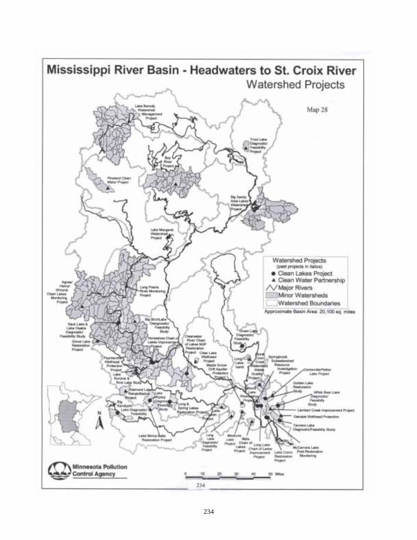
234
Clean Water Partnership Map
235
Lake Bemidji Watershed ProjectClean Water Partnership Lake Bemidji is a large, mesotrophic lakelocated in north central Minnesota, in theNorthern Lakes and Forests ecoregion. TheMississippi River enters Lake Bemdji along thesouthern shore after flowing through LakeIrving, a 620-acre lake just upstream fromBemidji. The City of Bemidji (population11,000 and growing) is located primarily on theshores of Lakes Bemidji and Irving. Populationwithin the city limits has remained relativelysteady over the past few years, howeversubstantial growth in adjoining townships hasoccurred. The trend of increasing population isexpected to continue. Management efforts forthe Lake Bemidji Watershed have focusedprimarily upon reducing phosphorus loading tothe system using an integrated watershedapproach with seven primary managementconcerns: 1. Urban runoff; 2. Moose Lake subwatershed; 3. Residential lawn care; 4. Agricultural pesticide and nutrient
management; 5. Shallow aquifer protection and
management; 6. Individual septic tanks; 7. Schoolcraft and Upper Mississippi River
subwatersheds. The LBWMP has completed Clean WaterPartnership Phase I, II and IIb (continuationgrant), State Revolving Fund loan program,U.S. Environmental Protection Agency 314 (a)Clean Lakes Phase II and Section 319 CleanWater Act grant efforts since 1989. A detaileddiagnostic study of Lakes Bemidji and Irvingwas the main focus of a Phase I Clean WaterPartnership grant. In addition to characterizingwater quality conditions within the lake basins,water quality assessments of the Mississippi and
Schoolcraft Rivers, several smaller tributaries,stormsewers and ground water were conducted.The diagnostic study allowed the SteeringCommittee of the LBWMP to establish in-lakewater quality objectives. Phase II of the CleanWater Partnership grant was conducted fromMarch of 1992 to September of 1995 with aprimary focus of the installation of BestManagement Practices (BMPs) along withcoordinated information and educationcampaign. Phase IIb Clean Water Partnershipefforts have continued from 1995 to presentwith the installation of additional sedimentbasins, education and information, septic tankupgrading, agricultural and forestry BMPinstallations. Cass/Winnibigoshish WatershedClean Water Partnership –Beltrami, Cass and ItascaCounties The Cass/Winnibigoshish Watershed Project isa Phase I Clean Water Partnership Project. It isa diagnostic and feasibility study designed tocharacterize the water quality of the secondsegment of the Mississippi headwaters from theStump Lake dam through the LakeWinnibigoshish dam. The project will also identify land use practicesand patterns that currently are stressors to waterquality and will further identify future areas ofconcern. The "waters of concern" in the project area areCass Lake, Lake Winnibigoshish and theMississippi River downstream from LakeBemidji through Lake Winnibigoshish. Thewatershed includes the major tributaries of theTurtle River, North Turtle River, Third River,First River and Pike Bay Creek. Numerousother small streams, lakes and wetlands are animportant part of the watershed. The size of the
236
project area is 522,880 acres with land usecomposition as follows: 8% Agricultural 0% Drained/Tiled 2% Urban/Suburban 1% Impervious Surface 62% Forest 8% Wetland 19% Surface Water The project area is located in portions of fourcounties, five municipalities, 15 townships andthe Leech Lake Indian Reservation. Contributing sponsors to the project include: Beltrami County Beltrami SWCD Itasca SWCD Cass CWCD Hubbard SWCD
Minnesota Chippewa Tribe Bemidji State University Mississippi River Watch Mississippi Headwaters Board Citizens Steering Committee Chippewa National Forest US Army Corps of Engineers Minnesota Dept. of Natural Resources The total estimated cost for the project is$187,000, with $93,500 being a grant from theMinnesota Pollution Control Agency. Cass Lake and Lake Winnibigoshish are theeighth and fifth largest lakes respectively in theState of Minnesota and as such are invaluablerecreational resource for the tourism industry ofNorthern Minnesota. The Minnesota ChippewaTribe makes extensive use of the resource forharvesting wild rice. The rice beds are some ofthe largest natural beds in the world. Cass andWinnie are also operated as reservoirs formultipurpose use by the Corps of Engineers.
Big Sandy Area Clean WaterPartnership Project Big Sandy Lake, one of the state's largest lakerecreational resources (as evidenced by thenumber of boats, the number of homes, lakesurface area and the number of requested lakesummaries during the Minnesota State Fair), hasexhibited considerable fluctuations in waterrunoff quantity and lake water quality over thepast 10 years. As a reservoir, it has a largerwatershed than natural lakes and hence can beexpected to exhibit greater fluctuations in waterquality than is typical for the Northern Lakesand Forests Ecoregion. Additional futuredevelopmental pressures (e.g. includingagricultural, urban and especially lakeshoredevelopment) will not likely improve theseconditions without implementing reasonable andeffective Best Management Practices as well ascarrying out rehabilitation efforts asopportunities allow.
The Big Sandy Area Watershed lakes andstreams are important economic, social andenvironmental resources. The lakes are home tothousands of individuals, hundreds of plants andanimals and the center of the quality of lifeknown to Northern Minnesota. In terms of real-estate values, there is over $27 million aroundBig Sandy Lake alone.
The Big Sandy Area Watershed Studyconducted an intensive monitoring andassessment program of the lake and 413-square-mile watershed complex. To accomplish thistask a network of stream and lake monitoringstations were established in mid-1994, whichhave been operated through 1999 to characterizethe individual subwatershed drainages withinthe watershed. An intensive inflow monitoringeffort was conducted in 10 subwatersheds,representing over 74 % of the water inflows andmore than 73% of the total phosphorus loadingto the lake in the study period. Six state-of-the-
237
art monitoring sites were constructed, consistingof computerized flow loggers and automatedstorm event samplers.
Big Sandy Lake is a reservoir system, whichmeans it has a very large watershed and variablewater flow-through volumes, it can be expectedto have year-to-year variations in water quality.Conditions monitored in 1995 were relatively"wet" and hence stream flows wereconsiderable. The majority of water inflowsoccurred from three surface drainages includingthe Prairie, Minnewawa and Sandy Riversubwatersheds which collectively contributed65% of the water and 75% of the totalphosphorus loads. The highest total phosphorusand total suspended solids concentrations weremonitored in the Sandy River system as valueswere 68 ug P/L and 13 mg/L, respectively.These concentrations exceed more typicalecoregion interquartile ranges of 20 to 50 ug P/Land 1.8 to 6 mg/L, respectively. Loss of criticalsport fisheries and their associated biologicalfood webs and the elevated nutrient andsediment loss rate appear to be a function of theextent of wetland drainage. However, the lakeand stream resource will likely improve, withrelatively small improvements within thewatershed, focusing upon the prioritymanagement areas. Phase II implementation actions have beenunderway since 1996, with a recent extension ofthe Big Sandy Area Lakes CWP Phase II grantin March of 2000. Updating of project goalsand objectives will be accomplished in 2000. Priority Management Areas Based upon the results of several years of study,the long-term management of this watershed isbased upon (1) maintaining a NondegradationPolicy and (2) achieving reductions in nutrientand sediment loading from Priority Areas (orPriority Management Areas). For this purpose,
four watershed areas have been emphasized forspecific future implementation actions toachieve desired future conditions including: (1)Big Sandy Lakeshore; (2) Sandy River; (3)Tamarack River contributing to the Prairie Riversystem; and (4) the lower Minnewawa Creeksubwatershed. General implementationobjectives by Priority Management Area aredefined below. Lakeshore Sandy River Tamarack Minnewawa Creek Short-term Goals � Septic Tanks - full compliance within 3
years� Compliance with Shoreland Zoning Rules
(90%+ compliance based on Aitkin SWCDAudit)
� Develop septage ordinance� 15% reduction in flow weighted mean
(FWM) total phosphorus (numeric goal is 60ug P/L)
� 25% reduction in FWM total suspendedsolids (numeric goal is 10 mg/L)
� Implement continuous dissolved oxygen,temperature, redox, solids and pHmonitoring at three points within the SandyRiver system to better define effects ofwatershed best management practiceimplementation (this could serve as animportant model for NLF ecoregionimpacted stream assessments for futureCWPs)
� Continue to fine-tune the Sandy Rivermonitoring network to better assess effectsof widespread spring vegetation burningupon water quality
� Institute voluntary BMPs on riparianlivestock operations
� 10% reduction in FWM total phosphorus
In general, the large stream numeric goals are aFlow Weighted Mean total phosphorus
238
concentration of 50 ug P/L and a target rangefor total suspended solids of 2-6 mg/L.
Long-term Goals
� Minimization of nutrients and bacterialsources from on-site systems
� Lake Mean TP = 30 to 40 ug P/L� 27% reduction in FWM total phosphorus
(numeric goal is 50 ug P/L)� 50% reduction in FWM total suspended
solids (numeric goal is 2-6 mg/L)� Increase diversity and abundance of fish and
mussels similar to unditched rivers(Tamarack River)
� Develop more flow monitoring of the PrairieRiver System to assess opportunities forreducing TP and TSS sources (TamarackRiver is tributary)
� Institute voluntary BMPs on all riparianlivestock operations
� Increase forestry BMP compliance usingaudit as measurement tool (increasecompliance from 87% to 95%+)
� Maintain biodiversity (mussels and fish) inriver
� Institute voluntary BMPs on all riparianlivestock operations
The Diagnostic-Feasibility Study concluded thatthree monitored tributaries contributed over75% of the measured total phosphorus load tothe lake. Of this amount, it was estimated thatabout 15-25% of the loading could be reducedfrom a combination reduction plan associatedwith primary management areas. Given thecurrent ranges of total phosphorus observed inBig Sandy Lake, reductions of loading willlikely have perceptible impacts to long-termresidents. Additionally, the plan calls for a50% reduction in the total solids loads enteringthe Sandy River system.
Lake Osakis Clean WaterPartnership Project Lake Osakis had experienced decreasing waterclarity and increasing areas of submergedaquatic vegetation since the early 1970s.The1993 Phase I Diagnostic Study documentedthat Lake Osakis had experienced decliningtransparency over the past 10 years. Lakes of theNorth Central Hardwood Ecoregion typicallyhave Total Phosphorus concentrations rangingfrom 23 to 50 ug/L while Lake Osakis averagedabout 91 ug/L in 1989 and 63 ug/L in 1990. The principal conclusion of the DiagnosticStudy was that Lake Osakis had becomeeutrophic and that if corrective actions were notundertaken, continued degradation would likelyoccur at measurable rates and could reach non-recreational conditions within 20 years. The Lake Osakis Watershed ManagementProject (LOWMP) was a logical extension ofthe Phase I Study. Therefore the followinggrants were attained to help fund BestManagement Practices implementation in orderto improve the water quality of Lake Osakis. � Clean Lakes Program (CLP) from the
Environmental Protection Agency for theJudicial Ditch 2 subwatershed
� Central Minnesota Initiative Fund for waterquality monitoring and staff time
� A Clean Water Partnership (CWP) grantfrom the Minnesota Pollution ControlAgency for water quality monitoring andSeptic System upgrades
� A Clean Water Partnership (CWPcontinuation grant for additional BestManagement Practices and Alum Treatmentfor the Clifford and Faille Lake chain ofwetland/lakes.
239
Big Birch Lake Clean WaterPartnership Project Big Birch Lake is a popular recreational waterbody located in central Minnesota. Big BirchLake is made up of two large basins, theNortheast Basin, covering 705 acres, and theMain Basin covering 1,362 acres, for a total areaof 2,067 acres. There are two public beachesand six public boat accesses located around thelake. The overall watershed is approximately9,601 acres in size for a watershed to lake ratioof 4.65. Its land use is comprised of lakeshoreproperty, agriculture, wooded areas (Big BirchLake State Forest) and wetlands. Evidence suggests that Big Birch Lake has beendegraded over the past decade as evidenced byalgal scums and the perception of impairedfisheries. In order to address these issues, theBig Birch Lake Association funded a Phase IDiagnostic Study ($93,000) with assistance fromthe Sauk River Watershed District, andcontracted with Barr Engineering to completethe Diagnostic Study. The Diagnostic Study wascompleted in 1993 and the results prompted theBig Birch Lake Association to pursue this PhaseII Implementation Grant. The study concluded that the water quality ofBig Birch Lake was poorer or close to theoutside of the range for lakes in its ecoregion.Lakes of the ecoregion typically have totalphosphorus concentrations ranging from 23 to50 ug/L while Big Birch Lake averaged about 46ug/L(Northeast Basin) in 1992-93.
The Big Birch Lake Phase I study determinedthat about 17% of the phosphorus budget isfrom direct atmospheric deposition. Thewatershed contributes approximately 73% of thetotal phosphorus to Big Birch Lake, with 66 %coming from the Fish Creek subwatershed. Theremaining 10% was estimated to be contributedfrom septic systems.
Fish Creek Fish Creek is located on the northeast corner ofthe lake and is the largest subwatershed of BigBirch Lake (42%). Fish Creek winds through1,670 acres of prime agricultural land before itdischarges into Big Birch Lake. Fish Creekdischarges the largest volume (48%) of water toBig Birch Lake and was found to have thehighest phosphorus concentrations.Calculations from Phase I indicate thatapproximately 66% of the total phosphorusentering Big Birch Lake is from FishCreek\Goose Lake subwatershed. The high concentrations together with the highinflow volume combine to produce the mostsignificant mass loading of pollutants.Therefore, the Steering Committee hasrecommended that this watershed receive firstpriority consideration for implementation ofmanagement alternatives. Septic Systems Septic system performance was furtherexamined in an attempt to better understand thispotential bacterial and nutrient source to thelake. It is extremely difficult and expensive totechnically quantify the precise losses of anyone system to the lake. However, over the past10 years, methods have been defined toapproximate nutrient losses to septic systemswhich were employed in the Phase I Diagnostic-Feasibility study. These results indicated that upto 10 % of the total phosphorus loading to thelake could be attributed to septic systems. Short Term Goals and Activities (1-3 years) For the project, the following goals will guidethe implementation of the activities. Fish Creek� Implement education programs� Implement water monitoring program� Reduce the flow-weighted mean average
total phosphorus concentrations by about60% from 468ug/L to those more closely
240
resembling regional average values of 150ug/L
� Reduce the flow-weighted mean averageortho phosphorus concentrations by about70% from 101ug/L to those more closelyresembling regional average values of 30ug/L
� Reduce average total suspended solidsconcentrations by a target of 80% from35,700 ug/L to those more closelyresembling regional average values of 7,000ug/L
Big Birch Lake� Nondegradation goal - to maintain 1993
water quality conditions, at a minimum,allowing for natural year-to-year variability
� Reduce average epilimnetic whole totalphosphorus to less than 30ug/L (primaryemphasis on the Northeast basin to achieveless than 40ug/L)
� Chlorophyll A 15 ug/L +/-18� Summer transparency 5 feet +/-1.5ft� Achieve 3 to 5 septic demonstration
programs around the Big Birch Lake usingcluster systems and or upgraded 50+individual sites within three years.
Long Term Goals and Activities (4 plusyears) Fish Creek� Maintain education programs and project
effectiveness monitoring� Targeted average annual flow-weighted
mean total phosphorus concentrations 150ug/L or less
� Targeted average annual flow-weightedmean ortho phosphorus concentrations 30ug/L or less
� Targeted average annual flow-weightedmean total suspended solids concentrations7000 ug/L
Big Birch Lake� Maintain education programs and project
effectiveness monitoring� Average summer total phosphorus
concentrations 20 - 25 ug/L� Average summer Secchi transparency -
greater than 2 meters� Chlorophyll A 10ug/L +/- 5� Achieve 90 % compliance with county
ordinance septic tank rules by year 2005 Short- and long-term water quality goals are thefoundation of the watershed management effort.Desired lake water quality improvements wereused to define likely ranges of watershedphosphorus loading reductions. The first andmost important lake management goal is toprevent further declines in lake water quality.Therefore a NONDEGRADATION GOAL hasbeen established. The defined goals are based upon historical lakedata and ecoregion patterns. Application ofMINLEAP demonstrated that the lake wouldreasonably be expected to be in better condition(e.g. average summer total phosphorus of 23ug/L +/- 9 (see Table 2). As the lake isaveraging approximated 46 ug/L in theNortheast basin and 34ug/L in the Main basin,substantial improvements in lake water qualityappear to be reasonable over the long-term. Themodel of Vighi and Chiadani (1983) predictedpresettlement water quality was on the order of20 ug/L. Hence, the long-term goals werechosen to be on the order of 20-25ug/L.Achievability will be assessed by the SRWD asthe project progresses over the next two years.Monitoring and further examination of attainedwater quality will be used to reassess this levelin the future after implementation of priorityactions. To achieve the inlake goal of less than 30 ug/Lwhole-lake average total phosphorusconcentration, it will be necessary to reduce
241
phosphorus loading to the lake by about 50%,which in turn translates into annual flow-weighted mean total phosphorus concentrationsin the inflow streams of about 100 - 160 ug/L.Hence, this value being used for the long-termstream total phosphorus target levels isnecessary to achieve improvement of inlakeconditions. To achieve the goals mentioned above, it will benecessary to decrease feedlot and agriculturerunoff, upgrade septic systems, and incorporateBest Management Practices in the Fish CreekWatershed and the near-shore areas of Big BirchLake. Selected management options werechosen to meet the short- and long-term goals ofthe project and perceptibly improve Big BirchLake. Proposed monitoring of streams and thelake basins using state-of-the-art monitoringtechniques will allow tracking of projectprogress to defined resource management goals. Horseshoe Chain of Lakes CleanWater Partnership Project In 1985, the Minnesota Pollution ControlAgency (MPCA) completed a “LimnologicalInvestigation” of the Sauk River Chain of Lakes.As recommended by the MPCA, the Sauk RiverWatershed District addressed the identifiedpollution point sources, i.e. the Melrose WasteWater Treatment Plant (WWTP). However,area citizens continued to express their concernsabout poor water quality. In 1989, the SaukRiver Chain of Lakes Association requested theSauk River Watershed District to sponsor aPhase I Diagnostic Feasibility Study for theSauk River Chain of Lakes. With funds from theEnvironmental Protection Agency (section 314of the Clean Water Act), the Sauk RiverWatershed District sponsored a Phase I project,which was completed in1992. The objective ofthis study was to determine baseline hydrologic,water quality and ecological information tomake necessary remedial and management
decisions. The problems identified have had adetrimental impact on recreation, aesthetics,economics and the aquatic environment in thearea. Water quality data collected during the 1992study concluded that phosphorus concentrationshad been reduced since the implementation ofAlum treatment at the Melrose WWTP.However, the 1992 diagnostic study furtherconcluded that the non-point sources (NPS) ofphosphorus were more severe than previouslyanticipated. The primary NPS source ofnutrients and sediments entering the Sauk RiverChain of Lakes is from agricultural and feedlotrunoff (97%) during the spring thaws andrainstorms and from direct input from septicsystems (2%). According to the 1992 study,unless a major reduction in nutrient andsediment loading is transpired, “swimmingimpaired” conditions will likely continue and“no recreation” conditions may be encounteredwithin 20 years, causing immediate economicconsequences to this area. Lakes of the North Central Hardwood Forestecoregion typically have total phosphorusconcentrations ranging from 23 to 50 ug/L.According to both previous studies, and theSTORET data received from the MPCA, thestudy lakes having lake-like (nonflowage)characteristics had a yearly TP average 5 timesthat of the ecoregion average while the studylakes having more river-like (flowage)characteristics had TP averages 10 times theecoregion average. The Sauk River Watershed District attained the1997 Clean Water Partnership Implementationgrant and its continuation (2000) to reduce thenutrient loading to the Sauk River Chain ofLakes. Further discussion on the Sauk River Chain ofLakes or the Horseshoe Chain of Lakes is in the
242
Water Quality – Lakes Assessment Section ofthis document. Boy River Clean Water PartnershipProject. Boy River Project The Middle Boy River Watershed (MBRW)Project was initiated in the late 1980s bycitizens, lake associations and sports groupswho were concerned about the quality of thelakes of the area and who wanted to maintainthe water quality for generations to come. Atthat time there was no evidence of largedegradation patterns. However, there weresuspicions that the lakes could change quicklywith intense upper watershed and lakeshoredevelopment. The combined efforts of severaldedicated individuals resulted in a lakeprotection management plan, which is the firstin Minnesota for a chain of lakes of this size. Previous lake management efforts that havetaken place in the MBRW area started with CassCounty working with the Minnesota PollutionControl Agency’s (MPCA) Lake AssessmentProgram in 1988. This effort laid the foundationby: (1) accurately defining inlake conditionsfor the Upper Chain of Lakes (e.g., Child,Woman and Girl Lakes); (2) underscoring theimportance of citizen volunteer monitors todetect trends; (3) determining generalwatershed characteristics; and, mostimportantly, (4) setting general lakemanagement goals. Cass County received aClean Water Partnership resource investigationgrant in 1990 as one of the first 14 projectsacross the state. Various information wascollected as a part of that study, which serves asthe groundwork for much of this report andsummary. Most recently, Phase II (implementation) lakeprotection efforts have been conducted by Cass
County with Clean Water Partnership and U.S.Environmental Protection Agency 319 grantfunds. Further data collection and assessmentshave allowed continued estimation of waterquality trends and definition of very difficult-to-measure water flows through this system.Citizen volunteers, Cass County staff andMPCA staff performed all of theimplementation and continuing monitoringactivities. State-of-the-art computerized stream flowmonitoring conducted in the 190 mi2 M B R Wover the 1994-95 sampling seasons measuredabout 66% of the tributary flows and nearly 70%of tributary phosphorus loading. Pick Lakeoutlet flow weighted mean total phosphorusconcentrations were 11- 15 µg P/L, which is lessthan the typical ecoregion interquartile range of20 to 50 µg P/L. Elevated concentrations (e.g.80 to 100 µg P/L) were monitored from onestream (Spring Creek) that was believed to havebeen caused by water level fluctuation inducedeffects upon oxidation/reduction of wetlandorganic materials. Additional monitoring willlikely reveal greatly-reduced concentrations overtime. Long-term Secchi transparency monitoringconducted by citizen volunteers has revealed astatistically significant improvement in thequality of Woman Lake’s main basin over thepast 10 years. No defined patterns wereidentified for the other lake basins of the studyarea. The measured stream concentrations andvolumes, along with in-lake measurements,were coupled in the computerized lakesimulation model (BATHTUB) to develop apractical lake management tool to predict futureconditions based upon changing watershedconditions. The primary focus for these effortsshould be on total phosphorus loading to thelakes from their watersheds. The models did avery good job at estimating in-lake conditions in1994-95. Additional refinement of flows and
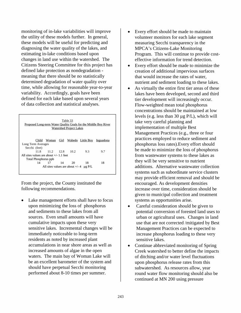
243
monitoring of in-lake variabilities will improvethe utility of these models further. In general,these models will be useful for predicting anddiagnosing the water quality of the lakes, andestimating in-lake conditions based uponchanges in land use within the watershed. TheCitizens Steering Committee for this project hasdefined lake protection as nondegradation -meaning that there should be no statisticallydetermined degradation of water quality overtime, while allowing for reasonable year-to-yearvariability. Accordingly, goals have beendefined for each lake based upon several yearsof data collection and statistical analyses.
Table 33
PPrrooppoosseedd LLoonngg--tteerrmm WWaatteerr QQuuaalliittyy GGooaallss ffoorr tthhee MMiiddddllee BBooyy RRiivveerrWWaatteerrsshheedd PPrroojjeecctt LLaakkeess
CChhiilldd WWoommaann GGiirrll WWaabbeeddoo LLiittttllee BBooyy IInngguuaaddoonnaa Long Term Averages Secchi (feet) 11.8 11.2 12.8 10.2 9.3 9.7 AAllll ssiitteess vvaalluueess aarree aabboouutt ++//-- 11..11 ffeeeett TToottaall PPhhoosspphhoorruuss ppppbb
1144 1177 1144 2200 1188 1188 AAllll ssiitteess vvaalluueess aarree aabboouutt ++//-- 44 µµgg PP//LL
From the project, the County instituted thefollowing recommendations. � Lake management efforts shall have to focus
upon minimizing the loss of phosphorusand sediments to these lakes from allsources. Even small amounts will havecumulative impacts upon these verysensitive lakes. Incremental changes will beimmediately noticeable to long-termresidents as noted by increased plantaccumulations in near shore areas as well asincreased amounts of algae in the openwaters. The main bay of Woman Lake willbe an excellent barometer of the system andshould have perpetual Secchi monitoringperformed about 8-10 times per summer.
� Every effort should be made to maintainvolunteer monitors for each lake segmentmeasuring Secchi transparency in theMPCA’s Citizens-Lake MonitoringProgram. This will continue to provide cost-effective information for trend detection.
� Every effort should be made to minimize thecreation of additional impervious surfacesthat would increase the rates of water,nutrient and sediment loading to these lakes.
� As virtually the entire first tier areas of theselakes have been developed, second and thirdtier development will increasingly occur.Flow-weighted mean total phosphorusconcentrations should be maintained at lowlevels (e.g. less than 30 µg P/L), which willtake very careful planning andimplementation of multiple BestManagement Practices (e.g., three or fourpractices employed to reduce sediment andphosphorus loss rates).Every effort shouldbe made to minimize the loss of phosphorusfrom wastewater systems to these lakes asthey will be very sensitive to nutrientadditions. Alternative wastewater collectionsystems such as subordinate service clustersmay provide efficient removal and should beencouraged. As development densitiesincrease over time, consideration should begiven to municipal collection and treatmentsystems as opportunities arise.
� Careful consideration should be given topotential conversion of forested land uses tourban or agricultural uses. Changes in landuse that are not corrected /mitigated by BestManagement Practices can be expected toincrease phosphorus loading to these verysensitive lakes.
� Continue abbreviated monitoring of SpringCreek watershed to better define the impactsof ditching and/or water level fluctuationsupon phosphorus release rates from thissubwatershed. As resources allow, yearround water flow monitoring should also becontinued at MN 200 using pressure
244
transducers, to better define flows throughthe system and winter-related ground waterflows.
Wabedo Township The Wabedo Township Project originated in theMiddle Boy River Project as one of theimplementation activities. The project is usinglow-interest loan dollars from the CWP programto form several subordinate sewer districts as analternative to individual septic treatmentsystems. This is a solution for several lake areasthat have many lots that are too small for siting acompliant septic system. Lake Margaret Clean WaterPartnership Project Lake Margaret is located in north centralMinnesota in the City of Lake Shore, in CassCounty. The lake is 217 acres in size, with amaximum depth of 26 feet. The near shore areaand the lake basin itself are entirely locatedwithin the City of Lake Shore. The watershed consists of 18,340 acres, withforested land as the primary land use. There arethree streams, which run into Lake Margaret:Home Brook, Cory Brook, and Rush Brook.There are 104 landowners on Lake Margaret,most of which have seasonal or year-roundhomes there. Total population of the watershedis approximately 3,560, with 2,460 living eitheryear round or seasonally within the City of LakeShore, and the rest residing in FairviewTownship of Cass County. According to the Minnesota Department ofNatural Resources (DNR), Lake Margaret andHome Brook have historically had walleyespawning habitat, but recent surveys show thishabitat has disappeared. Also, Cory Brook stillproduces great numbers of brook trout, buthabitat conditions there have deteriorated and
most fish can’t live past two years old. TheDNR has acquired easements along part of thecritical habitat area of Cory Brook, and wouldlike to acquire more to protect this habitat. Lake Margaret is the first lake draining into thelarger Gull Lake watershed from the west, and isfirst to experience nutrient loading coming intothe lake from the Home Brook Watershed.Residents began to notice a decline in thequality of water in the lake, as evidenced bydecreased clarity, increased weed growth, andsediment on the bottom. In 1989 as part of aGull Lake assessment, the Minnesota PollutionControl Agency found that while Gull Lake waswhere it was expected to be with regards tonutrient and algae levels, Lake Margaret wasabove what was expected in a lake in thisecoregion. Because of these and subsequentassessments, following the recommendation ofthe MPCA the City of Lake Shore determinedthat the water quality in Lake Margaret was poorenough to warrant additional study and action toprevent further degradation. In the summer of 1994, the MPCA, along withmembers of the Gull Area Lakes Association(GALA), sampled Lake Margaret as part of theLake Assessment Program (LAP). Water qualitydata collected during this study indicate thatMargaret is eutrophic to hypereutrophic, with amean total phosphorus concentration of 65.2ug/l, a summer mean Secchi transparency of 3.5feet, and a mean chlorophyll of 52.6 ug/1. Thetypical range for these readings in the NorthernLakes and Forests Ecoregion should be between14-27 ug/1 for phosphorus, 8-15 feet Secchi,and less than 10 ug/l chlorophyll a. In 1995, through the city’s EnvironmentalCommittee, the City of Lake Shore undertook astudy of the Home Brook watershed. The studyidentified preliminary total and ortho-phosphorus flow weighted means in the streamof 90 and 50 ug/L respectively.
245
It is suspected that the elevated phosphorus inHome Brook and Lake Margaret are causing thedecreasing water clarity that has been a concernto local residents. Land use practices in thewatershed and along the lakeshore are believedto be the main contributing factor to the elevatedphosphorus levels. The Clean WaterPartnership Project purpose is to further assessthe inputs from this watershed to the lake. Theproject will be completed in April of 2001.
Lake Mille Lacs Clean WaterPartnership Project The Lake Mille Lacs Watershed Group wassuccessful in obtaining Phase I CWP funding fora diagnostic study on Lake Mille Lacs in 1999.Several activities have been outlined in therecently-completed work plan including dataassessment, lake and stream sampling, educationand outreach on lakeshore management,development of consistent planning and zoningstrategies, a recreation impact study andgeographic information system mapping. Theproject encompasses the entire Lake Mille LacsWatershed, which extends approximately twomiles around the lake and will last for threeyears.
Minneapolis Chain of Lakes CleanWater Partnership Project. Funding to improve the water quality in theMinneapolis Chain of Lakes (Brownie Lake,Cedar Lake, Lake of the Isles, Lake Calhoun andLake Harriet) became available in 1993 througha seven-year initiative with the Chain of LakesClean Water Partnership (CWP). Thispartnership is funded and sponsored by the Cityof Minneapolis, the City of St. Louis Park,Hennepin County, the Minneapolis Park andRecreation Board, the Minnehaha Creek
Watershed District, and the Minnesota PollutionControl Agency. The project is the “Minneapolis Chain of LakesClean Water Partnership” (CWP), and it is oneof the largest urban watershed-restorationinitiatives in the U.S. It is a multi-facetedprogram, and its goal is to significantly improvethe water quality of the Chain of Lakes. From1994 to 2001, $8.1 million is being strategicallyspent to achieve this goal. In order to restore the water quality of the lakes,the CWP is using multiple, proven techniquesthroughout the Chain of Lakes watershed. Aninitial action to clean up the lakes was toincrease street sweeping practices andefficiency. Street sweeping removes sand,leaves and other pollutants that would otherwisereach the lake through storm drains. As part ofthe CWP, the Minneapolis Park and RecreationBoard added one sweeper in 1995 andMinneapolis purchased two additional sweepersin 1996 at a cost of $110,000 each. City streets,parkways and parking lots are now swept morefrequently. An important part of the CWP program is themanagement of storm water runoff. In order totrap pollution-laden sediment before it enters thelakes, the CWP plan includes the installation of10 grit chambers in the Chain of Lakeswatershed. The plan also includes the creationof two wetland and storm water pond systems tonaturally filter storm water, and removephosphorus. Alum will be applied to some ofthe lakes after the wetlands and other stormwater management techniques are in place.Alum treatments stop phosphorus already inlake sediment from fueling algae growth. Thefollowing table summarizes the specific actionsbeing taken on each lake (parentheses indicateCWP future actions).
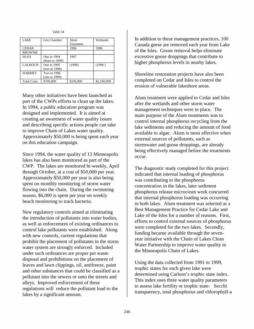
246
Table 34 LAKE Grit Chamber Alum
Treatment Wetlands
CEDAR 1996 1996 BROWNIE ISLES One in 1994
(three in 1999) 1997
CALHOUN One in 1995 (two in 1998)
(1998) (1998 )
HARRIET Two in 1996 (one in 1999)
Total Costs $700,000 $196,000 $2,160,000 Many other initiatives have been launched aspart of the CWPs efforts to clean up the lakes.In 1994, a public education program wasdesigned and implemented. It is aimed atcreating an awareness of water quality issuesand describing specific actions people can taketo improve Chain of Lakes water quality.Approximately $50,000 is being spent each yearon this education campaign. Since 1994, the water quality of 13 Minneapolislakes has also been monitored as part of theCWP. The lakes are monitored bi-weekly, Aprilthrough October, at a cost of $50,000 per year.Approximately $50,000 per year is also beingspent on monthly monitoring of storm waterflowing into the chain. During the swimmingseason, $6,000 is spent per year on weeklybeach monitoring to track bacteria. New regulatory controls aimed at eliminatingthe introduction of pollutants into water bodies,as well as enforcement of existing ordinances tocontrol lake pollutants were established. Alongwith new controls, current regulations thatprohibit the placement of pollutants in the stormwater system are strongly enforced. Includedunder such ordinances are proper pet wastedisposal and prohibitions on the placement ofleaves and lawn clippings, oil, antifreeze, paintand other substances that could be classified as apollutant into the sewers or onto the streets andalleys. Improved enforcement of theseregulations will reduce the pollutant load to thelakes by a significant amount.
In addition to these management practices, 100Canada geese are removed each year from Lakeof the Isles. Goose removal helps eliminateexcessive goose droppings that contribute tohigher phosphorus levels in nearby lakes. Shoreline restoration projects have also beencompleted on Cedar and Isles to control theerosion of vulnerable lakeshore areas. Alum treatment were applied to Cedar and Islesafter the wetlands and other storm watermanagement techniques were in place. Themain purpose of the Alum treatments was tocontrol internal phosphorus recycling from thelake sediments and reducing the amount of foodavailable to algae. Alum is most affective whenexternal sources of pollutants, such asstormwater and goose droppings, are alreadybeing effectively managed before the treatmentsoccur. The diagnostic study completed for this projectindicated that internal loading of phosphoruswas contributing to the phosphorusconcentration in the lakes, later sedimentphosphorus release microcosm work concurredthat internal phosphorus loading was occurringin both lakes. Alum treatment was selected as aBest Management Practice for Cedar Lake andLake of the Isles for a number of reasons. First,efforts to control external sources of phosphoruswere completed for the two lakes. Secondly,funding became available through the seven-year initiative with the Chain of Lakes CleanWater Partnership to improve water quality inthe Minneapolis Chain of Lakes. Using the data collected from 1991 to 1999,trophic states for each given lake weredetermined using Carlson’s trophic state index.This index uses three water quality parametersto assess lake fertility or trophic state: Secchitransparency, total phosphorus and chlorophyll-a
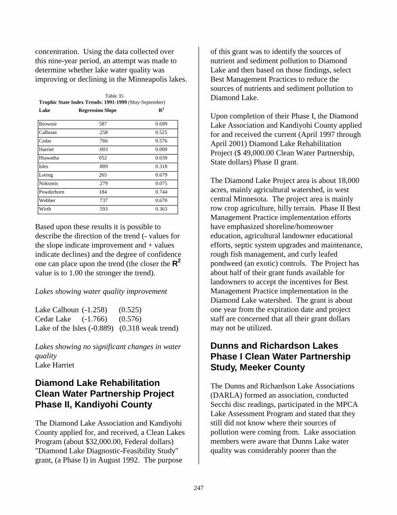
247
concentration. Using the data collected overthis nine-year period, an attempt was made todetermine whether lake water quality wasimproving or declining in the Minneapolis lakes. Table 35 Trophic State Index Trends: 1991-1999 (May-September) Lake Regression Slope R2
Brownie 587 0.699 Calhoun .258 0.525 Cedar .766 0.576 Harriet .003 0.000 Hiawatha 052 0.039 Isles .889 0.318 Loring 265 0.679 Nokomis .279 0.075 Powderhorn 184 0.744 Webber .737 0.670 Wirth .593 0.363
Based upon these results it is possible todescribe the direction of the trend (- values forthe slope indicate improvement and + valuesindicate declines) and the degree of confidenceone can place upon the trend (the closer the R2
value is to 1.00 the stronger the trend). Lakes showing water quality improvement Lake Calhoun (-1.258) (0.525) Cedar Lake (-1.766) (0.576) Lake of the Isles (-0.889) (0.318 weak trend) Lakes showing no significant changes in waterquality Lake Harriet
Diamond Lake RehabilitationClean Water Partnership ProjectPhase II, Kandiyohi County The Diamond Lake Association and KandiyohiCounty applied for, and received, a Clean LakesProgram (about $32,000.00, Federal dollars)"Diamond Lake Diagnostic-Feasibility Study"grant, (a Phase I) in August 1992. The purpose
of this grant was to identify the sources ofnutrient and sediment pollution to DiamondLake and then based on those findings, selectBest Management Practices to reduce thesources of nutrients and sediment pollution toDiamond Lake. Upon completion of their Phase I, the DiamondLake Association and Kandiyohi County appliedfor and received the current (April 1997 throughApril 2001) Diamond Lake RehabilitationProject ($ 49,000.00 Clean Water Partnership,State dollars) Phase II grant. The Diamond Lake Project area is about 18,000acres, mainly agricultural watershed, in westcentral Minnesota. The project area is mainlyrow crop agriculture, hilly terrain. Phase II BestManagement Practice implementation effortshave emphasized shoreline/homeownereducation, agricultural landowner educationalefforts, septic system upgrades and maintenance,rough fish management, and curly leafedpondweed (an exotic) controls. The Project hasabout half of their grant funds available forlandowners to accept the incentives for BestManagement Practice implementation in theDiamond Lake watershed. The grant is aboutone year from the expiration date and projectstaff are concerned that all their grant dollarsmay not be utilized.
Dunns and Richardson LakesPhase I Clean Water PartnershipStudy, Meeker County The Dunns and Richardson Lake Associations(DARLA) formed an association, conductedSecchi disc readings, participated in the MPCALake Assessment Program and stated that theystill did not know where their sources ofpollution were coming from. Lake associationmembers were aware that Dunns Lake waterquality was considerably poorer than the
248
upstream Lake Richardson’s water quality, butstill did not know why. In the fall of 1998 Meeker County sponsoredDARLA's Phase I Clean Water Partnershipapplication. The "Dunns and Richardson LakesPhase I Study" received a $33,750.00 CleanWater Partnership grant. Because of the smallgrant dollar amount DARLA volunteers, withMPCA staff and consultant assistance, will beconducting the sampling. The project areawatershed has been evaluated, the monitoringsites have been selected and the monitoring planhas been completed. The monitoring equipmentwill be installed and volunteer training will beprovided again this spring, a refresher course forlast year’s volunteer training.
Lake Francis Clean WaterPartnership Diagnostic FeasibilityStudy, Isanti County Over the past several years, watershed residentshave observed a continual degradation of thewater quality in Lake Francis. More severe andmore frequent algae blooms have beendocumented, unsightly shoreline scums, and, ingeneral, a rapidly diminishing lake water qualityhave been observed by lakeshore homeowners.The perception is that watershed run-off coupledwith septic system contributions and sedimentenrichment are responsible for the excessivealgal blooms in the lake. Isanti County and the Lake Francis LakeAssociation applied for the "Lake FrancisDiagnostic-Feasiblity Study" and were funded($24,150.00 Clean Water Partnership grant),effective March 23, 1999. The objective of thePhase I Study will be to determine baselinehydrology, water quality and ecologicalinformation to make the necessary remedial andmanagement decisions. Phase I objectivesinclude the gathering of water quality, streamflow and watershed data. Data will be
summarized, modeled and analyzed to produce aprioritized list of cost effective lake andwatershed management alternatives forsubsequent implementation. The desired uses for the lake include fishing,swimming and boating. Contact sports arecurrently avoided due to turbidity, algal scumand mucky bottom. There is currently noaquatic vegetation in Lake Francis because ofturbidity and algae density. Phosphorus andnitrogen levels are currently very high and areresponsible for the excessive algae growth.
Grass Lake Restoration Project,Kandiyohi County The Grass Lake Restoration Project is a 319grant ($100,000.00) for the restoration of GrassLake, which was drained many years ago. Themajority of the 319 grant will be used forsedimentation basins upstream of the GrassLake Basin. The storm water that will be treatedby the sedimentation basins is from the City ofWillmar. This project should soon becompleted. Long and Spring LakesRestoration Project – Clean WaterPartnership Phase II, MeekerCounty The Long and Spring Lakes residents formed theDassel Area Environmental Association. Sincetheir formation the association has participatedin numerous water quality projects: The MPCALake Assessment Program (1992), the "Longand Spring Lakes Restoration Project" (a CleanLakes Program, Diagnostic-Feasibility Study)1993-1997, a Federal 319 shoreline stabilizationgrant ($15,000.00) October 1998, and a "Longand Spring Lakes Restoration Project" Phase IIClean Water Partnership grant ($26,689.00)March 1999 - March 2002.
249
Shoreline restoration efforts are currentlyunderway. Association members and DNRWaters staff have videotaped the shoreline, metto view the shoreline and discuss and select thepriority sites. Most landowners have beencontacted and several sites are working onshoreline restoration/stabilization plans. Severalstorm sewer outlets had erosion problems at thelake shoreline. The City of Dassel owns thoseproperties so those site restoration plans are alsoin progress. Minnie Belle Restoration CleanWater Partnership Project Phase II,Meeker County The Lake Minnie Belle Restoration Project isthe result of years of water quality efforts by theLake Minnie Belle Lake Association. Theassociation has participated in Meeker CountyCoalition of Lakes efforts, the MPCA LakeAssessment Program, the MPCA Citizens LakeMonitoring Program, the Clean Lakes ProgramPhase I Diagnostic-Feasibility Study, and nowthe Minnie Belle Restoration Project, a CleanWater Partnership Phase II ($76,225.00). The Phase II efforts have included: Septicsystem educational material purchase anddistribution to lakeshore (and some watershed)homeowners; lawn care and septic system careworkshops; replacement of septic systems withState Revolving Fund loan dollars, shorelinestabilization demonstration projects, andnumerous agricultural Best ManagementPractice efforts to reduce nutrient and sedimentcontributions into Lake Minnie Belle. Theproject is nearing the end date and still has abouthalf of the grant money to spend on BestManagement Practice implementation.
Green Lake Diagnostic FeasibilityClean Water Partnership Study,Isanti County Green Lake is a major recreational water body(about 800 acres) in Isanti County. Over 50% ofthe shoreline has sand ridges up to 40 feet high,and the remaining shoreline is about 10 feetabove normal lake level. The watershed issmall, about 19 square miles. Surface runoff tothe lake is low because of the relatively flatterrain and pervious surface soils. The RumRiver does occasionally back flow into GreenLake during significant rain events and duringspring melts, when the stop log dam gets heldopen with logs and debris. People who had lived around Green Lake formany years thought the lake had more frequentand severe algae blooms. They formed theGreen Lake Association to try to confirm ordispel the suspected water quality degradationand try to identify the cause, if justified. The Green Lake Association has conducted a1984 lake hydrology study, a 1989 lake andstream survey (both funded by the lakeassociation), the MPCA Citizens LakeMonitoring Program (ongoing), the MPCA LakeAssessment Program (1991), and the GreenLake Diagnostic Feasibility Study 1994 – 1997. The studies did not identify a significant sourceof pollutants. The orthophosphate to totalphosphorus ratio was high. Although the totalphosphorus itself was not high compared to theNorth Central Hardwood Forest Ecoregionexpected range. The suspected source of theorthophosphate was wetland organic materialsand/or nutrient management on sandyagricultural lands in the watershed. Thewatershed land composition is: wetlands ~53%,agricultural ~27%, urban ~ 10%, forest ~ 9%,and water ~ 1 %. So far the project has notapplied for the Phase II Implementation grant.
250
Big Fish Lake Clean WaterPartnership Project Big Fish Lake is located in Stearns County northof Cold Spring. The lake has a surface area ofapproximately 580 acres, a mean depth of 26.5feet and a maximum depth of 70 feet. Waterresidence time is estimated at approximately 12years. The Phase I CWP project for Big Fish & LongLakes has three major objectives. � Conduct a comprehensive diagnostic study
to determine which elements of thewatershed are functioning and helping tomaintain the high water quality of Big Fishand Long Lakes.
� After completion of the diagnostic study,
protect critical watershed functions andprocesses through various means such asland use regulations, conservationeasements, and other regulatory or volunteerefforts.
� Preserve and improve the health of the
aquatic and terrestrial ecosystems of thelakes and surrounding watershed.
Major project elements of the project include:lake and tributary monitoring, watershedassessment, homeowner education and dataanalysis. Stearns County is the local projectsponsor and the Sauk River Watershed Districtwill conduct water quality monitoring for theproject.
Other Watershed ProjectsThe McKnight Foundation - UpperMississippi Initiative.
The McKnight Foundation is a charitablefoundation, headquartered in Minneapolis,Minnesota. The foundation’s primarygeographic focus is in the State of Minnesota.Founded in 1953 and endowed by William L.McKnight and Maude L. McKnight, thefoundation’s purpose is to strengthencommunity and community institutions toimprove and provide opportunities to enrichpeople’s lives through the arts, preservation ofthe natural environment, and support ofscientific knowledge.
The McKnight Foundation’s EnvironmentalProgram and Upper Mississippi Riverdemonstration project were established in 1991.Its larger goal is to maintain and, wherenecessary, restore a healthy and sustainableenvironment in the Mississippi River Basin. Asecondary goal is to encourage energyconservation and the use of alternative sourcesof energy in Minnesota. Grants within theMississippi River program seek to safeguard theriver at reasonable cost while maintaining itseconomic and recreational value.
The Fish Hook/Shell River CorridorProject-Hubbard and WadenaCounties
The Fish Hook/Shell River Corridor Project is acooperative effort by Hubbard and WadenaCounty SWCDs, the MNDNR, the MPCA, theUSACOE and local residents to restore a portionof the two rivers back to their original channels.These river reaches were channelized in 1912-15 at the request of individuals who wanted tofarm the river bottoms. The Hubbard CountyBoard denied the original petition, the
251
individuals then appealed to the MinnesotaSupreme Court who overturned the county'sdecision.
The subsequent channelization failed to producethe desired result, and may have resulted insignificant siltation to downstream Upper TwinLake.
The Army Corps of Engineers provided aproject manager and a preliminary engineeringreport along with a preliminary budget. Theproject needs a local sponsor to proceed, butliability language within the sponsor contracthas precluded selection of a sponsor. DNRFisheries has expressed interest in becoming thelocal sponsor, and they are working with theattorney general's office to interpret the liabilitylanguage in the Corps’ contract.
The project area is still a legal drainage withHubbard County being the drainage authority.Legal abandonment by the drainage authoritymust be accomplished before the project canproceed.
The proposed natural channel restoration wouldapproximately triple the length of the currentchannel and greatly enhance fish and wildlifehabitat, thereby increasing recreationalopportunities. Also, the problem of siltation tothe downstream lakes would likely be reduced.
Leech Lake Watershed Foundation
The Leech Lake Watershed Foundation (LLWF)is a non-profit, tax exempt organization ofcitizens in the Leech Lake area who arededicated to preserving the environment.Volunteer citizens, in partnership with privateand public entities, work to identify and protectsensitive lands and waterways in the 750,000-acre Leech Lake area watershed, and encourageland and water stewardship, for the benefit andenjoyment of present and future generations.
The LLWF was formed in 1995, but already hasbeen an instrumental leader in lake, river andforest protection. The foundation’s first project,completed in 1997 on Lost Lake east ofHackensack, involved the purchase andprotection of 2,000 feet of wild lakeshore for anaquatic management area.
Pine River Watershed Foundation
The Pine River Watershed Foundation (PRWF)is a non-profit, tax exempt organization ofcitizens in the Pine River Watershed and theWhitefish Chain of Lakes in Crow Wing Countywho are dedicated to preserving the Pine RiverWatershed. Volunteer citizens, in partnershipwith private and public entities, work to identifyand protect sensitive lands and waterways in thewatershed.