Embed Size (px)
Citation preview
Section B: Chapter 6 - Yadkin-Pee Dee River Subbasin 03-07-06 167
Section B: Chapter 6Yadkin-Pee Dee River Subbasin 03-07-06 South Yadkin River Watershed including Hunting Creek, FourthCreek, Third Creek and Second Creek
6.1 Water Quality Overview
The South Yadkin River watershed makes up this largesubbasin in primarily Iredell and Rowan counties. TheSouth Yadkin River is one of three major tributaries to theYadkin River in North Carolina. Streams within thesubbasin include Hunting Creek, Rocky Creek, andSecond, Third and Fourth Creeks. Statesville is the largestmunicipality, although portions of Mocksville andMooresville are also included.
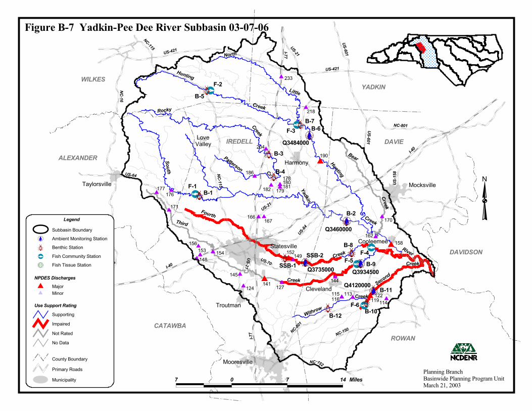
A map including the locations of NPDES discharges andwater quality monitoring stations is presented in Figure B-7. Table B-11 contains a summary of monitoring datatypes, locations and results. Use support ratings for watersin this subbasin are summarized in Table B-12. AppendixI provides a key to discharge identification numbers. Referto Appendix III for a complete listing of monitored watersand more information about use support ratings.
About 54 percent of the land is forested. Approximately 6 percent is cultivated and nearly 40percent is in pasture. The subbasin contains more than 100,000 people, and the population ofIredell County is expected to increase by 49 percent between 2000 and 2020. Projected increasesfor Davie and Rowan counties are 37 and 32 percent, respectively. There are 29 NPDESpermitted discharges and 50 registered animal operations in the subbasin. Despite a significantdecrease between 1994 and 1998, this subbasin alone contains approximately 20 percent ofstate’s capacity for dairy production. Facilities with compliance or toxicity problems arediscussed in following sections.
Water quality cannot be generalized across this subbasin. The northern portion contains manystreams with Excellent bioclassifications and several other streams where there are a fewproblem areas. In the lower portion, more water quality impacts are evident, but there are stillstreams that received Good bioclassifications. The headwaters of the South Yadkin River areclassified WS-II and receive the same level of protection offered by the HQW classification.Although several other streams likely qualify, there are no other waters classified HQW or ORWin the subbasin. All or part of Hunting Creek, Rocky Creek, Little Hunting Creek, North LittleHunting Creek, and a larger segment of the upper South Yadkin River likely qualify for eitherHQW or ORW. Refer to page 54 of Section A for details on stream classifications.
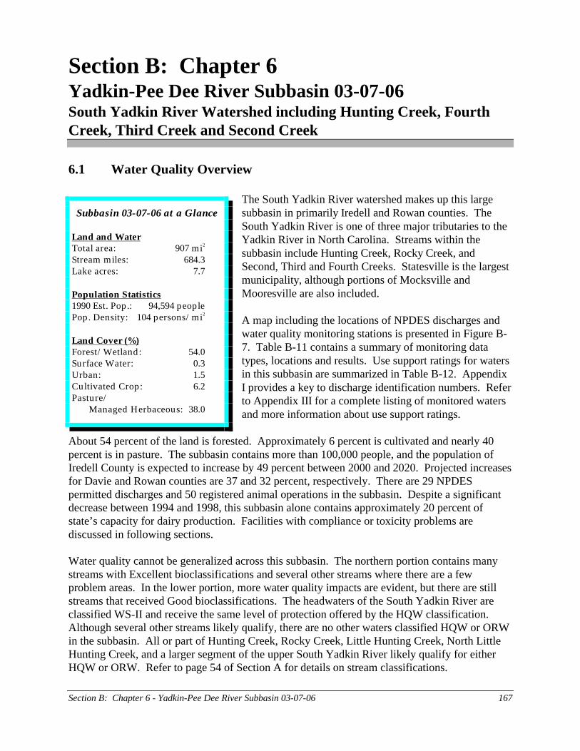
Subbasin 03-07-06 at a Glance
Land and WaterTotal area: 907 mi2
Stream miles: 684.3Lake acres: 7.7
Population Statistics1990 Est. Pop.: 94,594 peoplePop. Density: 104 persons/mi2
Land Cover (%)Forest/Wetland: 54.0Surface Water: 0.3Urban: 1.5Cultivated Crop: 6.2Pasture/
Managed Herbaceous: 38.0
$ $$$ $$$ $$ $$
$ $$$ $$ $
$
$$ $$
$$$$$$$
$
$$
$
$
"F
"F
"F
"F
"F
"F
àààà
à
àà
àà
à
à
à
àà
à
à
!9
!9
!9 !9
!9
WILKES
ALEXANDER
IREDELL DAVIE
YADKIN
DAVIDSON
ROWAN
Statesville
Mooresville
Mocksville
Troutman
Taylorsville
Cleveland
Cooleemee
Harmony
LoveValley
CATAWBA
South
Yadkin
River
Fourth
Creek
Third
Creek
Hunting
Creek
Second
Creek
115116 122
124 127141 144145
148 149152153 154158
162
166 167 170
171
176
178
179182
186
190204
218
233
180181177
156
113119114
Q3484000
Q3460000
Q3934500
Q4120000
Q3735000
Creek
Hunting
North
Little
Rocky
Creek
Withrow
Creek
Patterson Cr
BearCreek
I-77
I-40
US-21
NC-150
US-421
NC-115
US-64
NC-16
US-70
US-601
NC-152
US-1
58
US-421
NC-801
NC-115
NC-801
I-40
I-77
US-64
US-21
NC-16
US-21
US-601
B-8
B-5
B-6B-7
B-4
B-3
B-2
B-1
B-10B-12
SSB-2SSB-1 B-9
B-11
F-1
F-2
F-3
F-4F-5
F-6
Planning BranchBasinwide Planning Program UnitMarch 21, 2003
Figure B-7 Yadkin-Pee Dee River Subbasin 03-07-06
7 0 7 14 Miles
Subbasin BoundaryAmbient Monitoring Station!9Benthic Stationà
Use Support RatingSupportingImpairedNot RatedNo Data
County Boundary
Legend
NPDES Discharges
Primary Roads
"F Fish Community Station
$ MinorMajor$
Fish Tissue Station!6
Municipality
N
Section B: Chapter 6 - Yadkin-Pee Dee River Subbasin 03-07-06 169
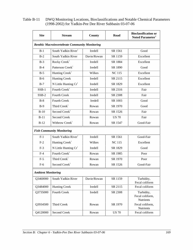
Table B-11 DWQ Monitoring Locations, Bioclassifications and Notable Chemical Parameters(1998-2002) for Yadkin-Pee Dee River Subbasin 03-07-06
Site Stream County RoadBioclassification orNoted Parameter2
Benthic Macroinvertebrate Community Monitoring
B-1 South Yadkin River1 Iredell SR 1561 Good
B-2 South Yadkin River Davie/Rowan SR 1159 Excellent
B-3 Rocky Creek1 Iredell SR 1884 Excellent
B-4 Patterson Creek1 Iredell SR 1890 Good
B-5 Hunting Creek1 Wilkes NC 115 Excellent
B-6 Hunting Creek Iredell SR 2115 Excellent
B-7 N Little Hunting Cr1 Iredell SR 1829 Excellent
SSB-1 Fourth Creek1 Iredell SR 2316 Fair
SSB-2 Fourth Creek Iredell SR 2308 Fair
B-8 Fourth Creek Iredell SR 1003 Good
B-9 Third Creek1 Rowan SR 1970 Good
B-10 Second Creek1 Rowan SR 1526 Fair
B-11 Second Creek Rowan US 70 Fair
B-12 Withrow Creek1 Rowan SR 1547 Good-Fair
Fish Community Monitoring
F-1 South Yadkin River1 Iredell SR 1561 Good-Fair
F-2 Hunting Creek1 Wilkes NC 115 Excellent
F-3 N Little Hunting Cr1 Iredell SR 1829 Good
F-4 Fourth Creek1 Rowan SR 1985 Poor
F-5 Third Creek1 Rowan SR 1970 Poor
F-6 Second Creek1 Rowan SR 1526 Good-Fair
Ambient Monitoring
Q3460000 South Yadkin River Davie/Rowan SR 1159 Turbidity,Fecal coliform
Q3484000 Hunting Creek Iredell SR 2115 Fecal coliform
Q3735000 Fourth Creek Iredell SR 2308 Turbidity,Fecal coliform,
Nutrients
Q3934500 Third Creek Rowan SR 1970 Fecal coliform,Nutrients
Q4120000 Second Creek Rowan US 70 Fecal coliform
Section B: Chapter 6 – Yadkin-Pee Dee River Subbasin 03-07-06 170
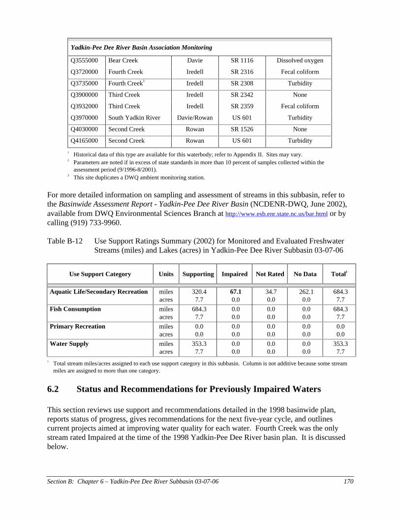
Yadkin-Pee Dee River Basin Association Monitoring
Q3555000 Bear Creek Davie SR 1116 Dissolved oxygen
Q3720000 Fourth Creek Iredell SR 2316 Fecal coliform
Q3735000 Fourth Creek3 Iredell SR 2308 Turbidity
Q3900000 Third Creek Iredell SR 2342 None
Q3932000 Third Creek Iredell SR 2359 Fecal coliform
Q3970000 South Yadkin River Davie/Rowan US 601 Turbidity
Q4030000 Second Creek Rowan SR 1526 None
Q4165000 Second Creek Rowan US 601 Turbidity
1 Historical data of this type are available for this waterbody; refer to Appendix II. Sites may vary.2 Parameters are noted if in excess of state standards in more than 10 percent of samples collected within the
assessment period (9/1996-8/2001).3 This site duplicates a DWQ ambient monitoring station.
For more detailed information on sampling and assessment of streams in this subbasin, refer tothe Basinwide Assessment Report - Yadkin-Pee Dee River Basin (NCDENR-DWQ, June 2002),available from DWQ Environmental Sciences Branch at http://www.esb.enr.state.nc.us/bar.html or bycalling (919) 733-9960.
Table B-12 Use Support Ratings Summary (2002) for Monitored and Evaluated FreshwaterStreams (miles) and Lakes (acres) in Yadkin-Pee Dee River Subbasin 03-07-06
Use Support Category Units Supporting Impaired Not Rated No Data Total1
Aquatic Life/Secondary Recreation milesacres
320.47.7
67.10.0
34.70.0
262.10.0
684.37.7
Fish Consumption milesacres
684.37.7
0.00.0
0.00.0
0.00.0
684.37.7
Primary Recreation milesacres
0.00.0
0.00.0
0.00.0
0.00.0
0.00.0
Water Supply milesacres
353.37.7
0.00.0
0.00.0
0.00.0
353.37.7
1 Total stream miles/acres assigned to each use support category in this subbasin. Column is not additive because some streammiles are assigned to more than one category.
6.2 Status and Recommendations for Previously Impaired Waters
This section reviews use support and recommendations detailed in the 1998 basinwide plan,reports status of progress, gives recommendations for the next five-year cycle, and outlinescurrent projects aimed at improving water quality for each water. Fourth Creek was the onlystream rated Impaired at the time of the 1998 Yadkin-Pee Dee River basin plan. It is discussedbelow.
Section B: Chapter 6 – Yadkin-Pee Dee River Subbasin 03-07-06 171
6.2.1 Fourth Creek (29.3 miles from source to SR 1972 and from SR 1985 to South YadkinRiver)
1998 RecommendationsProblems with low dissolved oxygen, high fecal coliform concentrations and elevated levels ofnutrients downstream of Statesville were discussed in the 1998 basin plan. Recommendationsare for further identification of causes and sources of pollution, along with reduction of nutrients.DWQ also planned to consider reallocation of oxygen-consuming wastes based on an updated7Q10 flow estimate if instream dissolved oxygen standards continued to be violated.
Status of ProgressBiological surveys were conducted at four sites along Fourth Creek over the last five-yearplanning period. In addition, water chemistry data were collected from two sites. With theexception of a small portion of the stream in the lower half of the watershed, all of Fourth Creekis currently rated as Impaired. Much of the watershed contains significant habitat degradation.Elevated turbidity and nutrients were also observed below Statesville; however, both permitteddischarges are in compliance with permit limits. There is no indication of a dissolved oxygenproblem in Fourth Creek.
The geometric means of fecal coliform samples collected from two stations between 1998 and2001 and one station between 1996 and 2001 from Fourth Creek (543, 306 and 504colonies/100ml, respectively) indicate that the stream may not be suitable for primary recreation.In addition, fecal coliform concentrations were greater than 400 colonies/100ml in more than 20percent of samples from each site. Fourth Creek is not currently classified for primary recreation(Class B). However, the stream was historically placed on the 303(d) list for fecal coliform and aTMDL has already been developed by DWQ.
2002 RecommendationsDWQ’s fecal coliform TMDL for Fourth Creek was approved by the EPA in 2001. The studyrevealed that the sources of fecal coliform in the Fourth Creek watershed include urban sourcesin the Statesville area, livestock grazing and manure application on agricultural lands, the FourthCreek WWTP, and wildlife in the forested areas of the watershed. The Coliform Routing andAllocation Program was utilized to simulate instream fecal concentrations and to allocate thefecal coliform loads to the various sources. In order for water quality standards for fecalcoliform to be met in Fourth Creek, a nonpoint source load reduction of 40-60 percent under dryweather conditions and 84-98 percent under wet weather conditions must be met. The modelestimates that the Fourth Creek WWTP contributes less than one percent of the total fecalcoliform loading in the watershed. Therefore, the majority of the reduction allocation focuses onfecal coliform loading from urban sources in the Statesville area and livestock grazing andmanure application on agricultural lands.
These calculations are the first step in reducing fecal coliform concentrations in the watershed.Many of the BMPs employed to implement the TMDL will likely help reduce habitatdegradation, turbidity and nutrient concentrations in the watershed as well. The Fourth CreekTMDL can be viewed on the DWQ Modeling and TMDL Unit website under "Approved"TMDLs at http://h2o.enr.state.nc.us/tmdl/General_TMDLs.htm. DWQ plans to conduct further
Section B: Chapter 6 – Yadkin-Pee Dee River Subbasin 03-07-06 172
investigation into the causes and sources of the biological impairment of Fourth Creek duringthis basinwide planning cycle, beginning in 2003.
DWQ will notify local agencies of water quality concerns regarding these waters and work withthem to conduct further monitoring and to locate sources of water quality protection funding. Inaddition, Rowan County is required to obtain an NPDES permit for municipal stormwatersystems under the Phase II stormwater rules. Statesville will likely be required by DWQ toobtain a stormwater permit. Refer to page 37 of Section A, Chapter 2 for details.
Water Quality Improvement InitiativesThe DWQ Nonpoint Source Pollution Program is working with Carolina Land and Lakes,Resource Conservation and Development, Inc., and the Iredell Soil and Water ConservationDistrict to implement management strategies outlined in the Fourth Creek fecal coliform TMDL.The main goal of the Fourth Creek TMDL Implementation Project will be to reduce the fecalcoliform load to the creek from agricultural sources by excluding grazing cattle from the stream.
Results of modeling during DWQ’s TMDL study suggest that in order to attain water qualitystandards, fecal coliform loading from grazing has to be reduced by 40-50 percent during dryweather conditions and by 95-98 percent during wet weather conditions. Such substantialreductions can be achieved by completely eliminating free access that cattle have to the streamand providing alternative watering sources. The project will include construction of the fencesalong the streambanks, reestablishing vegetation in the buffer zone to reduce erosion,construction of the stream crossing and installation of the water wells and waterers withassociated infrastructure. For more information about the Carolina Land and Lakes RC&D, referto page 296 of Section C.
Fourth Creek and the lower South Yadkin River watersheds (03040102 030020 & 030040) aretwo of 55 watersheds in the Yadkin-Pee Dee River basin that have been identified by the NCWetlands Restoration Program (NCWRP) as areas with the greatest need and opportunity forstream and wetland restoration efforts. This watershed will be given higher priority than anontargeted watershed for the implementation of NCWRP restoration projects. Refer to page278 in Section C for details.
6.3 Status and Recommendations for Newly Impaired Waters
A portion of South Yadkin River, Third Creek and Second Creek are rated Impaired based onrecent DWQ monitoring (1996-2001). This section outlines the potential causes and sources ofimpairment and provides recommendations for improving water quality.
6.3.1 South Yadkin River (5.3 miles from Fourth Creek to the Yadkin River)
Current StatusEven though only a small portion of the South Yadkin River is Impaired, impacts are evidentthroughout the watershed. There is light to moderate habitat degradation in the upper portions ofthe watershed, but overall the biological communities upstream of Cooleemee are in goodcondition. No biological surveys have been conducted by DWQ downstream of Cooleemee, butwater chemistry data indicate turbidity problems. More than 24 percent of samples collected at
Section B: Chapter 6 – Yadkin-Pee Dee River Subbasin 03-07-06 173
US 601 were in excess of state water quality standards. Turbidity was only slightly elevated at asite above Hunting Creek (8 percent of samples exceeded water quality standards). The DavieCounty WWTP near Cooleemee was in significant noncompliance for chronic problems withtotal suspended solids over the assessment period; concentrations ranged from 50 to 400 mg/l.
In addition, the geometric means of fecal coliform samples collected from one station between1996 and 2001 and a second station between 1998 and 2001 from the South Yadkin River (398and 225 colonies/100ml) indicate that the stream may not be suitable for primary recreation.Fecal coliform concentrations were greater than 400 colonies/100ml in more than 20 percent ofsamples from each site as well. Current methodology requires additional bacteriologicalsampling for streams with a geometric mean greater than 200 colonies/100ml or whenconcentrations exceed 400 col/100ml in more than 20 percent of samples. However, theseadditional assessments are prioritized such that, as monitoring resources become available, thehighest priority is given to those streams where the likelihood of full-body contact recreation isgreatest. The South Yadkin River is not currently classified for primary recreation (Class B).
2002 RecommendationsDWQ will work with the Davie County WWTP to regain compliance; however, local actions arealso needed to reduce turbidity in runoff associated with all kinds of land uses. Section A,Chapter 4 contains additional recommendations for reducing the impacts of nonpoint sourcepollution. Further investigation into the causes and sources of these water quality impacts isneeded before more specific recommendations to improve water quality can be made.
Water Quality Improvement InitiativesThe lowest 24 miles of the South Yadkin River corridor was included in a conservation plandeveloped in 2001 by The LandTrust for Central North Carolina. The highest priorities forconservation identified by the plan are land between Fourth Creek and the South Yadkin River,above and including the confluence of the two streams; and land between the South YadkinRiver and the Yadkin River, above and including the confluence of the two rivers (Merrill,December 2001). Page 179 of this chapter discusses the conservation plan in greater depth.Page 294 of Section C contains more information about The LandTrust for Central NC.
The South Yadkin River watershed is one of three priority areas in the Yadkin-Pee Dee Riverbasin under the USDA Environmental Quality Incentives Program (EQIP). EQIP providestechnical, educational and financial assistance to farmers and ranchers to address soil, water andrelated natural resource concerns on their lands. Refer to page 274 in Section C for details.
The lower South Yadkin River watersheds (03040102 020070 and 030040) comprise two of 55watersheds in the Yadkin-Pee Dee River basin that have been identified by the WetlandsRestoration Program as an area with the greatest need and opportunity for stream and wetlandrestoration efforts. These watersheds will be given higher priority than nontargeted watershedsfor the implementation of NCWRP restoration projects. Refer to page 278 in Section C fordetails.
Section B: Chapter 6 – Yadkin-Pee Dee River Subbasin 03-07-06 174
6.3.2 Third Creek (22.1 miles from SR 2359 to SR 1970)
1998 RecommendationsThird Creek was rated support threatened in the 1998 basin plan, primarily due to highconcentrations of fecal coliform. Recommendations were for reduction in nonpoint sourcepollution.
Status of ProgressThe middle section of Third Creek near Cleveland is currently Impaired based on a Poor fishcommunity bioclassification in 2001 and a Fair bioclassification in 1996. Severe habitatdegradation was observed and the water was plum-colored at the time of sampling. Conductivityand nutrients were elevated over the five-year assessment period. The Town of ClevelandWWTP was in significant noncompliance for pH in 2000.
The geometric means of fecal coliform samples collected from one station between 1996 and2001 and two stations between 1998 and 2001 from Third Creek (375, 314 and 294colonies/100ml) indicate that the stream may not be suitable for primary recreation. Fecalcoliform concentrations were greater than 400 colonies/100ml in more than 20 percent ofsamples from each site as well. Current methodology requires additional bacteriologicalsampling for streams with a geometric mean greater than 200 colonies/100ml or whenconcentrations exceed 400 col/100ml in more than 20 percent of samples. However, theseadditional assessments are prioritized such that, as monitoring resources become available, thehighest priority is given to those streams where the likelihood of full-body contact recreation isgreatest. Third Creek is not currently classified for primary recreation (Class B).
2002 RecommendationsDWQ will work with the Town of Cleveland WWTP to reduce impacts to Third Creek from itsdischarge. DWQ will also investigate the source of color in Third Creek and develop a strategyfor color reduction over the next basinwide planning cycle. Local actions are needed to reducesedimentation, turbidity and fecal coliform contamination and to promote the production ofinstream habitat by restoring riparian vegetation throughout the watershed. Section A, Chapter 4contains general recommendations for reducing habitat degradation from a variety of sources.
Water Quality Improvement InitiativesThe middle and lower portions of the Third Creek watershed (03040102 040030 & 040040) aretwo of 55 watersheds in the Yadkin-Pee Dee River basin that have been identified by theWetlands Restoration Program as areas with the greatest need and opportunity for stream andwetland restoration efforts. This watershed will be given higher priority than a nontargetedwatershed for the implementation of NCWRP restoration projects. Refer to page 278 in SectionC for details.
6.3.3 Second Creek (10.4 miles from source to South Yadkin River)
1998 RecommendationsSecond Creek was discussed in the 1998 basin plan as being support threatened. There weresome concerns about low dissolved oxygen, and recommendations focused on better estimationsof assimilative capacity in the event that a new or expanding WWTP requested a permit.
Section B: Chapter 6 – Yadkin-Pee Dee River Subbasin 03-07-06 175
Status of ProgressModerate to severe habitat degradation was observed along Second Creek during biologicalsurveys of both fish communties and benthic macroinvertebrates in 2001 and 2002. There wereno indications of problems with dissolved oxygen conentrations in the stream. Three facilities inthe watershed were in significant noncompliance over the review period: RDH Tire and Retread(total suspended solids); Rowan County Second Creek WWTP (pH); and Aquasource(ammonia). However, impairment also occurred above all permitted discharges.
The geometric means of fecal coliform samples collected from one station between 1996 and2001 and a second station between 1998 and 2001 from Second Creek (309 and 359colonies/100ml) indicate that the stream may not be suitable for primary recreation. Fecalcoliform concentrations were greater than 400 colonies/100ml in more than 20 percent ofsamples from each site as well. Current methodology requires additional bacteriologicalsampling for streams with a geometric mean greater than 200 colonies/100ml or whenconcentrations exceed 400 col/100ml in more than 20 percent of samples. However, theseadditional assessments are prioritized such that, as monitoring resources become available, thehighest priority is given to those streams where the likelihood of full-body contact recreation isgreatest. Second Creek is not currently classified for primary recreation (Class B).
2002 RecommendationsDWQ will work with these facilities to regain and maintain compliance with NPDES permits.However, local actions are needed to reduce the effects of nonpoint source pollution, particularlyfrom agricultural activities, and to restore habitat in the watershed. DWQ will notify localagencies of water quality concerns regarding these waters and work with them to conduct furthermonitoring and to locate sources of water quality protection funding.
Water Quality Improvement InitiativesThe Second Creek watershed (03040102 050020 and 050030) is one of 55 watersheds in theYadkin-Pee Dee River basin that has been identified by the NC Wetlands Restoration Program(NCWRP) as an area with the greatest need and opportunity for stream and wetland restorationefforts. This watershed will be given higher priority than a nontargeted watershed for theimplementation of NCWRP restoration projects. Refer to page 278 in Section C for details.
6.4 Section 303(d) Listed Waters
Currently, portions of Fourth Creek are on the state’s draft 2002 303(d) list for fecal coliform,turbidity and biological impairment. A total maximum daily load (TMDL) study, which DWQcompleted in 2001, has been approved by the EPA for use in reducing fecal coliformconcentations in the Fourth Creek watershed. It is likely that portions of the South Yadkin River,Third Creek and Second Creek, discussed above, will be added to the 303(d) list in the future.Refer to Appendix IV for more information on the state’s 303(d) list and listing requirements.
6.5 Status and Recommendations for Waters with Notable Impacts
Based on DWQ’s most recent use support assessment, the surface waters discussed below are notImpaired. However, notable water quality impacts were documented. While these waters are not
Section B: Chapter 6 – Yadkin-Pee Dee River Subbasin 03-07-06 176
considered Impaired, attention and resources should be focused on them over the next basinwideplanning cycle to prevent additional degradation or facilitate water quality improvement. Adiscussion of how impairment is determined can be found in Appendix III.
Although no action is required for these streams, voluntary implementation of BMPs isencouraged and continued monitoring is recommended. DWQ will notify local agencies andothers of water quality concerns discussed below and work with them to conduct furthermonitoring and to locate sources of water quality protection funding. Additionally, education onlocal water quality issues is always a useful tool to prevent water quality problems and topromote restoration efforts. Nonpoint source agency contacts are listed in Appendix VI.
6.5.1 Bear Creek
Bear Creek flows south near Mocksville into the South Yadkin River above Cooleemee. Theheadwaters are primarily in agriculture with some channelization present. The mid-sectioncontains moderate road coverage and an increasing level of development around Mocksvillealong US 64. The last biological survey was done in 1994 and a Good-Fair bioclassification wasassigned. These data are too old to base a current use support rating on. Yadkin-Pee Dee RiverBasin Association data show 6 percent of samples between 1998 and 2001 contained dissolvedoxygen below 5.0 mg/l and 2 percent of samples contained concentrations less than 4.0 mg/l.
The geometric mean of fecal coliform samples collected between 1998 and 2001 from BearCreek (382 colonies/100ml) indicates that the stream may not be suitable for primary recreation.Current methodology requires additional bacteriological sampling for streams with a geometricmean greater than 200 colonies/100ml. However, these additional assessments are prioritizedsuch that, as monitoring resources become available, the highest priority is given to thosestreams where the likelihood of full-body contact recreation is greatest. Bear Creek is notcurrently classified for primary recreation (Class B).
The Town of Mocksville was in significant noncompliance for cyanide in 2001, and there werealso a few violations of the total suspended solids permit limit. Due to the potential impacts andthe lack of adequate data to assess these impacts, the stream is currently not rated. DWQ plans tocollect benthic macroinvertebrate samples in order to better assess the aquatic life use of thestream. In the meantime, DWQ will work with the Town of Mocksville WWTP to ensurecompliance with the NPDES permit. Local actions are needed to reduce the effects of nonpointsource pollution, both from agriculture activities and from developed areas. Section A, Chapter4 contains general recommendations for reducing nonpoint source pollution from a variety ofsources.
6.5.2 Olin Creek
Olin Creek is a tributary to Patterson Creek in the Rocky Creek watershed. The stream flowssoutheast from near Love Valley and the headwaters are mostly forested. However, there isextensive channelization in the lower portion of the watershed. I-77 also crosses the stream.DWQ does not have recent data on which to base an assessment; however, fish community datacollected in 1996 indicated impairment. There are eight registered animal operations in thewatershed; all are dairy. DWQ plans to resample this stream over the next basinwide planning
Section B: Chapter 6 – Yadkin-Pee Dee River Subbasin 03-07-06 177
period. However, local actions are needed to reduce the effects of nonpoint source pollution.Section A, Chapter 4 contains general recommendations for reducing nonpoint source pollutionfrom a variety of sources.
6.6 Additional Water Quality Issues with Subbasin 03-07-06
The previous parts discussed water quality concerns for specific stream segments. This sectiondiscusses water quality issues related to multiple watersheds within the subbasin. Informationfound in this section may be related to concerns about things that threaten water quality or aboutplans and actions to improve water quality.
6.6.1 NPDES Discharges
Twenty of the 29 NPDES discharges had a few permit violations over the two-year reviewperiod. Table B-13 presents summary information for nine facilities which were in significantnoncompliance.
Table B-13 NPDES Discharges with Significant Discharge Violations in Subbasin 03-07-06(9/1999-8/2001)
FacilityReceiving
StreamProblem
ParameterDates
Gulistan Carpet – Turnersburg Plant Rocky Creek pH 1999
NC DOT I-77 Rest Area – Iredell Co Camel Branch Ammonia 2001
Aquasource, Inc. – Pine Valley Setman Branch Ammonia 2000
Town of Cleveland Third Creek pH 2000
RDH Tire and Retread Beaverdam Creek Total suspended solids 2000
Rowan Co – Second Creek WWTP Second Creek pH 2001
Davie Co – Cooleemee WWTP South Yadkin River Total suspended solids Two-year review period
Town of Mocksville Bear Creek Cyanide 2001
NC DOT I-77 Rest Area – Yadkin Co Rocky Branch Total suspended solids 2001
Eleven facilities are required to monitor effluent toxicity. Two have had recent problemsmeeting whole effluent toxicity permit limits: Town of Mocksville WWTP and the NCDOT I-77rest area in Yadkin County. Recent noncompliances at the NC Department of Transportation’s I-77 rest area in Yadkin County have been attributed to excessive chlorination. Facility staffmembers are investigating installation of a flow-paced chlorination system.
Noncompliances beginning in August 2001 at the Town of Mocksville’s Bear Creek WWTPwere associated with high levels of nickel and zinc that have been attributed to a particularindustrial user. The levels of zinc detected in the effluent coupled with whole effluent toxicityfailures have made the facility subject to DWQ’s Action Level Implementation Strategy. Thefacility is required to either accept a permit limit for zinc or conduct investigations that
Section B: Chapter 6 – Yadkin-Pee Dee River Subbasin 03-07-06 178
definitively rule out zinc as the cause of toxicity. The investigations must be completed by theend of September 2002.
Although Statesville’s Fourth Creek WWTP and Tyson Foods-Harmony Division had historicaltoxicity problems, both facilities passed all tests in 2000 and 2001.
6.6.2 High Fecal Coliform Concentrations
Fecal coliform bacteria are widely used as an indicator of the potential presence of pathogenstypically associated with the intestinal tract of warm-blooded animals and are therefore found intheir wastes. Coliform bacteria are relatively easy to identify and are usually present in largernumbers than more dangerous pathogens, even though they respond to the environment and totreatment in much the same way. Sources of fecal coliform bacteria, as well as other moredangerous pathogens, include runoff from pastures, feedlots, poultry operations and lagoons thatdo not employ appropriate best management practices. Other sources include straight pipes,leaking and failing septic systems, and noncompliant WWTPs. Wildlife and pet waste alsocontribute to elevated concentrations of pathogens.
The water quality standard for fecal coliform bacteria is based on a geometric mean of 200colonies/100ml of five samples collected within 30 days, or 20 percent of samples having aconcentration greater than 400 colonies/100ml. High levels of fecal coliform bacteria arewidespread through this subbasin. Samples were collected from 13 locations on seven streams,and the geometric means for each over the five-year assessment period was greater than 200colonies/100ml. These data indicate that many streams in this subbasin may not be suitable forprimary recreation. Current methodology requires additional bacteriological sampling forstreams with a geometric mean greater than 200 colonies/100ml. However, these additionalassessments are prioritized such that, as monitoring resources become available, the highestpriority is given to those streams where the likelihood of full-body contact recreation is greatest.Currently, no waters in this subbasin are classified for primary recreation (Class B).
6.6.3 Projected Population Growth
Iredell County has the fourth largest projected population increase (49 percent between 2000 and2020) of the 21 counties that comprise the Yadkin-Pee Dee River basin. Population is alsoexpected to increase by 32 percent for Rowan County over the same 20-year period. Growthmanagement within the next five years will be imperative, especially in and around urbanizingareas, in order to protect or improve water quality in this subbasin. Growth management can bedefined as the application of strategies and practices that help achieve sustainable development inharmony with the conservation of environmental qualities and features of an area. On a locallevel, growth management often involves planning and development review requirements thatare designed to maintain or improve water quality. Refer to Section A, Chapter 4 for moreinformation about urbanization and development and recommendations to minimize impacts towater quality.
Section B: Chapter 6 – Yadkin-Pee Dee River Subbasin 03-07-06 179
6.6.4 The South Yadkin/Yadkin River Corridor Conservation Plan
The LandTrust for Central NC (LTCNC) received $7,500 from the Conservation Trust for NorthCarolina and the Clean Water Management Trust Fund to develop a report evaluating theconservation needs and opportunities along 24 miles of the lower South Yadkin River and a 26-mile section of the Yadkin River above High Rock Lake. This corridor incidentally included thelowermost portions of Fourth and Second Creeks as well.
The South Yadkin/Yadkin River Corridor Conservation Plan was completed in December 2001.The highest priorities for conservation identified by the plan are land between Fourth Creek andthe South Yadkin River, above and including the confluence of the two streams; and landbetween the South Yadkin River and the Yadkin River, above and including the confluence ofthe two rivers. There are large tracts of land (owned by Duke Power-Progress Energy) along theYadkin River which are in close proximity to lands that are already by LTCNC. There are alsolarge amounts of riparian land (owned by ALCOA) along both the South Yadkin and YadkinRivers. These Duke Power and ALCOA lands also received high priority for protection (Merrill,December 2001).
The conservation plan has been integrated into the daily efforts of LTCNC while pursuingconservation opportunities in the Yadkin-Pee Dee River basin. Page 294 of Section C containsmore information about The LandTrust for Central NC. You may also visit the website fordetails about the many lands which LTCNC helped place in conservation ownership athttp://www.landtrustcnc.org/aboutlandtrust.html.