Embed Size (px)
Citation preview
DEEP WELL RANCH MASTER PLAN 11/15/2017
© 2017 Espiritu Loci Incorporated 8-1
Section 8
Circulation Standards
8.1 INTRODUCTION
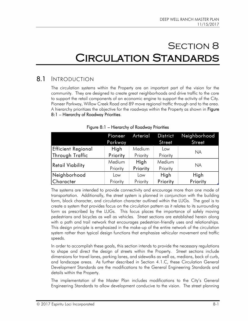
The circulation systems within the Property are an important part of the vision for the community. They are designed to create great neighborhoods and drive traffic to the core to support the retail components of an economic engine to support the activity of the City. Pioneer Parkway, Willow Creek Road and 89 move regional traffic through and to the area. A hierarchy prioritizes the objective for the roadways within the Property as shown in Figure 8:1 – Hierarchy of Roadway Priorities.
Figure 8:1 – Hierarchy of Roadway Priorities
Column1 Pioneer
Parkway
Arterial District
Street
Neighborhood
Street
Efficient Regional
Through Traffic
High
Priority
Medium
Priority
Low
PriorityNA
Retail ViabilityMedium
Priority
High
Priority
Medium
PriorityNA
Neighborhood
Character
Low
Priority
Low
Priority
High
Priority
High
Priority
The systems are intended to provide connectivity and encourage more than one mode of transportation. Additionally, the street system is planned in conjunction with the building form, block character, and circulation character outlined within the LUGs. The goal is to create a system that provides focus on the circulation pattern as it relates to its surrounding form as prescribed by the LUGs. This focus places the importance of safely moving pedestrians and bicycles as well as vehicles. Street sections are established herein along with a path and trail network that encourages pedestrian-friendly uses and relationships. This design principle is emphasized in the make-up of the entire network of the circulation system rather than typical design functions that emphasize vehicular movement and traffic speeds.
In order to accomplish these goals, this section intends to provide the necessary regulations to shape and direct the design of streets within the Property. Street sections include dimensions for travel lanes, parking lanes, and sidewalks as well as, medians, back of curb, and landscape areas. As further described in Section 4.1.C, these Circulation General Development Standards are the modifications to the General Engineering Standards and details within the Property.
The implementation of the Master Plan includes modifications to the City’s General Engineering Standards to allow development conducive to the vision. The street planning
DEEP WELL RANCH MASTER PLAN 11/15/2017
8-2 © 2017 Espiritu Loci Incorporated
strategy for the community is to create a flexible framework that can allow for a wide variety of future diverse uses, intensities and densities. The functional street classification system for the community is compatible with the traditional city street classification categories, while altering the operational and physical characteristics to support the land use patterns and form planned for the Property. The goal is to create a vibrant living community with multi-modal transportation opportunities and a pedestrian friendly environment while maintaining necessary minimum requirements for vehicle access.
DEEP WELL RANCH MASTER PLAN 11/15/2017
© 2017 Espiritu Loci Incorporated 8-3
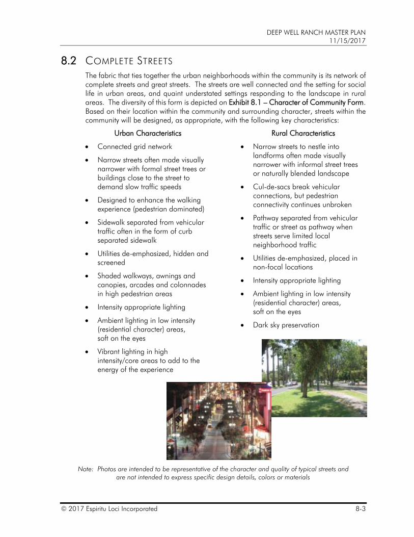
8.2 COMPLETE STREETS
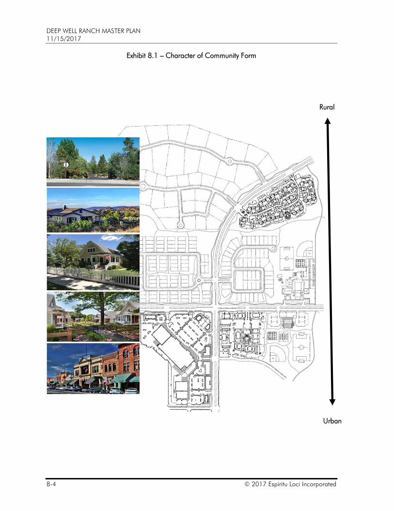
The fabric that ties together the urban neighborhoods within the community is its network of complete streets and great streets. The streets are well connected and the setting for social life in urban areas, and quaint understated settings responding to the landscape in rural areas. The diversity of this form is depicted on Exhibit 8.1 – Character of Community Form. Based on their location within the community and surrounding character, streets within the community will be designed, as appropriate, with the following key characteristics:
Urban Characteristics
Connected grid network
Narrow streets often made visually narrower with formal street trees or buildings close to the street to demand slow traffic speeds
Designed to enhance the walking experience (pedestrian dominated)
Sidewalk separated from vehicular traffic often in the form of curb separated sidewalk
Utilities de-emphasized, hidden and screened
Shaded walkways, awnings and canopies, arcades and colonnades in high pedestrian areas
Intensity appropriate lighting
Ambient lighting in low intensity (residential character) areas, soft on the eyes
Vibrant lighting in high intensity/core areas to add to the energy of the experience
Rural Characteristics
Narrow streets to nestle into landforms often made visually narrower with informal street trees or naturally blended landscape
Cul-de-sacs break vehicular connections, but pedestrian connectivity continues unbroken
Pathway separated from vehicular traffic or street as pathway when streets serve limited local neighborhood traffic
Utilities de-emphasized, placed in non-focal locations
Intensity appropriate lighting
Ambient lighting in low intensity (residential character) areas, soft on the eyes
Dark sky preservation
Note: Photos are intended to be representative of the character and quality of typical streets and are not intended to express specific design details, colors or materials
DEEP WELL RANCH MASTER PLAN 11/15/2017
8-4 © 2017 Espiritu Loci Incorporated
Exhibit 8.1 – Character of Community Form
Rural
Urban
DEEP WELL RANCH MASTER PLAN 11/15/2017
© 2017 Espiritu Loci Incorporated 8-5
8.3 TRANSPORTATION AND TRAFFIC REPORTS 1. The Master Transportation Report for the Property provides the basic concept for the
circulation system within the Property; however, the detailed traffic impact analysis analyzes the need for the number of lanes and other circulation improvements for the roadways depicted in Exhibit 8.2 – Roadway Hierarchy and intersections depicted in Exhibit 8.40-Conceptual Intersection Spacing based on further updates to the Master Transportation Report.
2. A more detailed analysis to address changes in a LUG(s) and adjacent LUG(s) may occur as development progresses and densities are designated.
3. Updates to the Master Transportation Report may be required if significant changes are made to the land uses and assumptions utilized to prepare the Master Transportation Plan.
4. The Master Transportation Report for the Property shall be used to determine basic roadway requirements including roadway type, classification, rights of way, dimensions, number of lanes, medians and speeds for all internal streets except SR 89 and Willow Creek Road from SR 89 to Pioneer Parkway.
8.4 PUBLIC RIGHT OF WAY STANDARDS
A. General
1. Rights of way (“ROW”) within the Property are intended to be public or private streets utilized by pedestrians, bicycles and vehicles to provide access to parcels, lots and open spaces. Streets shall be provided such that the arrangement, character, width and grade are in general conformance with this Master Plan.
2. Roadways shall be designed in context with the urban or rural character and the LUG through which they pass.
3. Roadways may be designed with altered design speeds, widths and sections as the ROW passes from one LUG to another.
4. Roadways within urban areas shall be designed to complement the pedestrian experience while having the ability to move vehicles through the Property.
5. Design conflict between pedestrian and vehicular movement generally shall be decided in favor of the pedestrian.
6. Within LUG GU and D pedestrian comfort shall be the primary consideration of the ROW.
7. Within rural areas, on Neighborhood streets and where vehicular traffic is considered lower volume pedestrians, bicycles and vehicles may share the roadway.
8. Cul-de-sacs and hammerheads shall generally be limited to Neighborhood streets and Service Lanes unless providing motor court access, service access or when a through route is not practical or detracts from the built form. Temporary Cul-de-sacs may terminate phased roadway development.
9. Each lot shall have frontage on a ROW or tract, or an access easement that connects to a ROW or tract. Residential lot driveway access to an arterial or District Street shall be restricted to avoid vehicles backing out onto the arterial.
DEEP WELL RANCH MASTER PLAN 11/15/2017
8-6 © 2017 Espiritu Loci Incorporated
10. The City Engineer may approve modifications to the Circulation Standards during the Site Plan or subdivision plat process when proposed by the Master Plan Administrator.
11. Interim access may be provided via the interim street sections included herein.
B. Roadway Hierarchy, Typical Sections, and Character
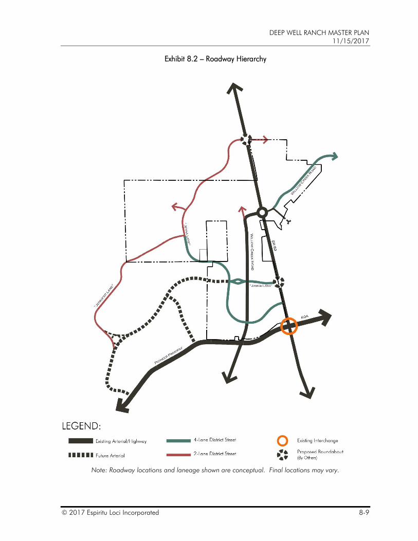
1. The primary roadway hierarchy within and around the Property includes arterials/highways and District Streets. Conceptual roadway alignments and hierarchy are depicted on Exhibit 8.2 – Roadway Hierarchy.
2. State Route 89, Pioneer Parkway/89a, Willow Creek Road west of 89 and the future extension of James Lane west of Jenna Lane shall follow local jurisdictional design standards.
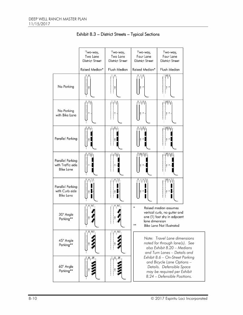
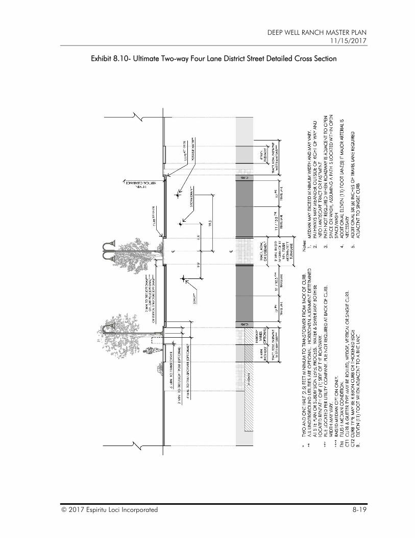
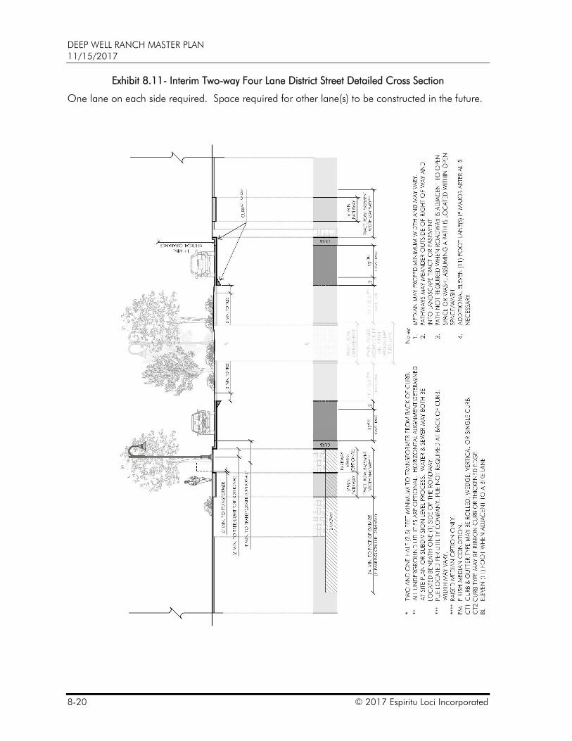
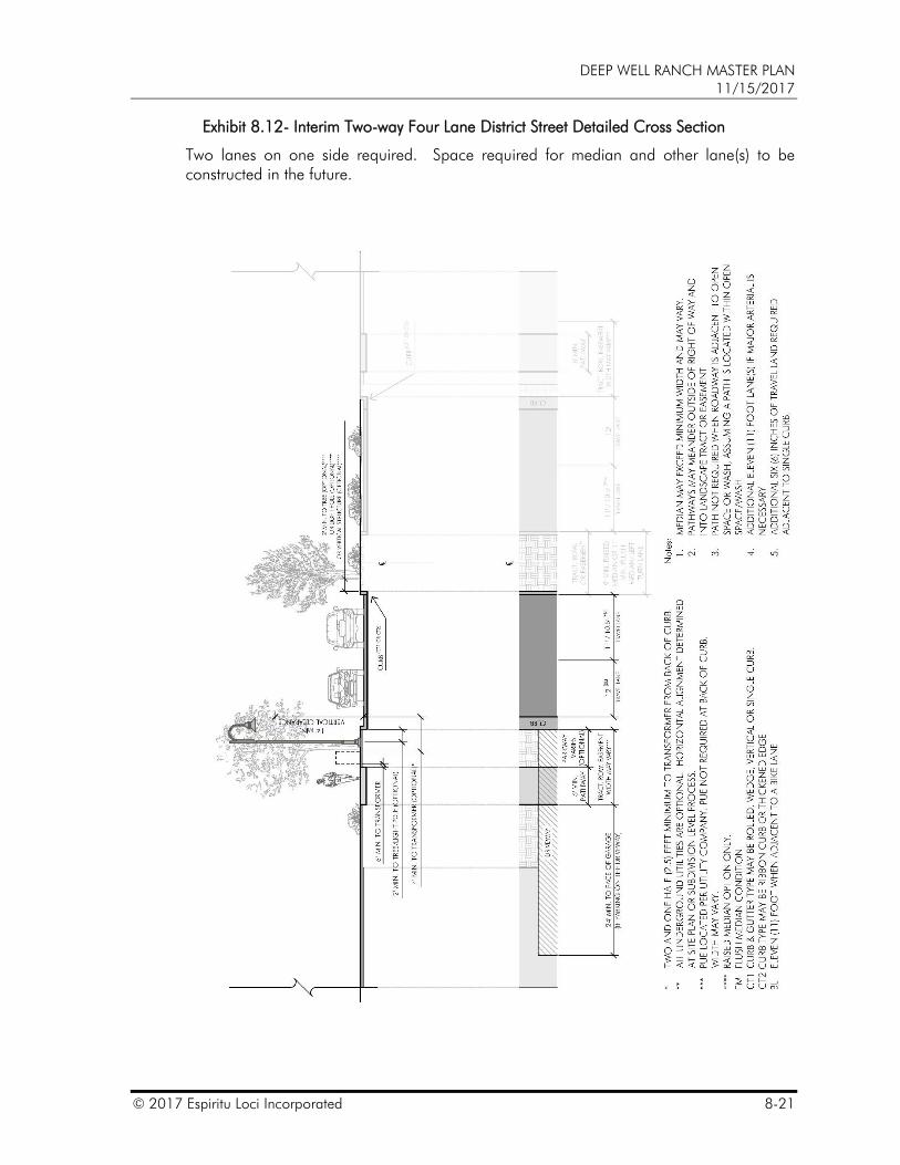
3. District Streets are allowed to be public (ROWs) or private (tracts). Typical roadway sections allowed for District Street are depicted on Exhibit 8.3 – District Streets – Typical Sections. District Streets construction may be phased. Interim sections allowed for District Streets are depicted on Exhibit 8.11 – Interim Two-way Four Lane District Street Detailed Cross Section and Exhibit 8.12 – Interim Two-way Four Lane District Street Cross Section.
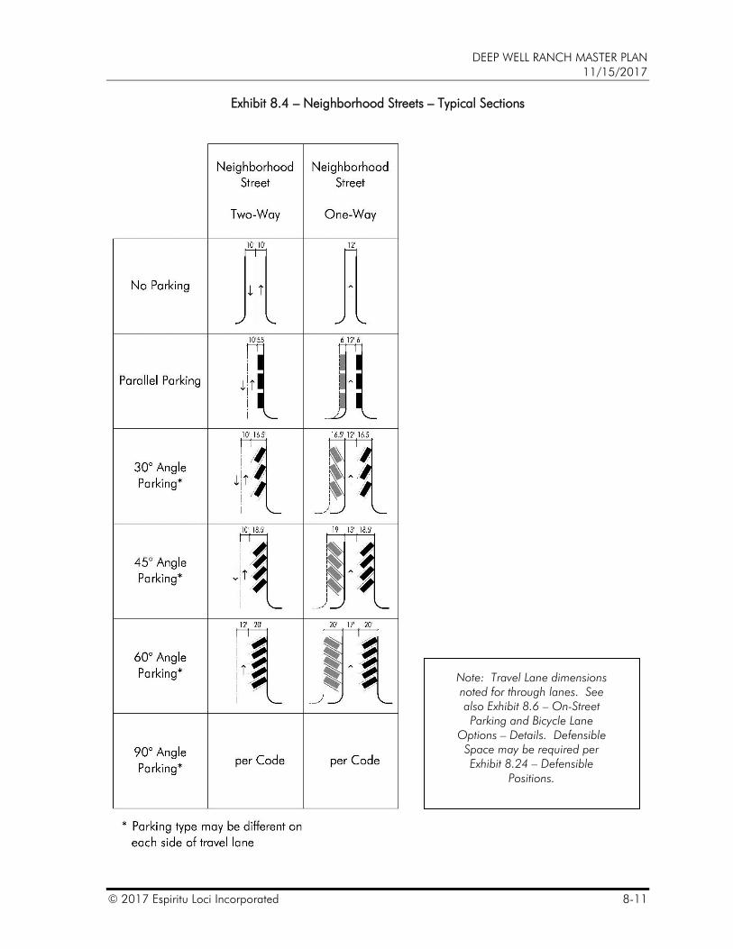
4. The remainder of the street network (that which is not arterial/highway or District Street) within the Property can be typified as Neighborhood Streets and are intended to provide a network that extends throughout the community. Neighborhood Streets are allowed to be public (ROWs) or private (tracts). Typical roadway sections allowed for Neighborhood Street are depicted on Exhibit 8.4 –Neighborhood Streets – Typical Sections. Neighborhood streets are designed to support residential as well as non-residential uses.
5. To the greatest extent possible the City shall work with the Master Plan Administrator to reduce the suggested posted speed limit and design speed for District Streets and Neighborhood Streets to match with the intention of lowering the actual travel speeds on the roadways. When possible, District Streets should be designed and posted for a maximum speed of thirty-five (35) miles per hour, and Neighborhood Streets should be designed and posted for a maximum speed of twenty-five (25) miles per hour.
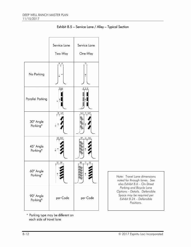
6. Service Lanes (also known as alleys) are intended to provide access to supporting areas and uses of the community. Service lanes are not required. Service Lanes are allowed to be public (ROWs) or private (tracts or easements). Typical roadway sections allowed for Service Lanes are depicted on Exhibit 8.5 – Service Lanes / Alleys – Typical Sections. Service Lanes may be used to provide access to individual lots.
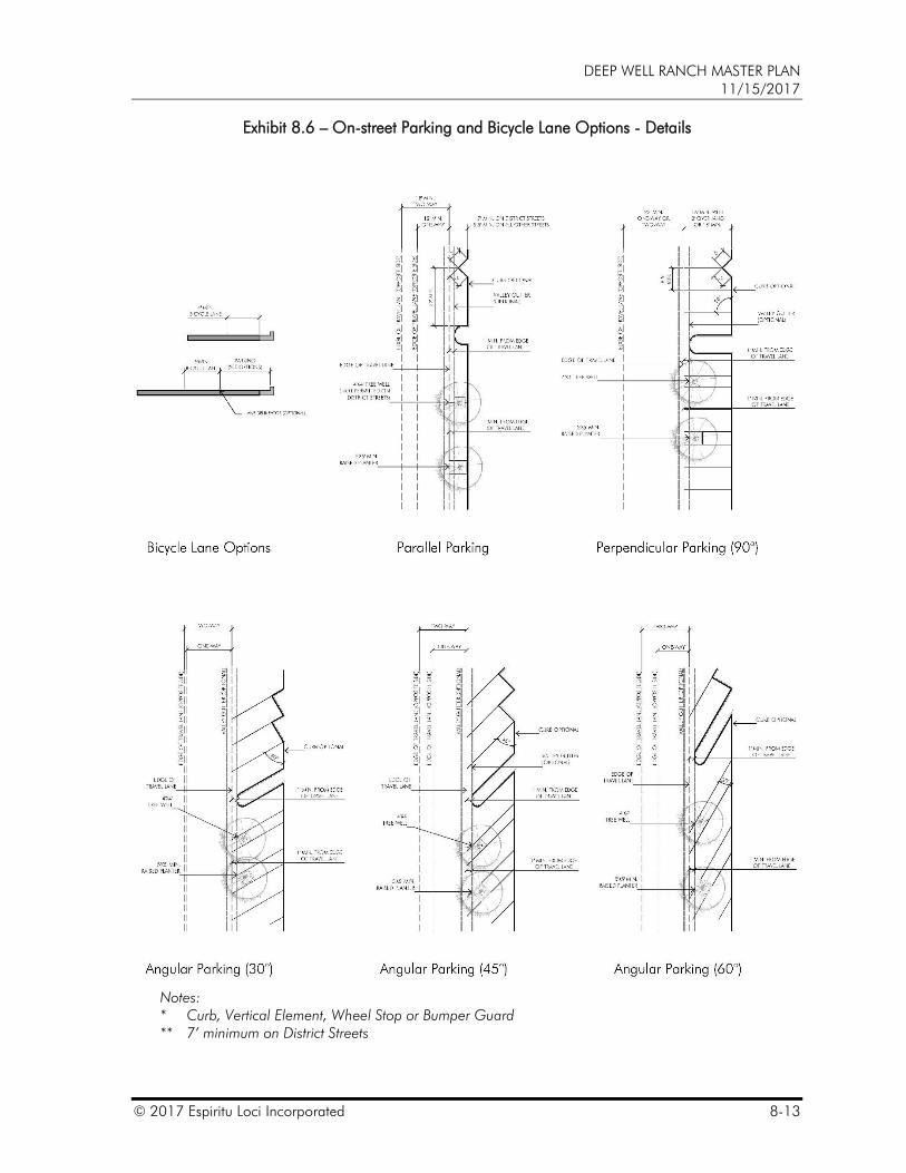
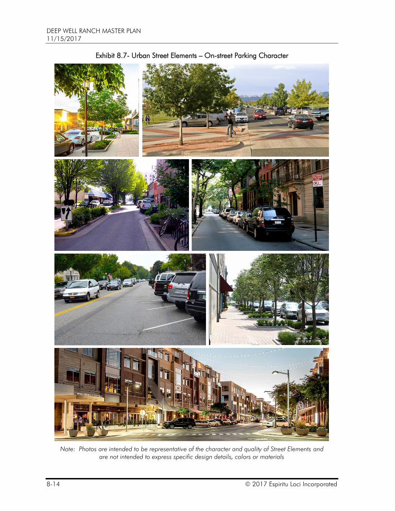
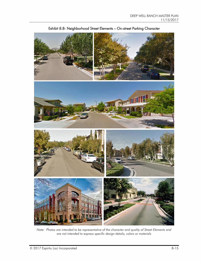
7. Parking and Bicycle- Lane options may be incorporated in or along District Streets, Neighborhood Streets and Service Lanes and are referred to as Street Elements. Exhibit 8.6 – On-street Parking and Bicycle Lane Options – Details provides acceptable options that can be used beyond the edge of the travel lane on various street cross sections for bicycle lanes, on-street parking and parking character. These concepts are further illustrated on Exhibit 8.7 – Urban Street Elements – On-street Parking Character and Exhibit 8.8 – Neighborhood Street Elements – On-street Parking Character. While bike lanes are included as an option, they are not required when a multi-use path is located along the roadway. Multi-use paths are
DEEP WELL RANCH MASTER PLAN 11/15/2017
© 2017 Espiritu Loci Incorporated 8-7
preferred over bike lanes, but bike lanes may be used instead of Multi-use paths when the roadway section is required to be wider than the minimum lane width requirements. Parking and bike lanes may be public (ROWs) or private (tracts or easements).
8. The combination of on-street parking and bicycle lanes along with the detailed street cross sections, turn lanes, cul-de-sacs, hammerheads, entry drives, turn-arounds, sidewalk, and sidewalk ramps provides the menu of cross sections for District Streets, Neighborhood Streets and Service Lanes. The following exhibits define the standards for District Streets, Neighborhood Streets, Service Lanes and Shared Drives that are considered acceptable ingress and egress for emergency and City service vehicles; are permitted within the Property.
Exhibit 8.2 – Roadway Hierarchy,
Exhibit 8.6 – On-street Parking and Bicycle Options – Details,
Exhibit 8.7- Urban Street Elements – On-street Parking Character,
Exhibit 8.8 – Neighborhood Street Elements – On-street Parking Character,
Exhibit 8.9 –,
Exhibit 8.10 – Ultimate Two-way Four Lane District Street Detailed Cross Section,
Exhibit 8.11 – Interim Two-way Four Lane District Street Detailed Cross Section,
Exhibit 8.12 – Interim Two-way Four Lane District Street Detailed Cross Section,
Exhibit 8.13 – Two-way Two Lane Raised Median District Street Detailed Cross Section,
Exhibit 8.14 – Two-way Two Lane Flush Median District Street Detailed Cross Section,
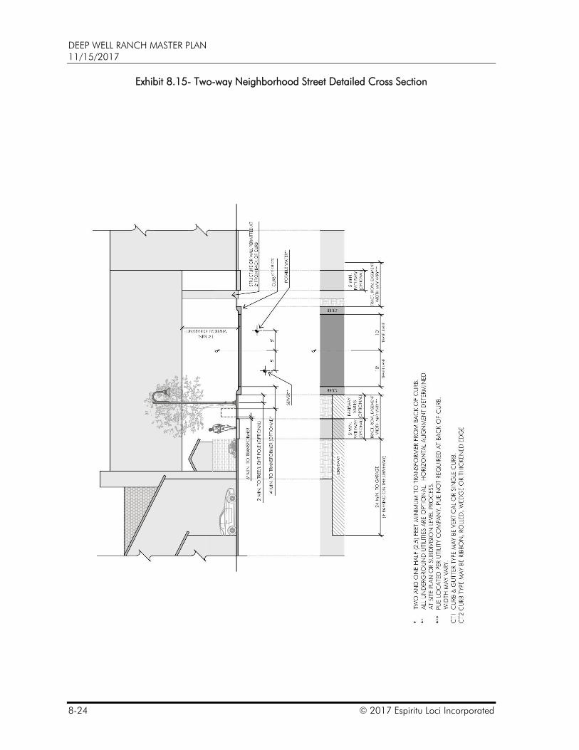
Exhibit 8.15 – Two-way Neighborhood Street Detailed Cross Section,
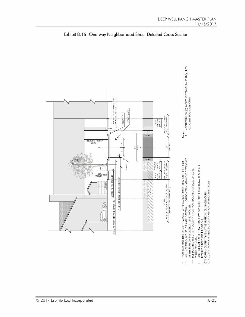
Exhibit 8.16 – One-way Neighborhood Street Detailed Cross Section,
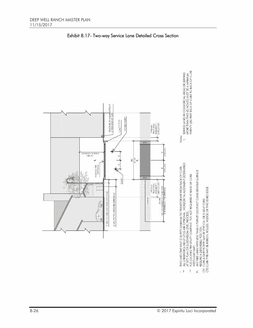
Exhibit 8.17 – Two-way Service Lane Detailed Cross Section,
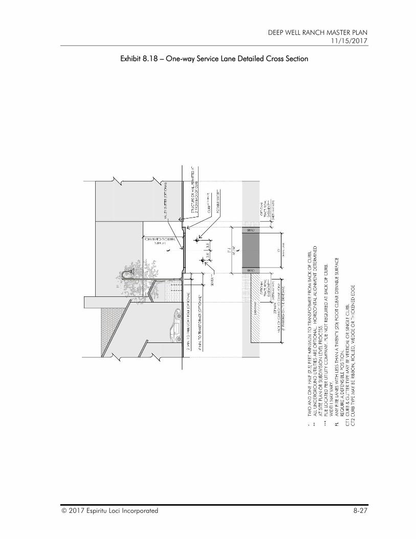
Exhibit 8.18 – One-way Service Lane Detailed Cross Section,
Exhibit 8.19 – Shared Drive Detailed Cross Section,
Exhibit 8.20 – Medians and Turn Lanes – Details,
Exhibit 8.21 – Maximum Block Length with Approved Turn-around,
Exhibit 8.22 – Maximum Block Length with Approved Turn-around,
Exhibit 8.23 – Methods of Two-points of Ingress and Egress,
Exhibit 8.24 – Defensible Positions,
Exhibit 8.25 – Sidewalk and Sidewalk Ramps,
Exhibit 8.26 – Sidewalk and Sidewalk Ramps at Choker,
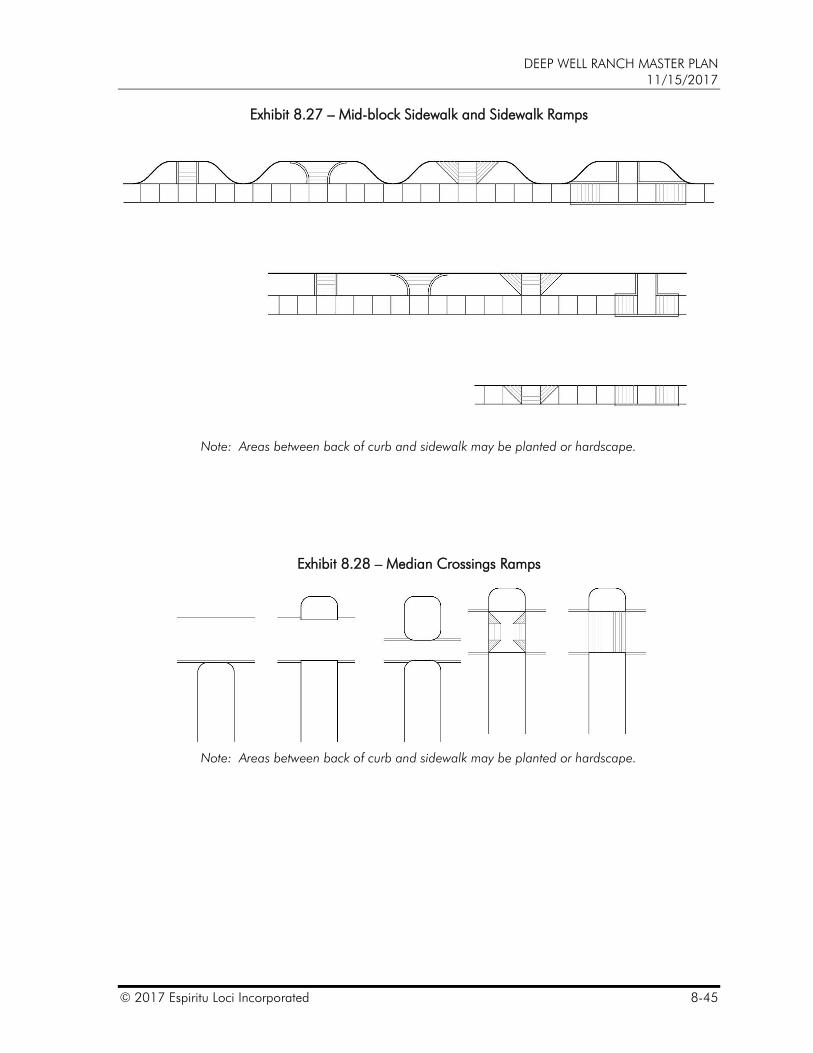
Exhibit 8.27 – Mid-block Sidewalk and Sidewalk Ramps,
Exhibit 8.28 – Median Crossings and Ramps,
Exhibit 8.29 – Conceptual Park and Ride and Bus Stop Locations,
DEEP WELL RANCH MASTER PLAN 11/15/2017
8-8 © 2017 Espiritu Loci Incorporated
Exhibit 8.30 – Cul-de-sacs,
Exhibit 8.31 – Hammerheads,
Exhibit 8.32 – Intermediate Turn-arounds,
Exhibit 8.33 – Conceptual Entry Drive,
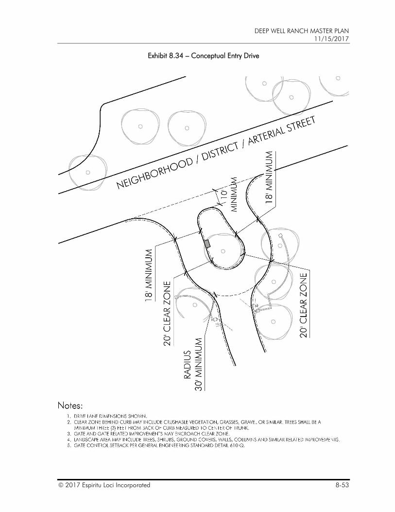
Exhibit 8.34 – Conceptual Entry Drive,
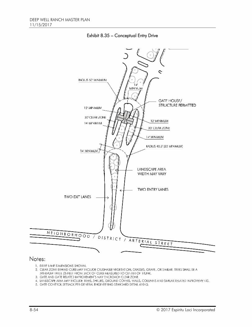
Exhibit 8.35 – Conceptual Entry Drive,
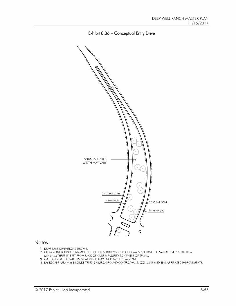
Exhibit 8.36 – Conceptual Entry Drive,
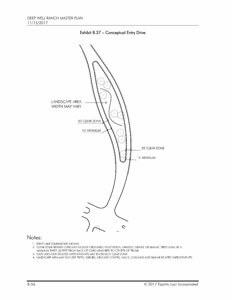
Exhibit 8.37 – Conceptual Entry Drive,
Exhibit 8.38 – Conceptual Entry Drive,
Exhibit 8.39 – Conceptual Entry Drive,
Exhibit 8.40 – Conceptual Intersection Spacing,
Exhibit 8.41 – Pedestrian and Bicycle Circulation,
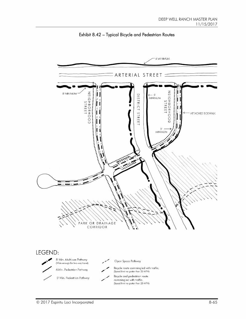
Exhibit 8.42 – Typical Bicycle and Pedestrian Routes,
Exhibit 8.43 – Pathways and Sidewalk Integration,
Exhibit 8.44 – Typical Pathway, Trail and Sidewalk Conditions
Exhibit 8.45 – Urban Walkways and Sidewalk Character and Elements,
Exhibit 8.46 – Urban Walkways and Sidewalk Character and Elements,
Exhibit 8.47 – Urban Walkways and Sidewalk Character and Elements, and
Exhibit 8.48 – Urban Walkways and Sidewalk Character and Elements.
DEEP WELL RANCH MASTER PLAN 11/15/2017
© 2017 Espiritu Loci Incorporated 8-9
Exhibit 8.2 – Roadway Hierarchy
Note: Roadway locations and laneage shown are conceptual. Final locations may vary.
DEEP WELL RANCH MASTER PLAN 11/15/2017
8-10 © 2017 Espiritu Loci Incorporated
Exhibit 8.3 – District Streets – Typical Sections
Note: Travel Lane dimensions noted for through lane(s). See
also Exhibit 8.20 – Medians and Turn Lanes – Details and
Exhibit 8.6 – On-Street Parking and Bicycle Lane Options – Details. Defensible Space may be required per Exhibit 8.24 – Defensible Positions.
DEEP WELL RANCH MASTER PLAN 11/15/2017
© 2017 Espiritu Loci Incorporated 8-11
Exhibit 8.4 – Neighborhood Streets – Typical Sections
Note: Travel Lane dimensions noted for through lanes. See also Exhibit 8.6 – On-Street Parking and Bicycle Lane
Options – Details. Defensible Space may be required per Exhibit 8.24 – Defensible
Positions.
DEEP WELL RANCH MASTER PLAN 11/15/2017
8-12 © 2017 Espiritu Loci Incorporated
Exhibit 8.5 – Service Lane / Alley – Typical Section
Note: Travel Lane dimensions noted for through lanes. See also Exhibit 8.6 – On-Street Parking and Bicycle Lane
Options – Details. Defensible Space may be required per Exhibit 8.24 – Defensible
Positions.
DEEP WELL RANCH MASTER PLAN 11/15/2017
© 2017 Espiritu Loci Incorporated 8-13
Exhibit 8.6 – On-street Parking and Bicycle Lane Options - Details
Notes: * Curb, Vertical Element, Wheel Stop or Bumper Guard ** 7’ minimum on District Streets
DEEP WELL RANCH MASTER PLAN 11/15/2017
8-14 © 2017 Espiritu Loci Incorporated
Exhibit 8.7- Urban Street Elements – On-street Parking Character
Note: Photos are intended to be representative of the character and quality of Street Elements and are not intended to express specific design details, colors or materials
DEEP WELL RANCH MASTER PLAN 11/15/2017
© 2017 Espiritu Loci Incorporated 8-15
Exhibit 8.8- Neighborhood Street Elements – On-street Parking Character
Note: Photos are intended to be representative of the character and quality of Street Elements and are not intended to express specific design details, colors or materials

DEEP WELL RANCH MASTER PLAN 11/15/2017
8-16 © 2017 Espiritu Loci Incorporated
Exhibit 8.9
(exhibit removed)
DEEP WELL RANCH MASTER PLAN 11/15/2017
© 2017 Espiritu Loci Incorporated 8-17
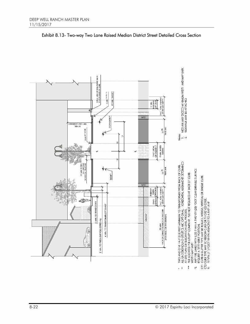
C. The following general notes apply to:
Exhibit 8.10 – Ultimate Two-way Four Lane District Street Detailed Cross Section,
Exhibit 8.11 – Interim Two-way Four Lane District Street Detailed Cross Section,
Exhibit 8.12 – Interim Two-way Four Lane District Street Detailed Cross Section,
Exhibit 8.13 – Two-way Two Lane Raised Median District Street Detailed Cross Section,
Exhibit 8.14 – Two-way Two Lane Flush Median District Street Detailed Cross Section,
Exhibit 8.15 – Two-way Neighborhood Street Detailed Cross Section,
Exhibit 8.16 – One-way Neighborhood Street Detailed Cross Section,
Exhibit 8.17 – Two-way Service Lane Detailed Cross Section,
Exhibit 8.18 – One-way Service Lane Detailed Cross Section, and
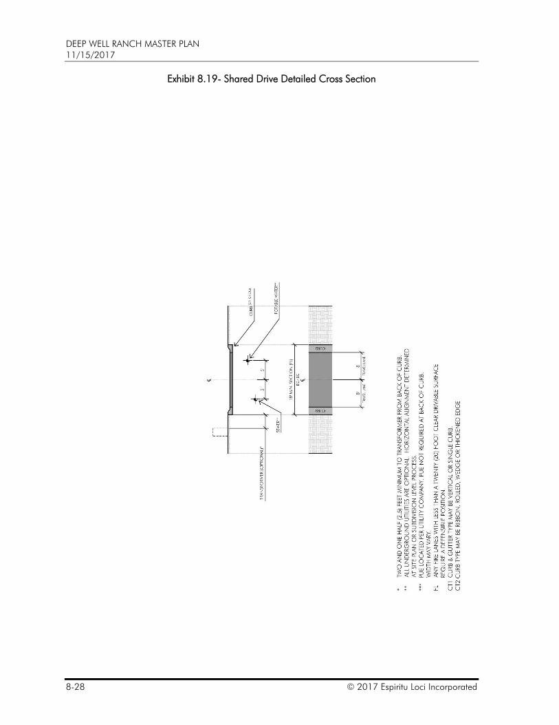
Exhibit 8.19 – Shared Drive Detailed Cross Section.
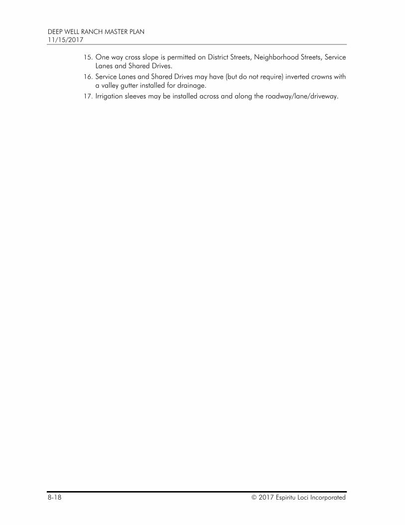
1. Trash collection on one-way streets shall be on the right side only.
2. Minimum vertical clearance requirement for trash collection under overhead structures is eighteen (18) feet for trash barrel collection and twenty-six (26) feet for trash bin collection.
3. Minimum vertical clearance requirement shall be per the General Engineering Standards or AASHTO requirements, whichever is greater.
4. Structures may encroach into ROW provided all structures encroaching into ROW are specifically approved by the City Engineer.
5. Typical utility locations shown; specific locations based on actual planned utilities.
6. Parking options may be added at the edge of travel lane for all Neighborhood and District streets.
7. Bicycle lanes are not required, but may be added at the edge of travel lane.
8. Bicycle lanes may be part of a fire lane, parking stall areas may not.
9. Parking on a Four Lane District Street is permitted provided that:
a. the travel lane nearest to the parking is at least as wide as required on Exhibit 8.6 – On-street Parking and Bicycle Options – Details, and,
b. no more than one (1) travel lane is encumbered by required parking maneuvers.
10. Integral color concrete may be used.
11. Concrete may include a stamp finish. Coloring may be added or applied.
12. Roadways may include specialty paving (including but not limited to pavers, concrete, brick or stone pavers). When included, a band to delineate the start and stop of the specialty paving may be required.
13. The design speed and posted speed are permitted to be the same.
14. Vehicular access to a lot or parcel for residential or other uses may be provided by a Service Lane.
DEEP WELL RANCH MASTER PLAN 11/15/2017
8-18 © 2017 Espiritu Loci Incorporated
15. One way cross slope is permitted on District Streets, Neighborhood Streets, Service Lanes and Shared Drives.
16. Service Lanes and Shared Drives may have (but do not require) inverted crowns with a valley gutter installed for drainage.
17. Irrigation sleeves may be installed across and along the roadway/lane/driveway.
DEEP WELL RANCH MASTER PLAN 11/15/2017
© 2017 Espiritu Loci Incorporated 8-19
Exhibit 8.10- Ultimate Two-way Four Lane District Street Detailed Cross Section
DEEP WELL RANCH MASTER PLAN 11/15/2017
8-20 © 2017 Espiritu Loci Incorporated
Exhibit 8.11- Interim Two-way Four Lane District Street Detailed Cross Section
One lane on each side required. Space required for other lane(s) to be constructed in the future.
DEEP WELL RANCH MASTER PLAN 11/15/2017
© 2017 Espiritu Loci Incorporated 8-21
Exhibit 8.12- Interim Two-way Four Lane District Street Detailed Cross Section
Two lanes on one side required. Space required for median and other lane(s) to be constructed in the future.
DEEP WELL RANCH MASTER PLAN 11/15/2017
8-22 © 2017 Espiritu Loci Incorporated
Exhibit 8.13- Two-way Two Lane Raised Median District Street Detailed Cross Section

DEEP WELL RANCH MASTER PLAN 11/15/2017
© 2017 Espiritu Loci Incorporated 8-23
Exhibit 8.14- Two-way Two Lane Flush Median District Street Detailed Cross Section
DEEP WELL RANCH MASTER PLAN 11/15/2017
8-24 © 2017 Espiritu Loci Incorporated
Exhibit 8.15- Two-way Neighborhood Street Detailed Cross Section
DEEP WELL RANCH MASTER PLAN 11/15/2017
© 2017 Espiritu Loci Incorporated 8-25
Exhibit 8.16- One-way Neighborhood Street Detailed Cross Section
DEEP WELL RANCH MASTER PLAN 11/15/2017
8-26 © 2017 Espiritu Loci Incorporated
Exhibit 8.17- Two-way Service Lane Detailed Cross Section
DEEP WELL RANCH MASTER PLAN 11/15/2017
© 2017 Espiritu Loci Incorporated 8-27
Exhibit 8.18 – One-way Service Lane Detailed Cross Section
DEEP WELL RANCH MASTER PLAN 11/15/2017
8-28 © 2017 Espiritu Loci Incorporated
Exhibit 8.19- Shared Drive Detailed Cross Section
DEEP WELL RANCH MASTER PLAN 11/15/2017
© 2017 Espiritu Loci Incorporated 8-29
D. On-street Parking
1. Exhibit 8.6 - On-street Parking and Bicycle Lane Options - Details provides a list of detailed options that can be used beyond the edge of the travel lane on various street cross sections.
2. Public on-street parking may be within the ROW.
3. Private on-street parking (private parking immediately accessible from the roadway with the roadway acting as a parking drive aisle) may be adjacent to the ROW with a ribbon curb or valley gutter defining the edge of the ROW. Private on-street parking may be within a tract or easement.
4. Parking is allowed only on paved parking surfaces (except temporary parking). Pavement may be concrete, asphalt, a porous material, or other material approved by the City Engineer. Where decomposed granite or similar porous pavement is used, it shall conform to ADA guidelines.
5. Public or private on-street parking spaces may be used to accommodate the required parking of adjacent properties.
6. Parking may overhang landscape or hardscape by two (2) feet. Parking may likewise overhang required pathways by two (2) feet when the minimum required pathway width is maintained exclusive of the overhang. In either case, the length of a parking stall (paved area) may be reduced by overhang length when overhang is provided.
7. All parking spaces may be marked or denoted, and the paved area shall be properly drained or appropriately designed to handle stormwater storage. Changes in paving type, texture, color, curb design, tree placement, painted stripes or similar elements may be used to denote parking stalls. Parallel parking stalls along streets, Service Lanes, drives or access ways do not require striping for individual parking stalls.
8. Private on-street parking spaces may be publicly or privately metered by a pay per use, lease, long term purchase or other similar agreement.
9. Public on-street parking spaces may be publicly metered by a pay per use or other similar agreement by the City or the Master Plan Administrator.
10. Availability of public on-street parking for “reserved”, “loading” or other such use may be designated at any time so long as such designation is not intended to reserve spaces for a specific or individual user. On public streets and Service Lanes, the designation shall be made and monitored by the Master Plan Administrator. The City shall not be responsible to make, monitor or maintain such designations.
11. Availability of private on-street parking for “reserved”, “guest”, “loading” or other such use may be designated at any time. Along public streets and Service Lanes, the designation shall be made and monitored by the Master Plan Administrator. The City shall not be responsible to make, monitor or maintain such designations.
12. Vehicle charging stations or other alternative energy solutions may be provided as part of the parking stall without additional space requirements so long as the typical alternative vehicle’s size is accommodated.
DEEP WELL RANCH MASTER PLAN 11/15/2017
8-30 © 2017 Espiritu Loci Incorporated
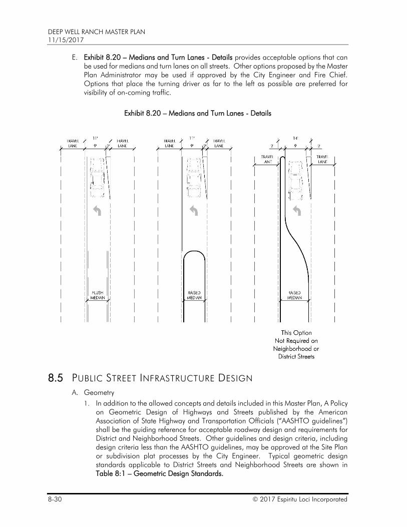
E. Exhibit 8.20 – Medians and Turn Lanes - Details provides acceptable options that can be used for medians and turn lanes on all streets. Other options proposed by the Master Plan Administrator may be used if approved by the City Engineer and Fire Chief. Options that place the turning driver as far to the left as possible are preferred for visibility of on-coming traffic.
Exhibit 8.20 – Medians and Turn Lanes - Details
8.5 PUBLIC STREET INFRASTRUCTURE DESIGN
A. Geometry
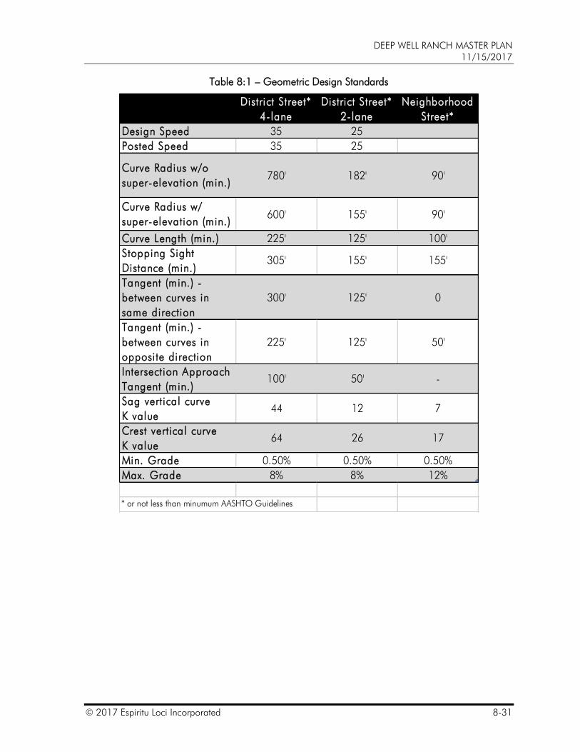
1. In addition to the allowed concepts and details included in this Master Plan, A Policy on Geometric Design of Highways and Streets published by the American Association of State Highway and Transportation Officials (“AASHTO guidelines”) shall be the guiding reference for acceptable roadway design and requirements for District and Neighborhood Streets. Other guidelines and design criteria, including design criteria less than the AASHTO guidelines, may be approved at the Site Plan or subdivision plat processes by the City Engineer. Typical geometric design standards applicable to District Streets and Neighborhood Streets are shown in Table 8:1 – Geometric Design Standards.
DEEP WELL RANCH MASTER PLAN 11/15/2017
© 2017 Espiritu Loci Incorporated 8-31
Table 8:1 – Geometric Design Standards
Column1 District Street*
4-lane
District Street*
2-lane
Neighborhood
Street*
Design Speed 35 25
Posted Speed 35 25
Curve Radius w/o
super-elevation (min.)780' 182' 90'
Curve Radius w/
super-elevation (min.)600' 155' 90'
Curve Length (min.) 225' 125' 100'
Stopping Sight
Distance (min.)305' 155' 155'
Tangent (min.) -
between curves in
same direction
300' 125' 0
Tangent (min.) -
between curves in
opposite direction
225' 125' 50'
Intersection Approach
Tangent (min.)100' 50' -
Sag vertical curve
K value44 12 7
Crest vertical curve
K value64 26 17
Min. Grade 0.50% 0.50% 0.50%
Max. Grade 8% 8% 12%
* or not less than minumum AASHTO Guidelines
DEEP WELL RANCH MASTER PLAN 11/15/2017
8-32 © 2017 Espiritu Loci Incorporated
2. Travel Lanes
a. The width of a Travel Lane on a District Street is eleven (11) feet. The inside Travel Lane width can be reduced to ten and one-half (10.5) feet with a curb and gutter when adjacent to a raised median. The inside Travel Lane width shall be at least eleven and one-half (11.5) with a single curb when adjacent to a raised median. The inside Travel Lane width can be reduced to ten (10) feet when adjacent to a flush median. Refer to Exhibit 8.3 – District Streets – Typical Sections.
b. The typical width of a Travel Lane on a Neighborhood Street is ten (10) feet. Refer to Exhibit 8.4 – Neighborhood Streets – Typical Sections.
c. The typical width of a Travel Lane on a Service Lane or Shared Drive is eight (8) feet. Refer to Exhibit 8.5 – Service Lane / Alley – Typical Section.
3. ROW is allowed at back of curb and as depicted on:
Exhibit 8.10 – Ultimate Two-way Four Lane District Street Detailed Cross Section,
Exhibit 8.11 – Interim Two-way Four Lane District Street Detailed Cross Section,
Exhibit 8.12 – Interim Two-way Four Lane District Street Detailed Cross Section,
Exhibit 8.13 – Two-way Two Lane Raised Median District Street Detailed Cross Section,
Exhibit 8.14 – Two-way Two Lane Flush Median District Street Detailed Cross Section,
Exhibit 8.15 – Two-way Neighborhood Street Detailed Cross Section,
Exhibit 8.16 – One-way Neighborhood Street Detailed Cross Section,
Exhibit 8.17 – Two-way Service Lane Detailed Cross Section,
Exhibit 8.18 – One-way Service Lane Detailed Cross Section, and
Exhibit 8.19 – Shared Drive Detailed Cross Section.
4. Horizontal Curve
a. See Table 8:1 – Geometric Design Standards for acceptable horizontal curve standards.
5. Stopping Distance
6. See Table 8:1 – Geometric Design Standards for acceptable stopping distance standards.Super-elevation
a. Super-elevation of may be used in conjunction with the minimum horizontal radius. In such case, the minimum radius may be reduced.
b. Super-elevation up to four (4) percent may be utilized. Super-elevation greater than four (4) percent may be utilized with the approval of the City Engineer.
c. A stormdrain system is required when a super-elevated roadway includes a raised median; a stormdrain system is not required when a super-elevated roadway includes a flush median or no median.
d. See Section 11 – Grading and Drainage Standards.
DEEP WELL RANCH MASTER PLAN 11/15/2017
© 2017 Espiritu Loci Incorporated 8-33
7. Stormwater storage in a median shall be designed to avoid regular deposit of sedimentation in a Travel Lane. A flush median may include landscape.
8. Tangents and Compound Curves
a. The minimum tangent length is determined by the design speed.
b. A minimum tangent is not required on a Service Lane.
c. On a District Street, a tangent section is not required between two (2) curves that curve in the opposite direction when a minimum radius of each curve is at least fifty (50) percent greater than the minimum with the approval of the City Engineer.
d. A tangent section between two (2) curves that curve in the opposite direction is not required on a Neighborhood Street or Service Lane.
e. Compound curves (two (2) curves in the same direction with different radii in the same direction) are acceptable with the approval of the City Engineer.
9. Roadway Grade
a. Up to twelve (12) percent roadway grades are permitted as depicted in Table 8:1 – Geometric Design Standards.
10. Intersection Spacing
a. Intersections on arterial and District Streets are allowed as generally depicted on Exhibit 8.40 – Conceptual Intersection Spacing and the Master Transportation Report.
b. Centerline offsets of less than 200 feet should be avoided. Neighborhood street intersection spacing shall typically be 125 feet or greater measured centerline to centerline. Neighborhood street intersection spacing of forty (40) feet or greater is allowed at or around a park or open space with one-way circulation and with two-way circulation when approved by the City Engineer. Intersection spacing is measured centerline to centerline.
c. Neighborhood street intersection spacing requirements do not apply around neighborhood accents as conceptually depicted in Exhibit 9.8 – Conceptual Neighborhood Accents.
11. Auxiliary Lanes
a. A minimum auxiliary lane width of ten (10) feet is allowed. Refer to Exhibit 8.20 – Medians and Turn Lanes - Details. Lane entering taper length of ninety (90) feet is allowed. A minimum right turn storage length of sixty (60) feet is allowed on District Streets and Neighborhood Streets. The minimum allowed length shall be 100 feet when at a signalized intersection.
b. Dedicated left-turn, right-turn and accelerations lanes are based on the Master Transportation Report and subsequent updates.
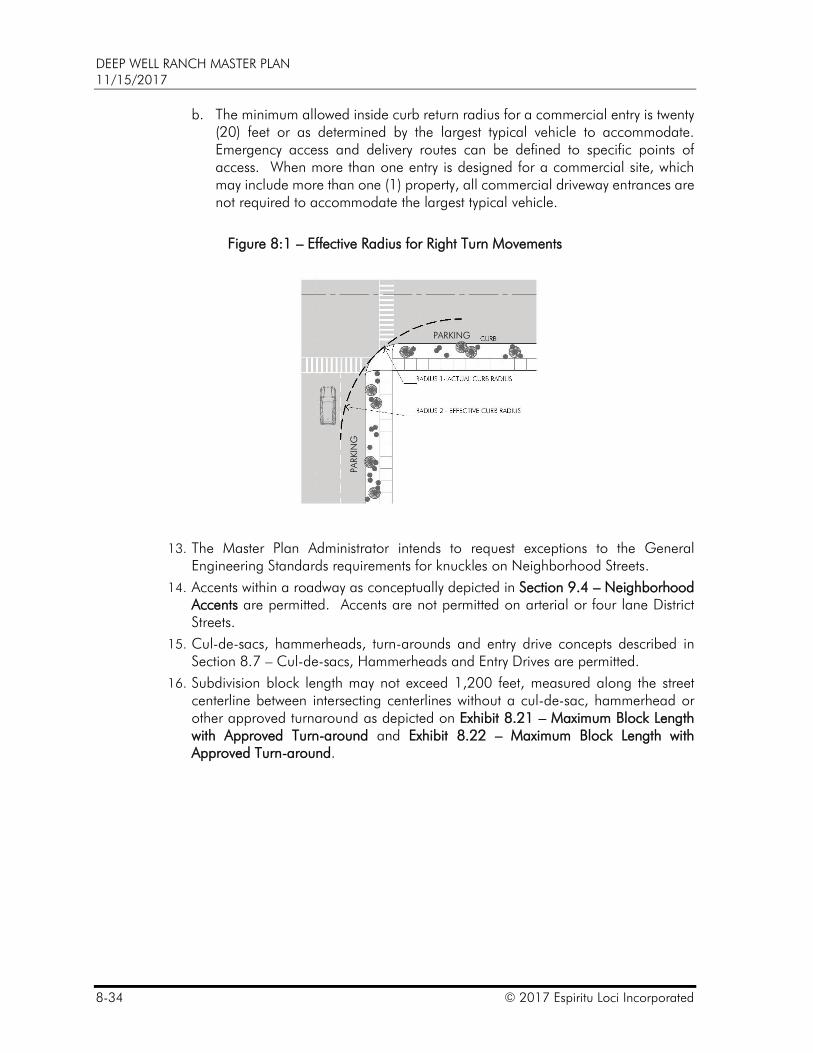
12. Curb Return Radius
a. A curb return shall be clear of the effective turning radius for right turn movements at an intersection. The City Engineer may require a traffic impact and/or auto-turn analysis to determine curb radii. The minimum curb return radius is five (5) feet. See Figure 8:1 – Effective Radius for Right Turn Movements.
DEEP WELL RANCH MASTER PLAN 11/15/2017
8-34 © 2017 Espiritu Loci Incorporated
b. The minimum allowed inside curb return radius for a commercial entry is twenty (20) feet or as determined by the largest typical vehicle to accommodate. Emergency access and delivery routes can be defined to specific points of access. When more than one entry is designed for a commercial site, which may include more than one (1) property, all commercial driveway entrances are not required to accommodate the largest typical vehicle.
Figure 8:1 – Effective Radius for Right Turn Movements
13. The Master Plan Administrator intends to request exceptions to the General Engineering Standards requirements for knuckles on Neighborhood Streets.
14. Accents within a roadway as conceptually depicted in Section 9.4 – Neighborhood Accents are permitted. Accents are not permitted on arterial or four lane District Streets.
15. Cul-de-sacs, hammerheads, turn-arounds and entry drive concepts described in Section 8.7 – Cul-de-sacs, Hammerheads and Entry Drives are permitted.
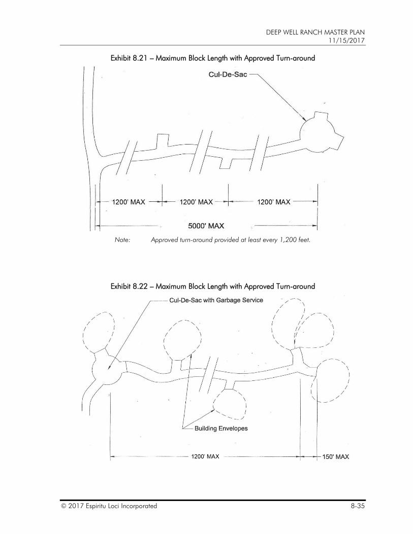
16. Subdivision block length may not exceed 1,200 feet, measured along the street centerline between intersecting centerlines without a cul-de-sac, hammerhead or other approved turnaround as depicted on Exhibit 8.21 – Maximum Block Length with Approved Turn-around and Exhibit 8.22 – Maximum Block Length with Approved Turn-around.
PARKING
g
PARKIN
G
DEEP WELL RANCH MASTER PLAN 11/15/2017
© 2017 Espiritu Loci Incorporated 8-35
Exhibit 8.21 – Maximum Block Length with Approved Turn-around
Note: Approved turn-around provided at least every 1,200 feet.
Exhibit 8.22 – Maximum Block Length with Approved Turn-around
DEEP WELL RANCH MASTER PLAN 11/15/2017
8-36 © 2017 Espiritu Loci Incorporated
B. City Services and Fire Department Access and Markings
1. While it is the intent of the fire department to establish requirements based on nationally recognized practices for safeguarding life and property from hazards of fire, the Fire Chief may approve development standards that deviate from nationally recognized practices. In order to create a character that is unique to Prescott and enhance the daily quality of life without jeopardizing the ability of the fire department to perform their duties, the development standards of this Master Plan have been approved for use on the Property. This may only be done so long as: circulation and access are sufficient for fire service vehicles, at least one (1) 100-year design storm event all-weather access route is provided, and minimum fire flows are delivered where required.
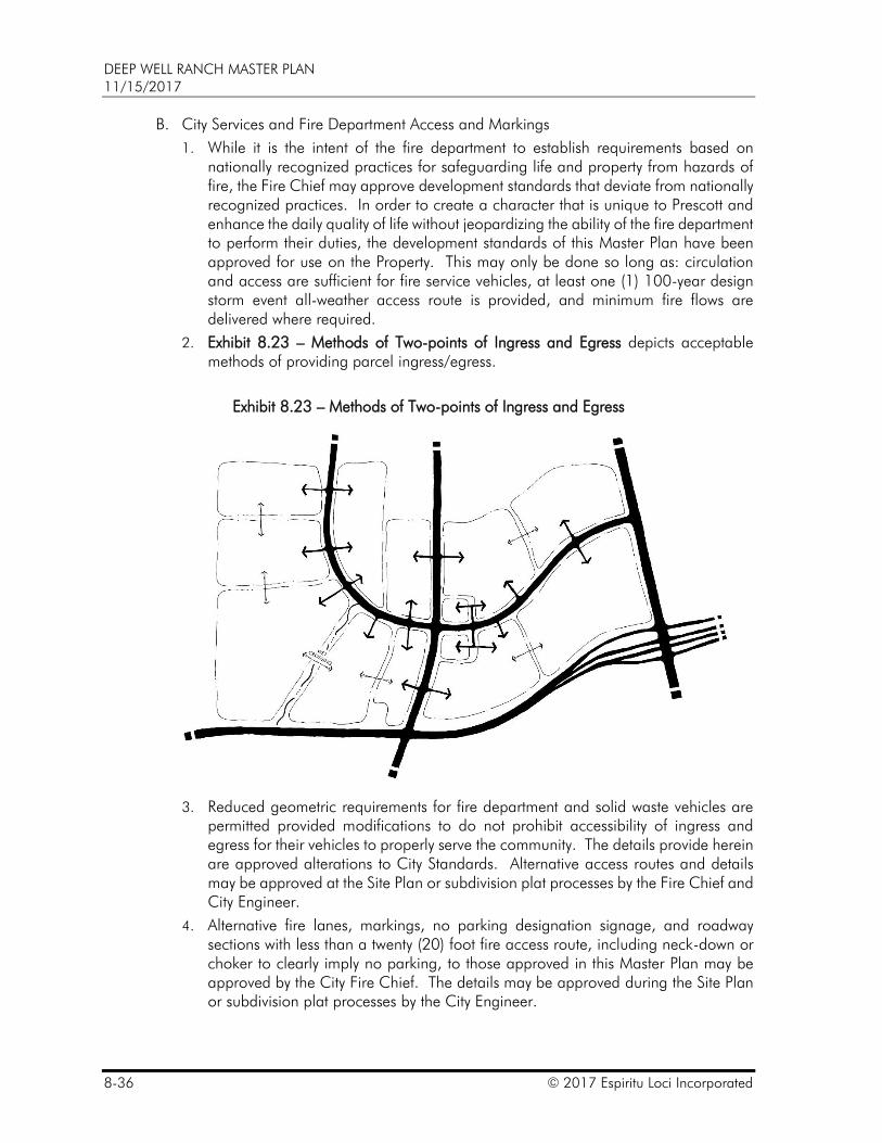
2. Exhibit 8.23 – Methods of Two-points of Ingress and Egress depicts acceptable methods of providing parcel ingress/egress.
Exhibit 8.23 – Methods of Two-points of Ingress and Egress
3. Reduced geometric requirements for fire department and solid waste vehicles are permitted provided modifications to do not prohibit accessibility of ingress and egress for their vehicles to properly serve the community. The details provide herein are approved alterations to City Standards. Alternative access routes and details may be approved at the Site Plan or subdivision plat processes by the Fire Chief and City Engineer.
4. Alternative fire lanes, markings, no parking designation signage, and roadway sections with less than a twenty (20) foot fire access route, including neck-down or choker to clearly imply no parking, to those approved in this Master Plan may be approved by the City Fire Chief. The details may be approved during the Site Plan or subdivision plat processes by the City Engineer.
DEEP WELL RANCH MASTER PLAN 11/15/2017
© 2017 Espiritu Loci Incorporated 8-37
5. A cul-de-sac, hammerhead or alternative turn-around that is also a fire access route shall accommodate an outside radius of thirty-six and one-half (36.5) feet with a minimum four (4) foot clear zone, or a forty and one-half (40.5) foot clear zone radius.
6. An additional four (4) feet shall be provided, when necessary, for trash container clearance. In such instance, the outside radius shall be a minimum forty-four and one-half (44.5) feet.
7. A minimum inside turn radius of twenty-eight (28) feet shall be provided. See Figure 8:1 – Effective Turn Radius for Right Turn Maneuver.
8. The Fire Chief, or designee, may request virtual vehicle plans (autoturn) to demonstrate adequate space for turning maneuvers. The vehicle path may use the entire fire accessway on virtual vehicle plans.
9. A fire accessway on a one-way roadway shall not be less than twelve (12) feet wide for limited distances measured from edge of pavement to edge of pavement.
a. Chokers or bump-outs that reduce roadway width to less than twenty (20) feet are permitted at intersections to discourage on-street parking.
10. A driveway in excess of 150’ measured from roadway back of curb to the primary structure shall be a minimum twelve (12) feet in width with a minimum sixteen (16) foot clear zone and provide a turn-around.
11. A driveway in excess of 200’ measured from roadway back of curb to the primary structure that is less than twelve (12) feet in width shall provide a thirty (30) foot long by six (6) foot deep turnout in addition to a turn-around.
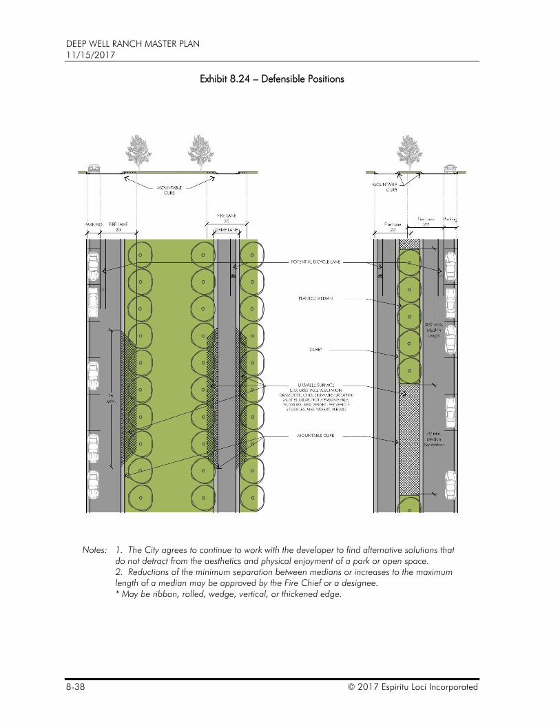
12. Where a fire lane is required, and the street pavement width including bicycle lanes (excluding the area for parked vehicles) does not accommodate the entire fire lane width, a defensible position is required. Defensible positions along these roads shall be as detailed in Exhibit 8.24 – Defensible Positions.
13. When more than thirty (30) dwelling units are accessed by a single point of access, those homes shall install a fire suppression system.
14. The need for on-street no parking signs shall be reviewed on a case-by-case basis. In general, no parking signs are not required along one-way streets (with or without parking), nor along two-way streets with no parking. The use and placement of no parking signs is to prohibit parking where clearance is necessary for emergency and utility service vehicles circulation and adequate space to park a vehicle exists.
15. The need for painted curbs shall be reviewed on a case-by-case basis. In general, painted curbs are not required along one-way streets (with or without parking), nor along two-way streets with no parking. The use and placement of painted curbs is to prohibit parking where adequate space for parking exists, excluding the through lane, and clearance is necessary for emergency and utility service vehicles.
DEEP WELL RANCH MASTER PLAN 11/15/2017
8-38 © 2017 Espiritu Loci Incorporated
Exhibit 8.24 – Defensible Positions
Notes: 1. The City agrees to continue to work with the developer to find alternative solutions that do not detract from the aesthetics and physical enjoyment of a park or open space.
2. Reductions of the minimum separation between medians or increases to the maximum length of a median may be approved by the Fire Chief or a designee.
* May be ribbon, rolled, wedge, vertical, or thickened edge.
DEEP WELL RANCH MASTER PLAN 11/15/2017
© 2017 Espiritu Loci Incorporated 8-39
C. Pavement sections may include various types of structural sections including, but not limited to, asphaltic concrete, concrete, porous pavements, recycled materials, or other alternatives. The Geotechnical details may be approved at the Site Plan or subdivision plat processes by the City Engineer.
D. Alternative types of curbs including, but not limited to, vertical, roll, ribbon, wedge, mountable, etc. may be introduced to improve ease of pedestrian use and to provide a framework that allows a constant evolution of adjacent uses. The details may be approved at the Site Plan or subdivision plat processes by the City Engineer.
E. Alternative materials may be introduced for construction of curbs, sidewalks, driveways, trails, pavements, etc. including, but not limited to, porous materials, recycled materials, pavers, stamped concrete or other alternatives. The details may be approved at the Site Plan or subdivision plat processes by the City Engineer.
F. Stamped concrete, pavers or other similar materials that are installed within the ROW shall be approved by the City Engineer as a maintenance cost effective alternative to be maintained by the City or the materials shall be maintained by the Community.
G. Utilities and associated appurtenances including, but not limited to, above ground water meters, backflow preventers, and air release valves may have alternative locations and screening than depicted in the Engineering Standards. The locations, and details, may be approved at the Site Plan or subdivision plat processes by the City Engineer.
H. The sustainable re-use of existing asphalt and concrete track pavement and base course for the base course of roadways on the Property shall be permitted.
I. Partial street improvements and interim access.
1. Street improvements are required adjacent to and parallel with the Property per Exhibit 4.1 – Improvement Phasing and as required per the Master Transportation Report and subsequent updates.
2. Median breaks for interim turning maneuvers may be permitted.
3. Interim access may include District Street half-street improvements with two (2) travel lanes. When a median is intended, two (2) interim travel lanes may be installed on one side or one (1) travel lane on each side of the median (see Exhibit 8.11 – Interim Two-way Four Lane District Street Detailed Cross Section, and Exhibit 8.12 - Interim Two-way Four Lane District Street Detailed Cross Section. Interim access may be provided until actual traffic demand requires additional lanes. Cross over segments may be provided to transition between interim roadway sections.
4. The width of half street improvements may equal the minimum Travel Lane for a one-way Neighborhood Street when travel is intended in one (1) direction and when proper analysis and justification are provided by the developer and approved by the City Engineer.
DEEP WELL RANCH MASTER PLAN 11/15/2017
8-40 © 2017 Espiritu Loci Incorporated
8.6 ROADWAY DESIGN ELEMENTS
The following roadway design elements shall apply:
A. Driveways
1. Driveway access along arterial streets, as depicted on Exhibit 8.2 – Roadway Hierarchy, shall follow the Code.
2. At least one (1) driveway per abutting street is permitted.
3. Driveways in LUGs E, V and D are permitted within twenty (20) feet of a commercial property line.
4. A site is allowed one (1) additional driveway along a District Street for every three-hundred (300) feet of District Street frontage with proper justification via an approved traffic impact analysis. A site may include multiple properties, for instance, multiple retail and commercial pads.
5. Driveway locations and details may be modified during the site plan or subdivision plat processes when approved by the City Engineer. The City Engineer may require proper analysis and justification provided by the developer.
6. Alternative types of driveway details including, but not limited to, curb cut, curb return, flush, mountable, etc. are permitted when they are approved at the site plan or subdivision plat processes by the City Engineer.
7. Private drives may connect to public streets without distinct delineation. Curb returns that continue the urban or rural street fabric are allowed at private drives. Specific details may be approved at the Site Plan or subdivision plat process.
8. Residential driveways shall be a minimum distance from the ROW of an intersecting four (4) lane District Street as set by Code or supported by a traffic impact analysis. Residential driveway access is permitted on two (2) lane District Streets.
9. No more than ten (10) dwelling units shall be permitted on a single dead end Shared Drive or Service Lane, unless an approved turn-around is provided.
B. Medians
1. Medians may be raised or flush with details as depicted on
Exhibit 8.10 – Ultimate Two-way Four Lane District Street Detailed Cross Section,
Exhibit 8.11 – Interim Two-way Four Lane District Street Detailed Cross Section,
Exhibit 8.12 – Interim Two-way Four Lane District Street Detailed Cross Section,
Exhibit 8.13 – Two-way Two Lane Raised Median District Street Detailed Cross Section,
Exhibit 8.14 – Two-way Two Lane Flush Median District Street Detailed Cross Section,
Exhibit 8.20 – Medians and Turn Lanes – Details,
Exhibit 8.24 – Defensible Positions, and
Exhibit 8.28 – Median Crossings and Ramps.

DEEP WELL RANCH MASTER PLAN 11/15/2017
© 2017 Espiritu Loci Incorporated 8-41
2. Median openings are allowed at intersections. Refer to Section 8.8 – Traffic Signal and Intersection Standard.
C. Curb and Gutter
1. Vertical and rolled curbs are typical except in rural character areas, to mitigate drainage and stormwater management and to meet fire access and clear zones with the approval of the City Engineer.
2. Rolled, wedge, vertical, single, ribbon curbs are allowed on Neighborhood and District Streets. In rural character areas thickened edge is also allowed with the approval of the City Engineer.
3. When approved for use, ribbon curbs eighteen (18) inches in width are allowed.
4. When thickened edge is used, the outside edge of pavement shall be a minimum one (1) foot beyond the Travel Lane.
D. Easements and Dedications
1. A Public Utility Easement (a “PUE”) shall be dedicated on one (1) or both sides of a street as required by the utility provider(s).
2. A PUE, typically eight (8) feet, shall be dedicated with/along arterial or District Streets.
3. When a PUE is less than eight (8) feet, “pop-outs” are required for transformers, switch cabinets and other necessary equipment necessary.
4. PUE width may be reduced or eliminated with the approval of the utility provider(s).
5. The locations and widths of easements for dry utilities, typically including power, natural gas, cable television and telephone/fiber, are anticipated to vary within, adjacent to and separated from a ROW.
6. Along local residential streets, dry utilities may be located on either side of the street regardless of sidewalk location.
7. Dry utilities may be located along either side of a Service Lane.
8. Natural gas should be located on the side of the street or Service Lane with the least conflict with City utilities.
9. Open trenching may be allowed within an incomplete street with only one lift of asphalt installed, upon approval by the City Engineer. Trench backfill and surface replacement shall comply with quad city standard detail 200Q-1. Open trenching on public streets with paved surfaces shall not be permitted unless otherwise approved by the City Engineer.
E. Pathways, Sidewalks and Ramps
1. Pedestrian and bicycle pathways shall be provided per Exhibit 8.41 – Pedestrian and Bicycle Circulation Plan and per the roadway sections of this Master Plan. Ultimate pedestrian circulation alignments and locations may be altered during the Site Plan or Subdivision Plat processes as approved by the Planning Manager.
2. Sidewalks in shown in the street sections may be replaced with a multi-use path along District Streets per Exhibit 8.41 – Pedestrian and Bicycle Circulation Plan.
3. Where an existing sidewalk ramp is not incompliance with City standards or the General Development Standards of this Master Plan, the sidewalk ramp shall be
DEEP WELL RANCH MASTER PLAN 11/15/2017
8-42 © 2017 Espiritu Loci Incorporated
removed and replaced with a sidewalk ramp that meets City standards or the General Development Standards of this Master Plan.
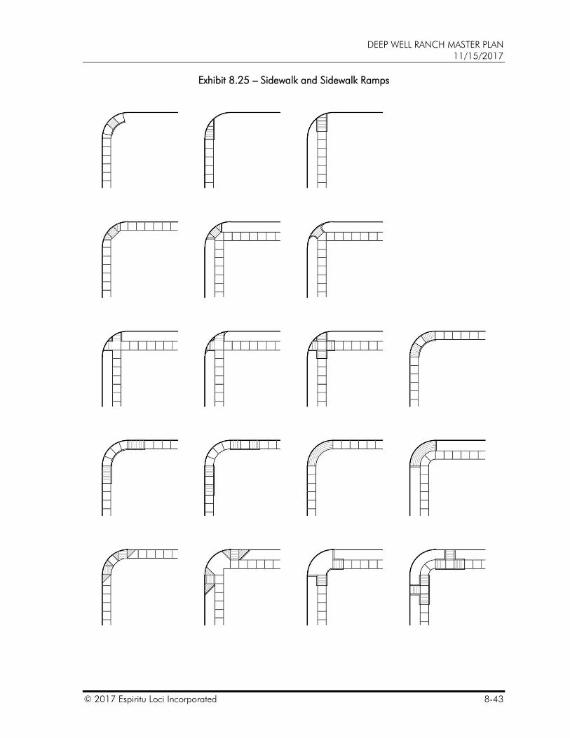
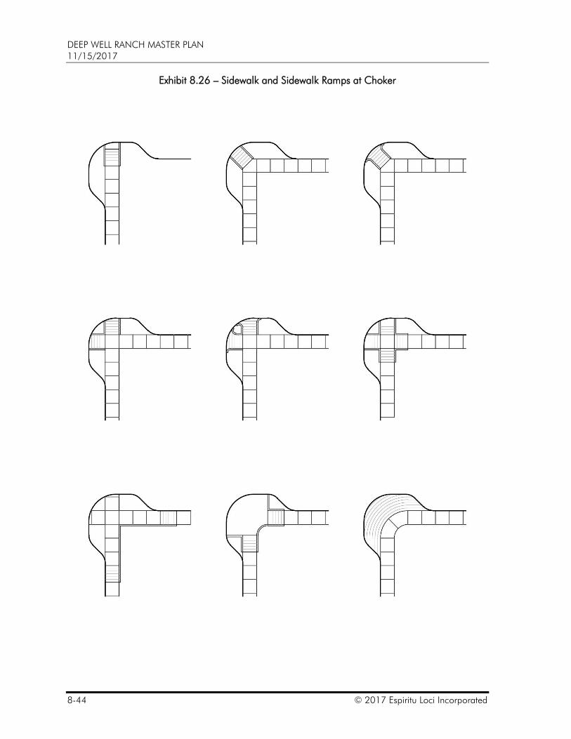
4. In addition to the approved sidewalk and sidewalk ramp details in Exhibit 8.25 – Sidewalk and Sidewalk Ramps, Exhibit 8.26 – Sidewalk and Sidewalk Ramps at Choker, Exhibit 8.27 – Mid-block Sidewalk and Sidewalk Ramps, and Exhibit 8.28 – Median Crossings and Ramps, the City Engineer shall have the authority to approve alternative sidewalk and sidewalk ramp details. Alternative sidewalk and sidewalk ramp details may be approved during the Site Plan or subdivision plat process.
5. Sidewalks within City ROW shall be constructed per the Engineering Standards. Sidewalks within a tract may deviate from the Engineering Standards.
6. Acceptable sidewalk and sidewalk ramps options on Neighborhood and District Streets are depicted on Exhibit 8.25 – Sidewalk and Sidewalk Ramps, Exhibit 8.26 – Sidewalk and Sidewalk Ramps at Choker, Exhibit 8.27 – Mid-block Sidewalk and Sidewalk Ramps, and Exhibit 8.28 – Median Crossings and Ramps.
7. Mid-block crossings are acceptable on Neighborhood Streets. Acceptable midblock sidewalk and sidewalk ramps options on Neighborhood and District Streets are depicted on Exhibit 8.27 – Mid-block Sidewalk and Sidewalk Ramps, and Exhibit 8.28 – Median Crossings and Ramps.
DEEP WELL RANCH MASTER PLAN 11/15/2017
© 2017 Espiritu Loci Incorporated 8-43
Exhibit 8.25 – Sidewalk and Sidewalk Ramps
DEEP WELL RANCH MASTER PLAN 11/15/2017
8-44 © 2017 Espiritu Loci Incorporated
Exhibit 8.26 – Sidewalk and Sidewalk Ramps at Choker
DEEP WELL RANCH MASTER PLAN 11/15/2017
© 2017 Espiritu Loci Incorporated 8-45
Exhibit 8.27 – Mid-block Sidewalk and Sidewalk Ramps
Note: Areas between back of curb and sidewalk may be planted or hardscape.
Exhibit 8.28 – Median Crossings Ramps
Note: Areas between back of curb and sidewalk may be planted or hardscape.
DEEP WELL RANCH MASTER PLAN 11/15/2017
8-46 © 2017 Espiritu Loci Incorporated
F. Mailboxes
1. Individual and cluster mailbox locations shall be installed as required by the Code and United States Postal Service; the City may review and provide recommendations for mailbox locations and pedestrian safety.
2. Individual mailboxes will be used when permitted on single family lots.
3. A cluster mailbox should be at least ten (10) feet away from a driveway.
4. A cluster mailbox may be located near a street intersection, within a park, within a tract, or within an easement. A cluster mailbox should be located 100 feet or more away from an arterial street intersection.
5. Pedestrian access to a cluster mailbox shall be provided.
6. When not incorporated into a structure or building, a cluster mailbox shall be located on a concrete pad.
G. Corner Setbacks and Intersection Visibility
1. The minimum corner setback may be reduced to fifteen (15) feet by fifteen (15) feet in LUG GU or at a driveway to driveway intersection.
H. Signing, Signs and Fixtures
1. Signing along public streets may include custom modifications that may include non-standard shape, size color, backing material or post(s) as approved in the District Comprehensive Sign Plan for the Property.
2. Custom street name signs may be installed as approved in the District Comprehensive Sign Plan.
3. Stop signs are not required at Neighborhood Street to Neighborhood Street intersections unless warranted. Stop signs are not required on Service Lanes.
4. Custom street fixtures and furniture may be used for street signs, streetlight poles, traffic light poles, equipment cabinets, fire lanes and fixtures. Designation, fire lane markers, neighborhood or district signs, benches, pots, tree grates, drinking fountains, bicycle racks, bollards, etc. Specific details may be approved at the Site Plan or subdivision plat processes by the City Engineer.
5. Custom street fixtures and furniture located within public street right-of-way may require a maintenance agreement.
I. Striping
1. At time of site plan or subdivision approval to the greatest extent possible the City will work with the Master Plan Administrator to minimize all striping.
DEEP WELL RANCH MASTER PLAN 11/15/2017
© 2017 Espiritu Loci Incorporated 8-47
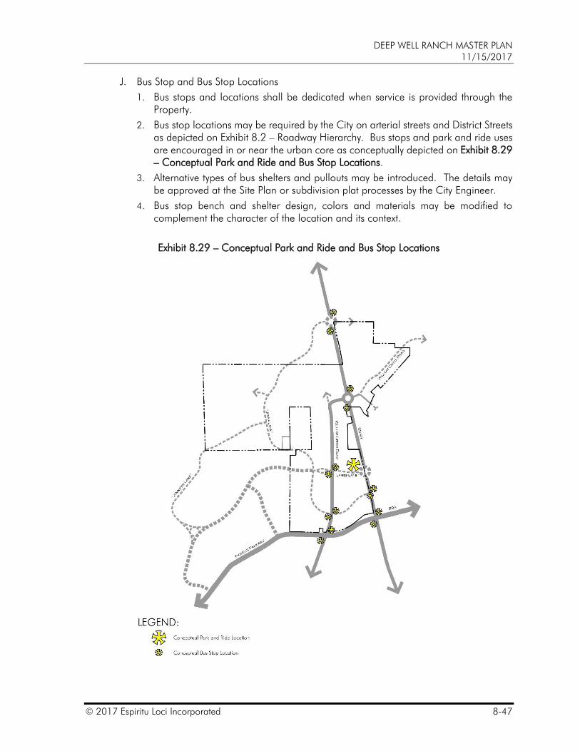
J. Bus Stop and Bus Stop Locations
1. Bus stops and locations shall be dedicated when service is provided through the Property.
2. Bus stop locations may be required by the City on arterial streets and District Streets as depicted on Exhibit 8.2 – Roadway Hierarchy. Bus stops and park and ride uses are encouraged in or near the urban core as conceptually depicted on Exhibit 8.29 – Conceptual Park and Ride and Bus Stop Locations.
3. Alternative types of bus shelters and pullouts may be introduced. The details may be approved at the Site Plan or subdivision plat processes by the City Engineer.
4. Bus stop bench and shelter design, colors and materials may be modified to complement the character of the location and its context.
Exhibit 8.29 – Conceptual Park and Ride and Bus Stop Locations
DEEP WELL RANCH MASTER PLAN 11/15/2017
8-48 © 2017 Espiritu Loci Incorporated
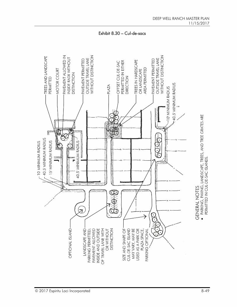
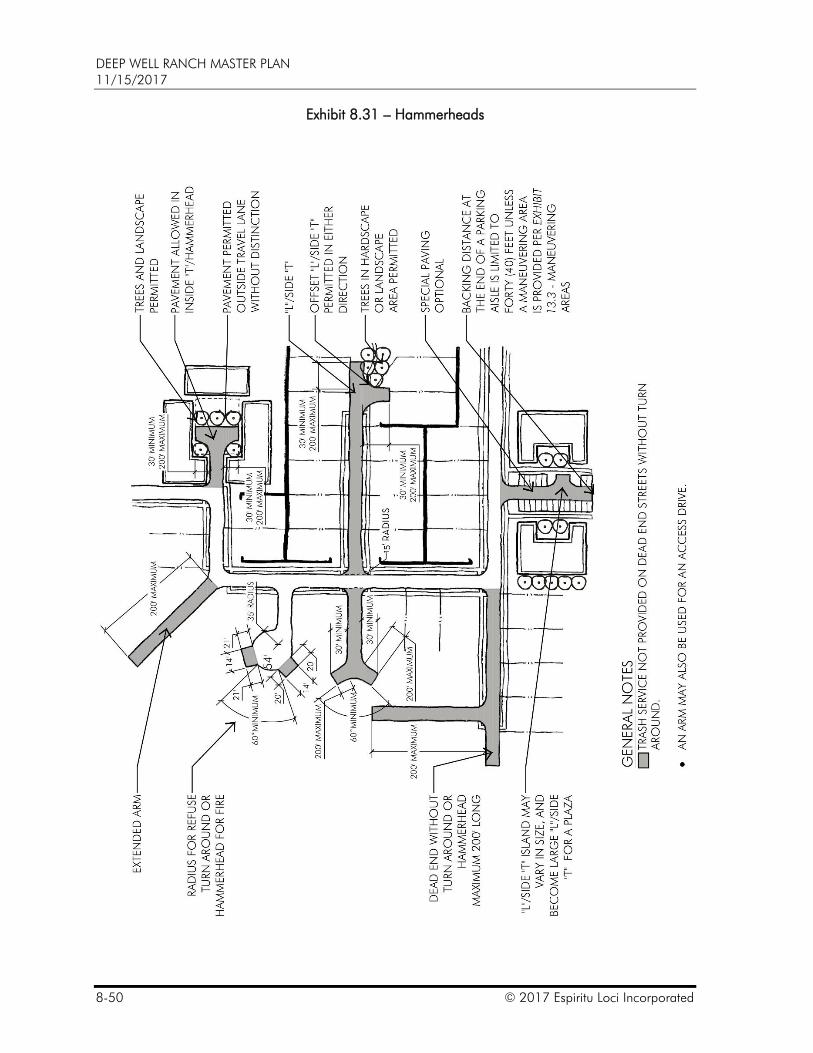
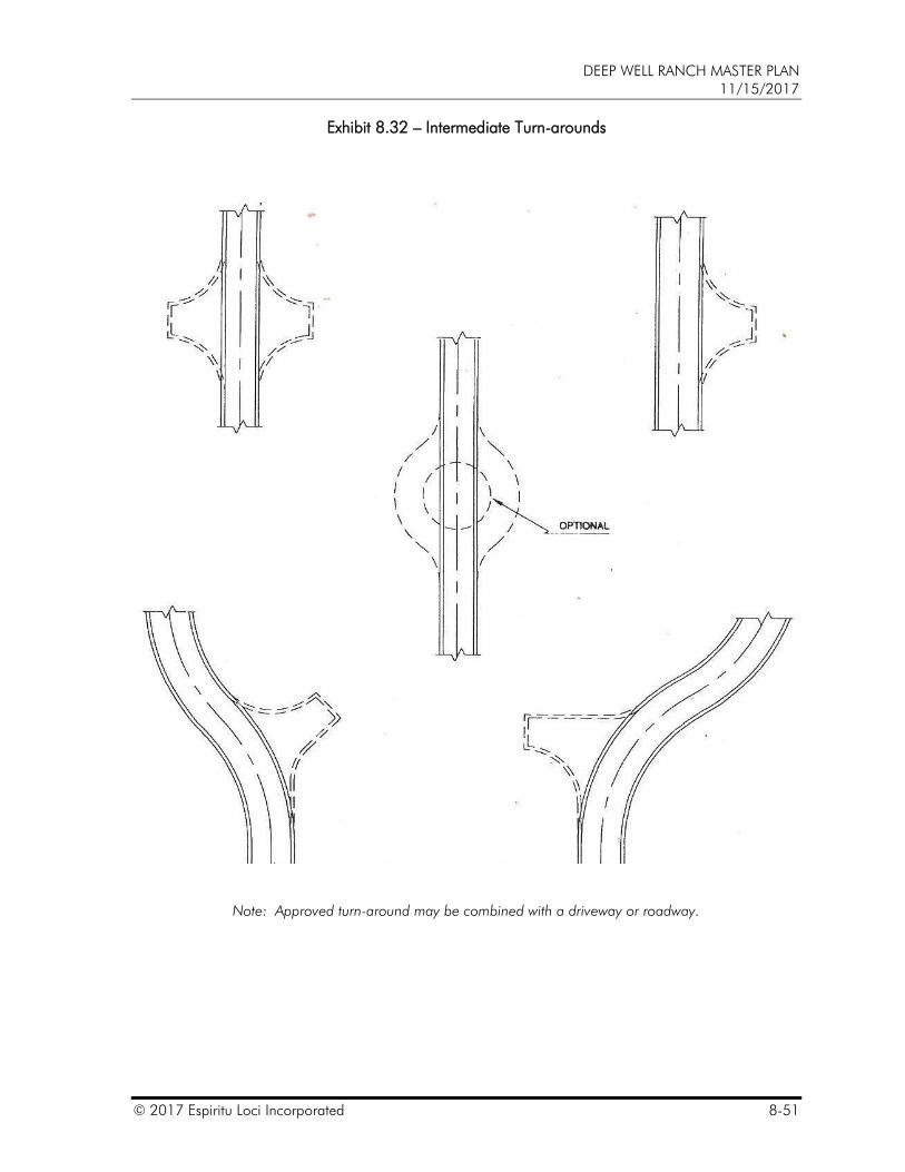
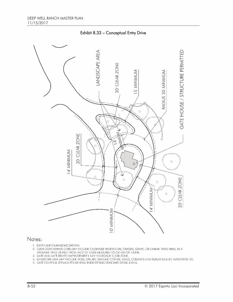
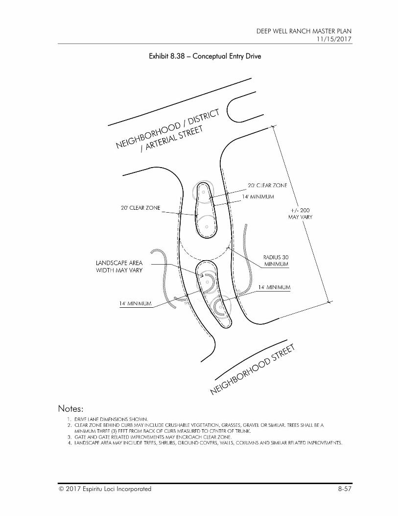
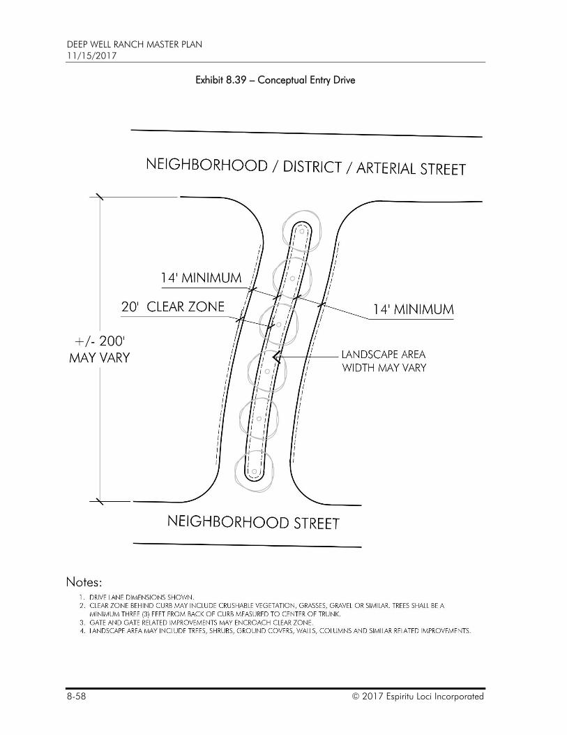
8.7 CUL-DE-SACS, HAMMERHEADS, TURN-AROUNDS AND ENTRY DRIVES
The tight vehicular circulation requirements of an urban setting and landforms in a rural setting often make cul-de-sacs and hammerheads a practical solution. In urban settings, cul-de-sacs and hammerheads often provide motor court or service access to reduce the impact of the automobile on the pedestrian street frontage along arterial and District Streets. In rural areas, long dead end cul-de-sacs may blend in with the terrain. Entry Drives may be used to announce an enclave or provide a desired sequence upon entering a neighborhood, business or urban core. Due to the short nature of an Entry Drive, the back of curb to back of curb (or edge of pavement when a curb does not exist) shall be considered an acceptable fire apparatus access road. Entry Drives shall not provide frontage to individual lots. To the greatest extent possible the City shall work with the Master Plan Administrator to permit cul-de-sacs, hammerheads, turn-around and entry drives as conceptually included in this Master Plan. Cul-de-sacs, hammerhead, turnarounds, Entry Drives are permitted as depicted on:
Exhibit 8.30 – Cul-de-sacs,
Exhibit 8.31 – Hammerheads,
Exhibit 8.32 – Intermediate Turn-arounds,
Exhibit 8.33 – Conceptual Entry Drive,
Exhibit 8.34 – Conceptual Entry Drive,
Exhibit 8.35 – Conceptual Entry Drive,
Exhibit 8.36 – Conceptual Entry Drive,
Exhibit 8.37 – Conceptual Entry Drive,
Exhibit 8.38 – Conceptual Entry Drive, and
Exhibit 8.39 – Conceptual Entry Drive.
DEEP WELL RANCH MASTER PLAN 11/15/2017
© 2017 Espiritu Loci Incorporated 8-49
Exhibit 8.30 – Cul-de-sacs
DEEP WELL RANCH MASTER PLAN 11/15/2017
8-50 © 2017 Espiritu Loci Incorporated
Exhibit 8.31 – Hammerheads
DEEP WELL RANCH MASTER PLAN 11/15/2017
© 2017 Espiritu Loci Incorporated 8-51
Exhibit 8.32 – Intermediate Turn-arounds
Note: Approved turn-around may be combined with a driveway or roadway.
DEEP WELL RANCH MASTER PLAN 11/15/2017
8-52 © 2017 Espiritu Loci Incorporated
Exhibit 8.33 – Conceptual Entry Drive
DEEP WELL RANCH MASTER PLAN 11/15/2017
© 2017 Espiritu Loci Incorporated 8-53
Exhibit 8.34 – Conceptual Entry Drive
DEEP WELL RANCH MASTER PLAN 11/15/2017
8-54 © 2017 Espiritu Loci Incorporated
Exhibit 8.35 – Conceptual Entry Drive
DEEP WELL RANCH MASTER PLAN 11/15/2017
© 2017 Espiritu Loci Incorporated 8-55
Exhibit 8.36 – Conceptual Entry Drive
DEEP WELL RANCH MASTER PLAN 11/15/2017
8-56 © 2017 Espiritu Loci Incorporated
Exhibit 8.37 – Conceptual Entry Drive
DEEP WELL RANCH MASTER PLAN 11/15/2017
© 2017 Espiritu Loci Incorporated 8-57
Exhibit 8.38 – Conceptual Entry Drive
DEEP WELL RANCH MASTER PLAN 11/15/2017
8-58 © 2017 Espiritu Loci Incorporated
Exhibit 8.39 – Conceptual Entry Drive
DEEP WELL RANCH MASTER PLAN 11/15/2017
© 2017 Espiritu Loci Incorporated 8-59
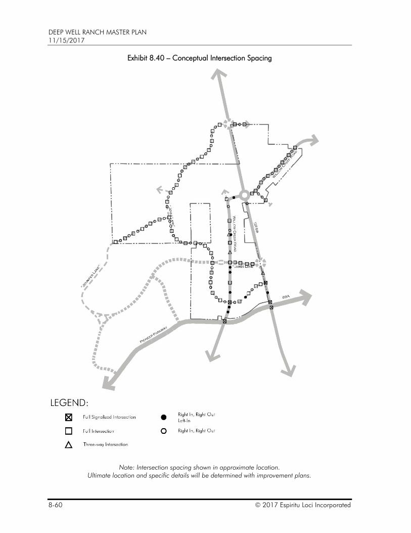
8.8 TRAFFIC SIGNAL AND INTERSECTION STANDARDS
A. The intent is to provide safe and functional traffic signal system along the public street transportation system while providing convenient access to commercial patrons.
B. Signals and full movement intersections are likely to occur at the one quarter and one-half mile locations in the urban cores as they become more intense over time. Traffic signal and intersection spacing shall be generally a minimum 330’/660’ spacing as depicted on Exhibit 8.40 – Conceptual Intersection Spacing. To the greatest extent possible the City will work with the Master Plan Administrator to approve intersection spacing as proposed by the Master Plan Administrator provide the Master Plan Administrator can prove through site specific traffic analysis that proposed intersections can be designed and constructed to operate safely within City permitted acceptable levels of service.
C. Custom poles, mast arms, traffic signal faces, pedestrian push button stations, control cabinets, and other hardware other than those outlined in City Standards may be installed. Traffic signals may be hung from buildings or cables. Custom traffic signal elements can be used to change the aesthetic conditions, but not the functional operations.
DEEP WELL RANCH MASTER PLAN 11/15/2017
8-60 © 2017 Espiritu Loci Incorporated
Exhibit 8.40 – Conceptual Intersection Spacing
Note: Intersection spacing shown in approximate location. Ultimate location and specific details will be determined with improvement plans.
DEEP WELL RANCH MASTER PLAN 11/15/2017
© 2017 Espiritu Loci Incorporated 8-61
8.9 PUBLIC STREET LIGHTING
The intent is to provide safe and adequate illumination of the public street transportation system without excessive illumination of the street system to enhance the quality of life and protect the dark sky. Street lighting layout is dictated by street classification and location. In areas characterized as dense urban, continuous street lighting may be considered appropriate. While in areas characterized as rural, street lighting may strategically located to preserve dark skies. Neighborhood streets shall be illuminated to provide a comfortable environment. The following shall apply when public street lighting is required:
A. Public street lighting shall be per City standards along arterial streets.
B. Lighting locations shall be allowed to vary to complement specific development design that may include location, side of street, clearance from driveways and clearance from landscaping.
C. Lighting shall typically be located at least five (5) feet from a commercial driveway.
D. Lighting along arterial and District Streets shall typically be located at least ten (10) feet from a street tree as measured from the center of the tree trunk to the center of the light pole.
E. Lighting along Neighborhood Streets shall be typically located at least five (5) feet from a street tree as measured from the center of the tree trunk to the center of the light pole.
F. Within a neighborhood lighting may be provided at intersecting streets and cul-de-sacs only.
G. Lighting shall include lamps that conform to the standard City street light specification or similar equivalent, including alternative energy efficient lamp sources such as LED, induction fluorescent and compact fluorescent lamps that meet light level requirements.
H. Lighting may include custom street lights and/or light poles and traffic signal poles and arms approved at the Site Plan or subdivision plat process.
I. Lighting may be attached to buildings or hung from cables.
J. Lighting levels and uniformity ratios may exceed recommendations outlined in the Illuminating Engineering Society Handbook where appropriate within LUG C, CS, R and GU.
K. Lighting components such as lighting control cabinets may be altered to blend into the setting.
L. The City Engineer may approve alternate lighting standards during the Site Plan or subdivision plat process
M. The Master Plan Administrator may retain ownership of street lighting systems within developed areas where the character of the architecture is not consistent with the typical street lighting standards.
N. The Master Plan Administrator may take over the maintenance and operation of lighting systems that vary from the City standards.
DEEP WELL RANCH MASTER PLAN 11/15/2017
8-62 © 2017 Espiritu Loci Incorporated
8.10 PATHWAYS AND BICYCLE LANES
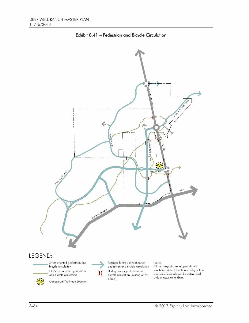
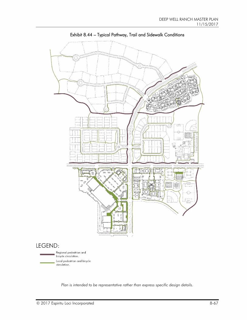
A. A regional system of paths and trails will provide connectivity to community cores and amenities as shown on Exhibit 8.41 – Pedestrian and Bicycle Circulation. In addition to the regional system, a secondary network will provide connectivity to neighborhoods and parcels as conceptually depicted on Exhibit 8.42 – Typical Bicycle and Pedestrian Routes. This integrated system provides alternative routes for bicycles and therefore striped bicycle lanes are not required on arterial or District Streets.
B. The network includes street oriented and open space oriented pedestrian and bicycle circulation routes. Street oriented routes are typically associated with District Streets and arterial street alignments. Open space oriented routes provide connectivity that may follow a wash corridor or weave in and around open space, civic and community amenities (see Exhibit 8.41 – Pedestrian and Bicycle Circulation).
C. Path and trail alignments along Willow Creek Road may be altered with adjacent parcel development. The width and material of the path and trail shall remain consistent with existing improvements.
D. A minimum ten (10) foot wide multi-use pathway is required along one (1) side of all District Streets and may be installed with adjacent parcel or roadway improvements. The width of a multi-use path may be reduced when consistent with AASHTO guidelines or when approved by the City Engineer. The pathway shall be a continuation of the regional system within the community and should generally avoid alternating from one side of the roadway to the other. In urban areas, the pathways may parallel back of curb and connect with plaza spaces. In rural areas, the pathway shall generally meander through the landscape (see Exhibit 8.2 – Typical Pathway, Trail and Sidewalk Conditions).
E. When the multi-use path is located along a District Street between back of curb and a privacy wall, a landscape tract, minimum thirty-five (35) foot in depth shall be provided in rural areas. The landscape tract may be reduced to a minimum twenty-five (25) feet in urban areas.
F. District Streets should be designed to intentionally slow and inter-mingle traffic modes. These streets are designed to have posted speeds at or below thirty-five (35) mph so that neighborhood electric vehicles and other alternative forms of transportation may share the road. Rather than creating isolated independent uses for each of these modes, the street may provide a mingled system to further slow traffic and heighten awareness of the surroundings. The Recreation Cores and Neighborhood Streets should be used as the preferred bicycle routes when possible.
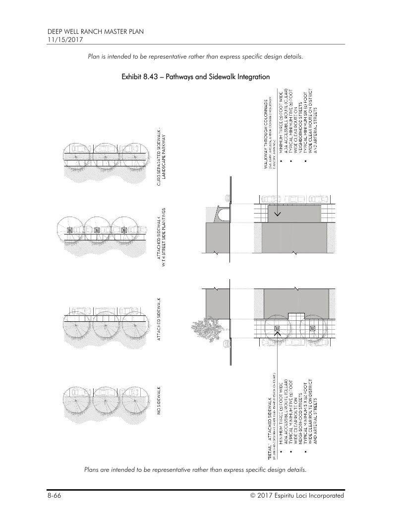
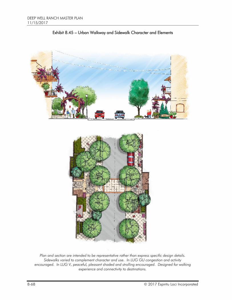
G. Walkways and sidewalks in an urban setting take on a wide variety of forms: attached at back of curb, attached at back of curb with street side plantings, curb separated, retail and under colonnade; in some cases, it may be appropriate and desirable to have no sidewalk or walkway (see Exhibit 8.3 – Pathways and Sidewalk Integration, Exhibit 8.45 – Urban Walkway and Sidewalk Character and Elements and Exhibit 8.4 – Urban Walkway and Sidewalk Character and Elements). In urban settings, walkways may seamlessly transition from one type to another providing a varied walking experience while responding to the adjacent users (see Exhibit 8.47 – Urban Walkway and Sidewalk Character Elements and Exhibit 8.5 – Urban Walkway and Sidewalk Character and
DEEP WELL RANCH MASTER PLAN 11/15/2017
© 2017 Espiritu Loci Incorporated 8-63
Elements). In activity areas, the total quantity of sidewalk may increase rather than minimize sidewalk widths and in many cases, sidewalks are indistinguishable from the plazas they may cross. Scoring patterns, color, texture and material may all be used to vary the pedestrian experience.
H. Open space oriented (off-street) trails (unpaved) that are part of the regional network shall generally be an average of five (5) feet wide. Open space oriented (off-street) pathways (paved) that are part of the regional network shall generally be an average of eight (8) feet wide.
I. Earthen trails may be installed alongside or generally parallel to a sidewalk, or path. In rural areas, a trail may be more appropriate than a path.
DEEP WELL RANCH MASTER PLAN 11/15/2017
8-64 © 2017 Espiritu Loci Incorporated
Exhibit 8.41 – Pedestrian and Bicycle Circulation
DEEP WELL RANCH MASTER PLAN 11/15/2017
© 2017 Espiritu Loci Incorporated 8-65
Exhibit 8.42 – Typical Bicycle and Pedestrian Routes
DEEP WELL RANCH MASTER PLAN 11/15/2017
8-66 © 2017 Espiritu Loci Incorporated
Plan is intended to be representative rather than express specific design details.
Exhibit 8.43 – Pathways and Sidewalk Integration
Plans are intended to be representative rather than express specific design details.
DEEP WELL RANCH MASTER PLAN 11/15/2017
© 2017 Espiritu Loci Incorporated 8-67
Exhibit 8.44 – Typical Pathway, Trail and Sidewalk Conditions
Plan is intended to be representative rather than express specific design details.
DEEP WELL RANCH MASTER PLAN 11/15/2017
8-68 © 2017 Espiritu Loci Incorporated
Exhibit 8.45 – Urban Walkway and Sidewalk Character and Elements
Plan and section are intended to be representative rather than express specific design details. Sidewalks varied to complement character and use. In LUG GU congestion and activity
encouraged. In LUG V, peaceful, pleasant shaded and strolling encouraged. Designed for walking experience and connectivity to destinations.
DEEP WELL RANCH MASTER PLAN 11/15/2017
© 2017 Espiritu Loci Incorporated 8-69
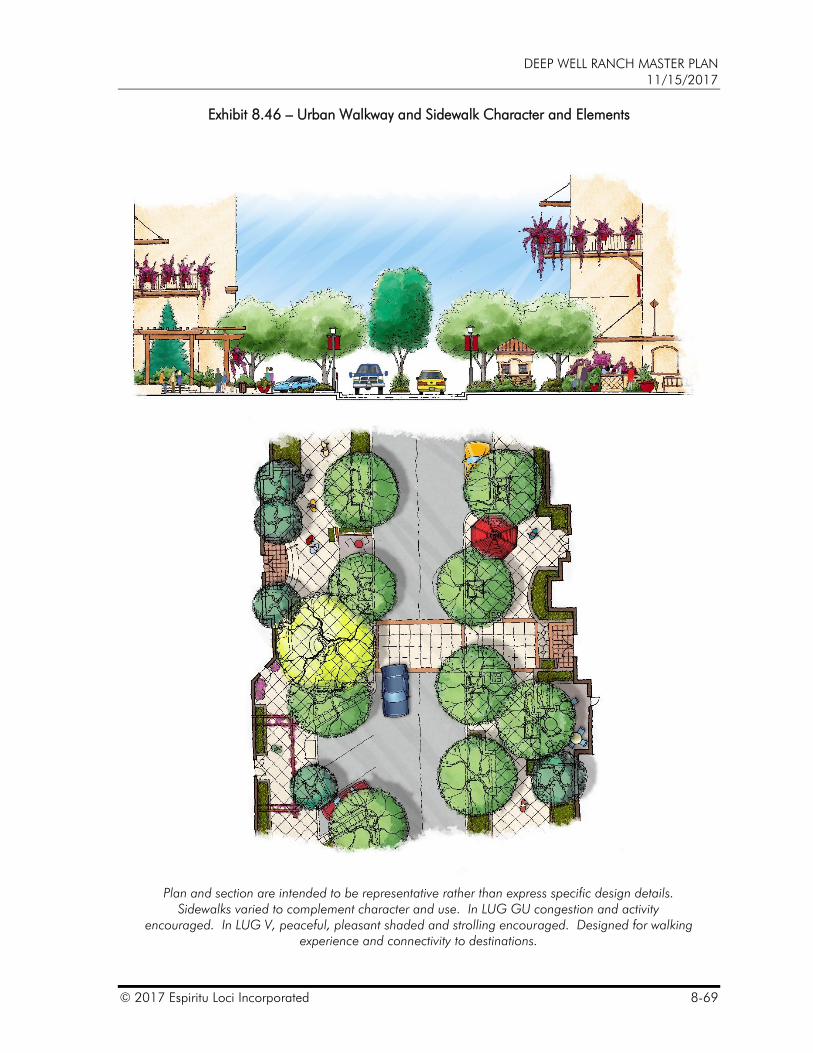
Exhibit 8.46 – Urban Walkway and Sidewalk Character and Elements
Plan and section are intended to be representative rather than express specific design details. Sidewalks varied to complement character and use. In LUG GU congestion and activity
encouraged. In LUG V, peaceful, pleasant shaded and strolling encouraged. Designed for walking experience and connectivity to destinations.
DEEP WELL RANCH MASTER PLAN 11/15/2017
8-70 © 2017 Espiritu Loci Incorporated
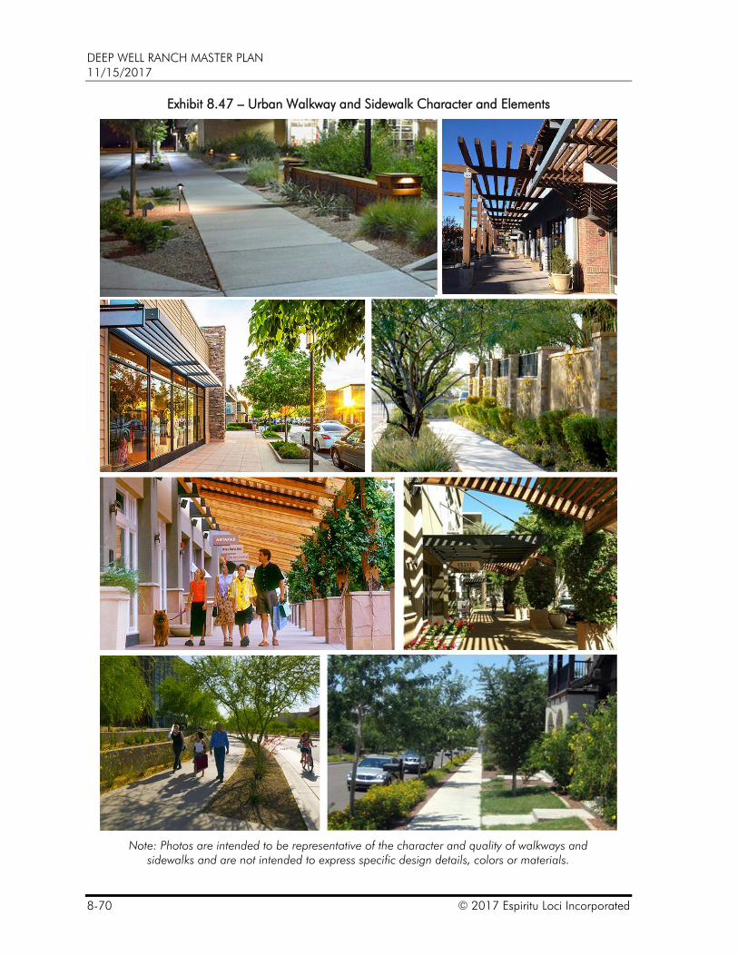
Exhibit 8.47 – Urban Walkway and Sidewalk Character and Elements
Note: Photos are intended to be representative of the character and quality of walkways and sidewalks and are not intended to express specific design details, colors or materials.
DEEP WELL RANCH MASTER PLAN 11/15/2017
© 2017 Espiritu Loci Incorporated 8-71
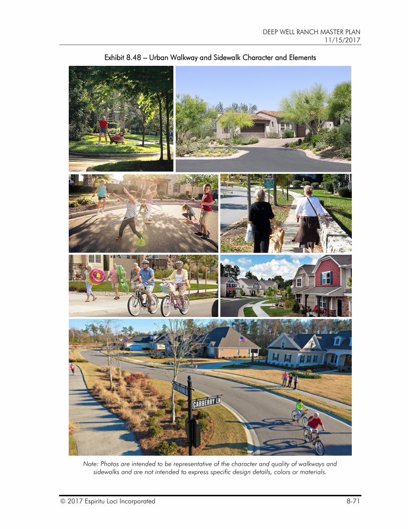
Exhibit 8.48 – Urban Walkway and Sidewalk Character and Elements
Note: Photos are intended to be representative of the character and quality of walkways and sidewalks and are not intended to express specific design details, colors or materials.
DEEP WELL RANCH MASTER PLAN 11/15/2017
8-72 © 2017 Espiritu Loci Incorporated
This page intentionally blank.