Embed Size (px)
Citation preview

Ministry of Housing, Communities & Local Government Maria Stasiak, Decision Officer Planning Casework Unit 3rd Floor Fry Building 2 Marsham Street London SW1P 4DF
Tel: 0303 444 1624 Email: [email protected]
Mr Tim Waller Waller Planning Ltd Suite C 19-25 Salisbury Square Old Hatfield Herts AL9 5BT
Our ref: APP/Y0435/W/17/3169314 Your ref: 213.3
5 December 2018
Dear Sir, TOWN AND COUNTRY PLANNING ACT 1990 – SECTION 78 APPEAL MADE BY WAVENDON PROPERTIES LIMITED LAND TO THE EAST OF NEWPORT ROAD AND TO THE EAST AND WEST OF CRANFIELD ROAD AT WOBURN SANDS, BUCKINGHAM, MK17 8UH APPLICATION REF: 16/00672/OUT
1. I am directed by the Secretary of State to say that consideration has been given to the report of D R Cullingford BA MPhil MRTPI, who held a public local inquiry between 11-14 and 18–19 July 2017 into your client’s appeal against the decision of Milton Keynes Council to refuse your client’s application for outline planning permission for residential development of up to 203 dwellings, a doctor’s surgery, open space and landscaping, together with pedestrian, cycle and vehicular access from Newport Road and Cranfield Road and supporting infrastructure, in accordance with application ref 16/00672/OUT, dated 20 July 2016.
2. On 31 October 2017 this appeal was recovered for the Secretary of State's determination, in pursuance of section 79 of, and paragraph 3 of Schedule 6 to, the Town and Country Planning Act 1990.
Inspector’s recommendation and summary of the decision
3. The Inspector recommended that the appeal be allowed and planning permission granted, subject to conditions.
4. For the reasons given below, the Secretary of State disagrees with the Inspector’s recommendation. He has decided to dismiss the appeal and refuse planning permission. A copy of the Inspector’s report (IR) is enclosed. All references to paragraph numbers, unless otherwise stated, are to that report.

2
Matters arising since the close of the inquiry
5. On 8 May 2018, the Secretary of State wrote to Milton Keynes Council to afford the Council an opportunity to make representations on a letter dated 6 April 2018 from the agent, which included recent appeal decisions relating to Land at Long Street Road, Hanslope (APP/Y0435/W/17/3177851) and Land at Linford Lakes, off Wolverton Road, Milton Keynes (APP/Y0435/W/17/3175391). The Council in its response of 22 May 2018 forwarded recent decisions relating to Land at Moat Farm, North Crawley (APP/Y0435/W/17/3186814) and Land off Olney Road, Lavendon (APP/Y0435/W/17/3182048).
6. On 26 July 2018, the Secretary of State wrote to parties giving them the opportunity to make representations on the revised National Planning Policy Framework (‘the Framework’), published 24 July 2018, and on the Milton Keynes Site Allocations Plan, which was adopted on 18 July 2018.
7. On the 27 September 2018, the Secretary of State wrote further to parties giving them the opportunity to make representations on the publication, on 13 September 2018, of revised guidance on how councils should assess their housing need, and the publication, on 20 September 2018, of new household projections for England.
8. A list of representations which have been received since the inquiry is at Annex A. Copies of these letters may be obtained on written request to the address at the foot of the first page of this letter.
Policy and statutory considerations
9. In reaching his decision, the Secretary of State has had regard to section 38(6) of the Planning and Compulsory Purchase Act 2004 which requires that proposals be determined in accordance with the development plan unless material considerations indicate otherwise.
10. In this case the development plan consists of the saved policies of the Milton Keynes Local Plan (LP) 2001-2011 (adopted in 2005), the Core Strategy (CS) 2010-2026 (adopted in 2013), the Milton Keynes Site Allocations Plan (SAP) (adopted on 18 July 2018) and the Woburn Sands Neighbourhood Plan (NP) 2014-2026 (made in 2014). The Secretary of State considers that the development plan policies of most relevance to this case are those set out at IR4.2-4.9. The appeal site is not allocated as one of the non-strategic sites in the SAP.
11. In accordance with section 66(1) of the Planning (Listed Buildings and Conservation Areas) Act 1990 (the LBCA Act), the Secretary of State has paid special regard to the desirability of preserving those listed buildings potentially affected by the proposals, or their settings or any features of special architectural or historic interest which they may possess.
12. Other material considerations which the Secretary of State has taken into account include the National Planning Policy Framework (‘the Framework’) and associated planning guidance (‘the Guidance’). The revised National Planning Policy Framework was published on 24 July 2018, and unless otherwise specified, any references to the Framework in this letter are to the revised Framework.

3
Emerging plan
13. The Proposed Submission Version of the Local Plan (Plan:MK) was submitted for independent examination in April 2018, and the Council has published a schedule of main modifications to Plan:MK for a six-week consultation period between 31 October and 12 December 2018. The Secretary of State considers that the emerging policies of most relevance to this case include DS1, DS5, SD13 and HN1.
14. Paragraph 48 of the Framework states that decision makers may give weight to relevant policies in emerging plans according to: (1) the stage of preparation of the emerging plan; (2) the extent to which there are unresolved objections to relevant policies in the emerging plan; and (3) the degree of consistency of relevant policies to the policies in the Framework. Footnote 22 states that during the transitional period of emerging plans submitted for examination, consistency should be tested against the previous Framework published in March 2012. Given the current stage of the emerging Local Plan, the Secretary of State gives moderate weight to its policies.
Main issues Five-year housing land supply 15. The Secretary of State has considered the Inspector’s assessment of housing land
supply at IR9.4-9.18, and has also taken into account the revised Framework, and material put forward by parties as part of the reference back processes.
16. As the Core Strategy was adopted in July 2013, the adopted housing requirement figure
is more than 5 years old. Paragraph 73 of the Framework indicates that in that scenario, unless these strategic policies have been reviewed and found not to require updating, local housing need should be applied. The Secretary of State has therefore calculated the local housing need figure, using the standard method. He considers that local housing need is 1,604. The agent in their representation of 5 October 2018 has considered the question of the buffer to be added at paragraph 4.12-4.15. The Secretary of State considers that their proposed approach is appropriate, and agrees that for the purposes of this decision, a 5% buffer should be added. This gives a figure of 1,684.
17. The Secretary of State has also considered the deliverable supply and has taken into account both the Inspector’s analysis and the material put forward by the agent in their representation of 5 October 2018 which deals with local market evidence on past delivery, and potential delivery rates. For the reasons given at IR9.9 he agrees with the Inspector that the current method of factoring in uncertainty, slippage or failure in the forecasts of housing delivery fails to adequately reflect reality. For the reasons given in IR9.10-9.13, he further agrees with the Inspector that the delivery rates implied by the forecasts used by the Council to demonstrate a 5-year provision of housing land seem unlikely to be achievable (IR9.11).
18. The Secretary of State has further taken into account the change to the definition of ‘deliverable’ in the revised Framework, the Council’s position put forward in their Updated Housing Land Supply Position 2018-19 (referred to in paragraph 7.2 of the agent’s representation of 5 October), and the evidence on progress which is set out in the summary of site assessments put forward by the agent in that representation. Taking all these factors into consideration, he considers that on the basis of the evidence put forward at this inquiry, estimated deliverable supply is roughly in the region of 10,000–

4
10,500. The Secretary of State therefore considers that the housing land supply is approximately 5.9–6.2 years. He notes that on this basis, even if the emerging plan figure of 1,766 were used (1,854 with a 5% buffer added), as the agent proposes, there would still be an estimated deliverable housing land supply of over 5 years.
Location of site 19. The Secretary of State agrees with the Inspector at IR9.19 and IR9.20 that as the appeal
site is beyond the development boundary of Woburn Sands and is in open countryside, it is contrary to saved LP policy S10 and NP policy WS5. He further agrees that the boundary is tightly drawn, and is defined in a Local Plan intended to guide development only up to 2011. For these reasons the Secretary of State considers that policies S10 and WS5 are out of date, and that only moderate weight attaches to them.
20. For the reasons given at IR9.20, the Secretary of State further agrees with the Inspector that in terms of NP policy WS5, while field and farmland would be lost, the scheme would not encroach onto woodland nor sever footpath links into the countryside.
21. Since the inquiry, the Milton Keynes SAP has been adopted. The role of this document is to identify and allocate new, non-strategic development sites to provide short term flexibility and contingency to the existing housing land supply (SAP, paragraph 1.2). It does not allocate this site for development. The emerging Plan:MK also does not allocate this site for development.
22. The Secretary of State agrees with the Inspector’s analysis at IR9.21-9.22 and with his conclusion at IR9.48 that the scheme would accord with the aims and some specific policies of the Core Strategy, and given the characteristics and explicit designation of Woburn Sands as a ‘key settlement’, would be in a sustainable location.
23. Overall the Secretary of State considers that the conflicts with current and emerging policy arising from the appeal site’s location in unallocated open countryside outside the development boundary of Woburn Sands carry moderate weight.
Housing density 24. The Secretary of State has carefully considered the Inspector’s assessment of the
density of the appeal scheme (IR9.42-9.47). He has also taken into account paragraphs 122-123 of the revised Framework and the agent’s representation of 5 October 2018. He considers that policy H8 is consistent with the revised Framework, both in its requirement that the density of new housing development should be well related to the character and appearance of development in the surrounding area, and in its use of a range of average net densities. His conclusion on this is not altered by the fact, as pointed out by the agent in their representation of 5 October, that the policies of the 2005 Local Plan ‘were required to accord with government policy of the time…[and] PPG3 set out a requirement for a minimum density of 30 dwellings per hectare’.
25. He has taken into account that policy H8 also requires the density of new housing development to be well related to the character and appearance of development in the surrounding area, and that the Core Strategy and NP echo these themes (IR9.43). He has also taken into account, as set out in the agent’s representation of 5 October 2018, that the draft Plan:MK does not contain a policy which sets out a minimum density, and that a higher-density scheme was put forward by the appellant (IR9.46).

5
26. The Secretary of State notes that policy H8 seeks an average net density of 35dph in this
location, and that this is over twice the density of 16dph actually proposed (IR9.43). He considers that the proposed density is a very significant departure from policy. Even taking into account the matters set out above, the desirability of maintaining the area’s prevailing character and setting, and the rest of the factors set out at paragraph 122 of the Framework, he does not consider that such a significant departure from policy is justified. He therefore considers that the proposed development is in conflict with policy H8, and he gives this conflict significant weight.
Character of the area 27. For the reasons given at IR9.24-9.28 and IR9.49, and noting that reference to ‘valued
landscapes’ is now at paragraph 170 of the Framework, the Secretary of State agrees with the Inspector at IR9.27 that the significant visual and landscape effects of the scheme would be very local, while beyond those immediate surroundings, the effects would be very limited. The Secretary of State considers that the adverse effects carry limited weight against the proposal.
Heritage 28. For the reasons given at IR9.41 and IR9.49, the Secretary of State agrees with the
Inspector that the rural character of the appeal site is no longer integral to appreciating the heritage of Deethe Farmhouse, and that there would be minimal harm to the setting of the Farmhouse. The Secretary of State considers that the harm carries little weight, and in terms of the heritage test at paragraph 196 of the Framework, is ‘less than substantial’.
Benefits of the scheme 29. For the reasons given at IR9.53, the Secretary of State considers that the provision of
housing, including 30% affordable housing, carries significant weight in favour of the proposal. He further considers that the economic benefits arising from the temporary construction employment and secondary employment generated by the scheme (IR9.52) carry moderate weight in favour of the proposal.
Other matters 30. For the reasons given in IR9.29-9.40, the Secretary of State considers that matters
relating to traffic and parking, the impact of the development on the facilities of the town, and ecology and drainage, do not weigh against the proposal.
Planning conditions
31. The Secretary of State has given consideration to the Inspector’s analysis at IR3.8 and
9.56, the recommended conditions set out at the end of the IR and the reasons for them, and to national policy in paragraph 55 of the Framework and the relevant Guidance. He is satisfied that the conditions recommended by the Inspector comply with the policy test set out at paragraph 55 of the Framework. However, he does not consider that the imposition of these conditions would overcome his reasons for dismissing this appeal and refusing planning permission.

6
Planning obligations
32. Having had regard to the Section 106 Agreement dated 17 August 2017, the Inspector’s
analysis at IR3.6 and 9.57, paragraph 56 of the Framework, the Guidance and the Community Infrastructure Levy Regulations 2010, as amended, the Secretary of State considers that the Agreement complies with Regulations 122 and 123 of the CIL Regulations and the tests at paragraph 56 of the Framework. However, the Secretary of State does not consider that the obligation overcomes his reasons for dismissing this appeal and refusing planning permission.
33. The Secretary of State has also carefully considered the Inspector’s analysis of the Obligation dated 17 August 2017 at IR3.7, 9.51 and 9.57. The Obligation sets out that ‘the owners will use reasonable endeavours to build out the development within 5 years of the Council approving the last reserved matters application’. The Secretary of State considers that in the circumstances of the case there has not been an adequate demonstration of the planning harm which this Obligation addresses, and there has not been an adequate demonstration that the Obligation is necessary to make the development acceptable in planning terms. It therefore does not pass the tests set out in the Framework and the CIL Regulations and the Secretary of State has not taken it into account in reaching his conclusion on this case.
Planning balance and overall conclusion
34. For the reasons given above, the Secretary of State considers that the appeal scheme conflicts with development plan policies relating to development outside settlement boundaries and density. He further considers that it is in conflict with the development plan as a whole. The Secretary of State has gone on to consider whether there are material considerations which indicate that the proposal should be determined other in accordance with the development plan.
35. The Secretary of State considers that the housing benefits of the scheme carry significant weight and the economic benefits carry moderate weight in favour of the proposal.
36. The Secretary of State considers that the low density of the appeal proposal carries significant weight against the proposal, while the location in unallocated open countryside outside the development boundary of Woburn Sands carries moderate weight, and the impact on the character of the area carries limited weight. He further considers that the minimal harm to the listed building carries little weight and that the public benefits of the scheme outbalance this ‘less than substantial’ harm. The heritage test under paragraph 196 of the Framework is therefore favourable to the proposal.
37. The Secretary of State considers that there are no material considerations which indicate the proposal should be determined other than in accordance with the development plan. He therefore concludes that the appeal should be dismissed, and planning permission should be refused.
Formal decision
38. Accordingly, for the reasons given above, the Secretary of State disagrees with the
Inspector’s recommendation. He hereby dismisses your client’s appeal and refuses planning permission for residential development of up to 203 dwellings, a doctor’s

7
surgery, open space and landscaping, together with pedestrian, cycle and vehicular access from Newport Road and Cranfield Road and supporting infrastructure, in accordance with application ref 16/00672/OUT, dated 20 July 2016.
Right to challenge the decision
39. A separate note is attached setting out the circumstances in which the validity of the
Secretary of State’s decision may be challenged. This must be done by making an application to the High Court within 6 weeks from the day after the date of this letter for leave to bring a statutory review under section 288 of the Town and Country Planning Act 1990.
40. A copy of this letter has been sent to Milton Keynes Council, and notification has been
sent to others who asked to be informed of the decision. Yours faithfully
Maria Stasiak Authorised by the Secretary of State to sign in that behalf

8
ANNEX A: SCHEDULE OF REPRESENTATIONS
General representations
Party Date
Clyde & Co LLP for the appellant 12/10/2017
Clyde & Co LLP for the appellant 08/11/2017
Clyde & Co LLP for the appellant 20/12/2017
Aitchison Raffety on behalf of Mr Menday 05/03/2018
Waller Planning (Agent) for the applicant 06/04/2018
Waller Planning (Agent) for the applicant 29/04/2018
Clyde & Co LLP for the appellant 23/07/2018
Aitchison Raffety on behalf of Mr Menday 02/08/2018
Milton Keynes Council 05/09/2018
Cllr David Hopkins 11/10/2018
Representations received in response to the Secretary of State’s letter of 08/05/2018
Party Date
Milton Keynes Council 22/05/2018
Waller Planning (Agent) for the applicant 29/05/2018
Representations received in response to the Secretary of State’s letter of 26/07/2018
Party Date
Milton Keynes Council 31/07/2018
Cllr David Hopkins 01/08/2018
Clyde & Co LLP for the appellant 06/08/2018
Noel Payne 06/08/2018
Jill Floyd 07/08/2018
Lynne Stapleton, Woburn Sands Town Council 08/08/2018
Alistair Ewing, Woburn Sands & District Society 10/08/2018
P & T Dixon 14/08/2018
Lynda Joslyn 14/08/2018
Judith Barker 16/08/2018
Julian Shreeve 17/08/2018
Representations received in response to the Secretary of State’s letter of 27/09/2018
Party Date
Waller Planning (Agent) for the applicant 05/10/2018

9

Inquiry held on 11-14 and 18 – 19 July 2017 An accompanied site visit was undertaken on 19 July and an unaccompanied visit was made on 17 July 2017 Land to the east of Newport Road and to the east and west of Cranfield Road at Woburn Sands, Buckinghamshire, MK17 8UH File Reference: APP/Y0435/W/17/3169314
Report to the Secretary of State for
Housing, Communities and Local Government
by D R Cullingford BA MPhil MRTPI an Inspector appointed by the Secretary of State
Date: 2 February 2018
Town and Country Planning Act 1990
MILTON KEYNES COUNCIL
Appeal
by
WAVENDON PROPERTIES LIMITED

Report: APP/Y0435/W/17/3169314
i *** Contents ***
CONTENTS
1. PROCEDURAL MATTERS 1 The proposal in outline 1 The application and the recommendation 2 The reasons for refusal and for recovery 2 The need for EIA 3 Public consultation 3
2. THE SITE AND THE SURROUNDINGS 5 The site 5 The surroundings 6
3. THE PROPOSAL 8
4. POLICY 10 The Development Plan 10
The Core Strategy 10 The Local Plan 10 The Neighbourhood Plan 11
Emerging plans and policies 12 Supplementary Planning Documents 12 Government policies 13
5. THE CASE FOR THE APPELLANTS 16
Introduction 16
The Development Plan 17
The 5-year housing land supply 19 The backlog, the requirement and alternative estimates of provision 19 Sedgefield v Liverpool 22 Uncertainty, slippage and failure 23 Delivery on large sites 23 The Site Allocations Plan and other sites 24 Misguided advice 25 Addressing the shortfall 26 Providing affordable housing 27
The impact of the scheme 28 The landscape and the surroundings 28 The facilities of the town 31 Heritage – Deethe Farmhouse 32
Density 33
Traffic and parking 35
The planning balance 37 Benefits 37

*** Contents ***
ii
Overall balance 38
6. THE CASE FOR MILTON KEYNES BOROUGH COUNCIL 40
Introduction 40
The Development Plan 40
The 5-year housing land supply 43 The backlog, the requirement and alternative estimates of provision 43 Sedgefield v Liverpool 44 Uncertainty, slippage and failure 45 Delivery on large sites 45 Addressing the shortfall 47
The impact of the scheme 48 The landscape and the surroundings 48 The facilities of the town 49
Density 51
The planning balance 52 Benefits 52 Overall balance 52
7. THE CASES FOR LOCAL PEOPLE 53
Introduction and summary 53
Individual submissions 54 Ian McGrane - Associate Director with Integrated Transport Planning Ltd 54
Traffic and parking 54 Alistair Ewing – Woburn Sands and District Society 54
Traffic and parking 55 The facilities of the town 57
Cllr David Hopkins – Danesborough and Walton Ward 58 The Development Plan 58
Cllr Jacky Jeffreys– Woburn Sands Town Council 59 The facilities of the town 59 Traffic and parking 60
Chris Jenner BEng CEng IMechE – resident of Woburn Sands 60 Traffic and parking 60 Flooding 61 Ecology 61 Conclusion 61
Judith Barker – local resident 62 Steph Forester – local resident 62 Mr Trigg – local resident 63
8. OTHER WRITTEN REPRESENTATIONS 65
In respect of the application 65 Woburn Sands Town Council 65 Wavendon Parish Council 66

*** Contents ***
iii
Aspley Guise Parish Council 67 Objections from local people 67
Traffic 67 Pollution 67 Flooding 67 The landscape and surroundings 67 Ecology 68 Planning 68 Social infrastructure 68
In respect of the appeal 69
9. CONCLUSIONS 70
Introduction 70
The 5-year housing land supply 70 The backlog, the requirement and alternative estimates of provision 70 Sedgefield v Liverpool 71 Uncertainty, slippage and failure 72 Delivery on large sites and the Site Allocations Plan 72 Providing affordable housing 74 Addressing the shortfall 74
The Development Plan 75
The impact of the scheme 76 The landscape and the surroundings 76 The facilities of the town 78 Traffic and parking 79 Ecology and drainage 79 Heritage – Deethe Farmhouse 80
Density 81
The planning balance 82
Conditions and the section 106 Agreement and Obligation 83 Conditions 83 Section 106 Agreement and Obligation 84
10. RECOMMENDATION 85
APPEARANCES 86
DOCUMENTS 87
INQUIRY DOCUMENTS 87
CORE DOCUMENTS 88
PLANS 96

*** Contents ***
iv
ANNEX 1: SUGGESTED CONDITIONS 97 Details, phasing and lighting 97 Affordable housing 97 Drainage 97 Car parking, travel and access 98 Archaeology 98 Ecology 98 Open space, play areas and landscaping 99 Construction 99 Contamination 99
~

Report: APP/Y0435/W/17/3169314
1
*** Procedure ***
File Ref: APP/Y0435/W/17/3169314
Land to the east of Newport Road and to the east and west of Cranfield Road at Woburn Sands, Buckinghamshire, MK17 8UH
This appeal is made under sections 78 of the Town and Country Planning Act 1990 against
a refusal to grant outline planning permission.
The appeal is by Wavendon Properties Limited against the decision of the Milton Keynes
Council.
The application (ref: 16/00672/OUT and dated 20 July 2016) was refused by notice dated
5 December 2016.
The scheme entails an outline planning application with all matters except the means of
access reserved for subsequent approval described as ‘residential development of up to
203 dwellings, a doctor’s surgery, open space and landscaping, together with pedestrian,
cycle and vehicular access from Newport Road and Cranfield Road and supporting
infrastructure’.
Summary of Recommendation: ~ That the appeal be allowed and planning permission
granted, subject to conditions.
1. Procedural Matters
1.1 I held an inquiry between 11 and 19 July 2017 in the Orchard Suite 1 & 2 of the Holiday Inn Hotel, Saxon Gate West, Milton Keynes, MK9 2HQ into an appeal made
by Wavendon Properties Limited under sections 78 and 79 of the Town and Country Planning Act 1990. I undertook an accompanied site inspection on 19 July 2017 and
an unaccompanied inspection of the site on 17 July. Although requests that the appeal be determined by the Secretary of State were refused in August1, the Secretary of State subsequently directed that he should determine this appeal
himself in letters dated 31 October 20172.
The proposal in outline
1.2 The appeal site extends across almost 15.2ha. It consists of about half a dozen arable and pasture fields, often enclosed behind mature hedges and trees, that wrap around the assorted closes and culs-de-sac that project behind Newport Road and
either side of Cranfield Road at the northern end of Woburn Sands; the main body of the town lies to the south beyond the Bletchley to Bedford railway line and a level
crossing3.
1.3 The proposal is made in outline with all matters except the means of access reserved for subsequent approval4. The access arrangements entail the provision of 4 T-
junctions with 2.4mx70m visibility splays5. Two are designed to serve a new ‘spine road’ running through the development from Newport Road to Cranfield Road6. The
other 2 access points are intended to serve culs-de-sac either side of Cranfield Road. An illustrative Masterplan and a Parameters Plan show how up to 203 dwellings
could be laid out across the site at an overall density of barely 16dpha in a series of residential enclaves, together with about 3.4ha of open space7. The Design and Access Statement indicates that the dwellings are to range in type and size (from 1-
5 bedrooms) and include both houses and some flats, with 30% of the units (ie
1 ID26
2 ID27
3 Documents 11, 13 and CD1.3
4 CDs1.1 and 1.2
5 CD1.15
6 CD1.6
7 CDs1.4, 1.5 and 1.7

2
*** Procedure ***
some 60 homes) offered as ‘affordable dwellings’, to be ‘pepper-potted’ across the site and designed to be indistinguishable from the market housing1.
The application and the recommendation
1.4 The planning application form is dated 20 July 20162; it was validated in April and reported to the committee in December 20163. In the absence of sufficient housing
land being identified as available to meet requirements over the next 5 years, the scheme was recommended for approval, subject to conditions and the execution of a
section 106 Agreement securing contributions towards the provision of health and education facilities, parks, play and community facilities, together with the maintenance of open space4. The reasons for the recommendation were that5:
With the lack of a five year housing land supply, the strategic policies of the Development Plan are out of date, as outlined by the National Planning Policy
Framework. Having weighed all other matters, the proposed development is considered to represent a sustainable form of development in terms of its social, environmental and economic functions and the proposed development
is therefore acceptable in principle. Access to the site is considered appropriate and would not put undue pressure on the local road network and
there are no other fundamental issues that would warrant a refusal of the application. All other detailed matters would be considered under reserved
matters applications at a later date. In the light of these comments and the report above, approval is recommended.
The main policies addressed explicitly in the report were:
The ‘saved’ policies in the Milton Keynes Local Plan 2001-2011 (adopted in 2005) - policies NE1, NE3, H4 and D1;
The Core Strategy 2010-2026 (adopted in 2013) – policies CS10 and CS19; The Woburn Sands Neighbourhood Plan 2014-2026 (‘made’ in 2014) – policy WS5, and
The National Planning Policy Framework (NPPF)
The reasons for refusal and for recovery
1.5 In the event, however, the decision was made to refuse the application, contrary to officers’ recommendation. The reasons for refusal were6:
1. The Committee resolved to refuse planning permission on the basis that any such
development of this site would result in the loss of future development and
infrastructure options, causing significant and demonstrable harm and is therefore not
sustainable development in accordance with Resolution 24/187 of the United Nations
General Assembly definition of sustainable development and the National Planning
Policy Framework (NPPF) in respect of future generations. The development would
also therefore be contrary to paragraphs 14 and 19 of the National Planning Policy
Framework, Saved Policy D1 of the adopted Milton Keynes Local Plan 2001-2011
(adopted 2005) and policy WS5 of the Woburn Sands Neighbourhood Plan 2014-2026
(adopted 2014). This does not constitute sustainable development in terms of
paragraph 14 of the National Planning Policy Framework.
2. Furthermore the low density of this proposed development would not be considered
sustainable given the current objectives of central government and this Council to
both optimise use of land and to build both quickly and strategically.
1 Document 11 and CDs1.9 and 1.10
2 CD1.2
3 CD3.2
4 ID 23 and 24
5 CD3.2
6 CD3.4

3
*** Procedure ***
1.6 However, in the Council’s Statement of Case1 the first reason for refusal is effectively amended to read:
1. The development would be contrary to policy WS5 of the Woburn Sands
Neighbourhood Plan 2014-2016 ([sic] adopted 2014). This does not constitute
sustainable development in terms of paragraph 14 of the National Planning Policy
Framework.
1.7 An initial request to recover this appeal for determination by the Secretary of State was made on the basis that the development exceeded the threshold of 150
dwellings and on whether the Liverpool or Sedgefield method of calculating the available provision for housing was the ‘correct’ approach to adopt in this case; that request was refused in August2. However, the Secretary of State subsequently
directed that he should determine this appeal himself in letters dated 31 October 20173. The reason for recovery was that:
… the appeal involves proposals for residential development of over 150 units or on
sites of over 5 hectares, which would significantly impact on the Government’s
objective to secure a better balance between housing demand and supply and
create high quality, sustainable, mixed and inclusive communities.
The need for EIA
1.8 Although this ‘urban development project’ falls within the descriptions set out at paragraph 10b of Schedule 2 and exceeds the thresholds in column 2 of the Town
and Country Planning (Environmental Impact Assessment) (England and Wales) Regulations 2015, the Screening Opinion issued by the Council on 7 December 2016
indicated that the effects were likely to be mainly local and, given that the site was not in a specially sensitive location, that an Environmental Statement was not
necessary, bearing in mind the advice in Schedule 3 to the Regulations. Accordingly, the scheme is not EIA development and an Environmental Statement is not required4. Nevertheless, the application was accompanied not just by5:
A Planning statement A Design and Access Statement
But also by: A Transport Assessment, A Flood Risk Assessment,
An Archaeology Report, A Tree Survey,
A Landscape and Visual Assessment An Ecology Assessment A Protected Species Report
A Noise survey and supplementary report A Statement of Community Involvement
A Sustainability Statement, and A Geo-environmental audit
Public consultation
1.9 Pre-application discussion with Council officers together with statutory and non-statutory consultees preceded the application; meetings were held in December
2015 and February 20166. As a result, the intention to pursue a low density
1 CD9.12
2 ID26
3 ID27
4 On file
5 CD10-CD29
6 Document 11

4
*** Procedure ***
scheme, creating a ‘soft edge’ to the settlement, was endorsed. In addition, the link road through the site between Newport Road and Cranfield Road was considered to
help relieve congestion at the junction beside the level crossing. And, technical evidence was requested, relating to noise emissions from the Deethe Farm Industrial Estate, surface water drainage, ecological assessments and the setting of Deethe
Farmhouse (a Listed Building1).
1.10 A public consultation event (publicised in advance) was held in the Summerlin
Centre, Woburn Sands on Friday 22nd January 2016. This attracted 218 mostly local people2. Concerns were raised about the existing junction between Cranfield Road and Newport Road, considered unsafe and subject to congestion, particularly
when the level crossing was closed, and the need for traffic calming on Newport Road and Cranfield Road. There was support for the low density and the large
gardens proposed and for the possibility of an additional doctor’s surgery to ease perceived capacity problems at the existing facility.
1.11 Discussions with officers continued after the submission of the scheme and a revised
illustrative site layout responded to specific points made at a meeting in June 20163. In addition, a Landscape and Visual Impact Appraisal4 was undertaken, surveys of
protected species5 carried out and the Transport Assessment updated6.
1 Document 11.7
2 Document 11 and CD1.28
3 Document 11
4 CD1.25
5 CD1.19
6 CD1.12
Report: APP/Y0435/W/17/3169314
5 *** Site & Surroundings ***
2. The Site and the Surroundings
The site
2.1 The appeal site is almost 15.2ha. It consists of about half a dozen arable and pasture fields, often enclosed behind mature hedges and trees, that wrap around the assorted closes and culs-de-sac that project a little haphazardly behind Newport
Road and either side of Cranfield Road at the northern end of Woburn Sands1. There is a verdant luxury to these clay-lands beneath the sandstone ridge (to the south),
in spite of the proximity of Milton Keynes itself (to the north and west) and the M1 (to the east); there is burgeoning vegetation and mature trees amongst the thick hedgerows and swathes of manicured landscape within the golf courses evident to
the north and south of the site2. Immediately to the north is the Golf Academy golf course, to the east is agricultural land and to the south and west are rear gardens of
residential properties in the culs-de-sac of Parkway, Hillway, Tavistock Close and Ridgeway, as well as the car park of the Wyevale Garden Centre3. The site is divided by Cranfield Road and it wraps around the Deethe Farm Industrial Estate. At
its northern edge, the site includes a long narrow strip of scrub and mixed woodland, intended to accommodate the access to Newport Road. There is a badger sett in the
vicinity and the group of fine trees towards Newport Road is protected by a Tree Preservation Order4. The Milton Keynes Boundary Walk runs along a Public Right of Way (FP003) from Cranfield Road through the site to its northern corner and thence
onwards across the golf course.
2.2 The site lies within ‘landscape character area’ 4b denoted as the Wavendon Clay
Lowland Farmland in the Milton Keynes Landscape Character Assessment (2016)5. Its low-lying, flat, arable and pasture fields reflect that ‘landscape character’, but it is more enclosed than elsewhere and it is affected by adjacent urban fringe uses, not
just the garden centre, the industrial estate and dwellings in Woburn Sands, but also the proximity of Milton Keynes and nearby villages6. There are views from the site
to the Greensand Ridge (‘landscape character area’ 6a) about 0.9km to the south at its closest point and beyond the town of Woburn Sands. Much of the ‘ridge’ is designated as an Area of Attractive Landscape. The district boundary is barely 100m
to the south and east of the site. Here equivalent landscape character areas are denoted within Central Bedfordshire; they are named as ‘5c - Aspley Clay Vale’ and
‘6a - Woburn Greensand Ridge’.
2.3 The countryside here is also punctuated by industrial and commercial concerns that
have ‘mushroomed’ from farmsteads and isolated farm buildings. The Deethe Farm Industrial Estate on Cranfield Road is an example; a collection of commercial sheds and other structures that now largely surround Deethe Farmhouse, an attractive
early eighteenth century structure and a Grade II Listed Building7. But, contractors, motor enterprises and other businesses are evident at intervals amongst the fields
and farmland beside Cranfield Road8.
1 Documents 8, 11 and 13 and CDs1.3 and 1.10
2 Document 8
3 CD1.5
4 Documents 8 and 11
5 Documents 8 and 9.A.4
6 Document 8
7 Document 11.7
8 Documents 8 and 11

6 *** Site & Surroundings ***
The surroundings
2.4 There are no national landscape designations affecting the site or within 5km. The nearest local landscape designation is the Area of Attractive Landscape 0.9km to the
south east on the wooded slopes of the ‘greensand ridge’. There are Conservation Areas within Woburn Sands and within Aspley Guise and Aspley Heath – the latter both about 1.5km from the site; at Woburn Abbey there is a Registered Park and
Garden, roughly 3.4km to the south east1.
2.5 Solid suburban dwellings line the eastern side of Newport Road immersed amongst
the foliage of spacious gardens. Once this ‘ribbon development’ heralded the approach to the station and the level crossing into the modest town of Woburn Sands, mostly contained to the south of the old LNWR ‘varsity line’. But during the
1950s a series of culs-de-sac began to consolidate this ‘outlying’ development as Parkway, Hillview and Ridgeway created suburban inroads into the surrounding
fields. And, what were once generous ‘rural’ council houses were built on Cranfield Road and at Deethe Close. The consolidation has continued with a later council estate (though, I think, offering public housing no more) around the cul-de-sac at
Bellway on the western side of Newport Road and denser, more modern development at the closes of Tavistock and Vandyke or on ‘infill’ sites at Chantry
Close and Turnpike Court2.
2.6 There are businesses here too. The sheds and car parks of the extensive Wyevale
Garden Centre lie behind the roadside dwellings at the northern end of Newport Road, while opposite, swathes of land to the north and south of the Bellway cul-de-sac are used by Frosts for a landscape construction business (to the north) or for a
garden centre and a garden design and construction enterprise (to the south). Part of the land to the north of Bellway now has planning permission for the erection of
53 dwellings arranged around an access from Newport Road and various subsidiary ‘streets’ (APP/Y0435/A/14/2224004)3.
2.7 The closes and culs-de-sac to the north of the railway line (adjoining the appeal site)
are now all within a tightly drawn ‘development boundary’ around Woburn Sands, as identified in the adopted Local Plan (2005)4. In this part of the town the dwellings
and their curtilages are included but the garden centre and businesses are not. To the south of the railway line roads around the Conservation Area, the High Street and Station Road lie within the town ‘boundary’, but estates and extensive areas of
spacious suburban housing to the east of Weathercock Lane and almost immediately to the south east and south west of the High Street are excluded. Being beyond the
‘development boundary’ the appeal site lies within the countryside, albeit that it lies adjacent to one of only 3 ‘key settlements’ identified in the Core Strategy (2013) as those towns in the rural area with the largest range of facilities and best public
transport links chosen to serve as a focus for development beyond the City itself5. A small part of the appeal site (a field opposite Ridgeway and between Tavistock Close
and the Deethe Farm Estate) lies within the area covered by the ‘made’ Woburn Sands Neighbourhood Plan (2014)6. Here policy WS5 seeks to preserve the countryside setting of the town and prevent any alteration of the ‘development
boundary’, unless specified circumstances apply.
1 Document 8
2 Site inspections and old maps
3 Documents 11 and 13
4 CD5.1
5 CD5.2
6 CD5.3

7 *** Site & Surroundings ***
2.8 Woburn Sands is a modest town with small shops and cottages in the High Street
giving way to large red brick villas astride Station Road. However, of the 3 rural ‘key settlements’, it is the only one with a railway station where currently mainly
hourly services provide connections to Bletchley, Bedford, Milton Keynes and beyond1. There are emerging plans and proposals for huge improvements in the form of an east-west rail link between Oxford and Cambridge, with commitments
from Government, local enterprise boards, local authorities and other partners to build the western and central sections between Oxford and Bedford by 2024 (the
western section already being largely in place)2. One of the stated aims (set out in the National Infrastructure Commission’s interim report3) is to unlock major new housing sites to remove what is currently seen as a restraint on growth within an
identified ‘corridor of innovation and enterprise’. In addition, studies are in hand for an east-west expressway providing a link between the motorways and major roads
ploughing northwards from London; 2 of the 3 options under consideration involve a route to the north of Woburn Sands4. Hence, the town is likely to be in a particularly accessible location with good connections to centres of growth and employment
opportunities within the foreseeable future.
2.9 In the meantime (apart from the train) there is an hourly bus service along Newport
Road into central Milton Keynes throughout the day and evening and an assortment of ‘rural services’ (some intermittent, some daily and one up to 3 times a day)
serving local villages on the way to Bedford, Bletchley, Woburn or Dunstable. Woburn Sands offers a good range of local services including a couple of modest supermarkets, quite a wide range of shops, together with newsagents, banks, cafés,
restaurants, take-away outlets and pubs5. There is a medical centre, a veterinary surgery, a pharmacy, 2 community halls, 3 churches and a library. There is also a
junior and middle school within the town (though, as the county boundary dissects part of the town, they are in Central Bedfordshire rather than Buckinghamshire), but secondary education has to be sought elsewhere, the nearest school being at Walton
with sites some 3-4km distant6. Average walking times from the appeal site to the schools within the town or to the facilities in the High Street would take roughly 15
minutes over the pedestrian railway crossing via Cranfield Road; the crossing is to be replaced by a footbridge when the east-west rail link materialises7. A route via Newport Road would take longer and be beside a busy road at peak times.
Nevertheless, the appeal site would clearly be in a reasonably sustainable place immediately adjacent to a key rural settlement. Indeed, the Council’s assertion that
the scheme on the Frosts site (across Newport Road) was in an unsustainable location and divorced from services and facilities was ‘not defended’ at that Inquiry. With good reason, that assertion has not been repeated here8.
1 Document 11
2 Documents 13 and 14.15.1-15.3
3 See website
4 ID13 and ID14
5 Documents 11 and 13
6 Documents 11 and 13
7 Site inspection
8 Document 11

Report: APP/Y0435/W/17/3169314
8 *** The Proposals ***
3. The Proposal
3.1 The proposal is made in outline with all matters except the means of access reserved for subsequent approval1. The access arrangements are now shown on drawing nos.WO1188-101 rev.PO5 and WO1188-1021 rev.PO3 indicating junction geometries
with, respectively, vehicle tracking and visibility splays2. Each access is shown as a simple T-junction with 2.4mx70m visibility splays. There are 4. Two are designed
to serve a new ‘spine road’ running through the proposed development from Newport Road (at a position north of Frosts landscape business and the Wyevale Garden Centre) to Cranfield Road (at a point beyond the Deethe Farm Industrial
Estate and Spinney Lodge); those access points are shown with 9m radii and are intended to serve a road some 6.2m wide suitable to accommodate buses3. The
access on to Newport Road entails the removal of 2 category A trees and 2 category B trees protected by a group Tree Preservation Order. It also necessitates the relocation of a badger sett4.
3.2 The 2 other access points are shown on Cranfield Road, one on the outside of the bend beyond Ridgeway and the other opposite the Deethe Farm Industrial Estate;
they are also shown with 9m radii, but with carriageways only 5.5m wide, as they are mainly intended to serve discrete parts of the scheme5.
3.3 Both of the submitted ‘access drawings’ are entitled ‘indicative access junction
arrangements’. But, as access is not a reserved matter, the drawings are not ‘indicative’.
3.4 All other matters are reserved for subsequent approval, although an illustrative Masterplan and a Parameters Plan show how the new road between Newport Road and Cranfield Road could serve a series of residential enclaves created partly around
culs-de-sac taken from that new road and partly around the 2 additional junctions on to Cranfield Road6. Some 3.4ha of open space would be provided and a low
density high quality scheme is envisaged, at an overall density of about 16dpha7. The intention is to provide a scheme reflecting the spacious character of the adjacent and nearby dwellings with relatively long back gardens, generous planting
and swathes of open space8. The claim is that such a scheme would provide for a market under-represented in Milton Keynes. The layout incorporates screening,
open space, play areas, surface-water attenuation ponds and new planting around the Deethe Farm Estate and the Listed farmhouse: a green corridor is shown beside
the Milton Keynes Boundary Walk where it passes through, or along the edge of, the site and there are new footpaths (or pedestrian walks) shown throughout the scheme: landscaped buffer zones are intended, particularly around the periphery of
the site, incorporating most of the mature and protected trees and the significant hedgerows evident around the fields and frontages of the appeal site9.
3.5 The Design and Access Statement indicates that the dwellings would range in type and size (from 1-5 bedrooms) and include both houses and some flats, with 30% of
1 CD1.2
2 Plans A2 and A3, see also CD1.6 and CD1.15
3 Document 11
4 Document 11
5 CD1.5
6 CD1.4 and CD1.5
7 Document 11
8 Document 6
9 Document 11 and CD1.5

9 *** The Proposals ***
the units (ie some 60 homes) offered as ‘affordable dwellings’ (25% being social rented properties and 5% being for shared ownership) in line with the Council’s
requirements and the Affordable Housing SPD1. The affordable dwellings are to be ‘pepper-potted’ across the site and designed to be similar to the market housing. It is clear that the appellant company intends to build a variety of uniquely designed
dwellings of ‘exceptional quality’ and to create enclaves of different character within the development as a whole, as the illustrative Masterplan indicates2.
3.6 A section 106 Agreement provides for contributions of almost £3m toward the costs of improving or providing facilities for education, parks and playing fields, community assets and social infrastructure (including health, waste and social
care)3. A particular provision is to offer land within the site for a health centre or doctor’s surgery and to contribute over £318,000 towards the costs of erecting a
suitable building on the site. In the event that such an offer attracts no interest from the NHS, the contribution is to be used to enhance the existing facilities in Woburn Sands and the land occupied by 3 ‘reduced cost houses’ in addition to the
60 affordable dwellings currently proposed. The Agreement also secures the provision of affordable housing on the site in accordance with the Affordable Housing
SPD. It is stated that these provisions meet the tests set out in the Framework (NPPF) and comply with Regulations 122 and 123 in the CIL Regulations4.
3.7 A section 106 Obligation is offered to ensure that ‘all reasonable endeavours’ are undertaken to deliver the scheme within 5 years of any final approval of the reserved matters5. The aim is to reflect the exhortations advanced in the
Government’s White Paper Fixing our Broken Housing Market6. Even so, there are impediments, not least those entailed in relocating the badger sett to construct the
access on to Newport Road. Nevertheless, the test suggested could be appropriate, in the circumstances that apply here, and it would contribute to pursuing a stated Government objective. Hence, this too should meet the relevant tests.
3.8 Suggested conditions7 are intended to ensure that the scheme would be implemented as intended and that the reserved matters and other details (including
hard and soft landscaping and boundary treatments) would be submitted to the Local Planning Authority for approval. In addition, foul and surface water drainage systems would be installed and controlled: a Construction Management Plan
(including hours of operation) would be devised and implemented: a Landscape and Ecological Management Plan, including measures to safeguard protected species,
would be prepared: a Travel Plan would be instigated: further archaeological investigations would be undertaken: the provision of ‘green infrastructure’, the retention of trees and the creation of new pedestrian and cycle facilities would be
secured.
1 Document 11, CDs 1.9-1.11 and CD5.7
2 Documents 6 and 11 and CD1.5
3 ID23
4 Document 11
5 ID24
6 CD4.4
7 ID25

Report: APP/Y0435/W/17/3169314
10 *** Policy ***
4. Policy
The Development Plan
4.1 The Development Plan currently consists of the ‘saved’ policies in the Milton Keynes Local Plan 2001-2011 (adopted in 2005)1, the Core Strategy 2010-2026 (adopted in
2013)2 and the Woburn Sands Neighbourhood Plan 2014-2026 (‘made’ in 2014)3.
The Core Strategy
4.2 The appeal site lies adjacent to one of only 3 ‘key settlements’ (Woburn Sands,
Newport Pagnell and Olney) identified in the Core Strategy4 as places in the ‘rural area’ with the largest range of facilities and best public transport links and so
suitable to serve as a focus for development beyond the City itself (policy CS9). Changes to the boundary of these settlements and the identification of sites to assist in delivering an average of 110 homes a year in the rural area are both to be
achieved through the preparation of a Site Allocations Plan (policy CS9). Housing development ‘elsewhere’ than the City, ‘strategic urban extensions’, strategic sites
and allocations in the Site Allocations Plan is to be ‘concentrated’ within these 3 ‘key settlements’ (policy CS1).
4.3 Notionally, the ‘rural area’ is envisaged as accommodating just 1,760 dwellings,
mainly in ‘key settlements’ and (to a limited extent) in ‘selected villages’ (table 5.8), out of the 28,000 homes to be provided over the Plan period (policy CS1 and table
5.2). But that distinction is not reflected in any planning policy; there is no separate requirement to meet the needs of a recognised rural housing market nor is some proportionate distribution between rural and urban areas to be maintained. On the
contrary, the 28,000 homes required over the Plan period (1750 pa) is a District-wide requirement. Moreover, the quoted figures are not ‘caps’ on development but
minimum requirements5. Similarly, the Core Strategy does not identify different levels of provision that might be appropriate to each ‘key settlement’, even though Woburn Sands is by far the smallest of the 3 (containing barely a ¼ of the dwellings
in Newport Pagnell and little more than ½ of those in Olney) and has accommodated more than twice as many new dwellings as either place (some 270) over the Plan
period to date6.
4.4 No policy in the Core Strategy is cited in the reasons for refusal, either as originally drafted or as amended7.
The Local Plan
4.5 The appeal site is identified as beyond the ‘development boundary’ of Woburn Sands and in the ‘open countryside’ by the Local Plan8 (‘saved’ policy S10) where
development is to be strictly controlled; the appeal proposal is contrary to that policy. Policy S10 sates that:
The open countryside is defined as all land outside the development boundaries
defined on the Proposals Map. In the open countryside, planning permission will
1 CD5.1
2 CD5.2
3 CD5.3
4 CD5.2
5 Paragraph 5.18 of CD5.2 states that – ‘an interim provision at this stage for the delivery of 1,750 homes per annum (a
minimum of 28,000 in total by 2026)’ 6 Document 13
7 CD3.4 and documents 11 and 13
8 CD5.1

11 *** Policy ***
only be given for development that is essential for agriculture, forestry,
countryside recreation or other development which is wholly appropriate to a rural
area and cannot be located within a settlement.
4.6 However, policy S10 is not cited in the reasons for refusal. Instead, the only Local Plan policy referred to in the Decision Notice is policy D11. This states that:
Planning permission will be refused for development that would be harmful for any
of the following reasons:
(i) Additional traffic generation which would overload the existing road network or
cause undue disturbance, noise or fumes
(ii) Inadequate drainage, which would adversely affect surface water disposal,
including flood control, or overload the existing foul drainage system
(iii) An unacceptable visual intrusion or loss of privacy, sunlight and daylight
(iv) Unacceptable pollution by noise, smell, light or other emission to air, water or
land
(v) Physical damage to the site and neighbouring property including statutorily
protected and other important built and natural features and wildlife habitats
(vi) Inadequate access to, and vehicle movement within, the site
4.7 From the Statement of Case2 it appears that the main element of that policy impinging on the scheme may be the potentially intrusive impact of the development
with respect to the countryside. However, reference to this policy is removed from the amended version of the reasons for refusal3.
The Neighbourhood Plan
4.8 A small part of the appeal site (a field opposite Ridgeway) is within the area covered by the ‘made’ Woburn Sands Neighbourhood Plan4. Policy WS5 seeks to preserve the countryside setting, the existing woodland and the footpath links into the
countryside as key features of the town. The countryside is to be protected and changes to the development boundary resisted, unless sanctioned by certain
exceptional circumstances or the emergence of Plan:MK. Policy WS5 states that:
The preservation of the countryside setting, existing woodland and footpath links
into the countryside is key to the future of Woburn Sands. Accordingly no
extension to the current Woburn Sands Development Boundary will be permitted
other than in the following exceptional circumstances:
Plan:MK identifies a specific need for an amendment to the Development
Boundary, and
Any proposed amendment is brought forward following full consultation with, and
agreement by, Woburn Sands Town Council and
The implications of any revised Development Boundary has been assessed in
terms of the need to protect and maintain the character and countryside setting of
Woburn Sands
4.9 This policy is cited in the reasons for refusal, both as originally issued and as subsequently amended. Indeed, in the latter version it is the only policy explicitly cited. As written, the appeal proposal is contrary to policy WS5. But, technically,
perhaps only a small part of it as, apart from the field opposite Ridgeway, the rest of the countryside that is the appeal site and several of the adjacent houses, lie beyond
the Plan area and within the neighbouring parish of Wavendon.
1 CD3.4
2 CD9.12
3 Documents 11 and 13
4 CD5.3

12 *** Policy ***
4.10 No housing site is allocated in the Woburn Sands Neighbourhood Plan, the view being that, ‘following the completion of Parklands and the Greens development,
there should be a period during which the town can assimilate the large increase in population and that during the early years of the Plan period further development should be limited to infilling and the redevelopment of previously developed land’.
This means that whether or not the Plan is to be deemed as being ‘out-of-date’ under the protocol prescribed in paragraph 49 of the Framework must depend solely
on the existence or otherwise of the availability of a 5-year supply of dwellings within the District; the relaxations set out in the Ministerial Statement made on 12 December 2016 do not apply1.
Emerging plans and policies
4.11 There are 2 emerging Plans. There is a new Local Plan (Plan:MK) which has been
published for consultation purposes2 (in October 2017 as a proposed submission draft3) and a Site Allocations Plan4 (subject to objections), which has been submitted for examination (with hearings undertaken in September 20175). Both emerging
Plans are intended to serve key roles identified in the Core Strategy and are subject to specific policies there. Policy CS1 explicitly identifies the purpose of the Site
Allocations Plan as bringing forward non-strategic sites to provide short term flexibility and contingency ahead of the full review anticipated through Plan:MK;
sites for some 1,300 new homes mainly in the rural areas were originally envisaged. Policy CSAD1 explicitly commits the Council to have Plan:MK adopted by 2015. The former requirement reflects the Examining Inspector’s concerns about the over-
reliance in the Core Strategy on large sites to deliver the dwellings required6. The latter requirement reflects the uncertainty emanating from the doctrinal revocation
of the South East Plan and the consequent need to treat the housing requirements of the Core Strategy as ‘interim targets’ until a more thorough reassessment could be made in the context of Plan:MK7. Both findings, and the consequent
modifications, were crucial to the ‘soundness’ of the Core Strategy.
Supplementary Planning Documents
4.12 A Residential Design Guide SPD encourages a mix of housing and house types recognising that ‘a range of densities will encourage a range of house types to be provided that will suit a range of needs’8. There is also an Affordable Housing SPD,
revised in 2013, that provides guidance on the proportion of affordable housing sought from residential schemes, including the mix of tenures and the approach to
delivery9; it is agreed that the arrangements proposed here would meet those requirements. The proposal would exceed the parking requirements set out in the Parking Standards SPD10, although Woburn Sands falls within Zone 3 where
requirements are higher than the main urban area of Milton Keynes.
4.13 The intended contributions are designed to meet the requirements of the Education
Facilities SPG, which identifies educational requirements likely to be generated by
1 Written Statement HCWS346, 12 December 2016
2 CD5.30
3 Council’s website
4 CD5.23
5 Now completed
6 CD5.29
7 CD5.29
8 CD5.11
9 CD5.7
10 CD5.5
13 *** Policy ***
housing schemes outside Central Milton Keynes1. And, the open space provision is intended to accord with policy L3 of the Local Plan and the Planning Obligations for
Leisure, Recreation and Sports Facilities’2
Government policies
4.14 The National Planning Policy Framework (NPPF)3 endorses a ‘presumption in favour
of sustainable development’, which is to ‘be seen as a golden thread running through both plan-making and decision-taking’ with economic, social and
environmental dimensions. Planning applications are to be determined in accordance with the Development Plan unless material considerations indicate otherwise, one such material consideration being the Framework itself; this indicates
that relevant policies for the supply of housing should not be considered ‘up-to-date’ if a 5-year supply of deliverable housing sites cannot be demonstrated (paragraph
49).
4.15 As will be demonstrated later in this report, it is not agreed that a 5-year supply of deliverable housing sites can be demonstrated4. At the time of the decision and the
recommendation for approval, the Council accepted that a 5-year supply of housing land did not exist5. However, they now believe that they can demonstrate sufficient
deliverable housing sites to provide for the housing required over almost the next 5.2 years, though that depends on adopting a specific methodology and on engaging
certain assumptions6; the appellants dispute both the methodology and the assumptions employed7.
4.16 It is thus necessary to consider whether paragraphs 49 and 14 of the Framework are
engaged. These indicate that ‘relevant policies for the supply of housing should not be considered up-to-date if the Local Planning Authority cannot demonstrate a five-
year supply of deliverable housing sites’ and, in those circumstances, that the presumption in favour of sustainable development should be interpreted to mean that permission should be granted unless consequent adverse impacts of the scheme
significantly and demonstrably outweigh the benefits (as assessed against the Framework as a whole), or specific policies in the Framework indicate otherwise.
Even so, not all policies that might influence the supply of housing deal solely with housing supply. So, although ‘saved’ policy S10 and the policy WS5 in the Neighbourhood Plan certainly aim to restrict housing development on the appeal
site, they also aim to protect the countryside and the rural surroundings of Woburn Sands, seen as features contributing to the character and identity of the town. Such
considerations reflect some of the core planning principles espoused in the Framework which, together with subsequent paragraphs, set out aims requiring places in which people live their lives to be enhanced, high quality design to be
secured and the intrinsic character and beauty of the countryside to be recognised. And, there are exhortations that proposals should properly reflect local character,
reinforce local distinctiveness and provide a good standard of amenity for all8.
4.17 This tension between providing the housing needed and protecting the countryside and the identity of towns and villages is not new; it is permanent to planning. Now,
1 CD5.8
2 CD5.9
3 CD4.1
4 ID22
5 CD8.1 and CD8.2
6 CD9.12 and document 15
7 Documents 2, 5 and 11
8 Paragraphs 17 and 58
14 *** Policy ***
however, the Supreme Court judgement in Suffolk Coastal District Council v Hopkins Homes Limited and SoS and Richborough Estates Partnership LLP v Cheshire East
Borough Council and SoS1 provides some guidance on how such tension might be resolved. The judgement confirms that, even if the absence of a 5-year supply of housing renders a policy not ‘up-to-date’ by the Framework, it should not necessarily
be discarded or disregarded; the statutory requirements, both to have regard to the Development Plan and to make decisions in accordance with it unless material
considerations indicate otherwise, remain. Moreover, the judgement also confirms that ‘policies for the supply of housing’ are to be interpreted quite narrowly as explicitly addressing housing supply. So, policies such as policies S10 and WS5,
which provide a means for decision-taking to recognise the intrinsic character and beauty of the countryside, or reflect the distinctiveness and identity of Woburn
Sands (as the Framework extols) may not automatically be rendered not ‘up-to-date’ by the lack of a 5-year supply of housing because they cannot be interpreted solely as ‘policies for the supply of housing’. Instead, the absence of a 5-year
supply of housing (paragraph 49) triggers the presumption in favour of sustainable development (paragraph 14) and the task here is to set that material consideration
against the statutory requirements that continue to apply in order to arrive at an appropriate balance in favour or against the scheme, always bearing in mind that
the advice in the Framework is itself an important material consideration.
4.18 Even so, the existence or otherwise of a deliverable 5-year supply of housing is not an end in itself. On the contrary, it is part of a suite of measures intended to
‘significantly boost the supply of housing’2. To that end, Councils are advised to undertake a series of tasks. They should:
use their evidence base to ensure that their Local Plan meets the full, objectively assessed needs for market and affordable housing in the housing market area, as far as is consistent with the policies set out in the Framework,
including identifying key sites which are critical to the delivery of the housing strategy over the plan period;
identify and update annually a supply of specific deliverable sites sufficient to provide a 5-year supply of housing with an additional buffer of 5% to ensure choice and competition in the market for land. Where there has been a record
of persistent under delivery the buffer should be increased to 20% to provide a realistic prospect of achieving the planned supply and to ensure choice and
competition in the market for land; identify a supply of specific, developable sites or broad locations for growth,
for years 6-10 and, where possible, for years 11-15;
for market and affordable housing, illustrate the expected rate of housing delivery through a housing trajectory for the Plan period and set out a housing
implementation strategy describing how a 5-year supply would be maintained to meet the housing target; and
set out their own approach to housing density to reflect local circumstances.
4.19 Further advice on how such tasks should be implemented is set out in the Planning Practice Guidance3, intended to supersede previous planning guidance documents.
Household projections are just the starting point in estimating overall housing need and should be tempered by considerations relating to the relevance of past trends, market signals, future policies, employment projections and the like. In addition,
the historic local delivery of housing is suggested as likely to be more robust if a longer term view is taken, capable of encompassing peaks and troughs in the
1 CD7.2
2 Paragraph 47
3 CD4.2

15 *** Policy ***
housing market cycle. It is also asserted that any under-supply of housing should be dealt with in the first 5 years of the Plan, where possible: if that is not possible
the ‘duty to cooperate’ should be invoked. The implications of mooted methodological changes are not considered here1.
1 CD4.2

Report: APP/Y0435/W/17/3169314
16
*** The Case for the Appellants ***
5. The Case for the Appellants
Introduction
5.1 The Council explain in the letter dated 17 May 2017 accompanying the Rule 6 Statement that they had sought authorisation through the Chairs of the
Development Control Committee to amend the wording of the reasons for refusal, substantially changing the first reason for refusal but leaving the second
unchanged1. The Town and Country Planning (Development Management Procedure) (England) Order 2015, in Article 35(1)(b)2 requires that:
When the local planning authority gives notice of a decision or determination on an
application for planning permission or for the approval of reserved matters …
(b) where planning permission is refused, the notice must state clearly and
precisely their full reasons for refusal, specifying all policies and proposals in the
development plan which are relevant to the decision ....
5.2 Hence, as the decision notice3 only refers to policy WS5 of the Woburn Sands Neighbourhood Plan, proper compliance with the Order implies that all policy
objections to the scheme are encompassed by that policy. Nevertheless, the evidence presented on behalf of the Council refers to several other policies potentially contravened by the proposed development4. There has been no express
authority for so expanding the Council’s case. Indeed, the case advanced is materially at variance with the Planning Officer’s report and well beyond anything
encompassed by the reasons for refusal. And, in the absence of any express authority, the arguments advanced might best be described as the personal views advocated by the witness rather than as representing an authorised approach likely
to be pursued by the Council5. The distinction is important in assessing the robustness of, and the reliance that can be placed on, the approaches advanced at
the inquiry to address any dearth in the 5-year housing land supply.
5.3 Apart from that basic flaw, the key issues entail:
the relationship of the scheme to the Development Plan,
the existence, or otherwise, of a 5-year supply of deliverable housing sites and the provision of affordable dwellings,
the impact of the proposal on the character of the landscape and the surroundings, the facilities in Woburn Sands and the setting of heritage assets,
the acceptability of the housing density proposed,
the impact of the proposal on the traffic and car parking in Woburn Sands, and the overall planning balance in relation to the economic, social and
environmental dimensions of ‘sustainable development’.
1 CD9.12 and documents 11 and 13
2 ID01
3 CD3.4
4 Documents 14-16 and ID21
5 ID22

*** The Case for the Appellants ***
17
The Development Plan
5.4 The Core Strategy was found sound on the basis that it would be immediately
reviewed and replaced by a new Local Plan (Plan:MK) to be adopted by 2015 and that, in the interim, a new Site Allocations Plan would be prepared and adopted to provide a supply of non-strategic sites allowing the housing trajectory to be
maintained1. Both emerging Plans are intended to serve key roles identified in the Core Strategy and are subject to specific policies2. Policy CS1 explicitly identifies the
purpose of the Site Allocations Plan as bringing forward non-strategic sites to provide short term flexibility and contingency ahead of the full review anticipated through Plan:MK. Policy CSAD1 explicitly commits the Council to have Plan:MK
adopted by 2015. The former requirement reflects the Examining Inspector’s concerns about the over-reliance in the Core Strategy on large sites to deliver the
dwellings required. The latter requirement reflects the uncertainty emanating from the doctrinal revocation of the South East Plan and the consequent need to treat the housing requirements of the Core Strategy as ‘interim targets’ until a more thorough
reassessment could be made in the context of Plan:MK3. Neither of those requirements has been met. At the time of the inquiry Plan:MK was at an embryonic
stage and the Site Allocations Plan, subject to several objections, was due to be ‘examined’ at hearings scheduled for September 20174.
5.5 In spite of the reasons for refusal citing only policy WS5 of the Woburn Sands Neighbourhood Plan, the Council claim that the scheme would also conflict with the strategy underlying the Development Plan and, in particular, fail to adhere to the
requirements of policies CS1, CS2 and CS9 of the Core Strategy5.
5.6 Policy CS1 sets out the provision of new homes and jobs in accordance with the
settlement hierarchy portrayed in table 5.16. That table indicates that Woburn Sands is one of 3 ‘key settlements’ (the others being Newport Pagnell and Olney) expected to serve as a foci for development beyond the City itself and not part of a
‘strategic urban extension’, or a strategic site or allocation identified in the Site Allocations Plan. Indeed, paragraph (i) of policy CS1 states that ‘development will
be concentrated on the Key Settlements of Newport Pagnell, Olney and Woburn Sands, as the towns with the largest range of facilities and best public transport links. Neither the overall housing target nor the housing to be provided in the ‘key
settlements’ is subject to any ceiling7. Nor, for that matter, is there anything in the Core Strategy to prevent additional housing land being released at Woburn Sands in
appropriate circumstances. Moreover, the town is the only ‘key settlement’ to have its own train station, thereby facilitating journeys by public transport to both east and west and (with a change) to central Milton Keynes or further afield. Hence, the
proposal would not undermine the strategy embodied in policy CS1 nor would it conflict with any requirement of that policy.
1 Document 11 and CD5.29
2 CD5.2
3 CD5.29
4 Document 11
5 Document 13
6 CD5.2
7 ID22

*** The Case for the Appellants ***
18
5.7 Policy CS2 sets out the provision for housing over the Plan period. As will be demonstrated later, it has spectacularly failed to deliver the housing required to
date1. Indeed, the agreed shortfall currently amounts to some 3,230 dwellings when (excluding any buffer) some 12,250 dwellings ought to have materialised. Hence, the Council have failed to provide over a quarter of the housing deemed to
be required. And, that failure is also evident in the persistent failure to meet the average annual requirement throughout the operation of the Core Strategy2.
Clearly, the provision of additional housing at Woburn Sands would not contravene the requirements of this policy. On the contrary, the scheme would contribute to providing the houses required.
5.8 Policy CS9 also focuses development on the ‘key settlements’, including Woburn Sands, describing such places as ‘the most sustainable rural settlements, taking into
account the population, constraints, transport links and the capacity of services in these towns’3. There is no identified constraint on the amount of housing development to be accommodated in Woburn Sands either on its own or in
comparison with the other two key settlements. And, although the intention was that any changes in settlement boundaries were to have been considered through
the Site Allocations Plan and Plan:MK, the absence of those Plans and the dearth of the housing required, make it inevitable that policy CS9, like policy CS2, must be
rendered ‘out-of-date’ in terms of the housing provision indicated.
5.9 As for the Woburn Sands Neighbourhood Plan, only policy WS5 is advanced against the proposed development4. The policy seeks to preserve the countryside setting,
the existing woodland and the footpath links into the countryside as key features of the town. Whether or not the proposal would affect the countryside setting is a
matter of judgement to be addressed later. However, the scheme would not lead to any loss of woodland or sever footpath links into the countryside. And, although it would alter the development boundary and partially pre-empt its intended review in
the context of emerging or mooted Plans, that boundary is rendered ‘out-of-date’ in the absence of a deliverable 5-year housing land supply. That approach is
consistent with that adopted in the Frost appeal5 by the Secretary of State who, like the inspector, accorded policy WS5 ‘very little weight’. That approach must still pertain because, as the Neighbourhood Plan does not allocate any land for housing,
it cannot benefit from the relaxations embodied in the Ministerial Statement made on 12 December 20166.
5.10 The appeal site is identified as beyond the ‘development boundary’ of Woburn Sands and in the ‘open countryside’ by the Local Plan7 (‘saved’ policy S10) where development is to be strictly controlled. But, although the appeal proposal would
nominally contravene that policy, the absence of a deliverable 5-year housing land supply would render the policy ‘out-of-date’ and capable of commanding only
‘limited weight’ in the context of the planning balance.
1 ID02
2 Documents 2 and 11
3 CD5.2
4 CD5.3
5 CD6.6
6 Written Statement HCWS346, 12 December 2016
7 CD5.1

*** The Case for the Appellants ***
19
5.11 As a result, although, on the face of it, there may be conflict with the terms of one or two policies, the scheme would clearly comply with the general intent and thrust
of the Core Strategy, when read as a whole. In those circumstances it would be legitimate to describe the scheme as generally in accord with the Development Plan, notwithstanding the conflict with certain requirements rendered ‘out-of-date’ by the
absence of a 5-year supply of housing, a stance consistent with the Richborough decision1. Alternatively, if conflict with the Development Plan is held to exist, then
the claim is that the other material considerations evident here fall in favour of permission being granted, particularly in the context of the presumption in favour of sustainable development2.
The 5-year housing land supply
The backlog, the requirement and alternative estimates of provision
5.12 Milton Keynes is intended to be a key driver of economic activity, both in the region
and nationally, so that any shortfall in housing provision can have far reaching consequences. As an example, an imbalance between jobs and housing can give
rise to increasing in-commuting directly frustrating the sustainable growth that was envisaged as the City’s raison d’etre.
5.13 It is agreed that the adopted Core Strategy provides the basis for the calculation of
the 5-year housing requirement and that, in the interim, there is a requirement to provide for 1,750 dwellings annually over the Plan period (April 2010 to March
2026). It is agreed that the backlog should be measured against that requirement so that, to date, some 12,250 (1,750*7) dwellings should have been provided against the 9,019 that have actually materialised, resulting in a shortfall of 3,231
dwellings (using net completions), though the under-delivery has actually persisted for much longer3. However, the period covered by the Core Strategy coincided with
the creation of some 27,000 new jobs in the City demonstrating both the economic strength of the place and the absence of any market-related constraints to the take-
up of the housing available.
1 CD7.4
2 ID22
3 Document 2
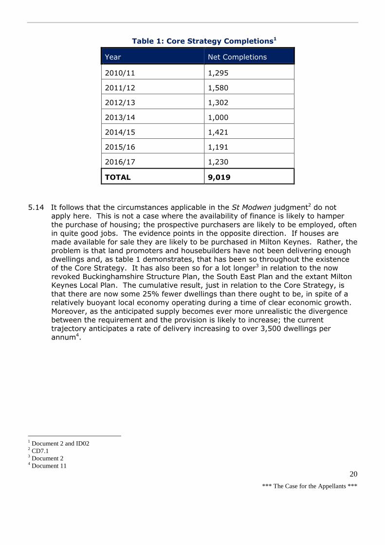
*** The Case for the Appellants ***
20
Table 1: Core Strategy Completions1
Year Net Completions
2010/11 1,295
2011/12 1,580
2012/13 1,302
2013/14 1,000
2014/15 1,421
2015/16 1,191
2016/17 1,230
TOTAL 9,019
5.14 It follows that the circumstances applicable in the St Modwen judgment2 do not apply here. This is not a case where the availability of finance is likely to hamper
the purchase of housing; the prospective purchasers are likely to be employed, often in quite good jobs. The evidence points in the opposite direction. If houses are made available for sale they are likely to be purchased in Milton Keynes. Rather, the
problem is that land promoters and housebuilders have not been delivering enough dwellings and, as table 1 demonstrates, that has been so throughout the existence
of the Core Strategy. It has also been so for a lot longer3 in relation to the now revoked Buckinghamshire Structure Plan, the South East Plan and the extant Milton Keynes Local Plan. The cumulative result, just in relation to the Core Strategy, is
that there are now some 25% fewer dwellings than there ought to be, in spite of a relatively buoyant local economy operating during a time of clear economic growth.
Moreover, as the anticipated supply becomes ever more unrealistic the divergence between the requirement and the provision is likely to increase; the current trajectory anticipates a rate of delivery increasing to over 3,500 dwellings per
annum4.
1 Document 2 and ID02
2 CD7.1
3 Document 2
4 Document 11

*** The Case for the Appellants ***
21
Table 2: 5-year housing land supply; methodological differences1
Requirement MKC
L’pool
TROY
L’pool
SPRU
L’pool
SPRU
S’field
A Requirement 2010-2026 28,000 28,000 28,000 28,000
B Annual requirement 1,750 1,750 1,750 1,750
D Net completions 9,019 9,019 9,019 9,019
G Requirement to date 12,250 12,250 12,250 12,250
I Shortfall -3231 -3231 -3231 -3231
J Remaining requirement
(A-G) 18,981 18,981 18,981 18,981
K Annual requirement (Liverpool)
2,109 2,109 2,109
M 5-year requirement + 20% (Liverpool)
(K*5)*1.2
12,654 12,654 12,654
N 5-year requirement +
20% (Sedgefield) ((B*5)+I)*1.2
14,377
Overall supply 13,727 13,727 13,727 13,727
Windfall adjustment 0 0 -30 -30
Delivery adjustment -697 -669 -4,936 -4,936
Estimated supply 13,030 13,058 8,761 8,761
Surplus or deficit 376 404 3,893 5,616
Years supply 5.2 5.2 3.5 3.1
Notes: Troy is Troy Hayes Planning Limited: SPRU is Strategic Planning Research Unit, Sheffield
5.15 Table 2 demonstrates that the existence or otherwise of a 5-year supply of housing depends largely on the different methodologies employed in the calculations; the
estimates vary from just being sufficient to being barely enough to cater for the requirements over the next 3 years. A key difference is the application of the
Liverpool or Sedgefield approach in the estimation; using the latter in place of the
1 ID02

*** The Case for the Appellants ***
22
former would be enough to reduce the provision to well below 5 years. The second source of disagreement is in the adjustments in delivery deemed to be necessary.
There are several elements involved in the different estimates of delivery proffered. Essentially these entail different allowances for uncertainty, slippage and failure: different responses to the results of research into the delivery of dwellings on ‘large
sites’ when estimating the expected progress on the ‘strategic sites’: and, different expectations for the development proposed in the emerging Site Allocations Plan1.
Sedgefield v Liverpool
5.16 The Planning Practice Guidance2 is clear as to the desirability of using the ‘Sedgefield’ approach for meeting any shortfall within the first 5 years. This is not
an invariable rule. But, it is the method favoured by the Secretary of State, save in circumstances where there is a cogent reason to show that such an approach would be inappropriate. The situation is set out in the Longhorsley appeal3. The PPG is the
correct starting point. The Guidance advocates dealing with any undersupply within the first 5 years, ‘where possible’. That must mean more than just ‘difficult’, given
that the whole point of the exercise is to boost the supply of housing significantly. And, as the Guidance continues, where the shortfall cannot be met in the first 5 years, Local Planning Authorities will need to work with neighbouring authorities
under the Duty to Co-operate in efforts to achieve the provision deemed to be required. That is quite a severe test. There is no evidence that the Council has
sought to cooperate with neighbouring authorities to meet the housing needs required. In the absence of such evidence, adopting the Liverpool approach risks becoming a means for manipulating the 5-year housing land supply to mask deficits
due, as in this case, to the particular mix and characteristics of the sites identified. Nor should it be a means to sidestep the clear requirement both to provide a
continuous 5-year supply of housing land and to boost significantly the supply of housing overall.
5.17 This situation is wholly unlike the position at Dark Lane, Alrewas4 where the housing provision of a recently adopted Local Plan entailed the Liverpool approach and where the consequence of utilising the Sedgefield methodology would have produced an
unrealisable figure and might have imperilled the delivery of the Plan itself. That is not the case here. Even though the housing trajectory set out in the Core Strategy
incorporated the ‘Liverpool’ approach in addressing the shortfall then arising that was part of the interim measures expected to endure only for the 2 years preceding the adoption of Plan:MK in 20155. That time is past. And, the argument that the
Liverpool approach better reflects the patterns of delivery derived from a preponderance of large sites with long lead times, is confounded by the facts that
many of these sites have already existed for some time, benefit from at least some kind of partial preparation and that one purpose of the Site Allocations Plan is to provide choice and flexibility in the short term6. In those circumstances, there is no
reason why the ‘Sedgefield’ approach should not be applied in this case.
1 Document 2
2 CD4.2
3 Document 3, appendix 9
4 CD6.1
5 CD5.29
6 CD5.2 and CD5.29

*** The Case for the Appellants ***
23
Uncertainty, slippage and failure
5.18 The Council have been persistently optimistic in the way that they have approached the projected delivery of dwellings on the allocated or identified housing sites, as
derived from the responses of developers and land owners. One expression of this is that past forecasts of housing delivery over successive 5-year periods from
2007/8 to 2012/13 have (apart from one year in the era of the Milton Keynes Partnership Committee) always over-estimated the delivery anticipated. On average, the delivery achieved has been about 25% below the delivery forecast,
though the ‘failure’ varies from roughly 20% to 37%1. It may be that these flawed forecasts have served to provide a false sense of security masking the real need to
take appropriate action to rectify the burgeoning deficit. But, whatever their effects, robust forecasts cannot be achieved without taking such ‘uncertainty’ into account.
5.19 Previously, and at the time that the Core Strategy was examined, the Council
utilised a 25% ‘optimism bias’ in order to achieve a reasonably robust forecast of housing delivery; that roughly reflects the experienced divergence between the
delivery achieved and the delivery forecast2. However, more recent assessments have diluted the robustness of that allowance. First a 10% overall ‘optimism allowance’ was utilised. That is quite common elsewhere and represents a simple
way to recognise that there can be delays in building the dwellings permitted and that some permissions may expire or allocations fail to materialise. Simply applying
a 10% reduction to the supply of dwellings indicated in table 2 would be sufficient to reduce the provision available to below 5 years in any of the methods outlined in the table.
5.20 However, the current approach to allowing for uncertainty reduces the ‘optimism allowance’ still further. It is now suggested that the 10% reduction in the supply of
identified housing sites should only apply to those sites expected to deliver dwellings in year 5 and beyond, no reduction at all being applied to the sites where all
dwellings are anticipated within years 1-43. The effect of this ‘relaxation’ is to reduce the effective ‘optimism allowance’ from 10% to about 5%. While this increases the estimate of the dwellings likely to be available to just achieve a 5-year
supply of housing land, there is little to warrant such an ‘optimistic’ approach to the perils and uncertainties experienced in the development of land for housing.
Delivery on large sites
5.21 The rate of delivery envisaged for several sites is disputed as being unrealistic. As an example, the ‘eastern expansion area’ (consisting of sites at Broughton Gate and Brooklands) achieved the second highest average delivery rate in the country
recorded in the NLP research into the delivery of dwellings on ‘large’ sites; an average of 268 dwellings were delivered annually over the 5 year period between
2008/9 to 2013/144. That was achieved because serviced parcels of land were delivered to the market, allowing several builders to commence building houses
almost immediately; and, it partly occurred before the MK Partnership Committee was disbanded in 2011. Those favourable pre-conditions are not so prevalent now. Yet, the current forecasts for the remaining sites at Brooklands are about 16%
1 Document 2, particularly tables 2 and 3
2 Op cit
3 Op cit
4 Document 3.23

*** The Case for the Appellants ***
24
higher, entailing an average of about 310 dwellings per annum over the 5 years from 2017/18 to 2021/22 with peaks of around 400 dwellings delivered within 2 of
those years. Moreover, the forecast delivery on 4 of the ‘outlets’ on the parcels that make up this site are substantially higher than might be expected from much of the research undertaken, including that by Savills, the HBF and NLP1. An estimate more
in keeping with the research and taking account of local conditions2 might envisage an average of 171dpa on each part of the ‘western expansion area (Fairfields and
White House) and on Brooklands from the ‘eastern expansion area’. There is no precedent, either locally or nationally, for a site such as this to deliver at the exceptionally high rate suggested by the Council of well over 500dpa between
2019/20 and 2021/22. Similar caution is required at Tattenhoe Park and at Central Milton Keynes or Campbell Park. The reductions estimated in table 2 are
warranted3.
5.22 The cumulative impact of these exaggerated levels of delivery on particular sites results in unrealistic estimates over successive 5 year periods. The 5-year housing
monitoring report for 2016 suggests annual delivery rates of over 2,500 dwellings in 4 out of the 5 relevant years. Such rates of delivery have been achieved just once
in almost a quarter of a century since the demise of the Development Corporation and the highest rate envisaged of over 2,800 dwellings has never been achieved in
that period. The report for 2017 is even more extreme. There, some 3,500 dwellings are anticipated to be completed in 2020/21 with completions in 4 of the other 5 years being around 2,500 or more. That higher figure was not even
achieved within the last decade of the Development Corporation; it is about twice the average annualised requirement of the Core Strategy and close to 3 times the
level recently achieved4.
5.23 Nevertheless, even if the ‘highest’ rate of development in Milton Keynes identified in the NLP study is substituted, thereby increasing the anticipated annual yield from
these strategic sites from 171dpa to about 270dpa for the entire 5-year period that would still only represent an additional 1,500 dwellings. It is evident from the last 2
columns of table 2 that, although the deficit would be reduced, the provision available would still be a long way short of catering for a 5-year supply of housing land.
The Site Allocations Plan and other sites
5.24 The availability of 5 sites identified in the Site Allocations Plan is disputed. The sites are all subject to objections and, although assumed to accommodate some 236
dwellings together, there are good reasons why those dwellings may not materialise within the next 5 years. In general the impediments involve access and ownership
problems5. As an example, the largest site (expected to accommodate 147 homes beside Groveway) is subject to an objection from the Parks Trust seeking an alternative access to one across land in their ownership6. It is also subject to an
objection from David Lock Associates on behalf of Baytree/AXA on the grounds that
1 Document 3
2 ID12
3 See also document 5
4 Response to inspector’s questions from Roland Burton
5 Document 2
6 Document 4.57

*** The Case for the Appellants ***
25
it is a large site originally allocated for employment purposes directly opposite an established and thriving employment area. And, being one of the most important
and best available employment sites within Milton Keynes, due to the proximity to the strategic road network, it should be retained in employment use1. These are issues to be resolved during the examination of the Plan. But, they suggest that
dwellings may not materialise on this site within the 5-year period.
5.25 The Council accept that the 75 dwellings anticipated at the Latham's Buildbase site
must be removed2. The site has been allocated since the adoption of the Local Plan in 2005. But, it is occupied by a company still selling building and timber supplies and no formal planning application has been submitted at any time, notwithstanding
its long-standing allocation. Similarly, the 61 dwellings on a site south of Water Hall School have benefitted from a planning permission since 2007 without any dwelling
materialising. Since the application was submitted by the Council itself, the delay may be prescient for delays still to come. Moreover, the absence of any planning application on several housing sites identified in the Lakes Estate Neighbourhood
Plan may also indicate a lack of interest in pursuing development there3.
5.26 The difference between the parties in respect of windfalls is not large. However,
while the Council’s estimate is a modest over-estimate, the appellant’s suggestion reflects what has actually been achieved. The difference identified in table 2
amounts to some 30 dwellings over the 5-year period.
Misguided advice
5.27 The advice proffered by Richard Harwood QC (in written submissions) suggests that the choice as to whether to utilise the Sedgefield or Liverpool approach is simply a
matter of planning judgement and that there is some overlap or double counting by including the buffer and the shortfall in calculating the requirement4. These claims
are misguided.
5.28 The claim that the choice of the Sedgefield or Liverpool approach is simply a matter
of planning judgement is derived mainly from the Bloor Homes judgment, but fails to acknowledge that the judgement did not take account of the guidance in the PPG. Indeed, the judgement related to a hearing in the High Court that took place before
the PPG emerged in connection with a decision letter issued the previous year following an appeal held in December 20125. Of course, the choice must involve a
planning judgement, but that judgement is one that must be properly informed by the appropriate policy and guidance; that is absent here.
5.29 As for the claim that there is some overlap or double counting entailed through
including the buffer and the shortfall in calculating the requirement, that is simply wrong. The annual requirement is derived from assessing the ‘objectively assessed
need’ to which a buffer is then applied (in this case 20%) to provide for diversity of supply and choice where, as here, there has been a persistent record of under-delivery. The buffer serves to bring forward development from later in the Plan
1 Document 4.55
2 XX Mr Goodall
3 Document 2
4 CD9.10
5 ID22

*** The Case for the Appellants ***
26
period so that the intended supply can be achieved. There is no increase in the overall supply1.
Addressing the shortfall
5.30 The existence or otherwise of a deliverable 5-year supply of housing is not an end in itself. On the contrary, it is part of a suite of measures intended to ‘significantly
boost the supply of housing’2. Hence, in the absence of a 5-year supply, a key consideration must be how the supply of housing is to be boosted significantly rather than just on how the shortfall is to be addressed. As demonstrated above, much of
the problem in Milton Keynes is due to the choice of sites identified, allocated or promoted by the Council; the mix of sites has failed to deliver sufficient housing
annually to date. The judgement of Lord Gill in Suffolk Coastal DC v Hopkins Homes and Richborough Estates v Cheshire East BC [2017] UKSC373, is apposite:
In relation to housing, the objective of the Framework is clear. Section 6,
"Delivering a wide choice of high quality homes", deals with the national problem
of the unmet demand for housing. The purpose of paragraph 47 is "to boost
significantly the supply of housing". To that end it requires planning authorities (a)
to ensure inter alia that plans meet the full, objectively assessed needs for market
and affordable housing in the housing market area, as far as is consistent with the
policies set out in the Framework, including the identification of key sites that are
critical to the delivery of the housing strategy over the plan period; (b) to identify
and update annually a supply of specific deliverable sites sufficient to provide ,five
years' worth of housing against their housing requirements, with an additional
buffer of 5% to ensure choice and competition in the market for the land; and (c)
in the longer term to identify a supply of specific, developable sites or broad
locations for growth for years six to ten and, where possible, for years 11-15.
The importance that the guidance places on boosting the supply of housing is
further demonstrated in the same paragraph by the requirements that for market
and affordable housing planning authorities should illustrate the expected rate of
housing delivery through a housing trajectory for the plan period and set out a
housing implementation strategy for the full range of housing, describing how they
will maintain delivery of a five years supply of housing land to meet their housing
target; and that they should set out their own approach to housing density to
reflect local circumstances. The message to planning authorities is unmistakeable.
These requirements, and the insistence on the provision of "deliverable" sites
sufficient to provide the five years' worth of housing, reflect the futility of
authorities' relying in development plans on the allocation of sites that have no
realistic prospect of being developed within the five-year period.
5.31 The preponderance of very large sites in the mix of sites identified as available,
dominated by the major national house builders and land developers, is suggested as a key reason why the delivery of dwellings has failed to meet either the delivery
anticipated or the calculated requirements4. This was to have been addressed in the short term by the immediate preparation of the Site Allocations Plan to provide a selection of more modest and non-strategic sites expected to be attractive to, and
developable by, medium and small builders and developers5. Such an initiative, subject to a specific policy in the Core Strategy, was seen as a crucial requirement in
1 ID22
2 CD4.1, paragraph 47
3 CD7.4
4 Document 2
5 Documents 2 and 11

*** The Case for the Appellants ***
27
finding the Core Strategy sound1. The Plan was expected to be in place in advance of the thorough review required in the new Local Plan (Plan:MK, also subject to a
specific policy in the Core Strategy), itself intended for adoption in 20152. The absence of both those documents means that the mechanisms specifically designed to address the weaknesses initially identified in the supply of housing land have
failed. That failure has left a void. There is no new initiative to boost the supply of housing significantly. Unlike the example of Stockton on Tees, where the withdrawal
of Government funds to support regeneration by building housing on brownfield land led to a radical strategic rethink in substituting alternative greenfield sites to provide for the housing required3, the approach at Milton Keynes is simply to plough on with
‘more of the same’. Even the financial incentives offered by the Council represent pale reflections of previous initiatives4. There is no realistic prospect of the housing
land supply shortfall being eradicated any time soon, as the increasingly unrealistic forecasts of delivery demonstrate5.
5.32 In those circumstances, the appeal proposal would represent a scheme uniquely
focused on addressing the void created by the absence of the Site Allocations Plan and Plan:MK. It would entail the development of a non-strategic and, in the context
of Milton Keynes, a fairly modest site to be developed by a relatively small developer using local builders. The scheme would be honed to reflect local circumstances,
including the spacious character and long back gardens of the adjacent dwellings with carefully designed new homes of ‘exceptional quality’, generous planting and swathes of open space6.. This would provide for a market under-represented in
Milton Keynes. As the Design and Access Statement indicates, the dwellings would range in type and size (from 1-5 bedrooms) and include both houses and some flats,
with 30% of the units offered as ‘affordable dwellings’ (25% being social rented properties and 5% being for shared ownership) in line with the Council’s requirements and the Affordable Housing SPD7.. Moreover, a section 106 Obligation
would ensure that ‘all reasonable endeavours’ would be undertaken to deliver the scheme within 5 years of any final approval of the reserved matters8, so responding
to the exhortations advanced in the Government’s White Paper Fixing our Broken Housing Market9. The proposal is not ‘just another housing scheme’. Rather, it is a development uniquely focused on addressing the housing problems all too evident in
Milton Keynes.
Providing affordable housing
5.33 There has been a significant shortfall in the provision of affordable housing, which
has occurred year on year10. The appeal proposal would provide at least 30% of the units as affordable homes, in accordance with ‘saved’ policy H4. In addition, should
it be that the opportunity for the doctor’s surgery within the site were not to be taken up, Wavendon Properties would provide 3 additional shared ownership
1 CD5.29
2 CD5.2
3 Example quoted by inspector
4 ID12 and ID13
5 Documents 11 and 12
6 Document 6
7 Document 11, CDs 1.9-1.11 and CD5.7
8 ID24
9 CD4.4
10 Document 11
*** The Case for the Appellants ***
28
houses1. Assuming that 203 dwellings were to be built, this would equate to a provision of 64 affordable homes. Indeed, the Planning Statement2 indicates that up
to 33% of the units might be ‘affordable’, although the Council have only sought 30%, in line with currently operative local policy.
5.34 There is a dire need to provide affordable homes. Although some 1,459 affordable
homes have been completed in the Borough in the past 5 years, this only represents an annual average provision of about 292 affordable homes and a level of provision
of around 24% of the 6,205 dwellings completed during that 5-year period3. Clearly, that level of provision is below the overall level actually sought due, no doubt, to some developments being below the threshold applied by policy H4, or
relating to ‘prior approval’ and permitted development conversions or providing a reduced contribution due to financial viability constraints. In addition, because the
level of completions has failed to meet the identified targets4, the annual provision of affordable units is well below the level estimated as necessary in the SHMA 20175. A need for some 8,094 additional affordable dwellings is estimated to be required
over the 15-year Plan period (2016-31), amounting to an annual average requirement of about 540 affordable units; that is roughly 1.8 times the level of
provision recently achieved. As of 2016 there were some 2,802 households in need of affordable housing, including those in unsuitable accommodation. The affordable
dwellings to be provided by the appeal scheme would not only be ‘policy compliant’, but also be provided quite quickly, thereby helping to address an identified and outstanding need6.
The impact of the scheme
5.35 In citing policy WS5 within the Woburn Sands Neighbourhood Plan in the revised
reasons for refusal7, the Council imply that the impact of the proposal on the character of the landscape and the surroundings of the town are issues to be addressed. Consideration of the impact on the setting of a Listed Building is a
statutory requirement of the Planning (Listed Buildings and Conservation Areas) Act 19908.
The landscape and the surroundings
5.36 The proposal would alter the outlook from nearby homes, the character and appearance of the fields themselves and the perception of those enjoying the
Boundary Walk9. There would be some removal of the vegetation around and within the site, including a few trees covered by a group TPO along Newport Road10. But
the site is quite well enclosed to the west by the housing along Newport Road and residential culs-de-sac, to the south by the dwellings along Cranfield Road and to the north by the trees and foliage around the golf course11. Only to the east is the site
1 ID23
2 CD1.11
3 Document 11 and CD9.1-9.7
4 Documents 2 and 11
5 CD5.25
6 ID23 and ID24
7 CD9.12
8 Document 11.7
9 Document 8
10 Documents 8 and 11
11 Document 8

*** The Case for the Appellants ***
29
more evident. But, even here views are restricted by thick hedges and trees along Cranfield Road, by the assortment of buildings at the Deethe Farm Estate and
tempered by the field hedges and trees1. Such visual containment would be reduced during the winter months. But, from most of the eastern vantage points the development would be seen against the existing houses or garden centres within the
settlement; the intention is to retain existing hedges and trees and to include new planting within the low density scheme envisaged2. As the Planning Officer
observed, ‘Whilst the site is located outside the development boundary of Milton Keynes [sic] consideration should be given to the fact that this site adjoins a settlement (Woburn Sands) boundary and as such offers a degree of sustainability.
In this respect, the site does not represent isolated land within the countryside and it could therefore be argued that the proposed development would form an
extension to the existing urban area3’.
5.37 Most of the site lies within the Wavendon Claylands4 character area, a place deemed to be of low susceptibility to change in relation to enclosure, landform and inter-
visibility consisting largely of flat fields enclosed by hedges with the occasional gentle rise. It is more susceptible in relation to its small scale, varied land cover,
the perception that it is relatively peaceful and the proximity of urban areas. However, a substantial expanse of fields and farmland would remain between the
appeal proposal and the Strategic Land Allocation to the north. And, although the site is currently classed as grade 3a agriculture land, the Council have not sought to demonstrate that suitable poorer quality land might be available to accommodate
the scheme.
5.38 The field to the south of Cranfield Road is within a slightly different character area
(Aspley Guise Triangle)5. This is deemed to be of low susceptibility to change in relation to historic landscape, land cover and buildings, but more susceptible due to its medium to large scale, low lying landform, and tranquillity (at least away from
the motorway). There are views westwards towards the Greensand Ridge (an Area of Attractive Landscape) lying beyond the town of Woburn Sands6.
5.39 A Zone of ‘Theoretical Visibility’ has been identified based on buildings on the site being some 2 to 2½ storeys and up to 8.5m in height7. This demonstrates that views of the development would be screened by buildings, major landscape features
and topography to the west and from substantial areas to the north, south and east. A ‘Zone of Visual Influence’ (ZVI) has also been derived from site visits and chosen
viewpoints to incorporate the influence of all the trees and hedgerows and the perceptibility of any likely change8. This is quite tightly drawn around the site itself, including little more than the adjacent fields to the east and south. The proposal
would result in large scale effects within the site and within the area immediately to the east and south. But, from slightly further afield the visibility of the development
would be contained by topography, the settlement and the hedges and trees to the
1 Documents 8 and 11
2 Document 9B
3 CD3.2
4 Document 9A.4
5 Document 9A.5
6 Document 8
7 Documents 8 and 9A
8 Document 9A

*** The Case for the Appellants ***
30
north, within the golf course and to the east; the magnitude of the change perceived would be much less. Low density housing would still abut fields enclosed by thick
hedgerows: the approach along Newport Road would still pass spacious houses in sylvan plots: the approach along Cranfield Road would still be beside hedgerows and trees until reaching the new access road beside Spinney Lodge1.
5.40 Although part of the pleasant Buckinghamshire countryside, the site and its surroundings are not identified as an ‘attractive landscape’ or as anything
particularly special. This is an ‘everyday’ landscape rather than a ‘valued landscape’, as referred to in paragraph 109 of the Framework. The large scale effects of the scheme would be confined to the site and its immediate surroundings.
The overall effects on the character of the ‘clay-lands’ and character areas nearby would be negligible2.
5.41 The main visual effects would be particularly evident on Cranfield Road, the Boundary Walk and from adjacent dwellings. The impact on Cranfield Road is assessed to be of major to moderate significance and adverse in the vicinity of
viewpoints 2 and 3, especially where the proposed houses would be seen on both sides of the road. Similarly, the impact on the Boundary Walk is deemed to be of
high magnitude (viewpoint 1), of major significance and adverse, particularly where views across fields and hedgerows would be replaced by the proposed housing. But
the scheme would be visible from only a small number of other locations including the Bletchley to Bedford railway line, a short section of Salford Road (through a field gate) to the east (viewpoint 4) and part of the Woburn Sands golf course (viewpoint
5). The effects would be limited due to views being heavily screened or filtered and because the development would be seen against the existing houses within the
town. That would certainly be so from viewpoint 6, since the town would be spread out in the foreground with the appeal proposal well beyond existing development: while from viewpoint 7, distance, the intervening motorway and the filtering effects
of vegetation would render the scheme practically unnoticeable. The effects would be very local. Beyond the immediate surroundings, the effects would be very
limited, the scheme being contained behind existing housing and topography and filtered through existing and proposed vegetation3.
5.42 The scheme would alter the prospect from the rear elevations and rear gardens
enjoyed by existing residents. The seclusion of immediately adjoining countryside would be lost and the outlook across an open field would be replaced by one across
suburban gardens towards suburban dwellings. But the low density and the generous length of the back gardens proposed would ensure that existing residents would continue to enjoy the prospect and privacy that they might reasonably
expect4.
5.43 In conclusion, given the nature, scale and sensitivity of the landscape, the proposal
could be accommodated satisfactorily. While very localised significant visual effects and effects on character would occur, none of the identified effects would be unacceptable, in landscape and visual terms. Such effects would be unavoidable
1 Documents 8 and 11
2 Document 8
3 Documents 8, 9A and 9B
4 Documents 8 and 11

*** The Case for the Appellants ***
31
consequences in relation to any housing development. Hence, they should be considered, along with other factors, in the overall planning balance1.
The facilities of the town
5.44 The suggestion that the proposed development would harm the equilibrium of Woburn Sands has not been demonstrated2. There is no Development Plan policy
indicating a ‘cap’ on development in the town and most of the development that has taken place is on the Nampak site, which was allocated3. In contrast, the appeal
scheme would offer a more appropriate form of development. In any case, Woburn Sands is identified in the Core Strategy as a ‘key settlement’ and as a focus for new development, so that ‘growth’ is supported by the Plan. Consultations have
indicated that the Asplands Medical Centre should have the capacity to take on new patients and that it currently offers a good service, with patients being able to make
an appointment on the day4. Nevertheless, if improvements turn out to be required, the proposal entails the offer of land for a health centre (or doctor’s surgery) within the site and a contribution of over £318,000 towards the costs of erecting a suitable
building there or a contribution to enhance the existing facilities in Woburn Sands5.
5.45 The evidence is that Swallowfield Lower School only has a small current capacity to
accommodate further admissions and that that Fullbrook Middle School, although not over-subscribed now, may be so in the future6. However, the proffered section
106 Agreement entails a contribution of almost £1.8m towards improving, or providing additional, educational facilities7. The contributions accord with policy CS21 and ‘saved’ policy PO4. There is space at both schools in the form of playing
fields, car parks and landscaping, to accommodate additional classrooms, if required. Both institutions are in Central Bedfordshire rather than within Milton
Keynes. But, that is not an insurmountable administrative problem and, in any case, schools with spare capacity exist within the Borough, albeit at least 1.7km distant8.
5.46 It follows that the appeal scheme would provide for any pressure the development might place on existing facilities, enabling such pressure to be adequately
accommodated. Moreover, additional housing would help to provide patronage for public transport and for local shops and services, adding to the vitality and sustainability of the town9. As in the Frosts appeal, Woburn Sands is a sustainable
place and was deemed to be so by the Secretary of State10. It was certainly not contended to be approaching any form of capacity constraint. Indeed, that would
also appear contrary to the emerging Plan:MK11.
1 Document 8 and ID22
2 Document 13 and some local representations
3 See section 4 and CD5.1
4 Document 11
5 ID23
6 Document 11 and CD5.20
7 ID23
8 Document 11
9 ID22
10 CD6.6
11 CD5.30
*** The Case for the Appellants ***
32
Heritage – Deethe Farmhouse
5.47 The site wraps around the Listed Building at Deethe Farmhouse, itself now
surrounded by commercial or industrial sheds of the Deethe Farm Estate1. The farmhouse itself was Listed in 1983, since when the south elevation has been remodelled and is brick rather than stucco. The Listing2 describes the property as:
Early C18 altered C19. Brick with painted stucco south elevation. Hipped old tile
roof with diaper pattern, flanking pairs of brick chimneys with offset heads and
moulded bases, 2 storeys and attic. South front has pair of 2 storey canted bays
carried up to parapets, each with central 4 pane wide sash window on 1st floor and
2 large casement windows on ground floor. Modern porch with lean-to roof
between bays.
5.48 The farmhouse and outbuildings remained largely as originally laid out until about 1925. Since then, the current arrangement has evolved with the introduction of light industrial units and modern roofing over older farm structures so that
commercial units now impinge hard against the fairly modest walled garden and driveway that surround the Listed Building. Even so, the farmhouse has historic
value as a building once the centre of an agricultural estate. Its surviving form is typical of its Georgian origins with a simple four room plan at ground and first floor levels and its association with local individuals adds to its historical interest as a
Georgian dwelling of some note in the local area. Its architectural interest is exhibited in the symmetrical southern elevation (albeit probably altered from a
single plain Georgian frontage with the two later double height bays added), the timber sash windows, prominent chimney stacks and hipped clay tile square roof with internal dormers and ‘zig-zag’ tiling. However, the east, west and northern
elevations are of a less architectural importance, including the later extension3.
5.49 There are no other Listed Buildings or designated heritage assets of relevance to an
understanding of Deethe Farmhouse. The remnant farm buildings to the north are much altered by later additions. The mature trees along the southern and western boundary of the plot enclose the gardens and the building. The surrounding
landscape consists of fields and modern houses. The fields faintly recall the origins of this farmhouse, but they are visually cut off by vegetation and the rural setting of
the building has radically altered through the encroachment of housing to the south and west and commercial structures to the north. The integrity of the setting has been lost. Only the southern elevation testifies to the character of the building and
that can only be fully appreciated from within the plot or over short distances along the driveway. The roof and chimney stacks can be glimpsed from outside the plot,
but from many directions the building remains enclosed by walls and foliage4.
5.50 There is no opportunity to experience the building without perceiving the impact of the surrounding industrial estate. The building neither dominates the landscape nor
is it an obvious focal point. On the contrary, even the roof-scape is only noticeable from short stretches of Cranfield Road and even then it is seen beyond the
surrounding walls and amongst the corrugated roofs of the industrial units. Hence, although the appeal site forms part of the setting of the farmhouse it is not integral
1 Document 11
2 Document 11.7
3 Document 11.7
4 Document 11.7
*** The Case for the Appellants ***
33
to an appreciation of its heritage significance. Indeed, the setting of Deethe Farmhouse is considered to have a low sensitivity to change due to the existing
degradation of its surroundings. So, although the illustrative layout would entail built development some 70m to the west and 63m to the south of Deethe Farmhouse, the open green space proposed would provide an appropriate ‘green
buffer’ between the Listed Building and the proposed development1.
5.51 A similar view is expressed in the Planning Officer’s report2, repeating a similar
assessment made in relation to a previous proposal in the vicinity3. It is stated that:
‘Some of the buildings within the current site appear on the 1881 map and
therefore are curtilage buildings, forming part of the listing. Now, some of the
original buildings survive, however to the north, large industrial sheds dominate
the site and the listed building. As such, the original rural setting has changed
significantly
[On this basis] the Conservation Officer assesses this to be less than substantial
harm on the basis that much of the site’s original rural setting has already been
eroded by the development of the site for industrial uses. On this basis there is no
objection to the principal of residential development in terms of the impact of the
setting of the listed building. The impact on the listed building should be carefully
considered when dealing with the future reserved matters application for layout
and suitable buffer/design mitigation secured’.
5.52 The appeal proposal would not fundamentally change the character of the
surroundings and the open green space immediately around the Listed Building would help to retain the semi-rural character of its setting. The effect of the scheme
is considered to result in less than substantial harm, as described in paragraph 134 of the Framework; indeed, it would be at the lower end of that category and, in effect, almost negligible. As the Council have previously observed, it would certainly
not be a reason to refuse planning permission for the scheme4.
Density
5.53 The second reason for refusal indicates that the low density of the proposal would not be sustainable, given the current objectives of both Government and the Council5. That was not a view echoed by officers. On the contrary, they suggested
that the location of the site merited a different approach recognising that policy H8 was out of date6.
5.54 The policy sets a minimum density of 30dph in rural areas and 35dph in Woburn Sands itself. The supporting text explains that ‘the policy promotes lower densities in the smaller rural settlements outside the City so that new development will be
more compatible with their character and also to allow choice and diversity in the type of residential development that is available within the Borough’. However,
‘developments with an average net density of less than 30 dwellings per hectare will not be permitted’7. This is in conflict with current national policy and, in line with
1 Document 11.7
2 CD3.2
3 Document 11.7
4 Document 11.7
5 CD3.4
6 CD3.2
7 CD5.1

*** The Case for the Appellants ***
34
paragraph 215 of the Framework; such a policy should be given less weight than more up to date guidance1. Indeed, the coalition Government amended the national
policy set out in PPS3 in a Ministerial Statement during 2010, removing the minimum density indicated and promoting a more flexible approach, now evident in paragraph 47 of the Framework. This simply requires Councils to ‘set out their own
approach to density to reflect local circumstances’; and for design, paragraph 59 advocates an approach to density ‘in relation to neighbouring buildings and the local
area more generally’. No minimum density is specified2.
5.55 The Core Strategy was adopted in 2013 and complies with the Framework3. It does not contain a policy to replace policy H8 and, in the absence of Plan:MK, the policy
still applies. But, policies CS10 and CS13 both refer to the need for a range of residential densities, the latter requiring that ‘all new development must be based on
a thorough site appraisal and be sensitive to its context. New housing should be of an appropriate density for the area in which it is located’. This exhortation was taken into account in the design of the appeal scheme having regard to the
character of the surroundings and the location of the site at the edge of the settlement4. The Residential Design Guide SPD also encourages a range of densities
in new developments appropriate to their context. It states that ‘a range of densities should be included that are contextually appropriate and take into account
the site’s size and its level of accessibility to public transport, facilities, shops, employment opportunities, open space and the rural edge. A range of densities will encourage a range of house types to be provided that suit a range of needs5’. And,
policy WS1 of the Woburn Sands Neighbourhood Plan requires all new development
within Woburn Sands to ‘respect the existing distinct vernacular character of the settlement’6.
5.56 The proposed density is a direct response to the constraints of the site and it reflects the characteristics of the surrounding housing. It is also a response to comments received at the public consultation event, at which local people repeatedly referred
to the recent development on the Nampak site (off Station Road), suggesting that a lower density would have been more suitable7.
5.57 Some concern was expressed that, if planning permission was granted, Wavendon Properties would submit a further application at a higher density. However, although a subsequent application for a higher density scheme was submitted, this
was only to demonstrate the appropriateness of the original scheme, which is the appellants’ favoured approach. Even so, the density was still below the minimum
level set out in policy H8 (at about 26dph) and the scheme amounted to some 303 dwellings8. The higher density was achieved by building over several areas of public
open space (including at the settlement edge), pushing development outwards and closer to the boundaries with existing housing, reducing garden sizes, reducing the
amount of landscaping and planting and including a greater proportion of flats
1 CD4.1
2 Document 11
3 CD5.2
4 CD1.10 and document 11
5 CD5.11
6 CD5.3
7 Document 11 and CD1.28
8 Document 11.13

*** The Case for the Appellants ***
35
around parking courts. The result is a scheme that compares unfavourably with the appeal proposal and fails to reflect the character of its surroundings1.
5.58 There are precedents for relaxing the limits of policy H8. The Development Framework for the Strategic Land Allocation2 allows for flexibility with some areas accommodating dwellings at densities of 5-10 or 10-15dph. And, development on
strategic sites is expected to be at an overall average of around 25dph, itself below the minimum required by policy H83. Recent approvals tell a similar story. A
scheme at Station Road, Bow Brickhill adjacent to dwellings built at around 16dph provides for 36 dwellings at a density of some 20.5dph4. A scheme on the edge of Sherington consists of 9 bungalows at a density of 12dph5. In contrast, the
relatively high density achieved on the Nampak site results in characteristics that residents considered out of place in Woburn Sands and which are deemed as
unsuitable for the appeal site6. It accommodates a high proportion of flats and buildings of 4 to 5 storeys, as well as more conventional 2 storey housing. There is little open space and much of what there is consists of a deep balancing pond.
5.59 The streets close to the appeal site are all developed at relatively low densities7. Parkway and Ridgway are developed at 11dph and 10dph respectively, each with
broad streets, detached or semi-detached dwellings set back from the road and exhibiting a consistent building line with large rear gardens; their most striking
characteristic is one of spaciousness. Hillway too is another low-density street developed at about 9dph now benefitting from substantial mature landscaping, a pattern to emulate at the settlement edge.
5.60 The suggestion that the illustrative layout was inappropriately wasteful of land was not backed up by a clear demonstration of where such waste might be evident8. On
the contrary, a need for lower densities in peripheral locations, adjacent to low density housing and countryside, was recognised. Moreover, it is clear that the Secretary of State is not unduly concerned about a density lower than 30dph; the
scheme at the Frost’s site (Wain Close) achieves a density of roughly 20dph9. There is nothing to demonstrate that the appeal scheme would fail to appropriately reflect
the site-specific context of its location. In those circumstances, there is no justifiable reason to withhold consent by reason of the indicated number of dwellings proposed and the likely density that would thereby arise.
Traffic and parking
5.61 No adverse highway impact is alleged by the Council10. On the contrary, the access
arrangements are deemed appropriate and the traffic generated is not envisaged as putting undue pressure on the local road network; details are to be considered
1 Document 11
2 CD5.4
3 CD9.12
4 Document 11.5
5 Op cit
6 CD1.10
7 Documents 11.4 and 11.13
8 Mr Goodall XX
9 CD6.6
10 CDs3.2, 3.4 and 9.12

*** The Case for the Appellants ***
36
subsequently as reserved matters1. The simple T-junctions proposed are deemed to have visibility splays commensurate with the surveyed speed of the traffic and also
with the limited queues and the modest use forecast in the updated Traffic Assessment; indeed, not much more than 1 vehicle a minute is estimated to exit the estate at the junction with Newport Road during the morning peak hour (allowing for
traffic growth) with practically no queuing2. Moreover, the suggested conditions allow for ‘gateway’ features and discussions have elicited the possibility of extending
the 30mph speed limits northwards on Newport and Cranfield Roads. Although the Transport Assessment does not incorporate all the recent or anticipated development, it has been updated to address traffic growth and the estimated
capacity of the junctions and the road network is such that incorporating the likely traffic from Parklands or the Frosts development would make little material
difference3. The concerns raised by third parties do not warrant an alternative view4.
5.62 Doubts that the TRICS data may not have been an appropriate comparator were
addressed by Mr Garner5. He explained that the explanation proffered in the TA may not have been clearly expressed6. In fact, settlements such as Exeter and
Chichester were chosen to avoid data from suburban locations in large or metropolitan settlements benefitting from substantial public transport networks that
could have depressed trip generation figures. In that way, and with the agreement of the Council’s Highway Officers, the trip generation rates are likely to be robust7. Further TRICS data runs had been undertaken to provide internal sensitivity tests to
reinforce the robustness of the selections made. Moreover, the results accord with the range anticipated. A change is occurring. Travel patterns are beginning to
reflect increases in homeworking and more flexible travel opportunities. Hence, peak hour spreading is increasing and it may well be more prevalent in the south-east than elsewhere. So, although Milton Keynes has been designed to be easy to
drive around and to find parking places, it also accommodates a workforce more likely than many to exhibit modern patterns of working. Given that Woburn Sands
also has a railway station and lies on a bus route, the opportunities for flexible travel are likely to be prevalent8.
5.63 The proposed development would not stymie the options for the east-west
expressway9. The intention to link the motorways and major roads north of London involve 2 of the 3 options following a route between Woburn Sands and the City of
Milton Keynes (the other option is for a route to the north of Leighton Buzzard)10. But, no detailed alignment has yet been published and although a connection to junction 13 on the M1 via an extension of Groveway is possible, nothing has been
safeguarded in the vicinity of the appeal site and there is nothing to indicate how
1 CDs3.5 and 3.17
2 CDs1.12, 1.13 and 1.15
3 CD1.13
4 ID22
5 Concerns raised by inspector
6 CD1.12
7 CDs3.5 and 3.17
8 Mr Garner’s explanation
9 ID22
10 Document 18

*** The Case for the Appellants ***
37
that connection might be made1. The proposed development need not interfere with the eventual construction of the east-west expressway.
5.64 There is some concern that prospective residents would be likely to drive rather than walk to the shops and other facilities in the town centre, thus adding to the pressure on the parking provision in the town2. The main car park may be busy but it is not
permanently full, nor is it the only place to park within the town3. Both the supermarkets are fairly small and aim to provide for ‘top-up shopping’, so that the
duration of car parking may well be rather less than elsewhere. Even though the scheme would involve the provision of some 530 parking spaces4 (excluding garages) a Travel Plan5 is intended to reduce the incidence of single occupancy trips
by car; there is no evidence that the proposal would unacceptably increase the competition for parking spaces in the town.
5.65 As a result, the TA remains robust and justifies the conclusions reached both by the Appellant and the Council. Moreover, the new road would alleviate the need for awkward manoeuvres at the level crossing, so reducing potential hazards and
contributing to road safety6.
The planning balance
Benefits
5.66 The proposal would provide substantial economic benefits and even more significant social benefits in the provision of much needed market and affordable housing. The
economic benefits7 would entail temporary construction employment for some 150 workers annually, or about 530 workers over the course of a 5 year construction period; demographic and labour market benefits, including the attraction of a high
proportion of working-age residents (80% in employment) and a cross-section of working people due to the range of accommodation offered; secondary employment
generated by increased spending in the local area (£5m in total, with £3.9m spent within Milton Keynes Borough), directly supporting around 35 full-time equivalent
jobs; a ‘new homes bonus’ paid to Milton Keynes Council of about £1.3m; and, annual Council Tax revenues of around £310,000.
5.67 The social benefits would include the provision of some 200 homes, 60 of which
would be ‘affordable’. That would not only contribute to meeting the dearth in the provision identified, but also represent a step towards reducing the imbalance
between jobs and housing that has arisen as a result of the failure of house-building to keep pace with local economic growth; the consequent increase of in-commuting is evident8. The proposal would thus help to foster sustainable patterns of
development at a regional level and, being within reasonable walking distance of the existing local services and facilities within Woburn Sands, at a local level too. The
new road through the site would create highways and transportation benefits by providing additional flexibility in the local network and an alternative to the existing
1 Mr McGrane XX
2 Document 19
3 Site inspection
4 CD1.5
5 CD1.14
6 CDs3.9 and 3.17
7 Set out in documents 11 and 11.8
8 Documents 11 and 12

*** The Case for the Appellants ***
38
junction between Newport and Cranfield Roads1. An additional social benefit could be provided in the form of the doctor's surgery within the appeal site or as
improvements to the existing facility2.
5.68 Environmentally, the scheme would provide for the potential to enhance habitats, particularly compared to the use of the site for agriculture and, as the ecological
assessment indicates, provide a net environmental benefit3. As the Planning Officer's report indicates4:
‘In terms of environmental sustainability the proposal would result in the
development of greenfield agricultural land. In addition the site also contains
important individual trees and hedges which positively contribute to the rural
character of the area. Whilst it is greenfield this does not necessarily prevent
development as the NPPF supports a more balanced approach when considering
proposals. It accepts that development may be permitted unless adverse impacts
would significantly and demonstrably outweigh the benefits; or specific policies
within the NPPF indicate that development should be restricted’.
5.69 Clearly the site is beyond the settlement boundary of Woburn Sands, but the same would apply to any unallocated site. Indeed, almost all the housing land identified
involves the development of greenfield sites. There would have to be something distinct about the appeal site for its greenfield location to be enough to render it unsustainable. That was not the view of officers in recommending approval for the
scheme and there is no landscape or similar argument to support such an objection to the proposal5.
Overall balance
5.70 The proposal would represent sustainable development. That was the view set out in the Planning Officer’s report; providing much needed market and affordable
housing on a site accessible to local services and facilities and providing for any additional need for educational or medical requirements, would warrant such a description. Thus, having regard to the three dimensions of ‘sustainability’ set out in
the Framework, this scheme should properly benefit from the presumption in favour of ‘sustainable development’. The fact that Woburn Sands is a ‘key settlement’ and
the only one with a railway station, serves to emphasise the point. No specific policy in the Framework has been identified to indicate that, in the absence of a 5-year
supply of housing, permission should be refused6.
5.71 In those circumstances, although the starting point may well be the Development Plan, that cannot be the end of the matter. As Lindblom LJ indicates7:
‘...planning decision making is far from being a mechanical or quasi-mathematical
activity. It is essentially a flexible process, not rigid or formulaic. It involves,
largely, an exercise in planning judgement, in which the decision-maker must
understand relevant national and local policy correctly and apply it lawfully for
particular facts and circumstances of the case in hand in accordance with
requirements of the statutory scheme. The duties imposed by Section 70 (2) of
1 ID22
2 Document 11
3 CDs1.16-1.19
4 CD3.2
5 ID22
6 ID22
7 Barwood Strategic Land LLP v East Staffordshire BC and Secretary of State [2017] EWCA Civ 893

*** The Case for the Appellants ***
39
the 1990 Act and Section 38 (6) of the 2004 Act leave with a decision-maker a
wide discretion. The making of a planning decision is, therefore, quite different
from the adjudication by a Court on an issue of law... I would endorse, and
emphasise, the observations to the same affect made by Holgate J in paragraphs
140 to 143 of his judgment in Trustees of the Barker Mill Estates’.
5.72 So, even in circumstances where an inspector were to conclude that the Council
could demonstrate a 5-year supply of housing, the sustainability and other advantages could constitute material considerations sufficient to justify the grant of planning permission. As recognised by Council Officers, the appeal proposal would
represent sustainable development adjacent to a ‘key settlement’, which contains not only a wide range of service and facilities but also, uniquely among the ‘key
settlements’, a railway station. As the Council cannot demonstrate a 5-year housing land supply and as the shortfall in both market and affordable housing is longstanding, acute and continuing, the proposal must continue to benefit from the
presumption in favour of sustainable development. There are clear benefits that are economic, social and environmental. Moreover, the landscape and visual impacts of
the scheme are both limited and localised; they are to be substantially ameliorated by an appropriate landscaping scheme. Similarly, the heritage impact has been assessed by the Appellant and the Council as causing less than substantial harm and
at the lowest end of that spectrum1.
5.73 Hence, in conclusion, the proposed development would give rise to substantial
benefits which would not be outweighed by any of the alleged detrimental impacts. The presumption in favour of sustainable development must thus indicate that the
scheme should warrant approval.
1 ID22

Report: APP/Y0435/W/17/3169314
40 *** The Case for the Council ***
6. The Case for Milton Keynes Borough Council
Introduction
6.1 The Town and Country Planning Act 1990 indicates that this initial application for planning permission is now before the Secretary of State, as if it were before him in
the first instance. The determination must be made by reference to the Development Plan, so far as material, and to any other material consideration. If
the Development Plan indicates a particular outcome, then that outcome should occur unless material considerations indicate otherwise. The Framework is consistent with that legal position. Indeed, it emphasises the position of the
Development Plan and the primacy of the Plan-led process1.
6.2 An application for planning permission can reach an inquiry either via a refusal or
through the failure of a Council to determine an application within the prescribed period. The latter entails no reasons for refusal. But, no-one would suggest that the Council should refrain from presenting the evidence pertinent to the inquiry.
The situation is no different if reasons for a refusal have been given. The rule requiring the planning authority to submit a statement of case is in no way limited
(as suggested by the appellants) or at all; in this case, it is evidence presented by Mr Goodall. Moreover, planning is an exercise in the public interest so that the Council’s case cannot be irrevocably tied to the language set out in a reason for
refusal, especially if a material change in circumstances had occurred in the interim. And, the process for seeking planning permission is distinct from the process for
dealing with appeals. Each has its own requirements detailing what information is to be given, what a reason for refusal might entail or what a statement of case might involve. There is no particular rule requiring some internal mechanism to be
followed by the Local Planning Authority; a case is made and evidence called to substantiate it2.
6.3 The key issues in this case are:
the relationship of the scheme to the Development Plan, the existence, or otherwise, of a 5-year supply of deliverable housing sites,
the impact of the proposal on the character of the landscape and the surroundings, as well as the facilities in Woburn Sands,
the acceptability of the housing density proposed, and the overall planning balance in relation to the economic, social and
environmental dimensions of ‘sustainable development’
The Development Plan
6.4 Although the Development Plan is designed to be read as a whole it contains distinct
policies which may pull in different directions; the Plan reveals a comprehensive whole in which housing supply is just as much a part as, for example, employment
policies. The Plan is also a living document to be interpreted not at some past fixed date but in the light of the current circumstances. The Neighbourhood Plan is part of a Development Plan. The Framework indicates that such Plans are to provide a
powerful set of tools for local people to ensure they get the right types of development for their communities. In this case there are ‘saved’ Local Plan3
1 ID21
2 ID21
3 CD5.1
41 *** The Case for the Council ***
policies, a Core Strategy1 and a Neighbourhood Plan2 providing a strategy and local implementation measures reflecting the views of the community.
6.5 Milton Keynes may not be found to have a 5-year housing land supply; although sites have been identified dwellings may not have materialised. In those circumstances first, a deficiency does not automatically warrant permission for
housing development anywhere. Second, the weight to be given to such a material consideration remains a matter for the decision maker. Third, the Framework and
several decided cases indicate that the weight to be given to achieving a 5-year housing land supply should be advanced and the weight to be given to inhibiting policies reduced. Even so, a balancing exercise still has to be undertaken, albeit a
‘tilted’ one. Fourth, one consideration in reaching such a balance might be that a deficiency of one month would not be equivalent to one of 36 months3.
6.6 In Milton Keynes, the Development Plan is especially important. The place came into existence as a planned New Town and ‘planning’ is inherent to its identity. Here a spatial strategy is ‘aided’ by a relevant Neighbourhood Plan, the latter being the
most recent document to have completed all the statutory processes. In the exercise of development control, where a valid choice can be made, it should be
supportive of the Development Plan. Even more so where there is a coherent strategy informing past and future development for a place intended to foster
growth. Of course, the Supreme Court case4 only addressed the absence of a 5-years supply: it offered no guidance where a 5-year supply exists. Where there is clear evidence that development would be contrary to, or undermine, a
Development Plan (as here), it is difficult to see how it would be right to do anything other than uphold the Plan, unless very weighty considerations indicated otherwise5.
6.7 Core Strategy policies CS1 and CS9 imply that development in the ‘key settlements’ of Newport Pagnell, Olney and Woburn Sands should have regard to the population, constraints, transport links and the capacity of services in these towns. And, such
assessment against the strategy to manage sustainable patterns of development must take account of recent and committed levels of development. Previous
refusals for housing development on part of the appeal site addressed such matters6. Woburn Sands has continued to deliver growth at rates significantly above the other ‘key settlements’ and its stock of dwellings has increased by around 50%
between 2006 and 2017. In contrast, Olney and Newport Pagnell have increased by less than 7% and 5%, respectively accommodating just 184 and 295 additional
dwellings against the 522 new homes accommodated in Woburn Sands7. Proper interpretation of policies CS1 and CS9 must take account of how the requirements for development in the rural areas are being achieved in order to maintain a balance
between uses and places.
6.8 For example, development on the ‘Frosts’ site forms a functional part of Woburn
Sands although it lies within Wavendon Parish8. The recent permission for ‘Nampak’ increases the number of dwellings from 30 to 81 by utilising land previously identified for employment purposes in the Local Plan9. It thus adds to the housing
1 CD5.2
2 CD5.3
3 ID21
4 CD7.4
5 ID21
6 CDs8.1 and 8.5
7 Document 13
8 CD6.6
9 Document 14.3

42 *** The Case for the Council ***
growth at Woburn Sands but limits the options to increase local job opportunities, thereby reducing the scope for self-containment and the maintenance of sustainable
patterns of development1. Policies S10, CS1, CS2 and CS9 do not provide a ‘broad brush’ approach for significant additional greenfield development in rural areas. Nor do they indicate a specific requirement for further allocations in specific settlements
or a need to support development in advance of further site allocations. Instead, the Development Plan sets out an appropriate, plan-led response to manage
sustainable patterns of development, having regard to population constraints, capacity and transport infrastructure. Permitting further unplanned, speculative, development outside of settlement limits must risk undermining the aim of achieving
such sustainable development. The Development Plan thus remains the most appropriate mechanism to identify new housing allocations, particularly those
outside settlement boundaries, as it will allow extensive consultations with local communities and a comprehensive assessment of a number of sites within and around all of the ‘key settlements’ and ‘selected villages’2.
6.9 In examining the Core Strategy, the Inspector considered that the rural areas housing target should be separated from that for the growth area around Milton
Keynes and that separate consideration of the needs for the rest of the borough is part of a sound spatial strategy3. The remaining requirements for the rural areas did
not need the identification of additional areas for growth and the strategy set out in policy CS1 represented a sound balance of the sustainability considerations that should guide the location of new development4. The Core Strategy was deemed to
identify the quantum of developable sites needed to meet the requirements up to 2026 with Plan:MK needed to identify the additional requirements up to 2031.
Hence, the purpose of the Site Allocations Plan was not to identify more land for housing, but to identify additional non-strategic sites to provide flexibility and choice in the short-term and to maintain a 5-year supply of housing land in advance of
Plan:MK5. This was also a response to providing a 20% ‘buffer’ for choice and competition amounting to around 1,000 dwellings in the rural areas6. The Council
maintain that, even without the allocation of additional sites through the Site Allocations Plan, sufficient developable sites remain to fulfil the requirements of the Core Strategy by 20267.
6.10 Recent development and the emergence of Neighbourhood Plans affect the provision of dwellings in the rural areas; several allocations in Neighbourhood Plans already
benefit from planning permission8. And, of course, significant levels of development can occur without reference to Neighbourhood Plans, as at Woburn Sands9. The Council claim that the ‘full rural deficit’ has been addressed through such processes,
so that there is no need to make further allocations within the rural area in the Site Allocations Plan10. The Woburn Sands Neighbourhood Plan takes account of those
processes and, as a consequence, makes no allocations of land for housing. The appeal proposal directly conflicts with its approach to development in the countryside. Policy WS5 seeks to prevent schemes that impact on the countryside
setting of Woburn Sands and ignore the need to assimilate the recent high level of 1 Document 14.3
2 ID21
3 Document 13
4 CD5.29
5 In accordance with policy CS2 in CD5.2
6 Document 14.4
7 Document 15
8 Documents 13 and 14.4
9 CD5.3
10 Document 14.5

43 *** The Case for the Council ***
growth. The Examiner indicated that the ‘vision’ outlined in the Neighbourhood Plan accorded with the Core Strategy in seeking to maintain the sustainability of the town
and its character, while facilitating limited levels of development in ‘key settlements’. The maintenance of settlement boundaries complied with those aims1. Hence, the view was that the ‘Core Strategy in its Development Strategy and
policies CS2 and CS9 effectively continues this policy approach and it is clearly not the intention that housing will be developed in open countryside’.
6.11 The Supreme Court2 indicates that, even where a 5-year supply of housing land cannot be demonstrated, weight can still be given to the inhibitory policies in a Development Plan and that the weight to be assigned is a matter for the decision
maker. It is perfectly clear that weight should be given to policies S10 and WS5. First, those policies have warranted comparatively recent refusals and like cases
should be decided alike to ensure consistency3. Second, the policies have been through all necessary procedures and have not been found wanting. Nor do they impinge on the land that is available or the planning permissions that have been
given. Third, the Framework emphasises the importance of the most recent part of the Development Plan which, in this case, is a consequence of the Localism Act
2011. Fourth, the policies plainly perform a valuable function; it is desirable in rural areas to have development limits. Plainly, a limit to prevent a straggling outlier of
Woburn Sands is a ‘good thing’.
The 5-year housing land supply
The backlog, the requirement and alternative estimates of provision
6.12 There is more than sufficient land allocated or identified for the supply of the
housing required by the Core Strategy. Further, there is no difficulty about the grant of planning permission; there is a huge supply of housing sites with planning
permission. Indeed, together these sources of supply might provide sufficient housing land for the next 8 years and accommodate some 22,000 dwellings4. This
was agreed by witnesses for the appellant. The only question is about delivering the dwellings required on the sites identified in accordance with the Core Strategy trajectory. It is possible to take a horse to water but not to make it drink. Here, the
infrastructure is provided, the permissions are granted, administrative support is available and economic activity is encouraged, yet the appellants assert that their
site must be developed to make up the backlog that has occurred in the past. Because under delivery has occurred it must be expected to continue; optimism is to be doubted and expectations mistrusted.
6.13 Much is agreed. This is shown in Table 2 above which demonstrates that the existence or otherwise of a 5-year supply of housing depends largely on the different
methodologies and assumptions employed in the calculations; the estimates vary from just being sufficient according to the Council to being barely enough to cater for the requirements over the next 3 years according to the appellants. The key
differences are whether to apply the Liverpool or Sedgefield approach and the scale of adjustments warranted to the Council’s initial estimates of supply. As can be
seen, the latter varies from a reduction of about 670-700 dwellings to nearly 5,000 units.
1 CD5.17
2 CD7.4
3 CDs8.1-8.8
4 Document 15 and CD3.6

44 *** The Case for the Council ***
Sedgefield v Liverpool
6.14 How should the existing deficit be managed? It is accepted that the Guidance favours Sedgefield. However, that is not conclusive because there are
circumstances, including decisions made by the Secretary of State, where the use of the Liverpool approach has been deemed to be appropriate1. If the Sedgefield
approach is used there is a deficiency. The contrary can be the case if the Liverpool method is applied. A judgment needs to be made. There are 9 years left of the Plan period and, as that period decreases, the results derived from the 2 methods
converge. However, the spatial strategy does not envisage development on the appeal site during that period. The strategy covers an area that is regionally
important and is recognised nationally as a key engine to foster economic growth. The suggestion is that if a choice between the Sedgefield and Liverpool approaches resolves itself into a choice between the pursuit of a spatial strategy supported by
the Development Plan and one that contravenes the Plan, then the choice ought to accord with the Plan and, in this case, favour the Liverpool approach2. The
alternative is to allow development beyond clear settlement limits resulting in a straggling extension separated from the town by the intervening railway line. Why allow development on the ‘wrong side of the tracks’, contrary to the aims of the
spatial strategy and the requirements of the Development Plan?
6.15 The Liverpool approach is also endorsed by the Core Strategy itself. The housing
trajectory set out in the Core Strategy incorporated the ‘Liverpool’ approach in addressing the shortfall then arising3. An approach condoned in a ‘sound’ and adopted Core Strategy might well be warranted, especially if something close to the
trajectory had actually been achieved. Although that has not been the case, it demonstrates that the Liverpool approach is consistent with the Core Strategy and
some of the reasons for condoning that approach set out by the Examining Inspector, including the size and distribution of the allocated housing sites and their
progress towards delivering the dwellings required, still apply4.
6.16 It is suggested that permitting development on the appeal site could inhibit progress on allocated sites, thereby further undermining the Core Strategy5. The appellants
expect to use local labour and source their materials locally. Very fairly it was agreed that the use of such labour, materials and equipment must preclude their use
elsewhere, including for the development of allocated sites6. Also, preventing development on unallocated land beyond settlements (like the appeal site) must encourage it on sites allocated or identified in accordance with the adopted strategy.
In this case the planning system should support rather than impede the Council in their efforts to persuade the house builders to deliver the dwellings required. The
appeal site might be a distraction beyond settlement limits and an impediment to progress elsewhere. As an example, the claim that ownership of the appeal site by the appellants would allow a high quality development there ignores the fact that the
site could be sold and there is nothing to suggest that such skills could not be deployed to build a high quality development on a site elsewhere allocated for
residential development and in accordance with the Development Plan7.
6.17 For all those reasons, the Liverpool approach is to be preferred here.
1 CD6.6
2 ID21
3 CD5.2
4 CD5.29
5 ID21
6 XX Katy Jordan
7 ID21

45 *** The Case for the Council ***
Uncertainty, slippage and failure
6.18 Parliament expects extensive monitoring by the Council and commands, through planning legislation, that the Council undertake surveys into all manner of
phenomena, including the availability of housing land and the erection of dwellings thereon1. This is largely achieved by contacting builders and developers directly and
asking those involved in the industry how they anticipate development proceeding. No criticism is made of the results by the appellants and, indeed, Mr Bolton has made extensive use of them. Past forecasts of housing delivery over successive 5-
year periods from 2007/8 to 2012/13 are compared with the completions that have materialised2. Although 5 of the 6 forecasts for each 5-year period over-estimate
the delivery anticipated, the forecast for 2008/9 is spot on and in several of the individual years delivery exceeds the forecast expectation. So, although on average, the delivery achieved has been about 25% below the delivery forecast, that is not
always the case; the forecast can sometimes be accurate and delivery can often exceed expectations in particular years.
6.19 To achieve robust forecasts in the face of the uncertainty indicated above, the Council utilised a 25% ‘optimism bias’ at the time that the Core Strategy was examined. However, more recent assessments have applied a reduction of 10% to
cope with ‘uncertainty’, as is common elsewhere. But the current approach is to apply the 10% reduction to sites where delivery is expected to continue in year 5
and beyond, no reduction being applied to sites where all deliverable dwellings are expected to materialise within years 1-43.
The effect of this ‘relaxation’ is to reduce
the ‘optimism allowance’ from 10% to about 5%. It is justified by careful analysis. Lapse rates over the previous 5 years have shown that expired planning permissions
have amounted to just 3% of the overall supply and, as 48% of those losses occurred on ‘windfall’ sites (which are already accounted for in the calculation), an
allowance of just 1.4% would cater for the risks of non-implementation for sites expected to deliver within the 5-year period4.
6.20 The appellants are also wrong in the reductions they make to the ‘windfall’
allowance. The Framework makes it plain that such an allowance is permissible if evidence exists to warrant it. Detailed evidence is presented to demonstrate the
existence and scale of the provision accruing on ‘small windfall’ sites in both urban and rural areas5. The allowance is derived from the annual average number of
dwellings materialising in both areas and, in the urban area, this includes those schemes of less than 10 dwellings converted from buildings in other uses. The latter are not encompassed by the SHLAA and thus are a legitimate addition to the supply
of homes. The resulting ‘windfall’ allowance of 95 dwellings a year is thus justified: the reduction of 6 dwellings a year made by the appellants wrongly ignores the
contribution from conversions6.
Delivery on large sites
6.21 The rates of delivery envisaged for ‘large sites’ are based on the Council’s rigorous
monitoring of past performance and surveys of the developers and builders involved in delivering the dwellings permitted on the relevant sites7. The estimates thus
1 Section 13 of the 2004 Act requires (1) local planning authorities to keep under review matters which may be expected to
affect ...development or ...its planning 2 Document 2, particularly tables 2 and 3
3 Documents 2 and 15
4 Document 15
5 Documents 3.2 and 15
6 Document 15
7 CD9.8 and document 4.61

46 *** The Case for the Council ***
harness the knowledge and experience of those directly engaged in the process and who might be expected to know the physical and market constraints likely to apply.
The results have been further assessed by the Council’s witness1 and, as a result, a ‘delivery adjustment’ of about 670 dwellings is suggested2.
6.22 In contrast, the appellants ignore such local knowledge and detailed surveys to apply
average levels of delivery. This is contrary to Government requirements for robust monitoring3. The averages employed are largely based on company reports4 and a
paper by Nathaniel Lichfield and Partners5. However, the paper itself points out that Milton Keynes is very different from other parts of the Country and that there are very large differences from site to site in the rates of delivery achieved. It is
accepted6 that some of those differences can be due to the matters set out in the Colin Buchanan7 report such as site conditions, the strength of the local market, the
scope for joint working, the type of developer and the release of land by landowners. Moreover, it is those factors contributing to expedition rather than delay that are clearly present here. In addition, that list does not expressly include some of the
points made by the builders themselves as encouraging delivery that exist in Milton Keynes, such as high employment, good mortgage availability and low interest
rates8. Applying a notional ‘average’ to the rate of delivery on sites in Milton Keynes that does not properly reflect the unique characteristics of the place is thus a
fundamental error. Milton Keynes is not Redruth, Beaconsfield or even Yorkshire. It follows that applying a ‘delivery adjustment’ derived from averages of almost 5,000 dwellings must be highly suspect9.
6.23 For example, although 237 dwellings are recorded as ‘under construction’ for 2016/17 on the ‘western expansion area 11’ (Fairfield) the average applied by the
appellants assumes only 171 would materialise in 2017/18 rather than the 201 estimated from surveys and experience by the Council10. Even odder, the 294 dwellings ‘under construction’ for 2016/17 on the ‘western expansion area 10’
(Whitehouse) also turns into just 171 dwellings materialising in 2017/18 rather than the 291 estimated by the Council. Or, the 273 dwellings ‘under construction’ and
the 252 ‘starts’ for 2016/17 at ‘Brooklands’ similarly results in 171 dwellings materialising in 2017/18 rather than the 336 estimated by the Council.
6.24 Properly interpreted the figures reveal a large number of sites and the delivery of
sufficient dwellings to meet the housing requirements identified11. One reason for this is that the sites are divided into appropriate parcels, thereby facilitating their
development by house builders and the approval of reserved matters12. As confirmed by Mrs Jordan, developers create momentum and build up a ‘head of steam’ in the course of developing parcels of land; they assemble their labour, their
materials and their equipment and they seek to employ it all efficiently13. So, units started are likely to be completed as quickly as possible and brought to the market
1 Document 15 and CD9.8
2 See table 2
3 ID21
4 Document 3.32-39
5 Document 3.23
6 XX Roland Bolton
7 Document 3.26
8 Document 3.38
9 See table 2
10 CD9.8
11 ID21 and document 15
12 XX Roland Bolton
13 ID21

47 *** The Case for the Council ***
for sale. And, once the infrastructure and footings are completed on one parcel, the relevant building teams are likely to proceed to the next one. The averages
employed by the appellants do not reflect the starts that have been made nor do they take account of the momentum that such starts can generate.
6.25 Moreover, the appellants are too ready to condemn others as being too optimistic.
So, Mr Claye’s response (for Gallagher Estates)1 that over 300 units might be completed in 2017 on ‘area 10’ and annually thereafter from 5 builders (one of
which had already achieved the completion of 75 dwellings) and that 240 units are expected annually on ‘area 11’, given that such numbers were achieved in 2016, is dismissed as not being supported by robust evidence and from a promoter who has
been over-optimistic in the past2. But, the level of completions that has actually occurred is evidence. And, the fact that estimates may have been over-optimistic in
the past does not mean that they must always be so. Although some reduction to the Council’s initial estimate of the delivery of dwellings on large sites might be warranted, a reduction of about 670 dwellings is to be preferred to the flawed and
exaggerated reduction suggested by the appellants.
Addressing the shortfall
6.26 The claim is that a shortfall does not exist. If, due to methodological considerations,
it is decided that it does, then it is important to bear in mind that the existence or otherwise of a deliverable 5-year supply of housing is part of a suite of measures
intended to ‘significantly boost the supply of housing’3. The focus should thus be on the measures in place to do just that. The short term measure derived from the examination of the Core Strategy was the immediate preparation of the Site
Allocations Plan, intended to provide a selection of more modest and non-strategic sites attractive to, and developable by, medium and small builders and developers4.
In addition, a thorough review of the housing requirements and the supply of land needed to meet them was anticipated through the preparation of Plan:MK, intended
for adoption in 20155. Although the preparation of both those documents is underway, with the emerging Site Allocations Plan having reached a fairly advanced stage, the current absence of both those documents means that the mechanisms
specifically designed to address the weaknesses initially identified in the supply of housing land are not yet in place.
6.27 However, the Council have embarked on strenuous efforts to ‘plug the gap’ left by the current absence of those documents and to ‘boost significantly the supply of housing’, albeit mainly on strategic sites. The Council have intervened to fund and,
in conjunction with Highways England, construct road schemes to open up both the Eastern and Western Expansion Areas. Loans have been provided to enable
developers to bring forward necessary infrastructure to utilise the south eastern sector of Brooklands. The lead has been taken in devising and coordinating ‘equalisation’ arrangements to ensure ‘fair’ contributions and encourage cooperation
between developers in building out strategic sites. They have used the mechanism offered by the Milton Keynes ‘Tariff’ to make use of initially landlocked areas for
housing, though these arrangements are increasingly hampered by the CIL Regulations. And, they are negotiating significant disposals of Council owned land at Campbell Park, Central Milton Keynes and Tickford Fields6. Such measures have led
1 Document 4.61.3
2 Document 2
3 CD4.1, paragraph 47
4 Documents 2 and 11
5 CD5.2
6 ID12-ID17

48 *** The Case for the Council ***
to particularly high rates of delivery in the past (as demonstrated by the NLP research1, for example) and help to justify the high rates of development forecast by
the Council over the next 5 years.
The impact of the scheme
6.28 The Core Strategy allocates a large site as a Strategic Land Allocation to the north
and east of the appeal site in the parish of Wavendon. In doing so, a range of options was considered, including the allocation of land extending southwards and
immediately east of the appeal site2. That option was rejected because the Examining Inspector considered that ‘the protection of Wavendon’s identity and setting are important. The need for settlement character to be respected has been a
consistent theme in the studies and strategies for large scale expansion in this area’3. Similarly, options risking coalescence or poor integration with the city were
ruled out. Hence, housing development in this location has already been rejected due both to its impact on the landscape and to its effect on the character of the settlement.
The landscape and the surroundings
6.29 Most of the appeal site is within the ‘Wavendon Claylands’ identified as a landscape
with a ‘medium sensitivity’ to change and with a diverse mix of land cover; there is a need to consider impacts cumulatively with the development of the Strategic Land
Allocation to the north4. Indeed, the advice is that ‘Future development within the Strategic Land Allocation area to the north will have a significant impact on the landscape character of the area extending the built development of Milton Keynes
towards the northern boundary of this area’. Although the Visual Impact Assessment5 indicates that the site itself has a ‘medium to high capacity’ to
accommodate the scheme, it pre-dates the more recent study6. The latter indicates that ‘Woburn Sands Claylands’ and Woodley’s Farm Claylands’ (to the west of Woburn Sands), both demonstrate a lower sensitivity to change and higher capacity
for development.
6.30 The appeal site is on the northern fringe of Woburn Sands and mainly within the
parish of Wavendon. There is open landscape to the east of the site providing a rural buffer to the north of Woburn Sands. The site is currently classed as grade 3a agriculture land7 and it is greenfield land. The Framework advises that where
‘significant development of agricultural land is demonstrated to be necessary, local planning authorities should seek to use areas of poorer quality land in preference to
that of a higher quality’. Speculative development on such a site is inconsistent with that advice. Nor could the scheme be described accurately as ‘infill’ development, since the site only abuts the southern and western edges of the settlement.
6.31 ‘Saved’ policy S10 and the Framework seek to protect the intrinsic value of the countryside, including its rural landscape and character8. The proposed
development would represent a significant incursion on to a greenfield site damaging the rural landscape character. The development limit would be pushed outwards to accommodate the scheme resulting in the town sprawling into the open countryside
1 Document 3.23
2 CDs5.4, 5.26 and 5.27 leading to 5.24
3 CD5.29
4 CD5.14
5 CD1.25
6 CD5.14
7 Document 14.7
8 See section 4

49 *** The Case for the Council ***
and harming a setting important to its identity. Significant natural features, such as hedgerows and field patterns, would be lost. This would be evident along the
eastern boundary resulting in an uncomfortable juxtaposition between rural and residential elements. The character of an existing footpath would be impaired by the encroaching development. The proposed access on to Newport Road would
necessitate the removal of 4 trees protected by a Group Tree Preservation Order1. The soft rural border to the settlement would be altered and the open views
eastwards would be lost. The scheme would result in the suburbanisation of the countryside here2.
6.32 The Parameters Plan indicates a formal, suburbanised pattern of development ‘at-
odds’ with the incremental growth that has occurred at the settlement edge3. This is evident in the new road connecting Newport and Cranfield Roads, resulting in
additional highway infrastructure at the settlement edge. The areas of open space are shown towards the centre of the site separated into different parcels and provided in association with road frontages or sustainable drainage systems
(SUDs)4. They would not necessarily function as destinations in their own right; they would principally be adjoined and overlooked by residential development5.
Although that would provide surveillance, the pattern of development would not reflect the current character and appearance of the area or its countryside setting6.
That would be particularly pronounced where the footpath would run through the scheme and contravene the requirements of policy WS5 of the Woburn Sands Neighbourhood Plan.
The facilities of the town
6.33 Woburn Sands is the smallest of 3 ‘key settlements’. In 2011 over 66% of the total
rural population was within the ‘key settlements’ of Newport Pagnell, Olney and Woburn Sands; the largest is Newport Pagnell with a population of 15,118; followed by Olney with a population of 6,477 and Woburn Sands with 2,916 residents.
Woburn Sands thus accommodates only 8% of the rural population compared with Newport Pagnell (some 40%) and Olney (17%)7. There is no obvious reason why
Woburn Sands should accommodate a disproportionate level of development in the rural area between 2010 and 2026. The number of local amenities in Woburn Sands is significantly less than in the other ‘key settlements’; it contains less than ½ of the
shops and from a third to a quarter of typical high street uses: there is only one doctors’ and one dental surgery and there is no secondary school8.
6.34 Travel to work patterns confirm that the town is less well-contained than the other ‘key settlements’; fewer people work within 2km of their home although there is little difference between the 3 towns in the method of travelling to work, all make
higher use of the private car than the average for Milton Keynes9. The appeal proposal would be likely to exacerbate car-borne travel. Indicative parking details10
exceed the requirements of the Parking Standards SPD11 providing 4 spaces for 3, 4
1 CDs1.25, 3.10 and 3.20
2 Document 13
3 Document 13
4 CDs1.5 and 1.21
5 Document 13
6 Documents 14.16 and 14.17 include correspondence and assessments from the Council’s arboricultural and landscape
officers 7 Document 13
8 Document 13, table 10.1 and also CD5.16
9 Document 13, tables 10.2 and 10.3, although not all the differences in table 10.2 are statistically significant at the 5% level
10 CD1.10
11 CD5.5

50 *** The Case for the Council ***
and 5-bedroom properties against a requirement of 2.5 spaces for 3-bed and 4+ bed dwellings. This is likely to facilitate a significant generation of car-borne trips,
contrary to policies T10 and D1 of the adopted Local Plan and policies CS9, CS11 and CS13 of the Core Strategy. This would undermine the overall sustainability of the scheme and demonstrates the importance of adhering to the spatial strategy set
out in the Development Plan. Indeed, the proposal would fail to provide opportunities for sustainable development and fail to follow the advice in paragraphs
37 to 39 of the Framework. It would also conflict with policies CS11, CS13 and CS21 of the Core Strategy, ‘saved’ policies T3, T4, and T5 of the Local Plan and policies WS1 and WS5 of the Woburn Sands Neighbourhood Plan1.
6.35 Open space requirements for the appeal proposals are set out by policy L3 of the Local Plan and associated documents2. The effectiveness of provision can also
depend on catchment areas, for example the Locally Equipped Play Area (LEAP) catchment is usually some 300m from the play area. There is no technical objection to the scheme on this basis, although details need to be determined later and are a
pre-requisite for approval rather than a benefit of the scheme.
6.36 There is no technical objection to the scheme in relation to its provision for
education facilities. The contributions offered3 are considered necessary. The local schools are at, or close to, capacity. There is no requirement to make school
transport available, due to the proximity of the site to local facilities. However, it is likely that a number of journeys will be undertaken by private car4.
6.37 Policy CS11 requires large housing developments to be well served by and
connected to public transport, walking and cycling routes5. The appeal site, especially those areas at the eastern end of Cranfield Road, lie more than 1 mile
from Woburn Sands High Street and over 400m from the nearest bus stop in Newport Road. Moreover, walking to the High Street would require pedestrians (or cyclists) to navigate the level crossing. It is thus likely that a significant number of
potential residents would opt to use a private vehicle to access the day-to-day amenities, rather than use either public transport or walk, thereby undermining the
aims of policies CS11 and CS126. And, although the town is the only ‘key settlement’ to benefit from a railway station, the infrequent services, the need to change trains and the distance of the station from the appeal site would detract from
the train as a significant sustainable option in travel to and from the proposed development. Moreover, the appeal site lies beyond the level crossing, which is
closed to all traffic as trains pass, creating restrictions on all traffic movements. This represents a physical barrier between the appeal proposals and the main services in Woburn Sands increasing travel time and contributing to congestion, so
acting to deter the use of local facilities7. This would further undermine the sustainability of the proposals, as has been found elsewhere8.
6.38 Although the provision of land for a Doctor’s Surgery is a potential benefit of the scheme, delivery is dependent on the views of NHS England and the willingness of future practitioners to occupy and operate the facility. The proposal thus fails to
fully accord with policies CS17 or CS21; increased access to local services or
1 CDs5.1, 5.2 and 5.3
2 CDs5.1, 5.9-11
3 CD1.31
4 Document 13
5 CD5.2
6 Document 13
7 Document 13
8 Documents 14.10 and 14.11

51 *** The Case for the Council ***
improvements to local infrastructure cannot be guaranteed. The weight to be given to such a benefit must be reduced in line with decisions elsewhere, including those
by the Secretary of State1.
6.39 The scheme would thus represent a further disproportional increase in the size of Woburn Sands with consequent pressure on local facilities. Moreover, the new
dwellings would not be sustainably located either in relation to Milton Keynes or the town and the characteristics of the development would exacerbate car borne travel2.
Density
6.40 The Framework encourages local authorities to set their own approach to housing densities to reflect local circumstances3, advising against maximum or minimum
density requirements. Nevertheless, a ‘core principle’ is to encourage the effective use of land4.
6.41 The scheme would achieve a net residential density of 16dph, significantly below that set out in policy H8 of the Local Plan and not obviously in accordance with the approach advocated in policy CS13 of the Core Strategy5. The emerging Plan:MK6
suggests that the density of schemes should make efficient use of land while responding to local character and appearance, with higher densities encouraged in
locations well-served by public transport or around town and neighbourhood centres. But, the appeal proposal does not include an overall land budget nor does it
demonstrate the net density that would be achieved; indeed, the Parameters Plan7 does not indicate what variations would occur across the site and in different character areas.
6.42 A comparison is made to the Strategic Land Allocation SPD8 suggesting that lower densities may be acceptable in the vicinity of the appeal site. The comparison is
flawed. The SPD provides a framework for allocated strategic sites where development is deemed to be acceptable: the variations envisaged are across different ‘character areas’ within a much larger area: and, the overall net density
expected is around 25dph. Hence, the appeal proposals would not necessarily represent an efficient or effective use of land.
6.43 The scheme is out of kilter with densities envisaged or achieved elsewhere. The ‘made’ Newport Pagnell Neighbourhood Plan9 supports development on a large and previously partially allocated site at a net density of 35dph. Although variations
across the site are envisaged to reflect local character and identity, the proposal is expected to achieve an efficient and effective use of land consistent with policy H8.
Similarly, a site on the edge of Hanslope is expected to achieve about 32dph in spite of its rural location10. Even the scheme on the ‘Frosts’ site achieves nearly 20dph11.
6.44 Concerns about the density proposed are therefore justified. As the appellants
demonstrate, a subsequent proposal for around 300 dwellings could be
1 Document 14.12
2 Document 13
3 CD4.1, paragraph 47
4 CD4.1, paragraph 17
5 CDs5.1 and 5.2
6 CD5.30
7 CD1.4
8 CD5.4
9 CD5.21
10 Document 14.14
11 CD6.6

52 *** The Case for the Council ***
accommodated on the appeal site1. If the land is to be used, it is desirable that it should be used as efficiently and effectively as possible, in accordance with the
operative planning policies. The scheme for up to 203 dwellings contrasts very unfavourably with the one for 303.
The planning balance
Benefits
6.45 The scheme is contrary to policies S10 and WS5 and, whether or not a 5-year supply of housing land can be demonstrated, the Supreme Court judgement indicates that
weight can be given to the inhibitory Development Plan policies that apply2. For the reasons outlined above, those policies are important. Moreover, as the development
would be contrary to the Development Plan, the decision should be made in accordance with the Plan unless material considerations indicate otherwise. There may be a ‘tilted balance’ in favour of the scheme, but there is still a set of scales in
which that balance must be struck3.
6.46 On analysis the appellants have nothing of significance to add to the balance apart
from a (possible) deficiency in the 5-year housing land supply. True, the dwellings might be buildings of high quality: the economic benefits of additional employment, expenditure by prospective residents, the ‘new homes bonus’ and tax revenues
might well all accrue: and, the Travel Plan might provide some modest encouragement to use local bus services. But, none of those benefits are site
specific. They are consequences of building dwellings anywhere in Milton Keynes, including on allocated land. Similarly, the ecological enhancements proposed are not materially different from what might be expected on any greenfield site4.
6.47 It was suggested that this housing development could be completed relatively quickly, although the existence of a badger sett could prove to be an effective
impediment. However, this is not a significant benefit, even if achieved. In any case, all that is being offered by the Obligation is to employ ‘reasonable endeavours’
to complete the project within 5 years. What developer would use ‘unreasonable endeavours’ to build out a site with planning permission for housing? Moreover, the new road through the site is primarily necessitated by the development itself. Its
contribution to easing traffic flows through the town would be minimal. It is thus clear that the ‘tilted balance’ is still properly tilted towards a refusal of planning
permission5.
Overall balance
6.48 It follows that each reason for refusal is sustained. More particularly, it follows that planning permission should be refused due to the policy breaches alone, but also to
the inefficient use of land stemming from the low density proposed. These matters significantly and demonstrably outweigh the benefits of the scheme, which merely
derive from additional residential development on another greenfield site. Permission should thus be refused.
1 Document 11.13
2 Document 13
3 ID21
4 ID21
5 ID21

Report: APP/Y0435/W/17/3169314
53 *** The Cases for other organisations & individuals ***
7. The cases for local people
Introduction and summary
7.1 Local people object to the scheme on planning grounds and also because of its negative impact on the local community and the environment. In relation to the
former, they point out that the site is designated as countryside and lies in the rural south east corner of the Borough, an area identified in the Site Allocations Plan as
unsuitable for further housing due to the high level of development recently undertaken and the extent of outstanding planning permissions1. Examples of development include the Parklands Estate, the conversion at Sandymount, the
redevelopment at Greens Hotel and the permission for 53 homes on the Frosts site, granted on appeal2. They point out that the latter cannot be a precedent for the
appeal scheme, being a ‘brownfield’ site rather than countryside and wholly beyond the area covered by the Neighbourhood Plan. In addition, there are ‘strategic land allocations’ in this south eastern sector of Milton Keynes3. The cumulative effect
must constitute over-development here and render the appeal scheme premature in advance of Plan:MK4.
7.2 Moreover, it is asserted that the proposal would generate a noticeable increase in traffic on Newport Road and at the awkward junction with Cranfield Road. The access arrangements would be sub-standard either with restricted visibility, or
designed to achieve an insufficient ‘sight stopping distance’, or positioned too close to existing junctions. And, the additional traffic would exacerbate queuing when the
level crossing is shut, an occurrence expected to double when the east-west rail link becomes operational. The Transport Assessment does not incorporate all the recent or planned development, so that the estimated capacity of the junctions may be
exaggerated. There are also doubts about the effectiveness of the new road proposed through the development and concerns that the scheme could curtail
potential options for the east-west expressway5.
7.3 In relation to the impact of the scheme on the local community and the environment, concerns are expressed about the local flora and fauna; the loss of
protected trees to create the access on to Newport Road, the impact on an identified badger sett, the effects on mature hedgerows as vital habitats and corridors for
wildlife and the disruption to hedgehog foraging areas caused by garden fences. Doubts are expressed about the capacity of the retention ponds and the scale of the
measures required to protect existing dwellings from flood risks, likely to be exacerbated by the proposed development given the boggy ground between Parkway and Hillway and the experience at Tavistock Close. In addition, it is
suggested that the scheme would result in unacceptable additional pressure on the local facilities in Woburn Sands. Prospective residents are likely to drive rather than
walk to the shops thus adding to the pressure on what little parking space is likely to be available in the town; the ‘first school’ is likely to be over-subscribed (due to on-going development) and space to provide additional classrooms is not obviously
1 CD5.23
2 Parklands (500) the Greens’ site (35) and Sandymount (10) estimated to increase the housing stock in Woburn Sands by
about 55% over the 7 years preceding 2014, see CD5.3; the Frosts appeal is at CD6.6 3 CD5.27
4 CD5.30
5 See subsequent submissions

54 *** The Cases for other organisations & individuals ***
available. Similarly, the Asplands Medical Centre is seen by residents to be operating at capacity and without space to expand1.
Individual submissions
Ian McGrane - Associate Director with Integrated Transport Planning Ltd
7.4 We represent Wavendon Residential Properties LLP and Merton College Oxford who
object to this application as being contrary to paragraph 14 of the Framework, since highway matters have not been fully resolved. Although several of our original
concerns2 have been addressed in the revised Transport Assessment3, the proposed site access off Newport Road is not safe and does not meet current technical requirements, particularly in relation to adjacent road junctions. The access
arrangements thus render the scheme ‘unsustainable’ and contrary to paragraph 49 of the Framework.
Traffic and parking
7.5 There are 3 elements to this objection4:
the interaction of the site access with the existing Frosts’ access,
the geometric design of the proposed site access, and the vehicle swept-path analysis.
7.6 There are only 18m between the proposed site access and the existing Frosts’
landscape access on the western side of Newport Road. No proper assessment of the interaction between those junctions has been made. On the contrary, it is
asserted that the Frosts access represents a lightly-used service road rather than a highway junction. It does not. And, no evidence is adduced to support that assertion. Moreover, the composition of vehicles using Frosts’ access from 6am to
6pm (HGVs, LGVs and general motor vehicles) has not been taken into account and the visibility splays at the proposed site access do not accord with the Council's own
Highway Guide for schemes of this size; rather than splays of 4.5m x 90m (as required), splays of 2.4m x 70m are intended. The defects are confirmed by the
swept path analysis. This shows that a typical 12m bus exiting the proposed site access and turning left onto Newport Road would cross into the opposing traffic lane, thereby impinging on existing traffic as well as the traffic exiting the Frosts access
and turning left onto Newport Road. The access arrangements would thus be unsafe.
7.7 A solution is possible. A roundabout would offer a safer design solution and would allow for the safeguarding and future construction of a strategic route onto and across Newport Road5. In those circumstances there are 3 options to consider.
7.8 The options that were put to the Planning Committee , but which were ignored were:
defer the current application to allow for further work on appropriate access
arrangements, impose a pre-commencement planning condition requiring the provision of
an appropriately designed site access, or
refuse the application on highway safety grounds.
Alistair Ewing – Woburn Sands and District Society
1 See subsequent submissions
2 Letter dated 3 May 2016
3 CD1.12
4 Document 18.A
5 Document 18.B refers to a new strategic route

55 *** The Cases for other organisations & individuals ***
7.9 Mr Ewing has lived in Woburn Sands for some 36 years. Woburn Sands and District Society was founded in 1965 and is a registered charity. It is a conservation and
amenity society encompassing Woburn Sands and neighbouring villages including Aspley Guise, Aspley Heath, Wavendon and Bow Brickhill. The Society urges that this appeal be refused. It believes that the application would not constitute
sustainable development as described in the Framework and would have a deleterious effect on Woburn Sands and on the surrounding area, principally through
its effect on the volume and flow of traffic on the local road network1.
Traffic and parking
7.10 Newport Road is usually very busy, particularly during the morning and evening rush
hours due to commuters and to children being driven to and from school; at the weekends busy traffic is evident near the 2 garden centres (Frosts and Wyevales). The situation is exacerbated when the level crossing is closed, currently for a total of
about seven minutes in every hour for passenger traffic, but this is due to increase once the East-West Rail link is in operation. In addition, congestion is likely to
increase with the completion of several permitted housing developments in Woburn Sands and the surrounding area; the traffic from the appeal scheme (another 200 or so new dwellings) can only make the situation worse.
7.11 The modelling in the revised Transport Assessment2 is flawed. In particular:
the level of traffic generated by the proposed development would
significantly impact on the volume and flow of traffic on Newport Road as the generated traffic has been underestimated,
conversely, the level of pedestrian traffic has been overestimated,
the potential effect of several housing developments nearby has been overlooked or deliberately ignored,
the effect of the East-West railway line through Woburn Sands has been underestimated or deliberately ignored, and
the overall effect on Newport Road, on the junction of Newport Road and Cranfield Road and on the access on to Newport Road has not been fully appreciated.
7.12 Baseline traffic3 is estimated to be about 12,000 vehicles (ADT) on Newport Road and about 1600 vehicles on Cranfield Road. Estimates of the traffic generated by
the scheme are 935 car trips (ADT) with peaks of 70 departures (8.00-9.00hrs) and 64 arrivals (17.00-18.00hrs); some 44 people are assumed to travel daily by bus. Since 80% of the generated traffic is assumed to use Newport Road with the
remaining 20% using Cranfield Road, the proposal would lead to over a 6% increase on Newport Road and nearly a 12% increase on Cranfield Road. These increases are
considered significant, undesirable and unsustainable. And, they would be most noticeable at peak times. But, they are also based on several dubious assumptions and oversights, so that they underestimate the traffic generated by the scheme. For
example, at least one member from each of the 200 households would probably be commuting to work and children from the proposed estate would often be taken to
school by car; the assumptions that many would walk or that the estate would be served by a convenient, regular bus service are not substantiated. And, as set out in the Design and Access Statement4, some 530 car parking spaces are proposed on
driveways or courts with another 170 spaces in garages. The scheme would accommodate facilities for a large number of cars to be used.
1 Document 21
2 CD1.12
3 CD1.12
4 CD1.10

56 *** The Cases for other organisations & individuals ***
7.13 The scheme is estimated to generate an average of 315 pedestrian daily trips; in addition, there would be trips by bus, by bicycle and by rail. It is suggested that
this figure might be an over-estimate owing to the semi-rural character of the site1. The Society agrees. The shops in Woburn Sands High Street are some 2km from the Newport Road access and some 3km from the centre of the site. Such distances
could well deter pedestrians, particularly if walking both ways, carrying shopping or experiencing inclement weather. For similar reasons children might not always walk
to school. The 2 schools in Woburn Sands are over 1km from the proposed Newport Road and Cranfield Road accesses, though the schools are about 2km from the centre of the appeal site. Hence, it is likely that many shopping and school trips
would be made by car rather than on foot. This would lengthen the queues of traffic trying to exit the site, would increase the volume of traffic on Newport Road and
Cranfield Road, would add to the problems at the junction of Newport Road and Cranfield Road, and would exacerbate the pressure for car parking space in Woburn Sands.
7.14 The existing bus service (No.300) runs from the Swan in Woburn Sands, down Station Road and along Newport Road, and thence to the Kingston Shopping Centre,
the City Centre, Milton Keynes Railway Station and eventually to Westcroft. Until recently it was a half-hourly service and was subsidised by section 106 payments
derived from the Parklands development. However, those payments have ceased and the service is now hourly. The use of the bus will thus be discouraged, it being less attractive and less convenient.
7.15 Several developments are shortly to be completed nearby. Of those committed schemes only the 53 houses on the Frosts site and the 86 dwellings and employment
space in Phases 5 and 6 of Parklands (Nampak) have been considered. However, the 95 dwellings in phase 4 of Parklands2 are not included, nor is the sports building there, or the Greens development (35 dwellings). Nor are the 2,900 dwellings
anticipated on the Strategic Land Allocation immediately to the south and east of the Kingston Roundabout (about ½ a mile from the appeal site) factored in to the
considerations. These schemes will have direct access to Newport Road and be likely to significantly affect the volume and flow of the traffic. Such omissions undermine the validity of the traffic projections and analysis.
7.16 The East-West rail link will double the frequency of the passenger trains between Oxford, Bletchley and Bedford and it is scheduled to be operating by 2024. As a
result, the level crossing in Woburn Sands will be closed 4 times an hour, increasing disruption to the flow of traffic on Newport Road; the gates will also be closed at irregular intervals for freight traffic. The Transport Assessment3 does not reflect the
situation when the level crossing is closed for a significant period and queues form along Newport Road and Cranfield Road. Moreover, it is suggested that ‘long-term
proposals to improve the train services could theoretically require the level crossing to be closed for up to 40 minutes per hour, which would have a severe impact on traffic flows and cause critical delays’4. However, this has not been considered.
Again, such omissions undermine the validity of the projections made in the Traffic Assessment.
7.17 The access from the proposed estate on to Newport Road is awkward being less than 20m from the access to Frosts Landscape Construction site opposite. This is also
1 CD1.12
2 13/00005/FUL was approved on 1 April 2014 but the start of building work was delayed
3 CD1.12
4 CD1.12

57 *** The Cases for other organisations & individuals ***
where dropped kerbs are to assist pedestrians crossing, a necessary facility to reach the bus stop for the 300 service into Milton Keynes. However, without a pedestrian
crossing or some sort of refuge, this could be dangerous and the multiplicity of junctions here would exacerbate hazards for all road users.
7.18 The new road across the site between Newport Road and Cranfield Road is claimed
to provide a new route for pedestrians, cycles, cars and potentially buses avoiding the existing junction beside the level crossing. This would create a ‘rat-run’.
However, houses would be built close to that road and the road itself would include various speed control measures intended to change the ‘user hierarchy’ so that cars are not to be in the prime position. Elsewhere, shared surfaces would encourage
drivers to reduce speed and ‘Home Zones’ assist in reducing the dominance of cars within the public realm. Hence, something of a dual role is envisaged. It is doubtful
that much traffic would utilise such a thoroughfare, so that more traffic would exacerbate conditions at the busy T-junction close to the level crossing. The flow of traffic is hampered here by each arm accommodating only one lane in each
direction, with the consequence that turning traffic can impede traffic flows while waiting for a suitable gap in the opposing stream. Neither Network Rail nor Milton
Keynes Council has found a solution to this problem. The Society believes that a development of 200 houses at the appeal site would exacerbate matters.
7.19 For all those reasons, the Society believes that the appeal scheme would exacerbate road hazards, add to congestion and result in an unsustainable form of development.
The facilities of the town
7.20 The assumption that most children from the proposed estate would attend schools in
Woburn Sands (Swallowfield Lower School or Fulbrook Middle School) is dubious. Both schools are at, or close to, capacity1 and there will be even greater pressure for
places when phases 4, 5 and 6 of the Parklands development are completed and the houses at the Frosts site are built. Both schools are in Bedfordshire rather than
Milton Keynes, and it is the policy of Milton Keynes Council that children in Milton Keynes should normally be educated within the Borough. As a result, it is likely that children would travel by car to schools some distance away, possibly to schools in
the ‘eastern expansion area’ some 2-3km distant and without a direct bus service from the appeal site; the new schools to be built in the ‘eastern expansion area’
have not been designed to take children from unallocated development sites such as the appeal site.
7.21 It is also assumed that families living on the appeal site would attend either some
surgery that would be provided by the developers or the Asplands Medical Centre in Woburn Sands. However this is ill-founded. Decisions on the location of new
surgeries and their funding are decided by NHS England and there is no reason to believe that it would finance any facilities on this site. Moreover, the Asplands Medical Centre is already at, or near to, capacity and there is no obvious space to
expand the existing facility. Again, the Centre will be even busier once the 100-150 new dwellings in Phases 4, 5 and 6 of the Parklands development are completed and
the Greens development is brought into use later this year. The latter development is to accommodate 29 apartments restricted to occupants over 55 years of age, likely to make more than an average use of medical facilities. The claim is that the
Asplands Medical Centre is part of the Bedfordshire Health Trust and may not be interested in extending so far into the Borough of Milton Keynes. As a result, it is
likely that families would need to seek medical facilities some distance away within
1 CD5.20

58 *** The Cases for other organisations & individuals ***
the Borough, presumably in the ‘eastern expansion area’, if there was spare capacity there.
7.22 Hence, the Society believes that the appeal scheme would unacceptably add to the pressure on important local facilities, to the detriment of the local community.
Cllr David Hopkins – Danesborough and Walton Ward
7.23 Cllr Hopkins is Chairman of Wavendon Parish Council and also a member of Woburn Sands Town Council and is the Mayor of Milton Keynes for 2017-18. His career has
been in telecommunications and then in the Education Sector and he attended the inquiry as the voice of the local community who are worried and dismayed at the size of this development and the impact it would have on land which forms part of
the open countryside around the village of Wavendon and the border areas of Woburn Sands1.
The Development Plan
7.24 If there is over a 5-year supply of housing land, there is no need to develop this site now. Indeed it would be contrary to the existing Core Strategy2 and detrimental to
the preparation of Plan:MK3. The Council is on schedule to produce Plan:MK and this site is not included in the draft of that Plan. Moreover, land to the east of the existing development sites (the Strategic Land Allocation at Church Farm) is subject
to a moratorium until at least 2026 to allow the existing permissions (for over 3,500 dwellings in Wavendon alone) to be built out and their impact assessed4. In
addition, a decision is necessary for the route through Milton Keynes of the proposed Oxford to Cambridge expressway5. The proposed development of this site is thus premature in the extreme. To allow Milton Keynes to grow in a sustainable way it is
essential that development accords with the Development Plan, thereby ensuring that essential infrastructure accompanies planned development.
7.25 The applicants, like many other developers and land owners, have had a number of opportunities to put forward this land as part of the consultation process entailed in
the preparation of Plan:MK. They have chosen not to do so. But, that should not bestow an advantage over others who have ‘played by the rules’. In Wavendon over 3,500 dwellings with approval are awaiting development. In Woburn Sands over
500 dwellings have been built over the past few years on the Parklands site, resulting in an increase of over 50% in the town’s housing supply6. We need time to
assess the impact of all this development on our local communities. We are certainly not nimbies, far from it. Danesborough and Walton Ward is the fastest growing part of the fastest growing part of the UK. And, for example, we have been
aware of the Strategic Land Allocation since 2004 and have worked closely with developers such as Gallagher's to ensure the best development outcomes for all
concerned. But the appeal scheme is too large and not needed now with ample sites identified to the north, south, east and west of the Borough; the appeal scheme is not welcome and not sustainable.
7.26 There is considerable and sustained local opposition to the proposal and previous schemes for development here have been refused because the site is open
1 Document 17
2 CD5.2
3 CD5.30
4 CD5.4 and CD5.27 do not reflect such a moratorium
5 See section 2
6 Document 13

59 *** The Cases for other organisations & individuals ***
countryside and is not identified for development1. Others will bring forward concerns regarding the local highways infrastructure and over-stretched local and
community services. There is no need for this site and that there is a process involved in strategic planning that these developers have chosen to bypass. This appeal should be declined.
Cllr Jacky Jeffreys– Woburn Sands Town Council
7.27 Much is made of the fact that Woburn Sands is designated as a ‘key settlement’ in
the Core Strategy and intended to act as a service centre for the surrounding rural area. But, the town is by far and away the smallest of the ‘key settlements’ and yet has experienced, disproportionately, the most growth2.
The facilities of the town
7.28 Over the last 20 years or so the town has grown from about 888 properties in the early 2000s with the development of Parklands adding some 487 new homes and a
further 74 still to be completed, increasing the housing stock by 63%; completion of the scheme on the Greens site will result in a 68% increase. And, the recent appeal
on the Frosts site will add a further 53 homes, so that Woburn Sands will be coping with a 74% increase3. A major improvement in infrastructure might be expected to cope with such an expansion of the town. But, that has not occurred.
7.29 There are no state schools in the parish. Children mainly attend the nearest primary schools, which happen to be in Central Bedfordshire. The First School is full: the
Middle School is also full. Then the children are scattered to various Upper Schools in Central Bedfordshire at 13 or they go to a secondary school in Milton Keynes at 11. Hence, this ‘key settlement’ cannot offer school places to prospective occupants
of the appeal proposal4.
7.30 There is a Medical Centre in Woburn Sands, but it is on a congested site with no
space for further expansion. Trying to get an additional clinic opened in the town to relieve some of the pressure has proved impossible because the Centre is part of a
Bedfordshire Primary Care Trust, apparently unwilling to allocate funds to improve the medical facility in Woburn Sands. So, the local medical facility would not be able to accommodate patients from this development and the NHS is unlikely to fund the
improvements mooted by the appellants.
7.31 A ‘key settlement’ might be expected to provide a full size playing field, but there is
not one in Woburn Sands. There are only small play areas unsuitable for cricket, football and other big team sports, for which residents have to travel to one of the neighbouring villages. Section 106 monies and precepts are supposed to help
parishes cope with providing, improving, and maintaining such facilities and amenities. But the area of the appeal site within Woburn Sands consists of only one
very small field, so very little of the contributions derived from this development are likely to benefit the town.
7.32 Hence, Woburn Sands as a ‘key settlement’ is already full and already trying to cope
with a massive increase in population without any realistic prospect of improving the infrastructure needed to support it. The appeal must be rejected.
1 CDs8.1-8.8
2 Document 19
3 See section 2 and document 13
4 See also CD.20

60 *** The Cases for other organisations & individuals ***
Traffic and parking
7.33 Woburn Sands has a good range of shops and eating places. But, parking places are difficult to find because the public car park is frequently full and on street parking
limited. There is no space to build another carpark. Nor is there an adequate bus service; the half hourly service along Newport Road to the town centre has ceased
and reduced to an hourly service; that cannot be conducive to encouraging people to come to the High Street by public transport1.
7.34 In any case, congestion is high at peak times, particularly around the level crossing
when gates are shut twice an hour. With the expansion of the East-West rail link between Oxford and Bedford such closure is likely to double with 4 trains an hour
and unknown freight journeys adding to the congestion2. Even now queues form back from the level crossing to the High Street (southwards) and to the proposed new junction into the site from Newport Road (northwards). The proposal would not
be sustainable.
Chris Jenner BEng CEng IMechE – resident of Woburn Sands
7.35 There is considerable strength of feeling against this scheme in the Woburn Sands community3. This is the third time development here has been rejected by the Council since 20114 and the opposition by local residents has not waned in that time.
For this proposal some 291 letters of objection were submitted along with 56 comments on the portal; that is nearly 350 objections and a significant proportion of
the local population. The public consultation event in January 2016 was attended by 218 local residents5. Mr Jenner attended and heard the very vocal objections to the scheme confirmed by an evening ballot in which 96% of attendees opposed the
proposal. There have been placards around the village and a demonstration on Woburn Sands High Street attended by our local MP lain Stewart. This strength of
feeling is largely motivated by the impact of the proposal on the community (as outlined by Jacky Jeffries6), but also by the knowledge that this is a watershed
moment for the rural areas of Milton Keynes; approval of this scheme would trigger profound and irreversible urbanisation of the villages. Such a decision would also cut across the judgement of 9 counsellors on the planning panel, 350 vocal residents
and, it is assumed, the majority of those in Woburn Sands and Wavendon who object to the proposal, albeit silently.
Traffic and parking
7.36 It is expected that almost all of the 291 objection letters have cited traffic and parking issues that currently exist in the town. The incremental increase in road hazards and congestion from unintegrated road schemes is unacceptable, especially
where, as here, a traffic increase of some 7-10% is forecast7. Moreover, the assessment is based on the traffic habits of an ageing population underpinning its
most crucial assumption that the majority of traffic will flow away from Woburn Sands; indeed, current guidelines do not take demographic changes into account.
In this case, the likely demography of prospective occupants (mainly young families) might be expected to generate journeys to local schools in Woburn Sands or to commute through the town to Bletchley or Flitwick; such journeys have not been
1 See section 2
2 See section 2
3 Document 20
4 CDs8.1-8.8
5 CD1.28
6 Document 19
7 CD1.12

61 *** The Cases for other organisations & individuals ***
factored into the Transport Assessment so that wider ranging assessments and costly mitigation are avoided.
7.37 In addition, the effects of the railway crossing have not been properly assessed. A report prepared by Mr Jenner includes photos of the southbound traffic that frequently queues back from the crossing past the proposed access into the appeal
site on to Newport Road1. Although Network Rail have ‘no objection in principle’, that is based upon there being no increased risk at the level crossing; additional
traffic and lengthening queues are likely to exacerbate existing risks2. Currently the ‘town planning process’ does not properly encompass the future requirements of the East-West rail link as there is no active project in place to engender detailed
schemes3. However, although the Council may not be submitting prematurity arguments, safeguarding around the level crossing should be considered in the
context of this inquiry as an issue of genuine strategic importance.
Flooding
7.38 The site extends to about 15ha on the crest of a modest hill. At the foot of the hill is
the proposed East-West railway line, a nursery, a community centre, school fields and dozens of existing homes. Photos of two flash floods in June 20164 show a problem which would be exacerbated by the proposed development and the increase
in impermeable ground. A SUDS strategy is proposed5. But, there are concerns:
the common methods of soakaway may not be suitable due to the soil type,
high intensity storms have not been analysed and may overwhelm the on-site storage, and
there is not enough space between Parklands and Hillway to cater for the
French drains assumed in the hydrology assessment together with the minimum 10m back gardens drawn on the illustrative plans.
7.39 It is evident that Wavendon Properties lack experience in the integration of large scale designs.
Ecology
7.40 The Design & Access Statement6 is a skewed representation of the Ecological Evaluation7, which supports the ecological value of the appeal site. The Ecological Survey places a lot of value on the boundary features, namely ‘The mature [and]
semi-mature native trees are particularly valuable and difficult to replace’ and ‘the hedges and ditches represent an important network of wildlife corridors for many
species’. But, those boundaries are the exact locations where the shale filled ditches are to be laid for the SUDS drainage. Hence, the scheme would not be truly sustainable nor would it avoid permanent ecological damage.
Conclusion
7.41 Residents are deeply concerned that approval of this application would trigger profound and irreversible urbanisation. To reduce a debate of such local importance
to arguments about two different methods of calculating housing land supply would be shameful, particularly as the housing white paper puts forward a standard
1 Document 20.A
2 CD3.2
3 See section 2
4 Document 20.A
5 CDs1.20 and 1.21
6 CD1.10
7 CD1.18

62 *** The Cases for other organisations & individuals ***
approach to such matters. Such arguments serve to marginalise the contributions from local communities.
Judith Barker – local resident
7.42 Government policies are adding to the lack of construction of new houses1. Local councils are being forced to approve planning applications on open countryside
because 'land supply' has been re-defined as 'houses being built' rather than land actually available. Councils must be empowered to prevent developers from
stockpiling planning permissions, which only raises land values, house prices and rents, so pushing more people into poverty. Indeed, ordinary people cannot afford to buy, so private landlords buy in bulk and rent out at ever-increasing levels, which
councils are unable to challenge on the basis of ‘value for money’. Because rents are rising so fast, the living wage has to be raised, causing problems for employers,
especially those in the social care sector.
7.43 Contrast all those problems for ordinary people with the vast profits being accumulated by large housing developers (several of whose directors are personal
friends of David Cameron2) who are still failing to deliver enough affordable housing. We do not actually need lots more houses in the UK. Although the population has
increased, so has the housing stock and according to a research report3, while the rate of building has decreased over the last decade, the quantity of ‘housing per
person’ has risen by nearly 50% since 1970; it is still increasing. In reality there is not a shortage of housing: there is a shortage of Council and affordable housing for those people unable to buy or to pay commercial rents.
7.44 In Milton Keynes, although there are many thousands of dwellings approved and in the ‘pipeline’ (over 28,000), developers are not building them, preferring instead to
raise the value of their land. For just such a reason approved housing sites should be counted as ‘land supply’ instead of re-defining ‘land supply’ as ‘houses being built’. Locally, housing construction is running at about 1,200 a year and this would
amount to more than the required 5-year supply. But, the amount of housing on approved or allocated sites would provide for more than 20 years4. It is a ridiculous
situation. Lots of land owners and developers are getting approval for housing development and not starting to build. And if their planning applications get refused, they appeal to the Planning Inspectorate to receive approval and
compensation. Why should our council tax be used to subsidise 'speculation'? It should be spent in much better ways, such as providing social care, services for
disabled people and public sports facilities.
Steph Forester – local resident
7.45 Ms Forester has lived in Milton Keynes for 10 years and currently resides in Hillway.
But she grew up locally and knows the value of strong planning and development decisions in fostering growth, the economy, jobs and homes5. The integrity of such
planning logic should be maintained to ensure approval only for sound sustainable planning projects, so that the number of dwellings accords with Local Plans, the provision of services and the expressed vision for the City.
1 Document 22
2 The view expressed by Judith Barker
3 Fathom Financial Consulting (Nov 2012)
4 Although the figures here do not tally with those agreed (eg in ID02), the principle is perfectly understandable
5 ID7 – submitted in writing but the statement would have been presented had the timings allowed

63 *** The Cases for other organisations & individuals ***
7.46 The original vision for Milton Keynes was to maintain and preserve the character of the surrounding villages (like Woburn Sands and Wavendon), providing a rural
buffer between such settlements and the City rather than infilling the land and reducing the villages to extensions of Milton Keynes. However, recently house prices in Woburn Sands and Wavendon have risen faster than elsewhere creating
attractive conditions for developers to pursue an increasing number of developments. Increases in household numbers in any community should not come
before commensurate increases in services or highways. Yet again a proposal that would substantially increase the number of dwellings would not bring a commensurate improvement to the services and roads on which the town depends.
Worse still, the proposal would not only encroach into the countryside but also almost adjoin the 3,000 homes on the Strategic Land Allocation1 and diminish a gap
between a speculative ‘new village’ in Bedfordshire and the edge of Milton Keynes. The entire rural buffer would be in jeopardy.
7.47 Her objections are focused on 3 main concerns:
The increase in traffic on Cranfield Road, Newport Road and over the level crossing generated by this scheme has not been properly considered. In
spite of the new road, some 400 additional cars would engender further delays and queues up to the Kingston roundabout, especially with an
increase in trains over the level crossings2. This is unsafe, impractical and fails to acknowledge the highway impact of this development.
The provision of land for a doctors’ surgery is a false promise. The NHS has
no plans to facilitate the scheme. Hence, the burden will immediately fall on the existing surgeries in the area, all of which are already struggling to
cope with the recent housing increases in the town. A condition of any permission should require the full cost of the promised surgery to be borne by the developer and insist such a surgery should be ready and staffed
before any house is occupied. There are no available school places for the children of the proposed
estate3. The most likely lower school attractive to residents would be Swallowfields Lower, which is in Central Bedfordshire. The demand for places there has soared and local residents are already unable to secure
places. Permission for new housing must be integrated with a strategy to properly accommodate children at an appropriate school.
7.48 Although this proposal would probably provide very nice homes in a very nice place, it would fail to comply with the Development Plan and thus impose more pressure on local services and fail to be truly sustainable; it would also extend across good
arable land and urbanise a valuable green space. Development should be focused on brownfield sites and incentives should be offered to developers to help with
clearance and to develop those sites first, as they often are where the highways and services already exist. We have a great place to live in Milton Keynes. Solid planning has preserved it to a large extent as a leafy green place with open space
where people can travel freely on the road network and enjoy the villages that surround it. Let us not undermine that now.
Mr Trigg – local resident
7.49 Mr Trigg has lived in Woburn Sands for 21 years. He does not wish to repeat the objections made by others although he is in agreement with them. Instead he
1 CD5.4
2 See section 2
3 CD5.20 does not quite support this assertion although difficulties are acknowledged

64 *** The Cases for other organisations & individuals ***
wants to stress that it is the quality of life that is at stake here and that the ‘predatory’ approach adopted by developers threatens to undermine that quality.
Traffic has increased exponentially over the time he has lived in Woburn Sands, so that it is now possible to hear the traffic on the A421 within the town. More housing means more traffic and more traffic means more waiting and longer queues on
Newport Road, making that road more difficult and dangerous for pedestrians to cross. More importantly, congestion, waiting and queuing add to the fumes and
pollution emitted by petrol and diesel engines with the consequent harmful effects on human health and well-being; the increasing incidence of asthma and the shortening of lives from respiratory illnesses being just 2 examples. The health and
well-being of residents are crowded out in the scramble to develop greenfield sites, thereby causing yet more harm by the loss of green spaces and tracts of
countryside. All the residents spoken to by volunteers in the community are opposed to the scheme; it should be rejected.

Report: APP/Y0435/W/17/3169314
65 *** Other written objections ***
8. Other Written Representations
In respect of the application
8.1 The Council consulted widely on the application posting a site notice and notifying
neighbours. In addition, a public consultation event (publicised in advance) was held in the Summerlin Centre, Woburn Sands on Friday 22nd January 20161. As a
result Woburn Sands Town Council together with Wavendon and Apsley Guise Parish Councils objected to the scheme and some 279 letters of objection were received from third parties2.
Woburn Sands Town Council
8.2 The Town Council object to this outline application because, in spite of its relatively
low density and the fact that it will contribute to making up the shortfall in the 5 year supply of housing land, this scheme in this particular location would be unacceptable, and its negative impacts would outweigh the benefits.
This south east corner of the Borough around Woburn Sands has done its fair share in accommodating housing with development at Parklands, Sandy
Mount, the Green Hotel and the Frosts site increasing the size of the town by about 60% over the last 20 years or so. Such a scale of development in what was originally a rural area must constitute a massive
overdevelopment. The proposals were not discussed with this Council, who were confronted by
a fait accompli at the ‘consultation’ event. The areas under the control of the appellant company clearly indicate an
intention to continue expansion eastwards, effectively infilling this rural
area up to the Milton Keynes eastern boundary when combined with the Strategic Land Allocation. The public open space on the eastern edge of the
estate confirms that possibility. There is concern about the impact of additional traffic on a small town and
its neighbouring villages where congestion is already evident. It is not
accepted that the new road would remove 700 vehicles from the level crossing; it is unlikely to prove an attractive route with the installation of so
many traffic calming measures. Cycle facilities and bus routes are inaccurately portrayed in the Transport Assessment3.
The scheme would entail ecological damage. Several mature oak trees lie along the north east side of Newport Road contributing to the character and appearance of the Conservation Area; some of these would be removed to
create the new access road. Close to this proposed access there is evidence of a substantial badger sett, which would have to be removed.
Further removal of hedgerows and the loss of vital habitats would occur. And, the installation of non-permeable fencing would impede wildlife corridors and further undermine the already diminishing numbers of
hedgehogs by curtailing their foraging area4. The site is on non-permeable Oxford Clay and the hard standing proposed
will substantially increase the water logging in surrounding areas5. The
1 CD1.28
2 CD3.2
3 CD1.12
4 See also document 20.A
5 Document 20.A

66 *** Other written objections ***
land does not slope northwards, as claimed in the Design and Access Statement1, but to the south and east towards the dwellings in Tavistock
Close. Further measures are required to supplement the 3 storage ponds proposed.
Although the scheme may bring added trade to the shops, it will also put
more pressure on local car parking, already at something of a premium. There are schools in the town, but places are unlikely to be available in the
First School (there were 2 spaces for the September 2016 intake) and section 106 contributions would not provide the new classrooms required.
The applicants are in no position to provide an additional surgery on the site
and the Asplands Medical Centre is already ‘heavily over-subscribed’.
Wavendon Parish Council
8.3 The Parish Council consider that the adverse impacts associated with the scheme would clearly outweigh the benefits. The site is designated as open countryside in the Milton Keynes Core Strategy and the recent assessment in the draft Site
Allocations Plan2 makes it clear that no further large scale development should be allowed in this area because of the high level of developments which have taken
place here in recent years. In particular:
Wavendon has done its bit in accommodating housing with 575 new homes
at Parklands, 3,000 dwellings on the Strategic Land Allocation and a further 53 dwellings on the Frosts site. There should be no more large scale schemes until the impact of existing permissions can be assessed.
The proposals were not discussed with this Council, who were not even notified of the date, venue or time of the public consultation, and the
presentation material contained numerous errors. The location of the access onto Newport Road is close to the proposed
access into the Wain Close development. There is inadequate visibility for
vehicles traveling in both directions at each access point and the proposed junction on to Newport Road will not be clearly visible to drivers travelling
in the southbound direction. Drivers of large vehicles (including buses) will find the junctions awkward to negotiate in both directions and visibility on exiting the proposal may be obstructed due to signage. The impact on
cyclists and pedestrians on Newport Road has not been assessed. There is concern about the impact of additional traffic on a small village and
its neighbouring town where congestion is already evident. The likelihood of traffic queuing from the level crossing to the proposed access on to Newport Road, and the impending increase of trains, has not been
assessed. The scheme would have a detrimental impact upon the views of the open
countryside from the urban fringe and upon the landscape and visual character of Wavendon village.
Further work is required to establish the presence of protected species on
or adjacent to the site. A condition requiring an archaeological field evaluation, including trenching
should be imposed. A condition should also require the appropriate assessment of ground conditions, given the partial use of the site for intensive farming.
Although the scheme may bring added trade to the shops, it will also put more pressure on local car parking, already at something of a premium.
1 CD1.10
2 CD5.23

67 *** Other written objections ***
The applicants are in no position to provide an additional surgery on the site and the Asplands Medical Centre is already ‘heavily over-subscribed’.
Aspley Guise Parish Council
8.4 The Traffic Assessment1 does not encompass the junction between Cranfield Road and Crabtree Lane. This junction is dangerous because vehicles must pull out into
the carriageway due to limited visibility. Hence, an assessment is necessary.
Objections from local people
8.5 Local people wrote to express their concerns. The gist of the main objections from those not heard at the inquiry include:
Traffic
Several housing schemes are yet to be completed so that the environmental impact of traffic and the impact on services are not yet known.
The traffic would adversely impact on the safety of the cycle route on Newport Road.
The proposals do not consider the East-West Rail project, which would further exacerbate delays relating to the level crossing in Woburn Sands.
The application estimates 930 vehicles trips per day. Along with those from
the Frosts Development this would be a 20% increase on the existing traffic overwhelming this section of Newport Road and exacerbating the extensive
traffic queues at the traffic lights on the Kingston Roundabout. Cranfield Road suffers from a lack of visibility, bends and blind hills. Traffic
calming is required on this road and the increase in traffic will make safety
on this road worse. Theydon Avenue, Wood Street and Chapel Street will be used as rat runs.
The application proposes a reduction in traffic through the creation of a new road linking Cranfield Road and Newport Road. This only accounts for a
small percentage of traffic in the area. Two junctions in proximity will have an adverse impact on highway safety
on Newport Road. A ‘stopping sight distance’ should be 71m for a speed of
40mph. Paths within the development should be of a suitable surface to encourage
walking for local trips.
Pollution
The proposals would increase pollution in terms of noise and fumes which would be detrimental to people’s health.
Flooding
Woburn Sands suffers from flooding. The site floods due to poor draining clay soil.
The gradient of the land is towards the south and southeast and means surface water will run to the existing built up area.
Photographs of previous flooding events at Tavistock Close have been submitted.
The landscape and surroundings
The proposal would encroach into the open countryside. The loss of several mature trees that line the road, including some subject
to a TPO, would be damaging in itself and harm the character and
appearance of the Conservation Area.
1 CD1.12

68 *** Other written objections ***
The Local Authority has a responsibility to ensure the best quality of agricultural land is retained for the future. This land has been well
managed and not intensively farmed as suggested by the applicant.
Ecology
The scheme would adversely impact on ecology within the area. There are
Great Crested Newts in the ditches and fields behind Ridgeway and Tavistock Close and bats within the hedgerows in the area. There is also a badger sett to the north of the Wyevale Garden Centre that forages within
the application site. The development would result in the loss of mature trees adversely
affecting the local bird population such as owls, greenfinches, goldfinches and chaffinches.
Planning
The proposal is contrary to Milton Keynes planning policy and to the Woburn Sands Neighbourhood Plan.
The Frosts appeal is not a precedent for this scheme because the Frosts site
was a former industrial site. Part of the site lies within the area covered by Woburn Sands
Neighbourhood Plan and would be contrary to policy WS5. This rural area has already significantly contributed to the Milton Keynes
Housing shortfall and it is not sustainable for more development to be
located in this area. There are alternative areas within Milton Keynes boundaries which are
designated for housing and which have not been built on; these areas already benefit from transport and infrastructure. There are ten thousand homes in Milton Keynes which have planning permission but have not been
built. Development should be spread around the authority not concentrated in one area. The original plans for the town’s growth are being ignored.
The development of this site would open the floodgates for development on surrounding land.
A similar proposal for development on this site has been refused twice
before. This site should provide a buffer between Woburn Sands and the new
development in the area otherwise the town will merge into Milton Keynes. The loss of this open space will deprive local residents of an important
amenity.
The development of all the land within the applicants’ control would result in 400 houses.
The buffer zone around the employment uses at Deethe Farm is not sufficient.
This proposal should not be considered whilst Milton Keynes is still in the process of deciding its future planning policy.
The style of buildings and layout of the area do not suit the area.
Much attention is given to the impact on the Listed Deethe Farmhouse but not to Spinney Lodge.
Social infrastructure
The development will exacerbate parking issues on the High Street which will threaten the shops.
Woburn Sands is unable to cope with the volume of development in the area and there is insufficient social infrastructure.
The Asplands Medical Centre cannot accommodate this growth and current
waiting times are unacceptable. The application proposes a new doctors surgery but the development of

69 *** Other written objections ***
such sites are governed by strict NHS criteria beyond the applicant’s control.
Milton Keynes General Hospital struggles to cope with current growth. The additional residents would overwhelm local schools.
In respect of the appeal
8.6 There were 9 letters of objection from local people received before the start of the Inquiry, including one received after the deadline. All the concerns raised are
reflected in the submissions made by the people who spoke at, or wrote subsequently to, the Inquiry. Those matters are reported in the previous sections. The representations themselves and an index providing the gist of their content are
included in the documents1.
1 Documents 23 and 24, respectively

Report: APP/Y0435/W/17/3169314
70
*** Conclusions ***
9. Conclusions
Introduction
9.1 The appeal site and its surroundings are described in section 2 and the main features of the proposal, including the conditions, the section 106 Agreement and
the section 106 Obligation, are outlined in section 3. The numbers in square brackets below are references to previous paragraphs in this report.
9.2 The key issues are:
the existence, or otherwise, of a 5-year supply of deliverable housing sites and the provision of affordable dwellings,
the consequent relationship of the scheme to the Development Plan, the impact of the proposal on the character of the landscape and the
surroundings, the facilities in Woburn Sands and the setting of heritage assets, the acceptability of the housing density proposed, the impact of the proposal on the traffic and car parking in Woburn Sands, and
the overall planning balance in relation to the economic, social and environmental dimensions of ‘sustainable development’.
9.3 The list of conditions discussed at the Inquiry is set out in an annex attached to this report. The appropriate form of those conditions and the ‘compliance’ of the Agreement and Obligation are considered at the end of this section.
The 5-year housing land supply
The backlog, the requirement and alternative estimates of provision
9.4 The Council claim to be able to demonstrate almost a 5.2-year supply of deliverable
housing sites: the appellants suggest that it amounts, in reality, to barely more than 3 years. Both parties agree that a 20% buffer should be applied to ‘compensate’ for
a persistent failure to deliver the housing required in the past. That is entirely justified because, ever since the demise of the Development Corporation in 1992, the Council have failed to deliver the housing requirements implied in the now
revoked Buckinghamshire Structure Plan, the South East Plan, the extant Milton Keynes Local Plan and the adopted Core Strategy. That is not for the want of trying.
There is no lack of land allocated or identified for housing and there are plenty of sites with planning permission; together allocated and permitted sites might provide sufficient housing land for the next 8 years and accommodate some 22,000
dwellings. But, a deficit has persisted. Just in relation to the Core Strategy, over 3,000 fewer dwellings have now been built than had been anticipated, with the
average annualised provision to date being roughly 1,200 rather than the 1,750 required. [5.13, 5.14, 6.12, 6.13, 7.42-7.44]
9.5 So, how do the Council now convince themselves that a 5-year supply of housing
land can be demonstrated? First, the shortfall is distributed over the rest of the Plan period rather than just over the next 5 years (the Liverpool rather than the
Sedgefield approach); using the latter in place of the former would be enough to reduce the provision to well below 5 years. Second, an odd optimism is imputed to
the delivery of dwellings so that everything forecast to be built within the first 4 years is deemed to materialise and a 10% non-implementation allowance only applied to dwellings expected to materialise later; numerically this amounts to a 5%
reduction (roughly) to reflect the uncertainties inherent in forecasts of housing delivery which, even if it captures the effects of non-implementation may not allow
for ‘slippage’. This contrasts with a 10% reduction (quite common elsewhere) that

*** Conclusions ***
71
would be sufficient on its own to reduce the provision available to below 5 years in any of the methods outlined in table 2. Third, the imputed cumulative rate of
delivery and the delivery implied on some sites, appears to become unrealistically high. For example, the current trajectory (in the 2017 monitoring report) anticipates a rate of delivery increasing to over 3,500 dwellings per annum, a figure
not even achieved within the last decade of the Development Corporation, about twice the average annualised requirement of the Core Strategy and close to 3 times
the level recently achieved. Doubts about this inform the scale of adjustments applied to the estimates of provision; a reduction of about 670-700 dwellings for the Council and a reduction of nearly 5,000 units for the appellants (see table 2). I
examine each of those disagreements below. [5.14-5.17, 5.19, 6.14-6.16, 6.19, 6.21]
Sedgefield v Liverpool
9.6 I consider that both the ‘Liverpool’ and ‘Sedgefield’ approaches for dealing with a
‘shortfall’ can be legitimate. But, the former needs to be warranted by certain carefully defined circumstances, since the Guidance clearly favours the latter. The
Guidance advocates dealing with any undersupply within the first 5 years, ‘where possible’. A legitimate doubt involves the interpretation of what ‘where possible’ might reasonably mean. But, it must mean more than just ‘difficult’. After all, the
whole point of the exercise is to ‘boost the supply of housing significantly’ and to encourage a proactive approach in bringing forward sites for development that have
already been identified and in identifying others to meet the specified requirements. Moreover, the Guidance indicates that ‘where [the shortfall] cannot be met in the first 5 years, Local Planning Authorities will need to work with neighbouring
authorities under the Duty to Cooperate’. That is quite a severe test. It implies that, if the ‘Sedgefield’ approach cannot be met within the confines of a particular
authority (perhaps due to severe constraints or exceptional needs), then efforts to do so should be made by cooperating with neighbouring Councils. [section 4, 5.16, 6.14]
9.7 No evidence is adduced to show that such Guidance has been followed in Milton Keynes. On the contrary, the argument is simply that the ‘Liverpool’ approach better reflects the likely profile of delivery derived from a preponderance of large
sites identified to supply the housing required over the Plan period. And, that the Secretary of State has endorsed such an approach on occasions. That may be so.
But the choice of sites is a choice made by the Council. And, the endorsement of the Secretary of State depends on circumstances that do not apply here. Although the Core Strategy was found ‘sound’ by the Examining Inspector, that support was
given on the basis that, as a matter of policy (policy CS1), immediate efforts should be made to identify a wide variety of non-strategic sites to provide choice and
flexibility in the short term through the preparation and adoption of a Site Allocations Plan by 2015. The mere existence of policy CS1, and the mechanism provided by the Site Allocations Plan, is enough to undermine the argument
proffered by the Council. The housing land supply does not have to rely just on the large strategic sites identified, but it can be ‘leavened’ with the variety and flexibility
necessary through specific actions and mechanisms entailed in identifying non-strategic sites. Why else bother to monitor? If delivery is seen to be failing, a suitable response is required. The fact that the adoption of the Site Allocations Plan
is still awaited does not justify using the ‘Liverpool’ approach to ‘side-step’ the considerations that apply in the absence of being able to identify a 5-year supply of
housing land. Even though the emerging version of the Site Allocations Plan envisages rather less variety than originally contemplated (allocations in rural areas being left to Neighbourhood Plans, although no allocation is proposed in Woburn

*** Conclusions ***
72
Sands), I see no reason why the ‘Sedgefield’ approach should not be applied in this case. [section 4, 5.16, 5.17, 6.14]
9.8 Even so, the housing trajectory set out in the Core Strategy incorporated the ‘Liverpool’ approach in addressing the shortfall then arising. An approach condoned in a ‘sound’ and adopted Core Strategy might well be warranted. The trouble is that
the ‘challenging’ nature of that trajectory identified by the Examining Inspector has turned out to be well beyond what has actually been achieved, so that the deficit has
increased with every passing year during the operation of the Core Strategy. There is no evidence that the lack of finance or a depressed local economy has contributed to this failure; quite the reverse. Moreover, the Core Strategy was adopted as an
interim measure, being expected to endure only for the 2 years preceding the adoption of Plan:MK in 2015, during which the Site Allocations Plan was intended to
provide choice and flexibility. No cogent evidence is adduced to demonstrate that development of the appeal site would inhibit development elsewhere. And, there can be little justification for adhering to a trajectory based on assumptions that have
ceased to apply. The need to adopt a new approach is thus all the more pressing. [section 4, 5.17, 6.15, 6.16]
Uncertainty, slippage and failure
9.9 An odd optimism inflates the forecasts of housing delivery. One expression of this is
that past forecasts of housing delivery over successive 5-year periods from 2007/8 to 2012/13 have (apart from one year in the era of the Milton Keynes Partnership
Committee) always over-estimated the delivery anticipated. That is in spite of the forecasts being based on surveys of builders and developers, thereby asking those
directly involved in the industry how they anticipate development proceeding. On average, the delivery achieved has been about 25% below the delivery forecast, though the ‘failure’ varies from roughly 20% to 37%. It may be that these flawed
forecasts have served to provide a false sense of security masking the real need to take appropriate action. But, whether or not that is so, the result is that the Core
Strategy trajectory has simply not been met and subsequent monitoring has not galvanised effective measures to get the trajectory ‘back on track’, a good reason not to adhere to it now. Moreover, these results demonstrate that the current
effective 5% reduction to reflect uncertainty is well wide of the mark. Indeed, even a reduction of 10% (common elsewhere) might not be sufficient, albeit that it would
reduce the estimated supply closer to 4 years rather than 5. And, although I think that the ‘windfall’ allowance estimated by the Council is legitimate, the difference between the parties (less than 0.3% of the 5-year housing requirement) is too small
to make any material difference. In my view, therefore, the current method of factoring in uncertainty, slippage or failure in the forecasts of housing delivery fails
to adequately reflect reality; reasonable adjustments would clearly reduce the result to less than 5 years. [5.18-5.20, 6.18-6.21]
Delivery on large sites and the Site Allocations Plan
9.10 Furthermore, as the under-provision accumulates the imputed cumulative rate of delivery, and the delivery implied on some sites, becomes ever greater. The 5-year housing monitoring report for 2016 suggests annual delivery rates of over 2,500
dwellings in 4 out of the 5 relevant years. Such rates of delivery have been achieved just once in almost a quarter of a century since the demise of the
Development Corporation and the highest rate envisaged of over 2,800 dwellings has never been achieved in that period. The report for 2017 is even more extreme. There, some 3,500 dwellings are anticipated to be completed in 2020/21 with
completions in 4 of the other 5 years being around 2,500 or more. That higher figure was not even achieved within the last decade of the Development

*** Conclusions ***
73
Corporation; it is about twice the average annualised requirement of the Core Strategy and close to 3 times the level recently achieved. Something very special
would need to materialise to endow such forecasts with a reasonable degree of realism. [5.14, 5.22]
9.11 It is hard to see what special circumstance might occur because, although delivery
on some sites in Milton Keynes has been spectacular in the past, the current forecasts entail even greater feats in the future. As an example, the ‘eastern
expansion area’ (consisting of sites at Broughton Gate and Brooklands) achieved the second highest average delivery rate in the country recorded in the NLP research into the delivery of dwellings on ‘large’ sites; an average of 268 dwellings were
delivered annually over the 5 year period between 2008/9 to 2013/14. That was achieved because serviced parcels of land were delivered to the market, allowing
several builders to commence building houses almost immediately; and, it partly occurred before the MK Partnership Committee was disbanded in 2011. But the current forecasts for the remaining sites at Brooklands are about 16% higher,
entailing an average of about 310 dwellings per annum over the 5 years from 2017/18 to 2021/22 with peaks of around 400 dwellings delivered within 2 of those
years. Moreover, the forecast delivery on 4 of the ‘outlets’ on the parcels that make up this site are substantially higher than might be expected from much of the
research undertaken, including that by Savills, the HBF and NLP. Similar findings apply to several, though not all, of the other strategic sites. The implication is clear. The delivery rates implied by the forecasts used to demonstrate a 5-year provision
of housing land seem unlikely to be achievable. [5.21, 6.21, 6.22]
9.12 The Council point out that these delivery rates are based on surveys of the
developers and builders directly involved in delivering the dwellings permitted on the relevant sites. But, past experience has demonstrated that such estimates have often turned out to be over-optimistic. Some form of ‘temperance’ is thus
warranted. Averages derived from company reports provide some insight. But results recorded in the NLP research relate specifically to Milton Keynes and
encompass the considerable support then given to the development of a particular ‘strategic site’. And, although I agree that a ‘head of steam’ can build up as development progresses on a particular site, judgement is still necessary to decide
whether the 237 dwellings under construction at Fairfield subsequently materialise as 171 (the appellants) or 201 (the Council): or the 294 dwellings under
construction at Whitehouse becomes 171 or 291, respectively: or the 273 dwellings under construction at ‘Brooklands’ similarly results in 171 or 336. No doubt a robust estimate lies somewhere between the two. However, even if the ‘highest’ rate of
development in Milton Keynes identified in the NLP study is substituted for the estimates made by the appellants, thereby increasing the anticipated annual yield
from each strategic site from 171dpa to 268dpa for the entire 5-year period that would only reduce the deficit estimated by the appellants by less than 3,000 dwellings. It is evident from table 2 that the provision available would still be
insufficient to provide the required 5-year supply of housing land under any of the methods advocated. But, such provision would be a long way short of catering for a
5-year supply of housing land in accordance with the methodology commensurate with the Guidance, as indicated in the last column of table 2. [5.21, 5.23, 6.21-6.25]
9.13 There is some agreement that not all the dwellings on sites identified in the Site
Allocations Plan are likely to materialise, due to outstanding objections to the Plan and other reasons outlined by the parties. However, all the doubtful sites identified
by the appellants would accommodate only some 236 dwellings (about 3% of the 5-

*** Conclusions ***
74
year requirement), so that the contribution from these sites would be insufficient to affect the existence, or otherwise, of the 5-year housing land supply. [5.24, 5.25]
Providing affordable housing
9.14 There has also been a significant shortfall in the provision of affordable housing. The appeal proposal would provide at least 30% (and possibly up to 33%) of the units as
affordable homes, in accordance with ‘saved’ policy H4. There is a dire need to provide affordable homes. The level of provision achieved within the previous 5-year period represents only around 24% rather than the 30% actually sought. And,
because the level of completions has failed to meet the identified targets, the annual provision of affordable units is well below the level estimated as necessary in the
SHMA 2017. As of 2016 there are some 2,802 households in need of affordable housing, including those in unsuitable accommodation. The affordable dwellings to be provided by the appeal scheme would not only be ‘policy compliant’, but also be
provided quite quickly under the terms of the proffered Obligation, thereby helping to address an identified and outstanding need. [5.33, 5.34, 7.43]
Addressing the shortfall
9.15 The existence or otherwise of a 5-year supply of housing land is not solely an end in itself, but rather one of 5 tasks set out in the Framework to ‘boost significantly the
supply of housing’. Those tasks are consistent with a plan-led approach to decision-making. But that is lacking here because crucial components of the planning framework intended are not in place; the Site Allocations Plan has not yet brought
forward the non-strategic sites to provide the short term flexibility and contingency required by policy CS1, so that the over-reliance on large sites to deliver the
dwellings required (of concern to the Examining Inspector) remains. Nor has the full review anticipated through Plan:MK, and required by policy CSAD1, occurred so that the uncertainty in which the Core Strategy was prepared and the ‘interim targets’
then employed still pertain. Indeed, the appeal proposal could well represent a scheme addressing the void created by the absence of the Site Allocations Plan and
Plan:MK. It would entail the development of a non-strategic and fairly modest site by a relatively small developer using local builders to implement a scheme honed to reflect local circumstances entailing carefully designed new homes amongst
generous planting and swathes of open space. The proposal would provide the affordable housing required and ‘all reasonable endeavours’ would be undertaken to
deliver the scheme within 5 years of any final approval of the reserved matters. The proposal would thus seek to address the particular housing problems currently manifest in Milton Keynes. [section 4, 5.30-5.32, 6.26]
9.16 In any case, it is clear that the provision illustrated by the housing trajectory has not materialised and that the strenuous efforts to survey, monitor and forecast future
provision has resulted in unrealistic expectations rather than effective interventions to deliver the dwellings required. It may be that the supply of housing might be
‘boosted significantly’ once the Site Allocations Plan and Plan:MK are in place. But, in the absence of those documents, the mechanisms available to the Council appear inadequate. The evident willingness to grant planning permission for housing
(theoretically now amounting to enough to provide a supply for 8 years) and to make residential allocations (together stated to accommodate some 22,000
dwellings) is not sufficient to secure a realistic prospect of providing the housing required within the 5-year period. [section 4, 5.30, 5.31, 6.12, 6.26, 7.42-7.44]
9.17 That is not to deny that considerable efforts have been (and are being) made to
encourage the delivery of dwellings on mainly strategic sites. The Council have intervened to fund and, in conjunction with Highways England, construct road

*** Conclusions ***
75
schemes to open up both the Eastern and Western Expansion Areas. Loans have been provided to enable developers to bring forward necessary infrastructure to
utilise the south eastern sector of Brooklands. The lead has been taken in devising and coordinating ‘equalisation’ arrangements to ensure ‘fair’ contributions and encourage cooperation between developers in building out strategic sites. The
Milton Keynes ‘Tariff’ has been employed to make use of initially landlocked areas for housing, though these arrangements are increasingly hampered by the CIL
Regulations. And, the Council are negotiating significant disposals of Council owned land at Campbell Park, Central Milton Keynes and Tickford Fields. But, those efforts are largely focused on the strategic sites and entail the sort of measures that mimic,
without matching, the mechanisms that existed in the past; budgets are squeezed, the ‘tariff’ is hampered and the Milton Keynes Partnership Committee disbanded. It
is thus unlikely that all those efforts, however laudable, could boost the supply of housing to such an extent that it would exceed anything that has been experienced within the last 35 years or so, which is what the forecasts suggest. [5.21, 5.22, 5.31,
6.27, 7.42-7.44]
9.18 Applying any one of the indicated ‘corrections’ to the estimation of the housing land supply would be sufficient to reduce it to less than 5 years. Applying them all (the
‘Sedgefield’ approach, a reasonable reduction to reflect non-implementation and slippage and realistic estimates of delivery on some of the strategic sites) would
reduce the estimated supply of housing land to 4 years or less. Allowing for sites that might not materialise at all, including those in the Site Allocations Plan subject to objections or still in some other productive use, would reduce the provision still
further. Hence, I consider that a 5-year supply of housing land cannot be demonstrated now and, worse still, that the mechanisms specifically intended to
boost the supply of housing significantly here are not in place. In those circumstances it is necessary to set the statutory requirements of the Development Plan against the important material consideration (as espoused in the Framework)
derived from the absence of a 5-year supply of housing.
The Development Plan
9.19 The proposal, being beyond the ‘development boundary’ of Woburn Sands and in the ‘open countryside’, would be contrary to ‘saved’ policy S10. However that boundary is tightly drawn and it is defined in a Plan intended to guide development only up to
2011, some 6 years hence (that is, 6 years from the date the Plan was adopted). The policy is thus time-expired, although ‘saved’. Moreover, in the absence of a 5-
year supply of housing land the restrictions imposed by this policy must seriously impede the aim of boosting significantly the supply of housing land, contrary to the advice in the Framework. [section 4, 5.10, 6.11, 7.24-7.26, 7.45, 7.46, 7.48, 8.3, 8.5]
9.20 By the same token, the proposal would also be contrary to policy WS5 of the Neighbourhood Plan. And, although only a small part of the site would be within the
parish of Woburn Sands, the spirit of the policy is to preserve the countryside setting, the existing woodland and the footpath links into the countryside as key features of the town, even though the fields and farmland of the appeal site are
almost all beyond Woburn Sands and in the parish of Wavendon. Even so, while the fields and farmland would be lost, the scheme would not encroach into woodland nor
sever footpath links into the countryside. Nevertheless, the policy applies to the same boundary as that identified in the Local Plan and it is subject to the same defects. Hence, bearing in mind the recently updated advice in the Guidance and
the Ministerial Statement of 12 December 2016, in the absence of a 5-year supply of housing land, policy WS5 should also be regarded as contrary to the advice in the
Framework. [section 4, 5.9, 5.10, 6.4, 6.10, 6.11, 7.24-7.26, 7.45, 7.46, 7.48, 8.3, 8.5]

*** Conclusions ***
76
9.21 In contrast, the appeal proposal would not conflict with the adopted Core Strategy. On the contrary, it would be adjacent to one of the 3 key settlements identified in
the Core Strategy as places in the ‘rural area’ with the largest range of facilities and best public transport links suitable to serve as a focus for development beyond the City itself (policy CS9). Housing development ‘elsewhere’ than the City, ‘strategic
urban extensions’, strategic sites and allocations in the Site Allocations Plan are to be ‘concentrated’ within such ‘key settlements’ (policy CS1 and table 5.1). Hence, in
the absence of a demonstrable 5-year supply of deliverable sites for housing and in accordance with policy CS2, additional provision in one of the ‘key settlements’ would appear to be supported by the Core Strategy. Moreover, the appeal site
would inject some variety and contrast to the large scale strategic sites otherwise available and thus widen the scope of the housing development that might
eventually materialise, a role intended for the still emerging Site Allocations Plan. [section 4, 5.4-5.8, 5.32, 6.4-6.7, 7.24-7.26, 7.45, 7.46, 7.48, 8.3, 8.5]
9.22 Such development would not violate any strategic aim evident in the Core Strategy.
There is no ‘cap’ on development here, either within the ‘rural area’ or at the ‘key settlement’ of Woburn Sands. The effects of such development remain to be assessed, but there is no ‘policy’ reason in the Core Strategy to prevent
development here. It is far too early to take much account of what might emerge from Plan:MK, although a review of development boundaries is raised as a question
in the consultation document. Perhaps that Plan may also have to respond to the opportunities created by the east-west rail link and the expressway. But, such mooted possibilities do not suggest that no further development should occur at
Woburn Sands; indeed, the reverse is the case. Hence, as things now stand, the scheme would accord with the aims of the Core Strategy. [section 4, 5.4-5.8, 5.11, 6.6-6.10,
7.24-7.26, 7.45, 7.46, 7.48, 8.3, 8.5]
The impact of the scheme
9.23 The main impacts of the proposal addressed in the objections relate to the character of the landscape and the surroundings, the effects on the facilities, traffic and
parking within the town and the implications for drainage and the ecology of the site. Consideration of the impact on the setting of a Listed Building is a statutory
requirement of the Planning (Listed Buildings and Conservation Areas) Act 1990.
The landscape and the surroundings
9.24 The transformation of fields and farmland into a suburban estate, however well
designed, would greatly alter the outlook from nearby homes, the character and appearance of the fields themselves and the perception of those enjoying the
Boundary Walk. But the site is quite well enclosed to the west by the housing along Newport Road and the various residential culs-de-sac, to the south by the dwellings along Cranfield Road and to the north by the trees and foliage around the golf
course. Only to the east is the site more evident. But, even here views are restricted by thick hedges and trees along Cranfield Road, by the assortment of
buildings at the Deethe Farm Estate and tempered by the field hedges and trees. Of course, such visual containment would be reduced during the winter months, albeit that from most of the eastern vantage points the development would be seen
against the existing houses or garden centres within the settlement. And, although some hedgerows and trees would be lost, including 4 subject to a TPO beside
Newport Road, the intention is to retain many of the important existing landscape features on the site and to take advantage of the low density to strengthen and
enhance the scheme with additional planting. [sections 2 and 3, 5.36, 6.30, 6.31, 8.3-8.5]

*** Conclusions ***
77
9.25 Most of the site lies within the Wavendon Claylands character area, a place deemed to be of low susceptibility to change in relation to enclosure, landform and inter-
visibility consisting, as it does, largely of flat fields enclosed by hedges with the occasional gentle rise. A substantial gap would remain between the site and the Strategic Land Allocation to the north and, although classified as grade 3a
agriculture land, no evidence is adduced to demonstrate that the scheme could be located on poorer quality land. The Zone of Theoretical Visibility (based on buildings
on the site being some 2 to 2½ storeys and up to 8.5m in height) demonstrates that views of the development would be screened by buildings, major landscape features and topography to the west and from substantial areas to the north, south and east.
A Zone of Visual Influence (ZVI) (derived from site visits and viewpoints chosen to reflect the effects of trees and hedgerows, as well as the perceptibility of any likely
change) encompasses little more than the site itself and the adjacent fields to the east and south. At the site inspection I was able to establish that the ZVI is an accurate reflection of the likely ‘visual influence’ of the scheme. There would be
large scale effects within the site and within the fields immediately to the east and south, but from elsewhere the development would be contained by topography, the
settlement and the hedges and trees to the north, within the golf course and to the east so that the magnitude of the change perceived would be much less. Low
density housing would still abut fields and hedgerows to the east: the approach along Newport Road would still pass spacious houses in sylvan plots: and, the approach along Cranfield Road would still be beside hedgerows and trees until
reaching the new access road beside Spinney Lodge. [5.36-5.39, 6.29-6.31, 8.3-8.5]
9.26 In relation to the effects on the landscape, although part of the pleasant
Buckinghamshire countryside, the site and its surroundings are not identified as an ‘attractive landscape’ or as anything particularly special. And, although the Boundary Walk runs beside a section of the site, this would represent a very modest
part of a longer route and still retain a connection to the fields and farmland beyond. I agree with the appellants that this is a pleasant but ordinary and ‘everyday’
landscape rather than a ‘valued landscape’, as referred to in paragraph 109 of the Framework. The large scale effects of the scheme would be confined to the site and the immediately adjacent fields. The overall effects on the character of the ‘clay-
lands’ and character areas nearby would be negligible. [5.40, 6.31, 8.3-8.5]
9.27 The main visual effects would be from Cranfield Road, the Boundary Walk and
adjacent dwellings. The impact on Cranfield Road would be adverse and of major to moderate significance (viewpoints 2 and 3): that on the Boundary Walk would be similarly adverse and of high magnitude (viewpoint 1). But the scheme would be
visible from only a small number of other locations including the Bletchley to Bedford railway line, a short section of Salford Road (viewpoint 4) and from parts of the
Woburn Sands golf course (viewpoint 5). The effects would be limited due to the screening and filtering effects of intervening vegetation and because the scheme would often be seen against the town itself (viewpoints 6 and 7). For those reasons,
I agree with the appellants that the significant visual and landscape effects of the scheme would be very local, while beyond those immediate surroundings, the effects
would be very limited. [5.41, 6.31, 6.32, 8.3-8.5]
9.28 The scheme would radically alter the prospect from the rear elevations and rear gardens enjoyed by existing residents. The seclusion imparted by immediately
adjoining countryside would be lost and the outlook across an open field would be replaced by one across suburban gardens towards suburban dwellings. But the low
density and the generous length of the back gardens intended for the proposed

*** Conclusions ***
78
dwellings should ensure that existing residents would continue to enjoy the prospect and privacy that they might reasonably expect. [5.42, 8.3-8.5]
The facilities of the town
9.29 The Council and local residents suggest that the scheme would represent a substantial influx of dwellings with the potential to materially harm the equilibrium
and identity of the settlement and the local community. Local residents assert that the schools in the town would be over-subscribed and the Asplands Medical Centre
over-worked, if permission were to be granted for the scheme. [6.33, 6.34, 7.20-7.22,
7.28-7.32, 7.47, 7.49, 8.2, 8.3, 8.5]
9.30 Although Woburn Sands is the smallest of the 3 ‘key settlements’ with commensurately fewer facilities and has accommodated more recent development,
there is little cogent evidence that the proposal could not be accommodated or upset the ‘equilibrium’ of the place. There is no Development Plan policy indicating a ‘cap’
on development or implying that growth of the ‘key settlements’ should be proportionate to their size. In any case, much of the recent development that has
taken place in Woburn Sands has been on an allocated site and the concerns raised about the density of that scheme would not apply to the low density appeal proposal, which many consider to be a more appropriate form of development.
Moreover, the ‘key settlements’ are intended to serve as sustainable foci for new development, so that the ‘growth’ of Woburn Sands is supported by the Plan and the
allegation (by the Council) that the proposal would not be sustainable fails. It may be less ‘well-contained’ than the other ‘key settlements’. But, even if that is right (since not all the differences cited are statistically significant), that may just reflect a
higher level of connectivity. In that respect, an impending ‘step-change’ to both road and rail connections is imminent, one purpose of which is explicitly intended to
foster ‘growth’. [sections 2 and 4, 5.44, 6.33, 6.34, 6.37, 7.20-7.22, 7.28-7.32, 7.47, 7.49, 8.2, 8.3, 8.5]
9.31 Consultations undertaken by the appellants have indicated that the Asplands Medical Centre should have the capacity to take on new patients and that currently patients
are able to make an appointment on the day. Local residents dispute those findings. But, if improvements or additional facilities turn out to be required, the proposal
entails the offer of land for medical facilities within the site and a contribution of over £318,000 towards the costs of erecting a suitable building there. If that offer attracts no interest from the NHS, then the contribution is to be used to enhance the
existing facilities in Woburn Sands. I saw that ground space for additional buildings would be very limited at the existing centre. But, that would not rule out other ways
of catering for additional patients or providing additional space. [5.44, 6.38]
9.32 The local schools are at, or close to, capacity. But, the section 106 Agreement offers a contribution of almost £1.8m towards improving, or providing additional,
educational facilities, in accordance with operative policies and current guidance. There is space at both schools in the form of playing fields, car parks and
landscaping, to accommodate additional classrooms, if required. Both schools are in Central Bedfordshire rather than within Milton Keynes, but that should not prove an insurmountable administrative difficulty and there are schools with spare capacity
within the Borough, albeit further away. [5.45, 6.36, 7.20-7.22, 7.28-7.32, 7.47, 7.49, 8.2, 8.3,
8.5]
9.33 There is no technical objection to the scheme relating to the provision of open space
or play areas, the details of which are to be determined later. [6.35]
9.34 The appeal scheme would thus cater for any pressure currently envisaged that the
development might place on existing facilities. The additional housing would build

*** Conclusions ***
79
on and contribute to the vitality and sustainability of the town, as indicated by the Secretary of State in the Frosts appeal. [5.46, 6.39]
Traffic and parking
9.35 There is no objection to the scheme from the Council on highway grounds. Their Highway Engineers see the new road through the site as a benefit allowing some
motorists to avoid the awkward junction between Newport Road and Cranfield Road close to the level crossing, thereby alleviating an existing hazard, particularly when
the east-west rail link leads to the more frequent closure of the level crossing. The provision of common traffic calming measures would be unlikely to deter motorists from making use of that road. All the junctions proposed would achieve visibility
splays commensurate with the surveyed speed of the traffic, bearing in mind the limited queuing and the modest use forecast in the updated Traffic Assessment. The
suggested conditions allow for ‘gateway’ features and discussions have elicited the possibility of reviewing the speed limits on Newport and Cranfield Roads, extending the 30mph limits and enhancing road safety. The proximity of junctions at the
Newport Road access would not be an uncommon occurrence in a ‘built-up’ area. And, although the Transport Assessment does not incorporate all the recent or
anticipated development, it allows for traffic growth and the estimates of ‘spare’ capacity are such that the traffic from Parklands or the Frosts scheme would, I think,
make no significant difference. It is explained that the selection of the TRICS data was designed to avoid inappropriate comparators where extensive public transport networks might reduce observed car-borne trips. And, subsequent sensitivity
testing indicates that the results are likely to be robust, being in line with modern trends reflecting the opportunities for home working and flexible or staggered
working hours likely to be prevalent in this relatively modern local economy. [5.61,
5.62, 7.5-7.8, 7.10-7.19, 7.33, 7.34, 7.36, 7.37, 7.47, 7.49, 8.2-8.5]
9.36 In the absence of any detailed alignment or safeguarded route in the vicinity of the appeal site, it is not possible to conclude that the proposed development would
interfere in any way with the eventual construction of the east-west expressway. [5.63, 7.5-7.8, 7.10-7.19, 7.33, 7.34, 7.36, 7.37, 7.47, 7.49, 8.2-8.5]
9.37 No doubt prospective residents would drive rather than walk to the shops, schools or
other facilities in the town on occasions; the scheme would provide the opportunity, entailing the provision of some 530 parking spaces (excluding garages). But, although I saw that the main car park was busy, it was not full. Nor is it the only
place to park within the town. And, because both the modest supermarkets must provide mainly for ‘top-up shopping’, the duration of car parking may well be rather
less than elsewhere. The Travel Plan is intended to reduce the incidence of single occupancy trips by car and some modest discernible effect might reasonably be expected. [5.64, 7.5-7.8, 7.10-7.19, 7.33, 7.34, 7.36, 7.37, 7.47, 7.49, 8.2-8.5]
9.38 Hence, I consider that the proposal would provide safe and convenient highway arrangements and reduce the relative use of an awkward junction. The scheme
would not interfere with the eventual construction of the east-west expressway, nor unacceptably increase the competition for parking spaces in the town.
Ecology and drainage
9.39 The Baseline Ecological Evaluation and Impact Assessment indicated that, as agricultural land, the site offered little value for wildlife although the existing trees,
hedgerows and ponds offered the more valuable habitats, the potential for which could be enhanced by the scheme. The existing habitats for nesting birds, breeding
bats, great crested newts and reptiles, all mainly within the field margins, are to be

*** Conclusions ***
80
enhanced by retaining and adding to nearly all the trees and hedgerows, providing bat and bird boxes and by creating and maintaining ponds. Details relating to such
enhancements and to matters affecting protected species are to be the subject of subsequent approvals and the provisions of a Landscape and Ecological Management Plan. As for the existing badger sett, it is suggested that a new sett could be
provided within the site and the existing sett closed, subject to a obtaining a licence from Natural England. Again, details relating to these arrangements are to be the
subject of subsequent approvals. Such provisions should be capable of achieving the net gains to biodiversity sought by ‘saved’ policy NE3 and policy CS19 and assuaging the concerns raised by local people. In a scheme of such low density it
should be more than possible to accommodate the drainage ditches required by the SUDS strategy and the enhanced boundary treatments as well as retaining wildlife
corridors across the spacious gardens. [section 3, 7.40, 8.2, 8.3, 8.5]
9.40 The site lies on non-permeable Oxford Clay and slopes towards the dwellings in Tavistock Close where flooding has previously occurred. But the Flood Risk
Assessment and Drainage Strategy identifies current problems, including those associated with the blocking of a local culvert and the flooding of ditches. The
proposal would offer the means to alleviate such problems through the provision of additional attenuation and the instigation of a suitable maintenance regime.
Moreover, there should be sufficient space between Parklands and Hillway to cater for the French drains assumed in the hydrology assessment, since the gardens are proposed to be about 20m deep rather than the 10m alleged. In any case, the site
is located within Flood Zone 1, where there ought to be only a low risk of flooding. More than enough capacity would be provided within the proposed retention ponds,
swales and ditches, to adequately attenuate the surface water run-off from the site. Hence, no objection is raised, subject to suitable conditions requiring, amongst other things, details of a maintenance plan to operate, maintain and fund the drainage
arrangements over the lifetime of the development. [section 3, 7.38, 8.2, 8.3, 8.5]
Heritage – Deethe Farmhouse
9.41 The site wraps around the Listed Building at Deethe Farmhouse immersed in the assorted commercial or industrial sheds and buildings of the Deethe Farm Estate. In accordance with section 66(1) of the Planning (Listed Buildings and Conservation
Areas) Act 1990, it is necessary to have special regard to the desirability of preserving such a building or its setting, including any features of special
architectural or historic interest which it possesses. The proposal would have no effect on the farmhouse or any of its features. And, although a couple of fields on the appeal site provide a remnant of the Listed Building’s original rural setting, so
much has been eroded by the plethora of commercial and industrial structures on the Deethe Farm Estate that the setting has been altered irrevocably. In any case
the farmhouse shelters behind tall hedges and is visually somewhat divorced from the adjacent fields and farmland. Hence, the rural character of the appeal site is no longer integral to appreciating the heritage of the farmhouse. Moreover, the
Masterplan envisages a swathe of open space along the western and southern sides of the farmhouse and along the opposite side of Cranfield Road. The proposal would
further alter the setting of the building, but it would incorporate significant mitigation measures by retaining open space around the farmhouse and the Deethe Farm Estate. The effect of the scheme would be to cause less (I would say far less)
than substantial harm to this Listed Building. [5.47-5.52]

*** Conclusions ***
81
Density
9.42 The second reason for refusal asserts that the low density of the scheme would
render it unsustainable, given Government and Council objectives to optimise the use of land and to build both quickly and strategically. [5.53, 6.40]
9.43 ‘Saved’ policy H8 seeks an average net density of 35dph here, over twice the 16dph
actually proposed, and it insists that projects achieving less than 30dph should be prevented. But the guidance advocating such minimum densities has long since
been revoked and the Framework now advises that Local Planning Authorities should devise their own approach to density in order to reflect local circumstances, taking account of neighbouring buildings and the local area. The Core Strategy is
consistent with that approach for, although it does not contain a specific density policy, it does require that a scheme should be of an ‘appropriate density for the
area in which it is located’, a theme echoed in the Residential Design Guide SPD and policy WS1 in the Neighbourhood Plan requiring all new development to ‘respect the existing distinct vernacular character of the settlement’. The proposal is intended to
be a direct response to the constraints of the site and to reflect the characteristics of the surrounding housing. It also responds to comments received at the public
consultation event, at which local people repeatedly referred to a recent scheme as incorporating too high a density. Indeed, as the Framework indicates, a measure of
good design (a key aspect of achieving sustainable development) entails responding ‘to local character and history, and reflecting the identity of local surroundings and materials, while not preventing or discouraging appropriate innovation’. The low
density of the appeal proposal is commensurate with the low density of the nearby housing. [5.54-5.56, 5.59, 6.41]
9.44 There are examples of schemes which meet and which fail the density criteria set out in policy H8. Current policies and guidance accommodate such flexibility. And, the variations evident across several Neighbourhood Plans attest to the flexibility
that might be expected to be appropriate across different neighbourhoods. [5.58, 6.42,
6.43]
9.45 The appeal proposal is intended to reflect the character and spaciousness of its
surroundings. Different parts of the scheme respond to the density of adjacent dwellings, reflect the character of the streets nearby and aim to respect the privacy and amenity of nearby residents with commensurate (though more modest) areas of
garden and separation distances. Intervening green areas and landscaping are intended to preserve the setting of the Listed farmhouse and mitigate noise
emanating from the Deethe Farm Estate (this should also ensure that the scheme should not unnecessarily limit the operations of future or existing enterprises on the Estate): public open space is to be provided and a ‘green corridor’ created beside
the Boundary Walk: substantial buffer planting is intended around the periphery of the development to create a new ‘rural’ settlement edge and along the road
frontages. All these features combine to necessitate development at a relatively low density. [section 3]
9.46 In order to explore the consequences of building a scheme at a higher density, a
subsequent planning application for up to 303 dwellings, at a net density of 26dph, was submitted to the Council. This entailed the loss of several pieces of public open
space, more development towards the settlement edge and closer to the boundaries, providing smaller back-to-back distances and smaller gardens, reducing the landscape and planting and increasing the number of flats and car parking courts.
This is not a scheme that the appellants wish to pursue and it would not reflect the

*** Conclusions ***
82
character and appearance of the rural surroundings or nearby dwellings to the same extent as the appeal scheme. [5.57, 5.60, 6.44]
9.47 For all those reasons, although the proposed development would be a relatively low density scheme, I do not consider that it would be unsustainable nor contrary to the tests advocated in Government guidance or operative planning policy.
The planning balance
9.48 A 5-year supply of housing land cannot be demonstrated and, worse still, the
mechanisms intended to boost the supply of housing significantly here are not in place. In those circumstances it is necessary to set the statutory requirements of the Development Plan against the important material consideration that a 5-year
supply of housing land does not exist. The Development Plan pulls both ways. The scheme would be contrary to ‘saved’ policy S10 and policy WS5, although both
would undermine the aim to boost significantly the supply of housing and frustrate the provision of further housing land to address the shortfall identified. However, the scheme would accord with the aims and some specific policies of the Core
Strategy and, given the characteristics and explicit designation of Woburn Sands as a ‘key settlement’, be in a sustainable location. [section 4, 9.4-9.18, 9.19-9.22]
9.49 Are there material considerations that would constitute serious impediments to the grant of planning permission? The proposal would radically alter the character and
appearance of the site and one or two adjoining fields. But, the significant visual and landscape effects would be largely confined to that area alone. Beyond those immediate surroundings, the effects would be very limited, the scheme being
contained behind existing housing and topography to the west and south and filtered through existing and proposed vegetation to the north and east. The new homes
would marginally affect the setting of the Listed farmhouse, but the minimal harm identified would not warrant preventing a scheme to provide much needed market and affordable housing. The scheme would provide safe and convenient highway
arrangements and offer a benefit in reducing the potential use of an awkward junction. It would not interfere with the eventual construction of the east-west
expressway nor, in the absence of evidence to the contrary, unacceptably increase the competition for parking spaces in the town. Provision would also be made for any additional educational and medical facilities required. Although the proposal
would entail building at a relatively low density, it would reflect the character of the surroundings and safeguard the amenities of those nearby; the density could not be
regarded as unsustainable, as it would reflect the tests advocated in Government guidance and operative planning policy. Adequate measures would be in place to appropriately attenuate surface water run-off from the site and although the
development would affect the local flora and fauna, mitigation measures would prevent damage and, potentially, contribute to some enhancement. [section 3, 9.24-9.41,
9.42-9.47]
9.50 Hence, the potential impediments identified here would not be sufficient to prevent a sustainable housing development from proceeding, especially in the absence of a 5-year supply of housing land. As the Framework advises, housing applications should
be considered in the context of the presumption in favour of sustainable development and, in the absence of an up-to-date Development Plan, receive
planning permission unless adverse impacts of the scheme significantly and demonstrably outweigh the benefits (as assessed against the Framework as a whole), or specific policies in the Framework indicate otherwise. No specific policies
in the Framework have been identified that would indicate that the scheme should be prevented. [section 4]

*** Conclusions ***
83
9.51 In this case, there would be other benefits associated with the scheme. It is recognised (in the Ministerial Statement of November 2014 and in the White Paper)
that the supply of housing can be ‘boosted’ by involving a greater range of developers in local housing markets and encouraging smaller house builders, thereby utilising sites of differing sizes, appealing to different sub-markets and
offering distinct products. This scheme could potentially provide a product not typically available elsewhere, due to the low density proposed and the intention to
create an ‘outstanding development of exceptional quality’. Moreover, the aim is to deliver the scheme within 5 years, an aim backed by a legal commitment to do so. And, although that cannot be guaranteed, for the reasons already outlined, it
reflects one suggestion made in the recent White Paper. [section 4, 6.47, 9.15]
9.52 Of course, this development would entail economic benefits. There would be
temporary construction employment, both on and off-site: the range of homes to be provided would be suitable for a wide cross-section of working people: secondary employment would be generated through increased spending in the local area by
prospective residents (estimated to amount to some £5m, with £3.9m spent within the Borough): a ‘new homes bonus’ would be paid and additional Council Tax would
accrue. [section 4, 5.66, 6.46]
9.53 The scheme would also offer social benefits. Most importantly, it would provide 60
(or possibly 63) affordable dwellings in accordance with Council policy. This would contribute to meeting a substantial current need for such accommodation (estimated as almost 1,600 households in need of an affordable home) and meet a proportion
(albeit modest) of the estimated annual future requirement for some 540 affordable dwellings. And, in providing some of the market housing needed, the scheme could
contribute to improving the balance between employment and housing, reducing the need to live beyond the Borough and commute for work. Provision would also be made for any additional educational and medical facilities required. [section 4, 5.67, 6.46]
9.54 Environmentally, the proposal would result in the loss of greenfield land. But, the visual effects would be confined and the landscape, although pleasant, is not
protected or obviously ‘special’. Sufficient space could be made available to mitigate the impact of the new homes on the Listed farmhouse. The new road through the site could reduce the potential use of an awkward junction. The low density would
reflect the character of the surroundings and safeguard the amenities of those nearby. Adequate measures would be in place to appropriately attenuate surface
water run-off and overcome some inadequacies in existing drainage arrangements. And, although the development would affect the local flora and fauna, mitigation measures would prevent damage and, potentially, contribute to some enhancement. [section 4, 5.68, 6.46]
9.55 Taking all those matters into account, I consider that the planning balance in this case is firmly in favour of the scheme. The benefits of this sustainable housing
proposal would significantly and demonstrably outweigh the adverse impacts elicited.
Conditions and the section 106 Agreement and Obligation
Conditions
9.56 The conditions discussed at the Inquiry are set out in the form I would recommend in the annex; the conditions discussed are listed at ID25, although some small
drafting changes are made for clarity. The main effects of the conditions are described in section 3. They are intended to ensure that the development is carried
out along the lines currently indicated. Controls are imposed to provide satisfactory
*** Conclusions ***
84
access and parking arrangements and to minimise car-borne travel. Measures are intended to prevent any exacerbation of flood risks and to provide for the installation
and maintenance (over the life-time of the scheme) of the ‘sustainable drainage’ of the site. A Construction Management Plan (including hours of operation) would be devised and implemented to protect the residential amenities of those nearby. A
Landscape and Ecological Management Plan would be prepared to ensure that features in the landscape would be retained (almost everywhere) and enhanced,
that ‘green infrastructure’ would be created and that measures to safeguard protected species and foster ecological improvements would be instigated. A Travel Plan would be designed and supported to discourage single occupancy car-borne
trips and the creation of new pedestrian and cycle facilities would be secured. In addition, although archaeological field evaluation has been undertaken on the
southern part of the site, the northern area may still offer some archaeological potential; an appropriate condition is imposed. Otherwise the reasons for imposing the conditions are either explained elsewhere or are self-evident. [section 4]
Section 106 Agreement and Obligation
9.57 The main thrust of the section 106 Agreement and the Obligation are outlined above. They both meet the tests set out in the Framework and comply with
Regulations 122 and 123 in the CIL Regulations, for the reasons given. The Agreement now provides for the maintenance of the open space, includes
arrangements for the affordable housing to be built slightly earlier than had initially been the case and allows for rents to be truly affordable. The Obligation now allows for a renegotiation of the 5-year timetable for completing the scheme if negative
growth in GDP persists for a year, rather than for 2 successive quarters as originally suggested. It is thus now a little more stringent and tied more firmly to the
suggestion set out in the White Paper. [section 4, 6.47]

*** Recommendation ***
85
10. Recommendation
10.1 I recommend that the appeal be allowed, subject to the conditions set out in the annex.
David Cullingford
Inspector

Report: APP/Y0435/W/17/3169314
86 *** Appearances ***
APPEARANCES
FOR THE APPELLANTS:
Peter Goatley of Counsel No.5 Chambers
Instructed by: Stephen Webb, Clyde & Co LLP, The St Botolph Building, 138 Houndsditch, London
He called: Roland Burton BSc MRTPI Senior Director DLP Planning Ltd and Head of
the Strategic Planning Research Unit, Sheffield Katy Jordon BSc Managing Director, Storey Homes (Storey
Property Developments Ltd) Wavendon
Properties Ltd (M&M (MK) Ltd) owned by Mark and Matthew Storey
Mary Fisher BSc MA CMLI Associate, LDA Design, Glasgow Tim Waller MSc DipUD MRPI Director, Waller Planning, Old Hatfield
Simon Garner BSc FCIHT Formerly of Scott White and Hookins LLP, Harman House, Andover Road, Winchester
FOR THE LOCAL PLANNING AUTHORITY:
Tim Straker QC 4-5 Grays Inn Square
Instructed by: Sharon Lee Bridglalsingh, Solicitor, Milton Keynes Council
He called Jon Goodall MA MSc MRTPI Associate Director, Troy Planning and Design
(Troy Hayes Planning Limited), Aldwych House, London
INTERESTED PERSONS:
Cllr David Hopkins Danesborough and Walton Ward Counsellor,
Woburn Sands Town Counsellor and chairman of Wavendon Parish Council,
Ian McGrane MCIHT Associate Director, Integrated Transport Planning Limited, Milton
Keynes
on behalf of Wavendon Residential Properties Limited and Merton College Oxford Letter of objection and
Letter of objection from Heather Pugh, Partner, David Lock Associates
Cllr Jackie Jeffreys Woburn Sands Town Council Chris Jenner BEng CEng IMechE Local resident Alistair Ewing Woburn Sands and District Society and local
resident Judith Barker Local resident
Mr Trigg Local resident

Report: APP/Y0435/W/17/3169314
87
*** Documents and Plans ***
DOCUMENTS
Document 1 Lists of persons present at the Inquiry Document 2 Conclusion and proof ~ Roland Bolton Document 3 Appendices 1-35, folder 1 ~ Roland Bolton
Document 4 Appendices 36-62, folder 2 ~ Roland Bolton Document 5 Supplementary proof and appendices 1-4 ~ Roland Bolton
Document 6 Proof and appendix ~ Katy Jordan Document 7 Summary proof ~ Mary Fisher Document 8 Proof ~ Mary Fisher
Document 9 Appendices A-D ~ Mary Fisher Document 10 Summary proof ~ Tim Waller
Document 11 Proof and appendices 1-13 ~ Tim Waller Document 12 Supplementary proof and appendices 1-6 ~ Tim Waller Document 13 Summary and planning proof ~ Jon Goodall
Document 14 Appendices 1-18 to planning proof ~ Jon Goodall Document 15 Summary and housing land availability proof ~ Jon Goodall
Document 16 Appendices 1-20 to housing land availability proof ~ Jon Goodall Document 17 Statement ~ Cllr David Hopkins Document 18 Objection letters on behalf of Wavendon Residential Properties
Limited and Merton College Oxford ~ Ian McGrane A. Letter of objection from Integrated Transport Limited
B. Letter of objection from Heather Pugh, Partner, David Lock Associates
Document 19 Statement ~ Cllr Jackie Jeffreys
Document 20 Statement ~ Chris Jenner A. Technical Objection Report
Document 21 Statement ~ Alistair Ewing Document 22 Statement ~ Judith Barker Document 23 Bundle of representations in respect of the appeal
Document 24 Inspector’s index to representations Document 25 Index to Core Documents
INQUIRY DOCUMENTS
ID01 Town and Country Planning (Development Management Procedure) (England) Order 2015, extract
ID02 Statement of Common Ground
ID03 Opening Statement ~ Peter Goatley
ID04 Opening Statement ~ Tim Straker
ID05a Housing figures, updated
ID05b Summary; housing monitoring
ID06 Implications of using Core Strategy trajectory
ID06a Updated implications of using Core Strategy trajectory
ID07 Written objections from Steph Foster
ID08 Draft conditions 1
ID09 Draft section 106 Agreement 1
ID10 Draft section 106 Obligation 1
ID11 Development Brief for Walton Manor, Walton
ID12 Interventions by Milton Keynes Council to ‘boost the delivery of housing’.

*** Documents and Plans ***
88
ID13 Minister opens the dual carriageways of the A421, helping to develop
2,900 new homes, October 2015
ID14 Funded road schemes
ID15 Eastern Expansion Area Delivery Pack
ID16 Strategic Land Allocation Delivery Pack
ID17 Programme of development on appeal site
ID18 Draft section 106 Agreement 2
ID19 Draft section 106 Obligation 2
ID20 Draft conditions 2
ID21 Closing submissions ~ Tim Straker
ID22 Closing submissions ~ Peter Goatley
ID23 Signed section 106 Agreement 3
ID24 Signed section 106 Obligation 3
ID25 Suggested conditions 3
ID26 Letter dated 30 August 2017 refusing to recover the appeal for decision
by the Secretary of State
ID27 Letter dated 31 October 2017 recovering the appeal for decision by the
Secretary of State
CORE DOCUMENTS
Application Documents CD1
CD1.1 Application forms and certificates
submitted 11/03/16
CD1.2 Application forms and certificates
submitted 20/07/16
CD1.3 Site Location Plan Drawing PL-X-001/B submitted 09.06.16
CD1.4 Parameters Plan Drawing PL-X-003/C submitted 04.08.16
CD1.5 Illustrative Layout Drawing PL-X-004/C submitted 17.10.16
CD1.6 Illustrative Layout (Transport) Drawing PL-X-005/B submitted
17.10.16
CD1.7 Illustrative Layout (Landscape) Drawing PL-X-006/B submitted 17.10.16
CD1.8 Illustrative Layout (Character Areas)
Drawing PL-X-007/B) submitted 17.10.16

*** Documents and Plans ***
89
CD1.9 Illustrative Layout (Affordable Housing)
Drawing PL-X-008/B submitted 17.10.16
CD1.10 Design and Access Statement submitted 04.08.16
CD1.11 Supporting Planning Statement
CD1.12 Transport Assessment, Revision C
submitted 08.07.16
CD1.13 Use of TEMPRO to Forecast Traffic Impact in 2021, Addendum to Transport
Assessment
submitted 14.11.16
CD1.14 Residential Travel Plan
CD1.15 Highway Access Drawings 102 P03 submitted 05.10.16
CD1.16 Arboricultural Schedule
CD1.17 Tree Survey Drawings SJA115.01.0 —SJA115.01.06.0
submitted 22.03.16
CD1.18 Baseline Ecological Evaluation and Impact Assessment
CD1.19 Protected Species Report submitted 27.07.16
CD1.20 Flood Risk Assessment (incorporating Drainage Strategy)
CD1.21 Further Details on Surface Water Drainage
submitted 08.06.16
CD1.22 Geo-Environment Audit
CD1.23 Landscape Character Areas Drawing SJA115.10.0
CD1.24 Landscape Masterplan Drawing SJA115.11.0
CD1.25 Landscape and Visual Impact Appraisal
submitted 04.08.16

*** Documents and Plans ***
90
CD1.26 Environmental Noise Survey
CD1.27 Supplementary Noise Impact Report: Sound PLAN
CD1.28 Statement of Community Involvement
CD1.29 Sustainability Statement
CD1.30 Delivery Programme 1 submitted
01.12.16
CD1.31 S106 Heads of Terms
Appellant Documents CD2
CD2.1 Housing Density Drawing 213.3/101
CD2.2 Appellants Statement of Case
Council Documents CD3
CD3.1 Pre-Application Advice Letter
CD3.2 Committee Report
CD3.3 Minutes of Committee Meeting
CD3.4 Decision Notice
CD3.5 Note from Council's Senior Engineer, 'Highway Observations for 16/00672/FUL
CD3.6 MKC Housing Land Supply Calculation and Trajectory April 2017 -2022
www.miltonkeynes.gov.uk/planning-and building/planning-policy/five year-housing-land-
supply-annual monitoring-report
02.06.2017
CD3.7 Countryside Officer Reps 20160423 23.04.2016
CD3.8 Conservation Officer Reps 20160425 25.04.2016
CD3.9 Passenger Transport Reps 20160527 27.05.2016
CD3.10 Countryside Officer Reps 20160623 23.06.2016
CD3.11 Travel Plans 20160628 28.06.2016

*** Documents and Plans ***
91
CD3.12 Natural England Reps 20160812 12.08.2016
CD3.13 Ecology Reps 20160817 17.08.2016
CD3.14 Urban Design Reps 20160817 17.08.2016
CD3.15 Countryside Officer Reps 20160823 23.08.2016
CD3.16 Network Rail Reps 20161018
CD3.17 Highways Observations Final 20161128
CD3.18 Appeal Reps from MKC Website 20170515
CD3.19 [Blank Record]
CD3.20 Trees
CD3.21 Dev Plans
CD3.22 Landscape Architecture
CD3.23 Wavendon PC
CD3.24 WS Town Council
CD3.25 WS Town Council Appendix
National Policy CD4
CD4.1 National Planning Policy
Framework
CD4.2 National Planning Practice Guidance
(Electronic Only)
CD4.3 Ministerial Statement of Greg Clark, then SSCLG
CD4.4 White Paper 'Fixing Our Broken Housing Market', UK Government
Local Policy CD5
CD5.1 Milton Keynes Local Plan 2001-2011
CD5.2 Milton Keynes Core Strategy
CD5.3 Woburn Sands Neighbourhood Plan
CD5.4 Strategic Land Allocation Development Framework SPD November 2013
CD5.5 Parking Standards SPD

*** Documents and Plans ***
92
CD5.6 Milton Keynes Sustainable Construction Design Guide SPD
CD5.7 Milton Keynes Affordable Housing SPD 2013
CD5.8 Planning Obligations for Educational Facilities
CD5.9 Planning Obligations for
Leisure, Recreation and Sports Facilities SPG
CD5.10 MKC Supplementary Planning Document Social Infrastructure
Planning Obligations
CD5.11 New Residential Development Design Guide SPD
CD5.12 Milton Keynes Council Urban Capacity Study
Feb-17
CD5.13 Milton Keynes Residential Characterisation Study: An
Evidence Base For Plan:MK
Mar-17
CD5.14
Landscape Sensitivity Study to Residential Development in the Borough of Milton Keynes and
Adjoining Areas
Dec-16
CD5.15 Milton Keynes Strategic Housing Land Availability
Assessment 2012
Dec-12
CD5.16 Plan: MK Topic Paper- Issues Consultation Rural Issues
Sep-14
CD5.17
Woburn Sands Neighbourhood Plan - A Report to Milton
Keynes Council of the Examination into the Woburn Sands Neighbourhood Plan
Mar-14
CD5.18
Development Plan Policies Map Extract - Development
Boundaries for Policies CS1 and H7
CD5.19 Development Plan Policies Map Extract - Policy S10
CD5.20 Milton Keynes School Place Planning Forward View 2017-18

*** Documents and Plans ***
93
CD5.21 Newport Pagnell Neighbourhood Plan - Referendum version
CD5.22 Milton Keynes Core Strategy Sustainability Appraisal Final
Report 2010
Feb-10
CD5.23 Milton Keynes Site Allocations Plan Proposed Submission Draft
October 2016
Oct-16
CD5.24 Plan:MK The Way Forward Development Strategy Topic
Paper (2014)
Jul-05
CD5.25
Milton Keynes Strategic Housing Market Assessment
2016-2031 Report of Findings Feb 2017, ORS
Feb-17
CD5.26 Core Strategy Housing Technical Paper
24.03.2011
CD5.27
Strategic Land Allocation Development Framework SPD Adoption Statement November
2013
2013
CD5.28 Milton Keynes Drainage Strategy Development and Flood Risk SPG May 2004
CD5.29 Milton Keynes Core Strategy Inspector's Report May 2013
CD5.30 Plan:MK Draft Consultation (Reg18) March 2017
Appeal Decisions CD6
CD6.1 Land North of Dark Lane, Alrewas, Burton Upon Trent, Staffordshire (PINS Ref:2225799) Decided 13.02.17
CD6.2 Brook Farm, 94 High Street, Wrestlingworth, Bedfordshire,
SG19 2EJ (PINS Ref:3150607) Decided 31.08.16
CD6.3 Land South of Nanpantan Road, Loughborough, Leicestershire (PINS Ref:3028159) Decided 16.01.17

*** Documents and Plans ***
94
CD6.4 Land North of Lenham Road,
Headcorn, Kent, TN27 9TU (PINS Ref:3151144) Decided 9.12.16
CD6.5 Land East of Seagrave Road,
Sileby, Leicestershire (PINS Ref:3152082) Decided 27.03.17
CD6.6 Land at Wain Close, Newport Road, Woburn Sands, Milton
Keynes (PINS Ref:2224004) Decided 01.10.15
CD6.7 Land at Burford Road, Witney, Oxford
(PINS Ref:3005737) Decided 24.08.16
CD6.8 Land East of Wolvey Road, Three Pots, Burbage, Leicestershire
(PINS Ref:2202261) Decided 03.01.14
Case Law CD7
CD7.1 St Modwen Developments V SSCLG & East Riding of Yorkshire Council
[2016] EVVHC 968 (admin)
CD7.2
Suffolk Coastal DC v Hopkins Homes & SSCLG and Richborough Estates V Cheshire
East BC & SSCLG
[2016] EWCA Civ 168
CD7.3 Crane v Secretary of State for Communities and Local Government
[2015] EWHC 425 (admin)
CD7.4
Suffolk Coastal District Council (Appellant) v Hopkins Homes Ltd and another (Respondents) Richborough Estates Partnership
LLP and Another (Respondents) v Cheshire East Borough Council
(Appellant)
[2017] UKSC 37
CD7.5 Barker Mill Estates v SSCLG & Test Valley BC
[2016] EWHC 3028 (Admin)
CD 7.6 Edward Ware Homes Ltd vs SSCLG and Bath and North East Somerset Council
[2016] EWHC 103 (Admin)
Related Applications CD8
CD8.1 11/00936/OUT - Committee Report
CD8.2 11/00936/OUT -Decision Notice

*** Documents and Plans ***
95
CD8.3 11/00936/OUT, Proposed Site Layout Plan
CD8.4 11/00936/OUT, SITE/LOCATION PLANS
CD8.5 12-01502-OUT, Officer Report
CD8.6 12-01502-OUT, Decision Notice
CD8.7 12-01502-OUT, Location Plan
CD8.8 12-01502-OUT, Resolved Site Layout
Additional Documents CD9
CD9.1 MK Housing Stats - Starts 2016/2017
CD9.2 MK Housing Stats - Comps 2016/2017
CD9.3 MK Housing Stats Appx la
Completions 1981-2017
CD9.4 MK Housing Stats Appx Starts,
Under Cons and Completions by Tenure
CD9.5 MK Housing Stats Appx 1g Starts Inside and Outside MK Dev Area
CD9.6 Total Starts by Grid Square
CD9.6a Starts by Grid Square (200+)
CD9.7 Total Completions by Grid Square
CD9.7a Housing Completions by Grid Square
CD9.8 Summary Note of Mk Housing
Statistics
CD9.9 Summary of RB PoE delivery rates
CD9.10 Counsel Opinion on 5YHLS
CD9.11 Council's Instructions to Counsel & appendices on 5YHLS
CD9.12 Council's Statement of Case

*** Documents and Plans ***
96
PLANS
Plans A 1. 1. Site Location Plan PL-X-001 rev.B
2. 2. Proposed site access drawing no.WO1188-101 rev.PO5 3. 3. Proposed site access drawing no.WO1188-1021 rev.PO3
4. 4. Site Location Plan PL-X-001 rev.B (A1) Plan B Illustrative layout PL-X-004 rev.C Plan C Parameters Plan PL-X-003 rev.C

Report: APP/Y0435/W/17/3169314
97
*** Annex: conditions ***
ANNEX 1: SUGGESTED CONDITIONS
Details, phasing and lighting
1) No development shall commence on any phase of the development until details of the layout, scale, appearance and landscaping for that phase (hereinafter called 'the reserved matters') have been submitted to and approved in writing by the Local Planning Authority
2) Application/s for approval of all the reserved matters shall be made to the Local Planning Authority before the expiration of three years from the date of this permission. The development hereby permitted shall be begun no later than the latest of the following dates:
i. The expiration of three years from the date of this permission; or ii. The expiration of two years from the date of the approval of the last of the reserved
matters to be approved.
3) The development hereby permitted shall be carried out along the lines shown on the Illustrative Layout Plan ref.PL-X-004 rev.C and the Parameters Plan ref.PL-X-003 rev.C
4) The development hereby permitted shall not exceed 203 dwellings (Use Class C3). The use classes are those set out in the Town and Country Planning (Use Classes) Order 2010 or in any provision equivalent to that Class in any statutory instrument revoking or re-enacting that order with or without modification.
5) Prior to the commencement of development of any phase of the development, a phasing plan for the whole site shall be submitted to and approved in writing by the Local Planning Authority. For the avoidance of doubt the phasing plan shall include the phasing of the delivery of all roads, footways, redway and bridleway links and Framework Travel Plan measures. The development shall take place in accordance with the approved phasing plan.
6) The access arrangements hereby permitted shall be carried out in accordance with Proposed Site Access drawings nos.WO1188-101 rev.PO5 and WO1188-1021 rev.PO3.
7) Reserved matters applications for each phase of the development shall include details of the proposed finished floor levels of all buildings and the finished ground levels in relation to existing surrounding ground levels for that phase. Development for that phase shall be undertaken in accordance with the approved levels.
8) Reserved matters applications for each phase of the development, shall include details of the proposed boundary treatments for that phase. The approved boundary treatments shall be carried out in accordance with the approved details for that phase and be completed prior to the occupation of the associated dwelling or first use of such phase of the development.
9) Reserved matters applications for each phase of the development shall include a lighting scheme for all public and private streets, footpaths and parking areas. The lighting scheme shall include details of what lights are being proposed, a lux plan showing maximum, minimum, average and uniformity levels, details of means of
electricity supply to each light and how the lights will be managed and maintained in the future. If any lighting is required within the vicinity of current or built-in bat features, it shall be low level with baffles to direct the light away from the boxes and units, thus preventing severance of bat commuting and foraging routes. The approved scheme shall be implemented prior to the occupation of each associated dwelling within that phase of the development.
10) Reserved matters applications for each phase of the development shall incorporate measures to minimise the risk of crime in accordance with Secured by Design principles. All dwellings shall be designed to achieve Secured by Design accreditation (as awarded by Thames Valley Police) in accordance with details to be submitted to, and approved in writing by, the Local Planning Authority.
11) Reserved matters applications for each phase of the development shall be accompanied by a Sustainability Statement for that phase including, as a minimum, details required by saved policy D4 of the Milton Keynes Local Plan 2001-2011 and accompanying Supplementary Planning Document Sustainable Construction Guide. The approved details shall be implemented for each dwelling prior to the occupation of that dwelling.
12) No development shall take place above slab level until samples of the external materials to be used in the construction for each phase of the development (if any) have been submitted to and approved in writing by the Local Planning Authority. The development shall thereafter be carried out in full accordance with the approved details.
Affordable housing
13) Reserved matters applications for each phase of development shall include details of the location and type of affordable housing pursuant to the development phase for which approval is sought. Each phase of the development shall be carried out in accordance with the approved details.
Drainage
14) Prior to the commencement of the development hereby permitted a detailed design, and associated management and maintenance plan, for a surface and storm water drainage scheme, based on sustainable

*** Annex: conditions ***
98
drainage principles for the site shall be submitted to and approved in writing by the Local Planning Authority. The management and maintenance plan shall include details of the way the surface and storm water drainage scheme will be implemented for each phase of development. The approved drainage scheme shall subsequently be implemented and maintained in accordance with the approved detailed design and scheme for maintenance, and in accordance with the approved phasing details and be retained thereafter.
15) Prior to the commencement of each phase of the development, a foul water strategy shall be submitted to and approved in writing by the Local Planning Authority. No dwellings in that phase shall be occupied until the works have been carried out in accordance with the approved foul water strategy for that phase.
Car parking, travel and access
16) Reserved matters applications for each phase of the development shall include a scheme to provide car parking and cycle parking and manoeuvring of vehicles within the development in accordance with the Milton Keynes Council Parking Standards SPG (2016) or any subsequent parking standards adopted at the time any reserved matters application is submitted and in accordance with the Council's New Residential Development Design Guide (2012) or any further guidance on parking that may be adopted at the time any reserved matters application is submitted. The approved scheme shall be implemented and made available for use for each dwelling prior to the occupation of that dwelling and shall not thereafter be used for any other purpose.
17) No development shall take place until there has been submitted to and approved in writing by the Local Planning Authority a Construction and Delivery Plan that shall outline, in accordance with the phasing as approved under Condition 5 the proposed access works and which shall include links to the existing highway, footpaths and cycle ways (including the specification thereof). Development shall then take place in accordance with the approved Construction and Delivery Plan. No other parts of the development shall begin until the new means of access for that phase has been provided and laid out in accordance with the Construction and Delivery Plan and constructed in accordance with Milton Keynes Council’s standard specification.
18) Measures proposed within the approved Framework Travel Plan dated March 2016 will be implemented in a phased manner, in accordance with condition 5. No phase of the development shall be occupied prior to the implementation of the agreed Framework Travel Plan measures relating to that phase. Those parts of the
approved Framework Travel Plan that are identified therein as being capable of implementation after occupation shall be actioned and reported in accordance with the timetable contained within, with a minimum of annual reporting for the first five years.
19) No dwelling shall be occupied in any phase of the development until the estate road which provides access to the dwelling, from the existing highway, has been laid out and constructed.
Archaeology
20) Prior to the commencement of each phase of the development a programme of archaeological field evaluation comprising trial trenching shall be completed. The programme of archaeological evaluation shall be detailed in a Written Scheme of Investigation submitted to and approved by the Local Planning Authority in writing. On completion of the agreed archaeological field evaluation for each phase a further Written Scheme of Investigation for a programme of archaeological mitigation in respect of any identified areas of significant buried archaeological remains shall be submitted to and approved by the Local Planning Authority in writing. The scheme for archaeological mitigation shall include an assessment of significance and research questions; and
i. The programme and methodology of site investigation and recording, ii. The programme for post investigation assessment, iii. Provision to be made for analysis of the site investigation and recording, iv. Provision to be made for publication and dissemination of the analysis and records of the site
investigation, v. Provision to be made for archive deposition of the analysis and records of the site investigation, vi. Nomination of a competent person or persons/organisation to undertake the works set out within
the Written Scheme of Investigation. No development in any phase shall take place other than in accordance with the Written Scheme of Investigation so approved. The development hereby permitted shall not be occupied until the site investigation and post investigation assessment has been completed in accordance with the programme set out in the approved Written Scheme of Investigation and the provision made for analysis, publication and dissemination of results and archive deposition has been secured.
Ecology
21) Any protected species survey report in excess of three years old at the time of the commencement of development of each phase of the development shall be updated and submitted to and approved in writing by the Local Planning Authority prior to the commencement of development of that phase of the development. Natural England derogation licence(s) shall be obtained for any protected species likely to be harmed prior to the commencement of the development.
22) Prior to the commencement of development of each phase of the development, a Landscape and Ecology
Management Plan which covers the landscape and ecological features of the development ensuring net gains for wildlife compliance with local and national policies shall be submitted to and approved in writing by the Local Planning Authority. The submitted plan shall include the creation of additional habitat areas and a scheme to incorporate additional biodiversity features such as swallow cups, bird and bat boxes, bricks or cavities into appropriate buildings. Thereafter the development shall be carried out in accordance with the approved scheme and all features and access to them shall be maintained in perpetuity.

*** Annex: conditions ***
99
Tree protection
23) All existing trees and hedgerows to be retained in each phase of the development are to be protected according to the provisions of BS 5837:2012 'Trees in relation to design, demolition and construction -Recommendations' prior to the commencement of any works on each phase. All protective measures shall be in place prior to the commencement of any building operations (including any structural alterations, construction, rebuilding, demolition and site clearance, removal of any trees or hedgerows, engineering operations, groundworks, vehicle movements or any other operations normally undertaken by a person carrying on a business as a builder) in that phase.
Open space, play areas and landscaping
24) Prior to the commencement of any phase of the development, an open space specification which includes the location, details and specification for all areas of open space including the Neighbourhood Play Area shall be submitted to and approved in writing by the Local Planning Authority. Detailed proposals for play areas shall be submitted and agreed at the same time as the detailed housing layouts or otherwise demonstrate that the minimum buffer distances between residential property boundaries and the play area active zone can be achieved in compliance with the standards set out in Milton Keynes Local Plan Policy Appendix L3, or any subsequent standards. The open space specification shall also include the phasing for the laying out of all areas of open space including any Play Areas and the long term management and maintenance arrangements for all open space and play facilities, to cover a minimum period of ten years. The development shall be completed in accordance with the approved details.
25) Reserved matters applications for each phase of the development shall include a landscaping scheme with detailed drawings showing which trees and hedgerows are to be retained in that phase and which trees and hedgerows are proposed to be felled or lopped in that phase. The landscaping scheme shall also show the numbers, types and sizes of trees and shrubs to be planted in that phase including their locations in relation to associated infrastructure and a species list to include native species and species beneficial to wildlife. The planting plans shall include existing trees and/or hedgerows to be retained and/or removed within each phase accurately shown with root protection areas. Any trees or shrubs removed, dying, or which become severely
damaged or diseased within two years of planting shall be replaced in the next planting season with trees or shrubs of such size and species to be agreed in writing by the Local Planning Authority.
Construction
26) Prior to the commencement of development of any phase of the development, a Construction Environmental Management Plan (CEMP) shall be submitted to and approved in writing by the Local Planning Authority. The CEMP shall include Noise Action Levels (based on a noise survey) and site procedures to be adopted during the course of construction including working hours, intended routes for construction traffic, details of vehicle wheel washing facilities, location of site compound, lighting and security and how dust and other emissions will be controlled. The development shall be carried out in accordance with the approved CEMP.
Contamination
27) Prior to the commencement of development on any phase, the developer shall carry out an intrusive site investigation into the ground conditions at the site to determine the likelihood of any ground, groundwater or gas contamination of the site. The results of this survey detailing the nature and extent of any contamination, together with a strategy for any remedial action deemed necessary to bring each phase to a condition suitable for its intended use, shall be submitted to and approved in writing by the Local Planning Authority before construction works commence on that phase. Any remedial works shall be carried out on each phase in accordance with the approved strategy and validated on a phase by phase basis by submission of an appropriate verification report prior to the first occupation on that phase of the development. Should any unforeseen contamination be encountered, the Local Planning Authority shall be informed immediately. Any additional site investigation and remedial work that is required as a result of unforeseen contamination shall also be carried out to the written satisfaction of the Local Planning Authority.

www.gov.uk/mhclg RIGHT TO CHALLENGE THE DECISION IN THE HIGH COURT These notes are provided for guidance only and apply only to challenges under the legislation specified. If you require further advice on making any High Court challenge, or making an application for Judicial Review, you should consult a solicitor or other advisor or contact the Crown Office at the Royal Courts of Justice, Queens Bench Division, Strand,London,WC2 2LL (0207 947 6000). The attached decision is final unless it is successfully challenged in the Courts. The Secretary of State cannot amend or interpret the decision. It may be redetermined by the Secretary of State only if the decision is quashed by the Courts. However, if it is redetermined, it does not necessarily follow that the original decision will be reversed. SECTION 1: PLANNING APPEALS AND CALLED-IN PLANNING APPLICATIONS The decision may be challenged by making an application for permission to the High Court under section 288 of the Town and Country Planning Act 1990 (the TCP Act). Challenges under Section 288 of the TCP Act With the permission of the High Court under section 288 of the TCP Act, decisions on called-in applications under section 77 of the TCP Act (planning), appeals under section 78 (planning) may be challenged. Any person aggrieved by the decision may question the validity of the decision on the grounds that it is not within the powers of the Act or that any of the relevant requirements have not been complied with in relation to the decision. An application for leave under this section must be made within six weeks from the day after the date of the decision. SECTION 2: ENFORCEMENT APPEALS Challenges under Section 289 of the TCP Act Decisions on recovered enforcement appeals under all grounds can be challenged under section 289 of the TCP Act. To challenge the enforcement decision, permission must first be obtained from the Court. If the Court does not consider that there is an arguable case, it may refuse permission. Application for leave to make a challenge must be received by the Administrative Court within 28 days of the decision, unless the Court extends this period. SECTION 3: AWARDS OF COSTS A challenge to the decision on an application for an award of costs which is connected with a decision under section 77 or 78 of the TCP Act can be made under section 288 of the TCP Act if permission of the High Court is granted. SECTION 4: INSPECTION OF DOCUMENTS Where an inquiry or hearing has been held any person who is entitled to be notified of the decision has a statutory right to view the documents, photographs and plans listed in the appendix to the Inspector’s report of the inquiry or hearing within 6 weeks of the day after the date of the decision. If you are such a person and you wish to view the documents you should get in touch with the office at the address from which the decision was issued, as shown on the letterhead on the decision letter, quoting the reference number and stating the day and time you wish to visit. At least 3 days notice should be given, if possible.